Embed Size (px)
Citation preview

ENGINEERING GEOLOGY 15CV35
50
Dept of Civil Engg, ACE
Module -4
Hydrogeology:
Hydrologic cycle
The water cycle, also known as the hydrologic cycle or the world’s water cycle,
describes the continuous movement of water on, above and below the surface of the Earth.
Although the balance of water on Earth remains fairly constant over time, individual water
molecules can come and go, in and out of the atmosphere. The water moves from one
reservoir to another, such as from river to ocean, or from the ocean to the atmosphere, by
the physical processes of evaporation, condensation, precipitation, infiltration, runoff, and
subsurface flow. In so doing, the water goes through different phases: liquid, solid (ice),
and gas (vapor).
The stages of the cycle are

ENGINEERING GEOLOGY 15CV35
51
Dept of Civil Engg, ACE
1) Evaporation
2) Transpiration
3) Condensation
4) Precipitation
5) Infiltration
6) Percolation
7) Run-off
Evaporation: During part of the water cycle, the sun heats up liquid water and changes it to
a gas by the process of evaporation. Water that evaporates from Earth’s oceans, lakes,
rivers, and moist soil rises up into the atmosphere.
Transpiration: Transpiration is the process by which plants lose water from their
leaves. The water rises in to the air.
Condensation: Water vapour in the air gets cold and changes back into liquid, forming
clouds. This is called condensation.
Precipitation: When the water in the clouds gets too heavy, the water falls back to the
earth. This is called precipitation.
Infiltration: downward movement of water into soil.
Percolation: Rainfall seeps underground through a process called percolation, where
water travels downwards through the tiny spaces between rocks and soil particles. The
water eventually saturates the underlying rock much like water fills the tiny holes of a
sponge. This helps to replenish aquifers under the ground.
Run-off: When rain falls on the land, some of the water is absorbed into the ground forming
pockets of water called groundwater. Most groundwater eventually returns to the ocean.
Other precipitation runs directly into streams or rivers. Water that collects in rivers,
streams, and oceans is called runoff.
Occurrence of Groundwater in different terrains -Weathered, Hard and
Stratified rocks.
The rainfall that percolates below the ground surface passes through the voids of the rocks
and joints the water table. These voids are generally interred connected permitting the
movements of the groundwater. Some of the rocks are not permitting the water inside,
hence the mode of occurrence of ground water depends largely upon the type of formation,
and hence upon the geology of the area.
The various kinds of rocks posses’ variable water-bearing properties, depending
chiefly on their permeability and porosity. Of the three important types of rocks, the
Sedimentary rocks, generally, constitute the best aquifers, the Metamorphic rocks and
especially the foliated ones, making moderate to good aquifers; and the Igneous rocks
generally behaving as the poor aquifers. The various kinds of rocks and their water-
bearing potentials are briefly discussed below.

ENGINEERING GEOLOGY 15CV35
52
Dept of Civil Engg, ACE
SEDIMENTARY ROCKS AS AQUIFERS: - Among the Sedimentary rocks, Gravels
possess the highest water retaining as well as water yielding capacities. This is truer in case
of loose and weakly cemented coarse gravels. In general, next to Gravel, the other
Sedimentary rocks in their successive order of decreasing water bearing capacity are;
loose sand, sandstone, limestone etc. Shale (Clay) is the poorest in absorbing water, being
impermeable although porous, and hence classified as aquicludes.
Among sandstones, the water-bearing capacity depends much upon their texture
and nature of cementing material. Coarse-grained sandstone may be good aquifers.
Whereas fine grained sandstone may prove to be the poorest aquifers.
The water-bearing capacity of limestone depends much upon the presence of
solution channels, crevices, fissures and other such opening in the rock. Hence, fissured
and cracks limestones may prove to be excellent aquifers and other compacted limestones
may prove to be totally unproductive.
IGNEOUS ROCKS AS AQUIFERS: - The intrusive igneous rocks like granites, syenites
etc., are generally very compact and dense and hence are non-porous. They are barren
groundwater under normal conditions. However when they are traversed by fissures or
cracks, they may be capable of holding some groundwater quantities. Even these cracks
and fissures die out with depth, and as such, there is absolutely no possibility of getting any
groundwater in these rocks at depths greater than 80-100mts.
The extrusive igneous rocks also exhibit great variations in their water-bearing properties.
Basic igneous rocks like basalts are generally rich in cavities and contraction cracks; and
as such may become permeable and sources of groundwater. Acidic igneous rocks like
rhyolites may or may not contain groundwater, because such rocks although generally
possess interstices, but may be filled up with ash and other material, and hence the
uncertainty.
METAMORPHIC ROCKS AS AQUIFERS: - Non-foliated metamorphic rocks like
Marble and Quartzite are generally impermeable, except along the original bedding, if the
same is not completely destroyed during metamorphism. Foliated metamorphic rocks like
Slates, Schist, Phyllites and sometimes even Gneiss may contain some good amount of
Groundwater due to their being highly fractured.
Groundwater Contamination
Groundwater contamination occurs when man-made products such as gasoline, oil, road
salts and chemicals get into the groundwater and cause it to become unsafe and unfit for
human use.
Materials from the land's surface can move through the soil and end up in the
groundwater. For example, pesticides and fertilizers can find their way into groundwater
supplies over time. Road salt, toxic substances from mining sites, and used motor oil also
may seep into groundwater. In addition, it is possible for untreated waste from septic
tanks and toxic chemicals from underground storage tanks and leaky landfills to
contaminate groundwater.

ENGINEERING GEOLOGY 15CV35
53
Dept of Civil Engg, ACE
Potential Sources of Groundwater Contamination
Storage Tanks: May contain gasoline, oil, chemicals, or other types of liquids and they
can either be above or below ground. There are estimated to be over 10 million storage
tanks buried in the United States and over time the tanks can corrode, crack and develop
leaks. If the contaminants leak out and get into the groundwater, serious contamination
can occur.
Septic Systems:
Onsite wastewater disposal systems used by homes, offices or other buildings that are not
connected to a city sewer system. Septic systems are designed to slowly drain away
human waste underground at a slow, harmless rate. An improperly designed, located,
constructed, or maintained septic system can leak bacteria, viruses, household chemicals,
and other contaminants into the groundwater causing serious problems.
Uncontrolled Hazardous Waste:
In the U.S. today, there are thought to be over 20,000 known abandoned and uncontrolled
hazardous waste sites and the numbers grow every year. Hazardous waste sites can lead
to groundwater contamination if there are barrels or other containers laying around that
are full of hazardous materials. If there is a leak, these contaminants can eventually make
their way down through the soil and into the groundwater.
Landfills:
Landfills are the places that our garbage is taken to be buried. Landfills are supposed to
have a protective bottom layer to prevent contaminants from getting into the water.
However, if there is no layer or it is cracked, contaminants from the landfill (car battery
acid, paint, household cleaners, etc.) can make their way down into the groundwater.
Chemicals and Road Salts:
The widespread use of chemicals and road salts is another source of potential
groundwater contamination. Chemicals include products used on lawns and farm fields to
kill weeds and insects and to fertilize plants, and other products used in homes and
businesses. When it rains, these chemicals can seep into the ground and eventually into
the water. Road salts are used in the wintertime to put melt ice on roads to keep cars from
sliding around. When the ice melts, the salt gets washed off the roads and eventually ends
up in the water.
Atmospheric Contaminants:
Since groundwater is part of the hydrologic cycle, contaminants in other parts of the
cycle, such as the atmosphere or bodies of surface water, can eventually be transferred
into our groundwater supplies.
GROUNDWATER PROSPECTING
The term groundwater prospecting means searching for the ground water. It not only
includes to find out the places where ground water is available, but also to find out its
ENGINEERING GEOLOGY 15CV35
54
Dept of Civil Engg, ACE
approximate quantity and quality as well. Carrying out can do this job, what are called
ground-water survey.
These groundwater surveys or investigations are extremely important in arid regions, where
ground water is scarcely available. In such regions, if such surveys are not carried out in
advance, and the excavation of wells is undertaken, then everything may come out to be
futile, as no sufficient and good quality water may become available for obtaining the
required water supplies.
Besides this problem of conducting such surveys for obtaining water supplies, another
problem, which an engineer may face, is to detect whether any ground water would be
encountered in underground construction operations, and the likely problems that it may
create in those operations. The engineer will also have to find out the means and ways to
check and control that ground water, and the problems created by it.
For both these purposes, investigations would have to be conducted to detect the presence
of water at the given region or at the particular site, and to fairly estimate its quality or
quantity, or both.
The very first indicator of the presence of groundwater in an arid region is the presence of
plants and vegetations, especially the plants that habitually grow in arid regions only when
they can send their roots down to the water table. The type of grown plants will also, to
certain extent, indicate the depth of the water table. The plants may also to some extent
indicate the quality of the groundwater.
The other important type of geophysical investigation, which may be performed for
groundwater exploration, is called the Resistivity surveys. Resistivity surveys make use of
the fact that water increases the conductivity of rocks, and thereby decreasing their
resistivity. Hence, if it can be established geologically, that the same rock formation exists
for a certain depth, say 100m, and by electrical testing it is found that the resistivity is
decreasing below say 60m depths, then it can be easily concluded that water is present
below 60m depths.
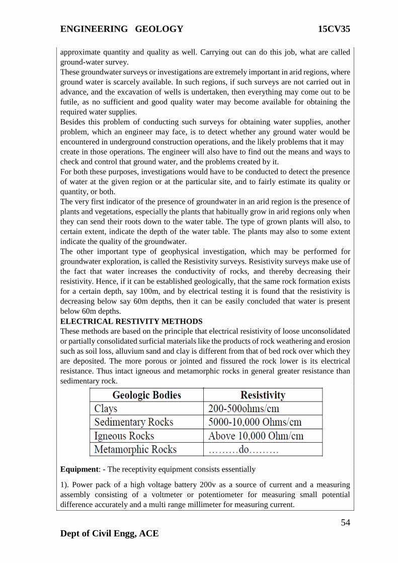
ELECTRICAL RESTIVITY METHODS
These methods are based on the principle that electrical resistivity of loose unconsolidated
or partially consolidated surficial materials like the products of rock weathering and erosion
such as soil loss, alluvium sand and clay is different from that of bed rock over which they
are deposited. The more porous or jointed and fissured the rock lower is its electrical
resistance. Thus intact igneous and metamorphic rocks in general greater resistance than
sedimentary rock.
Equipment: - The receptivity equipment consists essentially
1). Power pack of a high voltage battery 200v as a source of current and a measuring
assembly consisting of a voltmeter or potentiometer for measuring small potential
difference accurately and a multi range millimeter for measuring current.

ENGINEERING GEOLOGY 15CV35
55
Dept of Civil Engg, ACE
2). Four Stainless Steel metallic spikes (electrodes) about 800mm long 20m dia prod vided
with heads for easy driving into the ground and clamps for cable connection.
3). Abundant stranded insulated single conductor cable of 0.5m2 conducting area. The
cable is wound on portable reels.
FIELD PROCEDURE AND INTERPRETATION
In this method, four electrodes are driven into the ground in a straight line at equal distances
and electric current is intruded through, two outer spikes called current electrodes, which
are connected by insulated wire through a mill ammeter to a power pack. The current flows
through the ground. Theoretically the current flow extends to indefinite depths but the
intensity diminishes with dept. For practical purposes the current is considered to be
confined within a depth approxcipamately equal to one-third the distance between the
current electrodes. The current impressed into the ground is recorded by the millimeter. In
homogeneous ground the lines of current flow have a definite shape independent of the
medium of the distance between electrodes. As such the current penetration can be varied
by varying the electrode spacing. Next, the voltage drop due to potential difference between
two inner electrodes called potential electrodes is measured from the potentiometer.
Restivity is then obtained by the expression
R=2P/I
R=Resistivity, P= Potential difference, I= Current applied between electrodes
The value of R so measured is only apparent resistivity of the ground as the ground is rarely
homogeneous. The underground configuration of rocks is deduced by variations in the
apparent resistivity obtained as a function of depth. The electrode system as a whole. The
depth determined would be over the central point of electrode determined would be over
the central point of electrode system. This forms the station sounded. Thus principally there
are two distinct methods of resistivity determinations
a). Expanding electrodes separation techniques or Vertical Profiling
b). Lateral traversing techniques or Horizontal Profiling.
a). Expanding electrodes separation techniques or Vertical Profiling: - In this method
electrode spacing is increased about a fixed central point thereby depth of current
penetration is increased. If the ground is homogeneous resistivity is constant for all
electrode spacing and equal to actual resistance of the geological formation. Therefore the
graph of resistivity against electrode spacing would be a constant. The resistivity curve is
then compared with a series of master curves, computed for various values of depth and
resistivity ratio like those of master curves and depth is obtained.

ENGINEERING GEOLOGY 15CV35
56
Dept of Civil Engg, ACE
Test value curve for electrical resistivity analysis

ENGINEERING GEOLOGY 15CV35
57
Dept of Civil Engg, ACE
b). Lateral traversing techniques or Horizontal Profiling.: - In this method electrode
system is moved along a traverse while the electrode spacing is kept constant, i.e. the depth
of penetration is kept constant and the horizontal variations or variations in depth of a given
geological formation is determined. The apparent resistivity is measured at measured at
successive stations along the line of traverse and plotted as ordinates against distance to
obtain
Electrical sounding methods are usually employed in engineering geology site
investigations in conjunction with auger holes, trial pits, boring and core drilling in the
determination of depth of bed rock, unconformity, location of construction materials (sand
and Gravel) and water bearing formations.
In addition by other related techniques like using fine electrode configuration, the dip of
strata concealed vertical dykes, faults etc, can be traced.
Seismic method
Seismic Prospecting: Prospecting based on the analysis of elastic waves generated in the
earth by artificial means.
The elastic waves produced during sudden disturbance is called as Seismic wave. These
seismic waves are recorded using the instrument, Seismograph and the record obtained is
Seismogram.
It is an important geophysical prospecting applied in oil and natural gas deposits, deep
ground water exploration, depth estimation, geotechnical problems.
Principles: Seismic prospecting depend upon the difference in wave velocity and
transmission pattern of elastic waves through different rock formations.
The waves are generated by explosives, hammering big nails, weight dropping techniques.
Types of seismic waves:
Primary waves or longitudinal waves (P waves): High frequency, relatively low
wavelength. In Solid, Liquid, Gas media. Particles- to and fro in motion

ENGINEERING GEOLOGY 15CV35
58
Dept of Civil Engg, ACE
Shear waves (S waves): Relatively high frequency, relatively high wavelength. In Solid
media.
Love waves (L waves): Low frequency, high wavelength, in Crust only. Responsible for
earthquakes.
Propagation of seismic wave in any medium depends upon the elastic modulus and the
density of the body. Only P and S waves are used for Seismic exploration purpose. The
travel time gives the velocity, hence depth and structure can be determined.
TYPES OF AQUIFERS
AQUIFERS: Ground water occur in many types of Geological formations. Aquifers may
be defined as a formation that contains sufficient, saturated permeable material to yield
significant quantities of water to wells and springs.
The word aquifer is derived from Latin. Aqua- means “water” and fer- means “to bear”.
Hence aquifer is a “water bearer”.
Aquifers are generally aerially extensive and may be overlain or underlain by a confining
bed. They may be defined as a relatively impermeable material stratigraphically adjacent
to one or more aquifers
There are various types of confining beds.
1. Aquifers- means “water bearer”.
2. Aquiclude- means “to shut or close”.
3. Aquifuge- means “to drive away”.
4. Aquitard- means “slow”.
TYPES OF AQUIFERS
ENGINEERING GEOLOGY 15CV35
59
Dept of Civil Engg, ACE
There are four types, they are
1. Unconfined aquifers (Water table aquifers):-
An unconfined aquifers is one in which a water table varies in undulating form and in
slope, depending on the area of recharge and discharge, pump age from wells and
permeability, rises and falls in the water table corresponds to changes in volume of water
in storage within an aquifer.
2. Confined aquifers (Artesian or pressure aquifers):-
This type of aquifers occurs where ground water is confined under pressure (hydrostatic)
greater than atmospheric by overlying impermeable strata. Water in wells stand above the
top of the aquifer rather than storage changes. It exhibit only minor changes in storage and
act as conducts from zones of recharge to those of discharge. The imaginary surface to
which water rises in wells tapping an artesian aquifer is known as “PIEZOMETRIC
SURFACE”. A well be “free flowing” when this Piezometric levels rises above the ground
surfaces. Such wells are called “Artesian wells”.
3. Semi confined (Leaky) aquifers:-
It is completely saturated aquifer bounded above by a semi pervious and below by an
impervious layer. A semi pervious layer is defined as a layer which has low permeability.
Lowering of piezometric levels in leaky aquifer for examples by pumping will generate a
vertical flow of water semi pervious layer into the pumped aquifer. Horizontal flow
component in the semi pervious layer is negligible since it is very low permeability.
4. Semi unconfined aquifer:- If the hydraulic conductivity of the semi pervious layer of the
above case is very high an aquifer intermediate between semi-confined and unconfined
aquifers may exit, and it is called as semi unconfined.
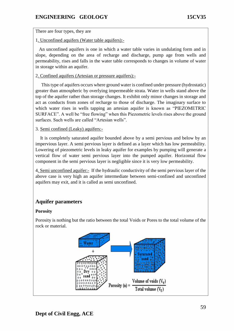
Aquifer parameters
Porosity
Porosity is nothing but the ratio between the total Voids or Pores to the total volume of the
rock or material.

ENGINEERING GEOLOGY 15CV35
60
Dept of Civil Engg, ACE
Permeability
Permeability is the ability of a formation to transmit water through its pores. It can be
defined as the flow per unit cross sectional area of the formation when subjected to a unit
hydraulic head per unit length of flow and has the dimension of velocity.
Specific yield
Specific yield is the water removed from unit volume of aquifer by pumping or drainage
and is expressed as percentage volume of aquifer. Specific yield depends up on grain size,
shape and distribution of pores and compaction of the formation.
Specific retention
Specific Retention is the percentage (%) of total volume of the saturated Aquifer which
will be held/retained in a unit volume of saturated Aquifer by molecular and surface tension
forces against the force of Gravity after full Gravity Drainage.
Storitivity:
Storativity(S) or Storage coefficient is the volume of water that an Aquifer takes into storage
per unit surface area of the Aquifer.
The amount of water per unit volume of a saturated formation that is stored or expelled
from storage owing to compressibility of the mineral skeleton and the pore water unit
change in head
Transmissibility
Amount of water that can be transmitted horizontally through a unit width by the full
saturated thickness of the aquifer under a hydraulic gradient.
T= K B
T: transmissivity (L2/T or m2/d)
K: hydraulic conductivity (L/T)
B: saturated thickness of the aquifer (L or m)

ENGINEERING GEOLOGY 15CV35
61
Dept of Civil Engg, ACE
Springs
A spring is a water resource formed when the side of a hill, a valley bottom or other
excavation intersects a flowing body of groundwater at or below the local water table,
below which the subsurface material is saturated with water. A spring is the result of an
aquifer being filled to the point that the water overflows onto the land surface. They range
in size from intermittent seeps, which flow only after much rain, to huge pools flowing
hundreds of millions of gallons daily.
Springs may be formed in any sort of rock. Small ones are found in many places. In
Missouri, the largest springs are formed in limestone and dolomite in the karst topography
of the Ozarks. Both dolomite and limestone fracture relatively easily. When weak carbonic
acid (formed by rainwater percolating through organic matter in the soil) enters these
fractures it dissolves bedrock. When it reaches a horizontal crack or a layer of non-
dissolving rock such as sandstone or shale, it begins to cut sideways. As the process
continues, the water hollows out more rock, eventually admitting an airspace, at which
point the spring stream can be considered a cave. This process often takes tens to hundreds
of thousands of years to complete.
Artesian wells
If water reaches the ground surface under the natural pressure of the aquifer, the well is
called a flowing artesian well. An aquifer is a geologic layer of porous and permeable
material such as sand and gravel, limestone, or sandstone, through which water flows and
is stored.

ENGINEERING GEOLOGY 15CV35
62
Dept of Civil Engg, ACE
Seawater intrusions in groundwater
When groundwater levels in aquifers are depleted faster than they can recharge. This is
directly related to the position of the interface and determines the amount of saltwater that
can intrude into the freshwater aquifer system. Since saltwater intrusion is directly related
to the recharge rate of the groundwater, this allows for other factors that may contribute to
the encroachment of seawater into the freshwater aquifers. Climatic variables, such as
precipitation, surface runoff, and temperature can play a big role in affecting saltwater
intrusion. With lower precipitation amounts and warmer temperatures, the recharge rate
will be much less due to lack of groundwater present and increased evaporation (Ranjan,
2007). Along with this, other factors may influence the groundwater recharge rate
indirectly. An example of this would be the rising carbon dioxide emissions in the
atmosphere. Increasing carbon dioxide levels can lead directly to an increase in average
surface temperatures, indirectly increasing the evaporation rate and affecting the recharge
of freshwater into the coastal aquifers. Figure illustrates a situation where major pumping
of well water has lead to a cone of depression in the water table. Figure 4 illustrates a
situation where major pumping of the well water has lead to a cone of depression in the
water table. When this occurs, it will move the saltwater freshwater interface inland,
resulting in a higher saline concentration in the aquifers' water, rendering it useless for
human consumption, unless it is treated.

ENGINEERING GEOLOGY 15CV35
63
Dept of Civil Engg, ACE
Remedial measures of Seawater intrusions
The coastal aquifers have to be managed carefully and cautiously to avoid problems like
sea water intrusion and land subsidence. For this, detailed studies and regular monitoring
are required.
• The aquifer geometry, distribution of the fresh water and saline water in the system has
to be studied in detail.
• Constant monitoring of the pumping, movement of the fresh water saline water interface
are to be carried out.
• Tidal influence into the aquifer has to be studied in detail and is to be monitored
periodically.
• Safe yield of the aquifer has to be evaluated and accordingly the extraction has to be
restricted.
• Remedial measures have to be done wherever sea water intrusion has taken place.
• Finding alternate source of water or other suitable remedial measure wherever serious
ground water problem exists.
• Impose restriction for ground water withdrawal along over exploited, critical and other
problem areas.
• Mass awareness/ mass interaction programmes shall be conducted to educate the masses
and also to understand their problems.

ENGINEERING GEOLOGY 15CV35
64
Dept of Civil Engg, ACE
• Preparing a policy document for the judicial and equitable distribution of the resource.
Artificial Recharge of Ground Water
The artificial recharge to ground water aims at augmentation of ground water reservoir by
modifying the natural movement of surface water utilizing suitable civil construction
techniques. Artificial recharge techniques normally address to following issues -
(i) To enhance the sustainable yield in areas where over-development has depleted the
aquifer.
(ii) Conservation and storage of excess surface water for future requirements, since these
requirements often changes within a season or a period.
(iii) To improve the quality of existing ground water through dilution.
(iv) To remove bacteriological and other impurities from sewage and waste water so that
water is suitable for re-use.
The basic purpose of artificial recharge of ground water is to restore supplies from aquifers
depleted due to excessive ground water development.
Artificial Recharge Techniques and Designs
A wide spectrum of techniques are in vogue to recharge ground water reservoir.
Similar to the variations in hydrogeological framework, the artificial recharge techniques
too vary widely. The artificial recharge techniques can be broadly categorized as
follows:-
a. Direct surface techniques
• Flooding
• Basins or percolation tanks
• Stream augmentation
• Ditch and furrow system
• Over irrigation
b. Direct sub surface techniques
• Injection wells or recharge wells
• Recharge pits and shafts
• Dug well recharge
• Bore hole flooding
• Natural openings, cavity fillings.

ENGINEERING GEOLOGY 15CV35
65
Dept of Civil Engg, ACE
c. Combination surface – sub-surface techniques
• Basin or percolation tanks with pit shaft or wells.
d. Indirect Techniques
• Induced recharge from surface water source.
• Aquifer modification.