Embed Size (px)
Citation preview

Planning Act 2008
Infrastructure Planning (Applications: Prescribed Forms and Procedure)
Regulations 2009
Regulation Number: Regulation 5(2)(o) & 6(2)
Author: Highways Agency & Jacobs
Document Reference: TR010007/APP/23.4
Revision Date Description
0 08/01/2014 Application Issue
Engineering Drawings – Drainage Details
A160/A180 Port of Immingham Improvement

A160/A180 Port of Immingham Improvement Engineering Drawings - Drainage Details
Page not used
A160/A180 Port of Immingham Improvement Engineering Drawings - Drainage Details
Rev.: 0
1 Issued: 08/01/14
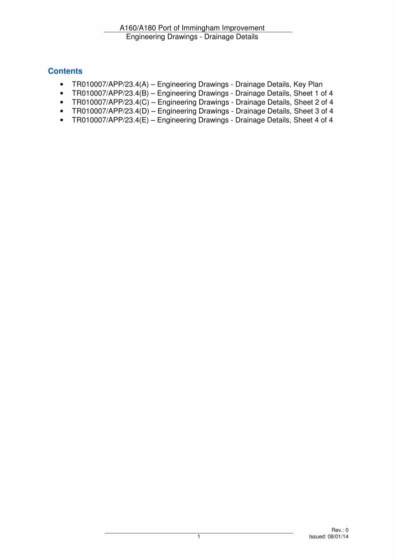
Contents
• TR010007/APP/23.4(A) – Engineering Drawings - Drainage Details, Key Plan
• TR010007/APP/23.4(B) – Engineering Drawings - Drainage Details, Sheet 1 of 4
• TR010007/APP/23.4(C) – Engineering Drawings - Drainage Details, Sheet 2 of 4
• TR010007/APP/23.4(D) – Engineering Drawings - Drainage Details, Sheet 3 of 4
• TR010007/APP/23.4(E) – Engineering Drawings - Drainage Details, Sheet 4 of 4
A160/A180 Port of Immingham Improvement Engineering Drawings - Drainage Details
Rev.: 0
2 Issued: 08/01/14
Page not used

S
H
E
E
T
1
SHEET 2
SHEET 3
SHEET 4
A
1
0
7
7
U
L
C
E
B
Y
R
O
A
D
A180
A
1
6
0
C
1
3
1
H
A
B
R
O
U
G
H
R
O
A
D
A
1
6
0
E
A
S
T
F
I
E
L
D
R
O
A
D
E
A
S
T
F
I
E
L
D
R
O
A
D
A
1
6
0
A
1
1
7
3
M
A
N
B
Y
R
O
A
D
H
U
M
B
E
R
R
O
A
D
C
1
3
3
R
O
S
P
E
R
R
O
A
D
A
1
8
0
T
O
W
N
S
T
R
E
E
T
C
1
3
1
E
A
S
T
H
A
L
T
O
N
R
O
A
D
H
U
M
B
E
R
O
IL
R
E
F
IN
E
R
Y
A160
H
U
M
B
E
R
O
IL
R
E
F
IN
E
R
Y
SOUTH
KILLINGHOLME
IMMINGHAM
HABROUGH
NORTH
KILLINGHOLME
T
O
P
R
O
A
D
A160/A180 PORT OF IMMINGHAM
IMPROVEMENT
ENGINEERING DRAWINGS
REGULATION 5(2)(o) & 6(2)
DRAINAGE DETAILS
KEY PLAN
PRELIMINARY
1:10,000 @ A1
B1879500
TR010007/APP/23.4(A) 0
0 JAN 14
DCO Submission
IB SR SH ST
© Crown copyright and database right 2013 Ordnance Survey 100030649.
This drawing is not to be used in whole or part other than for the intended
purpose and project as defined on this drawing. Refer to the contract for full
terms and conditions.
Drawing status
Drawing number
Scale
Client no.
Jacobs No.
Drawing title
DO NOT SCALE
Rev
Project
Client
P:\B
15
00
00
0\B
18
79
50
0 - A
16
0 Im
min
gh
am
Im
pro
ve
me
nt\C
AD
\D
CO
- A
pp
lica
tio
n\F
IN
AL
P
IN
S A
pp
lica
tio
n\E
ng
in
ee
rin
g D
ra
win
gs\T
R0
10
00
7-A
PP
-2
3.4
(A
) D
ra
in
ag
e D
eta
ils.d
wg
Apprv'dPurpose of revision
Rev Rev. Date Drawn CheckdRev'd
1 City Walk, Leeds, LS11 9DX, UK.
Tel: +44(0)113 242 6771 Fax:+44(0)113 389 1389
www.jacobs.com
NOTES
1. All dimensions are in metres unless stated
otherwise.
Limits of Land to be Acquired or
Used Permanently or Temporarily
KEY
0
1 City Walk, Leeds, LS11 9DX
Tel:+44(0)113 242 6771 Fax:+44(0)113 389 1389
www.jacobs.com
A160/A180 PORT OF IMMINGHAM
IMPROVEMENT
ENGINEERING DRAWINGS
REGULATION 5(2)(o) & 6(2)
DRAINAGE DETAILS
SHEET 1 OF 4
PRELIMINARY
1:2500 @ A1
B1879500
TR010007/APP/23.4(B) 0
0 JAN 14 IB EW SH ST
1 City Walk, Leeds, LS11 9DX
Tel:+44(0)113 242 6771 Fax:+44(0)113 389 1389
www.jacobs.com
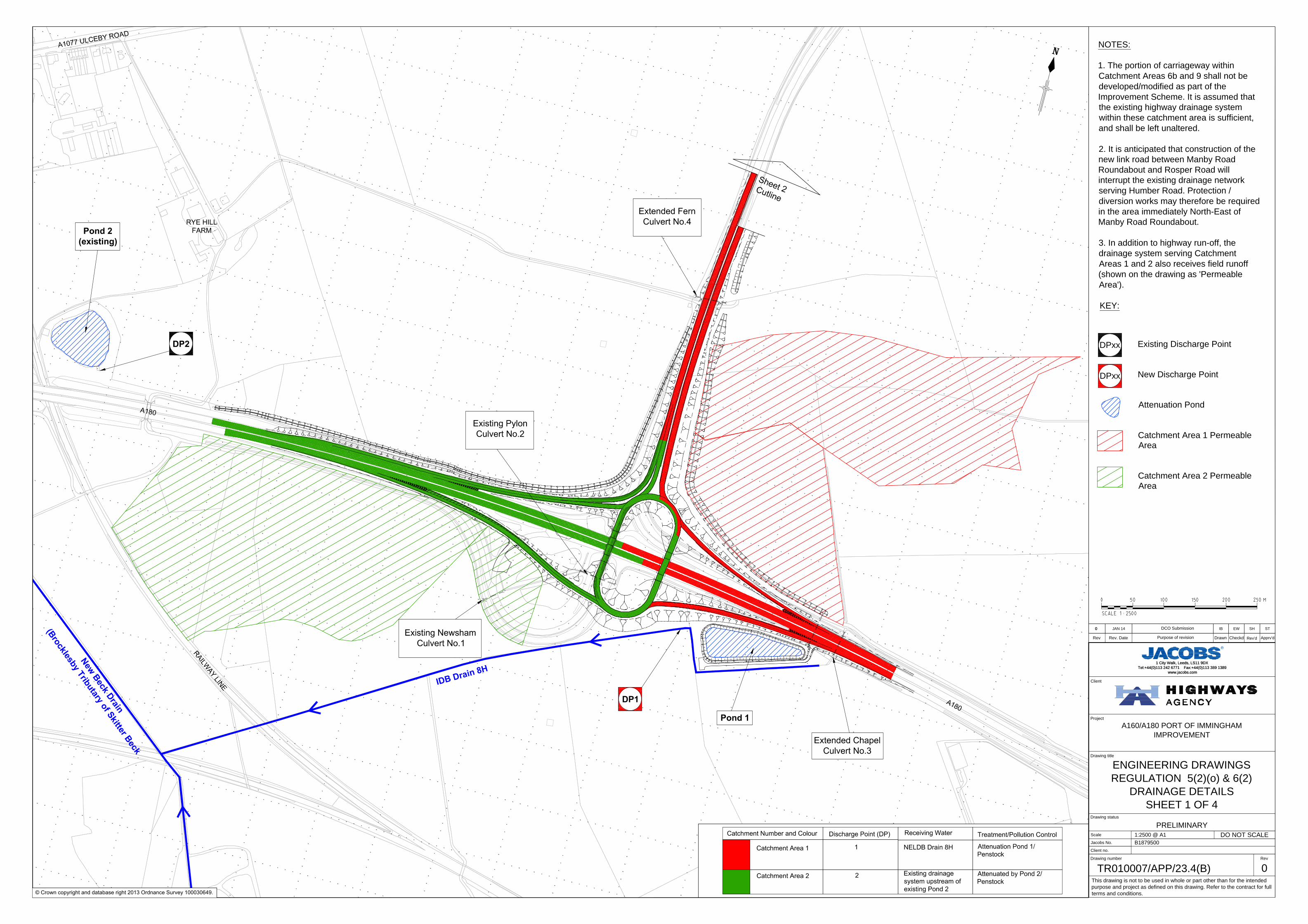
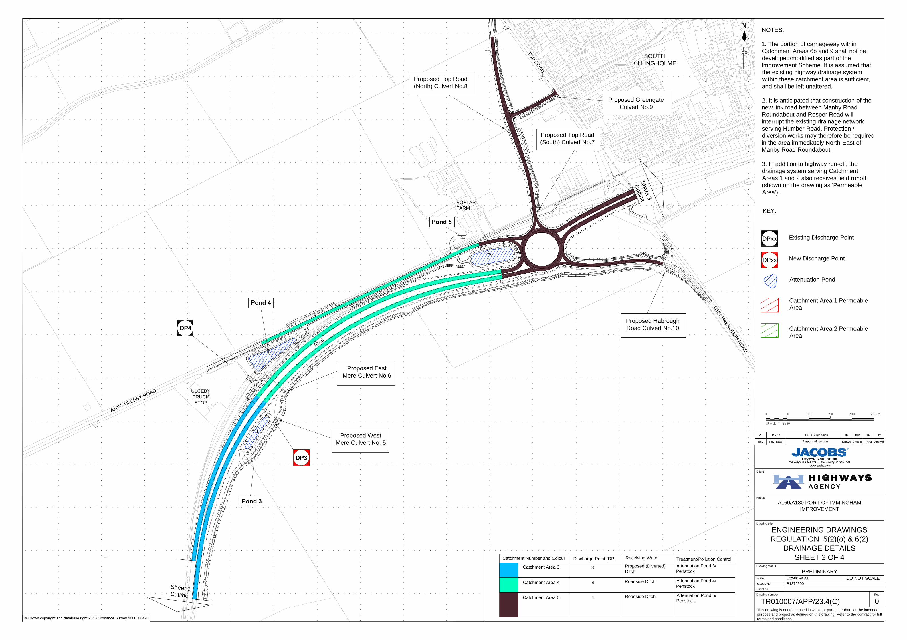
KEY:
Existing Discharge Point
New Discharge Point
Attenuation Pond
Catchment Area 1 Permeable
Area
Catchment Area 2 Permeable
Area
DPxx
DCO Submission
NOTES:
1. The portion of carriageway within
Catchment Areas 6b and 9 shall not be
developed/modified as part of the
Improvement Scheme. It is assumed that
the existing highway drainage system
within these catchment area is sufficient,
and shall be left unaltered.
2. It is anticipated that construction of the
new link road between Manby Road
Roundabout and Rosper Road will
interrupt the existing drainage network
serving Humber Road. Protection /
diversion works may therefore be required
in the area immediately North-East of
Manby Road Roundabout.
3. In addition to highway run-off, the
drainage system serving Catchment
Areas 1 and 2 also receives field runoff
(shown on the drawing as 'Permeable
Area').
This drawing is not to be used in whole or part other than for the intended
purpose and project as defined on this drawing. Refer to the contract for full
terms and conditions.
Drawing status
Drawing number
Scale
Client no.
Jacobs No.
Drawing title
DO NOT SCALE
Rev
Project
Client
R
Apprv'dPurpose of revision
Rev Rev. Date Drawn CheckdRev'd
© Crown copyright and database right 2013 Ordnance Survey 100030649.
DPxx
Treatment/Pollution Control
Catchment Number and Colour
Catchment Area 3
Catchment Area 4
Catchment Area 5
Discharge Point (DP)
3
4
4
Attenuation Pond 3/
Penstock
Attenuation Pond 4/
Penstock
Attenuation Pond 5/
Penstock
Proposed (Diverted)
Ditch
Roadside Ditch
Roadside Ditch
Receiving Water
A
1
0
7
7
U
L
C
E
B
Y
R
O
A
D
ULCEBY
TRUCK
STOP
A
1
6
0
POPLAR
FARM
T
O
P
R
O
A
D
C
1
3
1
H
A
B
R
O
U
G
H
R
O
A
D
Sheet 1
C
utlin
e
S
h
e
e
t
3
C
u
t
l
i
n
e
SOUTH
KILLINGHOLME
Proposed Top Road
(South) Culvert No.7
Pond 5
Proposed Top Road
(North) Culvert No.8
Proposed East
Mere Culvert No.6
Proposed Greengate
Culvert No.9
Proposed Habrough
Road Culvert No.10
Pond 4
Pond 3
Proposed West
Mere Culvert No. 5
DP4
DP3
0
1 City Walk, Leeds, LS11 9DX
Tel:+44(0)113 242 6771 Fax:+44(0)113 389 1389
www.jacobs.com
A160/A180 PORT OF IMMINGHAM
IMPROVEMENT
ENGINEERING DRAWINGS
REGULATION 5(2)(o) & 6(2)
DRAINAGE DETAILS
SHEET 2 OF 4
PRELIMINARY
1:2500 @ A1
B1879500
TR010007/APP/23.4(C) 0
0 JAN 14 IB EW SH ST
1 City Walk, Leeds, LS11 9DX
Tel:+44(0)113 242 6771 Fax:+44(0)113 389 1389
www.jacobs.com
DCO Submission
This drawing is not to be used in whole or part other than for the intended
purpose and project as defined on this drawing. Refer to the contract for full
terms and conditions.
Drawing status
Drawing number
Scale
Client no.
Jacobs No.
Drawing title
DO NOT SCALE
Rev
Project
Client
R
Apprv'dPurpose of revision
Rev Rev. Date Drawn CheckdRev'd
© Crown copyright and database right 2013 Ordnance Survey 100030649.
KEY:
Existing Discharge Point
New Discharge Point
Attenuation Pond
Catchment Area 1 Permeable
Area
Catchment Area 2 Permeable
Area
NOTES:
1. The portion of carriageway within
Catchment Areas 6b and 9 shall not be
developed/modified as part of the
Improvement Scheme. It is assumed that
the existing highway drainage system
within these catchment area is sufficient,
and shall be left unaltered.
2. It is anticipated that construction of the
new link road between Manby Road
Roundabout and Rosper Road will
interrupt the existing drainage network
serving Humber Road. Protection /
diversion works may therefore be required
in the area immediately North-East of
Manby Road Roundabout.
3. In addition to highway run-off, the
drainage system serving Catchment
Areas 1 and 2 also receives field runoff
(shown on the drawing as 'Permeable
Area').
DPxx
DPxx
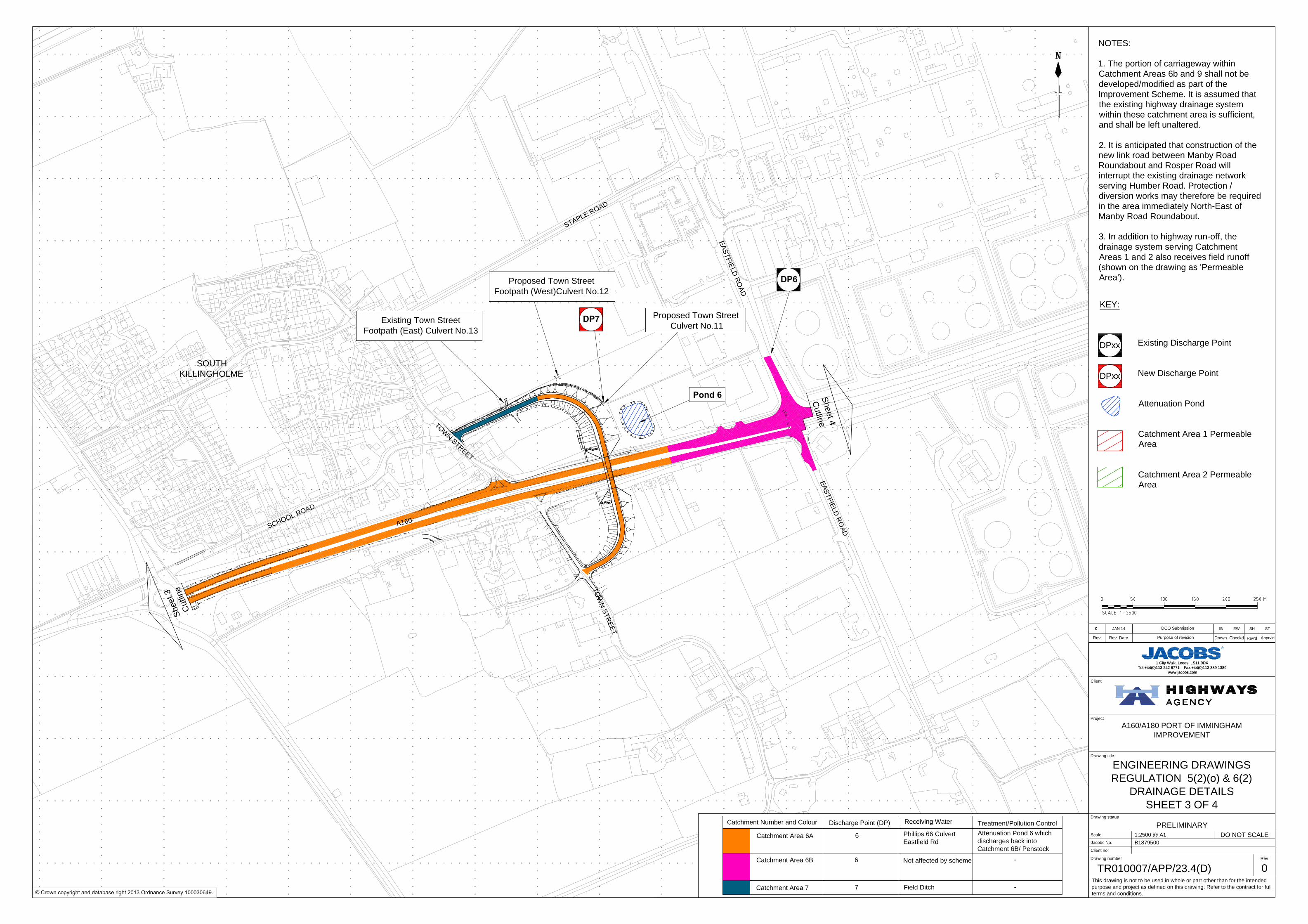
Treatment/Pollution Control
Catchment Number and Colour
Catchment Area 6A
Discharge Point (DP)
6
Attenuation Pond 6 which
discharges back into
Catchment 6B/ Penstock
-
Catchment Area 77
Catchment Area 6B 6-
Phillips 66 Culvert
Eastfield Rd
Field Ditch
Receiving Water
Not affected by scheme
S
C
H
O
O
L
R
O
A
D
A
1
6
0
S
T
A
P
L
E
R
O
A
D
E
A
S
T
F
I
E
L
D
R
O
A
D
E
A
S
T
F
I
E
L
D
R
O
A
D
T
O
W
N
S
T
R
E
E
T
SOUTH
KILLINGHOLME
S
h
e
e
t
3
C
u
t
l
i
n
e
T
O
W
N
S
T
R
E
E
T
S
h
e
e
t 4
C
u
tlin
e
DP7
Proposed Town Street
Culvert No.11
DP6
Existing Town Street
Footpath (East) Culvert No.13
Proposed Town Street
Footpath (West)Culvert No.12
Pond 6
0
1 City Walk, Leeds, LS11 9DX
Tel:+44(0)113 242 6771 Fax:+44(0)113 389 1389
www.jacobs.com
A160/A180 PORT OF IMMINGHAM
IMPROVEMENT
ENGINEERING DRAWINGS
REGULATION 5(2)(o) & 6(2)
DRAINAGE DETAILS
SHEET 3 OF 4
PRELIMINARY
1:2500 @ A1
B1879500
TR010007/APP/23.4(D) 0
0 JAN 14 IB EW SH ST
1 City Walk, Leeds, LS11 9DX
Tel:+44(0)113 242 6771 Fax:+44(0)113 389 1389
www.jacobs.com
DCO Submission
This drawing is not to be used in whole or part other than for the intended
purpose and project as defined on this drawing. Refer to the contract for full
terms and conditions.
Drawing status
Drawing number
Scale
Client no.
Jacobs No.
Drawing title
DO NOT SCALE
Rev
Project
Client
R
Apprv'dPurpose of revision
Rev Rev. Date Drawn CheckdRev'd
© Crown copyright and database right 2013 Ordnance Survey 100030649.
KEY:
Existing Discharge Point
New Discharge Point
Attenuation Pond
Catchment Area 1 Permeable
Area
Catchment Area 2 Permeable
Area
NOTES:
1. The portion of carriageway within
Catchment Areas 6b and 9 shall not be
developed/modified as part of the
Improvement Scheme. It is assumed that
the existing highway drainage system
within these catchment area is sufficient,
and shall be left unaltered.
2. It is anticipated that construction of the
new link road between Manby Road
Roundabout and Rosper Road will
interrupt the existing drainage network
serving Humber Road. Protection /
diversion works may therefore be required
in the area immediately North-East of
Manby Road Roundabout.
3. In addition to highway run-off, the
drainage system serving Catchment
Areas 1 and 2 also receives field runoff
(shown on the drawing as 'Permeable
Area').
DPxx
DPxx
Treatment/Pollution Control
Catchment Number and Colour
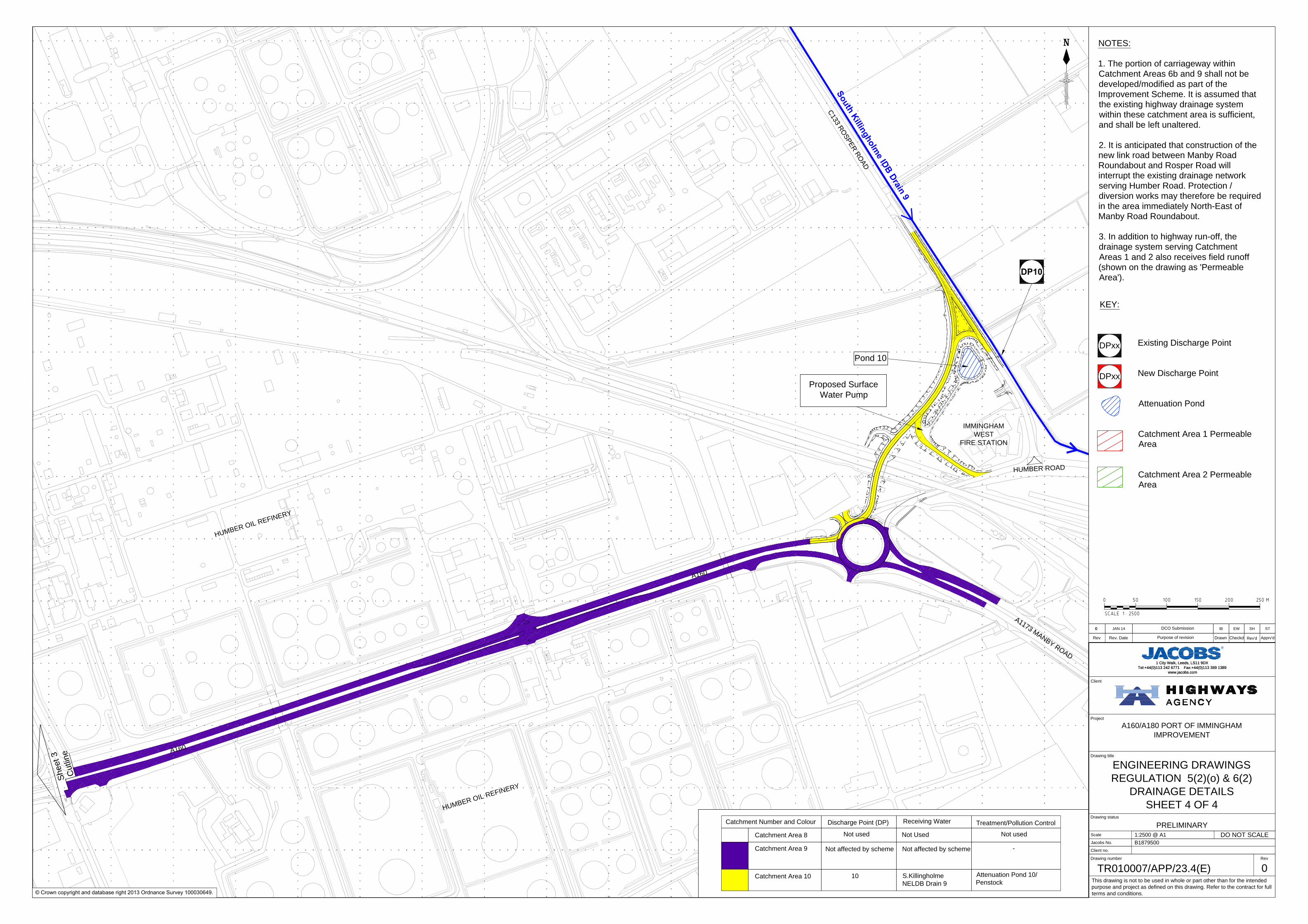
Catchment Area 8
Catchment Area 9
Catchment Area 10
Discharge Point (DP)
10
Not used
Attenuation Pond 10/
Penstock
-
Not used
S.Killingholme
NELDB Drain 9
Not Used
Not affected by scheme
Receiving Water
Not affected by scheme
S
o
u
t
h
K
i
l
l
i
n
g
h
o
l
m
e
I
D
B
D
r
a
i
n
9
Proposed Surface
Water Pump
A
1
6
0
A
1
6
0
A
1
1
7
3
M
A
N
B
Y
R
O
A
D
HU
MBER
RO
AD
C
1
3
3
R
O
S
P
E
R
R
O
A
D
IMMINGHAM
WEST
FIRE STATION
H
U
M
B
E
R
O
IL
R
E
F
IN
E
R
Y
H
U
M
B
E
R
O
IL
R
E
F
IN
E
R
Y
S
h
e
e
t 3
C
u
tlin
e
DP10
Pond 10
0
1 City Walk, Leeds, LS11 9DX
Tel:+44(0)113 242 6771 Fax:+44(0)113 389 1389
www.jacobs.com
A160/A180 PORT OF IMMINGHAM
IMPROVEMENT
ENGINEERING DRAWINGS
REGULATION 5(2)(o) & 6(2)
DRAINAGE DETAILS
SHEET 4 OF 4
PRELIMINARY
1:2500 @ A1
B1879500
TR010007/APP/23.4(E) 0
0 JAN 14 IB EW SH ST
1 City Walk, Leeds, LS11 9DX
Tel:+44(0)113 242 6771 Fax:+44(0)113 389 1389
www.jacobs.com
DCO Submission
This drawing is not to be used in whole or part other than for the intended
purpose and project as defined on this drawing. Refer to the contract for full
terms and conditions.
Drawing status
Drawing number
Scale
Client no.
Jacobs No.
Drawing title
DO NOT SCALE
Rev
Project
Client
R
Apprv'dPurpose of revision
Rev Rev. Date Drawn CheckdRev'd
© Crown copyright and database right 2013 Ordnance Survey 100030649.
KEY:
Existing Discharge Point
New Discharge Point
Attenuation Pond
Catchment Area 1 Permeable
Area
Catchment Area 2 Permeable
Area
NOTES:
1. The portion of carriageway within
Catchment Areas 6b and 9 shall not be
developed/modified as part of the
Improvement Scheme. It is assumed that
the existing highway drainage system
within these catchment area is sufficient,
and shall be left unaltered.
2. It is anticipated that construction of the
new link road between Manby Road
Roundabout and Rosper Road will
interrupt the existing drainage network
serving Humber Road. Protection /
diversion works may therefore be required
in the area immediately North-East of
Manby Road Roundabout.
3. In addition to highway run-off, the
drainage system serving Catchment
Areas 1 and 2 also receives field runoff
(shown on the drawing as 'Permeable
Area').
DPxx
DPxx