Embed Size (px)
Citation preview


Calculation Number: TV-GO-APC389153-002
Project/Plant: Plant Gorgas Gypsum Pond
Unit(s): Units 6-7
Discipline/Area: ESFS
Title/Subject: Slope Stability Analysis of Plant Gorgas Gypsum Pond Dam Purpose/Objective: Analyze slope stability of the Plant Gorgas Gypsum Pond Dam System or Equipment Tag Numbers:
NA Originator:
Stacey H. Simpson, P.E.
Topic Page Attachments
(Computer Printouts, Tech. Papers, Sketches, Correspondence) # of
Pages Purpose of Calculation 2 Attachment A - Boring Location Plan 1 Methodology 2 Attachment B - Boring Logs 32 Criteria and Assumptions 2 Attachment C - Laboratory Analyses 1
Input Data 3 Attachment D - Critical Section Profile Used in Analysis 1
Summary of Conclusions 4 Design Inputs/References 4 Body of Calculation 5
Total # of pages including cover sheet & attachments: 49
Rev. No. Description
Originator Initial / Date
Reviewer Initial / Date
Approver Initial / Date
0 Issued for Information SHS 10/06/16 JAL 10/10/16 JCP 10/10/16
Notes:
Contents
Revision Record
Engineering and Construction Services Calculation

Plant Gorgas Gypsum Pond Dam Slope Stability Analysis TV-GO-APC389153-002
Rev. 0 Page 2 of 10 10/06/2016
Purpose of Calculation The William C. Gorgas Electric Generating Plant is a 5-unit electric generating facility, all of which are coal-fired units. The Plant Gorgas Gypsum Pond is designed to receive and store coal combustion residuals (gypsum) produced during the electric generating process at Plant Gorgas. The gypsum slurry from the flue gas desulfurization operation is wet-sluiced to the gypsum storage area. The gypsum is allowed to settle and the water decants to the sedimentation pond.
The purpose of this calculation is to provide a slope stability assessment of the Plant Gorgas Gypsum Pond dam under conditions prescribed by the EPA CCR rule.
Methodology The calculation was performed using the following methods and software:
GeoStudio 2012 (Version 8.15.5.11777), August 2015 Release, Copyright 1991-2016, GEO-SLOPE International, Ltd.
Strata (Version alpha, Revision 0.2.0), Geotechnical Engineering Center, Department of Civil, Architectural, and Environmental Engineering, University of Texas.
The Morgenstern-Price analytical method with an entry-exit slip surface was used for slope stability calculation.
Criteria and Assumptions The slope stability models were run using the following assumptions and design criteria:
• Seismic site response was determined using a one-dimensional equivalent linear siteresponse analysis. The analysis was performed using Strata and utilizing random vibrationtheory. The input motion consisted of the USGS published 2008 Uniform HazardResponse Spectrum (UHRS) for Site Class B/C at a 2% Probability of Exceedance in 50years. The UHRS was converted to a Fourier Amplitude Spectrum, and propagatedthrough a representative one dimensional soil column using linear wave propagation withstrain-dependent dynamic soil properties. The input soil properties and layer thicknesswere randomized based on defined statistical distributions to perform Monte Carlosimulations for 100 realizations, which were used to generate a median estimate of thesurface ground motions.
• The median surface ground motions were then used to calculate a pseudostatic seismiccoefficient for utilization in the stability analysis using the approach suggested by Bray andTavasarou (2009). The procedure calculates the seismic coefficient for an allowableseismic displacement and a probability exceedance of the displacement. For this analysis,an allowable displacement of 0.5 ft, and a probability of exceedance of 16% wereconservatively selected, providing a seismic coefficient of 0.053g for use as a horizontalacceleration in the stability analysis.

Plant Gorgas Gypsum Pond Dam Slope Stability Analysis TV-GO-APC389153-002
Rev. 0 Page 3 of 10 10/06/2016
• The Corps of Engineers (COE) EM 1110-2-1902 standard, October 2003, allows the use ofthe phreatic surface established for the maximum storage condition (normal pool) in theanalysis for the maximum surcharge loading condition. This is based on the short termduration of the surcharge loading relative to the permeability of the embankment and thefoundation materials. This method is used in the analysis for the impoundments at thisfacility with surcharge loading.
• The current required minimum criteria (factors of safety) were taken from the StructuralIntegrity Criteria for Existing CCR Surface Impoundments, 40 CFR 257.73, published April17, 2015.
• The critical section was selected at the location having the apparent maximum dam heightand gypsum storage. The cross-section of the Plant Gorgas Gypsum Pond dam wasmodeled using the following sources:
1) Alabama Power Company (APC) Drawing D-591423, Plant Gorgas GypsumStorage Area Cell, Sections and Details Sheet 1.
• A phreatic surface within the dam was not modeled because the cell is lined with 60-milHDPE, which for purposes of this analysis is considered to be impermeable.
Input Data
• Soil Properties: The soil properties (unit weight, phi angle, and cohesion) of coal minespoils comprising the dam used in the analysis were conservatively estimated fromevaluating average blow counts of the material encountered during drilling operations,and from laboratory testing of the coal mine spoils.
• The soil properties (unit weight, phi angle, and cohesion) of the gypsum were derivedfrom laboratory testing of gypsum similar to what is produced and stored at PlantGorgas.
Soil Description Unit Weight, pcf Effective Stress Parameters
Cohesion, psf Phi Angle, degrees
Gypsum 100 100 34
Coal Mine Spoil 104 0 36
Summary of Conclusions The following table summarizes the factors of safety resulting from the slope stability analyses. The results indicate the safety factors of the Plant Gorgas Gypsum Pond dam meet or exceed the minimum criteria set forth in the structural integrity criteria for existing CCR surface impoundments, 40 CFR 257.73.
Plant Gorgas Gypsum Pond Dam Slope Stability Analysis TV-GO-APC389153-002
Rev. 0 Page 4 of 10 10/06/2016
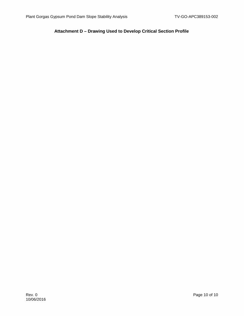
Factor of Safety Summary Table
Loading Condition Minimum Calculated Safety Factor
Minimum Required Safety Factor
Long-term Maximum Storage Pool (Static) 2.5 1.5 Maximum Surcharge Pool (Static) 2.5 1.4 Seismic 2.3 1.0
Design Inputs/References • Bray, J. D. and Travasarou, T., Pseudostatic Coefficient for Use in Simplified Seismic
Slope Stability Evaluation, Journal of Geotechnical and Environmental Engineering,American Society of Civil Engineers, September 2009
• D-591423, Plant Gorgas Gypsum Storage Area Cell Sections and Details Sheet 1, 2006• Subsurface Investigation Report, Gypsum Storage Area at Alabama Power Company’s
Gorgas Steam Plant, Southern Company Technical Services, 2005

Plant Gorgas Gypsum Pond Dam Slope Stability Analysis TV-GO-APC389153-002
Rev. 0 Page 5 of 10 10/06/2016
Body of Calculation

Coal Mine Spoil
Gypsum
2.5HDPE Liner
Plant Gorgas
Gypsum Storage Pond
Name: Gypsum Unit Weight: 100 pcfCohesion': 100 psfPhi': 34 °
Name: Coal Mine Spoil Unit Weight: 104 pcfCohesion': 0 psfPhi': 36 °
Long Term Maximum Storage
Distance (ft)-25 25 75 125 175 225 275 325 375 425 475 525 575 625 675 725
Ele
vatio
n (ft
)
270
290
310
330
350
370
390
410
430
450
470
Materials
GypsumCoal Mine Spoil

Coal Mine Spoil
Gypsum
2.5HDPE Liner
Plant Gorgas
Gypsum Storage Pond
Name: Gypsum Unit Weight: 100 pcfCohesion': 100 psfPhi': 34 °
Name: Coal Mine Spoil Unit Weight: 104 pcfCohesion': 0 psfPhi': 36 °
Maximum Surcharge
Distance (ft)-25 25 75 125 175 225 275 325 375 425 475 525 575 625 675 725
Ele
vatio
n (ft
)
270
290
310
330
350
370
390
410
430
450
470
Materials
GypsumCoal Mine Spoil

Coal Mine Spoil
Gypsum
2.3HDPE Liner
Horizontal Seismic Coefficient.: 0.053
Plant Gorgas
Gypsum Storage Pond
Name: Gypsum Unit Weight: 100 pcfCohesion': 100 psfPhi': 34 °
Name: Coal Mine Spoil Unit Weight: 104 pcfCohesion': 0 psfPhi': 36 °
Seismic
Distance (ft)-25 25 75 125 175 225 275 325 375 425 475 525 575 625 675 725
Ele
vatio
n (ft
)
270
290
310
330
350
370
390
410
430
450
470
Materials
GypsumCoal Mine Spoil

Plant Gorgas Gypsum Pond Dam Slope Stability Analysis TV-GO-APC389153-002
Rev. 0 Page 6 of 10 10/06/2016
ATTACHMENTS

Plant Gorgas Gypsum Pond Dam Slope Stability Analysis TV-GO-APC389153-002
Rev. 0 Page 7 of 10 10/06/2016
Attachment A - Boring Location Plan


Plant Gorgas Gypsum Pond Dam Slope Stability Analysis TV-GO-APC389153-002
Rev. 0 Page 8 of 10 10/06/2016
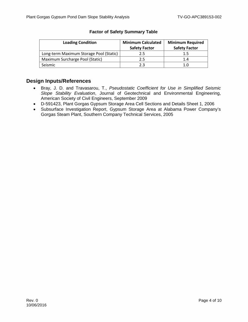
Attachment B - Boring Logs

DRILLING LOGGEOLOGICAL SERVICES
SITE
E
ANGLE CONTRACTOR
Graphic Material Description, SampleLog Depth Elev. Classification and Remarks From To Blows N No.
0
1
2 Coal Mine Spoils 0 - 66.5'Dark gray-black 10YR3/1 very dark gray
3
4
5
6 1
7
8
9
10
11 2
12
13
14
15
16 3
17
18
19
20
21 4
22
23
24Form GS9901 4/10/2003
CommentsStandard Penetration Test
20.0-21.5 9-3-3 6
15.0-16.5 13-19-10 29
10.0-11.5 23-11-7 18
5.0-6.5 2-34-7 41
TYPE GROUT DRILLING START DATE
DRILLING COMP. DATEAPPROVEDRECORDERDRILLER B. Filipovich
Auger Spoils
J. Chitwood
LOCATION
WATER TABLE DEPTH ELEV. TIME AFTER COMP.
LENGTH CORE SIZE
OVERBURDEN DEPTH NO. U.D. SAMPLES
CASING SIZE
Plant Gorgas Gypsum Disposal AreaNorth of Plant Gorgas in Coal Mine Spoil Storage Area
NO. SAMPLES
COORDINATES N
BEARING SCS
HOLE DEPTH SURF.ELEV.
DRILL NO.
13
GPZ-1Hole No.
66.5' 411
Sheet 1 of 3
4/29/2003
TOTAL % REC.
4/29/2003
Backfilled Hole DATE TAKEN
QUANTITY MIX

DRILLING LOGGEOLOGICAL SERVICES
SITE TOTAL DEPTH SURF.ELEV.
Graphic Material Description, SampleLog Depth Elev. Classification and Remarks From To Blows N No.
25
26 Coal Mine Spoils 5
27
28
29
30
31 6
32
33
34
35
36 7
37
38
39
40
41 8
42
43
44
45
46 9
47
48
49
50
51 10
52
53
54
55
1156
Form GS9902 4/10/2003
55.0-56.5 4-7-9 16
45.0-46.5 5-5-6 11
40.0-41.5 6-6-5 11
35.0-36.5 5-7-8 15
30.0-31.5 9-11-13 24
25.0-26.5 11-14-13 27
411
Hole No. GPZ-1
Standard Penetration Test
Sheet 2 of 3
Comments
50.0-51.5 9-7-7 14
Plant Gorgas Gypsum Disposal Area 66.5'

DRILLING LOGGEOLOGICAL SERVICES
SITE TOTAL DEPTH SURF.ELEV.
Graphic Material Description, SampleLog Depth Elev. Classification and Remarks From To Blows N No.
57
58
59
60
Coal Mine Spoils 61 12
62
63
64
65
66 13
66.5 344.567 Boring terminated @ 66.5'
No water encountered. Hole backfilled with auger spoils.68
69
70
71
72
73
74
75
76
77
78
79
80
81
82
83
84
85
86
87
88
Form GS9902 4/10/2003
Hole No. GPZ-1
Standard Penetration Test
Sheet 3 of 3
Comments
Plant Gorgas Gypsum Disposal Area 66.5' 411
60.0-61.5 4-7-7 14
65.0-66.5 9-7-6 13

DRILLING LOGGEOLOGICAL SERVICES
SITE
E
ANGLE CONTRACTOR
Graphic Material Description, SampleLog Depth Elev. Classification and Remarks From To Blows N No.
0
1
2 Coal Mine Spoils 0 - 46'
3
4
5
6 1
7
8
9
10
11 2
12
13
14
15
16 3
17
18
19
20
21 4
22
23
24
Form GS9901 4/10/2003
CommentsStandard Penetration Test
20.0-21.5 5-4-4 8
15.0-16.5 2-2-2 4
10.0-11.5 2-2-2 4
5.0-6.5 2-2-3 5
TYPE GROUT DRILLING START DATE
DRILLING COMP. DATEAPPROVEDRECORDER DRILLER B. Filipovich J. Chitwood
LOCATION
WATER TABLE DEPTH ELEV. TIME AFTER COMP.
LENGTH CORE SIZE
OVERBURDEN DEPTH NO. U.D. SAMPLES
CASING SIZE
Plant Gorgas Gypsum Disposal AreaNorth of Plant Gorgas in Coal Mine Spoil Storage Area
NO. SAMPLES
COORDINATES N
BEARING SCS
HOLE DEPTH SURF.ELEV.
DRILL NO.
8
GPZ-2Hole No.
46' 410
Sheet 1 of 2
4/30/2003
TOTAL % REC.
5/2/2003
4/29/2003
34 376 48 hrs DATE TAKEN
QUANTITY MIX

DRILLING LOGGEOLOGICAL SERVICES
SITE TOTAL DEPTH SURF.ELEV.
Graphic Material Description, SampleLog Depth Elev. Classification and Remarks From To Blows N No.
25
26 Coal Mine Spoils 5
27
28
29
30
31 6
32
33
34 Wet around 34'
35
36 Saturated @ 36' 7
37
38
39
40
41 8
42
43
44
45
46.0 46 364.00 Boring terminated @ 46' - 10' of auger broke off in the hole.
Offset 5' and cored 5' of rock.47
48
49
50
51
52
53
54
55
56
Form GS9902 4/10/2003
40.0-41.5 1-1-2 3
35.0-36.5 2-2-3 5
30.0-31.5 2-20-20 40
25.0-26.5 2-4-3 7
Hole No. GPZ-2
Standard Penetration Test
Sheet 2 of 2
Comments
Plant Gorgas Gypsum Disposal Area 46' 410

DRILLING LOGGEOLOGICAL SERVICES
SITE
E
ANGLE CONTRACTOR
Graphic Material Description, SampleLog Depth Elev. Classification and Remarks From To Blows N No.
0
1
2 Coal Mine Spoils 0 - 65'
Dark gray-black 10YR3/1 very dark gray3
4
5
6
7
8
9
10
.
.
.
.
.
.
58
59
60
61 1
62
63
64
65.0 65 371.00 Boring Terminated @ 65'. Set Piezometer.
Form GS9901 4/10/2003
CommentsStandard Penetration Test
60.0-61.5 11-15-24 39
TYPE GROUT DRILLING START DATE
DRILLING COMP. DATEAPPROVEDRECORDER DRILLER B. Filipovich H. Hill
LOCATION
WATER TABLE DEPTH ELEV. TIME AFTER COMP.
LENGTH CORE SIZE
OVERBURDEN DEPTH NO. U.D. SAMPLES
CASING SIZE
Plant Gorgas Gypsum Disposal AreaNorth of Plant Gorgas in Coal Mine Spoil Storage Area
NO. SAMPLES
COORDINATES N
BEARING SCS
HOLE DEPTH SURF.ELEV.
DRILL NO.
1
GPZ-3Hole No.
65' 436
Sheet 1 of 1
4/30/2003
TOTAL % REC.
5/2/2003
4/30/2003
Dry 48 hrs DATE TAKEN
QUANTITY MIX

DRILLING LOGGEOLOGICAL SERVICES
SITE
E
ANGLE CONTRACTOR
Graphic Material Description, SampleLog Depth Elev. Classification and Remarks From To Blows N No.
0
1
2 Coal Mine Spoils 0 - 65'
Dark gray-black 10YR3/1 very dark gray3 No Rock Encountered. No water.
4
5
6
7
8
9
10
.
.
.
.
.
.
58
59
60
61
62
63
64
65.0 65 341.00 Boring Terminated @ 65'. Set Piezometer.
Form GS9901 4/10/2003
CommentsStandard Penetration Test
TYPE GROUT DRILLING START DATE
DRILLING COMP. DATEAPPROVEDRECORDER DRILLER B. Filipovich H. Hill
LOCATION
WATER TABLE DEPTH ELEV. TIME AFTER COMP.
LENGTH CORE SIZE
OVERBURDEN DEPTH NO. U.D. SAMPLES
CASING SIZE
Plant Gorgas Gypsum Disposal AreaNorth of Plant Gorgas in Coal Mine Spoil Storage Area
NO. SAMPLES
COORDINATES N
BEARING SCS
HOLE DEPTH SURF.ELEV.
DRILL NO.
GPZ-4Hole No.
65' 406
Sheet 1 of 1
4/30/2003
TOTAL % REC.
5/2/2003
4/30/2003
Dry 48 hrs DATE TAKEN
QUANTITY MIX

DRILLING LOGGEOLOGICAL SERVICES
SITE
E
ANGLE CONTRACTOR
Graphic Material Description, SampleLog Depth Elev. Classification and Remarks From To Blows N No.
0
1
2 Coal Mine Spoils 0 - 60'
Dark gray-black 10YR3/1 very dark gray3 Augered through mine spoils
No rock encountered. No water.4
5
6
7
8
9
10
.
.
.
.
.
.
53
54
55
56
57
58
59
60.0 60 339.00 Boring Terminated @ 60'. Set Piezometer.
Form GS9901 4/10/2003
5/1/2003
Dry 24 hrs DATE TAKEN
QUANTITY MIX
GPZ-5Hole No.
60' 399
Sheet 1 of 1
5/2/2003
5/1/2003
HOLE DEPTH SURF.ELEV.
DRILL NO.
TOTAL % REC.
OVERBURDEN DEPTH NO. U.D. SAMPLES
CASING SIZE
Plant Gorgas Gypsum Disposal AreaNorth of Plant Gorgas in Coal Mine Spoil Storage Area
NO. SAMPLES
COORDINATES N
BEARING SCS LOCATION
WATER TABLE DEPTH ELEV. TIME AFTER COMP.
LENGTH CORE SIZE
TYPE GROUT DRILLING START DATE
DRILLING COMP. DATEAPPROVEDRECORDER DRILLER B. Filipovich H. Hill
CommentsStandard Penetration Test

DRILLING LOGGEOLOGICAL SERVICES
SITE
E
ANGLE CONTRACTOR
Graphic Material Description, SampleLog Depth Elev. Classification and Remarks From To Blows N No.
0
1
2 Coal Mine Spoils 0 - 61'
3
4
5
6
7
8
9
10
. Water encountered around 15'.
.
.
. Lots of water around 25'.
.
.
55
56
57
58
59
60
Tan slightly clayey and sandy silt with Sandstone fragments @ 61'61 1
62.0 62 264.00 Boring Terminated @ 61.5'. Set Piezometer 30' - 35'.
Form GS9901 4/10/2003
CommentsStandard Penetration Test
60.0-61.5 5-13-10 23
TYPE GROUT DRILLING START DATE
DRILLING COMP. DATEAPPROVEDRECORDER DRILLER B. Filipovich H. Hill
LOCATION
WATER TABLE DEPTH ELEV. TIME AFTER COMP.
LENGTH CORE SIZE
OVERBURDEN DEPTH NO. U.D. SAMPLES
CASING SIZE
Plant Gorgas Gypsum Disposal AreaNorth of Plant Gorgas in Coal Mine Spoil Storage Area
NO. SAMPLES
COORDINATES N
BEARING SCS
HOLE DEPTH SURF.ELEV.
DRILL NO.
1
GPZ-6Hole No.
61.5' 326
Sheet 1 of 1
5/1/2003
TOTAL % REC.
5/2/2003
5/1/2003
8 318 24 hrs DATE TAKEN
QUANTITY MIX

DRILLING LOGGEOLOGICAL SERVICES
SITE
E
ANGLE CONTRACTOR
Graphic Material Description, SampleLog Depth Elev. Classification and Remarks From To Blows N No.
0
1
2 Augered through coal mine spoils 0 - 25'
3
4
5
6
7
8
9
10 Moist around 10'.
.
.
25 Original ground around 25'.
Refusal @ 28'.. Cored through rock 28'-45' - Gray Sandstone with weathered layers
.
.
38
39
40
41
42
43
44
45.0 45 382.00 Boring Terminated @ 45'. Set Piezometer 40-45'
Form GS9901 4/10/2003
5/1/2003
18.5 408.5 24 hrs DATE TAKEN
QUANTITY MIX
GPZ-7Hole No.
45' 427
Sheet 1 of 1
5/2/2003
5/1/2003
HOLE DEPTH SURF.ELEV.
DRILL NO.
TOTAL % REC.
OVERBURDEN DEPTH NO. U.D. SAMPLES
CASING SIZE
Plant Gorgas Gypsum Disposal AreaNorth of Plant Gorgas in Coal Mine Spoil Storage Area
NO. SAMPLES
COORDINATES N
BEARING SCS LOCATION
WATER TABLE DEPTH ELEV. TIME AFTER COMP.
LENGTH CORE SIZE
TYPE GROUT DRILLING START DATE
DRILLING COMP. DATEAPPROVEDRECORDER DRILLER B. Filipovich H. Hill
CommentsStandard Penetration Test

DRILLING LOGGEOLOGICAL SERVICES
SITE
E
ANGLE CONTRACTOR
Graphic Material Description, SampleLog Depth Elev. Classification and Remarks From To Blows N No.
0
1.0 1 455.00 Coal Mine Spoils (1')
2
3 1' - 30' Gray gravely silt - weathered SS with intermediate soft
Sandstone layers4
5
6
7
8
9
10
.
.
30 Tan to brown back to gray around 30'
.
.
.
43
44
45 Rock encountered - Auger refusal
45-50' Cored gray SS46
47
48
49
50.0 50 406.00 Boring terminated @ 50'. No water. Hole Backfilled.
Form GS9901 4/10/2003
5/1/2003
dry tod DATE TAKEN
QUANTITY MIX
GPZ-8Hole No.
50' 456
Sheet 1 of 1
5/2/2003
5/1/2003
HOLE DEPTH SURF.ELEV.
DRILL NO.
TOTAL % REC.
OVERBURDEN DEPTH NO. U.D. SAMPLES
CASING SIZE
Plant Gorgas Gypsum Disposal AreaNorth of Plant Gorgas in Coal Mine Spoil Storage Area
NO. SAMPLES
COORDINATES N
BEARING SCS LOCATION
WATER TABLE DEPTH ELEV. TIME AFTER COMP.
LENGTH CORE SIZE
TYPE GROUT DRILLING START DATE
DRILLING COMP. DATEAPPROVEDRECORDER DRILLER B. Filipovich
Backfilled
H. Hill
CommentsStandard Penetration Test

DRILLING LOGGEOLOGICAL SERVICES
SITE
E
ANGLE CONTRACTOR
Graphic Material Description, SampleLog Depth Elev. Classification and Remarks From To Blows N No.
0
1
2
3
4
5
Road base6 Mine Spoils 1
7
8
9
10
11 Coal mine spoils 2
12
13
14
15
16 SAA 3
17
18
19
20
21 4
SAA22
23
24
Form GS9901 4/10/2003
5/2/2003
41 297 tod DATE TAKEN
QUANTITY MIX
GPZ-9Hole No.
61.5' 338
Sheet 1 of 3
5/2/2003
5/2/2003
HOLE DEPTH SURF.ELEV.
DRILL NO.
12
TOTAL % REC.
OVERBURDEN DEPTH NO. U.D. SAMPLES
CASING SIZE
Plant Gorgas Gypsum Disposal AreaNorth of Plant Gorgas in Coal Mine Spoil Storage Area
NO. SAMPLES
COORDINATES N
BEARING SCS LOCATION
WATER TABLE DEPTH ELEV. TIME AFTER COMP.
LENGTH CORE SIZE
TYPE GROUT DRILLING START DATE
DRILLING COMP. DATEAPPROVEDRECORDER DRILLER B. Filipovich
Auger Spoils
H. Hill
5.0-6.5 18-8-8 16
10.0-11.5 7-4-3 7
15.0-16.5 10-4-3 7
20.0-21.5 7-4-3 7
CommentsStandard Penetration Test

DRILLING LOGGEOLOGICAL SERVICES
SITE TOTAL DEPTH SURF.ELEV.
Graphic Material Description, SampleLog Depth Elev. Classification and Remarks From To Blows N No.
25
26 Coal Mine Spoils 5
27
28
29
30
31 SAA 6
32
33
34
35
36 SAA 7
37
38
39
40
41 SAA - Wet @ 41' 8
42
43
44
45
46 Wet Coal Mine Spoils 9
47
48
49
50
51 SAA 10
52
53
54
55
1156 SAA
Form GS9902 4/10/2003
woh-3-550.0-51.5 8
Plant Gorgas Gypsum Disposal Area 61.5' 338
Hole No. GPZ-9
Standard Penetration Test
Sheet 2 of 3
Comments
25.0-26.5 3-3-3 6
30.0-31.5 4-3-3 6
35.0-36.5 2-3-4 7
40.0-41.5 2-3-4 7
45.0-46.5 1-1-5 6
55.0-56.5 2-4-6 10

DRILLING LOGGEOLOGICAL SERVICES
SITE TOTAL DEPTH SURF.ELEV.
Graphic Material Description, SampleLog Depth Elev. Classification and Remarks From To Blows N No.
57
58
59
60
Coal Mine Spoils 61 12
61.5 276.5 Boring terminated @ 61.5'. Piezometer set.62
63
64
65
66
67
68
69
70
71
72
73
74
75
76
77
78
79
80
81
82
83
84
85
86
87
88
Form GS9902 4/10/2003
60.0-61.5 1-2-4 6
Sheet 3 of 3
Comments
Plant Gorgas Gypsum Disposal Area 61.5' 338
Hole No. GPZ-9
Standard Penetration Test

DRILLING LOGGEOLOGICAL SERVICES
SITE
E
ANGLE CONTRACTOR
Depth Elev. %Rec
0.0 0 487.87
1 Coal Mine spoils (0-45')
2
3
4
5
6 SAA
7
8
9
10
11 SAA
12
13
14
15
16 SAA
17
18
19
20
21 SAA
22
23
24
RQD
SS-5 20-21.5 10-10-8 18
SS-4 15-16.5 5-5-7 12
SS-3 10-11.5 7-17-21 38
SS-2 5-6.5 3-7-9 16
Standard Penetration TestFrom To Blows N
4-5-5 10
MIX
Material Description, Classification and Remarks Sample No. Comments
SS-1 0-1.5
GPZ-10Hole No.
56.5' 487.87
Sheet 1 of 2
DATE TAKEN
HOLE DEPTH SURF.ELEV.
DRILL NO.
0CME-850
585426.44
12
3/28/2005
LENGTH CORE SIZE
3/28/2005
NA
QUANTITY
Christian Testing Lab.90
LOCATION 1330680.47
TOTAL % REC.
DRILLING METHOD NO. U.D. SAMPLES
CASING SIZE
S. Sprayberry
WATER TABLE DEPTH ELEV. TIME AFTER COMP.
GORGAS STEAM PLANTGYPSUM STORAGE
NO. SAMPLES
COORDINATES N
BEARING
Form GS9901 7-26-2004
TYPE GROUT DRILLING START DATE
DRILLING COMP. DATEAPPROVEDRECORDER DRILLER Billy Spivey

DRILLING LOGGEOLOGICAL SERVICES
SITE TOTAL DEPTH SURF.ELEV.
Depth Elev. %Rec
25
26 SAA
27
28
29
30
31 SAA
32
33
34
35
36 SAA
37
38
39
40
41 SAA
42
43
44
45.0 45 442.87
46 Tan to gray, moist, stiff, silty CLAY (CL) with
SANDSTONE and SHALE fragments, FILL47
48
49
50.0 50 437.87
51 Tan to gray, moist, very stiff to very hard, silty CLAY
(CL) with weathered SANDSTONE residuum52
53
54
55
SAA56
56.5 Boring Terminated @ 56.5'
45-46.5SS-10
SS-9 40-41.5
SS-8 35-36.5 6-4-3 7
SS-7 30-31.5 6-6-7
25-26.5 6-6-7 13
Hole No. GPZ-10
Sheet 2 of 2
Material Description, Classification and Remarks Sample No.Standard Penetration Test
CommentsFrom To Blows N RQD
GORGAS STEAM PLANT 56.5' 487.87
SS-6
SS-11 50-51.5 4-7-14 21
13
6-9-11 20
4-5-6 11
50/3" 50+
Form GS9901 7-26-2004
SS-12 55-56.5

DRILLING LOGGEOLOGICAL SERVICES
SITE
E
ANGLE CONTRACTOR
Depth Elev. %Rec
0.0 0 473.36
1 Coal Mine spoils (0-63')
2
3
4
5
6 SAA
7
8
9
10
11 SAA
12
13
14
15
16 SAA
17
18
19
20
21 SAA
22
23
24
Form GS9901 7-26-2004
TYPE GROUT DRILLING START DATE
DRILLING COMP. DATEAPPROVEDRECORDER DRILLER Billy Spivey S. Sprayberry
WATER TABLE DEPTH ELEV. TIME AFTER COMP.
GORGAS STEAM PLANTGYPSUM STORAGE
NO. SAMPLES
COORDINATES N
BEARING Christian Testing Lab.90
LOCATION 1329499.75
DRILLING METHOD NO. U.D. SAMPLES
CASING SIZE LENGTH CORE SIZE
HOLE DEPTH SURF.ELEV.
DRILL NO.
0CME-850
585740.85
16
GPZ-11Hole No.
76.5 473.36
Sheet 1 of 3
3/24/2005
TOTAL % REC.
3/24/2005
NA DATE TAKEN
QUANTITY MIX
Material Description, Classification and Remarks Sample No. Comments
SS-1 0-1.5 2-2-7 9
Standard Penetration TestFrom To Blows N
SS-2 5-6.5 6-6-13 19
SS-3 10-11.5 6-6-8 14
SS-4 15-16.5 3-8-19 27
SS-5 20-21.5 10-12-13 25
RQD
DRILLING LOGGEOLOGICAL SERVICES
SITE TOTAL DEPTH SURF.ELEV.
Depth Elev. %Rec
25
26 SAA
27
28
29
30
31 SAA
32
33
34
35
36 SAA
37
38
39
40
41 SAA
42
43
44
45
46 SAA
47
48
49
50
51 SAA
52
53
54
55
56 SAA
Form GS9901 7-26-2004
SS-12 55-56.5 7-13-14 27
4-8-10 18
5-9-10 19
26
SS-6
SS-11 50-51.5 2-8-9 17
RQD
GORGAS STEAM PLANT 76.5 473.36
Hole No. GPZ-11
Sheet 2 of 3
Material Description, Classification and Remarks Sample No.Standard Penetration Test
CommentsFrom To Blows N
25-26.5 2-6-13 19
SS-7 30-31.5 10-14-12
8-17-32 49SS-8 35-36.5
SS-9 40-41.5
SS-10 45-46.5

DRILLING LOGGEOLOGICAL SERVICES
SITE TOTAL DEPTH SURF.ELEV.
Depth Elev. %Rec
57
58
59
60
61 SAA
62
63.0 63 410.36
64
65
Tan to gray, moist, very stiff, clayey SILT (ML)66 with highly weathered SHALE residuum
67
68
69
70.0 70 403.36
71 Tan, soft to medium hard, weathered SANDSTONE
72
73
74
75
76 SAA
76.5 396.8677 Boring Terminated @ 76.5' (Not Auger Refusal)
78
79
80
81
82
83
84
85
86
87
88
SS-16 75-76.5
SS-15 70-71.5
65-66.5 11-15-14 29SS-14
SS-13 60-61.5 36
Material Description, Classification and Remarks Sample No.Standard Penetration Test
CommentsFrom To Blows N
GORGAS STEAM PLANT 76.5 473.36
Hole No. GPZ-11
Sheet 3 of 3
RQD
14-19-17
9-13-14 27
9-14-16 30
Form GS9901 7-26-2004

DRILLING LOGGEOLOGICAL SERVICES
SITE
E
ANGLE CONTRACTOR
Depth Elev. %Rec
0.0 0 421.61
1 Coal Mine spoils (0-15')
2
3
4
5
6 SAA
7
8
9
10
11 SAA
12
13
14
15.0 15 406.61
16 Tan to gray, moist, very hard, silty CLAY (CL)
to clayey SILT (ML) with weathered SANDSTONE17 residuum
18
19
20.0 20 401.61
21 SAA
22
23
24 Auger Refusal @ 24'
Form GS9901 7-26-2004
TYPE GROUT DRILLING START DATE
DRILLING COMP. DATEAPPROVEDRECORDER DRILLER Billy Spivey S. Sprayberry
WATER TABLE DEPTH ELEV. TIME AFTER COMP.
GORGAS STEAM PLANTGYPSUM STORAGE
NO. SAMPLES
COORDINATES N
BEARING Christian Testing Lab.90
LOCATION 1330213.32
DRILLING METHOD NO. U.D. SAMPLES
CASING SIZE LENGTH CORE SIZE
HOLE DEPTH SURF.ELEV.
DRILL NO.
0CME-850
585619.97
5
GPZ-12Hole No.
24 421.61
Sheet 1 of 1
3/28/2005
TOTAL % REC.
3/28/2005
NA DATE TAKEN
QUANTITY MIX
Material Description, Classification and Remarks Sample No. Comments
SS-1 0-1.5 2-3-2 5
Standard Penetration TestFrom To Blows N
SS-2 5-6.5 2-2-2 4
SS-3 10-11.5 2-3-3 6
SS-4 15-16.5 10-12-50/3" 50+
SS-5 20-21.5 50/2" 50+
RQD

DRILLING LOGGEOLOGICAL SERVICES
SITE
E
ANGLE CONTRACTOR
Depth Elev. %Rec
0.0 0 402.64
1 Coal Mine spoils (0-5')
2
3
4
5.0 5 397.64
6 Red, Coal Mine spoils (5-10')
7
8
9
10.0 10 392.64
11 Tan to gray, moist to wet, stiff, silty CLAY (CL)
with weathered SANDSTONE residuum12
13
14
15.0 15 387.64
Auger Refusal @ 15'16
17
18
19
20
21
22
23
24
Form GS9901 7-26-2004
TYPE GROUT DRILLING START DATE
DRILLING COMP. DATEAPPROVEDRECORDER DRILLER Billy Spivey S. Sprayberry
WATER TABLE DEPTH ELEV. TIME AFTER COMP.
GORGAS STEAM PLANTGYPSUM STORAGE
NO. SAMPLES
COORDINATES N
BEARING Christian Testing Lab.90
LOCATION 1329692.8
DRILLING METHOD NO. U.D. SAMPLES
CASING SIZE LENGTH CORE SIZE
HOLE DEPTH SURF.ELEV.
DRILL NO.
0CME-850
586131.45
4
GPZ-13Hole No.
15 402.64
Sheet 1 of 1
3/28/2005
TOTAL % REC.
3/28/2005
NA DATE TAKEN
QUANTITY MIX
Material Description, Classification and Remarks Sample No. Comments
SS-1 0-1.5 2-3-2 5
Standard Penetration TestFrom To Blows N
SS-2 5-6.5 9-10-8 18
SS-3 10-11.5 2-5-5 10
SS-4 15-16.5 50/2" 50+
RQD

DRILLING LOGGEOLOGICAL SERVICES
SITE
E
ANGLE CONTRACTOR
Depth Elev. %Rec
0.0 0 394.93
1 Gray, moist, medium stiff to stiff, silty CLAY (CL)
with SANDSTONE fragments, FILL2
3
4
5
6 SAA
7
8
9
10
11 SAA
12
13.0 13 381.93
14
15
Gray to tan, moist, stiff, silty CLAY (CL) with16 SANDSTONE and SHALE fragments, FILL
17
18
19
20
21 SAA
22
23
24
RQD
SS-5 20-21.5 4-5-6 11
SS-4 15-16.5 3-4-6 10
SS-3 10-11.5 6-7-5 12
SS-2 5-6.5 6-6-5 11
Standard Penetration TestFrom To Blows N
4-3-5 8
MIX
Material Description, Classification and Remarks Sample No. Comments
SS-1 0-1.5
GPZ-14Hole No.
35 394.93
Sheet 1 of 2
DATE TAKEN
HOLE DEPTH SURF.ELEV.
DRILL NO.
0CME-850
586268.34
8
3/28/2005
LENGTH CORE SIZE
3/28/2005
NA
QUANTITY
Christian Testing Lab.90
LOCATION 1329416.45
TOTAL % REC.
DRILLING METHOD NO. U.D. SAMPLES
CASING SIZE
S. Sprayberry
WATER TABLE DEPTH ELEV. TIME AFTER COMP.
GORGAS STEAM PLANTGYPSUM STORAGE
NO. SAMPLES
COORDINATES N
BEARING
Form GS9901 7-26-2004
TYPE GROUT DRILLING START DATE
DRILLING COMP. DATEAPPROVEDRECORDER DRILLER Billy Spivey

DRILLING LOGGEOLOGICAL SERVICES
SITE TOTAL DEPTH SURF.ELEV.
Depth Elev. %Rec
25
26 SAA
27
28
29
30.0 30 364.93
31 Gray, moist, stiff, silty CLAY (CL/CH) with highly
weathered SANDSTONE residuum32
33
34
35.0 35 359.93
Auger Refusal @ 35'36
37
38
39
40
41
42
43
44
45
46
47
48
49
50
51
52
53
54
55
56
SS-8 35-36.5 10-50/2" 50+
SS-7 30-31.5 4-5-8
25-26.5 5-8-6 14
Material Description, Classification and Remarks Sample No.Standard Penetration Test
CommentsFrom To Blows N
GORGAS STEAM PLANT 35 394.93
Hole No. GPZ-14
Sheet 2 of 2
SS-6
RQD
13
Form GS9901 7-26-2004

DRILLING LOGGEOLOGICAL SERVICES
SITE
E
ANGLE CONTRACTOR
Depth Elev. %Rec
0 411.18
1 Coal Mine spoils (0-101')
2
3
4
5
6 SAA
7
8
9
10
11 SAA
12
13
14
15
16 SAA
17
18
19
20
21 SAA
22
23
24
Form GS9901 7-26-2004
TYPE GROUT DRILLING START DATE
DRILLING COMP. DATEAPPROVEDRECORDER DRILLER B. Filipovich S. Sprayberry
WATER TABLE DEPTH ELEV. TIME AFTER COMP.
GORGAS STEAM PLANTGYPSUM STORAGE
NO. SAMPLES
COORDINATES N
BEARING SCS90
LOCATION 1329179.05
DRILLING METHOD NO. U.D. SAMPLES
CASING SIZE LENGTH CORE SIZE
HOLE DEPTH SURF.ELEV.
DRILL NO.
0CME-550
586236.28
21
GPZ-15Hole No.
101.5 411.18
Sheet 1 of 4
3/30/2005
TOTAL % REC.
3/29/2005
NA DATE TAKEN
QUANTITY MIX
Material Description, Classification and Remarks Sample No. Comments
SS-1 0-1.5 4-11-10 21
Standard Penetration TestFrom To Blows N
SS-2 5-6.5 21-22-19 41
SS-3 10-11.5 7-11-25 36
SS-4 15-16.5 4-9-12 21
SS-5 20-21.5 7-16-13 29
RQD

DRILLING LOGGEOLOGICAL SERVICES
SITE TOTAL DEPTH SURF.ELEV.
Depth Elev. %Rec
25
26 SAA
27
28
29
30
31 SAA
32
33
34
35
36 SAA
37
38
39
40
41 SAA
42
43
44
45
46 SAA
47
48
49
50
51 SAA
52
53
54
55
56 SAA
Form GS9901 7-26-2004
SS-12 55-56.5 3-4-7 11
3-5-6 11
3-4-5 9
30
SS-6
SS-11 50-51.5 2-5-5 10
RQD
GORGAS STEAM PLANT 101.5 411.18
Hole No. GPZ-15
Sheet 2 of 4
Material Description, Classification and Remarks Sample No.Standard Penetration Test
CommentsFrom To Blows N
25-26.5 4-16-33 49
SS-7 30-31.5 11-13-17
6-5-6 11SS-8 35-36.5
SS-9 40-41.5
SS-10 45-46.5

DRILLING LOGGEOLOGICAL SERVICES
SITE TOTAL DEPTH SURF.ELEV.
Depth Elev. %Rec
57
58
59
60
61 SAA
62
63
64
65
SAA66
67
68
69
70
SAA71
72
73
74
75
76 SAA
77
78
79
80
81 SAA
82
83
84
85
86 SAA
87
88
SS-17 80-81.5
SS-16 75-76.5
SS-15 70-71.5
65-66.5 5-6-6 12SS-14
SS-13 60-61.5 11
Material Description, Classification and Remarks Sample No.Standard Penetration Test
CommentsFrom To Blows N
GORGAS STEAM PLANT 101.5 411.18
Hole No. GPZ-15
Sheet 3 of 4
RQD
5-5-6
5-6-9 15
SS-18 85-86.5 6-8-13 21
6-8-15 23
WOR-3-7 10
Form GS9901 7-26-2004

DRILLING LOGGEOLOGICAL SERVICES
SITE TOTAL DEPTH SURF.ELEV.
Depth Elev. %Rec
89
90
91 SAA
92
93
94
95
96 SAA
97
98
99
100
101.0 101 310.18101.5 309.68 Tan, moist, stiff, sandy SILT (ML)
102 Boring Terminated @ 101.5'
103
104
105
Form GS9901 7-26-2004
6-9-12 21
WOR
5-8-9 17
RQD
GORGAS STEAM PLANT 101.5 411.18
Hole No. GPZ-15
Sheet 4 of 4
Material Description, Classification and Remarks Sample No.Standard Penetration Test
CommentsFrom To Blows N
SS-19 90-91.5
SS-20 95-96.5 WOR
SS-21 100-101.5

DRILLING LOGGEOLOGICAL SERVICES
SITE
E
ANGLE CONTRACTOR
Depth Elev. %Rec
0.0 0 440.65
1 Coal Mine spoils (0-43')
2
3
4
5
6 SAA
7
8
9
10
11 SAA
12
13
14
15
16 SAA
17
18
19
20
21 SAA
22
23
24
Form GS9901 7-26-2004
TYPE GROUT DRILLING START DATE
DRILLING COMP. DATEAPPROVEDRECORDER DRILLER Billy Spivey S. Sprayberry
WATER TABLE DEPTH ELEV. TIME AFTER COMP.
GORGAS STEAM PLANTGYPSUM STORAGE
NO. SAMPLES
COORDINATES N
BEARING Christian Testing Lab.90
LOCATION 1329035.86
DRILLING METHOD NO. U.D. SAMPLES
CASING SIZE LENGTH CORE SIZE
HOLE DEPTH SURF.ELEV.
DRILL NO.
0CME-850
585813.17
12
GPZ-16Hole No.
55.5 440.65
Sheet 1 of 2
3/24/2005
TOTAL % REC.
3/24/2005
NA DATE TAKEN
QUANTITY MIX
Material Description, Classification and Remarks Sample No. Comments
SS-1 0-1.5 6-10-12 22
Standard Penetration TestFrom To Blows N
SS-2 5-6.5 22-25-33 58
SS-3 10-11.5 4-6-10 16
SS-4 15-16.5 3-7-7 14
SS-5 20-21.5 4-9-10 19
RQD

DRILLING LOGGEOLOGICAL SERVICES
SITE TOTAL DEPTH SURF.ELEV.
Depth Elev. %Rec
25
26 SAA
27
28
29
30
31 SAA
32
33
34
35
36 SAA
37
38
39
40
41 SAA
42
43.0 43 397.65
44
45
46 Gray, soft, weathered SHALE residuum
47
48
49
50.0 50 390.65
51 Tan, soft to medium hard, weathered SANDSTONE
52
53
54
55
55.5 385.1556 Boring Terminated @ 55.5' (Not Auger refusal)
Form GS9901 7-26-2004
SS-12 55-55.5' 50/3" 50+
18-50/4" 50+
10-11-23 34
18
SS-6
SS-11 50-51.5 50/3" 50+
RQD
GORGAS STEAM PLANT 55.5 440.65
Hole No. GPZ-16
Sheet 2 of 2
Material Description, Classification and Remarks Sample No.Standard Penetration Test
CommentsFrom To Blows N
25-26.5 4-9-11 20
SS-7 30-31.5 5-6-12
9-14-19 33SS-8 35-36.5
SS-9 40-41.5
SS-10 45-46.5

DRILLING LOGGEOLOGICAL SERVICES
SITE
E
ANGLE CONTRACTOR
Depth Elev. %Rec
0.0 0 414.27
1 Coal Mine spoils (0-5')
2
3
4
5.0 5 409.27
Tan to gray, moist, very stiff to very hard, clayey SILT6 (ML) with highly weathered SHALE and SANDSTONE
residuum7
8
9
10
11 SAA
12
13
14
15.0 15 399.27
16 Tan, dry to moist, very hard, clayey SILT (ML)
with weathered SANDSTONE17
18
19
20
21 Tan, soft, weathered SANDSTONE
22
23
24
Form GS9901 7-26-2004
TYPE GROUT DRILLING START DATE
DRILLING COMP. DATEAPPROVEDRECORDER DRILLER Billy Spivey S. Sprayberry
WATER TABLE DEPTH ELEV. TIME AFTER COMP.
GORGAS STEAM PLANTGYPSUM STORAGE
NO. SAMPLES
COORDINATES N
BEARING Christian Testing Lab.90
LOCATION 1328770.35
DRILLING METHOD NO. U.D. SAMPLES
CASING SIZE LENGTH CORE SIZE
HOLE DEPTH SURF.ELEV.
DRILL NO.
0CME-850
585853.67
7
GPZ-17Hole No.
30.5 414.27
Sheet 1 of 2
3/23/2005
TOTAL % REC.
3/23/2005
NA DATE TAKEN
QUANTITY MIX
Material Description, Classification and Remarks Sample No. Comments
SS-1 0-1.5 8-8-9 17
Standard Penetration TestFrom To Blows N
SS-2 5-6.5 26-26-36 62
SS-3 10-11.5 9-9-14 23
SS-4 15-16.5 25-50/3" 50+
SS-5 20-21.5 27-29-50 79
RQD

DRILLING LOGGEOLOGICAL SERVICES
SITE TOTAL DEPTH SURF.ELEV.
Depth Elev. %Rec
25.0 25 389.27
26 Gray, soft, weathered SHALE
27
28
29
30
30.5 383.77 SAA31 Boring Terminated @ 30.5' (not auger refusal)
32
33
34
35
36
37
38
39
40
41
42
43
44
45
46
47
48
49
50
51
52
53
54
55
56 Form GS9901 7-26-2004
50+
SS-6
RQD
GORGAS STEAM PLANT 30.5 414.27
Hole No. GPZ-17
Sheet 2 of 2
Material Description, Classification and Remarks Sample No.Standard Penetration Test
CommentsFrom To Blows N
25-26.5 19-50/4" 50+
SS-7 30-31.5 50/3"

DRILLING LOGGEOLOGICAL SERVICES
SITE
E
ANGLE CONTRACTOR
Depth Elev. %Rec
0 338.02
1 Coal Mine spoils (0-1')
2 Tan to brown, moist, stiff, clayey SILT (ML)
3
4
5.0 5 333.02
6 Tan to gray, moist, very hard, clayey SILT (ML)
with highly weathered SHALE residuum7
8
9
10
11 SAA
12
13
14
15
15.5 322.5216 Auger Refusal @ 15.5'
17
18
19
20
21
22
23
24
RQD
SS-4 15-16.5 50+/6" 50+
SS-3 10-11.5 31-50/5" 50+
SS-2 5-6.5 30-26-50 76
Standard Penetration TestFrom To Blows N
5-5-8 13
MIX
Material Description, Classification and Remarks Sample No. Comments
SS-1 0-1.5
GPZ-18Hole No.
15.5 338.02
Sheet 1 of 1
DATE TAKEN
HOLE DEPTH SURF.ELEV.
DRILL NO.
0CME-850
586290.18
4
3/23/2005
LENGTH CORE SIZE
3/23/2005
NA
QUANTITY
Christian Testing Lab.90
LOCATION 1328283.18
TOTAL % REC.
DRILLING METHOD NO. U.D. SAMPLES
CASING SIZE
S. Sprayberry
WATER TABLE DEPTH ELEV. TIME AFTER COMP.
GORGAS STEAM PLANTGYPSUM STORAGE
NO. SAMPLES
COORDINATES N
BEARING
Form GS9901 7-26-2004
TYPE GROUT DRILLING START DATE
DRILLING COMP. DATEAPPROVEDRECORDER DRILLER Billy Spivey


Plant Gorgas Gypsum Pond Dam Slope Stability Analysis TV-GO-APC389153-002
Rev. 0 Page 9 of 10 10/06/2016
Attachment C - Laboratory Analyses

Plant Gorgas Gypsum Pond Dam Slope Stability Analysis TV-GO-APC389153-002
Rev. 0 Page 10 of 10 10/06/2016
Attachment D – Drawing Used to Develop Critical Section Profile