Embed Size (px)
Citation preview

Brux
elle
s / B
russ
els
201025 Ans / Years
Le Huitiéme Grand Prix Europeén de L’Urbanisme / The Eighth European Urban and Regional Planning Awards
Consei l Europeén des Urbanistes / European Counci l of Spat ia l Planners
ECTP-CEUEuropean Council of Spatial Planners
Council Européen des Urbanistes
Creat ing ou r fu tu re

8

The 8th European Urban and Regional Planning Awards – Le 8ème Grand Prix Européen de l’Urbanisme Bruxelles 2010
________________________________________________________________________1
The 2010 European Urban and Regional Planning Awards 2010 marks the 8th European Urban and Regional Planning Awards. The first round of Awards was presented in 1991. The Awards are supported by the European Council of Spatial Planners (ECTP-CEU), in association with its national member organisations. The 8th round of Awards has been organised in two stages. The first selection was made by the national planning institutes and associations of ECTP-CEU. At the second stage the final selection was made by an international jury appointed by ECTP-CEU. This year there were 29 submissions from 13 countries. I wish to thank everyone who has contributed to the success of this year's awards. In particular, I wish to thank all the candidates for their enthusiasm, for the research undertaken, the added knowledge resulting from their work and their professional dedication. I would also like to thank to all national planning institutes and associations for all the work they have and the Jury for their time, enthusiasm and professional contributions. It is in this spirit of enthusiasm and dedication and in a joint wish to develop our professional skills that the ECTP-CEU will grow and flourish. Europe is in the middle of a major economic and financial crisis. Planning can make a significant contribution to the recovery through strategies for urban regeneration, territorial competitiveness, the development of territorial cohesion and cooperation. However, the crisis will also change the nature of planning. Some European governments are already changing their approach to planning. Some look to planning as a means of reducing its impacts and identifying measures to overcome it. Others seek to deregulate. As a profession we are challenged by these changes. The European Spatial Agenda will change. The instruments of European Spatial Planning will be altered. Strategies, visions, programmes and projects of territorial cooperation must adapt to new conditions. There will be new actors with new roles on the stage of European planning. There is, however no doubt that European Spatial Planning will have to play an important role. Planners are accustomed to change, uncertainty and difficult decisions. Innovation, creativity and knowledge is essential to find new solutions. We have more than 100 years of experience from handling crises and other challenges throughout Europe during the last century, both from research and as practicing planners. The submissions for the 8th round of awards ranged from projects at the very local level to regional as well as international scales. Several candidates have submitted projects concerned with urban regeneration. This reflects a wide spread need for regeneration in many cities and towns throughout Europe. Sustainable Urban Regeneration can help resolve many of the problems arising from the current economic crisis. Planning also has a role in handling issues associated with global warming, the need to curb energy consumption and problems of social exclusion to mention just a few. The principles and practices of planning for urban regeneration are well established. In our past experience European programmes for the regeneration of cities and towns have been of great benefit. There is a need for a new European programme and policy to stimulate sustainability and prosperity for future generations - an Urban Renaissance under new conditions.
The Toledo Declaration provides an opportunity for European Towns and Cities for the Future. The 2010 European Urban and Regional Planning Awards demonstrate what can be achieved through good planning.
João Teixeira President, ECTP - CEU
The 8th European Urban and Regional Planning Awards – Le 8ème Grand Prix Européen de l’Urbanisme Bruxelles 2010
________________________________________________________________________2
Le Grand Prix Européen de l’Urbanisme 2010 2010 marque le 8ème Grand Prix Européen de l’Urbanisme. La première édition du prix remonte à 1991. Le Prix est financé par le Conseil européen des urbanistes (ECTP-CEU), en association avec ses organisations membres nationales. La 8ème édition du prix a été organisée en deux étapes. La première sélection a été effectuée par les instituts d’urbanisme nationaux et les associations de l’ECTP-CEU. Lors de la seconde étape, un jury international désigné par l’ECTP-CEU a procédé à la sélection finale. Cette année, 29 candidats ont été proposés par 13 pays. Je tiens à remercier tous ceux qui ont contribué au succès du prix cette année. Je remercie tout particulièrement tous les candidats pour leur enthousiasme, leurs recherches, les connaissances acquises grâce à leur travail et leur dévouement professionnel. J’aimerais également remercier l’ensemble des instituts et associations d’urbanisme au niveau national pour tout le travail qu’ils ont accompli ainsi que le jury pour le temps qu’il a passé, son ardeur et ses contributions professionnelles. C’est dans cet esprit d’enthousiasme et d’engagement et avec la volonté de développer nos compétences professionnelles que l’ECTP-CEU se développera et prospèrera. L’Europe traverse actuellement une crise économique et financière majeure. Or l’urbanisme peut contribuer de manière non négligeable à la reprise par des stratégies de régénération urbaine, de compétitivité territoriale et en développant la cohésion et la coopération territoriales. Cependant, la crise va aussi transformer la nature même de l’urbanisme. Certains gouvernements européens changent déjà leur approche dans ce domaine. Les uns voient dans l’urbanisme un moyen de réduire l’impact de la crise et d’identifier des mesures pour la surmonter. D’autres visent une déréglementation. Ces mutations remettent en question notre profession. L’Agenda territorial européen va changer. Les instruments d’aménagement du territoire européen vont être modifiés. Les stratégies, les visions, les programmes et les projets de coopération territoriale doivent s’adapter à la situation actuelle. De nouveaux acteurs, investis de rôles nouveaux, vont apparaître sur la scène de l’urbanisme européen. Mais l’aménagement du territoire européen aura indubitablement un rôle important à jouer. Les urbanistes sont habitués au changement, à l’incertitude et aux décisions difficiles. L’innovation, la créativité et la connaissance sont indispensables pour trouver de nouvelles solutions. Nous disposons de plus de 100 ans d’expérience de la gestion des crises et autres défis à travers l’Europe, notamment au cours du siècle dernier, tant par nos recherches que par notre activité d’urbanistes. Les projets proposés pour la 8ème édition du prix étaient de dimension aussi bien très locale que régionale, voire internationale. Plusieurs candidats ont soumis des projets consacrés à la régénération urbaine, reflétant ainsi un besoin très répandu de rénovation dans de nombreuses villes et agglomérations d’Europe. La régénération urbaine durable peut contribuer à résoudre bon nombre des difficultés provoquées par la crise économique actuelle. L’urbanisme peut également être utile pour gérer les problèmes liés au réchauffement mondial, à la diminution indispensable de la consommation énergétique et à l’exclusion sociale, pour n’en citer que quelques-uns. Les principes et les pratiques des projets de régénération urbaine sont bien établis. Notre expérience passée montre que les programmes européens de rénovation urbaine ont été très bénéfiques. Il est indispensable de renouveler la politique et le programme européens en vue de stimuler la durabilité et la prospérité pour les générations futures – une renaissance urbaine dans un nouveau contexte.
La Déclaration de Tolède constitue une opportunité pour les villes et agglomérations du futur. Le Grand Prix Européen de l’Urbanisme 2010 illustre ce que peut apporter un urbanisme de qualité.
João Teixeira Président de l’ECTP - CEU

The 8th European Urban and Regional Planning Awards – Le 8ème Grand Prix Européen de l’Urbanisme Bruxelles 2010
________________________________________________________________________3
THE WORK OF THE JURY The International Jury held three sessions at the ECTP-CEU office in Brussels on 17th, 18th and 19th June 2010. The members of the Jury were: • Alain Naman, Société Française des Urbanistes (SFU), France • Mojca Sasek Divjak, Društvo urbanistov in prostorskih planerjev Slovenije (DUPPS), Slovenia • Vladan Djocic, Udruženje urbanista Srbije (UUS), Serbia • Anna Marson, Associazione nazionale degli urbanisti e dei pianificatori territoriali e ambientali (ASSURB),
Italy • Petter Wiberg, Forum for Kommunale Planleggere (FKP), Norway The International Jury was chaired by Petter Wiberg. The Jury began by going through the procedure for the meeting, including signing a formal Jury declaration of independence and integrity. All entries were checked and it was agreed that 29 valid entries had been received. The Jury went on to discuss the method of evaluation. Following a first presentation of the entries and discussion of how to evaluate these in relation to the aims of the awards scheme, the following aspects were selected as those to be given particular attention in the evaluation process:
• the application of principles of sustainable development for the
enhancement of the environment and any recognisable social and economic benefits in terms of human well-being, safety or efficiency;
• originality and innovation in approach and achievements; and their contribution to the development of planning skills, insights and knowledge.
• the quality of the professional work involved in terms of design, the development of planning concepts or in the application of planning techniques;
• the extent to which the scheme may serve as a reference for other work elsewhere;
• the role played by the planner as enabler or co-ordinator and the demonstration of the added value brought to the project through the involvement of young planners.
Furthermore, as the entries varied greatly in scale, topic and ambition, the jurors would also bear in mind the following differentiating factors throughout the evaluation process:
• Scale: cross-border, region, sub-region, urban, rural, local • Agents: public, private, cooperation, participation • Project status: Completed with tangible results, in process of
completion, not completed • Topic, aims and ambitions: Is the object under consideration a plan
or a research report or is it a project to be implemented? If it is a project to be implemented physically, is it a new development, a renewal or upgrading of existing structures and what are the implications for the environment, climate, social conditions and for
the use of energy? Having agreed on the range of criteria to be used, all the entries were given a thorough assessment resulting in a first short list. The following day was mainly spent on the short–listed candidates with an in-depth examination of their stronger and weaker aspects. As references and double checks were also made of the entries which had not proceeded to the second round, the Jury was satisfied that the short list was justified. It was then possible to proceed and develop a final short list of winners. This list emerged as a result of thorough scrutiny, elimination procedures and votes. On the third day the work was concentrated on a final evaluation, assessment and summary of the merits of the winning entries. It was decided to present a list of 5 award winners and 3 entries for a special mention. It was decided not to rank the winning entries as they are very different in nature and scope. It was also decided not to give awards by category, but rather to present them on their own merits as good examples of planning.

The 8th European Urban and Regional Planning Awards – Le 8ème Grand Prix Européen de l’Urbanisme Bruxelles 2010
________________________________________________________________________4
LE TRAVAIL DU JURY Le jury international organisa trois sessions au bureau de l'ECTP-CEU à Bruxelles, les 17, 18 et 19 juin 2010. Les membres du jury furent les suivants : • Alain Naman, Société Française des Urbanistes (SFU), France • Mojca Sasek Divjak, Društvo urbanistov in prostorskih planerjev Slovenije (DUPPS), Slovénie • Vladan Djocic, Udruženje urbanista Srbije (UUS), Serbie • Anna Marson, Associazione nazionale degli urbanisti e dei pianificatori territoriali e ambientali (ASSURB),
Italie • Petter Wiberg, Forum for Kommunale Planleggere (FKP), Norvège Le jury international fut présidé par Petter Wiberg. Le jury commença par observer la procédure de la réunion, notamment en signant une déclaration officielle d'indépendance et d'intégrité du jury. Tous les dossiers de candidature furent examinésvérifiés et il fut convenu que 29 des candidatures déposées étaient recevables.valables avaient été reçues. Le jury poursuivit en discutant de la méthode d'évaluation. Après une première présentation des dossiers de candidature et une discussion sur la manière de les évaluer par rapport aux objectifs du système de prix, les aspects suivants furent retenus comme méritant une attention particulière lors du processus d'évaluation : • l'application des principes de développement durable en vue du renforcement de valoriser l'environnement,
et tous avantages reconnaissables sur les plans sociaux et économiques en termes de bien-être des populations, de sécurité des personnes ou d'efficacité dans l'action ;
• l’originalité et le caractère innovant de l'approche et de l'action ; et leur contribution au développement de compétences, d'enseignementsd'aperçus et de connaissances en matière d'urbanisme ;
• la qualité du travail professionnel déployé en termes de conception, d'élaboration de concepts d'urbanisme et de mise en œuvre des différentes techniques d'urbanisme ;
• l'exemplarité du sujet, au sens de sa capacité à servir de référence à d'autres projets ailleurs ; • le rôle joué par l'urbaniste en tant que catalyseurfacilitateur ou coordinateur, et la démonstration de valeur
ajoutée apportée par le projet grâce à la participation de jeunes urbanistes.
D'autre part, devant la très forte diversité des candidatures en termes d'envergure, de sujet et d'ambition, les jurés durent également tenir compte des facteurs de différentiation suivants tout au long du processus d'évaluation : • Envergure : planPlan transnational, régional, sous-régional, urbain, rural,
local • Agents : public, privé, coopération, participation • État d’avancement du projet : achevé et étayé de résultats tangibles, en
cours d'achèvement, non achevé • Sujet, objectifs et ambitions : S'agit-il d'un plan ou d'un rapport de
recherche, ou d'un projet qu'il est prévu de mettre en œuvre ? S'il s'agit d'un projet à mettre en œuvre de façon concrètesur le plan concret, s'agit-il d'un nouvel aménagement, d'une remise à neuf ou d'une modernisation de structures existantes, et quelles en sont les implications pour l'environnement, le climat, les conditions sociales et la consommation énergétique ?
Après avoirs'être convenu de la panoplie des critères à employer, tous les dossiers de candidature firent l'objet d'une évaluation approfondie qui
aboutita abouti à une première présélection. Le lendemain fut principalement consacré à l’examen approfondi des forces et des faiblesses des aux candidats présélectionnés. Les , par un examen approfondi de leurs forces et de leurs faiblesses. Des références et des contrôles croisés furent également effectués sur les dossiers de candidature non retenus pour le second tour furent de nouveau consultés et vérifiés, ce qui permit de conforter le jury dans le choixsatisfaire le jury de la justification de cette présélection. Ceci étant fait, il futIl fut alors possible de procéder à l'établissement d'une continuer et d'établir une présélection finale des gagnants. Cette liste fut le fruit d'un examen minutieuxtravail rigoureux d'examen, de procédures d'élimination et de votes.scrutin. Le troisième jour, le travail du jury évalua, estima et récapitula une dernière fois les qualités s'attacha à finaliser l'évaluation, l'estimation et le récapitulatif des mérites des dossiers gagnants. Il fut décidé que de présenter une liste de 5 dossiers seraient récompensés et que gagnants de récompenses et de 3 dossiers méritaientméritant une mention spéciale. Le jury convint Il fut décidé de ne pas établirdonner de classement pour les aux dossiers gagnants en raison de leurs très grandes différences en termes de nature et d'envergure. Il fut également décidé d'octroyer des prix non pas par catégorie maisplutôt que de les présenter pour leurs propres mérites en tant que bons exemples d'urbanisme.

The 8th European Urban and Regional Planning Awards – Le 8ème Grand Prix Européen de l’Urbanisme Bruxelles 2010
________________________________________________________________________5
SELECTING THE WINNERS The decision on which entries should go to the final is the responsibility of the Jury. So is the final choice of winners. The choice is difficult. All the entries had been submitted through national planning organisations by virtue of their high standards and qualities. As such they are already winners. Several of the projects that were submitted were very good examples of small-scale physical planning, the main focus being on urban design, architectural or landscape design rather than on more broadly-based urban or regional planning issues. In selecting the winners the Jury sought to emphasise a broader planning perspective. The projects are very different in nature. These differences will reflect a variety of factors, such as different national or cultural contexts, a variety of local conditions, needs, requirements and also differences in the way planning issues are dealt with. An international Jury with a background in basic common concepts and issues should be qualified to evaluate entries across such boundaries. There will nevertheless always be a risk of overlooking subtle differences which get lost in the translations and interpretations. During the evaluation the projects were grouped and regrouped several times with reference to the selected criteria in order to ascertain a necessary degree of comparability and objectivity. Referring to their geographical dimension, the projects were grouped in the following broad categories: • Small or local scale with a focus on individual buildings, architecture open space, landscaping and urban
design. • District scale: larger urban areas under redevelopment, revitalisation or transformation. • New developments on a district scale within urban areas. • City-wide and sub-regional projects. • Regional and cross boundary projects. Thematically the most relevant perspectives were • Sustainability – the robustness and long-term durability of the projects: The degree to which broader
environmental policies are integrated in the project, the handling of energy issues, the degree to which already developed land is recirculated for new uses rather than consuming virgin greenfield sites for urban expansion or the development of new settlements.
• The way in which social and economic development perspectives are an integral part of the project and the extent to which the aims and objectives have been or are likely to be achieved.
• The role of the planner in facilitating effective governance, involvement of a variety of public and private interests and enabling active and effective public participation.
• Implementation - the degree to which the projects have been implemented both with regard to the degree of completion of physical development projects and the extent to which the results of broader strategies, policies and plans can be documented.
• Originality and innovation - the extent to which the projects may serve as references for other work in terms of methods, the application of skills as well as achievements on the ground.
A final but important part of the assessments concerned the clarity and quality of the presentations with regard to their ability to present their messages and to explain the essence of their ideas, approaches and results. In a world where everyone is bombarded with professionally designed and targeted sales and marketing promotions, planners and plans have a way to go.

The 8th European Urban and Regional Planning Awards – Le 8ème Grand Prix Européen de l’Urbanisme Bruxelles 2010
________________________________________________________________________6
LE CHOIX DES LAUREATS La décision portant sur le choix des dossiers sélectionnés pour la à arriver en finale relève de la responsabilité du jury. Et il en va de même pour leIl s'agit donc du choix définitif des laureats. Il s'agit d'C'est un choix difficile. Tous les dossiers avaient déjà été retenus par leurs organismes d'urbanisme nationaux en raison de leur leurs critères de haute qualité. À ce titre, ce sont déjà des laureats. Plusieurs des projets présentés étaient d'excellents exemples de projets d'urbanisme concret à petite échelle, l'accent portant principalement sur la conception urbanistiquel'art urbain, la conception architecturale ou l'architecture paysagèredu paysage, plutôt que de s'appuyer sur des questions d'urbanisme ou d'aménagement régional à plus large échelle. Par son choix de laureats, le jury a essayé de mettre en exerguesouligner une perspective plus large de l'urbanisme. Les projets sont de natures très différentes. Ces différences se ressentent dans tout un éventail de facteurs : des contextes nationaux ou culturels différents, diverses toute une variété de conditions, diversde besoins et exigences à satisfaire d'exigences sur le plan local, ainsi que des divergences quant aux modalités de traitement des questions d'urbanisme. Toutefois, un jury international ayant des antécédents à traiter des concepts et difficultés de base de la sorte devrait être parfaitement qualifié pour évaluer ces dossiers en faisant la part des choses. Il subsiste néanmoins toujours un risque de passer outre des différences subtiles qui échappent aux traductions et interprétations. Au cours de l'évaluation, les projets furent groupés et regroupés à plusieurs reprises en fonction despour déterminer les critères sélectionnés afinpermettant de parvenir à un certain degré de comparabilité et d'objectivité. En ce qui concerne leur dimension géographique, les projets ont étéfurent regroupés dans les grandes catégories suivantes : • Petite échelle ou échelle locale, mettant l'accent sur des bâtiments individuels, l'architecture, les espaces
non bâtis, l'aménagement paysagiste et l'urbanisme. • Échelle du district : zones urbaines plus importantes en cours de réaménagement, de revitalisation ou de
transformation. • NouveauxDe nouveaux aménagements à l'échelle du district à l'intérieur de zones urbaines. • ProjetsDes projets à l'échelle d'une ville ou d'une sous-région. • Projets Des projets régionaux ou transnationaux. Sur le plan thématique, les perspectives les plus pertinentes ont étéfurent les suivantes : • Durabilité : robustesse et durabilité à long terme des projets. Dans quelle mesure les il est possible
d'intégrer des politiques environnementales de grande envergure sont intégrées au dans le projet, le traitement des questions énergétiques, dans quelle mesure des zones de friche industrielle au lieu d'empiéter sur des sites vierges pour faire face à l'expansion urbaine ou construire de nouvelles installationsà l'aménagement de nouveaux lotissements.
• La façon d’intégrer auLes modalités visant à intégrer dans le projet des perspectives de développement socio-économique et dans quelle mesure les objectifs visés ont été atteints, ou sont susceptibles de l'être.
• Le rôle de l'urbaniste pourà faciliter une gouvernance efficace, la participation de divers intérêts publics et privés, et la participation active et efficace du grand-public.
• Mise en œuvre : dans quelle mesure les projets ont été mis en œuvre, à savoir letant en termes du degré d'achèvement des projets d'aménagement physique, mais aussi dans quelle mesure il est possible d’observer les qu'en termes de possibilité de documentation des résultats de stratégies, de politiques et de projets de plus large envergure.
• Originalité et caractère innovant : dans quelle mesure les projets peuvent servir de référence à d'autres projets en termes de méthodologie, d'application des compétences ettout comme de réalisations sur le terrain.
Une dernière partie toute aussi importante de ces évaluations porta sur la clarté et la qualité des présentations quant à leur capacité à faire passer leurs messages et à expliquer l'essence de leurs idées, de leurs approches et de leurs résultats. Dans un monde où l'on est constamment assailli par des promotions commerciales et de marketing conçues et ciblées professionnellement, les urbanistes et leurs projets ont encore des progrès à faire.

The 8th European Urban and Regional Planning Awards – Le 8ème Grand Prix Européen de l’Urbanisme Bruxelles 2010
________________________________________________________________________7
CONCLUSION The 8th European Urban and Regional Planning Awards attracted nearly 30 candidates. The geographical distribution of these between different parts of Europe is uneven. There is probably more than one reason for this. Perhaps the submission fees are too high for some. Perhaps presentations and marketing of the Awards have varied or perhaps for some it may seem a daunting challenge to present a project for evaluation at the European level. Perhaps the threshold is perceived as too high, too difficult and too demanding.
One experience of the Jury is that wherever we are in Europe, we meet many of the same issues and challenges relating to urban and regional development, environmental issues or the need to regenerate or transform towns and cities in accordance with changing conditions at the global as well as at a very local scale. The submissions also show that there is a lot of experience and much skilful work being carried out throughout Europe. The European Planning Awards provide an arena in which some of this experience may be shared. Many more projects could prove themselves worthy of an Award. Increased participation should be an aim for ECTP-CEU.
It is interesting to note that so many of the entries have an essentially local focus. Whereas this may be coincidental, it may well also illustrate the fact that a considerable proportion of planning work deals with local
matters with a view to implementation in a foreseeable future. Much of the profession’s collective skills, knowledge and perspectives will be rooted in this reality coloured by the nitty-gritty of day-to-day planning.
At the same time there is a role for planning at regional and international if not global levels. Planning will also have valid and legitimate roles in the formation of new approaches to handling environmental and climate issues. To participate in the development of these roles is one of the ambitions of ECTP-CEU. In order to visualise and publicise the potential of planning and to develop and share skills and experience in these areas, perhaps future awards schemes should be more focused by inviting candidates to submit projects in a variety of categories.
CONCLUSION
Le Huitième Grand Prix Européen de l'Urbanisme a attiré près de 30 dossiers de candidature. La répartition géographique de ces dossiers entre les différentes régions de l'Europe est inégale. Cette constatation s'explique sans doute depar plusieurs manières.raisons. Peut-être les frais d'inscription sont-ils trop élevés pour certains. Peut-être les actions de la présentation et de la sensibilisation à ce Grand Prix ont-elles changé ou peut-être certains sonttrouvent-ils intimidés à l’idéecela un challenge intimidant de présenter un projet destiné à en vue d'être jugé au niveau européen. Il est possible que le seuil d'accès soit perçu comme étant trop élevé, trop difficile et trop exigeant.
Le jury sait pertinemmenta bien pour expérience que partout où que nous nous trouvions en Europe, nous sommes confrontés aux mêmes difficultés et aux mêmes problèmes en ce qui concerne l'aménagement du territoire urbain et régional, les questions environnementales ou la nécessité de régénérer ou de transformer des villes pour faire face aux changements de conditions tant au niveau mondial que sur le plan très local. Les dossiers attestent qu'il existe une formidable somme d'expériences et d'expertise est déployée partout en Europe. Or justement, le Grand Prix Européen de l'Urbanisme constitue une plateforme favorisant l'échange de toute cette expérience. Bien d'autres projets pourraient s'avérer dignes d'un mériter un prix. L'ECTP-CEU devrait se donner pour objectif de renforcer le taux de participation. Il est intéressant de relever qu'un très grand nombre de dossiers ont, au bout du compte, un champ d'action extrêmement très localisé. Même si cela ne tientn'est peut-être qu'à une coïncidence, il n'empêchecela illustre bien le fait qu'une proportion considérable des projets d'urbanisme traitent de questions locales et sont destinés à être mis en œuvre dans un avenir proche. Des préoccupations très concrètes et terre-à-terre de l'urbanisme au quotidien influent directement sur une grande partie des compétences, des connaissances et des perspectives collectives de la profession.
Parallèlement à cela Dans le même temps, l'urbanisme a assurément une fonctionbien un rôle à remplir au niveau régional et international, voire même mondial. L'urbanisme aura également des rôles valables et légitimes à assumer dans l'élaboration de nouvelles approches pour faire face à des problématiques environnementales et climatiques. L'ECTP-CEU a pour ambition de contribuerfermement l'intention de participer au développement de ces rôles. Si l'intention recherchée est de se faire une idée duvisualiser et de rendre public le potentiel de l'urbanisme et de le rendre public, et de développer et partager les compétences et l'expérience qui existent dans ces domaines, il faudrait peut-être que les programmes de prix futurs s'attachent davantage à inviter les candidats à présenter leursdes projets en fonction de diverses s'inscrivant dans un choix de catégories.
Petter Wiberg Chairman of the jury / Président du jury

The 8th European Urban and Regional Planning Awards – Le 8ème Grand Prix Européen de l’Urbanisme Bruxelles 2010
________________________________________________________________________8
LIST OF ENTRIES 1. Belgium: Promenade Verte Région Bruxelles-Capitale. 2. Belgium: Park spoor Noord, city of Antwerp 3. Czech Republic: The reconstruction of Vanorny Square of the city of Vysoke Myto 4. Czech Republic: Reconstruction of promenade along the Otava River and regeneration of gothic moats. 5. France: Ville de Genève, Projet d'agglomération franco-valdo-genevois. 6. Germany: Paul Wunderlich Haus in Landkreis Barnim. 7. Germany: Elefantensiedlung in Neu–Ulm. 8. Germany: The Nordhaide - Munich - Innovative living between the city and the Grassland. 9. Germany: The Angerviertel – Munich, Impulses for a Historic District. 10. Hungary: Balatonfüred – Historic spa area, integrated waterfront rehabilitation. 11. Hungary: Regeneration of a brownfield site in the central area of Budapest – The Ganz Park, millennium
exhibition and program centre. 12. Hungary: Rehabilitation of a brownfield area in Budapest – the former central pig slaughterhouse. 13. Hungary: Nagykanizsa – linking urban spaces. 14. Ireland: The Kilkenny City & Environs Loughmakask Local Area Plan. 15. Ireland: Phibsborough / Mountjoy Local Area Plan, Dublin 16. Ireland: Dolphin decides – a sustainable model for community regeneration 17. Italy: Torino – the Town Plan. The linear centrality of the central spine. 18. Italy: Progetto Po – Plans, programmes and projects for the protection and enhancement of the Po River in
Piedmont. 19. Italy: Il Piano Strutturale Comunale Associato dell’ Ambito Faentino – Intermunicipal plan. 20. Poland: Local spatial development plan – Wrzeszcz Dolny in the area of Kolonia Zency and Kolonia Uroda in the
city of Gdansk. 21. Serbia: Golija - Nature to Share. Spatial detailed regulation plans for mountain Golija. 22. Slovakia: The urban planning study of the area Zlate Piesky in Bratislava. 23. Slovakia: Revitalization of Woodland park Kamenný Mlyn - Trnava 24. Slovenia: Urban design competition for the abandoned quarry and separation plant in Ljubljana Podutik. 25. Spain: Transformation plan of La Mina neighbourhood in the Barcelona conurbation. 26. The Netherlands: Heerhugowaard – the City of the Sun 27. UK: High Speed 1 28. UK: St. David’s Gateway and Oriel Y Parc Gallery/National Park Visitor Centre Scheme 29. UK: Liverpool One. Regeneration, Renewal, Reinvention.
LISTE DES DOSSIERS DE CANDIDATURE 1. Belgique : Promenade Verte Région Bruxelles-Capitale. 2. Belgique : Park spoor Noord, ville d'Anvers 3. République tchèque : Reconstruction de la place Vanorny de la ville de Vysoke Myto 4. République tchèque : Reconstruction de la promenade sur les berges de l'Otava et restauration des douves
gothiques. 5. France : Ville de Genève, Projet d'agglomération franco-valdo-genevois. 6. Allemagne : Paul Wunderlich Haus à Landkreis Barnim. 7. Allemagne : Elefantensiedlung à Neu–Ulm. 8. Allemagne : Nordhaide - Munich - Mode de vie innovant entre la ville et la prairie. 9. Allemagne : Angerviertel – Munich, Impulsions pour un quartier historique. 10. Hongrie : Balatonfüred – Région thermale historique, réhabilitation intégrée des berges du lac. 11. Hongrie : Régénération d'une friche industrielle dans le quartier du centre Budapest : le parc Ganz, centre
d'exposition et de programme du millénaire 12. Hongrie : Réhabilitation d'une friche industrielle dans Budapest, l'ancien abattoir porcin central. 13. Hongrie : Nagykanizsa – connexion des espaces urbains. 14. Irlande : Ville de Kilkenny et ses Environs, Plan de la zone locale de Loughmakask 15. Irlande : Plan de la zone locale Phibsborough / Mountjoy, Dublin 16. Irlande : Dolphin Decides, modèle durable de régénération communautaire 17. Italie : Torino – le plan d'aménagement urbain. Centralité linéaire de l'artère centrale. 18. Italie : Progetto Po – Plans, programmes et projets pour la protection et le renforcement du Pô dans le Piedmont. 19. Italie : Il Piano Strutturale Comunale Associato dell’ Ambito Faentino – Plan intermunicipal. 20. Pologne : Plan local d'aménagement du territoire – Wrzeszcz Dolny dans la région de Kolonia Zency et Kolonia
Uroda dans la ville de Gdansk. 21. Serbie : Golija - Nature à partager. Plans détaillés d'aménagement du territoire pour la montagne de Golija. 22. Slovaquie : L'étude d'urbanisme du quartier Zlate Piesky à Bratislava. 23. Slovaquie : Revitalisation du parc boisé de Kamenný Mlyn - Trnava 24. Slovénie : Concours d'e conception urbanistique pour la carrière abandonnée et l'usine de séparation à Ljubljana
Podutik. 25. Espagne : Plan de transformation du quartier La Mina de l'agglomération de Barcelone. 26. Pays-Bas : Heerhugowaard : la Cité du Soleil 27. Royaume-Uni : High Speed 1 28. Royaume-Uni : Programme de St David's Gateway et de musée Oriel Y Parc (centre de visiteurs du parc national) 29. Royaume-Uni : Liverpool One. Régénération, Renouvellement, Réinvention.

The 8th European Urban and Regional Planning Awards – Le 8ème Grand Prix Européen de l’Urbanisme Bruxelles 2010
________________________________________________________________________9
RESULTS The winners of the 2010 European Urban and regional Planning Awards are: France: Ville de Genève - Projet d'agglomération franco-valdo-genevois Italy: Progetto Po – Plans, programmes and projects for the protection and enhancement of the Po River in Piedmont UK: Liverpool One - Regeneration, Renewal, Reinvention Italy: Torino – the Town Plan. The linear centrality of the central spine.
Spain: Transformation plan of La Mina neighbourhood in the Barcelona conurbation. The Jury singles out for special mention: The Netherlands: Heerhugowaard – the City of the Sun Hungary: Nagykanizsa – linking urban spaces. Belgium: Promenade Verte Région Bruxelles-Capitale RÉSULTATS Les lauréats du Grand Prix Européen de l'Urbanisme de 2010 sont les suivants : France : Ville de Genève, Projet d'agglomération franco-valdo-genevois. Italie : Progetto Po – Plans, programmes et projets pour la protection et le renforcement du Pô dans le Piedmont. UK: Liverpool One - Régénération, Renouvellement, Réinvention Italie: Torino – le plan d'aménagement urbain. Centralité linéaire de l'artère centrale. Spain: Plan de transformation du quartier La Mina de l'agglomération de Barcelone. Le jury décerne une mention spéciale aux projets suivants : Pays - Bas: Heerhugowaard : la Cité du Soleil Hongrie: Nagykanizsa – connexion des espaces urbains. Belgique: Promenade Verte Région Bruxelles-Capitale.

The 8th European Urban and Regional Planning Awards – Le 8ème Grand Prix Européen de l’Urbanisme Bruxelles 2010
________________________________________________________________________10
THE EUROPEAN URBAN AND REGIONAL PLANNING AWARDS The European Urban and Regional Planning Awards give recognition to planning strategies, schemes or developments which make an outstanding contribution to the quality of life in urban and rural regions of Europe. The aims of the Awards Scheme are to: • demonstrate to the general public, and to the
planning profession in particular, successful and innovative planning projects and developments through which the quality of life of European citizens is enhanced and improved, socially, economically and environmentally.
• promote the views, ideas and Vision of ECTP-CEU on the future of European cities and regions as expressed in the New Charter of Athens to create and enhance conditions favourable to the promotion of sustainable development.
• illustrate the diversity and wide scope of planning activity today: in regeneration of urban and other areas, economics and leisure, transport and traffic management, as well as promoting economic and social cohesion, enhancing cultural identity, to mention but a few.
• demonstrate clearly the advantages of the participatory planning process, facilitated and enabled by professional planners: how the co-operation between and the direct participation of stakeholders, Local Authorities, development agencies and interested citizens, can have a synergistic effect of benefit to the whole planning process.
• illustrate the growing significance of the concept of “territorial cohesion” and explain through programmes, plans, concepts and best practices how planners and other stakeholders in spatial development reach across borders to formulate joint strategies for tackling problems in an interconnected world.
The scope of the subjects to be considered for the awards embraces published plans and studies, projects involving community participation, and significant physical development, either at a trans-national, national, trans-regional, regional scale or at a local scale. The themes or topics are freely chosen: they do not have to be considered of “European relevance” to be submitted.
LE GRAND PRIX EUROPÉEN DE L'URBANISME Le Grand Prix Européen de l‘Urbanisme a vocation de distinguer les politiques urbaines, les opérations, ou les projets de développement qui contribuent à améliorer la qualité de vie dans les régions urbaines et rurales en Europe. Les objectifs du Grand Prix sont: • présenter au grand-public, et aux urbanistes
professionnels en particulier, des actions et des projets de développement exemplaires et innovants qui ont pour effet d'améliorer la qualité de vie des citoyens dans chaque pays d’Europe, aussi bien sur le plan social et économique qu'environnemental.
• illustrer et commenter les idées, les avis et la Vision de ECTP-CEU sur le futur des villes et des régions en Europe qu’il exprime dans la Nouvelle Charte d’Athènes, notamment par la mise en pratique des conditions favorables à la promotion d'un développement durable.
• montrer le champ très vaste des actions d’urbanisme aujourd'hui; tout autant dans la régénération et le renouvellement urbains, l’économie et les loisirs, les transports et les déplacements, que dans le renforcement de la cohésion sociale et économique et de l’identité culturelle, pour n'en citer que quelques-uns.
• démontrer clairement les avantages des processus de participation du public, conçus et animés par les urbanistes professionnels d'aujourd'hui ; notamment, comment la coopération entre les acteurs du développement, les autorités locales, les institutions spécialisées, et les citoyens concernés peut déclencher par synergie des résultats favorables à tous les participants.
• démontrer l’importance croissante du concept de “cohésion territoriale” et expliquer par des programmes, plans, concepts et meilleures méthodes comment les travaux des urbanistes et autres responsables du développement spatial dépassent les frontières pour formuler des stratégies communes pour résoudre les problèmes dans un monde interconnecté.
L'envergure des sujets qui peuvent être présentés à la candidature comprend aussi bien des plans officiels que des études ou des politiques, ou des projets spécifiques de participation de communautés d'habitants que des opérations d'urbanisme, que ce soit aux niveaux transnational, national, régional, ou local. Les thèmes et les sujets sont choisis librement. Les thèmes n’ont pas besoin d'être considérés comme “européens” par leur envergure.

The 8th European Urban and Regional Planning Awards – Le 8ème Grand Prix Européen de l’Urbanisme Bruxelles 2010
________________________________________________________________________11
WINNER - LAUREAT Cross-border Geneva: an urban project as the cornerstone for a united conurbation / Projet
d'agglomération Franco-Valdo-Genevois. Jury Citation The Jury was impressed by the way in which administrative as well as national boundaries were crossed to achieve both a common vision and a plan for the development of the metropolitan area of Geneva. Involving public authorities at different levels on both sides of the international border, the project has developed a methodology and a process of cooperation involving a wide range of public and private interests. In particular the Jury were struck by the emphasis on the use of consultations and round-table discussions involving civil society on a wide range of local and thematic studies. The organisation and execution of the project will without doubt serve as a good reference and inspiration for others.
The Jury also found the quality of the professional content of the plan commendable. A key objective was to develop a compact city while avoiding urban sprawl and thus preserving the rural qualities of the city’s surroundings with regard to landscape, agricultural land and natural resources. The plan also seeks a balance between visions for physical and social change and development. It carries a social vision of fairness, and it seeks a balance in the distribution of employment, residential functions as well as public and private services at city and regional level on both sides of the international border. It emphasises the importance of paying attention to the need for accessibility, mobility and the development of adequate means of transport. Public transport including efficient trans-frontier connections and other alternatives to the private car such as bicycles and pedestrian access are essential to the strategies drawn up in the plan. The Geneva plan deals with a very complex set of issues in a complex administrative and political setting. The achievement is a comprehensive and convincing plan for the sustainable social and physical development.
Citation du jury Le jury a été impressionné par la manière dont les frontières administratives et nationales ont été franchies afin de parvenir à une vision commune et à un plan pour l'aménagement de l'agglomération de Genève. Ce projet a élaboré une méthodologie et un processus de coopération mettant en jeu toute une variété d'intérêts publics et privés en interpelant les autorités locales à différents niveaux de part et d'autre de la frontière internationale. Le jury a été plus particulièrement frappé par l'accent accordé au recours à des consultations et des discussions en table ronde faisant participer la société civile à un large éventail d'études locales et thématiques. Il ne fait aucun doute que l'organisation et l'exécution du projet serviront de référence et d'inspiration à d'autres. Le jury a également félicité l'équipe du projet pour la qualité du contenu professionnel de son projet. L'un des principaux objectifs du projet s'attachait à développer une ville compacte tout en évitant le risque d'une expansion urbaine anarchique, pour ainsi préserver les qualités rurales des environs de la ville en ce qui concerne son paysage, ses terres agricoles et ses ressources naturelles. Le projet cherche en outre à parvenir à un équilibre entre les visions d'un changement et d'un développement tant sur le plan physique que social. Il s'accompagne d'une vision sociale d'équité et cherche à créer un équilibre en matière de répartition des emplois, des fonctions résidentielles ainsi que des services publics et privés, au niveau de la ville et de la région, de part et d'autre de la frontière internationale. Il souligne toute l'importance de tenir compte des besoins d'accessibilité, de mobilité et de développer des moyens de transport adéquats. Des transports publics qui comportent des connexions transfrontalières efficaces et d'autres alternatives à la voiture particulière, comme le vélo et les voies piétonnes, figurent parmi les éléments essentiels des stratégies énoncées dans le plan. Le plan de Genève traite d'un ensemble de problèmes extrêmement complexes, dans un cadre de grande complexité administrative et politique. Il en résulte un plan complet et convaincant pour le développement durable sur le plan social et physique.
The 8th European Urban and Regional Planning Awards – Le 8ème Grand Prix Européen de l’Urbanisme Bruxelles 2010
________________________________________________________________________12
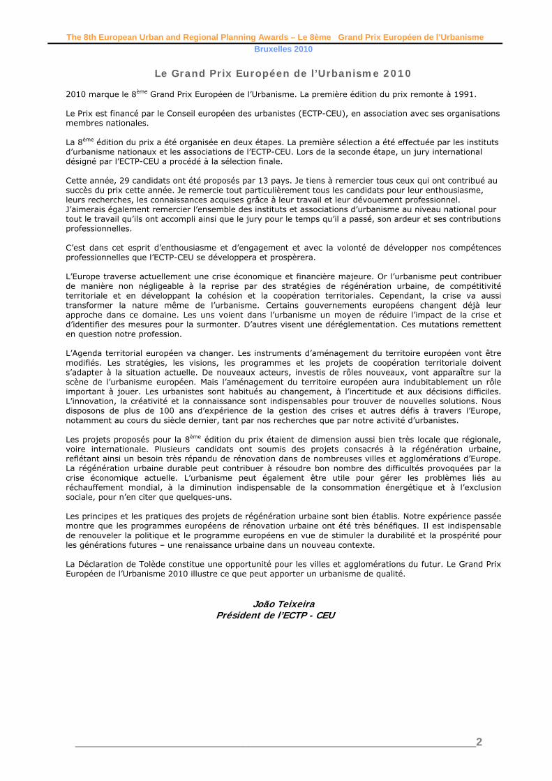
Entrant’s Project Description Once a city-state corseted inside its walls, Geneva is now a cross-border agglomeration of 800,000 people embracing two Swiss cantons and two French départements. Unsustainable development springing from decades of non-interventionism has now reached the point where housing and employment imbalances, the surge in car use and disparities in terms of services for residents demand urgent solutions.
However the area's de facto unity is in marked contrast with its institutional fragmentation. On this Swiss-Europe border there exists no authority capable of imposing a single "top-down" set of rules on its component parts: everybody might speak the same language, but the territory is and will remain subject to different laws, official bodies, calendars, etc.
The France-Vaud-Geneva Conurbation Project is the local "bottom-up" response to the problem: a contractual approach functioning within the joint framework of Swiss conurbation policy, French metropolis policy and a Major Project mounted by France's Rhône-Alpes Region. It bears simultaneously on spatial planning and service policies, with the modus operandi involving a steadily growing number of political, administrative and technical actors in shared supervision of the urban situation. A first relatively classical step has been the drawing up of a multi-purpose Conurbation Charter, signed in 2007 by 18 French and Swiss partners. This binding document lays down the overall conditions for sustainable, community-based development over the whole of the cross-border territory.The second, more innovative step is the honing of the Conurbation Project via local, thematic studies currently in progress. The urban project is driven by focus on
specific lines of development and is negotiated with many different actors, including municipalities and civil society. This renders it more concrete and provides support from an expanding collective base.
The local approaches consist of two-phase "test studies" entrusted to three teams of professionals, steered by "colleges" of politicians, technical experts, specialists and administrative departments, and submitted for discussion to round-tables open to civil society. Rapid implementation of eight such studies has resulted in formation of a cross-border "collective" of several hundred political, administrative and technical actors alert to conurbation issues and the benefits of joint development.
The thematic studies are enabling the ongoing shaping of a shared vision and enhancing consistency between partner territories' policies.
The third step will be a summary and consolidation of the approach: the launching of operational studies of rapidly definable strategic areas; creation of an updated "Conurbation Project 2"; and the establishment of a cross-border cooperation body (CCB).
Developed at several levels and honed by the multiple nature of its approach, the urban project functions as a laboratory and a lever for cross-border unity. A European Urban and Regional Planning Award will provide recognition for the France-Vaud-Geneva Conurbation Project and enhance its credentials, its reputation and its unifying capacity.

The 8th European Urban and Regional Planning Awards – Le 8ème Grand Prix Européen de l’Urbanisme Bruxelles 2010
________________________________________________________________________13
WINNER - LAUREAT Progetto Po – Plans, programmes and projects for the protection and
enhancement of the Po River in Piedmont. Jury Citation The River Po project was approved in 1995 and will be completed in 2010. It is a regional project involving regional government, nearly 80 local authorities and the management authority of the river park. The project has a strong focus on long-term sustainability of the river Po eco-system. It comprises policies for protecting the natural environment and the ecology of the river and its flood plains, for networking and integration of natural and cultural resources, diversification of land uses such as landscape features, agriculture and urban land use and for assessment and management of risks which might threaten the river and its environs. The Jury was impressed by the innovative and comprehensive approach to development of combined policies for river management and conservation of both natural resources and cultural heritage in the context of a large and economically expansive region. The project draws on a wide range of specialised expertise and it provides an excellent example of how planning can be effective in the development of a common direction and strategy in the context of a holistic perspective on the river system as an ecological system in which human settlements and are parts. The project is presented as a regional plan. Implementation depends on the formulation and implementation of a large number of detailed and local schemes. Success depends on consistency between the overall objectives for the region and the direction and results of individual local projects. The Jury felt that there was a high degree of consistency between objectives and results. In this perspective the Po project is also an outstanding example of effective governance and management.
Citation du jury Le projet du Pô a été approuvéautorisé en 1995 et sera achevé en 2010. Il s'agit d'un projet régional mettant en jeu le gouvernement régional, près de 80 autorités locales et l'autorité de gestion du parc fluvial. Le projet porte fortement l'accent sur la durabilité à long terme de l'écosystème fluvial du Pô. Il comporte des politiques de protection du cadre naturel, et de l'écologie du fleuve et de ses plaines inondables, de mise en réseau et d'intégration des ressources naturelles et culturelles, de la diversification de l'occupation des sols, comme des traits marquants du paysage, l'agriculture, l'aménagement de l'espace urbain et d’évaluation et dela gestion des risques susceptibles de menacer le fleuve et ses environs. Le jury a été impressionné par l'approche innovante et exhaustive en matière d'élaboration de d'aménagement des politiques combinées pour la gestion et la conservation du fleuvefluviales tant du point de vue des ressources naturelles que du patrimoine culturel, dans le contexte d'une grande région économiquement très étendue et en pleine expansion économique. Le projet s'appuie sur un large éventail d'expertise spécialisée et constitue un excellent exemple de la manière dont l'urbanisme peut être un outil efficace dans l'élaboration d'une orientation et d'une stratégie communes dans le contexte d'une perspective globale du système fluvial en tant que système écologique et dont les installationsdes implantations humaines font partie intégrante. Le projet est présenté sous forme de plan régional. Sa mise en œuvre est fonctiondépend de la formulation et de la mise en œuvre d'un grand nombre de projets détaillés locaux. Sa réussite dépend de la cohérence entre, d'une part, les objectifs globaux arrêtés pour la région et, d'autre part, l'orientation et les résultats de projets locaux individuels. Le jury a trouvé qu'il existait une très forte cohérence entre les objectifs et les résultats. À cet égard, le projet du Pô est également un exemple remarquable de gouvernance et de gestion efficaces.

The 8th European Urban and Regional Planning Awards – Le 8ème Grand Prix Européen de l’Urbanisme Bruxelles 2010
________________________________________________________________________14
Entrant’s Project Description The context of Progetto Po is the Po watershed basin (75,000 km2, 652 km of river), bounded by the Alps, the Apennines and the Adriatic Sea, one of the largest economic and productive areas in Europe, and the main theatre of Italian demographic, social and economic development. The Piedmont region encompasses 36% of the entire Po course and 40% of the whole basin.
Its problems - hydrological management and risks, pollution, environmental degradation, energy production - have a major impact on other parts of the basin and the Adriatic Sea. The “extensive” definition of the area of covers nearly 80 communes affected by the river’s dynamics over 2,000 km2; the “restricted” definition covering only 475 km2 may appear small, but its management has a strategic European inter-regional importance. This explains the complexity of the relationship between Progetto Po and regional and territorial planning for the whole basin, in particular the Po Basin Plan assigned to the care of the Basin Authority under Law 183 of 1989. Tthe conceptual and political background of the PTO is the Piano Regionale di Sviluppo. In the face of worsening ecological conditions and environmental risks, the Plan stated the need for policies linking hydrological and hydro-geological aspects with economics, infrastructure, settlement organization, land use, ecology, landscape, social and cultural aspects. The aim was to avoid the negative effects of sectoral and “emergency” policies. Meanwhile, the protection of the Po as one of the main ecological corridors of the European Ecological Network and as a basic resource for tens of millions of people called for special protection measures. A first step was taken in 1990 with the constitution of the River Po Park (“Sistema delle aree protette della fascia fluviale del Po”), covering the entire length of the river from the source in Monviso mountain to the border with Lombardy. The key principle is a very simple and ambitious one requiring freedom of river dynamics and evolution and more coherent and sustainable land uses and development patterns but avoiding, as far as possible,
any exacerbation of human pressures. Every other choice must be subordinate to this principle – in order of importance, these are: strategies for water quality and safety, protection of sensitive areas and ecological continuity, conservation of historic structure and enhancement of cultural heritage, responsible exploitation of agriculture and forestry, improvement of opportunities for accessibility and enjoyment of the river and its banks, and preservation and enhancement of river landscape. Given the complexity of the mosaic of the river landscape, with many varied and even conflicting interests and stakeholders, adhering to the basic principle requires a mix of different strategies, ranging from spatial separation whenever necessary to functional integration whenever possible. Emerging features Measured against the aims of the European Awards, the Po Project meets the following criteria: a) Sustainability: the Project tries to link
revitalisation of a threatened and degraded landscape (one that is nevertheless still rich in resources), with appropriate improvement of economic, social and cultural activities.
b) Originality and innovation: the Project proposes a radical shift in policies concerning river systems, fostering a holistic approach and introducing some innovative concepts (such as the FPF or the network paradigm), later applied in other contexts.
c) Quality of the professional work: the process of the Project implies a large use of innovative techniques, both in connecting efficiently the specialised analysis and understanding with the drafting of the plan, and in connecting a strategic approach with a normative approach.
d) Exemplary nature of the work: the Po Project - a powerful example of an integrated approach to the management of a large fluvial system - has already influenced planning and policies both at the national and regional level.
e) Planning role: the Project has proved that the planner’s work plays a crucial and irreplaceable role in steering governance strategies and connecting them effectively with specific interventions.

The 8th European Urban and Regional Planning Awards – Le 8ème Grand Prix Européen de l’Urbanisme Bruxelles 2010
________________________________________________________________________15
WINNER - LAUREAT Liverpool One. Regeneration, Renewal, Reinvention.
Jury Citation Citation du jury This is a large-scale project aimed at the transformation and regeneration of a run-down central city area in the context of a historically important urban environment. The Jury felt that the project was particularly successful in paying detailed attention to integrating the new development into the surrounding existing urban fabric and the historical townscape as a reference. The physical improvements comprise large-scale urban design of high quality while at the same time there is a high degree of sensitivity in relation to detail; not least in the way historic and well-known landmarks have been retained. The Jury also took note of the way in which new places have been made and how principles of mixed-use have been adopted in combination with a central city development. It provides a good example of how streets, collective open spaces, and linkages to other areas of importance and interest such as the river and the harbour contribute to the integration of the area into the surrounding area.
The Jury has also noted that this project represents the implementation of one of a number of projects in a strategy aimed at the regeneration of the city by reintroducing economic activity, job opportunities, services and other functions which will re-establish and revitalise the city as an attractive regional centre. The project was approved in 2004 and completed in 2008. Surveys show that the project has been given a favourable reception, the city has become more attractive to visitors, and a considerable number of new jobs have been created. The contributions of planners and planning are many. In particular the Jury noted that as a multifunctional hybrid scheme with a high degree of complexity and large dimensions, it was carried out with an impressive attention to detail, historical context and the surrounding urban environment at large. Its success has also been dependent on effective and close cooperation between the private and the public sectors. In this respect the project provides a good example of urban planning, management and governance.
Citation du jury Il s'agit d'un projet à grande échelle destiné à transformer et régénérer un centre-ville délabré dans le contexte d'un cadre urbain historiquement important. Le jury a trouvé que le projet a particulièrement bien réussi à accorder une attention détaillée à l'intégration des nouveaux aménagements dans le tissu urbain environnant existant en prenant comme référence le paysage urbain historique. Les améliorations physiques comportent d'excellentes réalisations de conception urbanistique d'art urbain de grande envergure, faisant preuve d'un très grand sens du d'une grande sensibilité dans l'attention au détail, notamment dans la manière de conserver les sites lieux d'intérêt historiques et emblématiques de la ville. Le jury a également relevé la façon dont les de nouveaux siteslieux ont été créés et dont les principes d'usage mixte ont été adoptés conjointement à un aménagement du centre-ville. On y trouve là un bon exemple de la manière dont les rues, les espaces collectifs non bâtis et les connexions à d'autres quartiers d'importance et d'intérêt (la rivière et le port, par exemple), contribuent à l'intégration de ce quartier dans la périphérieses environs. Le jury a aussi noté que ce projet faisaitfait partie de toute une série d'autres projets, s'inscrivant dans le cadre d'une stratégie destinée à la régénération de la ville en réintroduisant de l'activité économique, des opportunités d'emplois, des services ainsi que d'autres fonctions qui permettront de rendre à la ville son rôle de centre régional attrayant et de la revitaliser. Le projet a été approuvéautorisé en 2004 et achevé en 2008. Les enquêtes montrent qu’il que le projet a été reçu favorablement. La ville est devenue plus attrayante pour les visiteurs et un nombre considérable de nouveaux emplois y ont été créés. Les contributions apportées par les urbanistes et l'urbanisme sont nombreuses. Le jury a plus particulièrement relevé un programme hybride à fonctions polyvalentes affichant un haut degré de complexité et de grande envergure ; il impressionne par l'attention accordéequ'il accorde aux détails, au contexte historique et au cadre urbain environnant dans son ensemble. Il doit aussi sa réussite à une coopération efficace et étroite entre le privé et le public. À ce titre, le projet constitue un bon exemple d'urbanisme, de gestion et de gouvernance.

The 8th European Urban and Regional Planning Awards – Le 8ème Grand Prix Européen de l’Urbanisme Bruxelles 2010
________________________________________________________________________16
Entrant’s Project Description The large area covered by the scheme enabled the development to be broken down into a series of related character zones that allowed for a different appearance and ‘feel’, and also emphasised the intention that this should not be a shopping mall. These areas also allowed a strong rationale for a retail strategy based on variety, as well as adding to place-making. The anchor tenants of John Lewis and Debenhams were located to help the urban form of the overall development and to act as attractors, helping to increase footfall though the development and to provide a focus for connections beyond the scheme.
The scheme is grounded in Liverpool’s heritage- as part of the development the Old Dock was excavated by an archaeological team and the remains consolidated and put on show underground. The Old Dock can be viewed through a glass portal at street level, and it is planned to open up an underground visitor centre. The site was celebrated through a water-based public art feature consisting of open water and fountains, along with the lunar calendar that predicts tides, and the underground location of the Old Dock is picked out on the street surface in contrasting materials. The sandstone outcrop of the original hill is acknowledged through the red sandstone retaining wall that supports the new Chavasse Park at high level, thus recreating the original hill. The park itself is also informally divided into different character areas, allowing for events and community activities and also for quiet, solitary activities such as sitting and reading. It also allows for a choice of routes from the city centre to the waterfront, either at high level through the park or at lower level along the Discovery Axis. Surrounded by restaurants and bars, and offering direct access from the 14 screen cinema, the park is a meeting place and focus. It forms part of the dynamic ellipse that draws the built form together and provides a viewing corridor that focuses on the Albert Dock, drawing the eye of users and further encouraging connectivity. Important sight lines to other existing historic buildings were also key factors influencing the masterplan- there are framed views of the monumental Anglican cathedral, the lantern of Bluecoat Chambers, Liverpool’s oldest building, and long views of the
towers of the Liver Building, for many the emblematic building of Liverpool. This attention to detail and the fine-grained approach to a large retail development are what makes the project unique, and underlines the emphasis on linkages. Views of key landmarks that enable pedestrians to navigate around the city are complemented by new routes that ensure the traditional shopping streets of Church street and Lord Street are seen as part of the city’s retail and connections offer, and not subservient to the new Liverpool One. The arcades leading from the heart of Liverpool One to Church Street aid permeability and provide bespoke shopping areas that help to define the different character zones. Shop front guidelines for the whole of the development was provided to help further define character areas, and to help establish an internal rhythm and pattern, promoting human scale and helping to draw together the different designs of each of the building plots. Evaluation • The important heritage site of Albert Dock saw
an increase in visitors of over 46% with the opening of Liverpool One.
• Pedestrian flows on the traditional shopping streets of Church Street and Lord Street increased by over 40% when phase 1 of Liverpool One opened in May 2008.
• Prime Zone A rents outstrip neighbouring cities. Liverpool is now 5th in the UK retail hierarchy.
• The opening of Liverpool One has helped to increase visitor numbers to the city - 83% of those interviewed in a 2009 survey think that the city has improved, and of those, 91% intended to return.
• For the second consecutive year a Condé Nast survey places Liverpool the 3rd most favourite city for overseas visitors to the UK, behind London and Edinburgh.
• Liverpool One has created in excess of 3,000 temporary construction jobs and 5,000 permanent jobs for the local community via a local recruitment initiative, ‘Shop for Jobs’.

The 8th European Urban and Regional Planning Awards – Le 8ème Grand Prix Européen de l’Urbanisme Bruxelles 2010
________________________________________________________________________17
WINNER - LAUREAT Torino – the Town Plan. The linear centrality of the Central Spine.
Jury Citation The Jury was impressed with the implementation of a single large-scale infrastructure project. Essentially the plan was to cover over the railway line which effectively divides the city of Turin in two, but to combine this with a vision and plans for the regeneration of the city’s economic and cultural identity and to introduce new areas of development The planning profession was central to the integration of new infrastructure - a new road system on top of the existing railway – bringing new urban functions and landscapes and thus introducing a new centrality to the city. Improved accessibility across the central spine gives new vitality to central areas. It has facilitated the reuse of derelict sites for development of new central urban functions and extensive upgrading of existing facilities, buildings, parks and infrastructure. The process has led to the introduction of new economic activities notably in the fields of services, culture, education and research. The long-term decline in the city’s population has been halted. The project was introduced via the 1995 City Plan, approved in 1999 and scheduled for completion in 2013. It has involved a large number of private and public interests, land owners, other stakeholders and representatives of the affected communities as well as public authorities at various levels. The Jury noted the considerable complexity of interaction between the different interests. In the opinion of the Jury, successful implementation of the scheme is a reflection of good planning, management and governance.
Citation du jury Le jury a été impressionné par la mise en œuvre d'un projet d'infrastructure unique de grande échelle. À la base, il s'agissait de recouvrir la ligne de chemin de fer qui coupe en deux la ville de Turin, tout en combinantmais de combiner cela à une vision et des plans visant à la régénération de l'identité économique et culturelle de la ville, et à l'introduction de nouvelles zonesnouveaux domaines d'aménagement. Les urbanistes ont joué un rôle capital dans l'intégration de la nouvelle infrastructure (à savoir, un nouveau système routier surmontant la ligne de chemin de fer existante), en apportant de nouvelles fonctions urbaines et de nouveaux paysages, et en introduisant par là-même une nouvelle centralitéun nouveau cœur central à la ville. L'amélioration de l'accès sur l'artère centrale apporte un regain de vitalité aux quartiers du centre-ville. Le projet a permis de réutiliser des facilité le remploi de sites abandonnés pour développerles aménager en leur donnant de nouvelles fonctions urbaines centrales et d’engagera engagé d'importants travaux de rénovationremise à neuf des installations, immeubles, parcs et infrastructures déjà présents. Ce processus a eu pour effet d'introduire de nouvelles activités économiques, notamment dans le domaine des services, de la culture, de l'éducation et de la recherche. Le déclin de la population de la ville, entamé dedepuis longue date, a été enrayérésorbé. Le projet a été introduit par le plan urbain de 1995, approuvéautorisé en 1999 et devrait il est prévu de s'achever en 2013. Il a fait appel à un grand nombre d'intérêts privés et publics, à des propriétaires fonciers, d'autres partenairesdépositaires d'enjeux et
des représentants des communautés concernées ainsi que des pouvoirs publics à divers niveaux. Le jury a relevé la grande complexité considérable des interactions qui ont existé entre les différents intérêts. De l'avis du jury, la réussite de la mise en œuvre du projet atteste de la qualité de l’urbanisme, de lasa planification, de sa gestion et de lasa gouvernance.

The 8th European Urban and Regional Planning Awards – Le 8ème Grand Prix Européen de l’Urbanisme Bruxelles 2010
________________________________________________________________________18
Entrant’s Project Description 1. The City Along the Railway Line Throughout the 20th century the north-south railway route across the city - dating back to the end of the 19th century had a strategic influence on development of the city and areas located at the edge of a highly accessible road system. It was also a strong separating element in the city: a limit and a break. The starting point of the major process of urban renewal– indeed, a precondition for that renewal - is the project to restructure the railway junction, to strengthen transit of goods and passengers at urban and regional level and to introduce of high-speed trains. The project involves lowering of the surface railway lines below ground for 15 km and siting a boulevard - the ‘Central Spine’ over the railway. The Central Spine project within the Land-use Plan seizes the opportunity offered by restructuring the railway junction for powerful urban renewal. Instead of being a disruptive element the railway now facilitates connectivity thanks to the creation of the boulevard and new stations. The Central Spine runs for about 8 km from north to south across the city, and its sections, stations, squares, wide stretches and cycle tracks make it a vital part of public realm renewal. It has created a new urban landscape.
2. The Land-use Plan and the Road Network of the Central Spine Within the Land-use Plan, the Central Spine is the hub of the new ‘linear centrality’ of the city. It is a strategic territorial resource for the new city identity established on the foundation of its industrial
heritage. The Land-use Plan identifies abandoned industrial areas located along the underground railway link as strategic elements allowing the introduction of new stations and the boulevard, the main elements of accessibility. These areas include the university, cultural facilities and parks. They are important centres of excellence and will contribute to urban recovery in environmental, cultural, social and architectural terms. These initiatives aim to turn the trend from decay to improvement in the central part of the city. The strategy aims to create linearity through physical, functional and morphological integration of territories once separated by the railway. The two parts of the city will become one, reinforcing their strengths and creating opportunities for the development of the city as a whole. The innovative element of this strategic vision relies on a transport solution allowing the creation of a new centrality which gives an added value to all urban interventions. First, by covering the railway route and creating a boulevard; an important tool was created to enhance the city’s environment, image and over all quality. Second, in terms of ltransport, there is an opportunity to improve both the railway and a new urban accessibility system deriving from the new urban and regional road network. At the same time, urban public transport is extended and modernised via the opening of the first metro line. Shortly, the creation of a second line will be under way. Both have links to the railway. The objective is a considerable reduction in private vehicular traffic. 3. Accessibility and Urban Renewal Projects The key point about the Spine and its extension across the city is the continuity of urban renewal along the highly accessible road system. The four sections of the Central Spine are the most important complex of convertible dismantled industrial areas, covering about 2 million m² of urban space. Within this area various mixed-use interventions exceeding 1 million m² of built-up area are in progress. The projects will provide new housing, commercial activities, services, high value-added production facilities, research centres and more. Railway stations will become important nodes connecting the new urban layout and its functions with efficient public transport. Furthermore they will connect the modernised railway service at urban, metropolitan, regional and international level. The construction of a new railway line to the city airport is also in progress. Each transformation section will be served by at least one new or modernised station. The number of railway stations will increase from 4 to 6. Each station will become meeting places, provide amenities for the area, space for services and promoting human relations in new neighbourhoods under construction. Thanks to the transformation of the Central Spine areas, important benefits have been obtained not only

The 8th European Urban and Regional Planning Awards – Le 8ème Grand Prix Européen de l’Urbanisme Bruxelles 2010
________________________________________________________________________19
In terms of landscape value and urban image: they have brought back to life large areas of the city and its citizens by creating new public facilities, parks, public spaces and cultural facilities of considerable size and interest. With the creation of new housing, a programme for building social housing at reasonable prices was approved to meet demand for accommodation of various types. As a result, Turin is no longer experiencing demographic decline. After thirty years when people moved out of the central city to the surrounding areas, there is a marked return to Turin, with positive effects on demography, partly attributable to emergence of valuable real estate served by good facilities. Meanwhile the city moved from de-industrialisation to re-industrialisation projects in IT systems, research, etc. facilitated by recovery and restoration of old industrial buildings of considerable architectural prestige bearing witness to the glorious industrial past of the city. Culture and professional training are boosting development. In collaboration with private partners, the city invests in initiatives in areas along the Spine, creating high-level exhibition and cultural spaces for the benefit of the city and its region. Strengthened education and research, combined with increased availability of accommodation, is a strategic objective to attract students, researchers and staff from other regions and countries. Linking education and business, has made the scientific and cultural milieu more dynamic and competitive.
The Central Spine initiative stands out in Europe because of the sheer scale of recovery of brown field land in the core of a city. It is also unique in terms of its complexity and time-scale, as a lengthy process involving several different actors both during the decision-making phase and the operational phase involving institutional private and public bodies, entrepreneurs etc. The process has taken more than 10 years. Moreover, the city has played a fundamental role in organising and coordinating implementation of the operational phase using public financial resources and considerable private funds. The process has now reached its final stage. It demonstrates real cohesion of the urban vision and the planning process.
4. Conclusions and References to the New Athens Charter 2003 The decision to direct the planning process exclusively towards already urbanised areas, the improvement of external and internal accessibility of the city and the creation of a new centrality has opened up a real regional and urban network, with the power to re-build economic and social prosperity. The implementation of several plans led to new forms of participation and representation of the communities concerned, improving communication and interaction with citizens, giving all the people -residents and users - the chance to express their opinions on the future development of the city. The recovery of the areas along the Spine allowed innovative approaches and procedures in urban planning to be tested out, from land reclamation to the reuse of brown field land, from the development of large areas for parks and public spaces, to the improvement and optimisation of networks and utilities. Infrastructural improvements comprise district heating, waste management programmes, projects to reduce energy consumption and the use of non-renewable resources. The testing of new procedures and operational tools over the last ten years created a favourable environment for establishing and reinforcing best practice in the field of governance and management of urban transformation, by optimising relations between the private and public sectors to the benefit of the public interest and of all involved. This has led to the creation of a cadre of skilled professionals
working as private agents or employees in the public sector (planners, architects, engineers, economists, landscape architects, experts in environmental issues), all able to work together in an integrated way during the various stages of analysis, planning and implementation. Experience derived from the Spine and other important projects has led to new forms of collaboration and co-operation operating beyond the mere municipal level (by structuring a Strategic Plan), based on the conviction that the city needs innovative projects in order to overcome decline and become truly competitive. These projects can only arise from an intense exchange between a wide variety of actors at different levels of government. It is very important to combine
different specialisations with strategic operational guide-lines and diversified targets aiming at the realisation of infrastructural interventions of urban recovery; in turn that implies investment in various sectors such as tourism development, culture and city promotion, to support economic development and business competitiveness. The vision and the many projects linked to the Central Spine are an example of the core values of the New Athens Charter, in particular with regard to the Charter’s innovative emphasis on territorial cohesion, economic and social integration, interconnection between cities and territories as for the development of networks and respect for environment. Turin has become a real Connected City.

The 8th European Urban and Regional Planning Awards – Le 8ème Grand Prix Européen de l’Urbanisme Bruxelles 2010
________________________________________________________________________20
WINNER - LAUREAT The Transformation plan for La Mina neighbourhood in the Barcelona conurbation
Jury Citation In the opinion of the Jury, the plan for the transformation of the La Mina neighbourhood, a large peripheral housing estate, merits the award for its achievements. It combines strategies for dealing with particularly complex social issues in a very deprived area with strategies for changing and improving a dilapidated and run-down urban environment. The project - approved in 2002 - is scheduled to be completed by 2011. The transformation strategy is based on three basic principles for development of central places to create identity, the introduction of greater social, economic and physical diversity and increased exchange or interaction between individuals as well as between groups. The social action plan seeks to achieve stronger and more robust communities with a more differentiated social mix. It comprises job placement programmes and schemes to involve the local population through participation in community development programmes. The plan includes selective renewal and renovation schemes for the housing stock. Considerable effort has been made to reduce social segregation stemming from the nature of the local housing market while seeking to enable the population to remain within the area. The urban fabric is going through a total restructuring. A core element in the process is the introduction of a central promenade, a rambla, as an axis along which new facilities are established: public and private services, education, culture and health facilities. The rambla will also serve as a means of integrating La Mina in a wider context through general infrastructure improvements and improved public transport. Physical changes in the area will create a greater sense of a traditional urban environment and identity rather that of a large peripheral housing estate. La Mina is located on the administrative boundary of the city. The policies are therefore dependent on close co-operation between the city and its neighbour. The solution has been to create a consortium with a wide-ranging mandate. The success of the project is dependent on co-operation with the local population of more than 33,000 people. To that end, a permanent channel for involvement and participation of the local residents has been established.
Citation du jury De l'avis du jury, le plan de transformation du quartier de La Mina, grand lotissement résidentiel périphérique, mérite son prix pour les accomplissements qu'il a réalisés. Il allie des stratégies de traitement de des problèmes sociaux particulièrement complexes dans une zone extrêmement défavorisée à des stratégies de changement et d'amélioration d'un cadre urbain délabré. Le projet, approuvéautorisé en 2002, devrait est programmé pour s'achever en 2011. La stratégie de transformation s'appuie sur trois principes de base pour l'aménagement des lieux centraux : créer une identité, introduire une plus forte diversité sociale, économique et physique, et renforcer les échanges ou interactions entre les individus ainsi qu'entre les groupes. Le plan d'action sociale cherche à établir des communautés plus fortes et plus soudées, au affichant un mix social plus différentié. Il comporte des programmes d'embauche et d'autresd’autres destinés à obtenir l'adhésion de la population locale au projet en la faisant participer aux programmes de développement d'action sociale au sein du quartier. Le plan comporte des programmes de renouvellement et de rénovation sélectifs despour les immeubles. Des efforts considérables ont été engagés pour réduire la ségrégation sociale qui est due à la nature du marché immobilier local, tout en cherchant à permettre à la population de rester dans le quartier. Le tissu urbain est en train de connaître une restructuration fondamentale. Un élément essentiel au processus tient à l'introduction d'une promenade centrale, une rambla, qui sert d'axe le long duquel de nouvelles installations sont implantéesétablies : des services publics et privés, des installations à des fins pédagogiques, culturelles et de santé. La rambla servira aussi de moyen d'intégration du quartier de La Mina dans un contexte plus large, par des améliorations générales apportées à l'infrastructure et aux transports publics. Les changements physiques survenus au sein du quartier éveilleront un sens renforcé d'environnement et d'identité urbains traditionnels, plutôt que de ressembler à un grand lotissement résidentiel en périphérie.
La Mina se situe à la périphérie administrative de la ville. Les politiques engagées dépendent par conséquent d'une coopération étroite entre la ville et son voisin. La solution trouvée a consisté à créer un consortium doté d'un mandat de grande amplitude. Pour que le projet réussisse, il faut qu'il obtienne la coopération de la population locale qui se chiffre à plus de 33 000 personnes. Dans ce but, un réseau de contact permanent veillant à l'implication et à la participation des résidents locaux a été mis en place.

The 8th European Urban and Regional Planning Awards – Le 8ème Grand Prix Européen de l’Urbanisme Bruxelles 2010
________________________________________________________________________21
Entrant’s Project Description The Transformation Plan of La Mina neighbourhood proposal aims to go beyond urban renewal, embracing a wide perspective in which social, economic, cultural and urban aspects. It is a holistic project geared to open up a new scenario of habitability. La Mina neighbourhood was created in 1969 as part of a campaign to eradicate slum areas of the Barcelona metropolitan area. Deprivation was endemic. Its inhabitants were marginalised geographically, socially, physically and economically, making La Mina a text-
book example of conflict. La Mina neighbourhood was designed mainly to rehouse people who had settled in shanty towns and slums around the Barcelona seafront. The area had a significant Romany population, and over a period of nearly thirty years (1972-2000), it was the subject of repeated attempts at transformation ranging from total demolition to simple restoration. The process created distrust and scepticism about government initiatives. The strategy for urban transformation entails a radical intervention: a central “opening-up” of facilities. It is about undoing in order to generate new living conditions. It is about recycling to optimise a poorly organised urban space. The proposed transformation called for the establishment of a new flexible and open framework on which to graft the necessary regeneration and revitalisation strategy for the neighbourhood. The content of the transformation, in terms of urban planning, is based on the construction of an urban ‘zip’ defining a new centrality. This will support and
nurture new and existing buildings, will be the place for new civic, social, economic and cultural activities and a pedestrian link from Besòs Park to the seafront. This new urban model is based on the three basic principles: centrality, diversity, exchange.
1. CENTRALITY: Central places confer identity on cities. They are quintessential spaces for community activities, spaces where public buildings are especially prominent, spaces for communication, commerce and culture.
2. DIVERSITY: The principle of diversity is significant in the city and should ensure the greatest possible richness of relationships among its components.
Diversity must be present at all levels: social, physical; and economic. EXCHANGE: Understood as a basic principle of relationships, essential to prevent stagnation, decay and consequent social disruption, which could lead to the isolation of any human group. “Opening the neighbourhood” means taking action to transform the urban fabric, reconnecting its civic functions with other neighbourhoods. The “opening-up” is completed through the construction of a new 40-metre wide promenade - a Rambla a tree-lined urban promenade characteristic of Catalonia. The short distance between the wide pavements, the large central avenue,
the slight slope toward the sea, and the views framed by the arching trees will make this high-street boulevard a new vibrant place for social relationships and activities. This new Rambla will also be an appropriate space for improving the public transport network via the tram which will cross the centre of the neighbourhood, breaking into its isolation and exclusion and linking La Mina with the whole metropolitan city.

The 8th European Urban and Regional Planning Awards – Le 8ème Grand Prix Européen de l’Urbanisme Bruxelles 2010
________________________________________________________________________22
Promoting social cohesion will be achieved by fostering new economic and social activities, along with a diversity of residential typologies and users. This will ensure spaces for inclusion and social mixing, the basis of sustainable urban planning, both from the ecological and the social point of view. New facilities and housing long La Mina’s new central walk will foster demographic and social diversity. An optimal location will be sought to boost social relationships between the neighbourhood and the city. Existing local facilities will give up their central location in favour of new key buildings providing health, culture and civic facilities. Public buildings will be re-sited to make best use of land without loss of capacity to generate activity and remaining consistent with the new urban granularity of the proposal. A new approach to housing will see a move away from principles of minimum occupancy and maximum release of land advocated by the projects of the age of Modernism. The open space proposal prioritises quality of urban space over quantity, promoting relationships and contacts between residents, generating complicities and complexities in the new urban layouts. The proposal bids for an intensive mixture of typologically and spatially diverse dwellings, occupied by current and new residents and a significant presence of complementary economic activities. The concept of "physical compactness” is a complex way of defining spatial continuity and discontinuity in areas based on distance and relationships, as well as the quality and consistency of the spaces between them. Work on existing housing in La Mina, always neglected in earlier proposals, focuses on the need to improve the environment. Special emphasis will be placed on stairways, improvement of living conditions, provision of lifts and selective substitution of properties to achieve an ‘acupuncture’ effect. In September 2000, the Consortium for La Mina Neighbourhood was formed by the municipalities of Sant Adria de Besòs and Barcelona, the Generalitat of Catalonia and the Barcelona Provincial Council, to lead, coordinate and deliver the transformation plan during the initial period of 2000-2010. The drafting of the plan was commissioned by Barcelona Regional government. This statutory planning instrument, the PERM, is intended to steer the transformation of the neighbourhood. It is based on three reports: the social and anthropological framework, the technical assessment of the condition of existing buildings, and the scenario summary report. These documents form the basis of the Transformation Plan of La Mina
neighbourhood were elaborated by Jornet-Llop-Pastor architects with the collaboration of Marcela Balliano. Since the adoption of the Transformation Plan, more than 80% of the planned delivery projects have been implemented. The district is in the final stretch leading to construction of 422 new social housing units. Works are almost complete: the boulevard, streets and public transport are in place. Reorganisation of urban space will define the new centrality of the neighbourhood. The works reflect the highest quality standards of a city hub. The majority of the facilities provided are already in place. Renovation of existing buildings is under way with all the new lifts of La Mina Vieja in place. This includes 30 lifts, co-financed by the local council and residents), and a significant part of the lobby renovation and distribution works of La Mina Nueva have been executed. The Transformation Plan was followed by the Social Action Plan, with an annual investment of on average €3 million. It has seven main sections: education and employment, work-life balance, economic development, participation and community development, improvement of civic values and co-
existence, social and education support, and public space and civic responsibility. Over seventy actions and programmes have already been undertaken. Employment programmes have yielded results: more than 2,700 people have benefited and 1,763 people have found jobs, with special attention being paid to programmes to treat drug addiction, and employment of disabled people and the Roma community. Family social services have been strengthened to reconcile tensions between work and family life, and to facilitate the access of women to the job market, improving the domestic economy. Other measures are aimed at environmental awareness, co-existence and civic responsibility. This community now looks to the future with new eyes: the transformation is now a reality.
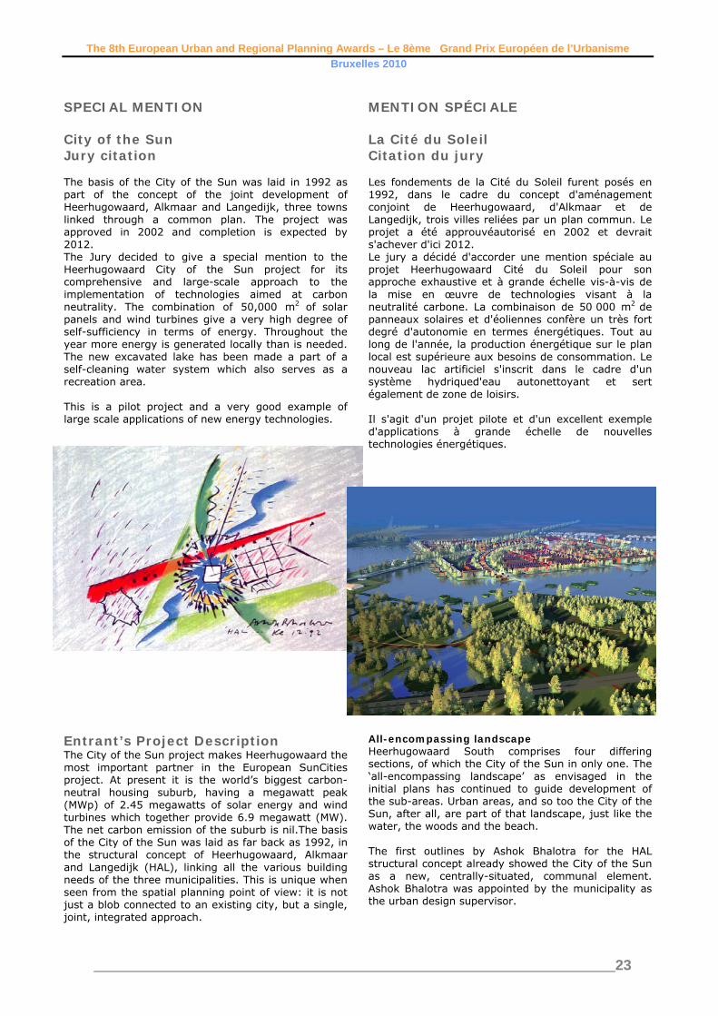
The 8th European Urban and Regional Planning Awards – Le 8ème Grand Prix Européen de l’Urbanisme Bruxelles 2010
________________________________________________________________________23
SPECIAL MENTION City of the Sun Jury citation The basis of the City of the Sun was laid in 1992 as part of the concept of the joint development of Heerhugowaard, Alkmaar and Langedijk, three towns linked through a common plan. The project was approved in 2002 and completion is expected by 2012. The Jury decided to give a special mention to the Heerhugowaard City of the Sun project for its comprehensive and large-scale approach to the implementation of technologies aimed at carbon neutrality. The combination of 50,000 m2 of solar panels and wind turbines give a very high degree of self-sufficiency in terms of energy. Throughout the year more energy is generated locally than is needed. The new excavated lake has been made a part of a self-cleaning water system which also serves as a recreation area. This is a pilot project and a very good example of large scale applications of new energy technologies.
MENTION SPÉCIALE La Cité du Soleil Citation du jury Les fondements de la Cité du Soleil furent posés en 1992, dans le cadre du concept d'aménagement conjoint de Heerhugowaard, d'Alkmaar et de Langedijk, trois villes reliées par un plan commun. Le projet a été approuvéautorisé en 2002 et devrait s'achever d'ici 2012. Le jury a décidé d'accorder une mention spéciale au projet Heerhugowaard Cité du Soleil pour son approche exhaustive et à grande échelle vis-à-vis de la mise en œuvre de technologies visant à la neutralité carbone. La combinaison de 50 000 m2 de
panneaux solaires et d'éoliennes confère un très fort degré d'autonomie en termes énergétiques. Tout au long de l'année, la production énergétique sur le plan local est supérieure aux besoins de consommation. Le nouveau lac artificiel s'inscrit dans le cadre d'un système hydriqued'eau autonettoyant et sert également de zone de loisirs. Il s'agit d'un projet pilote et d'un excellent exemple d'applications à grande échelle de nouvelles technologies énergétiques.
Entrant’s Project Description The City of the Sun project makes Heerhugowaard the most important partner in the European SunCities project. At present it is the world’s biggest carbon-neutral housing suburb, having a megawatt peak (MWp) of 2.45 megawatts of solar energy and wind turbines which together provide 6.9 megawatt (MW). The net carbon emission of the suburb is nil.The basis of the City of the Sun was laid as far back as 1992, in the structural concept of Heerhugowaard, Alkmaar and Langedijk (HAL), linking all the various building needs of the three municipalities. This is unique when seen from the spatial planning point of view: it is not just a blob connected to an existing city, but a single, joint, integrated approach.
All-encompassing landscape Heerhugowaard South comprises four differing sections, of which the City of the Sun in only one. The ‘all-encompassing landscape’ as envisaged in the initial plans has continued to guide development of the sub-areas. Urban areas, and so too the City of the Sun, after all, are part of that landscape, just like the water, the woods and the beach. The first outlines by Ashok Bhalotra for the HAL structural concept already showed the City of the Sun as a new, centrally-situated, communal element. Ashok Bhalotra was appointed by the municipality as the urban design supervisor.

The 8th European Urban and Regional Planning Awards – Le 8ème Grand Prix Européen de l’Urbanisme Bruxelles 2010
________________________________________________________________________24
Sustainability The development of the City of the Sun is a breakthrough in the field of sustainability. The energy required by the suburb is mainly generated sustainably. In the mid-1990s, solar energy was still an expensive investment, and on a global scale there
were few manufacturers. Moreover, there was little knowledge of how to apply this in larger living environments; builders and architects were reluctant to apply it. There was also a rather negative attitude to siting of wind turbines in a housing environment. Over time reservation transformed into perseverance. Managers, municipal authorities, market parties, developers, contractors, supervisors and architects were adamant about it, even when there was a reduced interest in sustainability. The ‘seized’ quadrant Within the City of the Sun the quadrant known as the Carré, ‘seized’ from the strip-parcelling of the polder landscape, is actually the carbon neutral portion. Active solar power is delivered by solar panels on the roofs of houses and various facilities. A major portion of the housing, especially in the Zonnestelsel [solar system] area in the City of the Sun, is south-facing. For residences which are not directly south-facing, collectors have been incorporated in the façade or placed at right angles. The solar panels on the roofs of the residences and buildings in the entire HAL area cover a total surface area of 50,000 m2. In time, residents of the solar homes will own the system and will therefore own the generated energy. The surplus, approximately 44% on an annual basis, is returned to the mains grid. Other measures for making the suburb carbon neutral are construction of energy-efficient houses (‘ISO++’ houses) and future placement of wind turbines. Water Site preparations for the City of the Sun began in 2003 and the lake was excavated. In this way a stretch of 75 hectares of open water was created. The lake is at a higher level than the surrounding polder water-level, and any seepage is driven back. The quality of the water is good enough to swim in. It forms part of a self-cleansing water circuit, a
dedicated water system for Heerhugowaard South, which is separated from the other water systems in the polder. In periods of excessive rainfall, the water can be buffered which keeps the water in the area. This also happens in the ‘flow labyrinth’, an area of small pools. In future this labyrinth will be a highly-developed wetland maze of canoe routes. Woods with footpaths, a mountain biking trail and a water ski course are also planned. This combination of a housing suburb with a recreational area was particularly difficult to achieve. Among the major challenges were the access roads through green space in combination with the various water systems. And looking to the future, the existence of a polluting housing suburb wil mean that it will require a greater effort to keep the area and the water clean. Attractive housing area All decisions are based on the quality, sustainability and coherence in the development of the whole area. The uniqueness of the project is not specifically because of the revolutionary new techniques. Solar panels, solar boilers, combined heat and power and other sustainable techniques already exist. The City of the Sun add nothing new. The uniqueness lies in the scale and in the interpretation of the definition of sustainability. This is also the focus in the development of the green space and water plans in the suburb, but especially sustainability in the sense of a coherent housing and
living community. In each area a mix of housing categories has emerged for the sake of sustainable social construct. Many residential streets have been made traffic-free by making use of special small inner areas or backyards for parking. The pedestrianised residential streets are fitted out with extra greenery, special paving or playground equipment. The central area of the Carré is also the central amenities and facilities area for the entire suburb of the City of the Sun. These purposeful and consistently executed ideas make the City of the Sun in Heerhugowaard South an attractive housing area. The first residences of the Carré were built in early 2004. It is expected that the last portion of City of the Sun will be completed by 2012.

The 8th European Urban and Regional Planning Awards – Le 8ème Grand Prix Européen de l’Urbanisme Bruxelles 2010
________________________________________________________________________25
SPECIAL MENTION Nagykanizsa – linking urban spaces. Jury citation The Jury was impressed by the way in which the municipality has reshaped and strengthened the image of the town’s public spaces using a systematic upgrading of infrastructure and traffic systems as a starting point and an opportunity to intervene. The basic aim of the project is to integrate and unify important urban spaces and functions in the centre of the town. It seeks to establish new connections and links between a series of important public spaces, functions, buildings and facilities. The project has a strong emphasis on traffic engineering and management, and on landscape planning. The Jury noted particularly that the project paid considerable attention to detail to ensure good quality in the final result. It is expected to result in calmer traffic flows, reduction in through traffic, and provision of more space for pedestrians and cyclists. It is the opinion of the Jury that the project succeeds in combining heavy infrastructural intervention with a clear strategy for the development of the town centre. It will improve accessibility for the public at large and raise the general aesthetic and environmental qualities of the central urban area.
MENTION SPÉCIALE Nagykanizsa – connexion des espaces urbains Citation du jury Le jury a été impressionné par la façon dont la municipalité a refaçonné et renforcé l'image des espaces publics de la ville, en employant une stratégie systématique de modernisation des infrastructures et des systèmes de circulation comme point de départ et comme moyen d'intervention.d’intervention. À la base, le projet vise à intégrer et à unifier des espaces et des fonctions urbains importants dans le centre-ville. Il cherche à établir de nouvelles connexions et de nouveaux liens entre toute une série d'espaces publics, de fonctions, de bâtiments et d'installations de grande importance. Le projet insiste tout particulièrement sur l'aspect technique et la gestion de la circulation et sur l'aménagement du paysage. Le jury a particulièrement relevé que le projet avait accordé énormément d'attention au détail pour veiller à la bonne qualité du résultat final. On s'attend à ce qu'il limitecalme la circulation, réduise le trafic de passage et fournisseprévoie davantage d'espace auxpour les piétons et aux cyclistes. Le jury est d'avis que le projet est parvenu à combiner une intervention lourde en termes d'infrastructures à une stratégie claire pour le développement du centre-ville. Il améliorera l'accès au public dans son ensemble et renforcera les qualités esthétiques et environnementales générales du quartier urbain du centre-ville.

The 8th European Urban and Regional Planning Awards – Le 8ème Grand Prix Européen de l’Urbanisme Bruxelles 2010
________________________________________________________________________26
Entrant’s Project Description Historic development of Nagykanizsa and its place in the Hungarian urban network Nagykanizsa in south-west Hungary lies in a beautiful area with thermal springs, forests and game. It is located at the interchange of motorways connecting Budapest with the south side of Lake Balaton and the future M9 motorway. Croatia, Slovenia, Austria are within reach, while Sármellék Airport is 35 km away and Lake Balaton – the Hungarian inland sea – is only 40 km from the town. In the second half of the 19th century, taking advantage of its favourable location and good traffic connections, the town started to flourish and became a significant trade centre. In those days most of the grain from Bánság was delivered to the ports of Fiume
by the merchants of Nagykanizsa. Following the Trianon Treaty ending the First World War, Nagykanizsa became a border town and lost its most important markets as well as 60-70% of its economic catchment area. The disappearance of merchants in the Second World War and the Cold War with Yugoslavia led to years of stagnation. The industrialisation of the Fifties brought about significant changes turning the town into the centre of oil production in Zala County. Tungsram (later Egyesült Izzó) brought the national fluorescent lamp production centre to Nagykanizsa. However, the exhaustion of Hungarian oil fields and the political-economic changes of the Nineties resulted in the radical loss of industrial jobs in the town. The proposed modification of the town structure in line with the development of the national trunk road system The last 30 years have brought significant changes to the traffic system in the town. In the Eighties, Trunk Road 7 was moved from the centre to north of the town. Roads No. 74 and 61, leading to the county town of Zala County and Kaposvár, county town of
neighbouring Somogy County, were also moved out of the town centre. The M7 was opened to traffic in 2009. National and international traffic now bypasses the town. The changes in traffic systems have not worsened the accessibility of Kaposvár. The rearranged traffic system provided an opportunity for environmental renewal in the downtown area. At the same time, the value of vacant industrial land rose due to good accessibility and logistic conditions. The arrival of General Electric succeeding Egyesült Izzó resulted in the development of an industrial park with modern infrastructure. Venture capital plays a significant role in the spectacular renewal of the buildings in the city centre (reconstruction of shops, banks, restaurants and courtyards). The role of the State and local government is to set conditions, frameworks and guidelines for the development forces by creating and enforcing modern structural and regulatory plans. On the other hand, local government is supposed to participate in re-shaping the town by infrastructure development. The leaders of the town have to lead the changes by upgrading public spaces and creating positive synergies. The attractiveness of the town centre has a decisive impact on the competitiveness of Nagykanizsa, on income from tourism and on the number of jobs. The time has come to reconstruct and revitalise the downtown area. This process and the renewed environment will increase employment and improve living conditions. Now that the M7 is complete, Nagykanizsa should become more attractive and encourage travellers to stop in the town. This requires private and business targets of proper number and weight, otherwise the
only benefit brought by the motorway will provision of a fast traffic corridor. Tourism – national as well as international – is becoming more and more important for Nagykanizsa. A further goal is to increase the attractiveness of the town both in Hungary and abroad. The improvement of environmental conditions in the centre targets sustainable development and creates significant cohesive force for small enterprises in the region.

The 8th European Urban and Regional Planning Awards – Le 8ème Grand Prix Européen de l’Urbanisme Bruxelles 2010
________________________________________________________________________27
The characteristics of the town centre, changes in the urban structure The most significant buildings in the centre are the Vasemberház (Iron-man house) reflecting the history of trade, the Kereskedelmi Kaszinó (Trade Casino), the Bazár Udvar (Market Yard), the Dél-zalai Takarékpénztár (Savings Bank), the Biztosító Palotája (Insurance Company Palace) and the Pénzügyi Palota (Palace of Finance). All these buildings are located on the Fő (Main) road. Squares of national significance adjoin the Main road (Eötvös, Széchenyi, Deák and Erzsébet Squares) with valuable building stock and planting. Erzsébet Square has long been considered as the “Main Square”, both in terms of public administration and everyday life. The Mayor's Office, the Court, a hotel, banks, restaurants and tea-shops are all located here. (The square is often closed for traffic when important community events are being held there.) Building façades and fine art items that are the most valuable assets of the town in terms of architecture, statues and monuments are concentrated on these
squares. They are the creations of Hungarian artists including István Medgyaszay, Dezső Hütl, Alfréd Jedrassik and the sculptors Zsigmond Kisfaludi Stróbl, János Istók and György Zala. The above elements of the urban structure had been placed along roads No. 7, 61 and 74 which used to pass through the town centre. The Main road (trunk road No. 7) was the connection to the Hungarian capital city Budapest, while the road on the south side of Erzsébet Square (road No. 61) led to neighbouring Somogy County. Trunk road No. 74 connecting Kaposvár with Zalaegerszeg, the county capital, used to connect to the Main road right in the heart of the town at Erzsébet Square. All these national trunk roads have bypassed the town for 10 years now and even the M7 motorway has now been completed. However, due to the lack of further traffic control measures, significant (and unnecessary) traffic remained on the Main road and other streets e.g. on the south side of Eötvös Square.

The 8th European Urban and Regional Planning Awards – Le 8ème Grand Prix Européen de l’Urbanisme Bruxelles 2010
________________________________________________________________________28
SPECIAL MENTION Promenade Verte Région Bruxelles-Capitale Jury citation The Jury consider the merit of this scheme to be an important contribution towards the greening of a large urban area. It is a part of a larger plan to create a continuous landscaped itinerary linking isolated green spaces, sports and leisure areas as well as a range of varied elements of architectural, social and commercial interest surrounding the entire city region of Brussels. The scheme also comprises brownfield sites, disused railway land and other derelict land which will be restored gradually. Its functions are social as well as ecological as it will provide walkways and cycle paths and facilitate mobility for a wide range of users. The scheme integrates a range of environmental disciplines including ecology, landscape architecture and transport in an overall strategic plan. It is the opinion of the Jury that the project may serve as an excellent reference for the development of city-wide plans and projects concerned with green urban structures elsewhere. MENTION SPÉCIALE
Promenade Verte Région Bruxelles-Capitale. Citation du jury Le jury considère que le mérite de ce projet est d'apporter une contribution importante à l'aménagement d'espaces verts d'une grande zone urbaine. Il s'inscrit dans un plan de plus grande envergure, destiné à créer un itinéraire paysagé continu reliant des espaces vertes isolés, des zones de sports et de loisirs, ainsi que toute une succession d'éléments variés d'intérêt architectural, social et commercial qui entourent l'ensemble de l'agglomération urbaine de Bruxelles. Le projet comporte également des zones de friche industrielle, du terrain ferroviaire abandonné et d'autres sites abandonnés qui vont être progressivement restaurés. En plus d'être écologique, il remplit des fonctions sociales en aménageant des passages pour piétons et des pistes cyclables et en facilitantfacilitera la mobilité pour un large éventail d'utilisateurs. Le projet intègre toute une variété de disciplines environnementales : écologie, architecture paysagiste et transports, qui s'inscrivent dans un plan stratégique global. Il est de l'avis du jury que le projet pourrait servir d'excellente référence ailleurs, pour le développement de plans et projets au niveau d'une ville entière préoccupée pars'intéressant à ses structures urbaines écologiques.

The 8th European Urban and Regional Planning Awards – Le 8ème Grand Prix Européen de l’Urbanisme Bruxelles 2010
________________________________________________________________________29
Entrant’s Project Description The Green Walk was implemented on the initiative of Brussels–Environment, the regional authority responsible for environmental management. Its implementation required co-operation of a concerted network of departments and administrations: Environment, Land Settlement and Mobility. It crosses 14 Brussels municipalities, each with its own department in each of the areas addressed. To that must be added the intervention of the Federal Government with regard to the financing of some of the projects. The approach The principle of the Green Walk and its general route are inscribed in the Regional Development Plan for the Brussels-Capital Region which defines the priorities for the ‘City Project’. Brussels-Environment is in charge of co-ordination of the project and implements, in-house, the projects which fall within the fields it manages. After an invitation to tender, a planning firm – a multi-disciplinary team consisting of a planner, an architect, an engineer, a landscape designer and an environmentalist – was involved with the implementation of the overall project in order to establish by sections:
• Validation of the routes at the local level according to objectives of social and environmental heritage development, users’ convenience and safety, and protection and development of environmental and landscape potential of the places it crosses.
• Establishment of preliminary development projects in relation to places identified as being structural, or needing to be made safe or developed, which could range from marking a crossing to stabilisation of banks, creation of paths, slopes or steps and/or the creation of civil engineering structures.
• Validation of these options with the local authorities so that they were incorporated in their local development programmes.
• Implementation of development projects identified as being of regional interest. The first approach of the research department was to establish, in dialogue with the owner, development principles to guide all the projects so that all interventions had a guideline in common, though each action was generally very specific and needed to be incorporated in sites that already had their own characteristics which had to be respected. The first deliberation concerning the route of the Green Walk A central objective was to create a structuring regional axis and to “make the Green Walk easily identifiable by pedestrians and cyclists”. The walk is signposted with specific descriptive signage. Beyond this it had to be identifiable not only for walkers but for all users of the public space. Its identification starts initially with the choice of its course; it is as far
as possible the same for all users and it borders public spaces to be visited in order to distinguish it from the potential stopping places, which are then enhanced.
As the spaces crossed by the walkway had their own development programmes, interventions relating to the Green Walk needed to be consistent with them, but nevertheless convey a common “brand” specific to the Green Walk. Certain indigenous materials were used as a priority: schist, earth-coloured concrete and Robinia wood.
The second deliberation concerned compatibility of the social objective with environmental interests The first effect of the Green Walk development and inherent in its role was the increase of human (and canine) frequentation of these green areas, with attendant negative impact on the natural environment, a fundamental element of the Walk. In addition the Green Walk goes from one major corridor of the Green Grid to another. Ecological and

The 8th European Urban and Regional Planning Awards – Le 8ème Grand Prix Européen de l’Urbanisme Bruxelles 2010
________________________________________________________________________30
social functions are not completely separated - the walker benefits from Nature. The points of fragility and/or compatibility were therefore identified and steps taken to ensure that the route, the work and walkers’ behaviour preserved and sustainably developed the environments that were crossed. In practice, the selected orientations were developed on a case-by-case basis according to established guidelines, for example, the use of natural materials and enhancement of the environmental setting by the choice of planting.
The third deliberation concerned the Green Walk’s criterion of practicability The mission’s purpose was to make the Green Walk easily practicable by pedestrians and cyclists. So questions were asked as to the physical constraints (type of surface, length and width profile) that would be practicable, and about safety and coexistence of various categories of users with specific needs; pedestrians, cyclists, strollers, hikers and so on. Guidelines were adopted for each of these criteria according to the various scenarios that were encountered. As an example: the route favoured “exclusive right of way” areas, the walk’s width is 3 metres in the absence of environmental or landscape constraints, a hard surface is preferred and a slope of less than 5% is required at particularly busy places and at the main access points.

The 8th European Urban and Regional Planning Awards – Le 8ème Grand Prix Européen de l’Urbanisme Bruxelles 2010
________________________________________________________________________31
The European Council of Spatial Planners The European Council of Spatial Planners (ECTP), founded in 1985, brings together 26 professional town planning associations and institutes from 24 European countries. It is an umbrella association providing its members with a common framework for planning practice, planning education, continuing professional development and the definition of professional responsibilities. ECTP sets standards of education and conduct for the planning profession; identifies, celebrates and rewards examples of good planning all over Europe, and engages in dialogue with local, national and European government. Planners are enablers and specialists in spatial analysis and interaction, committed to working with other professionals across disciplinary boundaries to advance the sustainable development of the both the natural and the built environment. The current work of the Council includes: • Dissemination of the revised New Charter of Athens on planning European cities in the 21st
century; • The design of a Vision enhancing the quality and efficiency of cities and urban life in Europe. • The production in several European languages of a guide to good practice in sustainable urban
development; • The publishing of the proceedings of major conferences on European spatial development and the
preparation offorthcoming conferences; • The preparation of the European Urban and Regional Planning Awards.

The 8th European Urban and Regional Planning Awards – Le 8ème Grand Prix Européen de l’Urbanisme Bruxelles 2010
________________________________________________________________________32
Le Conseil Européen des Urbanistes Le Conseil Européen des Urbanistes (CEU), fondé en 1985, rassemble 26 associations et instituts nationaux d'urbanistes de 24 pays européens. Le CEU est une organisation une association faîtière, qui donne à ses membres un contexte commun de travail, de formation des urbanistes, de formation continue et de définition des responsabilités professionnelles. Le CEU définit des standards de formation et de conduite pour la profession d'urbaniste; identifie, célèbre et récompense les exemples de bonne pratique d'aménagement à travers l'Europe; et engage le dialogue avec municipalités, gouvernements nationaux et institutions européennes. Les urbanistes sont des facilitateurs, des spécialistes d'analyse spatiale et de médiation, travaillant en partenariat avec d'autres professions à travers les champs disciplinaires pour promouvoir le développement durable de l'environnement naturel et construit et urbain. Les travaux en cours du CEU incluent : • La diffusion de la révision de la Nouvelle Charte d'Athènes, produite en 1998, sur la planification
des villes au XXIème siècle; • La préparation d'une Vision pour l'amélioration de la qualité et l'efficacité des villes et de la vie
urbaine en Europe. • La production d'un Guide en plusieurs langues européennes de bonne pratique pour le
développement urbain durable; • La publication des transactions de conférences majeures sur l'aménagement du territoire
européen; • La préparation du Grand Prix Européen de l'Urbanisme;