Embed Size (px)
Citation preview

Eliminating Transit Barriers A review of bus stops and access to them on Cape Cod October 2016

Eliminating Transit Barriers i
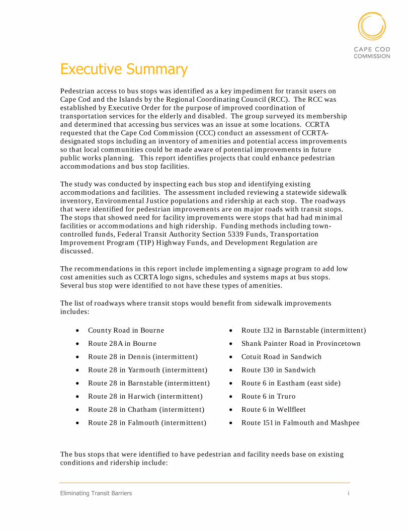
Executive Summary Pedestrian access to bus stops was identified as a key impediment for transit users on Cape Cod and the Islands by the Regional Coordinating Council (RCC). The RCC was established by Executive Order for the purpose of improved coordination of transportation services for the elderly and disabled. The group surveyed its membership and determined that accessing bus services was an issue at some locations. CCRTA requested that the Cape Cod Commission (CCC) conduct an assessment of CCRTA-designated stops including an inventory of amenities and potential access improvements so that local communities could be made aware of potential improvements in future public works planning. This report identifies projects that could enhance pedestrian accommodations and bus stop facilities.
The study was conducted by inspecting each bus stop and identifying existing accommodations and facilities. The assessment included reviewing a statewide sidewalk inventory, Environmental Justice populations and ridership at each stop. The roadways that were identified for pedestrian improvements are on major roads with transit stops. The stops that showed need for facility improvements were stops that had had minimal facilities or accommodations and high ridership. Funding methods including town-controlled funds, Federal Transit Authority Section 5339 Funds, Transportation Improvement Program (TIP) Highway Funds, and Development Regulation are discussed.
The recommendations in this report include implementing a signage program to add low cost amenities such as CCRTA logo signs, schedules and systems maps at bus stops. Several bus stop were identified to not have these types of amenities.
The list of roadways where transit stops would benefit from sidewalk improvements includes:
County Road in Bourne
Route 28A in Bourne
Route 28 in Dennis (intermittent)
Route 28 in Yarmouth (intermittent)
Route 28 in Barnstable (intermittent)
Route 28 in Harwich (intermittent)
Route 28 in Chatham (intermittent)
Route 28 in Falmouth (intermittent)
Route 132 in Barnstable (intermittent)
Shank Painter Road in Provincetown
Cotuit Road in Sandwich
Route 130 in Sandwich
Route 6 in Eastham (east side)
Route 6 in Truro
Route 6 in Wellfleet
Route 151 in Falmouth and Mashpee
The bus stops that were identified to have pedestrian and facility needs base on existing conditions and ridership include:

ii Eliminating Transit Barriers
Stop and Shop, Orleans – H2O and Flex
Patriot Square - H2O
Stop and Shop, South Yarmouth – H2O
Shaw’s, South Yarmouth – H2O
Highland Road – Flex and Provincetown/North Truro Shuttle
(List of recommended bus stop improvement locations continued)
Stop and Shop at Quaker Meeting House Road – Sandwich Line
Anchorage at Crowell Road – H2O
Seacoast Shores Boulevard – Sealine
Chatham Rotary – H2O
Woods Hole Steamship – Sealine and WHOOSH Trolley
Cape Cod Mall Route 28 – Hyannis Villager and Barnstable Villager
Higgins Crowell Road – H2O
North Truro Camping Area- Provincetown/North Truro Shuttle
Catamount Hotel- Bourne Run

Eliminating Transit Barriers iii
Table of Contents Executive Summary ................................................................................................................ i
Introduction ........................................................................................................................... 1
Study Objectives ................................................................................................................. 1
Study Area .......................................................................................................................... 1
Project Team ...................................................................................................................... 2
Data Collection ................................................................................................................... 3
Previous Studies ................................................................................................................. 4
Bus Stop Design ..................................................................................................................... 6
Bus Facilities ...................................................................................................................... 6
Pedestrian Accommodations ............................................................................................. 6
Example Bus Stops ............................................................................................................ 8
Existing Conditions ............................................................................................................. 10
Ridership .......................................................................................................................... 10
Sidewalks .......................................................................................................................... 12
Pedestrian Accommodations ........................................................................................... 15
Transit Stop Facilities ...................................................................................................... 17
Environmental Justice ..................................................................................................... 18
Improvement Considerations ............................................................................................. 19
Recommendations ............................................................................................................... 26
Signage, Map and Schedule Program ............................................................................. 26
Sidewalks .......................................................................................................................... 27
Build-Out of High Ridership Stops ................................................................................. 27

iv Eliminating Transit Barriers
Funding ............................................................................................................................ 28
Conclusion ........................................................................................................................... 29
Appendices:
Data table
List of Figures Figure 1: Study Area .............................................................................................................. 2
Figure 2: Regional Coordinating Committee Survey Questionnaire Results ...................... 4
Figure 3: Bus Shelter Design ................................................................................................. 6
Figure 4: Continental or Piano Key Crosswalk ..................................................................... 7
Figure 5: Curb Ramp Examples ............................................................................................ 7
Figure 6: Ridership Map ...................................................................................................... 11
Figure 7: Upper Cape Sidewalks ......................................................................................... 12
Figure 8: Mid Cape Sidewalks ............................................................................................. 13
Figure 9: Lower Cape Sidewalks ......................................................................................... 14
Figure 10: Outer Cape Sidewalks ........................................................................................ 15
Figure 11: Cape Wide Count of Pedestrian Accommodations at Bus Stops ...................... 16
Figure 12: Number of Facilities ........................................................................................... 17
Figure 13: Environmental Justice ....................................................................................... 18
Figure 14: Signage Location Map ........................................................................................ 26
List of Tables Table 1: Annual CCRTA Ridership Distribution by Stop ................................................... 10
Eliminating Transit Barriers 1
Introduction Study Objectives
The focus of this report is to develop a plan for increasing pedestrian access to transit and improving facilities at bus stops. The project goals are to identify where to invest in transit stops and to prioritize the investments by ridership, equity and cost. This report is meant as a tool for local communities to identify potential gaps in their pedestrian network.
Study Area
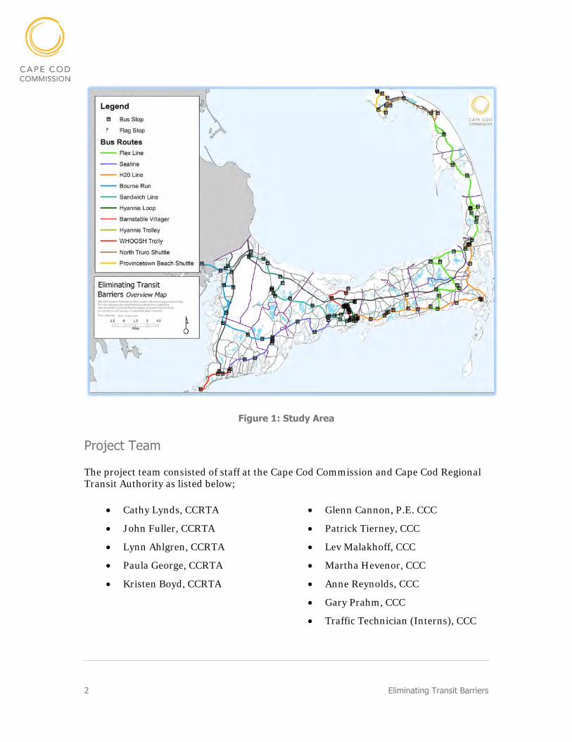
All Cape Cod Regional Transit Authority (CCRTA) bus stops in Barnstable County for CCRTA routes and some intercity bus stops were evaluated. Sidewalks throughout Cape Cod were identified near bus stops. Figure 1 shows the Cape Cod region, including CCRTA bus stops and bus routes.
Project Goals Include:
Identify where to invest in transit stops
Prioritize by ridership, equity and cost
2 Eliminating Transit Barriers
Figure 1: Study Area
Project Team
The project team consisted of staff at the Cape Cod Commission and Cape Cod Regional Transit Authority as listed below;
Cathy Lynds, CCRTA
John Fuller, CCRTA
Lynn Ahlgren, CCRTA
Paula George, CCRTA
Kristen Boyd, CCRTA
Glenn Cannon, P.E. CCC
Patrick Tierney, CCC
Lev Malakhoff, CCC
Martha Hevenor, CCC
Anne Reynolds, CCC
Gary Prahm, CCC
Traffic Technician (Interns), CCC
Eliminating Transit Barriers 3
For feedback, Eliminating Transit Barriers was presented to the Regional Coordinating Committee and the Cape Cod Regional Transit Authority Advisory Board.
Data Collection
Cape Cod Commission staff collected data at CCRTA bus stops to evaluate the stops for pedestrian accommodations and transit stop facilities. An ESRI Geographic Information System (GIS) application was used gather site attributes of bus stops and sidewalks, and streamline the data collection process. The types of attributes are discussed further in the existing conditions section of the report. In addition to bus stop data, a Massachusetts state sidewalk GIS layer was reviewed to identify locations with limited pedestrian accommodations.

4 Eliminating Transit Barriers
Previous Studies
This initiative was prompted by the findings of previous studies including the Regional Coordinating Committee survey and the Cape Cod Commission’s Closing the Gaps study.
Regional Coordinating Committee Survey
In September 2012, the Regional Coordinating Committee conducted a survey on transit consumers and providers. The top response for barriers that impedes the ability to access public transportation, identified by sixty percent of consumer respondents, was lack of sidewalks. The results of the survey question are presented in Figure 2.
Figure 2: Regional Coordinating Committee Survey Questionnaire Results
Eliminating Transit Barriers 5
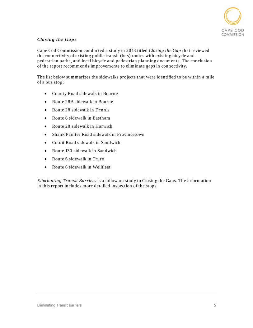
Closing the Gaps
Cape Cod Commission conducted a study in 2013 titled Closing the Gap that reviewed the connectivity of existing public transit (bus) routes with existing bicycle and pedestrian paths, and local bicycle and pedestrian planning documents. The conclusion of the report recommends improvements to eliminate gaps in connectivity.
The list below summarizes the sidewalks projects that were identified to be within a mile of a bus stop;
County Road sidewalk in Bourne
Route 28A sidewalk in Bourne
Route 28 sidewalk in Dennis
Route 6 sidewalk in Eastham
Route 28 sidewalk in Harwich
Shank Painter Road sidewalk in Provincetown
Cotuit Road sidewalk in Sandwich
Route 130 sidewalk in Sandwich
Route 6 sidewalk in Truro
Route 6 sidewalk in Wellfleet
Eliminating Transit Barriers is a follow up study to Closing the Gaps. The information in this report includes more detailed inspection of the stops.

6 Eliminating Transit Barriers
Bus Stop Design The ideal bus stop would have complete pedestrian accommodation and facilities, and have sidewalks that connect directly to the passenger’s origin or destination.
Some bus stops are located along the street. These types of bus stops require the bus to stop in the road and passengers must walk to their destination. Some bus stops are curb side or off-street at a developments including shopping centers or grocery stores.
Bus Facilities
The current design of bus stops to be installed by the CCRTA is represented in Figure 3. Modifications to this design include brown metal trim. CCRTA previously built wood bus shelters, however due to the high costs of materials, construction, and maintenance, the CCRTA has discontinued this design.
The bus stops also may include facilities such as benches, lighting and system maps. Bus stop facilities enhance the transit experience and provide indication of where the bus stops.
A feature that is included in many of the stops now is NextBus signage that tells the time of the next bus arrival. The CCRTA will be discontinuing the usage of this product. As a replacement, a cellphone application will be advertised that alerts passengers of bus arrivals.
Figure 3: Bus Shelter Design
Pedestrian Accommodations
Sidewalks, crosswalks and curb ramps are some of the major pedestrian accommodations for accessibility to transit stops. On-street bus stops have a higher need for these accommodations because they support the safe travel for each passenger to and from the bus stop towards their destination.
Existing sidewalks are typically four feet wide or more. The Massachusetts Department of Transportation (MassDOT) design guidelines require sidewalks that are at least five feet wide. It is beneficial to have sidewalks on both sides of the road so that a passenger can walk to the bus that travels from both directions. Many CCRTA stops are off-street or curbside at grocery stores and shopping centers. At these locations it is important for the sidewalk network on the streets to connect to those at the commercial development.

Eliminating Transit Barriers 7
Crosswalks are utilized by pedestrians to cross the street. If a passenger is taking transit to and from their destination, at an off-street stop the pedestrian will be required to cross the street. Crosswalks are important for pedestrians to safely access the stop from either side of the road. Crosswalks are typically five feet wide and there are several designs, most typically used is the piano key or continental, as shown in Figure 4.
Curb ramps are essential for handicap and stroller access. Modern design of all pedestrian facilities is guided by Americans with Disabilities Act (ADA) regulations. The design of curb ramps includes a four-foot-wide ramp, five-foot-wide turning areas, and textured pads at transitions from the ramp to a road crossing. Figure 5 shows drawings of typical curb ramps.
Figure 5: Curb Ramp Examples
Figure 4: Continental or Piano Key Crosswalk

8 Eliminating Transit Barriers
Example Bus Stops
Several bus stops were identified to have excellent pedestrian accommodations and transit facilities when compared to other bus stops. High Ridership stops are recommended to reflect attributes shown in the examples below.
Dennis Crossing – H2O
Ridership: 12,685 passengers per year
Pedestrian Accommodation: crosswalk, curb ramps, sidewalks on both sides
Transit Facilities: Bus Shelter, Lighting, CCRTA sign, Benches, Bike Racks
Proposed Improvements: System Map, Schedules
East Falmouth Dunkin Donuts - Sealine
Ridership: 13,608 passengers per year
Pedestrian Accommodation: crosswalk, curb ramps, sidewalks on both sides
Transit Facilities: Bus Shelter, Lighting, CCRTA sign, Benches, Schedule, System Map, Bike Racks
Notes: Ongoing construction project at the Route 28 and Davisville Road intersection
Proposed Improvements: None
Eliminating Transit Barriers 9
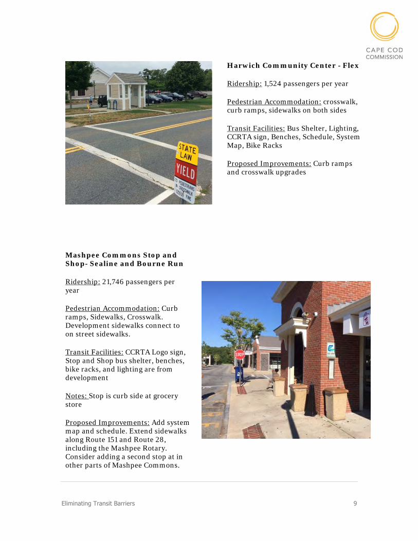
Harwich Community Center - Flex
Ridership: 1,524 passengers per year
Pedestrian Accommodation: crosswalk, curb ramps, sidewalks on both sides
Transit Facilities: Bus Shelter, Lighting, CCRTA sign, Benches, Schedule, System Map, Bike Racks
Proposed Improvements: Curb ramps and crosswalk upgrades
Mashpee Commons Stop and Shop- Sealine and Bourne Run
Ridership: 21,746 passengers per year
Pedestrian Accommodation: Curb ramps, Sidewalks, Crosswalk. Development sidewalks connect to on street sidewalks.
Transit Facilities: CCRTA Logo sign, Stop and Shop bus shelter, benches, bike racks, and lighting are from development
Notes: Stop is curb side at grocery store
Proposed Improvements: Add system map and schedule. Extend sidewalks along Route 151 and Route 28, including the Mashpee Rotary. Consider adding a second stop at in other parts of Mashpee Commons.
10 Eliminating Transit Barriers
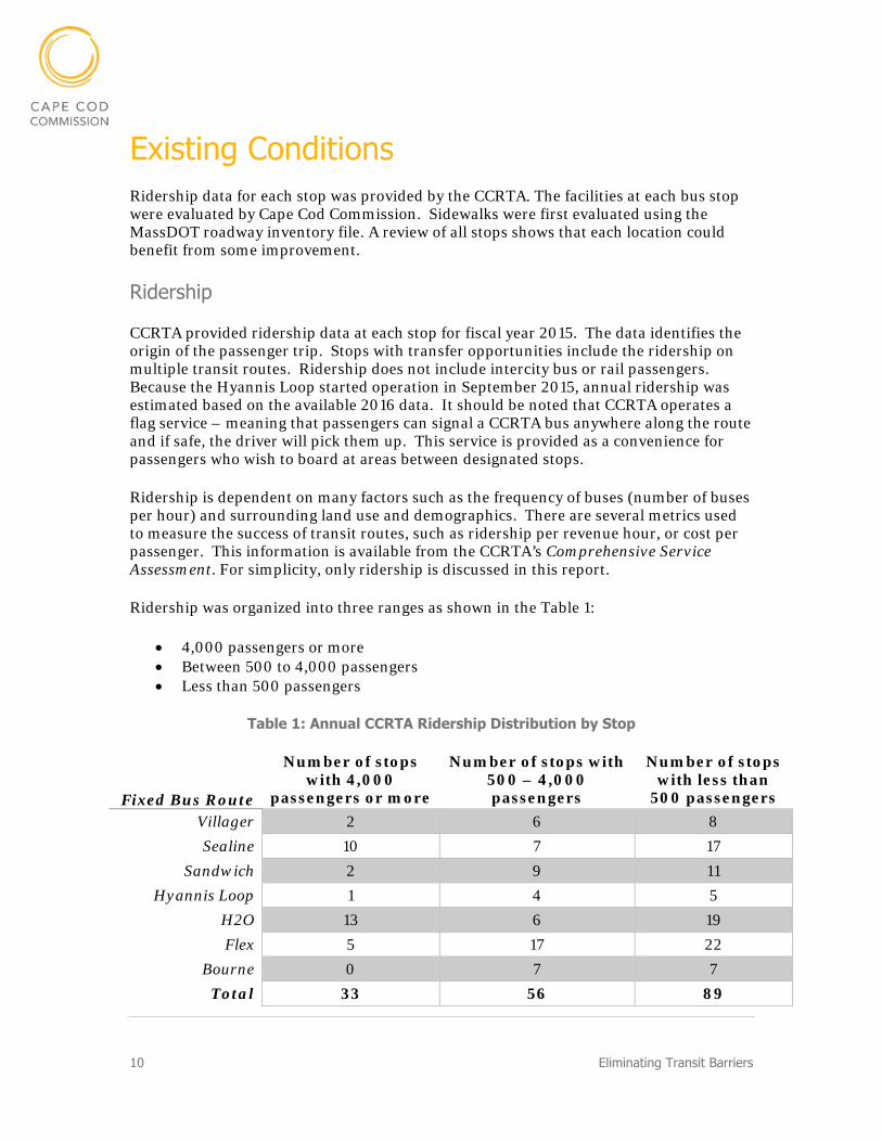
Existing Conditions Ridership data for each stop was provided by the CCRTA. The facilities at each bus stop were evaluated by Cape Cod Commission. Sidewalks were first evaluated using the MassDOT roadway inventory file. A review of all stops shows that each location could benefit from some improvement.
Ridership
CCRTA provided ridership data at each stop for fiscal year 2015. The data identifies the origin of the passenger trip. Stops with transfer opportunities include the ridership on multiple transit routes. Ridership does not include intercity bus or rail passengers. Because the Hyannis Loop started operation in September 2015, annual ridership was estimated based on the available 2016 data. It should be noted that CCRTA operates a flag service – meaning that passengers can signal a CCRTA bus anywhere along the route and if safe, the driver will pick them up. This service is provided as a convenience for passengers who wish to board at areas between designated stops.
Ridership is dependent on many factors such as the frequency of buses (number of buses per hour) and surrounding land use and demographics. There are several metrics used to measure the success of transit routes, such as ridership per revenue hour, or cost per passenger. This information is available from the CCRTA’s Comprehensive Service Assessment. For simplicity, only ridership is discussed in this report.
Ridership was organized into three ranges as shown in the Table 1:
4,000 passengers or more Between 500 to 4,000 passengers Less than 500 passengers
Table 1: Annual CCRTA Ridership Distribution by Stop
Fixed Bus Route
Number of stops with 4,000
passengers or more
Number of stops with 500 – 4,000 passengers
Number of stops with less than
500 passengers
Villager 2 6 8
Sealine 10 7 17
Sandwich 2 9 11
Hyannis Loop 1 4 5
H2O 13 6 19
Flex 5 17 22
Bourne 0 7 7
Total 33 56 89
Eliminating Transit Barriers 11
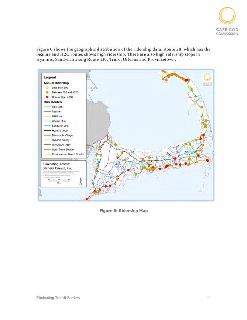
Figure 6 shows the geographic distribution of the ridership data. Route 28, which has the Sealine and H2O routes shows high ridership. There are also high ridership stops in Hyannis, Sandwich along Route 130, Truro, Orleans and Provincetown.
Figure 6: Ridership Map
12 Eliminating Transit Barriers
Sidewalks
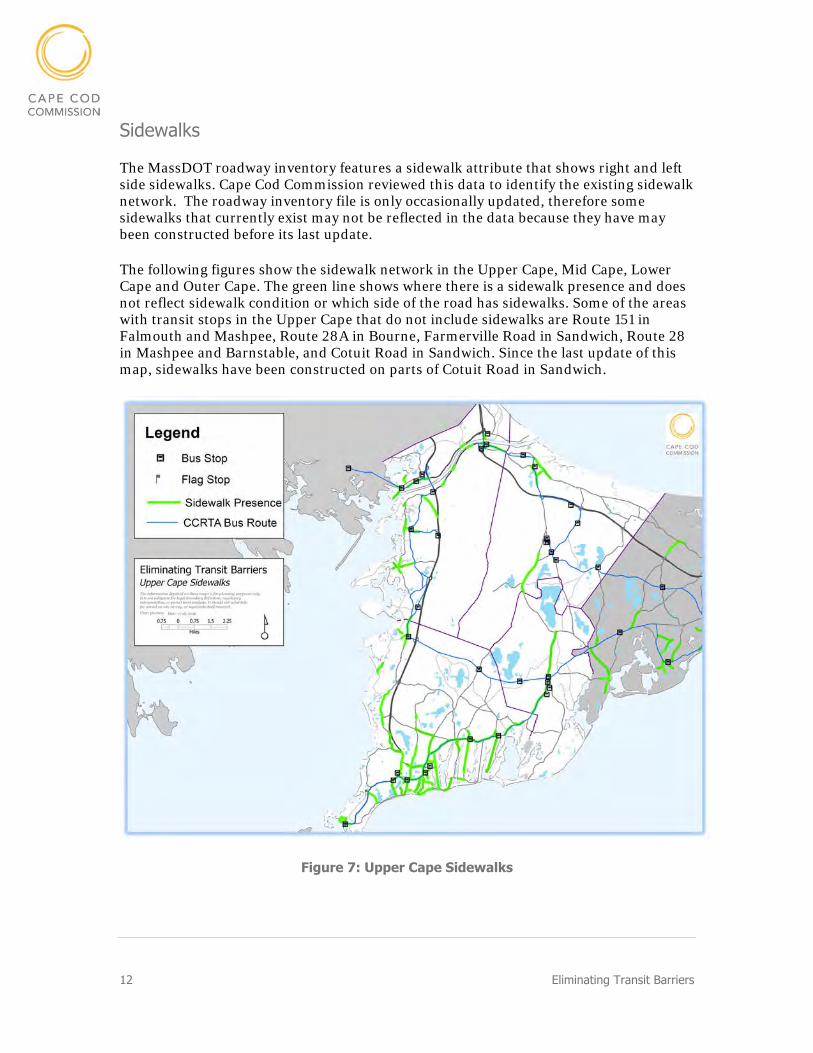
The MassDOT roadway inventory features a sidewalk attribute that shows right and left side sidewalks. Cape Cod Commission reviewed this data to identify the existing sidewalk network. The roadway inventory file is only occasionally updated, therefore some sidewalks that currently exist may not be reflected in the data because they have may been constructed before its last update.
The following figures show the sidewalk network in the Upper Cape, Mid Cape, Lower Cape and Outer Cape. The green line shows where there is a sidewalk presence and does not reflect sidewalk condition or which side of the road has sidewalks. Some of the areas with transit stops in the Upper Cape that do not include sidewalks are Route 151 in Falmouth and Mashpee, Route 28A in Bourne, Farmerville Road in Sandwich, Route 28 in Mashpee and Barnstable, and Cotuit Road in Sandwich. Since the last update of this map, sidewalks have been constructed on parts of Cotuit Road in Sandwich.
Figure 7: Upper Cape Sidewalks
Eliminating Transit Barriers 13
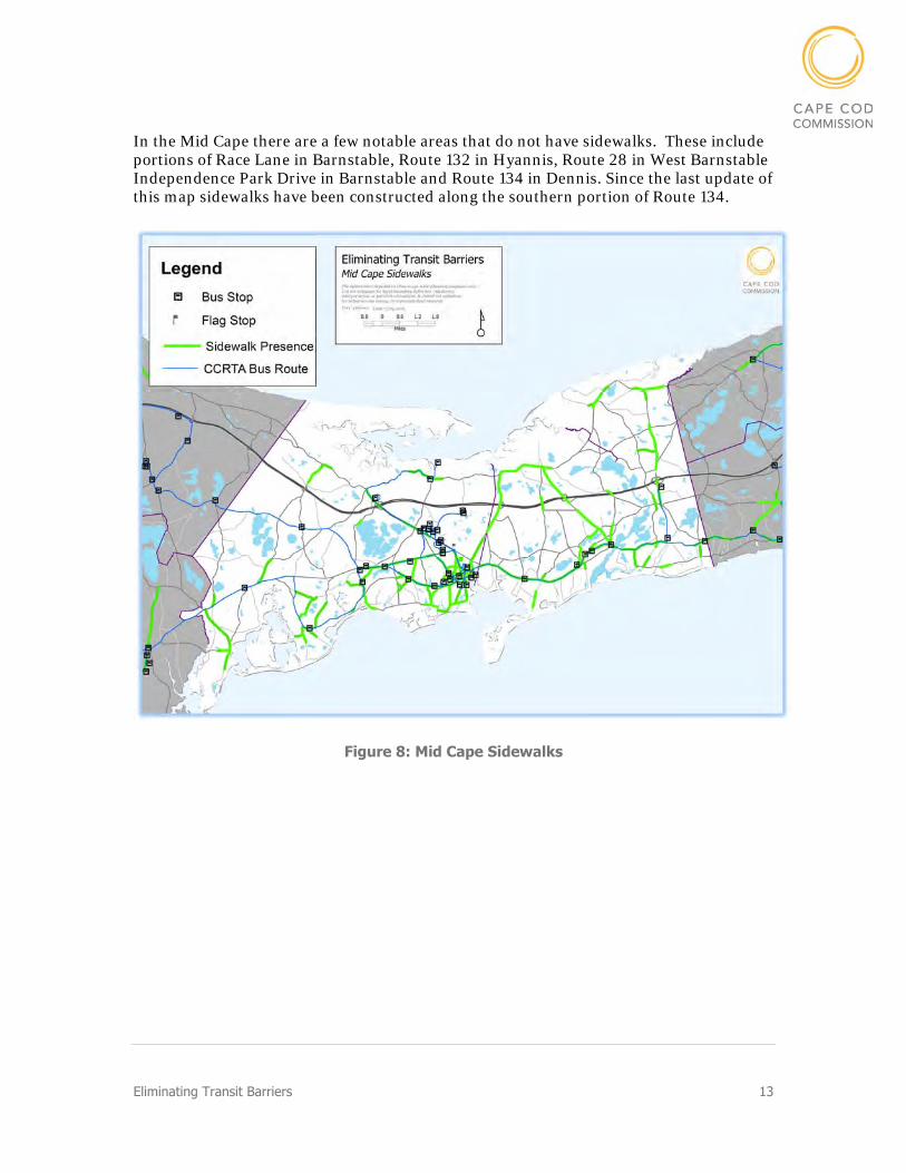
In the Mid Cape there are a few notable areas that do not have sidewalks. These include portions of Race Lane in Barnstable, Route 132 in Hyannis, Route 28 in West Barnstable Independence Park Drive in Barnstable and Route 134 in Dennis. Since the last update of this map sidewalks have been constructed along the southern portion of Route 134.
Figure 8: Mid Cape Sidewalks
14 Eliminating Transit Barriers
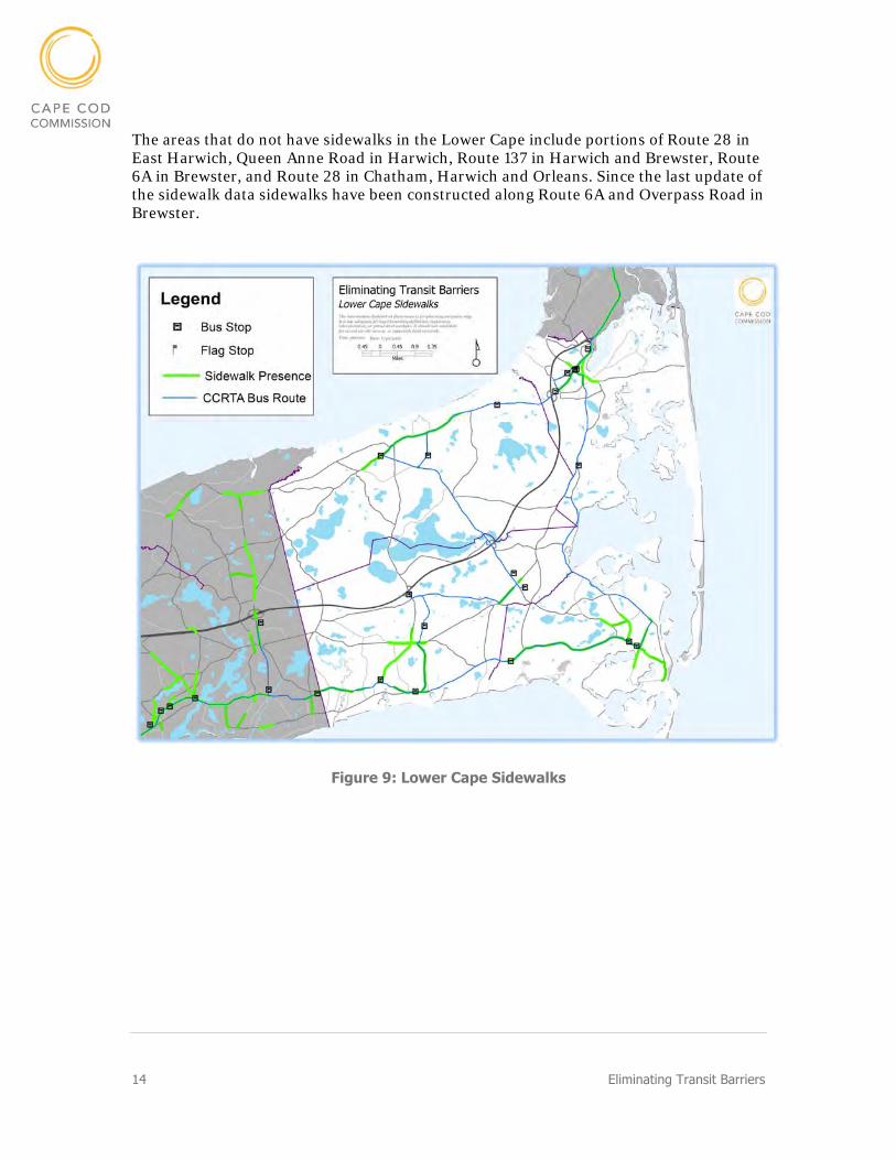
The areas that do not have sidewalks in the Lower Cape include portions of Route 28 in East Harwich, Queen Anne Road in Harwich, Route 137 in Harwich and Brewster, Route 6A in Brewster, and Route 28 in Chatham, Harwich and Orleans. Since the last update of the sidewalk data sidewalks have been constructed along Route 6A and Overpass Road in Brewster.
Figure 9: Lower Cape Sidewalks

Eliminating Transit Barriers 15
In the Outer Cape, sidewalks are more limited. The roadways that do not have sidewalks include the majority of Route 6 in Wellfleet and Truro, Highland Road in Truro, Bradford Street in Provincetown, Province Lands Road in Provincetown, and Shank Painter Road in Provincetown.
Figure 10: Outer Cape Sidewalks
Pedestrian Accommodations
Cape Cod Commission staff inspected transit stops for curb ramp access, sidewalks along the street, and crosswalk availability at the stop. The intention of collecting this data is to identify which stops have issues with access. When technicians inspected each bus stop they were prompted with the following questions for each category and answered “Yes” or “No.” Answers reflect the general state of the area and do not reflect the exact conditions;
Crosswalk – “Does the Stop have a crosswalk near the bus stop location? Across the nearby street? Does the nearby traffic signal have pedestrian phasing?”
Sidewalk – “Does the street and nearby streets have a sidewalk accessing the area of the bus stop? Does the commercial lot have sidewalks that connect to the street sidewalk network?”
16 Eliminating Transit Barriers
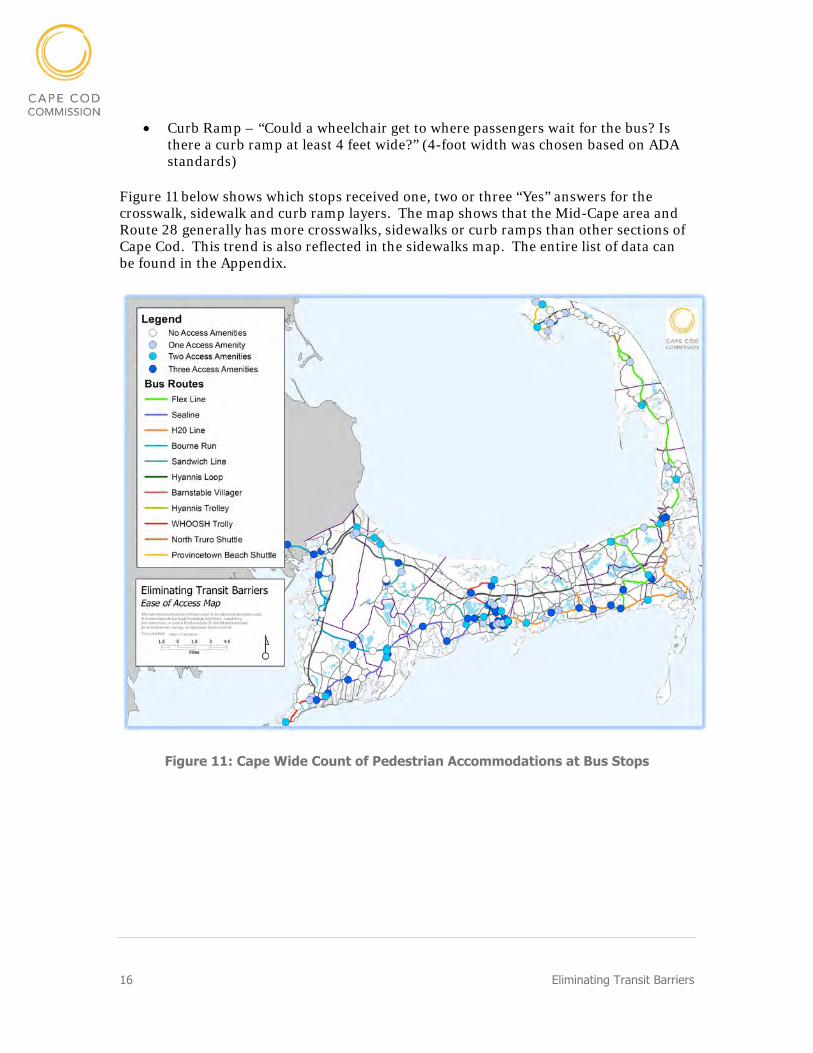
Curb Ramp – “Could a wheelchair get to where passengers wait for the bus? Is there a curb ramp at least 4 feet wide?” (4-foot width was chosen based on ADA standards)
Figure 11 below shows which stops received one, two or three “Yes” answers for the crosswalk, sidewalk and curb ramp layers. The map shows that the Mid-Cape area and Route 28 generally has more crosswalks, sidewalks or curb ramps than other sections of Cape Cod. This trend is also reflected in the sidewalks map. The entire list of data can be found in the Appendix.
Figure 11: Cape Wide Count of Pedestrian Accommodations at Bus Stops

Eliminating Transit Barriers 17
Transit Stop Facilities
At each bus stop technicians also identified facilities including:
Bus shelters Lighting NextBus signs (to be replaced with QR codes) CCRTA signage Benches Schedules System maps Bike racks
The entire list of data can be found attached as Appendix. Figure 12 shows which transit stops include the select facilities. The intention of this map is to identify which transit stops have facilities.
Figure 12: Number of Facilities
18 Eliminating Transit Barriers
Environmental Justice
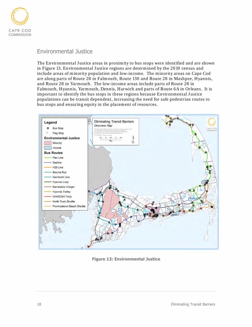
The Environmental Justice areas in proximity to bus stops were identified and are shown in Figure 13. Environmental Justice regions are determined by the 2010 census and include areas of minority population and low-income. The minority areas on Cape Cod are along parts of Route 28 in Falmouth, Route 130 and Route 28 in Mashpee, Hyannis, and Route 28 in Yarmouth. The low-income areas include parts of Route 28 in Falmouth, Hyannis, Yarmouth, Dennis, Harwich and parts of Route 6A in Orleans. It is important to identify the bus stops in these regions because Environmental Justice populations can be transit dependent, increasing the need for safe pedestrian routes to bus stops and ensuring equity in the placement of resources.
Figure 13: Environmental Justice

Eliminating Transit Barriers 19
Improvement Considerations The reviewing of the existing conditions identified several sidewalk projects and recommendations. The stops that showed high ridership and a need for improved pedestrian access are detailed below.
Stop and Shop Orleans – H2O and Flex
Ridership: 21,094 passengers per year
Pedestrian Accommodation: On street sidewalks are not connected to bus stop
Transit Facilities: Bus Shelter, benches, schedule
Notes: Bus stop is on the side of Stop and Shop. Visible to foot traffic only. In proximity to low-income EJ populations.
Proposed Improvements: Move the bus stop to be more visible or closer to the street and provide a sidewalk connection to the on street sidewalk. Include lighting, system maps, bike racks, and CCRTA signage in a redesign.
Patriot Square – H2O
Ridership: 15,713 passengers per year
Pedestrian Accommodation: Curb side stop with no connection to on street sidewalks.
Transit Facilities: None
Notes: Curb side stop
Proposed Improvements: Add signage and schedule to current bus stop location. Consider location for a bus shelter with all transit facilities. Connect location of bus stop to sidewalks with pedestrian connection. Extend sidewalks the entire length of Route 134 (connection through exit 9 ramps).
20 Eliminating Transit Barriers
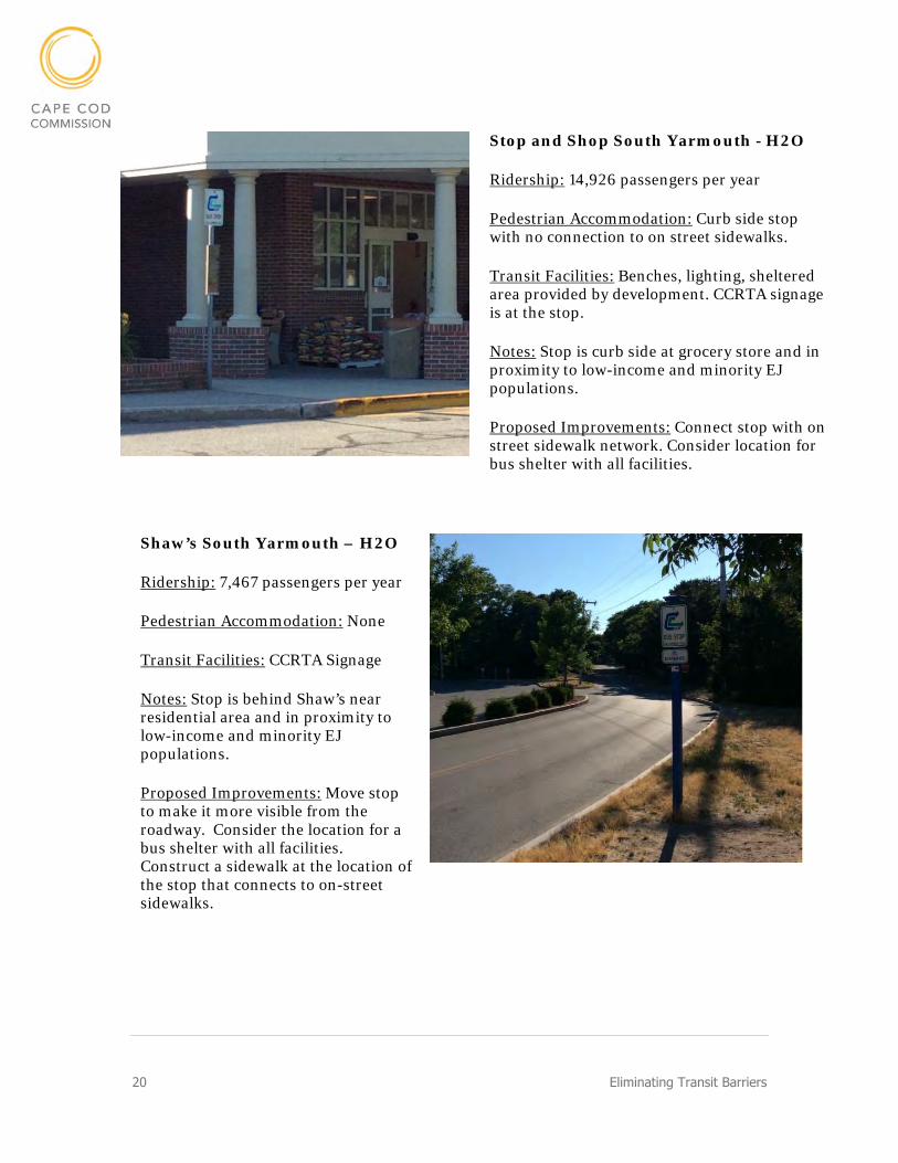
Stop and Shop South Yarmouth - H2O
Ridership: 14,926 passengers per year
Pedestrian Accommodation: Curb side stop with no connection to on street sidewalks.
Transit Facilities: Benches, lighting, sheltered area provided by development. CCRTA signage is at the stop.
Notes: Stop is curb side at grocery store and in proximity to low-income and minority EJ populations.
Proposed Improvements: Connect stop with on street sidewalk network. Consider location for bus shelter with all facilities.
Shaw’s South Yarmouth – H2O
Ridership: 7,467 passengers per year
Pedestrian Accommodation: None
Transit Facilities: CCRTA Signage
Notes: Stop is behind Shaw’s near residential area and in proximity to low-income and minority EJ populations.
Proposed Improvements: Move stop to make it more visible from the roadway. Consider the location for a bus shelter with all facilities. Construct a sidewalk at the location of the stop that connects to on-street sidewalks.
Eliminating Transit Barriers 21
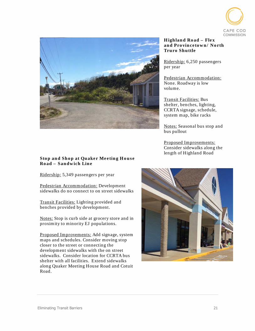
Highland Road – Flex and Provincetown/ North Truro Shuttle
Ridership: 6,250 passengers per year
Pedestrian Accommodation: None. Roadway is low volume.
Transit Facilities: Bus shelter, benches, lighting, CCRTA signage, schedule, system map, bike racks
Notes: Seasonal bus stop and bus pullout
Proposed Improvements: Consider sidewalks along the length of Highland Road
Stop and Shop at Quaker Meeting House Road – Sandwich Line
Ridership: 5,349 passengers per year
Pedestrian Accommodation: Development sidewalks do no connect to on street sidewalks
Transit Facilities: Lighting provided and benches provided by development.
Notes: Stop is curb side at grocery store and in proximity to minority EJ populations.
Proposed Improvements: Add signage, system maps and schedules. Consider moving stop closer to the street or connecting the development sidewalks with the on street sidewalks. Consider location for CCRTA bus shelter with all facilities. Extend sidewalks along Quaker Meeting House Road and Cotuit Road.
22 Eliminating Transit Barriers
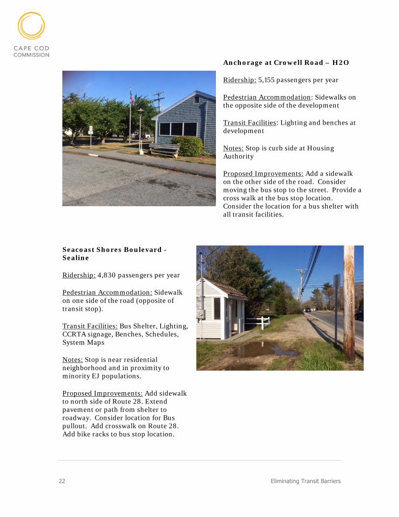
Anchorage at Crowell Road – H2O
Ridership: 5,155 passengers per year
Pedestrian Accommodation: Sidewalks on the opposite side of the development
Transit Facilities: Lighting and benches at development
Notes: Stop is curb side at Housing Authority
Proposed Improvements: Add a sidewalk on the other side of the road. Consider moving the bus stop to the street. Provide a cross walk at the bus stop location. Consider the location for a bus shelter with all transit facilities.
Seacoast Shores Boulevard - Sealine
Ridership: 4,830 passengers per year
Pedestrian Accommodation: Sidewalk on one side of the road (opposite of transit stop).
Transit Facilities: Bus Shelter, Lighting, CCRTA signage, Benches, Schedules, System Maps
Notes: Stop is near residential neighborhood and in proximity to minority EJ populations.
Proposed Improvements: Add sidewalk to north side of Route 28. Extend pavement or path from shelter to roadway. Consider location for Bus pullout. Add crosswalk on Route 28. Add bike racks to bus stop location.
Eliminating Transit Barriers 23
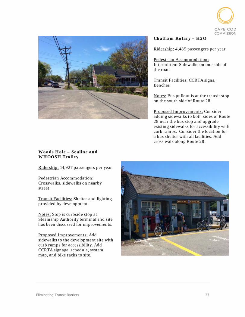
Chatham Rotary – H2O
Ridership: 4,485 passengers per year
Pedestrian Accommodation: Intermittent Sidewalks on one side of the road
Transit Facilities: CCRTA signs, Benches
Notes: Bus pullout is at the transit stop on the south side of Route 28.
Proposed Improvements: Consider adding sidewalks to both sides of Route 28 near the bus stop and upgrade existing sidewalks for accessibility with curb ramps. Consider the location for a bus shelter with all facilities. Add cross walk along Route 28.
Woods Hole – Sealine and WHOOSH Trolley
Ridership: 14,927 passengers per year
Pedestrian Accommodation: Crosswalks, sidewalks on nearby street
Transit Facilities: Shelter and lighting provided by development
Notes: Stop is curbside stop at Steamship Authority terminal and site has been discussed for improvements.
Proposed Improvements: Add sidewalks to the development site with curb ramps for accessibility. Add CCRTA signage, schedule, system map, and bike racks to site.
24 Eliminating Transit Barriers
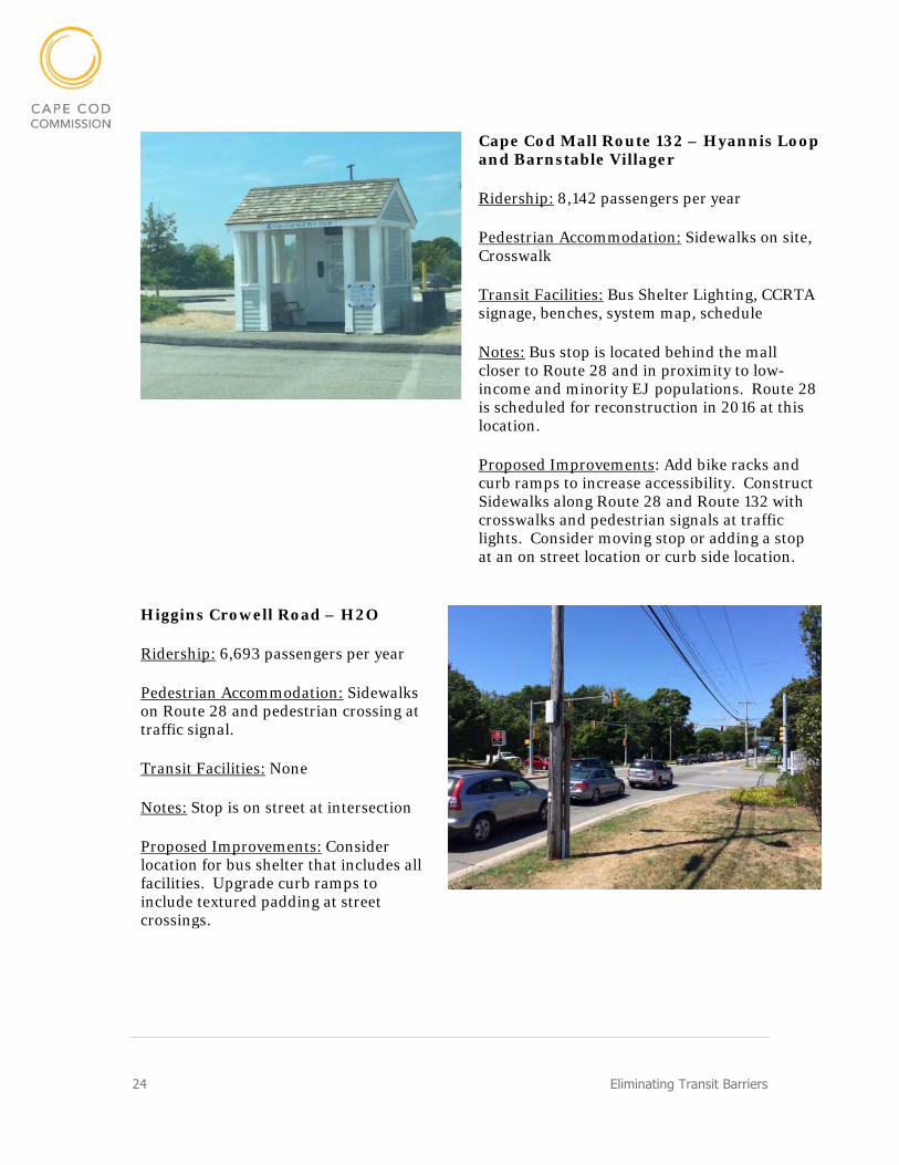
Cape Cod Mall Route 132 – Hyannis Loop and Barnstable Villager
Ridership: 8,142 passengers per year
Pedestrian Accommodation: Sidewalks on site, Crosswalk
Transit Facilities: Bus Shelter Lighting, CCRTA signage, benches, system map, schedule
Notes: Bus stop is located behind the mall closer to Route 28 and in proximity to low-income and minority EJ populations. Route 28 is scheduled for reconstruction in 2016 at this location.
Proposed Improvements: Add bike racks and curb ramps to increase accessibility. Construct Sidewalks along Route 28 and Route 132 with crosswalks and pedestrian signals at traffic lights. Consider moving stop or adding a stop at an on street location or curb side location.
Higgins Crowell Road – H2O
Ridership: 6,693 passengers per year
Pedestrian Accommodation: Sidewalks on Route 28 and pedestrian crossing at traffic signal.
Transit Facilities: None
Notes: Stop is on street at intersection
Proposed Improvements: Consider location for bus shelter that includes all facilities. Upgrade curb ramps to include textured padding at street crossings.

Eliminating Transit Barriers 25
North Truro Camping – Provincetown/ North Truro Shuttle
Ridership: 5,521 passengers per year
Pedestrian Accommodation: None, Low volume road
Transit Facilities: None
Notes: Seasonal stop at campgrounds
Proposed Improvements: Consider sidewalks along Highland Road. Add CCRTA signage. Consider location for bus shelter that includes all facilities.
Catamount Motel – Bourne Run
Ridership: 3,151 passengers per year
Pedestrian Accommodation: None
Transit Facilities: None
Notes: Stop is in proximity to minority EJ populations. Motel name is not clearly marked and does not show up on Google Maps.
Proposed Improvements: Consider sidewalks along Route 28A. Add CCRTA signage and Benches. Consider location for bus shelter that includes all facilities. Consider moving the bus location to on-street or to a new location.

26 Eliminating Transit Barriers
Recommendations Cape Cod Commission Staff recommends the following projects and methods to improve access to transit following a review of the data.
Signage, Map and Schedule Program
Many of the bus stops on the CCRTA system do not have signs indicating that the bus stops at that particular location. Staff recommends placing a CCRTA logo sign, CCRTA system map and CCRTA fixed route schedule at each bus stop. This could help to improve the visibility of the stops and decrease confusion for passengers and bus drivers. The majority of the bus stops on the Sandwich and Bourne Run, and many of the curb side bus stops are do not have signage. Figure 14 shows the bus stops where Cape Cod Commission staff did not see CCRTA signage as well as those locations that are signed.
Figure 14: Signage Location Map
Eliminating Transit Barriers 27
Sidewalks
As identified in both the Closing the Gaps and Eliminating Transit Barriers there are several roadways that do not have consistent sidewalks and have transit stops on them. Sidewalks are typically recommended on most roadways. Exceptions may include low-volume or low-speed roads or limited access highways. Staff recommends sidewalks be constructed to improve walkability to these CCRTA bus stops.
The list of roadways that have transit lines and would be benefit from sidewalk improvements includes;
County Road in Bourne
Route 28A in Bourne
Route 28 in Dennis (intermittent)
Route 28 in Yarmouth (intermittent)
Route 28 in Barnstable (intermittent)
Route 28 in Harwich (intermittent)
Route 28 in Chatham (intermittent)
Route 28 in Falmouth (intermittent)
Route 132 in Barnstable (intermittent)
Shank Painter Road in Provincetown
Cotuit Road in Sandwich
Route 130 in Sandwich
Route 6 in Eastham (east side)
Route 6 in Truro
Route 6 in Wellfleet
Route 151 in Falmouth and Mashpee
Build-Out of High Ridership Stops
As identified in the Problem identification portion of the report the bus stops that were identified to have pedestrian and facility needs based on existing conditions and ridership include:
Stop and Shop, Orleans – H2O and Flex
Patriot Square- H2O
Stop and Shop, South Yarmouth – H2O
Shaw’s, South Yarmouth – H2O
Highland Road – Flex and Provincetown/North Truro Shuttle
Stop and Shop at Quaker Meeting House Road – Sandwich Line
Anchorage at Crowell Road – H2O
Seacoast Shores Boulevard – Sealine
Chatham Rotary – H2O
Woods Hole Steamship – Sealine and WHOOSH Trolley
28 Eliminating Transit Barriers
Cape Cod Mall Route 28 – Sealine and Barnstable Villager
Higgins Crowell Road – H2O
North Truro Camping Area- Provincetown/North Truro Shuttle
Catamount Hotel- Bourne Run
Funding
Funding for the above projects is not identified but could be facilitated through the programs listed below. Funding for each program is based on availability and competing interests will determine the outcomes.
Town-controlled funds – Cape towns could fund the sidewalk projects using specific funds under their control. This may be easiest if the roadway is owned by the town.
Federal Transit Authority Section 5339 Funds– CCRTA controls funds allocated by the FTA that are annually categorized for Bus Shelters or Improvements to Bus Stops. These funds could be used to outfit bus stops with facilities or small scale sidewalk projects. In 2017 approximately $30,000 was allocated to bus stop improvement.
Transit Enhancement Funds Section 5307 – Annually CCRTA receives 5307 funds for general operating expenses as well as capital improvements. Current Federal law requires that recipients of 5307 funds spend 1% of their funds on “transit enhancements” which are defined in the regulations. Bus shelters and improvements to them and the area around them qualify for this use. In 2017, CCRTA will spend approximately $80,000 on transit enhancements.
Transportation Improvement Program (TIP) Highway Funds - The Cape Cod Metropolitan Planning Organization’s (MPO) transportation capital plan, the Transportation Improvement Program (TIP), lists major transportation projects planned in the next five years. The MPO is made up of eleven voting members with representatives of state agencies, regional organizations, and Cape Cod towns. Discussions at MPO meetings help to establish a preference for which projects are funded through the TIP. Members of the public are welcome and encouraged to attend these meetings and voice opinions. Each year the TIP allocates approximately $20 million split between highway and transit funds. To request use of highway funds a Project Need Form (PNF) must be submitted for review by MassDOT staff. In 2017 a project at the Harwich Route 124 Park and Ride, a bus stop location for the Plymouth and Brockton Bus was funded in the TIP. This funding category may be able to both construct sidewalks and bus stop improvement.
Eliminating Transit Barriers 29
Development Regulation - Town planning boards review and approve site plans for developments. In Barnstable County, the Cape Cod Commission reviews development with major impacts to the region or lots with proposed structures larger than 10,000 square feet. A town or county development regulation could request improvements to a bus stop or roadway layout paid for by the developer. Several CCRTA bus stops are located curbside at retail or grocery stores. Some of these developments do not have a pedestrian path that connects to the street or bus stop facilities.
Conclusion Pedestrian access to bus stops was identified as an issue by transit users on Cape Cod and bus stops on Cape Cod were identified to have varying levels of facilities. This report identifies projects that could enhance pedestrian accommodations and bus stop facilities.
The study was conducted by inspecting each bus stop and identifying what accommodations and facilities are existing. The assessment included reviewing a statewide sidewalk inventory, Environmental Justice populations and ridership at each stop. The roadways that were identified for pedestrian improvements are on major roads with transit stops. The stops that showed need for facility improvements were stops that had minimal facilities or accommodations and high ridership. Funding methods including town controlled funds, Federal Transit Authority Section 5339 Funds, Section 5307 Funds, Transportation Improvement Program (TIP) Highway Funds, and Development Regulation are discussed.

Eliminating Transit Barriers 31