Embed Size (px)
Citation preview

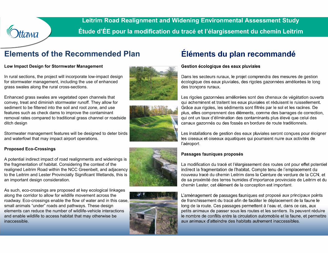
Elements of the Recommended Plan
Low Impact Design for Stormwater Management
In rural sections, the project will incorporate low-impact design for stormwater management, including the use of enhanced grass swales along the rural cross-sections.
Enhanced grass swales are vegetated open channels that convey, treat and diminish stormwater runoff. They allow for sediment to be filtered into the soil and root zone, and use features such as check dams to improve the contaminant removal rates compared to traditional grass channel or roadside ditch design
Stormwater management features will be designed to deter birds and waterfowl that may impact airport operations.
Proposed Eco-Crossings
A potential indirect impact of road realignments and widenings is the fragmentation of habitat. Considering the context of the realigned Leitrim Road within the NCC Greenbelt, and adjacency to the Leitrim and Lester Provincially Significant Wetlands, this is an important design consideration.
As such, eco-crossings are proposed at key ecological linkages along the corridor to allow for wildlife movement across the roadway. Eco-crossings enable the flow of water and in this case, small animals “under” roads and pathways. These design elements can reduce the number of wildlife-vehicle interactions and enable wildlife to access habitat that may otherwise be inaccessible.

Managing Noise and Vibration Impacts
A preliminary noise and vibration impact assessment has been completed. The assessment aligns with the municipal and provincial guidelines that apply to transportation projects.
Future vibrations associated with the long-term operation of the roadway are expected to fall below perceptible levels for existing sensitive receivers by the project area.
For noise, key criteria include: • Noise sensitive receivers are identified as the rear or exposed side yard
amenity areas of residential dwellings and other sensitive land uses. • For residential dwellings, the noise sensitive location of concern is the
outdoor amenity area located 3.0 m behind the rear wall of the dwelling, and 1.5 m above the ground.
• Where the forecasted noise levels at sensitive receivers are higher than 60 dBA from the resulting ultimate build out condition for the project, noise attenuation is investigated. Where technically, administratively, and economically feasible, noise attenuation will be provided as part of the project. However, this 60 dBA threshold is not met for this project.
With the proposed Recommended Plan, the nearest noise sensitive receiver is 160m +/-from the project. Based on the distance from the proposed roadway to existing sensitive receivers and the forecasted noise levels, noise attenuation is not required as part of this project.

Leitrim Road Realignment and Widening Environmental Assessment Study
Étude d’ÉE pour la modification du tracé et l’élargissement du chemin Leitrim
Environmental Considerations & Mitigation
There are a number of environmental considerations (natural, social, and physical) along the corridor. These are shown below, as are the interactions with the project and suggested mitigation or design considerations.
1Future Employment Area. The realigned and widened Leitrim Road will be located alongside future employment areas. The design ensures connections to these lands for all modes so they may develop accordingly.
2
3
4
5
6
7
8
10
11
Future Residential Area. The realigned and widened Leitrim Road will be located nearby future residential areas. The design ensures connections to these lands for all modes.
Provincially Significant Wetlands. Two provincially significant wetlands (PSWs) are in the study area. The project avoids directly impacting the PSWs, and eco-crossings are provided to ensure wildlife movement is maintained within the area
Former Gloucester Landfill. The project will travel through the former Gloucester Landfill. Investigations as part of this study suggest less waste in the area where the roadway is proposed. Best practices will be used to minimize risk during construction.
Existing and Proposed Stormwater Ponds. To manage stormwater runoff from the future Leitrim Road, stormwater management facilities are required. These ponds will lessen the impact of the project runoff on the surrounding natural environment and receiving watercourses.
Potential Future Southern Runway. The location of the potential future southern runway is protected with the proposed realigned Leitrim Road corridor. The project travels south away from the runway to avoid any encroachment.
National Capital Commission Greenbelt. The project travels adjacent to and through the Greenbelt at various points. Rural cross-sections provide a design that reflects the nature of the Greenbelt. Low Impact Design for Stormwater Management techniques are used to protect the Greenbelt lands, and a context sensitive landscaping and lighting strategy is proposed.
Agricultural Resource Area. The realigned and widened Leitrim Road will travel alongside an agricultural resource area. The reconstruction widens to the south to avoid impacts to agricultural lands in the west, and incorporates enhanced grass swales to improve current conditions. Any loss of land will be offset or compensated.
Cultural Heritage Resources. The Greenbelt is a cultural heritage landscape, and there is archaeological potential. Additional investigations such as Heritage Impact Assessments and Archaeological Assessments are recommended.
Significant Woodlands. Any impacts to the vegetation within the significant woodlands will be compensated for a no net loss approach, ensuring that the overall tree cover is maintained, or if possible improved.
Significant Valley Lands The realigned and widened Leitrim Road minimizes impacts on the Mosquito Creek valley lands by using the existing corridor and only widening to accommodate a cycling facility. Slope stabilization is recommended in this area.
9
Futurs secteurs d’emploi. Le chemin Leitrim retracé et élargi longera de futurs secteurs d’emploi. L’aménagement comprend des correspondances intermodales en prévision de la croissance de ces secteurs.
Futurs secteurs résidentiels. Le chemin Leitrim retracé et élargi se trouvera près de futurs secteurs résidentiels. L’aménagement prévoit des correspondances intermodales pour ces secteurs.
Terres humides d’importance provinciale. Le secteur à l’étude comprend deux terres humides d’importance provinciale. Le projet évite toute répercussion directe sur celles-ci, et prévoit des passages fauniques pour assurer le déplacement de la faune dans le secteur.
Ancien site d’enfouissement de Gloucester. Le projet traversera l’ancien site d’enfouissement de Gloucester. Les enquêtes effectuées dans le cadre du projet montrent qu’il y a moins de déchets dans le secteur où l’aménagement de la route est proposé. Des pratiques exemplaires seront appliquées pour réduire au minimum les risques pendant les travaux de construction.
Bassins de rétention des eaux pluviales existants et proposés. Des installations sont nécessaires pour gérer le ruissellement des eaux pluviales provenant du futur chemin Leitrim. Ces bassins atténueront les effets du ruissellement sur l’environnement naturel avoisinant et les cours d’eau récepteurs.
Piste sud potentielle. L’emplacement de la piste sud potentielle est protégé dans le tracé proposé du chemin Leitrim, qui contourne la piste par le sud pour éviter tout empiètement.
Ceinture de verdure de la CCN. Plusieurs tronçons du tracé longent et traversent la Ceinture de verdure; par conséquent, les coupes transversales rurales y sont adaptées. Des conceptions et techniques de gestion écologique des eaux pluviales sont utilisées pour protéger les terrains de la Ceinture de verdure, et une stratégie d’aménagement paysager et d’éclairage adaptée au contexte est proposée.
Secteur de ressources agricoles. Le chemin Leitrim retracé et élargi longera un secteur de ressources agricoles. Le projet est élargi vers le sud pour éviter les répercussions sur les terres agricoles à l’ouest, et comprend des rigoles gazonnées qui améliorent les conditions actuelles. Toute perte de terres sera compensée.
Ressources du patrimoine culturel. La Ceinture de verdure est un paysage du patrimoine culturel qui comporte un potentiel archéologique. Il est recommandé d’effectuer d’autres études, comme des évaluations archéologiques et de conservation du patrimoine.
Terrains boisés d’importance. Toute répercussion sur la végétation des terrains boisés d’importance sera compensée par l’application du principe « aucune perte nette » pour ainsi conserver l’ensemble du couvert forestier, ou même l’améliorer, dans la mesure du possible.
Vallées d’importance. Le chemin Leitrim retracé et élargi réduit au minimum les répercussions sur la vallée du ruisseau Mosquito en utilisant l’ancien tracé, et en l’élargissant seulement pour aménager une installation cyclable. L’aménagement de mesures de stabilisation des rives est recommandé dans ce secteur.
Effets environnementaux et mesures d’atténuation
Les nombreuses considérations environnementales (naturelles, sociales et physiques) associées au tracé sont présentées ci-dessous, ainsi que les liens avec le projet et les mesures d’atténuation ou les éléments de conception proposés.

Environmental Effects & Mitigation
The Recommended Plan will be designed and implemented with the benefit of contemporary planning, engineering, and environmental best practices and plans. Examples of these are listed below and will be updated and refined during the subsequent detailed design phase of the project.
• Stormwater Management Plan • Erosion and Sediment Control Plan • Construction and Traffic Management Plan • Emergency Response Plan • Environmental Management Plan • Management of Contaminated Materials • Public Communications Plan • Lighting Treatment Plan • Construction Waste Management Plan • Landscape Plan
Many of the anticipated impacts are temporary in nature (during construction). Monitoring measures are recommended to determine which effects occur during construction, and may result in modifications to the recommended mitigation.
Monitoring measures include inspection and surveillance, and compliance monitoring for the above noted plans and complaint monitoring for such effects as noise and air quality (dust) during construction phases.

Next Steps
Following this Public Open House:
• Your comments on the study will be reviewed along with input received from the Consultation Groups
• The Recommended Plan will be refined and updated to resolve remaining issues
• The Final Recommended Plan will be presented to the City's Transportation Committee and Council for approval in Spring 2018. There is an opportunity for members of the public to present directly to Transportation Committee.
• After Council approval, the Environmental Study Report will be finalized and posted for public review.
• Information about the study will continue to be posted on the City's website as it becomes available at: www.Ottawa.ca/LeitrimRoad
Your views are important to the success of this study. Please fill out a comment sheet, and leave it in the box provided, or return to us by mail or email by March 15, 2018.
Comments or questions can also be submitted by email to: [email protected]