Embed Size (px)
Citation preview
Electronic Development Services Public Meeting
Agenda
Meeting No. 3
March 23, 2020, 7:00 PM
Live streamed
Note: Members of Development Services Committee will be participating in the meeting
remotely.
Due to COVID-19, our facilities are closed to the public.
Access is not permitted to the Markham Civic Centre and Council Chamber.
Members of the public may submit written deputations by email to
Members of the public who wish to make virtual deputations must register by completing an
online Request to Speak Form or e-mail [email protected] providing full name,
contact information and item they wish to speak to. Alternatively, you may connect via
telephone by contacting the Clerk's office at 905-479-7760 on the day of the meeting.
Development Services Public meetings are video and audio streamed on the City’s website
at:
https://pub-markham.escribemeetings.com/
Electronic Development Services Public Meeting Agenda
Meeting Number 3
March 23, 2021, 7:00 PM - 9:00 PMLive streamed
All Members of CouncilDevelopment Services
Chair: Regional Councillor Jim JonesVice Chair: Keith Irish
Development Services meetings are live video and audio streamed on the City’s website.
Alternate formats for this document are available upon request.
Closed captioning during the video stream may be turned on by clicking the [cc] icon located at the lower rightcorner of the video screen
Pages
1. CALL TO ORDER
2. DISCLOSURE OF PECUNIARY INTEREST
3. DEPUTATIONS
4. REPORTS
4.1. PRELIMINARY REPORT, APPLICATIONS FOR DRAFT PLAN OFSUBDIVISION AND ZONING BY-LAW AMENDMENT SUBMITTED BYKENNEDY MM MARKHAM LTD. TO FACILITATE RESIDENTIAL ANDMIXED USE DEVELOPMENT ON THE LANDS KNOWN MUNICIPALLY
2
AS 10537 KENNEDY ROAD (WARD 6), FILE # PLAN-20-129597 (10.7,10.5)
A. Crompton, ext. 2621
5. ADJOURNMENT
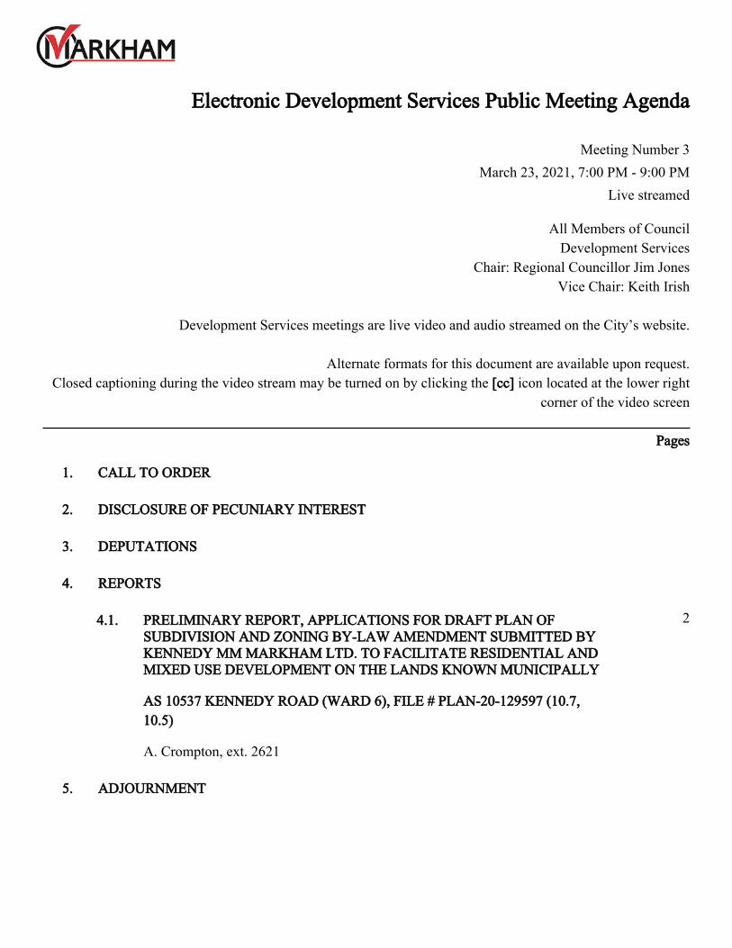
Report to: Development Services Committee Meeting Date: February 22, 2021
SUBJECT: PRELIMINARY REPORT
Applications for Draft Plan of Subdivision and Zoning By-
law Amendment submitted by Kennedy MM Markham Ltd.
to facilitate residential and mixed use development on the
lands known municipally as 10537 Kennedy Road (Ward 6)
File # PLAN-20-129597
PREPARED BY: Amanda Crompton, MCIP RPP
Planner II, North District, ext. 2621
REVIEWED BY: Stephen Kitagawa, MCIP, RPP
Acting Manager, North District, ext. 2531
RECOMMENDATION:
THAT the report dated February 22, 2021 titled “PRELIMINARY REPORT,
Applications for Draft Plan of Subdivision and Zoning By-law Amendment submitted by
Kennedy MM Markham Ltd. to facilitate residential and mixed use development on the
lands known municipally as 10537 Kennedy Road (Ward 6), File # PLAN-20-129597”
be received.
PURPOSE:
This report provides preliminary information on the Draft Plan of Subdivision and
Zoning By-law Amendment applications (the “Applications”) submitted by Kennedy
MM Markham Ltd. (the “Owner”) to facilitate residential and mixed use development on
the lands known municipality as 10537 Kennedy Road. This report contains general
information regarding Official Plan policies and Zoning By-law permissions, as well as
other issues and should not be taken as Staff’s opinion or recommendation on the
Applications.
BACKGROUND:
Subject property and area context
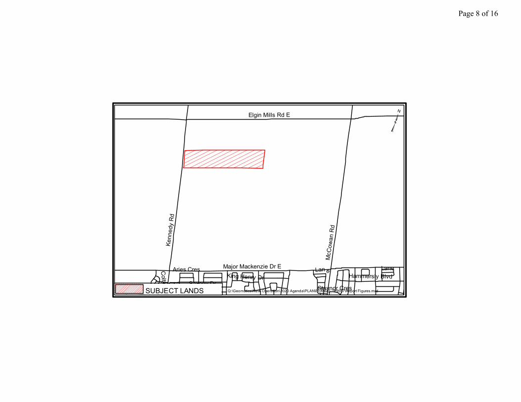
The approximately 26 hectare (64 acre) subject lands are located east of Kennedy Road,
south of Elgin Mills Road (see Figure 1 – Location Map). The subject lands are currently
used for agricultural purposes and contain the Arthur Wegg House, which is designated
under Part IV of the Ontario Heritage Act.
The subject lands are located within the Robinson Glen Secondary Plan Area, which is
bounded by Elgin Mills Road to the north, Kennedy Road to the west, Major Mackenzie
Drive to the south and the Robinson Creek to the east.
Surrounding land uses include (see Figure 2 – Aerial Photo):
Agricultural lands and rural residential properties are located immediately north
of the subject lands. Draft Plan of Subdivision and Zoning By-law Amendment
applications have been submitted to the City for the lands to the immediate north
Page 2 of 16
Report to: Development Services Committee Meeting Date: February 22, 2021 Page 2
(4551 Elgin Mills Road East) and are currently being reviewed (File No. PLAN
20 113780).
Natural environmental lands and agricultural lands with frontage on McCowan
Road are located directly east of the subject lands
Agricultural lands are located to the immediate south of the subject lands. Draft
Plan of Subdivision and Zoning By-law Amendment applications have been
submitted to the City for the lands to the south and are currently being reviewed:
o 10379 and 10411 Kennedy Road (File No. PLAN 20 133038); and
o 10225 – 10227 Kennedy Road and 4638 Major Mackenzie Drive East
(File No. PLAN 20 113780).
Agricultural lands are located to the west of the subject lands across Kennedy
Road. The Angus Glen Golf Club is located across Kennedy Road to the south-
west of the subject lands.
Process to date
The Applications were deemed complete on November 12, 2020.
Next steps
Holding a Statutory Public Meeting at a future date, when appropriate.
Recommendation Report for DSC’s consideration at a future date.
Future site plan applications for the mid-rise blocks
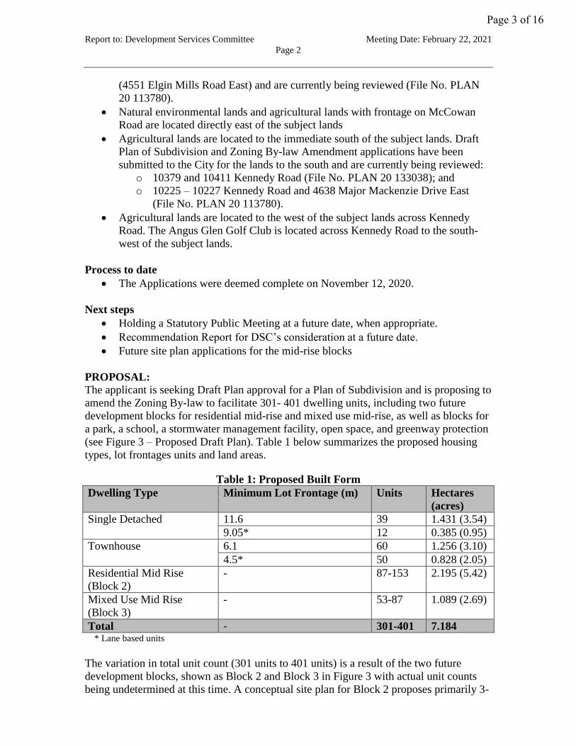
PROPOSAL:
The applicant is seeking Draft Plan approval for a Plan of Subdivision and is proposing to
amend the Zoning By-law to facilitate 301- 401 dwelling units, including two future
development blocks for residential mid-rise and mixed use mid-rise, as well as blocks for
a park, a school, a stormwater management facility, open space, and greenway protection
(see Figure 3 – Proposed Draft Plan). Table 1 below summarizes the proposed housing
types, lot frontages units and land areas.
Table 1: Proposed Built Form
Dwelling Type Minimum Lot Frontage (m) Units Hectares
(acres)
Single Detached 11.6 39 1.431 (3.54)
9.05* 12 0.385 (0.95)
Townhouse 6.1 60 1.256 (3.10)
4.5* 50 0.828 (2.05)
Residential Mid Rise
(Block 2)
- 87-153 2.195 (5.42)
Mixed Use Mid Rise
(Block 3)
- 53-87 1.089 (2.69)
Total - 301-401 7.184 * Lane based units
The variation in total unit count (301 units to 401 units) is a result of the two future
development blocks, shown as Block 2 and Block 3 in Figure 3 with actual unit counts
being undetermined at this time. A conceptual site plan for Block 2 proposes primarily 3-
Page 3 of 16
Report to: Development Services Committee Meeting Date: February 22, 2021 Page 3
storey condominium townhouses (see Figure 3A – Block 2 Conceptual Site Plan). A
conceptual site plan for Block 3 proposes 4-storey townhouses and a mid-rise building
that steps down from 5-storeys to 2-storeys (see Figure 3B – Block 3 Conceptual Site
Plan Option A). A second conceptual site plan for Block 3 proposes all 4-storey
townhouses (see Figure 3C – Block 3 Conceptual Site Plan Option B). The proposed built
form in Blocks 2 and 3 will be determined through a future Site Plan application.
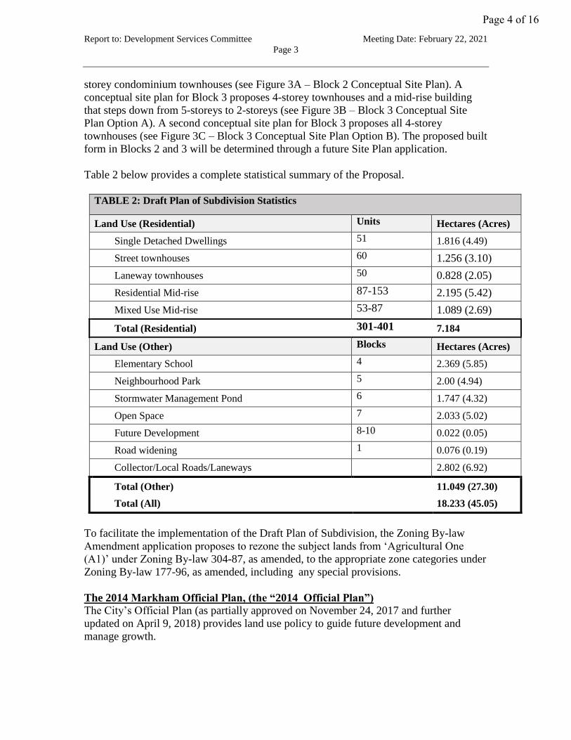
Table 2 below provides a complete statistical summary of the Proposal.
TABLE 2: Draft Plan of Subdivision Statistics
Land Use (Residential) Units Hectares (Acres)
Single Detached Dwellings 51 1.816 (4.49)
Street townhouses 60 1.256 (3.10)
Laneway townhouses 50 0.828 (2.05)
Residential Mid-rise 87-153 2.195 (5.42)
Mixed Use Mid-rise 53-87 1.089 (2.69)
Total (Residential) 301-401 7.184
Land Use (Other) Blocks Hectares (Acres)
Elementary School 4 2.369 (5.85)
Neighbourhood Park 5 2.00 (4.94)
Stormwater Management Pond 6 1.747 (4.32)
Open Space 7 2.033 (5.02)
Future Development 8-10 0.022 (0.05)
Road widening 1 0.076 (0.19)
Collector/Local Roads/Laneways 2.802 (6.92)
Total (Other) 11.049 (27.30)
Total (All) 18.233 (45.05)
To facilitate the implementation of the Draft Plan of Subdivision, the Zoning By-law
Amendment application proposes to rezone the subject lands from ‘Agricultural One
(A1)’ under Zoning By-law 304-87, as amended, to the appropriate zone categories under
Zoning By-law 177-96, as amended, including any special provisions.
The 2014 Markham Official Plan, (the “2014 Official Plan”)
The City’s Official Plan (as partially approved on November 24, 2017 and further
updated on April 9, 2018) provides land use policy to guide future development and
manage growth.
Page 4 of 16
Report to: Development Services Committee Meeting Date: February 22, 2021 Page 4
Map 3 - Land Use designates the Subject Lands ‘Residential Low Rise’, ‘Residential Mid
Rise’, ‘Mixed Use Mid Rise’ and ‘Greenway’ (See Figure 4: Official Plan Land Use
Excerpt).
The Official Plan provides direction for the development of a Conceptual Master Plan for
the Future Urban Area (FUA) as the basis for the development of Secondary Plans,
including the Robinson Glen Secondary Plan. The Conceptual Master plan for the FUA
was completed and endorsed by Council in November 2017. Staff will evaluate the
Proposal to determine if it conforms to the City’s Official Plan.
Robinson Glen Secondary Plan (the “Secondary Plan”)
The Secondary Plan includes detailed policies to guide future development and growth in
the Robinson Glen community to 2031. The Secondary Plan provides a comprehensive
policy framework for Council decisions with respect to the use of land, provision for
municipal services and infrastructure, and the implementation and phasing of
development.
Map SP1 – Detailed Land Use designates the Subject Lands ‘Residential Low Rise’,
‘Residential Mid Rise I’, ‘Mixed Use Mid Rise’ and ‘Greenway’. Site specific policy
8.3.1.6 (Neighbourhood Service Node) applies to the ‘Mixed Use Mid Rise’ block. The
following symbols are also shown on Map SP1 within the boundary of the Subject Lands:
one public elementary school symbol, one neighbourhood park symbol and one
stormwater management facility symbol (see Figure 5 – Robinson Glen Secondary Plan –
Land Use Map).
The Secondary Plan contains minimum and maximum density targets, minimum and
maximum building heights and specific development criteria associated with each land
use. Staff will evaluate the Proposal to determine if it conforms to the Secondary Plan.
Robinson Glen Community Design Plan (the “Design Guidelines”)
The Design Guidelines set out to achieve a coordinated approach to urban design
throughout the community. Among other things, the Design Guidelines provide direction
related to streetscape, parks and open space, building typology and mix, lotting pattern,
sustainability features, gateways, and special community and landmark features. Staff
will evaluate the Proposal to determine if it has regard for the Design Guidelines.
Zoning
The Subject Lands are zoned ‘Agricultural One (A1)’ by By-law 304-87, as amended
(See Figure 6: Area Context/Zoning). A zoning by-law amendment is required to permit
urban residential development on the Subject Lands.
OPTIONS/ DISCUSSION:
The following is a brief summary of the key matters raised to date. These matters, and
others identified at a future Public Meeting and through the circulation and detailed
review of the applications, will be addressed in a future Recommendation Report to
Committee:
Page 5 of 16
Report to: Development Services Committee Meeting Date: February 22, 2021 Page 5
Cultural Heritage Resource
The subject lands were designated under Part IV of the Ontario Heritage Act in 2014.
The designation applies to the Arthur Wegg House, which is located in the southwest
corner of the subject lands with an existing driveway onto Kennedy Road.
Parkland
Staff are reviewing the location, size and configuration of proposed parks as well as co-
located parks and school sites, based on Secondary Plan policies, Design Guidelines and
the Planning Act requirements. The proposal includes a Neighbourhood Park that is 2
hectares (4.9 acres) in size, as per the Secondary Plan.
Affordable housing, purpose-built secondary suites and seniors housing
The Secondary Plan has progressive policies for affordable housing including the
promotion of secondary suites. Staff have asked the Owner to consider purpose-built
secondary suites and options that will allow homeowners to easily implement secondary
suites. The owner has also been asked to design units and amenities that facilitate aging
in place. The Proposal remains under review as it relates to these topics.
Community Energy Plan and Sustainability Initiatives
A Community Energy Plan (the “CEP”) for the FUA has been completed. The CEP
identifies and promotes strategies to reduce energy use, to support renewable energy
generation and to reduce overall greenhouse gas emissions in the FUA. In addition, the
applicant has submitted a sustainability checklist. The Proposal remains under review in
the context of the CEP and the sustainability checklist.
Review the appropriateness of the proposed built form and zoning by-law
amendment
Staff are reviewing the proposed site-specific development standards (i.e. minimum lot
frontages, setbacks, maximum building heights, amenity space, etc.).
Public Art contributions to be determined and implemented in the amending zoning
by-law
Section 37 contributions for the provision of public art requires finalization for
implementation through the amending zoning by-law.
Outstanding Secondary Plan Studies
Robinson Glen Secondary Plan Master Environmental Servicing Plan (MESP) requires
final review and acceptance by City Staff. The Proposal is subject to the findings of the
MESP and as such, changes to the Draft Plan may be necessary to be consistent with the
accepted conclusions.
Technical studies/reports currently under review
Staff are in the process of reviewing the following studies/reports: Environmental Impact
Study, Heritage Impact Assessment, Tree Assessment and Protection Plan, Functional
Servicing and Stormwater Management Report, Traffic Impact and Transportation
Demand Management Study, Sustainability Checklist Report, Phase One Environmental
Site Assessments, Environmental Noise Feasibility Study, Hydrogeological Assessment,
Page 6 of 16
Report to: Development Services Committee Meeting Date: February 22, 2021 Page 6
Archaeological Assessments and Geotechnical Report. Comments from internal
departments and external agencies with respect to these studies may result in changes to
the Proposal.
FINANCIAL CONSIDERATIONS
Not applicable.
HUMAN RESOURCES CONSIDERATIONS
Not applicable.
ALIGNMENT WITH STRATEGIC PRIORITIES:
The applications are being evaluated in the context of the City’s strategic priorities.
BUSINESS UNITS CONSULTED AND AFFECTED:
The applications have been circulated to various departments and external agencies and
are currently under review. Requirements of the City and external agencies will be
reflected in a future recommendation report and/or as conditions of approval.
RECOMMENDED BY:
____________________________ _______________________________
Biju Karumanchery, M.C.I.P., R.P.P. Arvin Prasad, M.C.I.P., R.P.P.
Director, Planning and Urban Design Commissioner, Development Services
ATTACHMENTS:
Figure 1: Location Map
Figure 2: Aerial Photo
Figure 3: Proposed Draft Plan
Figure 3A: Block 2 Conceptual Site Plan
Figure 3B: Block 3 Conceptual Site Plan Option A
Figure 3C: Block 3 Conceptual Site Plan Option B
Figure 4: Official Plan Land Use Excerpt
Figure 5: Robinson Glen Secondary Plan – Land Use Map
Figure 6: Area Context/Zoning
Page 7 of 16
Elgin Mills Rd E
Kenn
edy R
d
McCo
wan R
d
Major Mackenzie Dr E
Lane Saxony DrHammersly BlvdKing Henry Dr
Colty Dr
Aries Cres
Staynor Cres
LaneLane
SUBJECT LANDS
³
Q:\Geomatics\New Operation\2020 Agenda\PLAN\PLAN20_129597\Report Figures.mxd
Page 8 of 16
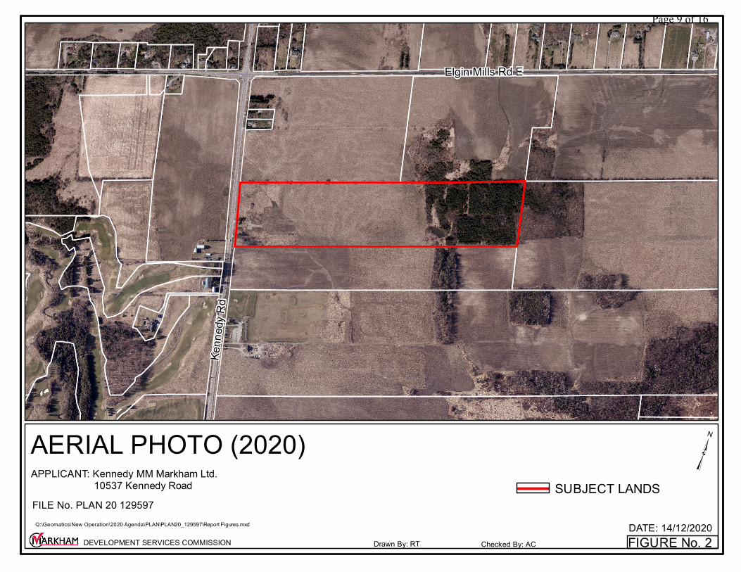
FIGURE No. 2DATE: 14/12/2020
AERIAL PHOTO (2020)
Drawn By: RT Checked By: ACDEVELOPMENT SERVICES COMMISSION
SUBJECT LANDS
Elgin Mills Rd E
Kenn
edy R
d
³ Q:\Geomatics\New Operation\2020 Agenda\PLAN\PLAN20_129597\Report Figures.mxd
APPLICANT: Kennedy MM Markham Ltd. 10537 Kennedy RoadFILE No. PLAN 20 129597
Page 9 of 16
FIGURE No. 3DATE: 14/12/2020
PROPOSED DRAFT PLAN
Drawn By: RT Checked By: ACDEVELOPMENT SERVICES COMMISSION
³ Q:\Geomatics\New Operation\2020 Agenda\PLAN\PLAN20_129597\Report Figures.mxd
APPLICANT: Kennedy MM Markham Ltd. 10537 Kennedy RoadFILE No. PLAN 20 129597
Page 10 of 16
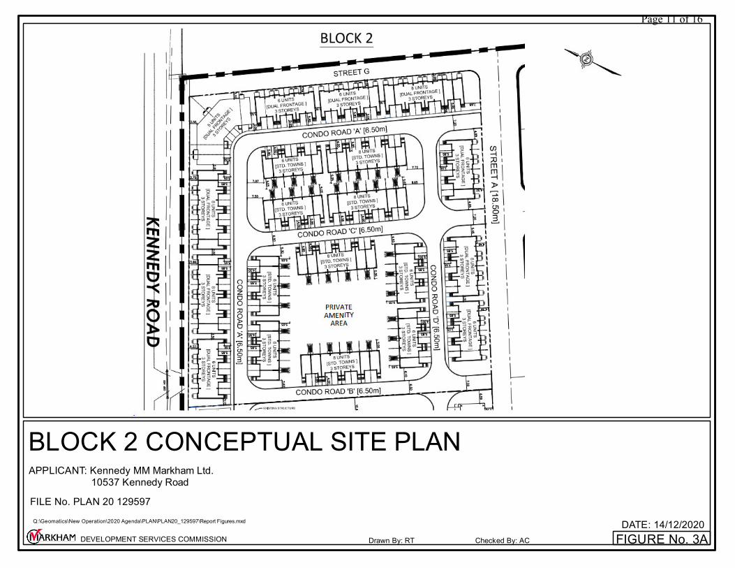
FIGURE No. 3ADATE: 14/12/2020
BLOCK 2 CONCEPTUAL SITE PLAN
Drawn By: RT Checked By: ACDEVELOPMENT SERVICES COMMISSION
Q:\Geomatics\New Operation\2020 Agenda\PLAN\PLAN20_129597\Report Figures.mxd
APPLICANT: Kennedy MM Markham Ltd. 10537 Kennedy RoadFILE No. PLAN 20 129597
Page 11 of 16
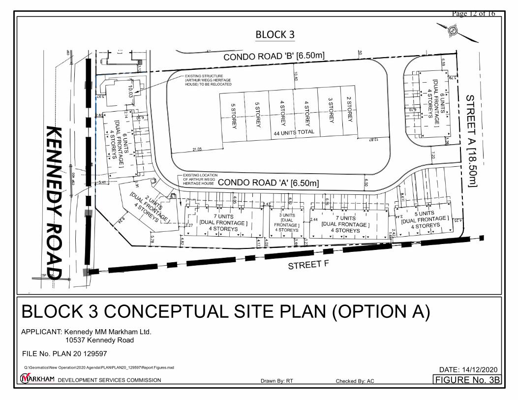
FIGURE No. 3BDATE: 14/12/2020
BLOCK 3 CONCEPTUAL SITE PLAN (OPTION A)
Drawn By: RT Checked By: ACDEVELOPMENT SERVICES COMMISSION
Q:\Geomatics\New Operation\2020 Agenda\PLAN\PLAN20_129597\Report Figures.mxd
APPLICANT: Kennedy MM Markham Ltd. 10537 Kennedy RoadFILE No. PLAN 20 129597
Page 12 of 16
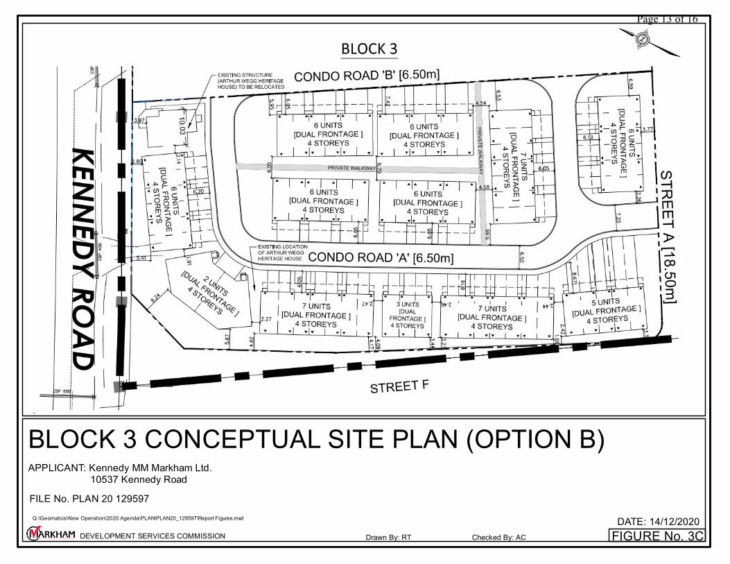
FIGURE No. 3CDATE: 14/12/2020
BLOCK 3 CONCEPTUAL SITE PLAN (OPTION B)
Drawn By: RT Checked By: ACDEVELOPMENT SERVICES COMMISSION
Q:\Geomatics\New Operation\2020 Agenda\PLAN\PLAN20_129597\Report Figures.mxd
APPLICANT: Kennedy MM Markham Ltd. 10537 Kennedy RoadFILE No. PLAN 20 129597
Page 13 of 16
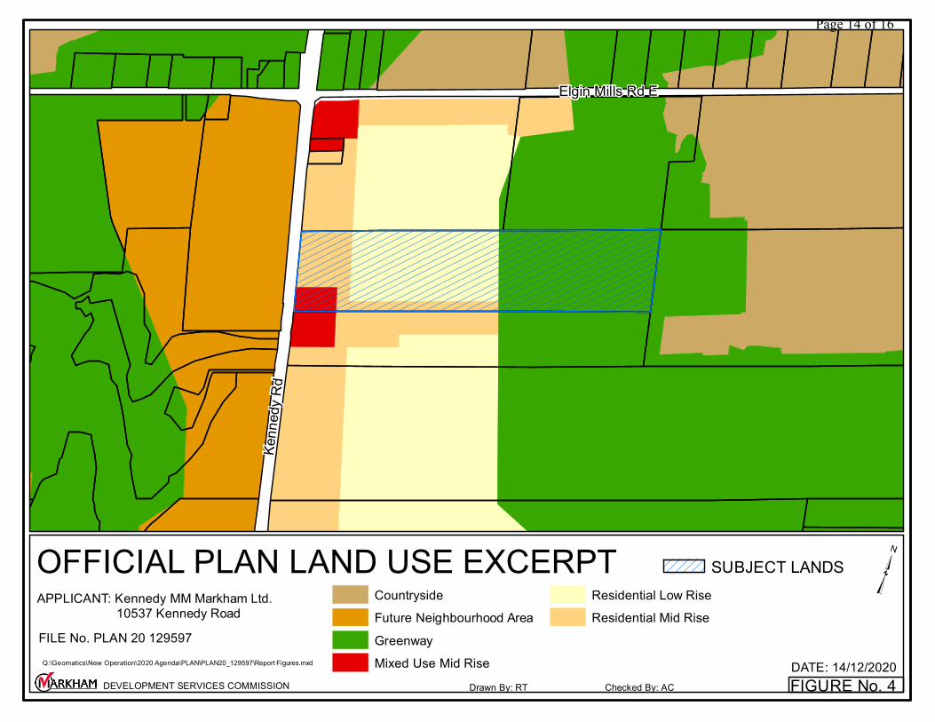
FIGURE No. 4DATE: 14/12/2020
OFFICIAL PLAN LAND USE EXCERPT
Drawn By: RT Checked By: ACDEVELOPMENT SERVICES COMMISSION
SUBJECT LANDS
Elgin Mills Rd E
Kenn
edy R
d
³ Q:\Geomatics\New Operation\2020 Agenda\PLAN\PLAN20_129597\Report Figures.mxd
APPLICANT: Kennedy MM Markham Ltd. 10537 Kennedy RoadFILE No. PLAN 20 129597
CountrysideFuture Neighbourhood AreaGreenwayMixed Use Mid Rise
Residential Low RiseResidential Mid Rise
Page 14 of 16
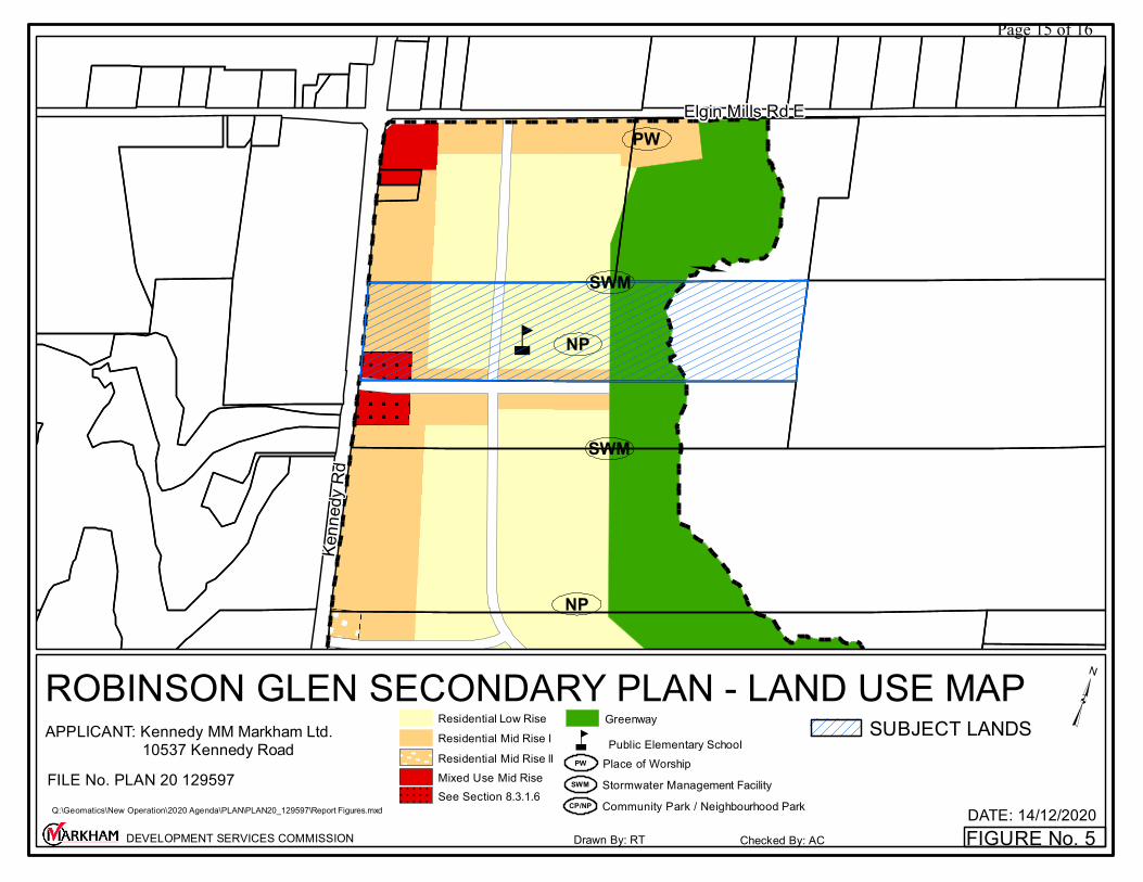
FIGURE No. 5DATE: 14/12/2020
ROBINSON GLEN SECONDARY PLAN - LAND USE MAP
Drawn By: RT Checked By: ACDEVELOPMENT SERVICES COMMISSION
SUBJECT LANDSå
åå
å
PW
NP
NP
SWM
SWM
Elgin Mills Rd E
Kenn
edy R
d
³ Q:\Geomatics\New Operation\2020 Agenda\PLAN\PLAN20_129597\Report Figures.mxd
APPLICANT: Kennedy MM Markham Ltd. 10537 Kennedy RoadFILE No. PLAN 20 129597
Public Elementary Schoolå
Stormwater Management FacilitySWM
Greenway
Mixed Use Mid RiseSee Section 8.3.1.6
Residential Low RiseResidential Mid Rise IResidential Mid Rise lI
Community Park / Neighbourhood ParkCP/NP
Place of WorshipPW
Page 15 of 16
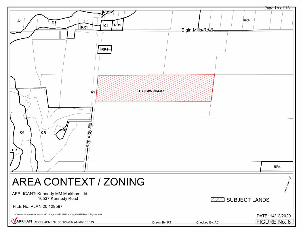
FIGURE No. 6DATE: 14/12/2020
AREA CONTEXT / ZONING
Drawn By: RT Checked By: ACDEVELOPMENT SERVICES COMMISSION
SUBJECT LANDS
BY-LAW 304-87A1
CRO1
RR4O1A1
CR
RR4
RR1 C1 RR1
RR1
RR2
RR1
Elgin Mills Rd E
Kenn
edy R
d
³ Q:\Geomatics\New Operation\2020 Agenda\PLAN\PLAN20_129597\Report Figures.mxd
APPLICANT: Kennedy MM Markham Ltd. 10537 Kennedy RoadFILE No. PLAN 20 129597
Page 16 of 16