Embed Size (px)
Citation preview

Electronic data Deliverable (EDD)
Comprehensive Specification Manual 4.0 EQuIS database version 6.4 Mar 2016 EPA R2 EDD format version 4
U. S. Environmental Protection Agency,
Region 2 Superfund
490 Broadway
New York, NY 10007

Region 2 EDD Comprehensive Specification Manual United States
Version 4.0 2 Environmental Protection Agency
THIS PAGE LEFT BLANK INTENTIONALLY

Region 2 EDD Comprehensive Specification Manual United States
Version 4.0 i Environmental Protection Agency
ACKNOWLEDGEMENTS
This document was originally prepared for EPA Region 5 by the John A. Volpe National Transportation
Systems Center (Volpe Center). This document was reviewed and edited by David Wilson and Mary
Tierney of EPA Region 5; William Halloran and Joseph Monaghan of the Volpe Center; and John
Hennessy and Ellen Baptiste-Carpenter of Battelle Laboratories, Inc. Other technical reviewers from
EPA include Patricia Scott, Chemist, EPA Region 5; Douglas Yeskis, Geologist, EPA Region 5; Luanne
Vanderpool, Geologist, EPA Region 5; Anthony Kahaly, EPA Region 5, RCRA Division; and Andy
Crossland, Hydrogeologist, EPA, Region 2. Other reviewers include Steve Losier of the Volpe Center;
Janet Magurn, Scot Weaver and Dave Abercrombie of EarthSoft, Inc.; Rosanna Buhl of Battelle
Laboratories, Inc.; and Izak Maitin of the New Jersey Department of Environmental Protection.
EarthSoft Inc. developed the Electronic Data Processor (EDP) and reviewed the EDD format to assure its
technical accuracy.
This documentation was reviewed and updated by Diann Cox-Tramel and Robert M. Alvey, Region 2 and
updated on June 2015 to meet the standards and requirements of EPA Region 2.

Region 2 EDD Comprehensive Specification Manual United States
Version 4.0 ii Environmental Protection Agency
DISCLAIMER OF ENDORSEMENT
Reference herein to any specific commercial products, process, or service by trade name, trademark,
manufacturer, or otherwise, does not necessarily constitute or imply its endorsement, recommendation, or
favoring by the United States Government. The views and opinions of authors expressed herein do not
necessarily state or reflect those of the United States Government, and shall not be used for advertising or
product endorsement purposes.

Region 2 EDD Comprehensive Specification Manual United States
Version 4.0 iii Environmental Protection Agency
EXECUTIVE SUMMARY
The purpose of this specification manual is to provide detailed instructions on how to report
environmental data electronically to the United States Environmental Protection Agency (EPA) Region 2.
The types of data can be reported electronically include, for example, data generated during site
characterization and investigation phases, data recorded when installing monitoring wells, and monitoring
data that is routinely collected from a variety of media. This manual describes the procedural and
formatting requirements you need to know to submit your Electronic Data Deliverable (EDD) to the EPA
Region 2 Superfund Division.
This EDD Comprehensive Specification manual describes the requirements for reporting all current and
future environmental data to EPA Region 2. EPA recognizes that some information about data collected
in the past may not be readily available and, by reducing the requirements for electronic basic data, is
endeavoring to strike a balance between minimizing the amount of effort involved in inputting
information and maximizing the ability to document remedy progress. Environmental data collected and
analyzed prior to the initial use of this EDD Comprehensive specification manual should be reported
using the EPA Region 2 “Basic Manual for Historic Electronic Data”. The reporting requirements of the
“Basic Manual for Historic Electronic Data” are a subset of this comprehensive EDD Comprehensive
specification manual.
The EPA Region 2 EDD is comprised of five groups: Initial, Field, Vapor Intrusion, Chemistry, and
Basic. The Initial EDD files refer to an electronic base map of the site property, one file containing
general information about the site and about the point of contact for the EDD, and a file containing data
pertaining to site sampling locations. The Initial EDD files are only resubmitted if information, such as
the point of contact, changes. The three initial files are:
Initial – (only submit once unless changes are needed)
Base Map (electronic map of the site property boundaries in *.dxf format)
Data Provider (point of contact for EDD and file providing the information)
Site (general information about the site)
Location (information regarding the sampling locations)
In most cases, the vast majority of the electronic data submitted over the life of the project, and that will
be submitted on a reoccurring, routine basis, will be chemistry data.
Field
The Field EDD files contain data regarding drilling activities, lithology, geologic sampling, well
construction, down hole point data, and water table levels. The seven Geology EDD files are the:
Drilling Activity (information about drilling activities)
Lithology (lithology information)
Well (monitoring well information)
Well Construction (well construction details)
Geology Sample (geology sample data)
Water Table (water table data collected during drilling)
Down Hole Point (down-hole logging data)
Soil Gas ( soil gas survey data)
Water Level (information regarding groundwater level measurements)
Extraction/Injection Well (information about extraction and/or injection wells)
Field Results (information of field results)

Region 2 EDD Comprehensive Specification Manual United States
Version 4.0 iv Environmental Protection Agency
Vapor Intrusion
Building Address (information of the building address)
Building
Task Parameters
Samples
Test Result QC
Batches
Chemistry
The Chemistry EDD files contain data related to chemistry field measurements, sample collection
information, sample tests and result QC. The Chemistry EDD files are the:
Sample (information about sample collection)
Sample Parameter (information about the parameter data associated with a sample sent to a lab)
Test Result QC (information about the analytical test performed on samples with quality control
data elements)
Batch (test batch information)
Basic Submittals
The Basic EDD files contain historical operation and maintenance (O&M) data. The EDD files are the:
Location (information about sampling locations from historical data)
Water Level (information regarding groundwater level measurements)
Chemistry Sample (information about sample collection)
Geology (information about geology data)
Of the files listed above, the Chemistry and Field files that most data providers will submit will be the
Well, Water Level, Extraction Injection Wells, Sample, Test/Result QC files. The Test Result with QC
and Batch files will only be submitted in those rare cases where EPA requires QA/QC data in electronic
format. The Extraction/Injection Well file will only need to be submitted for sites with extraction or
injection wells.
The process for creating initial, chemistry and field EDDs are shown in Figures E-1 and E-2, respectively.
The process begins by identifying the software tool that will be used. . Many software tools, such as text
editors, word processors, spreadsheets, and databases, are capable of creating EDDs. Because
spreadsheets and databases are designed to enter and manage data, however, they are generally preferred
for creating EDDs. The production of the data tables will normally be a collaborative effort between
laboratories and environmental contractors. The laboratories will typically produce the test/result tables
while the contractors normally will produce all of the other tables.
As shown in Figures E-1 and E-2, decision points are included in the EDD creation process to ensure that
Initial EDD files have been submitted for a site, as well as to prevent redundancy when getting ready to
submit chemistry or field EDDs. For example, one of the Initial EDDs called the SITE file, which
contains data describing the site and site contact information, should generally only be reported once
(unless, as previously noted, a change occurs). Similarly, another Initial EDD file, the Location file,
which contains locational data, typically only needs to be reported once. The only time a Location EDD
file would be resubmitted is if the data changed in some way. For example, if settling occurs at a site over
time, a resurvey of site monitoring wells may be warranted. If the survey results show changes in the
elevations of the monitoring wells, the Location file would have to be resubmitted.
The final step before submitting an EDD to EPA Region 2 is to check it using the Electronic Data
Processor (EDP) software application that is currently provided on the EPA Region 2 website (located at
http://www.epa.gov/region02/superfund/medd.htm). This software application will identify any
formatting errors in the files that must be corrected prior to submitting the EDD.

Region 2 EDD Comprehensive Specification Manual United States
Version 4.0 v Environmental Protection Agency
Figure E-1 Process flow diagram for the creation and checking of Initial , Field and Chemistry
EDD files
No
Yes
Enter Water Level Data
Enter Sample Data
Enter Test/Result
Data
Enter Extraction –Injection Data (if applicable)
Has sample ever been reported?
Enter Location Data (Initial EDD File)
Has location ever been reported?
No
No
Select a Data Entry Product
Use the file EDD Region 2 EDD Template http://www.epa.gov/region02/s
uperfund/medd.htm
Define the columns in the selected software according to
the tables in sections 3 & 4
Access or
Excel?
Enter Site Data (Initial EDD File)
Has site ever been
reported?
Check with EDP and Correct Errors
Send EDD Files to
Region 2
No Yes
Yes
Yes

Region 2 EDD Comprehensive Specification Manual United States
Version 4.0 vi Environmental Protection Agency
Figure E-2 Process flow diagram for the creation and checking of Initial and Field EDD files
Select a Data Entry
Product
Access or
Excel?
Use the EPA Region 2 EDD
format
Define the columns in
the selected software
according to tables in
section 3 and 5
Has site ever
been reported?
Has location ever
been reported?
Enter Site Data (Initial
EDD File)
Enter Location Data
(Initial EDD file)
Enter Drilling
Activity Date
Enter Lithology
Data
Enter Well Data Enter Well
Contruction
Data
Enter Geo
Sample Data
Enter Water
Level Data
Enter Water Table
Data
Enter Down Hole Point
Data (e.g. CPT)
Check with EDP
and Correct Errors
Send EDD Files to
Region 2
NO Yes
No
Yes
No
Yes

Region 2 EDD Comprehensive Specification Manual United States
Version 4.0 vii Environmental Protection Agency
THIS PAGE LEFT BLANK INTENTIONALLY

Region 2 EDD Comprehensive Specification Manual United States
Version 4.0 viii Environmental Protection Agency
TABLE OF CONTENTS EXECUTIVE SUMMARY ......................................................................................................................... iii 1. INTRODUCTION TO THE EPA REGION 2 ELECTRONIC DATA DELIVERABLE (EDD) ............ 1 2. GENERAL EDD REPORTING REQUIREMENTS................................................................................ 3
2.1 File Formats ........................................................................................................................................ 3 2.2 Initial Data Submittals ........................................................................................................................ 3 2.3 Chemistry Data Submittals ................................................................................................................. 4 2.4 Field Data Submittals ......................................................................................................................... 5 2.5 Vapor Intrusion Data Submittals ........................................................................................................ 7 2.6 File Naming Convention .................................................................................................................... 8 2.7 Data Integrity Rules .......................................................................................................................... 10 2.8 Definition of a Facility, Site, and Location ...................................................................................... 13 2.9 Reporting Null Values ...................................................................................................................... 13 2.10 Valid Values ................................................................................................................................... 14 2.11 Reporting Re-Tests ......................................................................................................................... 15 2.12 Reporting Non-Detects ................................................................................................................... 15 2.13 Reporting Tentatively Identified Compounds ................................................................................ 16 2.14 Data Types ...................................................................................................................................... 16 2.15 Data Entry Tools Provided to Create the EDD Files ...................................................................... 16 2.16 Using the Electronic Data Processor to Check EDD Formatting ................................................... 18 2.17 Submitting Your EDD to EPA ....................................................................................................... 18 2.18 Examples of Initial, Chemistry, and Field EDD Files .................................................................... 20
3. FORMATS FOR INITIAL FILES .......................................................................................................... 27 3.1 Site Base Maps in the file section ..................................................................................................... 27 3.2. Data Provider ................................................................................................................................... 28 3.3 SITE EDD File ................................................................................................................................. 28 3.4 Location EDD File ............................................................................................................................ 29
4. FORMATS FOR CHEMISTRY FILES ................................................................................................. 37 4.1 Chemistry Sample EDD File ............................................................................................................ 37 4.2 Chemistry Sample Parameter EDD Files ......................................................................................... 41 4.3 Chemistry Test/Result with QC Data EDD File ............................................................................... 41 4.4 Chemistry Batch Data EDD File ...................................................................................................... 50
5. FORMATS FOR FIELD FILES ............................................................................................................. 51 5.1 Drill Activity EDD File .................................................................................................................... 51 5.2 Lithology EDD File .......................................................................................................................... 52 5.3 Well EDD File .................................................................................................................................. 54 5.4 Well Construction EDD File ............................................................................................................ 56 5.5 Geology Samples EDD File ............................................................................................................. 57 5.6 Water Table EDD Files .................................................................................................................... 61 5.7 Geology Down Hole Point Data EDD File ....................................................................................... 62 5.8 Soil Gas Data EDD File .................................................................................................................... 63 5.9 Water Level ...................................................................................................................................... 63 5.10 Extraction – Injection Well EDD File ........................................................................................... 66 5.11 Field Parameters ............................................................................................................................. 69
6. FORMATS FOR VAPOR INTRUSION FILES .................................................................................... 71 6.1 Vapor Intrusion Building Address EDD File ................................................................................... 71 6.2 Vapor Intrusion Building EDD Files ................................................................................................ 71 6.3 Vapor Intrusion Task Parameter EDD File ...................................................................................... 73 6.4 Vapor Intrusion Sample EDD file .................................................................................................... 73 6.5 Vapor Intrusion Test Result QC ....................................................................................................... 74

Region 2 EDD Comprehensive Specification Manual United States
Version 4.0 ix Environmental Protection Agency
6.6 Vapor Intrusion Batch EDD File ...................................................................................................... 83 7. TECHNICAL SUPPORT ....................................................................................................................... 85

Region 2 EDD Comprehensive Specification Manual United States
Version 4.0 x Environmental Protection Agency
LIST OF TABLES
Table 2-1 General information on the files that comprise the Initial EDD ................................................... 3 Table 2-2 General information on the files that comprise the Chemistry EDD ............................................ 4 Table 2-3 General information on the files that comprise the Field EDD .................................................... 6 Table 2-4 General information on the files that comprise the Vapor Intrusion EDD ................................... 7 Table 2-5 EDD File Naming Formats ......................................................................................................... 10 Table 2-6 Examples of how to report null values ....................................................................................... 13 Table 2-7 Cross-reference between the valid value tables in appendix and the EDD files ........................ 14 Table 2-8 Example of reporting re-tests ..................................................................................................... 15 Table 2-9 Example of reporting non-detects ............................................................................................... 15 Table 2-10 Example nomenclature for TIC reporting................................................................................. 16 Table 2-11 Data type descriptions .............................................................................................................. 16 Table 2-12 Instructions for producing tab-delimited text files from some software packages ................... 17 Table 3-1 Files ............................................................................................................................................ 27 Table 3-2 Data Provider File Structure ....................................................................................................... 28 Table 3-3 SITE data file structure ............................................................................................................... 28 Table 3-4 Location Data File Structure ...................................................................................................... 31 Table 4-1 Chemistry sample file data structure .......................................................................................... 37 Table 4-2 Chemistry Sample Parameter file data structure ........................................................................ 41 Table 4-3 Chemistry test/results with QC data file structure ...................................................................... 42 Table 4-4 Chemistry batch file data structure ............................................................................................. 50 Table 5-1 Drill activity file data structure ................................................................................................... 51 Table 5-2 Lithology file data structure ....................................................................................................... 52 Table 5-3 Well file data structure ............................................................................................................... 54 Table 5-4 Well construction file data structure ........................................................................................... 56 Table 5-5 Geology samples file data structure ............................................................................................ 58 Table 5-6 Water table file data structure ..................................................................................................... 61 Table 5-7 Geology Down Hole Point File Data Structure .......................................................................... 62 Table 5-8 Example of down hole point data file ......................................................................................... 62 Table 5-9 Soil Gas Survey file data structure ............................................................................................ 63 Table 5-10 Water Level file data structure ................................................................................................. 64 Table 5-11 Extraction-Injection Well file data structure ............................................................................ 67 Table 5-12 Field Results file data structure ................................................................................................ 69 Table 6-1 Vapor Intrusion Building Address data structure ....................................................................... 71 Table 6-2 Vapor Intrusion Building data structure ..................................................................................... 71 Table 6-3 Vapor Intrusion Task Parameter data structure .......................................................................... 73 Table 6-4 Vapor Intrusion Samples data structure ...................................................................................... 73 Table 6-5 Vapor Intrusion Test Result QC file data structure .................................................................... 75 Table 6-6 Vapor Intrusion Batches file data structure ................................................................................ 83
LIST OF FIGURES Figure E-1 Process flow diagram for the creation and checking of Initial , Field and Chemistry EDD files ................ v Figure E-2 Process flow diagram for the creation and checking of Initial and Field EDD files ..................................vi Figure 2-1 Relationships between chemistry file data structures. ................................................................................ 12 Figure 2-2 Facility component definitions ................................................................................................................... 13 Figure 2-3. Example Initial EDD ready for conversion to text file ............................................................................. 20 Figure 2-4. Example Chemistry EDD ready for conversion to text file ...................................................................... 20

Region 2 EDD Comprehensive Specification Manual United States
Version 4.0 xi Environmental Protection Agency
Figure 2-5. Examples of QC data fields in a Chemistry EDD ..................................................................................... 21 Figure 2-5. Examples of QC data fields in a Chemistry EDD (continued) .................................................................. 23 Figure 2-6. Example Field EDD ready for conversion to text file .............................................................................. 24

Region 2 EDD Comprehensive Specification Manual United States
Version 4.0 xii Environmental Protection Agency
THIS PAGE LEFT BLANK INTENTIONALLY

Region 2 EDD Comprehensive Specification Manual United States
Version 4.0 1 Environmental Protection Agency
1. INTRODUCTION TO THE EPA REGION 2 ELECTRONIC DATA DELIVERABLE (EDD)
The EPA Region 2 Superfund Division has developed an electronic data management system to improve
how environmental data from Superfund sites are acquired and managed. The system will accelerate the
review of environmental data submittals, improve service to the regulated community, and enhance the
protection of the environment and the public. A vital element in the electronic transfer of environmental
data is the submittal of data in a standardized, “computer-friendly” format. The specifications and
formatting requirements for the EPA Region 2 EDD were developed to facilitate the transfer of data from
data providers to the EPA.
NOTE: This EDD Comprehensive Specification manual describes the requirements for reporting all
current and future environmental data to EPA Region 2. Environmental data collected and analyzed
prior to the initial use of this EDD specification manual should be reported using the EPA Region 2
“Basic Manual for Electronic Data”. EPA recognizes that some information about data collected in the
past may not be readily available and, by reducing the requirements for electronic historical data, is
endeavoring to strike a balance between minimizing the amount of effort involved in inputting
information and maximizing the ability to document remedy progress.
The EPA Region 2 EDD is in part based on standard EDDs used in applications developed by EarthSoft,
Inc. However, the format is designed to be software-independent and easy to achieve. Any spreadsheet,
database, or text editor can be used to create the EDD files. Examples of applications that can be used to
create Region 2 EDDs include Access, FoxPro®, Excel, and Notepad.
Basically, the EDD is a series of files used to report data. For example, one file is used to report location
data while another is used to report samples collected at a location. Multiple files are used to eliminate
the need to report redundant data. For example, the data for a location (e.g., coordinates and elevations)
are reported once in the location (Location_v3) file. Many years of sampling and analytical data may be
reported for that location without having to submit the LOC file again.
This specification manual includes examples of EDD files populated with data. In addition, several EDD
templates are currently available on the EPA Region 2 E-Data website
(http://www.epa.gov/region02/superfund/medd.htm) for loading data into the EDD format. The website
also contains a no-cost software program, the Electronic Data Processor (EDP) that needs to be used to
check EDD files before they are submitted to EPA Region 2. The EDP is a single application that checks
all EDD files and provides a much easier user interface for identifying and correcting errors.
This EDD Comprehensive Specification Manual discusses EDD submittals in five separate sections:
General reporting requirements are discussed in Section 2.
The Initial file structures (i.e., base map, site, data provider and location) are defined in Section 3.
These files must be submitted prior to, or in conjunction with, the first Chemistry or Geology EDD
submittals.
The Chemistry file structures are defined in Section 4. In most cases, chemistry data accounts for
the majority of data that is reported.
The Field file structures are defined in Section 5
The Vapor Intrusion file structures are defined in Section 6.
The Valid Values Reference Manual contains tables that list valid values for all data fields.

Region 2 EDD Comprehensive Specification Manual United States
Version 4.0 2 Environmental Protection Agency
Each file must be reported exactly as defined in these sections. Any deviations will result in loading
errors.
EPA Region 2 expects all fields referred to as “Required” or “If available” to be filled in. If data for
fields referred to as “If available” or “If applicable” are not available or applicable, respectively, a
description of why these fields are not available or applicable should be included in the cover letter that
accompanies the EDD submittal. Data fields indicated as “Reserved for future use” should not be
reported. These fields were only included so that other EPA regions or states could use the same EDD
but have slightly different data type requirements.
Currently, EPA is working to finalize EDD requirements that would be national standards for Superfund
data for all 10 EPA Regional offices. When this national Superfund EDD is finalized, data providers who
have already begun submitting data according to the EPA Region 2 format will be given time to transition
to any national format changes.
Excited News: EPA Region 2 EQuIS database has been upgraded to version 6.4, some of the EDD
requirements have been changed, please check out the “EPA Region 2 EQuIS 6 EDD format edits_release
notes.pdf” to get the summary of all new changes in the EDD format. Detail of changes can be found in
this document sections 3, 4, 5 and 6, and they will be highlighted in green.

Region 2 EDD Comprehensive Specification Manual United States
Version 4.0 3 Environmental Protection Agency
2. GENERAL EDD REPORTING REQUIREMENTS
2.1 File Formats
With the exception of the electronic base map, all data from the EPA Region 2 data providers must be
reported as text files. Each data field must be separated either by tabs (tab-delimited) (indicated by the
suffix “txt” on the file name) or comma-delimited (indicated by the suffix “csv” on the file name). One
other option is to enclose each field in double quotation marks (") (indicated by the suffix “txt” on the file
name). However, because using double quotation marks to delineate fields is typically more time
consuming (unless the data are already in this format), it is anticipated that this method will not be widely
used. Data fields containing no information should not be simply omitted. Instead they should be
represented by the delimiter of choice, e.g., by two tabs in tab-delimited files or two commas in comma-
delimited files (see example in Section 2.8). The maximum length of each text field is indicated in
parentheses in the EDD tables shown in Sections 3, 4, 5, and 6. If the information is less than the
maximum length, there is no need to add spaces to the record to ensure that all spaces are used.
Maximum length requirements imply that the field can be no longer than the specified number of
characters. However, it is completely acceptable to fill the field with fewer characters than the maximum
number. Each record -- which is the term used for each line of information -- must be terminated with a
carriage return/line feed (created by pressing the “Enter “key in a text editor). Guidance on creating text
files can be found in Section 2.15.
2.2 Initial Data Submittals
The initial data submittal consists of a site base map and three data files: the Site (Site) file, Data Provider
(DataProvider) and the Location (Location) file including facility center point in latitude longitude
coordinate. Initial submittals provide information pertaining to the site, the site EDD contact, and site
sampling locations. The base map, Site file, data provider and Location file generally only need to be
submitted once at the beginning of the project. These files only need to be resubmitted if any changes
occur. Examples of changes that would require resubmittal include changes in site contact information or
location data that changes after being resurveyed. New sampling locations established after the initial
Location file submittal will require a new submittal with data only pertaining to the new locations. Table
2-1 provides general information on the Initial EDD files. Detailed instructions for creating the Initial
EDD files are provided in Section 3, “Formats for Initial Files”. Instructions for submitting your EDDs to
EPA Region 2 are presented in Section 2.16.
Table 2-1 General information on the files that comprise the Initial EDD
File Type
File Name
Created By
Contents
What makes a
row of data
unique?
Dependence
of other
files on
these data
File_v3 The site’s base map in
Lat/Long and the file
format must be in .dxf or
drawing (.dwg) or ArcGIS
Shape files.
Another file type can be
documents or pdf, such as
cover letter or any kind of
documents.
Data provider #1. Basemap of sites
in (.dxf), drawing
(.dwg), or ArcGIS
Shape File.
#2. Cover letter or any
documents in .pdf or
doc files
Not applicable Not
applicable.

Region 2 EDD Comprehensive Specification Manual United States
Version 4.0 4 Environmental Protection Agency
File Type
File Name
Created By
Contents
What makes a
row of data
unique?
Dependence
of other
files on
these data Data
Provider SiteNameDate.
EPAID.
DataProvider_v3.txt (or
csv)
Data
Provider
Information about the
data provider
Data_Provider_c
ode
Not
applicable
Site (Section 3.3)
SiteNameDate.
EPAID.
Site_v3.
txt (or csv)
Data provider One-time definition of
site including EPA
Region 2 data
providers’ contact
information.
site_code The location
file cannot
be loaded
without
properly
referenced
sites
(site_code).
Location (Section 3.4)
SiteNameDate.
EPAID.
Location_v3.
txt (or csv)
Data provider’s
surveyor
One entry for each
location on a site
including a facility
center point. Contains
elevation, coordinate
and general locational
data. Facility center
point is required for
the initial submittal.
Data should only be
reported once for a
location.
sys_loc_code
Sample,
water levels,
field
measuremen
ts, and
extraction
well data
can only be
reported for
locations
that are
defined in
this file.
2.3 Chemistry Data Submittals
Chemistry EDDs are submitted after each round of sampling and include the following types of files:
chemistry sample information (Sample), sample Parameter (Sample Parameter), test/results with QC (Test
Result QC), batch information (Batch).
Table 2-2 provides general information on the files that make up the Chemistry EDD. Detailed
instructions for creating the Chemistry EDD files are provided in Section 4, “Formats for Chemistry
Files”. Instructions for submitting your EDDs to EPA Region 2 are presented in Section 2.16.
Table 2-2 General information on the files that comprise the Chemistry EDD
File Type
File Name
Created
By
Contents
What makes a row
of data unique?
Dependence of
other files on
these data
Sample (Section 4.1)
SiteNameDate.
EPAID.Sample_v3.
txt (or csv)
Data
provider’s
field
sampling
team(s)
One row for
each sample
collected at the
site.
sys_sample_code
Tests/results QC
and batch data can
only be reported
for samples that
are defined in this
file.

Region 2 EDD Comprehensive Specification Manual United States
Version 4.0 5 Environmental Protection Agency
Table 2-2 General information on the files that comprise the Chemistry EDD
File Type
File Name
Created
By
Contents
What makes a row
of data unique?
Dependence of
other files on
these data
Sample
Parameter
(Section 4.2)
SiteNameDate.EPAI
D.SampleParameter_
v3.txt (or csv)
Data
provider’s
field
sampling
team (s)
Parameter data
associated with
a sample sent to
a lab
Sys_sample_code None
Test/ Result
with QC
Data (Section 4.3)
SiteNameDate.
EPAID.TestResultQC
_v3.txt (or csv)
Data
provider’s
contractor
lab(s)
Test/Result file
with additional
fields for QC
data.
sys_sample_code
lab_anl_method_
name
analysis_date
analysis_time
total_or_dissolved
test_type
cas_rn
None.
Batch (Section 4.4)
SiteNameDate.
EPAID.Batch_v3.
txt (or csv)
Data
provider’s
contractor
lab(s)
Data that
relates
laboratory
quality control
samples with
field samples
that were
processed and
analyzed
together.
sys_sample_code
lab_anl_method_
name
analysis_date
analysis_time
total_or_dissolved
test_type
test_batch_type
None.
2.4 Field Data Submittals
Field EDD submittals contain data obtained during subsurface investigations at the site. When initially
submitting the Field EDD, all field EDD files for which information is available should be submitted.
The Field EDD includes files for Drilling Activity (DrillActivity), lithology data (Lithology), general well
information (WEL), well construction information (WellConstruction), geology sample data
(GeologySamples), general information about the water table (WaterTable), down-hole point data
(DownholePoint), soil gas survey data (SoilGas), water table levels (WaterLevel), extraction and injection
well (ExtractionInjectionWells), and Field Results (FieldResults). Unlike the Chemistry EDD, where
submittals are typically submitted on a cyclic basis, in most cases the Geology EDD is submitted only
once. Additional Geology EDDs are submitted only if new geology data are collected.
Sites reporting data from monitoring wells installed or from geology-related activities completed more
than one year prior to the date of data submittal are not required to submit the Field EDD files – unless
the monitoring wells are being used for operation and maintenance (O&M) monitoring. . However, for
all newly installed monitoring wells or current geology data collection efforts (i.e., within one year from
the date of data submittal), data providers must submit all applicable Field files as detailed in Section 5.
Table 2-3 provides general information on the files that make up the Field EDD. Detailed instructions for
creating the Field EDD files are provided in Section 5, “Formats for Field Files”. Instructions for
submitting your EDDs to EPA Region 2 are presented in Section 2.16.

Region 2 EDD Comprehensive Specification Manual United States
Version 4.0 6 Environmental Protection Agency
Table 2-3 General information on the files that comprise the Field EDD
File Type
File Name
Created By
Contents
What makes a row
of data unique?
Dependence of
other files on
these data
Drilling
Activity (Section 5.1)
SiteNameDate.
EPAID.
DrillActivity_v3.
txt (or csv)
Data
provider’s
geologist
General Information
regarding soil
borings.
sys_loc_code
event
None.
Lithology (Section 5.2)
SiteNameDate.
EPAID.Lithology_v3
.txt (or csv)
Data
provider’s
geologist
Lithology data for a
borehole.
sys_loc_code
start_depth
None.
Well (Section 5.3)
SiteNameDate.
EPAID.WEL_v3.
txt (or csv)
Data
provider’s
geologist
General information
regarding wells.
sys_loc_code
Well
construction
and water level
data can only
be reported for
wells that are
defined in this
file.
Well
Construction (Section 5.4)
SiteNameDate.
EPAID.
WellConstruction_v3
.txt (or csv)
Data
provider’s
geologist
Well construction
details recorded
during well
construction.
sys_loc_code
segment_type
start_depth
material_type_
code
None.
Geology
Samples (Section 5.5)
SiteNameDate.
EPAID.
GeologySample_v3.
txt (or csv)
Data
provider’s
geologist or
laboratory
Results for
geological, physical
properties of
samples.
Geo_sample_code None.
Water
Table (Section 5.6)
SiteNameDate.
EPAID.
WaterTable_v3.
txt (or csv)
Data
provider’s
geologist
General information
pertaining to water
table.
sys_loc_code
type
None.
Down Hole
Point (CPT)
Data (Section 5.7)
SiteNameDate.
EPAID.
DownholePoint_v3.
txt (or csv)
Data
provider’s
geologist
Results of all down
hole logging such as
CPT, resistivity, or
other geophysical
logs.
sys_loc_code
depth
param
None.
Soil Gas SiteNameDate.
EPAID.
SoilGas_v3.
Txt (or csv)
Data
Provider’s
geologist
Results of
information
regarding the soil
gas
sys_loc_code None
Water Level
(Section 5.9)
SiteNameDate.
EPAID.WaterLevel_
v3.txt (or csv)
Data
provider’s
field
sampling
team(s)
Groundwater level
data for monitoring
wells
sys_loc_code
measurement_date
measurement_time
None.
Extraction-
Injection Well
(Section 5.10)
SiteNameDate.
EPAID.
ExtractionInjectionW
ells_v3.
Txt (or csv)
Data
provider’s
field
sampling
team(s)
Data that relates to
any extraction wells
that are operating as
part of the remedial
action.
sys_loc_code
start_measurement_d
ate
start_measurement_ti
me
None.

Region 2 EDD Comprehensive Specification Manual United States
Version 4.0 7 Environmental Protection Agency
File Type
File Name
Created By
Contents
What makes a row
of data unique?
Dependence of
other files on
these data
Field Results
(Section 5.11)
SiteNameDate.EPAI
D.FieldResults_v3.T
xt (or csv)
Data
provider’s
field
sampling
team (s)
Data that relates to
collection of field
parameters or field
results data.
data_provider
sys_sample_code
field_parameter
result_date
result_time
result_unit
sample_matrix_code
reportable_result
value_type
None
2.5 Vapor Intrusion Data Submittals
Vapor Intrusion EDD submittals contain data of sampling taken inside of the contaminated sites or
buildings. The sample (VI_Sample), Test Result QC (VI_TestResultQC), and Batch (VI_Batch) data are
only for Vapor Intrusion data. If the data is collected for Vapor Intrusion, then it is not required to submit
the same Sample (Sample), Test Result QC (TestResultQC), and Batch (Batch) data in the Chemistry
group. Table 2-4 provides general information on the Vapor Intrusion EDD files. Detailed instructions
for creating the Vapor Intrusion EDD files are provided in Section 5, “Format for Vapor Intrusion Files”.
Instructions for submitting your EDDs to EPA Region 2 are presented in Section 2.16.
Table 2-4 General information on the files that comprise the Vapor Intrusion EDD
File Type
File Name
Created By
Contents
What makes a row of
data unique?
Dependenc
e of other
files on
these data
Vapor
Intrusion
Building
Address
(Section 6.1)
SiteNameDate.EPAI
D.VI_Bldg_Address
_v3.Txt (or csv)
Data
provider’s
Vapor
Intrusion
team (s)
Address and contact
information for the
building
Building_code
Building_name
None
Building data
(Section 6.2)
SiteNameDate.EPAI
D.VI_Building_v3.T
xt (or csv)
Data
Provider’s
Vapor
Intrusion
team (s)
Building specific
data
Building_code
Building_name
None
Vapor
Intrusion
Task
Parameters
(Section 6.3)
SiteNameDate.EPAI
D.VI_Task_Paramete
rs_v3.Txt (or csv)
Data
Provider’s
Vapor
Intrusion
team (s)
Additional
Sampling
parameters collected
in the field and not
analized in the lab
Task_code
Param_code
None
Vapor
Intrusion
Samples
(Section 6.4)
SiteNameDate.EPAI
D.VI_Samples_v3.T
xt (or csv)
Data
Provider’s
Vapor
Intrusion
team (s)
Sampling
Information for
Vapor Intrusion
Data_provider
Sys_loc_code
Sys_sample_code
Sample_matrix_code
Task_code
Sampling_company_cod
e
Sample_start_date
Tests/results
QC and
batch data
can only be
reported for
samples that
are defined
in this file.

Region 2 EDD Comprehensive Specification Manual United States
Version 4.0 8 Environmental Protection Agency
Vapor
Intrusion Test
Result QC
(Section 6.5)
SiteNameDate.EPAI
D.VI_TestResultQC_
v3.Txt (or csv)
Data
Provider’s
Vapor
Intrusion
team (s)
Test Result Sys_sample_code
Lab_anl_method_name
Analysis_date
Total_or_dissolved
Column_number
Test_type
None
Vapor
Intrusion
Batches
(Section 6.6)
SiteNameDate.EPAI
D.VI_Batches_v3.Tx
t (or csv)
Data
Provider’s
Vapor
Intrusion
team (s)
Batches Sys_sample_code
Lab_anl_method_name
Analysis_date
Total_or_dissolved
Column_number
Test_type
Test_batch_type
Test_batch_id
None
2.6 File Naming Convention
-Sign and Submit
After using the tools outlined above to resolve all of the issues in a set of Data Files the data is ready to be
submitted for loading into the EQuIS 5 database. The Sign and Submit tool was designed to facilitate
submittal of data to EQuIS Enterprise EDP. Sign and Submit option packages the data files with the
correct naming convention which allows easy submittal of data packages. Use of the Sign and Submit
feature requires a user name and password which can be created by the EQuIS EDP users, or obtained
from the EPA Region 2 MEDD database administrator.
To use the “Sign and Submit” feature, after data files have been loaded and all of the errors have been
resolved,
1. Select Sign and Submit from the Application Menu. This will open the Sign and Submit window.
Figure 13: Sign and Submit Window

Region 2 EDD Comprehensive Specification Manual United States
Version 4.0 9 Environmental Protection Agency
2. Enter your User Name and Password as well as the Program Code that applies to the data package
being submitted. The Registry ID will be automatically populated based on the selected Program Code.
If the Program Code does not exist, users can enter the Program Code and Registry ID manually. Rigister
ID and Program Code can be obtained from EPA Region 2 MEDD database administrator. For this
exercise use your name as the User Name and Password, and ‘NY0123456’ for the Program Code. This
information will be used to create a user certificate file that EQuIS Enterprise uses to ensure a valid user
is submitting data for the appropriate Program. NOTE: The Program Code and Registry ID are
extremely important for Enterprise Data Submittals; however, the data entered into these sections of the
Sign and Submit screen may be modified by the user as needed.
3. Click the Save button.
4. Users will be prompted to provide a filename and location where you would like to save the file. The
Sign and Submit feature will save an archived (“zipped”) file named with the current date, a period, the
Registry ID, a period and the Format File name used to create the EDDs. (Example file name: ‘20080424.
RegID123.EPARegion2EDD.zip’). The contents of the Zipped file includes text files named for the
sections of the format used to create them.
5. Select Save. Once the zipped EDD Package has been saved the following screen will appear.
Figure 14: Sign and Submit Verification Window
6. Select OK
After the zipped file has been created the EDD Package is ready to be submitted to your regulator for
loading into EQuIS Professional EDP or EQuIS Enterprise EDP.
Each file, except the base map file, must be named according to the following convention:
SiteNameDate.EPAIDCode.EDDFileFormat_v3.txt (or .csv)
The first part of the file name is the site name, followed by the submittal date of the EDD with the format
for the date being YYYYMMDD. The second part of the file name is the 12-character alphanumeric EPA
ID for the facility under investigation. IDs for EPA Region 2 sites are provided in Appendix Table A-22.
The third part of the file name refers to the EDD file format for the file being submitted. The “_v3” suffix
is an EPA marker to identify which version of the EDD specifications is being followed, and should not
be changed by the data provider. The name of the site base map file should include the site name and
EPAID and be saved in .dxf format.
As an example, the sampling data for the 1999 fourth quarter groundwater sampling round at the ABC
site (EPA identification number of XYZ123456789) that is being submitted to EPA on February 19, 2000
would be reported in a file named ABC20000219.XYZ123456789.Sample_v3.txt (or .csv). In the above

Region 2 EDD Comprehensive Specification Manual United States
Version 4.0 10 Environmental Protection Agency
example, the chemistry sample file (Sample) is being submitted, therefore the EDD File Format portion of
the file name is Sample_v3. The last part of the file name is an extension that will be “txt” if the file was
saved as a tab-delimited file or “csv” if it was saved as a comma–delimited file. Table 2-4 describes the
naming formats and for the various Initial, Chemistry and Geology EDD files.
Table 2-5 EDD File Naming Formats
File Type File Contents EDD File Name Submittal
Type
Initial File Sitename.DXF, *.dwg, or shape files from ArcGIS Initial
Initial Site SiteNameDate.EPAIDCode.Site_v3.txt Initial
Initial Data Provider SiteNameDate.EPAIDCode.DataProvider_v3.txt Initial
Initial Location SiteNameDate.EPAIDCode.Location_v3.txt Initial
Chemistry Sample SiteNameDate.EPAIDCode.Sample_v3.txt Recurring
Chemistry Sample SiteNameDate.EPAIDCode.SampleParameter_v3.txt Recurring
Chemistry Test/Results
QC
SiteNameDate.EPAIDCode.TestResultQC_v3.txt Recurring
Chemistry Batch SiteNameDate.EPAIDCode.Batch_v3.txt Recurring
Field Drill Activity SiteNameDate.EPAIDCode.DrillActivity_v3.txt Non-
Recurring
Field Lithology SiteNameDate.EPAIDCode.Lithology_v3.txt Non-
Recurring
Field Well SiteNameDate.EPAIDCode.Well_v3.txt Non-
Recurring
Field Well
Construction
SiteNameDate.EPAIDCode.WellConstruction_v3.txt Non-
Recurring
Field Geology
Samples
SiteNameDate.EPAIDCode.GeologySamples_v3.txt Non-
Recurring
Field Water Table SiteNameDate.EPAIDCode.WaterTable_v3.txt Non-
Recurring
Field Down Hole
Point (CPT)
Data
SiteNameDate.EPAIDCode.DownholePoint_v3.txt
Non-
Recurring
Field Soil Gas Data SiteNameDate.EPAIDCode.SoilGas_v3.txt Non Recurring
Field Water Level SiteNameDate.EPAIDCode.WaterLevel_v3.txt Recurring
Field Extraction –
Injection Well
SiteNameDate.EPAIDCode.ExtractionInjectionWells
_v3.txt
Recurring
Field Field Results SiteNameDate.EPAIDCode.FieldResults_v3.txt Recurring
2.7 Data Integrity Rules
Data providers are responsible for running three types of integrity checks on their data.
Validity: All codes used in a data set must be valid. Valid values for all coded fields are either
provided in the description columns of the tables in Sections 3, 4, 5, and 6 or in the tables in the
Appendix of this manual. For example, sample matrix information is inputted in the

Region 2 EDD Comprehensive Specification Manual United States
Version 4.0 11 Environmental Protection Agency
sample_matrix_code field of the sample file and must be reported using one of the values provided in
Table A-1 in the Appendix.
Row Uniqueness: Row uniqueness must be verified using the guidance provided in Tables 2-1, 2-2,
and 2-3. Row uniqueness is assured when no two rows in a file contain the same values for all the
fields listed under the heading “What makes a row of data unique?” In database terminology this is
called a primary key. For example, no two rows in the sample file can contain the same
sys_sample_code (commonly called a sample identifier). In addition, no two rows ever reported for a
single site can contain the same sys_sample_code. Each sys_sample_code must be unique for a site.
Files that have a primary key consisting of multiple fields, such as the water level file, must have a
different value in at least one of the prmary key fields. For example, no two rows in the water level
file can have the same sys_loc_code, measurement_date. For example, two rows with sys_loc_code
of “SB-01”, measurement_date of “05/02/2000 00:00:00” would violate row uniqueness. However,
row uniqueness would not be violated if one row had a sys_loc_code of “SB-01”, measurement_date
of “05/02/2000 00:00:00” and the other row had sys_loc_code of “SB-01”, measurement_date of
“06/12/2000 00:00:00”.
Row Integrity: The relationship between rows within the files of the EDD must be assured by
enforcing the “referential integrity” rules discussed in Tables 2-1, 2-2, and 2-3 under the column
labeled “Dependence of other files on these data.” For example, the values in the sys_sample_code
field in the Test/Result file must match with the corresponding fields in the Sample file. Logical
relationships between the various Chemistry EDD files are shown in Figure 2-1. The lines
connecting the files show which column(s) (or field(s)) are related in the two files. The file on the
side with the “1” at the end of the connecting line contains one row that is related to more than one
row in the related file on the other side. For example, one row in a SITE EDD file may correspond to
many rows in a LOCATION EDD file because there are always more than one, and in most cases
many locations, designated at a site. The logical relationship between the FIELD EDD files and the
Location EDD file is limited to the requirement that all entries in the sys_loc_code fields appear in
the LOCATION EDD file.

Region 2 EDD Comprehensive Specification Manual United States
Version 4.0 12 Environmental Protection Agency
Figure 2-1 Relationships between chemistry file data structures.
1
Shaded fields are required to have data. Blue fields define row uniqueness for the specified file.
Test Result QC
sys_sample_code
lab_anl_method_name
analysis_date
total_or_dissolved
column_number
test_type
lab_matrix_code
analysis_location
basis
container_id
dilution_factor
prep_method
prep_date
leachate_method
leachate_date
lab_name_code
qc_level
lab_sample_id
percent_moisture
subsample_amount
subsample_amount_unit
analyst_name
instrument_id
comment
preservative
final_volume
final_volume_unit
cas_rn
chemical_name
result_value
result_error_delta
result_type_code
reportable_result
detect_flag
lab_qualifiers
validator_qualifiers
interpreted_qualifiers
validated_yn
method_detection_limit
reporting_detection_limit
quantitation_limit
result_unit
detection_limit_unit
tic_retention_time
minimum_detectable_conc
counting_error
uncertainty
critical_value
validation_level
result_comment
Site
site_code
program code
site_name
site_task_code
site_desc1
site_desc2
contact_name
address1
address2
city
state
zip code
phone numbeer
alt_phone_number
fax_numbeer
email_address
Location
sys_loc_code
latitude
longitude
surf_elev
elev_unit
coord_sys_desc
observation_date
alt_x_coord
alt_y_coord
alt_coord_type_code
alt_identifier
horz_collect_method_code
horz_accuracy_value
horz_accuracy_unit
horz_datum_code
elev_collect_method_code
elev_accuracy_value
elev_accuracy_unit
elev_datum_code
source_scale
subcontractor_name_code
verification_code
reference_point
geometric_type_code
rank
loc_name
loc_desc
loc_type
loc_purpose
primary_site_code
within_facility_yn
loc_county_code
loc_district_code
loc_state_code
loc_major_basin
loc_minor_basin
remark
total_depth
depth_to_bedrock
depth_to_top_of_screen
depth_to_bottom_of_screen
top_casing_elev
datum_value
datum_unit
step_or_linear
datum_collection_method_code
datum_desc
datum_start_date
Sample
sys_sample_code
sample_name
sample_matrix_code
sample_type_code
sample_source
parent_sample_code
sample_delivery_group
sample_date
sample_time
sys_loc_code
start_depth
end_depth
depth_unit
chain_of_custody
sent_to_lab_date
sample_receipt_date
sampler
sampling_company_code
sampling_reason
sampling_technique
task_code
collection_quarter
composite_yn
composite_desc
sample_class
custom_field_1
custom_field_2
custom_field_3
comment
∞
∞
∞
1 1

Region 2 EDD Comprehensive Specification Manual United States
Version 4.0 13 Environmental Protection Agency
2.8 Definition of a Facility, Site, and Location
To submit and error-free EDD, it is important to understand how EPA Region 2 defines facility, site, and
location for the purposes of this EDD Specification Manual. Each facility (facility_id) will be identified
with its EPA ID number (see Table A-22 in the Appendix.) As EPA requirement, a facility center point
must be populated with the latitude and longitude centroid of the facility (*). The site (site_code) will be
the operable unit identifier. There will always be at least one operable unit per facility. The way the
location term is used is that each site can contain one or more locations, as long as they are distinct points
defined by X and Y universal transverse mercator (UTM) coordinates Examples of locations include soil
borings, monitoring wells, and sampling locations. Each location identifier (sys_loc_code) must be
unique for a facility.
Figure 2-2 provides a diagram of the facility components.
Figure 2-2 Facility component definitions
Facility ID = EPA ID #
Site = Site Operable Unit = site_code Must be unique at a Facility
Location= sample location = sys_loc_code Must be unique at a Facility
2.9 Reporting Null Values
When a field is not listed as required in Sections 3, 4, 5, and 6, and the data is not available or applicable,
a null or blank may be appropriate. However, tabs or commas must still delimit the blank value. In other
words, the number of fields is always the same, whether or not the fields include data. So a blank field in
a tab-delimited file would appear as “<TAB><TAB>” and a blank field in a comma-delimited file would
appear as “,,”.Table 2-5 shows a number of examples.
Table 2-6 Examples of how to report null values
Example Comment
"data_one"<tab>"data_two" <tab>"data_three"
"data_one","data_two","data_three"
O.K. All fields populated, one tab or comma
between fields.
Site Operable
Unit 1
Site Operable
Unit 2
Site Operable
Unit 3
Sys_loc_code:MW01
Sys_loc_code:MW02
Sys_loc_code: SB01
Sys_loc_code:MW03
Sample ID: SO1234
Facility

Region 2 EDD Comprehensive Specification Manual United States
Version 4.0 14 Environmental Protection Agency
Table 2-6 Examples of how to report null values
Example Comment
"data_one" <tab><tab>"data_three"
"data_one",,"data_three"
O.K. Optional field not populated, 2 tabs or 2
commas between first and third field.
"data_one" <tab>"data_three"
"data_one","data_three"
Not O.K. Optional field omitted, only 1 tab or
comma between first and third field.
2.10 Valid Values
Valid values, also known as reference values or code lists, govern the contents of some fields in the
EDDs. In other words, some fields may only be populated with data that matches a value listed in the
EPA Region 2 list of valid values. The lists of valid values are provided in the “Valid Values Table
Reference Manual”. A list of all the data fields that must contain valid values is presented in Table 2-6
(below). This list is also cross-referenced to the EDD file(s) the field appears in. If data providers need
to enter a value not already in the Region 2 list in the Appendix, they can request the proposed addition to
the valid value list in the EDD cover letter. The data provider should explicitly state the valid value that
she/he would like added, provide a description of the value, and explain why the addition is necessary. In
the case of requesting a new aboratory code, the data provider should include the full name of the
laboratory and its address. When requesting an addition of an analyte, the data provider must include the
appropriate CAS number or ERPMS code along with a description of the analyte.
Table 2-7 Cross-reference between the valid value tables in appendix and the EDD files
Valid Value Table
Name
Table
Number Field Name EDD File
Matrix A-1 sample_matrix_code, lab_matrix_code
Chemistry
Samples,
Test/Results
Reference Point A-2 reference_point Location
Horizontal Collection
Method A-3 horz_collection_method_code Location
Horizontal Accuracy
Unit A-4 horz_accuracy_unit Location
Horizontal Datum A-5 horz_datum_code Location
Elevation Collection
Method A-6 elev_collect_method_code Location
Elevation Datum A-7 elev_datum_code Location
Source Scale A-8 source_scale Location
Location Type A-9 loc_type Location
Qualifier A-10 lab_qualifiers, validator_qualifiers Test/Results
Result Type A-11 result_type_code Test/Results
Sample Type A-12 sample_type_code Chemistry Samples
Standard Preparation
Method A-14 lab_prep_meth Test/Results
Analyte A-15 cas_rn, chemical_name Test/Results
Lab Analysis Method
Name A-16 lab_anl_method_name Test/ Results
Laboratory A-17 lab_name_code Test/Results
Unit A-18 various_unit fields throughout all files All Files

Region 2 EDD Comprehensive Specification Manual United States
Version 4.0 15 Environmental Protection Agency
Valid Value Table
Name
Table
Number Field Name EDD File
Geology Soil Materials A-19 material_type Lithology, Geology
Samples
Well Segment and
Materials A-20 segment_type, material_type_code Well Construction
Hydrologic Unit Codes
(HUC) A-21 loc_major_basin Location
EPA Facility IDs A-22 facility_id, site_name Site
Company code A-23 Data_provider
Location, Sample,
Test Result, Data
Provider
Fraction (Total or
dissolved) A-24 Total_or_dissolved
Test Result, Test
Result QC, Batch
Test Type A-25 Test_type Test Result, Test
Result QC, Batch
Test Batch Type A-26 Test_batch_type Batch
2.11 Reporting Re-Tests
For initial tests, all analytes should be reported. In the case where retests are performed on a sample, the
result that is considered the reportable result should indicate a “Y” (for “yes”) in the reportable_result
field. The initial test, and any retest result not considered reportable will have reportable_result set to
"No". Table 2.8 provides examples of reporting re-tests.
Table 2-8 Example of reporting re-tests
Test
Type
Chem
Name
Cas rn
Result
Value
Detect
Flag
Lab
Qualifiers
Reportable
Result
Result_Comment
Initial Benzene 71-43-2 1000 Y E No too concentrated to
quantitate
Initial Toluene 108-88-3 5 N U Yes not detected
Initial Xylenes 1330-20-7 5 N U Yes not detected
dilution1 Benzene 71-43-2 780 Y Yes Quantitated
2.12 Reporting Non-Detects
Non-detects must be reported as shown in the example below. Each non-detect row must show an “N” in
the detect_flag field, must have an actual value entered in the reporting_detection_limit and
detection_limit_unit fields, and must contain a null in the result_value_field. The
reporting_detection_limit cannot be negative unless one of the radiological fields (including
minimum_detectable_conc, counting_error, uncertainty, critical_value) are populated. Table 2.9 presents
examples of how to report non-detects.
Table 2-9 Example of reporting non-detects
Cas rn Result
Value
Detect
Flag
Reporting
Detection
Limit
Detection
Limit Unit
Result_comment Laboratory_
qualifiers
108-88-3 .15 Y .005 ug/ml U
108-88-3 N .005 ug/ml not detected U

Region 2 EDD Comprehensive Specification Manual United States
Version 4.0 16 Environmental Protection Agency
2.13 Reporting Tentatively Identified Compounds
Tentatively Identified Compounds (TICs) should be reported when available. The naming of TICs should
be applied in a cascade fashion. The TIC should be identified to analyte name if possible. If this is not
possible, then the class of the TIC should be entered. If neither an analyte name nor a class can be
identified, the TIC should be identified as Unknown. The EPA Region 2 EDD only allows for reporting
up to 10 TICs. Only the 10 most concentrated or most relevant TICs should be reported. Table 2-10
shows examples of the nomenclature for TICs. As an example, if a sample has three Unknown
Hydrocarbons, then the TICs are labeled UnkHydrocarb1, UnkHydrocarb2, and UnkHydrocarb3. TIC
names are to be reported in the cas_rn field, Pos #31, of the Test/Result file (Tables 4-3 and Table 4-4).
In addition, the result_type_code, Pos # 35 in the Test/Result file should have “TIC” for all TIC records.
Table 2-10 Example nomenclature for TIC reporting
TIC Name Number for TIC Reported Name in cas_rn
Unknown 1-10 Unknown1 – Unknown10
Unknown Hydrocarbon 1-10 UnkHydrocarb1 - UnkHydrocarb10
Unknown PAHs 1-10 UnkPAH1 - UnkPAH10
Unknown Aromatics 1-10 UnkAromatic1 - UnkAromatic10
Unknown VOA 1-10 UnkVOA1 - UnkVOA10
Unknown SV 1-10 UnkSV1 - UnkSV10
2.14 Data Types
The table below describes the data types used in the chemistry and geology file descriptions. In addition
to the types listed below, certain fields have single and double data types. The single data type stores
numbers from –3.402823 x 1038 to –1.401298 x 10-45 for negative values and from 1.401298 x 1045 to
3.402823 x 1038 for positive values, with a decimal precision of up to 7 digits. The double data type
stores numbers from –1.79769313486231 x 10308 to
–4.94065645841247 x 10-324 for negative values and from 1.79769313486231 x 10308 to
4.94065645841247 x 10-324 for positive values, with a decimal precision of up to 15 digits.
Table 2-11 Data type descriptions
Type Description Decimal
Precision
Comments
Integer Stores numbers from –32,768 to 32,767 (no
fractions).
None
'Y' or 'N' Boolean field used to indicate yes or no to a
question. Enter either Y or N.
NA
Time Time in 24-hr (military) HH:MM:SS format. NA Text(8) is standard
length for time.
Date Date format is MM/DD/YYYY. NA
Text Stores characters and numbers. NA Length restrictions are
indicated in
parentheses.
2.15 Data Entry Tools Provided to Create the EDD Files
EDD files can be produced using any software with the capability to create text files. These files are
especially easy to create using spreadsheet or database software packages. However, if these are
unavailable, the files can be created using a word processor or text editor. Table 2-12 provides
instructions for creating tab-delimited text files from some widely-used software packages.

Region 2 EDD Comprehensive Specification Manual United States
Version 4.0 17 Environmental Protection Agency
Table 2-12 Instructions for producing tab-delimited text files from some software packages
Package Type Instructions
Access Database 1. Create tables using file structures in Sections 3 and 4.
2. After data are entered, close table.
3. Click on table name (under table tab) and then select
“File,” “Save As,” from the top menu. Save to an external
file or database. Change “Save as Type” to a text file.
Change the file extension from “txt” to “tab.” Press OK.
This will start the export wizard.
4. In the export wizard, select “Delimited,” then press the
“Next” button. Select “Tab” as the delimiter type and “ as
the text qualifier. Press the “Next” button. Select a
destination and name for the file. Press the “Finish”
button.
Excel Spreadsheet 1. Select “File,” “Save As,” from the top menu. Change
“Save as Type” to a “Text (Tab Delimited)” file. Press the
“Save” button.
Quattro® v8 Spreadsheet 1. Select “File,” “Save As,” from the top menu. Change the
“File Type” to “ASCII Text (Tab Delimited).” Press the
“Save Button.”
Word Word
Processor
[Note: A word processor is not the best tool for the job! A
large paper size will have to be selected to prevent wrapping
for most files. ] [wrapping?]
1. Enter data into a table in Word. Any text entered must be
contained within double quotes.
2. Select “Table,” “Select Table,” from the top menu. When
the table is highlighted, select “Table,” “Convert to Text,”
“Separate Text with Tabs.”
3. Select “File,” “Save As,” from the top menu. Change
“Save as Type” to “MS DOS Text (*.txt).
Lotus 1-2-3 Spreadsheet 1. Select “File,” “Save As,” from the top menu. Change
“Save as Type” to a “Comma Separated Value (CSV)”
file. Provide file name. Press the “Save” button.

Region 2 EDD Comprehensive Specification Manual United States
Version 4.0 18 Environmental Protection Agency
2.16 Using the Electronic Data Processor to Check EDD Formatting
The Electronic Data Processor (EDP) can be used by Data Providers to check EDD files prior to submittal
to EPA Region 2. The EDP is a no-cost application that performs a series of formatting checks on the
files and then identifies any records that have errors along with a description of the errors. This allows
the Data Provider to correct the errors before sending the files to EPA Region 2. EDD files that pass
through the EDP error-free should also result in error-free import at EPA Region 2.
EDP is currently available as a no-cost download from the EPA Region 2 website located at at
http://www.epa.gov/region02/superfund/medd.htm. Instructions on how to install and use the EDP are
also provided on the website.
2.17 Submitting Your EDD to EPA
It is preferred to submit by e-mail, e-mail submittals may be provided with cc: Remedial Project Manager
(RPM). Each EDD must be accompanied by a cover letter that specifies the name of the site, the contact
for any EDD technical questions regarding file names, any exceptions to the EDD format, any requests
for additional valid values, etc. Larger files should be zipped and renamed e.g. *.piz.
All electronic submittals should be sent to: [email protected] and cc:ed RPM
If you cannot submit files electronically, contact the EDD coordinator.
There are three possible EDD submittal types: an original submittal, an error correction resubmittal, and
an update submittal. These three EDD types are described below.
Original Submittal: An original EDD submittal contains data being submitted for the first time
to EPA Region 2. EPA Region 2 will process and check the EDD. If there are no errors in any of
the EDD files, EPA will import the data to the permanent database. EPA Region 2 can only
import and accept the EDD submittal if all files in the submittal are error-free. If any of the files
on the EDD contain errors, EPA will send the data provider a letter specifying the errors that
need to be corrected.
Correction Resubmittal: In the case where an original EDD submittal contains errors, the
entire EDD submittal will be returned to the data provider along with an error report explaining
the problems identified. The data provider should then correct the errors, check the files again
with the EDP, and then resubmit the entire EDD. A response is required within 30 days. It is
important that the resubmitted EDD contain all of the files and the SAME FILE NAMES (i.e.,
use the same site name and submittal date in the file name as was used in the original submittal)
as those in the original submittal. Thus, the EDD resubmittal will be identical to the original
submittal in everyway except the errors are corrected.
Update Submittal : This type of submittal updates data that has previously been accepted by
EPA Region 2. The files of an update submittal should follow the normal naming convention of
an EDD submittal and contain only data for the records being updated. For example, say a data
provider submits an EDD in 2001 that includes a location file (e.g.,
ABC20010121.EPAID.Location_v3.txt) that contains ten locations, and the EDD is accepted by
EPA Region 2 and loaded into the EPA database. If, in 2003, the site is resurveyed, and it is
discovered that three of the locations’ coordinate information has changed due to increased
accuracy, a new location file containing data for only those three locations would need to be
submitted as an update submittal. The update submittal would be named using the current
submittal date of the update (e.g., ABC20031108.EPAID.Location_v3.txt). Note: All required
fields need to be populated for the three locations regardless of whether or not these fields were

Region 2 EDD Comprehensive Specification Manual United States
Version 4.0 19 Environmental Protection Agency
updated. The reason for the update submittal and the records that have been changed must be
clearly indicated in the cover letter accompanying the updated EDD.

Region 2 EDD Comprehensive Specification Manual United States
Version 4.0 20 Environmental Protection Agency
2.18 Examples of Initial, Chemistry, and Field EDD Files
Examples of Initial, Chemistry and Field EDD files with the first few rows of the EDD populated with a typical data set are presented in Figures 2-
3, 2-4, 2-5, and 2-6. These examples were produced using Excel worksheets. To submit these files, the data provider would save the files as text
delimited files (txt) or comma separated files (csv), check the files using the EDP, and then send the error free files to Region 2. In order to fit the
examples on one page, not all of the fields (i.e., columns) were included for certain files (e.g., Site, Location, Chemistry Sample). The notation
“Additional Fields” has been inserted where, for purposes of these examples, one or more fields have been omitted.. It should be noted that all
fields must appear in the EDD files you submit regardless of whether or not the field is populated (see Section 2.9 regarding reporting blanks, or
“null” values). Special cases discussed in previous sections of this manual, as well as more standard types of data, are illustrated below.
Figure 2-3. Example Initial EDD ready for conversion to text file
Site File:
site_code facility_id site_name site_task_code site_desc1 site_desc2 contact_name address1 Additional
Fields
email_address
Example NJD123456723 Example Site John Smith 23 Main Street [email protected]
Location File:
sys_loc_code Latitude Longitude surf_elev elev_u
nit
coord_sys_desc observation
_date
alt_x_coord Alt_y_coor
d
alt_coord_t
ype-code
alt_identi
fier
Additional
Fields
comment
MW01 44.24543 -73.445678 120.2 ft LAT LONG 02/21/1999 440022.31 399612.23 SP 1
SB-01 44.24304 -73.470923 126.3 ft LAT LONG 02/23/1999 442430.31 393574.22 SP 1
MW03 44.24700 -73.460123 130.1 ft LAT LONG 02/22/1999 442470.22 399701.25 SP 1
MW04 44.24700 -73.460123 130.1 ft LAT LONG 02/22/1999 442356.51 399701.48 SP 1
Figure 2-4. Example Chemistry EDD ready for conversion to text file
Sample File:
sys_sample_
code
sample_
name
sample_
matrix_code
sample_type_
code
sample_so
urce
parent_sample
_code
sample_delivery
_group
sample_
date
sys_loc_code Additional
Fields
comment
MW01040198 WG N Field 04/01/1998
12:00:00
MW01
MW02040198 WG N Field 04/01/1998
12:00:00
MW02

Region 2 EDD Comprehensive Specification Manual United States
Version 4.0 21 Environmental Protection Agency
Test Result QC File:
sys_sample_
code lab_anl_
method_
name
Additional
Fields total_or_
dissolved
column_
number test_
type
lab_matrix
_code
analysis_
location
basis Additional
Fields dilution_
factor
lab_
name_
code
qc_
level lab_
sample
id_
Additional
Fields
MW02040198 SW8240 T Initial WG LB Wet 1.0 ABC quant LAB01
MW02040198 SW8240 T Initial WG LB Wet 1.0 ABC quant LAB02
MW02040198 SW8240 T Reanalysis WG LB Wet 10.0 ABC quant LAB02R
Test Result QC (Continue):
cas_rn chemical_
name
result_
value
result_
error_
delta
result_
type_
code
reportable
_result
detect_flag lab_
qualifiers
Validate
d_yn
Method_det
ection_limit
reporting_
detection
_limit
Quantitation
_limit
result_
units
Additional
Fields
result_
comment
71-43-2 BENZENE 12 TRG Yes Y Y 10 ug/ml
108-88-3 TOLUENE TRG Yes N Y 10 ug/ml
1330-20-7 XYLENES TRG Yes N Y 10 ug/ml
Figure 2-5. Examples of QC data fields in a Chemistry EDD
QC fields in a normal field sample (i.e., sample_type_code = N, TB, etc.)
The following table shows some of the fields in the test/result (TRS) file for a normal field sample. Notice that all QC fields are blank.
cas_rn result_value qc_original
_conc
qc_spike_
added
qc_spike_
measured
qc_spike_
recovery
qc_dup_
original_
conc
qc_dup_
spike_
added
qc_dup_
spike_
measured
qc_dup_
spike_
recovery
93-76-5 1.56
94-75-7 3.17
94-82-6 2.31
QC fields in a normal field sample with surrogates (i.e., sample_type_code = N, TB, etc.)

Region 2 EDD Comprehensive Specification Manual United States
Version 4.0 22 Environmental Protection Agency
The following table shows some of the fields in the test/result file (TRS) for a normal field sample. Notice that QC fields are blank except in rows
related to surrogate samples. . Many data providers will only need to populate the recovery field data; the spike-added and spike-measured fields
will not be needed in most situations.
Cas_rn result_value result_unit result_type_
code
qc_original_
conc
qc_spike_added qc_spike_
measured
qc_spike_
recovery
93-76-5 1.56 mg/l TRG
94-75-7 3.17 mg/l TRG
PHEN2F mg/l SUR 12.5 12.9 103
QC fields in a laboratory method blank sample (i.e., sample_type_code = LB)
The following table shows some of the fields in the test/result file for a laboratory method blank sample. Notice that all QC fields are blank.
cas_rn result_
value
lab_
qualifier
qc_
original_
conc
qc_spike_
added
qc_spike_
measured
qc_spike_
recovery
qc_dup_
original_
conc
qc_dup_
spike_
added
qc_dup_
spike_
measured
qc_dup_
spike_
recovery
93-76-5 U
94-75-7 U
94-82-6 0.01

Region 2 EDD Comprehensive Specification Manual United States
Version 4.0 23 Environmental Protection Agency
Figure 2-5. Examples of QC data fields in a Chemistry EDD (continued)
QC fields in a matrix spike (i.e., sample_type_code = MS)
The following table shows some of the fields in the test/result file for a matrix spike sample. Notice that all "dup" QC fields are blank and that the
result_value field is not needed. Also, the qc_rpd field would be blank for these rows. Many data providers will only need to populate the
calculated recovery field (qc_spike_recovery).
cas_rn result_
value
qc_
original_
conc
qc_spike_
added
qc_spike_
measured
qc_spike_
recovery
Qc_rpd qc_dup_
original_
conc
qc_dup_
spike_
added
qc_dup_
spike_
measured
qc_dup_
spike_
recovery
93-76-5 1.56 4.18 5.36 90.9
94-75-7 3.17 4.18 7.15 95.2
94-82-6 2.31 4.22 5.66 79.3
QC fields in a matrix spike duplicate (i.e., sample_type_code = SD)
The following table shows some of the fields in the test/result file for a matrix spike duplicate sample. Notice that all "dup" QC fields are filled in
and that the result_value field is not needed. Also, the qc_rpd field would be completed for these rows. Many data providers will only need to
populate the calculated recovery field (qc_dup_spike_recovery).
cas_rn result_
value
qc_
original_
conc
qc_spike_
added
qc_spike_
measured
qc_spike_
recovery
Qc_rpd qc_dup_
original_
conc
qc_dup_
spike_
added
qc_dup_
spike_
measured
qc_dup_
spike_
recovery
93-76-5 10 1.56 4.23 5.70 97.8
94-75-7 12 3.17 4.23 7.62 105
94-82-6 15 2.31 4.13 5.33 73.1
QC fields in a matrix spike/matrix spike duplicate (i.e., sample_type_code = MSD)
The following table shows some of the fields in the test/result file for a matrix spike/matrix spike duplicate considered as a single sample . (Note:
Matrix spike and matrix spike duplicate samples can be reported either this way or as two separate samples as shown above). Notice that all QC
fields are filled in and the result_value field is not needed. Also, the qc_rpd field would be completed for these rows. Many data providers will
only need to populate the calculated recovery fields (qc_spike_recovery and qc_dup_spike_recovery).
cas_rn result_
value
qc_
original_
conc
qc_spike_
added
qc_spike_
measured
qc_spike_
recovery
Qc_rpd qc_dup_
original_
conc
qc_dup
spike_
added
qc_dup
spike_
measured
qc_dup
spike_
recovery
93-76-5 1.56 4.18 5.36 90.9 7 1.56 4.23 5.70 97.8
94-75-7 3.17 4.18 7.15 95.2 10 3.17 4.23 7.62 105
94-82-6 2.31 4.22 5.66 79.3 8 2.31 4.13 5.33 73.1

Region 2 EDD Comprehensive Specification Manual United States
Version 4.0 24 Environmental Protection Agency
QC fields in a LCS (i.e., laboratory control sample, blank spike, sample_type_code = BS)
The following table shows some of the fields in the test/result file for an LCS sample. The qc_rpd field would be blank for these rows. Many data
providers will only need to populate the calculated recovery field (qc_spike_recovery). LCS duplicate samples (i.e., sample_type_code = BD)
and LCS/LCSD samples (i.e., sample_type_code = BSD) follow the patterns similar to the SD and MSD samples described above.
cas_rn result
_value
qc_original
_conc
qc_spike_
added
qc_spike_
measured
qc_spike_
recovery
qc_dup_
original_
conc
qc_dup_
spike_
added
qc_dup_
spike_
measured
qc_dup_
spike_
recovery
93-76-5 5.00 5.26 105
94-75-7 1.00 1.02 102
94-82-6 12.5 12.9 103
Figure 2-6. Example Field EDD ready for conversion to text file
Drill Activity File:
sys_loc_code drill_event start_depth end_depth drill_date diameter Additional
Fields
purpose
W-4A 1a 40 80 07/12/1999 8 Advanced well additional 40 feet to reach lower aquifer
W-6B 2c 45 110 07/14/1999 8 Advanced well 55 feet to reach bedrock.
Lithology File:
sys_loc_
code
start_
depth
material_
type
geo_unit_1 Additional
Fields
Remark_1 Additional
Fields
odor
W-1A 0 CL Glacial grayish brown clay, trace fine sand, med strength, med plastic, rapid dilatancy ,some brick
fragments
W-1A 10 SW Outwash med dense, 50% fine to coarse brown sand, 30% gravel, dry, trace clay
W-1A 23 SP Outwash dense, 70% coarse brown sand, 20% gravel, poorly graded, rounded, moist
W-2A 0 ML Alluvial Dark brown silt with little fine sand, low strength, nonplastic, rapid dilatancy
Well File:
sys_loc_code Additional
Fields
top_casing_elev datum_value datum_unit datum_desc Additional
Fields
geologic_unit_
code
remark
W-1A 122.0 122.0 ft top of casing of well outwash
W-2A 122.3 122.3 ft top of casing of well alluvial

Region 2 EDD Comprehensive Specification Manual United States
Version 4.0 25 Environmental Protection Agency
Figure 2-6. Example Field EDD for new monitoring wells or direct push samples ready for conversion to text file (continued)
Well Construction File
sys_loc_code segment_type material_type_code start_depth end_depth depth_unit inside_diameter Additional
Fields
remark
W-1A surface plug concrete 0 1.5 ft 4.5
W-1A annular backfill neat cement grout 1.5 8 ft 2.375
W-1A annular Seal Bentonite pellets 8 8 ft 2.375
W-1A Filter Pack sand pack 8 23.1 ft 2.375
W-1A Protective Casing steel -2.2 3.2 ft 4
W-1A Casing stainless steel 304 -2.1 24 ft 2
W-1A Screen stainless steel 304 24 29 ft 2
W-2A protective casing steel -2.0 3.0 ft 2
W-2A surface plug concrete 0 1.5 ft 4.5
W-2A annular backfill neat cement grout 1.5 10 ft 2.375
Geology Sample File:
sys_loc_code Geo_sample_code sample_name sample_top sample_bottom sample_date Additional
Fields
sample_method material_type Additional
Fields
organic_carbon
_units
W-1A ABCD-1 4 6 04/23/1999
00:00:00
split spoon SW
W-1A ABCD-2 14 16 04/23/1999
00:00:00
split spoon SW
W-2A DEFG-1 5 7 04/24/1999 split spoon SP

Region 2 EDD Comprehensive Specification Manual United States
Version 4.0 26 Environmental Protection Agency
Figure 2-6. Example Geology EDD for new monitoring wells or direct push samples ready for conversion to text file (continued)
Water Table File:
sys_loc_code Type sequence Depth flowing_yn measurement_method capped_pressure capped_pressure
_unit
Additional
Fields
temperature
_unit
MW01 Unconfined stable 21.2 y electric sensor
MW02 Unconfined stable 21.0 y electric sensor
Down Hole Point File:
sys_loc_code Depth param param_value
MW01 10.8 Tip Stress 612
MW01 11.2 Tip Stress 624
MW01 10.8 Sleeve Stress 6.1
MW01 11.2 Sleeve stress 5.8
MW02 9.5 Resistivity 510
MW02 10.1 Resistivity 521
MW02 11.0 Resistivity 489
Water Level File:
sys_loc_code measurement
_date
historical_ref_elev water_level_depth water_level_elev corrected_elev Additional
Fields
remark
MW01 05/10/1999
13:10:00
31.1 89.1
MW02 05/10/1999
13:45:00
34.1 89.0
Extraction Injection Wells
sys_loc
_code
Start_
measurement
_date
end_measure
_date
avg_pump_rate pump_rate_unit Additional
Fields
remark
EX-01 05/12/2000 11:23:00 06/12/2000
11:30:00
2.5 mgd
EX-02 11/12/2000 12:00:00 12/12/2000
13:10:00
1.75 mgd

Region 2 EDD Comprehensive Specification Manual United States
Version 4.0 27 Environmental Protection Agency
3. FORMATS FOR INITIAL FILES
This section contains information regarding the base map and the two files included in the initial EDD.
These files need to be submitted prior to, or in conjunction with, the first Chemistry EDD or Geology
EDD submittals These files only need to be submitted once unless information in the files changes or
additional information, such a new sampling location, needs to be added. Columns marked “Required”
must be reported for each row in the file. If these fields are not reported, errors will be identified in the
EDD and the EDD will need to be resubmitted. Columns marked “If available” should also be reported if
possible.
3.1 Site Base Maps in the file section
Site base maps can be submitted in CAD files in a DXF interchange format, or drawing (.dwg) file, or
Shapfiles generated from ArcGIS. The maps should include all well locations, waste management units,
landfills, buildings, and roads. Do not include any groundwater contours, contaminant contours, or
other temporal type information. If the CAD file is available in real world locational coordinates,
provide the coordinates along with a brief text description of the type of projection and datum used.
(Note: UTM NAD 83 is the data type preferred by EPA Region 2). Also include text descriptions of the
units and scale of the base map. The site base map file should be named according to the following
example:
SiteName.DXF (or dwg, or shape files)
The file section allows you to load supplementary information into EQuIS, such as Map, drawing files.
Table 3-1 Files
Pos# Column Name Data type Required Description Valid Values In
Appendix 1 File_name Text (255) Yes Name of the file No
2 File_type Text (20) Yes Type of the file No
3 File_date Date time If available Date of the file No
4 Title Text (255) If available Title of the file No
5 Author Text (255) If available Author of the file No
6 Confidential _yn Text (1) If available Whether or not the file is
confidential
No
7 Remark Text (255) If available Remark for the file No
8 Place_type Text (50) If available Type of the place tis file
is associated with
No
9 Place_code Text (50) If available Code/identifier of the
place this file is associate
with
No
10 Place_subcode Text (50) If available Subcode/ identifier of the
place this file is
associated with
No
11 Content Content of the file No

Region 2 EDD Comprehensive Specification Manual United States
Version 4.0 28 Environmental Protection Agency
3.2. Data Provider
The Data Provider EDD file provides general information about the data provider who is the contact for
the data on the site.
SiteNameDate.EPAIDCode.DataProvider_v3.txt (or .csv)
Table 3-2 Data Provider File Structure
3.3 SITE EDD File
The SITE EDD file provides general information about a site and provides the name, e-mail address, and
other contact information for the main EDD data contact for the site. The SITE file is a required part of
any initial EDD submittal. An example of a Site file is provided in Figure 2-3, section 2.17. NOTE: If
the SITE EDD file was previously submitted, including as part of a “Historic Data EDD”, as described in
the Region 2 “EDD Manual for Historical Data”, you DO NOT need to resubmit the file again.
Each SITE file must be named according to the following convention:
SiteNameDate.EPAIDCode.Site_v3.txt (or .csv)
Table 3-3 SITE data file structure
Pos# Column Name Data Type Required Description Valid Values
In Appendix
Pos# Column Name Data Type Required Description Valid Values
In Appendix 1 Data_Provider
_Code
Text (20) Required Data Provider company code A-23
2 Data_Provider Text(70) Required This is the name of the company who is
responsible for providing the site data.
A-23
3 Data_Contact
_Name
Text(50) Required This is the name of the contact person
who is responsible for providing the site
data.
No
4 Data_Contact
_Address1
Text (40) Required Data Provider address 1 No
5 Data_Contact
_Address2
Text (40) If available Data Provider address 2 No
6 Data_Contact
_City
Text (30) Required Data Provider city No
7 Data_Contact
_State
Text(2) Required Contact state No
8 Data_Contact_zi
pcode
Text(30) Required Contact zip No
9 Data_Contact
_country
Text (50) Required Data Provider Country No
10 Data_Contact
_Phone
Text(20) Required Contact phone number No
11 Data_Contact
_email
Text(100) Required Contact email address No

Region 2 EDD Comprehensive Specification Manual United States
Version 4.0 29 Environmental Protection Agency
Table 3-3 SITE data file structure
Pos# Column Name Data Type Required Description Valid Values
In Appendix 1 site_code Text(3) Required Code indicating the site operable unit
for which the data is collected, or
area of concern (AOC). Typically
the code is “01” unless there is a
second or third operable unit at
facility. Codes of “02” and “03”
should be used for second and third
operable units, respectively. Contact
the EPA RPM if unsure of proper
code.
No
2 Program_Code Text(20) If available This is equivalent to the EPA
CERCLIS ID number, or SRPID or
other state program code.
Table A-22
3 site_name Text(60) Required Name of site Table A-22
4 site_task_code Text(20) If available Code used to identify the task under
which the site or area is investigated.
This field is for informational
purposes only. Field samples are
formally associated with task codes.
No
5 site_desc1 Text(255) If available General description of the site. No
6 site_desc2 Text(255) If available Additional description of site, if
necessary.
No
7 contact_name Text(50) Required Name of person to contact if EPA
Region 2 has any questions about the
EDD.
No
8 address1 Text(40) Required Site address, part one. No
9 address2 Text(40) If available Site address, part two. Default to null
if information is not needed
No
10 City Text(30) Required Site city. No
11 State Text(2) Required Site state. No
12 Zipcode Text(10) Required Site zip code. No
13 phone_number Text(30) Required Site contact phone number. No
14 alt_phone_number Text(30) If available Alternate phone number for site
contact. Default to null where the
data are not available.
No
15 fax_number Text(30) If available Fax number of site contact. Default
to null where the data is not
available.
No
16 email_address Text(100) Required Site contact e-mail address. No
3.4 Location EDD File
The primary purpose of the Location EDD file is to define the sampling locations for a site. Each EPA ID
must have a center point identified. The location section will be used to enter the center point. This file
is referred to as one of the Initial EDD files because it needs to be submitted -- and error-free -- before
EDD files that contain chemistry and geology data can be used. Each row of the Location file contains
the definition of a unique sampling location. Do not create any records (i.e., rows) for any samples not
associated with a specific sampling location, such as field blanks and trip blanks. In the case of multiple
wells located in one borehole, each well in the borehole must have a unique sampling location identifier
(sys_loc_code).
3. F
OR
MA
TS
FO
R IN
ITIA
L F
ILE
S
Pag
e: 29

Region 2 EDD Comprehensive Specification Manual United States
Version 4.0 30 Environmental Protection Agency
Each sampling location should only be reported once for a site. The only time data a previously reported
location should be resubmitted is if some information about the location changes, such as when a location
is resurveyed after settling has occurred or after a resurvey using an instrument or methodology with
higher accuracy. When resubmitting changes to the Location file, the file should contain rows pertaining
to the affected locations only. As in a typical EDD submittal, all “required” fields should be populated
when updating data. Changes in the resubmittal should be described in the cover letter accompanying the
EDD, and the EPA RPM should receive a copy of the letter or should be otherwise notified. See section
2.16 “Submitting Your EDD to EPA” for more information regarding submitting updated data files.
The data structure of the LOCATION EDD file includes fields (Table 3-2 below) to collect data
requirements of EPA’s Locational Data Policy (LDP). LDP requires geographic coordinates and
associated method, accuracy, and description (MAD) codes for all environmental measurements collected
by EPA employees, contractors, and grantees. A key premise of the LDP policy is that secondary use of
these data in geographic information systems (GIS) and statistical mapping programs are significant to the
overall mission of the Agency. To facilitate the integration of data, EPA has established the LDP to
standardize the coding of geologic coordinates and associated attributes. Therefore, in addition to location
coordinates being reported in UTM meters, Region 2 requests that coordinates be reported in latitude and
longitude, along with associated attributes, if the data is available. An example of a Location file is
provided in Figure 2-3, section 2.17.
Each Location file must be named according to the following convention:
SiteNameDate.EPAIDCode.Location_v3.txt (or .csv)

Region 2 EDD Comprehensive Specification Manual United States
Version 4.0 31 Environmental Protection Agency
Table 3-4 Location Data File Structure
Pos# Column Name Data
Type
Required Description Valid Values
In Appendix
1 Data Provider Text(20) Required Data Prodiver company code A-23
2 sys_loc_code Text(20) Required Location ID, such as MW-01,
A24, SW12, or SB-2S, for all
samples collected, including
groundwater samples,
hydropunch samples, surface
water/sediment samples, and
soil samples. For facility
center point, sys_loc_code =
“FAC CENTER POINT”
No
3 Latitude Number
w/decimal
precision
up to 15
Required Latitude of sampling location
in decimal degrees
(dd.xxxxxx). Please provide 6
decimal digits. This field
accepts “zero” (0)s if the
loc_type = “Drum”,
“WSTAP”, “SEISMIC”,
“WI”, “REMEDIATION” and
“LANDFILL”
No
4 Longitude Number
w/decimal
precision
up to 15
Required Longitude of sampling
location in decimal degrees.
Must be negative for western
hemisphere (-ddd.xxxxxx).
Please provide 6 decimal
digits. This field accepts
“zero” (0)s if the loc_type =
“Drum”, “WSTAP”,
“SEISMIC”, “WI”,
“REMEDIATION” and
“LANDFILL”
No
5 surf_elev Number
w/decimal
precision
up to 15
Required Elevation of the ground
surface, or if location is for
surface water samples, water
surface elevation.
For water surface elevation,
use the average annual
elevation. Note: Subsequent
water surface elevations
should be obtained during the
surface water sampling period
and reported in the Water
Level EDD file (see sections
4.2 and 4.4).
No
6 elev_unit Text(2) Required Unit of measurement for
elevations.
Units must be in
ft/m

Region 2 EDD Comprehensive Specification Manual United States
Version 4.0 32 Environmental Protection Agency
Table 3-4 Location Data File Structure
Pos# Column Name Data
Type
Required Description Valid Values
In Appendix
7 coord_sys_desc Text(20) Required Sampling location coordinate
system description. Must be in
decimal degrees, Latitude and
Longitude.
Use the value ‘LAT LONG’
No
8 observation_date DateTime If available Date observation or site
survey was made.
No
9 alt_x_coord Text(20) If available X_ state plane or UTM
NAD83 coordinate
No
10 alt_y_coord Text(20) If available Y_ state plane or UTM
NAD83 coordinate
No
11 alt_coord_type_code Text(20) If available Use State Plane or UTM
NAD83. Code for the
coordinate type used for alt_x
and alt_y.
Values are:
‘UTM ZONE 17’,
‘UTM ZONE 18’,
‘SP’
No
12 alt_Identifier Text(20) It is required
when
“alt_x_coord”
and
“alt_y_coord”
are populated
For use by EPA Region 2.
This field is associated with
the alt_x and alt_y . Use the
value ‘PRIMARY’
No
13 horz_collect_method_c
ode
Text(3) required Method used to determine the
latitude/longitude
measurements. Horizontal
Collection Method.
Table A-3
14 horz_accuracy_value Text(20) required Accuracy range (+/-) of the
latitude and longitude. Only
the least accurate
measurement should be
reported, regardless if it is for
latitude or longitude.
No
15 horz_accuracy_unit Text(15) required Unit of the horizontal
accuracy value.
Table A-4.
Enumeration list
contains the
codes and
description
16 horz_datum_code Text(3) required Reference datum of the
latitude and longitude..
Table A-5
17 elev_collect_method_c
ode
Text(3) required Method used to determine the
ground elevation of the
sampling location.
Table A-6
18 elev_accuracy_value Text(20) Not required Accuracy range (+/-) of the
elevation measurement.

Region 2 EDD Comprehensive Specification Manual United States
Version 4.0 33 Environmental Protection Agency
Table 3-4 Location Data File Structure
Pos# Column Name Data
Type
Required Description Valid Values
In Appendix
19 elev_accuracy_unit Text(15) If available Unit of the elevation accuracy
value.
Table A-18.
Enumberation
list contains the
codes and
description.
20 elev_datum_code Text(3) If available Reference datum for the
elevation measurement
Table A-7
21 source_scale Text(2) *conditional
Required
Scale of source used to
determine the latitude and
longitude..
*required if horizontal
Collection Method is
prompted.
Table A-8
22 subcontractor_name_co
de
Text(20) If available Code used to distinguish
subcontractor name.
Table A-23
23 verification_code Text(1) Reserved for
future use
This field is only to be used by
EPA Region 2 personnel.
Please leave blank.
No
24 reference_point Text(3) Not required Describes the place at which
coordinates were established.
Use codes from Table A-2 in
the Appendix.
Tabel A-2.
Enumeration list
is available in
this field.
25 geometric_type_code Text(20) Reserved for
future use
This field is for by EPA
Region 2 future use. Please
leave blank.
Value: ‘POINT’
No`
26 Rank Numeric Reserved for
future use
This field is for by EPA
Region 2 future use. Please
leave blank.
No
27 loc_name Text(40) If available Sampling location name. No
28 loc_desc Text(255) If available Sampling location description. No
29 loc_type Text(20) Required Description of sampling type,
such as direct push, extraction
well, or sediment. Use
“CENTROID” to identify
facility center point. Use codes
from Table A-9 in the
Appendix.
Table A-9
30 loc_purpose Text(20) If available Sampling location purpose. No
31 site_code Text(3) Required Unique code for site or area.
Must match site_code field
from Table 3-1: Site File Data
Structure.
Table 3-1
32 within_facility_yn Text(1) Required Indicates whether this
sampling location is within
facility boundaries, “Y” for
yes or “N” for no.
Y = Yes
N=No

Region 2 EDD Comprehensive Specification Manual United States
Version 4.0 34 Environmental Protection Agency
Table 3-4 Location Data File Structure
Pos# Column Name Data
Type
Required Description Valid Values
In Appendix
33 loc_county_code Text(20) Use the 3
digits FIPS
county code
Location county code;
controlled vocabulary using
FIPS (Federal Information
Processing Standard) codes.
FIPS codes can be found via
the internet at
http://www.epa.gov/enviro/html/codes/ny.html
No
34 loc_district_code Text(3) If available Use the EPA region code
‘002’
No
35 loc_state_code Text(2) If available Location state code; controlled
vocabulary using FIPS codes.
No
36 loc_major_basin Text(8) If available Location major basin;
controlled vocabulary using
HUC (hydrologic unit codes
Table A-21
37 loc_minor_basin Text(20) If available Location minor basin;
controlled vocabulary using
HUC codes. Any digits after
the 8th (first 8 are reported in
loc_major_basin) should be
reported here.
No
38 Remarks Text(255) Required when
Latitude and
Longitue are
zeros
(0000…..) and
loc_type does
not equal to
any of the
indicated
location types
that allow
zeros.
Location specific comment. No
39 total_depth Number
w/decimal
precision
up to 15
Required when
the location
type (loc_type)
is MW,
EXWELL,
RW.
Total depth below ground
surface of boring, in feet.
No
40 depth_to_bedrock Number
w/decimal
precision
up to 15
If available Depth below ground surface
of bedrock in feet.
No
3. F
OR
MA
TS
FO
R IN
ITIA
L F
ILE
S
Pag
e: 34

Region 2 EDD Comprehensive Specification Manual United States
Version 4.0 35 Environmental Protection Agency
Table 3-4 Location Data File Structure
Pos# Column Name Data
Type
Required Description Valid Values
In Appendix
41 depth_to top_of_screen Number
w/decimal
precision
up to 15
If available Depth in feet below ground
surface to the top of the well
screen. This information is
required to obtain the vertical
location from which the
groundwater sample was
taken.
Leave null if well is not at this
location.
No
42 depth_to_bottom_of_sc
reen
Number
w/decimal
precision
up to 15
If available Depth in feet below ground
surface to bottom of well
screen. This information is
required to obtain the vertical
location from which the
groundwater sample was
taken.
Leave null if well is not at this
location.
No
43 top_casing_elev Number
w/decimal
precision
up to 15
If available Elevation of the top of casing
in feet.
Leave null if well is not at this
location.
No
44 datum_value Number
w/decimal
precision
up to 15
If available This field is for by EPA
Region 2 future use. Please
leave null.
No
45 datum_unit Text (15) Reserved for
future use
This field is for by EPA
Region 2 future use. Please
leave null.
Table A-18
46 step_or_linear Text (6) Reserved for
future use
This field is for by EPA
Region 2 future use. Please
leave null.
Value: ‘Step’, ‘Linear’
No
47 datum_collect_method
_
code
Text (2) Reserved for
future use
This field is for by EPA
Region 2 future use. Please
leave null.
No
48 datum_desc Text(70) Reserved for
future use
This field is for by EPA
Region 2 future use. Please
leave null.
No
49 Datum_start_date DateTime Required when
the
datum_value is
entered
This field is for by EPA
Region 2 future use. If the
datum_unit is populated, this
value has to be populated.
No
50 Stream_mile Numeric No This indicates where the river
or stream (stream_code) the
station exists
No

Region 2 EDD Comprehensive Specification Manual United States
Version 4.0 36 Environmental Protection Agency
Table 3-4 Location Data File Structure
Pos# Column Name Data
Type
Required Description Valid Values
In Appendix
51 Stream_code Text (30) No This indicates the river or
stream in which the station
exists. Steam_mile indicateds
where in the river/ stream the
stations exists.
No

Region 2 EDD Comprehensive Specification Manual United States
Version 4.0 37 Environmental Protection Agency
4. FORMATS FOR CHEMISTRY FILES
This section contains tables that define the file structures for the Chemistry EDD. The file structures
include chemistry sample, sample parameter, test/result QC, and Batch file. Please notice that some
columns are labeled as “Reserved for future use.” These columns should simply be reported as null
values and are only needed to comply with standard EQuIS® reporting formats. Columns marked
“Required” must be reported for each row. If an EDD is submitted with one or more “Required” fields
not filled in, EPA will not be able to load the EDD into its database, and the EDD will have to be returned
to the data provider for correction(s). Columns marked “If available” should be filled in if at all possible.
4.1 Chemistry Sample EDD File
The Chemistry Sample EDD file contains data for samples collected at a site and location. The unique
identifier for each sample is recorded in the sys_sample_code. For trip blank samples, please record the
sys_sample_code as “TB” plus the date on which the sample was collected in MMDDYY format. For
example a trip blank collected on April 5, 2000 would have a sys_sample_code of TB040500. A
sys_sample_code of ‘Trip Blank’ is unacceptable because it cannot be distinguished from another trip
blank labeled the same way. For samples that are not associated with a specific sampling location, such
as trip blanks or field blanks, leave the sys_loc_code field (field 10) null. For surface water samples,
record the sample depths, start_depth (field 11) and end_depth (field 12), as depth below the water
surface elevation. The water surface elevation at the time of the sampling should be recorded in the
Water Level file (see Section 4.3). An example of a Chemistry Sample file is provided in Figure 2-4,
section 2.17.
Each Chemistry Sample file must be named according to the following convention:
SiteNameDate.EPAIDCode.Sample_v3.txt (or .csv)
Table 4-1 Chemistry sample file data structure
Pos# Column Name Data
Type
Required Description Valid Values
In Appendix
1 Data_provider Text (20) Required Date provider company code A-23
2 sys_sample_code Text(40) Required Unique sample identifier. Each sample at a
facility must have a unique value, including
spikes and duplicates. You have
considerable flexibility in the methods used
to derive and assign unique sample
identifiers; however, uniqueness throughout
the database is required.
No
3 sample_name Text(30) If available Additional sample identification
information as necessary. Is not required to
be unique (i.e., duplicates are OK). Can be
the same value as in the sys_sample_code
field.
No
4 sample_matrix_code Text(3) Required Code that identifies the matrix being
sampled, such as soil, groundwater, or
sediment. For acceptable valid values, see
Table A-1 in the Appendix.
Table A-1
5 sample_type_code Text(4) Required Code that distinguishes between different
types of samples, such as normal field
samples versus laboratory method blank
samples. For acceptable valid values see
Table A-12 in the Appendix.
Table A-12

Region 2 EDD Comprehensive Specification Manual United States
Version 4.0 38 Environmental Protection Agency
Table 4-1 Chemistry sample file data structure
Pos# Column Name Data
Type
Required Description Valid Values
In Appendix
6 sample_source Text(10) Required Identifies where the sample originated. Use
either “Field” or “Lab”. Use “Field” for all
samples originating from the field and use
“Lab” if sample originated from the
laboratory.
Field
Lab
7 parent_sample_code Text(40) Required for
field
duplicate
samples
Unique identifier of the original sample
from which the current sample was derived,
i.e. the “parent” sample. Required for
samples with a sample_type_code of “BD”,
“FD”, “FR”, “FS”, “LR”, “MS”, “MSD” or
“SD.”
No
8 sample_delivery_
group
Text(10) If available EPA and most EPA Region 2 data providers
are accustomed to using the Contract
Laboratory Program (CLP) document
definition of the sample delivery group
(SDG). However, the CLP definition of an
SDG relates to a lab payment group which
is not what is being asked for in this field.
For the purposes of this field in this EDD,
the value entered should correspond more to
the "sampling event/ matrix" with which the
sample is associated. For example, the
SDG for ground water samples should be
different from that for surface water
samples. This will prevent flags associated
with surface water matrix effects from
being propagated to ground water results
No
9 sample_date DateTime Required Date sample was collected in
MM/DD/YYYY HH:MM:SS format.
MM/DD/YYYY
HH:MM:SS
format.
10 sys_loc_code Text(20) Required* Sample collection location. Must be a valid
code for the facility and must match one of
the reported values in the sys_loc_code
field of the location EDD file (Table 3-2)
submitted in the current or previous EDD. * Field should be null if sample is not
associated with a specific location, such as
QC samples (e.g., field blank, trip blank)
and this code cannot be the same as
sys_sample_code
No
11 start_depth Number
w/decimal
precision
up to 15
Required
when
Sample_mat
rix_code =
‘SO’ or
“WG” and
sample_type
_code = ‘N’
or ‘FD’.
Beginning depth (top) of sample in feet
below ground surface for Soil or
Groundwater sample. Only use for
groundwater samples if discrete samples are
taken at different depth elevations from a
single well, i.e. multiple well packer
samples.
No
4. F
OR
MA
TS
FO
R C
HE
MIS
TR
Y F
ILE
S
Pag
e: 38

Region 2 EDD Comprehensive Specification Manual United States
Version 4.0 39 Environmental Protection Agency
Table 4-1 Chemistry sample file data structure
Pos# Column Name Data
Type
Required Description Valid Values
In Appendix
12 end_depth Number
w/decimal
precision
up to 15
Required
when
Sample_mat
rix_code =
‘SO’ or
“WG” and
sample_type
_code = ‘N’
or ‘FD’
Ending depth (bottom) of sample in feet
below ground surface for Soil or
Groundwater sample. Only use for
groundwater samples if discrete samples are
taken at different depth elevations from a
single well, i.e. multiple well packer
samples.
No
13 depth_unit Text(15) Required
when
start_depth
or
end_depth is
populated.
Unit of measurement for the sample
beginning and end depths. For valid values,
see Table A-18 in the Appendix.
Table A-18
14 chain_of_custody Text(40) If available Chain of custody identifier. A single sample
may be assigned to only one chain of
custody.
No
15 sent_to_lab_date DateTime If available Date sample was sent to lab in
MM/DD/YYYY format.
No
16 sample_receipt_date DateTime If available Date that sample was received at laboratory
in MM/DD/YYYY format.
No
17 sampler Text(30) If available Name or initials of sampler. No
18 sampling_company_c
ode
Text(20) Required Name or initials of consulting company
performing sampling. (This field does not
have a controlled vocabulary, i.e., there is
no table of valid values for this field.)
No
19 sampling_reason Text(30) Reserved for
future use
Reason for Sampling No
20 sampling_technique Text(40) If available Sampling technique. No
21 task_code Text(20)
If available Code used to associate individual samples
to a specific sampling event. The format for
this field is XX-P#-, where XX is the type
of task required (PR = Pre Remedial, RI =
Remedial Investigation, FS = Feasibility
Study, PD = Pre-Design, RD = Remedial
Design, RA = Remedial Construction, PC =
Post Construction, RM = Removal Action,
BD = Before Dredge, AD = After Dredge,
BR = Brown Fields, SP = Special Project);
P# is the phase; For example, if sampling
was performed for a Phase 1 Post
Construction site, the task_code would be
PC-P1
No
22 collection_quarter Text(5) Reserved for
future use
Report as null. No
23 composite_yn Text(1) Required Is sample a composite sample? Enter “Y”
for yes or “N” for no.
Y= Yes
N=No
24 composite_desc Text(255) If available Description of composite sample. If sample
is not a composite, leave this field null.
No
25 sample_class Text(10) Reserved for
future use
Report as null. No
4. F
OR
MA
TS
FO
R C
HE
MIS
TR
Y F
ILE
S
Pag
e: 39

Region 2 EDD Comprehensive Specification Manual United States
Version 4.0 40 Environmental Protection Agency
Table 4-1 Chemistry sample file data structure
Pos# Column Name Data
Type
Required Description Valid Values
In Appendix
26 custom_field_1 Text (20) Reserved for
futurn use
Report as null. No
27 custom_field_2 Text(50) Reserved for
future use
Report as null. No
28 custom_field_3 Text(50) Reserved for
future use
Report as null. No
29 comment Text(255) If available Any comments regarding the sample. No

Region 2 EDD Comprehensive Specification Manual United States
Version 4.0 41 Environmental Protection Agency
4.2 Chemistry Sample Parameter EDD Files
The Chemistry Sample Parameter (SampleParameter) EDD files contain data relating data associated with
a sample sent to a lab. Please note: sys_sample_code in this section has to be existed in the Sample_v3
section, otherwise; an “Orphan Row” error will display.
Each Sample Parameter EDD file must be named according to the following convention:
SiteNameDate.EPAIDCode.SampleParameter_v3.txt (or .csv)
Table 4-2 Chemistry Sample Parameter file data structure
Pos# Column Name Data
Type
Required Description Valid Values
In Appendix
1 sys_sample_code Text(40) Required Sample identifier of the sample that was
tested and analyzed. Must match one of
the reported values in the
sys_sample_code field of the Sample_v3
file submitted in the current or previous
EDD.
2 Param_code Text(20) Required Uique code for sample parameter type.
Values:
‘CPEST’, ‘Metals’, ‘VOCs’
3 Measurement_date DateTim
e
Required Date of sample parameter measurement in
MM/DD/YYYY HH:MM:SS format.
4 Param_unit Text (15) If available Unit of measurement for subsample
amount.
Table A-18
5 Param_value Text
(255)
Sample parameter value.
No
6 Measurement_method Text (20) Measurement method
7 Remark Text
(2000)
Parameter measurement specific
comment.
4.3 Chemistry Test/Result with QC Data EDD File
The Chemistry test/results with QC (TRSQC) EDD file contains data from analytical tests performed on
samples along with quality control data.
Each Chemistry test/results with QC EDD file must be named according to the following convention:
4. F
OR
MA
TS
FO
R C
HE
MIS
TR
Y F
ILE
S
Pag
e: 41

Region 2 EDD Comprehensive Specification Manual United States
Version 4.0 42 Environmental Protection Agency
SiteNameDate.EPAIDCode.TestResultQC_v3.txt (or .csv)
Table 4-3 Chemistry test/results with QC data file structure
Pos# Column Name Data
Type
Required Description Valid Values
In Appendix
1 sys_sample_code Text(40) Required Sample identifier of the sample that
was tested and analyzed. Must match
one of the reported values in the
sys_sample_code field of the
Sample_v3 file submitted in the current
or previous EDD.
2 lab_anl_method_
name
Text(35) Required Laboratory analytical method name or
description. For acceptable valid
values. Default to “Unknown” if data
is unavailable.
Table A-16
3 analysis_date DateTim
e
Required Date of sample analysis in
MM/DD/YYYY HH:MM:SS format.
May refer to either beginning or end of
the analysis. For measurements taken
in the field (e.g., pH, dissolved
oxygen), use the same date as sample
date
4 Fraction (field name was
“total_or_dissolved” )
Text(4) Required Enumeration list contains the values A-24
5 column_number Text(2) Required Column number, if null, “NA” will be
placed in this field
No
6 test_type Text(10) Required Type of test. A-25
7 lab_matrix_code Text(3) Two situations to
determine this is a
required field:
1. When
analysis_locaiton is
“FI”, this field is
not a required field.
2. When
analysis_location is
not “FI”, then this
field is required.
Code that identifies the matrix, such as
soil, groundwater, and sediment.
The matrix of the sample when it is
analyzed may be different from the
matrix of the sample when it is
collected (e.g. leachates), so this field
is available at both the sample and test
level.
Table A-1
8 analysis_location Text(2) Required Must be either "FI" for field instrument
or probe (i.e, “in the field”
measurements such as pH, temperature,
conductivity, and dissolved oxygen), "FL" for mobile field laboratory
analysis, or "LB" for an analysis done
at a fixed-based laboratory.
FI = Field
Instrument
FL = Mobile
Field lab
LB = Fixed
based lab
9 Basis Text(10) Required Must be either "Wet" for wet-weight
basis reporting, "Dry" for dry-weight
basis reporting, or "NA" for tests for
which this distinction is not applicable.
EPA prefers that results are reported on
the basis of dry weight where
applicable.
Wet= wet-
weight
Dry= dry
weight
N/A = not
applicable
4. F
OR
MA
TS
FO
R C
HE
MIS
TR
Y F
ILE
S
Pag
e: 42

Region 2 EDD Comprehensive Specification Manual United States
Version 4.0 43 Environmental Protection Agency
Table 4-3 Chemistry test/results with QC data file structure
Pos# Column Name Data
Type
Required Description Valid Values
In Appendix
10 container_id Text(30) Reserved for future
use
Report as null. No
11 dilution_factor Text (4) Required Effective test dilution factor. No
12 prep_method Text(35) If available Laboratory sample preparation method
name or description. Must use valid
value from Table A-14 in the
Appendix.
Table A-14
13 prep_date DateTim
e
If available Beginning date of sample preparation. MM/DD/YYY
Y HH:MM:SS
format
14 leachate_method Text(15) Required if leached Laboratory leachate generation method
name or description. The method name
should be sufficient to reflect the
operation methodology used by the
laboratory (see analysis method
discussion).
No
15 leachate_date DateTim
e
Required if leached Beginning date of leachate preparation MM/DD/YYY
Y HH:MM:SS
format
16 lab_name_code Text(20) Two situations to
determine this is a
required field:
1. When
analysis_locaiton is
“FI”, this field is
not a required field.
2. When
analysis_location is
not “FI”, then this
field is required.
Unique identifier of the laboratory as
defined by the EPA. Controlled
vocabulary; see the lab valid value
table in appendix.
Table A-17
17 qc_level Text(10) Two situations to
determine this is a
required field:
1. When
analysis_locaiton is
“FI”, this field is
not a required field.
2. When
analysis_location is
not “FI”, then this
field is required.
May be either "screen" for screening
data or "quant" For quantitative data.
Default value is “quant.”
Screen =
screening
Quant =
quantitative

Region 2 EDD Comprehensive Specification Manual United States
Version 4.0 44 Environmental Protection Agency
Table 4-3 Chemistry test/results with QC data file structure
Pos# Column Name Data
Type
Required Description Valid Values
In Appendix
18 lab_sample_id Text(40) Two situations to
determine this is a
required field:
1. When
analysis_locaiton is
“FI”, this field is
not a required field.
2. When
analysis_location is
not “FI”, then this
field is required.
Laboratory LIMS sample identifier. If
necessary, a field sample may have
more than one LIMS lab_sample_id
(maximum one per each test event).
No
19 percent_moisture Text(5) If available Percent moisture of the sample portion
used in this test; this value may vary
from test to test for any sample.
Numeric format is "NN.MM," i.e.,
70.1% could be reported as "70.1" but
not as "70.1%."
No
20 subsample_amount Text(14) If available Amount of sample used for test. No
21 subsample_amount_unit Text(15) If available Unit of measurement for subsample
amount. Must use valid value from
Table A-18 in the Appendix.
Table A-18
22 analyst_name Text(30) Reserved for future
use
Report as null. No
23 instrument_id
Text(50) Reserved for future
use
Report as null. No
24 Comment
Text(255
)
If available Comments about the test, if necessary. No
25 Preservative Text(20) If available Sample preservative used. Table A-27
26
final_volume
Numeric If available The final volume of the sample after
sample preparation. Include all dilution
factors.
No
27 final_volume_unit Text(15) If available The unit of measure that corresponds to
the final_amount.
Table A-18
28 cas_rn Text(15) Required Analyte code.. Table A-15
29 chemical_name Text(75) Required Chemical name. Table A-15
30 Result_value Numeric Required * Analytical result reported at an
appropriate number of significant
digits. May be blank for non-detect
results.
* Required if detect_flag = “Y” and
result_type_code is “TRG” or “TIC”.
No
31 Result_error_delta Text(20) If available Error range applicable to the result
value; typically used only for
radiochemistry results.
No
4. F
OR
MA
TS
FO
R C
HE
MIS
TR
Y F
ILE
S
Pag
e: 44
4. F
OR
MA
TS
FO
R C
HE
MIS
TR
Y F
ILE
S
Pag
e: 44

Region 2 EDD Comprehensive Specification Manual United States
Version 4.0 45 Environmental Protection Agency
Table 4-3 Chemistry test/results with QC data file structure
Pos# Column Name Data
Type
Required Description Valid Values
In Appendix
32 Result_type_code Text(10) Required Must be either "TRG" for a target or
regular result, "TIC" for a tentatively
identified compound, "SUR" for
surrogates, "IS" for internal standards,
or "SC" for spiked compounds. Use
“TRG” for measurements taken from
the field (e.g., pH, dissolved oxygen).
‘CAL’ for calculated pore water concentrations.
Table A-11
33 reportable_result Text(10) Required Must be either "Yes" for results that are
considered to be reportable, or "No" for
other results. This field has many
purposes. For example, it can be used
to distinguish between multiple results
where a sample is retested after
dilution. It can also be used to indicate
which of the first or second column
result should be considered primary.
The proper value of this field in both of
these two examples should be provided
by the laboratory. New condition:
Samples with more than one result with
the same CAS_RN cannot have
Reportable_result = Yes
Yes
No
Y
N
34 detect_flag Text(2) Required Maybe either "Y" for detected analytes
or "N" for non-detects. “Y” should be
used for detected target compounds and
TICs only (i.e. result_type_code is
“TRG” or “TIC”).
Also use "Y" for estimated (above
detection limit but below the
quantitation limit) or ">" and "<" for
tests such as flash point. Note that "<"
must not be used to indicate non-
detects.
Y= detected
N = non-
detects
35 Lab_qualifiers Text(10) If available Qualifier flags assigned by the
laboratory.
No
36
validator_qualifiers
Text(10)
If available
Qualifier flags assigned by the person
who validates the laboratory data.
No

Region 2 EDD Comprehensive Specification Manual United States
Version 4.0 46 Environmental Protection Agency
Table 4-3 Chemistry test/results with QC data file structure
Pos# Column Name Data
Type
Required Description Valid Values
In Appendix
37 Interpreted_qualifiers Text(10) If available/
Required
Interpreted qualifier flag assigned by
the validator. When the validated_yn =
N (no, meaning the data is not validated
by validator), the interpret qualifier is
required if lab_qualifier or validator
_qualifier are populated. If the
validated_yn = Y (yes, meaning the
data has been validated and the
validator agreed witht eh lab qualifier),
then they should populate the
validator_qualifier and the
interpreted_qualifier. If the
validated_yn = Y (yes, but the validator
does not agree with the lab_qualifier),
then the validator will leave the
qualifier NULL and the final qualifier
is also NULL. When populating th e
interpreted_qualifier, please use the
qualifier in the Valid Value in A-10
with the description that can closely
match with the lab qualifier. EPAR
region 2 is not going to add any more
qualifiers.
A-10
38 Validated_yn Text (1) Required Must be either "Y" for validate or "N"
for not validate.
Indicated if the
result has been
validated
39 method_detection_limit Text(20) If available Report as null. The minimum
concentration of an analyte that can be
measured and reported with 99%
confidence that the analyte
concentration is greater than zero, as
determined for a specific procedure.
No
40 reporting_detection_limit Numeric Required if
detect_flag = N
Must be reported if sample result is
“non-detect.” The minimum
concentration of an analyte that can be
measured and reported with 99%
confidence that the analyte
concentration is greater than zero, as
determined for a specific procedure,
which is equal to or greater than the
MDL. Accepting negative numbers
unless one of the radionlogical fields
are populated:
minimum_detectable_conc,
counting_error, uncertainty, critical
value.
No

Region 2 EDD Comprehensive Specification Manual United States
Version 4.0 47 Environmental Protection Agency
Table 4-3 Chemistry test/results with QC data file structure
Pos# Column Name Data
Type
Required Description Valid Values
In Appendix
41 quantitation_limit Text(20) If available Quantitation limits refer to a
minimum concentration of an analyte that can be measured
within specified limits of precision and accuracy. They are generally
5-10 times the detection limit. Thus, when quantitation limits are
used as reporting limits, the
laboratory is saying that the analyte is not present in a sufficient amount
to be reliably quantified (i.e., at a concentration above the
quantitation limit).
It may be present and even positively identified or "seen" at a
lower concentration.
No
42 Result_unit Text(15) Required if
result_value is
populated
Units of measurement for the result.
Must use valid values from Table A-18
in the Appendix.
Table A-18
43 detection_limit_
unit
Text(15) Required if one of
the following fiels
is populated:
reporting_detection
_limit,
method_detection_l
imit, or
quantitation_limit
Units of measurement for the detection
limit(s). Must use valid value from
Table A-18 in the Appendix.
Table A-18
44 tic_retention_time Text(8) Required when
“Result_type_code”
= ‘TIC’
Report the value and time when the
result type is TIC. No
45 Minimum_detectable_con
c
Numeric If available Minimum detectable concentration or
activity. This value should be in the
same units as the result_value.
No
46 Counting_error Numeric If available Counting error as reported by the
laboratory. This value should be in the
same units as the result_value.
No
47 Uncertainty Text
(10)
Required if
counting_error is
populated
The uncertainty of the counting error,
value values include “1 sigma” or “2
sigma”. This field is required if the
counting _error field is populated
“1 sigma” , “2
sigma”
48 Critical_value Numeric If available Critical value as reported by the
laboratory.
No
49 Validation_level Text
(20)
Reserved for future
use
EPA defined validation level No
50 result_comment Text(255
)
If available Result specific comments. No
4. F
OR
MA
TS
FO
R C
HE
MIS
TR
Y F
ILE
S
Pag
e: 47

Region 2 EDD Comprehensive Specification Manual United States
Version 4.0 48 Environmental Protection Agency
Table 4-3 Chemistry test/results with QC data file structure
Pos# Column Name Data
Type
Required Description Valid Values
In Appendix
51 qc_original_conc Numeric If applicable The concentration of the analyte in the
original (unspiked) sample. Might be
required for spikes and spike duplicates
(depending on user needs). Not
necessary for surrogate compounds or
LCS samples (where the original
concentration is assumed to be zero).
No
52 qc_spike_added Numeric If Applicable The concentration of the analyte added
to the original sample. Might be
required for spikes, spike duplicates,
surrogate compounds, LCS and any
spiked sample (depending on user
needs).
No
53 qc_spike_measured Numeric If applicable The measured concentration of the
analyte. Use zero for spiked
compounds that were not detected in
the sample. Might be required for
spikes, spike duplicates, surrogate
compounds, LCS and any spiked
sample (depending on user needs).
No
54 qc_spike_recovery Numeric If applicable The percent recovery calculated as
specified by the laboratory QC
program. Always required for spikes,
spike duplicates, surrogate compounds,
LCS and any spiked sample. Report as
percentage multiplied by 100 (e.g.,
report "120%" as "120"). This field
allows values less than zero.
No
55 qc_dup_original_
conc
Numeric If applicable The concentration of the analyte in the
original (unspiked) sample. Might be
required for spike or LCS duplicates
only (depending on user needs). Not
necessary for surrogate compounds or
LCS samples (where the original
concentration is assumed to be zero).
No
56 qc_dup_spike_
added
Numeric If applicable The concentration of the analyte added
to the original sample. Might be
required for spike or LCS duplicates,
surrogate compounds, and any spiked
and duplicated sample (depending on
user needs). Use zero for spiked
compounds that were not detected in
the sample. Required for spikes, spike
duplicates, surrogate compounds, LCS
and any spiked sample. Also complete
the qc-spike-added field.
No

Region 2 EDD Comprehensive Specification Manual United States
Version 4.0 49 Environmental Protection Agency
Table 4-3 Chemistry test/results with QC data file structure
Pos# Column Name Data
Type
Required Description Valid Values
In Appendix
57 qc_dup_spike_
measured
Numeric If applicable The measured concentration of the
analyte in the duplicate. Use zero for
spiked compounds that were not
detected in the sample. Might be
required for spike and LCS duplicates,
surrogate compounds, and any other
spiked and duplicated sample
(depending on user needs). Also
complete the qc_spike_measured field.
No
58 qc_dup_spike_
recovery
Numeric If applicable The duplicate percent recovery
calculated as specified by the
laboratory QC program. Always
required for spike or LCS duplicates,
surrogate compounds, and any other
spiked and duplicated sample. Also
complete the qc_spike_recovery field.
Report as percentage multiplied by 100
(e.g., report "120%" as "120"). Also,
this field allows values less than zero.
No
59 qc_rpd Text(8) If applicable The relative percent difference
calculated as specified by the
laboratory QC program. Required for
duplicate samples as appropriate.
Report as percentage multiplied by 100
(e.g., report "30%" as "30").
No
60 qc_spike_lcl Text(8) If applicable Lower control limit for spike recovery.
Required for spikes, spike duplicates,
surrogate compounds, LCS and any
spiked sample. Report as percentage
multiplied by 100 (e.g., report "60%" as
"60").
No
61 qc_spike_ucl Text(8) If applicable Upper control limit for spike recovery.
Required for spikes, spike duplicates,
surrogate compounds, LCS and any
spiked sample. Report as percentage
multiplied by 100 (e.g., report "120%"
as "120").
No
62 qc_rpd_cl Text(8) If applicable Relative percent difference control
limit. Required for any duplicated
sample. Report as percentage
multiplied by 100 (e.g., report "25%" as
"25").
No
63 qc_spike_status Text(10) If applicable Used to indicate whether the spike
recovery was within control limits. Use
the "*" character to indicate failure,
otherwise leave blank. Required for
spikes, spike duplicates, surrogate
compounds, LCS and any spiked
sample.
No

Region 2 EDD Comprehensive Specification Manual United States
Version 4.0 50 Environmental Protection Agency
Table 4-3 Chemistry test/results with QC data file structure
Pos# Column Name Data
Type
Required Description Valid Values
In Appendix
64 qc_dup_spike_
status
Text(10) If applicable Used to indicate whether the duplicate
spike recovery was within control
limits. Use the "*" character to indicate
failure, otherwise leave blank. Required
for any spiked and duplicated sample.
No
65 qc_rpd_status Text(10) If applicable Used to indicate whether the relative
percent difference was within control
limits. Use the "*" character to indicate
failure, otherwise leave blank. Required
for any duplicated sample.
No
66 Lab_SDG Text
(20)
Lab Sample Delivery Group (SDG)
identifier. A single sample may be
assigned to multiple Sample Delivery
Group (SDG) based on different
analysis.
No
4.4 Chemistry Batch Data EDD File
The Chemistry Batch (BATCH) EDD file contains data that relate the individual samples to the
laboratory batch identifier. For the most part, as with the TestResultQC EDD file, the BATCH EDD file
will only need to be submitted by EPA contractors that are submitting quality data elements with their
reports. The purpose of this EDD file is so laboratory quality control samples can be associated with the
correct field samples with which they were processed and analyzed. This EDD file has been structured to
allow samples to have different batch IDs for various phases of analysis (e.g., preparation phase, analysis
phase). The majority of samples will only have one batch ID assigned by the laboratory. It is important
that the values in the sys_sample_code, lab_anl_method_name, analysis_date, analysis_time,
total_or_dissolved and test_type fields match those found in the TestResultQC EDD files. Each
Chemistry batch file must be named according to the following convention:
SiteNameDate.EPAIDCode.Batch_v3.txt (or .csv)
Table 4-4 Chemistry batch file data structure
Pos# Column Name Data type Required Description Valid Values
In Appendix
1 sys_sample_code Text(40) Required Sample identifier of the sample that was
tested and analyzed. Must match one of
the reported values in the
sys_sample_code field of the Sample_v3
file (Table 4-1) submitted in the current
or previous EDD.
No
2 lab_anl_method_
name
Text(35) Required Laboratory analytical method name or
description. For acceptable valid values,
see Table A-16 in the Appendix. Default
to “Unknown” if data is unavailable.
Table A-16
3 analysis_date Datetime Required Date of sample analysis. May refer to
either beginning or end of the analysis.
MM/DD/YYYY
HH:MM:SS
format.
4 Fration (field name
was changed from
“total_or_dissolved
”)
Text(4) Required Enumeration list contains the values A-24

Region 2 EDD Comprehensive Specification Manual United States
Version 4.0 51 Environmental Protection Agency
Pos# Column Name Data type Required Description Valid Values
In Appendix
5 column_number Text(2) Reserved
for future
use
Report as null.
No
6 test_type Text(10) Required Type of test. A-25 7 test_batch_type Text(8) Required Lab batch type.
This is a required field for all batches.
A-26
8 test_batch_id Text(20) Required Unique identifier for all lab batches. No
5. FORMATS FOR FIELD FILES
This section contains tables that define the file structures for the FIELD EDD. The file structures include
drilling activity, lithology, well, well construction, geology samples, water table, down hole point, Soil
Gas, Water level, extraction injection wells, and field results data . The columns marked “Required” must
be reported for each row in the file. If an EDD is submitted with one or more “Required” fields not filled
in, EPA will not be able to load the EDD into its database, and the EDD will have to be returned to the
data provider for correction(s). The columns marked “If available” should also be reported whenever
possible. Examples of the EDD files that make up the Field EDDs are provided in Figure 2-6, section
2.17.
5.1 Drill Activity EDD File
The drill activity (DRA) EDD file contains general information pertaining to the drilling activities
resulting from the soil boring. Each drill activity file must be named according to the following
convention:
SiteNameDate.EPAIDCode.DrillActivity_v3.txt (or .csv)
Table 5-1 Drill activity file data structure
Pos# Column Name Data
Type
Required Description Valid Values
In Appendix
1 sys_loc_code Text (20) Required Soil boring or well installation location.
Must be a valid code for the facility and
must match one of the reported values in the
sys_loc_code field of the location EDD file
(Table 3-2) submitted in the current or
previous EDD.
No
2 drill_event Text (20) Required Used to identify drilling event. Examples of
drilling events could be “initial” for initial
drilling or “second” for a subsequent
drilling at the same sys_loc_code .
No
3 start_depth Number
w/decimal
precision
up to 7
If
available
The start depth, in feet below ground
surface, of the drilling.
No
4 end_depth Number
w/decimal
precision
up to 7
If
available
End depth, in feet below ground surface of
the drilling.
No
5 start_date Date Time If
available
Date drilling began MM/DD/YYYY
format.

Region 2 EDD Comprehensive Specification Manual United States
Version 4.0 52 Environmental Protection Agency
Pos# Column Name Data
Type
Required Description Valid Values
In Appendix
6 Diameter Number
w/decimal
precision
up to 7
If
available
Diameter of boring. No
7 diameter_unit Text (15) If
available
Unit corresponding to measured diameter.
See Table A-18 in the Appendix for
appropriate value.
Table A-18
8 drill_method Text (50) If
available
Method used to drill boring. No
9
fluid Text (50) If
available
Description of fluid used during drilling. No
10 viscosity Text (50) If
available
Viscosity of drilling fluid. No
11 hammer_wt Text (50) If
available
Weight of hammer, in pounds, used for
sampling.
No
12 hammer_fall Text (50) If
available
Distance of hammer fall during sampling in
inches.
No
13 lift_mechanism Text (50) If
available
Type of mechanism used to lift hammer. No
14 new_yn Text (1) If
available
This field is to indicate whether this is a
new boring. Enter “Y” for yes or “N” for
no.
Y = yes
N= no
15 repair_yn Text (1) If
available
Is this drilling event to repair an existing
boring? “Y” for yes or “N” for no.
Y = yes
N= no
16 deepen_yn Text (1) If
available
Is this drilling event to deepen an existing
boring? “Y” for yes or “N” for no.
Y = yes
N= no
17 abandon_yn Text (1) If
available
Has the boring been abandoned? “Y” for
yes or “N” for no.
Y = yes
N= no
18 replace_yn Text (1) If
available
Is this boring event to replace an existing
boring? “Y” for yes or “N” for no.
Y = yes
N= no
19 public_yn Text (1) If
available
Is well being install for a public use? “Y”
for yes or “N” for no.
Y = yes
N= no
20 Purpose Text (70) If
available
Describe the purpose of the boring event. No
5.2 Lithology EDD File
The lithology (LTH) EDD file contains all the lithology data for soil borings. For each lithologic unit, 16
fields are available for populating with data about the boring. Optional comments can be recorded in the
remark1 and remark2 fields to describe depth-specific observations within a lithologic unit. Each
lithology EDD file must be named according to the following convention:
SiteNameDate.EPAIDCode.Lithology_v3.txt (or .csv)
Table 5-2 Lithology file data structure
Pos# Column Name Data
Type
Required Description Valid Valued
In Appendix

Region 2 EDD Comprehensive Specification Manual United States
Version 4.0 53 Environmental Protection Agency
Table 5-2 Lithology file data structure
Pos# Column Name Data
Type
Required Description Valid Valued
In Appendix
1 sys_loc_code Text(20) Required Soil boring or well installation location.
Must be a valid code for the facility and
must match one of the reported values in the sys_loc_code field of the location
EDD file (Table 3-2) submitted in the
current or previous EDD.
No
2 start_depth Number
w/decimal
precision
up to 15
Required The start depth, in feet below ground
surface, of the lithologic unit.
No
3 material_type Text(40) Required The type of material that composes the
lithologic unit. See Table A-19 in the
Appendix for appropriate values.
Table A-19
4 geo_unit_code_1 Text(20) If
available
The data provider’s interpretation of the
hydrogeologic unit present at this
lithologic unit, e.g., aquifer 1, aquitard 1,
aquifer 2, upper clay unit. See Figure A-
2 in the Appendix for examples.
No
5 geo_unit_code_2 Text(20) If
available
Alternate geologic unit grouping. This
can be a sub-classification of
geologic_unit_code_1 or a layer used for
groundwater flow/transport computer
modeling that contains the lithologic unit.
See Figure A-2 in the Appendix for
examples.
No
6 remark_1 Text(255) if applic-
able
Comments (if any) on the lithologic unit. No
7 remark_2 Text(255) if applic-
able
Additional comments on the lithologic
unit.
No
8 Moisture Text(1) If
available
Was any moisture detected within the
lithologic unit? “Y” for yes or “N” for no.
Y = yes
N=No
9 Permeable Text(20) If
available
Description of the permeability of the
lithologic unit such as “impervious,”
“semi,” “pervious,” or “very.”
No
10 consolidated_yn Text(1) If
available
Was lithologic unit consolidated? “Y” for
yes or “N” for no.
Y=yes
N=no
11 Color Text(30) If
available
Color of the lithologic unit. No
12 Observation Text(255) If
available
General field observations of the
lithologic unit.
No
13 Consistency Text(20) If
available
Description of the consistency of the soil,
such as “very soft,” “soft,” “firm,” “hard”
or “very hard.”
No
14 Sorting Text(20) If
available
Geologic description of the grain size
distribution of the lithologic unit. Use
“poor” for soil with a wide range of
particle sizes or “well” for soil with a
narrow range of particle sizes.
No
15 Grainsize Text(20) If
available
Description of grain size. No

Region 2 EDD Comprehensive Specification Manual United States
Version 4.0 54 Environmental Protection Agency
Table 5-2 Lithology file data structure
Pos# Column Name Data
Type
Required Description Valid Valued
In Appendix
16 Odor Text(20) If
available
Description of odor from the soil. No
5.3 Well EDD File
The well (WEL) EDD file contains general information relating to well installation. Each well file must
be named according to the following convention:
SiteNameDate.EPAIDCode.Well_v3.txt (or .csv)
Table 5-3 Well file data structure
Pos# Column Name Data
Type
Required Description Valid Value
In Appendix
1
sys_loc_code
Text(20) Required
Well installation location Must be a valid
code for the facility and must match one of
the reported values in the sys_loc_code
field of the location EDD file (Table 3-2)
submitted in the current or previous EDD.
No
2 Well_id Text(30) If available Well identification number No
3 well_descriptio
n
Text(255
)
If applic-
able
Used for additional well description if
necessary.
No
4 well_owner Text(30) If available Name of entity that owns the well. No
5 well_purpose Text (20) If available Purpose of well. No
6 well_status Text (20) If available Current status of well. No
7 top_casing_
elev
Number
w/decim
al
precision
up to 15
Required Elevation of the top of well casing.
Elevation must be in feet.
No
8 datum_value Number
w/decim
al
precision
up to 15
Required Elevation of datum used to reference
measurement of water level depths. (EPA
normally uses top of well casing for datum.)
No
9 datum_unit Text(15) Required
when
datum_value
is populated.
Unit of measure for the well datum.. Table A-18
10 datum_desc Text
(255)
Required Description of the datum, such as “top of
well casing.”
No
11 step_or_linear Text (6) If available Use only for re-surveys of well elevations.
If a section of the well casing was removed
or added use “step” as the value. If nothing
was added or removed from the last survey,
use “linear” as the value.
No

Region 2 EDD Comprehensive Specification Manual United States
Version 4.0 55 Environmental Protection Agency
Table 5-3 Well file data structure
Pos# Column Name Data
Type
Required Description Valid Value
In Appendix
12 start_date DateTim
e
Required Date that datum was first used to take
measurements.
MM/DD/YYYY
format.
13 datum_collect_
method_code
Text (2) If available Method used to determine the datum
elevation. Use codes from Table A-6 in the
Appendix
Table A-6
14 depth_of_well Number
w/decim
al
precision
up to 15
Required Depth below ground surface of the well
bottom.
No
15 depth_unit Text (15) Required Unit of measurement for depth. Table A-18
16 depth_measure_
method
Text (20) Required Method of measuring depth of well. No
17 stickup_height Text (8) If available Height of casing above ground surface. No
18 stickup_unit Text (15) If available Unit of measure for the stickup height Table A-18
19 sump_length Text (20) If available Length of sump. No
20 sump_unit Text (15) If available Unit of measure for the sump length. . Table A-18
21 Installation_dat
e
Date If available Date of well installation MM/DD/YYYY
format.
22 construct_start_
date
DateTim
e
If available Date well construction began MM/DD/YYYY
format.
23 construct_comp
lete_date
DateTim
e
If available Date well construction was completed MM/DD/YYYY
format.
24 construct_
contractor
Text (20) If available Name of contractor that installed well. No
25 pump_type Text (20) If available Type of pump used at well such as
centrifugal, propeller, jet, helical, rotary,
etc.
No
26 pump_capacity Text (6) If available Capacity of pump. No
27 pump_unit Text (15) If available Unit of measure for the pump capacity and
yield.
Table A-18
28 pump_yield Text (6) If available The yield of the pump. No
29 pump_yield_
method
Text (20) If available Method used for pump yield. No
30 weep_hole Text (1) If available Is there a weep hole? “Y” for yes or “N” for
no.
Y=yes
N=No
31 head_configurat
ion
Text (50) If available Description of the well-head. No
32 access_port_yn Text (1) If available Is there an access port? “Y” for yes or “N”
for no.
Y=yes
N=No
33 casing_joint_ty
pe
Text (50) If available Type of casing joint, such as “threaded,”
“flush,” or “solvent-welded.”
No
34 Perforator_used Text (50) If available Description of well perforation, such as
“slotted,” “drilled,” or “wound.”
No
35 intake_depth Number
w/decim
al
precision
up to 15
If available Depth in feet below ground surface of the
well intake.
Feet
36 Disinfected_yn Text (1) If available Was well disinfected? “Y” for yes or “N”
for no.
Y=yes
N=No

Region 2 EDD Comprehensive Specification Manual United States
Version 4.0 56 Environmental Protection Agency
Table 5-3 Well file data structure
Pos# Column Name Data
Type
Required Description Valid Value
In Appendix
37 historical_
reference_elev
Number
w/decim
al
precision
up to 15
Reserved for
future use
Leave null . No
38 geologic_unit_c
ode
Text (20) If available Geologic unit in which the well intake is
installed.
No
39 Remark Text
(255)
If available Available for general remarks. No
5.4 Well Construction EDD File
The well construction (WSG) file contains information relating to well construction and well segments.
Information is required for all well segments within each well, including surface plug, protective casing,
well casing, annular backfill, annular seal, screen, and filter pack. In order to obtain the depth of
groundwater samples, it is particularly important that the depths of the top and bottom of the well screen
be submitted for each well. Each well construction EDD file must be named according to the following
convention:
SiteNameDate.EPAIDCode.WellConstruction_v3.txt (or .csv)
Table 5-4 Well construction file data structure
Pos# Column
Name
Data
Type
Required Description Valid Value
In Appendix
1 sys_loc_code Text(20) Required Well installation location. Must be a valid
code for the facility and must match one
of the reported values in the sys_loc_code
field of the location EDD file (Table 3-2)
submitted in the current or previous EDD.
No
2 segment_type Text(20) Required Type of segment within well (e.g.,
protective casing, well casing, screen,
etc.).
Table A-20
3 material_type_
code
Text(20) Required Material description of well segment. Use
values.
Table A-20
4 start_depth Number
w/decimal
precision
up to 15
Required Depth, in feet below ground surface, of
the top of the described segment.
No
5 end_depth Number
w/decimal
precision
up to 15
Required Depth, in feet below ground surface, of
the bottom of the described segment.
No
6 depth_unit Text(15) Required The unit of depth measurements. Table A-18
7 inner_diameter Number
w/decimal
precision
up to 15
If
available
The inside diameter of the described
segment.
No

Region 2 EDD Comprehensive Specification Manual United States
Version 4.0 57 Environmental Protection Agency
Table 5-4 Well construction file data structure
Pos# Column
Name
Data
Type
Required Description Valid Value
In Appendix
8 outer_diameter Number
w/decimal
precision
up to 15
If
available
The outside diameter of the described
segment.
No
9 diameter_unit Text(15) Required
when the
“inner_dia
meter” or
“outer_dia
meter” is
populated.
The unit of diameter measurements Table A-18
10 Thickness Number
w/decimal
precision
up to 15
If
available
Thickness of the described well segment. No
11 thickness_unit Text(15) Required
when the
“Thicknes
s” is
populated.
The unit of measurement for thickness. Table A-18
12 slot_type Text(20) if applic-
able
Type of slots in screen segment such as
bridge, shutter, and continuous.
No
13 slot_size Number
w/decimal
precision
up to 15
if applic-
able
Width of slots. No
14 slot_size_unit Text(15) Required
when the
“slot_size
” is
populated.
The unit of measurement for slot size.. Table A-18
15 perf_length Number
w/decimal
precision
up to 15
if applic-
able
Length of perforated portion of screen in
feet.
No
16 screen_type Text(15) if applic-
able
Type of screen. No
17 material_quant
ity
Text(20) If
available
Quantity of material used in pounds.
Applicable to annular seal/fill material.
No
18 material_densi
ty
Text(20) If
available
Density of the annular seal material in
lbs/ft3.
No
19 Remark Text(255) If
available
Remarks regarding the segment. No
5.5 Geology Samples EDD File
The Geology Samples (GSMP) EDD file contains geotechnical sample information. (Samples results
related to chemical analyses should be reported using the Chemistry EDD.) Each Geology sample EDD
file must be named according to the following convention:

Region 2 EDD Comprehensive Specification Manual United States
Version 4.0 58 Environmental Protection Agency
SiteNameDate.EPAIDCode.GeologySamples_v3.txt (or .csv)
Table 5-5 Geology samples file data structure
Pos# Column
Name
Data
Type
Required Description Valid Values
In Appendix
1 sys_loc_code Text(20) Required Sample collection location. Must be a
valid code for the facility and must match
one of the reported values in the
sys_loc_code field of the location EDD
file (Table 3-2) submitted in the current
or previous EDD.
No
2 geo_sample_
code
Text(40) Required Unique sample identifier. Considerable
flexibility is given in the methods used to
derive and assign unique sample
identifiers, but uniqueness throughout the
database is the only restriction enforced.
No
3 sample_name Text(50) If
available
Use to provide a name or description of
sample. Does not have to be a unique
throughout database.
No
4 sample_top Number
w/decimal
precision
up to 15
Required Depth, in feet below ground surface, to
top of sample.
No
5 sample_
bottom
Number
w/decimal
precision
up to 15
Required Depth, in feet below ground surface, to
bottom of sample.
No
6 Sample_date DateTime Required Date sample was collected. MM/DD/YYYY
HH:MM:SS
format
7 sample_
method
Text(30) If
available
Method used to obtain sample, e.g., split
spoon or Shelby tube.
No
8 material_type Text(40) If
available
Material type of geologic sample. . Table A-19
9 sample_desc Text(255) If
available
General description of the sample or
sampling activities.
No
10 geologic_
unit_code
Text(20) If
available
Code used to identify the geologic unit of
the sample.
No
11 liquid_limit Number
w/decimal
precision
up to 7
If
available
Liquid limit (LL) of the sample. No
12 plastic_limit Number
w/decimal
precision
up to 7
If
available
Plastic Limit (PL) of the sample. No
13 shrinkage_
limit
Number
w/decimal
precision
up to 7
If
available
Shrinkage limit of the sample. No
14 flow_index Number
w/decimal
precision
up to 7
If
available
Flow index of the sample. No

Region 2 EDD Comprehensive Specification Manual United States
Version 4.0 59 Environmental Protection Agency
Table 5-5 Geology samples file data structure
Pos# Column
Name
Data
Type
Required Description Valid Values
In Appendix
15 plasticity_
index
Number
w/decimal
precision
up to 7
If
available
Plasticity index of the sample. No
16 Activity Number
w/decimal
precision
up to 7
If
available
Activity of the sample. No
17 E Number
w/decimal
precision
up to 7
If
available
Void ratio of the sample. No
18 e_max Number
w/decimal
precision
up to 7
If
available
Maximum void ratio of the sample. No
19 e_min Number
w/decimal
precision
up to 7
If
available
Minimum void ratio of the sample. No
20 N Number
w/decimal
precision
up to 7
If
available
Porosity of the sample. No
21 specific_
gravity
Number
w/decimal
precision
up to 7
If
available
Specific gravity of the sample. No
22 W Number
w/decimal
precision
up to 7
If
available
Water content of the sample. No
23 opt_w Number
w/decimal
precision
up to 7
If
available
Optimum water content. No
24 S Number
w/decimal
precision
up to 7
If
available
Degree of saturation of the sample. No
25 K Number
w/decimal
precision
up to 7
If
available
Hydraulic conductivity of the sample. No
26 K_unit Text(15) Required
when “K”
is
populated.
Unit of measure for K.. Table A-18
27 unit_wt Number
w/decimal
precision
up to 7
If
available
Unit weight of the sample. No
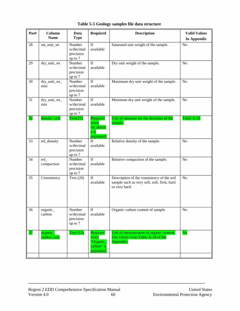
Region 2 EDD Comprehensive Specification Manual United States
Version 4.0 60 Environmental Protection Agency
Table 5-5 Geology samples file data structure
Pos# Column
Name
Data
Type
Required Description Valid Values
In Appendix
28 sat_unit_wt Number
w/decimal
precision
up to 7
If
available
Saturated unit weight of the sample. No
29 dry_unit_wt Number
w/decimal
precision
up to 7
If
available
Dry unit weight of the sample. No
30 dry_unit_wt_
max
Number
w/decimal
precision
up to 7
If
available
Maximum dry unit weight of the sample. No
31 dry_unit_wt_
min
Number
w/decimal
precision
up to 7
If
available
Minimum dry unit weight of the sample. No
32 density_unit Text(15) Required
when
rel_densit
y is
populated.
Unit of measure for the densities of the
sample.
Table A-18
33 rel_density Number
w/decimal
precision
up to 7
If
available
Relative density of the sample. No
34 rel_
compaction
Number
w/decimal
precision
up to 7
If
available
Relative compaction of the sample. No
35 Consistency Text (20) If
available
Description of the consistency of the soil
sample such as very soft, soft, firm, hard
or very hard.
No
36 organic_
carbon
Number
w/decimal
precision
up to 7
If
available
Organic carbon content of sample. No
37 organic_
carbon_unit
Text (15) Required
when
“Organic_
carbon” is
populated.
Unit of measurement of organic content.
Use values from Table A-18 of the
Appendix.
No

Region 2 EDD Comprehensive Specification Manual United States
Version 4.0 61 Environmental Protection Agency
5.6 Water Table EDD Files
The water table (TBL) EDD file stores data pertaining the water table and is used to record groundwater
data during drilling activities. Each water table EDD file must be named according to the following
convention:
SiteNameDate.EPAIDCode.WaterTable_v3.txt (or .csv)
Table 5-6 Water table file data structure
Pos# Column
Name
Data
Type
Required Description Valid Values
In Appendix
1 sys_loc_code Text (20) Required Soil boring or well installation location.
Must be a valid code for the facility and
must match one of the reported values in
the sys_loc_code field of the location
EDD file (Table 3-2) submitted in the
current or previous EDD.
No
2 Type Text (20) Required Aquifer designation, such as unconfined1,
confined1, or confined2.
No
3 Sequence Text (20) Required Designation of when water level
measurement was taken. Use
“unstabilized” if measurement was taken
before water stabilized and use
“stabilized” if measurement taken after
stabilization.
No
4 Depth Number
w/decimal
precision
up to 15
Required Depth of water table, in feet, below
reference point.
Feet
5 flowing_yn Text (1) If available Is the water table flowing? “Y” for yes or
“N” for no.
Y=yes
N=No
6 measurement_
method
Text (50) If available Method of measuring water table depth. No
7 capped_pressu
re
Number
w/decimal
precision
up to 15
If available Hydrostatic pressure of confined aquifer. No
8 capped_pressu
re_
unit
Text (15) Required
when
“capped_pre
ssure” is
populated.
Unit of measure for capped pressure. Use
values from Table A-18 in the Appendix.
Table A-18
9 reference_poin
t
Text (50) If available Description of reference point from which
depth measurements were taken.
No
10 reference_elev
ation
Number
w/decimal
precision
up to 15
Required Elevation of the reference point from
which depth measurement were taken.
Elevation must be in feet.
No
11 Temperature Number
w/decimal
precision
up to 15
If available Temperature of water in the water table. No

Region 2 EDD Comprehensive Specification Manual United States
Version 4.0 62 Environmental Protection Agency
Table 5-6 Water table file data structure
Pos# Column
Name
Data
Type
Required Description Valid Values
In Appendix
12 temperature_u
nit
Text (15) Required
when
“Temperatur
e” is
populated.
Unit of temperature. Use values from
Table A-18 in the Appendix.
Table A-18
5.7 Geology Down Hole Point Data EDD File
The Geology down hole point data (DHP) EDD file stores data from down hole logging methods such as
Cone Penetrometer Tests and geophysics. All down hole logging data should be submitted electronically.
Report the parameter being measured in the “param” field, such as resistivity, and report the measured
value at the depth of the measurement. Table 5-8 presents the DHP EDD file structure.
Each Geology down hole point data EDD file must be named according to the following convention:
SiteNameDate.EPAIDCode.DownholePoint_v3.txt (or .csv)
Table 5-7 Geology Down Hole Point File Data Structure
Pos# Column
Name
Data
Type
Required Description Valid Values
In Appendix
1 sys_loc_code Text(20) Required Sample collection location. Must be a valid
code for the facility and must match one of the
reported values in the sys_loc_code field of
the location EDD file (Table 3-2) submitted in
the current or previous EDD.
No
2 Depth Number
w/decimal
precision
up to 15
Required Depth of measurement below ground surface
in feet.
No
3 Param Text(20) Required The parameter being measured, such as tip
stress, resistivity, or pore pressure.
No
4 param_value
Number
w/decimal
precision
up to 15
Required
The measured value of the parameter.
No
5 Param_unit Text(15) If
available
Measured unit of the parameter No
Table 5-8 Example of downhole point data file
Sys_loc_code Depth Param Param_Value
MW01 10.8 Tip Stress 612
MW01 11.2 Tip Stress 624
MW01 10.8 Sleeve Stress 6.1

Region 2 EDD Comprehensive Specification Manual United States
Version 4.0 63 Environmental Protection Agency
Sys_loc_code Depth Param Param_Value
MW01 11.2 Sleeve stress 5.8
MW02 9.5 Resistivity 510
MW02 10.1 Resistivity 521
MW02 11.0 Resistivity 889
5.8 Soil Gas Data EDD File
The soil gas (SoilGas) data file contains soil gas survey data.
Each Soil Gas data EDD file must be named according to the following convention:
SiteNameDate.EPAIDCode.SoilGas_v3.txt (or .csv)
Table 5-9 Soil Gas Survey file data structure
Pos# Column Name Data
Type
Required Description Valid Values
In Appendix 1 sys_loc_code Text(20) Required Sample collection location N/A
2 survey date Date Required Sample survay date N/A
3 Parameter_code Text(20) Required Parameter measured by soil gas survey
N/A
4 Reading_depth Text(8) Required Depth of soil gas survey measurement
N/A
5 Reading unit Text(15) Required Parameter measured by soil gas survey
N/A
6 Reading Text(15) Required Soil gas survey measurement N/A
7 Depth_unit Text(15) If Available Unit of measure of soil gas survey measurement
N/A
8 Sampling_method Text(10) If Available Sampling method N/A
9 Instrument_type Text(15) If Available Instrument type N/A
10 East Text(14) If Available Easting coordinate of soil gas survey measurement
N/A
11 North Text(14) If Available Northing coordinate of soil gas survey measurement
N/A
12 Secondary_east Text(14) If Available Secondary easting coordinate of soil gas survey measurement
N/A
13 Secondary north Text(14) If Available Secondary easting coordinate of soil gas survey measurement
N/A
14 Lithology_code Text(10) If Available Lithology code N/A
15 Area_desc Text(70) If Available Discription of area N/A
16 Equipment_code Text(60) If Available Equipment_code N/A
17 Borehole_drill_met
hod
Text(10) If Available Drilling method N/A
18 Technician Text(50) If Available Technician N/A
19 Remark Text(255) If Available remark N/A
5.9 Water Level
The Water Level (WaterLevel) EDD file contains information on water levels measured during sampling
activities. Groundwater levels and surface water elevations should be reported using this file; however, in
most cases, the file will be used to report groundwater levels. When surface water samples are collected,
however, this EDD file should be used to record water surface elevations at the time the samples were
collected. Surface water elevations reported in this file will be used as the reference elevation for surface

Region 2 EDD Comprehensive Specification Manual United States
Version 4.0 64 Environmental Protection Agency
water sample depths (i.e., start_depth, field 11, and end_depth, field 12 in the Chemistry Sample (Sample)
EDD file. See Table 4-1). When using the Water Level EDD file for reporting surface water data, only
the first six fields (fields 1 through 6) and the “remark” field (field 17) should be populated. All fields in
the Water Level EDD file, however, should be populated for groundwater elevation data (if data is
available). An example of a Water Level file is provided in Figure 2-4, section 2.17. Each water level
file must be named according to the following convention:
SiteNameDate.EPAIDCode.WaterLevel_v3.txt (or .csv)
Table 5-10 Water Level file data structure
Pos# Column
Name
Data
Type
Required Description Valid Values
In Appendix
1 sys_loc_code Text(20) Required Water level measurement
location. Must be a valid
code for the facility and
must match one of the
reported values in the
sys_loc_code field of the
location EDD file (Table 3-
2) submitted in the current
or previous EDD.
No
2 Measurement_
date
DateTime Required Date of water level
measurement
If exact date is not known,
enter the best estimate for
the date of sampling. If an
estimated date is entered,
note this and provide an
explanation for how the
estimate was made in both
the EDD cover letter and in
the comment field in this
file ( field 10).
MM/DD/YYYY
HH:MM:SS
format
3 historical_
reference_elev
Number
w/decimal
precision
up to 15
Required For groundwater samples,
the value in this field should
be the elevation, in feet
above mean sea level, of the
reference point used to take
measurements of the water
level depth. Typically the
reference point for
groundwater measurements
is the top of the well casing.
For surface water samples,
the value in this field should
be the elevation of the
surface water in feet above
mean sea level.
If elevation is given in units
other than feet above mean
sea level, please indicate the
unit used in the remarks
field ( field 17).
No

Region 2 EDD Comprehensive Specification Manual United States
Version 4.0 65 Environmental Protection Agency
Table 5-10 Water Level file data structure
Pos# Column
Name
Data
Type
Required Description Valid Values
In Appendix
4 water_level_de
pth
Number
w/decimal
precision
up to 7
Required For groundwater, the value
in this field should be the
depth of ground water
below the elevation defined
in historical_reference_elev
field ( field 5).
For surface water, the value
in this field should be the
default value of “0”
No
5 water_level_el
ev
Number
w/decimal
precision
up to 7
If available Elevation of water level.
Elevation must be in feet.
Feet
6 corrected_dept
h
Number
w/decimal
precision
up to 7
If available Depth of water level after
any necessary corrections,
e.g., if free product was
encountered.
No
7 corrected_elev Number
w/decimal
precision
up to 7
If available Corrected water level
elevation that corresponds
to the corrected depth.
Elevation must be in feet.
feet
8 measured_dept
h_
of_well
Number
w/decimal
precision
up to 7
If available The depth below ground
surface to the bottom of the
well.
No
9 depth_unit Text (15) Required when
“corrected_elev” or
“measure_depth_of_
well” is populated.
Unit used for depth
measurements. See Table A-
18 in the Appendix for
appropriate values.
Table A-18
10 Technician Text (30) If available Name of technician
measuring water level
No
11 dry_indicator_
yn
Text (1) If available This field is used to indicate
whether or not a well is dry
-- “Y” for yes or “N” for no.
Y= yes
N=No
12 measurement_
method
Text (20) If available Method used to make water
level measurements.
No
13 batch_number Text (10) If available Batch number of group of
measurements.
No
14 dip_or_elevati
on
Text (10) If available Use either “elevation” or
“dip.” Use “elevation” if
water level measurement is
above the datum (i.e.,
artesian well) or “dip” if
water level is below datum.
Elevation
Dip
15 Remark Text (255) If available Any necessary remarks
related to groundwater or
surface water information
provided in this EDD file.
No

Region 2 EDD Comprehensive Specification Manual United States
Version 4.0 66 Environmental Protection Agency
Table 5-10 Water Level file data structure
Pos# Column
Name
Data
Type
Required Description Valid Values
In Appendix
16 Lnapl_cas_rn Text (15) If applicable Analyte code of the light
non-aqueous phase liquid
(lnapl) present in the well.
Use appropriate valid value
from Table A-15 in the
EDD Specification Manual
Valid Value Appendix.
Table A-15
17 Lnapl_depth Text
Number
with
precision
of up to 7
If applicable Depth to the top surface of
the lnapl in feet below the
reference elevation.
No
18 Dnapl_cas_rn Text (15) If applicable Analyte code of the dense
non-aqueous phase liquid
(dnalp) present in the well..
Table A-15
19 Dnaple_depth Number
with
precision
of up to 7
If applicable Depth to the top surface of
the dnapl in feet below the
reference elevation
No
20 Task_code Text(40) If available Code used to associate
individual samples to a
specific sampling event.
The format for this field is
XX-P# where XX is the
type of task required (PR =
Pre Remedial, RI =
Remedial Investigation, FS
= Feasibility Study, PD =
Pre-Design, RD =
Remedial Design, RA =
Remedial Construction, PC
= Post Construction, RM =
Removal Action, BD =
Before Dredge, AD = After
Dredge, BR = Brown Fields,
SP = Special Project); P# is
the phase; For example, if
sampling was performed
for a Phase 1 Post
Construction site, the
task_code would be PC-P1.
No
5.10 Extraction – Injection Well EDD File
The Extraction-Injection Well (EIW) EDD file should be submitted on a regular (e.g., quarterly) basis for
all sites where extraction and/or injection wells are a part of the remedial action at the site. I The purpose
of the EIW EDD file is to provide EPA Region 2 with designed pumping rates as well as the actual
pumping rates for each well during a particular reporting period. This information will be useful for
determining if the remedial system is successfully capturing the contaminant plume. An example of a

Region 2 EDD Comprehensive Specification Manual United States
Version 4.0 67 Environmental Protection Agency
Extraction-Injection Well file is provided in Figure 2-4, section 2.17. Each Extraction-Injection Well
EDD file must be named according to the following convention:
SiteNameDate.EPAIDCode.ExtractionInjectionWells_v3.txt (or .csv)
Table 5-11 Extraction-Injection Well file data structure
Pos# Column Name Data
Type
Required Description Valid Values
In Appendix 1 sys_loc_code Text(20) Required Well installation location. Must be a
valid code for the facility and must
match one of the reported values in the
sys_loc_code field of the location EDD
file (Table 3-2) submitted in the current
or previous EDD.
No
2 start_measure_date DateTime Required Date that the pumping rate
measurements began.
MM/DD/YYYY
HH:MM:SS format
3 end_measure_date Date Required Date that the pumping rate
measurements concluded in
MM/DD/YYYY HH:MM:SS format.
MM/DD/YYYY
HH:MM:SS format
4 avg_pump_rate Number
w/decimal
precision
up to 15
Required Average pumping rate. Recommended
method is to use volume pumped
divided by the reported date span. i.e.,
from the (start_measurement_date to
end_measurement_date)
No
5 pump_rate_unit Text(15) Required Unit of measure for the pumping rate.
Use values from Table A-18 in the
Appendix.
Table A-18
6 pct_operating_time Text(3) If Available Percentage of the measurement time
interval during which the well was
operating. Use a value from 0 to 100
(do not include the percent symbol,
“%”).
No
7 operating_
mode
Text(14) Required Mode in which well was operating
during the reported interval.
EXTRACTION,
INJECTION,
RECIRCULATION,
PULSE, DEVEL,
UNUSE.
8 design_rate Text(14) Required Pumping rate as specified in the
approved remedial design report for
fully capturing site groundwater
contamination.
No
9 design_rate_unit Text(14) Required Unit of measure for the design pumping
rate. Use values from Table A-18 in the
Appendix.
Table A-18
10 rate_measurement_t
ype
Text(14) If available Type of measurements used for
averaging.
TOTALIZER
(totalizing flow
meter), MANIFOLD
(estimated from total
manifold flow),
ESTIMATE
(estimate from prior
values), AVERAGE
(average of
instantaneous
measurements

Region 2 EDD Comprehensive Specification Manual United States
Version 4.0 68 Environmental Protection Agency
Table 5-11 Extraction-Injection Well file data structure
Pos# Column Name Data
Type
Required Description Valid Values
In Appendix 11 suction Text(14) If available Vacuum in well (e.g., wellpoint
vacuum) or well casing (e.g., vacuum
well), reported in equivalent feet of
water.
No
12 remark Text(255) If available Remarks regarding the pumping rate
measurements.
No

Region 2 EDD Comprehensive Specification Manual United States
Version 4.0 69 Environmental Protection Agency
5.11 Field Parameters
During purging of the well, monitor and record the field indicator parameters (turbidity, temperature,
specific conductance, pH, Eh, and DO) approximately every five minutes. These parameters must be
submitted using EPARSFRES section. Each Field Results file must be named according to the following
convention:
SiteNameDate.EPAIDCode.FieldResults_v3.txt (or .csv)
Table 5-12 Field Results file data structure
Pos# Column Name Data
Type
Required Description Valid Values
In Appendix 1 data_provider Text (20) Required Data provider company code No
2 sys_loc_code Text(20) Required Well installation location. Must be a
valid code for the facility and must
match one of the reported values in
the sys_loc_code field of the location
EDD file (Table 3-2) submitted in the
current or previous EDD.
No
3 sys_sample_code Text (40) Required Sample identifier of the sample that
was tested and analyzed. Must match
one of the reported values in the
sys_sample_code field of the
Sample_v3 file submitted in the
current or previous EDD.
No
4 field_parameter Text (15) Required Field Parameter Table A-15
5 start_depth Numeric Required when
the
sample_matrix_
code = “SO” or
“WG”
Sample start depth No
6 end_depth Numeric Required when
the
sample_matrix_
code = “SO” or
“WG”
Sample end depth No
7 depth_unit Text(2) Required when
start_depth or
end_depth is
populated.
Sample depth unit. Ft, m
8 result_date DateTime Required Result Date/time mm/dd/yr hh:mm:ss
format
9 result_time Text(8) Required Time result was collected. hh: mm:ss format
10 result_value Text(14) Required Result value. No
11 result_unit Text(15) Required Result unit. Table A-18
12 quantitation_limit Text(20) If available Quantitation limit No

Region 2 EDD Comprehensive Specification Manual United States
Version 4.0 70 Environmental Protection Agency
Table 5-12 Field Results file data structure
Pos# Column Name Data
Type
Required Description Valid Values
In Appendix 13 task_code Text(20) If available Code used to associate individual
samples to a specific sampling event.
The format for this field is XX-P#
where XX is the type of task required
(PR = Pre Remedial, RI = Remedial
Investigation, FS = Feasibility Study,
PD = Pre-Design, RD = Remedial
Design, RA = Remedial Construction,
PC = Post Construction, RM =
Removal Action, BD = Before
Dredge, AD = After Dredge, BR =
Brown Fields, SP = Special Project);
P# is the phase; For example, if
sampling was performed for a Phase
1 Post Construction site, the
task_code would be PC-P1.
No
14 sample_matrix_code Text(20) Required Sample Code that identifies the
matrix being sampled, such as soil,
groundwater, or sediment. For
acceptable valid values, see Table A-
1 in the Appendix. matrix code
Table A-1
15 qualifier Text(20) If available Interpreted qualifier flag assigned by
the data provider
Table A-10
16 sampling_company_c
ode
Text(20) If available Name or initials of consulting
company performing sampling. (This
field does not have a controlled
vocabulary, i.e., there is no table of
valid values for this field.)
Table A-23
17 sampling_reason Text(40) If available Reason for sampling No
18 sampling_method Text(40) If available Sampling method No
19 reportable_result Text(10) Required Reportable result Yes, No, Y, N
20 value_type Text(10) Required How value was derived
Values are: ACTUAL,
CALCULATED, ESTIMATED
No
21 remark Text(225) If available Remark No

Region 2 EDD Comprehensive Specification Manual United States
Version 4.0 71 Environmental Protection Agency
6. FORMATS FOR VAPOR INTRUSION FILES
Vapor Intrusion data submittals contain data of sampling taken inside of the contaminated sites or
buildings.
6.1 Vapor Intrusion Building Address EDD File
The Vapor Intrusion Building Address (VI_Bldg_Address) contains address and contact information for
the building.
Each Vapor Intrusion file must be named according to the following convention:
SiteNameDate.EPAIDCode.VI_Bldg_Address_v3.txt (or .csv)
Table 6-1 Vapor Intrusion Building Address data structure
Pos# Column Name Data Type Required Description Valid Values
In Appendix
1 building_code Text(20) Required Unique code that identifies the
building within the facility (i.e.
B001, B002, etc.)
2 building_name Text (60) Required Name of site
3 contact_name Text (50) Building contact name
4 address1 Text (40) Building address, part one.
5 address2 Text (40) Building address, part two
6 city Text (30) Building city
7 state Text (2) Building state
8 zip_code Text (10) Building zipcode
9 county Text (50) Building county
10 phone_number Text (30) Building contact phone number
11 alt_phone_number Text (30) Alternative site phone number
12 fax_number Text(30) Building contact fax number.
13 email_address Text(100) Building contact email address.
14 remark Text(2000) Remark
6.2 Vapor Intrusion Building EDD Files
The Vapor Intrusion Building (VI_Building) contains specific data about the building.
Each Vapor Intrusion building file must be named according to the following convention:
SiteNameDate.EPAIDCode.VI_Building_v3.txt (or .csv)
Table 6-2 Vapor Intrusion Building data structure

Region 2 EDD Comprehensive Specification Manual United States
Version 4.0 72 Environmental Protection Agency
Pos# Column Name Data Type Required Description Valid Values
In Appendix
1 building_code Text(20) Required Unique code that identifies the building within the facility (i.e.
B001, B002, etc.)
2 building_name Text(255) Required Building name (i.e. Denison Medical Building)
3 building_type Text(20) Type of building (i.e. Residential,
Industrial, etc.)
4 building_size Text(20) Size of building (Small, Medium, Large)
5 num_floors Numeric Number of floors in the building
6 construct_year Numeric Year of construction
7 foundation_depth Numeric Foundation depth (below ground
surface)
8 foundation_depth_unit
Text(15) Foundation depth unit
9 foundation_type Text(20) Foundation type (i.e. Basement,
crawlspace, ect.)
10 foundation_wall_material
Text(20) Foundation wall material
11 foundation_floor_m
aterial
Text(20) Foundation floor material
12 foundation_wall_thi
ckness
Numeric Foundation wall thickness
13 foundation_floor_thickness
Numeric Foundation floor thickness
14 foundation_thickne
ss_unit
Text(15) Foundation thickness units
15 attached_garage_yn
Text(1) Existance of an attached garage (Y/N)?
16 radon_mitigation_y
n
Text(1) Existance of radon mitigation
system (Y/N)?
17 heat_fuel_type Text(255) Type of heating fuels (i.e. Natural gas)
18 heat_system_type Text(255) Type of heating system (i.e. Forced
hot air)
19 central_air_yn Text(1) Existance of central air system
(Y/N)?
20 sump_yn Text(1) Existance of sump pump (Y/N)?
21 voc_mitigation_yn Text(1) VOC mitigation flag (Y/N)?
22 remark Text(2000) Building remarks
23 custom_field_1 Text(255)
24 custom_field_2 Text(255)
25 custom_field_3 Text(255)
26 custom_field_4 Text(255)
27 custom_field_5 Text(255)

Region 2 EDD Comprehensive Specification Manual United States
Version 4.0 73 Environmental Protection Agency
6.3 Vapor Intrusion Task Parameter EDD File
The Vapor Intrusion Task Parameter (VI_Task_Parameter) contains additional sampling parameter
collected in the field and not analyized in the lab.
Each Vapor Intrusion Task Parameter file must be named according to the following convention:
SiteNameDate.EPAIDCode.VI_Task_Parameter_v3.txt (or .csv)
Table 6-3 Vapor Intrusion Task Parameter data structure
Pos# Column Name Data Type Required Description Valid Values
In Appendix
1 task_code Text(40) Required Related task code for the parameter
2 param_code Text(20) Required Parameter code which related to
the parameter type (i.e. TEMP)
3 task_desc Text(255) Task description
4 building_use_type Text(20) The use of the building at the time
of the sampling event
5 measurement_date DateTime Measurement date
6 param_value Text(255) The value of the parameter
7 param_unit Text(15) Required The unit of measure of the
parameter Table A-18
8 remark Text(2000) Additional remarks or descriptor for the parameter
6.4 Vapor Intrusion Sample EDD file
The Vapor Intrusion Sample (VI_Samples) contains samples information.
Each Vapor Intrusion Sample file must be named according to the following convention:
SiteNameDate.EPAIDCode.VI_Samples_v3.txt (or .csv)
Table 6-4 Vapor Intrusion Samples data structure
Pos# Column Name Data Type Required Description Valid Values
In Appendix
1 data_provider Text(20) REQUIRED Data provider name
2 sys_loc_code Text(20) REQUIRED Location identifier of sample
collection
3 sys_sample_code Text(40) REQUIRED Unique sample identifier
4 sample_matrix_cod
e
Text(3) REQUIRED Code which distinguishes between
different type of sample matrix Table A-1
5 task_code Text(40) REQUIRED Sampling task code

Region 2 EDD Comprehensive Specification Manual United States
Version 4.0 74 Environmental Protection Agency
6 sampling_company_code
Text(20) REQUIRED Name or initials of sampling company.
7 sample_start_date DateTime REQUIRED Sample start date and time
8 sent_to_lab_date DateTime Date sample was sent to laboratory for analysis
9 chain_of_custody Text(40) Chain of custody
10 sample_end_date DateTime Sample end date and time
11 sample_duration Text(20) The sampling duration
12 sample_duration_u
nit
Text(15) Sample duration units Table A-18
13 floor_material Text(20) Lowest level floor material at sample location
14 slab_thickness Text(20) Slab thickness at sample location
(in inches)
15 subfloor_material Text(20) Material found below the foundation
floor
16 subfloor_moisture Text(20) Moisture content at subslab sample location (i.e. Dry, Damp, Saturated)
17 seal_type Text(20) Type of seal used during sampling
(i.e. Beeswax, Clay, Teflon Tape)
18 seal_adequate_yn Text(1) Did the sample probe seal pass the tracer test (Y/N)?
19 purge_yn Text(1) Was the sample equipment purged
in accordance with work plan (Y/N)?
20 purge_pid Numeric PID instrument reading
21 purge_pid_unit Text(15) PID instrument reading units (i.e. ppb)
22 vac_gauge_initial Numeric Vacuum gauge reading immediately
after start
23 vac_gauge_final Numeric Vacuum gauge reading immediately before end
24 vac_gauge_unit Text(15) Vacuum gauge instrument units
(i.e. inches of water)
25 vapor_loc_desc Text(255) Soil vapor intrusion location
description
26 sampling_reason Text(30) Reason for sampling
27 sampling_method Text(40) Sampling method
28 sampler Text(50) Person taking sample.
29 remark Text(2000) Remark
6.5 Vapor Intrusion Test Result QC
The Vapor Intrusion Test Result QC (VI_TestResultQC) contains data concerning analytical tests
performed on samples with quality control data elements.
Each Vapor Intrusion Test Result QC file must be named according to the following convention:

Region 2 EDD Comprehensive Specification Manual United States
Version 4.0 75 Environmental Protection Agency
SiteNameDate.EPAIDCode.VI_TestResultQC_v3.txt (or .csv)
Table 6-5 Vapor Intrusion Test Result QC file data structure
Pos# Column Name Data
Type
Required Description Valid Values
In Appendix
1 sys_sample_code Text(40) REQUIRED Unique sample identifier. Each
sample at a facility must have a unique value, including spikes and
duplicates. You have considerable flexibility in the methods used to
derive and assign unique sample identifiers, but uniqueness
throughout the database is the only
restriction enforced by EQuIS®.
2 lab_anl_method_na
me
Text(35) REQUIRED Laboratory analytical method name
or description. A controlled
vocabulary column, valid values can be found in the appendix in table
lab_anl_method_name.
Table A-16
3 analysis_date DateTime REQUIRED Date and time of sample analysis in 'MM/DD/YYYY HH:MM:SS' format.
May refer to either beginning or end of the analysis as required by
EPA.
4 total_or_dissolved Text(1) REQUIRED Must be either 'D' for dissolved or filtered [metal] concentration, or 'T'
for everything else
5 column_number Text(2) REQUIRED Report as null.
6 test_type Text(10) REQUIRED Type of test. Valid values include
'Initial', 'Reextract1', 'Reextract2',
'Reextract3', 'Reanalysis', 'Dilution1', 'Diluton2', and 'Diluton3'.
Table A-25
7 lab_matrix_code Text(3) Code which distinguishes between
different type of sample matrix. For example, soil samples must be
distinguished from ground water samples, etc. See matrix valid value
table in the appendix. The matrix of
the sample as analyzed may be different from the matrix of the
sample as retrieved (e.g. leachates), so this field is available
at both the sample and test level.
Table A-1
8 analysis_location Text(2) Must be either 'FI' for field instrument or probe, 'FL' for mobile
field laboratory analysis, or 'LB' for
fixed_based laboratory analysis.

Region 2 EDD Comprehensive Specification Manual United States
Version 4.0 76 Environmental Protection Agency
9 basis Text(10) Must be either 'Wet' for wet_weight basis reporting, 'Dry' for dry_weight
basis reporting, or 'NA' for tests for which this distinction is not
applicable. The EPA prefers that
results are reported on the basis of dry weight where applicable.
10 container_id Text(30) Report as null.
11 dilution_factor Numeric Effective test dilution factor. If value is less than 1, then you need
to put 'concentration factor' in the comment column.
12 prep_method Text(20) Laboratory sample preparation
method name or description. A controlled vocabulary (i.e., see
Prep_mthd_var valid values in the
appendix).
Table A-14
13 prep_date DateTime Beginning date and time of sample
preparation in 'MM/DD/YYYY
HH:MM:SS' format.
14 leachate_method Text(15) Laboratory leachate generation
method name or description. The
method name should be sufficient to reflect operation of the
laboratory (see analysis method discussion).
15 leachate_date DateTime Beginning date and time of leachate
preparation in 'MM/DD/YYYY HH:MM:SS' format.
16 lab_name_code Text(20) Unique identifier of the laboratory
as defined by the EPA. Controlled vocabulary, see lab valid value table
in the appendix.
Table A-23
17 qc_level Text(10) May be either 'screen' or 'quant'.
18 lab_sample_id Text(40) Laboratory LIMS sample identifier.
If necessary, a field sample may
have more than one LIMS lab_sample_id (maximum one per
each test event).
19 percent_moisture Text(5) Percent moisture of the sample portion used in this test; this value
may vary from test to test for any sample. Numeric format is
'NN.MM', i.e., 70.1% could be
reported as '70.1' but not as '70.1%'.
20 subsample_amount Text(14) Amount of sample used for test.
21 subsample_amount_unit
Text(15) Unit of measurement for subsample amount. Controlled vocabulary, see
Unit valid values table in appendix.
22 analyst_name Text(30) Report as null.

Region 2 EDD Comprehensive Specification Manual United States
Version 4.0 77 Environmental Protection Agency
23 instrument_id Text(50) Report as null.
24 comment Text(255) Comments about the test as
necessary.
25 preservative Text(20) Sample preservative used.
26 final_volume Numeric The final volume of the sample
after sample preparation. Include
all dilution factors.
27 final_volume_unit Text(15) The unit of measure that
corresponds to the final_volume.
28 cas_rn Text(15) REQUIRED Use values in analyte valid value table.
29 chemical_name Text(75) REQUIRED Use the name in the analyte valid
value table.
30 result_value Numeric Analytical result reported at an appropriate number of significant
digits. May be blank for non_detects.
31 result_error_delta Text(20) Error range applicable to the result
value; typically used only for radiochemistry results.
32 result_type_code Text(10) REQUIRED Must be either 'TRG' for a target or
regular result, 'TIC' for tentatively identified compounds, 'SUR' for
surrogates, 'IS' for internal
standards, 'SC' for spiked, compounds, ‘CAL’ for calculated
pore water concentrations.
33 reportable_result Text(10) REQUIRED Must be either 'Yes' for results which are considered to be
reportable, or 'No' for other results. This field has many purposes. For
example, it can be used to
distinguish between multiple results where a sample is retested after
dilution. It can also be used to indicate which of the first or second
column result should be considered primary. The proper value of this
field in both of these two examples
should be provided by the laboratory (only one result should
be flagged as reportable).
34 detect_flag Text(2) REQUIRED Maybe either 'Y' for detected analytes or 'N' for non_detects. Use
'Y' for estimated (above detection limit but below the quantitation
limit) or '<' and '>' for tests such as
flash point. Note that '<' must not be used to indicate non_detects
(use 'N' for non_detects instead).
35 lab_qualifiers Text(10) Qualifier flags assigned by the laboratory.

Region 2 EDD Comprehensive Specification Manual United States
Version 4.0 78 Environmental Protection Agency
36 validator_qualifiers Text(10) Qualifier flags assigned by the validation firm.
37 interpreted_qualifie
rs
Text(10) Interpreted qualifier flag assigned by
the validator. When the validated_yn =
N (no, meaning the data is not validated
by validator), the interpret qualifier is
required if lab_qualifier or validator
_qualifier are populated. If the
validated_yn = Y (yes, meaning the
data has been validated and the
validator agreed witht eh lab qualifier),
then they should populate the
validator_qualifier and the
interpreted_qualifier. If the
validated_yn = Y (yes, but the validator
does not agree with the lab_qualifier),
then the validator will leave the
qualifier NULL and the final qualifier
is also NULL. When populating th e
interpreted_qualifier, please use the
qualifier in the Valid Value in A-10
with the description that can closely
match with the lab qualifier. EPAR
region 2 is not going to add any more
qualifiers.
Table A-10
38 validated_yn Text(1) REQUIRED Indicates if the result has been
validated. Y= “Yes”
N= “No”

Region 2 EDD Comprehensive Specification Manual United States
Version 4.0 79 Environmental Protection Agency
39 method_detection_limit
Text(20) Lowest concentration that can be detected by an instrument with
correction for the effects of sample matrix and method-specific
parameters such as sample
preparation. MDLs are explicitly determined as
set forth in 40 CFR Part 136. They are defined as three times the
standard deviation of replicate
spiked analyses. This represents 99% confidence that the analyte
concentration is greater than zero. The organic methods in the EPA
500 series, EPA 600 series, and Standard Methods all give typical
MDLs for clean water samples.
Generally these clean-water MDLs (corrected for %moisture, sample
size, and dilution) are used for reporting limits,
but the laboratory may use MDLs
that they have generated. MDLs generated by the laboratory using
the sample matrix of interest are the most reliable. If the clean-water
MDLs are used, remember that they do not include all of the upward
correction
necessary to account for the effects of sample matrix. This is important
to remember especially for risk assessments and highly
contaminated samples.
40 reporting_detection_limit
Numeric Concentration level above which results can be quantified with
confidence. It must reflect
conditions such as dilution factors and moisture content.
Required for all results for which such a limit is appropriate. The
reporting_detection_limit column
must be reported as the sample specific detection limit.

Region 2 EDD Comprehensive Specification Manual United States
Version 4.0 80 Environmental Protection Agency
41 quantitation_limit Text(20) Quantitation limits refer to a minimum concentration of an
analyte that can be measured within specified limits of precision
and accuracy. They are generally
5-10 times the detection limit. Thus, when quantitation limits are
used as reporting limits, the laboratory is saying that the analyte
is not present in a sufficient amount
to be reliably quantified (i.e., at a concentration above the
quantitation limit). It may be present and even
positively identified or "seen" at a lower concentration.
42 result_unit Text(15) Units of measurement for the
result. Controlled vocabulary, see Units valid value table in the
appendix.
43 detection_limit_unit Text(15) Units of measurement for the detection limit(s). Controlled
vocabulary, see Units valid value
table in the appendix. This field is required if a
reporting_detection_limit is reported.
44 tic_retention_time Text(8) Report as null.
45 minimum_detectable_conc
Numeric Minimum detectable concentration or activity. This value should be in
the same units as the result_value.
46 counting_error Numeric Counting error as reported by the laboratory. This value should be in
the same units as the result_value.
47 uncertainty Text(10) The uncertainty of the counting error, valid values include "1 sigma"
or "2 sigma" This field is required if
the counting_error field is populated.
48 critical_value Numeric Critical value as reported by the
laboratory.
49 validation_level Text(20) EPA defined validation level
50 result_comment Text(255) Result specific comments.
51 qc_original_conc Numeric The concentration of the analyte in the original (unspiked) sample.
Might be required for spikes and
spike duplicates (depending on user needs). Not necessary for surrogate
compounds or LCS samples (where the original concentration is
assumed to be zero).

Region 2 EDD Comprehensive Specification Manual United States
Version 4.0 81 Environmental Protection Agency
52 qc_spike_added Numeric The concentration of the analyte added to the original sample. Might
be required for spikes, spike duplicates, surrogate compounds,
LCS and any spiked sample
(depending on user needs).
53 qc_spike_measured Numeric The measured concentration of the
analyte. Use zero for spiked
compounds that were not detected in the sample. Might be required for
spikes, spike duplicates, surrogate compounds, LCS and any spiked
sample (depending on user needs).
54 qc_spike_recovery Numeric The percent recovery calculated as specified by the laboratory QC
program. Always required for
spikes, spike duplicates, surrogate compounds, LCS and any spiked
sample. Report as percentage multiplied by 100 (e.g., report
"120%" as "120").
55 qc_dup_original_conc
Numeric The concentration of the analyte in the original (unspiked) sample.
Might be required for spike or LCS duplicates only (depending on user
needs). Not necessary for surrogate
compounds or LCS samples (where the original concentration is
assumed to be zero).
56 qc_dup_spike_added
Numeric The concentration of the analyte added to the original sample. Might
be required for spike or LCS duplicates, surrogate compounds,
and any spiked and duplicated
sample (depending on user needs). Use zero for spiked compounds that
were not detected in the sample. Required for spikes, spike
duplicates, surrogate compounds,
LCS and any spiked sample. Also complete the qc-spike-added field.
57 qc_dup_spike_mea
sured
Numeric The measured concentration of the
analyte in the duplicate. Use zero for spiked compounds that were not
detected in the sample. Might be required for spike and LCS
duplicates, surrogate compounds, and any other spiked and
duplicated sample (depending on
user needs). Also complete the qc-spike-measured field.

Region 2 EDD Comprehensive Specification Manual United States
Version 4.0 82 Environmental Protection Agency
58 qc_dup_spike_recovery
Numeric The duplicate percent recovery calculated as specified by the
laboratory QC program. Always required for spike or LCS duplicates,
surrogate compounds, and any
other spiked and duplicated sample. Also complete the qc-spike-recovery
field. Report as percentage multiplied by 100 (e.g., report
"120%" as "120").
59 qc_rpd Text(8) The relative percent difference calculated as specified by the
laboratory QC program. Required
for duplicate samples as appropriate. Report as percentage
multiplied by 100 (e.g., report "30%" as "30").
60 qc_spike_lcl Text(8) Lower control limit for spike
recovery. Required for spikes, spike duplicates, surrogate
compounds, LCS and any spiked sample. Report as percentage
multiplied by 100 (e.g., report
"60%" as "60").
61 qc_spike_ucl Text(8) Upper control limit for spike
recovery. Required for spikes,
spike duplicates, surrogate compounds, LCS and any spiked
sample. Report as percentage multiplied by 100 (e.g., report
"60%" as "60").
62 qc_rpd_cl Text(8) Relative percent difference control limit. Required for any duplicated
sample. Report as percentage
multiplied by 100 (e.g., report "25%" as "25").
63 qc_spike_status Text(10) Used to indicate whether the spike
recovery was within control limits. Use the "*" character to indicate
failure, otherwise leave blank. Required for spikes, spike
duplicates, surrogate compounds,
LCS and any spiked sample.
64 qc_dup_spike_statu
s
Text(10) Used to indicate whether the
duplicate spike recovery was within
control limits. Use the "*" character to indicate failure, otherwise leave
blank. Required for any spiked and duplicated sample.

Region 2 EDD Comprehensive Specification Manual United States
Version 4.0 83 Environmental Protection Agency
65 qc_rpd_status Text(10) Used to indicate whether the relative percent difference was
within control limits. Use the "*" character to indicate failure,
otherwise leave blank. Required for
any duplicated sample.
66 lab_SDG Text(20) Lab Sample Delivery Group (SDG)
identifier. A single sample may be
assigned to multiple Sample Delivery Group (SDG) based on
different analysis.
6.6 Vapor Intrusion Batch EDD File
Each Vapor Intrusion Batch file must be named according to the following convention:
SiteNameDate.EPAIDCode.VI_Batches_v3.txt (or .csv)
Table 6-6 Vapor Intrusion Batches file data structure
Pos# Column Name Data
Type
Required Description Valid Values
In Appendix
1 sys_sample_code Text(40) REQUIRED Unique sample identifier. Each sample must have a unique value,
including spikes and duplicates. Laboratory QC samples must also
have unique identifiers. The
laboratory and the EQuIS® Chemistry user have considerable
flexibility in the methods they use to derive and assign unique sample
identifiers, but uniqueness
throughout the database is the only restriction enforced by EquIS®
Chemistry.
2 lab_anl_method_name
Text(35) REQUIRED Laboratory analytical method name or description. A controlled
vocabulary column, valid values can be found in the appendix in table
ab_anl_method_name.
Table A-16
3 analysis_date DateTime REQUIRED Date and time of sample analysis in 'MM/DD/YYYY HH:MM:SS' format.
May refer to either beginning or end of the analysis as required by
EPA.
4 total_or_dissolved Text(1) REQUIRED Must be either 'D' for dissolved or filtered [metal] concentration, or 'T'
for everything else
5 column_number Text(2) REQUIRED Column number, if null, “NA” will be
placed in this field

Region 2 EDD Comprehensive Specification Manual United States
Version 4.0 84 Environmental Protection Agency
6 test_type Text(10) REQUIRED Type of test. Valid values include 'Initial', 'Reextract1', 'Reextract2',
'Reextract3', 'Reanalysis', 'Dilution1', 'Diluton2', and 'Diluton3'.
Table A-25
7 test_batch_type Text(10) REQUIRED Lab batch type. Valid values include
'Prep', 'Analysis', and 'Leach'. This is a required field for all batches.
Table A-26
8 test_batch_id Text(20) Unique identifier for all lab batches.

Region 2 EDD Comprehensive Specification Manual United States
Version 4.0 85 Environmental Protection Agency
7. TECHNICAL SUPPORT
EPA Region 2 provides technical support for users of this Comprehensive EDD Specification Manual.
For questions concerning data, data formats, and EDD submittal procedures, please contact EDD EQUIS
Coordinator. For more general questions relating to the site, please contact the EPA RPM assigned to the
site.