Embed Size (px)
Citation preview

Elasticity Between the Cadastre and Land Tenure:Balancing Civil and Political Society Interestsin Poland
Francis HarveyDepartment of Geography, University of Minnesota, Minneapolis, MN 55455.E-mail: [email protected]
ABSTRACT
The cadastre provides formal instruments for governments to administer land, theoretically assuringcritical space and resources for economic activities in Western societies. The informal organizationof access and control of land in any society, conducted often in parallel to the formal cadastre, isknown as land tenure. The cadastre records land ownership and rights to land. It is also an importantmeans for coordinating land governance, private activities, and public concerns related to land. Theongoing challenges for government use of the cadastre are largely administrative and political, nolonger technical. In the case examined here of Poland, a country undergoing rapid post-Socialistsocio-economic change, the challenges are evident in rural discrepancies between the cadastre andland tenure. They reflect historical tensions between colonizing formal government institutions andinformal resistance institutions developed to allocate access and control of land for most of the past300 years in Poland. During this period Polish political and civil society has worked out a numberof complex delegations of control and authority to regulate these discrepancies and provide for aflexible balance between competing and conflicting interests. Much rural land ownership was securedthrough an array of informal arrangements involving actors with overlapping and conflicting interests.The formal cadastre, in these cases, is often reduced to a self-referential institution solely for useby government agencies. Verdery’s concept of “elasticity” aids in understanding how discrepanciesbetween cadastre and land tenure have been traditionally resolved in relations between Polish politicaland civil society. The current transformation of Poland to a capitalist economy beginning in 1989 isaltering various aspects of these arrangements. Recent entry (May, 2004) into the European Unionhas additionally greatly accelerated the process of change. Based on literature analysis and thepreliminary analysis of the different roles the cadastre plays in three Polish counties ( powiat), thearticle presents some ideas for conceiving of the cadastre as part of a framework for the societalallocation and the coordination of access and control to land. It argues that the elasticity betweenrural formal de jure cadastre and informal de facto land tenure points to problems plainly visible inrural Poland yet relevant to cadastral information infrastructures occurring around the world. C© 2006Wiley Periodicals, Inc.
Keywords: cadastre; land tenure; Poland; post-socialist transition
Yola Georgiadou is the accepting Guest Editor for this article.
Information Technology for Development, Vol. 12 (4) 291–310 (2006) C© 2006Wiley Periodicals, Inc.Published online in Wiley InterScience (www.interscience.wiley.com). DOI: 10.1002/itdj.20049
291

292 HARVEY
1. INTRODUCTION
The cadastre has been the primary form of coordinating land ownership in Westerncivilization since the Roman times. Through imperialism and colonialism the cadastrehas been promoted around the world as the supreme administrative technology for record-ing private land ownership, rights to land, and obligations of land owners and users. Whileprimarily used for taxation by governments, the cadastre is also the means of regulating landoccupation, facilitating planning, and enabling speculation related to land. This is also thecase in Poland, the focus of the research presented here. In Poland, the cadastre has forcedthe merging of the formal governance of land allocation, rights, and responsibilities withinformal distribution of access and use of land. The historical balance between civil andpolitical society is being challenged by post-socialist transformations. Examining both thehistorical balance and current challenges offers to provide insight into tensions associatedwith cadastres and land tenure in other parts of the world.
The cadastre is one of the fundaments of Western governance and colonization. Theancient centrality of the cadastre to Roman colonization, the continued centrality of thecadastre in Western European regulation of land access, and the export of the cadastrenaturalize the cadastre to the point where it seems to be part of natural laws of any society.However, even in Europe, the cadastre is fraught with the same problem of Euro-centristideology in the face of sharply divergent European experiences as Dieter Senghaas’ politicaleconomic studies of variable economic growth in Europe show (Senghaas, 1985). Severalhistorical studies point to the problems of the cadastre and its uncertain development inEurope, colonized areas, and transition economies including places as varied as Sweden,Ireland, and Australia (Andrews, 1975; Kain & Baigent, 1992; Turnbull, 1998). Recentaccounts of indigenous land claims adjudication in Canada and Australia underscore thecontentions surrounding the cadastre’s role in colonization. The major hurdle has beenfinding the means to bring indigenous land use uses legally on the same level as surveyedland ownership boundaries (Turnbull, 1998). In Poland from the 18th century on, thecadastre was used by colonizing and partitioning foreign powers as well as by the Polishcentral government for land reform and redistribution of property, for the collection of taxesand as a means for increasing capitalization and encouraging foreign investment.
The cadastre has been naturalized in thought and practice. The cadastre remains invisibleto most people, but is central to government administration. This article explores howthe cadastre is integrated into the societal allocation of land access and control that thegovernment wishes to control. The Elasticity Required: Rural Cadastral Infrastructureand Land Tenure section lays out the theoretical framework for considering the broadroles of a cadastral infrastructure including key roles and tensions for the formal cadastreand informal land tenure in tensions between civil and political society. The Poland’sCadastral Infrastructure section discusses the historical background of Poland’s cadastralinfrastructure and current conflicts. This is followed by the Three Ways to Stretch theCadastre section, discussing exemplary strategies in three Polish counties ( powiat) to findflexibility to deal with tensions between the formal cadastre and informal land tenure. TheBroader Implications section of the article discusses the broad implications of this researchand is followed by the Conclusions section that presents key findings of this research andissues for future research.
Information Technology for Development DOI: 10.1002/itdj

CIVIL AND POLITICAL SOCIETY INTERESTS IN POLAND 293
2. ELASTICITY REQUIRED: RURAL CADASTRAL INFRASTRUCTUREAND LAND TENURE
Previous research in rural areas of Poland report up to 40% of land is not clearly recordedin a cadastre (Prosterman & Rolfes, 1999). At the same time, Polish government officialsworking on the cadastre stress that Poland has 100% cadastral coverage (Kozlowski, 1997).This discrepancy offers an interesting opportunity to study the activities of cadastral gover-nance where elasticity is required. More interesting is the possibility to explore how citizensand local governments resolve the tensions on their own. Elasticity between formal andinformal land tenure refers not to a single dimension, but it refers to many dimensions oftension that roughly correspond to the actors involved with local land and with an interestin how land access and control is both formally and informally regulated.
2.1 Cadastre and Land Tenure Defined
Considering how invisible the cadastre is, we should start with some definitions of thecadastre and land tenure. While a generic definition of the cadastre will state that it is amap register made for the purpose of taxation, the cadastre is more than a set of maps forcalculating taxation. As Scott writes:
When [maps are] allied with state power, [they] would enable much of the reality they depicted to beremade. . . a state cadastral map. . . does not merely describe a system of land tenure; it creates sucha system through its ability to give its categories the force of law. (1998)
Through colonization, the cadastral information infrastructure, the people, institutions,and technologies of the cadastre has diffused as a key instrument of governance aroundthe world. In the same vein, Kain and Baigent (1992) conclude their historical study ofcadastral mapping with salient points that highlight interactions and tensions related to thecadastral infrastructure’s role in the governance of agrarian reform:
• The cadastral map is an instrument of control that reflects and consolidates the powerof those who commission it.
• The cadastral map is partisan.• The cadastral map is active. In portraying one reality it obliterates the old.• The cadastral map can be understood as a balance of power and a balance of interest.• The acceptance of the cadastral map as an instrument of the state was as turbulent as
the struggles for power themselves. (p. 344)
Land tenure may be narrowly defined as the manner in which rights to property areheld. However, this definition is not only narrow but misleading. The term ‘right’ oftensuggests that claim to land is supported by law. This may or may not be the case, however.A more comprehensive definition and discussion, provided by the FAO, reflects the multi-dimensionality of land tenure and its salience for the complex roles the cadastre takes onin formalizing civil society’s arrangements.
Land tenure is the relationship, whether legally or customarily defined, among people, as individualsor groups, with respect to land. . . . Land tenure is an institution, i.e., rules invented by societiesto regulate behavior. Rules of tenure define how property rights to land are to be allocated within
Information Technology for Development DOI: 10.1002/itdj

294 HARVEY
societies. They define how access is granted to rights to use, control, and transfer land, as well asassociated responsibilities and restraints. In simple terms, land tenure systems determine who canuse what resources for how long, and under what conditions.
3.2 Land tenure is an important part of social, political and economic structures. It is multi-dimensional, bringing into play social, technical, economic, institutional, legal and political aspectsthat are often ignored but must be taken into account. Land tenure relationships may be well-definedand enforceable in a formal court of law or through customary structures in a community. Alter-natively, they may be relatively poorly defined with ambiguities open to exploitation. (Food andAgricultural Organization of the United Nations (FAO), no date)
Cadastral information can and should coincide with land tenure, but a persistent 1-to-1relationship between them is an ideal that can only be achieved at great cost. Clearly,many people make land access and control arrangements with relatives and neighborswithout going through the effort to formalize them through legal contracts or governmentprocedures. Short-term arrangements can easily become long-term status open to possibleanchoring in local practice. Part of the cost arises from the complexity of information storedand maintained in a cadastre and the lag time to record changes. The cadastre generallyincludes information about land ownership and the boundaries of land ownership, althoughin many countries the two are maintained in separate registries without coordination. Thecadastre can be implemented in an information technology environment following therules and specifications defined by laws, regulations, or politics of the design process(Andrews, 1975; Lemmen & van Oosterom, 2002; van Dijk, 2003). The cadastre may lackinformation about changes that have yet to be entered in the system, may contain errors,and, most importantly, may fail to reflect the informal arrangements people enter intoregarding uses and responsibilities for land. The resulting discrepancies can be substantial.The United Nations Center for Human Settlement (Habitat) reported in 1991 that up to 90%of parcels in developing countries lack documentary evidence of land ownership (UnitedNations Center for Human Settlement (Habitat), 1991). A number of areas in Europe havelarge discrepancies with respect to land tenure even when the cadastre is complete for anarea (Kain & Baigent, 1992).
In other words, even in its ancestral European place of origin the cadastre has failed toensure the rationality and equity of governance aspired for by Bentham and other progeni-tors of the Enlightenment. Still, the promotion of cadastre in its modern form is guided bythese Enlightenment ideals, framed, in particular, by Bentham’s notion of utility.1 Theseenlightenment concepts promote the cadastre as an essential part of a country’s economicfoundation, guarantee of an efficient land-market, and culturally preserve individual prop-erty ownership (P. F. Dale & McLaughlin, 1999; Miron Perez, 2002). For many people thisideological role finds its expression in Hernando de Soto’s understanding that governmentfacilitation of clear and simple property registration through the cadastre lies at the heartof successful transition economies (de Soto, 2000). The cadastre is highly complex, muchmore than a set of functions, but a set of relationships. In this sense, the cadastre is political,
1Utility, for Bentham, referred to the increase in happiness for an individual or group arising from the choiceof action. It serves as an ethical principle. It still primarily carries this meaning, but has been extended to meanthe happiness of all affected individuals or groups. It also follows an assumption that utility can be determinedrationally.
Information Technology for Development DOI: 10.1002/itdj

CIVIL AND POLITICAL SOCIETY INTERESTS IN POLAND 295
a highly complex infrastructure of people, institutions, and technologies, and subject to themachinations of politicians and administrators alike at all levels of government (Buissert,1992; Kain & Baigent, 1992; Prosterman & Rolfes, 1999; Said, 2000). To the same degree,the cadastral information infrastructure is likewise much more than data: it requires thecoordination of complex infrastructure arrangements.
2.2 Beyond Functional Blinders: Cadastre as Infrastructure
The cadastre’s invisibility leads to an over-emphasis on functional definitions of the cadas-tre that ignore or minimize the relationships to land tenure. The concept of infrastructure(Bowker & Star, 1999; Susan Leigh Star, 1999) draws together cultural, political, social,economic, and technological dimensions of the people, institutions and technologies in-volved in the assemblages that are integral to the many relationships between cadastre andland tenure and the requisite elasticity.
The political dimensions of an information infrastructure are important for explainingthe development and use of the technology, following Markus’ study of managementinformation system (MIS) implementation (Markus, 1983).
Generally speaking, a cadastral infrastructure is a complex assemblage of administrativetechnology used by staff in different governmental offices for the preparation, maintenance,and sharing of cadastral information and to support legislative, regulatory, or politicalactivities decided on by people in administrative and political positions. Depending onadministrative and political allocation of decision-making responsibility, the specific formof administrative technology varies greatly but is highly complex and inherently political(Rolland & Aanestad, no date).
To understand how Polish local communities address the discrepancies between thecadastre and land tenure in terms of relationships between civil and political society, we relyon this infrastructure concept of the complex relationships between cadastre and land tenure.Local cadastral infrastructural activities involve people, technologies, and institutions aswell as the relationships among all three. The local cadastral infrastructure constantlyarbitrates between different interests; cadastral stretching is an everyday occurrence.
Specific activities of cadastral stretching are conceptualized with the help of the conceivedboundary objects concept. Boundary objects both simultaneously connect and separate otheractors (Star & Griesemer, 1989). By maintaining the flexibility of different cadastral actorsand institutions involving civil and political society they play a key role in facilitatinginteractions among civil and political society participants. Extending the elasticity conceptto the cadastral infrastructure, the flexibility of land tenure in relationship to parcels is partof the flexibility between civil and political society. Flexibility in the cadastral informationinfrastructure allows the two to coexist, both the stability of the formal land cadastre andarrangements of informal land tenure, but as it develops it must negotiate challenges tomaintaining the existing elasticity between the cadastre and land tenure.
2.3 Elasticity of Land and Civil and Political Society
The cadastral infrastructure and its constituent boundary objects facilitate elasticity. While apaper map and surveyors legal description of property boundaries may seem to be epitomesof rational crisp logic and precision, they, in fact, permit a great deal of interpretative andsituated flexibility. Katherine Verdery’s anthropological work provides a starting point for
Information Technology for Development DOI: 10.1002/itdj

296 HARVEY
articulating the concept of cadastral elasticity (Verdery, 1994). Based on her long-termstudy of land restitution in Romania, Verdery suggests that land ownership is never fixed toa single set of boundaries, but it is flexible to such a degree that there is an almost unlimitedelasticity between the formal cadastre and informal land tenure.
The elasticity of land that Verdery describes points to the ability of different civil andpolitical society interests to locally reconcile differences of land occupation with politicaland social control (Verdery, 1994, 2003). Verdery describes the multiple boundaries, sizes,and shapes that a parcel of land could take during the process of property restitution ina rural Rumanian community: Although the parcel is always formally the “same,” shedocuments how it goes through startling and arbitrary changes in order to reconcile officialcadastral records with changing assertions from interested parties. Verdery describes thiselasticity in terms of the changing boundaries between parcels of land and between the veryshapes of parcels as the process of submitting restitution claims and resolving claims goeson for years. To Verdery, there is an apparent contradiction in the ever-changing locationof boundaries and shape of land parcels against the administrative rationale that acceptsevery claim and assesses only claims against their fit in the administration’s constructionof the formal cadastre. Verdery refers to this as a fuzzy property, which “invokes the totalsystem of social, cultural, and political relations and inquires into, rather than assuming, thenature of property conceptions” (Verdery, 1998). Private property involves routinized rulesand crystallized practices that the cadastre usually formally expresses or gives access to. InPoland and Romania, as in other transition countries, the arrangements of civil society areunexpressed and unarticulated, often without representation in the formal cadastre.
Verdery focuses on restitution of completely collectivized area in Rumania. In Poland,restitution is no issue: In fact, there is still no legally coordinated restitution process forprivate land restitution claims in Poland. However, elasticity is a significant concept tohelp explain the discrepancies in Poland between formal cadastre and informal land tenure,which involve arrangements established over many generations between civil and politicalsociety. The discrepancies between cadastre and land tenure creates possibilities to allocatethe control over land in a manner that takes better account of historical issues, societalchanges, and local contingencies than formal procedures and regulations.
In other words, the cadastral infrastructure in Poland is by no means defunct but functionsas a working status quo. A broader articulation of cadastral elasticity needs to examinethe multiple understandings of the cadastre as well as the multiple roles of land tenurearrangements. The elasticity between cadastre and land tenure mitigates economic andsocial consequences of discrepancies for civil and political society in an endless processof re-definition and re-constitution of alliances as the institutional and political contextchanges.
3. POLAND’S CADASTRAL INFRASTRUCTURE
The hypothesis guiding the research in Poland is that the allocation and access to ruralland are assured through informal arrangements as much as by the formal cadastre; thediscrepancies have already found some form of either de jure or de facto resolution inlocal practice. Past and current activities to automate and enhance the accuracy of Poland’scadastral infrastructure are one facet of these activities. At least of equal importance arelocal practices that maximize cadastral elasticity to meet local needs. The resolution oftensions between formal cadastre and informal land tenure was historically and remains
Information Technology for Development DOI: 10.1002/itdj
CIVIL AND POLITICAL SOCIETY INTERESTS IN POLAND 297
currently contingent—ongoing, independent, and local processes. Primary factors for thisdynamic stability can be found in Poland’s history as an occupied country for most ofthe last 300 years. This hypothesis is based on the assumption that Polish political andcivil society have established and re-established a locally constituted dynamic balance thatresolves tensions between the formal cadastre and informal land tenure.
3.1 Historical Contingency and Cadastral Elasticity
Lacking a detailed ethnographic study of land tenure issues in Polish rural society, thisarticle relies on a variety of secondary literature, particularly anthropological work inAfrican countries and rare studies addressing land tenure issues. This literature offersevidence that civil society in Poland has found ways to undermine—and at times subvert—the attempts of political society to control and tax land. The cadastre in Poland has been,since the partitions in 1759, a means of foreign control and manipulation of land rights inPoland. It was already problematized in the classical Polish novel Placowka by BoxeslawPrus, written in the 19th century.
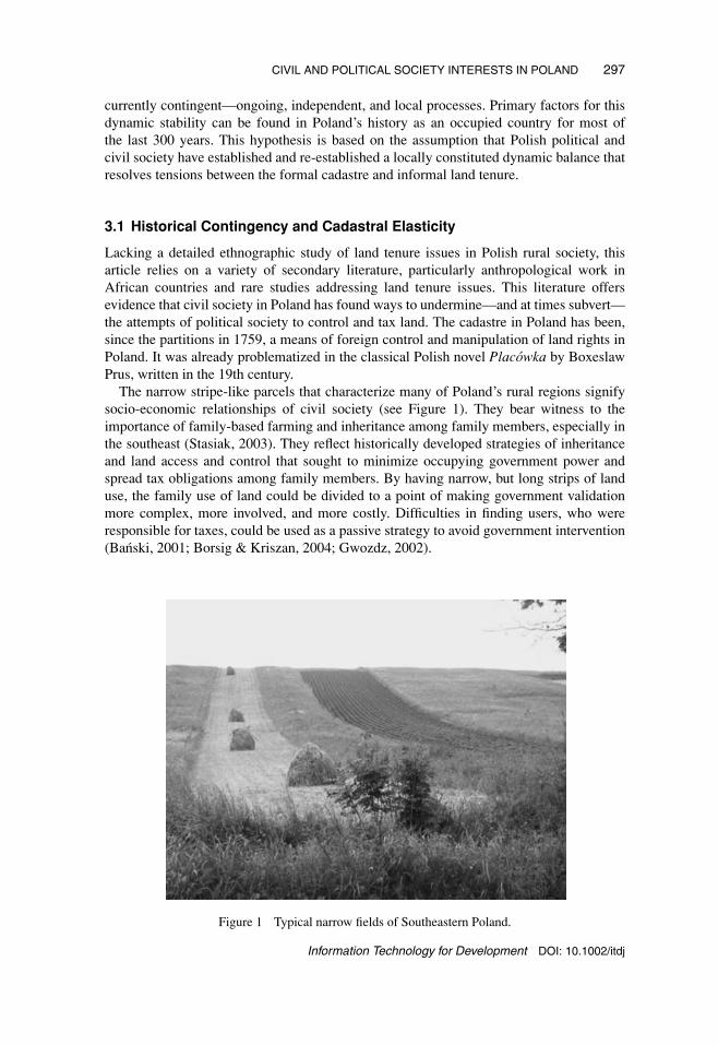
The narrow stripe-like parcels that characterize many of Poland’s rural regions signifysocio-economic relationships of civil society (see Figure 1). They bear witness to theimportance of family-based farming and inheritance among family members, especially inthe southeast (Stasiak, 2003). They reflect historically developed strategies of inheritanceand land access and control that sought to minimize occupying government power andspread tax obligations among family members. By having narrow, but long strips of landuse, the family use of land could be divided to a point of making government validationmore complex, more involved, and more costly. Difficulties in finding users, who wereresponsible for taxes, could be used as a passive strategy to avoid government intervention(Banski, 2001; Borsig & Kriszan, 2004; Gwozdz, 2002).
Figure 1 Typical narrow fields of Southeastern Poland.
Information Technology for Development DOI: 10.1002/itdj

298 HARVEY
This still widespread organization of farming may have taken form in the colonialistrelationships between Poles and occupiers. Following the hypothesis for this research, it alsoreflects tensions between Polish civil and political society. For example, Davies’ historicalanalysis makes the point that “Political authority was perceived as an alien imposition inpartitioned Poland on several counts” (2001, p. 213). This was particularly relevant for landownership: “The disrepute of political authority was reinforced by the fact that other formsof existing authority, in the social and religious spheres, remained essentially intact. Thepattern of land ownership, for example, was altered, but not overturned” (Davies, 2001,p. 215).
The partitioning and occupations of Poland from 1772 to 1918 led to considerablealterations of land access and rights. The Polish nobility that sought partitioning as a meansof preserving their political and economic status would witness an erosion of their powerunder the colonial powers, Austria-Hungary, Germany, and Russia, a minor reversal after1918, and a near-complete loss of land ownership following 1945. They are the mostimportant starting point for understanding how civil society developed means to regulateaccess and control of land separate from the colonizers’ control and manipulations ofpolitical society. The partitions and occupations during World War II play another significantrole in institutionalizing the underground economy as not only a means of circumventingthe occupying power’s destructive and absurd regulations but also as the underpinning forall economic activities (Wyka, 1992). Because Polish people were employed by colonizingor occupying countries, many people, especially peasants, were alienated from authorityand political society. Further, the chaos and loss of life during the last war and the periodthereafter led to tumultuous movements and displacement of people, with much land leftwithout an owner, or an owner who had fled abroad in fear of repercussions. Even if theiremployment required the execution of government regulations, generations of Poles hadbeen conditioned to deride political authority. The ingrained strategies continued during theSocialist era as a means of resisting and circumventing political power. The informal landtenure arrangements established by civil society became the basis of a status-quo betweencadastre and land tenure; the degree of discrepancy may serve as a good indicator of thetensions between civil and political society.
The unabated significance of the Polish peasantry is another indicator of the significanceof civil society. Agrarian reforms have been limited. After the Polish Republic was foundedin 1918, land reforms conducted until 1939 had limited effects overall, although specific re-appropriations had sizeable impacts (Blobaum, 1995). Post-World War II agrarian reformshad far more profound consequences; however, the greatest impacts were mostly limitedto previously German-held areas. Continued tensions between the government and civilsociety in Poland have been studied by numerous researchers (Franzke, Strohbach, &Tragl, 2003; Grzmala-Busse, 2003; Innes, 2002; Palmer, Munro-Faure, & Rembold, 2003;Regulski, Georg, Jensen, & Needham, 1988; Sagan & Lee, 2004; Zaborowska, 2001).Recent studies of civil society in Poland only offer limited discussion of land related issues(Buchowski, 1996; Hann, 1985; Kurczewski, 2003), Sikorski’s discussion of personalexperiences exempted (Sikorski, 1997).
These historical developments vary from region to region in Poland but have profoundimpacts on the discrepancies between cadastre and land tenure. In most areas of Polandduring the Socialist period from 1944–1989, private farmers, even with government poli-cies working against them, were economically and culturally significant. Many policiescan be noted, but it seems especially significant that in the 1980s the Socialist governmenthad already undertaken a number of measures to help private farmers (Borsig & Kriszan,
Information Technology for Development DOI: 10.1002/itdj

CIVIL AND POLITICAL SOCIETY INTERESTS IN POLAND 299
2004). This points to the importance of peasant strategies to avoid political society’s con-trols. Because of these strategies it was possible to keep people fed during occupationsand wars through the informal economy (Wyka, 1992). Informal land tenure was essentialto the informal economy. Following Janine Wedel, the informal economy, tolerated if notcondoned, kept the country economically afloat in the worst times of Nazi occupation andSocialist mismanagement (Wedel, 1992). Civil society’s division from political society wasstrengthened in the process. It still does support key aspects of many individuals’ economiclives. Unfortunately, English and Polish literature fails to directly engage the questionof informal land tenure in Poland, but drawing on Wedel’s research, Polish publications,and current indicators, it seems plausible that informal land tenure offers rural dwellersmuch needed flexibility to deal with exigencies in life, craft flexible material productionto maximize the value of their work, and minimize government intervention. Social circles(Buchowski, 1996; Gorlach & Serega, 1995; Wedel, 1992) remain significant for the infor-mal allocation of land resources. For example, the dissertation of Salameh underscores theimportance of civil society for the economy of one rural gmina studied between 1989 and1983 (Salameh, 1997).
The tension between civil and political society is also present in the arbitrary nature ofthe administration of the cadastre and political influence on the access to land. Arising fromthe dilemma of serving political power on one hand in an administrative position, and on theother sensing a civil society responsibility to resist political power, Polish government staff,deciding over a Byzantine system of laws and regulations, have enormous individual powerto apply and interpret their mandates. As Wedel writes, this contributes to the creation ofa shadow economy, which at times has become the sole means of avoiding the completedecay of the state (Wedel, 1992).
3.2 Post-Socialist Change and Cadastral Elasticity
The past developments in Poland are exacerbated by recent post-Socialist change. Arguably,Poland exemplifies the problems befalling the cadastre in transitional economies of Centraland Eastern Europe and elsewhere (Csaki & Lerman, 2001; P. Dale & Baldwin, 2000;Lerman, 2000; Prosterman & Rolfes Jr., 2000; Swinnen, 1999b). Indeed, by many statisticalmeasures, Poland’s situation makes it stand out as an exemplar of transition, fully embracinga post-Socialist liberalization of the economy. At the same time, its agriculture is consideredamong the most outmoded in Europe—small parcels and horse power are still common incontrast to other Central and Eastern European countries as well as strong significance of theagricultural sector (see Table 1). After regaining independence in 1918, Poland remaineda largely agriculturally orientated economy until long after World War II. Currently, thePolish economy is dominated by industries and services, although the majority of land isstill under agricultural use. It is seen, by most macro-economic measures, as having thegreatest economic development potential of the ten new European Union (EU) members,which joined on May 30, 2004 (Ingham & Ingham, 2002), especially in the agriculturalrural areas. However, issues of land ownership and land rights, which have been widelyrecognized as one of the chief impairments for Poland’s economic transition (Swinnen,1999a), point to handicaps arising from discrepancies between the cadastre and land tenurein rural areas in Poland.
The post-Socialist transition in Poland is atypical for the region and more similar toeconomic transitions in so-called developing countries. In terms of the post-World War II
Information Technology for Development DOI: 10.1002/itdj

300 HARVEY
TABLE 1. Participation in Farming
Persons PersonsRural engaged in performing Rural
population agriculture Number Subsistence additional unemploymentCountry ‘000 ‘000 of farms farms % activities %
Czech Rep. 3,610 760 26,900 NA 120,000 (5)Slovakia 2,255 580 8,900 NA 115,000 15Hungary 3,690 1,900 1,200,000 80 250,000 14Slovenia 736 350 156,700 10 180,000 8Poland 14,700 8,800 2,048,000 60 480,000 40Romania 9,490 2,750 3,190,000 75–90 275,000 35
Note. From Table 3, http://www.nri.org/rnfe/pub/papers/2630.pdf
Socialist-led collectivization, it is perhaps the most atypical among Central and EasternEuropean countries. Roughly only 25% of Poland’s total area (312,685 square kilometers)was collectivized during the Socialist era from 1944 to 1989. The collectivized areas were,however, regionally concentrated in Northeast, Northwest, and Southeast. Even in theseareas the cadastre was maintained, although rural collectives often had specially preparedcadastral documents. The legal cadastre documents of the Socialist era often were the basisfor developing the new cadastre after 1989.
Other significant issues point to the centrality of rural land ownership issues to Polishand Central and Eastern European developments of cadastral information infrastructures.Restitution of land seized or expropriated during and after World War II has been the focusof many discussions yet often remains an unresolved issue (Blacksell & Born, 2002). Itbecomes exceedingly complex in Poland because of changed national boundaries and massmovements of people following World War II. The unresolved restitution issue, particularlyrelevant in urban areas, constitutes an impairment to economic development that until nowhas only been partially addressed (Blacksell & Born, 2002). It also hangs metaphoricallyas a distant cloud over rural areas but lacks any immediacy for most people, except on acase-by-case basis. More importantly, as long as Poland lacks a restitution law to regulatethe return of private property seized or expropriated before, during, or after the SecondWorld War, the ambiguity arising over a potential return of land causes anxiety and tempersmany people’s desire for improvement of the land and buildings they live in or use. It isimportant to note that a law has been passed for the return of property belonging to religiousorganizations; however, the process has been slow and subject to criticisms of foot-draggingon the side of the Polish administration (Blacksell & Born).
3.3 The Polish Cadastral Information Infrastructure
To meet European Union (EU) membership criteria, Poland—along with the other newmember states—has embarked on programs to accelerate the automatization of their cadas-tral infrastructure. Polish national government agencies and some larger regional agenciesare now actively working on creating a Spatial Data Infrastructure (SDI), in which cadastraldata play a key role. EU-led programs to establish a European SDI through the INfras-tructure for SPatial InfoRmation in Europe (INSPIRE) program have been a key catalyst.Poland’s 100% cadastral coverage suggests a good starting point for collaboration with theEU and to support the liberalized Polish economy’s integration in the EU.
Information Technology for Development DOI: 10.1002/itdj

CIVIL AND POLITICAL SOCIETY INTERESTS IN POLAND 301
The Polish cadastral information infrastructure under development has run into thesimilar national political resistance, as have post-Socialist attempts to replace the cadastraland cartography laws (Albin, 2003; Knoop & Wilkowski, 2003; Miron Perez, 2002). Ruralpolitical groups and interests have effectively blocked private land restitution laws andreform of the cadastre in parliamentary committee. The issues for the dynamic stabilizationof cadastre and land tenure by political and civil society require an engagement with theimportance of informal settlements of local land tenure issues by civil society and theenforcement of rational control by political society.
The current Polish cadastral infrastructure is supported by three separate registries (seeFigure 2). Each registry supports a different legal function: (a) the registry of buildingsand ground is under the control of the Ministry for Infrastructure; (b) the “Perpetual Book”registry is under control of the Ministry for Justice; and (c) the property tax registry is undercontrol of the Ministry for Finance. The three responsible ministries do not coordinate orshare information among the registries; in fact, they each deploy different organizationalhierarchies and technologies (Harvey, 2005). Despite a plethora of studies to integrate theregistries and successful pilot studies (Albin, 2003), only some integration of the disparateregistries seems to be taking place.
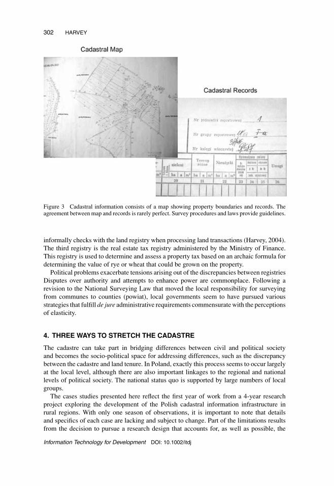
For most people, the most significant of the three registries is the land registry (seeFigure 3). This registry is under the control of the Ministry for Infrastructure, Office ofthe Surveyor General. Copies of all land survey activities are sent to the correspondingoffice in each powiat (county), when possible, in both paper and digital formats. After entryin the powiat’s registry, the materials are sent to the Wojwodscha (province) geodesy andcartography office; these materials are finally sent to the Office of the Surveyor Generalfor archival. The second registry is the land and mortgage registry, which, because of theover-taxed court system, experiences substantial backlogs, in some cases taking over twoyears to record a property sale. This registry is under the control of the Justice Ministry.All property transactions should be recorded in the district court. However, because ofthe legal problems arising as the result of backlogs, gmina (commune) administrative staff
Figure 2 Organization of the Polish cadastral infrastructure (simplified national level).
Information Technology for Development DOI: 10.1002/itdj
302 HARVEY
Figure 3 Cadastral information consists of a map showing property boundaries and records. Theagreement between map and records is rarely perfect. Survey procedures and laws provide guidelines.
informally checks with the land registry when processing land transactions (Harvey, 2004).The third registry is the real estate tax registry administered by the Ministry of Finance.This registry is used to determine and assess a property tax based on an archaic formula fordetermining the value of rye or wheat that could be grown on the property.
Political problems exacerbate tensions arising out of the discrepancies between registriesDisputes over authority and attempts to enhance power are commonplace. Following arevision to the National Surveying Law that moved the local responsibility for surveyingfrom communes to counties (powiat), local governments seem to have pursued variousstrategies that fulfill de jure administrative requirements commensurate with the perceptionsof elasticity.
4. THREE WAYS TO STRETCH THE CADASTRE
The cadastre can take part in bridging differences between civil and political societyand becomes the socio-political space for addressing differences, such as the discrepancybetween the cadastre and land tenure. In Poland, exactly this process seems to occur largelyat the local level, although there are also important linkages to the regional and nationallevels of political society. The national status quo is supported by large numbers of localgroups.
The cases studies presented here reflect the first year of work from a 4-year researchproject exploring the development of the Polish cadastral information infrastructure inrural regions. With only one season of observations, it is important to note that detailsand specifics of each case are lacking and subject to change. Part of the limitations resultsfrom the decision to pursue a research design that accounts for, as well as possible, the
Information Technology for Development DOI: 10.1002/itdj

CIVIL AND POLITICAL SOCIETY INTERESTS IN POLAND 303
manifold complexities of Polish society and history through studies over a 4-year period.The overall research focuses on three areas, one in each of the historical partitions. Theselection of sites also exemplifies different issues of post-Socialist transition and EuropeanUnion expansion.
In summary, results from three counties ( powiaty) in different parts of Poland suggestthat the formal cadastre appears to be reconciled with informal land tenure in many differentways, largely corresponding to the historical development of the area, cultural orientations,and relationships between government bodies. The manifestations of elasticity in theseareas point to multiple understandings of the cadastre as well as the multiple roles of thecadastre for Polish political and civil society.
In only one of the three powiaty were discrepancies in the order reported in other studiesof rural land ownership in Poland reported. Surveyors in the other two stated that thediscrepancies ran between 5% and 10%, a figure which can be explained simply by errorsand improved accuracy in newer surveys. In the powiat that reported a discrepancy between30% and 40%, the powiat surveyor noted that there was little interest in resolving thesedifferences by the communes, who, under Polish law, hold legal responsibility for thecadastre.
4.1 Grojec
Located roughly 50 km south of Warsaw, Grojec is one the most significant apple orchardareas in Poland, producing relatively large and reliable crops for domestic consumptionand also for Eastern export markets. Land prices are comparably high here because of thestrength of the production: increased demand from existing export markets and increasinginterest from markets in Western European countries.
Surveyors in Grojec powiat maintain that only five to eight percent of the land hasunclear ownership. The high cost of land has led most farmers to survey their parcels andany discrepancies are resolved. The cadastre supports their interests and they receive strongsupport from the county administration and villages for maintaining a highly accuratecadastre (highly accurate in the sense that it reflects the tenure situation on the ground).Because of difficulties in obtaining cadastral data from the responsible national agency, thelocal administration of one gmina (commune) has gone so far and created their own shadowapproval system to speed up the process for residents. Based on anecdotal evidence, thisstrategy may be the case in other areas of Poland.
4.2 Sanok
Located in the Southeast corner of Poland, Sanok has experienced significant economicproblems, in both its urban and rural areas. Rural areas were largely collectivized followinga successful campaign in the late 1940s to suppress Ukrainian partisans fighting for aseparate Ukrainian state. The land is often of marginal quality and mostly ill-suited formost crops. The tourism potential of the very hilly and somewhat mountainous area is thehoped-for economic force for development, although some highly specialized agriculture(animal breeding) has become very significant in a few well-situated villages.
The surveyors in Sanok indicate that easily 30 to 40 percent of the rural areas in thecounty face unclear ownership situations. At the county level, this was seen to be a complexproblem but insignificant for villages. A full set of cadastral records is kept by the county
Information Technology for Development DOI: 10.1002/itdj

304 HARVEY
without any regard for discrepancies. The cadastral registries still contain a number ofentries prepared in the 1950s and unmodified until today, “Unregulated, [owner] abroad.”As long as a record was created and properly maintained, the legal requirements that applyto the county are fulfilled. The county is currently in the process of completely automatingall its records supported in part by EU funds.
The situation in villages of this county was extremely different and variable. Two villagesmaintained their own cadastral records. Both do this by drawing on data sent by the county.In one case the data is sent monthly; the other receive it when they request it. Another villagehas no cadastral information at all because of the complexity of maintaining cadastralinformation. Administrative relationships with the county parallel the types of cadastraldata exchanges the local governments engage in with the county.
4.3 Slupsk
Located in the northwest of Poland, Slupsk has strong urban and rural economies, inpart due to strong foreign investment presence. In rural areas this is more variable andstrong differences are evident between individual villages. The majority of Sl�lupsk wascollectivized, leading to many difficulties in the 1990s but now offering potential for largefarms.
Surveyors in Sl�lupsk county have not only a complete set of records for the cadastregoing back to the late 1940s, they have also completely transformed the paper maps andregistries to digital formats, using an integrated system widely used in Polish counties. Thesystem is strongly centralized. Whereas in the other counties, villages also kept cadastralrecords for their own use; in Sl�lupsk, all cadastral records were solely kept by the county.This leads to some difficulties for people who have to make a long trip to obtain cadas-tral information, but village officials underscored the tremendous organizational elan andcoordination undertaken by the county surveyors.
5. BROADER IMPLICATIONS
The cadastre is of great importance for governance in all of these counties. It is an essentialpart of being able to govern at a distance, an essential part of regulating local control overland. The different strategies to resolve discrepancies between the cadastre and land tenureencountered in Poland point to the complex and locally contingent relationships betweenpolitical and civil society’s dynamic stabilization. Approaches for one county were rarelyadopted in other counties, or if something similar can be identified in Grojec and Sanok,then the organizations and personalities involved lead to radically different activities. Theimplications of these findings bear special attention to the historical background and roleof the cadastre in local arbitration of land access, control, and responsibilities.
5.1 Disruptions and Negotiations
The discrepancies between land tenure and cadastre discussed in the beginning of the articlecan be understood as indicators of the degree of historical upheaval and destabilization.The possibility is that the discrepancies are the result of the turmoil of twentieth centuryPoland. Indeed, in this one powiat, it was possible to find cadastral records from the 1950s,which simply indicated “no owner” next to a parcel and noted in the record, simply, “not
Information Technology for Development DOI: 10.1002/itdj

CIVIL AND POLITICAL SOCIETY INTERESTS IN POLAND 305
regulated [owner] abroad.” Numerous records like these in this powiat suggest that ownerswho moved, disappeared, or lost their lives became phantoms of the cadastre. That this situ-ation has remained unchanged in over forty years suggests that the advantage of access anduse to this land for some has outweighed the political challenges and risks of finding resolu-tion. Elasticity supports the persistence of de jure approaches and problems—whether theconsequences are negative or positive for a particular area is a question for future research.
This article points to historical issues as key factors to consider in understanding thecauses for discrepancies. Swinnen (1999) highlights four historical-institutional factorsinfluencing the choice of land reform activities in 1990 Central and Eastern Europeancountries: (a) post-collectivization ownership status, (b) the length of socialist rule andlost tradition of private farming, (c) political strength of ethnic groups, and (d) pre-collectivization asset distribution. As important as these factors are, they seem to missthe role of the disruption of communities in the twentieth century. In Poland, the loss ofover 20% of the entire population during World War II and the following forced removaland resettlement have led to immense alterations of communities, often characterized by avacuum into which existing and new settlers sprung.
This would also corroborate the hypothesized significance of local elites in negotiatinga high degree of flexibility between the cadastre and land tenure. Profiting from the accessand use of this land stands as a potential great benefit for some, at an unknown cost for otherresidents who arrived after the war and were never made aware of the un-owned land. Theongoing negotiations of these issues are relevant locally as well as nationally, as changesin the cadastral laws would impact the sizeable local elite across the country. Based ondiscussions in the popular media, it is strongly possible that the elite’s political influencehas stymied attempts to revise cadastral laws in Poland since 1989 (Winniczki, 2003).
5.2 A Crucible for Societal Coordination
The cadastre is more than an instrument; it has been the site for forging societal relation-ships related to the use, control, costs, and benefits of regulated and secure land access. Theflexibility between land tenure and cadastre empower localized strategies.
Figure 4 Cadastral record excerpt showing the note, “stanu nie regulowano, za granica,” which canbe translated “status not regulated, abroad.”
Information Technology for Development DOI: 10.1002/itdj

306 HARVEY
The elasticity between cadastre and land tenure can hypothetically maintain a localstatus quo in the following manner: Local administrations are closely linked to local civilsociety and maintain a cadastral concept that shields actual practices of land occupationfrom resolution of ownership situations. Local elites have a strong economic interest inthis protection of land which they use but face no obligations for. Supporting this socialorganization of land access, the local administration, largely evolved from past Communistparty members, receives crucial political support from these elites. The local administrationproduces cadastral records that satisfy regional and national agencies but fail to correspondto local ownership and actual use of the land.
6. CONCLUSIONS
Romans, the Europeans who first introduced cadastres, separated between the surveyingof land ownership boundaries and determination and evidence of legal title to land. Thesame separation exists today and is critical to understanding the delegation of control andauthority between cadastre and land tenure. The relationships between civil society’s landuse practices and political society’s attempts to benefit elites takes arguably shape in theover 2000 year collected experiences of Western Civilization. The Romans establishedelaborate rituals and procedures for allocating and re-crafting the relationships betweenadjacent land users and owners, binding each person and each piece of land into metaphys-ical alignment with governance and the divine. Perhaps the Enlightenment and search fora Benthaian utilitarian perfection has created blinders that stop us from seeing the signifi-cance of administrative technology in the political settlement of civil and political societyrelationships involving land. If this is the case, the engagement with the crafting of cadastralinformation infrastructure in Poland and elsewhere stands to broaden our understandingof the connections between land, politics, and the technologies that constantly bridge ourmodernist designs for a rational world to the realities of civil society’s day-to-day existence.Future research activities as part of this ongoing project will help shed light if the elasticitybetween formal cadastre and informal land tenure exacerbates the elite’s possibilities toincrease their status and power or if elasticity engenders a more equitable access to landthan the liberal cadastre.
6.1 Technologies, Politics, and the Enlightenment
The cadastre supposedly developed as a technology wedded with enlightenment ideals seeksto move beyond irrational political decision making. However, practices of the cadastralinfrastructure shed light on the untenable ideal of perfect rationality and unbiased recordingof land ownership. Counter the enlightenment ideal, this research suggests that the cadastreis a locally contingent administrative technology for addressing differences between civiland political society.
In regards to the material from Poland presented here, I suggest that the tension betweenthe cadastre’s Enlightenment ideals and the reality of local land ownership veils the moresignificant conflicts for civil and political society. The cadastre’s significance truly comesonly from resolving the tensions in each place. These technologies play important rolesas boundary objects between civil and political society—an important topic for futureresearch. The cadastral records are produced by and for local governments but are usedonly tangentially to the socially established practices of allocating access to land in thecommunity.
Information Technology for Development DOI: 10.1002/itdj

CIVIL AND POLITICAL SOCIETY INTERESTS IN POLAND 307
The role of the local resolution and the elasticity of the cadastre and land tenure lead to agreat challenge for the development of cadastral information infrastructures. The differencesbetween national approaches, standards, policies, and local cadastral activities may wellbecome the most significant onus for the development of the Polish SDI. This issue mayexacerbate or simply parallel difficulties of other countries seeking to develop SDI. Thepolitical resolution of these issues would also seem to be paramount to the development ofsuccessful policies. In this vein, further study in Poland may aid in looking under the skinat the developments in other countries around the world.
6.2 Consequences of EU Enlargement?
A key issue for land governance and cadastral infrastructure implementation in Polandis how government agencies and political actors manage to find enough elasticity to me-diate the tensions arising in the process of establishing a new social organization of thecadastral infrastructure. EU programs supporting the development of cadastral informationinfrastructures and changed socio-economic situations lead to tensions among local actors.Methodological and theoretical insights from the development of the Polish cadastral in-frastructure should also be beneficial for SDI and governance studies in other Europeantransitional economies and around the world.
As Aanestad (2005) discusses, there is a clear political dimension to the revisions ofthe cadastral infrastructure in Poland. They raise these highly relevant questions for EUenlargement and the Polish cadastral infrastructure in their discussion:
One of the key tasks will be to design the relations between these groups: How will burdens andbenefits be distributed? How will risk and responsibility be shared? What will be the value added toservices—value for whom? What will be public and common and what will available only to some?In the accounts above there is an implicit dilemma between the collective good and the individualgood, which I believe lies at the heart of the matter. (2005)
The research to date presented here is insufficient for answering these important ques-tions. The continuation of this research project over the coming years will make it possibleto offer some answers to these questions, at least in light of local interactions between civiland political society. We can expect that the formal cadastre will slowly become a morerelevant part for existing land tenure. The increased value of agricultural land and specula-tion should lead to a strengthening of peoples’ desire to have unchallengeable legal recordsof land ownership and rights. How the existing elites with long-term access to vacant landrespond will become an important part of a new flexibility between the cadastre and landtenure. The social coordination role of the cadastral infrastructure in Poland can take placeonly when it considers the lack of routine rules and crystallized practices related to privateproperty in Poland transition from Socialism.
ACKNOWLEDGMENTS
Many thanks to the many helpful individuals in Poland who assisted with interviews andgraciously provided materials. Portions of this work have been presented at GISRUK April2005 in Glasgow, Scotland and at the University of Wisconsin Madison in October 2004.The author wishes to acknowledge members of the audience who sought clarification about
Information Technology for Development DOI: 10.1002/itdj

308 HARVEY
the issues presented here. Thanks go additionally to Yola Georgiadou for providing copiesof papers presented at the IIS-SDI workshop in Enschede, discussions, and many helpfulcomments. I retain responsibility for any errors in this article.
REFERENCES
Aanestad, M. (2005). Building information infrastructures in the public sector. IFI, University ofOslo.
Albin, J. (2003). Spatial Data Infrastructures in Poland: State of play Spring 2003. Retrieved January8, 2005.
Andrews, J. H. (1975). A paper landscape. The ordnance survey in nineteenth-century Ireland. Oxford:Clarendon Press.
Banski, J. (2001). Problem areas in Poland’s agriculture. Geographia Polonica, 74(1), 47–63.Blacksell, M., & Born, K. M. (2002). Private property restitution: The geographical consequences
of official government policies in central and eastern Europe. The Geographical Journal, 168(2),178–190.
Blobaum, R. E. (1995). Rewolucja. Russian Poland 1904–1907. Ithaca, NY: Cornell University Press.Borsig, A., & Kriszan, M. (2004). Die Landwirtschaft Polens zwischen Transformation und
Strukturwandel. Europa Regional.Bowker, G., & Star, S. L. (1999). Sorting things out. Classification and its consequences. Cambridge,
MA: MIT Press.Buchowski, M. (1996). The shifting meanings of civil and civic society in Poland. In C. Hann & E.
Dunn (Eds.), Civil society. Challenging Western models (pp. 79–98). London: Routledge.Buissert, D. (Ed.). (1992). Monarchs, ministers, and maps, The emergence of cartography as a tool
of government in Early Modern Europe. Chicago: The University of Chicago Press.Csaki, C., & Lerman, Z. (2001). Land and farm structure in Poland. Retrieved June 26, 2003.Dale, P., & Baldwin, R. (2000). Emerging land markets in central and eastern Europe. In C. Csaki & Z.
Lerman (Eds.), Structural change in the farming sectors in Central and Eastern Europe. Lessonsfor the EU Accession—Second World Bank/FAO Workshop, June 27–29, 1999 (pp. 81–109).Washington, DC: World Bank.
Dale, P. F., & McLaughlin, J. D. (1999). Land administration. Oxford; New York: Oxford UniversityPress.
Davies, N. (2001). Heart of Europe. The past in Poland’s present. Oxford: Oxford University Press.de Soto, H. (2000). The mystery of capital. Why capitalism triumphs in the West and fails everywhere
else. New York: Black Swan.Food and Agricultural Organization of the United Nations (FAO). (no date). What is land tenure?
Retrieved May 28, 2005, from http://www.fao.org/documents/show cdr.asp?url file=/DOCREP/005/Y4307E/y4307e05.htm
Franzke, J., Strohbach, A., & Tragl, S. (2003). Problems of agricultural administration in central andeast European countries—Some preliminary results from Estonia, Poland, and Slovakia. RetrievedApril 28, 2004.
Gorlach, K., & Ser↪ega, Z. (1995). The family character of private farms: An empirical test for
postcommunist Poland. In K. Gorlach & Z. Serega (Eds.), Family farming in the contemporaryworld: East-West comparisons (pp. 113–122). Crakow, Poland: Zeszyty Naukowe UniwersytetuJagiello n skiego.
Grzmala-Busse, A. (2003). State reform and informal practices in East-Central Europe. RetrievedJanuary 5, 2005.
Gwozdz, K. (2002). Le devenir du monde rural polonais en europe (Document de travail). Paris,France: Groupement d’etudes et de recherches notre europe.
Hann, C. M. (1985). A Village without solidarity: Polish peasants in years of crisis. New Haven: YaleUniversity Press.
Harvey, F. (2004). Interview in Gmina Belsk Duzy, December 7, 2004.Harvey, F. (2005, April). Going East? The EU, GIS and the governance of Polish rural areas. Paper
presented at the GISRUK 2005, Glasgow, Scottland.Ingham, H., & Ingham, M. (Eds.). (2002). EU expansion to the East. Prospects and problems.
Cheltenham, UK: Edward Elgar.
Information Technology for Development DOI: 10.1002/itdj

CIVIL AND POLITICAL SOCIETY INTERESTS IN POLAND 309
Innes, A. (2002). The changing distribution of power in east European states (EUI Working Papers).San Domenico, Italy: European University Institute.
Kain, R. J. P., & Baigent, E. (1992). The cadastral map in the service of the state: A history of propertymapping. Chicago: University of Chicago Press.
Knoop, H., & Wilkowski, W. (2003). Integrating electronic platform (IPE) as a basic component ofcadastral system in Poland. Retrieved April 6, 2004, from www.eurocadastre.org/eng/documentseng.html
Kozlowski, J. (1997). Polish experience in creation of real property registration system. RetrievedMay 19, 2005, from http://www.fao.org/sd/LTdirect/LTforum/LTfo0011.htm
Kurczewski, J. (2003). Civil society in Poland. Warsaw: Institute of applied Social Sciences, WarsawUniversity, Center for Social Research.
Lemmen, C., & van Oosterom, P. (2002). Cadastral systems ii (Editorial). CEUS, 26, 355–360.Lerman, Z. (2000). Status of land reform and farm restructuring in Central and Eastern Europe. In
C. Csaki & Z. Lerman (Eds.), Structural change in the farming sectors in Central and EasternEurope. Lessons for the EU Accession—Second World Bank/FAO Workshop, June 27–29, 1999(pp. 3–21). Washington, DC: World Bank.
Markus, M. L. (1983). Power, politics, and MIS implementation. Communications of the ACM,26(6), 430–444.
Miron Perez, J. (2002). Cadastre in Europe: Actions to improve the situation ofthe cadastre among the accession countries. Retrieved November 25, 2003, fromwww.eurocadastre.org/pdf/mironglas.pdf
Palmer, D., Munro-Faure, P., & Rembold, F. (2003). Land consolidation and ru-ral development in Central and Eastern Europe. Retrieved January 5, 2005, fromhttp://www.eurocadastre.org/eng/2congress.html
Prosterman, R. L., & Rolfes Jr., L. (2000). Review of the legal basis for agricultural land marketsin Lithuania, Poland, and Romania. In C. Csaki & Z. Lerman (Eds.), Structural change in thefarming sectors in Central and Eastern Europe. Lessons for the EU Accession—Second WorldBank/FAO Workshop, June 27–29, 1999 (pp. 110–139). Washington, DC: World Bank.
Prosterman, R. L., & Rolfes, L. J. (1999). Agricultural land markets in Lithuania, Poland, andRomania: Implications for accession to the European Union (RDI Reports on Foreign Aid andDevelopment No. 99). Seattle: Rural Development Institute.
Regulski, J., Georg, S., Jensen, H. T., & Needham, B. (Eds.). (1988). Decentralization and localgovernment: A Danish-Polish comparative study in political systems. New Brunswick, NJ: Trans-action Publishers.
Rolland, K. H., & Aanestad, M. (no date). The techno-political dynamics of information infrastructuredevelopment: Interpreting two cases of puzzling evidence. Retrieved August 31, 2005.
Sagan, I., & Lee, R. (2004, 14 Mar 2004). Spatialities of regional transformation and the administrativespaces of the EU. Paper presented at the Association of American Geographers, Philadelphia, PA.
Said, E. (2000). Traveling Theory. In M. Bayoumi & A. Rubin (Eds.), The Edward Said Reader(pp. 195–2017). London: Granta.
Salameh, S. (1997). Bitter harvest: Antecedents and consequences of property reform in postsocialistPoland. Unpublished doctoral dissertation, University of California, Berkeley.
Scott, J. C. (1998). Seeing like a state. New Haven, CT: Yale University Press.Senghaas, D. (1985). The European experience: A historical critique of development theory (K. H.
Kimmig, Trans.). Dover, NH: Berg Publishers.Sikorski, R. A. I. H. o. P. (1997). The Polish house. London: The Orion Publishing Group.Star, S. L. (1999). The ethnography of infrastructure. American Behavioral Scientist, 43(3), 377–391.Star, S. L., & Griesemer, J. R. (1989). Institutional ecology, “translations,” and boundary objects: Am-
ateurs and professionals in Berkeley’s museum of vertebrate zoology. Social Studies of Science,19, 387–420.
Stasiak, A. (Ed.). (2003). Problemy zagospodarowania terenow wiejskich w Polsce. Warsaw: PAN.Swinnen, J. F. M. (1999a). The political economy of land reform choices in Central and Eastern
Europe. Economics of Transition, 7(3), 637–665.Swinnen, J. F. M. (1999b). A political economy perspective on policy-making and institutional reform
in agriculture. In K. Frohberg & P. Weingarten (Eds.), The significance of politics and institutionsfor the design and formation of agricultural policies (pp. 51–68). Kiel: Wissenschaftsverlag VaukKiel KG.
Information Technology for Development DOI: 10.1002/itdj

310 HARVEY
Turnbull, D. (1998). Mapping encounters and (en)countering maps: A critical examination of carto-graphic resistance. In Knowledge and Society (Vol. 11, pp. 15–43). London: JAI Press.
United Nations Center for Human Settlement (Habitat). (1991). Report of the workship on landregistration and land information systems in developing countries. Unpublished paper, Nairobi,Kenya.
van Dijk, T. (2003). Dealing with Central European land fragmentation. A critical assessment on theuse of Western European instruments. Delft, The Netherlands: Eburon.
Verdery, K. (1994). The elasticity of land: Problems of property restitution in transylvania. SlavicReview, 53(4), 1071–1109.
Verdery, K. (1998). Fuzzy property: Rights, power, and identity in Transylvania’s decollectivization.In J. M. Nelson, C. Tilley & L. Walker (Eds.), Transforming post Communist political economies(pp. 102–117). Washington, DC: National Academy Press.
Verdery, K. (2003). The vanishing hectare: Property and value in postsocialist Transylvania. Ithaca,NY: Cornell University Press.
Wedel, J. R. (Ed.). (1992). The unplanned society. Poland during and after Communism. New York:Columbia University Press.
Winniczki, M. (2003). Wykastrowac kwasniewskiego i jego syjonistyczna kilke szpiegowKGB/SVR-GRU w SLD i PO. Retrieved April 1, 2004, from www.naszdziennik.pl/index.php?typ = my&dat=20030331&id = my01.txt
Wyka, K. (1992). The excluded economy. In J. R. Wedel (Ed.), The unplanned society. Poland duringand after Communism (pp. 23–61). New York: Columbia University Press.
Zaborowska, M. (2001). La reforme administrative et territoriale polonaise dans le contexte europeen(Etude). Paris, Franci: Groupement d’etudes et de recherches notre europe.
Francis Harvey completed his PhD in 1996 at the University of Washington. Since then, he hasheld positions at the Swiss Federal Institute of Technology in Lausanne, University of Kentucky,and University of Minnesota. Current research focuses on heterogeneous techno-social strategies toresolve discrepancies between land tenure and land cadastre in rural Poland.
Information Technology for Development DOI: 10.1002/itdj