Embed Size (px)
Citation preview

EGNOS BULLETINIssue 18, Q1 2016
Precise navigation, powered by Europe
http://www.essp-sas.eu/http://egnos-portal.gsa.europa.eu/
P H O T O : A I R B U S

2 E G N O S B U L L E T I N | I S S U E 1 8 | Q 1 2 0 1 6
EGNOS implementation

3E G N O S B U L L E T I N | I S S U E 1 8 | Q 1 2 0 1 6
Finmeccanica’s Helicopter Division, the former AgustaWestland, has been for years one of the world’s leading companies in the design and manufacture of helicopters. The origins of the Italian Agusta and the British Westland date back to the beginning of last century.After more than 100 years, the British branch is still manufacturing helicopters at its main facilities in Yeovil (ICAO: EGHG) which includes a 1200 metre grass runway with 09/27 designation.The ATC managers at Yeovil / Westland airfield are currently involved in a project to implement new instrument approach procedures based on EGNOS. Tommy Brown, Senior Air Traffic Controller at Yeovil, talks about the project “Although quite unique because of the grass element, our runway
EGNOSSuccess Stories
has been instrumented for years. We aim however at further improving operations with the new approach procedures, which will make use of the EGNOS APV-1 Service Level. The new procedures will be a huge improvement over the existing offset NDB approaches, not only because of the addition of the vertical guidance but also because of the reduced Decision Height.”The Company has recently signed an EGNOS Working Agreement (EWA) with ESSP SAS as EGNOS Service Provider, and expects approval of the LPV procedures in the coming months “We are about to finalise the Safety Case, as requested by our CAA. It will be submitted soon and it is our objective to obtain approval by autumn this year”, finishes Brown.
…that, on the 26th of January, EGNOS remained stable and properly synchronised to UTC whilst incorrect time information was broadcast by several GPS satellites? Check the full story here.
Did you know…?
GREEN EGNOS PROCEDURES FOR YEOVIL / WESTLAND

4 E G N O S B U L L E T I N | I S S U E 1 8 | Q 1 2 0 1 6
EGNOSSuccess Stories
Positioning under control makes the difference between success and failure in the 52 SUPER SERIES. This monohulls’ race brings together the best sailors in the world. Boat crews are made up of Olympic champions, America’s Cup winners and also sailors that have been enshrined in offshore sailing as the Volvo Ocean Race.
One of the turning points of the TP52 regattas is the start line. It is probably the trickiest time, when the Navigator must rely on the accuracy of its on-board computer. The start is an equation driven by speed, position and choice of the perfect place on the line. In the past, the battle in the start line was a process of learning and expertise in which the Helmsman, the Bow and the Navigator had to mentally calculate the right moment to pass the start line without skipping the kickoff time.
Afterwards, GPS and computers came on the scene: technology got on board. Nevertheless, positioning system errors made them doubt. The
advent of GPS brought a helpful tool to navigate but its errors, which in some cases could reach until 16 meters, were of no use when fighting for each centimetre on the start line.Fortunately now, with the inclusion of EGNOS in the navigation system of the sailing boats, Navigators have managed to substantially reduce the interval of error provided by GPS: EGNOS has been a great breakthrough for them. The position error has been extremely reduced, hence nowadays they can rely much more on computers to find out if they are well positioned in the start line.
The decisive step forward has been the arrival of EGNOS to the sailors’ tablets; a rather simple functionality in terms of implementation within the complex navigation systems used by professional sailors. SBAS is a feature that is usually configured in new navigation systems; therefore it is quite simple to take advantage of all the potential that EGNOS is offering.
EGNOS IN SAILING COMPETITION
Credit: 52 Super Series

Talking about
EGNOS benefitswith Vicente Laso Cortés
Vicente Laso Cortés is a Topographer and Engineer in Cartography and Geodesy and Civil works project designer. He has been involved for 17 years in civil engineering business and in particular he has dealt with all types of GPS devices during l the last 12. Since 2013 he is involved in forestry maintenance and inventories to feed GIS systems.
5E G N O S B U L L E T I N | I S S U E 1 8 | Q 1 2 0 1 6
You work for the company in charge of the maintenance of parks and forest parks in Madrid capital. Please can you explain what activities are needed?
The company I work for, ORTIZ-EULEN, is in charge of managing and mantaining the forestal parks of Madrid. Those parks cover a great diversity of species, vegetal density and uses. The surface to be managed covers approximatley 2500 ha which includes both urban parks and forests.
Please can you explain what is the importance of doing inventories for such maintenance activities?
For an effcicent management it is needed to have information about the position and dimensions of each of the items to be mantained in order to define the corresponding management plans. From prunning to urban furniture conservation, up to reparation and maintenance of civil works.
Why EGNOS is a useful solution for inventories in natural environment?
Due to the great extension and great number of items to manage, it is neccesary to have highly versatile surveying equipments which provide the needed accuracy in complex environments for GPS. Nowadays thanks to the internet it is possible to obtain real time differential corrections, even for free, but where there is high tree density or when/where there is no GPRS signal, EGNOS corrections are extremely useful. New generation surveying equipment are easy to handle and transport and do not require wide knowledge of surveying and geodesy to operate with them in any environment.
What would be your message for companies interested in doing inventories in natural environments?
Resuming, the combination of different constelations allows surveyors to have more compact and easy equipment to perform accurate positioning. This brings a clear increase in the productivity in the generation of cartographic information.
When or where there is no GPRS
signal, EGNOS corrections are
extremely useful.

This is the xLS concept which aims at standardizing the way of flying an approach. Whatever the type of straight-in approach, the aircraft functions are designed to provide the crew with a similar and consistent operational solution. This concept provides not only the same guidance modes or displays to the crew but is also based on a similar avionics architecture.As part of this xLS concept, Airbus already proposes for all aircraft families:
·ILS (Instrument Landing System)·GLS (GBAS Landing System)·FLS (FMS Landing System) which extends the ILS look-alike concept to non-precision approaches (VOR, NDB, RNAV…)
On the 350, Airbus innovated by pushing the concept one step further with the SLS (Satellite Landing System). This new function uses GPS augmentation coming from SBAS systems such as WAAS or
EGNOS to allow the aircraft to fly down to LPV minima, as low as 200 ft DH and 550m RVR.Thanks to this SLS function Airbus is looking at maximizing airport accessibility for all its operators by providing a real “Precision Approach Service”. This includes in particular a geometrical vertical guidance which is fully independent from barometric setting error or temperature effect. The SLS function can enhance the airlines operations in multiple situations: at airports currently not having precision approach, at main runways as a backup of ILS (e.g. during maintenance) or at alternate airports in case of diversion. Airbus is therefore happy to see that the number of LPV approaches is increasing quickly all over Europe, with more than 250 procedures available today!
For example, in April Paris Charles de Gaulle will have LPV approaches with 200 ft minima. So during ILS antenna replacements, which are scheduled between 2016 and 2020, the A350 XWB could still have the capability to fly down to CAT I minima thanks to the SLS function.
Since the function was developed according to the xLS concept, there is no specific training required to fly a LPV approach. All pilots are trained to follow ILS beam and the SLS function provides
Thanks to the GPS constellation, aircraft navigation has significantly evolved over the past 20 years. Even if ILS remains the primary means for precision approaches, new technologies based on GPS now exist. Airbus has integrated these new technologies with an ILS look-alike interface which benefits from the ILS operational experience.
Thanks to this SLS function Airbus is looking
at maximizing airport accessibility for all its
operators by providing a real “Precision Approach
Service”.
6 E G N O S B U L L E T I N | I S S U E 1 8 | Q 1 2 0 1 6
SBAS on-boardAirbus A350 XWB
Frederic Belloir,Systems Sales and Marketing
Credit: Airbus

Airbus is proud to have the first wide-body aircraft embedding the SBAS technology.
7E G N O S B U L L E T I N | I S S U E 1 8 | Q 1 2 0 1 6
Frederic Belloir,Systems Sales and Marketing
a similar operational environment: the approach preparation is the same and the approach execution also. The aim of this concept is to have the crew immediately comfortable with the new approach function. And this was confirmed during A350 XWB flight tests campaign. In addition, pilots observed that the SLS signal was often better than CAT I ILS: aircraft position relative to the trajectory is always available and reliable, there are no false LOC or G/S side lobes and finally there is no interference linked to ILS protected area. In a nutshell, the pilot’s feedback is excellent!In terms of avionics architecture, the SLS function is hosted in the Multi-Mode Receiver (MMR). Through the GPS antenna, the MMR receives data from the GPS constellation and from the SBAS geostationary satellite. These data are then used to compute the LOC and G/S deviations which are sent to peripheral systems as if they were received from an ILS beam. The reference trajectory is based on a secured FAS, extracted from the navigation database. The MMR deviations are used by flight controls to guide the aircraft along the trajectory, and are also displayed on EFIS for pilot monitoring.In the end, the SLS development on the A350 XWB was a very positive experience and Airbus
is proud to have the first wide-body aircraft embedding the SBAS technology. This function provides high efficiency and flexibility to enhance A350 XWB operations. And it is already a success since more than 10 customers have selected this option: in a few years, more than 300 A350 XWB operating from all over the world will have the SLS capability! This new technology is unquestionably going to bring value in the precision approach domain.
Primary flight display showing SLS capability
Credit: Airbus

LPV & APV BARO PROCEDURES PUBLISHED PER COUNTRY
(including last AIRAC cycle 2016 #4 – 31/03/2016)
Next table shows, for each country:• the number of airports with LPV procedures, as well as the total number of LPV procedures;• the number of airports with APV Baro procedures authorised to be flown with EGNOS vertical
guidance as well as the total number of APV Baro procedures.
What’s new?Since last bulletin...
8 E G N O S B U L L E T I N | I S S U E 1 8 | Q 1 2 0 1 6
The following EWAs have been signed in the last quarter:
EGNOS WORKING AGREEMENTS (EWA) SIGNED
AgustaWestland LtdUnited Kingdom
Tallinn Airport LtdEstonia
Country Airports – LPV procedures
# LPV Procedures
Airports – APV baroProcedures
# APV baroProcedures
Austria 2 2 0 0Belgium 2 3 0 0Croatia 1 1 0 0
Czech Republic 4 8 1 4Denmark 3 6 0 0
Finland 1 2 0 0France 81 131 4 5
Germany 20 33 24 63Guernsey 1 2 0 0
Italy 7 17 0 0Netherlands 2 3 0 0
Norway 10 21 8 17Poland 2 4 0 0
Portugal 1 2 0 0Slovak Republic 2 4 0 0
Spain 1 2 0 0Sweden 2 3 0 0
Switzerland 8 10 0 0United Kingdom 2 4 0 0
Total 152 258 37 89
LPV200 SERVICE
NOTIFICATIONS TO
USERS AVAILABLE
If you would like to receive EGNOS notifications, including new ones such as LPV-200 Availability Degradations, you can freely subscribe to them through the EGNOS User Support Website. The subscription process will take just 2 minutes and is the following:
1. Go to EGNOS User Support website2. Create a user account, if you are not yet a registered user3. Fill in your data4. In the “Notifications Subscriptions”section inside your profile, select LPV-200 Availability Degradation Notifications to receive the information via email.
NEW SERVICE
IMPLEMENTATION
ROADMAPS READY
A new version of EGNOS Services Implementation roadmaps (SIRs) has been recently published in the EGNOS User Support website describing the current status of the EGNOS Services and the foreseen evolutions. The main improvements with respect to the previous version are the introduction of: · System milestones linked to service evolutions · New section with the high-level overview of the long-term Service Evolutions beyond the 3-year timeframe. Remember that information about EGNOS foreseen evolutions is updated minimum twice a year. More information here.
9E G N O S B U L L E T I N | I S S U E 1 8 | Q 1 2 0 1 6
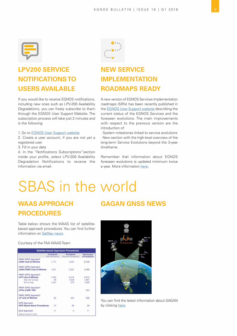
WAAS APPROACH
PROCEDURES
Table below shows the WAAS list of satellite-based approach procedures. You can find further information on SatNav news.
Courtesy of the FAA WAAS Team
GAGAN GNSS NEWS
You can find the latest information about GAGAN by clicking here.
SBAS in the world

New Catalogue of Services available for registered users!
It provides a list of services from different European companies for the implementation of LPV approach procedures and the equipage / certification of aircraft for their use.
· Airport Obstacle survey· Cost Benefit/ Business Cases· Instrument Flight Procedures Design· Flight Validation· GNSS Monitoring· GNSS Performance Assessment· Safety Assessment· Environmental studies· PBN Training
Companies interested in being listed here,please write to [email protected]
New filter “Airlines” available in the LPV Map
New features available at the
EGNOS User Support website
This new functionality allows you to find information on which arilines fly to the existing LPV destinations.
10 E G N O S B U L L E T I N | I S S U E 1 8 | Q 1 2 0 1 6
EGNOS Adoption Docs + Tools

11E G N O S B U L L E T I N | I S S U E 1 8 | Q 1 2 0 1 6
EGNOS user satisfaction
survey 2015 results
EGNOS, it’s there. Use it.
USER SATISFACTION SURVEY 2015
The questionnaire has been filled by
200 respondents
(*) Each respondent can use more than one service.
87 Open Service (OS)
19 EDAS
57 Safety of Life (SoL)
The Global Satisfaction Score shows a good level of satisfaction with
respect to EGNOS in general terms.
Global Satisfaction
Score
(*) All scores are graded out of 10 points.
USER SATISFACTION SCORE PER DOMAIN
wwwSUPPORT 7.1
8.2
7.8
EGNOS SUPPORT
Documentation
Support Website
Helpdesk
8.1SoL
42% EGNOS Users (*)
Your SATISFACTION is our reason for being!
EGNOS SERVICES
7.1EGNOS OS availability
7.2EGNOS OS accuracy
7.4EGNOS OS coverage
8.3EGNOS SoL
accuracy
7.5EGNOS SoL coverage
8.4EGNOS SoL availability
Performance
64 EGNOS
Non-Users
136 EGNOS Users
7.2OS
64% EGNOS Users (*)
7.7EDAS
14% EGNOS Users (*)
Agriculture
Aviation
Maritime
Road
Surveying & Mapping
6.7Rail
7.9
8.2
7.8
6.3
7.4
(*) Surveying & Mapping includes “Location Based Solutions”.
+

INCOMING
PUBLICATION OF THE
EASA OPINION ON THE
PBN IMPLEMENTATION
IN EUROPE
According to the latest developments of the EASA rulemaking task RMT.0639, the Opinion on the Implementation of Performance Based Navigation in the European Air Traffic Management Network (EATMN) is expected to be published very soon. Based on the material published under the Notice of Proposed Amendment (NPA) 2015.01 for public consultation in January 2015, the Opinion will set the basis for establishing a mandate on ANSPs and Airport Operators to deploy APV procedures to all non-instrumental runway ends where, to date, there are only NPA procedures available, by the end of 2020.This opens a means to increment the penetration of LPV procedures (APV enabled by EGNOS) in Europe, increasing safety on a quite cost-efficient basis.
LOTS OF INTEREST ON
EGNOS DURING WORLD
ATM CONGRESS
A new edition of the World ATM Congress took place in Madrid between the 8th and 10th of March, and once again EGNOS raised a lot of interest among the event visitors.A workshop devoted to EGNOS for aviation was also held in order to provide the most up-to-date information about status and roadmap of the services, together with expected implementation trends for the coming years. Attendees had also the opportunity to learn how some European ANSPs have implemented their first EGNOS procedures during the last year.
What’s going on...
12 E G N O S B U L L E T I N | I S S U E 1 8 | Q 1 2 0 1 6
in aviation.
On the other hand, the EGNOS Stand counted this year on a new element: a flight simulator which brought the visitors the opportunity to fly a LPV procedure enabled by EGNOS, thus learning the benefits of the concept over conventional approaches.
…that Belgium has established a plan to implement RNP APCH procedures to all their instrument runways ends by the end of 2017?These procedures will be published with LNAV, LNAV/VNAV and LPV lines of minima in order to serve all airspace users. Aerodrome locations and planned publication dates can be consulted through the LPV Procedures Map accessible at the EGNOS User Support website.
Did you know…?

13E G N O S B U L L E T I N | I S S U E 1 8 | Q 1 2 0 1 6
in maritime.OUTCOMES ON THE LAST
RTCM SC-104
Monterrey in California was the designated place to hold the last Special Committee No. 104 on Differential Global Navigation Satellite Systems, within the Radio Technical Commission for Maritime Services (RTCM SC-104).
A two-days meeting on the 28th and 29th of January 2016 where the 21 attendees, including receiver manufactures, precision positioning services providers and survey organisations among others, discussed and agreed on the way forward for the recommended standards on DGNSS.ESSP attended this meeting and informed the audience about the GSA and ESSP plans on working together in the preparation of the draft “Guidelines for manufacturers for the implementation of SBAS in shipborne Receivers” in view of the IMO resolution MSC.401 on multisystem receivers. In particular the
draft Guidelines will describe the minimum set of SBAS messages to be processed to be compliant with requirements in IMO Res A.1046. This information was warm welcomed and the SC-104 chairman highlighted the potential interest of Special Committee 131 on this subject, which is working on the production of a standard on Multi-system Shipborne Navigation Receivers in advance of IMO, International Telecommunications Union (ITU), and International Electrotechnical Commission (IEC) standards.One of the main outcomes of the meeting was the agreement on the publication of a new version of the RTCM “Recommended Standard for Differential GNSS (Global Navigation Satellite Systems) Services, version 3.3”.

14 E G N O S B U L L E T I N | I S S U E 1 8 | Q 1 2 0 1 6
What’s going on...in rail.
ERSAT EAV TRIALS IN SARDINIA
The main ERSAT EAV (ERtms on SATellite Enabling Application and Validation) objective is to verify the suitability of EGNSS (including EGNOS and Galileo early services) as the enabler of a cost-efficient and economically sustainable ERTMS signalling solution for safety railway applications.
In the frame of this project, two of the partners of the consortium, CEIT and ESSP, have performed a data campaign during five days in the Sardinia Trial railway site, between Cagliari and San Gavino, during the last week of January.
The objective of the data campaign performed between CEIT and ESSP was twofold. On one hand, CEIT is in charge of characterising the Sardinia Trial railway environment in terms of unknown blocking scenarios (EMI) and known blocking scenarios (natural GNSS blockers). On the other hand, ESSP acquired GNSS data both in static and dynamic modes in order to analyse EGNOS performance in this specific railway environment.
The ESSP measurement campaign was carried during one day with three return journeys. ESSP used part of its laboratory kit in order to perform this activity, a GNSS SiS recorder and a high-end GNSS receiver, which were installed onboard a diesel locomotive provided by RFI.
EGNOS data campaign results
Once the GNSS data were processed, they have been compared with the computed ground truth in order to have the horizontal accuracy for each test. The results were very promising, a good level of accuracy, on the order of 4 meters, was obtained in all return journeys. The only rejected points were those where the locomotive was passing through bridges being the only impact a higher horizontal accuracy error, between 6 and 15 meters, during less than 10 seconds; because of that, those outliers have a negligible impact on PVT solution on the test site.
…About STARS (Satellite Technology for Advanced Railway Signalling) project, a Horizon 2020 project under the 2nd Galileo call, which kicked off on the 23rd of February. This project aims to fill the gap between the need for safety critical applications and E-GNSS services through a characterisation of the railway environment and of GNSS performance assessments in that environment.
Did you know…?

The second day was kicked off by the introductory speech from Gian Gherardo Calini, Head of the Market Development unit at the GSA, who updated the attendees on the “European GNSS Adoption Opportunities in Transport with Focus on Rail”.
Mr. Per Enge from the Stanford University, talked about multipath in the railway environment and the need for international collaboration to explore the best techniques to solve this issue. Multipath errors
in the rail environment and the demanding safety levels to be achieved in railway signaling applications were the hot topics mentioned by most of the speakers.
The European Railway Agency was also represented by Mr. Angelo Chiappini, who described the process for production and adoption of ERA recommendations and the new responsibilities ERA will face as a result of the entry into force of the 4th Railway Package. He highlighted the potential strengths of satellite positioning and also the geographical constraints to face.
The Italian perspective and their presence in several ongoing and past initiatives was also addressed, together with the Italian Space Agency interest in boosting the development of GNSS based rail applications in Italy.
More information on the event here.
THE LATEST FRONTIERS OF HIGH ACCURACY AND
HIGH INTEGRITY APPLICATIONS
That was the topic during the second day of the 3rd IGAW (International GNSS Advances Workshop) organised by SOGEI in their Rome premises. A large number of key international speakers representatives of academia, the industrial sector and public institutions came together to discuss on rail and GNSS, with a special focus on a roadmap for exploitation and the role of stakeholders.
15
…about RHINOS (Railway High Integrity Navigation Overlay System) project? Selected by GSA on the Horizon 2020-Galileo 2nd Call, this project began in January 2016 and it is foreseen to last 18 months. Its main goal is to exploit the potential of GNSS world-wide infrastructures to identify a common platform for the expansion of the GNSS application in the fast grooving railway signaling market.
Did you know…?
E G N O S B U L L E T I N | I S S U E 1 8 | Q 1 2 0 1 6

16 E G N O S B U L L E T I N | I S S U E 1 8 | Q 1 2 0 1 6
What’s going on...in surveying.
EGNOS AVAILABLE
IN TABLETS AND
SMARTPHONES!
Visit Handheld to check for details
…NATURA 2000, is a network of core breeding and resting sites for rare and threatened species, and some rare natural habitat types which are protected in their own right. It stretches across all 28 EU countries, both on land and at sea. The aim of the network is to ensure the long-term survival of Europe’s most valuable and threatened species and habitats.It was created under directive 92/43/CEE, which requires that the spatial cartographical accuracy for the cartography to be used for such spaces may not be less than 1,0 mm at 1:50 000 ( equi-valent to 50 m). EGNOS is a suitable technology to use in such natural spaces cartopgraphy, as it complies with this accuracy requirement.
Did you know…?

MUNICH SATELLITE
NAVIGATION SUMMIT
“GNSS - Creating a Global Village” was the leitmotif of the 2016 edition. Taking place on March 1-3, worldwide speakers from industry, science and governments gave an overview on the latest developments in the field of GNSS, analysing how satellite navigation impacts on global developments and different areas of life. An update of regional and augmentation systems was provided, as well as the implementation status of Galileo.
Further information here and also here.
FUNDAMENTAL
ELEMENTS
One of the GSA R& D programs, so called “Fundamental Elements” which goal is to develop market-ready chipsets, receivers and antennas. The markets targeted by these end-products comprise, in varying proportions, end-users from all segments, including: Aviation, LBS, Agriculture, Surveying, Rail, Road, Maritime, Timing and Synchronisation and PRS. There are 111,5 Million euros.
Information on he Fundamental Elements Info Day on 8th March can be found here.
17
…that the NEREUS GNSS working group has been relaunched with a meeting at the margins of the Munich Satellite Navigation Summit. At this encounter, new ideas came up on how to exploit the benefits of EGNOS and Galileo for the benefit of regions. Click here for more information about NEREUS.
Did you know…?
E G N O S B U L L E T I N | I S S U E 1 8 | Q 1 2 0 1 6
in EuropeanGNSS initiatives.

18 E G N O S B U L L E T I N | I S S U E 1 8 | Q 1 2 0 1 6
The entire spectrum of general aviation will be present in the upcoming Aero Friedrichshafen 2016, taking place next April 20-23, Europe’s largest General Aviation show. It represents a great opportunity to learn about the latest products from general and business aircraft manufactures’, while getting in touch with various associations such as national AOPAs, PPL/IR, flight schools or airport owners.
EGNOS will be present at booth A4-114
Taking place at the World Forum Convention Centre from 30 May to 3 June 2016, this conference will bring together business and the public sector with users and developers of space-based solutions. Copernicus, EGNOS and Galileo will be present in the different sessions.
From the 23 to 26th May, in Rotterdam, The Netherlands, 8th edition of this conference will take place. It is the most premium global platform for geospatial community and offers the best opportunity for learning, sharing, connecting, branding and networking with senior decision makers associated with geospatial world.On the 24th from 13:30 to 17:30; a workshop will take place, devoted to present the Benefits and key-features of the European Global Navigation Satellite System (E-GNSS) for the Geospatial World.Find more info here.
At EBACE, business aircraft manufacturers, avionics firms, handling organizations, fractional providers, charter/lease companies and aircraft resellers will display their latest products and services. It is the right place to meet with new and existing customers within business aviation.
EGNOS will be present at stand X124
Upcoming Events
Aero Friedrichshafen
European Space Solutions
Geospatial World Forum
EBACE
20-23
April
23-26
May
30 May
3 June
24-26
May

19

Precise navigation, powered by Europe
http://egnos-portal.gsa.europa.eu/http://www.essp-sas.eu/
Disclaimer: EGNOS is a complex technical system and the users have certain obligations to exercise due care in using the EGNOS services. Before any use of the EGNOS services, all users should review the EGNOS SoL Service Definition Document (“SDD”) and/or EGNOS Open Service SDD (both available on the ESSP SAS website http://www.essp-sas.eu/) in order to understand if and how they can use these EGNOS services, as well as to familiarise themselves with their respective performance level and other aspects the services may offer. Use of an EGNOS service implies acceptance of its corresponding SDD specific terms and conditions of use, including liability.In case of doubt the users and other parties should contact the ESSP SAS helpdesk at [email protected]. Aviation Users may also contact their National Supervisory Authority.Data and information (the “Data”) provided in this document are for information purpose only. ESSP SAS disclaims all warranties of any kind (whether express or implied) to any party and/or for any use of the Data including, but not limited to, their accuracy, integrity, reliability and fitness for a particular purpose or user requirements.Text and pictures that are part of the Data may be protected by property rights. Any use shall require the prior written agreement of ESSP SAS.
http://egnos-user-support.essp-sas.eu
Information on historical and real-time EGNOS performance. EGNOS Signal in Space (SIS) status. Forecast on SIS availability and EGNOS performance. EDAS information and registration. EGNOS adoption material and tools.
http://egnos-portal.gsa.europa.eu
EGNOS applications. Developers platform. Business support.
For questions & information
EGNOS HELPDESK
+34 911 236 555