Embed Size (px)
Citation preview

Edited by
FIELD TRIP GUIDEBOOK
Ewa Głowniak, Agnieszka Wasiłowska

IX ProGEO Symposium
Geoheritage and Conservation:Modern Approaches and Applications
Towards the 2030 Agenda
Chęciny, Poland
25-28th June 2018
FIELD TRIP GUIDEBOOK
Edited by
Ewa Głowniak, Agnieszka Wasiłowska

This publication was co-financed by Foundation of University of Warsaw and ProGEO – The European Association for the Conservation of the Geological Heritage
Editors: Ewa Głowniak, Agnieszka Wasiłowska
Editorial Office:Faculty of Geology, University of Warsaw,
93 Żwirki i Wigury Street, 02-089 Warsaw, Poland
Symposium Logo design:Łucja Stachurska
Layout and typesetting:Aleksandra Szmielew
Cover Photo:A block scree of Cambrian quartzitic sandstones on the slope of the Łysa Góra Range – relict of frost
weathering during the Pleistocene. Photograph by Peter Pervesler
Example reference:Bąbel, M. 2018. The Badenian sabre gypsum facies and oriented growth of selenite crystals. In: E. Głow niak, A. Wasiłowska (Eds), Geoheritage and Conservation: Modern Approaches and Applications Towards the 2030 Agenda. Field Trip Guidebook of the 9th ProGEO Symposium, Chęciny, Poland,
25–28th June 2018, 55–59. Faculty of Geology, University of Warsaw, Poland.
Print:GIMPO Agencja Wydawniczo-Poligraficzna, Marii Grzegorzewskiej 8, 02-778 Warsaw, Poland
©2018 Faculty of Geology, University of Warsaw
ISBN 978-83-945216-5-3
The content of abstracts are the sole responsibility of the authors


Organised by
Faculty of Geology, University of Warsaw
Institute of Nature Conservation, Polish Academy of Science
Kielce Geopark
Polish Geological Institue – National Reserach Institute
Under the auspices of
ProGEO – The European Association for the Conservation of the Geological Heritage
IUGS International Commission on GeoHeritage
IUCN WCPA Geoheritage Specialist Group
Marshal of the Holy Cross Province
Mayor of the Chęciny Town and Municipality
Rector of the University of Warsaw
Co-financed by
Faculty of Geology, University of Warsaw
ProGEO – The European Association for the Conservation of the Geological Heritage
Rector of the University of Warsaw
University of Warsaw Foundation
Partners
European Center of Geological Education of the University of Warsaw
Bochnia Salt Mine
Museum of the Kielce Village
Ojców National Park
Journal of GeoHeritage

PATRONS
THE ORGANISING COMMITTEE WOULD LIKE TO
ACKNOWLEDGE THE VALUABLE SUPPORT
OF OUR PATRONS AND PARTNERS
PARTNERS

6
CONTENTS
Pre-symposium Field Trip – Top Geosites of the Kraków Region . . . . . . . . . . . . . . . . . . . . . . . . . . . . . . . . . 9
Convener and Leaders . . . . . . . . . . . . . . . . . . . . . . . . . . . . . . . . . . . . . . . . . . . . . . . . . . . . . . . . . . . . . . . . . . . 9
Itinerary of the Pre-symposium Field Trip . . . . . . . . . . . . . . . . . . . . . . . . . . . . . . . . . . . . . . . . . . . . . . . . . . . 10
Geological framework of the Kraków RegionJan Urban . . . . . . . . . . . . . . . . . . . . . . . . . . . . . . . . . . . . . . . . . . . . . . . . . . . . . . . . . . . . . . . . . . . . . . . . . . . . 11
Bochnia area . . . . . . . . . . . . . . . . . . . . . . . . . . . . . . . . . . . . . . . . . . . . . . . . . . . . . . . . . . . . . . . . . . . . . . . . . . 14
Stop 1.1. Bochnia Salt MineLeaders: Michał Flasza and The Bochnia Salt Mine Guides . . . . . . . . . . . . . . . . . . . . . . . . . . . . . . . . . . . . . 14
Geological history of the Bochnia Salt MineMichał Flasza . . . . . . . . . . . . . . . . . . . . . . . . . . . . . . . . . . . . . . . . . . . . . . . . . . . . . . . . . . . . . . . . . . . . . . 14
Kraków City . . . . . . . . . . . . . . . . . . . . . . . . . . . . . . . . . . . . . . . . . . . . . . . . . . . . . . . . . . . . . . . . . . . . . . . . . . 18
Stop 1.2. Krakus MoundLeader: Jan Urban . . . . . . . . . . . . . . . . . . . . . . . . . . . . . . . . . . . . . . . . . . . . . . . . . . . . . . . . . . . . . . . . . . . . . 18
Lithostratigraphy and tectonics as a factor controlling geomorphology of the Kraków areaJan Urban . . . . . . . . . . . . . . . . . . . . . . . . . . . . . . . . . . . . . . . . . . . . . . . . . . . . . . . . . . . . . . . . . . . . . . . . . 18
Stop 1.3. Bonarka Nature ReserveLeader: Jan Urban . . . . . . . . . . . . . . . . . . . . . . . . . . . . . . . . . . . . . . . . . . . . . . . . . . . . . . . . . . . . . . . . . . . . . 22
Mesozoic history of the Kraków areaJan Urban . . . . . . . . . . . . . . . . . . . . . . . . . . . . . . . . . . . . . . . . . . . . . . . . . . . . . . . . . . . . . . . . . . . . . . . . . 22
Stop 1.4. Wawel Hill and Royal CastleLeader: Jan Urban . . . . . . . . . . . . . . . . . . . . . . . . . . . . . . . . . . . . . . . . . . . . . . . . . . . . . . . . . . . . . . . . . . . . . 24
Kraków Old City and Wawel Royal Castle as an illustration of geological constraints of human historyJan Urban . . . . . . . . . . . . . . . . . . . . . . . . . . . . . . . . . . . . . . . . . . . . . . . . . . . . . . . . . . . . . . . . . . . . . . . . . 24
Stop 1.5. Wawel Hill and Smocza Jama (Dragon’s Den) CaveLeaders: Michał Gradziński and Jan Urban . . . . . . . . . . . . . . . . . . . . . . . . . . . . . . . . . . . . . . . . . . . . . . . . . 27
Smocza Jama Cave ‒ its origin, scientific potential and cultural importanceMichał Gradziński, Jan Urban . . . . . . . . . . . . . . . . . . . . . . . . . . . . . . . . . . . . . . . . . . . . . . . . . . . . . . . . . 27
Ojców National Park . . . . . . . . . . . . . . . . . . . . . . . . . . . . . . . . . . . . . . . . . . . . . . . . . . . . . . . . . . . . . . . . . . . 30
Stop 2.1. The Kraków Gate rockLeaders: Piotr Ziółkowski and Józef Partyka . . . . . . . . . . . . . . . . . . . . . . . . . . . . . . . . . . . . . . . . . . . . . . . . 30
Highlights of the Ojców National ParkJózef Partyka . . . . . . . . . . . . . . . . . . . . . . . . . . . . . . . . . . . . . . . . . . . . . . . . . . . . . . . . . . . . . . . . . . . . . . . 30Origin of the Upper Jurassic limestonePiotr Ziółkowski . . . . . . . . . . . . . . . . . . . . . . . . . . . . . . . . . . . . . . . . . . . . . . . . . . . . . . . . . . . . . . . . . . . . . 30
Stop 2.2. Ciemna CaveLeader: Michał Gradziński and Jan Urban . . . . . . . . . . . . . . . . . . . . . . . . . . . . . . . . . . . . . . . . . . . . . . . . . . 33
Geomorphology and genesis of Ciemna CaveMichał Gradziński . . . . . . . . . . . . . . . . . . . . . . . . . . . . . . . . . . . . . . . . . . . . . . . . . . . . . . . . . . . . . . . . . . . 33
Stop 2.3. Władysław Szafer Natural History MuseumLeader: Józef Partyka . . . . . . . . . . . . . . . . . . . . . . . . . . . . . . . . . . . . . . . . . . . . . . . . . . . . . . . . . . . . . . . . . . 35
Bio- and cultural heritage of the Ojców National Park and its protection and conservationJózef Partyka . . . . . . . . . . . . . . . . . . . . . . . . . . . . . . . . . . . . . . . . . . . . . . . . . . . . . . . . . . . . . . . . . . . . . . . 35

CONTENTS
7
Stop 2.4. The Maczuga Herkulesa (Hercules’ Club) crag and Pieskowa Skała CastleLeader: Piotr Ziółkowski . . . . . . . . . . . . . . . . . . . . . . . . . . . . . . . . . . . . . . . . . . . . . . . . . . . . . . . . . . . . . . . . 37
Neogene morphogenesis of the Ojców PlateauPiotr Ziółkowski . . . . . . . . . . . . . . . . . . . . . . . . . . . . . . . . . . . . . . . . . . . . . . . . . . . . . . . . . . . . . . . . . . . . . 37
Poniedzie Region . . . . . . . . . . . . . . . . . . . . . . . . . . . . . . . . . . . . . . . . . . . . . . . . . . . . . . . . . . . . . . . . . . . . . . 38
Stop 2.5. Chotel CzerwonyLeaders: Maciej Bąbel, Jan Urban and Anna Chwalik-Borowiec . . . . . . . . . . . . . . . . . . . . . . . . . . . . . . . . . 38
The Badenian Nida Gypsum deposits and their unique giant crystal faciesMaciej Bąbel . . . . . . . . . . . . . . . . . . . . . . . . . . . . . . . . . . . . . . . . . . . . . . . . . . . . . . . . . . . . . . . . . . . . . . . 38Structural morphology and karst developed in various rocks e.g. gypsum and marlJan Urban and Anna Chwalik-Borowiec . . . . . . . . . . . . . . . . . . . . . . . . . . . . . . . . . . . . . . . . . . . . . . . . . . 43
Stop 2.6. Skorocice and Skorocicka ValleyLeaders: Jan Urban, Maciej Bąbel and Anna Chwalik-Borowiec . . . . . . . . . . . . . . . . . . . . . . . . . . . . . . . . . 46
The facies of the lower selenite unit of the Nida Gypsum deposits at SkorociceMaciej Bąbel . . . . . . . . . . . . . . . . . . . . . . . . . . . . . . . . . . . . . . . . . . . . . . . . . . . . . . . . . . . . . . . . . . . . . . . 46Blind karst valley with numerous associated caves (karst conduits) as a unique example of active karstJan Urban and Anna Chwalik-Borowiec . . . . . . . . . . . . . . . . . . . . . . . . . . . . . . . . . . . . . . . . . . . . . . . . . . 49
Stop 2.7. SiesławiceLeaders: Maciej Bąbel and Jan Urban . . . . . . . . . . . . . . . . . . . . . . . . . . . . . . . . . . . . . . . . . . . . . . . . . . . . . 54
The Badenian sabre gypsum facies and oriented growth of selenite crystalsMaciej Bąbel . . . . . . . . . . . . . . . . . . . . . . . . . . . . . . . . . . . . . . . . . . . . . . . . . . . . . . . . . . . . . . . . . . . . . . . 54Gypsum karst developed in stagnant underground water: underground chambers and lakesJan Urban . . . . . . . . . . . . . . . . . . . . . . . . . . . . . . . . . . . . . . . . . . . . . . . . . . . . . . . . . . . . . . . . . . . . . . . . . 60
Post-symposium Field Trip ‒ Top Geosites of Góry Świętokrzyskie . . . . . . . . . . . . . . . . . . . . . . . . . . . . . . 63Convener and Leaders . . . . . . . . . . . . . . . . . . . . . . . . . . . . . . . . . . . . . . . . . . . . . . . . . . . . . . . . . . . . . . . . . . 63Itinerary of the Post-symposium Field Trip . . . . . . . . . . . . . . . . . . . . . . . . . . . . . . . . . . . . . . . . . . . . . . . . . . 64Geology of Góry Świętokrzyskie (Holy Cross Mountains)Stanisław Skompski . . . . . . . . . . . . . . . . . . . . . . . . . . . . . . . . . . . . . . . . . . . . . . . . . . . . . . . . . . . . . . . . . . . . 65Stop 1. Miedzianka HillLeader: Stanisław Skompski . . . . . . . . . . . . . . . . . . . . . . . . . . . . . . . . . . . . . . . . . . . . . . . . . . . . . . . . . . . . . . 67
Geological panorama of south-western corner of the Holy Cross MountainsBoguslaw Waksmundzki . . . . . . . . . . . . . . . . . . . . . . . . . . . . . . . . . . . . . . . . . . . . . . . . . . . . . . . . . . . . . . . 67
Stop 2. Northern wall of Ostrówka QuarryLeader: Stanisław Skompski . . . . . . . . . . . . . . . . . . . . . . . . . . . . . . . . . . . . . . . . . . . . . . . . . . . . . . . . . . . . . . 70
Frasnian (Upper Devonian) to Permian stratigraphic succession demonstrating depositional evolution from carbonate platform trough condensed pelagic limestones to basinal setting with sediment-gravity flows and finally epi-Variscan unconformityStanisław Skompski . . . . . . . . . . . . . . . . . . . . . . . . . . . . . . . . . . . . . . . . . . . . . . . . . . . . . . . . . . . . . . . . . . 70
Stop 3. Kadzielnia QuarryLeader: Stanisław Skompski . . . . . . . . . . . . . . . . . . . . . . . . . . . . . . . . . . . . . . . . . . . . . . . . . . . . . . . . . . . . . . 75
Devonian carbonate build-up covered by stratigraphically condensed Famennian section; neptunian dykesStanisław Skompski . . . . . . . . . . . . . . . . . . . . . . . . . . . . . . . . . . . . . . . . . . . . . . . . . . . . . . . . . . . . . . . . . . 75
Stop 4. Górno QuarryLeader: Stanisław Skompski . . . . . . . . . . . . . . . . . . . . . . . . . . . . . . . . . . . . . . . . . . . . . . . . . . . . . . . . . . . . . . 77
Upper Devonian succession typical of Kostomłoty facies: transition from deep basin to slope allochthonous deposits, redeposited from the Central Carbonate Platform of Kielce RegionStanisław Skompski . . . . . . . . . . . . . . . . . . . . . . . . . . . . . . . . . . . . . . . . . . . . . . . . . . . . . . . . . . . . . . . . . . 77

9th ProGEO Symposium, Chęciny, Poland, 2018
8
Stop 5. Krzemionki Opatowskie – prehistoric flint minesLeader: Stanisław Skompski . . . . . . . . . . . . . . . . . . . . . . . . . . . . . . . . . . . . . . . . . . . . . . . . . . . . . . . . . . . . . . 79
Upper Jurassic shallow water succession with horizons of striped flint concretions; underground route presenting prehistoric flint mines functioning for most of the Neolithic age and at the beginning of the Bronze Age (3900–1600 B.C.); a candidate for the UNESCO World Heritage ListStanisław Skompski . . . . . . . . . . . . . . . . . . . . . . . . . . . . . . . . . . . . . . . . . . . . . . . . . . . . . . . . . . . . . . . . . . 79
Stop 6. Łysa GóraLeader: Ewa Głowniak . . . . . . . . . . . . . . . . . . . . . . . . . . . . . . . . . . . . . . . . . . . . . . . . . . . . . . . . . . . . . . . . . . 82
The highest range of the Holy Cross Mountains; boulder fields (gołoborze) of periglacial origin; biostratigraphic data on the Cambrian of ŁysogóryAnna Żylińska . . . . . . . . . . . . . . . . . . . . . . . . . . . . . . . . . . . . . . . . . . . . . . . . . . . . . . . . . . . . . . . . . . . . . . 82
Stop 7. Mogiłki QuarryLeader: Stanisław Skompski . . . . . . . . . . . . . . . . . . . . . . . . . . . . . . . . . . . . . . . . . . . . . . . . . . . . . . . . . . . . . . 84
Upper Devonian succession typical of Kostomłoty facies: transition from deep basin to slope allochthonous deposits, redeposited from the central carbonate platform of Kielce Region.Stanisław Skompski . . . . . . . . . . . . . . . . . . . . . . . . . . . . . . . . . . . . . . . . . . . . . . . . . . . . . . . . . . . . . . . . . . 84
Stop 8. Zachełmie Quarry near ZagnańskLeader: Stanisław Skompski . . . . . . . . . . . . . . . . . . . . . . . . . . . . . . . . . . . . . . . . . . . . . . . . . . . . . . . . . . . . . . 86
Epi-Variscan unconformity in the Holy Cross Mountains: Devonian dolomites of the Wojciechowice and Kowala formations, unconformably covered by Buntsandstein deposits; tidal sedimentation with record of emersion episodesStanisław Skompski . . . . . . . . . . . . . . . . . . . . . . . . . . . . . . . . . . . . . . . . . . . . . . . . . . . . . . . . . . . . . . . . . . 86
Stop 9. Tumlin QuarryLeader: Ewa Głowniak . . . . . . . . . . . . . . . . . . . . . . . . . . . . . . . . . . . . . . . . . . . . . . . . . . . . . . . . . . . . . . . . . . 90
Eolian sediments in the Lower Triassic succession of the Mesozoic margin of the Holy Cross MountainsStanisław Skompski . . . . . . . . . . . . . . . . . . . . . . . . . . . . . . . . . . . . . . . . . . . . . . . . . . . . . . . . . . . . . . . . . . 90

9
PRE-SYMPOSIUM FIELD TRIP– TOP GEOSITES OF THE KRAKÓW REGION
Convener:
Jan UrbanInstitute of Nature Conservation Polish Academy of Sciences, Kraków,
e-mail: [email protected]
Leaders:
Maciej BąbelFaculty of Geology, University of Warsaw, Żwirki i Wigury 93, 02-089 Warsaw, Poland;
e-mail: [email protected]
Anna Chwalik-BorowiecThe Complex of Świętokrzyskie and the Nida River Landscape Parks in Kielce, ul. Łódzka 244,
25-655 Kielce, Poland; e-mail: [email protected]
Michał FlaszaKopalnia Soli Bochnia (Bochnia Salt Mine) Sp. z o.o., Campi 15, 32-700 Bochnia, Poland;
e-mail:[email protected]
Michał GradzińskiInstitute of Geological Sciences, Jagiellonian University, Gronostajowa 3a, 30-387 Kraków, Poland;
e-mail: Michal.gradziń[email protected]
Józef PartykaOjcowski Park Narodowy, Ojców 9, 32-045 Sułoszowa, Poland;
e-mail: [email protected]
Jan UrbanInstitute of Nature Conservation Polish Academy of Sciences, Kraków,
e-mail: [email protected]
Piotr ZiółkowskiFaculty of Geology, University of Warsaw, Żwirki i Wigury 93, 02-089 Warsaw, Poland;
e-mail: [email protected]
9th ProGEO Symposium, Chęciny, Poland, 2018
10
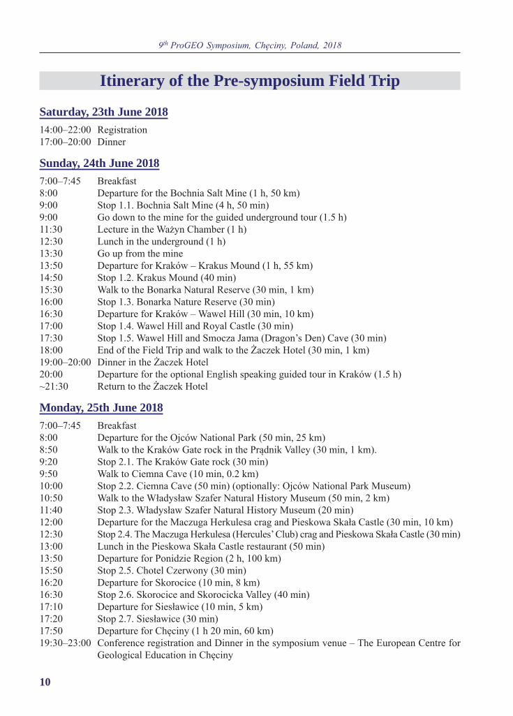
Itinerary of the Pre-symposium Field Trip
Saturday, 23th June 201814:00‒22:00 Registration17:00‒20:00 Dinner
Sunday, 24th June 20187:00‒7:45 Breakfast8:00 Departure for the Bochnia Salt Mine (1 h, 50 km)9:00 Stop 1.1. Bochnia Salt Mine (4 h, 50 min)9:00 Go down to the mine for the guided underground tour (1.5 h)11:30 Lecture in the Ważyn Chamber (1 h)12:30 Lunch in the underground (1 h)13:30 Go up from the mine13:50 Departure for Kraków ‒ Krakus Mound (1 h, 55 km)14:50 Stop 1.2. Krakus Mound (40 min)15:30 Walk to the Bonarka Natural Reserve (30 min, 1 km)16:00 Stop 1.3. Bonarka Nature Reserve (30 min)16:30 Departure for Kraków ‒ Wawel Hill (30 min, 10 km)17:00 Stop 1.4. Wawel Hill and Royal Castle (30 min)17:30 Stop 1.5. Wawel Hill and Smocza Jama (Dragon’s Den) Cave (30 min)18:00 End of the Field Trip and walk to the Żaczek Hotel (30 min, 1 km)19:00‒20:00 Dinner in the Żaczek Hotel20:00 Departure for the optional English speaking guided tour in Kraków (1.5 h)~21:30 Return to the Żaczek Hotel
Monday, 25th June 20187:00‒7:45 Breakfast8:00 Departure for the Ojców National Park (50 min, 25 km)8:50 Walk to the Kraków Gate rock in the Prądnik Valley (30 min, 1 km).9:20 Stop 2.1. The Kraków Gate rock (30 min)9:50 Walk to Ciemna Cave (10 min, 0.2 km)10:00 Stop 2.2. Ciemna Cave (50 min) (optionally: Ojców National Park Museum)10:50 Walk to the Władysław Szafer Natural History Museum (50 min, 2 km)11:40 Stop 2.3. Władysław Szafer Natural History Museum (20 min)12:00 Departure for the Maczuga Herkulesa crag and Pieskowa Skała Castle (30 min, 10 km)12:30 Stop 2.4. The Maczuga Herkulesa (Hercules’ Club) crag and Pieskowa Skała Castle (30 min)13:00 Lunch in the Pieskowa Skała Castle restaurant (50 min)13:50 Departure for Ponidzie Region (2 h, 100 km)15:50 Stop 2.5. Chotel Czerwony (30 min)16:20 Departure for Skorocice (10 min, 8 km)16:30 Stop 2.6. Skorocice and Skorocicka Valley (40 min)17:10 Departure for Siesławice (10 min, 5 km)17:20 Stop 2.7. Siesławice (30 min)17:50 Departure for Chęciny (1 h 20 min, 60 km)19:30–23:00 Conference registration and Dinner in the symposium venue ‒ The European Centre for
Geological Education in Chęciny

11
GEOLOGICAL FRAMEWORK OF THE KRAKÓW REGIONJan Urban
The pre-symposium field trip takes place in very specific – in geological terms – area, situated within the boundary zone of several geological units of different age and nature (Fig. 1). The area situated to the north of Kraków belongs generally to the West and Central European Phanerozoic (Variscan) Platform (Jarosiński et al. 2009) built of Palaeozoic rocks deformed during the Cale-donian and Variscan orogeneses, which are cov-ered by Mesozoic sediments only slightly mod-ified during the Alpine tectonic movements. However, the city of Kraków itself, is located in the area of much more intensive Alpine tec-tonic impact, namely within the Carpathian fore-land depression filled with the Neogene marine
sediments and called the Carpathian Foredeep. And, consequently, the margin of the Carpathian overthrust (boundary of the Outer Carpathians) is situated close to this city, a few kilometres far from its southern suburbs (Fig. 1). Moreover, the Varis can Platform, which obviously forms a sub-stratum of the Fore-Carpathian depression and the Outer Carpathians (in the zone accessible for human detection), is divided into two blocks of much deeper and older (at least Caledonian) foun-dation and different geological history: western Upper Silesian Block (a part of Brunovistulicum) and eastern Małopolska Block, which are sep-arated with the principal, transcontinental tec-tonic boundary called Hamburg-Kraków Tecto-
Fig. 1. Sites visited during the pre-symposium field trip against the simplified geological map of this area (geolog-ical background after Rühle et al. 1977, modified). Symbol explanations: 1-7 – geological units (1 – Palaeozoic, 2 – Triassic, 3 – Upper Jurassic, 4 – Lower Cretaceous, 5 – Upper Cretaceous, 6 – Cretaceous and Palaeogene of the Carpathian flysch, 7 – Neogene); 8 – main faults; 9 – northern margin of folded Neogene; 10 – Carpathian overthrust; 11 – sites visited and a route of field trip.

9th ProGEO Symposium, Chęciny, Poland, 2018
12
nic Zone (Buła et al. 2008; Jarosiński et al. 2009). This is probably the reason that the Kraków area is just located within the narrowest segment of the Fore- Carpathian depression, i.e. the Carpa-thian Foredeep.
The Palaeozoic basement of the European Phanerozoic Platform (Devonian and Carboni-ferous) is outcropped several ten kilometres west of Kraków (Fig. 1) and these outcrops will not be visited during the field trip. Rocks of its Mesozoic cover form the direct or sub-Quaternary sub-stratum north of Kraków and crop out as tec-tonic horsts within this city area. The Mesozoic succession outcropped in the Kraków vicinity is practically composed of the Upper Jurassic se-quence (with relatively very thin Middle Jurassic layer at the bottom) and the Upper Cretaceous sequence of marine sediments. Upper Jurassic sequence is built of limestone series several hundred meters thick generally gently dipping northeast, which forms extensive geological unit called the Silesian-Kraków Homocline to the north and northwest of Kraków. The natural outcrops of these rocks will be visited during the first day of the field trip in Kraków and in its sec-ond day in the Ojców National Park. The Upper Jurassic limestones were truncated during the Early Cretaceous terrestrial period and covered by carbonate, mainly marly Upper Cretaceous depositional sequence which is also up to several hundred meters thick. The Cretaceous sequence that forms the ground surface (or sub-Quater-nary substratum) north and northeast of Kraków belongs to the southeastern segment of the Mid-Polish Synclinorium (a unit that crosses Polish territory from the southeast to the northwest, parallel to the Trans-European Suture Zone) which is called Miechów Synclinorium (Fig. 1) (Karnkowski 2008; Matyszkiewicz 2008).
The territory built of Jurassic and Cretaceous carbonate rocks north of Kraków city comprises upland area characterised by hilly relief or pla-teau dissected by deep stream valleys. A lith-ified pre-Quaternary rocks are partly covered by Quaternary sediments, predominantly by Pleistocene loess layers that reach a thickness up to 20–30 m. Upper Jurassic massive limestones form numerous monadnocks, crags and cliffs as well as karst landforms and caves which are important
elements of relief and landscape in some parts of the Silesian‒Kraków Homocline, namely in the Kraków‒Częstochowa Upland (also called ‛Polish Jura Chain’). A spectacular, picturesque landscape of rocky relief has been a first and evident reason of practical and legal protection of many areas and sites in this region (Matyszkiewicz 2008). As a consequence, in the proximity of Kraków, there are some 200 rock forms protected as nature mon-uments, about 10 landscape and geological nature reserves and the Ojców National Park famous for its limestone crags, cliffs and karst caves, which will be visited during the second day of the field trip (Stops 2.1–2.4).
The Carpathian Foredeep, within which the city of Kraków is situated, is a part of the Parathetys system of basins formed as a tectonic depressions in front of the advancing Carpathian overthrust in the Early Miocene and then func-tioning as a marine basin up to the Late Miocene (Jarosiński et al. 2009). Consequently, this tec-tonic depression was filled with marine sedi-ments, which currently are partly covered by the overthrust Carpathian orogen and partly form a (sub-Quaternary) substratum of morphological basin between the Carpathians (to the south) and south-central Polish uplands (to the north).
The Badenian–Sarmatian (Langhian–Serra-valian) depositional sequence of the sediments fill-ing the Carpathian Foredeep ranges in a thickness from several or several ten meters in the northern marginal part of the unit up to some 2 000 m in its southern part and 3 500 m in south-eastern part. The sequence is composed predominantly of monotonous fine siliciclastic and clay (silty-clay) rocks with inserts of coarser clastics and evaporite series, as well as carbonate (biodetrital) facies that occur in the northern, coastal zone of the basin. Various thickness and differentiated facies devel-opment of these sediments are due to the active tectonic evolution of the basin during its existence and afterwards, which results in very complex fault (blocky) tectonics of the basin and its fills (Oszczypko et al. 2006; Jarosiński et al. 2009). The Badenian evaporite series is a relatively thin unit (reaching from several meters up to 200 m) in the Miocene sequence of the Carpathian Foredeep, however it is widespread within whole basin and differentiated in lithology: from ha-

FIELD TRIP: Geological framework of the Kraków Region
13
lite in the south-central part of the basin (near Kraków), through anhydrite up to gypsum in its northern marginal zone with occasional sulphur bearing limestone deposits (Bąbel 2004; Garlicki 2008). Salt deposits of Bochnia and Wieliczka – the towns situated southeast of Kraków – were extracted since the 13th century up to the end of 20th century and both mines are currently accessi-ble for public as historical and natural monuments inscribed into the World Heritage UNESCO List as ‛Wieliczka and Bochnia Royal Salt Mines’. The Bochnia Salt Mine will be visited in the first day of this field trip (Stop. 1.1).
The morphological basin constituted by the tectonic depression of the Carpathian Foredeep displays diversified relief in its different parts. The central part of this basin is a plain of the upper-middle section of the Wisła (Vistula) River Valley, in which the Miocene rocks are overlain by Quaternary fluvial sediments: clays, muds (silts) and sands as well as in some places aeolian sediments: sands and silts. Both its marginal seg-ments, southern and northern, are characterised by hilly relief usually of structural nature, i.e. controlled by lithology and tectonic structures, however in some places apparently affected by the neo-tectonic movements. In the northern mar-ginal zone of the basin, which is called Ponidzie or Nida Basin in geographic terms, Miocene gyp-sum and biodetritic limestones are the most im-portant morpho-structural units responsible for local relief. The sequence and sedimentary struc-tures (i.e. depositional environment) of gypsum as well as gypsum karst and morphology will be a matter of consideration in the second day of this field trip (Stops 2.5–2.7)
The narrowest segment of the Carpathian Foredeep, where the city of Kraków is located (Fig. 1), is one of the most interesting parts of the southern Poland. In this part of the Carpathian Foredeep its substratum is crossed by the trans-continental Hamburg-Kraków Tectonic Zone (that runs WNW-ESE) and adjoined secondary structure of the Rzeszotary Horst (NNW-SSE) (Buła et al. 2008). The Carpathian Foredeep is very narrow here (10–15 km wide), and densely divided by faults into numerous tectonic blocks among which are horsts built of the Jurassic and Cretaceous rocks of the Carpathian Foredeep
basement (Fig. 1) (Dżułyński 1953; Rutkowski 1986; Gradziński 1993). Such geological structure is a reason of very specific morphology of this area characterised by the occurrence of tectoni-cally driven hills surrounded by marshy plains, which, as a consequence, affected a human set-tlement and history in this area (Alexandrowicz et al. 2009). This problem will be a matter of discussion during the first day of the field trip (Stops 1.2–1.4).
The third principal geological unit that oc-curs near Kraków, the Carpathians, comprises a large Alpine orogen whose northern part, called the Outer Carpathians, is built of flysch rocks (sandstones, siltstones and claystones) mainly of the Cretaceous–Palaeogene age (Fig. 1). The Outer Carpathians are composed of several tec-tonic-lithological units (nappes) overthrust each other towards the north. In morphological terms they represent low and predominantly interme-diate mountains surrounded from the north with foothills (Malata 2008; Oszczypko et. al. 2008). Our field trip does not reach this region, but most probably we will see this mountain range from several sites in Kraków, e.g. from the Krakus Mound (Stop. 1. 2).
ReferencesAlexandrowicz, Z., Urban, J., Miśkiewicz, K. 2009.
Geological values of selected Polish properties of the UNESCO World Heritage List. Geoheritage, 1, 43–52.
Bąbel, M. 2004. Badenian evaporite basin of the north-ern Carpathian Foredeep as a drawndown salina ba-sin. Acta Geologica Polonica, 54, 3, 313–338.
Buła, Z., Żaba, J., Habryn, R. 2008. Tectonic subdi-vision of Poland: southern Poland (Upper Silesian Block and Małopolska Block). Przegląd Geolo-giczny, 56 (10), 912–920. (In Polish with English summary).
Dżułyński, S. 1953. Tektonika południowej części Wyżyny Krakowskiej (Tectonics of the southern part of the Cracovian Upland). Acta Geologica Polonica, 3 (3), 325–440. (In Polish).
Garlicki, A. 2008. Salt mines at Bochnia and Wieli-czka. Przegląd Geologiczny, 56 (8/1), 665–669.
Gradziński, R. 1993. Geological Map of Kraków Re-gion without Quaternary and terrestrial Tertiary deposits, scale 1:10.000. Geological Museum, In-stitute of Geological Sciences of Polish Academy of Sciences; Kraków.

9th ProGEO Symposium, Chęciny, Poland, 2018
14
Jarosiński, M., Poprawa, P., Ziegler, P.A. 2009. Ce-nozoic dynamic evolution of the Polish Platform. Geological Quaterly, 53, 1, 3–26.
Karnkowski, P.H. 2008. Tectonic subdivision of Po-land: Polish Lowlands. Przegląd Geologiczny, 56 (10), 895–903. (In Polish with English abstract).
Malata, T. 2008. Development of Polish Flysch Car-pathians revealed in outcrops and landscape. Prze-gląd Geologiczny, 56 (8/1), 688–691.
Matyszkiewicz, J. 2008. The Kraków-Częstochowa Up-land (Southern Poland) – the land of white cliffs and caves. Przegląd Geologiczny, 56 (8/1), 647–652.
Oszczypko, N., Krzywiec, P., Popadyuk, I., Peryt, T. 2006. Carpathian Foredeep basin (Poland and Ukraine): its sedimentary, structural and geody-
namic evolution. In: J. Golonka, F.J. Picha (Eds), The Carpathians and their foreland: Geology and hydrocarbon resources. American Association of Petroleum Geologists Memoir, 84, 293–350.
Oszczypko, N., Ślączka, A., Żytko, K. 2008. Tectonic subdivision of Poland: Polish Outer Carpathians and their foredeep. Przegląd Geologiczny, 56 (10), 927–935. (In Polish with English abstract).
Rühle, E., Ciuk, E., Osika, R., Znosko, J. 1977. Geo-logical map of Poland without Quarternary depos-its, scale 1:500000. Wydawnictwa Geologiczne; Warszawa. (In Polish).
Rutkowski, J. 1986. On Tertiary fault tectonics in the vicinities of Kraków. Przegląd Geologiczny, 36 (10), 587–590. (In Polish with English abstract).
BOCHNIA AREA
Stop 1.1. Bochnia Salt MineLeaders: Michał Flasza and The Bochnia Salt Mine Guides
Keywords: salt deposit, Miocene, Carpathian Foredeep, protection, salt mine, UNESCO World Cultural And Natural Heritage List
GPS coordinates: 49°58’8,7” N; 20°25’2,8” E
Location: Bochnia Salt Mine is located in the south of Poland, about 45 km to the east of Kraków.
Geological history of the Bochnia Salt Mine
Michał Flasza
Lithostratigraphy and tectonics: In the Miocene Epoch the Carpathian Foredeep in the territory of southern Poland was occupied by a sea, which was a part of a larger marine ba-sin, the Paratethys. Under favourable conditions about 13.8 million years ago evaporites started to deposit in the sea, including deposition of ha-lite, which constitutes the Badenian salt-bearing formation called also the Wieliczka Beds. The precipitation of salt started due to the climate cooling during which ocean waters were trapped in the polar zones, which resulted in lowering of the ocean level by ca. 50 m. The effect of this was the reduction of connections between the ocean and the Paratethys Basin. As a result of intensive evaporation of sea water, the brine was not diluted by less mineralised water, due to the
limited connection with the ocean and inflow of fresh, river water. At a later stage, during the so-called Badenian salinity crisis, salt precipitation occurred on a large scale (Poborski, Skoczylas-Ciszewska 1963; Bąbel 2004; Wiewiórka et al. 2007, 2009; Garlicki 2008).
The Bochnia salt deposits, situated in the southern part of the Carpathian Foredeep, over-lie (in the Miocene depositional succession) marly shales, sandstones and conglomerates (with Car pa thian flysch material) of the Skawina Beds (Fig. 2). The salt-bearing formation is, in turn, overlain by the Chodenice Beds composed of sandy-marly shales with dolostone interca-lations. Above the Chodenice Beds clayey and sandy layers of the Grabowiec Beds (Badenian–Sarmatian) occur. The deposition of salt forma-

FIELD TRIP: Geological framework of the Kraków Region
15
tion occurred in conditions of relatively high tectonic stress caused by the movements of the Carpathian orogenic belt. Frequent earthquakes caused submarine debry flows and the thrusts of sediments each over others. Such salt forma-tions have a particular structure: they consist of large olistolites embedded in poorly sorted
deposits (Poborski 1952; Poborski, Skoczylas-Ciszewska 1963; Wiewiórka et al. 2007, 2009, 2016; Garlicki 2008; Fig. 2).
Volcanic activity: The intensive volcanic ac-tivity during the Miocene is testified to by the tuffite layers encountered in the Badenian sed-
Fig. 2. Geological cross-section through the Miocene salt-bearing formation (13.6 million years ‒ radiometric dating of Badenian pyroclastic sediments) at the Campi shaft and its vicinity (C1–C10 exploitation levels) (after Poborski 1952).

9th ProGEO Symposium, Chęciny, Poland, 2018
16
iments of the Bochnia deposit. Interestingly, in the tuffite layer underlying the salt formation and signed WT1, the material originated from the andesites of the Pieniny Mountains (Inner Carpathians) was found. In the Bochnia deposit also other, thin WT2 and WT3 tuffite, layers were found. Several meter-thick tuffite package is also found in series overlying the salt-bearing formation (Dudek et al. 2004).
Tectonics of salt-bearing formation: During the orogenic phase in the Carpathians that occurred shortly after the deposition of rock salt, Carpathian flysch rocks shifted northward and thrust over the salt-bearing formation. Under the pressure of the Carpathian orogen, Badenian rocks situated close to the orogenic front, including the salt-bear-ing formation, were folded, moved northward, thrust over undisturbed sediments and uplifted. Consequently, due to so-called tectonic enrich-ment, the salt layers of original uniform thickness, underwent local accumulation forming rich salt deposits. As a result of such processes, two prin-cipal folds composed of flysch rocks in axial parts and Badenian salt-bearing formation in limbs de-veloped in the Bochnia area. The main fold, in the northern limb of which the Bochnia deposits are located, is named the Bochnia Anticline. To the south of this structure a second fold, called the Uzbornia Anticline, is located. Within Uzbornia Hill, sulphate rocks of the evaporite formation, including alabaster and fibrous gypsum, are out-cropped. The tectonically uplifted Bochnia salt deposit underwent destructive corrosion pro-cesses before the Pleistocene South-Polish gla-ciations. The destruction of salt layers was also slowed down when the salt-bearing formation was covered by loess cover formed during the Pleistocene (Wiewiórka et al. 2016).
Dimensions and thickness of salt deposits: The Bochnia salt deposit extends over a length of 3.6 kilometres from west to east and is limited by the northern limb of the Bochnia Anticline. It is rela-tively narrow, reaching a maximum width of 200 m. The maximum depth of the deposit, at the 16th level of the mine, is 468 m, however, drilling con-firmed a deposit depth of over 520 m. Folded salt layer stretch eastward to the village of Łazy, and to the west are extended by the available deposits
in villages of Łapczyca, Moszczenica, Siedlec and Łężkowice. The Skawina Beds frame the Bochnia deposit from the south. In a lithostratigraphic se-quence above the Skawina Beds the Badenian salt bearing formation was deposited in a form of al-ternating layers of claystones, siltstones and clay-stone-anhydrite-halite interbeddings with a total thickness of ca. 70 m. Above the salt formation, the Chodenice Beds of a thickness up to 300 m and the upper Grabowiec Beds occur.
Quaternary sediments cover: Folded Miocene sediments and Carpathian flysch are truncated and covered by Quaternary sediments, which consists of glacial and fluvioglacial formations of the Pleistocene South-Polish glaciations and eolian loess and loess-like silts and sands as well as Pleistocene and Holocene fluvial sediments. Quaternary formations hide and level an uneven relief of older rocks. Among the Quaternary sediments are silt-sand formations called quick-sands, which, watered, undergo semi-liquid de-formations and, therefore, have posed a techni-cal problem in the construction and maintenance of shafts since the beginning of salt mining (Poborski 1952; Poborski, Skoczylas-Ciszewska 1963; Wiewiórka et al. 2007, 2009; Garlicki 2008; Wiewiórka et al. 2016; Flasza 2016).
Highlights of Bochnia Salt Mine: Apart from the depositional and tectonic structures of the original sediments in the Bochnia Salt Mine gal-leries several very interesting secondary phenom-ena have been observed. One of them are halite stalactites oblique to the horizontal (roof) or ver-tical (wall) surfaces that grow against the air flow owing to the aggradation of micro-crystals from the sodium chloride aerosol in the air. The other very specific forms of salt crystallization are fi-brous halite crystals called ‘Hairs of Saint Kinga’ (the Princess who was a legendary founder of the Mine). The aggregates of large cubic halite crys-tals growing in brine pools due to the slow pre-cipitation and crystallization of sodium chloride are the most typical secondary salt forms. In turn, the uniqueness of the Bochnia Salt Mine is proved by a mirabilite (hydrous sodium sulphate), a very rare mineral that occurs (as a natural formation) only in a few places in the world. In the Bochnia

FIELD TRIP: Geological framework of the Kraków Region
17
Salt Mine it forms incrustations and flower-like formations (Wiewiórka et al. 2016).
Unique environment of the Bochnia Salt Mine is also a reason of the occurrence of flu-orescent secondary halite crystals. In 2014 in partly filled with brine and not accessible for public mine gallery the cubic halite crystals were found which emit orange or pink-red light when were radiated with UV rays. Such phenomenon is extremely rare. In the Bochnia Salt Mine it was observed only at two sites. The study performed by Professor M. Manecki and his collaborators (University of Science and Technology AGH in Kraków) indicated that this phenomenon in the Bochnia Salt Mine is caused by the occurrence of small admixture of manganese and lead in the crystal structure (Waluś et al. 2016).
Mining history: Archaeological artefacts indi-cate the extraction of brine springs and salt pro-duction in the vicinities of Bochnia has existed since the Middle Neolithic Period. As surface brine sources became exhausted, in the Middle Ages brine wells were dug, which facilitated the discovery of rock salt. In Bochnia the mine was founded in 1248. The oldest shafts: Sutoris, Regis, Gazaris and Floris, reached a depths of about 60 m. Greater depths (about 300 m) were reached by means of a complex system of in-clined galleries, small underground shaft and crosscuts. In the 16th century the Campi shaft was dug in the western part of the deposit. In 18th century the digging of the first straight hori-zontal gallery, called August and connecting the Campi shaft and the Floris shaft at a depth of 212 m, brought a kind of order in the mine devel-opment. The 19th and 20th centuries were marked up by the mechanisation of mining works, indus-trial exploitation from increasingly lower levels of the mine. Extraction continued in the mine until 1990. Since the early 1980’s, a change in the mine functions and activity from industrial to touristic, recreational and even medical one (as a spa) has been made. Nowadays, these functions comprise the essence of mine operations which continue to grow (Wiewiórka et al. 2009).
Protection and conservation: As early as in 1981 the historic parts of the Bochnia Salt Mine, i.e. the six oldest levels, were officially inscribed
into the register of historic monuments. The low-ermost levels of the mine (from the 10th to the 16th one, situated below a depth of 289 m) have been successively backfilled with sand and/or barren rocks. On 26th September 2000, the President of the Republic of Poland signed a decree officially recognizing ‘the Bochnia Salt Mine as a mon-ument of historical heritage’. Legal protection encompasses ca. 60 km of mining galleries and chambers situated on nine exploitation levels, at depths from 70 m to 289 m. The protected area stretches 3.5 km along the WE axis, with a max-imum width (NS) of 250 m, which is exactly a width of the deposit. Since 5th December 2005, 27 documentation sites that document the geol-ogy of the Bochnia salt deposit have been under legal protection (Wiewiórka et al. 2009). On 23th June 2013 the centuries-old mine in Bochnia entered the World Heritage UNESCO List, named together with the Wieliczka Salt Mine as ‘Wieliczka and Bochnia Royal Salt Mines’. Currently, the key issue consists in protecting and preserving for future generations as much as possible of the Earth history pages written in the dark chambers and galleries of the mine.
ReferencesBąbel, M. 2004. Badenian evaporite basin of the north-
ern Carpathian Foredeep as a drawndown salina basin. Acta Geologica Polonica, 54 (3), 313–338.
Dudek, K., Bukowski, K., Wiewiórka, J. 2006. Radio-metric dating of Badenian pyroclastic sediments from the Wieliczka-Bochnia area. In: Materiały 8. Ogólnopolskiej Sesji Naukowej ‘Datowanie Min-erałów i Skał’, Kraków 18–19.11.2006, p. 19–26. Instytut Nauk Geologicznych Polskiej Akademii Nauk w Krakowie; Kraków. (In Polish with En-glish summary).
Flasza, M. 2016. A description of the geological struc-ture of the Bochnia salt deposit. In: J. Flasza, M. Flasza, T. Migdas, S. Mróz, A. Puławska, K. Zięba (Eds), History caved in salt. Bochnia, p. 33–53. Kopalnia Soli Bochnia; Bochnia.
Garlicki, A. 2008. Salt Mines at Bochnia and Wieli-czka. Przegląd Geologiczny, 56 (8/1), 663–669 .
Poborski, J. 1952. The Bochnia Salt Deposit on the geological background of region. Biuletyn Państ-wowego Instytutu Geologicznego, 78, 1–160. (In Polish with English summary).
Poborski, J., Skoczylas-Ciszewska, K. 1963. Miocene in the zone of the Carpathian overthrust in the area

9th ProGEO Symposium, Chęciny, Poland, 2018
18
of Wieliczka and Bochnia. Rocznik Polskiego To-warzystwa Geologicznego, 33 (3), 339–346. (In Polish with English sumary).
Waluś, E., Głąbińska, D., Puławska, A., Flasza, M., Manecki, M. 2016. Fluorescent halite from Boch-nia salt mine, Poland, European Geosciences Union General Assembly 2016, 18, Geophysical Research Abstracts, p. 8505. http://adsabs.har-vard.edu/abs/2016EGUGA.18.8505W
Wiewiórka, J., Charkot, J., Dudek, K., Gonera, M. 2007. Nowe dane do budowy geologicznej złoża
i historii górnictwa w Kopalni Soli Bochnia. Gos-podarka Surowcami Mineralnymi, 23, 157–161.
Wiewiórka, J., Dudek, K., Charkot, J., Gonera, M. 2009. Natural and historic heritage of the Boch-nia salt mine (South Poland). Studia Universitatis Babeş-Bolyai, Geologia, 54 (1), 43–47.
Wiewiórka, J., Poborska-Młynarska, K., Zięba, K., Flasza, M. 2016. W głąb soli i czasu, w Kopalni Soli Bochnia, pp. 1– 64. Wydawnictwo Akademii Górniczo-Hutniczej; Kraków.
KRAKÓW CITY
Stop 1.2. Krakus MoundLeader: Jan Urban
Keywords: structural morphology, geological constraints of human history, Carpathian Foredeep, Kraków Old City
GPS coordinates: 50°02’17.1” N; 19°57’30.2” E
Location: 3 km south of the the Kraków City Centre, in the Krzemionki Podgórskie Hills (Podgórze quarter, Lasota Hill, Bonarka Horst).
Lithostratigraphy and tectonics as a factor controlling geomorphologyof the Kraków area
Jan Urban
Introduction: Krakus Mound is an artificial pre-historic mound, which is considered to be a grave of the legendary King Krakus (Krak) a founder of Kraków. Krakus Mound is one of the best view point on a landscape of the Kraków area, where morphological consequences of tectonic struc-ture and lithology can be shown.
Lithostratigraphy and tectonics: From Krakus Mound almost whole area of Kraków urban ag-glomeration can be observed. The city is situ-ated within the narrowest part of the Carpathian Foredeep, which is 10–15 km wide here, there-fore the neighbouring geological units (and ade-quate geographical regions, cf. Kondracki 2000) are well visible from the mound: to the south – hills and mountains of the Outer Carpathians (Carpathian Foothills and Beskidy Mountains in geographical terms), to the north-northwest –
plateau slope of the Silesian‒Kraków Homocline (Kraków‒Częstochowa Upland), to the north-north-east – plateau slope of the Miechów Syn-cli norium (Małopolska Upland). Between these regions distinctly deepened area of the Kraków city within the Carpathian Foredeep is located, however, this area is spotted with numerous hills.
This area is generally situated within the uplifted and marginal part of Precambrian and Palaeozoic units, the Hamburg-Kraków Tectonic Zone and the Rzeszotary Horst, therefore the trun-cated surface of the Variscan succession, mainly Devonian rocks, occur as shallow as ca. 300 m be-low ground surface in some places. The Variscan unit is overlain by the Alpine succession which is generally composed of three principal lithostrati-graphic complexes: the Upper Jurassic limestone complex, the Upper Cretaceous marl complex and

FIELD TRIP: Geological framework of the Kraków Region
19
the Middle Neogene siliciclastic clay complex, which were covered by sheets of Quaternary sed-iments (Fig. 3). The Upper Jurassic and Upper Cretaceous complexes represent the older Alpine units that were weakly modified (inclined to the north-east or south-east) due to the Laramide tec-tonic movements, whereas the Middle Neogene complex is a typical element of the Carpathian Foredeep tectonically shaped only during the younger Alpine, Neogene movements. Upper Jurassic, mainly Oxfordian complex is ca. 200 m thick and composed of three limestone lithotypes (facies): (1) Massive buildups (bioherms) that form more or less isolated bodies within the bedded rocks; (2) Thick-bedded limestones (biostromes) bearing numerous cherts and (3) Thin-bedded, ‘platy’, occasionally marly or chalky, limestones. This series is underlain by a thin, ranging several meters layer of Callovian sandstones and sandy limestones (Rutkowski 1986, 1994a; Pilecka, Szcze pańska 2004; Matyszkiewicz et al. 2006, Matyszkiewicz 2008; Gradziński M., Gradziń-ski R. 2013). The thick-bedded limestones grad-ing to massive ones are very well visible in the abandoned Liban Quarry situated just next to the Lasota Hill and Krakus Mound. We can also ob-serve the Palaeogene–Neogene karst palaeo-do-lines filled with sediments in this quarry faces (Gradziński R. 1962, 1972) .
The Upper Cretaceous complex mainly con-sists of Santonian–Maastrichtian marls, sandy marls and siliceous marls bearing cherts. Upper Cretaceous rocks occur principally in the Mie-chów Synclinorium, northeast of Kraków, where they reach a thickness ranging up to several hundred meters, while within the Kraków area
they were eroded during the Palaeogene and younger Neogene–Quaternary time (Rutkowski 1986, 1994a, b, c; Pilecka, Szczepańska 2004; Gradziński M., Gradziński R. 2013).
The Middle Neogene, strictly Middle Mio-cene, sequence is usually up to 200 m thick in the Kraków area and formed predominantly of siliciclastic-clayey rocks, which are occasion-ally underlain with thin sheets (lobes) of coquina (Ostrea) limestones (of earlier Miocene marine ingression) and terrestrial (also karst) sediments: caliche, clays, sands. Within this sequence the fol-lowing lihostratigraphic units are distinguished (from the bottom): Skawina Beds, Wieliczka Beds, Chodenice Beds and Bogucice Sands (these last occur only in the southern part of the area). The Wieliczka Beds are characterised be the occur-rence of evaporate series, which is formed of gyp-sum and anhydrite in the Kraków area and grades toward south-southeast to halite of the Wieliczka salt deposit (Rutkowski 1986, 1994a; Michalik et al. 1989; Felisiak 1992; Pilecka, Szczepańska 2004; Gradziński M., Gradziński R. 2013).
Neogene series, together with the older se-quence sections were significantly modified by the Neogene disjunctive tectonic movements: they were dissected into the tectonic blocks – horsts and grabens – by numerous dip-sleep faults (Fig. 4) (Dżułyński 1953; Rutkowski 1986, 1994a, b; Pilecka, Szczepańska 2004; Gradziński M., Gradziński R. 2013).
Structural geomorphology: This Cenozoic tec-tonics, together with the lithological differences of the complexes described above, is strictly responsible for the specific morphology of the
Fig. 3. Geological cross-section of the area between the Kraków Old City and Krzemionki Podgórskie Hills, i.e. just between our viewpoint and the city centre visible from this point (after Rutkowski 1994a, simplified). Symbol explanations: 1 – Upper Jurassic, 2 – Cretaceous, 3 – Neogene–Miocene, 4 – Quaternary, 5 – faults.

9th ProGEO Symposium, Chęciny, Poland, 2018
20
Kraków area. The Kraków area is characterised by the occurrence of numerous hills (groups and ranges of hills) that stand up to 150 m above the lowland of the Wisła (Vistula) River Valley, which are horsts built of Jurassic limestones (in some places covered with ‘caps’ of Cretaceous rocks) framed with normal, (sub)vertical faults or, more frequently, bundles/clusters of faults. The hilltops (ridges, plateaus) can be identified with the remnants of the Palaeogene denuda-tion palaeo-surface, while the hillslopes mark the courses and locations of zones of step faults framing the horsts (Dżułyński 1953; Gradziński M., Gradziński R. 2013; Izmaiłow 2013). The de-struction of the Gothic Saint Catherina Church situated in the marginal zone of the Skałka Hill horst in Kraków Old City during the earthquakes in 1443 and 1786 (Guterch 2009) suggests that some of these faults are still active.
The hills (horsts) are surrounded by the low-ered areas of grabens, which started to form in the Early–Middle Miocene and were filled
with the Neogene depositional complex, which, in turn, is covered by the Quaternary, fluvial and fluvioglacial sediments: gravels and sands overlain by clays and silts. Within these low-ered areas two principal fluvial levels are dis-tinguished: (1) Holocene floodplain, originally marshy and covered by overbank muds as well as numerous palaeo-channels (cut-off channels, ox-bow lakes) of the Vistula River and its tributaries and (2) The upper, Vistulian (Würm) terrace that stands from several meters to more than 10 m above the Vistula River channel (Rutkowski 1989; Kalicki 1991; Gradziński M., Gradziński R. 2013; Izmaiłow 2013).
Nowadays, most of this area is occupied by the urban agglomeration and definitely changed by human activity, however some hills (horsts) dis-tinctly stand out in the Kraków area landscape. Some of them are still not covered by buildings, such as the Lasota Hill (Bonarka Horst), on a top of which we are now, and forested Sowiniec-Las Wolski Hill Range very well visible to the north-
Fig. 4. Geological map of Kraków area (after Gradziński R. 1993, simplified). Symbol explanation: 1 – Upper Jurassic, 2 – Upper Cretaceous, 3 – Cretaceous and Palaeogene of the Carpathian flysch, 4 – Neogene, 5 – faults; 6 – Carpathian overthrust; 7 – sites visited and a route of field trip; 8 – historical centre of Kraków, route; 9 – cross-section shown on Fig. 3.

FIELD TRIP: Geological framework of the Kraków Region
21
west, as well as closer Krzemionki Podgórskie Hills being a city park in this part. Lower horst of Wawel Hill is completely covered by buildings of the Royal Castle, similarly to Skałka Hill, with two Medieval churches, situated next to Wawel Hill and the Old City, which is the low-ermost horst in this group, mostly covered by the Quaternary sediments of the upper, Vistulian terrace (Rutkowski 1989).
Geoheritage value: Looking at the landscape of the Kraków area from the Krakus Mound, we can simply appreciate the role of the morphology that is strictly controlled by the geological struc-ture, in the urban landscape and human activity in this area during several centuries of Kraków agglomeration development.
ReferencesDżułyński, S. 1953. Tektonika południowej części
Wyżyny Krakowskiej. Acta Geologica Polonica, 3 (3), 325–440. (In Polish).
Felisiak, I. 1992. Oligocene–Early Miocene karst deposits and their importance for recognition of the development of tectonics and relief in the Car-pathian foreland, Kraków region, southern Po-land. Annales Societatis Geologorum Poloniae, 62, 173–207. (In Polish with English summary).
Gradziński, M., Gradziński, R. 2013. Budowa geo-logiczna. In: B. Degórska, M. Baścik, (Eds), Śro-dowisko geologiczne Krakowa, p. 13–20. Instytut Geografii i Gospodarki Przestrzennej Uniwer-sytetu Jagiellońskiego; Kraków.
Gradziński, R. 1962. Origin and development of sub-terranean karst in the southern part of the Cracow Upland. Rocznik Polskiego Towarzystwa Geolo-gicznego, 32 (4), 429–492. (In Polish with English summary).
Gradziński, R. 1972. Przewodnik geologiczny po oko-licach Krakowa, pp. 1–335. Wydawnictwa Geolo-giczne; Warszawa.
Gradziński, R. 1993. Geological Map of Kraków Re-gion without Quaternary and terrestrial Tertiary deposits, Scale 1:10.000. Geological Museum, In-stitute of Geological Sciences of Polish Academy of Sciences; Kraków.
Guterch, B. 2009. Seismicity in Poland in the light of historical records. Przegląd Geologiczny, 57 (6), 513–520. (In Polish with English abstract).
Izmaiłow, B. 2013. Rzeźba terenu. In: B. Degórska, M. Baścik (Eds), Środowisko geologiczne Kra-kowa, p. 22–31. Instytut Geografii i Gospodar-
ki Przestrzennej Uniwersytetu Jagiellońskiego; Kraków.
Kalicki, T. 1991. The evolution of the Vistula river valley between Kraków and Niepołomice in Late Vistulian and Holocene times. In: L. Starkel (Ed.), Evolution of the Vistula river valley during the last 15 000 years, 6, Geographical Studies Special Is-sue, 6, 11–37.
Kondracki, J. 2000. Geografia regionalna Polski (2nd
edition), pp. 1–440. Państwowe Wydawnictwo Naukowe; Warszawa.
Matyszkiewicz, J. 2008. The Kraków-Częstochowa Upland (Southern Poland) – the land of white cliffs and caves. Przegląd Geologiczny, 56 (8/1), 647–652.
Matyszkiewicz, J., Krajewski, M., Żaba, J. 2006. Struc-tural control on the distribution of Upper Jurassic carbonate buildups in the Kraków-Wieluń Upland (south Poland). Neues Jahrbuch für Paläontologie und Geologie, 3, 182–192.
Michalik, M., Paszkowski, M., Szulc, J. 1989. Węgla-nowe utwory pedopdogeniczne miocenu okolic Krakowa. In: J. Rutkowski (Ed.), Przewodnik LX Zjazdu Polskiego Towarzystwa Geologicznego, Kraków, 14–16.09.1989, p. 190–195. Wydawnic-two Akademii Górniczo-Hutniczej w Krakowie; Kraków.
Pilecka, E., Szczepańska, M. 2004. Geological struc-ture of Kraków – general characteristics. Technika Poszukiwań Geologicznych, Geosynoptyka i Geo-termia, 56, 59–65. (In Polish with English abstract).
Rutkowski, J. 1986. On Tertiary fault tectonics in the vicinities of Kraków. Przegląd Geologiczny, 36 (10), 587–590. (In Polish with English abstract).
Rutkowski, J. 1989. Osady czwartorzędowe centrum Krakowa. In: J. Rutkowski (Ed.), Przewodnik LX Zjazdu Polskiego Towarzystwa Geologicznego, Kraków 14–16.09.1989, p. 196–200. Wydawnic-two Akademii Górniczo-Hutniczej w Krakowie; Kraków.
Rutkowski, J. 1994a. Introduction to the geological structure of the Kraków Region. Tectonics. In: Z. Kotański (Ed.), Excursion guidebook, 3rd Interna-tional Meeting of Peri-Tethyan Epicratonic Ba-sins, Kraków (Poland), 29 August – 3 September 1994, p. 1–10. Polish Geological Institute; War-szawa.
Rutkowski, J. 1994b. Excursion 1. Geology of Kraków Region. Tectonics. In: Kotański Z. (Ed.), Excursion guidebook. 3rd International Meeting of Peri-Tethyan Epicratonic Basins, Kraków (Po-land), 29 August – 3 September 1994, p. 10–11. Polish Geological Institute; Warszawa.
9th ProGEO Symposium, Chęciny, Poland, 2018
22
Rutkowski, J. 1994c. Excursion 2, Cretaceous of the Kraków Region. In: Kotański Z. (Ed.), Excursion guidebook. 3rd International Meeting of Peri-
Tethyan Epicratonic Basins, Kraków (Poland), 29 August – 3 September 1994, p. 12–19. Polish Geological Institute; Warszawa.
Stop 1.3. Bonarka Nature ReserveLeader: Jan Urban
Keywords: tectonics, geological history, Jurassic, Cretaceous, sedimentology, palaeogeography, ichnofauna, geoheritage protection
GPS coordinates: 50°01’45.2” N; 19°57’33.1” E
Location: Southern part of Kraków, Krzemionki Podgórskie Hills, Bonarka Horst.
Mesozoic history of the Kraków area
Jan Urban
Introduction: The Bonarka Nature Reserve protects the abandoned quarry in which Upper Cretaceous marls were excavated for a concrete production in the first half of 20th century. The quarry was a site of many geological studies, in particular, tectonic, paleontological and miner-alogical investigations since the beginning of the 20th century. The nature reserve was established in 1961 due to the high scientific and educational values of the geological outcrops in the quarry (Gradziński R. 1961, 1978; Alexandrowicz 1967; Rutkowski 1986; Alexandrowicz and Alexan-drowicz 1999; Słomka 2012).
Lithostratigraphy and tectonics: A principal part of the quarry bottom is occupied by a flat, truncated due to the erosion surface of thick-bed-ded Jurassic limestones – a palaeo-abrasion platform. This surface, gently tilted, is cov-ered by Upper Cretaceous, strictly Santonian–Campanian marls, which are outcropped in the eastern face of the quarry. Moreover, thin sheets of Cenomanian conglomerate as well as Lower Turonian conglomerate and limestone and Upper Turonian conglomeratic limestone separated by unconformity surfaces (with angle discordances ranging several degrees) were visible in the past in the marginal part of the quarry and its vicinity. The youngest depositional evidences of geologi-cal history identified in the vicinity of the quarry were remnants of the caliche zone developed in
the Cretaceous marls during the Early–Middle Miocene, which was overlain by Middle Miocene clay-siliciclastic rocks, however, this sequence is also not outcropped, now (Gradziński R. 1961, 1972, 1978; Rutkowski 1994; Słomka 2012).
The abrasion platform of the Jurassic lime-stone gently dips by the angle up to 12° to the south and is cut by three small dip-slip normal faults of a WNW-ESE direction (110–135°) and vertical displacement ranging 2–3 m. The fault surfaces are currently irregular, because they are associated with tectonic breccias, which are partly destroyed during the quarrying and sub-sequent weathering. Apart from this bundle of faults, diagonal hinge faults of smaller displace-ments (up to 0.5 m) can be observed. The faults cutting Jurassic limestone gradually disappear within the lower section of Upper Cretaceous marls grading into flexures that diminish up-ward (Gradziński R. 1961, 1972; Rutkowski 1994; Bromley et al. 2009; Słomka 2012).
Upper Cretaceous marl sequence is currently only partly outcropped in the quarry face due to the weathering-erosion process destroying densely cracked and soft rocks and consequen-tial formation of scree in the slope foot. The low-ermost part of this sequence is represented by a layer of grey-green glauconitic marls up to 0.5 m thick, which can be also found in thin crev-ices within underlying Jurassic limestones. Gray

FIELD TRIP: Geological framework of the Kraków Region
23
marls 2–3 m thick that overly glauconitic marls, grade up to the white marls bearing cherts, which are now outcropped and visible in the up-per parts of the quarry face (Gradziński 1961, 1972; Rutkowski 1994; Wieczorek, Olszewska 2001; Bromley et al. 2009).
Specific geological phenomena: Apart from the general features briefly described above, many other interesting phenomena were observed at this site and discussed since the beginning of the 20th century. A matter of such discussion was, for example, the nature and age of the faults and widened crevices filled with Cretaceous rocks. According to one of the hypothesis the faults cutting Jurassic limestones are of Cenozoic, most likely Neogene age and their disappearance within Upper Cretaceous marls is caused by plas-tic deformation of these soft and flexible rocks (Gradziński R. 1961; Dżułyński 1995; Felisiak 1995), whereas other geologists argues the syn-depositional development of these faults and also crevices in limestones (as neptunian dykes) during the Late Cretaceous (Santonian) period (Wieczorek et al. 1995; Wieczorek, Olszewska 2001). The Subhercynian tectonic movements in the Kraków area are proved at least by irregu-lar occurrence of sheets/lobes of Cenomanian, Lower Turonian and Upper Turonian sediments separated with angle unconformities.
The most impressive paleontological feature of the site is agglomeration of very numerous sponge borings that cover the abrasion platform of the Upper Jurassic limestones (Rutkowski 1994). They are ovoid depressions 1–4 cm in diameter from which numerous usually straight canals (several centimetres long) radiate. New species of ichnotaxa (trace fossils), called Entobia cracoviensis, has been described from here (Bromley et al. 2009). This ichnospecies is attributed to the endolithic, living (partly) em-bedded into the lithified rocks, sponge possibly of the genus Aka. This was a single chambered organism, supposedly half boring, which is sug-gested by the fact that all found specimens are lacking of roofs. Therefore, the hypothesis that the roof was removed by organism itself during its live seems to be most probable, however the psammobiontic character of this species (its liv-
ing within the detrital sediment covering lime-stone ground) is also considered. The exact time of these trace fossils and, consequently, abrasion platform formation, has not been defined and two possible ages, Late Turonian and Santonian, are taken into account (Bromley et al. 2009).
Apart from these trace fossils, the echino-derms, ammonites, belemnites, bivalves as well as fish fossils were collected and studied at this site (Gradziński R. 1961).
The occurrence of silica concentrations of very various oval and lenticular shapes (flints) as well as siliceous (sub)vertical thin veins within Jurassic limestones is the other specific petro-graphic feature of the Bonarka Nature Reserve. Such character of these concentration suggests that apart from diagenetic cherts, epigenetic sil-ica concentrations occur in the rocks. Moreover, the occurrence of small aggregates of hatchet-tine, a very rare mineral of hydrocarbon group, which was identified within the marls of the lowermost part of the Cretaceous sequence at the beginning of the 20th century, is considered to be another evidence of advanced hydrother-mal process developed within the zone of the Upper Jurassic–Upper Cretaceous unconfor-mity (Gradziński R. 1961; Matyszkiewicz 1987; Rutkowski 1994).
Geoheritage value and geoconservation: The geological studies at the Bonarka site make possible to reconstruct significant events of the Mesozoic and Cenozoic geological history of the Kraków area. Apart from general geological features, several very specific and unique phe-nomena were documented here, such as tectonic features, new species of ichnotaxa, hydrother-mal silification and other mineralisation. Some of them are still accessible and very illustrative (described on panels), e.g. faults and tectonic breccias, abrasion platform with sponge borings, cherts and other silica formations. However, some valuable features, as outcrops of Turonian and Neogene sediments as well as the lowermost part of the Santonian sequence were lost just af-ter the closing of quarrying. The legal protection of the Bonarka Nature Reserve has protected this site against the total destruction (Alexandrowicz 1967), and works performed by the environmen-

9th ProGEO Symposium, Chęciny, Poland, 2018
24
tal protection administration have kept the site in proper state. However, the geotechnical works that will recover some former features should be considered.
ReferencesAlexandrowicz, Z. 1967. A plan for the management
of the ‘Bonarka’ reserve of inanimate nature near Kraków. Chrońmy Przyrodę Ojczystą, 23 (3), 52–56.
Alexandrowicz, S.W., Alexandrowicz, Z. 1999. Se-lected geosites of the Kraków Upland. Polish Geo-logical Institute Special Papers, 2, 53–60.
Bromley, R.G., Kędzierski, M., Kołodziej, B., Uch-man, A. 2009. Large chambered sponge borings on a Late Cretaceous abrasion platform at Kraków, Poland. Cretaceous Research, 30, 149–160.
Dżułyński, S. 1995. Neptunian dykes of Bonarka – a testimony of the Late Cretaceous tectonic move-ments in the Kraków Upland – discussion. Prze-gląd Geologiczny, 43 (8), 689–690. (In Polish with English abstract).
Felisiak, I. 1995. Neptunian dykes of Bonarka – a testimony of the Late Cretaceous tectonic move-ments in the Kraków Upland – discussion. Prze-gląd Geologiczny, 43 (10), p. 863. (In Polish with English abstract).
Gradziński, R. 1961. The project of the reserve at Bonarka. Ochrona Przyrody, 27, 239–251. (In Pol-ish with English sumary).
Gradziński, R. 1972. Przewodnik geologiczny po okolicach Krakowa, pp. 1–335. Wydawnictwa Geologiczne; Warszawa.
Gradziński, R. 1978. Protection of geological object in the environs of Kraków. Prace Muzeum Ziemi, 25, 101–117. (In Polish with English sumary).
Rutkowski, J. 1994. Excursion 2, site 2-1. Bonarka: Cretaceous deposits and tectonics in Bonarka. In: Kotański, Z. (Ed.), Excursion guidebook. 3rd In-ternational Meeting of Peri-Tethyan Epicratonic Basins, Kraków (Poland), 29 August – 3 Septem-ber 1994, p. 19‒21. Polish Geological Institute; Warszawa.
Słomka, T. 2012. The Bonarka. In: T. Słomka (Ed.), The catalogue of geotourist sites in nature reserves and monuments, p. 233–236. AGH University of Science and Technology; Kraków.
Wieczorek, J., Dumont, T., Bouilin, J.-P., Olszewska, B. 1995a. Neptunian dykes of Bonarka – a testimo-ny of the Late Cretaceous tectonic movements in the Kraków Upland – reply. Przegląd Geologiczny, 43 (8), 690–692. (In Polish with English abstract).
Wieczorek, J., Dumont, T., Bouilin, J.-P., Olszewska, B. 1995b. Neptunian dykes of Bonarka – a testi-mony of the Late Cretaceous tectonic movements in the Kraków Upland – reply. Przegląd Geolog-iczny, 43 (10), p. 872. (In Polish with English ab-stract).
Wieczorek, J., Olszewska, B. 2001. Cretaceous nep-tunian dykes of the Kraków Upland. Geologica Saxonica, 46‒47, p. 139–147.
Stop 1.4. Wawel Hill and Royal CastleLeader: Jan Urban
Keywords: structural morphology, geological constraints of human history, Carpathian Foredeep, Kraków Old City
GPS coordinates: 50°03’15.3” N; 19°56’08.4” E
Location: Wawel is the Royal Castle Complex perched on the Wawel Hill, located at the southern part of the Kraków Old City, at the Wisła (Vistula) River bank.
Kraków Old City and Wawel Royal Castleas an illustration of geological constraints of human history
Jan Urban
Tectonics, lithostratigraphy and their geomor-phological consequences: In geological terms
Wawel Hill is a typical tectonic horst within the narrowest part of the Carpathian Foredeep

FIELD TRIP: Geological framework of the Kraków Region
25
(Rutkowski 1986, 1994a), whose occurrence is probably related to the structures of a deep, Palaeozoic and Precambrian substrate (Buła et al. 2008; Pilecka, Szczepańska 2004). This horst is built of the Upper Jurassic massive limestones and surrounded by grabens filled with silici clastic- clayey Neogene and Quaternary sediments as well as – just from the northeast, i.e. from the Old City side – by less uplifted horst built of Upper Jurassic limestone and Upper Cretaceous marls and partly covered by Quaternary sediments (Figs. 3, 4) (Gradziński R. 1972; Rutkowski 1986, 1989, 1994 a, b). The lithological differences and, most of all, the results of the Neogene tec-tonic movement are perfectly reflected in relief and landscape of this area: the highest horst of Wawel Hill distinctly (ca. 20 m) stands above the surrounding areas as hill with steep, locally rocky slopes and relatively flat summit. Some small karst dolines formed on the top of the hill were found during the archaeological excavations (Sawicki 1955; Kowalski et al. 1970).
The lower horst of the Old City comprises much lower but still elevated middle terrace cov-ered with clayey-sandy Quaternary sediments, whereas the area of grabens in Wawel Hill vi-cinity represents flat and marshy floodplain dis-sected by active or abandoned (cut off) chan-nels, e.g. oxbow lakes, of the Vistula River and its tributaries (Gradziński R. 1972; Rutkowski 1989; Kalicki 1991). Such landscape have been definitely changed due to human activity that have lasted for about ten centuries (formation of anthropogenic sediments, building construction, geotechnical regulation of river channels and others), nevertheless still two hundred years ago the oxbow lakes and riverbeds separating parts of the Old City were situated next to the Wawel Hill (Alexandrowicz et al. 2009).
Geological constraints of human activeness and history: Kraków is one of the most impor tant historic sites in Poland as a capital of Kingdom of Poland from the 11th through 16th century. It has a long range of historical monuments such as Medieval arrangement of the Old City that is sur-rounded by fragments of the Medieval ramparts, several tens of churches built in Romanesque, Gothic and Baroque styles, the largest Central
Square in Europe with the Renaissance ‘super-market’, one of the oldest universities in Europe founded in 1364 (Jagiellonian University), rem-nants of the historic Jewish city with several syn-agogues, and others. The first and most principal centre of this administration and urban agglom-eration since its beginning in the Early Middle Ages was obviously the Wawel Hill that is cur-rently occupied by the Renaissance Royal Castle. The preferable colonisation of the Wawel Hill was fully justified by the environmental con-straints of this area which are, in turn, closely controlled by geological history and structure of this area (as it was argued above). The first evident reason for the colonisation of the Wawel Hill was its shape (steep slopes) and location amid the marshy plain dissected by water chan-nels and lakes, which provided natural defence of the settlement. Concurrently, there was a per-manent source of water and food, because water and fish were in the river, whereas plants, e.g. cereals could be cultivated both on wet ground (at marshy floodplain) and arid ground (on hill-top), so profitably harvested alternatively in wet or dry years. Furthermore, this environment fa-cilitated the development of trading links and commercial relations, since the Vistula River was navigable and river ports and ferry jetties were situated along its bank (Alexandrowicz et al. 2009; Urban 2017). The developed urban ag-glomeration was also easily supplied with con-struction stone resources, which occur at the site (Upper Jurassic limestones) and in its vicinity (Carpathian sandstones, Palaeozoic limestones – ‛marbles’) (Rajchel 2005, 2008; Bromowicz, Magiera 2015). Even the oldest settlements on the Wawel Hill, falling on the Palaeolithic Period (Firlet 1996), met favourable conditions provided by caves as dwelling places. These factors of natural character and evident geological foun-dation significantly stimulated location and then development of human settlement firstly at a tec-tonic horst of the high Wawel Hill and then on the lower but still elevated horst of the Old City (Alexandrowicz et al. 2009; Urban 2017).
Geological foundation of human history and culture as a geoheritage: In the light of ar-gumentation presented above, the Kraków Old

9th ProGEO Symposium, Chęciny, Poland, 2018
26
City and, in particular, the Royal Castle crown-ing Wawel Hill are very evident examples of casual relationships between the geological structure that controls the morphological and environmental conditions and human history and culture. Taking into account the definition proposed by Dixon (1996) that the geoheritage comprises those components of natural geodi-versity of significant value to humans, includ-ing scientific research, education, aesthetics and inspiration, cultural development, and a sense of place experienced by communities (similar definitions were proposed and quoted by Brocx, Semeniuk 2007) one can, consequently, define Wawel Hill and Kraków Old City as elements of geoheritage, i.e. geosites, because they are very accurate elements illustrating that geology is a proper tool for the interpretation of important aspects of human history and culture, in other words: the geological structure was a foundation of human history (Alexandrowicz et al. 2009; Urban 2017).
The Royal Castle and Kraków Old City were entered into the UNESCO World Heritage List in 1978 as cultural elements, however, Alexandrowicz et al. (2009) postulated to ac-commodate the geological values and geological heritage to the evaluation process of these sites.
ReferencesAlexandrowicz, Z., Urban, J., Miśkiewicz, K. 2009.
Geological values of selected Polish properties of the UNESCO World Heritage List. Geoheritage, 1 (1), 43–52.
Brocx, M., Semeniuk, V. 2007. Geoheritage and geo-conservation – history, definition, scope and scale. Journal of the Royal Society of Western Australia, 90, 53–87.
Bromowicz, J., Magiera, J. 2015. Building stones used in early medieval edifices of Kraków; their origin and geology of the area, pp. 1–171. Wydawnic-two Akademii Górniczo-Hutniczej w Krakowie; Kraków. (In Polish with English summary).
Dixon, G. 1996. Geoconservation: an internation-al review and strategy for Tasmania, pp. 1–101. Miscellaneous Report, Parks and Wildlife Service; Tasmania.
Firlet, E.M. 1996. The Dragons Den in Wawel Hill; history, legends, dragons, pp. 1–154. Universitas; Kraków. (In Polish with English summary).
Gradziński, R. 1972. Przewodnik geologiczny po oko-licach Krakowa, pp. 1–335. Wydawnictwa Geo-logiczne; Warszawa.
Kalicki, T. 1991. The evolution of the Vistula river valley between Kraków and Niepołomice in Late Vistulian and Holocene times. In: L. Starkel (Ed.), Evolution of the Vistula River valley during the last 15 000 years, 6, Geographical Studies Special Issue, 6, 11–37.
Kowalski, S., Kozłowski, J. K., Ginter, B. 1970. Le gisement du Paléolitique moyen et supérieur à la colline du Wawel à Cracovie. Materiały Archeo-logiczne, 11, 47–70. (In Polish with French sum-mary).
Pilecka, E., Szczepańska, M. 2004. Geological struc-ture of Kraków – general characteristics. Tech-nika Poszukiwań Geologicznych, Geosynoptyka i Geotermia, 5-6, 59–65. (In Polish with English summary).
Rajchel, J. 2005. Kamienny Kraków, pp. 1–235. Uczel-niane Wydawnictwa Naukowo-Dydaktyczne; Kra-ków.
Rajchel, J. 2008. The stony Cracow: geological valors of its architecture. Przegląd Geologiczny, 56 (8/1), 653–662.
Rutkowski, J. 1986. On Tertiary fault tectonics in the vicinities of Kraków. Przegląd Geologiczny, 36 (10), 587–590. (In Polish with English abstract).
Rutkowski, J. 1989. Osady czwartorzędowe centrum Krakowa. In: J. Rutkowski (Ed.), Przewodnik LX Zjazdu Polskiego Towarzystwa Geologicznego, Kraków, 14‒16.09.1989, p. 196–200. Wydawnic-twa Akademii Górniczo-Hutniczej w Krakowie; Kraków.
Rutkowski, J. 1994a. Introduction to the geological structure of the Kraków Region. Tectonics. In: Kotański, Z. (Ed.), Excursion guidebook. 3rd In-ternational Meeting of Peri-Tethyan Epicratonic Basins, Kraków (Poland), 29 August – 3 Septem-ber 1994, p. 1–10. Polish Geological Institute; Warszawa.
Rutkowski, J. 1994b. Excursion 1. Geology of Kraków Region. Tectonics. In. Kotański Z. (Ed.), Excursion guidebook. 3rd International Meeting of Peri-Tethyan Epicratonic Basins, Kraków (Po-land), 29 August – 3 September 1994, p. 10–11. Polish Geological Institute; Warszawa.
Sawicki, L. 1955. Le gisement Paléolitique inférieur de Wawel à Cracovie. Studia do Dziejów Wawelu, 1, 1–70. (In Polish with French summary).
Urban, J. 2017. Urban geoheritage; the Old City of Kraków as a case. ProGEO News, 3, 2–3.

FIELD TRIP: Geological framework of the Kraków Region
27
Stop 1.5. Wawel Hill and Smocza Jama (Dragon’s Den) CaveLeaders: Michał Gradziński and Jan Urban
Keywords: karst, cave, geological constraints of culture, Kraków Old City
GPS coordinates: 50°03’11.7” N; 19°56’01.2” E
Location: Smocza Jama Cave is located within Wawel Hill, near its western slope.
Smocza Jama Cave ‒ its origin, scientific potential and cultural importance
Michał Gradziński and Jan Urban
Introduction: Smocza Jama (Dragon’s Den) Cave is a typical geological element of the Wawel Hill of important scientific and potential educa-tional value.
Geomorphology, hydrology and genesis: The origin of Smocza Jama Cave and the chemistry of cave waters have been discussed in detail by Gradziński M. et al. (2009) and Motyka et al. (2005), respectively. The description of this stop is based on the above mentioned papers.
Smocza Jama is a 276 m long cave which includes two parts primarily separated; they were linked by an artificial shaft mined in 1974 during the works aimed at stabilization of the hill (Fig. 5) (Szelerewicz, Górny 1986). The old series of the cave is spacious and acts as a show cave. Conversely, the new series is narrow; it includes some small chambers separated by in-tervening thin walls (locally less than 10 cm in thickness) with extremely narrow squeezes. The pools are present in fissures formed at the bottom of some chambers. The water table of the pools is located at the altitude of about 199 m, that is at the similar level as the Vistula (Wisła in Polish) River which flows in the proximity of about 50 m from the cave pools. Some small water insects migrate through the water filled fissures from the Vistula River (Dumnicka 2000).
The old series displays a suite of specific fea-tures which testify the artesian origin of the cave. They can be observed during a tour through the cave. The old series comprises three rounded spatial chambers which form NNW–SSE trend-ing passage. The chambers are up to 8 m in width whereas their length varies between 10
and 25 m. They maximal height exceeds 10 m, however the original height is bigger because the rocky bottom is covered with clastic deposits around 1.5 m in thickness (Kleczkowski 1976). The chambers originated along joints and bed-ding planes, which is especially visible in the northernmost chamber, named Alth’s chamber. The chamber ceiling is extensively rugged. It is featured by rounded hierarchically arranged solution cavities. Several smaller forms occur within one big form. The biggest of them fall into a definition of cupola. The smaller solution cavities may be called solution pockets. Some neighbouring cupolas integrate owing to breach-ing of intervening limestone walls. Most pockets are rounded in shape, and their height equals or exceeds their diameter. Only the minority of the cupolas and pockets is guided by joints. A big solution cavity in the ceiling of Grabowski’s chamber led to the surface and acted as a cave entrance in 19th century. At present it is blocked with a brick construction.
The cave almost lacks of speleothems. The bottom of the old series is filled with fine-grained clastics; however, the majority of cave deposits in the old series most probably have been destroyed during the long lasting use of the cave since the Middle Ages (see Firlet 1996). The vermiculation structures preserved in some places on cave walls suggest that the clastics also covered the cave walls. The cave clastics are composed predominantly of clay minerals and autochthonous limestone debris. Surprisingly, they lack any admixtures of the Vistula River de-posits, such as quartz sand (Alth 1877). It proves that the cave was completely isolated from the inflow of river waters.

9th ProGEO Symposium, Chęciny, Poland, 2018
28
The cave rocky relief, chiefly extensive ceil-ing solution cavities, shows that Smocza Jama cave developed in the phreatic conditions by slow and long lasting circulation of water of elevated temperature. Cave fine-grained de-posits represent residuum after dissolution of Jurassic limestone. The lack of quartz sand, Pleistocene mammal bones and Palaeolithic ar-tefacts, proves that the cave was isolated since its inception till Holocene time. The cave origi-nated due to the basal input of ascending water. The Wawel horst composed of Oxfordian lime-stone was at that time confined by overlying Miocene clays. The artesian circulation within Oxfordian limestone was possible owing to a topographic gradient between the recharge zone located northward of Kraków and the potential discharge zone in the former Vistula River val-ley over the cave.
The pool water is of Ca–Na–HCO3–SO4–Cl type, whereas the drip water represents SO4–Ca–Na type. High concentrations of NO3, SO4, Cl, Na, K, and P suggest that the wa-ter is considerably affected by pollution. The chemical composition of the studied pool water can be the effect of mixing of, at least, two of the components mentioned above. The wa-ter can: (1) Filtrate from the Vistula River; (2) Percolate down from the surface of Wawel Hill; (3) Migrate from the nearby area, where the city centre is located; and (4) Ascend as arte-sian water from deeper confined aquifer. The first three of the four mentioned water sources may be strongly degraded due to long lasting human occupation of both Wawel Hill and the city centre, as well as pollution of the Vistula River. The high amount of SO4 ions reaching 1439 mg/l in drip water results probably from leaching of litter and rubble poured over the cave in the 19th century.
Cultural and historical aspects: Smocza Jama is the most famous Polish cave being the im-portant natural attribute of the legendary his-tory of Poland. According to very popular and commonly known tale, the cave was a dwelling place of a dragon – monster that threatened the human settlement recently founded by legend-ary Krakus (Krak) King on Wawel Hill. The dragon was killed using an artifice, namely it swallowed an animal filled with burning sul-phur and left by devious men in front of the cave entrance. And, consequently, the dragon perished in flames (Firlet 1996; some other ver-sions of this legend are also known). The main part of the cave, easily accessible for people, has been known at least since the Middle Ages, the legend was recorded first time by the histori-cal source from the 13th century. Subsequently, Smocza Jama Cave and tales connected with it have been popular matter of notices in chron-icles, other descriptions and pictures of the Royal Castle during the 15–18th centuries. In the 17th and 18th centuries even a tavern exi-sted in the cave entrance. Since the first half of the 19th century the main part of the cave was periodically accessible for public. The geologi-cal and archaeological studies in the cave were
Fig. 5. Map of the Smocza Jama Cave (after Gradziński M. et al. 2009).

FIELD TRIP: Geological framework of the Kraków Region
29
conducted in 1874, whereas geotechnical and construction works preparing the cave for pub-lic access were performed in 1917‒1919, 1945 and 1966‒1976. Since 1919 the cave has been almost permanently accessible for public as show cave (excluding the winter time and with breaks during the 2nd World War and conserva-tion works). New, hardly accessible (narrow and partly filled with water) part of the cave was ex-plored in 1974‒1995 (Szelerewicz, Górny 1986; Firlet 1996). As a consequence, Smocza Jama Cave, described since the 19th century up to now in numerous guidebooks, fables, poems, nov-els, handbooks and even political dissertations, has become one of the most popular inanimate natural element of Polish tradition and culture. Currently, the cave, which is a part of the Wawel Royal Castle Complex, is the most popular cave in Poland visited by ca. 300 thousand people per year (the statistics comes from the beginning of the 21st century, see Urban 2011).
Geoheritage values and their usage: Smocza Jama Cave is the site of two specific values. The first is its meaning in a cultural, even national tradition as a significant element of Polish leg-endary and real history, while the second is its obvious scientific-educational importance as an example of specific karst developed in isolated horst massif, which is perfectly illustrated by morphology of the cave walls. Both values con-stitute the geological heritage of this site: this first one due to the cultural inspiration provided by this strictly geological object, according to the geoheritage definitions proposed by Dixon (1996), as well as Brocx and Semeniuk (2007), while this second value is strictly of geological nature. The most amazing (shocking) is the fact that the whole public awareness is currently fo-cused on the cultural aspect of Smocza Jama Cave, whereas an information about the natural character of this object is completely lacking: there is no information about the cave origin, features and even that this is a cave!
ReferencesAlth, A. 1877. Sprawozdanie z badań geologiczno-an-
tropologicznych przedsięwziętych w tak zwanéj ‘Smoczéj Jamie’ na Wawelu w Krakowie. Zbiór Wiadomości do Antropologii Krajowej, 1, 2–7. Komisja Antropologiczna Akademii Umiejętnoś-ci; Kraków.
Brocx, M., Semeniuk, V. 2007. Geoheritage and geo-conservation – history, definition, scope and scale. Journal of the Royal Society of Western Australia, 90, 53–87.
Dixon, G. 1996. Geoconservation: an internation-al review and strategy for Tasmania, pp. 1–101. Miscellaneous Report, Parks and Wildlife Service; Tasmania.
Dumnicka, E. 2000. Studies on Oligochaeta taxons in streams, interstitial and cave waters of southern Poland with remarks on Aphanoneura and Poly-chaeta distribution. Acta Zoologica Cracoviensia, 43, 339–392.
Firlet, E.M. 1996. The Dragon’s Den in Wawel Hill; history, legends, dragons, pp. 1–154. Universitas; Kraków. (In Polish with English summary).
Gradziński, M., Motyka, J., Górny, A. 2009. Artesian origin of a cave developed in an isolated horst: a case of Smocza Jama (Kraków Upland, Poland). Annales Societatis Geologorum Poloniae, 79, 159–168.
Kleczkowski, A. S. 1976. Hydrogeological conditions of the Wawel Hill in Cracow. Biuletyn Geologi-czny, 21, 153–175. (In Polish with English sum-mary).
Motyka, J., Gradziński, M., Różkowski, K., Górny, A. 2005. Chemistry of cave water in Smocza Jama, city of Kraków, Poland. Annales Societatis Geologorum Poloniae, 75, 189–198.
Szelerewicz, M., Górny, A. 1986. Jaskinie Wyżyny Krakowsko‒Wieluńskiej, pp. 1–200. PTTK Kraj; Kraków.
Urban, J. 2006. Legal and practical protection of caves in Poland. Chrońmy Przyrodę Ojczystą, 62, 1, 53–72. (In Polish with English summary).
Urban, J. 2011. Tourist accessibility of caves in Po-land – description of the problems. In: T. Słomka (Ed.), Geotourism; a cariety of aspects, p. 55–70. AGH University of Sciences and Technology; Kraków.

9th ProGEO Symposium, Chęciny, Poland, 2018
30
OJCÓW NATIONAL PARK
Stop 2.1. The Kraków Gate rockLeaders: Piotr Ziółkowski and Józef Partyka
Keywords: Upper Jurassic, carbonates, facial development, palaeoenvironment, fossils, Ojców National Park
GPS coordinates: 50°11’45.4” N; 19°49’44.8” E
Location: The Kraków Gate rock is situated in the central part of the Ojców National Park, at the mouth of the Ciasne Skałki Gorge to the Prądnik Valley.
Highlights of the Ojców National Park
Józef Partyka
The route of the trip within a field session leads from the King’s Łokietek Cave through Ciasne Skałki Gorge to the spectacular erosional rock form called Kraków Gate (in Polish ‒ Brama Krakowska) ‒ one of the Park’s classics. On the way, one can observe forest communities which are naturally restructured. The place of formerly planted pines is gradually taken by beech and fir. The walls of the bottom part of the Ciasne Skałki Gorge are under strict protection.
In front of Kraków Gate, on the other side of the Prądnik Valley, one can see a large rock mas-sif of Koronna Mountain with Ciemna (Dark) Cave. A large part of the massif is under active protection. Trees are removed and sheep graze in that part. In the proximity to this massif, there is a pictoresque view to the Panieńskie (Maiden) Rocks and a solitary rock of Igła Deotymy (Dio-tima’s Needle).
Origin of the Upper Jurassic limestone
Piotr Ziółkowski
Geological settings: Ojców National Park (ONP) owes its unique character and beauty to the Upper Jurassic limestones that build numer-ous picturesque rocks the park is famous for. This rock formation outcrops along valleys of the two streams, Prądnik and Sąspówka, at the distance of 11 km. The limestones were formed during Oxfordian and Kimmeridgian time (ca. 160‒154 million years ago) on the bottom of a warm, epicontinental sea that covered the area from today’s Portugal, France, Germany, and Poland, to Romania and the Caucasus (Matyja, Wierzbowski 1995). The Tethys Ocean stretched out to the south of this zone (Fig. 6).
Palaeoenvironment and biotas: Lithistid and hexactinellid sponges played an important role in the formation of the Upper Jurassic lime-
stones (Trammer 1989). In places where the sponges grew massively, dome-like forms called bioherms grew on the sea bottom. In addition to sponges, a variety of bacterial (microbial) struc-tures played a significant role in the construc-tion of bioherms, forming coatings and mats on the sediment surface. Thus, they stabilized the sediment, helping to create a rigid bioher-mal framework (Trammer 1989). Other benthic organisms also dwelled in such marine envi-ronments. These included brachiopods, sea ur-chins, mussels, bryozoans, foraminifers, small crabs and serpulids. Ammonites and belemnites predominated among the floating organisms in the sea.
Between areas of intense growth of sponge bioherms, deeper zones (inter-biohermal basins) developed. Organisms characteristic of bio-

FIELD TRIP: Geological framework of the Kraków Region
31
herm areas may also be found in these depres-sions, but generally they were the places where lime mud accumulated. In some inter-bioher-mal basins, deposits formed due to underwater mass movements and density currents can be found (Matyszkiewicz 1989; Ziółkowski 2007). Submarine avalanches developed on the mar-gins of the bioherms and sediments transported by gravity were accumulated in adjacent basins. The triggering factor of the slides could be the sea bottom palaeorelief and earthquakes.
Lithology and geomorphology: Several vari-eties of Upper Jurassic limestones can be dis-tinguished in the Ojców National Park and its vicinity. These include: (1) Rocky limestone; (2) Bedded limestone; (3) Pelitic limestone; and (4) Detritic limestone (Matyja, Wierzbowski 2004; Ziółkowski 2007).
(1) Rocky limestone: The most prominent in the landscape is the rocky limestone building
picturesque rock forms (cliffs, spurs, pinnacles) from which their name was taken. They form for example Maczuga Herkulesa (Herkules’ Club) rock in the Pieskowa Skała Hill, The Kraków Gate rock in the Prądnik Valley, the rocks of Igła Deotymy (Diotima’s Needle) and Rękawica (Glove) in the Koronna Mountain. Rocky lime-stones developed from sediment accumulated in the sponge bioherms. They are light-cream or light-yellow rocks when freshly fractured, and light-grey and white when weathered. The rocky limestones are mostly massive and more resistant to weathering than the other varieties of limestones in the area. No flints occur in this lithological variety, as opposed to its common occurrence in the bedded limestones. Numerous fossils of siliceous sponges preserved as cal-careous mummies (in which the soft body of the sponge was replaced by dark calcite) can be noticed on the weathered surfaces of the rock.
Fig. 6. Palaeogeography of Europe in Late Jurassic time (after Matyja, Wierzbowski 1995, modified)

9th ProGEO Symposium, Chęciny, Poland, 2018
32
These sponges attaining different shapes belong to the Hexactinellida and Lithistida (Trammer 1989). Their common feature is a skeleton com-posed of siliceous spicules. In the early stage of diagenesis these siliceous spicules were dis-solved and replaced by calcite, and the silica was removed from the biohermal limestone.
(2) Bedded limestone: It is a dominant litho-logical variety of limestone in the ONP area. It forms thick layers within the rocky limestones. These limestones are strongly eroded and karst-ified due to their lower resistance to weathering and karst corrosion. In the present-day landscape they form depressions between the rocks. They do not differ much from the rocky limestones, being characterized by bedding and a higher po-rosity. The thickness of individual layers varies from 0.6 m up to 3 m. In these limestones nu-merous dark-grey or brown oval siliceous con-cretions occur flints, with a diameter of up to 30 cm. They occur in prominent horizons empha-sizing the bedding or, less commonly, randomly distributed within the layers. Silica building the flints was derived from dissolved sponge spic-ules.
(3) Pelitic limestone: It contains a variety of limestones that originated beyond the areas of bioherm development, in the basins between them. Pelitic limestones are light-grey, grey or grey-yellow in colour with layers from a few to several dozen centimetres thick, sometimes showing cube separation when weathered. The limestone layers are interbedded with marly layers from 1 cm to several centimetres thick. Fossils are rare and poorly preserved in the pel-itic limestones. They are represented e.g. by am-monites, belemnites and trace fossils.
(4) Detritic limestone: It is composed of lime-stone grains of different sizes. These limestones were created as a result of submarine slides that moved the detritic material from the bio-herm margin to adjacent basins. Fine- and me-dium-grained limestones can be found among the detritic limestones; they also include vari-eties that contain fragments of previously con-solidated layers and blocks of rocky limestone reaching up to several metres in diameter.
ReferencesMatyja, B.A., Wierzbowski, A. 1995. Biogeographic
differentiation of the Oxfordian and Early Kim-meridgian ammonite faunas of Europe, and its stratigraphic consequences. Acta Geologica Po-lonica, 45 (1-2), 1–8.
Matyja, B.A., Wierzbowski, A. 2004. Stratigraphy and facies development in the Upper Jurassic of the Kraków-Częstochowa Upland and the Wieluń Upland. In: J. Partyka (Ed.), Zróżnicow-anie i prze miany środowiska przyrodniczo-kul-turowego Wy żyny Krakowsko-Częstochowskiej (Diversification and transformation of natural and cultural en vironment of the Kraków-Często-chowa Upland), Przyroda, 1, 13–18. Ojcowski Park Narodowy; Ojców. (In Polish with English summary).
Matyszkiewicz, J. 1989. Utwory osuwiskowe w wapie-niach górnego oksfordu w Ujeździe. Przewodnik 40. Zjazdu Polskiego Towarzystwa Geologicznego, 83‒88. Wydawnictwo Akademii Górniczo-Hut-niczej w Krakowie; Kraków.
Trammer, J. 1989. Middle to Upper Oxfordian spong-es of the Polish Jura. Acta Geologica Polonica, 39 (1-4), 49–91.
Ziółkowski, P. 2007. Stratygrafia i zróżnicowanie fac-jalne górnej jury wschodniej części Wyżyny Kra-kowskiej. Tomy Jurajskie, 4, 25–38.

FIELD TRIP: Geological framework of the Kraków Region
33
Stop 2.2. Ciemna CaveLeader: Michał Gradziński
Keywords: karst cave, Upper Jurassic limestone, Neogene, archaeological site, Kraków Upland, Ojców National Park
GPS coordinates: 50°11’49.8” N; 19°49’52.1 E”
Location: Ciemna Cave is located 62 m over the bottom of the Prądnik Valley at the altitude of 372 m in the central part of the Ojców National Park.
Geomorphology and genesis of Ciemna Cave
Michał Gradziński
Geomorphology and genesis: Ciemna Cave (in Polish – Jaskinia Ciemna) is one of the most fa-mous caves located in the Ojców National Park. There are 742 caves registered in the Prądnik catchment; the majority are located in the na-tional park area (Gradziński M. et al. 2008). They are formed in Oxfordian limestones along vertical joints. The majority of the caves are hor-izontal and relatively short; they do not exceed a length of a few hundred meters. The caves were formed in phreatic conditions and were
subsequently remodeled in a vadoze zone. The caves were filled with clastic deposits and con-tain some speleothems; the most common being moonmilk flowstones and cave coralloids. Cave clastics contain remnants of Pleistocene animals. The caves were settled by prehistoric human in the Pleistocene and Holocene time.
Ciemna Cave is a 209 m long horizontal cave (Gradziński M. et al. 2007) (Fig. 7). It is open for tourists, but not equipped with electricity. It comprises a large chamber which is 88 m long
Fig. 7. Map and cross-sections of Ciemna Cave in the Prądnik Valley (after Gradziński M. et al. 2007, simplified)

9th ProGEO Symposium, Chęciny, Poland, 2018
34
and 23 m wide. The narrow passage is an ex-tension leading from the chamber to the east. A small rocky-tunnel is an independent part of the cave. The cave is formed in Oxfordian lime-stone, partly along joints.
Ciemna Cave is famous for ceiling cupolas, up to 3.5 m in diameter, which are common in the chamber and the deeper series of the cave. They testify that the cave was formed in phreatic conditions (Gradziński R. 1962). However, neither the origin of the cave nor its age have been studied in detail, so far. The cave is the relict of a bigger cave, most probably of Neogene age, dissected by erosion. The other cave, called Oborzysko Wielkie, also used to belong to this system. One of the possible hy-potheses concerns the importance of hypogean circulation of water of elevated temperature for the origin of the cave. However, the formation of the cave by floodwater must be also taken into consideration.
The cave comprises a series of clastic de-posits, which is up to 7 m thick. It is composed of loam or silt mixed with autochthonous lime-stone debris (Madeyska 1982). At present the series is well-exposed in an archaeological trench. The cave clastics host a rich assem-blage of Palaeolithic flint-tools which represent Micoquian, Mouste rian and Taubachian (Valde-Nowak et al. 2014). Animal bones, including Ursus spelaeus, are also present. Radiocarbon dates reveal that bones associated with Micoquian levels are older than 50 ka (Alex et al. 2017). Some stalagmites occur on the top of
cave clastic series. They are Holocene in age and contain dark-coloured laminae associated with activity of human within the cave (Gradziński M. et al. 2003).
ReferencesAlex, B., Valde-Nowak, P., Regev, L., Boaretto, E.
2017. Late Middle Paleolithic of Southern Poland: Radiocarbon dates from Ciemna and Obłazowa Caves. Journal of Archaeological Sciences: Re-ports, 11, 370–380.
Gradziński, M., Górny, A., Pazdur, A., Pazdur, M. F. 2003. Origin of black coloured laminae in spele-othems from the Kraków-Wieluń Upland. Boreas, 32, 532–542.
Gradziński, M., Michalska, B., Wawryka, M., Szel-erewicz, M. 2007. Jaskinie Ojcowskiego Parku Narodowego, Dolina Prądnika, Góra Koronna, Góra Okopy, pp. 1‒122. Ojcowski Park Naro-dowy, Muzeum im. Prof. Władysława Szafera; Ojców.
Gradziński, M., Gradziński, R., Jach, R. 2008. Geolo-gy, morphology and karst of the Ojców area. In: A. Klasa, J. Partyka (Eds), Monografia Ojcowskiego Parku Narodowego, Przyroda, p. 31–95. Wydawn-ictwo Ojcowskiego Parku Narodowego; Ojców. (In Polish with English summary).
Madeyska, T. 1982. The stratigraphy of palaeolithic sites of the Cracow Upland. Acta Geologia Polon-ica, 32, 227–242.
Valde-Nowak, P., Alex, B., Ginter, B., Krajcarz, M. T., Madeyska, T., Miekina, B., Sobczyk, K., Stefańs-ki, D., Wojtal, P., Zając, M., Zarzecka-Szubińs-ka, K. 2014. Middle Paleolithic sequences of the Ciemna Cave (Prądnik valley, Poland): the prob-lem of synchronization. Quaternary International, 326‒327, p. 125–145.

FIELD TRIP: Geological framework of the Kraków Region
35
Stop 2.3. Władysław Szafer Natural History MuseumLeader: Józef Partyka
Keywords: nature protection, geoconservation, biotic and abiotic values, Kraków Upland, Ojców National Park
GPS coordinates: 50°12’35.9” N; 19°49’45.6” ELocation: Władysław Szafer Natural History Museum of the Ojców National Park is situated in the Prądnik Valley, nearby the Zamkowa (Castle) Hill in Ojców, in the central and most visited by tourists place of the Park. The administration centre of the Park is located at the distance of 300 m to the north.
Bio- and cultural heritage of the Ojców National Parkand its protection and conservation
Józef Partyka
Nature protection: The Ojców National Park was established on 14 January 1956. Its area ranges 2145.62 ha. It is located in the southern part of the Kraków‒Częstochowa Upland and includes the valleys of two streams: Prądnik and Sąspówka. The geological substratum is com-posed of Jurassic limestones. Karst groundwater activity and other denudational processes led to the creation of a unique landscape with deep gorges, various rock formations and caves. There are over 700 caves discovered within the Park and two the longest are: King’s Łokietek Cave (320 m long) and Ciemna Cave (230 m long).
The most valuable forest compositions, mainly Carpathian beech, covering the surface of 251 ha (12% of the Park’s area) are under strict protec-tion. The remaining part of the Park is under ac-tive and landscape protection. Forest ecosystems cover the largest area of the Park (71%). These are mixed forests, Carpathian beech and oak-horn-beam forests, and spots of sycamore and ther-mophilic beech. Agricultural area covers 464 ha (22%) including 81 ha of meadows (4%). These areas are gradually turning into forests owing to the sub-optimal agricultural use of the grounds, whereas the meadows need mowing which is done as part of active protection. The landscape protection generally covers private property.
There are about 950 species of vascular plants in the Park. They are mainly the species of Central Europe (the most numerous), North Europe and Asia (i.a. beech, hornbeam, common oak). Amongst about 50 species one can find: hornbeam (Carpinus betulus), fir (Abies alba),
blue aconite (Aconitum variegatum), Moldova aconite (A. moldavicum), Carpathian cardamine (Dentaria glandulosa), and others. Among the xerothermic species growing on the rocks there is e.g. European feather grass (Stipa joannis).
The Park’s fauna includes over 6 000 species. However, the expected number is estimated at about 12000 species. One of the most characteris-tic mammals of the Park are the bats (17 species), a lot of which hibernate in the Park’s caves (there are 25 species of bats in Poland), and the most common are a greater mouse-eared bat (Myotis myotis) and lesser horseshoe bat (Rhinolophus hipposideros).
Within the frames of the Park one can find numerous monuments of architecture. Amongst them there are e.g.: the well preserved Renaissance Pieskowa Skała Castle; the remnants of the Gothic Ojców Castle; sacral hermitage of Blessed Salo-mea in Grodzisko; old milling settlement Boro-niówka and some examples of 19th /20th century spa architecture.
Risk and protection: The Park is surrounded by large and populous villages, Krakow and Upper Silesian Industrial Region are located in close proximity. The neighborhood of the Park is an attractive settlement area which results in a large investment pressure and development of construction and infrastructure. It constitutes a great external threat to the nature of the Park, whose source is its buffer zone, which is the part that is supposed to protect it from threats. Meanwhile, the pressure on building and con-

9th ProGEO Symposium, Chęciny, Poland, 2018
36
flicts with local communities arising from that lead to serious problems with keeping ecological balance and ensuring sustainability of natural processes. Other threats for the Park include the negative impact of tourism on the Park’s nature, extinction of rare and endangered species of plants, including encroachment of the habitats of local flora by alien species, unfavorable owner-ship structure (30% of the Park is owned by third parties, mostly private owners).
Protective activities in the Park include tree-stands reconstruction by adjusting their species composition to the habitat conditions, mowing the meadows followed by collecting and trans-portation of biomass, removal of undesired plant species from rare and endangered stands, protec-tion of landscape values, organization of tourist movement.
The 1950s (when the Ojców National Park was established) was the time when the con-cept of nature conservation in Poland began to shape. At that time a lot of attention was paid to the protection and reconstruction of forests, and, as a matter of fact, the value of non-forest compositions – meadows and xerothermic grass-lands identified back then as wastelands – was completely not appreciated. Large part of them was afforested or left for secondary succession. The result of such activities was the reduction of grassland area by about 70% till the 1990s and significant loss of landscape value of the Park. In order to conserve the grasslands and unique landscape of the Valley of Prądnik in the 1980s the idea of active protection evolved. It was supposed to conserve the bottoms of the valleys covered with meadows and larger com-plexes covered with non-forest flora – rock and xerothermic species. Formerly, the meadows on the bottoms of the valleys had used to be inten-sively used by the local farmers, and farm ani-mals (sheep, goats) had used to be grazed on the rocks that had used to be regularly deforested.
As a result of traditional land use on the territory of the Park, interesting meadow com-munities and rock flora appeared that mark the landscape unique. Owing to the cessation of grazing because of disappearance of the tradi-tional land use around 1990, and due to the fact that many rock communities were granted strict
protection, negative changes in flora communi-ties and depletion of rock flora were recorded. Consequently, the area of strict protection was reduced by the main landmark rock complexes in the Prądnik Valley. Currently there are effective protection activities regularly conducted in the Park, including mowing the meadows on the bot-toms of the valleys (about 60 ha) and exposing the rocks (about 18 ha – 22 surfaces) to enhance growing of the rock flora. They have been more widely applied and monitored by the Park since 1990s. As the results of monitoring show, this form of protection secures the diversity of xe-rothermic grassland communities and valuable populations of flora species growing there.
Natural and cultural heritage: Moving along the Prądnik Valley towards Pieskowa Skała in Sułoszowice Village, one can touch the cultural landscape of the valley with preserved architec-ture of the former Ojców spa (preserved villas, wooden Chapel on the Water, and some exam-ples of lesser architecture). One permanent ele-ment of this landscape seen on the way are the mowed meadows and rock forms under active protection, including the Zamkowa (Castle) Hill in Ojców with remnants of the Gothic Castle on the top of the hill, and some eye-catching eros-inal rock forms as for example Wdowie (Widow) crags or Maczuga Herkulesa (Hercules’ Club) crag, with the Pieskowa Skała Castle next to it. This castle is best-preserved in the Kraków‒Częstochowa Upland, housing a permanent ex-hibition of the European painting art from the 14th century up to the interwar period.
In less than 60 years of the Ojców National Park, despite many problems, including finan-cial restrictions, the protection and conservation of the area allowed preservation of the natural wealth and natural and traditional cultural land-scape of the Prądnik Valley, which is also at-tractive for tourists. About 350–400 thousands of tourists visit the Park yearly. The objects available for tourists in the Park are: King’s Łokietek Cave, Ciemna (Dark) Cave, the Pieskowa Skała Castle, Natural History Museum of Prof. Władysław Szafer, remnants of the Gothic Ojców Castle and the Regional Museum of the Polish Tourist and Sightseeing Society.

FIELD TRIP: Geological framework of the Kraków Region
37
Stop 2.4. The Maczuga Herkulesa (Hercules’ Club) cragand Pieskowa Skała Castle
Leader: Piotr Ziółkowski
Keywords: Ojców Plateau, Prądnik Valley, Neogene, geomorphology, morphogenesis, rock terraces, Kraków Upland, Ojcowski National Park
GPS coordinates: 50°14’34.0”N; 19°46’58.8”E
Location: Sułoszowa Village in the northern part of the Ojców National Park.
Neogene morphogenesis of the Ojców Plateau
Piotr Ziółkowski
Ojców Plateau in Pliocene time: In that time (5.3−2.6 million years ago) the Ojców Plateau was incised and carved with deep ravines of me-ridionally flowing rivers. It was in that time, when the Prądnik Valley began to form (Fig. 8). The development of the valley went through sev-eral stages during Pliocene and Pleistocene time. Four levels of rock terraces are clearly visible on the slopes of the valley, being remnants of subse-quent stages of cutting of the river valley into the ground (Dżułyński et al. 1966).
Neogene rock tarraces and kars processes in the Prądnik Valley: The oldest rock terrace (I) is located at the highest position above the pres-ent-day river (i.e. at the level of the summit of the Hercules’ Club). The upper middle terrace (II) is located approximately 25−30 m below the highest terrace. An old road from Ojców to Murownia Village passes through this terrace. The lower middle terrace (III) marks the top of the rock with the ruins of the Ojców Castle, the basis of the Maczuga Herkulesa (Hercules’ Club) crag, and the topmost part of the Kraków Gate rock. This terrace is located about 10−20 m below the previous terrace. The low terrace (IV) is situated a few metres above present-day bottom of the Prądnik Valley (Fig. 8). There, at this level occurs (among others) the window of the Dziurawiec Cave in Ojców (Dżułyński et al. 1966).
The development of the Prądnik Valley in the Pliocene was associated with the intensive devel-opment of karst processes and caves formation. It has been estimated that the caves were formed
Fig. 8. Development of the tarraces in the Prądnik Valley in the Pliocene (after Dżułyński et al. 1966; Płonczyński 2000).

9th ProGEO Symposium, Chęciny, Poland, 2018
38
in the Miocene, or even earlier, in the Palaeogene (Gradziński M. et al. 2007).
ReferencesDżułyński, S., Henkiel, A., Klimek, K., Pokorny, J.
1966. The development of valleys in the southern part of the Cracow Upland. Rocznik Polskiego To-
warzystwa Geologicznego, 36, 329–343. (In Pol-ish with English abstract).
Gradziński, M., Michalska, B., Wawryka, M., Szel-erewicz, M. 2007. Jaskinie Ojcowskiego Parku Narodowego, Dolina Prądnika, Góra Koronna, Góra Okopy, pp. 1–122. Wydawnictwo Ojcows-kiego Parku Narodowego; Ojców.
PONIDZIE REGION
Stop 2.5. Chotel CzerwonyLeaders: Maciej Bąbel, Jan Urban and Anna Chwalik-Borowiec
Keywords: Badenian evaporites, Badenian salinity crises, Carpathian Foredeep, gypsum facies, selenites, giant gypsum intergrowths, largest gypsum crystals, gypsum karst, structural morphology, Nida Basin
GPS coordinates: 50°22’47.0”; 20°42’26.7”
Location: Escarpment near the road west of the church in Chotel Czerwony.
The Badenian Nida Gypsum deposits and their unique giant crystal facies
Maciej Bąbel
Introduction: The Badenian (=Wielician) salin-ity crisis in the Central Paratethys, ca. 13.6 Ma BP, in the Serravallian (Middle Miocene), leads to widespread evaporite deposition in the Carpathian Foredeep Basin. Gypsum deposits, known as the Krzyżanowice Formation, were formed mainly on the northern platformal mar-gin of the basin, and the halite deposits crys-tallized in the more central areas. Now these evaporites are mostly hidden in the subsurface. In Poland the largest area of outcrops of the Badenian gypsum deposits occurs at the vicin-ity of towns Busko-Zdrój, Wiślica and Pińczów. The gypsum deposits of this area are known as the Nida Gypsum deposits (named after the Nida river, a left tributary of the Vistula river). Studied since the 18th century they are the best recognized part of the Badenian evaporites in the Carpathian Foredeep Basin (Bąbel et al. 2015).
The Nida Gypsum deposits were not dehy-drated and transformed into anhydrite during diagenesis and burial, and hence their primary sedimentary structures are very well preserved. Therefore these deposits offer an excellent insight
into the uncommon ancient sedimentary facies and environments of the giant evaporite basin.
The sequence of the Nida Gypsum depos-its is up to ca. 50 m thick and is bipartite. The upper part is mostly clastic and composed of microcrystalline and fine-grained gypsum. This part of the sequence, called allochthonous, clas-tic or microcrystalline unit, is mostly eroded, mainly in the Quaternary. The lower part of the sequence which is nearly entirely composed of coarse-crystalline gypsum is called autoch-thonous or selenite unit. It is up to 16 m thick and is better exposed. This selenite unit will be presented during the trip. Special attention will be paid to the unique mineralogical, crys-tallographic and sedimentological phenomena revealed by these deposits, starting with the lowermost giant-crystalline layer seen in Chotel Czerwony outcrop. The outcrop was investigated and described by Pitera (2001) and Chwalik-Borowiec et al. (2013).
Selenite facies and the giant gypsum crystals: Gypsum is a mineral which forms one of the

FIELD TRIP: Geological framework of the Kraków Region
39
largest crystals on Earth (Rickwood 1981) and some evaporite deposits contain such crystals. They occur just in the primary evaporite facies known as selenites or selenite deposits. The term selenite has several meanings in geology, but in sedimentology it is used for large (>2 mm) gypsum crystals grown on the bottom of evap-orite basins directly from the overlying brine (Bąbel 2004). There are many varieties or facies of selenites, most of them are well bedded and composed of crystals no more than several cm in size. But there are also some coarse- or gi-ant-crystalline poorly to non-bedded selenite fa-cies composed of very large vertically elongated crystals arranged in a palisade-like manner, forming spectacular rows of ‘standing’ crystal-line prisms. The formation mechanism of these selenites is analogue to the growth of crystals on the walls of druses or mineral veins. Such crystals grew upward on the floor of the basin (like on the druse wall), being covered with Ca-sulphate supersaturated brine. Their growth was almost exclusively syntaxial and not accompa-nying by a creation of new crystal seeds (pre-sumably due to a low degree of supersaturation, Bąbel 2007), and this permitted them to reach a very large sizes controlled merely by depth of brine and available accommodation space. The gypsum deposits seen in Chotel Czerwony out-crop represent just such a selenite facies.
The giant gypsum intergrowths: The spec-tacular selenite facies exposed in the outcrop is called the giant gypsum intergrowths (called in Polish ‘szklica’; Kwiatkowski 1972, p. 87; Bąbel 1987). It is built of crystals from a few deci-metres to over 1.5 m in length. The crystals, arranged in a palisade-like manner, form the pe-culiar intergrowths (Wala 1979) resembling the gypsum twins called the swallow tails. These giant intergrowths build a layer, up to a few metres thick (3.5 m on average), occurring at the base of the gypsum section and widespread on a very large area of the northern margin of the Carpathian Foredeep Basin (from the Czech Republic, through Poland to the environs of Horodenka in Ukraine). The giant intergrowths exposed in the Nida Gypsum deposits contain the largest recorded Badenian gypsum crystals
– described here since the 19th century (Zejszner 1861; Kontkiewicz 1884). The giant intergrowths represent one of the most peculiar selenite facies considering not only the sizes of crystals but their specific crystallographic, textural, and sed-imentological features.
Size of crystals: The giant intergrowths facies, exposed best between towns Pińczów, Busko-Zdrój and Wiślica on the Nida river, contains the largest natural crystals (individual miner-als) in Poland. Older Polish reports mentioned gypsum crystals reaching length of 4 m here (e.g. Kontkiewicz 1907), or even more, but these findings remain unauthenticated (Bąbel 2002). At present, the largest gypsum crystals are seen in two outcrops: at Bogucice-Skałki and at Gacki villages – 12–14 km NE of Chotel Czerwony (Bąbel 2002, Bąbel et al. 2010). In both sites the length of the crystals is estimated as ca. 3.5 m.
Fig. 9. The giant gypsum intergrowths exposed west of church in Chotel Czerwony. Shining 010 perfect cleavage surfaces and composition surfaces (cs) are marked. Note porous skeletal structure of the crystals. Photograph by Maciej Bąbel.

9th ProGEO Symposium, Chęciny, Poland, 2018
40
Such a size (3.5 m) is a documented maximum length of the discussed gypsum crystals. In the visited Chotel Czerwony outcrop the crystals at-tain 2.7 m in length (Fig. 9; Kasprzyk 1993).
The described giant crystals are compara-ble to the largest existing (i.e. documented and preserved) natural crystals in the world. In the evaporite facies the largest gypsum crystals are known from the Messinian of the Mediterranean where some specimens have been reported to attain 6 m (at Buraitotto, SE Favara in Sicily) or even 7.5 m in length (a few km N-NE Paphos, on Cyprus; see references in Bąbel 2002). Unfortunately, these evaporite crystals remain unauthenticated. The largest documented gyp-sum crystal (a 100 twin) is a 11.4 m long speci-men originating from hypogenic caves at Naica in Mexico (Badino et al. 2009).
Crystallographic peculiarities: The Badenian intergrown giant crystals break most easily along the flat boundaries of contact between them, called the composition surfaces, or along the planes of the perfect gypsum cleavage 010. Just these surfaces, usually oriented vertically or subvertically to the depositional surface, are visible in the walls of outcrops (Fig. 9). The glow of sunlight reflected from the large 010 surfaces gives an unforgettable impression, unknown in the other types of rocks. The Polish regional name of the discussed rocks (szklica from szklić się – in Polish – to glisten, to shine like glass) refers to this feature. The intergrown crystals observed from the side of the 010 cleavage sur-faces reveal striking similarity to the contact 101 swallow-tail gypsum twins (Fig. 10).
It can be seen that the crystals are composed of elongated blocks forming re-entrant angle near the composition surface (Fig. 9) – an an-gle typical of the swallow tail twin morphology (Fig. 10, right). Closer investigation, however, re-veals a peculiar feature – the surfaces of the 010 cleavage of the two component crystals are not parallel, and traces of them do not coincide on the composition surface (Fig. 10, right; Kreutz 1925), as it should be in any known type of gyp-sum twins (Fig. 10, left; Bartels, Follner 1989; Rubbo et al. 2012; and references in Bąbel 1991), except of a few rare, poorly documented and
dubious exceptions recorded in some older publi-cations (see references in Bąbel 1991).
More detailed crystallographic measure-ments reveal that the pair of crystals forming the intergrowth, i.e. the component crystals, are not symmetrical to each other in the crystallographic sense (Fig. 10, left; Bąbel 1987). Furthermore, orientation of crystallographic axes a, b and c of the component crystals in every particular inter-growths is always slightly different than in the other ones (Bąbel 1991). Thus any strict twin law cannot be determined. However, statistically, the crystals fall into certain range of orientations similar to the present in the 101 gypsum twin (Fig. 10). The intergrowths thus differ not only from the gypsum twins but from any twins, be-cause such features do not fit to definitions of the twins. The Badenian forms appear to be dif-ferent from any so far recorded oriented inter-growths of the same crystal species.
The intergrowths show also striking asym-metry in frequency distribution of some mor-phological features. For example the faces con-tacting along the composition surface (irrational faces placed between 101, 302, and 111, 111) show dominance of the ‘left’ hkl forms (54.4%) over the ‘right’ hkl forms (37.6%), (frequency of the intermediate h0l forms is equal 8%). The other peculiar asymmetric morphological fea-tures are described in Bąbel (1991).
To explain the peculiar nature of these inter-growths a hypothesis was proposed that biologi-cally produced organic compounds present in the basinal brine influenced both the nucleation and the growth of the crystals (Bąbel 1991, 2000).
Fig. 10. Orientation of the crystallographic axes (a, c; b is normal to a–c plane) and the 010 perfect cleav-age planes of gypsum in the exemplary 101 twin (left), and in the typical giant intergrowths (right), hachure marks the position of 010 planes.
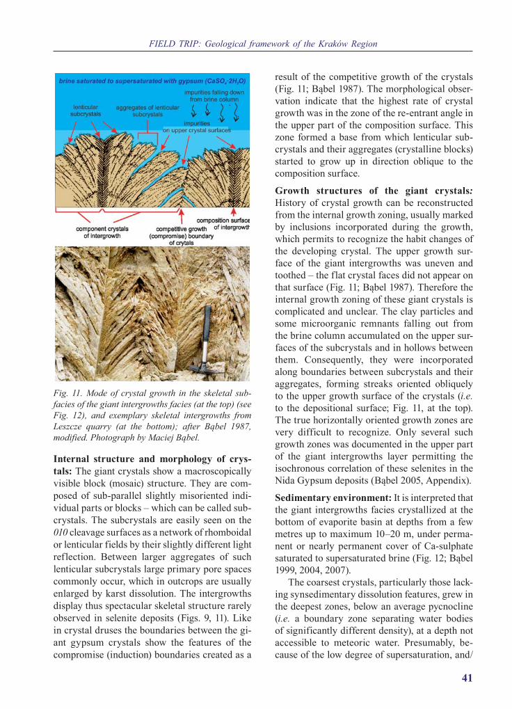
FIELD TRIP: Geological framework of the Kraków Region
41
Internal structure and morphology of crys-tals: The giant crystals show a macroscopically visible block (mosaic) structure. They are com-posed of sub-parallel slightly misoriented indi-vidual parts or blocks – which can be called sub-crystals. The subcrystals are easily seen on the 010 cleavage surfaces as a network of rhomboidal or lenticular fields by their slightly different light reflection. Between larger aggregates of such lenticular subcrystals large primary pore spaces commonly occur, which in outcrops are usually enlarged by karst dissolution. The intergrowths display thus spectacular skeletal structure rarely observed in selenite deposits (Figs. 9, 11). Like in crystal druses the boundaries between the gi-ant gypsum crystals show the features of the compromise (induction) boundaries created as a
result of the competitive growth of the crystals (Fig. 11; Bąbel 1987). The morphological obser-vation indicate that the highest rate of crystal growth was in the zone of the re-entrant angle in the upper part of the composition surface. This zone formed a base from which lenticular sub-crystals and their aggregates (crystalline blocks) started to grow up in direction oblique to the composition surface.
Growth structures of the giant crystals: History of crystal growth can be reconstructed from the internal growth zoning, usually marked by inclusions incorporated during the growth, which permits to recognize the habit changes of the developing crystal. The upper growth sur-face of the giant intergrowths was uneven and toothed – the flat crystal faces did not appear on that surface (Fig. 11; Bąbel 1987). Therefore the internal growth zoning of these giant crystals is complicated and unclear. The clay particles and some microorganic remnants falling out from the brine column accumulated on the upper sur-faces of the subcrystals and in hollows between them. Consequently, they were incorporated along boundaries between subcrystals and their aggregates, forming streaks oriented obliquely to the upper growth surface of the crystals (i.e. to the depositional surface; Fig. 11, at the top). The true horizontally oriented growth zones are very difficult to recognize. Only several such growth zones was documented in the upper part of the giant intergrowths layer permitting the isochronous correlation of these selenites in the Nida Gypsum deposits (Bąbel 2005, Appendix).
Sedimentary environment: It is interpreted that the giant intergrowths facies crystallized at the bottom of evaporite basin at depths from a few metres up to maximum 10–20 m, under perma-nent or nearly permanent cover of Ca-sulphate saturated to supersaturated brine (Fig. 12; Bąbel 1999, 2004, 2007).
The coarsest crystals, particularly those lack-ing synsedimentary dissolution features, grew in the deepest zones, below an average pycnocline (i.e. a boundary zone separating water bodies of significantly different density), at a depth not accessible to meteoric water. Presumably, be-cause of the low degree of supersaturation, and/
Fig. 11. Mode of crystal growth in the skeletal sub-facies of the giant intergrowths facies (at the top) (see Fig. 12), and exemplary skeletal intergrowths from Leszcze quarry (at the bottom); after Bąbel 1987, modified. Photograph by Maciej Bąbel.

9th ProGEO Symposium, Chęciny, Poland, 2018
42
or some organic compounds inhibiting gypsum crystallization present in the brine, gypsum nu-cleation was sparse and the crystal growth was mostly syntaxial. The protracted period of up-ward growth led to formation of extraordinarily large crystals on the whole marginal area of the basin. The skeletal crystals (forming the skeletal subfacies; Fig. 12) were deposited in a relatively deeper and less oxygenated brine, whereas the massive crystals (of the massive subfacies) were crystallised in the shallower brine.
ReferencesBartels H., Follner, H. 1989. Crystal growth and twin
formation of gypsum. Crystal Research and Tech-nology, 24, 1191–1196.
Bąbel, M. 1987. Giant gypsum intergrowths from the Middle Miocene evaporites of southern Poland. Acta Geologica Polonica, 37, 1–20.
Bąbel, M. 1991. Crystallography and genesis of the giant intergrowths of gypsum from the Miocene evaporites of Poland. Archiwum Mineralogiczne, 44 (volume for 1990), 103–135.
Bąbel, M. 1999. Facies and depositional environments of the Nida Gypsum deposits (Middle Miocene, Carpathian Foredeep, southern Poland). Geologi-cal Quarterly, 43, 405–428.
Bąbel, M. 2000. Giant organic-gypsum intergrowths from the Miocene evaporites of Carpathian Fore-deep Basin. In: N.P. Yushkin, V.P. Lutoev, M.F. Samotolkova, M.V. Gavriliuk, G.V. Ponomareva (Eds), Mineralogy and life: biomineral homolo-gies. Abstracts of 3th International Seminar ‛Min-eralogy and life‛, p. 16–18. Geoprint; Syktyvkar.
Bąbel, M. 2002. The largest natural crystal in Poland. Acta Geologica Polonica, 52, 251–267.
Bąbel, M. 2004. Models for evaporite, selenite and gypsum microbialite deposition in ancient saline basins. Acta Geologica Polonica, 54, 219–249.
Bąbel, M. 2005. Event stratigraphy of the Badenian selenite evaporites (Middle Miocene) of the north-ern Carpathian Foredeep. Acta Geologica Poloni-ca, 55, 9–29 (with On-Line Appendix).
Bąbel, M. 2007. Depositional environments of a sali-na-type evaporite basin recorded in the Badenian gypsum facies in the northern Carpathian Foredeep. In: B.C. Schreiber, S. Lugli, M. Bąbel (Eds), Evap-orites Through Space and Time. Geological Soci-ety, London, Special Publications, 285, 107–142.
Bąbel, M., Olszewska-Nejbert, D., Nejbert, K. 2010. The largest giant gypsum intergrowths from the Badenian (Middle Miocene) evaporites of the Carpathian Foredeep. Geological Quarterly, 54, 477–486.
Bąbel, M., Olszewska-Nejbert, D., Nejbert, K., Łu-gowski, D. 2015. Guide to field trip A2 (21–22 June 2015). The Badenian evaporative stage of the Polish Carpathian Foredeep: sedimentary fa-cies and depositional environment of the selenitic Nida Gypsum succession. In: G. Haczewski (Ed.), Guidebook for field trips accompanying IAS 31st
Meeting of Sedimentologyheld in Kraków on 22nd–25th of June 2015, p. 25–50. Polskie Towa-rzystwo Geologiczne; Kraków.
Badino, G., Ferreira, A., Forti, P., Giovine, G., Giuli-vo, I., Infante, G., Lo Mastro, F., Sanna, L., Te-deschi, R. 2009. The Naica caves survey. In: W.B. White (Ed.), Proceedings of 15th International
Fig. 12. Idealised reconstruction of the sedimentary environment of the giant gypsum intergrowths facies (showing palisade structure) and of its skeletal and massive subfacies (after Bąbel 1987, modified).

FIELD TRIP: Geological framework of the Kraków Region
43
Congress of Speleology ‛Karst Horizons’, 3, p. 1764–1769. Kerrville, Texas, USA.
Chwalik-Borowiec, A., Urban, J., Bąbel, M. 2013. Sta-nowisko 10. Chotel Czerwony: odsłonięcie gipsów, depresja krasowo-denudacyjna. In: A. Łajczak, A. Fijałkowska-Mader, J. Urban, A. Zieliński (Eds), Georóżnorodność Ponidzia, p. 79‒83. Instytut Geo-grafii Uniwersytetu Jana Kochanowskiego w Kiel-cach; Kielce.
Kasprzyk, A. 1993. Gypsum facies in the Badenian (Middle Miocene) of southern Poland. Canadian Journal of Earth Sciences, 30, 1799–1814.
Kontkiewicz, S. [Kontkewitsch, S.] 1884. Geolo-gische Untersuchen im südwestlichen Theile von Russisch-Polen. Verhandlungen der Russisch-Kai-serlichen Mineralogischen Gesellschaft zu St. Pe-tersburg, 2, 19, 43–84.
Kontkiewicz, S. 1907. Krótki podręcznik mineralogii (1st edition), pp. 1–226. Księgarnia E. Wende i Spółka (T. Hirż i A Turkut), Rubieszewski i Wrot-kowski; Warszawa.
Kreutz, S. 1925. W sprawie ochrony przyrody nieoży-wionej. Ochrona Przyrody, 5, 58–68.
Kwiatkowski, S., 1972. Sedimentation of gypsum in
the Miocene of southern Poland. Prace Muzeum Ziemi, 19, 3–94. (In Polish with English summary).
Pitera, H. 2001. Gips wielkokrystaliczny z Chotla Czerwonego. Wiadomości Naftowe i Gazowni cze, 4, 10–14.
Rickwood, P.C. 1981. The largest crystals. American Mineralogist, 66, 885–907.
Rubbo, M., Bruno, M., Massaro, F.M., Aquilano, D. 2012. The five twin laws of gypsum (CaSO4•2H2O): A theoretical comparison of the interfaces of the penetration twins. Crystal Growth and Design, 12, 3018−3024.
Wala, A. 1979. Badania litologiczne mioceńskich war-stw gipsowych i ilastych z wierceń na obszarze Niecki Nidy. In: Sprawozdanie z prac badawczych mioceńskiej serii gipsowej w obszarze Niecki Nidy, Zał. 4, pp. 1–31. Unpublished materials. Archiwum Przedsiębiorstwa Geologicznego (Kombinat Geo-logiczny ‘Południe’), Kraków.
Zejszner, L. 1861. O mijocenicznych gipsach i marg-lach w południowo-zachodnich stronach Króle-stwa Polskiego. Biblioteka Warszawska, 4 (10), 230–245; (11), 472–487; (12), 715–733.
Structural morphology and karst developed in various rocks e.g. gypsum and marl
Jan Urban and Anna Chwalik-Borowiec
Geological settings: In geological terms the stop is situated within the northern marginal part of the Neogene basin of the Carpathian Foredeep (Fig. 1), where various lithostratigraphical units of different lithology of Miocene marine succes-sion and its substrate crop out and control the structural relief. The hills in Chotel Czerwony are built of the Miocene gypsum deposits and the underlying gypsum series, i.e. Upper Cretaceous or Miocene marls. This geographical mesore-gion, characterised with significant importance of gypsum in structural morphology, is called the Niecka Solecka (Solec Basin), and is a part the Niecka Nidziańska (Nida Basin) macroregion or – according to other geographical division – Ponidzie. The specific, structural, denudation-al-karst landscape of this area is a matter of pro-tection in the Nadnidziański Landscape Park that covers this area (Urban 2012; Urban et al. 2012).
Tectonics: The Niecka Solecka geographic re-gion is the Solec Depression in tectonic terms
– a graben of WNW-ESE elongation, framed by faults from both (N and S) sides. Within this structure secondary shallow and wide (usually gently dipping) folds occur. In the area of Chotel Czerwony and its vicinity several shallow brachy-folds formed of Miocene–Upper Cretaceous rocks occur. They are genetically connected with the transversal tectonic discontinuity: Wiślica–Busko–Chmielnik zone identified within a deep substrate (Flis 1954; Łyczewska 1975; Krysiak 2000; Urban 2012).
Geomorphology: The hill crowned with a Gothic church is a monadnock that comprises component of greater morphological structure – frame of large karst-denudational depression 1.5–1.6 km long, 0.7–0.8 km wide and some 20 m deep (Chwalik 2002; Urban et al. 2009, 2015), which is well visible from the hill. The marginal morphological structure that surrounds the depression is composed of the hill with the church, the neighbouring monadnock – a char-

9th ProGEO Symposium, Chęciny, Poland, 2018
44
acteristic table-like Przęślin Hill, as well as the Góry Wschodnie hill range, which are all built of Miocene gypsum series (Fig. 13). This depression is a morphological element similar to ‛polje’ – a depression typical for carbonate karst, however, it is formed due to karstifying of gypsum, as well as weathering, karstifying and mechanic erosion of underlying Upper Cretaceous marls and Miocene sands. Moreover, the depression is formed within a brachy-anticline, that has constrained the struc-tural relief – an oval pattern of gypsum hills surrounding the depression. This is one of five similar inversion depressions formed within the
brachy-anticlines in this region. They belong to the older stages of gypsum karst, i.e. subjacent and entrenched karst stages, which started to de-velop when meteoric waters reached the gypsum strata in the uppermost parts of brachy-anticlines (Table 1), although nowadays all morphological karst elements represent stage of the denuded karst (Urban et al. 2015). According to the calcu-lation of Chwalik (2002) and Urban et al. (2015), who estimated a rate of mechanical and chemical (karst) denudation, the beginning of the develop-ment of these large depressions falls on the Early Pleistocene or even Pliocene.
Fig. 13. Denudational karst depression in Chotel Czerwony: a – morphological map (digital terrain model) and b – geological map (after Łyczewska 1972, simplified). Symbol explanations: 1 – Quaternary alluvial overbank sed-iments, 2 – Quaternary fluvial-periglacial sands of the middle terrace, 3 – Miocene clays of the Krakowiec Beds, 4 – Miocene gypsum, 5 – Miocene sands of the Baranów Beds; 6 – Upper Cretaceous marls; 7 – caves in gypsum; 8 – hill range; 9 – nature reserve legally protected. The LiDAR-derived topographical map made under the licence dio.dft.7211.1018.2015_pl_n given to the Institute of Nature Conservation, Polish Academy of Science in Kraków.

FIELD TRIP: Geological framework of the Kraków Region
45
In the structurally controlled relief of the Niecka Solecka, the gypsum series and, espe-cially, the glassy gypsum layer is the strongest rock unit that forms upper parts of hills (mo-nadnocks), hill ranges as well as slope edges (cuesta rims). This is inconsistent with theoret-ical scheme of mineral hardness according to which carbonates are harder than gypsum and is caused by rock fabric: large crystalline gyp-sum is, in fact, stronger than fine-grained and cracked marls with argillaceous admixture. The large depressions, such as the one observed in Chotel Czerwony, are very good examples of this principle because their elevated marginal zones are everywhere formed of gypsum unit while deepened central parts in almost all of them represent (sub-Quaternary) outcrops of marls (Urban 2012). At the Chotel Czerwony site this morphological regularity is confirmed by spectacular relief/landscape element, namely the Przęślin Hill. This monadnock comprises typical table-like hill with slopes formed of soft marls and crowned with almost horizontally oriented ‛plate’ of glassy gypsum layer with rocky, (sub)vertical slopes. This ‛cap’ of strong gypsum layer (partly covered by lobe of upper sabre-like gyp-sum) forms horizontal upper surface (plateau) of this monadnock (Urban 2012).
Geoheritage value and geoconservation: The whole area of Chotel Czerwony village is lo-cated within the Nadnidziański Landscape Park, whereas its particular elements are protected by various categories of legal protection, regarding
a wide scope of their biotic, landscape, geolog-ical and historical values and motivations. The Gothic Saint Bartholomew Church that crowns the hill is obviously the historical monument, which is often visited by touristic groups trav-elling from or to the neighbouring Busko Zdrój resort. On the occasion these groups visit the glassy gypsum outcrop under the church, which is protected as nature monument. Both gypsum hills forming the frames of the depression are protected as ‛Przęślin’ and ‛Góry Wschodnie’ nature reserves (Fig. 13). Although in both re-serves biotic, floristic elements are the princi-pal matter of protection, the abiotic, landscape and geomorphological values of the Przęślin Hill are perfectly discernible from the church vicinity, while the gypsum outcrops in the Góry Wschodnie Hill Range are hardly acces-sible and then rarely used as educational site. Nevertheless, despite the publication of pop-ular materials (Urban 2008, 2012), as well as activity of landscape park service that have promoted the geological heritage of this area, the geological heritage of the Chotel Czerwony site seems to be not sufficiently distinguished among other touristic attractions of this region, which is principally known for its historical monuments.
ReferencesChwalik, A. 2002. Morphometrical characterisation
of karstic forms in Wiślica region. In: Materiały XXI Szkoły Speleologicznej. Cieszyn–Morawski Kras, February 7–13, 2002, p. 39‒41. Sosnowiec.
Table 1. Stages of gypsum karst development in the Solec Basin, Ponidzie (after Urban et al. 2009, 2015).
Chronostratigraphy Karst stage Conditions, Environment Development of karst forms
Holocene, Late Pleistocene
denuded karst
meteoric, infiltration water circula-tion in gypsum series that is widely
outcropped
chemical denudation (karstification) and mechanic denudation: formation of karst channels (numer-
ous caves) at the water-table zone
Late and Middle Pleistocene
entrenched karst
gypsum series entrenched by karst valleys, in the entrenched areas mete-
oritic water circulation
chemical and mechanic denudation: formation of karst channels (caves) at the water-table zone but in spatially upper positions, development of karst
valleys and larger depressions
Middle and Early Pleistocene
subjacent karst
denudational entrenchment of the uppermost parts of (brachy)anticlines
development of karst in the uppermost parts of (brachy)anticlines, i.e. currently not existed central
parts of large depressions
Pleistocene, Pliocene
Intrastratal (deep) karst
local deep water circulation (e.g. in fault zones), under the cover of Neo-
gene impermeable rocks formation of rare and small cave systems

9th ProGEO Symposium, Chęciny, Poland, 2018
46
Flis, J. 1954. Gypsum karst of the Nida Trough. Prace Geograficzne, Instytut Geografii PAN, 1, 1‒73. (In Polish with English Abstract) .
Krysiak, Z. 2000. Tectonic evolution of the Carpathian Foredeep and its influence on Miocene sedimenta-tion. Geological Quarterly, 44 (2), 137–156.
Łyczewska, J. 1972. Szczegółowa mapa geologiczna Polski 1:50 000. Arkusz Busko Zdrój. Wydawnic-two Geologiczne; Warszawa.
Łyczewska, J. 1975. An outline of the geological struc-ture of the Wójcza‒Pińczów Range. Biuletyn Insty-tutu Geologicznego, 283, 151–189. (In Polish with English Abstract).
Urban, J., Andreychouk, V., Kasza, A. 2009. Epigene and hypogene caves in the Neogene gypsum of the
Ponidzie area (Niecka Nidziańska region), Poland. In: A.B. Klimchouk, D. Ford (Eds), Hypogene speleogenesis and karst hydrology of artesian ba-sins, p. 223‒232. Ukrainian Insitute of Speleology and Karstology; Simferopol.
Urban, J., Chwalik-Borowiec, A., Kasza, A. 2015. The development and age of the karst in gypsum deposits of the Niecka Solecka (Solec basin) area. Biuletyn Państwowego Instytutu Geologicznego, 462, 125‒152. (In Polish with English Summary).
Urban, J., Chwalik-Borowiec, A., Kasza, A., Gubała, J. 2012. Jaskinie i stanowiska krasowe. In: A. Świercz (Ed.), Monografia Nadnidziańskiego Parku Krajo-brazowego, p. 82‒121. Uniwersytet Jana Kochano-wskiego w Kielcach; Kielce.
Stop 2.6. Skorocice and Skorocicka ValleyLeaders: Jan Urban, Maciej Bąbel and Anna Chwalik-Borowiec
Keywords: gypsum facies, selenite deposits, selenite domes, gypsum karst, karst valley, caves, Carpathian Foredeep, Nida Basin
GPS coordinates: 50°25’08.5”; 20°40’16.8”
Location: Situated within the tectonic Solec Depression, which represents in geographic terms the Niecka Solecka (Solec Basin) region.
The facies of the lower selenite unit of the Nida Gypsum deposits at Skorocice
Maciej Bąbel
Introduction – selenite facies at Skorocice: The Skorocicka Valley is a karst valley formed within Miocene gypsum rocks of marginal, northern part of the Neogene basin of the Carpathian Foredeep.
The geology of the Skorocicka Valley was de-scribed by many authors including Flis (1954), Turchinov (1997), Bąbel (1999a) and Urban et al. (2013, 2015).
In the karst valley almost a complete section of the lower selenite unit of the Nida Gypsum depos-its is exposed. The section is here ca. 11 m thick and comprises three facies (from the bottom to the top): the giant gypsum intergrowths, the grass-like gypsum and the sabre gypsum (Fig. 14). These fa-cies are particularly well seen on the uncovered with speleothems walls of Skorocicka Cave.
The giant gypsum intergrowths: The giant intergrowths facies is similar to the observed
in the previous stop. It is composed of crys-tals more than 1 m in length and forms a layer about 2.8 m thick. It displays massive structure. Synsedimentary dissolution surfaces are visible in the upper part of this layer in the transition zone to the overlying grass-like facies.
The grass-like facies and its subfacies: The grass-like facies is composed of the more or less continuous rows of crystals (usually a few cen-timetres thick) intercalated with fine-grained gypsum and/or clay. Fine-grained gypsum com-monly shows wavy lamination and creates small domal structures. It is interpreted that this gyp-sum represents a kind of microbialite deposits and was deposited in the presence of microbial mats covering the basin floor.
Two subfacies of the grass-like gypsum are exposed: the subfacies with alabaster beds (in the

FIELD TRIP: Geological framework of the Kraków Region
47
southern part of the valley, directly overlying the giant gypsum intergrowths), and the subfacies with clay intercalations (in the northern part of
the valley). The subfacies with alabaster beds is characterized by thick (up to 40 cm) intercala-tions of white fine-grained gypsum (alabaster) and scarcity of clay. The selenite crystals in this subfacies form not only rows but also isolated ra-dial aggregates or domal structures. The crystals are from a few millimetres to more than several centimetres long. Within some domal structures they are up to 1 m in length.
The grass-like subfacies with clay intercala-tions occurs in the layer ca. 0.8 m thick. Small laminated domal forms composed of fine-grained gypsum and tiny selenite crystals, commonly twinned according to 100, are observed here.
The sabre gypsum subfacies and their sedi-mentary structures: The sabre gypsum facies is characterized by occurrence of long (from a few centimetres to over 0.5 m) curved crystals resembling sabres – and called the sabre crystals. Two subfacies are present separated by a thin clastic clay-gypsum layer forming a character-istic marker bed designated by letter h (Fig. 14). The flat bedded subfacies occurs below that layer and is nearly entirely composed of selenite crys-tals forming continuous beds 0.2 to 0.8 m thick (Fig. 15). In the overlying wavy bedded subfacies selenite crystals and their aggregates are placed within the laminated fine-grained gypsum. The aggregates show the features of the so-called selenite nucleation cones (Dronkert 1985). They
Fig. 14. The gypsum sections at the Skorocice and Siesławice sites (hachure reflects mainly the arrange-ment of selenite crystals); 1-6 – gypsum facies and subfacies; 1 – the giant gypsum intergrowths, 2 – the grass-like gypsum with alabaster beds, 3 – the grass-like gypsum with clay intercalations, 4 – the flat bed-ded sabre gypsum, 5 – the wavy bedded sabre gypsum, 6 – the microcrystalline gypsum (after Wala 1963; Bąbel 1999b).
Fig. 15. Natural bridge at Skorocice. Note concordant orientation of sabre gypsum crystals with apices di-rected to the east. Photograph by Maciej Bąbel.

9th ProGEO Symposium, Chęciny, Poland, 2018
48
resemble inverted cones in shape and the lami-nation of the fine-grained gypsum below them is thinned and bent downward presumably due to sinking of the crystals in the soft substrate during their growth. Deformation around the selenite aggregates are also the result of differ-ential compaction, creep or, in places, slumping. Compactional breaks and fractures of the sabre crystals are very common in this subfacies.
Orientation of sabre crystals: The majority of the sabre crystals visible in the outcrop is con-formably oriented with apices directed in similar horizontal direction, mostly to the east (Fig. 15). This is a regional feature observed in the sabre facies in the whole margin of basin and it will be discussed in detail in the next stop.
Giant selenite domes: In the southern part of the valley the giant domal structures several me-tres in diameter and height appear within the grass-like and sabre facies (Bąbel 2007b). They are primary structures accreted at the bottom of evaporite basin. The domes are visible in cross-sections on the walls of Skorocicka Cave and as hillocks – forms exhumed by weather-ing – at the surface above this cave. The domes started to grow on the convexities of the bottom created by the selenite crystal aggregates within the grass-like subfacies with alabaster beds. The most spectacular dome is visible in the cave called Pieczara Dzwonów (Bells’ Cave) which is formed within the giant selenite dome and shows the ceiling resembling a bell owing to the convex shape of the selenite beds (Fig. 16).
Depositional environments: The described selenite facies represent various environments (from subaqueous and more or less shallow-brine to subaerial) of a giant salina-type evaporite ba-sin (Kasprzyk 1999; Bąbel 2007a). The gypsum layers originated in a vast flat-bottom marginal zone of the basin. This area was occupied by a system of variable perennial saline pans (<5‒20 m deep, dominated by selenite giant intergrowths and sabre gypsum deposition) and evaporite shoals (dominated by grass-like and fine-grained
Fig. 16. Giant selenite dome exposed in the Pieczara Dzwonów Cave in the Skorocicka Valley. Photograph by Maciej Bąbel, taken in 1999.
Fig. 17. Development of giant selenite domes during drowning of elevated area of evaporitic shoal at Skorocice, hachure reflects the arrangement of sele-nite crystals. Note that giant domes were accreted on the small domal structures scattered on the shoal el-evation (after Bąbel 1999a). A – deposition of grass-like gypsum (subfacies with alabaster beds and sub-facies with clay intercalations) on a slope of evaporitic shoal. B – sabre gypsum deposition and accretion of giant domes, arrow indicates brine current; 1-4 – fa-cies and subfacies; 1 – giant gypsum intergrowths, 2 – grass-like gypsum with clay intercalations, 3 – grass-like gypsum with alabaster beds, 4 – sabre gypsum; 5 – pycnocline.

FIELD TRIP: Geological framework of the Kraków Region
49
microbialitic gypsum deposition). The various morphologies and fabric of the bottom-grown crystals in the giant intergrowths, the grass-like, and sabre gypsum facies, reflect different com-positions and properties of the brine in the sepa-rate saline pans evolving in time. The sequence of facies: the giant intergrowths → grass-like gypsum → sabre gypsum (Fig. 14), is interpreted as a result of shallowing followed by deepening accompanying with salinity rise (Bąbel 1999b).
The growth of giant selenite domes was re-lated to drowning of evaporite shoal and rise of salinity (Figs. 16, 17; Bąbel 1999a). The subfacies with alabaster beds represents former shoal el-evations overgrown with small domes built of aggregates of gypsum crystals. During the drowning of the shoal these small domes devel-oped into larger forms due to syntaxial growth of crystals taking place below a pycnocline, in a more saline, deeper brine. The domes were overgrown with successive layers of sabre gyp-sum which accreted concordantly with the initial bottom convexities. The giant domes occur in clusters, one near the other, passing laterally into a flat or wavy bedded sabre gypsum deposited in nearby depressions.
ReferencesBąbel, M. 1999a. Facies and depositional environ-
ments of the Nida Gypsum deposits (Middle Miocene, Carpathian Foredeep, southern Poland). Geological Quarterly, 43, 405–428.
Bąbel, M. 1999b. History of sedimentation of the Nida Gypsum deposits (Middle Miocene, Car-pathian Foredeep, southern Poland). Geological Quarterly, 43, 429–447.
Bąbel, M. 2007a. Depositional environments of a sa-lina-type evaporite basin recorded in the Badenian
gypsum facies in the northern Carpathian Fore-deep. In: B.C. Schreiber, S. Lugli, M. Bąbel (Eds), Evaporites Through Space and Time. Geological Society, London, Special Publications, 285, 107–142.
Bąbel, M., 2007b. Gypsum domes in the karst relief of Ponidzie region, southern Poland. Prace Instytutu Geografii Akademii Świętokrzyskiej w Kielcach, 16, 71–89. (In Polish with English Summary).
Dronkert, H. 1985. Evaporite models and sedimen-tology of Messinian and Recent evaporites. GUA Papers of Geology, Ser. 1, 24, 1–283.
Flis, J. 1954. Gypsum karst of the Nida Trough. Prace Geograficzne, Instytut Geografii PAN, 1, 1–73. (In Polish with English Summary).
Kasprzyk, A. 1999. Sedimentary evolution of Bad-enian (Middle Miocene) gypsum deposits in the northern Carpathian Foredeep. Geological Quar-terly, 43, 449–465.
Turchinov, I.I. 1997. Lithological controls on devel-opment of karst processes in the Badenian gypsum of the Carpathian Foredeep (southern Poland and West Ukraine). Przegląd Geologiczny, 45, 803–802. (In Polish).
Urban, J., Chwalik-Borowiec, A., Bąbel, M. 2013. Stanowisko 9. Skorocice, Dolina Skorocicka: dolina krasowa w gipsach. In: A. Łajczak, A. Fi-jałkowska-Mader, J. Urban, A. Zieliński (Eds), Georóżnorodność Ponidzia, p. 69–79. Instytut Geografii Uniwersytetu Jana Kochanowskiego w Kielcach; Kielce.
Urban, J., Chwalik-Borowiec, A., Kasza, A. 2015. The development and age of the karst in gypsum deposits of the Niecka Solecka (Solec Basin) area. Biuletyn Państwowego Instytutu Geologicznego, 462, 125–152. (In Polish with English Summary).
Wala, A. 1963 (printed for 1962). Korelacja litostraty-graficzna serii gipsowej obszaru nad ni dziańskiego. Sprawozdania z Posiedzeń Komisji, Polska Aka-demia Nauk, Oddział w Krakowie, 7/12, 530–532.
Blind karst valley with numerous associated caves (karst conduits)as a unique example of active karst
Jan Urban and Anna Chwalik-Borowiec
Tectonics: The gypsum strata gently dip to-wards east (thus are stretched parallel to the val-ley elongation) in the upper and middle sections of the valley (Fig. 18) and are approximately hor-izontal in its lower part of the section (Flis 1954; Urban et al. 2015).
Geomorphology: The Skorocicka Valley in the most typical example of active, currently de-veloping karst valley in the Polish territory. Its karstic origin and nature is perfectly reflected by its topographic division into the upper–middle section and the lower section, which are sepa-

9th ProGEO Symposium, Chęciny, Poland, 2018
50
rated by transversal rock bar – a natural bridge called in Polish Wysoka Droga, and hydrologi-cally connected with underground conduit of the Skorocicka Cave with the stream called Potok
Skorocicki (Fig. 18). The other evidences of karst origin of this valley are: (1) Lack of apparent streambed on the valley bottom; (2) The occur-rence of numerous irregular hills (karst hums)
Fig. 18. Skorocicka Valley: A – map (after Urban et al. 2015; simplified), B – fragment of rocky wall and cave in 2012 (photograph by J. Urban); C – fragment of the same view and the Wielki Schron Cave in 1951 (photo J. Fijałkowski). Symbol explanations: 1 – plateau and its relict elements within valley; 2 – valley (gorge); 3 – rock wall; 4 – escarpment; 5 – extent and dip of rock strata; 6 – perennial (solid line) and seasonal (dashed line) super-ficial stream (Potok Skorocicki); 7 – cave without water-pool or stream; 8 – cave of size too small to the map scale, without water-pool or stream; 9 – cave with water-pool or stream; 10 – cave of size too small to the map scale, with water-pool or stream, 11 – spring; 12 – swallow hole; 13 – arrow pointing the place presented on photographs B and C as well as Fig. 16. Caves mentioned in the text: a – Tunel (in Skorocice), b – Jaskinia z Potokiem, c – Wielki Schron, d – Jaskinia Stara, e – Pieczara Dzwonów, f – Jaskinia Górna, g – Jaskinia Skorocicka, h – Schronisko pod Drogą Zachodnie, i – Schronisko pod Drogą Wschodnie, j – Jaskinia u Ujścia Doliny.

FIELD TRIP: Geological framework of the Kraków Region
51
and some depressions (dolines) within the bottom of wider parts of the valley; (3) Numerous caves which are relicts or active fragments of an un-derground stream channel (Figs. 18, 19). Totally 33 caves were recorded in the Skorocicka Valley and its close vicinity, the longest of which is Skorocicka Cave (232 m long), which represents in main part an active underground streambed of the Potok Skorocicki stream (Urban 2008; Urban et al. 2008, 2009, 2012, 2015). Numerous other caves are also located within the water table zone and comprise fragments of stream channel, as for example Stara Cave (86 m long), and two other ones called in Polish Jaskinia z Potokiem (46 m) and Pieczara Dzwonów (91 m) caves. Some of the caves, e.g. Jaskinia u Ujścia Doliny (122 m), contain lake chambers. Some other caves, e.g. Jaskinia Górna (61 m), are situated above the wa-ter table and thus represent the preserved frag-ments of relict underground streambeds. Some of them are tunnels that transpierce hums, e.g. Tunnel Cave in Skorocice (18 m) (Figs. 18, 20). Other caves of the Skorocicka Valley represent
small karst-weathering forms or cavities devel-oped due to gravitational collapses of karst forms. All these features indicate that the valley was formed due to the gravitational destruction of underground stream channels and lake chambers that developed in the water table zone owing to the karst process. Consequently, the Skorocicka Valley represents a mature karst valley. Such or-igin of the valley is additionally confirmed by its direction (elongation) parallel to the stretching of gypsum strata, which indicates that the karst development was driven by the direction of the underground flow in the water table zone, along the bedding plain (Flis 1954; Urban 2008; Urban et al. 2008, 2009, 2015). High water mineralisa-tion in the gypsum aquifer suggests active con-temporary karstification processes (Dumnicka, Wojtan 1993; Różkowski et al. 2015).
The Skorocicka Valley and its caves represent the youngest stage of gypsum karst in the Niecka Solecka region – a denuded karst (Table 1). They have been developed during last several to several ten thousands years (Late Pleistocene
Fig. 19. Broad and very uneven bottom of Skorocicka Valley with numerous hums; at the background a bar of Wysoka Droga which closes the upper section of the valley, with the entrances of two small caves. Photograph by Jan Urban.

9th ProGEO Symposium, Chęciny, Poland, 2018
52
and Holocene), however, the beginning of the Skorocicka Valley formation (the oldest and up-permost karst conduits in this place) could reach back the older stage of the entrenched karst (Urban et al. 2008; 2015).
Invertebrate fauna and bats were stud-ied in the Skorocicka Cave (Wołoszyn 1990; Dumnicka, Wojtan 1993). Hibernating bats have been monitored in this cave every winters.
Cultural and scientific context: The relief and landscape of the Skorocicka Valley, in particular its caves, rocky sides (scarps) and uneven bottom with hums, attracted people since the first mani-festations of tourism in the region in the first half of the 19th century, when Busko Zdrój resort was founded. In the publications propagating this re-sorts (first such book was issued in 1834) the Skorocicka Valley was described as picturesque and mysterious place of recreation and cultural activity for people cured and relaxing in this resort (Urban, Gągol 1999). In that time visits of ‛bathers’ from Busko Zdrój were such pop-ular that even short story describing such visit that included a music concert in the cave was written by Dziekoński (1983) and published by Wiśniewski (2002).
In the same period (1836‒1837) the detailed description of gypsum karst, based – among oth-ers – on the observations in the Skorocicka Valley,
was published in German in the first scientific geological monograph of Polish territory, and seventy years later, in Polish, by Pusch (1903). Since that time numerous scientific and popu-lar descriptions of karst forms in the Skorocicka Valley were issued (Kontkiewicz 1882; Sawicki 1918‒1919; Malicki 1947; Nowak 1986; Wołoszyn 1990; Gubała et al. 1998; Urban, Gągol 1999; Urban et al. 2003, 2008, 2009, 2012, 2015).
Geoheritage value and geoconservation: The Niecka Solecka (Solec Basin) is the only region in Poland, in which active karst processes and its effects are fully accessible for scientific-educa-tional observations and the Skorocicka Valley is famous karst valley in which a continuous and unchangeable evolution of such valley can be accurately described and demonstrated for edu-cational purpose. The karst forms of this valley have been known for their aesthetic and land-scape values as well as scientific importance for last two hundred years (see above). Therefore, although the principal objective of the establish-ing, in 1960, the Skorocice Nature Reserve was a unique steppe, xerothermic and rocky flora, the educational-scientific values of karst forms also were a matter of human interest and protection since the beginning of its conservation. Several guidebooks concerning the biotic and abiotic or only karst values of this nature reserve were pub-
Fig. 20. Cave conduits formed as underground stream channels and abandoned by water due to water table lowering: A – Pieczara Dzwonów Cave (two level of channels are visible), B –Skorocicka Cave. Photograph by Jan Urban.
FIELD TRIP: Geological framework of the Kraków Region
53
lished (Urban 2008, 2012) and several times the educational trail was traced in the valley.
Unfortunately, fast overgrowing of grassy, steppe meadows of the reserve area with synan-thropic plant species and then shrubs and trees has been the most dangerous process that has threatened natural and landscape values of the Skorocicka Valley (Fig. 18 B and C). After the ending of pasturing and then grassland moving, large part of the area has been covered by such vegetation. Although this vegetation does not di-rectly threaten the caves, it significantly masks the valley relief, diminishes its landscape val-ues and ousts unique steppe plant communities. Occasional removing of this vegetation has not been effective, because the shrub and tree com-munity has been easily renewed.
ReferencesDumnicka, E., Wojtan, K. 1993. Invertebrates (with
special regard to Oligochaeta) of the semi-un-derground water bodies in the gypsum caves. Mémoíres de Biospéleologie, 20, 63–67.
Dziekoński, J.B. 1983. Duch jaskini. In: J. Tuwim (Ed.), Polska nowela fantastyczna, 2. Władca cza-su, p. 5–17. Wydawnictwo Alfa; Warszawa.
Flis, J. 1954. Gypsum karst of the Nida Trough. Prace Geograficzne, Instytut Geografii Polskiej Akademii Nauk, 1, 1–73. (In Polish with English Abstract).
Gubała, J., Kasza, A., Urban, J. 1998. Jaskinie Niec-ki Nidziańskiej, pp. 1‒173. Polskie Towarzystwo Przyjaciół Nauk o Ziemi; Warszawa.
Kontkiewicz, S. 1882. Sprawozdanie z badań geologic-znych dokonanych w 1880 r. w południowej częś-ci guberni kieleckiej. Pamiętnik Fizjograficzny, 2, 175–202.
Malicki, A. 1947. Zabytki przyrody nieożywionej na obszarach gipsowych dorzecza Nidy. Chrońmy Przyrodę Ojczystą, 1–2, p. 31–38.
Nowak, W. 1986. Karst phenomena of the Nida Basin. Studia Ośrodka Dokumentacji Fizjograficznej, 14, 87–117.
Pusch, J.B. 1903. Geologiczny opis Polski oraz innych krajów na północ od Karpat położonych, pp. 1–216. Druk S. Święckiego; Dąbrowa.
Różkowski, J., Jóźwiak, K., Chwalik-Borowiec, A. 2015. Water chemistry in the Neogene and Cre-taceous sulphate and carbonate rocks of the Nida Basin area. Biuletyn Państwowego Instytutu Geo-logicznego, 462, 163–170. (In Polish with English Abstract).
Sawicki, L. 1918–1919. O krasie gipsowym pod Bus-kiem. Przegląd Geograficzny, 1 (1–2), 306–310.
Turchinov, I.I. 1997. Lithological controls on develop-ment of karst processes in the Badenian gypsum of the Carpathian Foredeep (southern Poland and West Ukraine). Przegląd Geologiczny, 45, 803–802.
Urban, J. 2008. Kras gipsowy w Nadnidziańskim i Sza-nieckim Parku Krajobrazowym, pp. 1–87. Zespół Nadnidziańskich i Świętokrzyskich Parków Krajo-brazowych; Kielce.
Urban, J. 2012. Dziedzictwo geologiczne. In: A. Świercz (Ed.), Monografia Nadnidziańskiego Par-ku Krajobrazowego, p. 35–81. Uniwersytet Jana Ko cha nowskiego w Kielcach; Kielce.
Urban, J., Andreychouk, V., Gubała, J., Kasza, A. 2008. Caves in gypsum of the Southern Poland and the Western Ukraine – a comparison. Kras i Speleolo-gia, 12 (21), 15–38.
Urban, J., Andreychouk, V., Kasza, A. 2009. Epigene and hypogene caves in the Neogene gypsum of the Ponidzie area (Niecka Nidziańska region), Poland. In: A.B. Klimchouk, D. Ford (Eds), Hy-pogene speleogenesis and karst hydrology of ar-tesian basins, p. 223–232. Ukrainian Institute of Speleology and Karstology; Simferopol.
Urban, J., Chwalik-Borowiec, A., Kasza A. 2015. The development and age of the karst in gypsum de-posits of the Niecka Solecka (Solec Basin) area. Biuletyn Państwowego Instytutu Geologicznego, 462, 125–152. (In Polish with Eglish Summary).
Urban, J., Chwalik-Borowiec, A., Kasza, A., Gu-bała, J. 2012. Jaskinie i stanowiska krasowe. In A. Świercz (Ed.), Monografia Nadnidziańskiego Parku Krajobrazowego, p. 82–121. Uniwersytet Jana Kochanowskiego w Kielcach; Kielce.
Urban, J., Gągol, J. 1999. When were the caves near Skorocice visited. Jaskinie, 1 (14), 1–31. (In Polish with English Abstract).
Urban, J., Gubała, J., Kasza, A. 2003. Caves in gyp-sum of the Nida basin, Southern Poland. Przegląd Geologiczny, 51, 1, 79–86. (In Polish with English Abstract).
Wiśniewski, W.W. 2002. Wycieczka do jaskini w Skorocicach w noweli fantastycznej z I połowy XIX wieku. In: M. Gradziński, M. Szelerewicz, J. Urban (Eds.), Materiały 36. Sympozjum Spe-leologicznego, Pińczów, 25–27.10.2002, p. 5–19. Sekcja Speleologiczna Polskiego Towarzystwa Przyrodników im. Kopernika; Kraków.
Wołoszyn, B.W. 1990. Caves of Ponidzie Landscape Park Complex. Studia Ośrodka Dokumentacji Fiz-jograficznej, 18, 275–341. (In Polish with English Abstract).

9th ProGEO Symposium, Chęciny, Poland, 2018
54
Stop 2.7. SiesławiceLeaders: Maciej Bąbel and Jan Urban
Keywords: selenite facies, curved gypsum crystals, oriented crystal growth, brine paleocurrents, gypsum karst, caves, Carpathian Foredeep, Nida Basin
GPS coordinates: 50°26’59.0”; 20°41’29.1”
Location: Situated within the tectonic Solec Depression, which represents in geographic terms the Niecka Solecka (Solec Basin) region.
The Badenian sabre gypsum facies and oriented growth of selenite crystals
Maciej Bąbel
Introduction: In the abandoned gypsum quar-ries the upper part of the selenite unit and the overlying microcrystalline (clastic) unit crop out (Fig. 14). The sabre facies is best exposed in this outcrop, described previously by Niemczyk (1997), Bąbel (2015) and Bąbel et al. (2015).
Sabre gypsum subfacies: The sabre facies is separated by the thin clastic clayey-marly-gyp-sum marker bed h into two parts. Below bed h
the flat bedded subfacies of the sabre gypsum occurs composed of continuous selenite layers in which the crystals grew evenly over the en-tire surface of the basin floor (Figs. 21A, 22). The bedding planes are mostly represented by synsedimentary dissolution and/or erosion sur-faces, which are commonly covered with gyp-sum sand showing normal graded bedding.
The wavy bedded subfacies of sabre gypsum appearing above the bed h is built of separate
Fig. 21. Sabre gypsum facies and sabre crystals. A – Flat bedded sabre gypsum with concordant orientation of sabre crystals at Siesławice site, compactional breaks of crystals are arrowed; photograph by M. Bąbel. B – Morphology of sabre crystals; a – sabre crystal growing by advance of the prism faces 120; b – crystal growing by advance of lens-shaped subcrystals; note zoning related to growth of the 120 faces on the 010 surface (after Bąbel 1996). C – Initial forms of sabre crystals; a – 100 gypsum twin as a nucleus of sabre crystals, b-d – twinned nuclei growing on the substrate with low chance (b), higher chance (c) and the highest chance (d) to survive in the competitive growth; the fastest growth direction related to accretion of the apical 120 faces is shown by red arrows, the length of arrows corresponds to chance of survive (after Bąbel et al. 2015).

FIELD TRIP: Geological framework of the Kraków Region
55
aggregates of the sabre crystals (locally form-ing the so-called selenite nucleation cones; Bąbel 1986) lying within the fine-grained gypsum. In this subfacies the crystals grew as isolated groups, more or less simultaneously with depo-sition of fine-grained gypsum. Compactional deformation of the soft sediments surrounding the crystal aggregates are well developed. In the whole outcrop the compactional fractures and breaks of the sabre crystals are very common. Broken and fractured crystals are also observed near fault surfaces (Fig. 21A).
Morphology and growth zoning of sabre crys-tals: The morphology and internal structure of the sabre crystals is excellently visible in the out-crop. The crystals are usually seen split along the 010 cleavage surfaces which ran from the base to the apex of the crystals (Fig. 21A, B). Internal growth structures are well seen of these surfaces and in thin plates split along the 010 cleavage planes observed in transparent light (Fig. 23).
It can be easily reconstructed that most com-monly the crystals grew by advance of the flat 120 prism faces in the apical zone whereas the de-
velopment of side faces was extremely inhibited (Fig. 21B, a). The interior of such crystals is al-most entirely composed of two contacting growth sectors of the 120 and the 120 faces. The apices of the other sabre crystals were not terminated by the flat 120 prism faces but by many parallel lenticu-lar forms or subcrystals (Fig. 21B, b). The inter-mediate forms with apices being partly 120 prism faces and partly lenticular forms are common.
The sabre crystals represent the so-called twisted crystals. Their curved shape is a primary feature and is a result of the deformation of the crystal lattice during the crystal growth. Some sabre crystals are split into a bunch of subparallel aggregates of sabre crystals (Fig. 21B, b; 23, at the top).
The crystals with apices terminated by 120 faces show pronounced growth zoning. The zon-ing is related to development and advance of the 120 faces and is seen as set of parallel dark and light streaks of a fraction of millimetre thick forming traces of these faces (Fig. 21B, a; 23). The darker streaks are enriched with inclusions of organic material, mostly tube-like remnants
Fig. 22. Tree trunk trace in sabre gypsum, Siesławice site. A – Mould of tree trunk overgrown by selenite crystals; note conformable orientation of sabre crystals. B – Mould of tree trunk (and of its side branch?); detail of A. C – Mode of deposition of the drifting tree on basin bottom. D – Way of incrustation of the tree by the growing selenite crystals. Photographs by Maciej Bąbel.

9th ProGEO Symposium, Chęciny, Poland, 2018
56
of some microorganic debris, 300–500 μm long and 50–90 μm in diameter.
This very regular mm-scale growth zoning suggests monomictic hydrographic regime of the evaporite basin, i.e. regular mixing of the strati-fied brine once a year (Fig. 24). In the wet season of the year the brine was density stratified and then the growth of crystals was inhibited. In the dry season mixing of the basinal brine took place and then the crystal growth was accelerated due to intensive evaporation (Bąbel, Becker 2006). The microorganic remnants represent seasonal blooms of some planktonic micoorganisms dif-ficult to univocal taxonomic determination (cy-anobacteria?, chlorophytes?, colorless sulphur bacteria?) possibly associated with eutrofication of the basinal brine (Cackowska et al. 2016). The dead microorganic remnants falling down from
the water column were deposited on the faces of the crystals as organic detritus which was then incorporated into the crystal bodies during the accelerated growth in the dry season.
Moulds of trees in sabre gypsum: In the south part of the outcrop, at the base of the wavy subfacies (directly above the bed h), a unique structure is visible. Two horizontal elongated tube-like empty holes form giant pore spaces which are surrounded by a radially grown gyp-sum crystals (Fig. 22). The sabre crystals form a domal structure above these holes. These empty spaces are moulds of the tree trunk (larger hole) and probably its branch (smaller hole). The tree was carried from the land by flood water. Then it floated in basinal water as drift wood and when ‘anchored’ at the bottom it became a substrate for the gypsum crystal growth. The wood was later degraded during diagenesis. The tree trunk was probably surrounded by a crown of branches that rested on the substrate and lifted the trunk above the bottom. Therefore the crystals could grow on the trunk and the branch centrifugally in every direction, both up, down and horizontally.
Concordant orientation of sabre crystals and its significance: The other unique structure seen in this outcrop is ordered and concordant orien-tation of sabre crystals. The predominant orien-tation of the largest sabre crystals is perfectly visible in one long wall of the outcrop which coincides with direction of this orientation. It is seen that the majority of the apices of sabre crys-tals are turned horizontally towards NE (Figs. 21A, 22A, 25A). This orientation is interpreted as a result of the competitive growth of the crys-tals ‘fighting’ for free space, modified by the accelerated growth upstream of the Ca-sulphate supersaturated brine flowing over the bottom.
Depositional environment: The environment of crystal growth was similar to this in which the giant gypsum intergrowths were crystallised (Fig. 25). Nevertheless, the morphology of crys-tals was different because they grew in brines of different composition and properties (probably more saline in case of sabre gypsum). The basic difference was that the crystals of sabre gypsum grew syntaxially, in combination with seeding
Fig. 23. Growth zoning in sabre gypsum crystals seen on the 010 perfect cleavage surfaces (at top) and in plates split along the 010 cleavage observed in trans-parent light (at bottom), Siesławice site. Direction of crystal growth is marked by arrows. Photographs by Maciej Bąbel.

FIELD TRIP: Geological framework of the Kraków Region
57
(nucleation) of new crystals on the surfaces of the pre-existing crystals.
The crystals started to grow from the tiny 100 twins attached to the substrate and usually invis-ible with naked eye (Fig. 21C, a). At this stage the earliest selection took place. The twins grew with the re-entrant angle directed upwards to the substrate or the depositional surface, which is known as the so-called Mottura’s rule (Ogniben 1954). This rule determined the initial orientation of the sabre crystals, which developed from the
one component crystal of the twin. During fur-ther growth the component crystals unfavourable oriented, i.e. with the direction of fastest growth not vertical or subvertical (Fig. 21C, b), were eliminated from the further growth because they did not have enough space for the development. Such crystals did not attain large sizes. The long sabre crystals with a typical curved shape devel-oped from the favourably oriented twin seeds, with the direction of fastest growth of one com-ponent crystal vertical or nearly vertical (Fig.
Fig. 24. Interpreted depositional environment and structure of brine column during the growth of oriented sabre crystals (after Bąbel, Becker 2006, modified).

9th ProGEO Symposium, Chęciny, Poland, 2018
58
21C, c, d). Such crystals have the highest chance to win in the competitive growth. However, be-cause of the crystal twisting during the growth, the 120 faces forming the crystal apex gradually changed the growth direction from vertical into more and more horizontal (Fig. 21B) and it was the cause that these long crystals also did not survive the competition for space with the sur-rounding neighbours. Therefore, sooner or later they were also eliminated from the competitive growth.
When the crystallisation took place in the calm water the sabre crystal apices were directed in every horizontal direction and the resulted texture of the selenite beds was like in Fig. 25C (at the top). However, when the brine over the
bottom was flowing predominantly in the same or similar direction it was able to influence the growth competition. The crystals with 120 api-ces pointed upstream grew with an accelerated rate (Fig. 25C, at the bottom). They easily attain the position erected over the bottom surface and the larger sizes, winning the competition with the unfavourable oriented neighbours. The ac-celerated crystal growth presumably took place during mixing period in the dry season of the year (Fig. 24). The resulted unique oriented tex-ture is an excellent indicator of the brine flow di-rection in selenite evaporite basins (Fig. 25B), so far recorded only in the Badenian and Messinian evaporites (e.g. Lugli et al. 2010).
Concordant orientation of sabre crystal apices
Fig. 25. Brine palaeocurrents reconstruction. A – Rose diagram showing orientation of apices of sabre crystals at Siesławice; n – number of measurements, cr – consistency ratio, mean vector is coloured in purple (after Bąbel, Becker 2006). B – Scheme showing method of brine current vector determination, mean vector is interpreted as parallel to the brine current. C – Scheme showing competitive growth of sabre gypsum crystals in calm and flowing brine (after Bąbel 2002).

FIELD TRIP: Geological framework of the Kraków Region
59
in similar horizontal direction is a feature (or sed-imentary structure) observed in the sabre gypsum facies in the whole Carpathian Foredeep Basin (in the Czech Republic, Poland and Ukraine). The measurements of this structure indicate that the brine flow ‛en mass’ along the northern shores of the basin, from the east to the west, in the counterclockwise direction. This flow pattern is interpreted as the longshore cyclonic circulation of water (typical of the northern hemisphere), similar to the recently observed cyclonic circula-tion in the majority of large lakes and semi-closed basins of the northern hemisphere (Bąbel, Becker 2006, with references; Bąbel, Bogucki 2007, with references). In the Nida Gypsum deposits, in the visited Skorocice and Siesławice outcrops, only a small fragment of this circumbasinal flow is seen (Bąbel 1996, 2002).
The sabre gypsum facies represents the sub-aqueous environment of the giant salina-type evaporite basin (Fig. 24; Bąbel 2004). The sele-nite beds accreted in a vast flat marginal zone of the basin (Bąbel, Bogucki 2007). The flat bed-ded subfacies was deposited in a brine more than ca. 1 m deep. The brine was density stratified and seasonally mixed down to the bottom (Fig. 24, at top). The gypsum crystals and the domal structures accreted under permanent or nearly permanent cover of Ca-sulphate saturated to su-persaturated brine, i.e. below a pycnocline. Their growth was disturbed by refreshments associ-ated with the drop of the pycnocline, recorded by dissolution surfaces and fine-grained clastic gypsum deposition. The wavy bedded subfacies was deposited in a similar environment but as-sociated with copious deposition of fine-grained gypsum.
ReferencesBąbel, M. 1986. Growth of crystals and sedimenta-
ry structures in the sabre-like gypsum (Miocene, southern Poland). Przegląd Geologiczny, 34, 204–208.
Bąbel, M. 1996. Wykształcenie facjalne, stratygrafia oraz sedymentacja badeńskich gipsów Ponidzia. In: P. Karnkowski (Ed.), Analiza basenów sedy-mentacyjnych a nowoczesna sedymentologia. Materiały Konferencyjne V Krajowego Spotkania Sedymentologów, p. B1–B26. Warszawa.
Bąbel, M. 2002. Brine palaeocurrent analysis based
on oriented selenite crystals in the Nida Gypsum deposits (Badenian, southern Poland). Geological Quarterly, 46, 435–448.
Bąbel, M. 2004. Badenian evaporite basin of the northern Carpathian Foredeep as a drawdown sa-lina basin. Acta Geologica Polonica, 54, 313–337.
Bąbel, M. 2015. Stanowisko 3. Siesławice. Gipsy szablaste. In: S. Skompski (Ed.), Ekstensja i in-wersja powaryscyjskich basenów sedymentacy-jnych, 84 Zjazd Naukowy Polskiego Towarzystwa Naukowego, Chęciny, 9–11 września 2015 r., p. 159–162. Państwowy Instytut Geologiczny – Państwowy Instytut Badawczy; Warszawa.
Bąbel, M., Becker, A. 2006. Cyclonic brine-flow pat-tern recorded by oriented gypsum crystals in the Badenian evaporite basin of the northern Carpath-ian Foredeep. Journal of Sedimentary Research, 76, 996–1011.
Bąbel, M., Bogucki, A. 2007. The Badenian evapo-rite basin of the northern Carpathian Foredeep as a model of a meromictic selenite basin. In: B.C. Schreiber, S. Lugli, M. Bąbel (Eds), Evaporites Through Space and Time. Geological Society, London, Special Publications, 285, 219–246.
Bąbel, M., Olszewska-Nejbert, D., Nejbert K., Łu-gowski, D. 2015. Guide to field trip A2 (21–22 June 2015). In: G. Haczewski (Ed), Guidebook for field trips accompanying IAS 31st Meeting of Sedimentology held in Kraków on 22nd–25th of June 2015, p. 25–50. Polskie Towarzystwo Geo-logiczne; Kraków.
Cackowska, M., Bąbel, M., Kremer, B. 2016. Inkluzje mikroorganiczne w gipsach szablastych Ponidzia. In: D. Olszewska-Nejbert, A. Filipek, M. Bąbel, A. Wysocka (Eds), Granice sedymentologii, 6 Polska Konferencja Sedymentologiczna POKOS 6, Mate-riały konferencyjne: Przewodnik sesji terenowych, Streszczenia referatów i posterów, Materiały do warsztatów, 28.06–01.07.2016 Chęciny–Rzepka, p. 156–157. Instytut Geologii Podstawowej Wydziału Geologii Uniwersytetu Warszawskiego; Warszawa.
Lugli, S., Manzi, V., Roveri, M., Schreiber, B.C. 2010. The Primary Lower Gypsum in the Mediterra-nean: a new facies interpretation for the first stage of the Messinian salinity crisis. Palaeogeography, Palaeoclimatology, Palaeoecology, 297, 83–99.
Niemczyk, J. 1997. Osuwisko mioceńskie w serii gipsowej z Siesławic na tle budowy geologicznej okolic Buska Zdroju. Przegląd Geologiczny, 45, 811–815.
Ogniben, L. 1954. La ‛Regola di Mottura’ di orien-tazione del gesso. Periodico di Mineralogia, 23, 53–64.

9th ProGEO Symposium, Chęciny, Poland, 2018
60
Gypsum karst developed in stagnant underground water:underground chambers and lakes
Jan Urban
Geological settings: The site of Siesławice is located in the northern part of the Carpathian Foredeep, within the outcrop of the Miocene gypsum rocks (Łyczewska 1975). The site com-prises the abandoned gypsum quarry and neigh-bouring areas in which underground and surface karst forms occur, that are partly modified by human impact.
Tectonics: Gypsum strata are approximately horizontal.
Geomorphology: In the abandoned quarry as well as to the north of the quarry, within the area of undulated morphology only partly changed due to the human activity, thirteen karst caves have been recorded and documented. These caves range in length from 2 m up to 48 m and represent mostly wide and low chambers (or com-binations of chambers), frequently partly or al-most totally filled with water, i.e. lakes (Fig. 26). The chambers are more or less opened to the surface (Gubała et al. 1998; Urban et al. 2015). The occurrence of water in karst forms indicates their location within the water table zone and, consequently, relatively recent development of these structures during the young stage of karst-ification – stage of the denuded karst (Table 1), similarly to the karst in the Skorocicka Valley. However, the caves at the Siesławice site distinctly
differ in shape from the majority of caves at the Skorocice site: they are usually wide and low chambers – underground lakes, lacking of con-duits with streambeds. Different nature of water flow within the water table zone seems to be the principal reason of this difference: namely in the Skorocicka Valley the adequate hydrostatic gra-dient as well as the orientation of bedding planes (as a basic medium of water movement) force the relatively fast water flow along the strata stretch-ing, and this causes directional mechanic and karst corrosion resulting in conduit formation. In turn, at the Siesławice site located within the extensive and low water divide, the hydrostatic gradient is very small, and the horizontal strata orientation does not stimulate any flow direction. As a consequence, the karst corrosion of stagnant water that fills karst cavities acts similarly in all horizontal directions, which results in formation of more or less regular chambers. Therefore, both the Skorocice and Siesławice sites are very good examples that illustrate the reasons of different karst formation driven by only slightly distinct hydrogeological conditions (Urban et al. 2015). The mineral composition of water suggests active contemporary karstification (Dumnicka, Wojtan 1993).
Cultural and scientific context: The tradition of karst study at the Siesławice site is also relatively
Fig. 26. Karst lakes in Siesławice; at the right sides of both photographs an entrance of watered cave is visible. Photographs after Henryk Gąsiorowski (1925)

FIELD TRIP: Geological framework of the Kraków Region
61
long, because it dates back to the first half of 20th century, when the karst lakes in Siesławice were described by Gąsiorowski (1925) (Fig. 26). This author compared the karst forms and process as well as hydrological conditions at the Skorocice and Siesławice sites pointing to some differences between them. He described the state of natural elements and postulated protection of both these sites. The karst site in Siesławice was also de-scribed by Malicki (1997), whereas caves were documented by Wołoszyn (1990) and Gubała et al. (1998).
Geoconservation and geoheritage value: Due to its high scientific-educational values, the Siesławice site has been legally protected as na-ture monument since 1987. Moreover, the geo-logical outcrop of gypsum sequence is protected as documentary site (legal category typical for protection of abiotic, geological elements) since 2002. Situated very close to the crossroad, the site has been often polluted (depressions were filled by rubbish), however it has been regularly cleaned. Nevertheless, this site, situated very close to the Busko Zdrój resort needs better protection and, most of all, better educational (geotouristic) use, in particular, in a context of numerous people and, especially, the young ones
which have visited and have been treated in the Busko Zdrój resort.
ReferencesDumnicka, E., Wojtan, K. 1993. Invertebrates (with
special regard to Oligochaeta) of the semi-un-derground water bodies in the gypsum caves. Mémoíres de Biospéleologie, 20, 63–67.
Gąsiorowski H. 1925. Podziemne jeziorko w krasie gipsowym w Siesławicach. Ochrona Przyrody 5, 33–37.
Gubała J., Kasza A., Urban J. 1998. Jaskinie Niecki Nidziańskiej, pp. 1–173. Polskie Towarzystwo Przyjaciół Nauk o Ziemi; Warszawa.
Łyczewska, J. 1975. An outline of the geological structure of the Wójcza-Pińczów range. Biuletyn Instytutu Geologicznego, 283, 151–189. (In Pol-ish with English Abstract).
Malicki, A. 1947. Zabytki przyrody nieożywionej na obszarach gipsowych dorzecza Nidy. Chrońmy Przyrodę Ojczystą, 1–2, p. 31–38.
Urban, J., Chwalik-Borowiec, A., Kasza, A. 2015. The development and age of the karst in gypsum deposits of the Niecka Solecka (Solec Basin) area. Biuletyn Państwowego Instytutu Geologicznego, 462, 125–152. (In Polish with English Summary).
Wołoszyn, B.W. 1990. Caves of Ponidzie Landscape Park Complex. Studia Ośrodka Dokumentacji Fiz-jograficznej, 18, 275–341. (In Polish with English Abstract).

63
POST-SYMPOSIUM FIELD TRIP – TOP GEOSITES OF GÓRY ŚWIĘTOKRZYSKIE
Convener:
Stanisław SkompskiFaculty of Geology, University of Warsaw, Żwirki i Wigury 93, 02-089 Warsaw, Poland,
e-mail: [email protected]
Leaders:
Ewa GłowniakFaculty of Geology, University of Warsaw, Żwirki i Wigury 93, 02-089 Warsaw, Poland,
e-mail: [email protected]
Stanisław SkompskiFaculty of Geology, University of Warsaw, Żwirki i Wigury 93, 02-089 Warsaw, Poland,
e-mail: [email protected]

9th ProGEO Symposium, Chęciny, Poland, 2018
64
Itinerary of the Post-symposium Field TripFriday, 29th June 2018
9:00 Departure for Miedzianka (20 min, 12 km)9:20 Stop 1. Miedzianka Hill (1h)10:20 Departure for Gałęzice and Ostrówka (30 min, 8 km)10:50 Stop 2. Northern wall of the Ostrówka Quarry (40 min)11:30 Departure for Kielce ‒ Kadzielnia (30 min, 20 km)12:00 Stop 3. Kadzielnia Quarry (1h)13:00 Departure for lunch (50 min, 45 km)13:50 Lunch in the ‛Świętokrzyski Dwór’ restaurant, in Nowa Słupia village (1h 10 min)15:00 Departure for Krzemionki Opatowskie (1h, 45 km) (Note, Stop 4. Górno Quarry ‒ cancelled)16:00 Stop 5. Krzemionki Opatowskie – prehistoric flint mines (2h 30 min)18:45 Departure for the hotel (15 min, 5 km)19:00 Arrival to the ‛Leśne Kąty’ Hotel near Ostrowiec Świętokrzyski19:30 Dinner in the ‛Leśne Kąty’ Hotel
Saturday, 30th June 2018
8:30 Departure for Łysa Góra (1h, 45 km)9:30 Stop 1.6 Łysa Góra (1h)10.30 Departure for Mogiłki (45 min, 40 km)11:15 Stop 7. Mogiłki Quarry (45 min)12:00 Departure for Zachełmie near Zagnańsk (45 min, 30 km)12.45 Stop 8. Zachełmie Quarry near Zagnańsk (1h)13:45 Departure for lunch (15 min, 15 km)14:00 Lunch in the ‛Echa Leśne’ restaurant (1h)15:00 Departure for Tumlin Gród (20 min, 20 km)15.20 Stop 9. Tumlin Quarry (40 min)16:00 Departure for Chęciny via Jaworznia (1h, 25 km)17:00 Optional stop: Jaworznia Quarry (30 min)17:30 Departure for Chęciny (20 min, 10 km)~18.00 Arrival to Chęciny18:30 Dinner in the symposium venue

65
GEOLOGY OF GÓRY ŚWIĘTOKRZYSKIE(HOLY CROSS MOUNTAINS)
Stanisław Skompski
Introduction (description based on Skompski 2015): A brief look at the simplified geological map of the Holy Cross Mountains (Fig. 1) allows us to identify the basic features of their struc-ture: the central part composed of Palaeozoic rocks, usually referred to as the Palaeozoic core, and its Mesozoic margin. Such a distribution of stratigraphic units does not reflect the pa-laeogeographic relationships but is the effect of the post-Laramide erosion that removed the Mesozoic strata from the central part of the
area and exposed the strongly folded Palaeozoic rocks. As a result, the Palaeozoic core is an erosional window, an inlier, which exposes the rocks and structures that were buried be-neath younger strata, and the observations made here are often transposed to some other areas where the Palaeozoic is not as well exposed. This distinct regional disjunction, additionally emphasized by the Variscan angular unconfor-mity, means that the history of the Holy Cross Mountains can be subdivided into two parts:
Triassic
Permian: Zechstein
Carboniferous: Lower
Devonian
Devonian: Middle/Upper
Devonian: Lower
Ordovician/Silurian
Cambrian
Precambrian
Magmatic veins
Faults
Pliocene
Miocene: terrestrial
Miocene: marine
Oligocene: Lower
Cretaceous: Upper
Jurassic: Upper
Jurassic: Middle
Jurassic: Lower
Cretaceous: Lower
Gielniów
Przytyk
Szydłowiec
RADOM
Tomaszów
Inowłódz
Sulejów
Opoczno
Końskie
PrzedbórzRadoszyce
KIELCE
Chęciny
Pińczów
Daleszyce
Łagów
Bodzentyn
Nowa Słupia
Chmielnik
Raków
Staszów
Sandomierz
Koprzywnica
Klimontów
Iwaniska
Opatów
Ćmielów
KunówOstrowiec
Ożarów Rachów
Iłża
Bałtów
Tarłów
Skarżysko
Suchedniów
Tychów
Starachowice
San
Opatówka
Koprzywianka
Czarna
Wis
ła
Wis
ła
Kamienna
Kamienna
Nida
Nida
Pili
ca
Pilica
0 10 20 km
Fig. 1. Geological map of the Holy Cross Mountains (after Samsonowicz 1966 – appendix to the ‘Guide to Physical Geology labs’ edited by W. Jaroszewski, Wydawnictwa Geologiczne, slightly simplified).

9th ProGEO Symposium, Chęciny, Poland, 2018
66
the Palaeozoic (precisely: pre-Permian) and the Permian–Mesozoic–Cenozoic history.
A significant feature of the Palaeozoic inlier, which can be spotted already when analyzing the Cambrian history of the area, is its differ-entiation into two parts: the southern Kielce Region and the northern Łysogóry Region. This differentiation occurs at several levels; it refers to differences in lithologies and tectonic his-tory (e.g. Czarnocki 1919, 1957; Samsonowicz 1926; Szulczewski 1971, 1995). Tectonically, the boundary between the regions is the Holy Cross Fault. In terms of facies, the boundary separat-ing areas of different sedimentation and distinct diastrophic rhythms (presence of unconformities and stratigraphic gaps) is much more difficult to determine, particularly due to the fact that its position varied in time and usually overstepped the tectonic boundary. In order to eradicate these terminological discrepancies, in this book the term Łysogóry (or Kielce) Fold Belt will be used for tectonic units, while the term Łysogóry (or Kielce) Region will refer to facies areas. A basic problem that significantly influences the inter-pretation of the geological history of the Holy Cross Mountains is the choice of an hypothesis regarding the palaeogeographic relationships of the two regions. An extreme older hypothesis suggested that both regions were located in close vicinity to one another during Palaeozoic time, and that the development of different facies was influenced by the rate and course of subsidence and by different source areas of the clastic ma-terial (Dadlez et al. 1994; Żelaźniewicz 1998; Kowalczewski 2000; Jaworowski, Sikorska 2006). This theory has been confirmed by deep seismic soundings, which have shown that in the Łysogóry and Kielce regions (the latter lies in the northern part of the Małopolska Block), the structure of the deep basement is very similar to the crustal structure known from the East-European Craton (Malinowski et al. 2005). The recent hypothesis assumes that the regions devel-oped independently of one another and merged during the Variscan Epoch (Lewandowski 1993). There are a number of intermediate hypothe-ses, presuming, for instance, earlier collision times (see Pożaryski 1991; Bełka et al. 2002; Nawrocki 2008; Walczak, Bełka 2017). During
the Permian and Mesozoic time the area of Holy Cross Mountains has been included into the quickly subsided basin known as Mid-Polish (or Danish-Polish) Trough (Kutek, Głazek 1972). It originated in the post-Variscan time as eastern part of the Central European Basin, and was in-filled by facially different deposits from Permian to the Late Cretaceous. Finally trough has been inverted into the Mid-Polish Anticlinorium during Late Cretaceous time (Krzywiec 2006). The most uplifted, south-eastern part of this Anticlinorium is referred to as the Holy Cross Mountains.
ReferencesBełka, Z., Valverde-Vaquero, P., Dörr, W., Ahrendt,
H., Wemmer, K., Franke, W., Schäfer, J. 2002. Ac-cretion of first Gondwana-derived terranes at the margin of Baltica. In: J.A. Winchester, T.C. Pha-raoh, J. Verniers (Eds), Palaeozoic Amalgamation of Central Europe. Geological Society of London, Special Publications, 201, 19–36.
Czarnocki, J. 1919. Stratygrafia i tektonika Gór Świę-tokrzyskich. Prace Towarzystwa Naukowego War-szawskiego, 28, 1–172.
Czarnocki, J. 1957. Tektonika Gór Świętokrzyskich. Stratygrafia i tektonika Gór Świętokrzyskich. Prace Instytutu Geologicznego, 18, 11–133.
Dadlez, R., Kowalczewski, Z., Znosko, J. 1994. Some key problems of the pre-Permian tectonics of Po-land. Geological Quarterly, 38, 169–190.
Jaworowski, K., Sikorska, M. 2006. Łysogóry Unit (Central Poland) versus East European Craton – ap-plication of sedimentological data from Cambrian siliciclastic association. Geological Quarterly, 50, 77–88.
Kowalczewski, Z. 2000. Litostratygrafia, paleogeo-grafia, facje i tektonika kambru świętokrzyskiego (zagadnienia podstawowe i stan ich znajomości). Prace Instytutu Geografii Wyższej Szkoły Peda-gogicznej w Kielcach, 4, 7–66.
Krzywiec, P. 2006. Triassic–Jurassic evolution of the Pomeranian segment of the Mid-Polish Trough – Basement tectonics and subsidence patterns (re-ply). Geological Quarterly, 50, 491–496.
Kutek, J., Głazek, J. 1972. The Holy Cross area, Cen-tral Poland, in the Alpine cycle. Acta Geologica Polonica, 22 (4), 603–653.
Lewandowski, M. 1993. Paleomagnetism of the Pa-leozoic rocks of the Holy Cross Mts (Central Po-land) and the origin of the Variscan orogen. Pub-

FIELD TRIP: Top Geosites of Góry Świętokrzyskie
67
lications of the Institute of Geophysics, Polish Academy of Sciences, 265, 1–84.
Malinowski, M., Żelaźniewicz, A., Grad, M., Guterch, A., Janik, T. 2005. Seismic and geological structure of the crust in the transition from Baltica to Palae-ozoic Europe in SE Poland – ‘Celebration 2000’ experiment, profile CEL02. Tectonophysics, 401, 55–77.
Nawrocki, J. 2008. Paleomagnetism. In: T. McCann (Ed.) The Geology of Central Europe, 2, Mesozo-ic and Cenozoic, p. 757–760. Geological Society, London.
Pożaryski, W. 1991. The strike-slip terrane model for the North German-Polish Caledonides. Publica-tions of the Institute of Geophysics, Polish Acade-my of Sciences, 236, 3–15.
Samsonowicz, J. 1926. Uwagi nad tektoniką i paleo-geografią wschodniej części masywu paleozo-icznego Łysogór. Posiedzenia Naukowe Państwo-wego Instytutu Geologicznego, 15, 44–46.
Skompski, S. 2015. Geological history of the Holy Cross Mountains. In: S. Skompski, A. Żylińska (Eds), The Holy Cross Mountains – 25 journeys through Earth history, p. 7–18, University of War-saw, Faculty of Geology; Warsaw.
Szulczewski, M. 1971. Upper Devonian conodonts, stratigraphy and facial development in the Holy Cross Mts. Acta Geologica Polonica, 21, 1–129.
Szulczewski, M. 1995. Depositional evolution of the Holy Cross Mts. (Poland) in the Devonian and Car-boniferous – a review. Geological Quarterly, 39, 471–488.
Walczak, A., Bełka, Z. 2017. Fingerprinting Gondwa-na versus Baltica provenance: Nd and Sr isotopes in Lower Paleozoic clastic rocks of the Małopols-ka and Łysogóry terranes, southern Poland. Gond-wana Research, 45, 138–151.
Żelaźniewicz, A. 1998. Rodinian–Baltican link of the Neoproterozoic orogen in southern Poland. Acta Universitatis Carolinae, Geologica, 42, 509–511.
Stop 1. Miedzianka Hill Leader: Stanisław Skompski
Keywords: Palaeozoic anticline; Mesozoic margin; Devonian carbonate platform; hydrothermal mineralization
GPS coordinates: 50°50’47.7”N, 20°21’36.63”E
Location: Highest summit of Miedzianka Hill near Zajączków village.
Geological panorama of south-western corner of the Holy Cross Mountains
Bogusław Waksmundzki (based on original description by Waksmundzki 2015)
Geological structure and general succession: Miedzianka (Engl. ‘Copper’) Hill, a nature re-serve since 1958, is a unique place in very many aspects. Its attractiveness lies not only in the in-teresting morphology with three rocky summits (the highest middle summit at 354 m), but also in the magnificent view that it offers towards the Chęcińska Valley and the enclosing hill ranges, with Chęciny castle to the south-east (Fig. 2). Moreover, this locality is worth visiting due to its interesting geological structure and the com-pelling history of the copper mining, traces of which, in the form of old shafts and slag heaps, are extremely common in the area.
Miedzianka Hill is the last elevation of the Chęcińskie Range and in the view from Zamkowa Hill its sharp outline encloses the western perspective of the Chęcińska Valley. The hill is also the furthest promontory of the Palaeozoic inlier to the south-west, where expo-sures of Devonian rocks building the limbs of the Chęciny Anticline meet, being surrounded by the Buntsandstein (Lower Triassic) deposits. The Devonian Miedzianka massif is a tectonic block, from the east and west bounded by faults trans-verse to the anticlinal axis, whereas along longi-tudinal faults, the block is in a contact, from the north with Cambrian rocks and from the south

9th ProGEO Symposium, Chęciny, Poland, 2018
68
with the Buntsandstein deposits (Fig. 3). Despite the fact that the Upper Devonian strata com-posing the massif belong to the southern limb of the anticline, they possess northerly dips, as do the deposits in the northern limb, exposed on Kozi Grzbiet Hill, just opposite Miedzianka Hill. At this locality, the anticline has an asymmetric structure and rocks of the southern limb possess overturned dips.
Miedzianka Hill is almost entirely built of the resistant Frasnian sedimentary rocks with a total thickness of about 250 m, formed in the reef- lagoonal environments of the shallow marine Central Carbonate Platform (Racki 1993). The Frasnian/Famennian boundary is located within a thin (about 2 m) package of stratigraphically condensed crinoid limestones with cephalo-pods (Szulczewski 1989, 1995) that are exposed on the southern hill slope (location of outcrop and detailed stratigraphy in Dzik 2006). The appearance of condensed facies resulted from the drowning of the shallow-water carbonate platform, which till that time was an effective
‘carbonate factory’, and its transformation into a pelagic platform was characterised by low sedi-mentation rates (Szulczewski et al. 1996).
On the northern slope, just a few metres be-low the summit, on a small flat surface occurs the weathering cover of the Buntsandstein rocks that probably infilled a karst depression and were not subjected to the post-Laramide erosion.
History of copper mining and ore origin: The beginnings of copper mining in the Miedzianka area can probably be traced back to ancient times. In the middle ages, the ores were ex-ploited since the 14th century, whereas the first written records of copper mining and smelting are from 1478. Regular exploitation was termi-nated in 1919. The last prospecting was carried out in 1951–1953, after which the deposit was considered completely exhausted and the lower mining pits were flooded.
The deposit originated as a result of two types of processes: hydrothermal, related to primary vein mineralization, and subsequent weathering,
Fig. 2. View from Miedzianka hill towards the east. Photograph by Stanisław Skompski.

FIELD TRIP: Top Geosites of Góry Świętokrzyskie
69
whose products were subjected to later exploita-tion (Rubinowski 1958, 1971; Wojciechowski 1958; Balcerzak et al. 1992).
The primary Variscan hydrothermal mineral-ization developed along fractures parallel to the anticlinal axis and occurred only within Devonian rocks. In the first stage of the mineralization,
there were formed calcite veins (‘różanka’-type vein calcite). The subsequent veins contained cal-cite and primary sulphides. Most common are chalcopyrite veins, in which besides chalcopyrite (CuFeS2) there are subordinate quantities of gers-dorffite (NiAsS) and galena (PbS).
Secondary, post-Triassic weathering (hyper-
Fig. 3. Asymmetric structure of the western extremity of the Chęciny anticline with overturned Devonian strata in the southern limb visible on Miedzianka Hill (after Waksmundzki 2015).
Fig. 4. Cross-section through the main exploitation field in the Miedzianka Mine (after Rubinowski 1971, modified).

9th ProGEO Symposium, Chęciny, Poland, 2018
70
genic) mineralization resulted in the formation of chalcocite (Cu2S) and covellite (CuS), sec-ondary copper sulphides, from chalcopyrite and tennantite, primary minerals of the hydrother-mal phase.
The richest parts of the deposits occurred in the south-western part of the Miedzianka block, at the contact of the Devonian limestones with the Buntsandstein deposits (Fig. 4). Intense de-velopment of karst processes in this zone resulted in the accumulation of clasts of the hydrothermal ore veins, often strongly altered by hypergenic processes, in fractures and caves. Although the ore deposit has long been exhausted, mineral col-lectors still eagerly visit Miedzianka Hill. With enough stamina, many attractive specimens can be acquired from the old mine slag heaps.
ReferencesBalcerzak, E., Nejbert, K., Olszyński, W. 1992. Nowe
dane o paragenezach kruszcowych w żyłach siarczków pierwotnych złoża Miedzianka (Góry Święto krzyskie). Przegląd Geologiczny, 40, 659–663.
Dzik, J. 2006. The Famennian ‘golden age’ of cono-donts and ammonoids in the Polish part of the Va-riscan sea. Palaeontologia Polonica, 63, 1–360.
Racki, G. 1993. Evolution of the bank to reef complex
in the Devonian of the Holy Cross Mountains. Acta Palaeontologica Polonica, 37, 87–182.
Rubinowski, Z. 1958. Wyniki badań geologicznych w okolicy Miedzianki Świętokrzyskiej. Biuletyn Instytutu Geologicznego, 126, 143–153.
Rubinowski, Z. 1971. Rudy metali nieżelaznych w Górach Świętokrzyskich i ich pozycja metalo-geniczna. Biuletyn Instytutu Geologicznego, 247, 5–166.
Szulczewski, M. 1989. Światowe i regionalne zdarze-nia w zapisie stratygraficznym pogranicza franu z famenem Gór Świętokrzyskich. Przegląd Geologi-czny, 37, 551–557.
Szulczewski, M. 1995. Depositional evolution of the Holy Cross Mts. (Poland) in the Devonian and Carboniferous – a review. Geological Quarterly, 39, 471–488.
Szulczewski, M., Bełka, Z., Skompski, S. 1996. The drowning of a carbonate platform: an example from the Devonian–Carboniferous of the south-western Holy Cross Mountains, Poland. Sedimen-tary Geology, 106, 21–49.
Waksmundzki, B. 2015. Chęciny anticline – from Zamkowa hill to Miedzianka hill. In: S. Skomps-ki, A. Żylińska (Eds), The Holy Cross Mountains – 25 journeys through earth history, p. 87–97. Uni-versity of Warsaw, Faculty of Geology; Warsaw.
Wojciechowski, J. 1958. Minerały Miedzianki pod Chęcinami (pierwsze minerały niklu na Mie-dziance). Prace Muzeum Ziemi, 1, 133‒156.
Stop 2. Northern wall of Ostrówka Quarry Leader: Stanisław Skompski
Keywords: Devonian carbonate platform, Mississippian Culm facies, Permian cover
GPS coordinates: 50°50’37.55’’N, 20°24’3.71’’E
Location: Large quarry situated near the south- western corner of the Holy Cross Mountains, at the western end of the Gałęzice hills; southern limb of the Gałęzice–Kowala syncline.
Frasnian (Upper Devonian) to Permian stratigraphic succession demonstrating depositional evolution from carbonate platform trough condensed pelagic limestones to basinal setting with sediment-gravity flows and finally epi-Variscan unconformity
Stanisław Skompski (based on Skompski 2015)
Lithological sequence and stratigraphy: The point from which it is recommended to begin a study of the upper Palaeozoic rocks, is a small
hillock known as Todowa Grząba, close to the quarry escarpment. The succession (Fig. 5) re-cords the subsequent phases of development

FIELD TRIP: Top Geosites of Góry Świętokrzyskie
71
and drowning of the Devonian carbonate plat-form in the south-western part of the Holy Cross Mountains. The Devonian to Carboniferous se-quence, finally folded and uplifted during the Variscan cycle, was unconformably overlain by Zechstein deposits in the Permian.
A – Amphiporoid limestones: The thick-bed-ded, light coloured, usually micritic and some-times fine-grained limestones, are characterised by the presence of an impoverished fossil assem-blage, comprising mainly amphipores, massive stromatoporoids, and rare gastropods. The strati-graphic position of this complex is indicated by the foraminifers Tikhinella fringa, Eonodosaria stalinogorski, Eogeinizia rara, Eogeinizia alta, Nanicella ex gr. galloway and (?) Multiseptida sp. (Szulczewski et al. 1996).
In the uppermost part of the succession, in the amphiporoid limestones, beds with microbial lamination and fenestral structures cyclically ap-pear, as well as thin breccia beds in which the clasts are coated with characteristic vadose ce-ments. These specific breccia beds (Fig. 6) may be interpreted as incipient sub-paleosol rego-liths (Skompski, Szulczewski 2000). They are typically located in the top of the amphiporoid limestones, and are covered by the laminated beds, which show features typical of tidal flats (intertidal zone).
Sedimentation of the amphiporoid limestones was probably related to an environment of iso-lated lagoons, located in the marginal part of the
carbonate platform that in the Late Devonian spanned the area of the present-day Zgórskie Range and referred in the geological literature as the Dyminy Reef or the Central Carbonate Platform.
B – Cephalopod limestones: Dark-grey Famen-nian limestones with abundant cephalopods and crinoid detritus, characterised by very small thicknesses, overlie the amphiporoid lime-stones with a distinct angular unconformity (Szulczewski 1978; Szulczewski et al. 1996). The Frasnian/Famennian boundary is recorded here as an erosional surface that formed in conditions of subaerial karst weathering (Fig. 7). Famennian bioclastic limestones, characterised by variable (up to max. 3 m in diameter) size, contain ex-tremely rich bioclastic material, including goni-atites and clymenids, crinoids, trilo bites, some corals, bivalves, gastropods, some brachiopods
N S
0 10 20 m
Tournaisi
an
Famennian
U. Frasn
ianPermian
SKAŁKA HILL TODOWA GRZĄBA
A
B
CD
EF
G
HM.-U. Viséan
L . V i s e an
Fig. 5. Geological cross-section through the hills near the village of Gałęzice. For description of units A to H – see the text (after Szulczewski et al. 1996, supplemented with Permian strata).
Fig. 6. Polished slab incipient of the Frasnian sub- paleosol regoliths.

9th ProGEO Symposium, Chęciny, Poland, 2018
72
and fish remains. Specific bedding resulting from storm sedimentation, with crinoids in the basal part and gonitatites in the micritic matrix, has been observed in the Famennian deposits.
The Famennian strata represent a perfect ex-ample of stratigraphically condensed deposits, evidence of which is the abundance of cono-donts. The succession generally commences from the upper Marginifera Zone and extends (with some stratigraphic gaps) to the end of the Famennian, and in some sections – even to the lower Tournaisian (Szulczewski et al. 1996). The bioclastic material deposited on submarine highs was probably washed out to local depressions during high-energy sedimentary events.
C – Upper Tournaisian clay-marly succession: The overlying Carboniferous deposits represent a much deeper sedimentary setting. Tournaisian (lowermost Carboniferous) strata include ash-grey, rarely greenish clay shales with thin in-terbeds of pyroclastic material (particularly in the basal part), marls and limestones. The latter lithology sporadically contains abundant fossils: goniatites, trilobites, crinoids, brachiopods and corals (e.g. Czarniecki 1992). Rare grading in the limestones suggests redeposition of the bio-clastic material from the shallows to the deeper part of the basin, which was dominated by clay sedimentation.
D – Siliceous shales of the Zaręby Formation: Clay-siliceous shales with radiolarians and numer-ous phosphate concretions are typical represen-tatives of the deep-marine lower Carboniferous
facies known as the Culm. In terms of litho-stratigraphy, these rocks belong to the Zaręby Formation.
The age of this unit is roughly estimated from radiolarians as the lower–middle Visean (Żakowa, Paszkowski 1989). The Zaręby For-mation represents the deepest sedimentary en-vironment for the lithologies occurring in the Ostrówka succession, although the depth cannot be determined precisely.
E – Gałęzice Debrite Member: Rocks of this unit form the Todowa Grząba hillock and are ac-cessible in old research cross-cuts. The complex comprises mainly bioclastic limestones (Fig. 8) with variable bed thicknesses (from several cen-timetres to 1 m), with extremely abundant fos-sils, which include crinoids, corals and brachio-pods (descriptions can be found in Fedorowski 1971; Żakowa 1974, 1988). The basal part of the complex is a breccia of variable thickness, con-
Fig. 7. Boundary of the Frasnian amphiporoid lime-stone and Famennian crinoid/cephalopod limestone from the Todowa Grząba area (photograph of poli-shed slab).
Fig. 8. Upper Visean crinoidal marly limestone (Gałę-zice area). Photograph by Stanisław Skompski.

FIELD TRIP: Top Geosites of Góry Świętokrzyskie
73
taining huge blocks of colonial corals (up to 1 m in diameter), and limestone and clay lithoclasts derived from Frasnian, Famennian, Tournaisian and Visean rocks.
The deposits, formally representing the Carboniferous Limestone facies, which is alien to the Holy Cross Mountains, were formed within a deep basin from material redeposited by gravity flows from shallower zones (Bełka et al. 1996). The basis for such a conclusion include: the position of the complex in the succession of deep-marine facies, lens-shaped beds, their lateral thinning-out and irregular bedding, sedi-mentary features of the limestones, the presence of allochthonous material from the basement, preferred bioclast orientation, mixing of fauna from different ecological niches, and the geom-etry of the limestone bodies. The disappearance of the limestone bodies to the north (drilling log from Skałka Rykoszyńska) indicates that the bioclastic material was redeposited from the south (Nida Platform in Fig. 9), from an area that at present is devoid of Carboniferous rocks (Bełka et al. 1996).
F – Clay shales of the Lechówek Formation: Olive-green clay shales, interbedded in the upper
part of the succession with mudstones and sand-stones, complete the Carboniferous succession in the Holy Cross Mountains. Sideritic concretions are common in these rocks, whereas pyroclastic admixtures play a significant role in the sand-stone composition (Żakowa, Migaszewski 1995).
Numerous, although poorly preserved, fos-sils from this part of the succession indicate a late Visean age of the deposits (Goniatites gra-nosus Zone after Żakowa 1971). Remains of the Carboniferous flora (mainly stems of club mosses) are common in this part of the succession.
G – Permian: Devonian and Carboniferous rocks folded in the Variscan orogeny are cov-ered, with a distinct angular unconformity, by the Upper Permian strata of the Zechstein facies. The Zechstein sea shoreline that surrounded the uplifted massif of the Holy Cross Mountains was very variable, with numerous narrow bays par-allel to the Variscan fold axes. One of them was the Gałęzice Bay. Permian strata exposed on the slopes of Skałka Hill and further to the north to-wards the vicinity of the village of Gałęzice (for detailed descriptions see Bełka 1978) are repre-sented here by very diverse lithologies, including (from the base):
Nida Platform
Gałęzice area
Fig. 9. Palaeogeographic scheme of the areas located to the south of the Gałęzice area in the late Visean (after Bełka et al. 1996). Drawing by B. Waksmundzki.

9th ProGEO Symposium, Chęciny, Poland, 2018
74
– fine-grained limestones and marls with for-aminifers of the genera Agathammina and Geinitzina (visible to the naked eye) and bra-chiopods of the genus Horridonia (upper part of Skałka slopes);
– laminated limestones with galena crystals and calcite pseudomorphs after gypsum crystals, and with desiccation cracks (road dissecting the upper margin of Skałka Hill);
– stromatolitic limestones with interbeds of chalcedonites (road leading to the crossroads in Gałęzice), passing upwards into red, calcar-eous quartz mudstones;
– coarse-grained conglomerates with clasts of Devonian, sporadically Carboniferous lime-stones (escarpments of the road running through Gałęzice).All these sediments were deposited in the
marginal zone of a shallow, narrow and peri-odically drying-up bay of the Zechstein sea. The succession from limestones with foramini-fers that were formed at some distance from the shore, to periodically emersed stromatolites of the intertidal zone indicates a gradually shallow-ing sedimentary environment. Conglomerates at the top of this succession (also referred to as the Upper Conglomerates) are probably related to the local uplift of the basement blocks and re-juvenation of the mountainous relief around the bay. An analysis of palaeogeographic maps on a wider regional scale allows us to assume that the succession corresponds to the oldest Zechstein cyclothem (Werra) recognized in Central Poland.
ReferencesBełka, Z. 1978. Gałęzice-Zechstein profile along
the road to Rykoszyn. In: T.S. Piątkowski and R. Wagner (Eds), Symposium on the Central Europe-an Permian, Guide of excursions, part 2, Zechstein of the Holy Cross Mts, p. 49–55.
Bełka, Z., Skompski, S., Soboń-Podgórska, J. 1996. Reconstruction of a lost carbonate platform on the shelf of Fennosarmatia: evidence from Viséan polymictic debrites, Holy Cross Mountains, Po-land. In: P. Strogen, I.D. Somerville, G.L.I. Jones (Eds), Recent advances in Lower Carboniferous Geology. Geological Society of London, Special Publications, 107, 315–329.
Czarniecki, S. 1992. Warunki sedymentacji karbonu Gałęzic. Przegląd Geologiczny, 40, p. 604.
Fedorowski, J. 1971. Aulophyllidae (Tetracoralla) from the Upper Visean of Sudetes and Holy Cross Moun-tains. Paleontologia Polonica, 24, 1–137.
Skompski, S. 2015. Palaeozoic of the Gałęzice area. In: S. Skompski, A. Żylińska (Eds), The Holy Cross Mountains – 25 journeys through Earth His-tory, pp. 118–124. University of Warsaw, Faculty of Geo logy; Warsaw.
Skompski, S., Szulczewski, M. 2000. Lofer-type cyclo-thems in the Upper Devonian of the Holy Cross Mts (central Poland). Acta Geologica Polonica, 50, 393–406.
Szulczewski, M. 1978. The nature of unconformi-ties in the Upper Devonian–Lower Carboniferous condensed sequence in the Holy Cross Mts. Acta Geologica Polonica, 28, 283–298.
Szulczewski, M., Bełka, Z., Skompski, S. 1996. The drowning of a carbonate platform: an example from the Devonian–Carboniferous of the south-western Holy Cross Mountains, Poland. Sedimen-tary Geology, 106, 21–49.
Żakowa, H. 1971. Poziom Goniatites granosus w syn-klinie gałęzickiej (Góry Świętokrzyskie). Prace Instytutu Geologicznego, 60, 1–137.
Żakowa, H. 1974. Goniatitina from the Upper Visean (Galezice Syncline), Holy Cross Mts. Annales So-cietatis Geologorum Poloniae, 44, 3–30.
Żakowa, H. 1988. Brachiopods of the family Dictyoc-lostidae Stehli, 1954 from the Upper Visean strata of Gałęzice. Biuletyn Instytutu Geologicznego, 358, 45–71.
Żakowa, H., Migaszewski, Z. 1995. Góry Święto-krzyskie Mts. In: A. Zdanowski, H. Żakowa (Eds), The Carboniferous system in Poland. Prace Państwowego Instytutu Geologicznego, 148, 109–115.
Żakowa, H., Paszkowski, M. 1989. Pozycja stratygra-ficzna warstw zarębiańskich (karbon dolny) w Gó-rach Świętokrzyskich. Kwartalnik Geologiczny, 33, 376–377.
Waksmundzki, B. 2015. Chęciny Anticline – from Zamkowa Hill to Miedzianka Hill. In: S. Skomps-ki, A. Żylińska (Eds), The Holy Cross Mountains – 25 journeys through Earth History, p. 87–97. University of Warsaw, Faculty of Geology; War-saw.
Wojciechowski, J. 1958. Minerały Miedzianki pod Chęcinami (Pierwsze minerały niklu na Miedzian-ce). Prace Muzeum Ziemi, 1, 133–156.

FIELD TRIP: Top Geosites of Góry Świętokrzyskie
75
Stop 3. Kadzielnia Quarry Leader: Stanisław Skompski
Keywords: Devonian bioherms, neptunian dykes, stratigraphic condensation
GPS coordinates: 50º51’35.05’’N, 20º37’6.78’’E
Location: Old quarry in the centre of the city Kielce; A panorama from the summit offers a view towards Karczówka Hill, the Zgórskie and Posłowickie ranges and the Telegraf Hill massif.
Devonian carbonate build-up covered by stratigraphically condensed Famennian section; neptunian dykes
Stanisław Skompski (based on original description by Łuczyński 2015)
Lithologic sequence and stratigraphy: During the Frasnian (Late Devonian), biohermal carbon-ate build-ups developed along the margins of a carbonate platform in the central part of the Holy Cross Mountains. At the present, the quarry is the only well-preserved exposure of such car-bonate structures in the Holy Cross Mountains. For many years the Kadzielnia Quarry was the subject of intense geological investigations, conducted mainly by Michał Szulczewski, who distinguished the various lithological units, de-termined their age relationships on the basis of conodont stratigraphy, and presented a general facies model. The description presented below
is largely based on the results of his research (Szulczewski 1971, 1981, 1995).
Two basic Upper Devonian complexes are visible in the quarry: Frasnian and Famennian. The Frasnian complex (Fig. 10) comprises three main lithological units, visible in the eastern part of the quarry. From north to south they include (Fig. 11): the massive stromatoporoid‒coral lime stones (Kadzielnia limestone), the bioclas-tic limestones, and the Manticoceras lime stones. The dip observed on the boundaries of certain Frasnian members exposed in the Kadzielnia Quarry in relation to the base of the Famennian is not tectonic but is the effect of sea bottom
Fig. 10. Massive stromatoporoid-coral limestones in the central part of the Kadzielnia quarry. Photograph by Andrzej Konon.
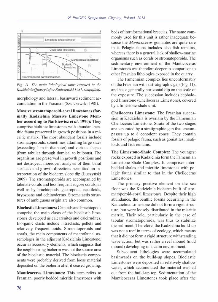
9th ProGEO Symposium, Chęciny, Poland, 2018
76
morphology and lateral, basinward sediment ac-cumulation in the Frasnian (Szulczewski 1981).
Massive stromatoporoid-coral limestones (for-mally Kadzielnia Massive Limestone Mem-ber according to Narkiewicz et al. 1990): They comprise biolithic limestones with abundant ben-thic fauna preserved in growth positions in a mi-critic matrix. The most abundant fossils include stromatoporoids, sometimes attaining large sizes (exceeding 1 m in diamater) and various shapes (from tabular through domical to bulbous). The organisms are preserved in growth positions and not destroyed; moreover, analysis of their basal surfaces and growth directions permitted an in-terpretation of the bioherm slope dip (Łuczyński 2009). The stromatoporoids are accompanied by tabulate corals and less frequent rugose corals, as well as by brachiopods, gastropods, nautiloids, bryozoans and echinoderms. Stromatactis struc-tures of ambiguous origin are also common.
Bioclastic Limestones: Crinoids and brachiopods comprise the main clasts of the bioclastic lime-stones developed as calcarenites and calcirudites. Inorganic clasts include intraclasts, pellets and relatively frequent ooids. Stromatoporoids and corals, the main components of macrofaunal as-semblages in the adjacent Kadzielnia Limestone, occur as accessory elements, which suggests that the neighbouring bioherm was not the source area of the bioclastic material. The bioclastic compo-nents were probably derived from loose material deposited on the bioherm after it ceased growing.
Manticoceras Limestones: This term refers to Frasnian, poorly bedded micritic limestones with
beds of intraformational breccias. The name com-monly used for this unit is rather inadequate be-cause the Manticoceras goniatites are quite rare in it. Pelagic fauna includes also fish remains, whereas there is a general lack of shallow-marine organisms such as corals or stromatoporoids. The sedimentary environment of the Manticoceras Limestones was therefore deeper in comparison to other Frasnian lithologies exposed in the quarry.
The Famennian complex lies unconformably on the Frasnian with a stratigraphic gap (Fig. 11), and has a generally horizontal dip on the scale of the exposure. The succession includes cephalo-pod limestone (Cheiloceras Limestone), covered by a limestone-shale unit.
Cheiloceras Limestone: The Frasnian succes-sion in Kadzielnia is overlain by the Famennian Cheiloceras Limestone. Strata of the two stages are separated by a stratigraphic gap that encom-passes up to 8 conodont zones. They contain fossils of pelagic fauna, such as goniatites, nauti-loids and fish remains.
The Limestone-Shale Complex: The youngest rocks exposed in Kadzielnia form the Famennian Limestone-Shale Complex. It comprises inter-bedded shales and micritic limestones with pe-lagic fauna similar to that in the Cheiloceras Limestones.
The primary positive element on the sea floor was the Kadzielnia bioherm built of stro-matoporoid-coral limestones. Despite their high abundance, the benthic fossils occurring in the Kadzielnia Limestone did not form a rigid struc-ture, but were loosely distributed in the micritic matrix. Their role, particularly in the case of tabular stromatoporoids, was thus to stabilize the sediment. Therefore, the Kadzielnia build-up was not a reef in terms of ecology, which means that it did not form a rigid structure withstanding wave action, but was rather a reef mound (mud mound) developing in a calm environment.
Subsequent lithologies were accumulated basin wards on the build-up slopes. Bioclastic Limestones were deposited in relatively shallow water, which accumulated the material washed out from the build-up top. Sedimentation of the Manticoceras Limestones took place after the
Fig. 11. The main lithological units exposed in the Kadzielnia Quarry (after Szulczewski 1981, simplified).

FIELD TRIP: Top Geosites of Góry Świętokrzyskie
77
whole system was drowned and resulted in level-ling the sea bottom morphology.
At the end of Frasnian time development of the carbonate platform was rapidly terminated by minor tectonic block movements that uplifted and sank the sea floor. Parts of the sea floor with the most profound relief were often ele-vated above sea level, and their tops were sub-ject to erosional shearing or even karstification (see Stop 2 – Ostrówka Quarry succession). An intensive development of neptunian dykes oc-curred with this time interval. The Famennian succession, from the Cheiloceras Limestones to the Limestone-Shale Complex, reflects a gradual deepening of the area.
The neptunian dykes and related structures (voids filled with internal sediments) occur along both margins of the Central Carbonate Platform. Most dykes contain a rich conodont assemblage that allows precise dating and recognition of their multi-stage evolution, comprising subsequent ep-isodes of opening and closing. The dykes were formed in several phases during the disintegration and drowning of the Frasnian carbonate platform and its transition into a Famennian–Tournaisian pelagic carbonate platform.
The Kadzielnia neptunian dykes penetrate downwards from the Manticoceras Limestones and the Famennian strata. In the Kadzielnia
Limestone they form a dense network of mu-tually cross-cutting structures. Their sediments attain reddish or greenish colours that are clearly visible in the complex of light coloured stro-matoporoid-coral limestones.
ReferencesŁuczyński, P. 2009. Stromatoporoid growth orientation
as a tool in palaeotopography: a case study from the Kadzielnia Quarry, Holy Cross Mountains, central Poland. Acta Geologica Polonica, 59, 319–340.
Łuczyński, P. 2015. Kadzielnia – a Devonian carbon-ate build-up. In: S. Skompski, A. Żylińska (Eds). The Holy Cross Mountains– 25 journeys through earth history, p. 102‒106, University of Warsaw, Faculty of Geology; Warsaw.
Narkiewicz, M., Racki, G. and Wrzołek, T. 1990. Lito-stratygrafia dewońskiej serii stromatoporoi dowo-koralowcowej w Górach Świętokrzyskich. Kwar-talnik Geologiczny, 34, 433–456.
Szulczewski, M. 1971. Upper Devonian conodonts, stratigraphy and facial development in the Holy Cross Mts. Acta Geologica Polonica, 21, 1–129.
Szulczewski, M. 1981. Dewon środkowy i górny zachodniej części Gór Świętokrzyskich. In: H. Żakowa, H. (Ed.) 1981. Przewodnik 53 Zjazdu Polskiego Towarzystwa Geologicznego, Kielce, 6–8 września 1981, p. 68–82.
Szulczewski, M. 1995. Depositional evolution of the Holy Cross Mts. (Poland) in the Devonian and Carboniferous – a review. Geological Quarterly, 39, 471–488.
Stop 4. Górno Quarry Leader: Stanisław Skompski
Keywords: Frasnian allodapic limestones, carbonate platform slope
GPS coordinates: 50°51’09.4”N, 20°49’13.2”E
Location: Abandoned quarry in Górno village, NE of Kielce.
Upper Devonian succession typical of Kostomłoty facies: transition from deep basin to slope allochthonous deposits, redeposited from the Central Carbonate Platform
of Kielce region
Stanisław Skompski
Geological settings: Górno Quarry is located in the northern limb of the Radlin Syncline – the second-order tectonic unit within the Kielce-
Łagów synclinorium (northern part of the Kielce region). This Variscan syncline is composed of the Devonian on the limbs and the Lower

9th ProGEO Symposium, Chęciny, Poland, 2018
78
Carboniferous (Culm facies) in the core. Its sim-ple form is complicated by longitudinal faults, bordering the Carboniferous core, which forms the internal anticline (Czarnocki 1938; Żakowa, Pawłowska 1961).
Devonian succession in the region is repre-sented by Eifelian dolomitic complex and then by different Givetian to Frasnian limestones, typical of the intra-shelf basinal environment (Szulczewski 1971; Małkowski 1981). Finally, oc-cur the nodular limestones intercalated with in-traformational breccias and allodapic limestones, well visible on the eastern wall of the quarry (Figs 12, 13). This type of facies, transitional between shallow water Kielce facies and basinal Łysogóry facies is known in the literature as Kostomłoty facies (and/or Kostomłoty Beds). It will be pre-sented more precisely in the Stop 7.
Kostomłoty Beds are typical platform slope deposits, composed of marly shales or micritic and nodular limestones, intercalated with nu-merous layers of intraformational conglomerates and graded limestones, interpreted as the de-
posits of submarine gravity flows (Szulczewski 1968, 1971). On the eastern wall of this small and abandoned quarry occur typical intraforma-tional, synsedimentary breccias. On the southern wall, in the equivalent stratigraphic interval the submarine slumps occur.
Fig. 12. General view of the eastern wall in Górno Quarry; marly limestones with numerous intercalations of allodapic beds. Photograph by Stanisław Skompski.
5 cm
Fig. 13. Intraformational breccias typical of Kosto-młoty Beds (old quarry in the Górno village).

FIELD TRIP: Top Geosites of Góry Świętokrzyskie
79
The Devonian (Frasnian) succession out-cropped in the Górno village illustrates the pro-cess of disappearance of a shallow carbonate platform, developed during Middle Devonian time in central part of the Holy Cross Mountains area (e.g. Szulczewski 1971, 1995; Racki 1993).
ReferencesCzarnocki, J. 1938. Ogólna mapa geologiczna Polski,
arkusz 4 Kielce, skala 1 : 100 000. Państwowy In-stytut Geologiczny; Warszawa.
Małkowski, K. 1981. Upper Devonian deposits at Górno in the Holy Cross Mts. Acta Geologica Po-lonica, 31, 223–232.
Racki, G. 1993. Evolution of the bank to reef complex in the Devonian of the Holy Cross Mountains. Acta Palaeontologica Polonica, 37, 87–182.
Szulczewski, M. 1968. Slump structures and turbid-ites in Upper Devonian limestones of the Holy Cross Mts. Acta Geologica Polonica, 18, 304–326.
Szulczewski, M. 1971. Upper Devonian conodonts, stratigraphy and facial development in the Holy Cross Mts. Acta Geologica Polonica, 21, 1–129.
Szulczewski, M. 1995. Depositional evolution of the Holy Cross Mts. (Poland) in the Devonian and Carboniferous – a review. Kwartalnik Geologic-zny, 39 (4), 471–488.
Żakowa, H., Pawłowska, J. 1961. Dolny karbon na obszarze między Radlinem i Górnem w synklino-rium kielecko-łagowskim (Góry Świętokrzyskie). [The Lower Carboniferous in the area between Radlin and Górno, in the Kielce-Łagów syncli-norium (Święty Krzyż Mountains)]. Biuletyn In-stytutu Geologicznego, 167, 101–166. (In Polish with English extended abstract).
Stop 5. Krzemionki Opatowskie – prehistoric flint mines Leader: Stanisław Skompski
Keywords: Upper Jurassic carbonates, flint concretions, Neolithic mines
GPS coordinates: 50°58’19.96”N, 21°29’28.06”E
Location: Forested area 8 km north-east of Ostrowiec Świętokrzyski.
Upper Jurassic shallow water succession with horizons of striped flint concretions; underground route presenting prehistoric flint mines functioning for most
of the Neolithic age and at the beginning of the Bronze Age (3900–1600 B.C.); a candidate for the UNESCO World Heritage List
Stanisław Skompski
Highlights: This unique place merges the geolog-ical phenomenon of occurrence of striped flints horizons and the archeological site, which is one of the most valuable relics of prehistoric mining. The numerous exploitation shafts and under-ground cavities are perfectly preserved and some of them are available for tourists. The exploitation of striped flints started 3 900 years B.C. The vast exploitation field (Fig. 14), with nearly four thou-sands of shafts, has been discovered by geologist Jan Samsonowicz, during cartographic investi-gations carried out in July 1922 (Samsonowicz 1934). He informed about this discovery the archeologist Stefan Krukowski and since that
time the place has been intensively investigated by archeologists. During nearly 2 000 years of exploitation the striped flint excavated here was treated as feedstock, from which different tools and axes were produced and distributed through the Central Europe. In addition, there have been two other fields recognised in the neighbouring villages of Borowina and Wojciechówka.
In the present guide, only geological setting is described; arecheological information is pre-sented in the attached folder.
Geological settings: Krzemionki Opatowskie are located within the north-eastern Mesozoic margin

9th ProGEO Symposium, Chęciny, Poland, 2018
80
of the Holy Cross Mountains. The slightly folded Jurassic complexes, with general strike of 135°, are here cut down by Kamienna river, flowing from the south to the north (Fig. 15). The Upper
Jurassic (Oxfordian and Kimmeridgian) rocks form the succession characterised by shallow-ing upward sedimentary environment. The suc-cession traceable in the Kamienna valley started with massive ‛rocky’ unit, composed of bioher-mal limestones with sponges and microbial struc-tures. This relatively deep water unit is covered by bioclastic and reef limestones, with numerous flat colonies of corals from genera Microsolena and Thamnasteria, echinoids, brachiopods and rhodophycean algae (Roniewicz 1966). Finally, the Jurassic complex is terminated by bioclas-tic-oolitic unit (Gutowski 1998), outcropped in the nearby villages Bałtów and Skarbka. The shal-lowing of the sedimentary environment is treated as an effect of eustatic fall of sea level and progra-dation of carbonate platform from the east to the west (Matyja et al. 1989; Gutowski 1998).
Flint horizons: The occurrence of 3 flint hori-zons is limited to the upper members of succes-sion; lowermost horizon (‘brown flints’) appeared within the coral limestones from Bałtów, two up-per horizons (‘striped flints’ and ‘chocolate flints’) are located within oolitic limestones. This part of succession, generally shallow water, is char-acterised by cyclothemic type of deposition, with microbial laminites, oolitic intercalations and ero-sional surfaces in the topmost part of cyclothems,
Fig. 14. The ‘Krzemionki’ exploitation area on the LIDAR photograph (www.geoportal.gov.pl); abundant exploitation shafts are visible.
Fig. 15. The meandering river in the souhern part of Kamienna Valley near Ćmielów. Photograph by Stanisław Skompski.

FIELD TRIP: Top Geosites of Góry Świętokrzyskie
81
interpreted as tidal flats or lagoonal deposits (Pieńkowski, Gutowski 2004). The flint horizons (Fig. 16) are regularly developed in the upper-most part of cyclothems. Abundant occurrence of flint nodules is reported only from north-eastern Mesozoic margin of Holy Cross Mts., they are absent in the south-western margin. It means that flints developed only in the proximal parts of the prograding carbonate platform. Nodule horizons are more or less parallel to the bedding and have stratigraphic correlation significance.
Flints origine: According to Pieńkowski and Gutowski (2004) the flint nodules form a net-works (Fig. 17), which correspond to the tem-plate of burrows produced by Decapoda crusta-
ceans, similarly to the well known forms from the Cretaceous chalk deposits (Bromley 1967; Bromley, Ekadale 1984). The infilling of crusta-cean burrows is interpreted as a nucleation centre for formation of early diagenetic flint nodules. Relatively high permeability of deposits infilling the crustacean burrows allowed their impregna-tion by solutions with increased content of silica. The main source of silica was decomposition of clay minerals, derived from the carbonate rocks, during process of weathering in tropical or sub-tropical climate. The specific chemical context of the flint nodules formation (lowering of pH) was provided by organic particles introduced to the burrows by crustacens.
Another hypothesis concerning the nature of flint nodules has been presented by Migaszewski et al. (2006). According to these authors the flint nodules formed as a result of an episodic influx of SiO2 rich fluids and numerous processes of multi-stage direct precipitation, dissolution and recrys-tallization. However, they also considered that the process of flint nodules formation could be con-trolled by hydrothermal activity on the sea-floor.
The striped flints observed in the Krzemionki mine differ from other types of flints by presence of dark-grey/light-grey bands (Fig. 16). This fea-ture is visible only in macroscopic view, in pol-ished slabs; in the thin sections there are no dif-ferences between 2 types of strips. According to Migaszewski et al. (2006) the onion-skin texture of nodules is caused by different level of pore im-pregnation by silica: ‘There is evidence showing that the fewer and smaller pores, the darker the bands. The largest numbers of non-impregnated pores are exhibited by the porcelain-like rind’.
ReferencesBromley, R.G. 1967. Some observations on burrows
of Thalassinidean Crustacea in chalk hard-grounds. Geological Society of Denmark Bulletin, 29, 111–118.
Bromley, R.G., Ekdale, A.A. 1984. Trace fossils pres-ervation in flint in the European chalk. Journal of Palaeontology, 58, 298–311.
Gutowski, J. 1998. Oxfordian and Kimmeridgian of the northeastern margin of the Holy Cross Mountains, Central Poland. Geological Quarterly, 42, 59–72.
Matyja, B.A., Gutowski, J., Wierzbowski, A. 1989. The open shelf-carbonate platform succession at
Fig. 16. The section of striped flint nodule. Photograph by Stanisław Skompski.
Fig. 17. Polygonal network of Decapoda burrows, impregnated by SiO2. according to interpretation of Gutowski and Pieńkowski (2004). Photograph by Anna Żylińska.

9th ProGEO Symposium, Chęciny, Poland, 2018
82
the Oxfordian/Kimmeridgian boundary in the SW margin of the Holy Cross Mts: stratigraphy, facies, and ecological implications. Acta Geologica Po-lonica, 39, 29–48.
Migaszewski, Z.M., Gałuszka, A., Durakiewicz, T., Starnawska, E. 2006. Middle Oxfordian–Lower Kimmeridgian chert nodules in the Holy Cross Mountains, south-central Poland. Sedimentary Geology, 187, 11–28.
Pieńkowski, G., Gutowski, J. 2004. Geneza krzemieni górnego oksfordu w Krzemionkach Opatowskich
(Genesis of the Upper Oxfordian flints in Krze-mionki Opatowskie, Poland). Tomy Jurajskie, 2, 29–36. (In Polish with English abstract).
Roniewicz, E. 1966. Les madréporaires du Jurassique supérieur de la bordure des Monts de Sainte-Croix, Pologne. Acta Paleontologica Polonica, 12, 157–254.
Samsonowicz, J. 1934. Objaśnienia do arkusza Opatów ogólnej mapy geologicznej Polski w skali 1 : 100 000. Państwowy Instytut Geologiczny, Warszawa.
Stop 6. Łysa Góra Leader: Ewa Głowniak
Keywords: Upper Cambrian quartzites, boulder field, periglacial environment
GPS coordinates: 50º51’37”N 21º02’49”E
Location: Platform viewpoint on the peak of Łysa Góra (at 595 m a.s.l.).
The highest range of the Holy Cross Mountains; boulder fields (gołoborze) of periglacial origin; biostratigraphic data on the Cambrian of Łysogóry
Anna Żylińska (based on Żylińska 2015, 2017, supplemented)
Geographical and geomorphological settings: The Main Range of the Holy Cross Moun tains, running from west to east for a distance of about 75 km, is generally composed of Cam-brian sandstones and quartzites that form an asymmetric anticlinal structure known as the Łysogóry Anticline. Three orographic units are distinguished within the range: the western Masłowskie Range, the central Łysogóry, and the eastern Jeleniowskie Range. The eponymous Łysogóry Range forms the highest part of the Main Range and is one of the few ridges in the area whose heights in relation to the surrounding valleys exceed up to 300 m. Its strongly forested eastern part, covered by the historical Jodłowa (Engl. ‘Fir’) Forest, common composed of fir (Abies alba) with rarer beech (Fagus silvatica), with Łysica (at 612 m a.s.l.), the highest peak of the Holy Cross Mountains, and Łysa Góra, is protected by the Świętokrzyski National Park, whereas the western part, with Radostowa and Kraiński Grzbiet, is much lower and woodless. The easternmost part of the Main Range is the
Jeleniowskie Range, covered by fir-beech for-ests and protected by the Jeleniowski Landscape Park. The axis of this range is shifted by about 4 km to the south in relation to the axis of Łysogóry along the N-S-trending Łysogóry Fault.
Pleistocene stone runs: A noteworthy feature of sandstone weathering in the periglacial con-ditions of the Pleistocene are stone runs, known in Polish as ‘gołoborze’, vast fields of sharp-edged boulders extending directly below the ridges and generally not covered by vegetation (see the cover page figure). They are commonly located on the northern slopes of the Łysogóry and Jeleniowskie ranges. The first who rec-ognised the nature of these boulder fields that formed as a result of sandstone weathering in temperate climate conditions was Łoziński (1909); he also introduced the term ‘periglacial facies’ into international geological literature (Łoziński 1912).
Toursist facilities: The platform offers a view towards the north, onto Chełmowa Góra Hill,
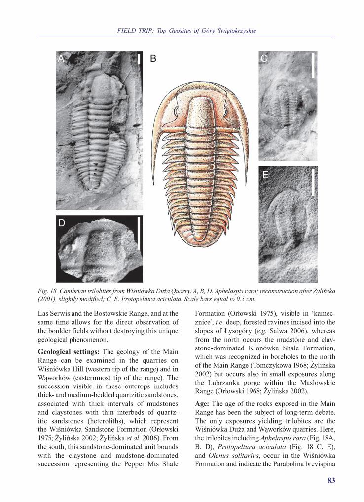
FIELD TRIP: Top Geosites of Góry Świętokrzyskie
83
Las Serwis and the Bostowskie Range, and at the same time allows for the direct observation of the boulder fields without destroying this unique geological phenomenon.
Geological settings: The geology of the Main Range can be examined in the quarries on Wiśniówka Hill (western tip of the range) and in Wąworków (easternmost tip of the range). The succession visible in these outcrops includes thick- and medium-bedded quartzitic sandstones, associated with thick intervals of mudstones and claystones with thin interbeds of quartz-itic sandstones (heteroliths), which represent the Wiśniówka Sandstone Formation (Orłowski 1975; Żylińska 2002; Żylińska et al. 2006). From the south, this sandstone-dominated unit bounds with the claystone and mudstone-dominated succession representing the Pepper Mts Shale
Formation (Orłowski 1975), visible in ‘kamec-znice’, i.e. deep, forested ravines incised into the slopes of Łysogóry (e.g. Salwa 2006), whereas from the north occurs the mudstone and clay-stone-dominated Klonówka Shale Formation, which was recognized in boreholes to the north of the Main Range (Tomczykowa 1968; Żylińska 2002) but occurs also in small exposures along the Lubrzanka gorge within the Masłowskie Range (Orłowski 1968; Żylińska 2002).
Age: The age of the rocks exposed in the Main Range has been the subject of long-term debate. The only exposures yielding trilobites are the Wiśniówka Duża and Wąworków quarries. Here, the trilobites including Aphelaspis rara (Fig. 18A, B, D), Protopeltura aciculata (Fig. 18 C, E), and Olenus solitarius, occur in the Wiśniówka Formation and indicate the Parabolina brevispina
Fig. 18. Cambrian trilobites from Wiśniówka Duża Quarry. A, B, D. Aphelaspis rara; reconstruction after Żylińska (2001), slightly modified; C, E. Protopeltura aciculata. Scale bars equal to 0.5 cm.
9th ProGEO Symposium, Chęciny, Poland, 2018
84
Biozone (Żylińska 2001, 2002), that is the lower part of the Furongian. This age has also been indicated by acritarch assemblages from the Wiśniówka Quarry (Żylińska et al. 2006). The only age determinations for rocks of the Łysogóry Range come from mudstones and shales of the underlying Pepper Mts Formation (Szczepanik, Malec 2017) and are based on acritarch as-semblages that point to the transition between Cambrian Series 3 and the Furongian.
ReferencesŁoziński, W. 1909. Das diluviale Nunatak des Pol-
nischen Mittelgebirges. Zeitschrift der Deutschen Geologischen Gesellschaft, Monatsberichte, 61, 447–451.
Łoziński, W. 1912. Die periglaziale Facies der mecha-nischen Verwitterung. Compte Rendu de la XIe ses-sion du Congrès Géologique International, Stock-holm, 1910, 1039–1053.
Orłowski, S. 1968. Cambrian of the Łysogóry Anticline in the Holy Cross Mountains. Biuletyn Geologic-zny Wydziału Geologii, 10, 153–222. (In Polish)
Orłowski, S. 1975. Cambrian and upper Precambri-an lithostratigraphic units in the Holy Cross Mts. Acta Geologica Polonica, 25, 431–448. (In Polish with English summary)
Salwa, S. 2006. Preliminary structural-petrography characteristic of phyllite from Podmąchocie in the
Łysogóry Unit of the Holy Cross Mts. Przegląd Geologiczny, 54, 513–520. (In Polish)
Szczepanik, Z., Malec, J. 2017. New data on the li-thology and acritarch biostratigraphy of Cambri-an rocks of Łysica Mt., the highest summit of the Holy Cross Mountains. Przegląd Geologiczny, 65, 564–575 (In Polish)
Tomczykowa, E. 1968. Stratigraphy of the Uppermost Cambrian deposits in the Świętokrzyskie Moun-tains. Prace Instytutu Geologicznego, 54, 5–85. (In Polish)
Żylińska, A. 2001. Late Cambrian trilobites from the Holy Cross Mountains, central Poland. Acta Geo-logica Polonica, 51, 333–383.
Żylińska, A. 2002. Stratigraphic and biogeograph-ic significance of Late Cambrian from Łysogóry (Holy Cross, Mountains, central Poland). Acta Geologica Polonica, 52, 217–238.
Żylińska, A. 2015. Cambrian of the Main Range. In: S. Skompski, A. Żylińska (Eds), The Holy Cross Mountains – 25 journeys through Earth History, p. 59–65. University of Warsaw, Faculty of Geo-logy; Warsaw.
Żylińska, A. 2017. Stop B4. Łysa Góra. In: A. Żylińs-ka (Ed.), 10th Baltic Stratigraphic Conference, Chęciny, 12–14 September, 2017, Abstracts and Guide Book, p. 145–147. Warszawa.
Żylińska, A., Szczepanik, Z., Salwa, S. 2006. Cambri-an of the Holy Cross Mountains, Poland: biostra-tigraphy of the Wiśniówka Hill succession. Acta Geologica Polonica, 56, 443–461.
Stop 7. Mogiłki Quarry Leader: Stanisław Skompski
Keywords: basin to slope carbonates, allodapic limestones, chevron faults
GPS coordinates: 50º55’26.84”N 20º34’48.02”E
Location: Abandoned quarry near Kostomłoty village, NE of Kielce.
Upper Devonian succession typical of Kostomłoty facies: transition from deep basin to slope allochthonous deposits, redeposited from the Central Carbonate Platform
of Kielce Region
Stanisław Skompski (based on Wańkiewicz, Konon 2015)
Lithologic sequence and stratigraphy: Struc-turally, the beds exposed in the Mogiłki Quarry (Fig. 19) constitute a fragment of the southern
limb of the Miedziana Góra Syncline, belong-ing to the Kielce Fold Zone, developed during Variscan deformation. Facially, the area rep-

FIELD TRIP: Top Geosites of Góry Świętokrzyskie
85
resents the northern margin of the Kielce Region of the Holy Cross Mountains, which in the Late Devonian was characterised by a diversity of carbonate facies, reflecting the development and disappearance of a shallow carbonate platform (e.g. Szulczewski 1971, 1995; Racki 1993). This type of facies, transitional between shallow wa-ter Kielce facies and basinal Łysogóry facies is known in the literature as Kostomłoty facies (and region).
In the quarry the Szydłówek Beds and Kosto-młoty Beds are outcropped (composite descrip-tion of Stop 4 – this excursion). Kostomłoty Beds, which were presented in limited range only in the Górno Quarry, here are developed in the most typical form. These deposits include micritic and nodular limestones, and marly shales, with numerous interbeds of clastic lime-stones with variable grain sizes (Fig. 20). The bioclastic interbeds have since long been con-sidered as deposits of submarine gravity flows with a high contribution from turbidity currents (Szulczewski 1968, 1971). Micritic and nodular limestones (Fig. 21) and marly shales formed due to slow, local sedimentation on the slopes of the carbonate platform, whereas the increasingly abundant and thicker beds of clastic limestones and intraformational carbonate breccias from the upper part of the sequence were deposited at the foot of this slope (Wańkiewicz, Konon 2015). Such a succession of deposits indicates an appar-ent withdrawal of the platform margin, drowned due to local tectonics and/or global sea level rise (see discussion in Szulczewski 1995).
The most interesting tectonic structures in the quarry include minor folds occurring in cen-tral part of the eastern wall (Fig. 19). Axes of these folds are sub-parallel to the axis of the Miedziana Góra Syncline, with an orientation of about 100°. The folds are dominated by sim-ilar (chevron) folds with steeply inclined axial planes. In the fold fragments where beds of dif-ferent thicknesses occur, a transition from simi-lar to concentric folds can be observed. Cleavage is tectonic feature visible commonly in most of beds. The characteristic chevron folds in the Mogiłki Quarry formed due to horizontal stress, perpendicular to the fold axial planes (Konon 2006a, b).
The tectonic style typical of Kostomłoty/Łysogóry (northern) and Kielce (southern) re-gions is completely different. The observed dif-ferences exemplify a phenomenon occurring in the entire Holy Cross Mountains area, where
Fig. 19. General view of chevron faults on the eastern wall of the Mogiłki Quarry. Photograph by Stanisław Skompski.
Fig. 20. Grain supported breccias with large flat clasts, derived from the platform slope. Photograph by Aleksandra Wańkiewicz.
Fig. 21. Nodular limestone. Photograph by Aleksan dra Wańkiewicz.

9th ProGEO Symposium, Chęciny, Poland, 2018
86
rocks significantly differing in mechanical prop-erties occur adjacent to each other (Wańkiewicz, Konon 2015).
ReferencesKonon, A. 2006a. Młodopaleozoiczna ewolucja struk-
turalna Gór Świętokrzyskich. In: S. Skompski, A. Żylińska (Eds), 77 Zjazd Naukowy Polskiego To-warzystwa Geologicznego, Ameliówka k. Kielc, 28–30 czerwca, 2006 r., materiały konferencyjne, 82–104.
Konon, A. 2006b. Buckle folding in the Kielce Unit, Holy Cross Mountains, central Poland. Acta Geo-logica Polonica, 56, 375–405.
Racki, G. 1993. Evolution of the bank to reef complex in the Devonian of the Holy Cross Mountains. Acta Palaeontologica Polonica, 37, 87–182.
Szulczewski, M. 1968. Slump structures and turbid-ites in Upper Devonian limestones of the Holy Cross Mts. Acta Geologica Polonica, 18, 303–330.
Szulczewski, M. 1971. Upper Devonian conodonts, stratigraphy and facial development in the Holy Cross Mts. Acta Geologica Polonica, 21, 1–129.
Szulczewski, M. 1995. Depositional evolution of the Holy Cross Mts. (Poland) in the Devonian and Carboniferous – a review. Geological Quarterly, 39, 471–488.
Wańkiewicz, A., Konon, A. 2015. Sedimentation and tectonics in the Devonian carbonate rocks of Mogiłki Quarry. In: S. Skompski, A. Żylińska (Eds), The Holy Cross Mountains – 25 journeys through Earth History, p. 112–117. University of Warsaw, Faculty of Geology; Warsaw.
Stop 8. Zachełmie Quarry near Zagnańsk Leader: Stanisław Skompski
Keywords: Devonian peritidal carbonates, epi-Variscan unconformity, Buntsandstein sandstones, tetrapod tracks
GPS coordinates: 50º58’10.11”N 20º41’23.03”E.
Location: Abandoned quarry on the western slope of Chełmowa Hill, between Zagnańsk and Zachełmie villages, about 10 km to the north of Kielce.
Epi-Variscan unconformity in the Holy Cross Mountains: Devonian dolomites of the Wojciechowice and Kowala formations, unconformably covered by Buntsandstein
deposits; tidal sedimentation with record of emersion episodes
Stanisław Skompski (based on Waksmundzki 2015; Kozłowski 2017)
Lithologic succession and stratigraphy: Za-cheł mie is one on the most interesting geolog-ical sites in the north-western part of the Holy Cross Mountains. It exposes variable facies of the Devonian (Eifelian), which in this local-ity terminate the Variscan tectonic stage; and the unconformably overlying Lower Triassic (Buntsandstein facies) strata of the Alpine tec-tonic stage (Fig. 22). Recently, the exposure has become famous for the tracks of the oldest tetra-pods discovered in Devonian rocks.
Eifelian: Devonian rocks composing the northern limb of the Łysogóry Anticline and the south-
ern limb of the Bodzentyn Syncline are exposed in a small area from beneath the Buntsandstein cover belonging to the north-western Mesozoic margin of the Holy Cross Mountains. Dolomites of the Wojciechowice Formation (Eifelian) dip at about 40º to the NNE and reach 90 m in thick-ness (Narkiewicz, Narkiewicz 2010). The strata include homogenous dolomicrites with bed thick-nesses reaching several tens of centimetres, inter-bedded with marly dolomicrites, often with hori-zontal lamination. The millimetre-thick laminae have a variable clay content and due to weathering split into thin plates. Desiccation cracks can be observed on the bedding planes of the laminated

FIELD TRIP: Top Geosites of Góry Świętokrzyskie
87
beds. The cracks can be quite deep, reaching even to the basal bedding planes, most probably due to the ‘inheritance’ of a once formed crack pattern in the subsequent layers of the slowly deposited, periodically drying-up carbonate mud.
Part of the laminated sets is characterised by irregular, wavy distribution of laterally thin-ning out laminae and the presence of fenestral structures, which originated through microbial processes. In the remaining beds, regular lami-nation is resulted from carbonate deposition that was subtly and rhythmically ‘dissolved’ by the supply of terrigenous clay (Niedźwiedzki et al. 2010). One well-exposed bed reveals pillow-like swellings, which are stromatolite structures that partly mimic the polygon pattern of the under-lying bed with desiccation cracks (Fig. 23). The dolomicrites generally do not record high-energy events, with the exception of a single horizon with intraformational breccias, filling an ero-sional trough. The entire succession is charac-terised by cyclic sedimentation (Grabowski et al.
2015; Narkiewicz et al. 2015). Each of more than a dozen cycles has a thickness from several tens of centimetres to 2 m and consistently begins with clay-dolomitic laminites or homogenous do-lomites, which pass up into dolomites with dis-continuous wavy lamination, in the upper part of-ten with desiccation cracks and sometimes with tepee structures related to pseudomorphs after evaporites, visible to the naked eye. The upper surfaces of these sets are erosionally sheared or contain poorly developed paleosols in the form of nodular horizons with root traces at the top (Narkiewicz, Retallack 2014). This part of the succession lacks macrofauna; only one dolomi-crite sample collected from the lowermost part of the sequence yielded index conodonts of the Lower Eifelian (Narkiewicz, Narkiewicz 2015).
The scarcity of fossils is compensated by the sensational finds of tracks of the world’s old-est tetrapod-four-limbed vertebrates capable of treading (Niedźwiedzki et al. 2010). So far, the succession has yielded three horizons with these
Fig. 22. Variscan unconformity in Zachełmie Quarry. Buntsandstein deposits overlie the Eifelian dolomites with a large angular unconformity. Channel deposits of a braided river in the Buntsandstein facies are visible in the uppermost right of the wall. Photograph by Stanisław Skompski.

9th ProGEO Symposium, Chęciny, Poland, 2018
88
fascinating trace fossils, all within the lower or middle part of the shallowing upward cycles, in deposits not registering emergence (Narkiewicz et al. 2015).
The higher part of the Wojciechowice Forma-tion is characterised by more massive bedding, more frequent occurrence of strongly bioturbated beds and lack of microbial structures, and by the occurrence of dissecation cracks and paleosol horizons, as compared to the lower part. Marine body fossils come almost exclusively from this part of the succession (the only exception are the oldest conodonts from beds preceding the first horizon with tetrapod tracks); the fossils, rec-ognised in thin sections and in the residue from dissolved rock samples, include conodonts, echi-noderms, bryozoans, scolecodonts, bivalves and gastropods.
The boundary with the overlying Kowala For-mation is marked by a distinct lithological change – the dolomicrites are replaced by dolosparites, and amphipores and tabular stromatoporoids ap-pear in a few biostromal horizons. The medium – and thick-bedded deposits are either homogenous or indistinctly laminated (Narkiewicz, Narkiewicz 2010; Niedźwiedzki et al. 2010).
Very well preserved sedimentary structures and the presence of clasts of earlier lithified do-lomitic sediments indicate a very early origin for the dolomites of the Wojciechowice Formation (Narkiewicz et al. 2015).
During Eifelian time, the Łysogóry Region with the Zachełmie area was part of a vast, rather flat, shallow-marine carbonate platform, extending from the area of present-day Moravia to the Holy Cross Mountains, and located on the Euramerican (Laurussian) shelf. The lower part of the Wojciechowice Formation exposed in the quarry, with the tetrapod tracks, in particu-lar was formed in an extremely shallow marine setting. At a large distance from land, carbon-ate muds with a small admixture of terrigenous silt of eolian origin were deposited in calm con-ditions only sporadically interrupted by storm events (intraformational breccias probably origi-nated during storm events), in an area covered by lagoons with depths probably not exceeding sev-eral metres, surrounded by flat islands that were scantily covered by early land plants (Narkiewicz
et al. 2015). The depositional processes were cy-clic, and proceeded according to a rhythm gen-erated by astronomical factors (Grabowski et al. 2015). Salinity exceeding normal levels and frequent emergent intervals did not favour the presence of stenohaline fauna on the sea floor. In turn, the upper part of the Wojciechowice Formation and the Kowala Formation originated in a less restrictive setting with a higher contri-bution from waters with normal salinity levels, which favoured the appearance of benthic fauna.
Buntsandstein: Close to the quarry entrance, in the eastern wall, is exposed a text-book ex-ample of a contact between two tectonic stages, the Variscan and Alpine stages (Fig. 24). A na-ture monument was established here in 1987. Eifelian dolomites are covered with a large angu-lar unconformity by the Buntsandstein deposits. The Devonian rocks were folded after the early
Fig. 23. Stromatolites mimicking the polygonal pat-tern of desiccation cracks in the underlying bed; Eifelian, Zachełmie Quarry, Holy Cross Mountains. Photograph by Anna Żylińska.

FIELD TRIP: Top Geosites of Góry Świętokrzyskie
89
Carboniferous during Variscan deformation, in which, among other structures, the Łysogóry Anticline and the Bodzentyn Syncline were formed. The flat-lying beds of the Buntsandstein represent the lowermost part of the Alpine stage. The top of the dolomites is uneven and shaped by karst and fluvial processes. Depressions in its surface are filled with strongly lithified do-lomite breccias with clasts reaching up to 30 cm in size. No sorting and grading are observed, resulting in a chaotic distribution of the clasts. The clasts occur in a red, calcareous-ferruginous matrix with admixture of detrital quartz and sub-ordinate muscovite. Several metres thick, easily weathered, red, thin-bedded, fine-grained quartz sandstones with interbeds of quartz mudstones occur above. Apart from quartz, they contain fine muscovite and subordinate quantities of ka-olinitised feldspars. These rocks overlie the brec-cias or lie directly on Eifelian dolomites. Both the breccias and the sandstones are assigned to the Jaworzna Formation (Kuleta et al. 2006). This part of the Buntsandstein succession was formed as a result of interfingering between deposits of alluvial fans (the so-called ‘sheet-flood’ deposits) and fine sediments of a river floodplain environ-ment (Szulczewski 1995). The uppermost part
of the Buntsandstein succession belongs to the Zagnańsk Formation (Kuleta et al. 2006). It in-cludes slightly lighter coloured, compared to the underlying beds, medium- to thick-bedded quartz sandstones which infill channels that erosionally cut into the sand-mud deposits. Channel soles sometimes contain accumulations of flat clay intraclasts or dolomite clasts, which represent residual lags. The sandstones reveal large-scale trough and tabular cross-bedding and represent channel facies of braided rivers that incised the floodplains (Fig. 24; cf. Szulczewski 1995).
Due to the lack of precise biostratigraphic tools, the age of the Buntsandstein deposits, especially their lowermost part, is a matter of controversy. Magnetostratigraphic data indicate an Early Triassic age (Nawrocki et al. 2003), whereas conchostracans point to the late Permian (Ptaszyński, Niedźwiedzki 2004; see discussion in Becker 2014).
ReferencesGrabowski, J., Narkiewicz, M., De Vleeschouwer, D.
2015. Forcing factors of the magnetic suscepti-bility signal in lagoonal and subtidal deposition-al cycles from the Zachełmie section (Eifelian, Holy Cross Mountains, Poland). In: A.C. da Silva,
Fig. 24. Sedimentary environments of the Buntsandstein in Zachełmie Quarry (after Waksmundzki 2015).

9th ProGEO Symposium, Chęciny, Poland, 2018
90
M. Whalen, J. Hladil, L. Chadimova, D. Chen, S. Spassov, F. Boulvain and X. De Vleeschouw-er (Eds), Magnetic Susceptibility Application: A Window onto Ancient Environments and Climatic Variations. Geological Society of London Special Publications, 414, p. 225–244.
Kozłowski, W. 2017. Stop A1. Zachełmie Quarry near Zagnańsk. In: A. Żylińska (Ed.), 10th Baltic Stratigraphic Conference, Chęciny, 12–14 Sep-tember, 2017, Abstracts and Guide Book, p. 108–110. Warszawa.
Kuleta, M., Zbroja, S., Gągol, J., Niedźwiedzki, G., Ptaszyński, T., Studencka, J. 2006. Excursion W2. Terrestrial Buntsandstein sediments in the northern Mesozoic margin of the Holy Cross Mountains: sedimentary conditions, vertebrate tracks, resour-ces. In: S. Skompski, A. Żylińska (Eds), 77 Zjazd Naukowy Polskiego Towarzystwa Geologicznego, Ameliówka koło Kielc, 28–30 czerwca, 2006, Ma-teriały Konferencyjne, p. 174–178. (In Polish).
Narkiewicz, M., Grabowski, J., Narkiewicz, K., Nied-źwiedzki, G., Retallack, G.J., Szrek, P. and De Vleeschouwer, D. 2015. Palaeoenvironments of the Eifelian dolomites with earliest tetrapod trackways (Holy Cross Mountains, Poland). Palaeogeography, Palaeoclimatology, Palaeoecology, 420, 173–192.
Narkiewicz, K., Narkiewicz, M. 2010. Mid Devonian carbonate platform development in the Holy Cross Mts. Area (central Poland): new constraints from the conodont Bipennatus fauna. Neues Jahrbuch für Geologie und Paläontologie, Abhandlungen, 255 (3), 287–300.
Narkiewicz, K., Narkiewicz, M. 2015. The age of the oldest tetrapod tracks from Zachełmie, Poland. Lethaia, 48, 10–12.
Narkiewicz, M., Retallack, G.J. 2014. Dolomitic pa-leosols in the lagoonal tetrapod track-bearing suc-cession of the Holy Cross Mountains (Middle De-vonian, Poland). Sedimentary Geology, 299, 74–87.
Nawrocki, J., Kuleta, M., Zbroja, S. 2003. Buntsand-stein magnetostratigraphy from the northern part of the Holy Cross Mountains. Geological Quarterly, 47, 253–260.
Niedźwiedzki, G., Szrek, P., Narkiewicz, K., Nark-iewicz, M. and Ahlberg, P.E. 2010. Tetrapod track-ways from the early Middle Devonian period of Poland. Nature, 463 (7277), 43–48.
Ptaszyński, T., Niedźwiedzki, G. 2004. Conchostraca from the lowermost Buntsandstein of Zachełmie, Holy Cross Mountains. Przegląd Geologiczny, 52, 1151–1155. (In Polish).
Szulczewski, M. 1995. Zachełmie quarry. In: S. Skompski (Ed.), Guide to Excursion A2. XIII In-ternational Congress on the Carboniferous –Perm-ian, Kraków, Poland, August 28 – September 2, p. 32–33.
Waksmundzki, B. 2015. Tracks of Devonian tetra-pods and the Variscan unconformity in Zachełmie Quarry. In: S. Skompski, A. Żylińska (Eds), The Holy Cross Mountains – 25 journeys through Earth History, p. 132–136. University of Warsaw, Faculty of Geology; Warsaw.
Stop 9. Tumlin Quarry Leader: Ewa Głowniak
Keywords: Buntsandstein, aeolian sedimentation, Polish-Danish Trough
GPS coordinates: 50°58’06.8”N 20°34’36.0”E.
Location: Large quarry situated in the Tumlin village, near the road Kielce-Piotrków Trybunalski.
Eolian sediments in the Lower Triassic succession of the Mesozoic margin of the Holy Cross Mountains
Stanisław Skompski
Lithologic sequence and stratigraphy: Medium and fine-grained, moderately sorted ferrugine-ous sandstones, traditionally classified as Tumlin
Sandstone, in formal classification as Tumlin Beds (according to Kuleta, Zbroja 2006), corresponding to the Baltic Formation of Polish Lowlands. The

FIELD TRIP: Top Geosites of Góry Świętokrzyskie
91
sandstones consist mainly of quartz; feldspars and micas occur as accessory grains.
The Lower Triassic sandstone complex (typ-ical Buntsandstein facies) in the margin of the Holy Cross Mts. is usually developed as fuvial deposits. The Tumlin Sandstone, outcropped in the Tumlin and neighbouring quarries, represents another facies, characteristic only for this area. According to Gradziński et al. (1979), Gradziński (1992) the presented complex is interpreted as eo-lian sediments, with 2 different sedimentary as-sociations: dune and interdune settings (Fig. 25).
Dune association features: Large-scale-cross- stratification with giant scoop-like bottom sur-faces and thickness of individual beds of several meters, relatively large dips of the depositional surfaces, presence of lenses of massive sands, resulting from avalanche-like sand deposition on the leeward dune slopes.
Interdune association features: The presence of flat-laminated sand and siltstone deposits, presence of dessication cracks, mud curls, rip-ple marks and raindrop impressions. Gradziński and Uchman (1994) and Ptaszyński and Niedź-wiedzki (2004) described from this association several vertebrate (Chirotheridae group of ich-nofossils) and invertebrate (Diplocraterion and Planolites) tracks.
As it was indicated by the presence of Bunt-sandstein sediments in other quarries, during Early Triassic time the sandstone deposits most probably covered the whole Variscan area of the Holy Cross Mountains.
ReferencesGradziński, R. 1992. Deep blowout depressions in the
aeolian Tumlin Sandstone (Lower Triassic) of the Holy Cross Mountains, central Poland. Sedimen-tary Geology, 81, 231–242.
Gradziński, R., Uchman, A. 1994. Trace fossils from interdune deposits – an example from the Lower Triassic aeolian Tumlin Sandstone, central Po-land. Palaeogeography, Palaeoclimatology, Palae-oecology, 108, 121–138.
Gradziński, R., Gągol, J., Ślączka, A. 1979. The Tum-lin Sandstone (Holy Cross Mts., Central Poland): Lower Triassic deposits of aeolian dunes and inter-dune areas. Acta Geologica Polonica, 29, 151–176.
Kuleta, M., Zbroja, S. 2006. Wczesny etap rozwo-ju pokrywy permsko-mezozoicznej w Górach Swiętokrzyskich. In: S. Skompski and A. Żylińska (Eds), 77 Zjazd Naukowy Polskiego Towarzystwa Geologicznego, Ameliówka koło Kielc, 28–30 czerwca, 2006, Materiały Konferencyjne, p. 105–125. (In Polish).
Ptaszyński, T., Niedźwiedzki, G. 2004. Late Perm-ian vertebrate tracks from the Tumlin Sandstone, Holy Cross Mountains, Poland. Acta Palaeonto-logica Polonica, 49, 289–320.
Fig. 25. Idealized blokdiagram showing gross internal geometry of the Tumlin Sandstone (after Gradziński et al. 1979). MB – main bounding surface; AB – additional bounding surface; AER – eolian ripples; WR – wave ripples; MC – mud cracks; WTL – water-level terraces; SS – lens of structurless sandstone; SC – scoop-like termination.

Warszawa 2018
ISBN 978-83-945216-5-3