Embed Size (px)
Citation preview

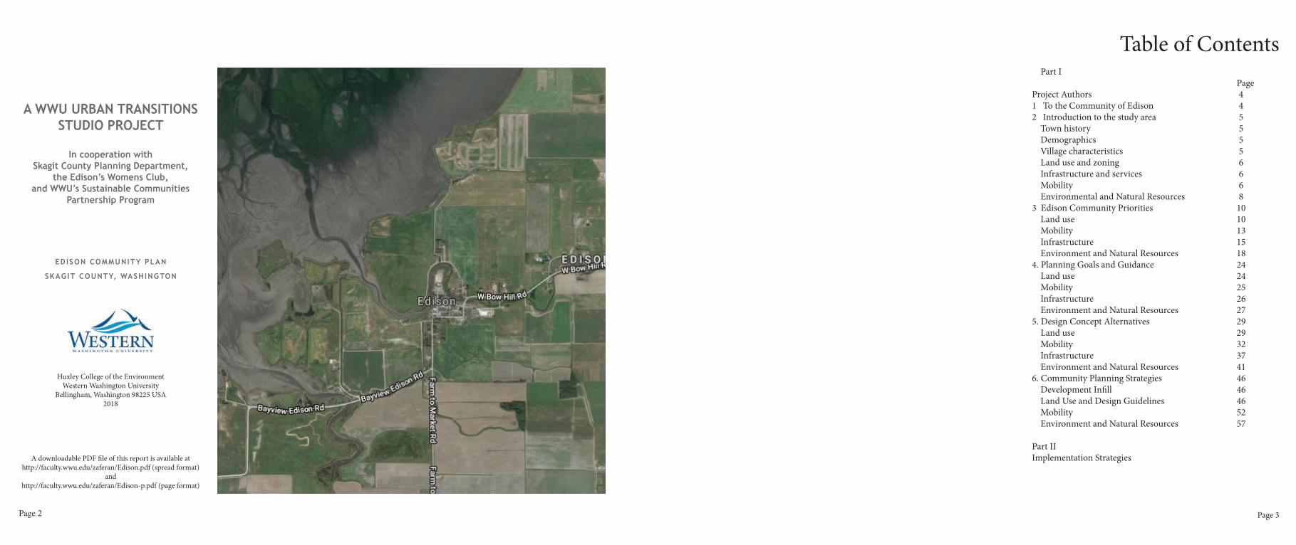
E D I S O Nc o m m u n i t y p l a n
Skagit County, Washington
Urban Planning Studio | Winter 2018 | Spring 2018Sustainable Communities Partnership Program
Western Washington University
Page 2
A WWU URBAN TRANSITIONS STUDIO PROJECT
In cooperation with Skagit County Planning Department,
the Edison’s Womens Club, and WWU’s Sustainable Communities
Partnership Program
EDISON COMMUNITY PLAN
SKAGIT COUNTY, WASHINGTON
Huxley College of the EnvironmentWestern Washington University
Bellingham, Washington 98225 USA2018
A downloadable PDF file of this report is available at http://faculty.wwu.edu/zaferan/Edison.pdf (spread format)
andhttp://faculty.wwu.edu/zaferan/Edison-p.pdf (page format)
Page 3
Table of Contents Part I PageProject Authors 41 To the Community of Edison 4 2 Introduction to the study area 5
Town history 5Demographics 5Village characteristics 5Land use and zoning 6Infrastructure and services 6Mobility 6Environmental and Natural Resources 8
3 Edison Community Priorities 10Land use 10Mobility 13Infrastructure 15Environment and Natural Resources 18
4. Planning Goals and Guidance 24 Land use 24
Mobility 25Infrastructure 26
Environment and Natural Resources 275. Design Concept Alternatives 29 Land use 29
Mobility 32Infrastructure 37
Environment and Natural Resources 416. Community Planning Strategies 46
Development Infill 46Land Use and Design Guidelines 46 Mobility 52Environment and Natural Resources 57
Part II Implementation Strategies

Page 4 Page 5
2018 Student Authors
Team 1: Land Use Grace Coffey Chris Pieroni Abigail Smith Ian Smith Katherine Weir Clay Williams
Team 2: Mobility Peter Cung Jewell Hamilton Holly Pope Nick Reilly David Simpson
Team 3: Infrastructure Dario Castellon Cedric Cornet Nick Giroux Mia Mcfarland Samantha Wanke Team 4: Environment, Parks and Trails Ryan Beberdick Madeline Hart Harrison Merrell Ryan Pernell Franziska Shelton
InstructorDr. Nicholas Zaferatos, Ph.D., AICPProfessor, Urban Planning
Urban Planning Studio Huxley College of the EnvironmentWestern Washington University
1. To the Community Of Edison“The best way to predict the future
is to design it”Buckminister Fuller
This planning study was commissioned by the Skagit County Planning Department as part of its partnership with Western Washington University’s Sustainable Communities Partnership program.
The community of Edison is designated as a Rural Village in the Skagit County Comprehensive Plan. Rural Villages represent pre-existing, rural enclaves that have historically been places for small-scale, rural business and residences. Rural Villages are established as LAMIRDS (RCW 36.70A.070(5)(d)) (Limited Areas of More Intensive Rural Development). The Skagit County Comprehensive Plan acknowledges these rural communities and encourages rural businesses to continue to locate within these historic places.
Edison is an active, lively, eclectic community, with a county road that winds its way through the rural village. It has several secondary streets and is surrounded by prime farmland. It is a walkable, quaint rural community, and is well visited both day and night, and especially on weekends. Single family homes are scattered about on small lots. The Edison Slough meanders around the Rural Village. A school and fire station lie east of the Village center. A community septic system, with a fixed capacity, provides for treatment of sanitary waste for most of Edison’s properties. The entire community of Edison is located within the 100-year floodplain.
In this study, Western Washington University’s urban planning students evaluated current conditions, Skagit County goals and policies, and community preferences in order to develop planning alternatives that considers a wide range of concerns, including: the community’s development inflll capacity; adaptive reuse of under utilized sites; commercial district urban design characteristics, safe routes to school; guidelines to promote building character vernacular, the use of rights of ways and other public assets for community-oriented purposes; the evaluation of traffic patterns, parking, biking, and pedestrian facilities, the need for a public rest room; habitat enhancement for fish and wildlife; and risks associated with dikes and exposure to flooding.
Our students investigated concerns identified at a community meeting with Skagit County officials in the spring of 2017, and at a community visioning workshop organized by our students in January 2018. These concerns provided a focus for this study.
The recommendations contained in this report are the result of a 10-week investigation conducted in the winter of 2018. The study provides a range of recommendations informed by the community, Skagit County land use policies, and principles and best practices in urban design and planning.
A Short History of EdisonSince time immemorial, Native Americans were the stewards of the shorelines, waterways, and the vast natural resources of the Skagit and Samish Valleys before their resettlement to reservation territories, as agreed to by local Indian chiefs in the 1855 Treaty of Point Elliot. The relocation of Native peoples provided for the subsequent settlement of their ceded territories.
In 1869, the Village of Edison was established, named in honor of Thomas Edison. Ben Samson claimed the land that now forms the town of Edison. Edward MacTaggart was next to settle in Edison, leading to the eventual collection of settlements that required a post office. Gathered at MacTaggart’s residence on March 26, 1876, forty-six settlers drafted and signed a petition designating MacTaggart as Edison’s postmaster. The post office was established the following June. The first school was established in 1874 and a trading post was opened in 1880. A year later, the Edison bridge was built. William Gilmore established the first pioneer store in 1882 as a general merchandise business and Thomas Cain’s saloon was established two years later.
In 1890, Edison established its first water supply system. Three years later, the town fell victim to fire that destroyed the Edison hotel. At the start of the new century, the Edison Eye newspaper was created. In 1908 the Farmers & Merchants Bank opened, followed by the formation of the Womens Club in 1910. During the next decade, a boardwalk between Edison and East Edison was constructed and the town acquired
street lighting and a fire truck. In 1926, a new school for all grades was built. 1932 and 1937 saw Edison experience two additional fires that destroyed several businesses. 70 years after its establishment, Edison built its first lumber yard. It wasn’t until 1996 that Edison replaced the school to accommodate grade levels K-8. The next year, Native American artifacts were unearthed during the excavation for a community sewer project, which was completed the following year. (Edison Women’s Club Historical Pamphlet).
Demographics and Town CharacterThe 2010 U.S. Census reported 133 people living in Edison with about 54 percent of the population comprised of males and 46 percent female. Roughly 25 percent of Edison residents are children under the age of 19. Fifty two of Edison’s fifty five homes are owner occupied. The median age is about 40.
Popular destinations and attractions in Edison include several restaurants, taverns, retail shops, and art galleries. Employment in Edison include 23.6 percent in construction; 34.5 percent in educational, health care, and social services; and 41.8 percent working in the finance, insurance, and real estate sector. Other occupations include management, production, transportation, sales, services, and related occupations.
Town CharacteristicsSkagit County is a rural landscape characterized by open spaces, marine shorelines, and extensive agriculture. Skagit County is comprised of a wide variety of agricultural, forestry, mining, and
2. Introduction to the Study Area Timeline
1869 Village of Edison established
1874 First school established east of town
1876 First post office opened
1880 First trading post established
1881 First Bridge built across the river
1890 First water supply system created
1893 Town experiences disastrous fire
1900 Edison Eye Newspaper established
1908 Farmers & Merchants Bank opens
1910 Women’s Club established
1913 Town boardwalk built
1917 Town lights installed
1918 First fire truck
1926 New school built
1932-7 Fires destroys town businesses
1939 Lumber yard built
1969 Edison Centennial
1996 Old school replaced with new K-8
1997 Native artifacts found in sewer
1998 Sewer Project completed

Page 6 Page 7
aquatic resources as well as small unincorporated rural communities and broad recreation opportunities. In particular, the Community of Edison provides a unique small scale urban environment complementing its farming, fishing and natural resources economy. The character of Edison has both historic and cultural attributes, open landscapes, and important intertidal natural resources. Edison is a quiet, working-class community that values its relationship with its surrounding environment. This is a natural resource-dependent community that relies on agricultural production while offering a wide variety of services including restaurants, taverns, bakeries, and art galleries.
Land UseThe Village of Edison is considered a rural village, and designated as a Limited Area of More Intensive Rural Development (LAMIRD). LAMIRD’s are in essence rural urban villages, with low population densities and agricultural lifestyles with historic characteristics. The boundaries of rural villages are defined by the extent of their historic built environment as
existing prior to July 1, 1990, at the adoption of Washington’s Growth Management Act (GMA).
Thus, the Village of Edison is bounded within the historic footprint of its built environment as it existed in 1990. Therefore, the urban area of Edison has no ability to expand its boundaries. Further, the village is entirely surrounded by the Natural Resources Area (NR) zoning classification comprised of agricultural lands.
ZoningCurrently, the Village of Edison has three distinct zoning classifications. The first of these zones is Rural Village Residential (RVR). Edison has approximately 65 residential structures, and RVR zoned land-parcels make up the majority of the land area within the Village of Edison. These structures include single-family homes, mother-in-law suites, mobile homes and several small scale residences. The second zoning classification is Rural Village Commercial (RVC). This classification applies primarily to the commercial district core that supports several restaurants, art galleries, local services, cafes and retail shops. The Village of Edison has 20-25 commercially-zoned businesses. Rural Village Commercial zoning is primarily limited to MacTaggart Avenue, Gilkey Avenue and Cain’s Court. The third zoning classification is Rural Business (RB). This zoning classification is primarily designed along county highways entering the Village of Edison. Surrounding the Village of Edison, family RB farms and agricultural services dominate the countryside. The Rural Business zoning classification is a reflection of Edison character: open spaces, low
density development, large agricultural fields and a strong relationship to natural resources.
MobilityEdison is a welcoming host to motorcyclists and bicyclists as well as visitors traveling by automobiles. The average daily traffic counts of automobiles traveling through Edison include:
TRAFFIC COUNT
Cain’s Court 1,062MacTaggart Avenue 1,201Main Avenue 60Gilmore Avenue 288
Infrastructure and Services
SchoolsThe Burlington-Edison School District serves approximately 3,683 students in six separate schools located in and around the communities of Edison and Bow as well as the City of Burlington. Edison Elementary School currently serves 444 students in K-5th grade. It is the only public building located in Edison. There is a large amount of parking which could have alternative uses when school isn’t in session, as well as a small playground. The school field is adjacent to the community wastewater drainfield serving Edison residences and businesses.
Water systemThe Skagit County Coordinated Water System Plan (CWSP) of 1999 codifies policies and management regulations regarding Skagit
County’s potable water supply system, and serves as the regional water plan. The public water systems included in the plan comprise the water supply utilities, cities, tribes, and water districts within Skagit county. The goals of the CWSP are to ensure that public drinking water supply requirements are met and to ensure that a functional water plan is incorporated as part of the cities, tribes, and county comprehensive plans. The CWSP provides a unified plan regarding the management, supply source, service area, and satellite system coordination, as well as for the conservation, monitoring, design standards, and administrative framework for maintaining the water systems. Service areas which have been established in the CWSP are delegated the responsibility for providing public water service within their service area. Water utilities must also fulfill planning requirements in accordance with the State Environmental Policy Act (SEPA) and the Growth Management Act (GMA). The Blanchard Edison Water Association is the designated public water supply system that serves Edison, and is categorized as a Group A community public water supply system.
Wastewater Edison has been treating its own domestic wastewater since 1996 when the village received a loan from Skagit County to build a community septic system. The treatment facility is located adjacent to the Edison Elementary School, and south of the slough, with a large drain field located directly south of the treatment system. The main components of the wastewater system include a series of septic tanks, disinfection and treatment, and the drain field. The wastewater
system serves households, commercial establishments, and the Edison Elementary School. Wastewater, including gray and black water, drains into individual septic tanks located on each Edison property. The septic tank separates solid waste from the wastewater. After this separation occurs, the effluent (liquid waste) is then delivered into a central collection system for treatment, which includes a recirculating gravel filter and ultra violet disinfection, before entering the drain fields. The treatment process removes nitrogen, phosphorus, ammonia, and
pathogens and naturally disinfects the effluent through soil percolation. The system is designed to accomodate a capacity of 24,000 gallons of inflow per day. Under the permit issued by Washington Department of Ecology, the flows may not exceed 20,000 gal/day.
In order to ensure that the septic tank and gravel filtration disposal system is operating efficiently, the Department of Ecology monitors the ground water quality on a monthly basis by testing water samples from eight wells located throughout the drain field for nitrates, phosphorus, ammonia,
2. Introduction to the Study Area
2. Introduction to the Study Area
Page 8 Page 9
BOD, and pathogens. The only contaminants which are regulated under the septic system’s permit are Biochemical Oxygen Demand (BOD), Total Suspended Solids (TSS), Fecal Coliform, and pH. The acceptable levels for each of these contaminants are indicated in figure 1. Edison produces 4,500,000 liters of wastewater annually from commercial uses alone.
Post office There is a postal office operating on regular business hours located in the adjacent village of Bow which services Edison residents and businesses.
Dike and Flood Management One big problem Edison constantly faces is the moderate-to-high levels of persistent flooding. In order to help mitigate this problem, dikes are used to function as protection around the slough and the marine waters of Samish Bay, to direct the flow of water through the slough, and prevent flooding during high tide or the rainy season. Edison is part the Skagit County 19th Dike District which services the area bounded by Samish Bay and Edison Slough to the north, State Route No. 11 to the east, Field Road to the south, and the Samish River to the west. The Dike District consists of about 8 miles of dikes, all of which are privately owned and maintained.
Fire department The town of Edison is located within Skagit County Fire District 5. The Edison-Bow Fire House is located at 14304 W Bow Hill Road, immediately adjacent to the Edison Elementary School. Fire District 5 service area includes the northwest corner of Skagit County, west of I-5, and north of Bayview. The facility maintains a WSRB public protection classification of 8 or higher and fire flows in accordance with the CWSP. The Skagit County Hazard Mitigation Plan recommends implementing the Firewise Public Education Program, a policy reflected in the Natural Resource Element in the Skagit County Comprehensive Plan. The
2. Introduction to the Study Area recommendation instruct residents on ways to adapt to living with wildfires and other risks, and encourages residents to apply mitigation techniques to reduce future risk associated with hazards.
Environment and Natural ResourcesA primary goal of Skagit County is to preserve, enhance, and maintain its agricultural resource lands, in part because agricultural represents an important part of Skagit County’s economy and history. Agriculture is a large contributor to the Skagit County economy, valued at $300 million in 2016. While there are problems facing the agricultural industry in Skagit County, including the conversion of agricultural land to urban uses, a variety of programs have been established to maintain the county’s goals for preserving, enhancing, and maintaining the region’s agricultural resources. The Purchase of Development Rights (PDR) program, for example, has been implemented as a method for balancing the economic interests of farmers and the desire to maintain the agricultural character of the county.
The community of Edison is located within the Samish River floodplain and surrounded by important natural resources, including rich soils comprised of alluvial deposits from past river deltas. The presence of exceptional soil conditions makes farming around Edison highly viable and, as a result, supports the Edison economy. In addition to its rich agricultural resources, Edison’s natural wealth includes scenic vistas of the surrounding Chuckanut Mountain range and the San Juan Islands.
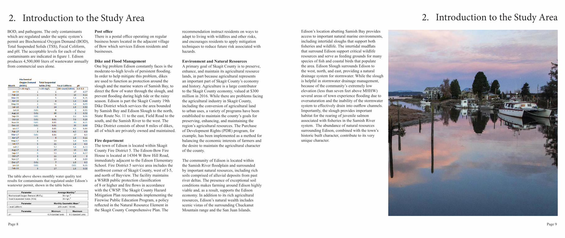
2. Introduction to the Study Area Edison’s location abutting Samish Bay provides access to important natural marine environments, including intertidal sloughs that support both fisheries and wildlife. The intertidal mudflats that surround Edison support critical wildlife resources and serve as feeding grounds for many species of fish and coastal birds that populate the area. Edison Slough surrounds Edison to the west, north, and east, providing a natural drainage system for stormwater. While the slough is helpful in stormwater drainage management, because of the community’s extremely low elevation (less than seven feet above MHHW) several areas of town experience flooding due to oversaturation and the inability of the stormwater system to effectively drain into outflow channels. Importantly, the slough provides important habitat for the rearing of juvenile salmon associated with fisheries in the Samish River system. The abundance of natural resources surrounding Edison, combined with the town’s historic built character, contribute to its very unique character.
The table above shows monthly water quality test results for contaminants that regulated under Edison’s wastewter permit, shown in the table below.

Page 10 Page 11
LAND USE
Infill PotentialInfill potential in Edison is limited. Based on the attached map of Land Value Ratios, there are only a small number of residential parcels classified as vacant or unimproved. This classification is reflected as a Land Value Ratio of “0”, reflecting a building’s value divided by the property value equals zero. These parcels are shown in green on the map. Only four of parcels are fully vacant; two parcels bordering McTaggart Avenue and two parcels on the north side of the Slough. Based on information gained from the community meeting, the two parcels on McTaggart have pre-existing septic hook-ups. These parcels pose difficulty for development because of their proximity to the slough. The green parcels have structures listed such as a double wide trailer and a single family home, but their values are listed as zero according to Skagit iMap and the Skagit Assessors Office records.
Commercial infill potential is also very limited. The northern most group of 4 parcels, shown in yellow, have the greatest potential for development but would be more suitable as an adaptive reuse of the existing structures. One of the parcels within the group is vacant, but may more appropriately be adapted for park or other public uses. The two green narrow parcels located at the bottom left corner of the map are vacant, but an underground utility pipe restricts development on this parcel.
Edison currently struggles with traffic and safety issues from the influx of tourists visiting the
Map Representation of Land Value Ratios in Edison
Land Value Ratio: Structure or Building Value / Property Value = LVR
commercial district. Increasing the amount of development in the area may negatively impact traffic. Urban infill may also threaten to alter the character of Edison, characterized as a tight knit rural community which reflects its community value. The following community priorities section reflects local preferences obtained
during a community planning workshop with residents of Edison. This meeting included a visual preference survey administered to the over 60 participants, as well as in a series of group activities. These activities addressed a variety of community issues.
3. Community Priorities 3. Community PrioritiesVisual Preference Survey
Community Character Participants at the Edison community meeting filled out surveys indicating their preferences of 61 images depicting different types of commercial and residential development, transportation, parks, and other urban design features. They rated each image from worst (A) to best (E). Images consisted of a mix of pictures that included locations in Edison, small towns such as Winthrop and La Conner, and other locations. 43 participants filled out the survey. Participants used Scantron sheets to mark their responses. This presentation informed the design guidelines recommendations presented later in this report.
ResultsThe overwhelming response from this activity is a general preference for maintaining local conditions. For the most part, images of Edison scored very high. These pictures ranged from single family houses to the parking in front of The Old Edison Inn. Other images receiving positive responses included the commercial core district, with 72% disapproval of maintaining lower density in the commercial core. Images of large parking lots scored low. Other land use features such as drive-through commercial businesses and large setbacks were equally disliked. These development features do not currently exist in Edison.
Architectural imagines showed a preference for maintaining traditional styles of building and the use of wood materials. These materials
this range. ADUs were preferred to be located in the rear yards of primary homes. ADUs that complemented the architectural features and styles of the main residence were preferred.
Wider sidewalks that featured street trees, seating, and a variety of businesses were strongly preferred, and rated highest in the survey. The image of the existing raised sidewalk on Cains Court was significantly less preferred. Parks that were small in size scored high, but those containing features such as gazebos were not preferred. Crosswalks also scored very high.
include building siding and shingles. Composite materials such as plastics, concrete and metals were less favored. Modern style street lights were disliked while orb style traditional street lighting were preferred. Planters in public space were favored, along with realistic rather than abstract art. Murals were viewed as neutral.
Residential densities and building scale typically found in Edison were strongly favored. Images depicting urban sprawl and high density housing were strongly disliked. Residential setbacks between 10 and 35 feet were equally favored. The current zoning setbacks in Edison fall within
Page 12 Page 13
3. Community Prioritiesparcels north of Gilkey Avenue had recently been purchased. There was conversation on what types of development would be suitable for this area.
The businesses in Edison’s commercial district largely define Edison’s character. Retaining these businesses unaltered was preferable. There were also noted concerns regarding inadequate parking and excess vehicle speed through this area. This activity reflect many preferences with respect to residents’ opinions on redevelopment and infill potential.
MOBILITY
This section reviews the topics discussed at the community event concerning traffic, mobility, vehicle parking, bike parking, and walking routes around town and to the elementary school. Town residents shared their concerns and recommendations regarding their preference for mobility improvements in Edison. The mobility event included hands-on activities where residents reviewed different maps showing street sections and traffic routing alternatives. Residents were divided into groups to facilitate personal interactions. Once residents finished activities, participants were requested to fill out a survey and a comment section.
Each group was presented with an aerial photograph of Edison and provided dot stickers to indicate problem areas, as well as possible parking lot, bike storage, and pedestrian improvement locations. Participants placed different colored dots on a map to indicate their locational preferences. For this activity,
participants were also provided markers to draw the route their children take to school to help evaluate alternative safe routes to school. Participants explained why their children use specific route to school as well as expressing concerns for their child’s safety when walking to school alongside traffic.
A second activity presented four possible street reconfigurations to Cains Court with corresponding traffic flowcharts along with the existing street configuration. One option showed existing street conditions within its forty-foot right of way. Another option included a one-way, 10-foot wide traffic lane with thirty degree angled parking and 6-foot wide sidewalks on both sides. Another option included two-way vehicle travel with 11-foot wide traffic lanes, an 8-foot wide parallel parking lane on one side, and 5-foot wide sidewalks on both sides. Another option included a one-way, 10-foot wide traffic lane, a 4-foot wide bike lane, 8-foot wide parallel parking lanes on both sides, and 5-foot wide sidewalks on either side. The final option included a pedestrian-only street for Cains Court with 7-foot wide sidewalks on both sides, 5-foot wide green spaces, and 8-foot wide bike lanes running along the center of the right of way. There were four different diagrams indicating changes in circulation that corresponded to each option. After the different options were presented to the group, participants placed green dots on their preferred option.
After each group completed the activities, they were requested to complete a short survey to provide additional comments or note concerns
3. Community Prioritiesregarding mobility in Edison. Shown below are the street sections and diagrams presented at the community engagement event.
ResultsThree mobility activities included a large map that residents used to identify problem areas, vehicle and bike parking opportunities, an evaluation and ranking of proposed traffic flow alternatives, and a survey concerning traffic and pedestrian safety.
The most important outcomes from the activities were the preferences indicated on the large aerial map containing stickers. Red stickers indicated identified problem areas and indicated locations where residents did not feel safe walking or driving. The exercise indicated four locations where residents felt at risk, the most prominent of which is at Gilmore Avenue. Residents felt that this location experienced vehicles driving too fast and suggested reducing the speed limit from 25 mph to 20 mph. This option was considered in this planning study along with other traffic calming methods.
Another locations that residents indicated as concerns included the intersection at Cain’s Court near the Longhorn Saloon. This location might benefit from a traffic calming device as semi trucks occasionally speed along this road segment and intersection. One solution discussed was the introduction of a roundabout, however, participants voiced concern that a roundabout at this location could hinder the movement of fire trucks.
Infill Capacity and Viability of DevelopmentA land valuation ratio analysis activity was conducted in order to evaluate the potential for development infill and redevelopment within Edison’s village boundaries. The activity consisted of an aerial map showing Land Value Ratios (LVR) in Edison. The map was developed using Skagit Assessor’s Office property and improvement data obtained from the Skagit iMap website. The LVR is a metric reflecting the likelihood and viability for redevelopment for an individual parcel. It is based on the economic evaluation of the ratio between a property’s land value against its improvement value. Vacant parcels are shown to have a LVR of zero, as these properties would be the most likely to be redeveloped because the properties would be considered underutilized and opportune for investment.
ResultsThe community expressed a desire to keep urban development infill low. The septic system was noted as a barrier to new development. There is also limited physical space to accommodate infill development in Edison. Two parcels on MacTaggart Avenue were noted to have pre-existing septic hook ups. There was also considerable conversation regarding the accuracy of the data supporting the map. Some of the values and property lines from the Skagit iMap system were noted to be incorrect. The community pointed out better sources of information that helped inform the mapping analysis.
One resident noted that the group of four large

Page 14 Page 15
The third location that was identified as problematic was the sharp turn entering Edison from Farm to Market Road. There have been a few accidents at this location because of poor visibility, the high speed of vehicles entering Edison, and the sharp curvature of the roadway. A fourth location of concern was identified as a stretch of West Bow Hill Road that leads into Edison, and at the intersect of MacTaggart Avenue and Main Avenue. The participants suggested a three way stop sign at this location as a cost effective measure to improve safety until a more permanent solution is identified.
Another component of the mapping activity included the placement of yellow sticker dots to indicate potential locations for public parking lots. There were four locations identified. One was a location on an undeveloped lot near Mariposa and Farm to Market Road. Another popular location was on Gilkey Avenue on an underutilized lot. The third option was a small section of land off of Gilmore Avenue near the farmers market. The last option was near the fire station and elementary school. The third component of the mapping exercise included the placement of blue dots for locations to install bike racks. There were preferences to park bikes on upper Gilkey Avenue, near the Edison elementary school as well as at a location above Mariposa.
The next activity involved the evaluation of street sections and circulation, as well as recommendations received from surveys collected. This activity solicited comments in response to a series of proposed street sections
Existing street.
One-way street with 30-degree, angled parking on one side of the road.
Pedestrian and bicycle boulevard.
One-way street with parallel parking.
Two-way street with parallel parking.
3. Community Prioritiesand circulation routes that were presented. One of the least favored options included the bike and pedestrian-only street section option on MacTaggart Avenue as most participants preferred vehicle access in addition to pedestrian improvements. The most preferred street section option was the two-way street with parallel parking on one side of the street. This option replaces the current configuration of informal parking with a defined system of parking on one side of the road. The second most preferred street section option was the existing configuration, with no change. As for the circulation maps, participants preferred the existing traffic flow. The next most preferred traffic flow option was a one way configuration on MacTaggart Avenue leading to the commercial district of town and a one way eastbound onto Gilmore exiting out of Edison and culminating in a roundabout adjacent to the Edison Elementary School. The results of the survey are shown in the following tables and pie charts.
Conclusion and Preferences The community goal in Edison is to improve mobility and safety throughout the town with particular attention paid to the safety of pedestrians and especially children. Additionally, the community desires to provide parking with safe routes from those areas to the town’s commercial district. The results of the outreach activity and survey indicate a strong preference for traffic calming devices as a means to promote traffic safety in town.
One-way Cains Ct and Gilmore Ave.Existing traffic circulation.
Figure 8. One-way Cains Ct circulation.
MacTaggart-Cains Ct-Gilmore Ave loop. Pedestrian and bicycle Cains Ct circulation.
INFRASTRUCTURE
The topics discussed at the community meeting included the community septic system, the potential for a public rest room facility in Edison, and location options for a public rest room.
Community members shared their concerns and recommendations regarding the current status of the septic system and the potential of expanding the system’s capacity in a facilitated group
3. Community Priorities

Page 16 Page 17
discussion. The main ideas and details brought up were noted on a white board. Participants were also given comment sheets where they could write down any comments they weren’t able to share in the group discussion. At the end of the community event these comment sheets were collected and summarized in a spreadsheet.
Additionally, participants were given two dot stickers and invited to place them on an aerial map of Edison to indicate their top two preferred locations for a public rest room facility, ignoring any limitations such as cost, boundary of the sewer service area, ownership or environmental conditions. Residents were then asked to explain why they had chosen their preferred locations. This created a visual representation of the most popular locations for a bathroom and allowed an opportunity to hear valuable, experiential insights regarding issues, opportunities and usage patterns of each of the proposed locations. Participants also discussed ideas and preferences regarding potential rest room designs and amenities, as well as maintenance requirements.
The goal of the community engagement event was to initiate discussion between members of the Edison community and the planning team to get an idea of general community preferences, concerns, and basic knowledge about the community septic system and potential requirements associated with incorporating a public rest room in the recommended plan.
The distribution of transportation preferences for residents of Edison.
The distribution of traffic calming preferences.
3. Community Priorities
1 Through 5 Rating of... Bike Lanes Needed?
Walking Safety Transportation Flow Street Cycling Average... no
5 5 5 Walking Score yes
4 3 2 2.8 yes
3 2 2 yes
3 3 1 Transportation Flow -
3 3 1 2.7 no
3 1 no
4 4 Street Cycling no
2 3 2 2.6 -
1 1 1 no
3 3 4 no
4 2 4 yes
3 2 1 no
3 4 4 -3 1 2 no5 5 5 no
2 2 3 no
2 2 yes
2.5 2.5 3 no
2 4 5 no
3 3 4 yes
1 1 1 no
3 2 yes
2 4 2 no
2 4 3 no
1 2 1 yes
2 2 2 no
5 4 4 Yes: 8, No: 16
Another important outcome from the discussion regarding limited septic system service was the issue raised regarding who would assume responsibility of the septic system once Edison’s loan to the County was paid off, particularly in the cases of emergency.
In regards to the public rest room discussion, there was a strong agreement among residents that Edison would benefit from a public rest room facility. Many commentaries pointed out
3. Community PrioritiesResultsThe community was generally opposed to expanding the capacity of the septic system as a method for preventing additional growth in Edison. When asked whether or not expansion was possible, many community members responded that it was not feasible to expand the system due to Edison’s status as a limited area of more intensive rural development (LAMIRD). Further research into this limitation is required.

Page 18 Page 19
1 2
3 4
5 6
7 8
that a public rest room facility would need to be self contained as it may not be able to connect to the at-capacity community septic system. Community suggested toilet system options included a composting system, vault system or rented Porta-Potty. In response to questions regarding who would own and maintain the rest room, there was far less agreement among community members. The most common suggestion for assigning responsibility for a public rest room was the county, a commercial businesses association, or the parks department. Additionally it was suggested that maintenance and upkeep could be supported by asking users to provide donations.
After compiling the community’s rest room location preferences into a single digital map, there were three clearly identified preferred locations for a public rest room in Edison. The most desired location was the empty lot adjacent to The Mariposa abutting the slough. The second and third most desired locations were the elementary school parking lot (NW corner) and a privately owned property next to the Mariposa.
Community’s Preferences• Edison prefers not to expand the septic
system’s capacity in order to limit growth.• The community would like a public rest
room within Edison to serve both residents and the growing visitor population. The rest room may be self-contained in the event the septic system icapacity cannot be expanded.
• The most desired location was the empty lot behind The Mariposa.
3. Community Priorities 3. Community Priorities
ENVIRONMENT, PARKS AND TRAILS
In order to gain information regarding the potentials hazard facings the community, a flood mapping activity was employed in order to identify areas of concern regarding flooding based on information received in the community meeting with residents. The goal of the flood mapping activity was to determine whether flooding primarily originates from the dikes surrounding the slough, or as overflow from rainfall events. An overlay sheet was placed over a large scale aerial photograph of Edison, allowing residents to identify where they had experienced flooding and ground saturation.
A visual preference survey was then performed for residents to identify preferences for types of public park and trail amenities the community
would like to see built or enhanced. Images included alternatives for establishing trails on top of existing dike systems, pedestrian bridges to cross the slough, amenities the community might desire for a park system (playground, dog park, etc), and ideas for an athletic track (a traditional running track or a mixed use track with the inclusion of playground activities). Participants were asked questions in reference to each image, and their preferences were recorded.
Results Results of the flood map activity provided valuable insights about the community’s preferences. Residents expressed that the areas of most concern were predominantly affected by rainfall and poor drainage, rather than by overflow from the dikes. Such input was integral to providing knowledge about how the study can better identify remedial actions to avoid future flooding.
Community residents had mixed opinions regarding a trail system proposed to be located along the town’s dikes. Many residents expressed interest in establishing a system of trails nearby for exercise and recreation. Other residents questioned whether such a trail system would be primarily for the use by tourists or by Edison’s residents, indicating concerns about increased tourism that may negatively impact the community. For those that supported the concept of a trail dike system, they tended to prefer natural landscaping and development styles as depicted in photos 1 and 2.
The peninsula on the northwest edge of town
was generally found to be an ideal location for the development of a trail system. There were several concerns voiced about locating the trails on dikes adjacent to residential and commercial lots, and residents cited privacy and noise concerns as two key concerns. They also voiced concerns regarding the feasibility of accessing privately owned dikes for public trail use. Some also suggested that they would like to see a trail leading east out of town toward the post office located in Bow, on Chuckanut Drive. They felt that this was a reasonable idea and that it did not infringe upon property rights or privacy. The trail could be located either along the Edison Slough or along the existing West Bow Hill Road right of way.
There were also mixed opinions regarding the concept of building a pedestrian bridge crossing Edison Slough west of the existing bridge. This concept was proposed in order to address concerns regarding pedestrian safety on the existing bridge, especially for children walking to school. Those who supported the concept for a pedestrian bridge identified Photo 4 on the visual preference survey as their preference. They believed it was important that boats and kayaks could traverse below the bridge. Certain residents suggested that their preferred solution to the issue of pedestrian safety was to widen the existing bridge rather than create a new pedestrian bridge structure. Others felt that building a separate pedestrian bridge to the east of the existing bridge was a preferable alternative.
Many residents supported the creation of at least one park in Edison. A generally accepted park

Page 20 Page 21
3. Community Prioritiesconcept was the creation of an athletic track at Edison Elementary School. This seemed to be preferable to the creation of a new park, as most residents felt that Edison does not lack recreational opportunities. Most of the community also expressed support for a new park to be located on private lands in the northwest peninsula property. Additionally, the idea of a small park located in the gravel lot in the southwest section of town was also identified.
Conclusions and PreferencesThe results from the community meeting serve as guidance for the recommendations contained in this planning study. Project goals and proposed actions reflect the comments, concerns, questions, and preferences provided by
3. Community Priorities
Edison residents as reflected in the community meeting. The study’s approach is to respect the preferences of the community while identifying feasible improvements based on sound planning principles in order to further improve and enhance the unique character of Edison. With this end in mind, improvements are recommended to address flood risk, enhancement of natural resources, and public parks and trails, as follows:
Flood MitigationPrefered Alternative: The most effective method for reducing flooding in Edison is to make improvements to the stormwater system. The majority of flooding in town is the result of poor drainage occurring during times of high rainfall.
Replacing existing culverts with larger culverts could increase the amount of water entering the drainage system and the slough.
Alternative 1: If culvert replacement is not feasible, an increase in maintenance of existing culverts would help to reduce sediment build up and increase the effectiveness of the existing system. Several existing culverts show blockages that may reduce conveyance and create flood conditions. While it is the responsibility of Skagit County to provide culvert maintenance, it is important that private land owners help to ensure that drainage ditches and culverts are free of debris and sediment.
Alternative 2: Replacement of the existing tidewater gate may reduce flooding of the Edison slough. The inadequate ability of the current gate to regulate tides in the slough may contribute to flooding conditions, particularly along the east side of the gate where water gets trapped. Replacing the gate with a more technologically advanced system may remedy the frequency and magnitude of flooding.
Alternative 3: Raise portions of selected road segments in order to reduce the accumulation of water. This alternative would need to be accompanied by an increase in culvert and storm drain maintenance as raising the road may result in an increase of water accumulation in adjacent private yards.
Trails SystemPrefered Alternative: Develop a gravel trail along the dikes surrounding the commercially zoned peninsula on the northwestern edge of town. Development of this trail would provide a place for residents to exercise and define a public pathway for tourists to access natural areas along the slough as well as future commercial businesses on the site without impacting residential properties. This trail was preferred to alternative trail routes because the trail’s entire length is encompassed on one single land owner’s commercially zoned property. The trail would be mutually beneficial to the landowner as it would provide pedestrian accessibility to future businesses located on the property.

Page 22 Page 23
3. Community PrioritiesAlternative 1: Develop a raised pedestrian trail along the slough heading east away from town and extending to the post office at the intersection of West Bow Hill Road and Chuckanut Drive. The trail would require an elevation rise at certain locations in order to avoid flood inundation. The trail could incorporate several small foot bridges that cross the slough.
Alternative 2: Construct a pedestrian bridge parallel to the existing bridge for children to safely access the elementary school. The ability of children to walk the short distance to school safely is a major concern in Edison. A bridge could provide an alternative route without having to walk along the existing roadway that lacks pedestrian facilities.
Parks Prefered Alternative: Develop a standard athletic track in the field behind the elementary school.
3. Community PrioritiesThe track should be accessible to the public. The track may require an increase to ground elevation in order to prevent flooding of the track.
In addition to developing the track, a playground could be developed in the center or adjacent to the track. Having a playground as part of the track would allow parents to use the track for exercise while keeping an eye on their child.
Alternative 1: Repurpose some of the existing park equipment at elementary school in order to maximize use and enjoyment. Some residents indicated that the tennis courts at the elementary school are rarely used. The site could be repurposed to provide more playground equipment for use by children.
Alternative 2: Develop a new public park space on parcels P48512 & P48513 in the commercial district, abutting the slough. These parcels are
privately owned yet unbuildable due to existing underground drainage infrastructure. This space is proposed for use as a small park with limited amenities including picnic tables and landscaping to provide shading on warm summer days.
Salmon Habitat RestorationPrefered Alternative: Replacement of the existing tidewater gate. The current tidewater gate does not allow juvenile salmon to access the upper reaches of the slough and traps those that have made it up steam behind the gate. Replacing the gate with a throttle pipe that is specifically engineered to allow access for salmon while preventing upstream flooding may help to increase salmon rearing habitat.
Additionally, the tide gate regulates the amount of water in different parts of the slough. The improper functioning of the current gate creates conditions where there is often more water to the east of the gate and less water flowing to the west of the gate into the tidal slough at low tide conditions. Improved freshwater flow into the intertidal slough is important in enhancing salmon rearing habitat and may be achieved by installing a more functional tide gate.
Alternative 1: Planting certain species of tree, shrub, and grasses along the dikes. Currently, Edison Slough may have impaired water quality due to runoff from nearby agricultural lands. Specific plant species has been shown to reduce pollutants entering into the waterway to improve overall water quality conditions.
Increased plant cover provides shading along the slough’s edges which reduce the temperature of the water during spring and summer months - conditions critical for the survival of juvenile salmon. Currently, the water temperature is too high during the warm season to support salmon growth. Increased shading is vital to enhancing salmon habitat.
Alternative 2: Building pedestrian bridges as part of a greater trail system across the Edison Slough to create shade conditions to further reduce water temperatures. The bridge could cross of the slough at several junctures in order to maximize shading along a portion of the waterway while enhancing pedestrian access to the marine environment.
Childrens Interactive PresentationChildren who attended the community planning event also had an opportunity to participate in a Childrens’ special design exercise. These activities were hands-on as children were asked to draw their favorite activities. There were seven plastic sheets laid over an aerial photograph of Edison for each of the design activity. These activities included marking where they lived; how they walked to school; their favorite restaurant; and where they liked to play. These locations were each marked on a different layers. They were also asked what kind of recreation activities they would like to see in Edison.
ResultsThe children made it clear the old indoor skate park/half pipe that used to exist in the old lumber yard north of Gilkey Avenue was the
main community center for recreation. They hoped it would return. The kids were action-sports oriented: they favored skateboarding, biking, hunting and fishing. They also noted the playground at the elementary school was in disrepair and in need of improvements. The school grounds and Edison’s interior roads were the only place safe enough to ride bikes because of dangerous traffic on main roadways. There was also a strong desire for a dog park.
When asked about routes taken to school, the children responded that they felt unsafe walking to school throughout Edison’s streets. This was especially true regarding the main roads, including West Bow Hill Road and MacTaggart Avenue, however these were also the routes most frequently taken to walk to school. The speed of cars and lack of crosswalks and sidewalks greatly affect the safety of pedestrian movement in Edison.

Page 24 Page 25
4. Planning Goals and Guidance Land Use
This conceptual land use plan summarizes the land use recommendations for Edison. The land use designations mirrors the existing Skagit County Plan, with the inclusion of three basic land use categories: Commercial, Residential, and Institutional. Purchasing land for a smaller public park is proposed in conjunction with a public bathroom to be located in the southern portion of the commercial district. A trail and park located at the northern edge of the commercial district adjacent to the slough is also depicted along with the clear designation of gateways as formal entry points into town.
The road that runs along Mactaggart Avenue to Cains Court will continue to be the main thoroughfare in Edison. A proposed roundabout at the entrance of Mactaggart Avenue provides traffic calming and represents the eastern gateway into Edison. A southern gateway is located on Farm to Market Road, near a proposed park and public bathrooms along the slough in the commercial district. The following summarizes the plan’s recommended land use and urban design goals for Edison:
CommercialDensity (FAR): Floor Area Ratio (FAR) of future commercial construction should complement current Edison ratios.
Setbacks: Commercial building should complement the historic orientation of commercial buildings in Edison.
4. Planning Goals and Guidance
Design GuidelinesSiding: Exterior surfaces of commercial buildings should complement the materials common to Edison’s historic buildings.
Architectural Detail: Architectural detail should emphasize the historic character of Edison. Artistic expression should be apparent within the architectural details of future buildings.
Building Height: The height of commercial buildings should remain consistent with existing buildings, conforming to Skagit County zoning regulations.
Street AssetsSidewalks: Sidewalks should provide adequate pedestrian access to commercial businesses.
Signage: Signage in the commercial core should maintain the style of existing commercial signage.
Open Space: Public open space should promote recreation and leisure activities for residents and visitors to Edison.
Parking: Public parking should accommodate residents and visitors alike. Parking should be disbursed throughout town and conveniently accessible to the commercial district.
ResidentialDensity (FAR): The Floor Area Ratio should remain consistent with current Skagit County regulations.
Setbacks: Front residential setbacks encourage social cohesion by providing space for front porches and yards to maintain resident privacy.
InfillSmall amounts of low impact infill should be permitted within residential zones. Design Guidelines: Building heights should maintain the current character of Edison and conform to Skagit County zoning regulations.
ADUs: Accessory Dwelling Units (ADUs) should reflect existing historical character of Edison and complement the design of the primary home.
MOBILITYCommunity goals for mobility were derived from the analysis of responses from participants in the community event and reflect a preference for several improvements to mobility conditions in Edison. These improvements include the addition of speed bumps, raised crosswalk, and speed limit signage. There was a strong agreement that the most dangerous intersections were at Farm to Market Road and Cain’s Court, Cain’s Court and MacTaggart Avenue, and MacTaggart Avenue and Main Street. Most participants felt these intersections would benefit from the addition of stop signs.
With respect to accessibility concerns, participants were largely in agreement that there exists a need for providing vehicular parking. Many indicated a desire to see parking provided nearer to the commercial district, however, others voiced support for using the school’s parking lot as supplemental town parking. Improvements for safe pedestrian access to the school was also mentioned as an important priority. Improvements to walking routes would serve the needs of local school children and their families as well as visitors to town. Dog owners also expressed concern for safe pedestrian routes for their pet’s daily walks.
Page 26 Page 27
In considering improvements to enhance safe access routes to school, several concerns were noted. The town lacks safe, well marked, crosswalks causing some families to go well out of their way to cross in places they felt only slightly more secure. The bridge on West Bow Hill Road, in particular, was identified as inadequate for safe pedestrian passage. A number of parents drive their children to school due to the unsafe walking routes, creating additional strain on the transportation system. Participants suggested changing the drop off location at the school in order to ease both vehicular and pedestrian traffic.
Walkability
Vision StatementEdison is an inviting, walkable community with safe and effective mobility systems supporting the movement of vehicles, pedestrians, and bicycles to and through town.
Goal: Improve walkability and create safe walking routes around town and between major attractions and the school.
• Objective: Improve intersection safety, provide well defined paths throughout the community, including marked and well lit crosswalks at intersections and the addition of stop signs at crosswalks
• Objective: Install roundabouts at busy intersections to reduce vehicle speed, improve visibility, and to prioritize pedestrians movement.
• Objective: Accommodate students walking across the highway bridge by installing a pedestrian bridge.
• Objective: Reduce vehicular congestion near the school by providing an alternative drop-off location.
Traffic FlowGoal: Improve traffic flow, reduce traffic speeds and enhance pedestrian safety.
• Objective: Implement traffic calming techniques including roundabouts, narrower streets, and stop signs at crosswalks.
• Objective: Discourage semi-trucks entering Edison with traffic calming techniques to
disincentivizing truck traffic.• Objective: Improve safety at intersections
by installing stop signs, roundabouts, and improved signage.
Public ParkingGoal: Provide sufficient on-street and an off-street parking adjacent to high use locations.
• Objective: Identify available parcels for public acquisition to provide public parking.
• Objective: Encourage businesses to share parking facilities in the commercial district.
• Objective: Realign roadways to more efficiently accommodate on-street parking.
• Objective: Provide signage to direct visitors to designated parking locations.
• Objective: Coordinate with the School District for use of their parking lot during off-school hours.
INFRASTRUCTURE
Limited expansion of Edison’s septic system could accommodate potential future development while preserving the small town character. Incorporating a public rest room facility could relieve local businesses from the burden of providing rest room facilities to visitors.
Septic System Capacity The current septic system is at capacity, meaning Edison may not be able to accommodate any future demand. There exists the potential for limited infill development in Edison, which would require expansion of the current system to meet that demand. The current operation of
4. Planning Goals and Guidance 4. Planning Goals and Guidance the wastewater system field should be evaluated to determine whether there exists additional capacity to serve new uses associated with a the addition of a public bathroom, infill development on vacant/underutilized properties, and the addition of residential accessory dwelling units.
Limited expansion of the wastewater system’s capacity could also provide for all of Edison’s wastewater needs to be addressed under a single unified system, rather than individual on site treatment systems. This would allow for centralized management of wastewater quality to ensure the protection of environmental resources and the public health.
Public Rest Room FacilityEdison’s need for a public rest room was voiced by both community residents and by business owners. In instances of large community events, businesses carry the burden for providing visitors access to rest rooms. A public rest room facility would help to alleviate the burden to businesses.
ENVIRONMENT, PARKS, TRAILS
Flood MitigationGoal: Significantly reduce the amount of flood water that accumulates and creates unsafe conditions along roads and in private yards.
• Objective: Improve the existing stormwater system by replacing existing culverts with increased capacity culverts.
• Objective: Increase maintenance of existing culverts to reduce sediment build up and increase effectiveness of the existing system.
• Objective: Replace existing tidewater gate with a more technologically advanced system to remedy the frequency and magnitude of flooding.
• Objective: Raise portions of road segments subject to flooding.
Salmon Habitat RestorationGoal: Enhance the environmental conditions in Edison Slough in order to create a habitat suitable for juvenile salmon rearing.
• Objective: Replace existing tidewater gate with a gate or throttle pipe engineered to allow access for salmon while preventing upstream flooding to expand salmon rearing habitat upstream of the gate.
• Objective: Plant select species of trees, shrubs, and grasses along the dikes to reduce pollutants entering the waterway, improve water quality, and lower water temperatures.
Trails SystemGoal: Increase pedestrian connectivity through town by providing a safe, walkable path for recreational use by residents and visitors to Edison.
• Objective: Develop a gravel trail along the dikes surrounding the peninsula on the northwestern edge of town.
• Objective: Develop a raised pedestrian trail along the slough extending to the post office at Bow.
• Objective: Construct a pedestrian bridge as part of a trail system to provide pedestrian access to the marine environment.
• Objective: Develop a pedestrian bridge parallel to the existing bridge to provide safe access to school.
ParksGoal: Increase opportunities for public parks and promote access to Edison’s natural features.
• Objective: Develop an athletic track in the field behind the elementary school.
• Objective: Repurpose existing playground equipment at elementary school to maximize use and enjoyment.
• Objective: Develop new public parks in the commercial district abutting the slough.

Page 28 Page 29
LAND USE: RESIDENTIAL DESIGN CONCEPTS
5. Design Concepts: Issues and Opportunities

Page 30 Page 31
5. Design Concepts: Issues and Opportunities 5. Design Concepts: Issues and OpportunitiesLAND USE: COMMERCIAL DESIGN CONCEPTS
LAND USE: RESIDENTIAL DESIGN CONCEPTS

Page 32 Page 33
Alternatives Issues Opportunities
5.1 Circulation
1. One-Way Loop
Unpopular with residents Could streamline traffic flow
Could speed up traffic Diverts northbound through traffic from commercial street
Limits visibility of business to motorists -
2. Partial One-Way Loop
Unpopular with residents Could streamline traffic flow
Confusing Diverts northbound through traffic from commercial street
3. Pedestrian/Bike Boulevard
Unpopular with residents Increases safety of pedestrians in commercial core
Disrupts traffic flow Provides opportunity for multiple uses of Right Of Way
Limits access for deliveries/emergency response services Promotes biking to and in Edison
5.2 Traffic Calming
1. Roundabouts
May require land acquisition to meet ROW requirements Preferred in residential areas
Potential obstacle for emergency response vehicles Less disruptive than 4-way stops
Construction downtime Less collisions than signaled intersections
2. Speed Bumps
Unpopular with motorists Highly effective
Slows emergency response time Cheaper than most traffic calming alternatives
Reduces property values -
3. Street NarrowingConstruction downtime Allows for more street parking
Expensive Slows traffic down throughout the whole community
4. Reduced Speed Limits
Questionable effectiveness Slows traffic down throughout the whole community
Could annoy some through-traffic motorists Cheapest traffic calming alternative
5. Traffic Circles
Construction downtime Preferred in residential areas
Potential obstacle for emergency response vehicles Less annoying than coming to a full stop
Motorist unfamiliarity Improves safety of intersections
5. Design Concepts: Issues and Opportunities
Alternatives Issues Opportunities
5.3 Parking
1. Parking Lot at El-ementary School
Distance to town center/main commercial street Concentrates all off street parking
Requires collaboration with school 2nd most popular alternative with residents
2. Parking Lot at the Top of Gilkey Ave
Doesn’t fully utilize prexisting parking at the school Close to town center
Occasional flood zone Most popular location with residents
Removes potential arts/crafts materials in storage Removes potential junk that’s visually unappealing
3. 30-Degree, Angled, Street Parking
Takes up more room in the Right Of Way Positive response from residents
- Improves organization/adds street parking spaces
4. Marked Parallel Street Parking
Doesn’t increase on street parking capacity Positive response from residents
Difficult for entering and exiting traffic Minimal costs
Can increase congestion Improves on street parking organization
5.4 Pedestrian Pathways
1. SidewalksDisrupts the rustic character of Edison Physically separates vehicles and pedestrians
Requires upkeep Narrows/envelopes the street and increases safety
2. Stop SignsRequires upkeep/intermittent replacement (In preparation for stops) Traffic is slowed
Inexpensive Easy to implement and is minimally invasive
3. Marked Crosswalks
Disrupts the rustic character of Edison Simple and cost-effective solution
Requires upkeep Greater visibility of crossing pedestrians
Can be expensive depending on the design Easy to implement and is minimally invasive
4. School-Time Speed Limit
Signage alone has questionable impact Increases safety of schoolchildren
- Allows for normal mobility during all other times
5. Design Concepts: Issues and OpportunitiesMOBILITYMOBILITY
Page 34 Page 35
MOBILITY
This section describes several design concepts to address circulation, traffic calming, parking, and pedestrian improvements in Edison.
Circulation
One-Way LoopThe one-way loop and other circulation concepts presented at the public meeting did not receive as much support as other mobility options as current circulation patterns were not viewed as major problems. The lack of support for rearranging traffic flows with a one way system was attributed to the perception that such a change would increase vehicular speeds through town.
The benefits associated with a one-way street system is to divert traffic in a counter clockwise direction through the town. A one-way street system would help to facilitate traffic flow through Edison while reducing bottlenecks posed by a two-way street system, especially at key intersections. However, this diversion was viewed unfavorably by residents as it would divert northbound traffic away from the commercial district, along Cain’s Court, thereby reducing the visibility of Edison’s commercial businesses.
Partial One-Way LoopThe partial loop proposal received similar concerns as with the full one-way loop. A partial one-way street option would help to streamline traffic through Edison as it would allows for easier access through Cains Court and Gilmore
Figure 1. Flowchart of one-way traffic alternative with a roundabout at the intersection of MacTaggart, Main, and Bow Hill Road.
Figure 2. Flowchart of one-way traffic alternative.
5. Design Concepts: Issues and Opportunities
Avenue. This traffic flow alteration would divert traffic away from the commercial district similar to the one-way loop alternative. Most residents don’t believe traffic flow is a problem that requires modification. Rather, they indicated that some form of traffic calming would be preferable. There remain concern regarding the intersections of Cains / Mactaggart, Main Street / Mactaggart and at Cains Court / Farm to Market Roads regarding traffic safety. These intersection should be redesigned in order to slow or stop traffic before proceeding through the intersections to mitigation risk of collision.
Pedestrian/Bike BoulevardThe Pedestrian/Bike Boulevard alternative is comprised of a car-free zone where only bikes and pedestrians would be permitted along Cains Court, the commercial district’s main street. This option was the least popular. Traffic rearrangement would limit delivery access on
the commercial street and may present obstacles for emergency vehicle access to the commercial district. Traffic access to Cain’s Court could be mitigated by placing retractable barricades that would allow passage of certain emergency and delivery vehicles. Another concern identified with this option is that the northern portion of the commercial district may be isolated from street accessibility.
Aside from its many drawbacks, this street closure option would significantly increase pedestrian safety in the commercial district, and create a human-scaled streetscape, essentially converting the street to a pedestrian oriented public space which could be expanded to include outdoor seating for restaurants, benches, greenspace, and activity space for children. A mitigating measure could allow only limited periods of closure on Cain’s Court, prohibiting vehicle access only during certain weekend
5. Design Concepts: Issues and Opportunities
An example of retractable traffic bollards for our pedestrian and bike boulevard alternative.
Flowchart of pedestrian and bike boulevard alternative with a roundabout at the intersection of MacTaggart, Main, and Bow Hill Road.
hours in summer months.
Traffic CalmingThe following five traffic calming alternatives represent methods to reduce the speed of traffic in town and to foster pedestrians safety and improved mobility.
RoundaboutsThis traffic calming method serves to slow the movement of cars through designated intersections. Roundabouts require more space and result in disruption to traffic flows during periods of construction. Roundabouts may pose an obstacle to emergency response vehicles. Advantages to roundabouts include less disruption to traffic flow than four-way stops and may be preferable in residential zones by eliminating stop and go acceleration movements.
Speed BumpsThis traffic calming solution alternative could be places where vehicles tend to travel faster than the posted speed limit. Concerns raised about speed bumps include they may be unpopular with motorists and may reduce emergency response time. Speed bumps are an inexpensive traffic calming device that have been shown in many communities to be effective in reducing the speed of traffic.
Street NarrowingThis method includes restricting the width of driving lanes devoted to automobile travel in order to promote a reduction in speeds. Reconfigurations of street widths may result in short term disruption to traffic flows during
construction and the added expense associated with realignment of driving lanes. Benefits associated with this option includes the dedication of more space in the public right of way for on-street parking and pedestrian sidewalks, while promoting slower vehicular movements through town.
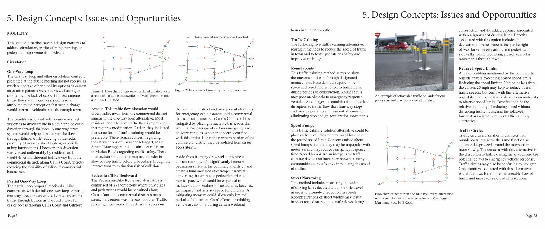
Reduced Speed LimitsA major problem mentioned by the community regards drivers exceeding posted speed limits. Reducing the speed limit to 20 mph or less from the current 25 mph may help to reduce overall traffic speeds. Concerns with this alternative regard its effectiveness as it depends on motorists to observe speed limits. Benefits include the relative simplicity of reducing speed without disrupting traffic flows, and the relatively low cost associated with this traffic calming alternative.
Traffic CirclesTraffic circles are smaller in diameter than roundabouts, but serve the same function as automobiles proceed around the intersection more slowly. The concern with this alternative is the disruption to traffic during installation and the potential delays to emergency vehicle response. Traffic circles may also be confusing to navigate. Opportunities associated with this alternative is that it allows for a more manageable flow of traffic and improves safety at intersections.

Page 36 Page 37
5. Design Concepts: Issues and OpportunitiesParking
Elementary School parking lot This alternative provides the lowest cost option for providing public parking, and was strongly supported by residents. The benefits associated with this option is that the parking lot currently exists, therefore no new construction would be required, other than obtaining approval from the school district for use during times that do not conflict with school activities. When combined with other parking options presented below, the school parking lot could serve as an auxiliary parking space to accommodate overflow parking demand, particularly during summer months when the school is closed. Negative aspects of this alternative include the greater distance required to reach the commercial district.
Parking Lot at Gilkey AvenueThe most popular location selected by residents is a site located on Gilkey Avenue due to its close proximity to the commercial district. Currently, the site is underutilized. Several concerns were raised associated with this alternative, including the susceptibility of the site to flooding, which may be aggravated by the addition of impermeable materials to provide a more permanent parking surface. This option would require either public acquisition of the site for public parking use, or other arrangements with the property owners to obtain parking use rights.
30-Degree Angled Street ParkingThis alternative would provide additional parking without the requirement of acquiring land. Benefits of the street realignment option include
the low-cost for implementation and locational advantages of additional parking that is provided nearby the commercial district. By installing 30-degree angled parking, an additional benefit includes the traffic calming affected associated with backing up from parking spaces and the narrowing of traffic lanes. This option can be implemented alone or in conjunction with other parking lot solutions.
Marked Parallel Street ParkingSimilar to the 30-degree angled street parking option, this alternative would entail minimal costs because the right-of-ways in Edison currently accommodate parallel street parking. This parking option aims to more efficiently manage on-street parking spaces by designating vehicle spaces. Drawbacks associated with this alternative include the small increase to existing parking capacity.
Pedestrian PathwaysThe following options are intended address improvements to pedestrian safety.
SidewalksMost residents expressed a desire to establish continuous sidewalks, especially along MacTaggert, Cain’s Court, and Main Avenue. Concerns associated with this option include a potential reduction of parking spaces to accommodate sidewalks and a change to the community’s rural character. Benefits may include traffic calming if street widths are narrowed to accommodate sidewalks, and the separation of pedestrian movement from automobile traffic to enhance pedestrian safety.
Stop SignsStop signs were identified for key intersections. Installing stop signs at MacTaggert and Main Street was the most commonly mentioned traffic calming option. Problems associated with the installation of stop signs include the potential for increased vehicular congestion. Benefits include the low cost associated with this option compared to other, more expensive, traffic controls such as roundabouts or stop lights.
Marked CrosswalksThe most frequently identified improvements by residents was for the installation of well marked, designated crosswalks throughout Edison. There are numerous options for designing crosswalks ranging from costly “smart crosswalks” with integrated lighting features, moderately costly designs consisting of raised crosswalks, to relatively inexpensive designs consisting of painted street crossings. Benefits associated with this option include the ease of implementation for improving pedestrian street crossing. Associated costs related to this option include the need to install accompanying sidewalks with handicap accessibility at designated crosswalk intersections.
School-Zone Speed Limit SignageThe implementation of a reduced school zone speed limit has had limited effect of calming traffic in Edison. Improving the signage at school crossing zones could aid in traffic calming. A more effective alternative is to provide a secondary school drop off location for parents who drive from eastern locations. This secondary drop off could use the bus entrance with minor modifications to accommodate buses and cars.
5. Design Concepts: Issues and OpportunitiesINFRASTRUCTURE
Community Wastewater System Wastewater from homes and businesses flows into either a 1000 gallon or 1500 gallon on site tank for the separation of effuent. The effluent from the tanks then is pumped into a sanitary sewer main and pumped to the community treatment facility. Effluent passes through a flow meter vault and enters a recirculation tank and pump chamber where effluent is further processed in a gravel filtration system. After initial processing, the effluent enters another recirculation and settling tank to facilitate final separation of particulate matter from the effluent. The final step in treatment is UV disinfection before the treated effluent is pumped into the drain field. This drain field comprises a system of drip disposal allowing for the controlled infiltration to the soil.
The community of Edison voiced concern against an expansion of the wastewater system. The most frequent reasons voiced concerned the desire to minimize future growth in Edison.
The current system is considered to be operating at or near its design capacity, therefore unable to serve future infill except for seven service connections reserved for residential parcels not currently connected to the system.
The following chart and table show the monthly average and peak flows for the past two years. On multiple occasions Edison’s wastewater flows into the system have exceeded the permitted 20,000 gal/day. Residents who have their
Figure 4. Map of possible parking lot locations. The four yellow circles are where the community expressed interest in parking lots. “A” is the elementary school parking lot and “B” is where the parking lot at the western end of Gilkey Ave could be located.

Page 38 Page 39
measures to reduce current flows, or the planned limited increase to the system’s capacity to accommodate the few potential future users. Incorporating all of Edison users in a unified wastewater system would represent a more sustainable alternative by allowing a single system of operation and maintenance, and facilitating a water quality monitoring program that ensures statewide environmental standards are met. If expansion is determined to be the best alternative to meeting future demands in Edison, capacity expansion could be carried out by expanding the current drainfield, allowing a greater volume to be distributed into the system. This would first require an evaluation of how much increased capacity is needed and the possible acquisition of additional land to
accommodate an extended drain field and the installation of additional test wells.
Currently, it appears that Edison’s drain field may be sufficiently large enough to accommodate increased flow. A second consideration would be to examine the feasibility of installing additional treatment technology to further treat effluent prior to it passing through the gravel filter, thereby increasing the system’s capacity as effluent quality would require less
treatment at the drain field. These systems improvement options may be determined too expensive to be practical and further research is recommended by the county’s Public Works engineer. Each alternatives, however, would allow Edison to expand its service area to include current off system properties as well as potential new commercial development as the addition of ADUs.
Community Public Rest RoomsThe Edison community has identified the need for a public rest room as an important priority. Currently, the burden of not having a public rest room available in Edison falls largely on commercial business owners, especially during the high tourism seasons. If Edison were to expand its wastewater treatment system, it could install a new connection to serve a public rest room. If system expansion is not feasible, a future public rest room would have to be self-contained. There are three types of public toilets presented in this report that could serve Edison’s needs. The first alternative consists of an enclosed vault system requiring the installation of a large underground tank and above-ground toilet structure that would require
periodic pumping. A second alternative includes a composting system. While environmentally friendly, a composting system requires more frequent maintenance to aerate the chamber and the removal of final composted products. Both of these options would include permanent structures. The third option is to rent a Porta-Potty. Representing the least-cost option of approximately $175 to $500 per month for a 60-250 gallon capacity unit. This alternative does not require maintenance other than occasional cleaning. This option is intended for seasonal use, with removal during the winter period.
Public Rest Room LocationsThe community identified the three most preferred locations for a public rest room. The preferred location identified is the empty lot directly west of the Mariposa, adjacent to the slough. This lot would require public acquisition. It is located in Edison’s commercial district making its location very convenient to visitors. Other identified locations include the right of way next to the Mariposa and the northwest corner of the Edison School parking lot. The ROW next to the Mariposa is privately owned which would require public acquisition. The school parking lot would require permission from the Burlington-Edison School District. Its location is farther from the commercial district, but close to the farmers market and playground, and where the community plans to build a recreational track.
5. Design Concepts: Issues and Opportunities5. Design Concepts: Issues and Opportunitiesdownspouts connected to the system or have loose septic tank covers that allow rainwater to enter the tanks can be potential causes of increased peak flows, particularly during high tides and high water table or flooding.
Potential future users include the commercially zoned properties located north of the commercial district, seven residential parcels, the possible addition of public rest room facility, and the potential for 5-10 accessory dwelling units (ADUs). By not expanding the system’s capacity, each of these potential new uses would be required to individually meet their wastewater treatment requirements. Issues regarding limiting the system’s capacity to current levels of services include the inefficiencies associated with multiple sewerage systems and the benefits associated with managing a single, community system that meets both present and future wastewater treatment requirements.
An alternative recommendation includes developing additional plant capacity, either through the introduction of conservation

Page 40 Page 41
Vault Toilet
This self-contained system requires the installation of an underground chamber which would require periodic pumping each month depending on the size of the vault and the frequency of usage. A 750 gallon vault serves about 11,000 uses; 1,000 gallon vault has the capacity to serve about 15,000 uses. This would provide a permanent solution, requiring regular maintenance as well as periodic pumping.
Composting Toilet
A composting toilet uses an all-natural process of decomposition to turn liquid and solid waste into its natural by product. Waste material is collected in an above ground chamber and mixed with a carbon based source such as saw dust. This system would require a moderate level of maintenance in order to aerate the chamber and remove the final product. This alternative would serve as a permanent rest room structure that would not need to be connected to the community wastewater system.
Porta-Potty
Edison could rent a Porta-Potty based on its seasonal tourism needs. The average cost to rent one is about $175 to $500 per month, but main-tenance would be included in the rental price. The average Porta-Potty has a capacity of about 68 gallons, meaning Edison may have to rent on a more frequent basis. It is recommended that two Porta-Potties are suffieient for an eight-hour event with less than 50 people. This alternative would be easy and convenient to install. There is flexibility in terms of how many units would be needed.
5. Design Concepts: Issues and Opportunities 5. Design Concepts: Issues and OpportunitiesRecommendations
Conservation MeasuresThe most cost efficient way to expand the sewer systems capacity is by employing water conservation measures to reduce current sewerage demand to provide additional capacity to serve future users. The county should engage the services of a consultant to evaluate cost effective measures for residential and commercial users to estimate the potential reductions to wastewater associated with the application of various conservation methods.
Sewer Capacity Limited ExpansionThis study recommends an increase to the capacity of wastewater system in order to support a modest level of urban infill within Edison’s service area. Thinking sustainably about the future of Edison, this recommendation helps to mitigate potential environmental and public health risks by eliminating multiple wastewater systems and relying instead on a single publically managed system capable of meeting both present and future demand.
Public Rest RoomsWith respect to meeting the need for a public rest room, and assuming an expansion of the wastewater treatment system capacity is feasible, the plan recommends the connection of a new public rest room facility to the sewer system.
If system expansion is not deemed feasible, the public rest room would be required to be self-contained. In that event, it is recommended to either install a permanent vault or composting
toilet system, or renting a Porta-Potty on a seasonal basis. The selection of alternative public rest rooms is largely dependent upon cost considerations, maintenance requirements, and preferences regarding the installation of a temporary or a permanent rest room facility.
The recommended location for a public rest room is the land parcel located adjacent to the Mariposa, abutting the slough. This site was identified as the highest ranked location by the community, as it is located closest to the commercial district. The plan recommends Skagit County acquire the parcel and designate it for public use to support multiple community needs, including the accommodation of a public rest room, the creation of a public open space and/
or community park, and to provide a location for public visitor parking.
ENVIRONMENT, PARKS, TRAILS
The following matrices present alternatives for flood mitigation, trails, parks, and habitat enhancement in Edison, along with the issues and opportunities associated with each design alternative.
Flood MitigationThe proposal for flood hazards mitigation contains four alternative recommendations (many of which have been adapted from the Edison Slough Drainage Improvement Plan) which may assist in alleviating the overflow

Page 42 Page 43
and saturation conditions that the community currently experiences.
Alternative 1 proposes the implementation of a stormwater vault within the vicinity of Cains Court and MacTaggart Avenue to collect and retain excess stormwater that currently collects along the street. The stormwater vault alternative provides a solution for mitigating street flooding experienced in Edison.
Alternative 2 proposes placing a stormwater pump system so that flood waters may be effectively pumped into Edison’s drainage system and deposited at an outflow to Edison slough. However the proposal may meet community resistance because the prime locations for locating the pump system may include privately owned property.
Alternative 3 proposes elevating the currently existing roadways (MacTaggart in particular) and enhancing the current drainage system to facilitate positive drainage flow, similar to Alternative 2. The cost for developing the street elevation change and drainage system improvements may likely be high, and in instances of high-tide flooding conditions, may prove ineffective at reducing local ground saturation.
Alternative 4 proposes incremental enhancements to Edison’s current drainage system. It has been noted in the Edison Slough Drainage Improvement Plan, as well as by local residents, that the current drainage system and floodgate function adequately for the majority of the year. However when high rainfall conditions occur, or the floodgate fail to operate correctly, the results can be severe flooding. Therefore, routine
maintenance is recommended to be performed more frequently.
TrailsThere are four locations for the location of potential trail development in and around Edison. Alternative 1 includes a trail along the privately owned commercially zoned northwestern peninsula of town. The trail could either be developed on top of the existing dike or a small boardwalk could be constructed over the slough adjacent to the dike. The total length of the trail would extend approximately 1,400 feet. One significant opportunity is presented by the current property owner who has indicated an interest in developing on or near the dikes to facilitate public access to future businesses that may be developed at the site. Siting the trail on a commercially zoned property minimizes privacy conflicts compared to siting the trail on or adjacent to residentially zoned properties, alleviating concern voiced by residents. Negative impacts associated with this trail proposal would be mitigated pursuant to permit compliance measures under the County’s Shoreline Master Plan.
Alternative 2 proposes the construction of a trail that begins at the bridge at West Bow Hill Road and leads directly east, ending at the post office at the intersection of West Bow Hill Road and Chuckanut Drive. Many residents indicated this as a desirable route given the absence of pedestrian sidewalks and crosswalks along West Bow Hill Road. This trail may require a raised boardwalk in order to prevent inundation from flooding that occurs along the slough. The trail
5. Design Concepts: Issues and Opportunities5. Design Concepts: Issues and Opportunitieswould extend approximately one mile long. One issue identified with this proposal is that constructing a raised boardwalk trail of this length would be expensive. Additionally, the trail would cross several private properties requiring owner permission or the purchase of public access easements.
Alternative 3 proposes access to the agricultural field located behind the elementary school. Benefits associated with this option include ample available open space for trail development that is currently owned by the school district, and vast scenic views that residents and visitors may enjoy. The trail may require elevation using infill soil or a built physical structure as the field is chronically wet.
Finally, Alternative 4 proposes a trail system adjacent to county roads outside of the Edison. This proposal provides opportunity for an extended trail system in excess of a mile. It could provide both residents and visitors a trail to enjoy the surrounding agricultural fields. One major safety concern associated with this proposal is that a trail would be located along county roads with high speed limits which may pose danger to pedestrians.
ParksAlternative 1 proposes establishing a park on the privately owned land on the peninsula. This location has ample space for a park, as the owner is limited from certain building on land adjacent to the shoreline under SMA regulations and may be agreeable to either selling or dedicating a parcel for public park use. An agreement with the
property owner would require negotiation with the county.
Alternative 2 proposes the creation of an athletic track located on property owned by the Edison-Burlington School District. Residents have indicated interest in this concept, and a nonprofit organization has been created to locate funding for the track. A track would likely be highly utilized by children and community adults alike who desire a safe space to recreate. However, high construction costs may present a limitation as the field is often saturated, and the track may
be require to be raised to avoid flooding.
Alternative 3 proposes the enhancement of a small park that is currently located at the school. Residents expressed concern that the current park is inadequate and could benefit from an upgrade. This proposal may represent the most cost effective and feasible solution to meeting the community’s desire for an improved park since the land is currently devoted to park use and the existing structures would require few improvements. Negative factors for investing in park improvement at this site include its distance

Page 44 Page 45
from the commercial district compared with other site alternatives.
Alternative 4 proposes to establish a small park on the two small gravel lots located in the southwest section of Edison’s commercial district. This park could contain several benches, tables, and other amenities. It would provide visitors a public place to enjoy scenic views along the slough. The proposal would require acquisition by the county.
Habitat EnhancementThe Edison slough provides opportunities for enhancing habitat values to support the rearing of juvenile salmon entering the marine waters of Samish Bay. Methods to increase its natural
productivity for fish and wildlife include the following recommendations: the replacement of Edison’s tidal gate with a “fish friendly” throttle pipe or improved tidal gate to allow fish passage; improvement to the riparian buffer; development of policies and educational programs promoting the function of fisheries habitat sites; and the construction of a pedestrian bridge or other means to provide increased public access and shading to reduce water temperatures.
Alternative 1 proposes the replacement of the current tidal gate to provide for passage of juvenile salmon rearing upstream of the slough. An engineered throttle pipe would allows fish to freely traverse from the intertidal slough into drainage sloughs currently located upstream of
the tidal gate. A passage would also increase habitat quality by allowing a mixture of salt water into the freshwater slough, expanding the area supporting fisheries rearing habitat. While this improvement could be extremely beneficial to improving habitat resources, it would require a both substantial investment as well as a reconciliation of current Skagit County policies that exempt drainage infrastructure from environmental requirements.
Alternative 2 proposes the planting of a riparian buffer to further improve fisheries habitat. This alternative may require public acquisition or the purchase of a conservation easement. Planting of a vegetative buffer requires careful selection of plant materials that would not pose risk to existing dikes. A riparian buffer would serve to enhance the availability of food for fish and enhance water quality by lowering temperatures and providing a buffer between human activity and agricultural practices and the slough.
Alternative 3 proposes the introduction of best management policies and educational programs to encourage knowledge about the natural functions associated with the intertidal slough. Educational programs promoted through the school and volunteer groups can result in assisting the public to become invested in habitat management and enhancement. The scope of best management practices should address farming practices that reduce harmful affects to intertidal water quality as well as the mitigation of human disturbances to fish and wildlife habitating the slough environment.
5. Design Concepts: Issues and Opportunities5. Design Concepts: Issues and OpportunitiesAlternative 4 proposes the construction of a pedestrian bridge to provide increased shading and promote greater pedestrian access to the slough. Increased shading helps to lower water temperatures during warm months when juvenile salmon utilize the slough for rearing. Coupled with this habitat improvement benefit, a pedestrian bridge would provide a safer pedestrian access to Edison’s commercial areas.
ConclusionDeveloping a park on the gravel lots located in the commercial district (Parcels P48512 & P48513) is the recommended alternative. These lots are centrally located within Edison’s commercial area to promote residents and visitors access to the slough and a place for rest and enjoyment. This recommendation was supported by resident at the community meeting that indicated preference for a small park within the commercial district. The relatively low cost of land acquisition and construction of park amenities would suggest this option as the most feasible. Additionally, this site can also accommodate a public bathroom as well as provide for needed public parking.
The replacement of the current tidal gate in
the Edison Slough with a fish-friendly throttle pipe or an improved tidal gate is the preferred alternative. The objective of expanding fisheries rearing habitat and improving the water quality of the slough can be achieved by providing for salmon passage into the drainage sloughs located upstream of the tidal gate. Currently, the tide gate does not work efficiently and prevents fish passage. Replacing the gate with a throttle pipe will allow juvenile salmon to move freely between the bay to reach intertidal habitats beyond the tidal gate. Upstream flooding would be prevented by correctly sizing the pipe in order to allow a limited amount of marine water to enter the drainage slough. Planting a riparian buffer, creating policies and environmental education materials, and building a pedestrian bridge across the slough are each achievable solutions to help increase the habitat quality of the slough.
The preferred alternative for trail development include the construction of a trail along the dike surrounding the commercially zoned property located on the peninsula immediately to the north of the commercial district. This option would require cooperation with the current property owner and the possible acquisition of a conservation easement. The trail would benefit both residents and visitors to Edison by providing public access to the slough as well as a pedestrian trail connecting the commercial uses to surrounding scenic views.
The construction of a stormwater vault is identified as the preferred alternative for alleviating stormwater flooding. Although
Example of a stormwater vault
potentially costly, a stormwater vault could provide a cost effective solution to reduce stormwater flooding on streets. The current flooding situation that Edison experiences would likely be reduced by collecting excess stormwater and diverting the water into the slough. The ideal location of siting the vault include the vicinity of Cains Court and MacTaggart Avenue which is currently experiences high levels of saturation and poor drainage.

Page 46 Page 47
6. Community Planning Strategies
may increase the amount of impervious surfaces in an area prone to flooding. ADUs should be permitted as a pilot project by issuing a limited number of permits.
Commercial
Density (FAR): Commercial floor-to-area ratio currently range between 40%-60%. The floor-to-area ratio (FAR) of future commercial construction should complement current Edison historic standards. The unbuilt portion of commercial properties may accommodate limited expansion, particularly to accommodate outside seating along the slough. This action is recommended in order
LAND USE
InfillInfill in Edison helps to reduce sprawl in surrounding rural areas. The vacant residential parcels on MacTaggart Avenue should be prioritized for development because of pre-existing septic hook-ups. The new housing should be consistent with existing character and style of Edison’s residential housing stock. Low Impact Development (LID) techniques should be utilized because of the proximity to the Slough and susceptibility to flooding.
Opportunities for commercial Infill is also limited. There are two narrow vacant lots located
on the slough in the commercial district. Due to an underground utility drainage pipe, commercial development is not possible. This area should be acquired and utilized as park space. The four large parcels in the northern-most section of Gilkey Avenue should be prioritized for reuse. Adaptive reuse of the buildings should be encouraged. This large area should also feature public parking along with park space opportunities.
Certain parcels in Edison that feature larger yards could be suitable for Accessory Dwelling Units (ADUs). ADUs work to increase housing stock. ADUs should be small in size and should complement the primary structure. ADUs also
6. Community Planning Strategies
to enhance public access and visibility to the waterfront. Future infill in commercially-zoned land therefore should include seating and social areas oriented toward the rear of the property, hidden from street traffic and oriented towards the slough. This recommendation involves increasing future commercial density from current Skagit County standards. Setbacks: Commercial building fronts should be built to the sidewalk/street front.
Commercial building should maintain zero setbacks from the sidewalk or street front. This recommended action complements the historic orientation of commercial buildings in Edison. There should be no side setback between buildings within the commercial zone. This serves to increase pedestrian mobility, and increase the connectivity of commercial businesses. Uses in rear setbacks abutting the slough must comply with the Shoreline Management Act (SMA). For all properties not abutting the slough, the plan recommends a 10’ to 20’ setback consistent with current Skagit County regulations.
Design GuidelinesExterior Siding: Exterior commercial building surfaces should complement materials common to historic Edison. This includes the use of natural materials such as painted wood siding, shingles, and brick. It is desirable that exterior siding include horizontal
shiplap siding.
Building Height: The maximum commercial building height should not exceed 35 feet. The maximum height of a commercial building in Edison should remain consistent with current Skagit County regulations. This includes limiting commercial building heights to 35 feet. Frontal facades are strongly encouraged along Cains Ct. to complement the existing character of Edison businesses. Where frontal facades are not used in commercial settings, the use of barn-style roofs is encouraged.
Street AssetsOpen Spaces: Small-scale “pocket parks” and public spaces for outdoor recreation are encouraged. Publical welcoming open spaces are desirable, especially in the development of small-scale pocket parks. Small public areas featuring seating, picnic tables and outdoor recreation activities are encouraged. Businesses located on the slough should mass the building towards the street and create useable open spaces oriented toward the slough. Where there is sufficient space, parks should

Page 48 Page 49
feature a children’s playground or skate park.
Parking: Public partnership with Edison Elementary School for commercial parking accommodations. To help accommodate the influx of tourism throughout the spring and summer seasons, the plan recommends a parking partnership with the school. In accordance with future transportation improvements, the existing public parking located at the school should be integrated as part of an overall community parking plan. This potential parking solution involves less than a 1/4 mile walk for commercial patrons, and will help increase pedestrian mobility throughout the village. Additionally, on-street parking accommodations should continue to exist. In terms of future commercial development, we recommend no on-site parking requirements.
Signage: Encourage painted, wooden signs.Signage in the commercial core of Edison should maintain the style of the existing signage. Currently, signage is characterized by painted, wooden signs mounted on the side of the building. Signs are often used to reflect the nature of commercial activity and often include illustrations. Many of the signs are mounted at eye level, hearkening to the walkable scale of Edison. Neon or electric lettering should be prohibited. Signs should not exceed 10’ by 5’.
Public Art: Encourage public art, especially by local artists. Public art is encouraged, especially art that features local artists or emphasizes the natural environment around Edison. Future development
and public works projects are encouraged to include public art in their designs. These actions are intended to enhance the built aesthetics and create a sense of place reflective of Edison’s character.
Lighting: Street lights should include historic light fixtures. Street lights contribute to the safety and visual appeal of the streetscape. Current street lights in Edison are unpopular. Future street light installations should feature historic lighting, such as orb lamps. In addition, lighting should be shielded to minimize light pollution. Street Furniture: Benches and planters should be made from natural materials.Street furniture should be provided along sidewalks and other public spaces. Furniture should express the artistic character of Edison and should be made from local, natural materials.
6. Community Planning Strategies 6. Community Planning Strategies
This creates an attractive street front, and encourages further pedestrian and public use of commercial sidewalks. Street furniture will increase the mobility of the community as well, providing areas to sit, relax and take in everything that Edison has to offer.
Sidewalks: Encourage street furniture and trees. Sidewalks should provide pedestrian access to commercial businesses. Sidewalks should abut the front of commercial structures and be sufficiently wide to accommodate street furniture and street landscaping. This action will increase the pedestrian mobility of the community. Additionally, this improves the overall connectivity and walkability within the commercial core.
Residential Density (FAR): Residential floor-to-area ratio should not exceed 40%.

Page 50 Page 51
6. Community Planning Strategies 6. Community Planning Strategies
Future residential construction in Edison should complement the density of existing residential buildings. Therefore, the recommendation is that new buildings not exceed a FAR of 40% for the main structure on a parcel. If a property owner opts to build an Accessory Dwelling Unit (ADU) on their residential parcel, the FAR of both structures together should not exceed 60%. The intent of this recommendation is to maintain the existing character of the residential areas in Edison, while allowing for minimal low-impact infill.
Setbacks: Front residential setbacks should not exceed 30’.Future residential construction in Edison should include front building setbacks that do not
GatewaysGateways are an important marker of a town’s identity. They are the first visible signs visitors see when entering a town and the last when they leave. The recommendation for the town is to establish aesthetically pleasing and functional gateways at the two entry points in town. Along with the recommendation of a traffic circle, there could also be an art piece placed in the center that reflects the community’s character or with signage indicating that travelers have entered the town of Edison. For the gateway without a traffic circle, the recommendation is to add signage indicate the entrance to town.
exceed 30’ from the street right of way. This will aid in maintaining the historic character of Edison by maintaining a uniform residential streetscape.
Design GuidelinesBuilding Height: Residential building height should not exceed 25’.Future residential construction in Edison should not exceed a height greater than 25’. Currently, existing structures in residential zones do not exceed two stories. The intent of this recommendation is to maintain the historic character of Edison’s residential neighborhood.

Page 52 Page 53
MOBILITY
Pedestrian Pathways
Safe Routes to SchoolTo create safe routes to school, the plan recommends a three part strategy to enhance designated areas for pedestrian use: 1) continuous sidewalk on south side of MacTaggart, 2) designate MacTaggart-Skagit-Main-Edison School Road route with signage and/or symbols painted on street, and 3) expand west side of bridge over slough for pedestrian use.
Extending the sidewalk from Cain’s to Main along the south side of MacTaggart provides clear passage through the town along the most popularly traveled route. Placing the sidewalk in this location also provides a route from the school parking lot to the commercial district of Edison. The route should be marked with signage to indicate that it is a school walking area and that motor vehicle operators should use caution when traveling adjacent to this route. Expanding the west side of the bridge over the slough is necessary to provide safe passage for pedestrians. If this determined not to be feasible, a secondary pedestrian bridge should be installed.
WalkabilityTo improve the perception of safety and comfort of pedestrian passage we recommend the following additions:1) three new, painted crosswalks at entries/exits to roundabout, 2) three-way stop & crosswalk at MacTaggart-Cains-Gilkey, 3) raised crosswalk across Cains between Tweets & Hedgerow (corner store), 4)
raised crosswalk across Gilmore to east side of Ewings, 5) crosswalk across Gilmore by The Old Edison, 6) continuous sidewalk on west side of Cains, and 7) stop sign for northbound on Farm to Market.
Routes to SchoolThree painted and raised crosswalks provide safe crossing at the roundabout on W. Bow Hill Rd., MacTaggart, and Main. A new three-way stop at MacTaggart-Cains-Gilkey calms traffic passing through the primary commercial district and generates greater pedestrian awareness to motor vehicle operators. Crosswalks at this intersection provide safe access to the sidewalk along the south side of MacTaggart and to the entire commercial district. Raised crosswalks
6. Community Planning Strategies 6. Community Planning Strategies
Overview of pedestrian pathway modifications.View across roundabout to Edison.
Bird’s-eye view of 3-way stop and crosswalk at MacTaggart, Cains, and Gilkey (looking Southwest).
between Tweets cafe and Hedgerow, and from Gilmore to the East side of Ewings provide both increased pedestrian mobility and traffic calming through the areas that experience both the fastest traffic and densest pedestrian activity. A crosswalk from the east side of Cain’s to the south side of Gilmore provides safer access to the S.K.A.T. bus stop on Gilmore. Continuous sidewalk along the west side of Cain’s will improve the perception of safety and increase sense of place for pedestrians. Placing a stop sign at the northbound corner of Farm-to-Market Rd. and Gilmore is intended to slow trucks that might pass through Edison to avoid weigh stations as well as possibly discourage them from using this strategy in the future. It will also encourage drivers to enter Edison with a greater degree of pedestrian awareness.
Vehicular CirculationThe plan recommends that the directional circulation of Edison remain the same, however the following changes should improve the overall flow of traffic as well as alleviate some of the congestion experienced during peak traffic times.
RoundaboutTo simplify the intersection of Bow Hill Road, MacTaggart Avenue, Main Street, and Edison School Road, a roundabout was modeled to replace the replace and augment stop signs currently directing traffic flow. A roundabout allows all four streets to function as single, unifying loop; the roundabout also allows drivers to head back to the road where they entered the intersection without having to navigate additional streets in town - a natural “U-turn” facilitated
= Stop Signs= Crosswalks= Raised Crosswalks= Sidewalks= Roads Marked as Safe
Overlay of pedestrian pathway additions/modifications.

Page 54 Page 55
and end of the school day.
Parking
Lot Behind MariposaThis small lot behind Mariposa can provide about 10 parking spots at either 90 degree or 30 degree angled parking. This location is also proposed to support a public rest rooms. A parking lot behind Mariposa also provides close walking accessibility to the commercial district, and should provide spaces for handicap parking.
On-Street ParkingMarked parallel parking on 2 sides of Cains Court.This proposal allows for more efficiency than current as parking spots will be marked. Another benefit to this is it narrows the road slightly and will force vehicles to move slower as they watch for people backing out of spots. Cains court will remain sufficiently passable for delivery and fire trucks. This should disincentivize semi trucks from entering Cain’s Court.
Marked parallel parking on north side of MacTaggart. This option will reduce parking on the south side of Mactaggart to provide sidewalks on both or one-side of the street. The measure will provide Edison with the benefit of a continuous sidewalk connecting the commerical district to the elementary school.
Bike ParkingBike racks are proposed to be included in the proposed park and parking lot behind Mariposa. The bike rack can securely support 5-7 bikes.
6. Community Planning Strategies 6. Community Planning Strategies
Overview of proposed school drop-off.
by the circle. It is safer for automobiles than the current layout, yet it only slightly impacts the speed of traffic through the intersection. GatewaysMonumental gateways at the north and south entry points to Edison welcome visitors and increase sense of awareness and caution in motorists. W. Bow Hill Rd. should have a reduced speed limit sign, “roundabout ahead” sign, and rumble strips on the road to alert drivers of the new infrastructure and pedestrian crossings. Farm-to-Market Rd. should be equipped with a “reduced speed limit ahead” sign, rumble strips, and a “prepare to stop” sign to warn drivers of the new stop sign as they approach the corner.
School Drop-OffThe study recommends parents drop their children off at school, approaching from the east, enter by the same route as the buses. Removal of parking across from the school’s entrance and the widening of existing lanes provides enough space to create an exit only lane between the entry and drop off lanes. To increase safety of students, children should only exit cars at the curb side and parents pull forward to the designated car drop off location near the playground area. Busses should disembark children curb side behind cars to maintain maximum visibility of children. Once children have exited the vehicles, drivers may pull to the exit lane and leave the school grounds via the driveway they first entered. This recommendation is intended to significantly reduce congestion along MacTaggart and Main Streets at the beginning
Closeup overview of roundabout. Proposed circulation flowchart on Edison streets.
Northern (above) and Southern (below) Gateways
Street Section of Cains Court, facing North. Section cut from between Tweets Cafe (left) and Hedgerow (right).
Street section of MacTaggart Avenue, facing West after exiting the proposed roundabout.

Page 56 Page 57
6. Community Planning Strategies 6. Community Planning Strategies
Bike RoutesWhile separate bike lanes were determine infeasible due to the narrow street right of ways, the plan recommends the addition of bike symbols on MacTaggart Avenue, Cains Court, Gilmore Avenue, and Main Street to ensure that drives are ware that they are sharing the roads with cyclists.
INFRASTRUCTURE
Sewer Capacity Limited ExpansionThis study recommends the increase to the capacity of the sewerage treatment system in order to support a modest level of urban infill development within Edison’s service area. This recommendation helps to mitigate potential environmental and public health risks by eliminating multiple wastewater systems and relying on a single publicly managed system to meeting both present and future demand.
Public Rest RoomsAssuming expansion of the wastewater treatment system capacity is feasible, the plan recommends the connection of a rest room facility to the sewer system. If system expansion is not deemed feasible, a public rest room would need to be self-contained. In that event, it is recommended to either install a permanent vault or composting toilet system or rent a Porta-Potty on a temporary and seasonal basis. The selection of alternative public rest rooms is largely dependent upon cost considerations, maintenance requirements, and community preferences regarding the permanency of the public rest room facility.
The recommended location for a public rest room is the parcel located adjacent to the Mariposa. This site was identified as the highest ranked location by the community, as it is located close to the commercial district, and has previously been used as a public parking lot.
ENVIRONMENT AND NATURAL RESOURCES
Several recommendations to enhance parks, trails, natural resources, and the environment of Edison have been recommended in this study. The following illustrations depict several of the planning and design concepts, including establishing a community park on a privately owned parcel north of the commercial district. Such a concept would require either the public acquisition and development of the property, or the purchase of a purchase of a conservation easement. The illustrations also show the recommended locations for establishing trail systems and an illustration of a tide gate allowing the passage of juvenile salmon into drainage channels located upstream of Edison Slough.
Fish friendly tide gates have larger openings to assist fish passage, improves water quality, manage water levels, and controls weeds. They are adjustable and can quickly be disabled if necessary.
Depiction of tidal gate technology allowing fish passage. An alternative approach is to investigate the application of an engineered throttle pipe that allows limited flow to prevent upstream flooding while permitting passage of juvenile salmon.
Left. Location of proposed parks north and south of Edison’s commercial district.The acquisition of the sites would require approval by property owners through purchase or conservation easements.
Perspective views of proposed parking lot, park, public restrooms, and bike rack behind Mariposa.

Page 58 Page 59
6. Community Planning Strategies 6. Community Planning Strategies
Showing a perimeter trail system around the north peninsula site, and connecting Edison to Bow.
A schematic drawing depicting the location of a public park looking south towards the commercial district.

A n U r b a n T r a n s i t i o n s S t u d i o P r o j e c t
Edison Community PlanS k a g i t C o u n t y , W a s h i n g t o n
I n p a r t n e r s h i p w i t h S k a g i t C o u nt y P l a n n i n g D e p a r t m e nt ,
t h e E d i s o n’s Wo m e n’s C l u b, a n d W W U ’s S u s t a i n a b l e C o m mu n i t i e s
Pa r t n e r s h i p P r o g r a m
2018