Embed Size (px)
Citation preview


ECOSYSTEM RESTORATION PROJECT BOSQUE RIVER WATERSHED
Bosque, Coryell, Hamilton, McLennan, Somervell and Erath Counties, Texas

TABLE OF CONTENTS
Summary ...................................................................................................................................................3 Purpose and Need for Action..............................................................................................................6
Introduction.......................................................................................................................................6 Physical Features and Environmental Factors...................................................................................6 Purpose and Need for the Project......................................................................................................8 Watershed Problems and Opportunities............................................................................................9
Ecosystem Restoration Project ........................................................................................................10 Areas of Consideration....................................................................................................................10 Selected Sub-Watersheds................................................................................................................10 Description of Ecosystem Restoration Project ...............................................................................11
Implementation of the Plan ...............................................................................................................12 Conservation Plan Development and Approval .............................................................................12 Environmental Considerations .......................................................................................................12 Schedule of Implementation Costs..................................................................................................13 Cost-Share Contracting ...................................................................................................................13 Table 1 - Estimated Schedule of Personnel Needs and Cost Distribution ......................................15 Table 2 - Estimated Schedule of Financial Assistance (FA) for Practice Installation ....................15 Operation and Maintenance of Practices.........................................................................................16 Memorandum of Agreement ..........................................................................................................16 Public Outreach Plan.......................................................................................................................16
Appendices ...............................................................................................................................................17 Appendix A – Bosque River Watershed Project Map.....................................................................18 Appendix B-1 – Gilmore Creek Detailed Soils Map .....................................................................19 Appendix B-2 – Tonk Creek Detailed Soils Map ...........................................................................20 Appendix C-1 – Gilmore Creek Land Use Map .............................................................................21 Appendix C-2 – Tonk Creek Land Use Map ..................................................................................22
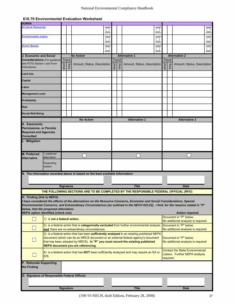
Exhibits......................................................................................................................................................23 Exhibit 1 – Examples of Conservation Practices, Resource Concerns & Physical Effects ............24 Exhibit 2 – NRCS-CPA-52, Environmental Evaluation Worksheet (Draft) ..................................25
Non-Discrimination Statement The U.S. Department of Agriculture (USDA) prohibits discrimination in all its programs and activities on the basis of race, color, national origin, age, disability, and where applicable, sex, marital status, familial status, parental status, religion, sexual orientation, genetic information, political beliefs, reprisal, or because all or part of an individual’s income is derived from any public assistance program. (Not all prohibited bases apply to all programs.) Persons with disabilities who require alternative means for communication of program information (Braille, large print, audiotape, etc.) should contact USDA’s TARGET Center at (202) 720-2600 (voice and TDD). To file a complaint of discrimination, write to USDA, Director, Office of Civil Rights, 1400 Independence Avenue, S.W., Washington, D.C. 20250-9410, or call (800) 795-3272 (voice) or (202) 720-6382 (TDD). USDA is an equal opportunity provider and employer.
2

SUMMARY OF ECOSYSTEM RESTORATION PROJECT
Project Name: Bosque River Watershed Ecosystem Restoration Project Counties: Bosque, Coryell, Erath, Hamilton, Somervell and McLennan Location: Bosque River Watershed, Texas Sponsors: Cross Timbers Soil and Water Conservation District, Hamilton-Coryell Soil and Water Conservation District, Bosque Soil and Water Conservation District, McLennan County Soil and Water Conservation District, and the Texas State Soil and Water Conservation Board Authorization: Authorization of this project is provided by the Water Resources Development Act of 2007 Section 5139. Brief Description of Ecosystem Restoration Project: This project will provide technical and financial assistance to individual landowners for the development of resource management system plans and the installation of conservation practices for restoring, preserving, and protecting the soil, water, air, plant, animal and human resources of the Bosque River Watershed. In order to provide concentrated conservation assistance in a relatively short time span, two sub-watersheds within the Bosque River Watershed were selected for the project: Gilmore Creek in the North Bosque River Watershed and Tonk Creek in the South Bosque River Watershed. The Project Map of the Bosque River Watershed, including sub-watershed delineations, is shown in Appendix A. Resource Information: The total drainage area of the Bosque River Basin entering Lake Waco is approximately 1,652 square miles. This drainage area consists of 39 sub-watersheds, two of which are Tonk Creek and Gilmore Creek. Gilmore Creek: 31,166 acres Land Use (North Bosque River Watershed) Barren Land 103 acres Operating Units – 207/ 30,500 acres Cropland 919 acres Pastureland 674 acres Conservation Plans Rangeland 28,991 acres Active Plans – 18/ 7,744 acres Urban 129 acres No Active Plan – 189/ 22,756 acres Water 280 acres Wetlands 3 acres Other 68 acres Total 31,166 acres
3

Tonk Creek: 26,043 acres Land Use (South Bosque River Watershed) Barren Land 165 acres Operating Units – 194/ 24,770 acres Cropland 10,000 acres Pastureland 3,338 acres Conservation Plans Rangeland 12,072 acres Active Plans – 18/ 5,595 acres Urban 244 acres No Active Plan – 176/ 19,175 acres Water 159 acres Wetlands 5 acres Other 61 acres Total 26,043 acres See Appendix C-1 and C-2 for land use maps of Gilmore Creek and Tonk Creek sub-watersheds. Problem Identification: Lake Waco, a major lake in central Texas, was constructed by the U.S. Army Corps of Engineers on the lower portion of the Bosque River Watershed about 4.5 miles above its confluence with the Brazos River. Lake Waco and the Bosque River Watershed serve as the primary drinking water supply for more than 200,000 people. Water quality has been degraded within the watershed for a number of years. Water quality testing has found high levels of nutrients in the watershed that have contributed to excessive algae growth in the Bosque River and in Lake Waco. Several tributaries of the Bosque River do not meet applicable water quality standards for bacteria. Publicly owned treatment works for municipal and domestic wastes, failed on-site sewage treatment systems (septic and filter fields), and agriculture have been identified as potential contributors of nutrients in the Bosque River Watershed. Much effort has been expended on the water quality aspects of the Bosque River Watershed, but ecosystems restoration has had limited attention in recent years. Project Purpose: The purpose of the Ecosystem Restoration Project is to develop a plan for the initiation of new technologies and innovative approaches for restoring, preserving, and protecting the soil, water, air, plant, animal and human resources within the Bosque River Watershed. Two sub-watersheds within the Bosque River Basin have been selected for initial efforts in accelerated application of land treatment practices. Upon the successful implementation of resource management plans within these two sub-watersheds, the initiative may be expanded into additional sub-watersheds to provide further enhancement to land and water resources. Achievement of the goals set forth in this ecosystem restoration project will improve the overall quality of living of human life within the watershed. Principal Project Measure: Technical assistance will be provided to individual agricultural land users to develop resource management system plans that prescribe a system of conservation practices that will adequately treat resource problems. Cost-share contracts will be developed to provide financial assistance for the installation of the conservation practices.
4

Project Costs: Federal funds Other Funds Total $7,065,000 $1,870,200 $8,935,200 Project Benefits: By evaluating expected effects of accelerated application of land treatment practices within the two sub-watersheds, on-site and off-site benefits are estimated to be $14,656,000. This equates to a benefit/cost ratio of 1.64:1.0. In other words, every $1.00 of combined federal and landowner investment will result in $1.64 of benefits to landowners and the public.
5

PURPOSE AND NEED FOR ACTION
INTRODUCTION The Bosque River is located in central Texas about 60 miles southwest of Fort Worth, Texas. The Bosque River enters the Brazos River near the western edge of Waco, Texas and extends about 90 miles to the northwest to where the watershed heads, just west of Stephenville, Texas. The 1,663.6 square mile watershed of the Bosque River is located in Erath, Bosque, Hamilton, Coryell, Somervell and McLennan Counties and is part of the Brazos River Basin. The following soil and water conservation districts (SWCDs) are also located within the Bosque River Watershed: Cross Timbers, Hamilton-Coryell, Bosque and McLennan County. The Bosque River Watershed area is serviced by United States Department of Agriculture-Natural Resources Conservation Service (NRCS) offices in Stephenville, Meridian, Hamilton, Gatesville and Waco. Water quality has been degraded within the Bosque River Watershed and the effects have continued downstream into Lake Waco. Intense agricultural operations have the potential to have a contributing affect on the degradation of water quality within the watershed. The Bosque River Basin is divided into the North Bosque, the Middle Bosque and the South Bosque watersheds with the North Bosque having by far the largest drainage area. Portions of the watershed, primarily the upper portion of the North Bosque, have been heavily influenced by rapid growth of the dairy industry in the last 25 years. Much of the South Bosque Watershed is intensely farmed in row crops and small grains while other parts of the river basin contain large acreages of intensely managed improved pastures, hay fields and rangeland. Water quality is monitored at numerous locations along the main river channel as well as on several of the sub-watersheds within the river basin. Monitoring is currently being conducted by the Texas Commission on Environmental Quality (TCEQ), the Brazos River Authority (BRA), and the Texas Institute for Applied Environmental Research (TIAER). Data available from the various monitoring agencies indicates that water quality impairments have occurred at various locations in the watershed. PHYSICAL FEATURES AND ENVIRONMENTAL FACTORS Climate: The watershed and surrounding vicinity has a warm-temperate, sub-humid climate. The daily mean temperature ranges from a high of 96 degrees Fahrenheit in July to a low of 36 degrees Fahrenheit in January. The passage of cold fronts can cause temperature readings to be in the teens for short durations. The average growing season for the watershed is about 240 days. Average annual precipitation for the watershed ranges from slightly over 29 inches to over 33 inches. The area is subject to high intensity, short duration rainfall events that can result in large volumes of runoff. A complete climatic description including historical rainfall, temperatures and frost-free growing periods can be found in published soil surveys for each county within the Bosque River Watershed.
6

Soils: Soils mapped in the Bosque River Watershed are described in detail in the following published soil surveys for each county within the watershed: Soil Survey of Erath County, January 1973; Soil Survey of Bosque County, May 1980; Soil Survey of Coryell County, May 1985; Soil Survey of McLennan County, 2001; and Soil Survey of Hamilton County, July 2007. The extreme upper portion of the watershed is in the West Cross Timbers Major Land Resource Area (MLRA), the extreme lower portion is in the Northern Blackland Prairie MLRA, and the majority of the watershed (middle portion) is in the Grand Prairie MLRA. Appendix B-1 and B-2 contain detailed soils maps of the Gilmore Creek and Tonk Creek sub-watersheds. Topography: Topography or relief within the Bosque River Watershed ranges from nearly level along streams and valleys to steep along escarpments. Most of the lower portion of the Bosque River Watershed is gently sloping with a tendency for moderately to more strongly sloping topography in the mid to upper portion of the watershed. Detailed descriptions for each county within the watershed can be found in the previously mentioned published soil surveys. Geology: Soils within the Bosque River Watershed have developed from parent materials of three geologic ages: the Pennsylvanian, the Cretaceous, and the Quaternary age. Pennsylvanian age materials are the oldest, and are mainly inter-bedded sandstones and shales of the Strawn Group and are found mostly in northwestern part of the watershed. Cretaceous age materials are mainly inter-bedded limestones, calcareous marls, and sands of the Fredericksburg and Trinity Groups and are found over the majority of the watershed. Quaternary age materials are the most recently formed materials in the watershed and are found in alluvial deposits along most of the streams of significant size. A more detailed geologic description of the Bosque River Watershed can be found in the previously mentioned published soil surveys for each county within the watershed. Cultural and Historic Resources: The archeological record of central Texas extends back at least 12,000 years. Prehistoric inhabitants exploited most every niche across the landscape. Prehistoric archeological sites may include open campsites, kill/butcher sites, rock shelters, stone tool chipping locations, burned rock middens, quarry locations, and in the Late Prehistoric period, perhaps settled villages. By the 1850s, the Gilmore Creek and Tonk Creek areas were being settled by European man. Communities such as Clairette, Carlton, Alexander, Osage, and Coryell emerged and growth continued through the late 19th century as rail reached the vicinity. Historic archeological sites dating to the mid-19th century may include town sites, mills, gins, pioneer homesteads, as well as ranches and farmsteads.
7
Threatened and Endangered Species: According to the Threatened and Endangered Species Lists provided on the U.S. Fish and Wildlife Service Web site, there are three endangered species that may occur in the counties located in the Bosque River Watershed: the whooping crane (Grus Americana), the black-capped vireo (Vireo atricapillus), and the golden-cheeked warbler (Dendroica chrysoparia). The whooping crane is known to migrate through the area in the vicinity of the Bosque River Watershed. The whooping crane winters on the Texas Gulf Coast; however, during migration it has been known to occur along rivers, shallow wetlands, reservoirs, as well as in croplands such as small grain fields. Black-capped vireo habitat consists of small motts of scattered trees (mainly oaks and small cedar) and numerous dense clumps of brush growing to ground level, interspersed with open areas of bare ground and rocks. Associated plant species are Texas oak, cedar, sumac, persimmon, elbow bush, deciduous holly and yaupon. The golden-cheeked warbler prefers woodlands, which contain mature junipers (cedars) for use in nest building and an oak/mixed hardwood component for foraging activities. In addition to mature cedars, associated plant species include Texas live or Spanish oak, elms, hackberry, and ash. Some or all of these types of vegetation occur in places in the Bosque River Watershed. PURPOSE AND NEED FOR THE PROJECT Over the past 50 years, various programs have been available for treating resource problems in the Bosque River Basin. Three flood prevention and watershed protection projects within the Bosque River Watershed have been completed. Included in these projects were installation of 42 floodwater-retarding structures and 2.3 miles of stream channel improvement. In addition, a watershed protection plan was developed to address water quality, primarily for reducing the pollutant load from dairies. Numerous conservation programs have been utilized over the past 20 years to provide rural landowners with both technical and financial assistance for installing conservation practices designed to treat various resource problems. Even though there have been numerous programs available to treat various resource problems within the watershed, water quality impairments still exist. This ecosystem restoration project is intended to enhance and complement existing programs by accelerating the application of conservation practices that will address the natural resource needs of individual operating units and provide restoration to the ecology within the basin. A variety of innovative approaches promoting new technology will be utilized for protecting, preserving, and restoring ecological conditions within the watershed. As a result of holding several planning meetings with interested groups and agencies, it was determined that the ecosystem restoration project would be most effective if two to three small sub-watersheds were selected as the initial implementation areas. Sub-watersheds were selected that were small enough to accomplish, within a short time frame, conservation planning and installation of recommended conservation
8

practices on 75 percent of the agricultural operating units within each sub-watershed. Water quality monitoring stations are currently in place in several of the sub-watersheds, and a number of agricultural operating units have shown an interest in developing conservation plans. Land use within the basin varies greatly from one sub-watershed to another due to topography, soil types and available resources. The North Bosque River Watershed contains numerous large dairies, while the South Bosque has a higher concentration of cultivated cropland situated in relatively close proximity to Lake Waco. Modeling studies indicate that these areas have the potential to transport higher rates of nutrients through the stream system of those portions of the watershed. A large portion of the middle section of the basin has a higher concentration of grazed rangeland, improved pastures and hayland. Modeling of these sub-watersheds indicates that they have the potential to induce moderate levels of nutrients into the stream system. WATERSHED PROBLEMS AND OPPORTUNITIES Lake Waco, a major lake in central Texas, was constructed by the U.S. Army Corps of Engineers on the lower portion of the Bosque River Watershed about 4.5 miles above its confluence with the Brazos River. Lake Waco and the Bosque River Watershed serve as the primary drinking water supplies for more than 200,000 people. Water quality has been degraded within the watershed for a number of years. Water quality testing has found high levels of nutrients in the watershed that have contributed to excessive algae growth in the Bosque River and in Lake Waco. Several tributaries of the Bosque River do not meet applicable water quality standards for bacteria. Publicly owned treatment works for municipal and domestic wastes, failed on-site sewage treatment systems (septic and filter fields), and agriculture have been identified as potential contributors of nutrients in the watershed. Much effort has been expended on the water quality aspects of the Bosque River Watershed, but ecosystems restoration has had limited attention in recent years. The primary focus of the Bosque River Watershed Ecosystem Restoration Project is to provide a means of accelerating the installation of conservation practices on agricultural lands that will provide ecological restoration to the land and water resources of the watershed. These opportunities for providing improvement to the overall health of the watershed are the basis for the Bosque River Watershed Ecosystem Restoration Project.
9

ECOSYSTEM RESTORATION PROJECT Areas of Consideration Upon consideration of available data from current water quality testing sites and the variations in land use in the different sub-watersheds, two sub-watersheds were selected that will provide significantly different opportunities for applying conservation practices but still have the capability of achieving measurable ecological improvements. Emphasis will be placed on development of whole farm plans (resource management systems) as opposed to recommending individual practices for a portion of an operating unit. The focus of conservation planning will be the selection of conservation practices that will meet the needs of the individual producer as well as provide on-site and off-site ecological benefits to the watershed with emphasis on improving water quality. These conservation practices will be identified in conservation plans that have been developed to the resource management system level using the NRCS Nine-Step Conservation Planning process. Sound planning and proper installation of conservation practices should show a reduction in nutrient levels at water quality monitoring stations, significant reductions in erosion and sediment, and improvement of plant and animal life within the watershed. Selected Sub-Watersheds Gilmore Creek Sub-Watershed, Hydrologic Unit Code 120602040201, contains 31,166 total acres, is located in the North Bosque River Watershed, and is comprised of approximately 93 percent rangeland, 3 percent cropland and 2 percent pastureland. In order to achieve 75 percent coverage of the watershed with an active conservation plan, approximately 155 new plans will need to be developed on approximately 23,000 acres. New conservation plans will likely include conservation practices such as prescribed grazing management, brush management, range seeding, and cross fencing. In addition to range management practices, a smaller amount of cropland and improved pastureland will also need to be adequately treated with conservation practices. Potential practices needed for these land uses include grazing management, nutrient management, pasture planting, conservation tillage, no-till planting, conservation cropping system, contour farming, terracing, grassed waterway, critical area treatment and various types of conservation buffers including riparian buffers. Tonk Creek Sub-Watershed, Hydrologic Unit Code 120602030104, contains 26,043 total acres, is located in the South Bosque River Watershed, and is comprised of approximately 46 percent rangeland, 38 percent cropland and 13 percent pastureland. In order to achieve 75 percent coverage of the watershed with an active conservation plan, approximately 145 new plans will need to be developed on approximately 19,000 acres. New conservation plans in this sub-watershed will likely include prescribed grazing management, brush management, range seeding, pasture planting, cross fencing, nutrient management, conservation tillage, conservation cropping system, no-till planting, pest management, contour farming, terracing, grassed waterway, critical area treatment and various types of conservation buffers including riparian buffers.
10

Description of Ecosystem Restoration Project: This project will provide financial and technical assistance to individual operators/landowners for the installation of land treatment practices for restoring, preserving, and protecting the soil, water, air, plant, animal and human resources of the Bosque River Watershed. The two selected sub-watersheds have the desired characteristics needed to successfully implement the project. These desirable traits include multiple areas of the watershed with diversified land use, smaller watersheds that would allow accelerated planning and treatment in a concentrated area, and a presence of existing water quality monitoring sites that could provide baseline data for the sub-watersheds and follow-up monitoring. This project will promote practicable alternatives for stabilization and enhancement of land and water resources within the Bosque River basin. Installation of a variety of conservation practices, as prescribed in site-specific resource management system conservation plans, will be the method of achieving ecological restoration within the watershed. The conservation planner will need to recognize the effect of applying conservation practices in order to select combinations of practices that solve the identified or predicted resource concern without creating new problems. In addition, secondary benefits should be identified. The effects concept is applicable for formulation and evaluation of resource management system options for specific fields or management units within the planning areas. The process of selecting the proper conservation practices will include analysis of the effects of the practices on the target problem, as well as the effects on other resource problems or concerns. Exhibit 1 displays examples of conservation practices, resource concerns, and the anticipated effects that certain practices will have on selected resource concerns. These effects are based on experience and available technical information.
11
IMPLEMENTATION OF THE PLAN Conservation Plan Development and Approval NRCS employees (certified conservation planners) in applicable offices will conduct on-site planning assignments with individual operators/landowners. Decisions of the operators/landowners will be recorded in a conservation plan with all planned practices scheduled in a prescribed timetable. Where possible, new conservation plans will focus on whole farm plans that address all resource concerns of a resource management system. Conservation plans will be signed by a certified conservation planner as meeting the criteria for a resource management system. The operator/landowner will also sign the conservation plan agreeing to carry out the plan as soon as possible when resources are available. The appropriate soil and water conservation district will review and approve each conservation plan developed for the Bosque River Watershed Ecosystem Restoration Project. Approved plans will be prioritized for potential cost-share contracting. Prioritizing criteria will include both on-farm and off-farm benefits, proximity to existing water quality monitoring stations, as well as the availability of funds. The overall goal is to have 75 percent of the agricultural land in each of the two selected sub-watersheds covered by a conservation plan that meets the criteria of a resource management system. Since existing conservation plans may or may not meet the current criteria of a resource management system, the total agricultural land acreage within the two sub-watersheds will be used to estimate the planning needs. This planning goal will require the development of approximately 155 conservation plans on 23,000 acres in Gilmore Creek sub-watershed and 145 conservation plans on 19,000 acres in Tonk Creek sub-watershed. In order to meet these goals of planning and application of conservation practices on 75 percent of the agricultural land in the two selected sub-watersheds, it is estimated that an additional 9.15 staff-years will be needed above that required to carry out existing conservation programs administered by the various NRCS offices within the Bosque River Watershed. Environmental Considerations In order to meet the requirements of the National Environmental Protection Act (NEPA), all conservation planning assistance for the Bosque River Watershed Ecosystem Restoration Project will be in accordance with procedures currently being used for Conservation Technical Assistance (CTA) planning. Form NRCS-CPA-52, 2-28-2008, Environmental Evaluation Worksheet (See Exhibit 2), will be utilized to document that part of the planning process in which the potential long-term and short-term impacts of an action on people, their physical surroundings, and nature are evaluated and alternative actions explored. Utilization of this form during the planning process will assist the conservation planner with compliance requirements for applicable federal laws, regulations, Executive Orders, and policy.
12

Environmental effects on the soil, water, air, plant, animal, and human resources will be considered during the planning process. Economic and social considerations will also be evaluated during the planning process. A copy of NRCS-CPA-52 will be included in the administrative file. Supporting documentation will be included with the NRCS-CPA-52 when appropriate for reference purposes. Schedule of Implementation Costs Authorization and funding appropriations for the project are provided through the Water Resources Development Act of 2007. Funding appropriations will be initially directed to the USACE who will apportion funds out to various agencies and organizations for development and implementation of different components of the overall comprehensive project plan. Funds will be provided by the USACE for the preparation of The Bosque River Ecosystem Restoration Project Plan, development of individual conservation plans, and preparation and administration of cost-share contracts within the Bosque River Watershed. Contract administration is time spent to service contracts, which includes preparing engineering designs on certain practices, layout, checkout and certification of practice installation, preparing payment documents for completed practices and conducting annual status reviews. See Table 1 for estimated personnel needs and cost distribution for technical assistance. Cost-Share Contracting Cost-shared contracts will be prepared on prioritized conservation plans. Emphasis will be placed on plans and contracts located upstream from existing water quality monitoring stations in an effort to secure data that supports environmental benefits provided by the installation of conservation practices. Contracting will be by one of two methods: (1) Long Term Contract (LTC) under the authority of Public Law 83-566 (PL 83-566) using procedures in Title 120, part 404 of the General Manual, or (2) Cooperative Agreement with individual program participants. Contracts may be written covering a period of three to 10 years depending on the complexity of the practice schedule and sequence of practices. Funds will be transferred from the USACE to NRCS to cover up to 75 percent of the cost for installation of the conservation practices. Individual landowners will be responsible for installing the planned practices or contracting with a private vendor to complete the practices. All cost-shared conservation practices will be installed according to NRCS standards and specifications. Individual participants will be required to submit receipts upon completion of a conservation practice prior to receiving cost-share assistance. NRCS will utilize the transferred funds to reimburse individual landowners for up to 75 percent of the cost of practice installation. Individual participants will be responsible for the remaining cost of practice installation. The individual participant’s share of the cost of installing practices may come from any source other than Federal funds without a reduction in Federal funds, as long as the total financial assistance to be received does not exceed 100 percent of the installation cost.
13

14
Financial assistance for the installation of conservation practices on the same acres of an operating unit that are already receiving cost-share assistance from other programs is not allowed through this project. Different acreage within a farm covered by a current cost-share program are eligible for this project as long as the same acres are not receiving cost-share assistance by two different programs. See Table 2 for the estimated federal share of installation cost allocated by land use.

Table 1 shows estimated schedule for NRCS personnel cost (technical assistance) for preparing plans, contracts and providing necessary assistance for practice installation.
Table 1 – Estimated Schedule for Personnel Needs and Cost Distribution FY-09 FY-10 FY-11 FY-12 FY-13 Total3 Task/Personnel2
FTE1 Cost FTE Cost FTE Cost FTE Cost FTE Cost FTE Cost Conservation Planning 0.66 $73,800 1.66 $184,400 1.00 $110,700 0.30 $33,400 0.25 $27,800 3.87 $430,100 Conservation Application 0.10 $10,500 1.42 $157,500 1.65 $183,800 0.47 $52,500 0.14 $15,800 3.78 $420,100
Engineering Technician 0.02 $1,900 0.24 $18,900 0.42 $34,100 0.19 $15,100 0.07 $5,700 0.94 $75,700 Engineering 0.01 $1,100 0.05 $5,600 0.20 $22,200 0.20 $22,200 0.10 $11,100 0.56 $62,200 Contract Administration 0.20 $23,200 0.80 $93,000 0.75 $87,200 0.60 $69,700 0.40 $46,600 2.75 $319,700 Support Staff 0.10 $13,300 0.10 $13,300 0.05 $6,700 0.05 $6,700 0.05 $6,700 0.35 $46,700 Totals 1.09 $123,800 4.27 $472,700 4.07 $444,700 1.81 $199,600 1.01 $113,700 12.25 $1,354,500
1 FTE = Full Time Equivalency 2 Estimated personnel needed to support the project in two selected sub-watersheds 3 Does not include technical assistance (TA) needed in years following FY13 in order to address the 2-year maintenance period following installation of the last cost-shared practice. Follow-up TA need is estimated to be $100,000.
Table 2 shows estimated schedule for federal share of installation cost of planned practices (financial assistance or FA).
Table 2 – Estimated Schedule of Financial Assistance (FA) Needed for Practice Installation by Land Use 1 FY-09 FY-10 FY-11 FY-12 FY-13 Total Land Use
Acres FA Acres FA Acres FA Acres FA Acres FA Acres FA Cropland 167 $27,900 2,335 $391,000 2,934 $491,600 934 $156,400 300 $50,300 6,670 $1,117,200 Pastureland 131 $7,000 1,838 $98,600 2,310 $124,000 735 $39,400 236 $12,700 5,250 $281,700 Rangeland 718 $103,000 10,045 $1,441,400 12,627 $1,812,000 4,018 $576,500 1,292 $185,300 28,700 $4,118,200 Hayland 30 $1,900 424 $26,700 533 $33,600 169 $10,700 54 $3,400 1,210 $76,300 Wildlifeland 4 $400 60 $6,000 74 $7,500 24 $2,400 8 $800 170 $17,100 Totals 1,050 $140,200 14,702 $1,963,700 18,478 $2,468,700 5,880 $785,400 1,890 $252,500 42,000 $5,610,500
1 2008 Dollars
15

Operation and Maintenance of Practices Operation is the administration, management, and performance of non-maintenance activities necessary to keep a practice safe and functioning as planned. Maintenance includes the recurring activities necessary to retain or restore a practice in a safe and functioning condition; including the management of vegetation, the repair or replacement of failed components, the prevention or treatment of deterioration, and the repair of damages caused by drought, flooding, or vandalism. The land user or program participant will be responsible for operation and maintenance (O&M) of installed practices. O&M requires effort and expenditures by the land user throughout the life of the practice to maintain safe conditions and assure proper functioning. Program participants will be required to carry out adequate O&M for a period of two years following the completion of the last cost-shared practice. The O&M requirements will be documented in the conservation plan of operations. By signing the conservation plan of operations (long-term contract), the program participant agrees to provide adequate and sound arrangements for proper operation, prompt and appropriate performance of needed maintenance, and financing the costs of operation and maintenance. The program participant should carry out the provisions of the agreed-to plan in a manner consistent with the spirit, intent, and purpose of the plan and project. Memorandum of Agreement A Memorandum of Agreement (MOA) has been prepared between the U. S. Army Corps of Engineers (USACE) and the USDA - Natural Resources Conservation Service (NRCS). The MOA establishes roles and responsibilities required of each agency for the development and implementation of the project. Reimbursement arrangements or fund transfer agreements and administrative procedures will be addressed in the MOA. Public Outreach Plan NRCS will prepare an abstract or synopsis to briefly explain the ecosystem restoration project and provide details that will be useful in promoting the project. NRCS public affairs specialists will be utilized to develop news releases and informational handouts to publicize the project. All soil and water conservation districts within the Bosque River Watershed will initiate a plan of action to inform the public about the project. Possible methods of informing the public may include public meetings, local newspapers, field tours, radio spots, SWCD newsletters, AgriLife Extension newsletters, postings on Web sites, Farm Service Agency newsletters, etc.
16

Appendices
Appendix A Bosque River Watershed Project Map Appendix B-1 Gilmore Creek Detailed Soils Map Appendix B-2 Tonk Creek Detailed Soils Map Appendix C-1 Gilmore Creek Land Use Map Appendix C-2 Tonk Creek Land Use Map
17
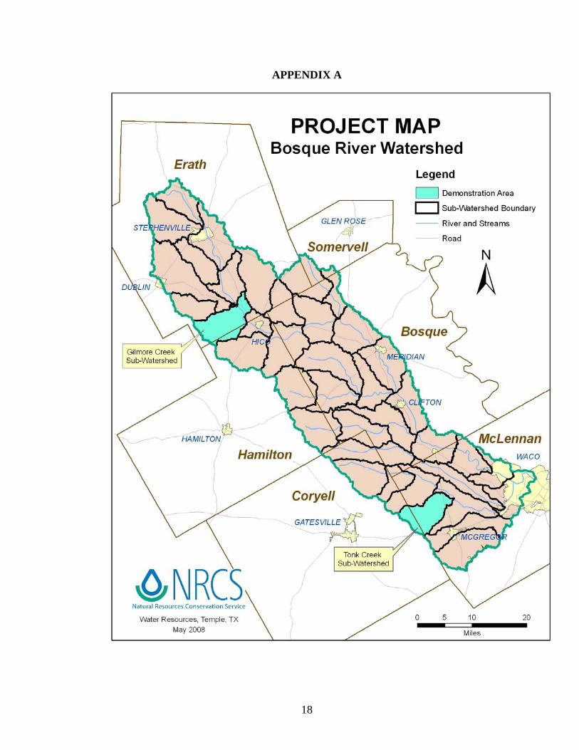
APPENDIX A
18

APPENDIX B-1
19
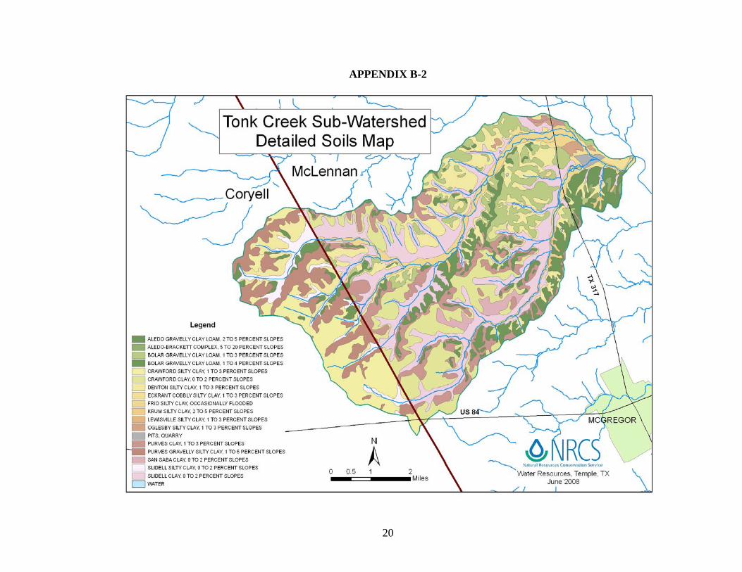
APPENDIX B-2
20
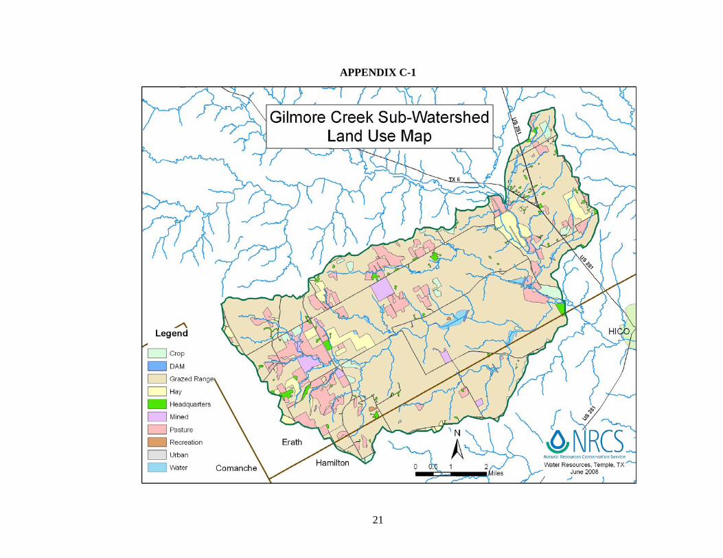
APPENDIX C-1
21

APPENDIX C-2
22
Exhibits
Exhibit 1 - Example List of Conservation Practices, Resource Concerns, and Physical Effects Exhibit 2 – NRCS-CPA-52 ENVIRONMENTAL EVALUATION WORKSHEET
23

EXHIBIT 1 – Examples of Conservation Practices, Resource Concerns, and Physical Effects that the Conservation Practices have on the Resource Concerns
RESOURCE CONCERNS/PHYSICAL EFFECTS 1
CONSERVATION PRACTICES Soil Erosion Sheet and Rill
Plants – Cropland Productivity
Water Quality - Surface Pesticides, Nutrients, Organics, Sediment
Plants Pasture and Hayland Productivity and Health
Animal Habitat – Wildlife Food, Water, Cover, Shelter
Animal Habitat – Domestic Food, Water, Cover, Shelter
Brush Management Slight to Mod Decrease Moderate to Sig Decrease Slight to Mod Decrease Significant Decrease Slight to Sig Increase Slight to Sig Increase Conservation Crop Rotation Slight to Sig Decrease Slight to Mod Decrease Slight to Mod Decrease N/A Situational Situational Contour Buffer Strips Slight to Sig Decrease Slight Decrease Slight to Sig Decrease N/a Slight Decrease Slight Decrease Contour Farming Slight to Mod Decrease Slight Decrease Slight to Mod Decrease Insignificant Insignificant Insignificant Fence Slight to Mod Decrease Moderate to Sig Decrease Moderate to Sig Decrease Moderate to Sig Decrease Moderate to Sig Decrease Moderate to Sig Decrease Field Border Slight to Sig Decrease N/A N/A N/A Slight to Moderate Decrease Slight to Moderate Decrease Filter Strip Slight to Sig Decrease Slight Decrease Slight Decrease Slight Decrease Moderate to Sig Decrease Moderate to Sig Decrease Forage Harvest Management Facilitating Slight to Sig Decrease Facilitating Moderate to Sig Decrease Slight Decrease Slight Decrease Grassed Waterway Insignificant Slight Decrease Slight to Mod Decrease Slight Decrease Significant Decrease Significant Decrease Nutrient Management Slight to Mod Decrease Slight to Sig Decrease Significant Decrease Slight to Sig Decrease Significant Decrease Significant Decrease Pasture & Hayland Planting Moderate to Sig Decrease Significant Decrease Slight to Mod Decrease Significant Decrease Significant Decrease Significant Decrease Pest Management Slight Decrease Slight to Mod Decrease Significant Decrease Slight to Mod Decrease Slight Increase Slight Increase Pond Insignificant Slight to Sig Decrease Moderate Increase Moderate to Sig Decrease Slight to Moderate Decrease Slight to Moderate Decrease Prescribed Burning Slight Increase Moderate to Sig Decrease Slight Increase Moderate to Sig Decrease Slight Decrease Slight Decrease Prescribed Grazing Slight Decrease N/A Moderate Decrease Significant Decrease Slight Decrease Slight Decrease Range Planting Moderate to Sig Decrease Significant Decrease Slight to Mod Decrease Significant Decrease Significant Decrease Moderate to Sig Decrease Residue Management, No-till Slight to Sig Decrease Slight to Sig Decrease Significant Decrease N/A Slight Decrease Slight Decrease Residue Management, Mulch till Slight to Sig Decrease Slight to Sig Decrease Significant Decrease N/A Slight Decrease Slight Decrease Terrace Slight to Mod Decrease Moderate to Sig Decrease Slight to Mod Increase Slight to Mod Decrease Slight Decrease Slight Decrease Upland Wildlife Habitat Management Situational N/A N/A N/A Significant Decrease Significant Decrease 1 The effects of practices may be greater if they are associated with a land use change. On-site effects of practices are generally greater than off-site effects, i.e., the further away from the problem or treatment the less significant the effect. The conservation practice effects are classified as follows: Effect Definition +5 Significant Decrease +4 Moderate to Significant Decrease +3 Moderate Decrease +2 Slight to Moderate Decrease +1 Slight Decrease 0 Insignificant or Neutral -1 Slight Increase -2 Slight to Moderate Increase -3 Moderate Increase -4 Moderate to Significant Increase -5 Significant Increase
24

610.70 Environmental Evaluation Worksheet
National Environmental Compliance Handbook
√ if RMS √ if RMS √ if RMS
Riparian Area
●Wetlands
●Wild and Scenic Rivers
●Clean Water Act/Waters of the U.S.
H. Alternatives
●Coastal Zone Management Areas
Floodplain Management needs
action
Prime and Unique Farmlands
needs
action
needs
action
needs
action
needs
action
needs
action
needs
action
needs
action
needs
action
needs
action
needs
action
needs
action
needs
action
A. Client Name:
B. Conservation Plan ID # (as applicable):
C. Identification # (farm, tract, field#, etc as required): Program Authority (optional):
needs
action
meets
QC
needs
action
Alternative 2
needs
action
Alternative 1
long
WATER
meets
QC
F. Resource Concerns & Special Environmental Concerns Record and address concerns identified through the Resources Inventory process as needing to be addressed. (For Resource Concerns see FOTG Section III - Resource Quality Criteria for guidance. For Special Environmental Concerns see Environmental Procedures Guide Sheets for assistance. Items with a " ●" may require a federal permit or consultation/coordination between the lead agency and another government agency. In these cases, effects may need to be determined in consultation with another agency. Planning and practice implementation may proceed for practices not involved in consultation.)
meets
QC
meets
QC
meets
QC
No ActionTrend
Amount, Status, Description
meets
QC
meets
QC
needs
action
meets
QC
SOIL
I. Effects of Alternatives
meets
QC
meets
QC
meets
QC
Natural Resources Conservation Service
TrendAmount, Status,
Description
long
shor
t
meets
QC
U.S. Department of Agriculture2-28-2008
NRCS-CPA-52
G. Benchmark Conditions[Record the current (benchmark) conditions for each identified resource concern]
E. Need for Action:
D. Client's Objective(s) (purpose):
ENVIRONMENTAL EVALUATION WORKSHEET
√ if meets QC orneedsaction
No Action
meets
QC
√ if meets QC orneedsaction
meets
QC
Amount, Status, Description
Trendsh
ort
long
Alternative 2
√ if meets QC orneedsaction
meets
QC
shor
t
meets
QC
meets
QC
meets
QC
needs
action
needs
action
Alternative 1
meets
QC
needs
action
meets
QC
meets
QC
needs
action
(190-VI-NECH, draft Edition, February 28, 2008) 25
610.70 Environmental Evaluation Worksheet
National Environmental Compliance Handbook
√ if meets QC orneedsactionsh
ort
long
G. Benchmark Conditions[Record the current (benchmark) conditions for each identified resource concern]
I. Effects of AlternativesNo Action Alternative 1 Alternative 2
TrendAmount, Status,
DescriptionAmount, Status,
Description
TrendAmount, Status,
Description
shor
t
long
shor
t
√ if meets QC orneedsaction
Invasive Species
needs
action
needs
action
needs
action
needs
action
●Migratory Birds/Bald and Golden Eagles
needs
action
needs
action
needs
action
Natural Areas
ANIMALS
●Endangered and Threatened Species
Riparian Area
Coral Reefs
●Clean Air Act
PLANTS
needs
action
needs
action
●Endangered and Threatened Species
needs
action
needs
action
needs
action
needs
action
needs
action
needs
action
needs
action
needs
action
needs
action
meets
QC
AIR
meets
QC
meets
QC
meets
QC
meets
QC
meets
QC
meets
QC
meets
QC
meets
QC
long
meets
QC
√ if meets QC orneedsaction
Trend
meets
QC
meets
QC
meets
QC
needs
action
meets
QC
meets
QC
needs
action
meets
QC
meets
QC
needs
action
meets
QC
meets
QC
meets
QC
meets
QC
meets
QC
meets
QC
meets
QC
needs
action
needs
action
needs
action
needs
action
meets
QC
needs
action
meets
QC
needs
action
needs
action
meets
QC
needs
action
needs
action
needs
action
needs
action
needs
action
Riparian Area
●Essential Fish Habitat
Invasive Species
(190-VI-NECH, draft Edition, February 28, 2008) 26
610.70 Environmental Evaluation Worksheet
National Environmental Compliance Handbook
needs
action
needs
action
needs
action
needs
action
Scenic Beauty needs
action
needs
action
needs
action
Environmental Justice
needs
action
needs
action
●Cultural ResourcesHUMAN
Contact the State Environmental Liaison. Further NEPA analysis required.
2) is a federal action that is categorically excluded from further environmental analysis and there are no extraordinary circumstances.
Document in "P" below.No additional analysis is required
3) is a federal action that has been sufficiently analyzed in an existing published NEPA document (which can be an NRCS document or an external federal agency's document that has been adopted by NRCS). In "P" you must record the existing published NEPA document you are referencing.
4) is a federal action that has NOT been sufficiently analyzed and may require an EA or EIS.
Document in "P" below.No additional analysis is required
Signature Title Date
Action required
Q. Signature of Responsible Federal Official:
NEPA option identified (check one)
1) is not a federal action.
P. Rationale Supporting the Finding
Document in "P" below.No additional analysis is required
I have considered the effects of the alternatives on the Resource Concerns, Economic and Social Considerations, Special Environmental Concerns, and Extraordinary Circumstances (as outlined in the NECH 610.22). I find, for the reasons stated in "P" below, that the proposed alternative:
K. Easements, Permissions, or Permits Required and Agencies ConsultedL. Mitigation
Alternative 1 Alternative 2No Action
Supporting reason
M. Preferred Alternative
√ preferred alternative
THE FOLLOWING SECTIONS ARE TO BE COMPLETED BY THE RESPONSIBLE FEDERAL OFFICIAL (RFO)
Title Date
Management Level
Profitability
Risk
Social Well-Being
Land Use
Capital
Labor
O. Finding (link to NEPA)
Signature
N. The information recorded above is based on the best available information:
Alternative 2Trend Trend Trend
shor
t
long Amount, Status, DescriptionAmount, Status, Description
shor
t
long
J. Economic and Social Considerations (For guidance see FOTG Section I and Form Instructions)
Amount, Status, Description
No Action Alternative 1
shor
t
long
(190-VI-NECH, draft Edition, February 28, 2008) 27