Embed Size (px)
Citation preview

Proceedings World Geothermal Congress 2015
Melbourne, Australia, 19-25 April 2015
1
Economic Feasibility for Geothermal Energy in Comoros
Mohamed Chaheire Mohamed Chamassi
Keywords: Energetic crisis, electricity cost, national economy, geothermal.
ABSTRACT
The Comoros is a country that suffers from energy problems. Several attempts to end the crisis have been proposed but still attends
a stagnant situation and sometimes catastrophic.
A total installed capacity of 17,908 MW across two islands (Grande Comore and Mohéli), only a total available energy of 7.2kWh
with energy of 3782.7 kWh consumed per month (only on Grande Comore). The production cost of electricity (excluding
distribution costs) is very expensive and is of the order of U.S. $ 0.75 per kWh. Over 76 % of the production costs due to the cost of
diesel fuel.
To solve this problem and reduce the costs of electricity, utilization of geothermal energy will have a direct impact on costs, as does
the productivity of individual wells. It would be reasonable to expect that the basic cost of geothermal generation for a 10MW plant
would be of the order of US$0.10 to 0.15per kWh.
From an economic standpoint these cost would need to be burdened with overheads and the cost of diesel co-generation and bear
some portion of the cost of amortization of existing plant but it is likely that the average cost of power could be improved by the
access to a geothermal power resource. By examining the high production costs, it is obvious to know that any alternative source of
energy especially geothermal could offset component of the current cost of electricity due to diesel. Thus we have an advantage
over the national economy by eliminating the need to use diesel power.
As production costs fall close to current rates, it will also allow us to improve the financial situation of the society of water and
electricity of Comoros (Mamwé) and further reduce the burden on the government.
1. INTRODUCTION
In the Grande Comore, early work has suggested that there is a heat source below the Karthala volcano and surrounding areas,
though the coexistence of a geothermal resource, its size, accessibility and sustainable production has yet to be confirmed. This will
take additional scientific surface exploration and then the drilling of exploration wells before a reliable steam source can be
absolutely demonstrated.
In considering any alternative fuel generation on Grande Comore it is important that all the issues that have to be considered are
addressed alongside the more obvious questions of the presence of a viable geothermal resource. A list of key issues, though not
exhaustive, would include the consideration of the following:
The current cost of generation using existing and newly installed diesel power plant;
Current load demands, and daily demand variation, to determine what level of geothermal base load generation could
practically be considered in a first stage development;
Given an estimate of a potential geothermal power plant size (subject to resource confirmation) determine the likely cost
of geothermal generation at this scale;
The economic benefits of displacing the use of imported fuels with geothermal energy;
Identification of the costs of the next stages of exploration and drilling in particular;
Determining potential sources of financing for these next phases – an issue whose importance is overlooked – raising
funding for the scientific and exploratory drilling phases is a key challenge in most geothermal developments;
Reviewing current legislation that may affect either public and/or private participation in any geothermal development, in
particular resource ownership and development rights and consider how appropriate legislation could be introduced;
Requirements for project staffing and the building of a small but well supported geothermal office, and the capacity
building inherent in this; every effort must be made to integrate the current skills on island into the project team;
Assessing the potential social issues such as land ownership, access, and public education about the project, potential
benefits to those in area of development and overall benefits of reliable, lower cost electricity supply.
Recognizing the demands that any development will put on port access, roading (existing and new), local water supplies
during drilling and construction and access to competent contractors on island.

Naoildine Houmadi et Mohamed Chaheire
2
2. STATUS OF ELECTRICITY PRODUCTION
2.1 Current total installed and effective capacity
The total installed capacity is 22.6MW (Mamwé, April 2012). The effective capacity is 13MW. The installed and effective
capacities are presented in Table 1.
2.2 Cost and Production of Mamwé
To turn the power, the Mamwé needs 65,000 liters per day in all three islands. Costs and details are shown in Table 2.
Table 1: Installed and Effective Capacity for Electricity Generation
Island
Installed
capacity
Mw
Available
capacity
Mw
Total
power
available
(Mw)
Total
installed
capacity
(Mw)
Ngazidja 15.6 9
13.8
22.6 Anjouan 6 4
Mohéli 1 800 Kva
Table2: Production and Cost
Island Ngazidja Anjouan Mohéli total
Litre/month 180 000 60 000 20 000 260 000
Cost/month
€ 683 000 228 000 76 000 987 0
3. ENERGY SOLUTIONS
A sum of 200 million € reached by imports Comoros in 2011, showing the interest of taking the import sector to the detriment of
local production affected by the lack of electricity, requires immediate and long-term solutions for all of this energy impasse.
From solar energy, wind and geothermal, the development of geothermal energy is a better solution to this situation with favorable
geological conditions. It allows:
Meet demand, high growth, medium and long term;
Reduce electricity cost to increase affordability, promote industry, tourism, and employment;
Preserve environment;
Add additional 20 to 30 MW soonest to satisfy demand and reduce outages.
4. STATUS OF GEOTHERMAL DEVELOPMENT IN THE COUNTRY
4.1 Geological setting
In the present state of knowledge, the constitution of the archipelago can be designed in the following way:
Comoros are built as a result of a major volcanic phases separated by periods of rest during which the erosion could act. It should
be noted that the volcanic activity still persists in the islands of Ngazidja especially in the West with a period of 11years.
• Mainly due to its volcanic nature, the archipelago of the Comoros presents an extremely high geothermal potential;
• Comoros are formed from the migration of lithospheric plate of Somalia over a relatively a relatively stationary and
active hot spot during the last 1 million years;
• Volcanism of Comoros is probably controlled by a complex regional constraints in relation to the separation of
Madagascar and the African continent (Flower, 1970);
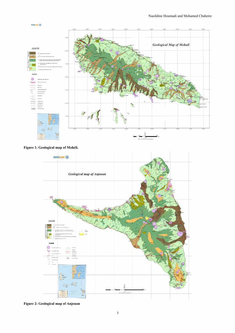
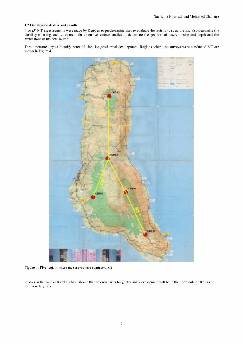
Figures 1, 2 and 3 show the geological maps respectively to Moheli Anjouan and Grande Comore.
Geological maps are updated by highlighting the fracture systems. Studies of the volcano have located the magma chamber and the
fluid circulation system at the caldera.
The hydrothermal system in the massif is formed by fracture networks associated with the volcano.
Naoildine Houmadi and Mohamed Chaheire
3
Figure 1: Geological map of Mohéli.
Figure 2: Geological map of Anjouan

Naoildine Houmadi et Mohamed Chaheire
4
Figure 3: Geological of Grande Comore
Naoildine Houmadi and Mohamed Chaheire
5
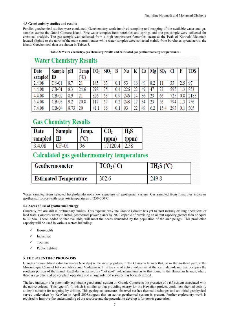
4.2 Geophysics studies and results
Five (5) MT measurements were made by KenGen to predetermine sites to evaluate the resistivity structure and also determine the
viability of using such equipment for extensive surface studies to determine the geothermal reservoir size and depth and the
dimensions of the heat source.
These measures try to identify potential sites for geothermal development. Regions where the surveys were conducted MT are
shown in Figure 4.
Figure 4: Five regions where the surveys were conducted MT
Studies in the zone of Karthala have shown that potential sites for geothermal development will be in the north outside the crater,
shown in Figure 5.

Naoildine Houmadi et Mohamed Chaheire
6
Figure 5: Karthala geothermal prospect
Based on studies of surface geophysical data recorded were analyzed and interpreted by KenGen. The results of surface exploration
are shown in Figure 6.
The interpretation shows that there is evidence of a geothermal reservoir at a depth of 1000- 1700m and a heat source for the
geothermal system at a depth of more than 5000m. It is also clear that more data is required the dimensions of both the geothermal
reservoir and the heat source.
Naoildine Houmadi and Mohamed Chaheire
7
4.3 Geochemistry studies and results
Parallel geochemical studies were conducted. Geochemistry work involved sampling and mapping of the available water and gas
samples across the Grand Comoro Island. Five water samples from boreholes and springs and one gas sample were collected for
chemical analysis. The gas sample was collected from a high temperature fumaroles steam at the Peak of Karthala Mountain
located slightly to the north of the main summit crater while water samples were collected mainly from boreholes spread across the
island. Geochemical data are shown in Tables 3.
Table 3: Water chemistry, gas chemistry results and calculated gas geothermometry temperatures
Water sampled from selected boreholes do not show signature of geothermal system. Gas sampled from fumaroles indicates
geothermal sources with reservoir temperatures of 250-300oC.
4.4 Areas of use of geothermal energy
Currently, we are still in preliminary studies. This explains why the Grande Comore has yet to start making drilling operations or
load tests. Comoros wants to install geothermal power plants by 2020 capable of providing an output capacity greater than or equal
to 30 Mw. These, added to that available, will meet the needs demanded by the population of the archipelago. This production
capacity will be used in various sectors including:
Households
Industries
Tourism
Public lighting.
5. THE SCIENTIFIC PROGNOSIS
Grande Comore Island (also known as Njazidja) is the most populous of the Comoros Islands that lie in the northern part of the
Mozambique Channel between Africa and Madagascar. It is the site of active volcanism at the Karthala volcano that occupies the
southern portion of the island. Karthala has formed by “hot spot” volcanism, similar to that found in the Hawaiian Islands, where
there is a geothermal power plant operating and a large inferred resource has been identified.
The key indicator of a potentially exploitable geothermal system on Grande Comore is the presence of a rift system associated with
the active volcano. This type of rift, which is similar to that providing energy for the Hawaiian project, could host thermal activity
at depth suitable for targeting by drilling. This geological structure, observed surface thermal discharges and an initial geophysical
survey undertaken by KenGen in April 2008,suggest that an active geothermal system is present. Further exploratory work is
required to improve the understanding of the resource and the potential to develop it for power generation.

Naoildine Houmadi et Mohamed Chaheire
8
For there to be an exploitable resource it is important that not only is there a heat source but that the geological structure is such that
it provides an impermeable “cap” that sits above any reservoir to provide a pressure seal; beneath this cap there should be a source
of fluids which are derived from the ingress of ground waters over a considerable period. The process of drilling provides a conduit
from the surface to the reservoir below the cap allowing high temperature geothermal fluids to be extracted for energy production.
6. SPECIFIC PLAN FOR EXPLORATION AT GRANDE COMORE
The following sections outline the tasks required to undertake the next phase of surface based exploration using a staged process to
systematically assess project viability. Initial work will involve a combination of desktop review and field surveys which, if
promising, may be followed by exploration drilling.
7. SURFACE EXPLORATION STUDIES
7.1 Geoscientific data review and fieldwork preparation
The main objective of the proposed exploration programme is to determine the key resource characteristicsof any Karthala and/or
associated geothermal system, including its size, depth, temperature and fluid chemistry, and the nature of permeability.
The activities proposed for the initial data review and fieldwork preparation include:
Collate and review all relevant geoscientific data on the Grande Comore resource area. This will be incorporated within
a centralised database developed by a Geographical Information System (GIS) specialist.
Determine any regulatory process for the project including data requirements, environmental studies and documentation
and permitting.
Spatial analysis, aerial photo/satellite imagery interpretation.
Interpret the limited existing chemistry data to calculate likely resource temperatures (geothermometry). This process
may identify additional geochemical sampling requirements though it is recognised that to date very few geothermal
springs or vents have been noted.
Review/reprocess existing geophysical data (electronic version - MT) that has been collected and if original data can be
procured from the original workers. Integrate this using geophysical modelling system to enable review of data
limitations, suitable editing/simplification and an appropriate amount of simple 1D and 2D remodelling if this is possible
given that only 5 MT soundings have been made.
Review the initial concept model of the resource and use this to guide planning of extended geophysics surveys and
geoscientific fieldwork.
EHS and logistics planning and management for fieldwork programme.
7.2 Fieldwork
A programme of geoscientific fieldwork will be necessary to expand on preliminary reconnaissance work undertaken by KenGen
and others. The objective of this fieldwork will be to visit and, as appropriate, sample thermal features and become familiar with the
local geology to improve the understanding of the likely nature and extent of the geothermal resource.
In conjunction with the geophysics (see below) the geoscientific information collected will be used to develop an integrated
conceptual model of the resource and assist with the development of an exploration drilling strategy. The tasks required for the
geoscientific fieldwork will include the following and in all cases will build on the considerable geological mapping that has
already been undertaken:
Review the existing geological assessments, which may include documentation and sampling of any areas of
hydrothermal alteration, structural and volcanological assessment of the island, with particular focus on geological
controls on the distribution of surface thermal activity and implications for future well targeting.
Consider the value for undertaking in parallel with geophysics surveys a soil gas survey to assess gas flux from the
geothermal system. This can be used to estimate system heat flow and help identify potentially permeable fault
structures.
Document and sample all geothermal features for geochemical analysis.
A preliminary assessment of potential geotechnical issues, access options, and water supply for drilling will also be
undertaken as part of this geoscientific investigation.
Provide initial reconnaissance information for planning the MT geophysical survey.
7.3 Geophysical Survey (MT survey)
Following the initial geoscientific review, undertake geophysical surveying to assist with the delineation of the geothermal
resources. The following activities would likely be required to undertake a Magneto telluric (MT) survey on Grande Comore
(Karthala and La Grille).

Naoildine Houmadi and Mohamed Chaheire
9
Plan a nominal 60 to 100 station MT resistivity survey.
Obtain clearances /permits for access to the required survey area.
Contract with a reputable and experienced survey contractor to complete the primary MT data acquisition and 3D
modelling.
Supervise the MT survey, modifying the survey based on interim results. Keep a flexible approach to survey layout and
adjust survey cover to maximise the benefit from the survey.
Model and interpret the MT data using 1D, 2D and 3D methods as appropriate.
The results of the MT modelling will be integrated with all other data to update the resource conceptual model and plan
an exploration drilling strategy.
7.4 Integrated resource assessment and exploratory drilling strategy
Integrated resource assessment and exploratory drilling strategies are listed below:
Conduct a multi-disciplinary assessment of the results of all surveys and existing data.
Develop conceptual hydrothermal models of the system/s.
Report the results in the form of an integrated resource assessment.
Prepare a recommended drilling strategy and plan. This will include assessment of what must be achieved by drilling to
confirm the geothermal concept model with consideration to drilling logistically and cost effective. Drilling strategy,
decision points, well targets, concept well design.
8. INVESTMENT OPPORTUNITIES
The Government of the Union of Comoros is creating conditions that will be fairly rewarded for potential investors, public and
private development of geothermal resources and its use. It will continue to support and provide information on key resources
through his institution to geological exploration, by providing for appropriations increased by external technical and financial
assistance. It will put in place legislation for geothermal development and institutional means of regulating the development and
use of resources.
9. OUTLOOK AND CONCLUSIONS
The potential for geothermal resources exists around the Karthala volcano extending to La Grotte in the north with probable
exploitable temperatures of about 250 – 300oC.
The heat source for the geothermal system is located at a depth of more than 5000 m. It is also clear that more data is required to
determine the dimensions of both the geothermal reservoir and the heat source.
It so happens that until now the data are still insufficient for a detailed study where we will explore and drill accurately. For this, it
is necessary to:
Implement other complementary geophysical studies (60 and 60 MV TEM) and geochemical detailed in the zone of
Karthala volcano and the Massif of the Grid.
These studies will provide an accurate precision drill sites,
Conduct geological and hydrological studies that will make structural studies to identify the fluid lines and follow the
evolution of magma chambers,
Carry out reconnaissance work of Karthala to The la Grille,
Train technicians in the fields of geophysics, geology and geochemistry in large laboratories (KenGen, GDC, Iceland,
Ethiopia),
Prepare a document for exploration drilling,
Create relationships with companies in the field of geothermal energy,
Make relationship with geothermal association. This will allow us to exchange information and many experiences in the
field of exploration of geothermal energy,
Obtain financing for the realization of different studies.
REFERENCES
Flower, 1970.
Mamwé.
Strategy for Comoros geothermal.
Office of geology of Comoros.

Naoildine Houmadi et Mohamed Chaheire
10
KenGen, Reconnaissance and Inception Report for Geothermal Resources Exploration Program of the Grande Comore, April 2008.


![Rapport pays Comoros English Translation def.Vdochabitat3.org/wp-content/uploads/National-Reports-Comoros...HABITAT III COUNTRY-REPPORT : UNION OF COMOROS [Date]" I" UNION OF THE COMOROS](https://img.dokumen.tips/doc/110x75/5e6ea1e22954bd2e3e41bf15/rapport-pays-comoros-english-translation-def-habitat-iii-country-repport-.jpg)


