Embed Size (px)
Citation preview

Document Type: EA-Administrative Record Index Field: Final Environmental
Document Project Name: Economic Development Grant
– Grenada County Project Number: 2014-23
ENVIRONMENTAL ASSESSMENT
ECONOMIC DEVELOPMENT GRANT PROPOSAL FOR SITE PREPARATION AT GRENADA INTERSTATE
BUSINESS AND TECHNOLOGY PARK NORTH
Grenada County, Mississippi
PREPARED BY: TENNESSEE VALLEY AUTHORITY
JULY 2014
For more information, please contact:
Amy B. Henry, Manager NEPA Program and Valley Projects Tennessee Valley Authority 400 West Summit Hill Drive Knoxville, Tennessee 37902 Phone: (865) 632-4045 Fax: (865) 632-3451 E-mail: [email protected]

Page intentionally blank
2

ENVIRONMENTAL ASSESSMENT
TVA ECONOMIC DEVELOPMENT GRANT PROPOSAL FOR SITE PREPARATION, GRENADA INTERSTATE BUSINESS AND TECHNOLOGY PARK NORTH
GRENADA COUNTY, MISSISSIPPI
TENNESSEE VALLEY AUTHORITY
JULY 2014
The Proposed Decision and Need The Tennessee Valley Authority (TVA) proposes to provide a grant to the Grenada County Economic Development District (the ‘applicant’) in Mississippi as part of TVA’s Economic Development Program. The grant would fund site preparation of two building pads, sewer lines and roads for future industrial and/or commercial opportunities within the existing, largely undeveloped 1,175-acre Grenada Interstate Business and Technology Park North (the ‘Industrial Park’). The Industrial Park is bordered by I-55 and the Grenada Railway in Grenada County, Mississippi (Attachment A, Figure 1). The scope of the project (Attachment A) includes:
1. Clearing, grubbing, grading, and leveling of two earthen building pads on adjacent parcels within the Industrial Park. A 320,000 square-foot (sq. ft.) building pad would be prepared on a 20-acre parcel on the northwest corner of the site. A second 400,000 sq. ft. building pad would be prepared on a 35-acre parcel located on the southwest corner of the site.
2. Extension of existing city owned sewer line to the building pad site. The subject site has a 10-inch water line in place (belonging to the City of Grenada) but lacks access to the city sewage system. The main sewage line is located about half a mile from the subject site. The proposed project would provide a sewer force main from the city owned sewage line to the proposed site.
3. Construction of a 768 foot-long industrial grade connector road (80 feet wide) to provide direct accessibility to Interstate 55 (I-55). This road would link the site with Paper Mill Road, which connects directly to I-55. The road would also be extended 600 feet inside the Industrial Park for a total of 1,368 feet, allowing for a more professional presentation to prospects.
4. Construction of a gravel roadbed to allow easy access from the connector road to the two building pad sites. In addition to providing access and a professional appearance for prospects when showcasing the site, the gravel road would serve as the base of an industrial grade road to be built in the future as funds and/or projects become available.
The areas to be disturbed by the proposed project are mostly within the Industrial Park; however, a portion of the proposed access road improvements, along with most of the sewer line extension, is located outside of this property. The total disturbed area for the project (including entrance road and pads) is estimated to be approximately 33.5 acres (the ‘project area’). The applicant would utilize a 22-acre borrow area within the Industrial Park located just northeast of the project area (Attachment A, Figure 2).
3

The primary purpose of this project is to prepare an industrial site within the undeveloped sections of the Industrial Park. An industrial or commercial facility at this site could provide long-term economic growth and development opportunities for Northeast Mississippi by creating a more diverse regional economy and stronger economic base.
Pursuant to the TVA Program Guidelines, TVA provides financial assistance for projects within the TVA area of service for economic development. The multi-year economic development program is designed to bring to market new/improved sites and facilities within the TVA area and position communities to compete successfully for new jobs and investment.
The applicant and the Grenada County Board of Supervisors have committed to provide funds for the project but do not have sufficient funds to complete all of the necessary infrastructure improvements that would make the site suitable to potential industrial customers. TVA would provide about 65 percent of the project cost and the Grenada County Economic Development District and the Grenada County Board of Supervisors would provide providing the remainder. The project would help facilitate the preparation of the site for potential future development.
TVA’s action is to make a decision on providing a grant to the Grenada County Economic Development District, for the infrastructure improvements in the southern portion of the Industrial Park. To address the potential environmental impacts of the proposal, TVA has prepared this environmental assessment (EA) in accordance with the Council of Environmental Quality’s regulations and TVA’s procedures for implementing the National Environmental Policy Act (NEPA).
Background The Industrial Park is bordered by I-55 and the Grenada Railway (see Attachment A, Figure 1), has utility infrastructure, and offers direct access to a Columbia Gas pipeline as well as connectivity to five major railroads and intermodal facilities in Memphis, Tennessee and Jackson, Mississippi. This project would help alleviate the critical shortage of market-ready sites in the Grenada area. Grenada currently does not have an industrial property that is competitive with other communities in the region. By completing the proposed infrastructure investments, the area would have a rail served site in Grenada County that is located within a half mile of a TVA substation, has industrial grade road access, direct connectivity to I-55, city owned water and sewer access, and two building pads able to accommodate the requirements of manufacturing projects.
Alternatives Scoping by TVA has determined that from the standpoint of NEPA, there are two viable alternatives available: the No Action Alternative and the Proposed Action Alternative.
The No Action Alternative Under the No Action Alternative, TVA would not provide funding. In this event, the applicant could seek alternative funding or not complete the project. If the project were not completed, the site would continue to be at a competitive disadvantage for selection by developers. If the applicant obtained alternative funding, the overall environmental consequences would be similar to the Action Alternative.
Action Alternative – The Proposed Action Alternative Under the Action Alternative, TVA would provide funding. The site would be prepared and available for industrial and/or commercial development. The applicant would implement best
4
management practices (BMPs), standard and special conditions to minimize or reduce the environmental effects of the proposed project to levels of insignificance or implement mitigation measures to offset adverse project impacts.
Future commercial or industrial development of the proposed site may involve facilities, such as manufacturing, service, utility, assembling, and/or warehouses. However, the particular kind of industrial or commercial development that may occur at this site is unknown at this time. Nor is it known at this juncture whether other TVA actions may be necessary for such future development.
Affected Environment and Evaluation of Impacts Site Description The proposed project is located in north east Mississippi in Grenada County, within the City of Grenada. Grenada County consists of many small communities with much of its area devoted to agriculture and forest. The western part of Grenada County is at the edge of the Mississippi Delta, which was formed by thousands of years of movement of the Mississippi River leaving behind rich, fertile soil. The project area is in the Loess Plains Level IV ecoregion, which contains rolling plains that are often vegetated with pine plantations and mixed hardwood forest (Chapman et al. 2004). Aerial photos of the project area indicate that it is comprised of herbaceous vegetation, which is characterized by greater than 75 percent cover of forbs and grasses and less than 25 percent cover of other types of vegetation.
Impacts Evaluated The applicant’s proposed actions, subsequent to TVA’s selection of the Action Alternative, would have no impacts on several natural resources. These resources are either not present on the site or would not be affected by the proposal: groundwater, navigation, unique or important aquatic wildlife habitats, prime or unique farmland, visual resources, wetlands, and wild and scenic rivers. These resources were therefore not evaluated further in this EA.
Resources that could potentially be affected by the proposed action or need further assessment include floodplains, natural areas and recreation, threatened and endangered species, cultural resources, terrestrial ecology, socioeconomics, environmental justice, transportation, noise, air quality, and solid waste.
Natural Areas and Recreation Review of the TVA Natural Heritage database (April 2014) indicated that the proposed project in Grenada County, Mississippi would not be located within or immediately adjacent to any Managed Areas or Ecologically Significant Sites. Grenada Reservoir Reservation is located within 1.5 miles of the project area. This reservoir has a total surface area of 35,820 acres and is managed by the U.S. Army Corps of Engineers for recreation, flood control, and wildlife habitat. Several public and commercial recreation areas have been developed on the shorelines of this lake. The closest to the project include Hugh White State Park and Wolf Creek Public Use Area, both of which are located about 4 miles southeast of the Industrial Park. Holly Springs National Forest is located within 4 miles of the project area. This national forest includes over 155,000 acres of Forest Service land managed for recreation, forestry, and wildlife habitat.
Frog Hollow Campground and RV Park, situated adjacent to I-55, is located approximately 0.5 miles north of the Industrial Park boundary and 1 mile north of the project area. The Mississippi Department of Wildlife, Fisheries, and Parks [(MDWFP) 2014] manage the 9,483 acre
5

Maimaison Wildlife Management Area (WMA) about 5 miles to the southeast. The WMA has mature upland and lowland forests, lakes and swamps provide hunting and fishing along with hiking and scenery.
Also a limited amount of informal outdoor recreation activity such as walking for pleasure may currently take place within or adjacent to the 1,175 acre Industrial Park.
No Action Alternative - Under this alternative, no impact on area recreation resources or natural areas would occur. If the applicant obtained alternative funding, the overall environmental consequences would be similar to the Action Alternative.
Action Alternative – There would be no impacts to Managed Areas or Ecologically Significant Sites, as these Areas or Sites are not located within or immediately adjacent to the proposed project area. Likewise, because of the distance between the proposed project and existing recreation resources within the general area, implementation of this alternative would have no significant impact on public recreation activities or facilities.
Floodplains Based on Grenada County, Mississippi Flood Insurance Rate Map (FIRM) Panel 130, the site could be flooded from Riverdale and Dement Creeks. There is no flood information available on the FIRM for these creeks. Grenada County participates in the National Flood Insurance Program, and any development must be consistent with these regulations.
As a Federal agency, TVA is subject to the directives of Executive Order (EO) 11988, Floodplain Management. The objective of EO 11988 is “…to avoid to the extent possible the long- and short-term adverse impacts associated with the occupancy and modification of floodplains and to avoid direct and indirect support of floodplain development wherever there is a practicable alternative” (United States Water Resources Council 1978). The EO is not intended to prohibit floodplain development in all cases, but rather to create a consistent government policy against such development under most circumstances. The EO directs Federal agencies, prior to taking actions, to avoid the 100-year floodplain unless there is no practicable alternative. For certain “Critical Actions”, the minimum floodplain of concern is the area subject to inundation from a 500-year (0.2 percent annual chance) flood.
No Action Alternative - Under the No Action Alternative, impacts to floodplains would not occur. If alternative funding is obtained the overall environmental consequences would be similar to the Action Alternative.
Action Alternative - The building pads, underground sewer line, and connector road would be located outside of the 100-year floodplain. The proposed gravel roadbed would cross the Dement Creek 100-year floodplain. Consistent with EO 11988, a road is considered to be a repetitive action in the 100-year floodplain. Therefore, the proposed project would be consistent with EO 11988 and have no significant impact on floodplains.
Aquatic Ecology and Water Quality The project area drains to Riverdale Creek of the Yalobusha River of the Yazoo River. Riverdale Creek and the Yalobusha River are classified by the Mississippi Department of Environmental Quality (MDEQ) for Fish and Wildlife protection. Precipitation in the project area averages 59 inches per year with the wettest month being March at 6.2 inches and the driest month being August at 3.0 inches. The median annual air temperature is 62 degrees Fahrenheit, ranging from a monthly average of 41 degrees Fahrenheit in January to 80 degrees
6
Fahrenheit in July. Stream flow varies with rainfall and averages 19.7 inches of runoff per year or approximately 1.5 cubic feet per second per square mile of drainage area.
No intermittent or perennial streams were identified within the proposed construction area; however it is possible that ephemeral streams are present within the project area. There are jurisdictional waters and wetlands within the 1,175 acre industrial park boundaries, but none occur within the parcels involved in this action.
No Action Alternative - Under the No Action Alternative, there would be no effects to surface water or aquatic communities. The Grenada County Economic Development District could seek alternative funding, resulting in impacts similar to those associated with the proposed action. However, changes to aquatic life would likely occur over the long term due to factors such as population growth and land use changes within the area.
Action Alternative - Under the Action Alternative, TVA would provide funding. No intermittent or perennial streams were identified within the project area. The potential for transport of soil, herbicides, and other chemicals in storm water draining from the site to surface water off-site would be minimized through the application of standard storm water construction permit requirements Because appropriate BMPs would be implemented during site preparation work, only minor impacts to aquatic ecology and water quality would occur as a result of the proposed TVA action.
Threatened and Endangered Species The Endangered Species Act (ESA) provides broad protection for species of fish, wildlife, and plants that are listed as threatened or endangered in the United States or elsewhere. The Act outlines procedures for federal agencies to follow when taking actions that may jeopardize federally listed species or their designated critical habitat. The policy of Congress is that federal agencies must seek to conserve endangered and threatened species and use their authorities in furtherance of the Act’s purposes.
The State of Mississippi provides protection for species considered threatened, endangered, or deemed in need of management within the state other than those federally listed under the ESA. The listing is handled by the MDWFP; additionally, the Mississippi Natural Heritage Program and TVA both maintain databases of species that are considered threatened, endangered, special concern, or tracked in Mississippi.
An April 2014 review of the TVA Natural Heritage Database indicated that no federally listed or state rare plant species have been previously documented within a five-mile vicinity of the project area. No federally listed plant species are known to occur in Grenada County, Mississippi; no designated critical habitat for plant species occurs in the project area. Based on the heavily manipulated vegetation currently present on the site, it is highly unlikely that habitat to support federally listed or state-listed plant species would be prevalent within the project area.
Based on review of information provided by the U.S. Fish and Wildlife Service (USFWS) and MDWFP, no federally listed terrestrial animal species or species of concern within Mississippi have been documented within three miles of the project area or within Grenada County, Mississippi. Correspondence from both of these agencies also indicated that suitable habitat for such species is not known to occur within the project vicinity (see Attachment B). Further, review of aerial photographs to assess and characterize habitat within the project footprint indicates that the potential for listed species to be present within project footprint is low.
7

A review of the TVA Natural Heritage Database also indicated that no federally listed aquatic species occur within a 10-mile radius of the Grenada proposed project site. However, the Steelcolor Shiner (Cyprinella whipplei) is state-listed as an imperiled aquatic species and is known to occur within Grenada County, Mississippi, or in watersheds within a 10-mile radius of the project area.
No Action Alternative - Under the no action alternative, impacts to protected species would not occur. If the applicant obtained alternative funding, the overall environmental consequences would be similar to the Action Alternative. Changes to the environment would likely occur over the long term due to factors such as population growth and land use changes within the area.
Action Alternative - Under the Action Alternative, TVA would provide funding for the proposal, which would result in earth moving on the site and construction of access roads and sewer line. Since no habitat for threatened or endangered terrestrial plant or animal species occurs within the project area, no impacts to these species or species of conservation concern within the state are expected to occur as a result of proposed actions.
Impacts could occur indirectly to the state-listed Steelcolor Shiner due to modification of the riparian zone and storm water runoff resulting from construction activities associated with the site preparation. Potential impacts due to removal of streamside vegetation within the riparian zone include increased erosion and siltation, loss of in-stream habitat, and increased stream temperatures. Other potential construction impacts include alteration of stream banks and stream bottoms by heavy equipment and runoff of herbicides into streams.
In July 2012, Willis Engineering, Inc., representing the applicant, received a letter from the USFWS Mississippi field office, stating no listed species or their habitats are within the Grenada project vicinity (Attachment B). Based on this conclusion, the USFWS determined that the proposed action would have no effect on federally listed aquatic species or their designated critical habitat. Additionally, the Mississippi Natural Heritage Program indicated that the proposed development poses no threat to state-listed or federally listed species or their habitats, but recommended that BMPs be implemented, monitored, and maintained to protect water quality and aquatic habitats.
Ephemeral streams near the project area would be protected by BMPs designed to prevent soil erosion and transport of sediment into surface waters. Because no listed aquatic species or designated critical habitat are known from the Grenada site, and appropriate BMPs would be implemented during site preparation activities, no impacts to federal or state listed aquatic species are anticipated.
Cultural Resources Historic and cultural resources, including archaeological resources, are protected under various federal laws, including: the Archaeological Resources Protection Act, the Native American Graves Protection and Repatriation Act, and the National Historic Preservation Act (NHPA). Section 106 of the NHPA requires federal agencies to consult with the respective State Historic Preservation Officer (SHPO) when proposed federal actions could affect these resources.
TVA determined the Area of Potential Effects (APE) to be the footprint of any proposed disturbance including the building pads, connector road, gravel road, sewer line, and borrow area. The proposed building pads, gravel road, and borrow area portion of the APE was subject to a previous archaeological survey (Johnson 2012). The survey was conducted as part of a larger industrial parcel planned prior to TVA’s involvement. Fifty-three archaeological sites were
8

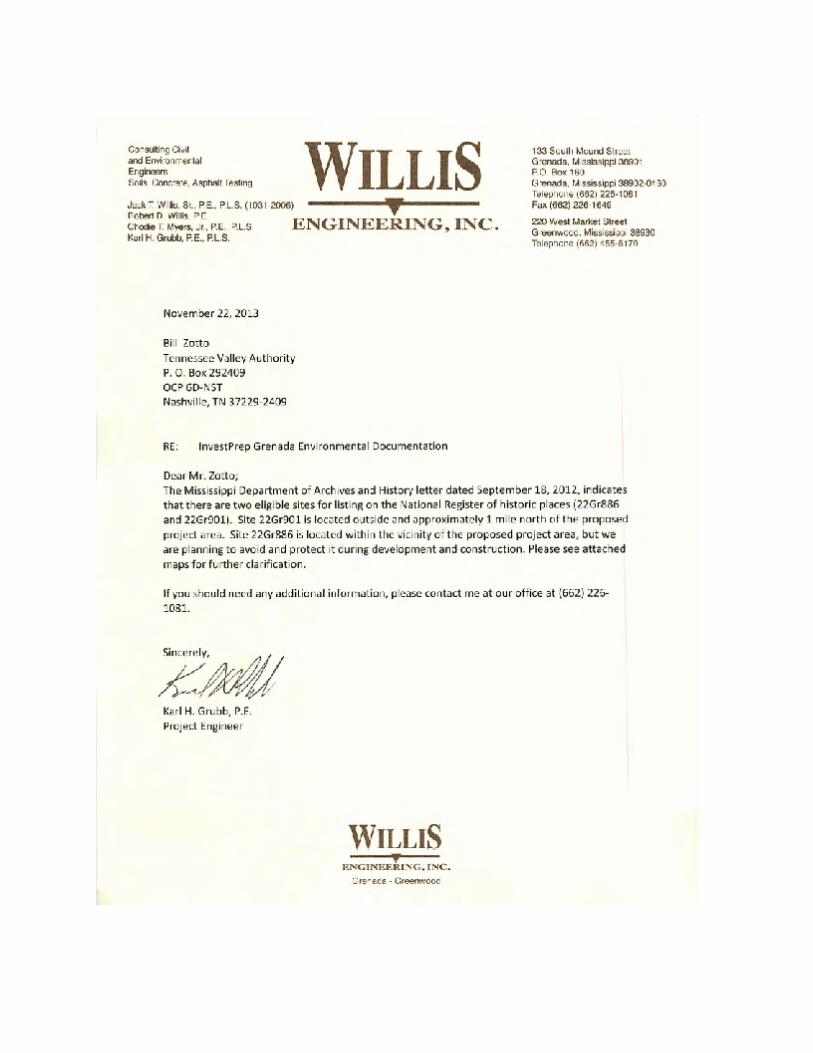
identified during the original Phase I survey. Of these, eight sites (22GR886, 22GR888, 22GR880, 22GR879, 22GR873, 22GR890, 22GR898, 22GR891) were identified within the current APE. Site 22GR886, a prehistoric and historic site, was recommended eligible for the National Register of Historic Places (NRHP), based on the historic component of the site. In a letter to Willis Engineering, Inc., dated September 18, 2012, Mississippi (Attachment B) SHPO agreed with the report author’s recommendation that site 22GR886 was eligible for the NRHP. The letter states that there would be no adverse effect to this historic property provided that the site was avoided.
The proposed sewer line and connector road were not covered by the aforementioned Phase I survey. In April 2014, TVA archaeologists conducted an archaeological survey of the remaining portion of the APE. Seven shovel tests were placed at 30 meter (98.4 feet.) intervals on the opposite side of a drainage ditch running parallel to the gravel connector road (see attached map), which extended between Riverdale Road to the north and Papermill Road to the south. Five tests were excavated; the shovel test profiles suggested significant prior disturbance of the area, indicated by mixed fill and gravel consistent with that found on the adjacent connector road. An additional two shovel tests were not excavated, because the locations in which they would have been positioned were heavily disturbed and could be assessed visually. None of the excavated shovel tests contained cultural material indicating the presence of buried cultural deposits, and no cultural material of historical significance was observed on the ground surface at the location of the two unexcavated tests.
The APE for the proposed sewer line, extending south along Papermill Road, was visually inspected. The artificially-raised bed on which Papermill Road was constructed, coupled with the observed (and previously excavated) drainage ditch along the western side of the road’s right-of-way, suggests that there is little to no risk of encountering intact cultural resources in the proposed sewer line’s APE. Two previously-recorded archaeological sites (22GR711 and 22GR703) were previously recorded along Papermill Road in the vicinity of the proposed APE, but were deemed ineligible for nomination to the NRHP.
During the survey, TVA archaeologists also flagged 22GR886 with a 50 foot buffer in order to ensure that the site would be avoided during construction and operation in this area.
No Action Alternative - Under the No Action Alternative, there would be no project-related effects to historic or archaeological resources under this alternative. Likewise, no direct, indirect, or cumulative effects to these resources are expected. If the applicant obtained alternative funding, the overall environmental consequences would be similar to the Action Alternative.
Action Alternative - Under the Action Alternative, the proposal would be completed. TVA agrees with the recommendations of the Phase I report. With avoidance measures in place for site 22GR886, TVA finds that no historic properties would be affected by the proposed activity.
Pursuant to 36 CFR Part 800.4, regulations implementing Section 106 of the National Historic Preservation Act, on April 24, 2014, TVA consulted with the Mississippi SHPO on the TVA finding that, with avoidance measures of site 22GR886 in place, no historic properties would be affected by the proposed undertaking. Mississippi SHPO concurred with TVA’s no effect finding in a letter dated June 23, 2014 (Attachment B).
Pursuant to 36CFR§ 800.2 (c)(2)(ii), 800.3 (f)(2), and 800.4 (a)(4)(b), TVA also consulted with federally recognized Indian tribes regarding properties within the proposed project’s APE that
9

may be of religious and cultural significance to them and eligible for the NRHP. TVA received no responses from the tribes.
Transportation Trucks going to or from the proposed site would travel to the site by Papermill Road which connects to Mississippi State Route (SR) 332 via Air Industrial Park Road and Kellwood Drive about 4 kilometers east. Westward traffic to and from the site would travel about 3.5 miles on Papermill Road to US Highway 51 and two miles further to I-55. Both routes are currently two lane roads but were recently widened with broad shoulders that access flat, rural terrain. According to the Mississippi Department of Transportation (MDOT 2014), the 2012 Annual Average Daily Traffic (AADT) count at the US 51 and Papermill Road intersection was 4,300 and 1,100 near the Kellwood Drive and SR 332 intersection.
The Grenada Rail Road (Grenada Railroad 2014) borders the site which interchanges with major national railroads northward at Memphis, Tennessee and also interchanges southward with the Illinois Central at Canton, Mississippi. The Grenada Municipal Air Port (Grenada Municipal Air Port 2014) a general aviation facility is about two miles to the east with two asphalt runways the longest at 7,000 feet.
No Action Alternative - Under the No Action Alternative, existing transportation would not be affected. If the earthen building pad and associated access road is constructed at this location without TVA involvement, the impacts would be much the same as the Action Alternative.
Action Alternative - Under the Action Alternative, there would be a minor temporary increase in transportation while the sites were constructed. The proposed earthen building pads and associated access road would be constructed. After the initial mobilization of equipment, traffic to and from the proposed site would consist of a small workforce of operators, laborers, and construction foreman observing a typical eight to ten-hour work day. The minor temporary increase in transportation while the proposed earthen building pads and associated access road are constructed would be insignificant.
Terrestrial Ecology Habitat within the project area was assessed and characterized based on review of aerial photography The project area is comprised primarily of early-successional habitat (open field), and occurs in a landscape surrounded by pasture, industrial sites, transportation corridors (roadway), and fragmented forest blocks. Habitat present includes an herbaceous field interspersed with a few scattered trees and linear rows of woody vegetation that borders the perimeter of the project area.
Vegetation on the site has been heavily managed to maintain its open condition and, as a result, it is likely dominated by non-native species. The site is predominantly comprised of an herbaceous field, with a few scattered trees and 2-3 narrow rows of woody vegetation along the perimeter of the project area. Portions of the proposed new sewer line may be forested, but the total amount of forested land impacted would be approximately 2 acres or less.
EO 13112 (Invasive Species) serves to prevent the introduction of invasive species and provides for their control to minimize the economic, ecological, and human health impacts that those species potentially cause. In this context, invasive species are non-native species that invade natural areas, displace native species, and degrade ecological communities or ecosystem processes (Miller 2010). The project area is currently dominated by weedy herbaceous vegetation, which reflects the frequency and magnitude of disturbance present on
10

site. Disturbances associated with agriculture, grazing, and mowing prevent tree species from becoming established, but can also encourage invasion and establishment of weedy plants.
Birds commonly observed in early successional and forest-field edge habitat include Carolina wren, tufted titmouse, northern mockingbird, northern cardinal, eastern towhee, eastern bluebird, brown thrasher, field sparrow, and eastern meadowlark. Red-tailed hawk, northern harrier and American kestrel also forage along open fields and road rights-of-way. Mammals frequently observed in this type of habitat include Virginia opossum, eastern cottontail, striped skunk, white-tailed deer, eastern coyote, eastern mole, woodchuck, and rodents such as white-footed mouse and hispid cotton rat. Common reptiles include black racer, black rat snake and eastern garter snake.
No caves or wading bird colonies have been documented within three miles of the project area. No suitable habitat for heron colonies is available within the project footprint. Work activities would not affect caves, heronries or other aggregations of migratory birds.
No Action Alternative - Under the no action alternative, TVA would not provide funding and the industrial site could remain in its current condition for some length of time. The applicant could seek alternative funding or not complete the project. If the project is not completed, no impacts to terrestrial ecology would occur. If the project is completed with alternative funding, the impact to terrestrial ecology is likely to be similar to the Action Alternative.
Action Alternative - Under the Action Alternative, removal of woody vegetation would be minimal and conversion of land cover from one type to another (e.g., mature forest to herbaceous field) would be discountable. Any terrestrial animals that may be present within the project area may move into surrounding areas during construction activities, but likely would return to the area once construction activities are completed.
Socioeconomics and Environmental Justice The proposed facility would be located in Grenada County, Mississippi, which had a population of 21,906 in 2012 (US Census Bureau 2014). The most recent unemployment rate was 11.0 percent, which is higher than the state’s rate of 10.6 percent. The minority population share was at 43 percent in the county, which is higher than the state (39) and national (36) percentages. According to the American Community Survey 2008-2012 estimates, the population below the poverty level at the county level is 22.4 percent and the state and national levels at 22.3 and 14.9 percent, respectively.
Medium household income in Grenada County was $35,912, as of 2012, about 68 percent of the national level of $53,040 and 92 percent of the state level of $38,882. Employment in the county is dependent primarily on manufacturing, education and health care, and retail, but less dependent on service and professional sectors of the economy.
No Action Alternative - Under the No Action Alternative, TVA would not provide funding for the proposal. If the pads were not constructed, socioeconomics or environmental justice would not be affected. If the proposal is constructed with alternative funding, the impacts would be much the same as the Action Alternative.
Action Alternative - Under the Action Alternative, because the immediate vicinity around the proposed site, as well as most of the nearby Industrial Park, is unpopulated, any construction or operation activities related to the proposed facility would be remote from the area’s population and not likely to have any noticeable impact on residents. The proposal would add temporary
11

construction jobs to the local economy as the facility is built. Therefore, minor beneficial impacts on commercial activity or other activities in the area are likely to occur because of new or increased purchases of local services and goods.
Minority and low-income populations occur in the county and vicinity of the project area. However, there are no adjacent residences. Therefore, any impacts that might occur would be economically beneficial and not disproportionately affect disadvantaged populations.
Noise, Air Quality, and Solid Waste Construction activities including the movement of large amounts of earth can produce noise from machinery and handling as well as fugitive dust and combustion emissions from engines and burning of unwanted vegetation. Also, localized solid waste would result from the packaging of materials used during the construction process or accumulated in the form of vegetation and construction debris. The proposed project would be located in an existing industrial operations area. No residential development is adjacent to the project area.
No Action Alternative - Under the No Action Alternative, there would be no additional impacts to noise, air quality, or solid waste. If project is constructed with alternative funds, the impacts would be much the same as the Action Alternative.
Action Alternative - Under the No Action Alternative, TVA would provide the grant and the earthen building pads and other infrastructure would be constructed. Construction noise and impacts to air quality (fugitive dust) expected during the building period would come from equipment used for excavating, grading, and hauling. Most of the construction activities would occur during weekday, daylight hours; however, construction could occasionally occur during nights and weekends, if necessary. The immediate area would experience temporary noise increases during construction; however, most activities would be during weekday daylight hours within an existing Industrial Park removed from the nearest residential receptor. Therefore the construction noise is expected to result in minor impacts. Construction of the proposed earthen building pad and associated access road would cause temporary minimal offsite fugitive air emissions, but with the employment of BMPs designed to suppress dust, is expected to result in minor impacts.
Solid wastes produced during the construction of the proposed building pads and associated infrastructure would consist of general refuse. These materials would be disposed of by a licensed waste management company in a permitted landfill. Therefore, the action alternative would result in only minor or temporary direct, indirect or cumulative effects relating to noise, air quality, and solid waste.
Cumulative Impacts Resources that could be cumulatively affected by TVA providing the grant and the construction of earthen building pads and associated infrastructure are transportation, socioeconomics, noise, air quality, and solid waste. Transportation, noise, air quality, and solid waste would continue to be affected by general population increases, industrial use, and development growth in the area. Socioeconomics would be beneficially impacted by direct job growth and indirectly by associated services. However, this action would not result in substantial cumulative impacts on a regional or Valley-wide basis. Although it would have a somewhat greater impact than the No Action Alternative, the Action Alternative would result in a minimal impact on the environment and improve local economy when the proposal was completed. Therefore, TVA has determined that cumulative impacts of this action would be insignificant.
12

Necessary Permits As the impacted area would be greater than one acre, a Construction Storm Water Permit from the Mississippi Department of Environmental Quality’s would be required, pursuant to Section 401 of the Clean Water Act. The applicant is responsible for obtaining any local, state, or federal permits necessary for this project.
Agency Involvement The applicant submitted a completed grant application for the proposed construction of earthen building pads and associated infrastructure within the Industrial Park on July 17, 2013. The applicant’s contract engineer, Willis Engineering, Inc., contacted the following agencies (Attachment B) regarding the proposal:
• A September 18, 2012 letter from the Mississippi Department of Archives and History (MDAH) concurring that site 22Gr886 within the project’s APE is eligible for listing in the NHRP and should be avoided; and that other unrecorded cultural resources may be encountered.
• A July 24, 2012 letter from the USFWS stating there are no listed species or their habitats within the project vicinity and, therefore, no federally listed species would be impacted by the work activities.
• A July 23, 2012 letter from the MDWFP stating that a state imperiled species (Steelcolor Shiner) was documented within 2 miles of the proposed project.
• A July 2, 2012 letter from the U.S. Army Corps of Engineers (USACE), stating that there were jurisdictional waters and wetlands within the 1,175 acre industrial park boundaries and any impact to them may require a section 404 permit. However, no jurisdictional waters or wetlands occur within the parcels involved in this action.
In addition to the applicant-provided correspondence, TVA contacted the following federal and state officials, as well as federally recognized Native American tribes, concerning the proposed project.
• Chickasaw Nation • Choctaw Nation of Oklahoma • Jena Band of Choctaw Indians • Mississippi Band of Choctaw Indians • Mississippi Department of Archives and History
Correspondence received from other agencies related to this review and coordination is contained in Attachment B.
Mitigation Measures To minimize or reduce the environmental effects of the proposed project, the applicant is to ensure all construction activities are in compliance with storm water permitting requirements and utilize applicable BMPs to minimize and control erosion and fugitive dust during construction. Archeological site 22GR886 will be avoided, with a 50 foot buffer, in order to ensure that the site would not be disturbed during construction and operation.
Preferred Alternative TVA’s Preferred Alternative is the Action Alternative under which TVA would provide the grant to the Grenada County Economic Development District for site preparation of two building pads,
13

sewer lines and roads for creating future industrial and/or commercial opportunities within the existing Industrial Park.
TVA Preparers Adam Dattilo, Botanist, Biological Resources, Terrestrial Ecology and Threatened and
Endangered Species
Michaelyn Harle, Contract Archaeologist, Cultural Resources, National Historic Preservation Act Section 106 Compliance
Andrew R. Henderson, Aquatic Endangered Species Biologist, Aquatic Ecology and Aquatic Threatened and Endangered Species
Amy B. Henry, Manager, NEPA Compliance and Document Preparation
Holly G. LeGrand, Biologist, Biological Resources, Terrestrial Resources and Terrestrial Endangered Species
Robert A. Marker, Recreation Specialist, Recreation Resources
Craig L. Phillips, Contract Aquatic Ecologist, Biological Resources, Aquatic Ecology
Roger Milstead, Program Manager, River Operations, Floodplains
Kim Pilarski, Biologist, Biological Resources, Wetlands and Natural Areas
Richard L. Toennisson, Contract Senior NEPA Specialist, NEPA Compliance and Document Preparation
Bill L. Zotto, Economic Development, Project Manager
Agencies and Others Consulted Mississippi Department of Archives and History, Jackson, Mississippi
United States Fish and Wildlife Service, Jackson, Mississippi
United States Natural Resources Conservation Service, Coffeeville, Mississippi
Chickasaw Nation
Choctaw Nation of Oklahoma
Jena Band of Choctaw Indians
Mississippi Band of Choctaw Indians
Mississippi Department of Archives and History
References Chapman, S.S, Griffith, G.E., Omernik, J.M., Comstock, J.A., Beiser, M.C., and Johnson, D.,
2004. Ecoregions of Mississippi, (color poster with map, descriptive text, summary tables, and photographs): Reston, Virginia, U.S. Geological Survey (map scale 1:1,000,000).
Johnson, J K., 2012. Cultural Resources Survey of a Proposed Riverdale Industrial Property, Grenada County, Mississippi (Revised) (Report #12- 0436).
14

Miller, J H., Manning, S.T., and S.F. Enloe. 2010. A management guide for invasive plants in the Southern forests. Gen. Tech. Rep. SRS-131. US Department of Agriculture, Forest Service, Southern Research Station: 1-3.
Mississippi Department of Transportation. 2014. MDOT Office of Intermodal Planning, Grenada County Traffic Data, 2012 AADT Count Retrieved from <http://sp.mdot.ms.gov/Office of Highways/Planning/Maps/Pages/TrafficVolumeMaps.aspx> (accessed April 2014).
Mississippi Department of Wildlife, Fisheries and Parks. 2014. http://www.mdwfp.com/wildlife-hunting/wmas/northdelta-region/malmaison.aspx (accessed April 2014).
Grenada Municipal Airport. 2014. http://gc.kls2.com/airport/KGNF "Grenada Municipal Airport (IATA: none, ICAO: KGNF, FAA: GNF)". Great Circle Mapper. (accessed April 2014).
Grenada Railroad. 2014. http://www.vsrailway.com/affilliated-railroads/grenada-railway-llc Accessed April, 2014
United States Water Resources Council. 1978. Floodplain management guidelines for implementing Executive Order 11988. 43 FR 6030, Federal Register 43(29), Feb. 1978.
United States Census Bureau. 2012 http://factfinder2.census.gov/faces/nav/jsf/pages/searchresults.xhtml?refresh=t (accessed June, 2012
Attachments A. Maps and Plans B. Agency Letters
15

Attachment A - Maps and Plans
16

Page intentionally blank

Figure 1. Grenada Industrial Park
18
Figure 2 - Aerial Depicting Project Area
19

TVA Grant
Project Proposal by: Greater Grenada Foundation for Economic Development
Project Scope Confirmation Final Project Description The Grenada proposed project seeks to develop a project ready TVA site in Grenada County that will be able to effectively compete for industrial projects. By completing the infrastructure investments proposed on this project, TVA will have a rail served site in Grenada that is located within half a mile from a TVA substation and that will count with industrial grade road access, direct connectivity to Interstate I-55, city owned water and sewer access, and two building pads able to accommodate the requirements of most automotive and other manufacturing related projects. The main elements of the project include:
• Development of a 320K sq. ft. and a 400K sq. ft. building pad on the highest ground available. A 320K sq. ft. building pad will be prepared on a 20-acre parcel on the northwest corner of the TVA served site. A second 400K sq. ft. building pad will be prepared on a 35-acre parcel located on the southwest corner of the TVA served site. Both parcels are located on the highest ground available and in areas with no major elevation differences, allowing for the most efficient use of resources. The parcel delineation chosen for the project will also provide for the most efficient use of future resources to accommodate storm water management as future investments happen on the parcels located nearby.
In addition, the sites selected for development provide very compelling aesthetic characteristics (such as open views, high grounds away from any flood plain areas, etc.) that we believe will make the site more appealing to potential recruitment prospects.
• Extension of existing city owned sewer line to the site.
The subject site has a 10-inch water line in place (belongs to the City of Grenada) but lacks access to the city sewage system. The main sewage line is located about half a mile from the subject site. The proposed project will provide a sewer force main from the city owned sewage line to the proposed site.
• Construction of an industrial grade connector road to provide direct accessibility to Interstate
55. A connector road (80K lb.) will be constructed to link the site with Paper Mill Road (80K lb.), which connects directly to Interstate 55. The road will also be extended 600 ft. inside the industrial park allowing for a more professional presentation to prospects.
• Construction of a gravel roadbed to link the new connector road (80K lb.) with the two sites
where building pads will be built.
20

Attachment B - Agency Letters
21

Page intentionally blank

24


26


28


30


32

34


36


38


