Embed Size (px)
Citation preview
ECOLOGICAL STUDIES BASELINE REPORT GRAND NIAGARA SECONDARY PLAN
November 2015 Revised May 2016
Ecological Studies Baseline Report Grand Niagara Development Niagara Falls, ON
Report Prepared for:
Grand Niagara Development c/o Municipal Law Chambers 1 Adelaide St. East, Ste. 2340 P.O. Box 189 Toronto, ON M5C 2V9
Report Prepared by:
Savanta Inc. 37 Bellevue Terrace St. Catharines, ON L2S 1P4
File No. 7201
Grand Niagara Secondary Plan
Ecological Baseline Studies
File No. 7201
2
TABLE OF CONTENTS
1.0 INTRODUCTION ............................................................................................................................... 3 1.1 STUDY PURPOSE ............................................................................................................................. 3 1.2 NATURAL HERITAGE PLANNING CONSIDERATIONS ............................................................................ 3
1.2.1 Municipal Official Plans ............................................................................................................ 4 1.2.3 Niagara Peninsula Conservation Authority ............................................................................... 6 1.2.4 Provincial Legislation and Associated Guideline Documents ................................................... 6
2.0 DATA COLLECTION APPROACH & METHODS ............................................................................ 8 2.1 BACKGROUND REFERENCES ............................................................................................................ 8
2.1.2 NHIC Database ....................................................................................................................... 8 2.2 AGENCY DISCUSSION ...................................................................................................................... 9
2.2.1 Ministry of Natural Resources and Forestry (MNRF) ............................................................... 9 2.2.2 Niagara Peninsula Conservation Authority (NPCA) ..................................................................... 9
2.3 FIELD INVESTIGATIONS .................................................................................................................... 9 3.0 ENVIRONMENTAL SETTING AND CHARACTERISTICS ............................................................ 10
3.1 PHYSICAL BASELINE CONDITIONS .................................................................................................. 10 3.2 BIOLOGICAL BASELINE CONDITIONS ............................................................................................... 10
3.2.1 Vegetation Communities ........................................................................................................ 10 3.2.2 Wildlife Species ...................................................................................................................... 13
3.2.2.1 Breeding Bird and Species at Risk Bird Surveys ................................................................ 13 3.2.2.2 Calling Amphibians .............................................................................................................. 17 3.2.2.3 Reptiles ............................................................................................................................... 19 3.2.2.4 Other Wildlife ....................................................................................................................... 22
3.2.3 Aquatic Resources ................................................................................................................. 23 3.2.3.1 Headwater Drainage Feature Assessment ......................................................................... 23 3.2.3.2 Aquatic Habitat Assessment ............................................................................................... 24
3.3 ANALYSIS OF ECOLOGICAL & NATURAL HERITAGE SIGNIFICANCE (PPS) ..................... 28 3.3.1 Significant Wetlands ............................................................................................................... 29 3.3.2 Habitat of Endangered and Threatened Species ................................................................... 29 3.3.3 Fish Habitat ............................................................................................................................ 30 3.3.4 Significant Woodlands ............................................................................................................ 31 3.3.5 Significant Valleyland ............................................................................................................. 32 3.3.6 Significant Wildlife Habitat ...................................................................................................... 32 3.3.7 Summary of Significant Wildlife Habitat Present on the Subject Lands ................................. 35
4.0 PRELIMINARY NATURAL HERITAGE .......................................................................................... 37 REFERENCES ............................................................................................................................................. 40 APPENDIX A ................................................................................................................................................ 43 APPENDIX B ................................................................................................................................................ 44

Grand Niagara Secondary Plan
Ecological Baseline Studies
File No. 7201
3
1.0 INTRODUCTION
1.1 Study Purpose
The Grand Niagara Incorporated (Grand Niagara) holdings (Subject Lands) are located in the urban area of the City of Niagara Falls (City), south of the Welland River, north of Biggar Road, west of the QEW and east of Morris Road (Figure 1). The Subject Lands have been investigated since the late 1990s in response to proposed development. The earliest environmental work responded to the proposed golf course itself and to associated facilities. Construction was initiated on the golf course areas of the Grand Niagara Resort in 2002, after considerable multi-season and multi-disciplinary investigations. Supplementary natural heritage studies were completed from 2012 to 2014 as development options were explored and a draft EIS (Savanta Inc., July 24, 2014) was prepared.
In response to proposed development of residential and hospital land uses, Savanta was retained by Grand Niagara in 2015, to complete an ecological studies update report. Detailed natural heritage studies were conducted in 2015 to update ecological data, to interpret the significance of natural features and functions associated with the Subject Lands, and to present preliminary information regarding natural heritage constraints and opportunities. A complete impact assessment is forthcoming, pending finalization of the development plan and ongoing discussions with Niagara Region (Region), the City and the Niagara Peninsula Conservation Authority (NPCA).
Figures and data tables from Savanta’s 2015 ecological studies are provided in Appendices A and B, respectively. Figures and data tables from Savanta’s earlier 2012-2014 ecological studies are provided as addendum to this report, for context.
1.2 Natural Heritage Planning Considerations
In addition to an assessment of natural heritage features and functions of the Subject Lands, there are legislation and environmental policies that also affect development on these lands. Planning Act related discussions are addressed directly by MMM Group Limited (MMM). This report addresses Natural Heritage policies and associated guidelines; areas affected by these regulatory aspects are illustrated on Figure 2.
In terms of municipal policies, the City of Niagara Falls proposed that OPA 69 be applied to the Subject Lands as an outcome of OPA 96 Ontario Municipal Board settlement discussions with the proponent in 2014. That settlement proposal is applied in this report, recognizing that OPA 96 and its associated environmental policies (i.e., policies 12.1, 12.2) do not fully apply, and that the current PPS (i.e., 2014) should be applied along with other relevant and current agency legislation and policies (e.g., Conservation Authorities Act, Ontario Regulation 155/06 and Endangered Species Act, 2007).
Grand Niagara Secondary Plan
Ecological Baseline Studies
File No. 7201
4
This updated ecological report provides a baseline of information that serves as input to the Secondary Planning process. As dialogue and this planning process progress, this report will also serve as the baseline from which an Environmental Impact Study (EIS) can be produced (i.e., as required in order to comply with the Regional Official Plan). Portions of the Region’s Core Natural Heritage System occur on the Subject Lands (Section 7 and Schedule C; Region, 2015); development adjacent to these natural features triggers the need for an EIS. The Subject Lands are located outside the Greenbelt Plan Area. The site is subject to the Provincial Policy Statement (2014), Ontario Endangered Species Act (2007) and NPCA regulations. 1.2.1 Municipal Official Plans Given that the City of Niagara Falls OPA 96 does not apply to these lands, the Region of Niagara Official Plan (consolidated version August 2015) was relied upon for additional guidance and direction pertaining to natural heritage features and associated functions. As noted previously, the Subject Lands contain elements of the Region’s Core Natural Heritage System (the Regional NHS). Policy 7.B.1.1. (RPP, 2015) summarizes the components of the Regional NHS as follows:
• Core Natural Areas, classified as Environmental Protection Areas (EPA) or Environmental Conservation Areas (ECA);
• Potential Natural Heritage Corridors connecting the Core Natural Areas; • Greenbelt Natural Heritage and Water Resource Systems; and, • Fish Habitat.
The Region’s EPA designation includes:
• Provincially significant wetlands; • Provincially significant life science Areas of Natural and Scientific Interest
(ANSIs); • Significant habitat of endangered and threatened species (not mapped by the
Region, where identified this habitat will be subject to EPA policies); • Greenbelt Natural Heritage System (wetlands, significant valleylands, significant
woodlands, SWH, habitat of species of concern, publicly owned conservation lands savannahs, tallgrass prairies, alvars); and,
Environmental Conservation Areas (ECA) include:
Grand Niagara Secondary Plan
Ecological Baseline Studies
File No. 7201
5
• Significant woodlands, significant wildlife habitat, significant habitat of species of concern;
• Regionally significant life science ANSIs; • Other evaluated wetlands; • Significant valleylands; • Savannahs, tallgrass prairie and alvars; and, • Publicly owned conservation lands.
Potential Natural Heritage Corridors include:
• Areas that maintain and, where possible, enhance the ecological functions of the corridor in linking the core natural areas.
Regional NHS policies (Chapter 7.B; Region, 2015) that apply to Regional NHS elements on the Subject Lands are summarized below:
• Only minor adjustments to EPA boundaries will be permitted without amendment to the Regional Official Plan (Plan);
• Development and site alteration may be permitted without amendment to the Plan in ECAs and on adjacent land to EPA and ECAs outside the Greenbelt NHS if it has been demonstrated over the long term that there will be no significant negative impact on the Regional NHS or adjacent lands and the proposed development or site alteration is not prohibited by other policies;
• Where it is demonstrated that all, or a portion of, an ECA does not meet the criteria for designation under this Plan the restrictions on development and site alteration do not apply;
• Where development or site alteration is proposed in or near a potential natural heritage corridor (shown conceptually on Schedule C), development should be located, designed and constructed to maintain and, where possible, enhance the ecological functions of the corridor in linking core natural areas or an alternative corridor should be developed;
• Development or site alteration within fish habitat may occur if it will result in no net loss of the productive capacity of fish habitat as determined by the Department of Fisheries and Oceans or its designate;
• Where development or site alteration is approved in or adjacent to the Regional NHS, new lots shall not extend into the area to be retained in a natural state as part of the NHS or the buffer zone identified through an EIS; and,
• Where development or site alteration is approved within the Regional NHS or adjacent lands the applicant shall submit a Tree Saving Plan that maintains or enhances the remaining natural features and ecological functions.
Grand Niagara Secondary Plan
Ecological Baseline Studies
File No. 7201
6
1.2.3 Niagara Peninsula Conservation Authority
The NPCA conducts reviews of planning processes associated with the future development of properties within its jurisdiction. In addition, the NPCA provides planning and technical advice to planning authorities to assist them with fulfilling their responsibilities regarding natural hazards, natural heritage and other relevant policy areas pursuant to the Planning Act. The NPCA administers the Development, Interference with Wetlands and Alterations to Shorelines and Watercourses Permit process, under Ontario Regulation 155/06.
1.2.4 Provincial Legislation and Associated Guideline Documents
Provincial Policy Statement (2014) The most recent PPS was issued under Section 3 of the Planning Act. It came into effect on April 30, 2014 and it replaces the PPS issued March 1, 2005 (MMAH, 2014). The PPS provides direction on matters of provincial interest related to land use planning and development. It ”…supports a comprehensive, integrated and long-term approach to planning…” The PPS is to be read in its entirety and land use planners and decision-makers need to consider all relevant policies and how they work together.
This Ecological Baseline Report addresses those policies that are specific to Natural Heritage (section 2.1) with some reference to other policies with relevance to Natural Heritage and impact assessment considerations and areas of overlap (e.g., those related to Efficient and Resilient Development and Land Use Patterns, section 1.1; Sewage, Water and Stormwater, section 1.6.6; Water, section 2.2; Natural Hazards, section 3.1).
Eight types of significant natural heritage features are defined in the PPS, as follows:
• Significant wetlands • Significant coastal wetlands; • Significant woodlands; • Significant valleylands; • Significant wildlife habitat; • Fish habitat; • Habitat of endangered and threatened species; and, • Significant areas of natural and scientific interest (ANSIs).
Development and site alteration shall not be permitted in significant wetlands, or in significant coastal wetlands. Development and site alteration shall not be permitted in: significant woodlands, significant valleylands, significant wildlife habitat or significant ANSIs, unless it is demonstrated that there will be no negative impacts on the natural features or their ecological functions.
Grand Niagara Secondary Plan
Ecological Baseline Studies
File No. 7201
7
Development and site alteration shall not be permitted in the habitat of endangered and threatened species or in fish habitat, except in accordance with provincial and federal requirements. Development and site alteration may be permitted on lands adjacent to fish habitat provided it has been demonstrated that there will be no negative impacts on the natural feature or their ecological functions.
Ontario’s Endangered Species Act (2007)
The provincial Endangered Species Act (ESA) 2007 was developed to:
• Identify species at risk, based upon best available science; • Protect species at risk and their habitats and to promote the recovery of species
at risk; and • Promote stewardship activities that would support those protection and recovery
efforts.
The ESA protects all threatened, endangered and extirpated species itemized on the Species at Risk in Ontario (SARO) list. These species are legally protected from harm or harassment and their associated habitats are legally protected from damage or destruction, as defined under the ESA 2007.
Grand Niagara Secondary Plan
Ecological Baseline Studies
File No. 7201
8
2.0 DATA COLLECTION APPROACH & METHODS
2.1 Background References
Substantial work has already been completed on the Subject Lands. Studies completed by ESG International Ltd. (ESG, now Stantec Consulting) included:
• Environmental Impact Assessment (EIA), 2001; • Tree Preservation Plan, March 7, 2001; • EIA Addendum Report, June 22, 2001; and, • Environmental Implementation Report (EIR), March 12, 2003.
The previous studies made specific reference to data collected from:
• OMNR wetlands and fisheries information; • Natural Heritage Information Centre (NHIC) rare species and communities; • NPCA natural areas, species of concern and hazard land mapping; • Regional Official Plans, ESA studies, natural areas reports, greenway inventory
and tree-cutting bylaw; • City Official Plan, Urban Wooded and Treed Inventory and Assessment study;
and, • Various provincial wildlife atlases (i.e., butterflies, amphibians, reptiles, breeding
birds, mammals).
This ecological studies update, which incorporates the results of detailed ecological surveys conducted in 2015, partially relies upon additional supporting background information, agencies and resources that are listed below:
• Federal and Provincial Species at Risk (SAR) websites; • Ontario Ministry of Natural Resources and Forestry (MNRF), Aurora District; • Natural Heritage Information Centre (NHIC) rare species and communities; • NPCA Natural Areas Inventory (2010); • NPCA South Niagara Falls Watershed Report (2008); and, • Natural Heritage Information Centre (NHIC, 2014).2.1.1 LIO Natural FeaturesSummary
Based on a search of the MNRF Land Information Ontario (LIO) geographic database, there are no ANSIs present on or within 120m of the Subject Lands. LIO natural heritage features are shown on Figure 2.
2.1.2 NHIC Database
The MNRF maintains the NHIC database. A search of this database in 2015 identified 35 Species at Risk and provincially rare species (SH, S1-S3) in the vicinity of the
Grand Niagara Secondary Plan
Ecological Baseline Studies
File No. 7201
9
Subject Lands. Table 1 (Appendix B) summarizes preferred habitat and possible presence / absence on the Subject Lands.
2.2 Agency Discussion
2.2.1 Ministry of Natural Resources and Forestry (MNRF)
The MNRF Guelph District Information Request Form pertaining to Species at Risk and natural heritage features on, and adjacent to, the Subject Lands was submitted on October 21, 2015. A response letter has not yet been received.
2.2.2 Niagara Peninsula Conservation Authority (NPCA)
The NPCA provided comments to the Terms of Reference for the EIS at a pre-consultation meeting for the Grand Niagara Secondary Plan on August 6, 2015. Based on these comments a technical meeting with the NPCA took place on October 7, 2015 to review and provide clarification with respect to their comments on natural heritage. In addition, some targeted field investigation actions were identified to be carried out in the spring of 2016. These studies are currently underway and the results will be provided as an addendum to this EIS.
2.3 Field Investigations
The substantial volume of background information already available through historic fieldwork conducted on the Subject Lands was supplemented with targeted fieldwork to verify the current ecological condition of the Subject Lands; this work was undertaken by Savanta in 2012, 2013 and in 2014. Detailed ecological studies were then conducted in 2015 in response to the proposed development of residential and hospital land uses.
Field studies were conducted by ESG for the original Environmental Impact Assessment in 2001 and for the Environmental Implementation Report in 2003. Field investigations completed in 2000, 2002 and 2003 included: fish habitat assessment and fisheries inventory, three-season botanical inventory, Ecological Land Classification of vegetation communities, woodland assessment, breeding bird survey, breeding amphibian survey, incidental wildlife (including discernable movement paths) and soils. Additional work completed by Savanta in 2006 / 2007 included: late season botanical survey (October 15, 2006), tree assessment (November 28, 2006), and verification of vegetation communities (ELC) and species composition (July 31, 2007).
Surveys conducted by Savanta ecologists in 2015 are summarized in Table 2. Surveys conducted from 2012-2014 are summarized in Addendum Table I.
Grand Niagara Secondary Plan
Ecological Baseline Studies
File No. 7201
10
3.0 ENVIRONMENTAL SETTING AND CHARACTERISTICS
3.1 Physical Baseline Conditions
The Subject Lands are situated in the Haldimand Clay physiographic region (Chapman and Putnam, 1984). Soils are characterized as being poorly drained and the water table is usually located close to the surface until late spring. Surface cracking is common during dry periods. The surface horizon ranges from 15 cm to 20 cm deep and has a texture of clay loam to clay; subsoils are heavy clays.
Further supplementary information regarding soils, hydrology, and slopes were provided in previous reports listed in Section 2.1.
3.2 Biological Baseline Conditions
The Subject Lands occur in the Carolinian or Deciduous Forest Zone; an area that is characterized by a warmer climate supporting plant species more typical of southern areas. In this broad zone, dominant associations on upland clay and silt areas were maple-beech-elm-basswood and butternut-chestnut-white ash-black cherry. Most lowland areas were dominated by single species such as white cedar, willow, tamarack, alder, red or silver maple or black ash (Rowe, 1972). Due to Niagara Region’s southern location and warmer climate, some trees and shrubs that are provincially uncommon in other areas of Ontario are locally common (e.g., pin oak, black gum, and swamp white oak).
3.2.1 Vegetation Communities
Table 3 (Appendix B) provides brief descriptions of the ELC types recognized on the Subject Lands. Current vegetation community types and locations are depicted on Figure 3. The Subject Lands contain a variety of tableland, wetland and riparian natural areas along with anthropogenically created features (i.e., hedgerows, golf course rough areas and ponds) that have been colonized by flora and fauna. Riparian vegetation is discontinuous along the Lyon’s Creek and Grassy Brook watercourses on-site. A vegetated buffer remains along the extent of the Welland River at the north end of the site. The larger blocks of natural areas often include units of the Lower Grassy Brook provincially significant wetland complex (Figure 2). Areas outside of the naturally vegetated areas are disturbed and have been previously farmed, utilized as an active golf course and/or cleared of vegetation in preparation for development. The Subject Lands are also bisected by a railway spur line. Botanical investigations were conducted on July 21, August 7 and August 13, 2015 (no access was available during the survey period for 2015 spring ephemeral flora; surveys conducted in previous years). Vegetation communities were first identified on aerial imagery and then verified in the field. Vegetation community types were confirmed, sampled and revised, if necessary, using the sampling protocol of the ELC for Southern
Grand Niagara Secondary Plan
Ecological Baseline Studies
File No. 7201
11
Ontario (Lee at al. 1998). ELC was completed to the finest level of resolution (Vegetation Type) where feasible. Species names generally follow nomenclature from the Flora Ontario – Integrated Botanical Information System (FOIBIS; Newmaster and Ragupathy, 2012). Regional rarity of vegetation communities was based on the Niagara Natural Areas Inventory (NPCA, 2010). Regional rarity of plants was based on Oldham (2010).
The provincial status of all plant species and vegetation communities is based on NHIC (2013). Identification of potentially sensitive native plant species is based on their assigned coefficient of conservatism (CC) value, as determined by Oldham et al. (1995). This CC value, ranging from 0 (low) to 10 (high), is based on a species’ tolerance of disturbance and fidelity to a specific natural habitat. Species with a CC value of 9 or 10 generally exhibit a high degree of fidelity to a narrow range of habitat parameters.
Ecological Land Classification
Table 3 (Appendix B) provides brief descriptions of the ELC types recognized on the Subject Lands. Some communities are characterized at higher levels of classification than the ELC Type due to high diversity of species, absence of clear dominants, and/or prevalence of human influences (golf course use, historical land uses). Several vegetation communities are considered provincially and/or globally rare (NHIC, 2016):
• Pin Oak Mineral Deciduous Swamp SWD1-3: G2, S2S3 – located south of the rail line within an area zoned ECA and is within the buffer of the Lyon’s Creek watercourse.
• Two other pin oak swamp communities (SWD1-5* and SWD1-6*) are not listed in the southern Ontario ELC manual; however, due to dominance of Pin Oak these communities may be considered similar in rarity to SWD1-3 (previous bullet). SWD1-5* is located north of the rail line and is partially contained within the buffer of the Lyon’s Creek watercourse. SWD1-6* is part of a provincially significant wetland (PSW) unit south of the rail line.
• Buttonbush Mineral Thicket Swamp SWT2-4: G4, S3 – is located adjacent to / beneath the dripline of a significant woodland and within the buffer area required for an adjacent PSW unit. This community is also the only regionally rare (NPCA, 2010) type on the Subject Lands.
3.2.1.1 Vascular Plants
Botanical inventories completed on the Subject Lands identified a total of 226 species of vascular plants. Of that number, 165 (or 73%) are native and 61 (or 27%) are exotic. A full species list is included in Table 4 (Appendix B).
Grand Niagara Secondary Plan
Ecological Baseline Studies
File No. 7201
12
The majority of the native species (91%) are ranked S5 (secure in Ontario). Thirteen species (8% are ranked S4 (apparently secure in Ontario; NHIC, 2013), while one species (Black Gum) is ranked S3 (Vulnerable; this species is described further below). Seven regionally rare and ten regionally uncommon plants were observed (Oldham, 2010); none of these species are considered rare in Ontario. Two species recorded from the Subject Lands have a co-efficient of conservation value of 9 or 10 (Black Gum and Pin Oak, described further below). No Species at Risk (SAR) plant species were recorded on the Subject Lands. Targeted searches confirmed the presence of one provincially rare (S3; NHIC, 2013) plant species: Black Gum (Nyssa sylvatica). This species was located in the woodlot on the north side of Grassy Brook Road, where at least four mature trees (DBH 30 cm to 40 cm) and associated shrub-sized stems from root suckers grow in the vicinity of vernal pools. Six species are considered rare in Niagara region (Oldham, 2010):
• Fennel-leaved Pondweed (Stuckenia pectinata); • Greater Duckweed (Spirodela plyrhiza); • Water-meal (Wolffia columbiana); • Hispid Hedge-nettle (Stachys hispida); • Swamp red currant (Ribes triste); and, • Cardinal Flower (Lobelia cardinalis).
Historical Surveys ESG (2001) recorded three locally rare species north of Grassy Brook Road: Fragrant White Water Lily (Nymphaea odorata ssp. odorata), Black Gum (Nyssa sylvatica) and Sallow Sedge (Carex lurida). One species recorded by ESG (2003) is provincially ranked S3 (vulnerable in Ontario) according to NHIC (2013): Pignut hickory (Carya glabra). This species was observed in a woodland south of the railway by ESG (2003), this species is uncommon in Niagara Region (Oldham, 2010). It was not relocated during 2012 to 2015 vegetation surveys. The following species identified in the ESG (2003) report, are rare in Niagara Region (Oldham, 2010):
• Purple Cress (S4), Niagara Region (R) • Cardinal Flower (S5), rare in Niagara Region (R) • Rough Hedge-nettle (S4S5), rare in Niagara Region (R) • Dark-purple Alexanders (S5), rare in Niagara Region (R) • Rough Fleabane (S5), rare in Niagara Region (R) • Cardinal Flower (S5), rare in Niagara Region (R)
Grand Niagara Secondary Plan
Ecological Baseline Studies
File No. 7201
13
• Wild Red Currant (S5), rare in Niagara Region • Rose-Twisted Stalk (S5), rare historic in Niagara Region (RH; no record since
1980s) • Pin Cherry (S5), rare in Niagara Region (R) • Beaked Hazel (S5), rare in Niagara Region (R)
3.2.2 Wildlife Species
Site visits were performed in 2012 - 2015 (Savanta) to assess wildlife use of the Subject Lands. Surveys included targeted searches for breeding birds, Species at Risk grassland birds, calling amphibians, snakes, turtles, bats, insects and incidental observations of mammals. Surveys included assessments of potential wildlife corridor functions. Methods and results are provided below for the detailed ecological studies completed in 2015 along with key findings from previous studies (ESG, 2001 and 2003; Savanta, 2012 - 2014).
3.2.2.1 Breeding Bird and Species at Risk Bird Surveys
Survey Methodology Two-round breeding bird surveys were conducted following protocol set forth by the Ontario Breeding Bird Atlas (Cadman et al., 2007), the Ontario Forest Bird Monitoring Program (Cadman et al., 1998) and the Marsh Monitoring Program (Bird Studies Canada, 2014 and 2006). Survey dates and conditions are provided in Table 2 (Appendix B). Access was not available to conduct a 2015 first round breeding bird survey.
Surveys were conducted between dawn and five hours after dawn with suitable wind conditions, no thick fog or precipitation (Cadman et al., 2007). Point count stations were located in various habitat types within the Subject Lands and combined with area searches to help determine the presence, variety and abundance of bird species. Each point count station was surveyed for 10 minutes for birds within 100 m and outside 100 m. All species recorded on a point-count were mapped to provide specific spatial information and were observed for signs of breeding behaviour. Surveys were conducted at least 10 days apart. During breeding bird surveys, vegetation was assessed for the potential presence of Species at Risk habitat. If suitable habitat was encountered or individuals were observed standard protocols were utilized (in consultation with MNRF).
Open grassland habitat, including pasture, hay fields and fallow areas, was surveyed according to the MNR (2012) Guidelines for Bobolink and Eastern Meadowlark. Point count stations (discussed above) were located within open grassland habitat. Where this habitat was greater than 250 m wide or long, two-point count stations were
Grand Niagara Secondary Plan
Ecological Baseline Studies
File No. 7201
14
completed (point count stations are set up every 250 m in large habitats). Transects or area searches were also conducted in addition to the 10-minute point count stations.
Both the Natural Heritage Information Centre (NHIC, 2013) database and the Species at Risk in Ontario (SARO) list (Ontario Regulation 230/08) were reviewed to determine the current provincial status for each bird species.
Investigations and Results A total of 30, point count stations were surveyed within the Subject Lands. Point count stations were located within cultural meadow, upland forest, forested swamp, golf course, wetland, disturbed land and agricultural lands (Figure 4). A total of 61 bird species were observed within the Subject Lands. Of this total, seven species are confirmed, 35 are probable and 11 are possible breeders on the Subject Lands. The remaining 8 bird species are considered non-breeders, flyovers or migrants. The observed breeding bird species are discussed in the sections below. All species observed on the Subject Lands are listed in Table 6 (Appendix B). A total of 53 (100%) of the confirmed, probable or possible breeders are provincially ranked S5 (common and secure), S4 (apparently common and secure) or SNA (species not native to Ontario). One bird species is considered provincially rare (S1 - S3; NHIC, 2013) and is discussed below. Great Egret (S2B; NHIC, 2013) was observed visiting and foraging along the edges of golf course water bunkers on the Subject Lands. These birds are presumed adults from nesting colonies in the Niagara River and no breeding evidence was recorded on the Subject Lands. The following Species at Risk were observed on the Subject Lands:
• Bobolink (Threatened in Ontario and Canada); • Barn Swallow (Threatened in Ontario and Canada); • Eastern Wood-Pewee (Special Concern in Ontario and Canada); and, • Wood Thrush (Special Concern in Ontario, Threatened in Canada).
Surveying for grassland bird Species at Risk included eleven point counts placed in cultural meadows and disturbed / fallow areas. These polygons did not provide suitable breeding habitat for Bobolink or Eastern Meadowlark due to small size, high disturbance and linear shape (i.e., lack of core / interior habitat). Several of the surveyed polygons were larger but did not provide suitable breeding habitat due to high disturbance, areas of bare soil or standing water, and inappropriate vegetation composition / structure (i.e., high forb content, low grass content, disturbed annual row crops). No post-breeding staging / flocking observations were recorded during surveys.
Grand Niagara Secondary Plan
Ecological Baseline Studies
File No. 7201
15
Two male Bobolinks were observed in flight at point count station 1 however no suitable breeding habitat was present at this location or anywhere else on the Subject Lands. These males were considered wanderers from off-site breeding habitat in the nearby landscape. No breeding evidence was recorded for this species on the Subject Lands. Barn Swallows were observed foraging over the Subject Lands on several occasions. However, no structures were observed with Barn Swallows nesting on them during the surveys. Barn Swallows use portions of the site for foraging purposes. Probable breeding evidence was recorded for Eastern Wood-Pewee and Wood Thrush. Each species was recorded at seven locations on the Subject Lands. A variety of species were observed that are listed as indicator species according to the Province’s significant wildlife habitat (SWH) criteria for ecoregion 7E (MNRF, 2015). These observations are summarized below for species that demonstrated breeding evidence on the Subject Lands. Probable breeding evidence was recorded for Green Heron, which is an indicator species of colonial nesting (tree/shrub) breeding bird SWH and marsh breeding bird SWH, at point count station 26 during a third round survey. One adult and two juveniles flew in from the north and landed at the small pond just west of point count 26 on July 8, 2015. No Green Heron nests were found in the trees and shrubs in the vicinity of the pond where the birds landed. The origin of the nesting site / breeding habitat is not known and could be as far away as the Welland River. This species, which may nest in a loose colony or solitarily, can fly some distance from the water to establish a nesting site. Two or more Green Heron nests would be required to meet the colonial nesting (tree/shrub) SWH type. The latter SWH type is not present on the Subject Lands. Probable breeding evidence was recorded for another indicator species of marsh breeding bird: Virginia Rail (two individuals were observed at point count station 24 during both the second and third round surveys). The minimum criteria for this SWH type are not met for this location on the Subject Lands. An Osprey was observed flying overhead, which likely nests off-site along the Welland River. Several other SWH indicator species were observed on the Subject Lands (Northern Rough-winged Swallow, Cliff Swallow, Savannah Sparrow, Willow Flycatcher, Red-tailed Hawk, Spotted Sandpiper); however, the relevant criteria/thresholds were not met. The following species that demonstrated breeding evidence on the Subject Lands are considered rare in Niagara region (NPCA, 2010):
• Virginia Rail – rare; and, • Orchard Oriole – uncommon / rare.
Grand Niagara Secondary Plan
Ecological Baseline Studies
File No. 7201
16
Incidental Observations There were 8 butterfly and 13 dragonfly species recorded on the Subject Lands. All but one species observed are provincially ranked S5 (common and secure), S4 (apparently common and secure) or SNA (species not native to Ontario). Slender Bluet (S1; NHIC, 2013) was observed in small numbers (6) along the south shore of the golf water bunker immediately south of point count station 21. A mated pair was observed in tandem, indicating that they were breeding at this pond. All species observed on the Subject Lands, including rarity ranks are provided in Table 10 (Appendix B). The following species observed on the Subject Lands are considered rare in Niagara Region (NPCA, 2010):
• Emerald Spreadwing – point count station 10; • Slender Spreadwing – grassland bird stations 16 and 20; • Prince Baskettail – point count station 24; • Spot-winged Glider – point count station 17; • Cherry-faced Meadowhawk – point count station 10, grassland bird station 16; • Tawny-edged Skipper – grassland bird station 20; and, • Acadian Hairstreak – point count station 6.
In 2014, insect observations during breeding bird surveys included 18 Odonata and 10 Lepidoptera. Of these, several provincially rare species were observed (none of which were observed in 2015 despite survey effort):
• Monarch (Special Concern in Ontario and Canada); • Swamp Darner (S2S3); and, • Double-striped Bluet (S3).
In addition, the following regionally rare species were observed (NPCA, 2010):
• Emerald Spreadwing; • Slender Spreadwing; • Common Spreadwing; • Sedge Sprite; • Cherry-faced Meadowhawk; and, • Prince Baskettail.
Historical Bird Surveys The following Species at Risk birds were observed on the Subject Lands during three-round breeding bird surveys conducted in 2012 and two-round breeding bird surveys conducted in 2014 (Savanta):

Grand Niagara Secondary Plan
Ecological Baseline Studies
File No. 7201
17
• Barn Swallow (Threatened in Ontario and Canada) – foraging in low numbers over the Subject Lands; no nesting structures present;
• Eastern Wood-Pewee (Special Concern in Ontario and Canada) – breeding in several woodlands; and,
• Wood Thrush (Special Concern in Ontario, Threatened in Canada) – breeding in a woodland south of the rail line.
A variety of species are indicators of significant wildlife habitat (MNRF, 2015) in 2014, bird species that require specialized marsh nesting habitat were found in a marsh adjacent to the central woodland south of the railway, including Virginia Rail and Sora (same location where Virginia Rail was observed in 2015). The SWH criteria were not met. The following species that demonstrated breeding evidence on the Subject Lands are considered rare in Niagara Region (NPCA, 2010):
• Orchard Oriole – uncommon / rare resident; and, • Tufted Titmouse – rare permanent resident.
All bird species recorded in the 2001 EIS (48 species in total) and 2003 EIA (15 species in total) are provincially ranked S5 (common and secure in Ontario) or S4 (apparently secure in Ontario) (NHIC, 2013).
3.2.2.2 Calling Amphibians
Survey Methodology Three rounds of calling amphibian surveys were completed in April, May and June 2015 following standard protocols outlined in the Great Lakes Marsh Monitoring Program (BSC, 2003). The stations were identified using a preliminary review of aerial photography and verified in the field to confirm the presence of suitable breeding habitat. Surveys were conducted on warm nights with light to gentle breezes. The surveys commenced one half hour before dusk and ended shortly after midnight. Each round of surveys was conducted at least 15 days apart and as per protocols, the first visit occurred with a minimum nighttime air temperature of 5°C, the second visit with a minimum of 10°C and the third visit with a minimum of 17°C. If noise from plane, road traffic and/or trains was present, monitoring paused until there was a quiet period. Each station was surveyed for three minutes and a three level call category system was utilized to identify the activity of the frogs. The call levels are: 1) Individual calls do not overlap and calling individuals can be discreetly counted; 2) Calls of individuals sometimes overlap but number of individuals can still be estimated; 3) Overlap among
Grand Niagara Secondary Plan
Ecological Baseline Studies
File No. 7201
18
calls seems continuous (full chorus) and a count estimate is impossible. Anurans were recorded as within the station if they were within 100m. All other species were recorded as incidental records heard outside the station. Road crossing observations were documented, during call-count surveys, at targeted areas (i.e. potential amphibian movement corridors for non-woodland breeding amphibians; MNRF, 2015). During all evening amphibian surveys, Wildlife Acoustics’ Echo Meter Touch Ultrasonic Modules were used to record and analyze bat echolocations. Each bat recording is assigned a GPS location for accuracy. The echo-meter serves as a reconnaissance exercise in an attempt to: identify bats in the general area (e.g. foraging over ponds or open meadows/wetlands); and identify potential bat roost habitat (maternity roost, as well as day roost for Species at Risk bats). Roosts can include trees/snags with signs of decay and cavities, as well old buildings/structures. Both the Natural Heritage Information Centre (NHIC, 2013) database and the Species at Risk in Ontario (SARO) list (Ontario Regulation 230/08) were reviewed to determine the current provincial status for each amphibian species. Investigations and Findings A total of 41 amphibian call count stations were surveyed within the Subject Lands. Stations were located within swamps, marshes, naturalized ponds and golf course ponds (Figure 4, Appendix A). Of these stations, eight were dry at the time of the second round (May) amphibian call count survey. Full amphibian call count data, including survey personnel and weather conditions, are provided in Table 2 (Appendix B) and results are provided in Table 5 (Appendix B). A total of six amphibian species were heard calling within the Subject Lands during the three rounds of call count surveys (Table 5, Appendix B). All of these species are provincially ranked S5 (common and secure) or S4 (apparently common and secure). No Species at Risk or provincially rare amphibians were recorded on the Subject Lands. All of these amphibian species are considered widespread in Niagara region (NPCA, 2010). A variety of amphibian species that are listed as indicator species according to the Province’s significant wildlife habitat (SWH) criteria for ecoregion 7E (MNRF, 2015) were observed. These observations are summarized below.
• The following station meets the criteria for the amphibian breeding habitat (woodland) SWH type: Station C.
• The following stations meet the criteria for the amphibian breeding habitat (open wetland) SWH type: Stations CC, DD, G, HH, I, J, K, LL, M, NN, OO, W and Y. All but one station (K) are golf course ponds that supported low numbers of
Grand Niagara Secondary Plan
Ecological Baseline Studies
File No. 7201
19
calling amphibians but are considered SWH due to the presence of Bullfrog (1 to 3 specimens). Based on historical aerial imagery, the pond at station K existed before creation of the golf course.
• The MNRF (2015) requires that wetlands that contain amphibian, breeding
habitat (open wetland) SWH also be examined for the presence of amphibian movement corridors. The only natural pond (station K) is part of a larger PSW and significant woodland unit that will be retained. The anthropogenic ponds are being examined in terms of potential for removal and replication of features and functions (pending demonstration of no negative impact; PPS, 2014). Movement corridor functions can be enhanced amongst the retained, larger wetland patches through naturalization of wetland and watercourse buffers. Establishment of a select number of local linkages would be beneficial, i.e. linkage to the Welland River and more robust link between the Lyon’s Creek and Grassy Brook watercourses.
Incidental Observations During evening surveys several incidental wildlife observations of note were recorded, including a bat species observed at station CC (echo-meter did not pick up a recording for this individual) and American Woodcock heard calling at stations DD, L, P, and W. Several other common bird species were observed. All wildlife species observed on the Subject Lands are summarized in Table 10 (Appendix B). Historical Surveys Amphibian surveys were conducted in April, May and June 2013 within the central portion of the Subject Lands. Survey station locations and results are shown on Figures 6 and 7 (Addendum). Surveys were conducted in accordance with the Marsh Monitoring Program (BSC, 2003). The greatest diversity and abundance of species were recorded during the early-spring survey in April. Full choruses of Spring Peeper were heard at several stations. Several other frog species were heard calling in lower numbers: Western Chorus Frog, Wood Frog, Northern Leopard Frog, Green Frog, and American Bullfrog.
3.2.2.3 Reptiles
The site visit conducted on June 23, 2015, included surveys for snakes, turtle basking, and turtle nesting. The weather was appropriate for completion of these reptile surveys and was as follows: air temperature 26°C, water temperature 21°C (basking is more prevalent when the water temperature is cooler than the air temperature), full / partial sun, and wind 1 km/hr to 5 km/hr. Specific survey methods are described below.
Grand Niagara Secondary Plan
Ecological Baseline Studies
File No. 7201
20
Survey Methodology i. Turtle Basking Survey Methods Potentially suitable aquatic habitat for turtles was identified using aerial photography (ponds, open wetlands, and riparian / lacustrine areas). Binoculars were used to scan, from a distance, for ten minutes, the edges and surface of each water body for basking turtles. Data recorded includes: water and air temperatures (basking prevalent when air is warmer than water), vegetation composition around the water body, and presence of basking features (logs, floating vegetation mats, floating / emergent debris like tires). This survey methodology focuses on Snapping Turtle and Midland Painted Turtle, which are two species that generally occur in the vicinity of the Subject Lands. Species-specific habitat preferences (COSEWIC, 2008) and survey methods of the MNRF (2015) and Toronto Zoo (Caverhill et al., 2011) were considered in the formulation of this basking survey protocol. ii. Turtle Nesting Survey Methods The survey occurred during the peak nesting period, which spans from late spring / early summer (late May - June). Candidate turtle nesting areas include shores/beaches of wetlands, lakes or rivers; gravel trails and driveways; and farm field margins with suitable substrate and aspect in relatively close proximity to core habitat (i.e., areas where turtles are observed basking). Potentially suitable nesting areas were searched for evidence, such as test nest dig sites, claw marks, turtle trails or predated nests. Where potential habitat was noted, soil type mapping was reviewed for the presence of potentially suitable substrate (site is an active golf course and soil auger samples were not permitted). Data recorded included: nesting area size, % slope of the nesting area, % canopy cover over the nesting area, direction of orientation (i.e., east facing), location (UTM coordinates), soil substrate, and distance from roadways. Species-specific habitat preferences (i.e., COSEWIC, 2008) and the survey methods of the OMNR (2012a) and Toronto Zoo (Caverhill et al., 2011; Kula, 2011) were considered in the formulation of this nesting survey protocol. iii. Snake Survey Methods Preliminary aerial photography review was performed to identify suitable snake habitat (cultural meadow, disturbed meadow, wetland edges, cultural woodland, cultural savannah, rural residence and farm buildings). Surveys focused on searching natural cover, like logs and debris (carpeting, tarps). All objects were replaced as they were found to reduce disturbance. Old barns, foundations and houses, where access was granted, were also searched.
Grand Niagara Secondary Plan
Ecological Baseline Studies
File No. 7201
21
Transects were walked along the Subject Lands as well as along roads for basking snakes or snake mortalities. Data recorded during snake surveys includes species observed and locations (UTM coordinates), air temperature, water temperature, start and end time, and weather conditions. This survey methodology focuses on Milksnake and Eastern Ribbonsnake, which are two Special Concern species that generally occur in the vicinity of the Subject Lands. Survey methods are based on OMNR (2012b) and Toronto Zoo (Yanuzzi et al. 2013) snake survey protocols and are also informed by specifies-specific habitat preferences (i.e., Environment Canada, 2015a and 2015b). Investigations and Findings Reptile survey stations and transects are summarized on Figure 4. Detailed survey results, including survey personnel and weather conditions, are provided in Table 2 (Appendix B). Seventeen turtle basking stations, three turtle nesting transects, and four road transects were established on the Subject Lands and adjacent roadways. Snakes were searched for at all turtle basking and nesting transects. Four reptiles were observed within the Subject Lands, all of which are provincially ranked S5 (common and secure in Ontario; NHIC, 2013) and considered widespread in Niagara region (NPCA, 2010). Detailed results are provided in Tables 7 to 9 (Appendix B); a summary is offered below:
• One or more Midland Painted Turtles were observed basking at stations: 6, 9, 10, 13, 14, 16 and 17;
• One Eastern Gartersnake was observed travelling between turtle basking stations 3 and 2;
• One Dekay’s Brownsnake was flushed along the edge of station 15 and one was observed dead near the golf cart path crossing of the railroad during the May evening amphibian survey; and,
• One Northern Watersnake was basking along the edge of station 6. No evidence of turtle nesting was observed during the survey. The site is dominated by tight clay soils that are not suitable for productive turtle nesting (i.e., nest would be drowned during storm events due to lack of suitable substrate). The sand bunkers within the golf course are too shallow (20 cm deep and underlain by clay) to provide suitable nesting habitat. No suitable snake hibernacula were observed. The reptile species observed on the Subject Lands are listed as indicator species according to the Province’s significant wildlife habitat (SWH) criteria for ecoregion 7E (MNRF, 2015). These observations are summarized below.

Grand Niagara Secondary Plan
Ecological Baseline Studies
File No. 7201
22
• Turtle basking station 16 is a natural pond with greater than five Midland Painted Turtles observed. Since the turtles were observed in June, which is outside the spring and fall observation windows required by MNRF (2015), it is not known if this pond provides turtle overwintering SWH. Survey effort in early spring (April) 2016 would confirm whether this pond provides turtle overwintering SWH. This pond is already considered SWH for other reasons (amphibian habitat) and is located partially within the buffer of a PSW unit.
• Congregations of turtles were noted at several man-made ponds, however; these dug ponds are not eligible as SWH according to MNRF (2015).
In addition, several other non-reptile SWH types were observed. Bullfrog was heard calling at turtle basking stations 4, 10, 14 and 16, which triggers the presence of the breeding amphibian open wetland SWH type. Terrestrial crayfish chimneys were observed at several turtle basking stations. The presence of one or more terrestrial crayfish individuals or their chimneys (burrows) in suitable meadow marsh, swamp or moist terrestrial sites triggers the presence of the terrestrial crayfish SWH type. The Subject Lands are located within the range of both Chimney Crayfish (Fallicambarus fodiens; S3G5) and the provincially rare Meadow Crayfish (Cambarus diogenes; S3G5) (MNRF, 2014). The cultural meadow (CUM1) beside turtle basking station 15 meets the criteria to be considered terrestrial crayfish SWH (one chimney in this ELC unit at UTM 651743 4766354). Single terrestrial crayfish chimneys were observed within four golf course ‘rough’ areas beside fairways. The latter do not meet the SWH criteria, as they are not located within listed ELC communities. Historical Surveys Two snake species were observed during 2012 and 2014 surveys. Four eastern garter snakes were observed in 2012 and two in 2014; and one Dekay’s brownsnake was observed during each of 2012 and 2014. Two midland painted turtles were observed in a marsh associated with the Central Development Block woodland south of the railway. No reptiles are mentioned in the previous studies (ESG, 2001 and 2003). All reptile species observed are common and secure in Ontario (NHIC, 2013).
3.2.2.4 Other Wildlife
All incidental wildlife observed on the Subject Lands are listed in Table 10 (Appendix B). In 2015, seven mammal species were observed. All of these species are common and secure in Ontario and Canada (no rarity listing for mammals at the regional level). Seven mammal species were observed on the Subject Lands through incidental observations recorded in 2012 and 2014. Previous studies (ESG, 2001 and 2003) recorded three mammal species that were not observed during recent surveys (Savanta, 2012-2014): northern short-tailed shrew, eastern cottontail, and meadow vole.
Grand Niagara Secondary Plan
Ecological Baseline Studies
File No. 7201
23
These species likely still persist on the Subject Lands. All of the species observed are common and secure in Ontario (NHIC, 2013).
3.2.3 Aquatic Resources
3.2.3.1 Headwater Drainage Feature Assessment
Survey Methodology Potential drainage features on the Subject Lands were assessed for categorization and subsequent identification of management recommendations using the Credit Valley Conservation (CVC)/Toronto Region and Conservation Authority (TRCA) Guidelines for the “Evaluation, Classification, and Management of Headwater Drainage Features” (2014). Savanta has adopted the 2014 guidelines and developed a standardized approach to the headwater drainage feature assessments (HDFA). Savanta conducted two site visits to examine headwater drainage features; in the spring on April 30, 2015 and in the summer on July 8, 2015. During the April 30 survey, all features were generally dry except for some shallow standing water at the extreme downstream ends of a few features associated with Lyon’s Creek and occasional shallow standing water in low areas. In all cases no flowing water was observed. During both visits, standard field sheets were completed and a photographic record was taken. A third visit was not required as all features were dry during the second round visit. Investigations and Findings The 2014 HDFA Guidelines address the approach towards classification of the headwater drainage features by providing step-by-step characterization of specific functions that may be associated with the features. These functions include: hydrology, riparian vegetation within 0-30m of the feature, fish and fish habitat and the presence of terrestrial habitat. The HDFA guidelines provide subsequent guidance on linking the characteristics and functions of features to specific management recommendations that may be applied to those features. The Guidelines include a figure entitled “Flow Chart Providing Direction on Management Options” to guide the user through the functional assessment of features. The flow chart depicts various decision points associated with hydrology, fish habitat, riparian vegetation and terrestrial vegetation, and ultimately leads to an appropriate management recommendation for the feature on the landscape in the context of changing land use. The flow chart was used to determine the management recommendations for the features on the Subject Lands. Thirty-four (34) headwater drainage features were identified and assessed by Savanta in the field in 2015 (Figure 5). The assessments and analyses resulted in a

Grand Niagara Secondary Plan
Ecological Baseline Studies
File No. 7201
24
management recommendation of “No Management Required” for all HDFs assessed indicating “these features are generally characterized by minimal flow, no fish or fish habitat and no amphibian habitat” (CVC/TRCA, 2014). It should be noted that these features occur in cultivated agricultural fields and exhibit no riparian vegetation. It is possible that they have been cultivated completely through in other years, however in 2015, it was apparent that a no-till approach to sowing soybeans was utilized so the drainage scars were evident on the landscape. In clay-based soils, drainage is often “encouraged” on the landscape through the use of V-ditch plows, designed to create a shallow trench that speeds up the process of field drainage during the spring period thus allowing for earlier seeding times. V-ditches are often created in the fall in preparation for the spring runoff period of the following year.
3.2.3.2 Aquatic Habitat Assessment
Survey Methodology Savanta conducted aquatic habitat assessments for two watercourses on the Subject Lands: Grassy Brook and the Lyons Creek. These assessments were conducted in conjunction with HDFA surveys on April 30 and July 8, 2015 and built upon assessments of Grassy Brook conducted by Savanta in 2012. Both watercourses are discussed in detail below. Investigations and Findings Grassy Brook The Grassy Brook headwaters originate 5.5 km to the west of the Subject Lands, in the vicinity of the Welland Canal, west of Darby Road. The creek bed winds in a northeasterly direction from its origins, entering the Subject Lands after crossing under Morris Road (Figure 6). From this point, it extends through the Subject Lands and continues in an easterly direction, eventually joining the Chippawa River east of the Queen Elizabeth Way (QEW), and downstream of the confluence of the Welland River with the Chippawa River. The Chippawa River then continues east, joining the Niagara River upstream of Niagara Falls. Grassy Brook is a warmwater system. A watercourse and fish habitat assessment was conducted by Savanta on August 15, 2012 and then reassessed during 2015 surveys to identify any changes since 2012. The assessment included an examination of Grassy Brook at the Morris Road crossing, and walking the entire length of the channel on the Subject Lands from the west property boundary and downstream of Crowland Avenue/Grand Niagara Drive. The creek was examined for evidence of flows, bank conditions and dimensions, substrate and vegetation. At Morris Road, Grassy Brook appears as a grass-lined watercourse with a bottom width of approximately 3 m. The entire channel is lined with terrestrial grasses.

Grand Niagara Secondary Plan
Ecological Baseline Studies
File No. 7201
25
Bankfull width of the channel is approximately 10 m, and the banks are lined primarily with reed canary grass. No flow was present in the channel in 2012, however, standing water was present at the culvert. A thick growth of duckweed was observed on the standing pool, suggesting the water had been present for some time and was exhibiting stagnation. In April 2015, much more water was present in the creek, and evidence of overbank conditions was noted in the field edges upstream of Crowland Avenue. At the Crowland Avenue/Grand Niagara Drive crossing, the creek retains its grass-lined drain appearance. The creek flows under Crowland Avenue via a 4 m wide box culvert, and downstream the channel is lined with heavy growths of cattail and terrestrial grasses. No water was present in 2012 at the culvert or through much of the length of the channel examined. In April 2015, more water was present. It is apparent that Grassy Brook experiences seasonal fluctuations in flow, with general flooding and overbank conditions occurring in early spring and subsidence to intermittent conditions in summer and early fall. As the channel enters the wooded area to the east of the Crowland Avenue, terrestrial vegetation lining the channel bed thins out due to overhead shading. Piled woody debris within the floodplain provides evidence of seasonal high flows. The channel bottom width is approximately 2 m to 3 m, while the flooded or bankfull width approximates 10 m and ranges with local micro-topography. Further into the wooded area, a section of the channel exhibited exposed mud substrates and bare bank areas. This short channel section contained no vegetation due to a combination of complete shading and sustained pooling of water. A shallow pool, approximately 5 cm deep, was noted in this area. No fish were noted in this pool; however green frogs were present. Beyond the exposed bed area, the overhead canopy thins out somewhat to allow more sunlight in, and the channel resumes its appearance as a grass-lined watercourse. At the downstream end of the wooded area, riparian vegetation is restricted to a narrow band of poplar trees and old-field vegetation. Buffer widths are minimal at this location, approximating 3 m to 5 m in width at their widest point. The channel is more incised at this location, resembling an agricultural drain given its incision and straight appearance. Downstream of the wooded riparian area, much of the channel is open, and resembles the reed canary grass-lined configuration noted in the reaches upstream of Crowland Avenue/Grand Niagara Drive. The north side of the channel exhibits a minimal buffer of approximately 2 m between the channel and the adjacent soybean field. Fisheries data for Grassy Brook were obtained from the NPCA in 2012. Species captured at various stations along Grassy Brook are representative of a warmwater community and, depending on station location (i.e. proximate to Chippawa River), include a variety of cyprinids (minnows), as well as top predators, such as bass and
Grand Niagara Secondary Plan
Ecological Baseline Studies
File No. 7201
26
pike. Pike spawning habitat and Grass Pickerel (Special Concern in Ontario and Canada) have been recorded from the Grassy Brook system. While Grass Pickerel is not currently listed under the Endangered Species Act, its dual listing under “Special Concern” has led to the identification of Grassy Brook as Type 1, critical fish habitat by NPCA. Fisheries and Oceans Canada (DFO) has produced mapping entitled Distribution of Fish Species at Risk, commonly referred to as SARA mapping, for the majority of Conservation Authority jurisdictions in Ontario, including the Niagara Peninsula Conservation Authority. The SARA mapping for NPCA identifies both Grassy Brook and Lyon’s Creek as habitat for Grass Pickerel. The data provided by NPCA (October 29, 2012) indicate that Grass Pickerel have been found at fisheries sampling stations upstream of the Subject Lands. In 2012, a report was prepared by MNRF entitled The Niagara River Watershed Fish Community Assessment (1997-2011). The report summarizes a number of fish community data collected between 1997 and 2011 for a variety of watercourses in the Niagara River watershed. That report provides records for Grass Pickerel upstream of the Subject Lands, as well as another member of the family Esocidae, Northern Pike, a species with very similar habitat requirements. Esocidae, such as Grass Pickerel and Northern Pike, inhabit warm, slow-moving streams, ponds and bays of lakes with an abundance of aquatic vegetation. They will spawn in the spring when water temperatures are in the range of 8oC to 12oC, and lay their eggs in vegetated areas where the eggs adhere to instream vegetation and organic debris. No parental care is provided to the eggs or young. Given that Grassy Brook is an intermittent or discontinuously flowing watercourse, Grass Pickerel likely move through the reaches on the Grand Niagara lands during spring flow periods when sufficient water is present to allow for migration of this species. They then likely recede downstream as flow conditions taper off and become discontinuous as the summer season progresses. There are some areas of the channel on the Subject Lands that support ample in-stream vegetation, however other portions of the channel are surrounded by dense riparian or streamside vegetation that provides heavy shade that precludes the in-stream growth. This results in a discontinuous reach of grass-lined and bare channel sections. Areas of well-connected grassy floodplain that would provide suitable conditions for spawning when overbank flows occur during the spring. Downstream of Crowland Avenue, channel areas with open grassy banks tend to be incised and somewhat disconnected from the floodplain, while channel sections with shallower banks and which are frequently connected to floodplain overbank flows are in the forested stand that does not support good understorey or instream vegetation for spawning habitat.
Grand Niagara Secondary Plan
Ecological Baseline Studies
File No. 7201
27
Channel sections upstream of Crowland Avenue and Morris Road are much more open and are characterized by a considerable length of grass-lined channel, due to the lack of shade providing riparian tree growth in these agricultural areas. In general, those upstream areas contain ample in-stream vegetation for spawning habitat. The overbank and floodplain zones are well connected to the main channel; however, vegetation tends to be reduced or impacted by cultivation practices in the open agricultural lands.
Lyon’s Creek Tributary
A tributary of Lyons Creek arises approximately 2 km southwest of the Subject lands on the west side of McKenney Road. The tributary enters the Subject Lands at the western boundary, downstream of Morris Road, and continues across the Subject Lands generally parallel to, and south of, Grassy Brook (Figure 6). It continues in an easterly direction to its confluence with the main Lyon’s Creek, east of the QEW immediately south of Lyons Creek Road. This creek is an intermittent warmwater tributary. During the April 30, 2015, site visit the tributary exhibited discontinuous pockets of standing water, with evidence of previous flooding and overbank flow conditions. The feature is primarily a shallow watercourse flowing through alternating pockets of mineral meadow marsh, occasional deciduous swamps pockets and agricultural fields. The majority of the channel’s riparian vegetation is limited to narrow meadow marsh communities beyond which the land is ploughed for agricultural purposes. Historical fish data are available for Lyon’s Creek near its confluence with the Welland River (Niblett Environmental Associates, 1995). Fisheries data are also available for Hunter Drain, which empties into the Welland River at the junction of the river and Lyon’s Creek. Fisheries data for Lyons Creek, collected in 1974, 1976 and 1981, were also summarized by Niblett Environmental Associates (1995). A total of 21 fish species have been reported from the length of Lyon’s Creek, including areas outside of the Subject Lands. In addition to the usual complement of minnow and sucker species, black and brown bullhead, tadpole madtom, grass pickerel, northern pike, central mudminnow, rock bass, pumpkinseed, black crappie, and yellow perch have been documented. Spawning of northern pike has been documented in both Lyon’s Creek and Hunter Drain (ESG, 2001). Grass Pickerel (Special Concern in Ontario and Canada) was recorded from the Lyon’s Creek system. No MNRF fisheries data are available for the tributary associated with the Subject Lands, nor was it sampled for any of the years listed in the Niagara River Watershed Fish Community Assessment report. Based on surveys conducted by ESG (2001) only two species of fish were recorded from the tributary to Lyon’s Creek on the Subject Lands: Pumpkinseed Sunfish and Golden Shiner. A detailed habitat assessment carried out by ESG at the time, described the reach of Lyon’s Creek downstream of Crowland Avenue as providing little aquatic

Grand Niagara Secondary Plan
Ecological Baseline Studies
File No. 7201
28
diversity. The channel is described as poorly defined and approximately two meters in width with a well vegetated floodplain consisting of soft silts, sands and clay. Little evidence of permanent flow was observed by ESG in 2001, however at the downstream edge of the woodlot, rushes and cattails are established suggesting lengthier periods of moisture. According to studies conducted by ESG (2001) a few locations throughout this reach on the Subject Lands could provide spawning habitat for both Grass Pickerel and Northern Pike if fish access from downstream is feasible. Observations of habitat conditions by Savanta, particularly in the reaches upstream of Crowland Avenue suggest that instream vegetation dominated by Reed Canary Grass, and seasonal flooding conditions provide potentially suitable spawning habitat for Esocids, including Grass Pickerel.
3.3 ANALYSIS OF ECOLOGICAL & NATURAL HERITAGE SIGNIFICANCE (PPS)
The most recent Provincial Policy Statement (PPS) was issued under Section 3 of the Planning Act, and came into effect on April 30, 2014. The PPS provides direction on matters of provincial interest related to land use planning and development. It ”…supports a comprehensive, integrated and long-term approach to planning…” The PPS is to be read in its entirety and land use planners and decision-makers need to consider all relevant policies and how they work together.
This EIS addresses those policies that are specific to Natural Heritage (section 2.1) with some reference to other policies with relevance to Natural Heritage and impact assessment considerations and areas of overlap (e.g., those related to Efficient and Resilient Development and Land Use Patterns, section 1.1; Sewage, Water and Stormwater, section 1.6.6; Water, section 2.2; Natural Hazards, section 3.1).
Section 2.1, Natural Heritage policies have been modified in the current version of the PPS to include greater attention to NHS planning, coastal wetlands and have been modified to ensure a level of harmonization across other pertinent legislation (e.g., sections 2.1.6 and 2.1.7; Federal Fisheries Act and the Provincial Endangered Species Act, 2007)
Eight types of significant natural heritage features are defined in the PPS, as follows:
• Significant wetlands • Significant coastal wetlands; • Significant woodlands; • Significant valleylands; • Significant wildlife habitat; • Fish habitat; • Habitat of endangered and threatened species; and,
Grand Niagara Secondary Plan
Ecological Baseline Studies
File No. 7201
29
• Significant areas of natural and scientific interest (ANSIs).
Development and site alteration shall not be permitted in significant wetlands, or in significant coastal wetlands. Development and site alteration shall not be permitted in: significant woodlands, significant valleylands, significant wildlife habitat or significant ANSIs, unless it is demonstrated that there will be no negative impacts on the natural features or their ecological functions. Development and site alteration shall not be permitted in the habitat of endangered and threatened species or in fish habitat, except in accordance with provincial and federal requirements. Development and site alteration may be permitted on lands adjacent to fish habitat provided it has been demonstrated that there will be no negative impacts on the natural feature or their ecological functions. A number of these elements appear to occur within and/or immediately adjacent to the Subject Lands. Significant Wetlands, Significant Wildlife Habitat, and Significant Woodlands are located on and/or adjacent to the three zoned development blocks. Some foraging habitat occurs for a threatened species, Barn Swallow (Hirundo rustica), on the Subject Lands. Each of these elements is described in detail in the following sections. Grassy Brook and Lyon’s Creek contain Fish Habitat. The naturally vegetated portions of the Welland River valley would reasonably meet thresholds for determination as Significant Valleyland.
3.3.1 Significant Wetlands
Within Ontario, Significant Wetlands are identified by the MNRF or by their designates. Other evaluated or unevaluated wetlands may be identified for conservation by the municipality or the conservation authority. MNRF’s database was consulted and natural heritage features (i.e., PSW, woodlands) are depicted, along with NPCA-identified natural features (Figure 2). Portions of the Lower Grassy Brook PSW complex are located on the Subject Lands.
3.3.2 Habitat of Endangered and Threatened Species
Endangered and threatened species are identified by the Committee on the Status of Species at Risk in Ontario (“COSSARO”) and are listed by the MNRF under regulations to the Endangered Species Act, 2007. Barn Swallow, which is listed as Threatened under Ontario’s Endangered Species Act, 2007, was observed foraging over the Subject Lands in low numbers but no breeding evidence was recorded. There are no nesting structures known from the Subject Lands. Barn Swallow foraging habitat is addressed on a case-by-case basis by the MNRF to determine whether the reduction in foraging habitat, caused by the development, would trigger the need for an overall benefit Permit under the ESA, 2007. The MNR General Habitat Description defines Barn Swallow foraging habitat as woodland edges, pasture
Grand Niagara Secondary Plan
Ecological Baseline Studies
File No. 7201
30
with livestock and waterbodies. The Subject Lands provide foraging habitat in the form of tributaries, ponds and woodland / swamp edges. A search of the NHIC database in 2015 identified 35 Species at Risk and provincially rare species (SH, S1-S3) in the vicinity of the Subject Lands. Table 1 (Appendix B) summarizes preferred habitat and possible presence / absence on the Subject Lands for each species. MNRF Guelph District typically requests a table of this nature be completed for all Species at Risk that occur in the regional municipality. It must be demonstrated that either no habitat is present or that sufficient survey effort has been invested in an effort to detect the species. Due to the presence of Jefferson Salamander (Endangered in Ontario and Canada) in proximity to the Subject Lands, wetlands that contain suitable habitat for this species must have a buffer applied that protects the life processes of this species. If development is proposed to intrude into this buffer, then an overall benefit permit may be required. Based on 2015 data, potentially suitable habitat for this species is present in the swamp north of Grassybrook Road and the central swamp units’ north and south of the rail line. All of these swamps are already considered PSW units, which typically require a 30 m buffer. Buffer width will be refined as part of the forthcoming impact assessment process. An Information Gathering Form to address Species at Risk must be prepared to address species raised in the MNRF Information Request Form (once received).
3.3.3 Fish Habitat
Fish habitat, as defined in the federal Fisheries Act, c. F-14, means… spawning grounds and nursery, rearing, food supply, and migration areas on which fish depend directly or indirectly in order to carry out their life processes. Fish, as defined in S.2 of the Fisheries Act, c. F-14, includes parts of fish, shellfish, crustaceans marine animals and any parts of shellfish, crustaceans or marine animals, and the eggs, sperm, spawn, larvae, spat and juvenile stages of fish, shellfish, crustaceans and marine animals (Department of Fisheries and Oceans, 2013). The SARA mapping for NPCA identifies both Grassy Brook and Lyon’s Creek tributary, on the Subject Lands, as habitat for Grass Pickerel (Special Concern in Ontario and Canada). Grassy Brook is an intermittent watercourse that provides warmwater fish habitat. This watercourse is designated by the NPCA as Type 1 or critical fish habitat due to potential spawning habitat for Grass Pickerel and Pike. Grass Pickerel has, however, been recorded upstream of the Subject Lands and likely pass through the reach that crosses the Subject Lands. The unnamed tributary of Lyon’s Creek that crosses the Subject Lands is an intermittent watercourse that provides warmwater fish habitat. Lyon’s Creek is mapped as providing spawning habitat for Grass Pickerel and Northern Pike and, according to studies

Grand Niagara Secondary Plan
Ecological Baseline Studies
File No. 7201
31
conducted by ESG (2001), a number of locations throughout this reach on the Subject Lands could provide spawning habitat for both these species of fish access from downstream is feasible. Due to these characteristics the watercourse is considered Type 1 or critical fish habitat. None of the headwater drainage features noted on the Subject Lands (Figure 5) provide fish habitat. 3.3.4 Significant Woodlands Significant woodlands should be identified by the planning authority using criteria established by the MNRF. Under the NHRM (2010), woodlands are defined as:
...treed areas that provide environmental and economic benefits to both the private landowner and the general public, such as erosion prevention, hydrological and nutrient cycling, provision of clean air and the long-term storage of carbon, provision of wildlife habitat, outdoor recreational opportunities, and the sustainable harvest of a wide range of woodland products. Woodlands include treed areas, woodlots or forested areas and vary in their level of significance at the local, regional and provincial levels.
The Region (2015) defines woodland as a treed area that provides environmental and economic benefits to both the private landowner and general public, such as ecosystem goods and services. It does not include a cultivated fruit or nut orchard or a plantation used for the purpose of producing Christmas trees. In accordance with this definition, natural treed communities (FOC, FOD, FOM, SWC, SWD, SWM) and cultural forest / plantation communities (CUW, CUP) are considered woodlands (i.e., meet the Forestry Act woodland density requirements). Woodland patches are considered part of the same continuous woodland if they are within 20 m of each other. To be identified as significant, a woodland on the Subject Lands must meet one or more of the following criteria (Region, 2015):
a) Contain threatened or endangered species or species of concern (Special Concern in Ontario or Canada or provincially ranked S1-S3);
b) Within the Urban Area, be 2 hectares or greater in size; c) Contain interior woodland habitat at least 100m in from the woodland boundaries; d) Contain older growth forest and be 2 hectares or greater in area;
Grand Niagara Secondary Plan
Ecological Baseline Studies
File No. 7201
32
e) Overlap or contain one or more of the other significant natural heritage features listed in Region (2015) policies 7.B.1.3 or 7.B.1.4 (i.e., EPA, ECA or fish habitat); and,
f) Abut or be crossed by a watercourse or water body and be 2 or more hectares in area.
The majority of the treed ELC polygons on the Subject Lands meet the Region’s (2015) definition of woodland. Woodland patches that meet one or more of the significant woodland criteria, listed above, are shown on Figure 7.
3.3.5 Significant Valleyland
Significant Valleylands should be defined and designated by the planning authority. General guidelines for determining significance of these features are presented in the NHRM (MNR, 2010) for Policy 2.1 of the PPS. Recommended criteria for designating significant valley lands include prominence as a distinctive landform, degree of naturalness, and importance of its ecological functions, restoration potential, and historical and cultural values The Welland River was identified as a significant valleyland. The contiguous riparian vegetation that fronts the Welland River, on the Subject Lands, was identified as significant valleyland on Figure 9.
3.3.6 Significant Wildlife Habitat
Significant Wildlife Habitat (SWH) is one of the more complex natural heritage features to identify and evaluate. There are several provincial documents that discuss identifying and evaluating SWH; including the:
• Natural Heritage Reference Manual (NHRM) (MNR, 2010); • Significant Wildlife Habitat Technical Guide (MNR, 2000); • Final SWH Ecoregion Criterion Schedule (MNRF, 2015); and • SWH Mitigation Support Tool (MNRF, 2014).
The Subject Lands are located in ecoregion 7E and were therefore assessed using the 7E Criteria Schedule (MNRF, 2015). There are four general types of SWH: seasonal concentration areas, rare or specialized habitats, habitat for species of conservation concern, and animal movement corridors. All types of SWH in relation to the Subject Lands are discussed in detail below; portions of the Subject Lands are considered SWH (Figure 8).
Grand Niagara Secondary Plan
Ecological Baseline Studies
File No. 7201
33
Seasonal Concentration Areas No evidence of seasonal concentration areas was observed on or adjacent to the Subject Lands. Seasonal concentration areas are those sites where large numbers of a species gather together at one time of the year, or where several species congregate. The following is a partial list of numerous potential examples: deer yards, amphibian breeding ponds, snake hibernacula, waterfowl staging and molting areas, raptor roosts, bird nesting colonies, shorebird staging areas, and passerine migration concentrations. Only the best examples of these concentration areas are usually designated as significant wildlife habitat. Areas that support Special Concern species or provincially vulnerable to imperiled species (S1-S3), or if a large proportion of the population may be lost if the habitat is destroyed, are examples of seasonal concentration areas which should be designated as significant. Rare of Specialized Habitat Rare or specialized habitat, are two separate components. Rare habitats are those with vegetation communities that are considered rare in the province. SRANKS are rarity rankings applied to species at the provincial level, and are part of a system developed under the auspices of the Nature Conservancy (Arlington, VA). Generally, community types with SRANKS of S1 to S3 (extremely rare to rare-uncommon in Ontario), as defined by the NHIC, could qualify. It is assumed that these habitats are at risk and that they are also likely to support additional wildlife species that are considered significant. Specialized habitats are microhabitats that are critical to some wildlife species. Potential examples include woodland amphibian breeding ponds and deep interior habitat for area-sensitive woodland or grassland fauna. Based upon observations of the site and adjacent lands, a number of SWH types within this category were evaluated. Three types are confirmed to be present – rare vegetation communities, non-woodland (open wetland) amphibian breeding habitat, and woodland amphibian breeding habitat:
• Rare vegetation communities are present on the Subject Lands, including SWT2-4 (buttonbush mineral thicket swamp), SWD1-3 (pin oak deciduous swamp) and potentially two other swamp types dominated by pin oak (SWD1-5*, SWD1-6*);
• Non-woodland (open wetland) amphibian breeding habitat is present at various stations (yellow shading on Figure 8 and the natural pond at amphibian station K);
• Woodland amphibian breeding habitat is present at station C with a swamp that is already identified as PSW; and,
• The pond at amphibian station K may support turtle overwintering habitat (would require 2016 confirmation).

Grand Niagara Secondary Plan
Ecological Baseline Studies
File No. 7201
34
Species of Conservation Concern Species of conservation concern include four types of species: i) those that are rare; ii) those whose populations are significantly declining; iii) those that have been identified as being at risk to certain common activities; and iv) those with relatively large populations in Ontario compared to the remainder of the globe. Habitats of species of conservation concern do not include habitats of endangered or threatened species as identified by the ESA, 2007. Endangered and threatened species are discussed in Section 3.3.2. The following species and their habitats were assessed to determine what would meet the definition of habitat of species of concern:
• Four Special Concern species were observed:
- Monarch (Danaus plexippus) was observed in low numbers in 2012 and 2014. Large concentrations of Monarch are normally required for designation of provincially significant wildlife habitat for this species.
- Grass Pickerel (Esox americanus vermiculatus) was observedin2000.Grass Pickerel passes through the Subject Lands at some point during the year due to the proximity of off-site spawning habitat (i.e., upstream of the Subject Lands).
- Eastern Wood-Pewee breeding evidence was recorded in a variety of woodlands on the Subject Lands. These woodlands provide sufficient canopy cover and height to sustain this species. Pewee is known to utilize woodlands close to human housing developments, possibly because it is less sensitive to changes in the lower levels of the forest.
- Wood Thrush breeding evidence was recorded in the South Block woodlot and, further south, in the woods opposite the railway (off-site). While there is no interior woodland habitat >200 m from edge on or adjacent to the Subject Lands, the South Block woodland and the woods south of the railway in this area, are suitable for nesting Wood Thrush based on available vegetation structure and layers that this species prefers.
• Four provincially rare species were observed:
- One provincially rare plant species was found in the swamp north of Grassy
Brook Road: Black Gum (S3). - One provincially rare odonate species was recorded in 2015: Slender Bluet
(S1), which was observed in small numbers (6) along the south shore of the golf water bunker immediately south of point count 21.

Grand Niagara Secondary Plan
Ecological Baseline Studies
File No. 7201
35
- Two provincially rare odonate species were recorded in 2014 that were not found in 2015 despite survey effort: Swamp Darner (S2S3) and Double-striped Bluet (S3). Both species were found in areas that are overlapped by other natural heritage designations (i.e. PSW, significant woodland, etc).
• Regionally rare plants, birds and insects were identified previously. Animal Movement Corridors Animal movement corridors are areas that are traditionally used by wildlife to move from one habitat to another. This is usually in response to different seasonal habitat requirements. Some examples are trails used by deer to move to wintering areas, and areas used by amphibians between breeding and summering habitat. Corridors containing water sources are usually more significant than similar corridors without water because of its importance to a variety of wildlife (OMNR, 2000). The most important riparian corridors should have at least 15 m of vegetation on both sides of the waterway. Though this is the case for Grassy Brook across part of the Subject Lands, riparian vegetation is discontinuous – particularly west of Crowland Avenue (active cultivation) and east of the Subject Lands where the creek passes through golf course fairways. The Lyon’s Creek corridor provides additional fish and wildlife movement functions. The vegetated corridor along the railway, south of the Subject Lands, also provides terrestrial linkage and movement corridor functions. These areas provide habitat for localized movement and connectivity and would not meet recommended levels of importance at a regional or provincial scale. No evidence of traditional mammal trails was found during any of the site visits. While mammals utilize these lands, there is no indication of a formal migration corridor or other evidence of “high traffic” trails. Snake observations, though still low overall, occurred in several years along the rail line. Opportunities exist to enhance linkages between the swamp communities’ north and south of the rail (i.e., increasing natural vegetation cover).
3.3.7 Summary of Significant Wildlife Habitat Present on the Subject Lands
Portions of the Subject Lands or adjacent lands (south of railway) meet the following criteria for designation as Significant Wildlife Habitat: Rare or Specialized Habitat
• Rare vegetation community (buttonbush mineral thicket swamp and pin oak deciduous swamps);
Grand Niagara Secondary Plan
Ecological Baseline Studies
File No. 7201
36
• Woodland amphibian breeding habitat;
• Non-woodland (open wetland) amphibian breeding habitat; and,
• Potential turtle overwintering habitat. Habitat of Species of Conservation Concern
• Eastern Wood-Pewee (Special Concern in Ontario and Canada);
• Wood Thrush (Special Concern in Ontario, Threatened in Canada);
• Monarch Butterfly (Special Concern in Ontario and Canada); • Grass Pickerel (Special Concern in Ontario and Canada);
• Black Gum (S3);
• Provincially rare odonates: Slender Bluet (S1), Swamp Darner (S2S3), Double-striped Bluet (S3); and,
• Regionally rare plants, birds and insects.
Grand Niagara Secondary Plan
Ecological Baseline Studies
File No. 7201
37
4.0 PRELIMINARY NATURAL HERITAGE
The composite of Natural Heritage policy related definitions is depicted on Figure 10. These areas represent a variety of natural features and associated functions in which the Province and municipalities have an interest. Natural heritage features were ranked on the Subject Lands to provide input into the planning process underway. Natural heritage features and associated functions defined by the PPS as generally unavailable for development which includes Provincially Significant Wetlands (PSWs), Critical fish habitat and significant habitat for endangered and threatened species were given the highest ranking and are protected from development, except in accordance with provincial and federal requirements. This may for example, include development that has satisfied an overall benefit test associated with an Endangered Species Act, 2007 permit. In addition, development shall not be permitted in other natural heritage policy component areas unless it has been demonstrated that there will be no negative impacts on the natural features or their ecological functions. Given these rules, development is essentially prohibited in Significant Wetlands. Development may occur in other areas subject to meeting specific tests (e.g., no negative impacts). In that sense, Figure 10 presents a partial explanation of potential constraints to development. Portions of depicted natural heritage policy areas may be included in community development, subject to meeting tests. In the case of the Grand Niagara Secondary Plan Area there are many opportunities for the enhancement and restoration of natural areas and associated functions. The potential for development within natural areas and for the enhancement and restoration of natural areas continues to be the focus of dialogue with the City, Region and NPCA. The following are some general principles that can be applied to these lands to guide the community planning process. The limits of natural features and development should be subject of dialogue with the planning team to optimize ecological outcomes.
• Generally, define a 30 m buffer along Grassy Brook Creek, Lyon’s Creek, and the Welland River given the presence of Type 1 or critical fish habitat and, for the latter, significant valleyland as well.
• Generally, define a 30 m buffer from PSW units as defined by the MNRF and as mapped on the Region’s Official Plan Schedule C. Where development is proposed within buffers and general catchments should consider feature-based water balances to ensure the balancing of pre- and post-development wetland hydrology. The general 30 m buffer from PSW units will provide support and protection for any potential occurrences of Jefferson Salamander (Endangered in Ontario and

Grand Niagara Secondary Plan
Ecological Baseline Studies
File No. 7201
38
Canada). Buffer widths and character will be refined as part of the subsequent impact assessment.
• Barn Swallow (Threatened in Ontario and Canada) foraging habitat is associated with the central portion of the Subject Lands. Discussions with the MNRF should occur (i.e., as per the ESA, 2007) through the Species at Risk Information Gathering Form process. Opportunities exist to enhance the habitat for this species within the Subject Lands through the provision of created nesting habitat (e.g., Barn Swallow nest structure installation).
• Generally, define a 30 m buffer along the Welland River to provide protection to the significant valleyland, fish habitat and PSW’s associated with this feature.
• Generally, define a 15 m buffer along Grassy Brook Creek and Lyon’s Creek given the presence of Type 1 or critical fish habitat. In many areas the buffer will be greater than 15 m in order to capture the 100-year floodplain limits.
• Where significant woodland will be retained, generally define a 10 m buffer (measured from the drip line).
• Where significant natural heritage features are proposed for removal, compensatory mitigation may be required to meet the no negative impact test. Restoration efforts (e.g., restored naturalized ponds to provide habitat for amphibians, including Bullfrog). Significant areas and opportunities exist west of Crowland Avenue for substantial restoration initiatives. These measures, and the extent to which they may be required to meet various ecological policy tests should be subject to detailed planning and dialogue with the City, Region and agencies.
This baseline report is intended to provide input to the Secondary Planning process. It serves as a background set of data and analyses to allow environmental impact assessment work to proceed as land use planning is advanced. This report will be revised in response to study team comments and will be finalized for submission in accordance with instructions from the MMM Group.

Grand Niagara Secondary Plan
Ecological Baseline Studies
File No. 7201
39
Report Prepared by: SAVANTA INC.
Antonette Zimic Senior Project Manager 1-800-810-3281 Ext 110 [email protected]
Heather Davis Ecologist 1-800-810-3281 Ext 106 [email protected]
Tom Hilditch President & CEO 1-800-810-3281 Ext 101 [email protected]
Grand Niagara Secondary Plan
Ecological Baseline Studies
File No. 7201
40
REFERENCES
Bird Studies Canada (BSC), Canadian Wildlife Service, Ontario Nature, Ontario Field Ornithologists and Ontario Ministry of Natural Resources. 2001-2005. Ontario Breeding Bird Atlas Website. http://www.birdsontario.org/atlas/atlasmain.html/.
Brady, R.F., ed. 1980. Regional Municipality of Niagara Environmentally Sensitive Areas. Department of Geography, Brock University, St. Catharines, Ontario. 392 pp. Burnside and Associates Ltd. 2001. Servicing Plan for the Grand Niagara Resort. Prepared for the Consulate Development Group. Canada Wildlife Service. 2006. Species at Risk website. Available online: http://www.speciesatrisk.gc.ca/.
Chapman, L.J. and D.F. Putnam. 1984. The physiography of southern Ontario, 3rd Edition. Ontario Geological Survey, Special Volume 2. Accompanied by Map P. 2715 (coloured), scale 1:600,000.
Christmas Bird Count. 2006. The Christmas Bird Count Historical Results. National Audubon Society. Available online: http://www.audubon.org/bird/cbc/.
City of Niagara Falls, 2006. Correspondence from City of Niagara Falls to Mayor and Council Members, PD-2006-60, Official Plan & Zoning By-Law Amendment Application AM-38/2004 & AM-19/2006. July 31, 2006. City of Niagara Falls Website 2010. Information related to draft Official Plan, Environmental Policies and Associated Mapping. COSEWIC 2007. Species at Risk Registry. Accessed July 15, 2007. Available online: http://www.sararegistry.gc.ca/.
COSEWIC 2005. COSEWIC assessment and status report on the grass pickerel Esox americanus vermiculatus in Canada. Committee on the Status of Endangered Wildlife in Canada. Ottawa. vi + 27 pp. http://dsp-psd.pwgsc.gc.ca/Collection/CW69-14-436- 2005E.pdf Endangered Species Act, 2007. Ontario Regulation 242/08. Accessed online www.e-laws.gov.on.ca
ESG International, 2001a. Environmental Impact Assessment (EIA). ESG International, 2001b. Tree Preservation Plan, March 7, 2001. ESG International, 2001c. EIA Addendum report, June 22, 2001.

Grand Niagara Secondary Plan
Ecological Baseline Studies
File No. 7201
41
ESG International, 2001d. Environmental Implementation Report (EIR), March 12, 2003. Farrar, J. L. 1995. Trees in Canada. Fitzhenry & Whiteside Ltd., Markham, Ontario. 502 pp. Kaiser, J. 1983. Native and exotic plant species in Ontario: a numerical synopsis. Plant Press 1:25-26. Kingston, M.S. and E.W. Presant. 1989. The soils of the Regional Municipality of Niagara. Report No. 60 of the Ontario Institute of Pedology. Land Resource Research Centre Contribution No. 89-1 Lee, H.T., W.D. Bakowsky, J. Riley, J. Bowles, M. Puddister, P. Uhlig and S. McMurray. 1998. Ecological land classification for Southwestern Ontario: first approximation and its application. Ontario Ministry of Natural Resources, South Central Region, Science Development and Transfer Branch. Technical Manual ELC-005. Ministry of Natural Resources and Forestry (MNRF). 2015. Significant wildlife habitat criteria schedules for ecoregion 7E. Available at: https://dr6j45jk9xcmk.cloudfront.net/documents/4775/schedule-6e-jan-2015-access-ver-final-s.pdf/. Natural Heritage Information Centre (NHIC). 2013. Provincial status of plants, wildlife and vegetation communities database. http://www.mnr.gov.on.ca/MNR/nhic/nhic.html. OMNR, Peterborough.
Newmaster, S.G. and S. Ragupathy. 2012. Flora Ontario – Integrated Botanical Information System (FOIBIS), Phase I. University of Guelph, Canada. Available at: http://www.uoguelph.ca/foibis/.
Newmaster, S.G., A. Lehela, P.W.C Uhlig, S. McMurray and M.J. Oldham. 1998. Ontario plant list. Ontario Ministry of Natural Resources, Ontario Forest Research Institute, Sault Ste. Marie, ON, Forest Research Information Paper No. 123. 550 pp. + appendices.
Niagara Peninsula Conservation Authority (NPCA). 2010. Niagara Natural Areas Inventory.
NPCA. 2008. South Niagara Falls Watershed Report.
Oldham, M.J., W.D. Bakowsky and D.A. Sutherland. 1995. Floristic quality assessment for southern Ontario. OMNR, Natural Heritage Information Centre, Peterborough. 68 pp.

Grand Niagara Secondary Plan
Ecological Baseline Studies
File No. 7201
42
Oldham, M.J. 1993. Distribution and status of the vascular plants of Southwestern Ontario. Draft. Aylmer District, Ontario Ministry of Natural Resources. 149 pp.
Ontario Ministry of Natural Resources. 2000. Significant Wildlife Habitat Technical Guide. Fish and Wildlife Branch Wildlife Section. Science Development and Transfer Branch Southcentral Sciences Section.
Ontario Ministry of Natural Resources. 2010. Natural Heritage Reference Manual for Policy 2.3 of the Provincial Policy Statement, Ontario Ministry of Natural Resources 245pp.
Ontario Odonata Atlas. 2005. Natural Heritage Information Center, Ontario Ministry of Natural Resources. http://www.mnr.gov.on.ca/MNR/nhic/odonates/ohs.html (updated 15-02-2005).
Rees Jones, Inc. 2001. Preliminary Route Plan – Grand Niagara Resort, Niagara Falls, Ontario. Riley, J., J.V. Jalava and S. Varga. 1996. Ecological Survey of the Niagara Escarpment Volumes 1 and 2.
Rowe, J.S. 1972. Forest Regions of Canada. Ottawa, Canadian Forest Service. Pub. No. 1300. 172 pp. Royal Ontario Museum, 2008. Distribution: Grass Pickerel, Ontario’s Biodiversity: Species at Risk Site. www.rom.on.ca/ontario/risk.php
Royal Ontario Museum and the Government of Ontario. 2007. Ontario’s Biodiversity: Species at Risk, Species at Risk in Deciduous Forest. Available online: http://www.rom.on.ca/ontario/risk.php?doc_type=listall®ion=5/.
Waldron, Gerry, 2003. Trees of the Carolinian Forest, A Guide to Species, Their Ecology and Uses. Boston Mills Press.

Grand Niagara Secondary Plan
Ecological Baseline Studies
File No. 7201
43
APPENDIX A
Figures
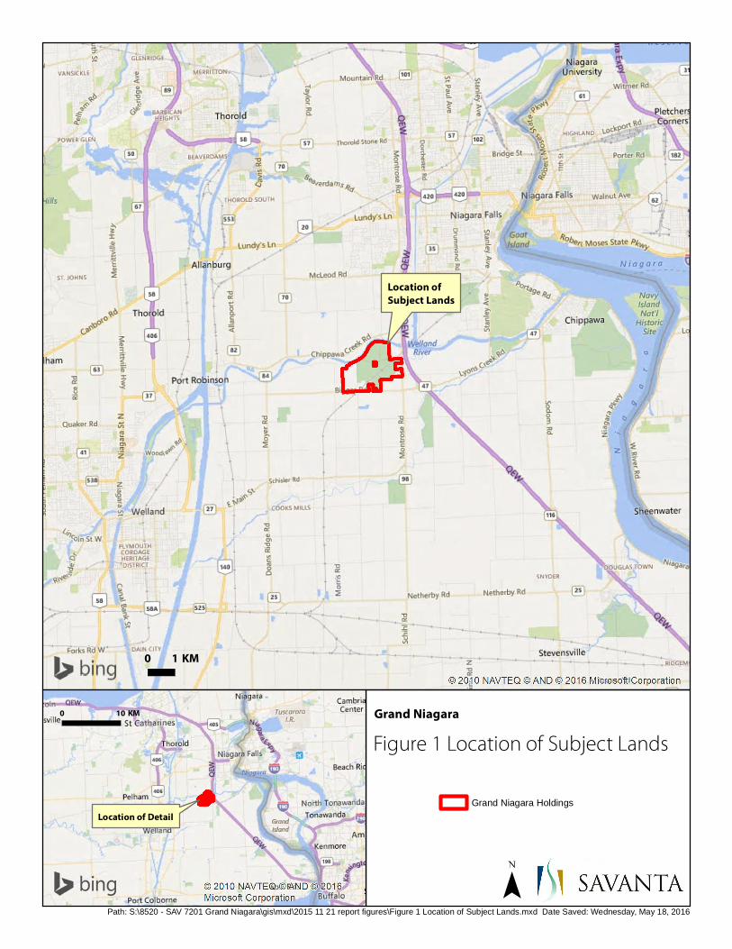
0 10 KM
Location of Detail
Location ofSubject Lands
0 1 KM
Path: S:\8520 - SAV 7201 Grand Niagara\gis\mxd\2015 11 21 report figures\Figure 1 Location of Subject Lands.mxd Date Saved: Wednesday, May 18, 2016
Figure 1 Location of Subject Lands
Grand Niagara
Grand Niagara Holdings

Lyons CreekNorth Wetland
Complex
Upper GrassieBrook Wetland
Complex
ThompsonCreek Wetland
Complex
Lyons CreekWetlandComplex
Lower GrassyBrook Wetland
Complex
WarrenCreek Wetland
Complex
Welland RiverEast Wetland
Complex
Niagara Falls SloughForest Wetland Complex
Sources: Esri, HERE, DeLorme, USGS, Intermap, increment P Corp., NRCAN, Esri Japan, METI, Esri China (Hong Kong),Esri (Thailand), TomTom, MapmyIndia, © OpenStreetMap contributors, and the GIS User Community
0 500 M
Path: S:\8520 - SAV 7201 Grand Niagara\gis\mxd\2015 11 21 report figures\Figure 2 Natural Heritage Features - Desktop Analysis.mxd REVISED: Wednesday, May 18, 2016
1:15,000
Grand Niagara
Figure 2Natural Heritage Features -Desktop Analysis
Fish Habitat (MNRF LIO)
TYPE 1
TYPE 2
Natural Features (MNRF LIO)
ANSI
Evaluated-Provincially significant wetland
Watercourse
Woodland
Grand Niagara Holdings
Niagara Regional Policy Plan 2015 Sch C
ECA Amendment 96 Schedule A
EPA Amendment 96 Schedule A

AG
AG
AG
AG
AG
GOLF
IND
CUM1-1
DISTGOLF
GOLF
GOLF
GOLF
OAO
GOLF
OAO
GOLF
FOD7-9
SWD2-2
SWD3-5CUM1-1/DIST
SWD3
FOD6-5
FOD
SWD2-2
GOLF
HGOLF
FOD6-5
GOLF
H
OAO
OAO
OAO
RES
SWD3-5
CUM1-1/MAM2
CUM1
FOD7-7
GOLF (rough)
CUM1-1
GOLF
RES
SWD2-2
MAM2-2
CUM1-1
FOD6-5
SAS1-1
GOLF
OAO
MAS2-1
SWD1-6
MAS2-1
DIST
FOD7-2
CUM1-1
CUT/CUM1-1
H/CUW
SWD1-5
MAM2-2
OAO
FOD7-2
RAIL
SWD3-5
GOLF (roug
h)CUM
1-1MAM2-10
FOD9
SWD2-2
CUM1-1
FOD7-8
H
MAS/MAM
FOD7-8
MAM2-10
CUM1-1
H
MAM2-2
H
CUM1-1/MAM2
FOD2-4
MAM2-10
H
GOLF (rough)
MAS2-10OAO
SWD1-3
SWD2-2
MAM2-11
CUS1-4/CUT1-4
CUM1-1
FOD7-6
SWD2-2
FOD2-4
GOLF (rough)
H
OAOGOLF (rough)
FOD
OAO
FOD9
H
OAO
CUM1-1
GOLF
MAS/MAM
RES
OAO
MAS2-10
GOLF
SWT2-9
FOD
MAM2-2/MAS2-1
GOLF (rough)
MAM2-11
MAM2
MAS2-1
GOLF (rough)
MAS2-1 / MAM2-2
MAS2-10/MAS2-1
CUM1-1SWD3-5SWD3-5
OAO
SWD3-5
MAS2-1/MAM2-2
SWD3-5SWD3-5
SWT2-9/MAM2-11
SAF1-3SWT2-2/MAM2-2/MAS2-1
GOLF (rough)
H
H
SWD2-2/SWT/CUM1-1/MAS2-1
FOD7-9
MAM2-11MAM2-11
GOLFGOLFGOLFGOLF
CUM1-1SWT2-4
MAM2-11MAM2-11MAM2-11MAM2-11MAM2-11
RES
FOD7-9SWD2-2
We l l a n d R i v e r
BIGGAR ROAD
GRASSY BROOK ROAD
QEW
HIG
HW
AY
GA
RN
ER R
OA
D
CHIPPAWA CREEK ROAD
MO
NTR
OS
E R
OA
D
CR
OW
LAN
D A
VEN
UE
GRASSY BROOK ROAD
MO
NTR
OS
E R
OA
D
Figure 3Vegetation Communitiies
Grand Niagara
0 200 Meters
Aerial image: MNRF Orthophoto and Google Earth.
Document Path: S:\8520 - SAV 7201 Grand Niagara\gis\mxd\2015 11 21 report figures\Figure 3 Vegetation Communities.mxd Date Saved: Wednesday, May 18, 2016
Privileged & Confidential
Grand Niagara Holdings
Non-participating land
120m adjacent lands
Ecological Land Classification
ELC Legend
FOREST FOD Deciduous Forest FOD2-4 Dry-Fresh Oak-Hardwood
Deciduous Forest FOD6-5 Fresh-Moist Sugar Maple-
Hardwood Deciduous Forest FOD7-2 Fresh-Moist Ash Lowland
Deciduous Forest FOD7-6* Fresh-Moist Red Maple
Lowland Deciduous Forest FOD7-7* Fresh-Moist Ash-Elm Lowland
Deciduous Forest FOD7-8* Fresh-Moist Walnut-Ash-
Willow Lowland Deciduous Forest
FOD7-9* Fresh-Moist Pin Oak-Green Ash Lowland Deciduous Forest
FOD9 Fresh-Moist Oak-Maple-Hickory Deciduous Forest
SWAMP SWD1-3 Pin Oak Mineral Deciduous
Swamp SWD1-5* Green Ash-Pin Oak Mineral
Deciduous Swamp SWD1-6* Pin Oak-Ash-Maple Mineral
Deciduous Swamp SWD2-2 Green Ash Mineral Deciduous
Swamp SWD3 Maple Mineral Deciduous
Swamp SWD3-5* Maple Mineral Deciduous
Swamp SWT Thicket Swamp SWT2-2 Willow Mineral Thicket Swamp SWT2-4 Buttonbush Mineral Thicket
Swamp SWT2-9 Grey Dogwood Mineral Thicket
Swamp
MARSH MAM Meadow Marsh MAM2 Mineral Meadow Marsh MAM2-2 Reed-canary Grass Mineral
Meadow Marsh MAM2-10 Forb Mineral Meadow Marsh MAM2-11* Mixed Mineral Meadow Marsh MAS Shallow Marsh MAS2-1 Cattail Mineral Shallow Marsh MAS2-10* Common Reed Mineral Shallow
Marsh OPEN WATER OAO Open Aquatic SHALLOW WATER SAS1-1 Pondweed Submerged Shallow
Aquatic SAF1-3 Duckweed Floating-leaved
Shallow Aquatic CULTURAL CUW Cultural Woodland CUS1-4* White Pine Cultural Savanna CUT Cultural Thicket CUT1-4 Grey Dogwood Cultural Thicket CUM1-1 Fresh-Moist Old Field Meadow *not listed in Southern Ontario ELC Guide RES Residence H Hedgerow

AG
AG
AG
AG
AG
GOLF
IND
CUM1-1
DISTGOLF
GOLF
GOLF
GOLF
OAO
GOLF
OAO
GOLF
FOD7-9
SWD2-2
SWD3-5CUM1-1/DIST
SWD3
FOD6-5
FOD
SWD2-2
GOLF
HGOLF
FOD6-5
GOLF
H
OAO
OAO
OAO
RES
SWD3-5
CUM1-1/MAM2
CUM1
FOD7-7
GOLF (rough)
CUM1-1
GOLF
RES
SWD2-2
MAM2-2
CUM1-1
FOD6-5
SAS1-1
GOLF
OAO
MAS2-1
SWD1-6
MAS2-1
DIST
FOD7-2
CUM1-1
CUT/CUM1-1
H/CUW
SWD1-5
MAM2-2
OAO
FOD7-2
RAIL
SWD3-5
GOLF (roug
h)CUM
1-1
MAM2-10
FOD9
SWD2-2
CUM1-1
FOD7-8
H
MAS/MAM
FOD7-8
MAM2-10
CUM1-1
H
MAM2-2
H
CUM1-1/MAM2
FOD2-4
MAM2-10
H
GOLF (rough)
MAS2-10OAO
SWD1-3
SWD2-2
MAM2-11
CUS1-4/CUT1-4
CUM1-1
FOD7-6
SWD2-2
FOD2-4
GOLF (rough)
H
OAOGOLF (rough)
FOD
OAO
FOD9
H
OAO
CUM1-1
GOLF
MAS/MAM
RES
OAO
MAS2-10
GOLF
SWT2-9
FOD
MAM2-2/MAS2-1
GOLF (rough)
MAM2-11
MAM2
MAS2-1
GOLF (rough)
MAS2-1 / MAM2-2
MAS2-10/MAS2-1
CUM1-1SWD3-5SWD3-5
OAO
SWD3-5
MAS2-1/MAM2-2
SWD3-5SWD3-5
SWT2-9/MAM2-11
SAF1-3SWT2-2/MAM2-2/MAS2-1
GOLF (rough)
H
H
SWD2-2/SWT/CUM1-1/MAS2-1
FOD7-9
MAM2-11MAM2-11
GOLFGOLFGOLFGOLF
CUM1-1SWT2-4
MAM2-11MAM2-11MAM2-11MAM2-11MAM2-11
RES
FOD7-9SWD2-2
We l l a n d R i v e r
SUN
SH
INE
GRASSYBROOKROAD
BIGGARROAD
MO
NTR
OS
E
RO
AD
MO
NTR
OS
E R
OA
DM
ON
TRO
SE
RO
AD
GA
RN
ER R
OA
D
GRASSY BROOK ROAD
CHIPPAWA CREEK ROAD
QE
W H
IGH
WA
Y
MO
RR
IS R
OA
D
CR
OW
LAN
D A
VE
NU
E
BIGGAR ROAD
GRASSY BROOK ROAD
T2
T3
T1R4
R3
R2R1
Stn1
Stn2Stn3
Stn4Stn5
Stn6
Stn7
Stn8
Stn9
Stn10Stn11
Stn12
Stn13
Stn14Stn15
Stn16
Stn17
A
BCD
EF
GH
I
J
K
L
M
NO
PQ R
S T
U V
WXYZ AA
BB
CC
DD EE
FF
GG
HH
II
JJKK
LL
NN
MM OO
1 2
3
4
5
6
7
89
10
11
12
13
14
15
16
17
18 19
2021
22
23
24
25
26 27
28
29
30
Figure 4Wildlife Monitoring Station Locations
Grand Niagara
0 200 Meters
Aerial image: MNRF Orthophoto and Google Earth.
Document Path: S:\8520 - SAV 7201 Grand Niagara\gis\mxd\2015 11 21 report figures\Figure 4 Wildlife Monitoring Station Locations.mxd Date Saved: Wednesday, May 18, 2016
Grand Niagara Holdings
Non-participating lands
120m Adjacent Lands
Ecological Land Classification
Breeding bird survey point count station (2015)
Grassland Species at Risk bird point count station (2015)
Amphibian call station location
No amphibian breeding habitat present as of May 2015
Wildlife road crossing transect
Reptile survey transect
Turtle basking station
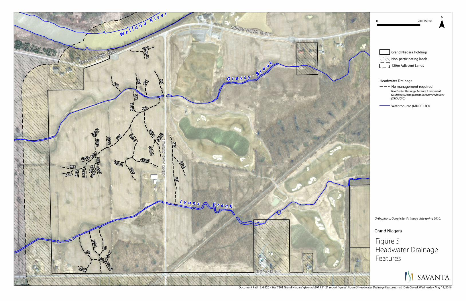
We l l a n d R i v e r
G r a s s yB
r oo
k
L y o n s C r e e k
GRASSY BROOK ROAD
BIGGAR ROAD
GRASSY BROOK ROAD
CR
OW
LAN
D A
VE
NU
E
GB5-F
GB5-F
GB5-E
1
WR-1A
LC1-A1
GB5 -I
LC1-A2LC1-B
GB5-G
GB6
GB5-F1
GB5-F GB5-C2
GB5-H
G B5- D GB5-A1
GB5-J
GB5 -B
GB5-A2
LC1-A
GB2
GB3GB4
GB7
GB5
GB7-A
GB5-E
WR-1
GB1
LC2-A
GB5-C1GB5
GB5-C
GB5 GB5-C
GB5
LC1
LC2
GB7
GB5-A
Figure 5 Headwater Drainage Features
Grand Niagara
0 200 Meters
Orthophoto: Google Earth. Image date spring 2010.
Document Path: S:\8520 - SAV 7201 Grand Niagara\gis\mxd\2015 11 21 report figures\Figure 5 Headwater Drainage Features.mxd Date Saved: Wednesday, May 18, 2016
Grand Niagara Holdings
Non-participating lands
120m Adjacent Lands
Headwater Drainage
No management requiredHeadwater Drainage Feature Assessment Guidelines Management Recommendations (TRCA/CVC)
Watercourse (MNRF LIO)
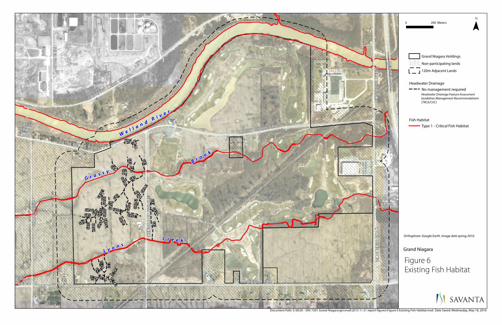
We l l a n d R i v e r
G r a s s y
B r o o k
L y o n s C r e e k
GRASSYBROOKROAD
BIGGARROAD
REIXINGERROAD
CR
OW
LAN
DA
VE
NU
E
MO
NT
RO
SE
RO
AD
MO
NT
RO
SE
RO
AD
MO
NT
RO
SE
RO
AD
GA
RN
ER
RO
AD
GRASSY BROOK ROAD
CHIPPAWA CREEK ROAD
QE
W H
IGH
WA
Y
MO
RR
IS R
OA
D
CR
OW
LAN
D A
VE
NU
E
BIGGAR ROAD
GRASSY BROOK ROAD
GB5-F
GB5-F
GB5-E
1
WR-1A
LC1-A1
GB5-I
LC1-A2
LC1-B
GB5-G
GB6
GB5-F1
GB5-F GB5-C2
GB5-H
GB5-D
GB5-A1
GB5-J
GB5-B
GB5-A
2
LC1-A
GB2GB3
GB4
GB7
GB5
GB7-A
GB5 -E
WR-1
GB1
LC2-A
GB5-C1
GB5
GB5-C
GB5
GB5-C
GB5
LC1
LC2
GB7
GB5-A
Figure 6 Existing Fish Habitat
Grand Niagara
0 200 Meters
Orthophoto: Google Earth. Image date spring 2010.
Document Path: S:\8520 - SAV 7201 Grand Niagara\gis\mxd\2015 11 21 report figures\Figure 6 Existing Fish Habitat.mxd Date Saved: Wednesday, May 18, 2016
Grand Niagara Holdings
Non-participating lands
120m Adjacent Lands
Headwater Drainage
No management requiredHeadwater Drainage Feature Assessment Guidelines Management Recommendations (TRCA/CVC)
Fish Habitat
Type 1 - Critical Fish Habitat
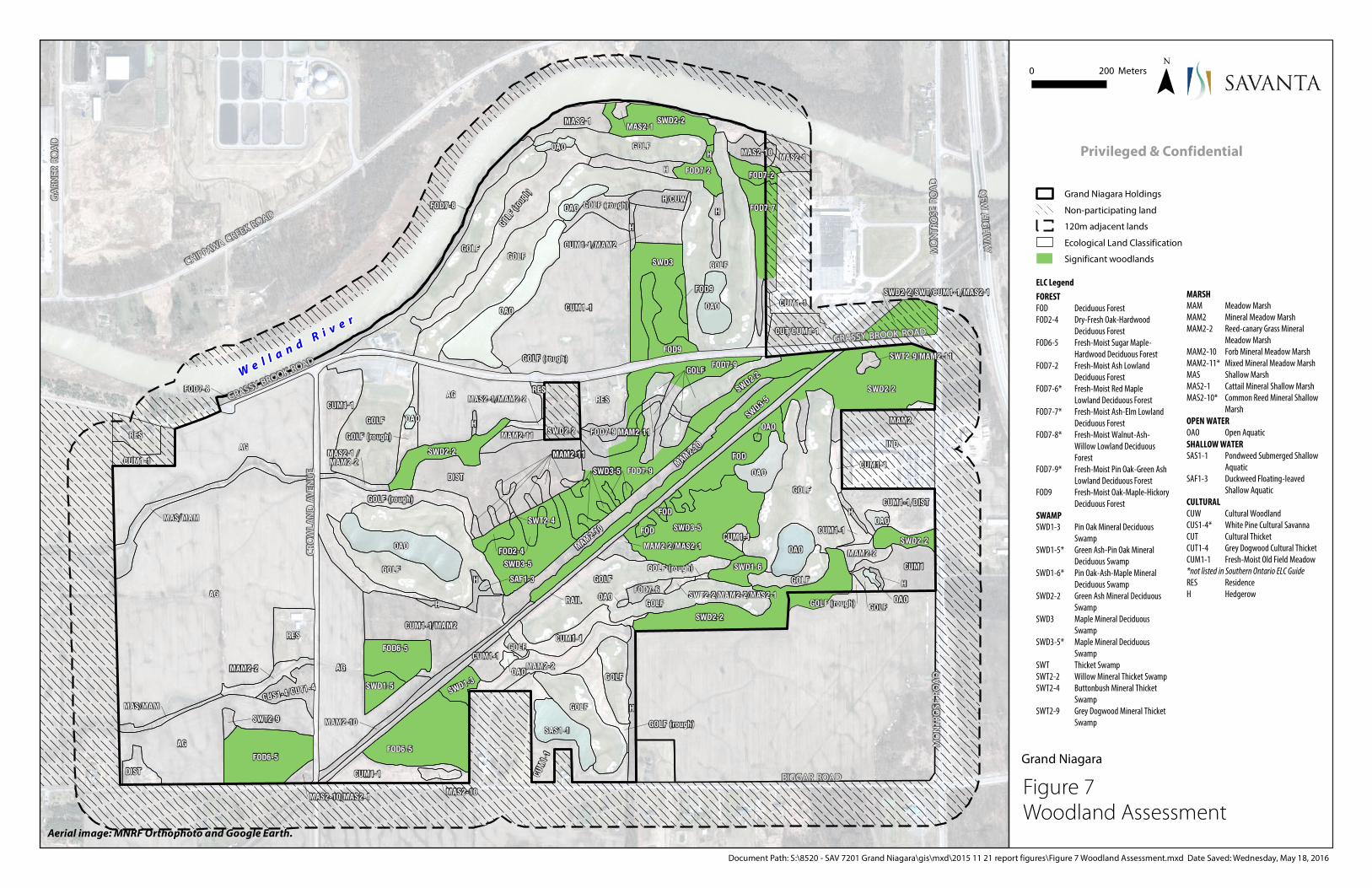
AG
AG
AG
AG
AG
GOLF
IND
CUM1-1
DISTGOLF
GOLF
GOLF
GOLF
OAO
GOLF
OAO
GOLF
FOD7-9
SWD2-2
SWD3-5CUM1-1/DIST
SWD3
FOD6-5
FOD
SWD2-2
GOLF
HGOLF
FOD6-5
GOLF
H
OAO
OAO
OAO
RES
SWD3-5
CUM1-1/MAM2
CUM1
FOD7-7
GOLF (rough)
CUM1-1
GOLF
RES
SWD2-2
MAM2-2
CUM1-1
FOD6-5
SAS1-1
GOLF
OAO
MAS2-1
SWD1-6
MAS2-1
DIST
FOD7-2
CUM1-1
CUT/CUM1-1
H/CUW
SWD1-5
MAM2-2
OAO
FOD7-2
RAIL
SWD3-5
GOLF (roug
h)CUM
1-1MAM2-10
FOD9
SWD2-2
CUM1-1
FOD7-8
H
MAS/MAM
FOD7-8
MAM2-10
CUM1-1
H
MAM2-2
H
CUM1-1/MAM2
FOD2-4
MAM2-10
H
GOLF (rough)
MAS2-10OAO
SWD1-3
SWD2-2
MAM2-11
CUS1-4/CUT1-4
CUM1-1
FOD7-6
SWD2-2
FOD2-4
GOLF (rough)
H
OAOGOLF (rough)
FOD
OAO
FOD9
H
OAO
CUM1-1
GOLF
MAS/MAM
RES
OAO
MAS2-10
GOLF
SWT2-9
FOD
MAM2-2/MAS2-1
GOLF (rough)
MAM2-11
MAM2
MAS2-1
GOLF (rough)
MAS2-1 / MAM2-2
MAS2-10/MAS2-1
CUM1-1SWD3-5SWD3-5
OAO
SWD3-5
MAS2-1/MAM2-2
SWD3-5SWD3-5
SWT2-9/MAM2-11
SAF1-3SWT2-2/MAM2-2/MAS2-1
GOLF (rough)
H
H
SWD2-2/SWT/CUM1-1/MAS2-1
FOD7-9
MAM2-11MAM2-11
GOLFGOLFGOLFGOLF
CUM1-1SWT2-4
MAM2-11MAM2-11MAM2-11MAM2-11MAM2-11
RES
FOD7-9SWD2-2
We l l a n d R i v e r
BIGGAR ROAD
GRASSY BROOK ROAD
QEW
HIG
HW
AY
GA
RN
ER R
OA
D
CHIPPAWA CREEK ROAD
MO
NTR
OS
E R
OA
D
CR
OW
LAN
D A
VEN
UE
GRASSY BROOK ROAD
MO
NTR
OS
E R
OA
D
Figure 7 Woodland Assessment
Grand Niagara
0 200 Meters
Aerial image: MNRF Orthophoto and Google Earth.
Document Path: S:\8520 - SAV 7201 Grand Niagara\gis\mxd\2015 11 21 report figures\Figure 7 Woodland Assessment.mxd Date Saved: Wednesday, May 18, 2016
Privileged & Confidential
Grand Niagara Holdings
Non-participating land
120m adjacent lands
Ecological Land Classification
Significant woodlands
ELC Legend
FOREST FOD Deciduous Forest FOD2-4 Dry-Fresh Oak-Hardwood
Deciduous Forest FOD6-5 Fresh-Moist Sugar Maple-
Hardwood Deciduous Forest FOD7-2 Fresh-Moist Ash Lowland
Deciduous Forest FOD7-6* Fresh-Moist Red Maple
Lowland Deciduous Forest FOD7-7* Fresh-Moist Ash-Elm Lowland
Deciduous Forest FOD7-8* Fresh-Moist Walnut-Ash-
Willow Lowland Deciduous Forest
FOD7-9* Fresh-Moist Pin Oak-Green Ash Lowland Deciduous Forest
FOD9 Fresh-Moist Oak-Maple-Hickory Deciduous Forest
SWAMP SWD1-3 Pin Oak Mineral Deciduous
Swamp SWD1-5* Green Ash-Pin Oak Mineral
Deciduous Swamp SWD1-6* Pin Oak-Ash-Maple Mineral
Deciduous Swamp SWD2-2 Green Ash Mineral Deciduous
Swamp SWD3 Maple Mineral Deciduous
Swamp SWD3-5* Maple Mineral Deciduous
Swamp SWT Thicket Swamp SWT2-2 Willow Mineral Thicket Swamp SWT2-4 Buttonbush Mineral Thicket
Swamp SWT2-9 Grey Dogwood Mineral Thicket
Swamp
MARSH MAM Meadow Marsh MAM2 Mineral Meadow Marsh MAM2-2 Reed-canary Grass Mineral
Meadow Marsh MAM2-10 Forb Mineral Meadow Marsh MAM2-11* Mixed Mineral Meadow Marsh MAS Shallow Marsh MAS2-1 Cattail Mineral Shallow Marsh MAS2-10* Common Reed Mineral Shallow
Marsh OPEN WATER OAO Open Aquatic SHALLOW WATER SAS1-1 Pondweed Submerged Shallow
Aquatic SAF1-3 Duckweed Floating-leaved
Shallow Aquatic CULTURAL CUW Cultural Woodland CUS1-4* White Pine Cultural Savanna CUT Cultural Thicket CUT1-4 Grey Dogwood Cultural Thicket CUM1-1 Fresh-Moist Old Field Meadow *not listed in Southern Ontario ELC Guide RES Residence H Hedgerow

AG
AG
AG
AG
AG
GOLF
IND
CUM1-1
DISTGOLF
GOLF
GOLF
GOLF
OAO
GOLF
OAO
GOLF
FOD7-9
SWD2-2
SWD3-5CUM1-1/DIST
SWD3
FOD6-5
FOD
SWD2-2
GOLF
HGOLF
FOD6-5
GOLF
H
OAO
OAO
OAO
RES
SWD3-5
CUM1-1/MAM2
CUM1
FOD7-7
GOLF (rough)
CUM1-1
GOLF
RES
SWD2-2
MAM2-2
CUM1-1
FOD6-5
SAS1-1
GOLF
OAO
MAS2-1
SWD1-6
MAS2-1
DIST
FOD7-2
CUM1-1
CUT/CUM1-1
H/CUW
SWD1-5
MAM2-2
OAO
FOD7-2
RAIL
SWD3-5
GOLF (roug
h)CUM
1-1MAM2-10
FOD9
SWD2-2
CUM1-1
FOD7-8
H
MAS/MAM
FOD7-8
MAM2-10
CUM1-1
H
MAM2-2
H
CUM1-1/MAM2
FOD2-4
MAM2-10
H
GOLF (rough)
MAS2-10OAO
SWD1-3
SWD2-2
MAM2-11
CUS1-4/CUT1-4
CUM1-1
FOD7-6
SWD2-2
FOD2-4
GOLF (rough)
H
OAOGOLF (rough)
FOD
OAO
FOD9
H
OAO
CUM1-1
GOLF
MAS/MAM
RES
OAO
MAS2-10
GOLF
SWT2-9
FOD
MAM2-2/MAS2-1
GOLF (rough)
MAM2-11
MAM2
MAS2-1
GOLF (rough)
MAS2-1 / MAM2-2
MAS2-10/MAS2-1
CUM1-1SWD3-5SWD3-5
OAO
SWD3-5
MAS2-1/MAM2-2
SWD3-5SWD3-5
SWT2-9/MAM2-11
SAF1-3SWT2-2/MAM2-2/MAS2-1
GOLF (rough)
H
H
SWD2-2/SWT/CUM1-1/MAS2-1
FOD7-9
MAM2-11MAM2-11
GOLFGOLFGOLFGOLF
CUM1-1SWT2-4
MAM2-11MAM2-11MAM2-11MAM2-11MAM2-11
RES
FOD7-9SWD2-2
We l l a n d R i v e r
BIGGAR ROAD
GRASSY BROOK ROAD
QEW
HIG
HW
AY
GA
RN
ER R
OA
D
CHIPPAWA CREEK ROAD
MO
NTR
OS
E R
OA
D
CR
OW
LAN
D A
VEN
UE
GRASSY BROOK ROAD
MO
NTR
OS
E R
OA
D
Figure 8 Significant Wildlife Habitat
Grand Niagara
0 200 Meters
Aerial image: MNRF Orthophoto and Google Earth.
Document Path: S:\8520 - SAV 7201 Grand Niagara\gis\mxd\2015 11 21 report figures\Figure 8 Significant Wildlife Habitat.mxd Date Saved: Wednesday, May 18, 2016
Privileged & Confidential
Grand Niagara Holdings
Non-participating land
120m adjacent lands
Ecological Land Classification
Significant wildlife habitat
Significant wildlife habitat in created anthropogenic features; potential removal of these features would require demonstration of no negative impact (Niagara Regional Policy Plan, 2015; PPS, 2014)
ELC Legend
FOREST FOD Deciduous Forest FOD2-4 Dry-Fresh Oak-Hardwood
Deciduous Forest FOD6-5 Fresh-Moist Sugar Maple-
Hardwood Deciduous Forest FOD7-2 Fresh-Moist Ash Lowland
Deciduous Forest FOD7-6* Fresh-Moist Red Maple
Lowland Deciduous Forest FOD7-7* Fresh-Moist Ash-Elm Lowland
Deciduous Forest FOD7-8* Fresh-Moist Walnut-Ash-
Willow Lowland Deciduous Forest
FOD7-9* Fresh-Moist Pin Oak-Green Ash Lowland Deciduous Forest
FOD9 Fresh-Moist Oak-Maple-Hickory Deciduous Forest
SWAMP SWD1-3 Pin Oak Mineral Deciduous
Swamp SWD1-5* Green Ash-Pin Oak Mineral
Deciduous Swamp SWD1-6* Pin Oak-Ash-Maple Mineral
Deciduous Swamp SWD2-2 Green Ash Mineral Deciduous
Swamp SWD3 Maple Mineral Deciduous
Swamp SWD3-5* Maple Mineral Deciduous
Swamp SWT Thicket Swamp SWT2-2 Willow Mineral Thicket Swamp SWT2-4 Buttonbush Mineral Thicket
Swamp SWT2-9 Grey Dogwood Mineral Thicket
Swamp
MARSH MAM Meadow Marsh MAM2 Mineral Meadow Marsh MAM2-2 Reed-canary Grass Mineral
Meadow Marsh MAM2-10 Forb Mineral Meadow Marsh MAM2-11* Mixed Mineral Meadow Marsh MAS Shallow Marsh MAS2-1 Cattail Mineral Shallow Marsh MAS2-10* Common Reed Mineral Shallow
Marsh OPEN WATER OAO Open Aquatic SHALLOW WATER SAS1-1 Pondweed Submerged Shallow
Aquatic SAF1-3 Duckweed Floating-leaved
Shallow Aquatic CULTURAL CUW Cultural Woodland CUS1-4* White Pine Cultural Savanna CUT Cultural Thicket CUT1-4 Grey Dogwood Cultural Thicket CUM1-1 Fresh-Moist Old Field Meadow *not listed in Southern Ontario ELC Guide RES Residence H Hedgerow
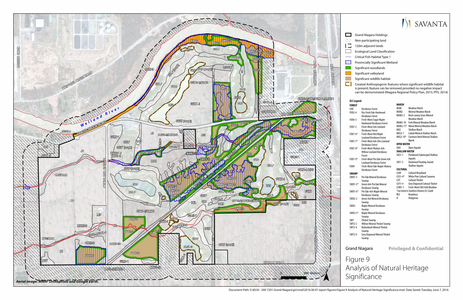
AG
AG
AG
AG
AG
GOLF
IND
CUM1-1
DISTGOLF
GOLF
GOLF
GOLF
OAO
GOLF
OAO
GOLF
FOD7-9
SWD2-2
SWD3-5CUM1-1/DIST
SWD3
FOD6-5
FOD
SWD2-2
GOLF
HGOLF
FOD6-5
GOLF
H
OAO
OAO
OAO
RES
SWD3-5
CUM1-1/MAM2
CUM1
FOD7-7
GOLF (rough)
CUM1-1
GOLF
RES
SWD2-2
MAM2-2
CUM1-1
FOD6-5
SAS1-1
GOLF
OAO
MAS2-1
SWD1-6
MAS2-1
DIST
FOD7-2
CUM1-1
CUT/CUM1-1
H/CUW
SWD1-5
MAM2-2
OAO
FOD7-2
RAIL
SWD3-5
GOLF (roug
h)CUM
1-1MAM2-10
FOD9
SWD2-2
CUM1-1
FOD7-8
H
MAS/MAM
FOD7-8
MAM2-10
CUM1-1
H
MAM2-2
H
CUM1-1/MAM2
FOD2-4
MAM2-10
H
GOLF (rough)
MAS2-10OAO
SWD1-3
SWD2-2
MAM2-11
CUS1-4/CUT1-4
CUM1-1
FOD7-6
SWD2-2
FOD2-4
GOLF (rough)
H
OAOGOLF (rough)
FOD
OAO
FOD9
H
OAO
CUM1-1
GOLF
MAS/MAM
RES
OAO
MAS2-10
GOLF
SWT2-9
FOD
MAM2-2/MAS2-1
GOLF (rough)
MAM2-11
MAM2
MAS2-1
GOLF (rough)
MAS2-1 / MAM2-2
MAS2-10/MAS2-1
CUM1-1SWD3-5SWD3-5
OAO
SWD3-5
MAS2-1/MAM2-2
SWD3-5SWD3-5
SWT2-9/MAM2-11
SAF1-3SWT2-2/MAM2-2/MAS2-1
GOLF (rough)
H
H
SWD2-2/SWT/CUM1-1/MAS2-1
FOD7-9
MAM2-11MAM2-11
GOLFGOLFGOLFGOLF
CUM1-1SWT2-4
MAM2-11MAM2-11MAM2-11MAM2-11MAM2-11
RES
FOD7-9SWD2-2
We l l a n d R i v e r
BIGGAR ROAD
GRASSY BROOK ROAD
QEW
HIG
HW
AY
GA
RN
ER R
OA
D
CHIPPAWA CREEK ROAD
MO
NTR
OS
E R
OA
D
CR
OW
LAN
D A
VEN
UE
GRASSY BROOK ROAD
MO
NTR
OS
E R
OA
D
Figure 9 Analysis of Natural Heritage Significance
Grand Niagara
0 200 Meters
Aerial image: MNRF Orthophoto and Google Earth.
Document Path: S:\8520 - SAV 7201 Grand Niagara\gis\mxd\2016 06 07 report figures\Figure 9 Analysis of Natural Heritage Significance.mxd Date Saved: Tuesday, June 7, 2016
Privileged & Confidential
Grand Niagara Holdings
Non-participating land
120m adjacent lands
Ecological Land Classification
Critical Fish Habitat Type 1
Provincially Significant Wetland
Significant woodlands
Significant valleyland
Significant wildlife habitat
Created Anthropogenic features where significant wildlife habitat is present; feature can be removed provided no negative impact can be demonstrated (Niagara Regional Policy Plan, 2015; PPS, 2014)
ELC Legend
FOREST FOD Deciduous Forest FOD2-4 Dry-Fresh Oak-Hardwood
Deciduous Forest FOD6-5 Fresh-Moist Sugar Maple-
Hardwood Deciduous Forest FOD7-2 Fresh-Moist Ash Lowland
Deciduous Forest FOD7-6* Fresh-Moist Red Maple
Lowland Deciduous Forest FOD7-7* Fresh-Moist Ash-Elm Lowland
Deciduous Forest FOD7-8* Fresh-Moist Walnut-Ash-
Willow Lowland Deciduous Forest
FOD7-9* Fresh-Moist Pin Oak-Green Ash Lowland Deciduous Forest
FOD9 Fresh-Moist Oak-Maple-Hickory Deciduous Forest
SWAMP SWD1-3 Pin Oak Mineral Deciduous
Swamp SWD1-5* Green Ash-Pin Oak Mineral
Deciduous Swamp SWD1-6* Pin Oak-Ash-Maple Mineral
Deciduous Swamp SWD2-2 Green Ash Mineral Deciduous
Swamp SWD3 Maple Mineral Deciduous
Swamp SWD3-5* Maple Mineral Deciduous
Swamp SWT Thicket Swamp SWT2-2 Willow Mineral Thicket Swamp SWT2-4 Buttonbush Mineral Thicket
Swamp SWT2-9 Grey Dogwood Mineral Thicket
Swamp
MARSH MAM Meadow Marsh MAM2 Mineral Meadow Marsh MAM2-2 Reed-canary Grass Mineral
Meadow Marsh MAM2-10 Forb Mineral Meadow Marsh MAM2-11* Mixed Mineral Meadow Marsh MAS Shallow Marsh MAS2-1 Cattail Mineral Shallow Marsh MAS2-10* Common Reed Mineral Shallow
Marsh OPEN WATER OAO Open Aquatic SHALLOW WATER SAS1-1 Pondweed Submerged Shallow
Aquatic SAF1-3 Duckweed Floating-leaved
Shallow Aquatic CULTURAL CUW Cultural Woodland CUS1-4* White Pine Cultural Savanna CUT Cultural Thicket CUT1-4 Grey Dogwood Cultural Thicket CUM1-1 Fresh-Moist Old Field Meadow *not listed in Southern Ontario ELC Guide RES Residence H Hedgerow

AG
AG
AG
AG
AG
GOLF
IND
CUM1-1
DISTGOLF
GOLF
GOLF
GOLF
OAO
GOLF
OAO
GOLF
FOD7-9
SWD2-2
SWD3-5CUM1-1/DIST
SWD3
FOD6-5
FOD
SWD2-2
GOLF
HGOLF
FOD6-5
GOLF
H
OAO
OAO
OAO
RES
SWD3-5
CUM1-1/MAM2
CUM1
FOD7-7
GOLF (rough)
CUM1-1
GOLF
RES
SWD2-2
MAM2-2
CUM1-1
FOD6-5
SAS1-1
GOLF
OAO
MAS2-1
SWD1-6
MAS2-1
DIST
FOD7-2
CUM1-1
CUT/CUM1-1
H/CUW
SWD1-5
MAM2-2
OAO
FOD7-2
RAIL
SWD3-5
GOLF (roug
h)CUM
1-1MAM2-10
FOD9
SWD2-2
CUM1-1
FOD7-8
H
MAS/MAM
FOD7-8
MAM2-10
CUM1-1
H
MAM2-2
H
CUM1-1/MAM2
FOD2-4
MAM2-10
H
GOLF (rough)
MAS2-10OAO
SWD1-3
SWD2-2
MAM2-11
CUS1-4/CUT1-4
CUM1-1
FOD7-6
SWD2-2
FOD2-4
GOLF (rough)
H
OAOGOLF (rough)
FOD
OAO
FOD9
H
OAO
CUM1-1
GOLF
MAS/MAM
RES
OAO
MAS2-10
GOLF
SWT2-9
FOD
MAM2-2/MAS2-1
GOLF (rough)
MAM2-11
MAM2
MAS2-1
GOLF (rough)
MAS2-1 / MAM2-2
MAS2-10/MAS2-1
CUM1-1SWD3-5SWD3-5
OAO
SWD3-5
MAS2-1/MAM2-2
SWD3-5SWD3-5
SWT2-9/MAM2-11
SAF1-3SWT2-2/MAM2-2/MAS2-1
GOLF (rough)
H
H
SWD2-2/SWT/CUM1-1/MAS2-1
FOD7-9
MAM2-11MAM2-11
GOLFGOLFGOLFGOLF
CUM1-1SWT2-4
MAM2-11MAM2-11MAM2-11MAM2-11MAM2-11
RES
FOD7-9SWD2-2
We l l a n d R i v e r
BIGGAR ROAD
GRASSY BROOK ROAD
QEW
HIG
HW
AY
GA
RN
ER R
OA
D
CHIPPAWA CREEK ROAD
MO
NTR
OS
E R
OA
D
CR
OW
LAN
D A
VEN
UE
GRASSY BROOK ROAD
MO
NTR
OS
E R
OA
D
Figure 10 Preliminary Natural Heritage Map
Grand Niagara
0 200 Meters
Aerial image: MNRF Orthophoto and Google Earth.
Document Path: S:\8520 - SAV 7201 Grand Niagara\gis\mxd\2016 06 07 report figures\Figure 10 Preliminary Natural Heritage Map.mxd Date Saved: Tuesday, June 7, 2016
Privileged & Confidential
Grand Niagara Holdings
Non-participating land
120m adjacent lands
Ecological Land Classification
Critical Fish Habitat Type 1
Provincially Significant Wetland
Significant woodlands
Significant valleyland
Significant wildlife habitat
Created Anthropogenic features where significant wildlife habitat is present; feature can be removed provided no negative impact can be demonstrated (Niagara Regional Policy Plan, 2015; PPS, 2014)
Preliminary 15m buffer applied to Critical Fish Habitat Type 1
Preliminary 30m buffer applied to PSW
Preliminary 10m buffer applied to Significant Woodlands
ELC Legend
FOREST FOD Deciduous Forest FOD2-4 Dry-Fresh Oak-Hardwood
Deciduous Forest FOD6-5 Fresh-Moist Sugar Maple-
Hardwood Deciduous Forest FOD7-2 Fresh-Moist Ash Lowland
Deciduous Forest FOD7-6* Fresh-Moist Red Maple
Lowland Deciduous Forest FOD7-7* Fresh-Moist Ash-Elm Lowland
Deciduous Forest FOD7-8* Fresh-Moist Walnut-Ash-
Willow Lowland Deciduous Forest
FOD7-9* Fresh-Moist Pin Oak-Green Ash Lowland Deciduous Forest
FOD9 Fresh-Moist Oak-Maple-Hickory Deciduous Forest
SWAMP SWD1-3 Pin Oak Mineral Deciduous
Swamp SWD1-5* Green Ash-Pin Oak Mineral
Deciduous Swamp SWD1-6* Pin Oak-Ash-Maple Mineral
Deciduous Swamp SWD2-2 Green Ash Mineral Deciduous
Swamp SWD3 Maple Mineral Deciduous
Swamp SWD3-5* Maple Mineral Deciduous
Swamp SWT Thicket Swamp SWT2-2 Willow Mineral Thicket Swamp SWT2-4 Buttonbush Mineral Thicket
Swamp SWT2-9 Grey Dogwood Mineral Thicket
Swamp
MARSH MAM Meadow Marsh MAM2 Mineral Meadow Marsh MAM2-2 Reed-canary Grass Mineral
Meadow Marsh MAM2-10 Forb Mineral Meadow Marsh MAM2-11* Mixed Mineral Meadow Marsh MAS Shallow Marsh MAS2-1 Cattail Mineral Shallow Marsh MAS2-10* Common Reed Mineral Shallow
Marsh OPEN WATER OAO Open Aquatic SHALLOW WATER SAS1-1 Pondweed Submerged Shallow
Aquatic SAF1-3 Duckweed Floating-leaved
Shallow Aquatic CULTURAL CUW Cultural Woodland CUS1-4* White Pine Cultural Savanna CUT Cultural Thicket CUT1-4 Grey Dogwood Cultural Thicket CUM1-1 Fresh-Moist Old Field Meadow *not listed in Southern Ontario ELC Guide RES Residence H Hedgerow
SITE PLAN:GrandNiagara-Concept-Fig3-150807.dwgMMM Group April 15, 2015

Grand Niagara Secondary Plan
Ecological Baseline Studies
File No. 7201
44
APPENDIX B
Data Tables
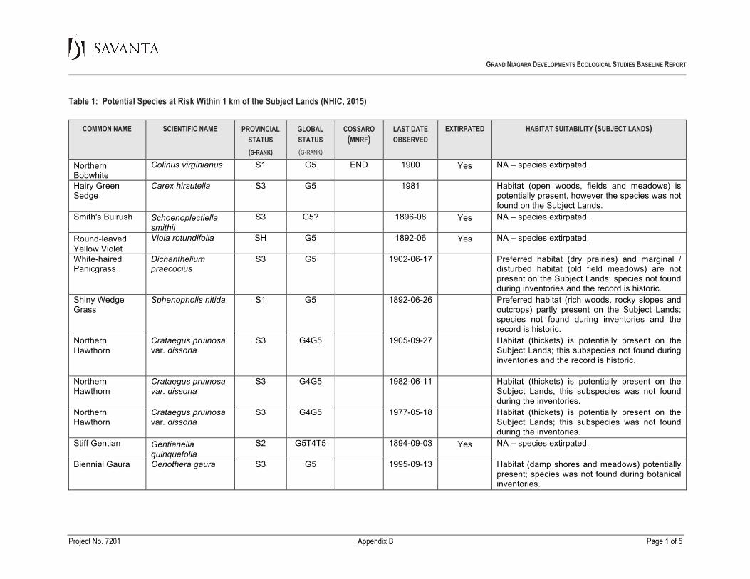
GRAND NIAGARA DEVELOPMENTS ECOLOGICAL STUDIES BASELINE REPORT
Project No. 7201 Appendix B Page 1 of 5
Table 1: Potential Species at Risk Within 1 km of the Subject Lands (NHIC, 2015)
COMMON NAME SCIENTIFIC NAME PROVINCIAL STATUS (S-RANK)
GLOBAL STATUS (G-RANK)
COSSARO (MNRF)
LAST DATE OBSERVED
EXTIRPATED HABITAT SUITABILITY (SUBJECT LANDS)
Northern Bobwhite
Colinus virginianus
S1
G5
END
1900
Yes
NA – species extirpated.
Hairy Green Sedge
Carex hirsutella
S3
G5
1981
Habitat (open woods, fields and meadows) is potentially present, however the species was not found on the Subject Lands.
Smith's Bulrush
Schoenoplectiella smithii
S3
G5?
1896-08
Yes
NA – species extirpated.
Round-leaved Yellow Violet
Viola rotundifolia
SH
G5
1892-06
Yes
NA – species extirpated.
White-haired Panicgrass
Dichanthelium praecocius
S3
G5
1902-06-17
Preferred habitat (dry prairies) and marginal / disturbed habitat (old field meadows) are not present on the Subject Lands; species not found during inventories and the record is historic.
Shiny Wedge Grass
Sphenopholis nitida
S1
G5
1892-06-26
Preferred habitat (rich woods, rocky slopes and outcrops) partly present on the Subject Lands; species not found during inventories and the record is historic.
Northern Hawthorn
Crataegus pruinosa var. dissona
S3
G4G5
1905-09-27
Habitat (thickets) is potentially present on the Subject Lands; this subspecies not found during inventories and the record is historic.
Northern Hawthorn
Crataegus pruinosa var. dissona
S3
G4G5
1982-06-11
Habitat (thickets) is potentially present on the Subject Lands, this subspecies was not found during the inventories.
Northern Hawthorn
Crataegus pruinosa var. dissona
S3
G4G5
1977-05-18
Habitat (thickets) is potentially present on the Subject Lands; this subspecies was not found during the inventories.
Stiff Gentian
Gentianella quinquefolia
S2
G5T4T5
1894-09-03
Yes
NA – species extirpated.
Biennial Gaura
Oenothera gaura
S3
G5
1995-09-13
Habitat (damp shores and meadows) potentially present; species was not found during botanical inventories.

GRAND NIAGARA DEVELOPMENTS ECOLOGICAL STUDIES BASELINE REPORT
Project No. 7201 Appendix B Page 2 of 5
COMMON NAME SCIENTIFIC NAME PROVINCIAL STATUS (S-RANK)
GLOBAL STATUS (G-RANK)
COSSARO (MNRF)
LAST DATE OBSERVED
EXTIRPATED HABITAT SUITABILITY (SUBJECT LANDS)
Scarlet Beebalm
Monarda didyma
S3
G5
1904
Habitat (rich woods, thickets and bottomlands) present on the Subject Lands; species was not found during botanical inventories and the record is historic.
Sharp-fruited Rush
Juncus acuminatus
S3
G5
1901-07-08
Habitat (damp habitats and meadows) present on the Subject Lands; species not found during inventories and the record is historic.
Stiff Yellow Flax
Linim medium var. medium
S3?
G5T3T4
1877-07-27
Habitat (dry prairies, open sandy ground, meadows) marginally present on the Subject Lands; species not found during inventories and the record is historic.
Woodland Flax
Linum virginianum
S2
G4G5
1897-07-16
Habitat (open woods, thickets and clearings) present on the Subject Lands; species not found during inventories and the record is historic.
Timber Rattlesnake
Crotalus horridus
SX
G4
EXP
1941-08-22
Yes
NA – species extirpated.
Unicorn Clubtail
Arigomphus villosipes
S2S3
G5
1934-06-20
Open wetlands with emergent vegetation constitute habitat for this species; the natural pond located south of the railway (breeding bird station 24) is the most likely to provide suitable habitat. This species has not been detected in-flight during surveys. Larval sampling would be required to conclude absence; however the record is historic.
Copenhagan Hawthorn
Crataegus intricate
SH
G5
1912-10-07
Habitat (thickets) is potentially present on the Subject Lands; species not found during inventories and the record is historic.
Eastern Flowering Dogwood
Cornus florida
S2?
G5
END
2008-06-17
The Subject Lands contain few upland, dry, well-drained sugar maple-dominated forest that are preferred by this species; this species was not detected despite botanical investigations conducted by Savanta (2012, 2014, 2015) and by previous consultants (Section 2.1).

GRAND NIAGARA DEVELOPMENTS ECOLOGICAL STUDIES BASELINE REPORT
Project No. 7201 Appendix B Page 3 of 5
COMMON NAME SCIENTIFIC NAME PROVINCIAL STATUS (S-RANK)
GLOBAL STATUS (G-RANK)
COSSARO (MNRF)
LAST DATE OBSERVED
EXTIRPATED HABITAT SUITABILITY (SUBJECT LANDS)
Swamp Rose-mallow
Hibiscus moscheutos
S3
G5
SC
2004
It is possible that the species may be present in the more inaccessible habitats along the Welland River, where its existence would not be threatened by proposed development; this species was not found in the portions of the Welland River wetlands that were sampled.
Green Arrow Arum
Peltandra virginica
S2
G5
2004
Despite the presence of potentially suitable habitat, this species was not found during botanical inventories.
Large Yellow Pond-lily
Nuphar advena
S3
G5T5
2004
Despite the presence of potentially suitable habitat, this species was not found during botanical inventories.
Fairywand
Chamaelirium luteum
SX
G5
1891-06-12
Yes
NA – species extirpated.
Slim-flowered Muhly
Muhlenbergia tenuiflora
S2
G5T5
1948-08-20
Habitat (rocky woods, slopes, shaded cliffs) is not present on the Subject Lands; species not found during inventories and the record is historic.
Great Plains Ladies'-tresses
Spiranthes magnicamporum
S3?
G4
2004
Habitat (fens, dry and wet prairies) is not present on the Subject Lands; species not found during the inventories.
Deer-tongue Panicgrass
Dichanthelium clandestinum
S2
G5?
1995-09-13
Habitat (thickets, shores, alluvial woods) potentially present on the Subject Lands; species was not found during botanical inventories.
Round-leaved Greenbrier
Smilax rotundifolia
S2
G5
THR
2003-06-01
Habitat (moist thickets and woods) present on the Subject Lands; species was not found during botanical inventories.
Round-leaved Greenbrier
Smilax rotundifolia
S2
G5
THR
1999-09-22
Habitat (moist thickets and woods) present on the Subject Lands; species was not found during botanical inventories.
Panicled Hawkweed
Hieracium paniculatum
S2?
G5
1937-08-16
Habitat (open woods) present on the Subject Lands; species not found during inventories and the record is historic.

GRAND NIAGARA DEVELOPMENTS ECOLOGICAL STUDIES BASELINE REPORT
Project No. 7201 Appendix B Page 4 of 5
COMMON NAME SCIENTIFIC NAME PROVINCIAL STATUS (S-RANK)
GLOBAL STATUS (G-RANK)
COSSARO (MNRF)
LAST DATE OBSERVED
EXTIRPATED HABITAT SUITABILITY (SUBJECT LANDS)
American Water-willow
Justicia americana
S1
G5
THR
2007-10-04
It is possible that the species may be present in the more inaccessible habitats (river shorelines) along the Welland River, where its existence would not be threatened by the proposed development; this species was not found in the portions of the Welland River wetlands that were sampled.
Greater Redhorse
Moxostoma valenciennesi
S3
G4
1992-08-26
This species is associated with larger river systems and would be present in a larger waterbody, like the Welland River. On the Subject Lands, Grassy Brook is a relatively shallow, slow-moving watercourse that does not contain the rifle-run morphology and coarse substrates that the species prefers for spawning. Given the shallow nature of the watercourse and its tendency to become intermittent or discontinuous on the Subject Lands, no suitable habitat exists for Greater Redhorse. This species may be present off-site near the confluence with Chippewa Creek.
Northern Bayberry
Morella pennsylvanica
S1
G5
1968-07-01
Habitat (dry to wet, sterile soil in coastal locations, seepage thickets) is not present on the Subject Lands and the species was not recorded during botanical surveys.
Yellow-breasted Chat
Icteria virens
S2B
G5
END
1983-07-07
Yellow-breasted Chat was not observed during the 2012-2015 surveys, during appropriate times of the breeding season. The habitat available is very limited and not of proper age/structure in general as younger growth has reached higher levels and filled in the former habitat, especially along the railway tracks. Savanta’s surveys would have detected the species had it been present during the 2012, 2014 or 2015 field seasons, as work was conducted at appropriate times during the breeding season.

GRAND NIAGARA DEVELOPMENTS ECOLOGICAL STUDIES BASELINE REPORT
Project No. 7201 Appendix B Page 5 of 5
COMMON NAME SCIENTIFIC NAME PROVINCIAL STATUS (S-RANK)
GLOBAL STATUS (G-RANK)
COSSARO (MNRF)
LAST DATE OBSERVED
EXTIRPATED HABITAT SUITABILITY (SUBJECT LANDS)
Shumard Oak
Quercus shumardii
S3
G5
SC
1980
Habitat (rich woods and bottomlands) present on the Subject Lands; species was not found during botanical inventories.
Azure Bluet
Enallagma aspersum
S3
G5
1997-06-27
Savanta detected the presence of two damselflies- Double-striped (Enallagma basidens) and Slender Bluet (E. traviatum) on the Subject Lands in 2014 and 2015. The Azure Bluet (E. aspersum) tends to prefer similar habitats to these two species: man-made, shallow pools in open areas, such as aggregate pits or golf course ponds. Suitable habitat is present on-site, however, this species was not detected.
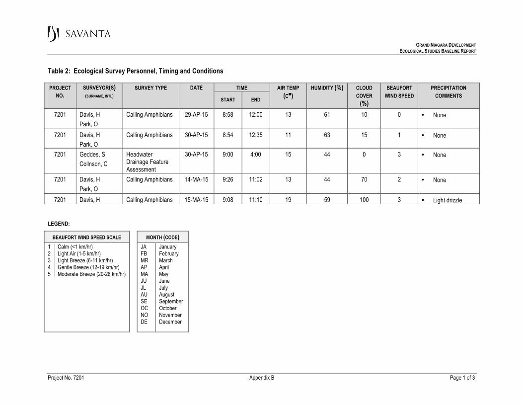
GRAND NIAGARA DEVELOPMENT
ECOLOGICAL STUDIES BASELINE REPORT
Table 2: Ecological Survey Personnel, Timing and Conditions
LEGEND:
BEAUFORT WIND SPEED SCALE MONTH (CODE) 1 2 3 4 5
Calm (<1 km/hr) Light Air (1-5 km/hr) Light Breeze (6-11 km/hr) Gentle Breeze (12-19 km/hr) Moderate Breeze (20-28 km/hr)
JA FB MR AP MA JU JL AU SE OC NO DE
January February March April May June July August September October November December
Project No. 7201 Appendix B Page 1 of 3
PROJECT NO.
SURVEYOR(S) (SURNAME, INTL)
SURVEY TYPE DATE
TIME AIR TEMP (C°)
HUMIDITY (%) CLOUD COVER
(%)
BEAUFORT WIND SPEED
PRECIPITATION COMMENTS
START END
7201 Davis, H Park, O
Calling Amphibians 29-AP-15 8:58 12:00 13 61 10 0 • None
7201 Davis, H Park, O
Calling Amphibians 30-AP-15 8:54 12:35 11 63 15 1 • None
7201 Geddes, S Collnson, C
Headwater Drainage Feature Assessment
30-AP-15 9:00 4:00 15 44 0 3 • None
7201 Davis, H Park, O
Calling Amphibians 14-MA-15 9:26 11:02 13 44 70 2 • None
7201 Davis, H Calling Amphibians 15-MA-15 9:08 11:10 19 59 100 3 • Light drizzle
GRAND NIAGARA DEVELOPMENT
ECOLOGICAL STUDIES BASELINE REPORT
Table 2: Ecological Survey Personnel, Timing and Conditions
LEGEND:
BEAUFORT WIND SPEED SCALE MONTH (CODE) 1 2 3 4 5
Calm (<1 km/hr) Light Air (1-5 km/hr) Light Breeze (6-11 km/hr) Gentle Breeze (12-19 km/hr) Moderate Breeze (20-28 km/hr)
JA FB MR AP MA JU JL AU SE OC NO DE
January February March April May June July August September October November December
Project No. 7201 Appendix B Page 2 of 3
PROJECT NO.
SURVEYOR(S) (SURNAME, INTL)
SURVEY TYPE DATE
TIME AIR TEMP (C°)
HUMIDITY (%) CLOUD COVER
(%)
BEAUFORT WIND SPEED
PRECIPITATION COMMENTS
START END
Park, O 7201 Davis, H
Zoladeski, C Calling Amphibians 21-MA-15 9:12 10:56 12 56 95 2 • None
7201 Davis, H Park, O
Calling Amphibians 24-JU-15 9:39 12:03 20 62 10 2 • None
7201 Davis, H Park, O
Calling Amphibians 25-JU-15 9:30 11:45 17 94 20 1 • None
GRAND NIAGARA DEVELOPMENT
ECOLOGICAL STUDIES BASELINE REPORT
Table 2: Ecological Survey Personnel, Timing and Conditions
LEGEND:
BEAUFORT WIND SPEED SCALE MONTH (CODE) 1 2 3 4 5
Calm (<1 km/hr) Light Air (1-5 km/hr) Light Breeze (6-11 km/hr) Gentle Breeze (12-19 km/hr) Moderate Breeze (20-28 km/hr)
JA FB MR AP MA JU JL AU SE OC NO DE
January February March April May June July August September October November December
Project No. 7201 Appendix B Page 3 of 3
PROJECT NO.
SURVEYOR(S) (SURNAME, INTL)
SURVEY TYPE DATE
TIME AIR TEMP (C°)
HUMIDITY (%) CLOUD COVER
(%)
BEAUFORT WIND SPEED
PRECIPITATION COMMENTS
START END
7201 Wildlife Road Crossing Survey
23-JU-15 20 • Light rain
7201 Geddes, S Collnson, C
Headwater Drainage Feature Assessment
8-JL-15
9:00 4:00 20 51 0 3 • None
GRAND NIAGARA DEVELOPMENT ECOLOGICAL STUDIES BASELINE REPORT
Project No. 7201 Appendix B Page 1 of 4
Table 3: Ecological Land Classification (ELC) Vegetation Types
ELC TYPE
COMMUNITY DESCRIPTION
NHIC
S-RANK
G-RANK
FOREST (FO)
Deciduous Forest (FOD) FOD DECIDUOUS FOREST
• This generic designation includes communities composed of several possible trees species , for example sugar maple, shagbark hickory, beech, black cherry, pin and red oak, green ash or white elm, growing in various combinations and proportions.
NR NR
FOD2-4 DRY-FRESH OAK -HARDWOOD DECIDUOUS FOREST
• Red oak and sugar maple are the dominants, followed by black cherry, shagbark hickory and white oak.
S5 G?
FOD6-5’ FRESH-MOIST SUGAR MAPLE-HARDWOOD DECIDUOUS FOREST
• A lowland forest composed of sugar maple and several co-dominants, including red oak, shagbark hickory, beech, basswood and swamp white oak.
• The understorey shrub and herb layers are well developed, with tree saplings, choke cherry, multiflora rose, enchanter’s nightshade, white avens, jewelweed, may-apple, Pennsylvania sedge and wild crane’s-bill.
S5 G?
FOD7-2 FRESH-MOIST ASH LOWLAND DECIDUOUS FOREST
• Green ash is the dominant canopy species in these stands. However, many trees have been affected by emerald ash borer infestation and are of poor health or dying. Associate species include red maple, pin oak, shagbark hickory and white oak.
• The shrub layer is well developed and composed of canopy tree saplings as well as true shrubs, such as grey dogwood, poison ivy, red raspberry, common buckthorn and choke cherry.
• The herb layer is moderately developed with enchanter’s nightshade, white avens, rough-leaf goldenrod, Jack-in-the-pulpit and garlic mustard.
S5 G?
FOD7-6* FRESH-MOIST RED MAPLE LOWLAND DECIDUOUS FOREST
• This forest type is represented by a narrow strip of woods separating two golf playing fields.
• Young red maple trees are associated with scattered pin oak and green ash. • The shrub understorey is dominated by grey dogwood, with lesser abundance of
common buckthorn, poison ivy, Alleghany blackberry and hawthorn. I • The herb layer is n weakly developed and is dominated by enchanter’s nightshade,
rough-leaf goldenrod, starved aster and common speedwell
NR NR
FOD7-7* FRESH-MOIST ASH-ELM LOWLAND DECIDUOUS FOREST
• A hedgerow-type regenerating community at the edge of the golf course composed of green ash and white elm. Tree regeneration is almost entirely ash.,
• The well-developed shrub layer is dominated by grey dogwood, common buckthorn, Virginia-creeper and riverbank grape.
• Herb cover is composed of starved aster, tall goldenrod, white avens, garlic mustard, enchanter’s nightshade and Virginia knotweed.
NR NR
FOD7-8* FRESH-MOIST WALNUT-ASH-WILLOW
• A long and narrow unit located on the low slope of the Welland River. • The vegetation is significantly disturbed due to windfalls and is uneven in structure
and composition.
NR NR
GRAND NIAGARA DEVELOPMENT ECOLOGICAL STUDIES BASELINE REPORT
Project No. 7201 Appendix B Page 2 of 4
ELC TYPE
COMMUNITY DESCRIPTION
NHIC
S-RANK
G-RANK
LOWLAND DECIDUOUS FOREST
• The main tree species include black walnut, green ash, reddish willow and black cherry.
• Main shrub species include black raspberry, grey dogwood, common buckthorn and multiflora rose. The two dominant herbs are enchanter’s nightshade and garlic mustard.
FOD7-9* FRESH-MOIST PIN OAK-GREEN ASH LOWLAND DECIDUOUS FOREST
• Located partly within hydro right-of-way, this narrow community is dominated by pin oak, followed by green ash and white elm.
• The main species in the shrub layer are common buckthorn, grey dogwood and red raspberry. The herb layer is poorly developed and dominated by garlic mustard.
NR NR
FOD9 FRESH-MOIST OAK-MAPLE-HICKORY DECIDUOUS FOREST ECOSITE
• A variably composed forest without a dominant tree species. • The main canopy is dominated by beech, red oak, shagbark hickory, sugar maple,
red maple, ironwood and white elm. • Shrub species include choke cherry, Virginia creeper, red raspberry and tree
saplings. • The ground cover consists of may-apple, Jack-in-the-pulpit, enchanter’s
nightshade, wild crane’s-bill, wood fern and wild lily-of-the valley.
NR NR
CULTURAL (CU)Cultural Savanna (CUS)CUS1-4* WHITE PINE CULTURAL SAVANNA
• Found only at one location, this community is composed of widely spaced young white pine trees that were originally planted in regular rows and have been left unmanaged.
• The spaces between the pines are covered by a thicket of grey dogwood, while the herbaceous cover is of the old field meadow type.
NR NR
Cultural Meadow (CUM) CUM1-1 FRESH-MOIST OLD FIELD MEADOW
• These open communities are composed of several non-native and native species, such as Canada bluegrass, Kentucky bluegrass, tufted vetch, timothy, Canada thistle, teasel, wild carrot, red clover, tall goldenrod, New England aster and common ragweed.
NR NR
Cultural Thicket (CUT)CUT1-4 GREY DOGWOOD CULTURAL THICKET
• Associated with unit CUS1-4, this is a medium shrub community of grey dogwood with co-dominant presence of narrow-leaved meadow-sweet.
NR NR
Cultural Woodland (CUW)CUW
• The open tree canopy is composed of black cherry, while the shrubs include hawthorn, silky dogwood, and common buckthorn.
NR NR

GRAND NIAGARA DEVELOPMENT ECOLOGICAL STUDIES BASELINE REPORT
Project No. 7201 Appendix B Page 3 of 4
ELC TYPE
COMMUNITY DESCRIPTION
NHIC
S-RANK
G-RANK
SWAMP (SW)Deciduous Swamp (SWD)SWD1-3 PIN-OAK MINERAL DECIDUOUS SWAMP
• Dominated by pin oak, with some presence of shagbark hickory and green ash. • Main understorey species are grey dogwood, inserted Virginia-creeper, riverbank
grape, moneywort, starved aster and Virginia knotweed.
S2S3 G2
SWD1-5 GREEN ASH PIN-OAK MINERAL DECIDUOUS SWAMP
• Main species in the tree canopy are green ash and pin oak, with lesser amounts of shagbark hickory.
• Poison ivy and swamp rose are the dominant shrubs, while the herb layer is composed of moneywort, jewelweed, fowl meadow grass, and various sedges.
NR NR
SWD1-6 PIN OAK-ASH-MAPLE MINERAL DECIDUOUS SWAMP
• This is an open-canopy stand, due to dieback of almost all ash and elm trees, which has resulted in vigorous development of a tall shrub layer of grey dogwood.
• The regenerating tree species, which surround the few surviving elm and ash, include red maple, pin oak and swamp maple. Herb layer is poorly developed and dominated by rough-leaf goldenrod.
NR NR
SWD2-2 GREEN ASH MINERAL DECIDUOUS SWAMP
• Diverse community dominated by green ash, with associates such as pin oak, swamp white oak and white elm.
• Both shrub and herb layers are well developed and composed of grey dogwood, red raspberry, narrow-leaved meadow-sweet, common elderberry, common buckthorn, lake-bank sedge, jewelweed, reed-canary grass and fringed loosestrife.
S5 G?
SWD3 MAPLE MINERAL DECIDUOUS SWAMP
• Located in the largest woodland patch north of Grassybrook Road, this is a complex community of treed areas and vernal pools, which support aquatic and marsh species.
• There is no dominant tree canopy species. Tree species include: swamp maple, red maple, swamp white oak, shagbark hickory and green ash.
• The shrub layer is composed of poison ivy, blue beech, Virginia creeper and saplings of canopy trees. The herb layer is well-developed but patchy, with sensitive fern, fowl meadow grass, Jack-in-the-pulpit and several species of sedges.
S5 G4?
SWD3-5 MAPLE MINERAL DECIDUOUS SWAMP
• Red and silver maples are the dominant tree canopy species, with associate pin oak and shagbark hickory.
1. Shrub layer is well developed with frequent occurrence of buttonbush. The herb layer is rich, composed of sedges, grasses and forbs.
S5 G47
Thicket Swamp (SWT)
SWT • This general designation describes variously composed stands of willow and dogwood (grey and/or red-osier), often in complex with treed swamps and meadow marshes.
NR NR
SWT2-2 WILLOW MINERAL THICKET SWAMP
• This small unit occurs only in a complex with the shallow and meadow marsh types, and is composed of saplings of reddish willow and some presence of grey dogwood and common elderberry.
S5 G5

GRAND NIAGARA DEVELOPMENT ECOLOGICAL STUDIES BASELINE REPORT
Project No. 7201 Appendix B Page 4 of 4
ELC TYPE
COMMUNITY DESCRIPTION
NHIC
S-RANK
G-RANK
SWT2-4 BUTTONBUSH MINERAL THICKET SWAMP
• Buttonbush forms a tall dense thicket, with minor presence of silky dogwood and Bebb’s sedge.
• Herbaceous species, located primarily along the periphery include dark-green bulrush, purple loosestrife and broad-fruited bur-reed.
S3 G4
SWT2-9GREY DOGWOOD MINERAL THICKET SWAMP
• Grey dogwood dominates the shrub canopy, followed by narrow-leaved meadow-sweet, green ash saplings and Bebb’s sedge.
S3S4 G5
MARSH (MA) Meadow Marsh (MAM) MAM MEADOW MARSH
• These are variously composed meadows of reed-canary grass, tall white aster, jewelweed, tall goldenrod, common reed, Joe-pye weed, broad-fruit bur-reed, beggarticks, and several others.
NR NR
MAM2 MINERAL MEADOW MARSH
• These communities are generally dominated by reed-canary grass, tall white aster and broad-leaved arrowhead, in various combinations.
NR NR
MAM 2-2 REED-CANARY GRASS MINERAL MEADOW MARSH
• In these communities, reed-canary grass is often the only herbaceous species, to the exclusion of others.
NR NR
MAM2-10 FORB MINERAL MEADOW MARSH
• The usual dominant species in these communities are tall white aster, jewelweed and spotted Joe-pye weed.
S4S5 G5
MAM2-11* MIXED MINERAL MEADOW MARSH
• This is a very diverse type incorporating many graminoid and forb species, such as reed-canary grass, common reed, porcupine sedge, fox sedge, spotted Joe-pye-weed, jewelweed, tall white aster, tall goldenrod, rough-leaved goldenrod, and blue vervain.
NR NR
Shallow Marsh (MAS)
•
MAS2-1 CATTAIL MINERAL SHALLOW MARSH (AREA 4)
• Under the dominant layer of glaucous cattail grow such species as reed-canary grass, American bindweed and jewelweed.
S5 G5
NON-VEGETATED SHALLOW WATER*
OW* OPEN WATER
• Thispondcontainedlessthan25%coverofvascularplantsandadepthoflessthan2meters.
NR NR
*Denotes a type not listed in the Southern Ontario ELC Guide
SAVANTA INC.Table 4: Vascular Plants
GRAND NIAGARA DEVELOPMENTECOLOGICAL STUDIES UPDATE REPORT
Project No. 7201 Appendix B 1 of 8
SPECIES SCIENTIFIC NAME SPECIES COMMON NAMECoefficient of Conservatism
Wetness Index
Weediness Index
Provincial Status S-Rank
MNRF Status
COSEWIC Status
Global Status
G-Rank
Local Status
Niagara
ReferenceNHIC 2013
Oldham 2010
Dennstaedtiaceae Bracken Fern FamilyPteridium aquilinum Bracken Fern 2 3 S5 G5 C
Dryopteridaceae Wood Fern FamilyAthyrium filix-femina Lady Fern 4 0 S5 G5 CDryopteris carthusiana Spinulose Wood Fern 5 -2 S5 G5 COnoclea sensibilis Sensitive Fern 4 -3 S5 G5 CPolystichum acrostichoides Christmas Fern 5 5 S5 G5 C
Equisetaceae Horsetail FamilyEquisetum arvense Field Horsetail 0 0 S5 G5 C
Thelypteridaceae Marsh Fern FamilyThelypteris palustris Marsh Fern 5 -4 S5 G5 C
Cupressaceae Cedar FamilyThuja occidentalis Eastern White Cedar 4 -3 S5 G5 U
Pinaceae Pine FamilyPinus nigra Austrian Pine -5 -1 SNA GNA IRPinus strobus Eastern White Pine 4 3 S5 G5 CPinus sylvestris Scotch Pine 5 -3 SNA GNA IC
Aceraceae Maple FamilyAcer negundo Manitoba Maple 0 -2 S5 G5 CAcer rubrum Red Maple 4 0 S5 G5 CAcer saccharum ssp. saccharum Sugar Maple 4 3 S5 G5T5 CAcer x freemanii Freeman's Maple SNA GNA hyb
Anacardiaceae Sumac or Cashew FamilyRhus typhina Staghorn Sumac 1 5 S5 G5 CToxicodendron rydbergii Rydberg's Poison Ivy 0 0 S5 G5T C
Apiaceae Carrot or Parsley FamilyCicuta maculata Spotted Water-hemlock 6 -5 S5 G5 CDaucus carota Wild Carrot 5 -2 SNA GNR ICSium suave Hemlock Water-parsnip 4 -5 S5 G5 C
Apocynaceae Dogbane FamilyApocynum androsaemifolium ssp. androsaemifoliumSpreading Dogbane 3 5 S5 G5T5 C
Araliaceae Ginseng FamilyAralia nudicaulis Wild Sarsaparilla 4 3 S5 G5 C
Asclepiadaceae Milkweed FamilyAsclepias incarnata Swamp Milkweed 6 -5 S5 G5 CAsclepias syriaca Common Milkweed 0 5 S5 G5 C
Asteraceae Composite or Aster FamilyAchillea millefolium Yarrow 3 -1 S5 G5 CAmbrosia artemisiifolia Annual Ragweed 0 3 S5 G5 CArctium minus Common Burdock 5 -2 SNA GNR ICBidens cernua Nodding Beggarticks 2 -5 S5 G5 CBidens frondosa Devil's Beggaticks 3 -3 S5 G5 CBidens tripartita Three-parted Beggarticks 4 -3 S5 G5 CCarduus nutans ssp. nutans Nodding Thistle 5 -1 SNA GNRTNR IRCentaurea stoebe Spotted Knapweed 5 -3 SNA GNRCichorium intybus Chicory 5 -1 SNA GNR IC

SAVANTA INC.Table 4: Vascular Plants
GRAND NIAGARA DEVELOPMENTECOLOGICAL STUDIES UPDATE REPORT
Project No. 7201 Appendix B 2 of 8
SPECIES SCIENTIFIC NAME SPECIES COMMON NAMECoefficient of Conservatism
Wetness Index
Weediness Index
Provincial Status S-Rank
MNRF Status
COSEWIC Status
Global Status
G-Rank
Local Status
Niagara
ReferenceNHIC 2013
Oldham 2010
Cirsium arvense Canada Thistle 3 -1 SNA GNR ICCirsium vulgare Bull Thistle 4 -1 SNA GNR ICErigeron annuus Annual Fleabane S5 G5 CErigeron strigosus Daisy Fleabane 0 1 S5 G5 REupatorium perfoliatum Common Boneset 2 -4 S5 G5 CEurybia macrophylla Large-leaved Aster 5 5 S5 G5 CEuthamia graminifolia Grass-leaved Goldenrod 2 -2 S5 G5 CEutrochium maculatum var. maculatum Spotted Joe Pye Weed 3 -5 S5 G5T5 CLactuca serriola Prickly Lettuce 0 -1 SNA GNR ICLeucanthemum vulgare Oxeye Daisy 5 -1 SNA GNR ICPilosella caespitosa Field Hawkweed 5 -2 SNA GNR ICRudbeckia hirta Black-eyed Susan 0 3 S5 G5 CSolidago altissima Tall Goldenrod 1 3 S5 G5 CSolidago caesia Blue-stemmed Goldenrod 5 3 S5 G5 CSolidago canadensis Canada Goldenrod 1 3 S5 G5 CSolidago flexicaulis Zig-zag Goldenrod 6 3 S5 G5 CSolidago juncea Early Goldenrod 3 5 S5 G5 CSolidago rugosa Rough-leaf Goldenrod 4 -1 S5 G5 CSonchus arvensis ssp. arvensis Field Sow-thistle SNA GNRTNR ICSonchus asper Prickly Sow-thistle 0 -1 SNA GNR ICSymphyotrichum cordifolium Heart-leaved Aster 5 5 S5 G5 CSymphyotrichum ericoides var. ericoides White Heath Aster S5 G5T5 CSymphyotrichum lanceolatum ssp. lanceolatum Tall White Aster 3 -3 S5 G5T5 CSymphyotrichum lateriflorum Starved Aster 3 -2 S5 G5 CSymphyotrichum novae-angliae New England Aster 2 -3 S5 G5 CSymphyotrichum pilosum var. pilosum Old Field Aster 4 2 S5 G5T5 CSymphyotrichum puniceum var. puniceum Swamp Aster S5 G5T5 CTragopogon dubius Yellow Goat's-beard 5 -1 SNA GNR IU
Balsaminaceae Touch-me-not FamilyImpatiens capensis Spotted Jewelweed 4 -3 S5 G5 C
Berberidaceae Barberry FamilyPodophyllum peltatum May Apple 5 3 S5 G5 C
Betulaceae Birch FamilyBetula alleghaniensis Yellow Birch 6 0 S5 G5 CBetula papyrifera White Birch 2 S5 G5 CCarpinus caroliniana Blue-beech 6 0 S5 G5 COstrya virginiana Eastern Hop-hornbeam 4 4 S5 G5 C
Boraginaceae Borage FamilyEchium vulgare Blueweed 5 -2 SNA GNR IC
Brassicaceae Mustard FamilyAlliaria petiolata Garlic Mustard 0 -3 SNA GNR ICHesperis matronalis Dame's Rocket 5 -3 SNA G4G5 ICLepidium campestre Field Pepper-grass 5 -1 SNA GNR IC
Campanulaceae Bellflower FamilyLobelia cardinalis Cardinal Flower 7 -5 S5 G5 R
Caprifoliaceae Honeysuckle FamilyLonicera tatarica Tartarian Honeysuckle 3 -3 SNA GNR ICSambucus canadensis Common Elderberry 5 -2 S5 G5T5 CViburnum opulus ssp. trilobum Highbush Cranberry 5 -3 S5 G5T5 C
Celastraceae Staff-tree FamilyEuonymus obovatus Running Strawberry-bush 6 5 S5 G5 C

SAVANTA INC.Table 4: Vascular Plants
GRAND NIAGARA DEVELOPMENTECOLOGICAL STUDIES UPDATE REPORT
Project No. 7201 Appendix B 3 of 8
SPECIES SCIENTIFIC NAME SPECIES COMMON NAMECoefficient of Conservatism
Wetness Index
Weediness Index
Provincial Status S-Rank
MNRF Status
COSEWIC Status
Global Status
G-Rank
Local Status
Niagara
ReferenceNHIC 2013
Oldham 2010
Chenopodiaceae Goosefoot FamilyAtriplex patula Halberd-leaf Saltbush 0 -2 S5 G5 IUChenopodium album var. album White Goosefoot 1 -1 SNA G5TNR IC
Convolvulaceae Morning-glory FamilyCalystegia sepium ssp. americana American Bindweed 2 0 SU G5T5 CConvolvulus arvensis Field Bindweed 5 -1 SNA GNR IC
Cornaceae Dogwood FamilyCornus alternifolia Alternate-leaf Dogwood 6 5 S5 G5 CCornus foemina Grey Dogwood 2 -2 S5 GNR CCornus sericea Red-osier Dogwood 2 -3 S5 G5 U
Cucurbitaceae Gourd FamilyEchinocystis lobata Wild Mock-cucumber 3 -2 S5 G5 C
Dipsacaceae Teasel FamilyDipsacus fullonum Fuller's Teasel 5 -1 SNA GNR IC
Fabaceae Pea FamilyLotus corniculatus Bird's-foot Trefoil 1 -2 SNA GNR ICMelilotus albus White Sweetclover 3 -3 SNA G5 ICTrifolium pratense Red Clover 2 -2 SNA GNR ICVicia cracca Tufted Vetch 5 -1 SNA GNR ICVicia tetrasperma Lentil Vetch 5 -1 SNA GNR IU
Fagaceae Beech FamilyFagus grandifolia American Beech 6 3 S4 G5 CQuercus alba White Oak 6 3 S5 G5 CQuercus bicolor Swamp White Oak 8 -4 S4 G5 CQuercus macrocarpa Bur Oak 5 1 S5 G5 UQuercus palustris Pin Oak 9 -3 S4 G5 CQuercus rubra Northern Red Oak 6 3 S5 G5
Geraniaceae Geranium FamilyGeranium maculatum Wild Crane's-bill 6 3 S5 G5 CGeranium robertianum Herb-robert 5 -2 SNA G5 IC
Grossulariaceae Currant FamilyRibes americanum Wild Black Currant 4 -3 S5 G5 CRibes cynosbati Prickly Gooseberry 4 5 S5 G5 CRibes rubrum Northern Red Currant 5 -2 SNA G4G5 ICRibes triste Swamp Red Currant 6 -5 S5 G5 R
Guttiferae St. John's-wort FamilyHypericum mutilum Slender St. John's-wort 6 -3 S5 G5 UHypericum perforatum Common St. John's-wort 5 -3 SNA GNR IC
Hydrophyllaceae Water-leaf FamilyHydrophyllum virginianum Virginia Waterleaf 6 -2 S5 G5 C
Juglandaceae Walnut FamilyCarya cordiformis Bitternut hickory 6 0 S5 G5 CCarya ovata Shagbark Hickory 6 3 S5 G5 CJuglans nigra Black Walnut 5 3 S4 G5 C
Lamiaceae Mint FamilyLycopus uniflorus Northern Bugleweed 5 -5 S5 G5 C
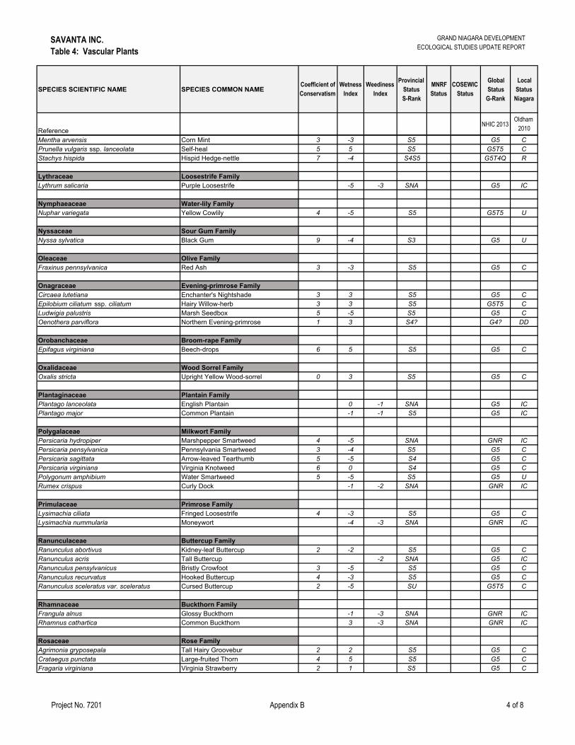
SAVANTA INC.Table 4: Vascular Plants
GRAND NIAGARA DEVELOPMENTECOLOGICAL STUDIES UPDATE REPORT
Project No. 7201 Appendix B 4 of 8
SPECIES SCIENTIFIC NAME SPECIES COMMON NAMECoefficient of Conservatism
Wetness Index
Weediness Index
Provincial Status S-Rank
MNRF Status
COSEWIC Status
Global Status
G-Rank
Local Status
Niagara
ReferenceNHIC 2013
Oldham 2010
Mentha arvensis Corn Mint 3 -3 S5 G5 CPrunella vulgaris ssp. lanceolata Self-heal 5 5 S5 G5T5 CStachys hispida Hispid Hedge-nettle 7 -4 S4S5 G5T4Q R
Lythraceae Loosestrife FamilyLythrum salicaria Purple Loosestrife -5 -3 SNA G5 IC
Nymphaeaceae Water-lily FamilyNuphar variegata Yellow Cowlily 4 -5 S5 G5T5 U
Nyssaceae Sour Gum FamilyNyssa sylvatica Black Gum 9 -4 S3 G5 U
Oleaceae Olive FamilyFraxinus pennsylvanica Red Ash 3 -3 S5 G5 C
Onagraceae Evening-primrose FamilyCircaea lutetiana Enchanter's Nightshade 3 3 S5 G5 CEpilobium ciliatum ssp. ciliatum Hairy Willow-herb 3 3 S5 G5T5 CLudwigia palustris Marsh Seedbox 5 -5 S5 G5 COenothera parviflora Northern Evening-primrose 1 3 S4? G4? DD
Orobanchaceae Broom-rape FamilyEpifagus virginiana Beech-drops 6 5 S5 G5 C
Oxalidaceae Wood Sorrel FamilyOxalis stricta Upright Yellow Wood-sorrel 0 3 S5 G5 C
Plantaginaceae Plantain FamilyPlantago lanceolata English Plantain 0 -1 SNA G5 ICPlantago major Common Plantain -1 -1 S5 G5 IC
Polygalaceae Milkwort FamilyPersicaria hydropiper Marshpepper Smartweed 4 -5 SNA GNR ICPersicaria pensylvanica Pennsylvania Smartweed 3 -4 S5 G5 CPersicaria sagittata Arrow-leaved Tearthumb 5 -5 S4 G5 CPersicaria virginiana Virginia Knotweed 6 0 S4 G5 CPolygonum amphibium Water Smartweed 5 -5 S5 G5 URumex crispus Curly Dock -1 -2 SNA GNR IC
Primulaceae Primrose FamilyLysimachia ciliata Fringed Loosestrife 4 -3 S5 G5 CLysimachia nummularia Moneywort -4 -3 SNA GNR IC
Ranunculaceae Buttercup FamilyRanunculus abortivus Kidney-leaf Buttercup 2 -2 S5 G5 CRanunculus acris Tall Buttercup -2 SNA G5 ICRanunculus pensylvanicus Bristly Crowfoot 3 -5 S5 G5 CRanunculus recurvatus Hooked Buttercup 4 -3 S5 G5 CRanunculus sceleratus var. sceleratus Cursed Buttercup 2 -5 SU G5T5 C
Rhamnaceae Buckthorn FamilyFrangula alnus Glossy Buckthorn -1 -3 SNA GNR ICRhamnus cathartica Common Buckthorn 3 -3 SNA GNR IC
Rosaceae Rose FamilyAgrimonia gryposepala Tall Hairy Groovebur 2 2 S5 G5 CCrataegus punctata Large-fruited Thorn 4 5 S5 G5 CFragaria virginiana Virginia Strawberry 2 1 S5 G5 C

SAVANTA INC.Table 4: Vascular Plants
GRAND NIAGARA DEVELOPMENTECOLOGICAL STUDIES UPDATE REPORT
Project No. 7201 Appendix B 5 of 8
SPECIES SCIENTIFIC NAME SPECIES COMMON NAMECoefficient of Conservatism
Wetness Index
Weediness Index
Provincial Status S-Rank
MNRF Status
COSEWIC Status
Global Status
G-Rank
Local Status
Niagara
ReferenceNHIC 2013
Oldham 2010
Geum aleppicum Yellow Avens 2 -1 S5 G5 CGeum canadense White Avens 3 0 S5 G5 CGeum laciniatum Rough Avens -3 S4 G5 CPotentilla recta Sulphur Cinquefoil 5 -2 SNA GNR ICPotentilla simplex Old-field Cinquefoil 3 4 S5 G5 CPrunus avium Sweet Cherry 5 -2 SNA GNR ICPrunus serotina Black Cherry 3 3 S5 G5 CPrunus virginiana Choke Cherry 2 1 S5 G5 CRosa multiflora Multiflora Rose 3 -3 SNA GNR ICRubus allegheniensis Alleghany Blackberry 2 2 S5 G5 CRubus hispidus Bristly Dewberry 6 -3 S4S5 G5 CRubus idaeus ssp. strigosus Red Raspberry 0 -2 S5 G5T5 CRubus occidentalis Black Raspberry 2 5 S5 G5 CSpiraea alba Narrow-leaved Meadow-sweet 3 -4 S5 G5 C
Rubiaceae Madder FamilyCephalanthus occidentalis Common Buttonbush 7 -5 S5 G5 CGalium palustre Marsh Bedstraw 5 -5 S5 G5 C
Salicaceae Willow FamilyPopulus deltoides ssp. deltoides Eastern Cottonwood 4 -1 S5 G5T5 CPopulus tremuloides Trembling Aspen 0 S5 G5 CSalix bebbiana Bebb's Willow 4 -4 S5 G5 CSalix eriocephala Heart-leaved Willow 4 -3 S5 G5 CSalix x rubens Reddish Willow -4 -3 SNA GNA
Scrophulariaceae Figwort FamilyLinaria vulgaris Butter-and-eggs 5 -1 SNA GNR ICVerbascum thapsus Common Mullein 5 -2 SNA GNR ICVeronica officinalis Common Speedwell 5 -2 SNA G5 ICVeronica scutellata Marsh Speedwell 7 -5 S5 G5 U
Solanaceae Nightshade FamilySolanum dulcamara Climbing Nightshade 0 -2 SNA GNR IC
Tiliaceae Linden FamilyTilia americana American Basswood 4 3 S5 G5 C
Ulmaceae Elm FamilyUlmus americana White Elm 3 -2 S5 G5? C
Urticaceae Nettle FamilyBoehmeria cylindrica False Nettle 4 -5 S5 G5 CPilea pumila Dwarf Clearweed 5 -3 S5 G5 CUrtica dioica ssp. gracilis American Stinging Nettle 2 -1 S5 G5T5 C
Verbenaceae Vervain FamilyVerbena hastata Blue Vervain 4 -4 S5 G5 CVerbena urticifolia White Vervain 4 -1 S5 G5 C
Vitaceae Grape FamilyParthenocissus inserta Inserted Virginia-creeper 3 3 S5 G5 CVitis riparia Riverbank Grape 0 -2 S5 G5 C
Alismataceae Water-plantain FamilyAlisma triviale Northern Water-plantain 3 -5 S5 G5 DDSagittaria latifolia Broad-leaved Arrowhead 4 -5 S5 G5 C
Araceae Arum Family
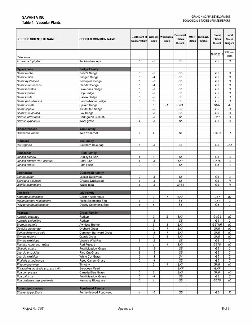
SAVANTA INC.Table 4: Vascular Plants
GRAND NIAGARA DEVELOPMENTECOLOGICAL STUDIES UPDATE REPORT
Project No. 7201 Appendix B 6 of 8
SPECIES SCIENTIFIC NAME SPECIES COMMON NAMECoefficient of Conservatism
Wetness Index
Weediness Index
Provincial Status S-Rank
MNRF Status
COSEWIC Status
Global Status
G-Rank
Local Status
Niagara
ReferenceNHIC 2013
Oldham 2010
Arisaema triphyllum Jack-in-the-pulpit 5 -2 S5 G5 C
Cyperaceae Sedge FamilyCarex bebbii Bebb's Sedge 3 -5 S5 G5 CCarex crinita Fringed Sedge 6 -4 S5 G5 CCarex hystericina Porcupine Sedge 5 -5 S5 G5 CCarex intumescens Bladder Sedge 6 -4 S5 G5 CCarex lacustris Lake-bank Sedge 5 -5 S5 G5 CCarex lupulina Hop Sedge 6 -5 S5 G5 CCarex lurida Sallow Sedge 6 -5 S5 G5 UCarex pensylvanica Pennsylvania Sedge 5 5 S5 G5 CCarex spicata Spiked Sedge 5 -1 SNA GNR ICCarex stipata Awl-fruited Sedge 3 -5 S5 G5 CCarex vulpinoidea Fox Sedge 3 -5 S5 G5 CScirpus atrovirens Dark-green Bulrush 3 -5 S5 G5? CScirpus cyperinus Wool-grass 4 -5 S5 G5 C
Dioscoreaceae Yam FamilyDioscorea villosa Wild Yam-root 7 1 S4 G4G5 U
Iridaceae Iris FamilyIris virginica Southern Blue-flag 5 -5 S5 G5 DD
Juncaceae Rush FamilyJuncus dudleyi Dudley's Rush 1 0 S5 G5 CJuncus effusus var. solutus Soft Rush 4 -5 S5? G5T5 CJuncus tenuis Path Rush 0 0 S5 G5 C
Lemnaceae Duckweed FamilyLemna minor Lesser Duckweed 2 -5 S5 G5 CSpirodela polyrhiza Greater Duckweed 4 -5 S5 G5 RWolffia columbiana Water-meal 4 -5 S4S5 G5 R
Liliaceae Lily FamilyAsparagus officinalis Garden Asparagus 3 -1 SNA G5? ICMaianthemum racemosum False Solomon's Seal 4 3 S5 G5T CPolygonatum pubescens Downy Solomon's Seal 5 5 S5 G5 C
Poaceae Grass FamilyAgrostis gigantea Redtop 0 -2 SNA G4G5 ICAgrostis stolonifera Redtop -3 S5 G5 CBromus inermis Awnless Brome 5 -3 SNA G5TNR ICDactylis glomerata Orchard Grass 3 -1 SNA GNR ICEchinochloa crus-galli Common Barnyard Grass -3 -1 SNA GNR ICElymus repens Quack Grass 3 -3 SNA GNR ICElymus virginicus Virginia Wild Rye 5 -2 S5 G5 CFestuca rubra ssp. rubra Red Fescue 1 -1 SNA G5T5 ICGlyceria striata Fowl Meadow Grass 3 -5 S5 G5 CLeersia oryzoides Rice Cut Grass 3 -5 S5 G5 CLeersia virginica White Cut Grass 6 -3 S4 G5 CPhalaris arundinacea Reed Canary Grass 0 -4 S5 G5 CPhleum pratense Timothy 3 -1 SNA GNR ICPhragmites australis ssp. australis European Reed SNR GNRPoa compressa Canada Blue Grass 0 2 SNA GNR ICPoa palustris Fowl Meadow Grass 5 -4 S5 G5 CPoa pratensis ssp. pratensis Kentucky Bluegrass 0 1 S5 G5T5 IC
Potamogetonaceae Pondweed FamilyStuckenia pectinata Fennel-leaved Pondweed 4 -5 S5 G5 R
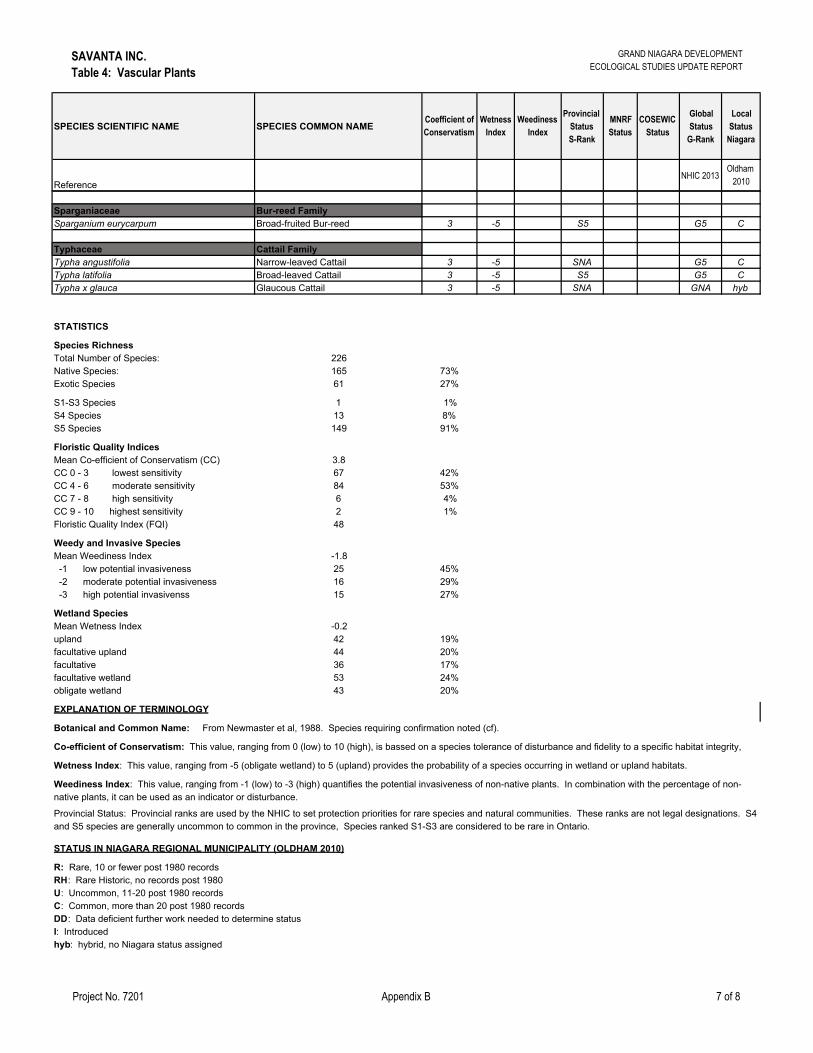
SAVANTA INC.Table 4: Vascular Plants
GRAND NIAGARA DEVELOPMENTECOLOGICAL STUDIES UPDATE REPORT
Project No. 7201 Appendix B 7 of 8
SPECIES SCIENTIFIC NAME SPECIES COMMON NAMECoefficient of Conservatism
Wetness Index
Weediness Index
Provincial Status S-Rank
MNRF Status
COSEWIC Status
Global Status
G-Rank
Local Status
Niagara
ReferenceNHIC 2013
Oldham 2010
Sparganiaceae Bur-reed FamilySparganium eurycarpum Broad-fruited Bur-reed 3 -5 S5 G5 C
Typhaceae Cattail FamilyTypha angustifolia Narrow-leaved Cattail 3 -5 SNA G5 CTypha latifolia Broad-leaved Cattail 3 -5 S5 G5 CTypha x glauca Glaucous Cattail 3 -5 SNA GNA hyb
STATISTICS
Species RichnessTotal Number of Species: 226Native Species: 165 73%Exotic Species 61 27%
S1-S3 Species 1 1%S4 Species 13 8%S5 Species 149 91%
Floristic Quality IndicesMean Co-efficient of Conservatism (CC) 3.8CC 0 - 3 lowest sensitivity 67 42%CC 4 - 6 moderate sensitivity 84 53%CC 7 - 8 high sensitivity 6 4%CC 9 - 10 highest sensitivity 2 1%Floristic Quality Index (FQI) 48
Weedy and Invasive SpeciesMean Weediness Index -1.8 -1 low potential invasiveness 25 45% -2 moderate potential invasiveness 16 29% -3 high potential invasivenss 15 27%
Wetland SpeciesMean Wetness Index -0.2upland 42 19%facultative upland 44 20%facultative 36 17%facultative wetland 53 24%obligate wetland 43 20%
RH: Rare Historic, no records post 1980U: Uncommon, 11-20 post 1980 recordsC: Common, more than 20 post 1980 records
I: Introducedhyb: hybrid, no Niagara status assigned
STATUS IN NIAGARA REGIONAL MUNICIPALITY (OLDHAM 2010)
R: Rare, 10 or fewer post 1980 records
DD: Data deficient further work needed to determine status
EXPLANATION OF TERMINOLOGY
Botanical and Common Name: From Newmaster et al, 1988. Species requiring confirmation noted (cf).
Co-efficient of Conservatism: This value, ranging from 0 (low) to 10 (high), is bassed on a species tolerance of disturbance and fidelity to a specific habitat integrity,
Wetness Index: This value, ranging from -5 (obligate wetland) to 5 (upland) provides the probability of a species occurring in wetland or upland habitats.
Weediness Index: This value, ranging from -1 (low) to -3 (high) quantifies the potential invasiveness of non-native plants. In combination with the percentage of non-native plants, it can be used as an indicator or disturbance.
Provincial Status: Provincial ranks are used by the NHIC to set protection priorities for rare species and natural communities. These ranks are not legal designations. S4 and S5 species are generally uncommon to common in the province, Species ranked S1-S3 are considered to be rare in Ontario.
SAVANTA INC.Table 4: Vascular Plants
GRAND NIAGARA DEVELOPMENTECOLOGICAL STUDIES UPDATE REPORT
Project No. 7201 Appendix B 8 of 8
SPECIES SCIENTIFIC NAME SPECIES COMMON NAMECoefficient of Conservatism
Wetness Index
Weediness Index
Provincial Status S-Rank
MNRF Status
COSEWIC Status
Global Status
G-Rank
Local Status
Niagara
ReferenceNHIC 2013
Oldham 2010
Provincial (Ontario) Status:
Global Status:
MNRF Status:
COSEWIC Status:
Local Status:
Sutherland, D.A. 1987. The Vascular Plants of Halimand-Norfolk; M.E. Gartshore, D.A. Sutherland & J.D. McCrackend (Eds.) Final Report on thr Natural Areas Inventory of the RM of Haldimand-Norfolk. 1985-86; Vol. II: Annotated Checklists. (pp. 1-152); Simcoe, Ontario. Norfolk Field Naturalists.
S-ranks: Provincial ranks are from the NHIC online database (October 2013); S1 (critically imperiled), S2 (imperiled), S3 (vulnerable), S4 (apparently secure), S5 (secure)Natural Heritage Information Centre (NHIC). 2000. Provincial Status of Plants, Wildlife and Vegetation Communities Database.
G-ranks: Global ranks are from the NHIC online database (October 2013); G1 (extremely rare), G2 (very rare), G3 (rare to uncommon), G4 (common), G5 (very common)
Ontario Species at Risk are listed by the Committee on the Status of Species at Risk in Ontario (COSSARO) [from NHIC Octobere 2013]; END - Endangered; THR - Threatened; SC - Special Concern; NAR - Not at Risk; Candidate Species at Risk to be assessed b y COSSARO are listed online.
Assessed Species at Risk at the national level are listed by the Committee on the Status of Endangered Wildlife in Canada (COSEWIC) [from NHIC October 2013]; END - Endangered; THR - Threatened; SC - Special Concern; NAR - Not at Risk; Candidate Species at Risk to be assessed by COSEWIC are listed online.
Goldham, M.J. 2010. Checklist of the Vascular Plants of Niagara Regional Municipality. Ontario Natural Heritage Information Centre (NHIC), Ministry of Natural Resources, Peterborough. Ontario for Niagara Peninsula Conservation Authority, Welland, Ontario.
REFERENCES
Nomenclature based on:Newmaster, S.G. A. Lehela, P.W.C. Uhlig, S.McMurray and M.J. Oldham. 1998. Ontario Plant List. Ontario Ministry of Natural Resources, OntarioForest Research Institute, Sault Ste. Marie, ON, Forest Research Information Paper No. 123. 550pp. + appendices.
Co-efficient of Conservatism, Wetness & WeedinessOldham, M.J., W.D. Bakowsky and D.A. Sutherland. 1995. Floristic Quality Assessment for Southern Ontario. OMNR, Natural Heritage Information Centre, Peterborough. 68 pp.

GRAND NIAGARA: ECOLOGICAL STUDIES UPDATE REPORT
Table 5: Amphibian Call Count Survey Station Results
LEGEND: SPECIES
CODE COMMON NAME SCIENTIFIC NAME
CALL CODES
NOAM No Amphibians No amphibians despite survey effort X No amphibians heard AMTO American Toad Anaxyrus americanus 1 Calls can be counted without error FOTO Folwers Toad Anaxyrus fowleri 2 Calls overlap but can be reliably estimated GRTR Gray Tree Frog Hyla versicolor 3 Calls overlap too much to estimate number CHFR Chorus Frog Pseudacris triseriata WOFR Wood Frog Lithobates sylvatica NLRF Northern Leopard Frog Lithobates pipiens PIFR Pickerel Frog Lithobates palustris
GRFR Green Frog Lithobates clamitans BULL Bullfrog Lithobates catesbeiana MIFR Mink Frog Lithobates septentrionalis
Notes: − For each species, the first number is the call code and the second number, which is in brackets, is the number of individuals heard calling of that species; and − One or more Bullfrogs were heard calling at several stations during a daytime reptile survey on June 23, 2015 – these observations are noted with an ‘X’ under the BULL column. Project No. 7201 Appendix B Page 1 of 10
SURVEY ROUND
STATION NUMBER
SPECIES CODE WATER SIGNIFICANT WILDLIFE HABITAT
Y/N NOAM AMTO FOTO GRTR SPPE CHFR WOFR NLFR PIFR GRFR BULL MIFR Y/N DEPTH (CM)
1 A X Y 20 No 2 A N Dry 1 AA 1(4) Y 13 No 2 AA N Dry 1 B 1(5) 1(1) Y >12 No 2 B X Y 12.5 3 B X Y 7.5 1 BB 1(1) 1(12) Y >5 No 2 BB N Dry 1 C 2(2) 1(4) 1(1) Y 30 Yes (woodland) 2 C 1(2) Y 11 3 C X Y 7

GRAND NIAGARA: ECOLOGICAL STUDIES UPDATE REPORT
Table 5: Amphibian Call Count Survey Station Results
LEGEND: SPECIES
CODE COMMON NAME SCIENTIFIC NAME
CALL CODES
NOAM No Amphibians No amphibians despite survey effort X No amphibians heard AMTO American Toad Anaxyrus americanus 1 Calls can be counted without error FOTO Folwers Toad Anaxyrus fowleri 2 Calls overlap but can be reliably estimated GRTR Gray Tree Frog Hyla versicolor 3 Calls overlap too much to estimate number CHFR Chorus Frog Pseudacris triseriata WOFR Wood Frog Lithobates sylvatica NLRF Northern Leopard Frog Lithobates pipiens PIFR Pickerel Frog Lithobates palustris
GRFR Green Frog Lithobates clamitans BULL Bullfrog Lithobates catesbeiana MIFR Mink Frog Lithobates septentrionalis
Notes: − For each species, the first number is the call code and the second number, which is in brackets, is the number of individuals heard calling of that species; and − One or more Bullfrogs were heard calling at several stations during a daytime reptile survey on June 23, 2015 – these observations are noted with an ‘X’ under the BULL column. Project No. 7201 Appendix B Page 2 of 10
SURVEY ROUND
STATION NUMBER
SPECIES CODE WATER SIGNIFICANT WILDLIFE HABITAT
Y/N NOAM AMTO FOTO GRTR SPPE CHFR WOFR NLFR PIFR GRFR BULL MIFR Y/N DEPTH (CM)
1 CC X Y 24 Y (wetland) 2 CC 1(2) 1(1) Y Deep 3 CC 1(1) 1(2) Y Deep 1 D 1(3) Y 25 N 2 D X Y 19 3 D 1(2) Y 7 1 DD X Y Deep Y (wetland) 2 DD X Y Deep 3 DD 1(4) 1(2) Y Deep 1 E 1(4) 1(8) Y 15 N 2 E 1(2) Y 4.5 3 E 1(5) Y 8
GRAND NIAGARA: ECOLOGICAL STUDIES UPDATE REPORT
Table 5: Amphibian Call Count Survey Station Results
LEGEND: SPECIES
CODE COMMON NAME SCIENTIFIC NAME
CALL CODES
NOAM No Amphibians No amphibians despite survey effort X No amphibians heard AMTO American Toad Anaxyrus americanus 1 Calls can be counted without error FOTO Folwers Toad Anaxyrus fowleri 2 Calls overlap but can be reliably estimated GRTR Gray Tree Frog Hyla versicolor 3 Calls overlap too much to estimate number CHFR Chorus Frog Pseudacris triseriata WOFR Wood Frog Lithobates sylvatica NLRF Northern Leopard Frog Lithobates pipiens PIFR Pickerel Frog Lithobates palustris
GRFR Green Frog Lithobates clamitans BULL Bullfrog Lithobates catesbeiana MIFR Mink Frog Lithobates septentrionalis
Notes: − For each species, the first number is the call code and the second number, which is in brackets, is the number of individuals heard calling of that species; and − One or more Bullfrogs were heard calling at several stations during a daytime reptile survey on June 23, 2015 – these observations are noted with an ‘X’ under the BULL column. Project No. 7201 Appendix B Page 3 of 10
SURVEY ROUND
STATION NUMBER
SPECIES CODE WATER SIGNIFICANT WILDLIFE HABITAT
Y/N NOAM AMTO FOTO GRTR SPPE CHFR WOFR NLFR PIFR GRFR BULL MIFR Y/N DEPTH (CM)
1 EE X Y 24 N 2 EE N Dry 1 F X Y Deep N 2 F X Y Deep 3 F X Y Deep 1 FF 1(3) 1(4) Y 15 N 2 FF 1 (7) Y 8 3 FF X Y 8 1 G 2(25) Y Deep Y (wetland) 2 G X Y Deep 3 G 1(3) X Y Deep 1 GG 1(2) Y 27 N
GRAND NIAGARA: ECOLOGICAL STUDIES UPDATE REPORT
Table 5: Amphibian Call Count Survey Station Results
LEGEND: SPECIES
CODE COMMON NAME SCIENTIFIC NAME
CALL CODES
NOAM No Amphibians No amphibians despite survey effort X No amphibians heard AMTO American Toad Anaxyrus americanus 1 Calls can be counted without error FOTO Folwers Toad Anaxyrus fowleri 2 Calls overlap but can be reliably estimated GRTR Gray Tree Frog Hyla versicolor 3 Calls overlap too much to estimate number CHFR Chorus Frog Pseudacris triseriata WOFR Wood Frog Lithobates sylvatica NLRF Northern Leopard Frog Lithobates pipiens PIFR Pickerel Frog Lithobates palustris
GRFR Green Frog Lithobates clamitans BULL Bullfrog Lithobates catesbeiana MIFR Mink Frog Lithobates septentrionalis
Notes: − For each species, the first number is the call code and the second number, which is in brackets, is the number of individuals heard calling of that species; and − One or more Bullfrogs were heard calling at several stations during a daytime reptile survey on June 23, 2015 – these observations are noted with an ‘X’ under the BULL column. Project No. 7201 Appendix B Page 4 of 10
SURVEY ROUND
STATION NUMBER
SPECIES CODE WATER SIGNIFICANT WILDLIFE HABITAT
Y/N NOAM AMTO FOTO GRTR SPPE CHFR WOFR NLFR PIFR GRFR BULL MIFR Y/N DEPTH (CM)
2 GG ~40
tadpoles Y
8 N
3 GG Dried out tadpoles Y 7
1 H 1(2) Y 15 N 2 H N Dry 1 HH X Y Deep Y (wetland) 2 HH X Y Deep 3 HH 1(1) 1(1) Y Deep 1 I 1(1) 1(1) Y >24 Y (wetland) 2 I X Y Deep 3 I 1(3) 1(4) Y Deep 1 II X Y Deep N
GRAND NIAGARA: ECOLOGICAL STUDIES UPDATE REPORT
Table 5: Amphibian Call Count Survey Station Results
LEGEND: SPECIES
CODE COMMON NAME SCIENTIFIC NAME
CALL CODES
NOAM No Amphibians No amphibians despite survey effort X No amphibians heard AMTO American Toad Anaxyrus americanus 1 Calls can be counted without error FOTO Folwers Toad Anaxyrus fowleri 2 Calls overlap but can be reliably estimated GRTR Gray Tree Frog Hyla versicolor 3 Calls overlap too much to estimate number CHFR Chorus Frog Pseudacris triseriata WOFR Wood Frog Lithobates sylvatica NLRF Northern Leopard Frog Lithobates pipiens PIFR Pickerel Frog Lithobates palustris
GRFR Green Frog Lithobates clamitans BULL Bullfrog Lithobates catesbeiana MIFR Mink Frog Lithobates septentrionalis
Notes: − For each species, the first number is the call code and the second number, which is in brackets, is the number of individuals heard calling of that species; and − One or more Bullfrogs were heard calling at several stations during a daytime reptile survey on June 23, 2015 – these observations are noted with an ‘X’ under the BULL column. Project No. 7201 Appendix B Page 5 of 10
SURVEY ROUND
STATION NUMBER
SPECIES CODE WATER SIGNIFICANT WILDLIFE HABITAT
Y/N NOAM AMTO FOTO GRTR SPPE CHFR WOFR NLFR PIFR GRFR BULL MIFR Y/N DEPTH (CM)
2 II X Y Deep 3 II 1(1) Y Deep 1 J X Y Deep Y (wetland) 2 J X Y Deep 3 J 1(1) 1(2) Y Deep 1 JJ X Y Deep N 2 JJ X Y 40 3 JJ 1(1) Y 25 1 K 1 (6) 1(4) Y 14 Y (wetland) 2 K 1(2) Y 18 3 K 1(5) X Y 5 1 KK 1(2) Y Deep N
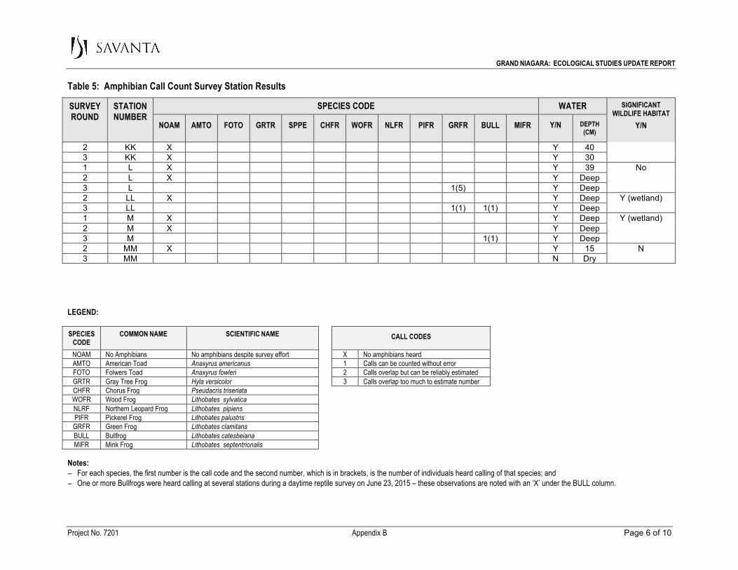
GRAND NIAGARA: ECOLOGICAL STUDIES UPDATE REPORT
Table 5: Amphibian Call Count Survey Station Results
LEGEND: SPECIES
CODE COMMON NAME SCIENTIFIC NAME
CALL CODES
NOAM No Amphibians No amphibians despite survey effort X No amphibians heard AMTO American Toad Anaxyrus americanus 1 Calls can be counted without error FOTO Folwers Toad Anaxyrus fowleri 2 Calls overlap but can be reliably estimated GRTR Gray Tree Frog Hyla versicolor 3 Calls overlap too much to estimate number CHFR Chorus Frog Pseudacris triseriata WOFR Wood Frog Lithobates sylvatica NLRF Northern Leopard Frog Lithobates pipiens PIFR Pickerel Frog Lithobates palustris
GRFR Green Frog Lithobates clamitans BULL Bullfrog Lithobates catesbeiana MIFR Mink Frog Lithobates septentrionalis
Notes: − For each species, the first number is the call code and the second number, which is in brackets, is the number of individuals heard calling of that species; and − One or more Bullfrogs were heard calling at several stations during a daytime reptile survey on June 23, 2015 – these observations are noted with an ‘X’ under the BULL column. Project No. 7201 Appendix B Page 6 of 10
SURVEY ROUND
STATION NUMBER
SPECIES CODE WATER SIGNIFICANT WILDLIFE HABITAT
Y/N NOAM AMTO FOTO GRTR SPPE CHFR WOFR NLFR PIFR GRFR BULL MIFR Y/N DEPTH (CM)
2 KK X Y 40 3 KK X Y 30 1 L X Y 39 No 2 L X Y Deep 3 L 1(5) Y Deep 2 LL X Y Deep Y (wetland) 3 LL 1(1) 1(1) Y Deep 1 M X Y Deep Y (wetland) 2 M X Y Deep 3 M 1(1) Y Deep 2 MM X Y 15 N 3 MM N Dry
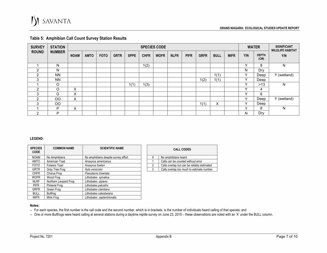
GRAND NIAGARA: ECOLOGICAL STUDIES UPDATE REPORT
Table 5: Amphibian Call Count Survey Station Results
LEGEND: SPECIES
CODE COMMON NAME SCIENTIFIC NAME
CALL CODES
NOAM No Amphibians No amphibians despite survey effort X No amphibians heard AMTO American Toad Anaxyrus americanus 1 Calls can be counted without error FOTO Folwers Toad Anaxyrus fowleri 2 Calls overlap but can be reliably estimated GRTR Gray Tree Frog Hyla versicolor 3 Calls overlap too much to estimate number CHFR Chorus Frog Pseudacris triseriata WOFR Wood Frog Lithobates sylvatica NLRF Northern Leopard Frog Lithobates pipiens PIFR Pickerel Frog Lithobates palustris
GRFR Green Frog Lithobates clamitans BULL Bullfrog Lithobates catesbeiana MIFR Mink Frog Lithobates septentrionalis
Notes: − For each species, the first number is the call code and the second number, which is in brackets, is the number of individuals heard calling of that species; and − One or more Bullfrogs were heard calling at several stations during a daytime reptile survey on June 23, 2015 – these observations are noted with an ‘X’ under the BULL column. Project No. 7201 Appendix B Page 7 of 10
SURVEY ROUND
STATION NUMBER
SPECIES CODE WATER SIGNIFICANT WILDLIFE HABITAT
Y/N NOAM AMTO FOTO GRTR SPPE CHFR WOFR NLFR PIFR GRFR BULL MIFR Y/N DEPTH (CM)
1 N 1(2) Y 8 N 2 N N Dry 2 NN 1(1) Y Deep Y (wetland) 3 NN 1(2) 1(1) Y Deep 1 O 1(1) 1(3) Y .>13 N 2 O X Y 4 3 O X Y 6 2 OO X Y Deep Y (wetland) 3 OO 1(1) X Y Deep 1 P X Y 8 N 2 P N Dry
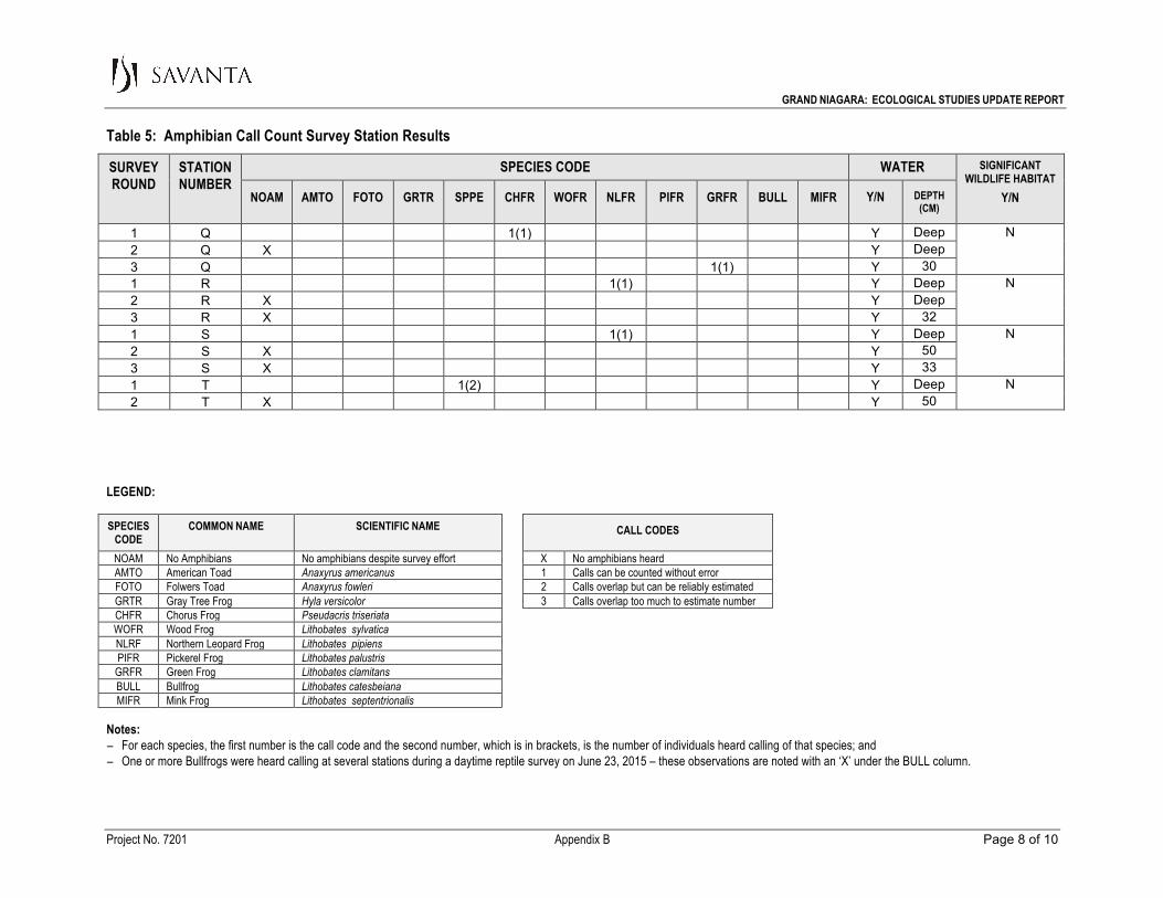
GRAND NIAGARA: ECOLOGICAL STUDIES UPDATE REPORT
Table 5: Amphibian Call Count Survey Station Results
LEGEND: SPECIES
CODE COMMON NAME SCIENTIFIC NAME
CALL CODES
NOAM No Amphibians No amphibians despite survey effort X No amphibians heard AMTO American Toad Anaxyrus americanus 1 Calls can be counted without error FOTO Folwers Toad Anaxyrus fowleri 2 Calls overlap but can be reliably estimated GRTR Gray Tree Frog Hyla versicolor 3 Calls overlap too much to estimate number CHFR Chorus Frog Pseudacris triseriata WOFR Wood Frog Lithobates sylvatica NLRF Northern Leopard Frog Lithobates pipiens PIFR Pickerel Frog Lithobates palustris
GRFR Green Frog Lithobates clamitans BULL Bullfrog Lithobates catesbeiana MIFR Mink Frog Lithobates septentrionalis
Notes: − For each species, the first number is the call code and the second number, which is in brackets, is the number of individuals heard calling of that species; and − One or more Bullfrogs were heard calling at several stations during a daytime reptile survey on June 23, 2015 – these observations are noted with an ‘X’ under the BULL column. Project No. 7201 Appendix B Page 8 of 10
SURVEY ROUND
STATION NUMBER
SPECIES CODE WATER SIGNIFICANT WILDLIFE HABITAT
Y/N NOAM AMTO FOTO GRTR SPPE CHFR WOFR NLFR PIFR GRFR BULL MIFR Y/N DEPTH (CM)
1 Q 1(1) Y Deep N 2 Q X Y Deep 3 Q 1(1) Y 30 1 R 1(1) Y Deep N 2 R X Y Deep 3 R X Y 32 1 S 1(1) Y Deep N
2 S X Y 50 3 S X Y 33 1 T 1(2) Y Deep N
2 T X Y 50

GRAND NIAGARA: ECOLOGICAL STUDIES UPDATE REPORT
Table 5: Amphibian Call Count Survey Station Results
LEGEND: SPECIES
CODE COMMON NAME SCIENTIFIC NAME
CALL CODES
NOAM No Amphibians No amphibians despite survey effort X No amphibians heard AMTO American Toad Anaxyrus americanus 1 Calls can be counted without error FOTO Folwers Toad Anaxyrus fowleri 2 Calls overlap but can be reliably estimated GRTR Gray Tree Frog Hyla versicolor 3 Calls overlap too much to estimate number CHFR Chorus Frog Pseudacris triseriata WOFR Wood Frog Lithobates sylvatica NLRF Northern Leopard Frog Lithobates pipiens PIFR Pickerel Frog Lithobates palustris
GRFR Green Frog Lithobates clamitans BULL Bullfrog Lithobates catesbeiana MIFR Mink Frog Lithobates septentrionalis
Notes: − For each species, the first number is the call code and the second number, which is in brackets, is the number of individuals heard calling of that species; and − One or more Bullfrogs were heard calling at several stations during a daytime reptile survey on June 23, 2015 – these observations are noted with an ‘X’ under the BULL column. Project No. 7201 Appendix B Page 9 of 10
SURVEY ROUND
STATION NUMBER
SPECIES CODE WATER SIGNIFICANT WILDLIFE HABITAT
Y/N NOAM AMTO FOTO GRTR SPPE CHFR WOFR NLFR PIFR GRFR BULL MIFR Y/N DEPTH (CM)
3 T 1(2) Y 30 1 U 1(5) Y 18 N 2 U X Y 14 3 U X Y 5 1 V X Y 23 N 2 V X Y 14 3 V X Y 31 1 W X Y >17 Y (wetland) 2 W X Y Deep 3 W 1(3) 1(3) Y Deep 1 X X Y 20 N
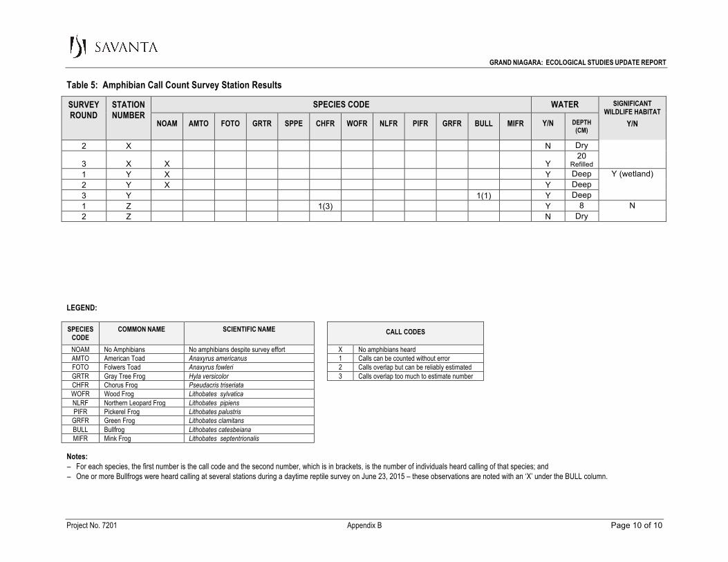
GRAND NIAGARA: ECOLOGICAL STUDIES UPDATE REPORT
Table 5: Amphibian Call Count Survey Station Results
LEGEND: SPECIES
CODE COMMON NAME SCIENTIFIC NAME
CALL CODES
NOAM No Amphibians No amphibians despite survey effort X No amphibians heard AMTO American Toad Anaxyrus americanus 1 Calls can be counted without error FOTO Folwers Toad Anaxyrus fowleri 2 Calls overlap but can be reliably estimated GRTR Gray Tree Frog Hyla versicolor 3 Calls overlap too much to estimate number CHFR Chorus Frog Pseudacris triseriata WOFR Wood Frog Lithobates sylvatica NLRF Northern Leopard Frog Lithobates pipiens PIFR Pickerel Frog Lithobates palustris
GRFR Green Frog Lithobates clamitans BULL Bullfrog Lithobates catesbeiana MIFR Mink Frog Lithobates septentrionalis
Notes: − For each species, the first number is the call code and the second number, which is in brackets, is the number of individuals heard calling of that species; and − One or more Bullfrogs were heard calling at several stations during a daytime reptile survey on June 23, 2015 – these observations are noted with an ‘X’ under the BULL column. Project No. 7201 Appendix B Page 10 of 10
SURVEY ROUND
STATION NUMBER
SPECIES CODE WATER SIGNIFICANT WILDLIFE HABITAT
Y/N NOAM AMTO FOTO GRTR SPPE CHFR WOFR NLFR PIFR GRFR BULL MIFR Y/N DEPTH (CM)
2 X N Dry
3 X X Y 20
Refilled 1 Y X Y Deep Y (wetland) 2 Y X Y Deep 3 Y 1(1) Y Deep 1 Z 1(3) Y 8 N 2 Z N Dry
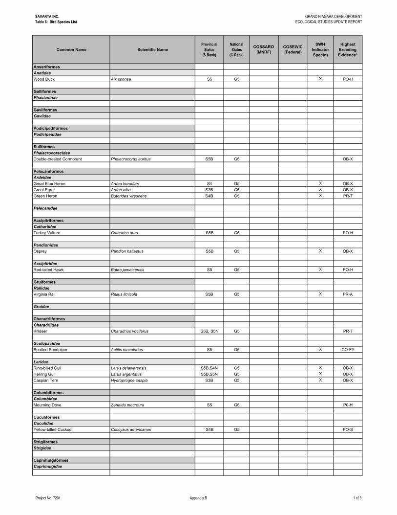
SAVANTA INC.Table 6: Bird Species List
GRAND NIAGARA DEVELOPOMENTECOLOGICAL STUDIES UPDATE REPORT
Project No. 7201 Appendix B 1 of 3
Common Name Scientific NameProvincial
Status (S Rank)
National Status
(G Rank)
COSSARO (MNRF)
COSEWIC (Federal)
SWH Indicator Species
Highest Breeding Evidence*
AnseriformesAnatidaeWood Duck Aix sponsa S5 G5 X PO-H
GalliformesPhasianinae
GaviiformesGaviidae
PodicipediformesPodicipedidae
SuliformesPhalacrocoracidaeDouble-crested Cormorant Phalacrocorax auritus S5B G5 OB-X
PelecaniformesArdeidaeGreat Blue Heron Ardea herodias S4 G5 X OB-XGreat Egret Ardea alba S2B G5 X OB-XGreen Heron Butorides virescens S4B G5 X PR-T
Pelecanidae
AccipitriformesCathartidaeTurkey Vulture Cathartes aura S5B G5 PO-H
PandionidaeOsprey Pandion haliaetus S5B G5 X OB-X
AccipitridaeRed-tailed Hawk Buteo jamaicensis S5 G5 X PO-H
GruiformesRallidaeVirginia Rail Rallus limicola S5B G5 X PR-A
Gruidae
CharadriiformesCharadriidaeKilldeer Charadrius vociferus S5B, S5N G5 PR-T
ScolopacidaeSpotted Sandpiper Actitis macularius S5 G5 X CO-FY
LaridaeRing-billed Gull Larus delawarensis S5B,S4N G5 X OB-XHerring Gull Larus argentatus S5B,S5N G5 X OB-XCaspian Tern Hydroprogne caspia S3B G5 X OB-X
ColumbiformesColumbidaeMourning Dove Zenaida macroura S5 G5 P0-H
CuculiformesCuculidaeYellow-billed Cuckoo Coccyzus americanus S4B G5 PO-S
StrigiformesStrigidae
CaprimulgiformesCaprimulgidae
SAVANTA INC.Table 6: Bird Species List
GRAND NIAGARA DEVELOPOMENTECOLOGICAL STUDIES UPDATE REPORT
Project No. 7201 Appendix B 2 of 3
Common Name Scientific NameProvincial
Status (S Rank)
National Status
(G Rank)
COSSARO (MNRF)
COSEWIC (Federal)
SWH Indicator Species
Highest Breeding Evidence*
ApodiformesApodidae
Trochilidae
CoraciiformesAlcedinidaeBelted Kingfisher Megaceryle alcyon S4B G5 PO-H
PiciformesPicidaeDowny Woodpecker Picoides pubescens S5 G5 PR-THairy Woodpecker Picoides villosus S5 G5 PR-TNorthern Flicker Colaptes auratus S4B G5 PR-A
FalconiformesFalconidae
PasseriformesTyrannidaeEastern Wood-Pewee Contopus virens S4B G5 SC SC PR-TWillow Flycatcher Empidonax traillii S5B G5 X PR-TEastern Phoebe Sayornis phoebe S5B G5 PR-TGreat Crested Flycatcher Myiarchus crinitus S4B G5 PR-TEastern Kingbird Tyrannus tyrannus S4B G5 PR-T
Laniidae
VireonidaeWarbling Vireo Vireo gilvus S5B G5 PR-TRed-eyed Vireo Vireo olivaceus S5B G5 PR-T
CorvidaeBlue Jay Cyanocitta cristata S5 G5 PR-TAmerican Crow Corvus brachyrhynchos S5B G5 PR-T
AlaudidaeHorned Lark Eremophila alpestris S4B G5 CO-FY
HirundinidaeTree Swallow Tachycineta bicolor S4B G5 PR-TNorthern Rough-winged Swallow Stelgidopteryx serripennis S4B G5 X PO-HCliff Swallow Petrochelidon pyrrhonota S4B G5 X PO-HBarn Swallow Hirundo rustica S4B G5 THR THR PO-H
ParidaeBlack-capped Chickadee Poecile atricapillus S5 G5 PR-T
SittidaeWhite-breasted Nuthatch Sitta carolinensis S5 G5 PR-T
Certhiidae
Troglodytidae
PolioptilidaeBlue-gray Gnatcatcher Polioptila caerulea S4B G5 PR-T
Regulidae
TurdidaeEastern Bluebird Sialia sialis S5B G5 PO-SWood Thrush Hylocichla mustelina S4B G5 SC THR PR-TAmerican Robin Turdus migratorius S5B G5 CO-FY
MimidaeGray Catbird Dumetella carolinensis S4B G5 PR-T
SAVANTA INC.Table 6: Bird Species List
GRAND NIAGARA DEVELOPOMENTECOLOGICAL STUDIES UPDATE REPORT
Project No. 7201 Appendix B 3 of 3
Common Name Scientific NameProvincial
Status (S Rank)
National Status
(G Rank)
COSSARO (MNRF)
COSEWIC (Federal)
SWH Indicator Species
Highest Breeding Evidence*
SturnidaeEuropean Starling Sturnus vulgaris SNA G5 PR-T
Motacillidae
BombycillidaeCedar Waxwing Bombycilla cedrorum S5B G5 PR-P
Calcariidae
ParulidaeBlue-winged Warbler Vermivora cyanoptera S4B G5 PO-SCommon Yellowthroat Geothlypis trichas S5B G5 PR-TYellow Warbler Setophaga petechia S5B G5 PR-T
EmberizidaeChipping Sparrow Spizella passerina S5B G5 PR-TSavannah Sparrow Passerculus sandwichensis S4B G5 X CO-NESong Sparrow Melospiza melodia S5B G5 CO-FYSwamp Sparrow Melospiza georgiana S5B G5 PR-T
CardinalidaeNorthern Cardinal Cardinalis cardinalis S5 G5 PR-TRose-breasted Grosbeak Pheucticus ludovicianus S4B G5 PR-TIndigo Bunting Passerina cyanea S4B G5 PR-P
IcteridaeBobolink Dolichonyx oryzivorus S4B G5 THR THR OB-XRed-winged Blackbird Agelaius phoeniceus S4 G5 CO-FYCommon Grackle Quiscalus quiscula S5B G5 CO-FYBrown-headed Cowbird Molothrus ater S4B G5 PR-TOrchard Oriole Icterus spurius S4B G5 PR-PBaltimore Oriole Icterus galbula S4B G5 PR-T
FringillidaeAmerican Goldfinch Spinus tristis S5B G5 PR-T
Passeridae
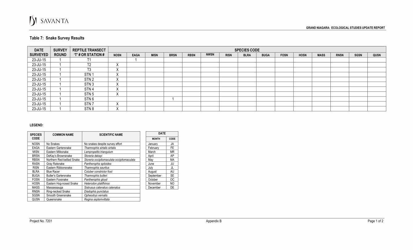
GRAND NIAGARA: ECOLOGICAL STUDIES UPDATE REPORT Table 7: Snake Survey Results
LEGEND: SPECIES
CODE COMMON NAME SCIENTIFIC NAME DATE
MONTH CODE NOSN No Snakes No snakes despite survey effort January JA EAGA Eastern Gartersnake Thamnophis sirtalis sirtalis February FE MISN Eastern Milksnake Lampropeltis triangulum March MR BRSN DeKay’s Brownsnake Storeria dekayi April AP RBSN Northern Red-bellied Snake Storeria occipitomaculata occipitomaculata May MA RASN Gray Ratsnake Pantherophis spiloides June JU RISN Eastern Ribbonsnake Thamnophis sauritus July JL BLRA Blue Racer Coluber constrictor foxii August AU BUGA Butler’s Gartersnake Thamnophis butleri September SE FOSN Eastern Foxsnake Pantherophis gloyd October OC HOSN Eastern Hog-nosed Snake Heterodon platifhinos November NO MASS Massassauga Sistrusus catenatus catenatus December DE RNSN Ring-necked Snake Diadophis punctatus SGSN Smooth Greensnake Opheodrys vernalis QUSN Queensnake Regina septemvittata
Project No. 7201 Appendix B Page 1 of 2
DATE SURVEYED
SURVEY ROUND
REPTILE TRANSECT ‘T’ # OR STATION #
SPECIES CODE NOSN EAGA MISN BRSN RBSN NWSN RISN BLRA BUGA FOSN HOSN MASS RNSN SGSN QUSN
23-JU-15 1 T1 1 23-JU-15 1 T2 X 23-JU-15 1 T3 X 23-JU-15 1 STN 1 X 23-JU-15 1 STN 2 X 23-JU-15 1 STN 3 X 23-JU-15 1 STN 4 X 23-JU-15 1 STN 5 X 23-JU-15 1 STN 6 1 23-JU-15 1 STN 7 X 23-JU-15 1 STN 8 X

GRAND NIAGARA: ECOLOGICAL STUDIES UPDATE REPORT Table 7: Snake Survey Results
LEGEND: SPECIES
CODE COMMON NAME SCIENTIFIC NAME DATE
MONTH CODE NOSN No Snakes No snakes despite survey effort January JA EAGA Eastern Gartersnake Thamnophis sirtalis sirtalis February FE MISN Eastern Milksnake Lampropeltis triangulum March MR BRSN DeKay’s Brownsnake Storeria dekayi April AP RBSN Northern Red-bellied Snake Storeria occipitomaculata occipitomaculata May MA RASN Gray Ratsnake Pantherophis spiloides June JU RISN Eastern Ribbonsnake Thamnophis sauritus July JL BLRA Blue Racer Coluber constrictor foxii August AU BUGA Butler’s Gartersnake Thamnophis butleri September SE FOSN Eastern Foxsnake Pantherophis gloyd October OC HOSN Eastern Hog-nosed Snake Heterodon platifhinos November NO MASS Massassauga Sistrusus catenatus catenatus December DE RNSN Ring-necked Snake Diadophis punctatus SGSN Smooth Greensnake Opheodrys vernalis QUSN Queensnake Regina septemvittata
Project No. 7201 Appendix B Page 2 of 2
DATE SURVEYED
SURVEY ROUND
REPTILE TRANSECT ‘T’ # OR STATION #
SPECIES CODE NOSN EAGA MISN BRSN RBSN NWSN RISN BLRA BUGA FOSN HOSN MASS RNSN SGSN QUSN
23-JU-15 1 STN 9 X 23-JU-15 1 STN 10 X 23-JU-15 1 STN 11 X 23-JU-15 1 STN 12 X 23-JU-15 1 STN 13 X 23-JU-15 1 STN 14 X 23-JU-15 1 STN 15 1 23-JU-15 1 STN 16 X
GRAND NIAGARA: ECOLOGICAL STUDIES UPDATE REPORT
Table 8: Turtle Survey Results
LEGEND: SPECIES
CODE COMMON NAME SCIENTIFIC NAME DATE
MONTH CODE NOTU No Turtles No turtles despite survey effort January JA MPTU Midland Painted Turtle Chrysemys picta marginata February FE SNTU Snapping Turtle Chelydra serpentina March MR MATU Northern Map Turtle Graptemys geographica April AP BLTU Blanding’s Turtle Emydoidea blandingii May MA SSTU Spiny Soft-shelled Turtle Apalone spinifera June JU WOTU Wood Turtle Glyptemys insculpta July JL STIN Stinkpot Turtle Stemotherus odoratus August AU SPTU Spotted Turtle Clemmys guttata September SE
October OC November NO December DE
Project No. 7201 Appendix B Page 1 of 2
DATE SURVEYED
SURVEY ROUND
TRANSECT OR STATION NUMBER
SPECIES CODE
NOTU MPTU SNTU MATU BLTU SSTU WOTU STIN SPTU 23-JU-15 1 STN 1 X 23-JU-15 1 STN 2 X 23-JU-15 1 STN 3 X 23-JU-15 1 STN 4 X 23-JU-15 1 STN 5 X 23-JU-15 1 STN 6 3 23-JU-15 1 STN 7 X 23-JU-15 1 STN 8 X 23-JU-15 1 STN 9 9 23-JU-15 1 STN 10 1 23-JU-15 1 STN 11 X 23-JU-15 1 STN 12 X 23-JU-15 1 STN 13 2 23-JU-15 1 STN 14 3 23-JU-15 1 STN 15 X
GRAND NIAGARA: ECOLOGICAL STUDIES UPDATE REPORT
Table 8: Turtle Survey Results
LEGEND: SPECIES
CODE COMMON NAME SCIENTIFIC NAME DATE
MONTH CODE NOTU No Turtles No turtles despite survey effort January JA MPTU Midland Painted Turtle Chrysemys picta marginata February FE SNTU Snapping Turtle Chelydra serpentina March MR MATU Northern Map Turtle Graptemys geographica April AP BLTU Blanding’s Turtle Emydoidea blandingii May MA SSTU Spiny Soft-shelled Turtle Apalone spinifera June JU WOTU Wood Turtle Glyptemys insculpta July JL STIN Stinkpot Turtle Stemotherus odoratus August AU SPTU Spotted Turtle Clemmys guttata September SE
October OC November NO December DE
Project No. 7201 Appendix B Page 2 of 2
DATE SURVEYED
SURVEY ROUND
TRANSECT OR STATION NUMBER
SPECIES CODE
NOTU MPTU SNTU MATU BLTU SSTU WOTU STIN SPTU 23-JU-15 1 STN 16 5 23-JU-15 1 STN 17 5 23-JU-15 1 T1 X 23-JU-15 1 T2 X 23-JU-15 1 T3 X Turtle Survey Results – Nesting
− A visual turtle nesting habitat / evidence survey was completed (Transects T1 to T3 and around perimeter of each pond station 1 to 17); − Soil auger tests were not permitted due to use of the site as an active golf course; − Soil mapping indicates no suitable substrate (high clay content soils); − Sand present in golf course bunkers was of insufficient depth for nesting; and, − No nesting evidence (i.e., test digs, claw marks, predated nests) was observed.

GRAND NIAGARA: ECOLOGICAL STUDIES UPDATE REPORT Table 9: Wildlife Road Crossing Survey Results
LEGEND:
MONTH JA January FE February MR March AL April MA May JN June JL July AU August SE September OC October NO November DE December
Project No. 7201 Appendix B Page 1 of 1
SURVEY DATE
SURVEYROUND (X OF Y)
TRANSECT NO.
SPECIES OBSERVED UTM OF OBSERVATION INDIVIDUALS
EASTING NORTHING QTY STATUS
23-Jun-15 1 of 1 R1 None observed 23-Jun-15 1 of 1 R2 None observed 23-Jun-15 1 of 1 R3 None observed 23-Jun-15 1 of 1 R4 None observed
SAVANTA INC.Table 10: Species List for Fauna Observed on Subject Lands
GRAND NIAGARA DEVELOPMENTECOLOGICAL STUDIES UPDATE REPORT
Project No. 7201 Appendix B 1 of 3
COMMON NAME SCIENTIFIC NAME Provincial SRANK
Global GRANK COSSARO COSEWIC Niagara Natural
Areas Inventory
ODONATAEmerald Spreadwing Lestes dryas S5 G5 RSlender Spreadwing Lestes rectangularis S5 G5 RFamiliar Bluet Enallagma civile S5 G5 CSlender Bluet Enallagma traviatum westfalli S1 G5 Not listedEastern Forktail Ischnura verticalis S5 G5 CCommon Green Darner Anax junius S5 G5 CPrince Baskettail Epitheca princeps S5 G5 REastern Pondhawk Erythemis simplicicollis S5 G5 CWidow Skimmer Libellula luctuosa S5 G5 CSpot-winged Glider Pantala hymenaea S4 G5 REastern Amberwing Perithemis tenera S4 G5 CCherry-faced Meadowhawk Sympetrum internum S5 G5 RBlack Saddlebags Tramea lacerata S4 G5 CBUTTERFLIESTawny-edged Skipper Polites themistocles S5 G5 RHCabbage White Pieris rapae SNA G5 ICClouded Sulphur Colias philodice S5 G5 Not listedAcadian Hairstreak Satyrium acadicum S4 G5 REastern Tailed Blue Everes comyntas S5 G5 CPearl Crescent Phyciodes tharos S4 G5 CRed Admiral Vanessa atalanta S5 G5 CCommon Wood-Nymph Cercyonis pegala S5 G5 COTHER ARTHROPODSEuropean Mantid Mantis religiosa Not listedNON-INSECT ARTHROPODSDigger Crayfish (burrow, terrestrial crayfish spp) Fallicambarus fodiens S4 G5 Not listedMeadow Crayfish (burrow, terrestrial crayfish spp) Cambarus diogenes S3 G5 Not listedAMPHIBIANSAmerican Toad Anaxyrus americanus S5 G5 WAmerican Bullfrog Lithobates catesbeiana S4 G5 WNorthern Green Frog Lithobates clamitans S5 G5 WNorthern Leopard Frog Lithobates pipiens S5 G5 WWood Frog Lithobates sylvaticus S5 G5 WSpring Peeper Pseudacris crucifer S5 G5 WWestern Chorus Frog / Carolinean population Pseudacris triseriata pop. 1 S4 G5TNR WREPTILESMidland Painted Turtle Chrysemys picta marginata S5 G5T5 WEastern Gartersnake Thamnophis sirtalis S5 G5 WDeKay's Brownsnake Storeria dekayi S5 G5 WNorthern Watershanke Nerodia sipedon sipedon S5 G5T5 WBIRDSCanada Goose Branta canadensis S5 G5 CMallard Anas platyrhynchos S5 G5 CWood Duck Aix sponsa S5 G5 UDouble-crested Cormorant Phalacrocorax auritus S5B G5 CGreat Blue Heron Ardea herodias S4 G5 UGreat Egret Ardea alba S2B G5 RGreen Heron Butorides virescens S4B G5 UTurkey Vulture Cathartes aura S5B G5 UWild Turkey Anas platyrhynchos S5 G5 UAmerican Woodcock Scolopax minor S4B G5 UOsprey Pandion haliaetus S5B G5 ORed-tailed Hawk Buteo jamaicensis S5 G5 UVirginia Rail Rallus limicola S5B G5 RKilldeer Charadrius vociferus S5B, S5N G5 CLeast Sandpiper Calidris minutilla S4B, S5N G5 CSpotted Sandpiper Actitis macularius S5 G5 CRing-billed Gull Larus delawarensis S5B,S4N G5 CHerring Gull Larus argentatus S5B,S5N G5 UCaspian Tern Hydroprogne caspia S3B G5 UMourning Dove Zenaida macroura S5 G5 CYellow-billed Cuckoo Coccyzus americanus S4B G5 UBelted Kingfisher Megaceryle alcyon S4B G5 URed-bellied Woodpecker Melanerpes carolinus S4 G5 UDowny Woodpecker Picoides pubescens S5 G5 CHairy Woodpecker Picoides villosus S5 G5 UNorthern Flicker Colaptes auratus S4B G5 CEastern Wood-Pewee Contopus virens S4B G5 SC SC C
SAVANTA INC.Table 10: Species List for Fauna Observed on Subject Lands
GRAND NIAGARA DEVELOPMENTECOLOGICAL STUDIES UPDATE REPORT
Project No. 7201 Appendix B 2 of 3
COMMON NAME SCIENTIFIC NAME Provincial SRANK
Global GRANK COSSARO COSEWIC Niagara Natural
Areas Inventory
Willow Flycatcher Empidonax traillii S5B G5 UEastern Phoebe Sayornis phoebe S5B G5 UGreat Crested Flycatcher Myiarchus crinitus S4B G5 CEastern Kingbird Tyrannus tyrannus S4B G5 CWarbling Vireo Vireo gilvus S5B G5 CRed-eyed Vireo Vireo olivaceus S5B G5 CBlue Jay Cyanocitta cristata S5 G5 CAmerican Crow Corvus brachyrhynchos S5B G5 CHorned Lark Eremophila alpestris S4B G5 CTree Swallow Tachycineta bicolor S4B G5 CNorthern Rough-winged Swallow Stelgidopteryx serripennis S4B G5 UCliff Swallow Petrochelidon pyrrhonota S4B G5 UBarn Swallow Hirundo rustica S4B G5 THR THR CBlack-capped Chickadee Poecile atricapillus S5 G5 CWhite-breasted Nuthatch Sitta carolinensis S5 G5 UBlue-gray Gnatcatcher Polioptila caerulea S4B G5 UEastern Bluebird Sialia sialis S5B G5 UWood Thrush Hylocichla mustelina S4B G5 SC THR UAmerican Robin Turdus migratorius S5B G5 CGray Catbird Dumetella carolinensis S4B G5 CEuropean Starling Sturnus vulgaris SNA G5 CCedar Waxwing Bombycilla cedrorum S5B G5 CBlue-winged Warbler Vermivora cyanoptera S4B G5 UCommon Yellowthroat Geothlypis trichas S5B G5 CYellow Warbler Setophaga petechia S5B G5 CChipping Sparrow Spizella passerina S5B G5 CSavannah Sparrow Passerculus sandwichensis S4B G5 CSong Sparrow Melospiza melodia S5B G5 CSwamp Sparrow Melospiza georgiana S5B G5 UNorthern Cardinal Cardinalis cardinalis S5 G5 CRose-breasted Grosbeak Pheucticus ludovicianus S4B G5 CIndigo Bunting Passerina cyanea S4B G5 CBobolink Dolichonyx oryzivorus S4B G5 THR THR URed-winged Blackbird Agelaius phoeniceus S4 G5 CCommon Grackle Quiscalus quiscula S5B G5 CBrown-headed Cowbird Molothrus ater S4B G5 COrchard Oriole Icterus spurius S4B G5 U/RBaltimore Oriole Icterus galbula S4B G5 CAmerican Goldfinch Spinus tristis S5B G5 CMAMMALSBat speciesEastern Chipmunk Tamias striatus S5 G5 Not listedEastern Gray Squirrel Sciurus carolinensis S5 G5 Not listedMeadow Vole Microtus pennsylvanicus S5 G5 Not listedCoyote Canis latrans S5 G5 Not listedRed Fox Vulpes vulpes S5 G5 Not listedWhite-tailed Deer Odocoileus virginianus S5 G5 Not listed
Explanation of Status and Acronymns
COSSARO: Committee on the Status of Species at Risk in OntarioCOSEWIC: Committee on the Status of Endangered Wildlife in CanadaREGION: Rare in a Site RegionS1: Critically Imperiled—Critically imperiled in the province (often 5 or fewer occurrences) S2: Imperiled—Imperiled in the province, very few populations (often 20 or fewer), S3: Vulnerable—Vulnerable in the province, relatively few populations (often 80 or fewer)S4: Apparently Secure—Uncommon but not rareS5: Secure—Common, widespread, and abundant in the provinceSX: Presumed extirpatedSH: Possibly Extirpated (Historical)SNR: UnrankedSU: Unrankable—Currently unrankable due to lack of information SNA: Not applicable—A conservation status rank is not applicable because the species is not a suitable target for conservation activities.S#S#: Range Rank—A numeric range rank (e.g., S2S3) is used to indicate any range of uncertainty about the status of the speciesS#B- Breeding status rankS#N- Non Breeding status rank?: Indicates uncertainty in the assigned rankG1: Extremely rare globally; usually fewer than 5 occurrences in the overall rangeG1G2: Extremely rare to very rare globallyG2: Very rare globally; usually between 5-10 occurrences in the overall rangeG2G3: Very rare to uncommon globallyG3: Rare to uncommon globally; usually between 20-100 occurrences
SAVANTA INC.Table 10: Species List for Fauna Observed on Subject Lands
GRAND NIAGARA DEVELOPMENTECOLOGICAL STUDIES UPDATE REPORT
Project No. 7201 Appendix B 3 of 3
COMMON NAME SCIENTIFIC NAME Provincial SRANK
Global GRANK COSSARO COSEWIC Niagara Natural
Areas Inventory
G3G4: Rare to common globallyG4: Common globally; usually more than 100 occurrences in the overall rangeG4G5: Common to very common globallyG5: Very common globally; demonstrably secureGU: Status uncertain, often because of low search effort or cryptic nature of the species; more data needed.T: Denotes that the rank applies to a subspecies or varietyQ: Denotes that the taxonomic status of the species, subspecies, or variety is questionable.END: EndangeredTHR: ThreatenedSC: Special ConcernNAR: Not At RiskIND: Indeterminant, insufficient information to assign statusDD: Data DeficientR: Locally RareRH: Locally Regionally RareO: Locally OccasionalU:Locally UncommonC: Locally CommonW: Locally WidespreadIC: Invasive and Locally Common
REFERENCES
Local Status: Oldham, M.J., Curry, R., Yagi, A. R. 2010. Niagara Natural Areas Inventory 2006 - 2009. Species Checklists. Niagara Penninsula Conservation Authority.
S ranks: Provincial ranks are from the Natural Heritage Information Centre; S1 (critically imperiled), S2 (imperlied), S3 (vulnerable), S4 (apparently secure), S5 (secure); ranks were updated using NHIC species list October 2013
G ranks: National ranks are from the Natural Heritage Information Centre; G1 (extremely rare), G2 (very rare), G3 (rare to uncommon), G4 (common), G5 (very common); ranks were updated using NHIC species list October 2013
COSSARO (MNRF): Ontario Species at Risk as listed by the Committee on the Status of Species at Risk in Ontario (from NHIC Table October 2013); END - Endangered, THR - Threatened, SC - Special Concern, NAR - Not at Risk; Candidate Species at Risk to be assessed by COSSARO are listed online: www.mnr.gov.on.ca/en/Business/Species/2ColumnSubPage/STDPROD_068707.html/.
COSEWIC: Assessed Species at Risk at the national level as listed by the Committee on the Status of Endangered Wildlife in Canada (from NHIC Table October 2013); END - Endangered, THR - Threatened, SC - Special Concern, NAR - Not at Risk; Candidate Species at Risk to be assessed by COSEWIC are listed online: www.cosewic.gc.ca /eng/sct3/index_e.cfm/.

SAVANTA INC.Table 11: Headwater Drainage Feature Assessment
GRAND NIAGARA DEVELOPMENTECOLOGICAL STUDIES UPDATE REPORT
Project No. 7201 Appendix B 1 of 1
Drainage Feature Segment
Step 1. Hydrology
Step 2. Riparian
Step 3. Fish Habitat
Step 4. Terrestrial Habitat
Management Recommendation
LC1 Limited Functions Limited Functions Contributing Functions Limited Functions No Management Required
LC1-A Limited Functions Limited Functions Contributing Functions Limited Functions No Management Required
LC1- A1 Limited Functions Limited Functions Contributing Functions Limited Functions No Management Required
LC1-B Limited Functions Limited Functions Contributing Functions Limited Functions No Management Required
LC2 Limited Functions Limited Functions Contributing Functions Limited Functions No Management Required
LC2-A Limited Functions Limited Functions Contributing Functions Limited Functions No Management Required
LC3 Limited Functions Limited Functions Contributing Functions Limited Functions No Management Required
LC4 Limited Functions Limited Functions Contributing Functions Limited Functions No Management Required
GB7 Limited Functions Limited Functions Contributing Functions Limited Functions No Management Required
GB7-A Limited Functions Limited Functions Contributing Functions Limited Functions No Management Required
WR1 Limited Functions Limited Functions Contributing Functions Limited Functions No Management Required
WR1-A Limited Functions Limited Functions Contributing Functions Limited Functions No Management Required
GB3 Limited Functions Limited Functions Contributing Functions Limited Functions No Management Required
GB4 Limited Functions Limited Functions Contributing Functions Limited Functions No Management Required
GB2 Limited Functions Limited Functions Contributing Functions Limited Functions No Management Required
GB1 Limited Functions Limited Functions Contributing Functions Limited Functions No Management Required
GB6 Limited Functions Limited Functions Contributing Functions Limited Functions No Management Required
GB5 Limited Functions Limited Functions Contributing Functions Limited Functions No Management Required
GB5-A Limited Functions Limited Functions Contributing Functions Limited Functions No Management Required
GB5-D Limited Functions Limited Functions Contributing Functions Limited Functions No Management Required
GB5-E Limited Functions Limited Functions Contributing Functions Limited Functions No Management Required
GB5-G Limited Functions Limited Functions Contributing Functions Limited Functions No Management Required
GB5-F Limited Functions Limited Functions Contributing Functions Limited Functions No Management Required
GB5-F1 Limited Functions Limited Functions Contributing Functions Limited Functions No Management Required
GB5-H Limited Functions Limited Functions Contributing Functions Limited Functions No Management Required
GB5-E1 Limited Functions Limited Functions Contributing Functions Limited Functions No Management Required
GB5-A1 Limited Functions Limited Functions Contributing Functions Limited Functions No Management Required
GB5-A2 Limited Functions Limited Functions Contributing Functions Limited Functions No Management Required
GB5-B Limited Functions Limited Functions Contributing Functions Limited Functions No Management Required
GB5-I Limited Functions Limited Functions Contributing Functions Limited Functions No Management Required
GB5-J Limited Functions Limited Functions Contributing Functions Limited Functions No Management Required
GB5-C Limited Functions Limited Functions Contributing Functions Limited Functions No Management Required
GB5-C1 Limited Functions Limited Functions Contributing Functions Limited Functions No Management Required
GB5-C2 Limited Functions Limited Functions Contributing Functions Limited Functions No Management Required
Note: Clay soils throughout the Subject Lands. Lands are completely cultivated. Ephemeral flow contributes only sediment and water; no food energy would be transported.