Embed Size (px)
Citation preview
© ECMWF March 23, 2018
ECMWF progress in tropical cyclone forecasts
Fernando PratesEvaluation, Forecast Department, ECMWF
…and colleagues

October 29, 2014
TC Forecast Performance [ All Basins, 1-year period ending in 30 Nov]
2EUROPEAN CENTRE FOR MEDIUM-RANGE WEATHER FORECASTS
Position (HRES)
Central pressure
Position (ENS)
Current Operational IFS:HRES TCo1279 (~9km)CNTR TCo639 (~18 km)
Recent Changes in IFS model:11-07-2017 cycle 43r3 (current)22-11-2016 cycle 43r1 08-03-2016 cycle 41r2 (resolution increase)
12-05-2015 cycle 41r1
200
300
2018161412
1050
-5
200
300
D+5
D+3
D+5
D+3
2017
2017 2017
2017
Erro
r (km
)
Erro
r (km
)
Erro
r (hP
a)
Erro
r (hP
a)
95% confidence interval (whiskers)

October 29, 2014
Last model upgrade/Next model upgrade [Highlights]Planned model changes can be found at: https://software.ecmwf.int/wiki/display/FCST/Changes+to+the+forecasting+system
3EUROPEAN CENTRE FOR MEDIUM-RANGE WEATHER FORECASTS
IFS 43r3 (11Jul2017) IFS 45r1 (this Summer)Assimilation• Bug fix in the first soil layer temperature analysis• Wavelet filter for EDA humidity variances
Assimilation• Update radiative transfer model from RTTOV-11 to RTTOV-12• Use OCEAN5 sea ice instead of OSTIA sea ice• Stochastic representation of model uncertainty in EDA revised so that it is
consistent with ENS
Observation• QC for GPS-RO• Consolidate use of microwave sounder channels over land and sea ice• Code for Constrained Variational Bias Correction for radiances
Observation• Assimilation of upper tropospheric and stratospheric peaking IR channels
over land• Assimilation of all sky MW sounding channels over coasts• Accounting for radiosonde drift• Assimilation of BUFR SYNOP data into the surface analysis• Assimilation of JASON-3 and Sentinel-3A altimeters
Model Changes• New radiation scheme• New aerosol climatology (CAMS)• Mixed-phase convection allowing super cooled water in the convection
scheme
Model Changes• Coupled ocean/sea-ice in HRES with "partial" coupling in the Extra-Tropics• Improvements to the numerics of warm-rain microphysics• Lightning parametrization activated with new output parameters for total
lightning flash density• Increased (improved) water vapour due to methane oxidation in the
stratosphere• Revised non-orographic GWD for L91
Medium Range ENS• No major upgrade
Medium Range ENS• Revision of SPPT: perturbations to clear-skies heating rates are removed;
tapering modified and random pattern variance reduced• SKEB deactivated• Reduced amplitude of singular vector initial perturbations for tropical
cyclones

October 29, 2014
Seamless coupled ocean-atmosphere forecast system (HRES & ENS)
4EUROPEAN CENTRE FOR MEDIUM-RANGE WEATHER FORECASTS
Summer
New in TCo1279
October 29, 2014
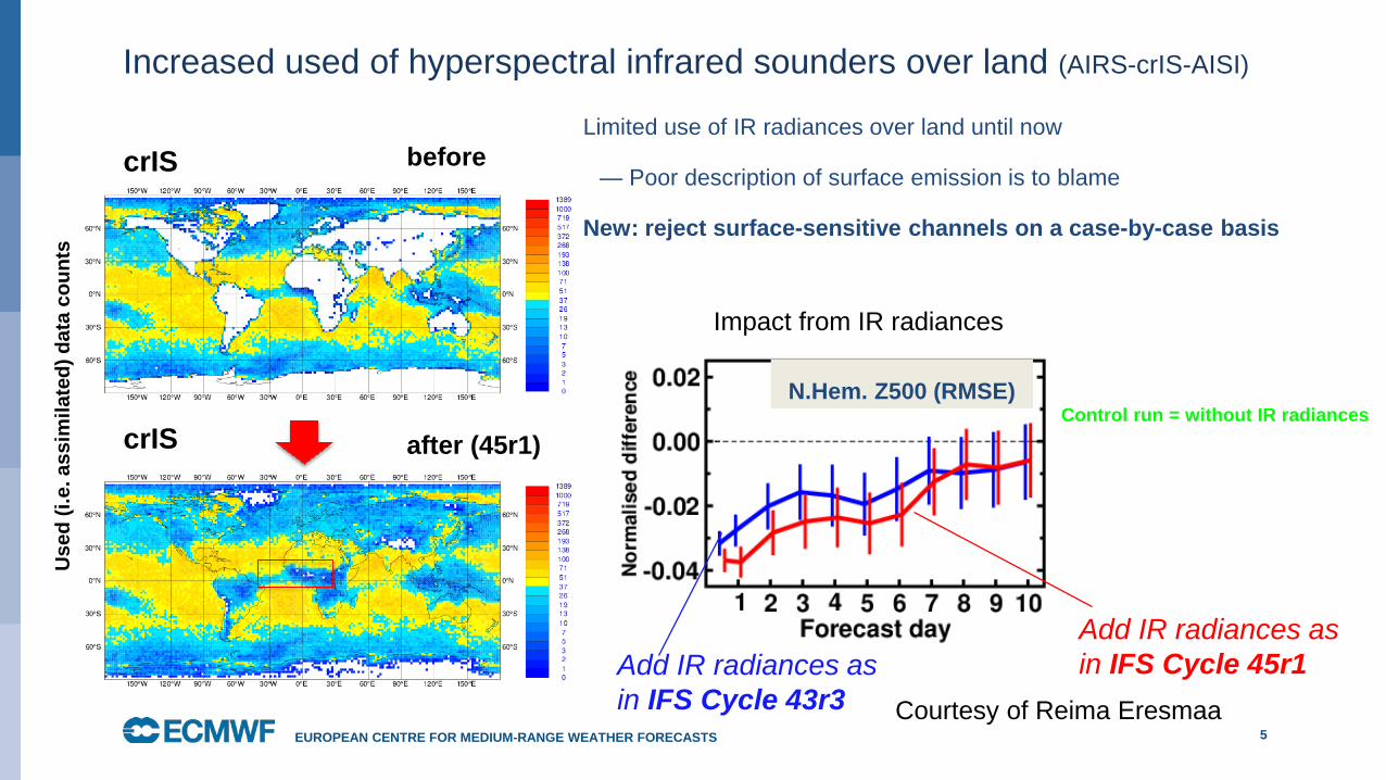
Increased used of hyperspectral infrared sounders over land (AIRS-crIS-AISI)
5EUROPEAN CENTRE FOR MEDIUM-RANGE WEATHER FORECASTS
crIS before
after (45r1)crIS
Limited use of IR radiances over land until now
— Poor description of surface emission is to blame
New: reject surface-sensitive channels on a case-by-case basis
Impact from IR radiances
Add IR radiances as in IFS Cycle 45r1Add IR radiances as
in IFS Cycle 43r3
N.Hem. Z500 (RMSE)Control run = without IR radiances
Courtesy of Reima Eresmaa
Use
d (i.
e. a
ssim
ilate
d) d
ata
coun
ts

Score Card: 45r1 versus Operations
6EUROPEAN CENTRE FOR MEDIUM-RANGE WEATHER FORECASTS
Verification against own analysis Region: TropicsNDJF (2016-17) JJAS (217) Score: RMSE
Temperature
Wind
Rel. Humidity
pressure levels
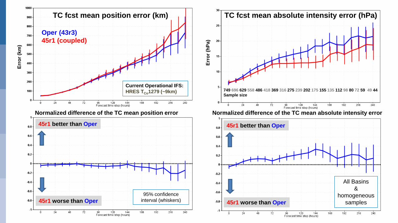
TC fcst mean position error (km) TC fcst mean absolute intensity error (hPa)
Normalized difference of the TC mean absolute intensity error Normalized difference of the TC mean position error
Oper (43r3)45r1 (coupled)
45r1 better than Oper
45r1 worse than Oper
45r1 better than Oper
45r1 worse than Oper
All Basins &
homogeneous samples
95% confidence interval (whiskers)
Current Operational IFS:HRES TCo1279 (~9km) 749 696 629 558 486 418 369 316 275 239 202 175 155 135 112 98 80 72 59 49 44
Sample size
Erro
r (km
)
Erro
r (hP
a)
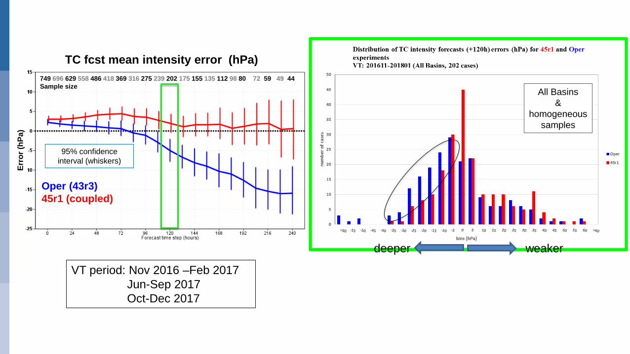
TC fcst mean intensity error (hPa)
Oper (43r3)45r1 (coupled)
All Basins &
homogeneous samples
749 696 629 558 486 418 369 316 275 239 202 175 155 135 112 98 80 72 59 49 44Sample size
VT period: Nov 2016 –Feb 2017 Jun-Sep 2017 Oct-Dec 2017
deeper weaker
Erro
r (hP
a)
95% confidence interval (whiskers)

Ensemble spread & mean error position (Inflation of TC-SVs relative to Extra-Tropical-SVs)
9
time step (hours)
Comparison of different ENS configurationsVT: 20160603-20160830 (every other day)
A reduction of the amplitude of SV in tropics (consistent with extra-tropics SVs) improves spread-mean error relationshipTo be implemented in cycle 45r1
2016 2017
D+5
D+3
Courtesy of Simon Lang

10
Resolution matters: current operational ENS (18km)
X IRMA BT positionsBT min central pressure
Strike probability plume next 10 days
Max wind speed (kt)Meteogram
Min surface pressureMeteogram
hPa
Prob (%) of each TC category

11
Resolution matters: the (far) future 5km ENS!!
X IRMA BT positionsBT min central pressure
NOT 45r1!
Strike probability plume next 10 days
Max wind speed (kt)Meteogram
Min surface pressureMeteogram
hPa
Prob (%) of each TC category
CTRL
CTRL
CTRL

New Product (45r1 this Summer)Lightning Flashes density
• Tropical Cyclone CEBILE
• Run started 27@12 HRES (~9km)
• Cloudy Brightness Temperature (cyan+white background)
• Surface pressure (contours every 4 hPa)
• Avg total lightning density (flashes km-2day-1 ; cell shading)
• t+53h VT: 29 January 18UTC
12EUROPEAN CENTRE FOR MEDIUM-RANGE WEATHER FORECASTS

On going work ….ASCAT-A & -B winds assimilation
13EUROPEAN CENTRE FOR MEDIUM-RANGE WEATHER FORECASTS
Operational configuration:• Sea-ice/speed > 35m/s Rejected• Thinned & one out of four is assimilated
(~100km) • Background check/VarQC• Sigma=1.5 m/s both wind components• 2 solutions provided: most appropriate
solution dynamically determined by comparison with background model winds
Legend:BT position of KILOmodel wind speed (shades)scatterometer winds (used) arrowsmodel mslp (contours)
CTRLVarQC/Thin=4/ObsErr=1.5m/s
HUBER NORM & Thin=2 & Obserr=0.5 TC KILO VT: 2015090812Model cycle 41r1 T1279 (~16km)
Courtesy of Giovanna Chiara
Observation weight after applying the VarQC
m/s

Seasonal Forecast SEAS5• SEAS5 was successfully implemented in operations on 5.11.2017
• The configuration of the IFS used in SEAS5 is almost identical to that used in ENS
• SEAS5 meteorological impact:
• substantial improvements in SST bias in the tropical Pacific, with consequent improvements in ENSO forecast skill.
14EUROPEAN CENTRE FOR MEDIUM-RANGE WEATHER FORECASTS
Newsletter article: ECMWF’s new long-range forecasting system SEAS5. doi:10.21957/tsb6n1
Summary• Small reduction of position errors at D+3 & D+5 last year compared with the previous year
• On average the HRES (~9km) TC forecasts are too intense at D+3 (& onwards)
• Significant improvement of TC intensity forecast errors when the HRES (~9km) is coupled with the ocean model. This configuration (45r1) should be in operations by this summer.
• Last year, on average, the TC ENS spread (position) on was too large (compared with the ENS mean error). Reduced amplitude of Singular Vectors initial perturbations seems to improve the spread-mean error relationship of the ENS and is expected to enter cycle 45r1
• Ongoing work to improve the scatterometer winds assimilation in particular around TCs.
• Seasonal Forecast System 5 (SEAS5) was successfully implemented last November.
15EUROPEAN CENTRE FOR MEDIUM-RANGE WEATHER FORECASTS
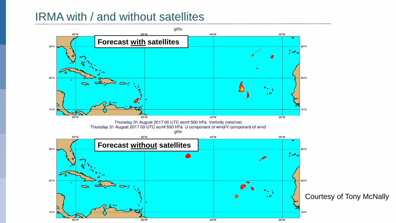
Forecast with satellites
Forecast without satellites
IRMA with / and without satellites
Courtesy of Tony McNally


![Lecture 11 Supplementary Slides - Earthdbj/PHY2506/PHY2506_Lecture1… · Supplementary Slides [ECMWF Lecture Notes, 2003] [From ECMWF Lecture Notes by E. Holm, 2003] [ECMWF Lecture](https://img.dokumen.tips/doc/110x75/605f6a75ac25324c0e370be1/lecture-11-supplementary-slides-dbjphy2506phy2506lecture1-supplementary-slides.jpg)