Embed Size (px)
Citation preview
World Meteorological OrganizationEXECUTIVE COUNCILSixty-Ninth SessionGeneva, 10 to 17 May 2017
EC-69/INF. 5.1(5)Submitted by:
Secretary-General3.IV.2017
This EC-69/INF. 5.1(5) refers to EC-69/Doc. 5.1(1)
WMO INTEGRATED GLOBAL OBSERVING SYSTEM (WIGOS)
Education and Outreach Strategy for Buoy Vandalism
Ocean data buoys collect in situ oceanographic and meteorological data that are critical to a wide user community of government, academic, industry, and public stakeholders. These observations are used in multiple applications including strengthening the quality and accuracy of severe and routine weather forecasting, improved coastal ocean circulation models, environmental and ecosystem monitoring and research, tsunami warning capability, and commercial and recreational marine transportation and fishing. Data buoy vandalism refers to the intentional interference with, damage to, or theft of observing platforms by human action.
Decision 49 at EC-68 requested JCOMM to revisit the issue of buoy vandalism and, in doing so, to assist in designing a regionally relevant education and outreach strategy that will reinforce the joint efforts of WMO and IOC to be tsunami- and weather-ready, which is consistent with the WMO mandate under the Sendai Framework for Disaster Risk Reduction 2015-2030.
Accordingly the Working Group on Data Buoy Vandalism of the Data Buoy Cooperation Panel (DBCP), working in collaboration with the IOC Working Group on Tsunamis and Other Hazards Related to Sea Level Warning and Mitigation Systems (TOWS-WG), has been working on a draft Outreach Strategy to Reduce Damage to Ocean Data Buoys From Vandalism or Interference (see Annex).
The purpose of this strategy is to create a framework that will guide the development of outreach and education resources to raise public awareness of the critical value of the services provided by ocean observation networks and warning systems, and of the related disaster risk reduction benefits.
__________
Annex: 1
EC-69/INF. 5.1(5), p. 2
ANNEX
DRAFT
Outreach Strategy to Reduce Damage to Ocean Data Buoys From Vandalism or Interference
March 2017

EC-69/INF. 5.1(5), p. 3
PrefaceOn 7 June 2016, the Intergovernmental Oceanographic Commission (IOC) and the World Meteorological Organization (WMO) both requested development of a regionally relevant education and outreach strategy in order to substantially reduce damage through vandalism or interference with ocean buoys. The IOC and WMO, working through the Data Buoy Cooperation Panel (DBCP) and the IOC Working Group on Tsunamis and Other Hazards Related to Sea-Level Warning and Mitigation Systems (TOWS-WG), should develop a regionally relevant- awareness strategy composed of both education and outreach elements for discussion at the May 2017 WMO Executive Council and June 2017 IOC Assembly that could be jointly implemented by IOC, WMO, the Food and Agriculture Organization of the United Nations (FAO), regional fishery management organizations (RFMOs), Member States, the commercial fisheries sector and other relevant organizations, in order to avert damage to ocean data buoys.
Table of Contents1. Executive Summary2. Introduction 3. Purpose of the Strategy4. Current Education and Outreach Efforts 5. Strategy Goals and Objectives6. Next Steps
1. Executive SummaryOcean data buoys collect in situ oceanographic and meteorological data that are critical to
a wide user community of government, academic, industry, and public stakeholders. These observations are used in multiple applications including strengthening the quality and accuracy of severe and routine weather forecasting, improved coastal ocean circulation models, environmental and ecosystem monitoring and research, tsunami warning capability, and commercial and recreational marine transportation and fishing. Data buoy vandalism refers to the intentional interference with, damage to, or theft of observing platforms by human action. The purpose of this strategy is to create a framework that will guide the development of outreach and education resources to raise public awareness of the critical value of the services provided by ocean observation networks and warning systems, and of the related disaster risk reduction benefits.
2. IntroductionOcean data buoys (Figure 1) collect in situ oceanographic and meteorological data that are
critical to a wide user community of government, academic, industry, and public stakeholders. These observations are used in multiple applications including strengthening the quality and accuracy of severe and routine weather forecasting, improved coastal ocean circulation models, environmental and ecosystem monitoring and research, tsunami warning capability, and commercial and recreational marine transportation and fishing. Ocean observations and the improved knowledge they provide, together with socioeconomic data describing the human dimension in the global environment, can help solve problems, address and mitigate risks, and deliver skillful forecasts of the future behavior of Earth systems. Sustaining the network that supports these observations over the long term is of critical importance to the user community and global society.
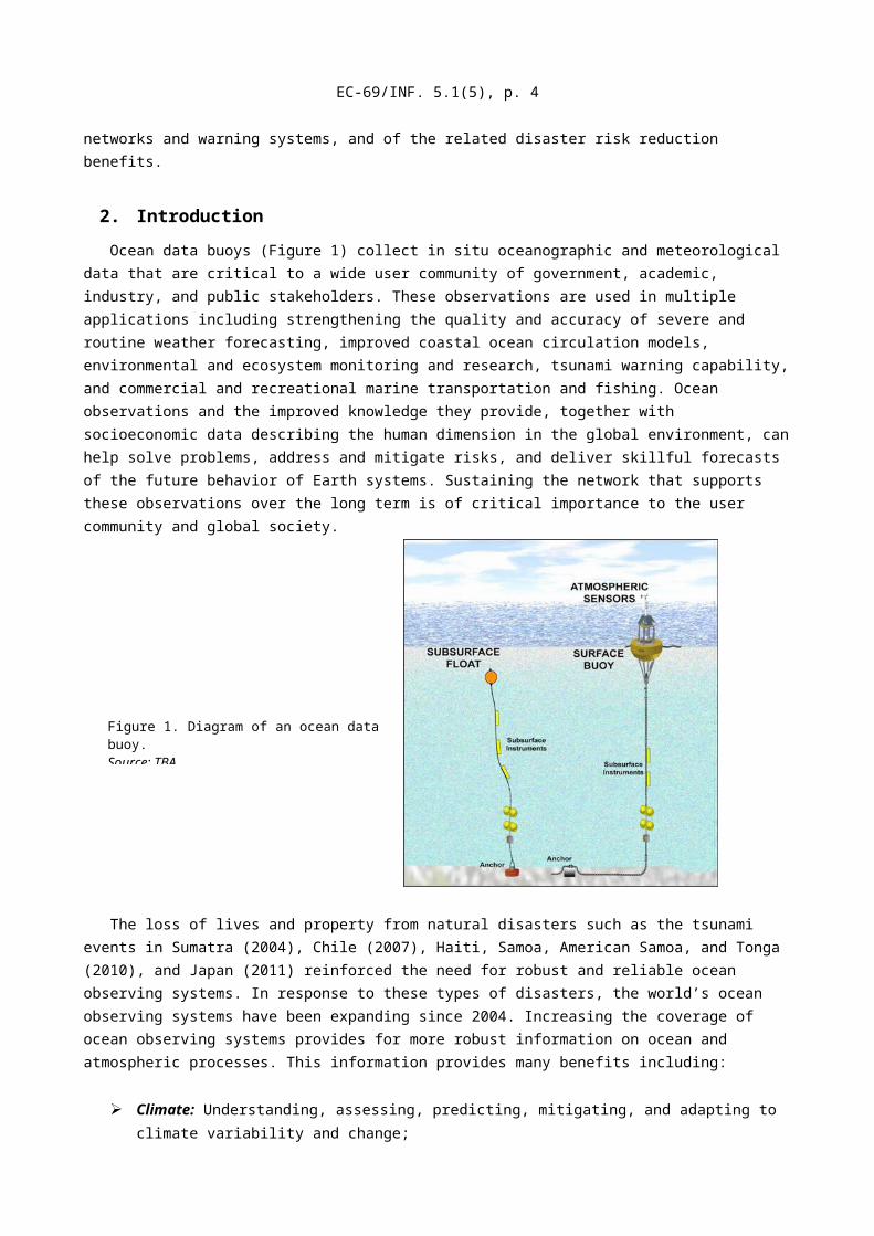
Figure 1. Diagram of an ocean data buoy.Source: TBA
EC-69/INF. 5.1(5), p. 4
The loss of lives and property from natural disasters such as the tsunami events in Sumatra (2004), Chile (2007), Haiti, Samoa, American Samoa, and Tonga (2010), and Japan (2011) reinforced the need for robust and reliable ocean observing systems. In response to these types of disasters, the world’s ocean observing systems have been expanding since 2004. Increasing the coverage of ocean observing systems provides for more robust information on ocean and atmospheric processes. This information provides many benefits including:
➢ Climate: Understanding, assessing, predicting, mitigating, and adapting to climate variability and change;
➢ Coastal and Marine Hazards and Disasters: Reducing loss of life, property, and ecosystem damage from natural and human-induced disasters;
➢ Ocean and Coastal Energy and Mineral Resources: Improving the identification and management of energy and mineral resources;
➢ Human Health: Understanding environmental factors affecting human health and well-being;
➢ Ocean and Coastal Resources and Ecosystems: Understanding and protecting ocean and coastal populations and resources, including fisheries, aquaculture, and marine ecosystems;
➢ Marine Transportation: Improving the safety and efficiency of all forms of marine transportation;
➢ Water Resources: Improving water-resource management through better understanding and monitoring of the water cycle;
➢ Coastal and Marine Weather: Improving weather information, forecasting, and warnings;
➢ Reference Measurements: Improving reference measurements and the fundamental measurement systems and standards supporting them.
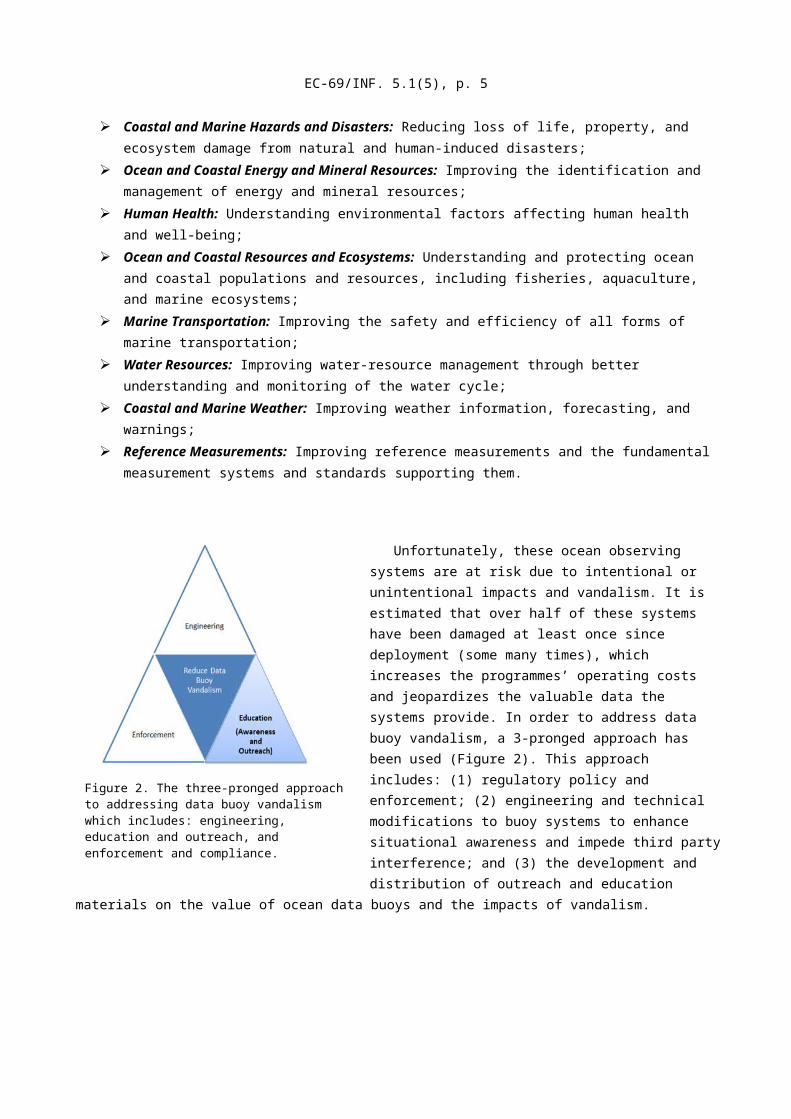
Figure 2. The three-pronged approach to addressing data buoy vandalism which includes: engineering, education and outreach, and enforcement and compliance.
EC-69/INF. 5.1(5), p. 5
Unfortunately, these ocean observing systems are at risk due to intentional or unintentional impacts and vandalism. It is estimated that over half of these systems have been damaged at least once since deployment (some many times), which increases the programmes’ operating costs and jeopardizes the valuable data the systems provide. In order to address data buoy vandalism, a 3-pronged approach has been used (Figure 2). This approach includes: (1) regulatory policy and enforcement; (2) engineering and technical modifications to buoy systems to enhance situational awareness and impede third party interference; and (3) the development and distribution of outreach and education materials on the value of ocean data buoys and the impacts of vandalism.
2.1 Data Buoy Vandalism DefinedData buoy vandalism refers to the intentional interference with, damage to, or theft of
observing platforms by human action. Data buoy vandalism has many forms, including:
● Fouling of mooring lines or damage to underwater cables or sensors from fishing lines or nets;
● Using the buoy as a temporary anchor which can overstress mooring lines and damage the buoy superstructure;
● Deliberately dragging the buoy from its moored location;
● Cutting mooring lines or cables; and/or● Removing physical infrastructure, cables,
or sensors, or other hardware.
Fishing activities are the primary cause of damage to data buoys because the buoys act as fish aggregating devices (FADs) which fishing vessels exploit in pursuit of fish. This increases the incidence of direct contact between the buoys and fishing vessels. There are also rare incidences of damage from unintentional impacts such as when a ship inadvertently collides with a buoy.
There is direct and indirect proof of intentional buoy vandalism. Physical examination of recovered buoys provides evidence of structural damage, fishing gear entanglement, theft of equipment, mooring and cable cuts, and vessel mooring (as exhibited by remnants of tow or attachment lines). In many cases photographic evidence taken from the buoy has confirmed vandalism of the buoy. In other cases, especially when the buoy goes adrift or is lost, there is evidence of abnormal mooring stress, stretching or anchor displacement, or patterns of station

EC-69/INF. 5.1(5), p. 6
data stream failure. Lastly, some stolen buoys have been tracked by their GPS location reports as they are transported across oceans - presumably on the deck of the vandalizing vessel.
2.2 Global Problem/Regional Impacts Buoy vandalism has been a problem since the establishment of substantial observing
networks in the late 1980s. The issue has garnered international attention because many platforms such as the tropical Pacific, Eastern tropical Indian Ocean, and equatorial Atlantic Ocean are internationally supported.
Incidences of data buoy vandalism are apparent in both open ocean and coastal networks. However, only a few highly-impacted networks have consolidated records of vandalism events including the tropical moored buoy arrays (TAO/TRITON, PIRATA, and RAMA), the tsunameter networks supporting the tsunami warning systems in the Indian and Pacific Oceans, and the tsunameter networks in the Caribbean and Western Atlantic.
The TAO/TRITON array is a major component of the El Niño/Southern Oscillation (ENSO) Observing System, the Global Climate Observing System (GCOS) and the Global Ocean Observing System (GOOS) located in the eastern tropical Pacific Ocean. The array provides data for coastal weather information, forecasting the ENSO, and the assessment and advance warning of tsunamis. It also has the longest experience with and records of vandalism, which are significant in both operational cost and the loss of scientific data. As an example, estimates of vandalism costs can be about US$1 million annually for equipment restoration- not including costs of lost data and other indirect costs. For the period of January 2013-May 2016, there were 66 confirmed vandalism events involving TAO buoys. In some cases, newly deployed TAO buoys have been lost within days – or even hours – following their deployment.
The tsunameter networks in the Indian Ocean also have a consistent multi-national record of vandalism events. India’s National Institute of Ocean Technology (NIOT) has reported serious losses through vandalism to their moored buoys in the Arabian Sea and Bay of Bengal. From 2006-2010 there were 31 vandalism events, which has resulted in some sites being abandoned as locations for buoy deployment because of the high frequency of damage resulting from vandalism. Using conservative assumptions, the total direct cost of Indian Ocean Tsunami Warning System vandalism between 2006 and 2010 is estimated to be around $110,000 per event.
These major tropical moored buoy arrays and expanded tsunameter networks are key components of the Global Ocean Observing System (GOOS) and the internationally networked marine observations coordinated by the Joint Technical Commission for Oceanography and Marine Meteorology (JCOMM). These mechanisms provide for international coordination of oceanographic and marine meteorological observing, data management, and services. For the most part, these networks are placed outside Exclusive Economic Zones on the high seas; they are more heavily exposed to vandalism, and require responses at both national and international levels. Vandalism erodes a system’s cost-benefit proposition. The substantial costs of upgrading equipment to deter vandalism and restoring vandalized stations adds to the costs of establishing and sustaining networks. At the same time, unless networks are fully resilient to equipment outages, the consequential data losses and the degradation of derived services reduce the societal benefits provided to communities from data buoys.

EC-69/INF. 5.1(5), p. 7
3. Purpose of the StrategyThe purpose of this strategy is to create a framework that will guide the development of
outreach and education resources to raise public awareness of the critical value of the services provided by ocean observation networks and warning systems, and of the related disaster risk-reduction benefits. It will help promote education and outreach, especially to recreational, artisanal, and commercial fishers. It will also broaden support of community stakeholders, and enable proactive engagement at regional and local scales through the development of new partnerships to share lessons learned and generate new ideas for addressing vandalism issues.
3.1 Key Regionally- Relevant Stakeholder Groups
Multiple stakeholders have an interest in reducing intentional and incidental impacts to ocean data buoys. These stakeholders include national and local governments, intergovernmental organizations (e.g., IOC, WMO), communities, emergency managers, ocean industry sectors (e.g., fishing and navigation), and scientists. In order to effectively address data buoy vandalism, more stakeholders, willing to serve as buoy advocates, are needed from the commercial fishing and shipping sectors, nongovernmental organizations, local communities, educators, and emergency managers. This strategy is the first step in identifying and engaging those stakeholders to develop education and outreach materials to increase sector and public awareness of buoy vandalism along with the social benefits enabled by sustained networks of ocean observations.
3.2 Timeline for StrategyThe DBCP will use this strategy to guide its efforts to address vandalism for the next five
years (2018-2023)1. The DBCP Task Team on Buoy Vandalism will provide an annual report during the DBCP annual session to include updates and/or recommendations identified at the IOC Assembly and WMO Executive Council meetings. Additionally, outreach and education recommendations will be submitted to the IOC Working Group on Tsunamis and Other Hazards Related to Sea-Level Warning and Mitigation Systems (TOWS-WG), the Food and Agriculture Organization of the United Nations (FAO), Regional Fishery Management Organizations, Member States, the commercial fisheries sector and other relevant stakeholder organizations as identified.
4. Current Education and Outreach EffortsNumerous local, national and international efforts have been made to educate and inform
people, in particular the fishing community, about the negative consequences of data buoy losses for research; weather, climate and ocean forecasting; and tsunami warnings. These observing losses have direct impact on loss of human life and property. Examples include:
The TAO and TRITON Project Offices have issued leaflets in several languages to fishing organizations and fishing boats, and have produced educational materials for local dissemination or promulgation via the Internet;
The DBCP has produced a leaflet on the value of ocean data buoys, translated in multiple languages, for circulation to fishermen and mariners. The leaflet provides advice with respect to interference with data buoys. Its content has been promulgated
1 Upon adoption by the IOC and WMO.
EC-69/INF. 5.1(5), p. 8
in full or in part by a number of national agencies, by port authorities, and by the International Hydrographic Organization;
The DBCP also developed technical documents to describe and document data buoy vandalism issues and presented findings at various ocean observation technical and intergovernmental meetings;
The German-led GITEWS project was proactive in coastal community education in Indonesia during the deployment of its tsunameter network, including distributing shirts with GITEWS tsunami buoy images to promote their recognition;
The Jakarta Tsunami Information Centre in Indonesia has produced community education materials including a poster on tsunami buoys;
India has mounted public information campaigns for coastal communities, using public television broadcasts in local languages across a number of coastal states;
The United States has actively engaged with regional fishing management bodies, such as the Inter-American Tropical Tuna Commission and the Western and Central Pacific Fisheries Commission, to inform them of vandalism issues, and to promote the adoption conservation and management measures that would protect marine observation platforms;
Some ocean platforms carry signage in multiple languages. This is in addition to prominent graphical signage, such as the tsunami warning (wave) symbol;
RFMOs including the Indian Ocean Tuna Commission, Inter-American Tropical Tuna Commission, and Western and Central Pacific Fisheries Commission have adopted resolutions (conservation and management measures) to protect moored ocean observing systems, which promote regional and local awareness of the issue.
These efforts are ongoing, but have met only limited success. While these efforts help to draw awareness to the impacts of data buoy vandalism, they are not adequate to stem the continued, documented vulnerability and loss of essential, multi-purpose ocean observing systems. Rather, these efforts provide the foundation that this strategy will build upon to increase education and outreach efforts.
5. Strategy Goals and Objectives
5.1 Goal I: Develop Regionally and Nationally Relevant Education MaterialsOutcome: A tool kit of regionally-relevant print and web-based resources for targeted stakeholder groups to improve the effectiveness of strategies for reducing the impacts of data buoy vandalism.
Objective: Inventory education and outreach resources to know what types of materials already exist
There are a variety of materials and resources on data buoy vandalism that already exist (Section 4). Therefore, to inform the other activities in this strategy the DBCP will lead an effort to reach out to TOWS, FAO and RFMOs to identify regional, national, and/or local education and outreach materials that already
EC-69/INF. 5.1(5), p. 9
exist. Based on this inventory, the DBCP will lead a gap analysis to determine the specific areas (e.g., format [print, web-based], topic, language) where materials are needed. This will also inform the identification of one or more areas (e.g., geography, language, topic) to conduct a needs analysis with key stakeholders.
Objective: Develop guidelines for regional and national organizations to use to develop education materials for protection of ocean data buoys
In order to help regions, nations, or localities to develop education and outreach materials and, as appropriate, provide consistent messages, the DBCP will coordinate with relevant groups to create a set of guidelines that can be used to develop these educational and outreach materials.
Objective: Develop education and outreach materials for stakeholders to use
Based on the inventory or resources, national, regional, or international groups could develop new materials or modify existing materials to meet specific regional or national needs for outreach. This could also include exploring the development of a web-based toolkit on data buoy vandalism that can serve as a central repository of these resources for stakeholders and the public. There could also be included promoting existing resources such as the JCOMMOPS website that shows the location of ocean data buoys around the world. This could also include coordinating on the translation of website pages and select materials.
5.2 Goal II: Enhance national, regional, and global coordination and cooperation to protect data buoys
Outcome: Increase visibility of the data buoy vandalism issue by working with and through national, regional, and global partners.
Objective: Promote and develop new resource and outreach materials for raising awareness of the importance of data buoys and the consequences of vandalism and interference
Encourage national and local governments and their partners to help develop nationally and regionally relevant educational materials and implement outreach programmes. Explore opportunities for promoting, developing and utilizing new resources and outreach materials to raise awareness of data buoy vandalism. This effort could include developing web-based platforms and/or using social media for engaging with stakeholders more directly and regularly. This could also include increasing information sharing (as appropriate) between and among data buoy operators, fishery managers, navigation managers, and other relevant stakeholders.
Objective: Explore opportunities for increasing the ability for rapid response to data buoy incidences

EC-69/INF. 5.1(5), p. 10
Establish relationships between DBCP and key stakeholders to facilitate information exchange and increase awareness and allow for rapid response to data buoy incidences. This could include hosting a series of webinars on data buoy vandalism or participating in capacity-building efforts in target areas to share and promote the resources available. This could also include conducting a pilot study on an alert network for reporting data buoy incidences (observed intentional or unintentional) to allow for rapid response.
5.3 Goal III: Identify key stakeholder groups and enhance education and outreach efforts to those stakeholders
Outcome: Increase awareness of data buoy vandalism issues among key stakeholders through strategic and effective partnerships.
Objective: Identify stakeholder groups that have an interest in data buoy vandalism issues
There are multiple stakeholders that have already engaged in activities to address data buoy vandalism. However, there are opportunities for re-engaging with those partners and/or identifying new partners with a particular focus on regions with the highest incidences of vandalism. This will inform the development of education and outreach materials that are most relevant to the communities in that region.
Objective: Promote cooperation between and among data buoy operators, fishery managers, navigation managers, and other relevant stakeholders
Promote educational and outreach cooperation regionally and internationally which could include developing specific initiatives with governmental or intergovernmental partners (i.e., RFMOs, ICGs, TOWS, International Hydrographic Organization (IHO), International Maritime Organization (IMO) and the International Association of Marine Aids to Navigation and Lighthouse Authorities (IALA)) to help educate stakeholders on the benefits of data buoys and the impact of data buoy vandalism on coastal communities. This could also include increasing the outreach efforts related to existing governmental or intergovernmental initiatives.
Objective: Explore opportunities for engaging with new partners to address data buoy vandalism
There has been a lot of work on raising awareness of data buoy vandalism among data buoy operators and among fishery managers. There could also be opportunities for working with non-governmental partners and/or local community leaders to incorporate new perspectives and to be able to increase engagement with stakeholders and the public.
5.4 Implement education and awareness to build compliance and support enforcement
Outcome: Increase compliance with data buoy resolutions through effective education and awareness activities.

EC-69/INF. 5.1(5), p. 11
Objective: Explore compliance issues with existing data buoy resolutions
Since the IOC, WMO, and RFMOs as well as individual countries have adopted both voluntary and binding measures and recommendations on intergovernmental collaboration, these organizations could consider information sharing to address data buoy vandalism; there could be a discussion and information sharing on the successes and challenges with those various efforts. This could also identify specific gaps or facilitate leveraging ideas or resources among interested stakeholders. Consistent reporting on data buoy incidences would enable collection of more consistent data across regions and nations.
Objective: Explore opportunities for increasing and/or improving data collection on vandalism incidents
There are a variety of ocean activities that that may contribute to data buoy vandalism. More information and consistent information about vandalism incidents could increase awareness and improve understanding of the relationship between data buoy vandalism and other ocean activities. More information could also allow for improved cost estimates to understand the economic impact of vandalism.
6. Next StepsThis education and outreach strategy will guide the continued engagement with regional,
national, and local stakeholders to strengthen their efforts to reduce data buoy vandalism. It will facilitate creation of new educational materials, expanded national and international collaboration, innovative stakeholder partnerships and information sharing to support compliance. It will also help to identify needs and gaps in order to increase the effectiveness of these efforts. This strategy enhances the international approach to reduce damage to observing systems through engineering and technological modifications to buoys, regulatory policy and enforcement. The DBCP will continue to lead this effort with the goal of engaging additional and new stakeholders that can also champion efforts to reduce data buoy vandalism. This strategy will be reviewed by JCOMM, subsequently proposed for adoption by the IOC and WMO in 2018, and would be implemented 2018-2023. An annual report will track progress toward implementation during that period.
__________


![343o de Vereadores [Modo de Compatibilidade])€¦ · CF/67 AI 07/69 EC 01/69 EC 04/75 + de 100 mil hab. + de 300 mil + de 200 mil hab. 100% Histórico Constitucional e legal da remuneração](https://img.dokumen.tips/doc/110x75/602aabf1fc472622150b4638/343o-de-vereadores-modo-de-compatibilidade-cf67-ai-0769-ec-0169-ec-0475-.jpg)