Embed Size (px)
Citation preview

Easy Analytics with Big SAR Data
Megan Gallagher
Solutions Engineer, L3Harris Geospatial
L3Harris GeospatialL3HarrisGeospatial.comgeospatialinfo@L3Harris.com303-786-9900
Megan GallagherSolutions [email protected]
www.l3harrisgeospatial.com/Company/Contact-Us

ENVI
AccessibleAccessible when and where you need in enterprise, partner platforms and in the cloud
ArcGIS integrationWorkflows and automated tools to execute ENVI analytics and access results within any ArcGIS environment
Data supportHyperspectral, multispectral, SAR, LiDAR, radar, FMV, panchromatic and more
Automated workflowsChange detection, anomaly detection, viewshed analysis and more
Extensible modulesDeep learning, SAR analytics, feature extraction, DEM extraction, atmospheric correction, photogrammetry and JITC compliant NITF
ENVI image analysis software uses scientifically-proven analytics to deliver expert-level results.

ENVI SARscapeEasily process and analyze SAR data
Easily process and analyze SAR data and generate products like DEMs or surface deformation maps
Built-in workflows and modules simplify processing and can be customized
ENVI integration brings advanced image and SAR processing and analysis together in one package

ENVI SARscape Analytics
Perform common SAR processing applications regardless of skill level
Easily process and analyze SAR data and generate products like DEMs or surface deformation maps
• Flood mapping• DEM extraction• Sentinel download• Sentinel auxiliary file
download• Time series
• Change detection• Displacement map• Ship detection• Persistent scatterers• Image geocoding
ENVI integration brings advanced image and SAR processing and analysis together in one package

SARscape Analytics Toolbox

Persistent Persistent Scatterers Scatterers
Analysis
Image Geocoding
Workflows for SAR Applications
Time Series Time Series Analysis
Ship Detection Ship Detection & &
AIS Tracking
Change DetectionInSARInSAR
DEM Generation
DInSARDInSARDisplacement Displacement
Mapping
Flood Mapping
Sentinel Sentinel Download

SARscape Analytics Toolbox vs. SARscapeSARscape Analytics Toolbox SARscape
• User-friendly • Data input validation• Low user supervision• Thematic output (raster/shape)
• Complete and exhaustive
• 12 all-in-one workflows• Includes world-leading
SARscape algorithms
• 7 Modules• 19 Workflows• > 100 Processing routines• > 75 Tools
• Basic knowledge on SAR system and techniques
• Good knowledge on SAR system and techniques
• SARscape Batch to run stored processing sequences
• IDL script to generate customized procedures
• ENVI Modeler / ENVI Engineto create workflows without coding and run in a server environment
• SARscape Cluster to run CPU-intensive tasks on a series of processing nodes

Supported Sensors
L-Ba
nd
JERS-11992 - 1998
ALOS PALSAR-12006 - 2011
ALOS PALSAR-22014
SAOCOM-12018
NovaSAR-12018 S-
Band
C-Ba
nd
ERS-11991 - 2000
ERS-21995 - 2011
RADARSAT-11995 - 2013
ENVISAT ASAR2002 - 2012
RADARSAT-22007
Sentinel-1A2014
Sentinel-1B2015
RISAT-12012
Gaofen-32016
X-Ba
nd
COSMO-SkyMed2007
TerraSAR-X2007 TanDEM-X
2010
KOMPSAT-52013
ICEYE constellation
PAZ
2018
2018
ASNARO-22018
Capella constellation2020
RCM2019
CSG2019

https://scihub.copernicus.eu/dhus/ https://search.asf.alaska.edu
SENTINEL Auxiliary File Download https://scihub.copernicus.eu/gnss/
SENTINEL Multidownload (ESA SciHub & ASF)

SAR Image Geocoding
Geocoded Sentinel-1 image, Munich, GermanyESRI Basemap: Topographic
Data courtesy
Visualization in ArcGIS Pro
Sentinel-1 IW SLC product, Munich, Germany, with the extents of the separate bursts

• Land use analysis (illegal timber harvesting, crop type analysis,seasonal crop changes)
• Maritime monitoring(ice / oil pollution monitoring)
• Natural disaster monitoring• Target detection
SAR Time Series
Natural disaster monitoringTarget detectionNatural disaster monitoringTarget detectionTarget detectionTarget detection
Sentinel-1 time series, Philippines Coefficient of Variation-Minimum-Gradient composite of all input data
Data courtesy

SAR Flood Mapping • Natural disaster management
(extent of flooded areas, impact on infrastructure)
• Agriculture (irrigated areas mapping)
Sentinel-1 pre- and post-event images, Nebraska, U.S.
Ratio of the pre- and post-event images and filtered flood map on PlanetScope data, © 2019 Planet Labs
Data courtesy

SAR Ship Detection• Civil and military authorities
(search & rescue, collision avoidance,fishing fleet control, maritime security)
Sentinel-1 intensity image, Skagerrak, Denmark,and subset of corresponding AIS data
Map with detected ships, AIS matches (green), no-AIS matches (red), AIS tracks (yellow), and land mask (blue)
ESRI Basemap: OpenStreetMap
Data courtesy
Data provided by
Visualization in ArcGIS Pro
Data courtesy
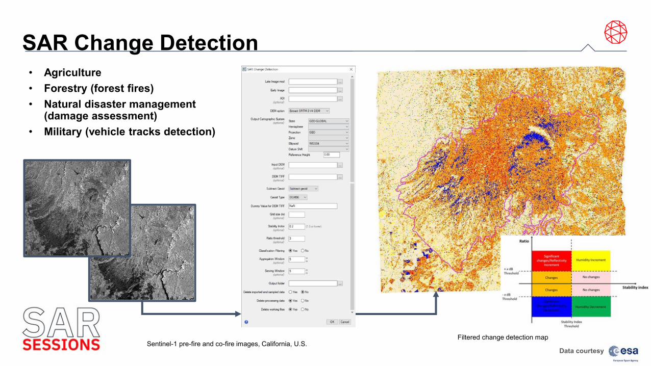
SAR Change Detection• Agriculture• Forestry (forest fires)• Natural disaster management
(damage assessment)• Military (vehicle tracks detection)
Sentinel-1 pre-fire and co-fire images, California, U.S.Filtered change detection map
Data courtesy

SAR Displacement Mapping• Natural disasters
(earthquakes, landslides, volcanoes)• Ground surface deformations
(mine subsidence, collapsing tailing dams)
Data courtesy
Primary and secondary ENVISAR ASAR intensity images, Bam, Iran
Displacement map with Bam transform faultESRI Basemap: Imagery Data courtesy

SAR Persistent Scatterers• Monitoring of civil infrastructures
(buildings, dam monitoring, construction works, pipelines)
• Monitoring of subsidence/uplift(mining, groundwater, landslides)
To be noted:AOIs are limited to 25 km2.A minimum of 20 images is required.
Data courtesy
Data provided bySentinel-1 time series (slant range geometry), Mosul, Iraq Velocity of the displacement
ESRI Basemap: Imagery
Data courtesy

Self-Paced Training

DEM Extraction

Easy Analytics Big Data? Key Benefits:
• Save time by running processes in parallel
• Run processes in the background in ENVI
• Take advantage of beefy machines and modern hardware
• Easily distribute processing to local servers with common data access
• No programming required!
Common data store for distributed processing
Anyone with ENVI 5.6 will be able to access ENVI Server at
no additional cost
ENVI is a client for ENVI Server, meaning we can connect to
machines used for dedicated processing
ENVI Server
ENVI Server

Why should I care about ENVI Server in SARscape?
Save time by running processes in parallel

Operational Processing with SARscape and ENVI ServerSARscape 5.6 supports ENVI Server to run processing remotely or in the background of ENVI• Save time by running processes in parallel• Bulk processing in the background • Take advantage of powerful network resources• Distribute processing to local servers
with common data access• No programming required!
ENVI ENVI Server
Additional Additional ENVI Server
ENVI 5.6 ships with one ENVI Server and SARscape 5.6 with one background process at no additional cost!
Distributed processing needs a common data store
Add additional ENVI Servers to scale up the number of concurrent processes you can run
ENVI ENVI ServerENVI ENVI
ServerServer
ENVI ENVI ENVI Server
ENVI ENVI Server

SARscape Tasks: Library of Functions for SAR Processing Processing

ENVI Modeler: Visual Programming for Remote Sensing
Combines the power of the ENVI API with an intuitive user interface
Batch processing without any knowledge of ENVI programming
Build Workflows that mix SAR and Optical processors seamlessly
Run workflows remotely or in the background with ENVI Server
Generate IDL and Python programs from models, create extensions to ENVI, and export metatasks to ArcGIS
A visual programming tool to create custom task-based workflows in ENVI

ENVI Server: Through SARscape Tasks and ENVI Modeler Automate and batch process SAR data remotely or in the background through ENVI Server, with SARscape Tasks and the ENVI Modeler

ENVI Modeler: Fusion of Optical and SAR Processes• Full support of nodes in non-native technology (e.g. Python, Java, ...).• Workflows can mix SAR and Optical processors seamlessly.Workflows can mix SAR and Optical processors seamlessly.
Optical ChainSentinel-2 L2A data
(before)
Workflows can mix SAR and Optical processors seamlessly.Workflows can mix SAR and Optical processors seamlessly.SAR Chain
any number of Sentinel-1 GRD data
(after)
Fusionof SAR and Optical data
for the final classification process
Create on the desktop‒
Deploy everywhere !

Example: Persistent Scatterer Monitoring of an Open Pit Mine
PSI (Jan2018–May 2020)PSIPSI (Jan(Jan 20182018– MayMay 2020)2020)

Sentinel-2 (06 June & 01 July 2019)
Sentinel-1
2 (06 June & 01 July 2019)
Demo: Monitoring Ground Activities – Coherence Change Detection
Multi Inverse Coherence Change DetectionInverse coherence 1Inverse coherence 2Inverse coherence 3
May 26, 2019 -June 7, 2019
June 7, 2019 -June 19, 2019
June 19, 2019 -July 01, 2019


L3Harris GeospatialL3HarrisGeospatial.comgeospatialinfo@L3Harris.com303-786-9900
Megan GallagherSolutions [email protected]
www.l3harrisgeospatial.com/Company/Contact-Us
Questions?


![EMBEDDED ANALYTICS 2.0: THE NEW B2B COMPETITIVE …€¦ · [Embedded analytics 2.0] makes it easy to understand the trends and analysis of the data. It ’s also easy to use and](https://img.dokumen.tips/doc/110x75/5f41b1ae3e92b0386724b65c/embedded-analytics-20-the-new-b2b-competitive-embedded-analytics-20-makes-it.jpg)