Embed Size (px)
Citation preview
Upper Whitecraigs
December 2012
East Renfrewshire Council
Conservation Area Appraisal
Planning Property and Regeneration

Conservation Area Appraisal
Upper Whitecraigs
December 2012
Director of Environment Andrew J Cahill B.Sc. (Hons)
Planning Contact Number: 0141 577 3001
Email: [email protected]


Upper Whitecraigs Conservation Area Appraisal
Consultation Process
Comments are being sought on this Conservation Area Appraisal.
The document will be available for comments for a period of six weeks commencing on 6th of February 2013.
Conservation Area Appraisals can be viewed online at:
www.eastrenfrewshire.gov.uk/conservation-areas
Your comments can be emailed to us at:
Alternatively you can post your comments to our free post address:
Development Plans Team FREEPOST RLUH-EUAU-KGTC East Renfrewshire Council Eastwood Park, Rouken Glen Road GIFFNOCK East Renfrewshire G46 6UG
Copies of the Conservation Area Appraisal are available to view at East Renfrewshire Council offices, the Council’s website and at all local libraries.
What Happens Next?
Following the six weeks of public consultation, consideration will be given to all comments received. A report will then be produced summarising all comments received, the Council’s response to each representation, and any suggested revisions. This will be made available to the public on the Council’s website, together with the finalised document. Once adopted, the Conservation Area Appraisal will be used as guidance in the determination of planning applications.
Further Information
If you have any questions regarding the Conservation Area Appraisal or the consultation process, please contact Julie Nicol at East Renfrewshire Council on 0141 577 3876.

Upper Whitecraigs Conservation Area Appraisal

Upper Whitecraigs Conservation Area Appraisal
Contents
1. INTRODUCTION, PURPOSE AND JUSTIFICATION ................................................. 1
1.1. Date and Reason for Designation................................................................ 1
1.2. What Does Conservation Area Status Mean? ................................................ 1
1.3. Purpose of Appraisal ................................................................................. 1
1.4. Planning Policy Context ............................................................................. 2
2. LOCATION AND LANDSCAPE ............................................................................ 3
2.1. Regional Context and Relationship to Surroundings ....................................... 3
2.2. Topography and Geology .......................................................................... 3
3. HISTORICAL DEVELOPMENT ............................................................................ 5
3.1. Changes in Upper Whitecraigs.................................................................... 5
4. CHARACTER AND APPEARANCE ........................................................................ 9
4.1. Spatial Analysis ....................................................................................... 9
4.2. Buildings and Townscape ........................................................................ 13
4.3. Scheduled Monuments ............................................................................ 14
4.4. Key Listed and Unlisted Buildings ............................................................. 14
4.5. Unlisted Positive Buildings ....................................................................... 15
4.6. Materials and Local Details ...................................................................... 17
4.7. Character Areas ..................................................................................... 19
5. KEY FEATURES ............................................................................................ 20
5.1. Assessment of Significance ...................................................................... 20
5.2. Character Area 1: Craignethan Road ......................................................... 20
5.3. Character Area 2: Roddinghead Road ........................................................ 21
5.4. Character Area 3: Broom Estate ............................................................... 21
5.5. Character Area 4: Neidpath Road East ...................................................... 21
6. NEGATIVE FACTORS ..................................................................................... 22
6.1. Identified Negative Factors ...................................................................... 22
6.2. Character Area 1: Craignethan Road ......................................................... 22
6.3. Character Area 2: Roddinghead Road ........................................................ 22
6.4. Character Area 3: Broom Estate ............................................................... 22
6.5. Character Area 4: Neidpath Road East ...................................................... 22
7. SENSITIVITY ANALYSIS ................................................................................ 26
7.1. Demolition ............................................................................................ 26
7.2. Loss of Original Architectural Details and Building Materials .......................... 26
7.3. Pressure for New Development ................................................................ 26
7.4. Quality of New Development, Alterations and Extensions ............................. 26
7.5. Buildings at Risk .................................................................................... 26

Upper Whitecraigs Conservation Area Appraisal
7.6. Protection of Trees and Hedgerows ........................................................... 26
8. FUTURE ACTION PLAN .................................................................................. 27
8.1. Actions ................................................................................................. 27
8.2. The Control of Unlisted Buildings .............................................................. 27
8.3. Quality of New Developments, Building Alterations and Extensions ................ 28
8.4. Public Realm Enhancement ...................................................................... 28
8.5. Landscape Management .......................................................................... 28
9. MONITORING .............................................................................................. 29
9.1. Review ................................................................................................. 29
10. CONTACT DETAILS .................................................................................... 30
GLOSSARY ........................................................................................................ 31
APPENDIX ......................................................................................................... 33
Acknowledgements
Recognition is given to the Scottish Civic Trust who prepared the original document upon which this review is based.

1
Chapter: IN
TRODUCTION, PURPOSE AND JUSTIFICATION
Upper Whitecraigs Conservation Area Appraisal
1. INTRODUCTION, PURPOSE AND JUSTIFICATION
1.1. Date and Reason for Designation 1.1.1. The East Renfrewshire area has 5 conservation areas. The Upper Whitecraigs
Conservation Area was designated in April 2005 in recognition of the variety and abundance of good quality 19th and early 20th century architecture
1.2. What Does Conservation Area Status Mean? 1.2.1. The Planning (Listed Buildings and Conservation Areas) (Scotland) Act 1997
states that conservation areas “are areas of special architectural or historic interest, the character or appearance of which it is desirable to preserve or enhance.” Local authorities have a statutory duty to identify and designate such areas.
1.2.2. Under the Town and Country Planning (General Permitted Development) (Scotland) Amendment Order 2011, the majority of permitted development rights within conservation areas have been removed.
1.2.3. In essence, this means that most development that affects the external appearance of a property within conservation areas require the consent of the Council before any works can be undertaken. This includes amongst others, demolition, house extensions and outbuildings, roof alterations, stone cleaning or painting of the exterior, installation of satellites and micro-renewables, as well as formation of hard surfaces including driveways.
1.2.4. The removal of permitted development rights can play a particularly important role in protecting features that are characteristic of the area (e.g. doors and windows) and in preventing the incremental erosion of character and appearance by small-scale alterations that in themselves may not be significant but collectively and over time might have a negative impact.
1.2.5. The Council also requires to be notified of any works proposed to trees in conservation areas.
1.3. Purpose of Appraisal 1.3.1. The Council has a duty to prepare proposals for the preservation and
enhancement of conservations areas, although there is no imposed timeframe for doing so. The Act also indicates that the Council must pay special attention to the desirability of preserving or enhancing the character or appearance of the designated area.
1.3.2. In response to these statutory requirements, this appraisal defines and records the special architectural and historic interest of the conservation area.
1.3.3. Furthermore it identifies, in Chapter 8, opportunities for enhancement and protection of the conservation area which provides the context for the preparation of a future action plan.

2
Chapter: IN
TRODUCTION, PURPOSE AND JUSTIFICATION
Upper Whitecraigs Conservation Area Appraisal
1.3.4. The appraisal conforms to Scottish Government guidance as set out in Planning Advice Note 71: Conservation Area Management (December 2004). Additional government guidance regarding the management of historic buildings and conservation areas is set out within Scottish Planning Policy and in Historic Scotland’s Scottish Historic Environment Policy (December 2011).
1.3.5. This document therefore seeks to:
1. define the special interest of the conservation area and identify the issues which threaten the special qualities of the conservation area;
2. suggest guidelines to prevent harm and achieve enhancement; 3. provide East Renfrewshire Council with a valuable tool with which to
inform its planning practice and policies for the area.
‘Preserve or Enhance’ 1.3.6. It should be noted that the phrase ‘preserve or enhance’ has been the subject
of debate over the years, and is one of the few areas of historic environment legislation that has been subjected to legal tests. A landmark case, now known as the Steinberg principle (from Steinberg and another v. Secretary of State for Environment, 1988) together with further refinements of other cases (notably South Lakeland District Council v Secretary of State for the Environment, 1992) defined the statutory objective of preserving and enhancing as one that achieved by positive contribution to preserve or by development which leaves the character or appearance unharmed. This is now largely considered to be the principle of ‘do no harm’.
1.3.7. It should also be noted that the assessment of ‘preserve or enhance’ for planning purposes needs to be made against the character of the whole of the conservation area, unless it can be shown that there are areas of distinct character within the whole. In this instance, the assessment is made in the context of these character zones.
1.4. Planning Policy Context 1.4.1. This appraisal provides background information and guidance on how
applications for development within the conservation area will be assessed. It should be read in conjunction with the wider Development Plan policy framework produced by East Renfrewshire Council.
1.4.2. The Development Plan for East Renfrewshire comprises of the Glasgow and the Clyde Valley Strategic Development Plan (2012) and the East Renfrewshire Local Plan (Adopted February 2011).
1.4.3. The East Renfrewshire Local Plan sets out the detailed framework for the area’s land use policies and identifies where different types of development should be located. In addition it also sets out the criteria by which all planning applications are considered. In terms of the built heritage, the following sections are particularly relevant:

3
Chapter: LOCATION AND LANDSCAPE
Upper Whitecraigs Conservation Area Appraisal
Chapter 3: Protecting Local Environmental Features Policy E4: Conservation of the Built Heritage Chapter 11: Development Management Policies Policy DM1: Detailed Guidance for all Development Policy DM2: Alterations to and Redevelopment of Existing Dwelling houses
1.4.4. The above policies are outlined in more detail in the Appendix at the back of this document.
2. LOCATION AND LANDSCAPE
2.1. Regional Context and Relationship to Surroundings 2.1.1. The Upper Whitecraigs Conservation Area lies in the commuter suburbs in
East Renfrewshire, 10km south of Glasgow and 7km west of East Kilbride. The conservation area encompasses mainly 19th and 20th century development and is bounded to the west by the A77 (Ayr Road) which is a major route north-south. The area is situated close to the urban edge and as such maintains a link with the landscape. The green belt designation covers Rouken Glen Park to the north west, Whitecraigs golf course and Cathcart Castle golf course to the west and north east respectively. To the south is further housing development at Newton Mearns before giving way to more green belt.
2.1.2. The conservation area is not self-contained, having few services, shops or amenities. The area primarily relies on Newton Mearns and Giffnock for these services and is well placed for transport links to the surrounding area. The Ayr Road (A77) passes immediately to the west of the conservation area, forming its western boundary. The nearest train station is Whitecraigs located to the north of the conservation area.
2.2. Topography and Geology 2.2.1. The conservation area is situated on the plateau which encircles the Glasgow
area, being at the edge of the uplands which define the basin in which the city has developed. East Renfrewshire is underlain by mainly sedimentary rocks of the Strathclyde and Clackmannan Groups of early to mid Carboniferous age (354-316 million years). These relatively soft, easily eroded rocks are mainly claystones (‘shales’), sandstones, coal seams and thin, but regionally persistent limestone. Consequently, the landform in the area is generally flat with gentle undulations.
2.2.2. Roddinghead Road sits at the centre of the conservation area with its highest point enclosed by Elphinstone Road, Lethington Road and Methven Road. At its highest point it is 115m above sea level. The surrounding area contains many small burns which wind through the housing developments. A burn running through Cathcart Golf Course forms a natural boundary to the north-east of the conservation area.

4
Chapter: LOCATION AND LANDSCAPE
Upper Whitecraigs Conservation Area Appraisal
2.2.3. Greenbank Gardens are located east of the conservation area and comprise 13 acres of walled garden and woodland walks. The gardens display a fine collection of designs of suburban gardens, fountains, and a specially created garden suitable for disabled gardeners. A shop and tearoom are also available for visitors during the summer and are located within the Georgian house (1764) which was built for one of Glasgow's merchants. Greenbank House and Gardens are managed by the National Trust for Scotland.
Figure 1: Location Plan
Photo 1: Lethington Road
5
Chapter: HISTO
RICAL DEV
ELOPMEN
T
Upper Whitecraigs Conservation Area Appraisal
3. HISTORICAL DEVELOPMENT
3.1. Changes in Upper Whitecraigs 3.1.1. Little is known of the history of this area prior to the 12th century although
the area must have long been the site of human habitation. Cup and ring markings were found on what is known as the ‘Cleuch Stone’ at a site on the Cathcart Castle Golf Course. Cup and ring markings are fairly common in Scotland and there is no accepted theory on the origin of the marks, however Ludovic Maclellan Mann who discovered the Cleuch Stone in 1930 believed that they may record a solar eclipse around 2983 B.C.
3.1.2. A Neolithic Axe c.3000 B.C. was also found in the NE corner of the Netherplace works in Newton Mearns around 1938.
3.1.3. In the 12th century King David I introduced Norman civil and church systems to Scotland. To implement these reforms, English and Norman Lords were appointed to high office. David gave lands in Renfrewshire to Walter Fitzalan who later split up the lands and gave Lordship to Roland de Mearns. David also introduced the Order of the Knights Templar to Scotland c.1150. The Templars were known to have possessed lands in Mearnskirk, Broom and Newton with their mainstay at Capelrig.
3.1.4. One of the main estates in this area is the Broom Estate. The earliest recorded proprietor of Broom is John the 4th Lord Maxwell who held the lands at the end of the 15th century. His ancestor Sir Aymer Maxwell had obtained extensive lands in this area by his marriage to Mary, daughter and heiress of Roland de Mearns. The Castle of Mearns was built by Lord Maxwell under licence from James II in 1449. Broom was significant enough to have been marked on Blaeu’s map of Renfrewshire from 1654.
3.1.5. By 1780 three bleachfields were established in the wider Newton Mearns area at Broom, Netherplace and Wellmeadow. Broom bleachfield was situated on the opposite bank of the Capelrig Burn from Capelrig House. It is marked on John Thomson’s map of Renfrewshire in 1820. It seems to have been unsuccessful due to land disputes over who should receive the feus. Most of the bleaching area lay within the meadow which now makes up part of Whitecraigs Golf Course. The drying house lay on the west bank of the Capelrig Burn opposite the confluence with the Broom Burn.
3.1.6. Mearns was a rural parish in the 19th century with about 80 farms. Employment was generally in farming and cloth processing along with the
Photo 3: Belmont House, formerly Broom House c.1960
Photo 2: Whitecraigs Golf Course with Netherton farm on the right, 1924

6
Chapter: HISTO
RICAL DEV
ELOPMEN
T
Upper Whitecraigs Conservation Area Appraisal
quarries in the area. Broom House to the south of the conservation area was built in 1840 and possibly designed by David Hamilton.
3.1.7. The train station in Giffnock from 1864 meant that those in Mearns could travel further afield to Glasgow for work. Mearns changed as road and rail links improved, making it a highly desirable place to live. The area had seen some small-scale quarrying, medium-sized bleachfields and printfields before 1903, when the Caledonian Railway opened Whitecraigs Station on their line from Glasgow to Patterton and beyond into Ayrshire. This marked the start of the area becoming a commuter suburb. The new Mearns was focussed heavily on Broom. The radiating lanes linking the lesser houses of Broom became the focus of infill development.
3.1.8. The expansion of Glasgow towards the suburbs resulted in a building boom as expanding railway and tramcar services in the 1920s. The first area of housing was mostly on Roddinghead Road and took its name from the Giffnock mansion of Whitecraigs.
3.1.9. Broom House still survives as Belmont House School immediately to the south of the conservation area outside the boundary. The school moved to Broom House in 1933.
3.1.10. On the northern edge of Mearns, parts of the Broom estate began to be offered for feuing, and a number of individually designed houses were built on Roddinghead Road and Lethington Road. In the 1930s bungalows appeared all along the Kilmarnock Road between Newton and Broom.
3.1.11. Most of the land belonging to the Broom Estate was sold to MacTaggart and Mickel in 1932 and to the south of Whitecraigs station development blossomed. This pattern, first on the east of Ayr Road, extended southwards to join up with Mearns Cross in the 1960s, then to the east of Old Mearns Road and later moved into Crookfur, on the west.
3.1.12. The biggest development of this period in Broom was MacTaggart and Mickel’s Broom Estate, a speculative venture heavily advertised as “an experiment in estate development which will silence critics of modern housing schemes” for its efforts to preserve the natural beauty of the original estate while providing prestigious modern housing. "The adoption of modernism does not always bid goodbye to beauty," ran the Glasgow Herald ads for MacTaggart and Mickel's Broom Estate, Newton Mearns in 1935. The proposed flat-roofed homes were never, ultimately, built, but the more conservative white Deco villas that did appear were very much of the period, using smooth cement exterior finishes, rounded corners and metal-framed windows.
Photo 4:Aerial photograph of the Broom Estate, 1949. Broom House can be seen in the centre with surrounding MacTaggart and Mickel housing

7
Chapter: HISTO
RICAL DEV
ELOPMEN
T
Upper Whitecraigs Conservation Area Appraisal
3.1.13. The Whitecraigs area has continued to be a highly desirable place to live. This exclusivity has been increased by the limited availability of land for development. Modern development has generally been on the existing pattern following plot subdivision or the demolition of existing buildings.
Figure 2: Historical Map (Blaeu, 1654)
The approximate area of Upper Whitecraigs Conservation Area is marked in red. Mearns Castle is shown as a significant structure to the south Newton is also shown as a settlement of some importance. A structure associated with the Broom Estate is marked, although the current Broom House was not built until 1840. Rouken (Roucan) is shown to the west of the conservation area, south of Davieland and Mains.
Figure 3: Historical Map (Ainslie, 1821)
Ainslie 1821 By 1821 we can see ‘Broom H.’ marked on the map close to the are we now associate with the Broom Estate. This possibly represents Broom House although the current building was constructed in 1840 and so this must refer to an earlier house. Interestingly Mearns Castle is no longer seen on the map, indicating that is has fallen into ruin.

8
Chapter: HISTO
RICAL DEV
ELOPMEN
T
Upper Whitecraigs Conservation Area Appraisal
Figure 4: Historical Map (Richardson, 1795)
The approximate area of Upper Whitecraigs Conservation Area is marked in red. On this we can see more clearly where the conservation area lies. Fenwick Rd/Ayr Rd is marked as far as Davieland and Mains but does not yet stretch as far south as Broom. A small settlement is marked on Roddinghead Road at the heart of the conservation area as ‘Roddenhead’. The Broom Estate is marked further north than we would expect. Newton is shown as a larger settlement in the area, consistent with Blaeu’s map.
Figure 5: Historical Map (Thomson, 1826)
The approximate area of Upper Whitecraigs Conservation Area is marked in red. Broom House is once again marked, confirming that there was an earlier house associated with the estate. Broom Bleachfields are also indicated, to the west of the conservation area.
Historic maps are reproduced by permission of the Trustees of the National Library of Scotland

9
Chapter: CHARACTER AND APPEA
RANCE
Upper Whitecraigs Conservation Area Appraisal
4. CHARACTER AND APPEARANCE
4.1. Spatial Analysis Activities/Uses
4.1.1. The conservation area is almost entirely residential with a variety of detached and semi-detached homes set in gardens. In addition there is a bowling club, a tennis club, the office of the Eastwood Conservative and Unionist Association and a building housing the local scout headquarters within the conservation area boundary. Street Pattern
4.1.2. The conservation area is a complex layout of wide tree lined streets and narrow lanes which are loosely centred on the high point at Roddinghead Road. Many of the roads run south-eastwards from Ayr Road with further streets providing links between these.
4.1.3. The Ordnance Survey map of 1856 shows us that the earliest roads in the conservation area are Ayr Road – the major road running south from Glasgow - and the roads belonging to the Broom Estate. Sandringham Avenue runs from Ayr Road south to Broom House with Broom Road linking smaller cottages on the estate and Roddinghead Road connecting the estate eastwards to Mearns Road. The gates and lodge of the Broom estate survive at the junction of Ayr Road, Sandringham Avenue and Broom Road.
4.1.4. The road pattern changed very little until 1910 when Craignethan Road, Lethington Road and Methven Road began to develop following the contours around Roddinghead Road. Houses began to be built on these new streets either detached or in pairs and set back from the street in spacious plots. By this time Whitecraigs House c.1898 has been built north of Craignethan Road.
4.1.5. The Ordnance Survey map of 1934 shows us the effect of the 1930s housing boom when housing and newly laid out streets filled in the spaces between existing developments. By this point the conservation area is almost entirely developed with further building work only to come along its southern boundary.
4.1.6. Neidpath Road West is the only cul-de-sac in the conservation area, with access only from Ayr Road, although it is possible given its alignment that it was originally intended to join up with Neidpath Road East and Roddinghead Road.
Photo 5: View down Roddinghead Road Photo 6: Entrance to the Broom estate from Ayr Road
10
Chapter: CHARACTER AND APPEA
RANCE
Upper Whitecraigs Conservation Area Appraisal
Figure 6: OS 1st Edition 1856
Figure 7: OS 2nd Edition 1896
Figure 8: OS 3rd Edition 1910
Figure 9: OS 4th Edition 1934

11
Chapter: CHARACTER AND APPEA
RANCE
Upper Whitecraigs Conservation Area Appraisal
Plot Pattern 4.1.7. The plots are generally similar in size, varying slightly depending on the
relative status of the house concerned, as the majority of the properties are detached and semi-detached homes set in large gardens. The dwellings are set back from the road, typically behind boundary walls. This creates a consistent character in the conservation area. Since the majority of the area was laid out in the 1930s there has been some subdivision of plots to allow for new development and there is concern that if this were to continue it would erode the character of the conservation area. Larger plots are found where the buildings themselves are larger and more prestigious such as Whitecraigs House or where the land is used for recreational activities such as the bowling and tennis clubs. Circulation and Permeability
4.1.8. Ayr Road provides the primary vehicular route through the area creating a sustained level of traffic on the roads leading from Ayr Road into the conservation area. Otherwise, within the conservation area traffic levels are fairly low creating a pleasant pedestrian environment. Further traffic is generated in the Roddinghead Road, Broom Road and Sandringham Avenue area as a result of the school, tennis club and bowling club which are found in this vicinity. This can create issues on the smaller lanes such as Roddinghead Road due to the lack of pavements, however the low speed limit and one-way system are sufficient to retain the peaceful environment. Open Spaces, Trees and Landscape
4.1.9. Much of the conservation area has relatively little open space although most of the properties have generous and mature gardens and the streets are wide, giving a feeling of open space characteristic of suburban areas.
4.1.10. There are two golf courses immediately outside the conservation area boundary - Whitecraigs Golf Club and Cathcart Golf Club. There are views to them from the conservation area.
Photo 7: Properties tend to be detached or in pairs and set back from the street.
Photo 9: Informal green space outside the Scout Headquarters
Photo 8: Trees enliven many of the streets

12
Chapter: CHARACTER AND APPEA
RANCE
Upper Whitecraigs Conservation Area Appraisal
4.1.11. The pavements are also home to many lime trees which enliven the street scene, good examples are found at Lethington Road and Greenbank Avenue.
4.1.12. In the southern part of the conservation area the character is less urban. Open spaces such as the bowling green and tennis courts relieve the sense of enclosure resulting from the sunken lanes and high banks and hedges on many of the routes in this area. There is also an informal green space outside the Scout Headquarters, which enhances the character. Views, Landmarks and Focal Points
4.1.13. Good views are available from the edges of the conservation area out towards the surrounding green spaces, particularly from the western and northern edges of the conservation area over Whitecraigs and Cathcart Castle Golf Courses. Otherwise views within the conservation area are generally street scenes. The high point at Roddinghead Road provides good views between the buildings on Elphinstone Road over the surrounding area enabling the hilltop setting of this part of the conservation area to be fully appreciated. In general the level changes within the conservation area allow for glimpses between buildings to areas of higher or lower ground.
4.1.14. Views of special note are, moving from the north:
Views between the buildings on The Loaning north over the golf course; The views from Lethington Road west over the golf course; Views from Elphinstone Road north over the surrounding landscape; The vistas along Broom Road and Roddinghead Road.
Photo 10: View from Elphinstone Road over surrounding area
4.1.15. Travelling south down Ayr Road, the first landmark we see in the conservation area is Whitecraigs House which can be glimpsed from the road through the trees and is set above the road level on a bank. As we travel further along Ayr Road the next landmark building is Broom Lodge and the Broom estate walls and gate piers marking the entrance into the residential area.
Photo 11: Broom Road

13
Chapter: CHARACTER AND APPEA
RANCE
Upper Whitecraigs Conservation Area Appraisal
4.1.16. Within the conservation area buildings which stand out tend to be on junctions where they terminate a vista or mark a corner. A good example is Numbers 12 and 14 Craignethan Road which faces the end of Greenbank Avenue.
4.1.17. The building is a pair of semi-detached gable fronted houses each with two curved bay windows to the ground floor and a central paired window to the second floor. The upper part of the gable has timbering painted black which contrasts with the white harl finish to the rest of the building while there is red brick detailing around the windows.
4.2. Buildings and Townscape Building Types
4.2.1. The most prevalent building type in the conservation area is the house, either detached or semi-detached.
4.2.2. In the northern part of the conservation area there is a mixture of 1 ½ and 2 storey dwellings. Whitecraigs House is the most substantial building in the area. Most of the dwellings here date from 1910 to the 1930s.
4.2.3. In Roddinghead Road and Neidpath Road East we find mostly 2 storey large detached villas although there are some more modest 1½ storey dwellings on Elphinstone Road. The oldest buildings in this area date to the early 20th century circa 1910 with the majority dating from the 1930s.
4.2.4. The earliest buildings in the conservation area belong to the Broom Estate in
the southern part of the conservation area and are therefore either in a classical style similar to the main house (as seen at Broom Lodge) or smaller more vernacular buildings. This part of the conservation area shows the most variety with larger villas such as Cherwell, smaller dwellings such as
Photo 12: Nos 12 and 14 Craignethan Road
Photo 13: Elphinstone Road
Photo 13: Elphinstone Road Photo 14: A stone villa on Methven Road

14
Chapter: CHARACTER AND APPEA
RANCE
Upper Whitecraigs Conservation Area Appraisal
Cherry Tree Cottage and the McTaggart and Mickel houses on Sandringham Avenue.
4.2.5. Many of the houses have small detached garages with gable fronts and barge boards. There are, in addition to housing, a bowling club, a tennis club, the office of Eastwood Conservative and Unionist Association and a scout headquarters building. One of the oldest buildings in the conservation area is Broomcroft Cottage which is now used as the Scout Headquarters on Broom Road. This is an early 19th century long rectangular one storey building with stone rubble walling and a slate pitched roof.
4.3. Scheduled Monuments 4.3.1. There are no scheduled monuments within the Upper Whitecraigs
Conservation Area.
4.4. Key Listed and Unlisted Buildings 4.4.1. The conservation area contains 1 listed building:
4.4.2. Whitecraigs House is listed category B. It is a large 2 storey villa designed
by HE Clifford, and built c.1898. The house is asymmetrical with Arts and Crafts influences, built in rock-faced snecked ashlar sandstone. The main body of the house, containing the public rooms (when viewed from Ayr Road), has a wide gable to the left and a projecting square bay to the right. The remainder of the house is set back to the left (i.e. north) with a porch in the re-entrant angle. The roofs are slated and tiled. The interior is believed to be largely intact with extensive timber panelling, particularly in the main hall, the study (original dining room) and in the billiards room. The listing describes the hall as a large, 2 storeyed and open room with an original chimney-piece, staircase and an arcaded gallery in timber, with carved Mannerist detail. The house is set in landscaped grounds which occupy a corner site at Ayr Road and The Loaning. The stone-built perimeter wall has circular gate piers on The Loaning. The grounds were originally more extensive but were later built over with the houses on Deramore Avenue. It is thought that the name ‘Whitecraigs’ came from an old 17th century limestone quarry on the opposite side of Ayr Road - in a certain light it seemed to show ‘white crags’.
Photo 15: The Scout Headquarters on Broom Road

15
Chapter: CHARACTER AND APPEA
RANCE
Upper Whitecraigs Conservation Area Appraisal
4.5. Unlisted Positive Buildings 4.5.1. The conservation area also contains a large number of unlisted buildings that
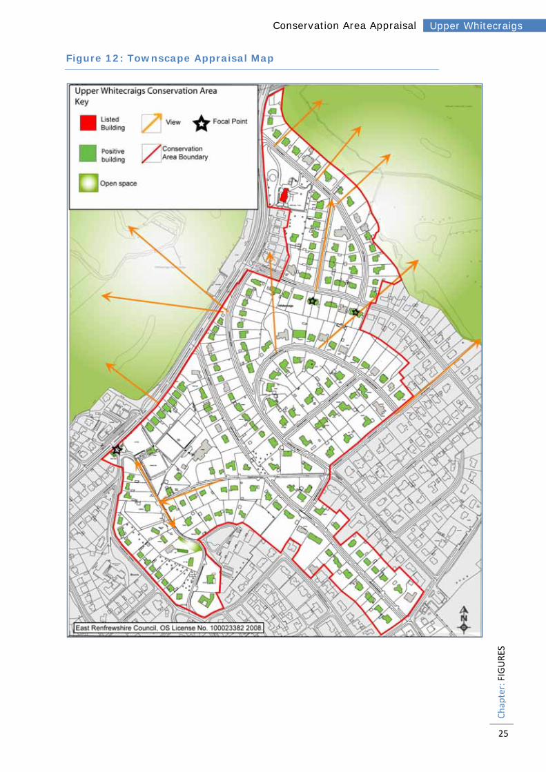
make a positive contribution to the character or appearance of the conservation area. These are identified as ‘positive buildings’ and shown in Figure 12: Townscape Appraisal Map.
4.5.2. Buildings identified as being positive will vary, but commonly they will be good examples of relatively unaltered historic buildings where their style, detailing and building materials provides the street or landscape with interest and variety. Most importantly, they make a positive contribution to the special interest of the conservation area. Where a building has been heavily altered, and restoration would be impractical, they are excluded.
4.5.3. Broom Lodge was historically the lodge building for Broom House, and dates from the early to mid 19th century. The main elevation facing the driveway is one storey with 3 bays built in ashlar sandstone. The walls are painted white with black detailing at the windows cills and hood moulds. The building has been identified as a candidate for listing.
4.5.4. 17 Elphinstone Road is characteristic of many of the smaller cottages in the conservation area. It is 1½ storeys and has two outer bays on the front elevation with bay windows and a doorway set behind a red brick segmental arch in the central bay. Both windows feature red brickwork detailing while the majority of the building is finished in a white harl. The roof is steep and covered in red tiles with a very prominent chimney above the bay window on the right. The windows are timber top hung casement with each narrow frame having 4 lights over 1.
4.5.5. 8a Lethington Road is a good example of the Arts and Crafts influenced houses in the area. It has a large central gable to the front with a steep slate roof behind and a chimney on either side of the gable. The gable has a pair of windows on the first floor and on the ground floor there is a bay window to the left with two smaller windows in the centre and a brick arched doorway to the right.
Photo 16: Broom Lodge, 69 Ayr Road
Photo 17: 17 Elphinstone Road
Photo 18: 8a Lethington Road
16
Chapter: CHARACTER AND APPEA
RANCE
Upper Whitecraigs Conservation Area Appraisal
There are a further two windows to the left of the gable close to the eaves. The majority of the building is in a white harl and black brick detailing with white pointing around the windows.
4.5.6. 12 Methven Road is an example of the larger sandstone villas to be found in
the conservation area. It occupies a corner position at the junction of Methven Road and Lethington Road. The building is 2 storeys and approximately square with the three visible corners each treated differently. The corner facing down Methven Road has a hexagonal bay window, the corner towards the junction has a round turret with crenulations and the corner on Lethington Road has a gable – all rising through both storeys. The elevation to Methven Road also has a central timber framed porch with a pitched roof on the ground floor. The roof is hipped and covered in red tiles with three prominent stone chimneys. Windows frames are timber sashes with 9 lights over 1.
4.5.7. Several of the buildings in the area are influenced by the Arts and Crafts movement and include characteristics such as red brick detailing and base courses and hipped red tile or slate roofs.
4.5.8. However the Art Deco influence found in details of corner windows, smooth white cement render (rather than rough harl), curved corners and the horizontality of the glazing patterns, have been particularly badly affected by modern replacements such as UPVC windows.
4.5.9. Very few original windows remain but a good example is found at offices at 69 Ayr Road where the original corner window with curved glass has remained.
4.5.10. Much of the modern development is out of keeping with the character of the conservation area; however a more successful example can be found at 21 The Loaning. The proportions and asymmetrical plan are consistent with the surrounding properties and it uses materials which are traditional to the area such as white render, red brick and red roof tiles. The roof is pitched and hipped with a gable to the front. The outshot to the rear of the building and the single storey projection to the south west help to break up the massing and keep the building in scale with its neighbours.
Photo 19: Methven Road
Photo 20: The Loaning.

17
Chapter: CHARACTER AND APPEA
RANCE
Upper Whitecraigs Conservation Area Appraisal
4.6. Materials and Local Details 4.6.1. In Upper Whitecraigs the most important materials are harl, red and yellow
sandstone, red brick, slate and tile. Traditionally, roofs are pitched and have hipped ends although some gables and half hips do exist. The roof pitches are generally steep with prominent chimneys.
4.6.2. For walls, a traditional harl is popular, sometimes with red brick or sandstone detailing. Generally, applied colours within the conservation area are muted pastels or white. Limewash and lime mortars are traditional in the area, which is ideal as they allow the wall to ‘breathe’ rather than sealing in any moisture, and provide a flexible finish which expands and contracts with changes in temperature and humidity. The red brickwork is often enlivened by the use of a very white pointing, creating a contrast against the deep red of the brick. In some places the brickwork has been painted and this has been most successful where the colour has been chosen so that this contrast between the brick and the white pointing is maintained.
4.6.3. Apart from the roofs and walls, the historic buildings in the conservation area are enlivened by the use of timber windows and doors, the design of which varies according to the status of the house. Windows are generally timber sash and case although there are instances of timber top or side hung casements. They are generally painted white, with many of the original windows featuring stained glass and other patterns such as leaded lights and small panes. Dormer windows are a characteristic of the conservation area, enabling the roof space behind the typically steep roofs to be used effectively.
4.6.4. In the south of the conservation area, several houses feature Crittall metal framed windows, often situated on corners of the building with elegant curved glass. These contribute to the character of the area and are worth retaining where possible.
4.6.5. Boundaries are usually marked by brick, stone or harled walls from ½m - 2m
high and often with railings or hedges. Railings are usually very simple and elegant and painted a dark colour. Iron gates, often incorporating the house name or number are also common. Higher boundary walls are found to the higher status properties and many areas have seen the introduction of private security devices such as CCTV cameras and security lighting. There are instances of these being sited poorly, detracting from the appearance of the area.
4.6.6. Many unique details such as turrets, domed roofs, brick arched doorways, bay windows with crenellations, and stained glass combine to enrich the
Photo 21: Craignethan Road
18
Chapter: CHARACTER AND APPEA
RANCE
Upper Whitecraigs Conservation Area Appraisal
character of the area. Many of the dwellings present a gable front to the road.
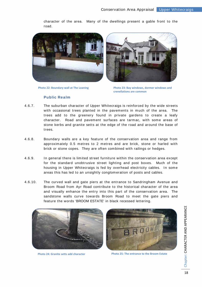
Public Realm
4.6.7. The suburban character of Upper Whitecraigs is reinforced by the wide streets with occasional trees planted in the pavements in much of the area. The trees add to the greenery found in private gardens to create a leafy character. Road and pavement surfaces are tarmac, with some areas of stone kerbs and granite setts at the edge of the road and around the base of trees.
4.6.8. Boundary walls are a key feature of the conservation area and range from approximately 0.5 metres to 2 metres and are brick, stone or harled with brick or stone copes. They are often combined with railings or hedges.
4.6.9. In general there is limited street furniture within the conservation area except for the standard unobtrusive street lighting and post boxes. Much of the housing in Upper Whitecraigs is fed by overhead electricity cables. In some areas this has led to an unsightly conglomeration of posts and cables.
4.6.10. The curved wall and gate piers at the entrance to Sandringham Avenue and Broom Road from Ayr Road contribute to the historical character of the area and visually enhance the entry into this part of the conservation area. The sandstone walls curve towards Broom Road to meet the gate piers and feature the words ‘BROOM ESTATE’ in black recessed lettering.
Photo 22: Boundary wall at The Loaning Photo 23: Bay windows, dormer windows and crenellations are common
Photo 24: Granite setts add character Photo 25: The entrance to the Broom Estate

19
Chapter: CHARACTER AND APPEA
RANCE
Upper Whitecraigs Conservation Area Appraisal
4.6.11. The southern part of the conservation area has a less urban more rural, historic character and the public realm reflects this. Boundaries to the road are generally low stone walls with banks and hedges and the roads are narrow lanes with narrow or no pavements. Condition
4.6.12. One of the greatest threats to any heritage site is the loss of primary fabric through decay and damage, reducing the authenticity of the site. The vast majority of the buildings within the conservation area are well-maintained although there are some examples where this is not the case. A significant threat to the historic fabric is inappropriate modern details, such as replacement windows, doors and boundaries.
4.7. Character Areas 4.7.1. The Upper Whitecraigs Conservation Area divides into four character areas
according to historical development; street pattern and layout; built form; and uses and activities (see Figure 10: Character Areas). These are:
1. Craignethan Road 2. Roddinghead Road 3. Broom Estate 4. Neidpath Road East
Character Area 1: Craignethan Road
4.7.2. This is the most northern part of the conservation area and is generally entered along The Loaning or Craignethan Road from Ayr Road. The area contains a mixture of 1½ and 2 storey dwellings with plot sizes varying slightly according to the status of the house. The dwellings have mature gardens which combine with street trees to create a leafy character. The key landmark building for the area is Whitecraigs House which is listed category B and dates from 1898. Cathcart Golf Course forms the northern boundary of the conservation here and views over the surrounding green space can be glimpsed between the buildings on The Loaning. There has been some modern infill, which is not always in keeping with the character of the area. Character Area 2: Roddinghead Road
4.7.3. In this part of the conservation area the land rises quite significantly to a high point on Elphinstone Road. The streets curve gently around these contours towards the top of the hill. The change in level allows excellent views between the buildings on Elphinstone Road over the surrounding landscape. The properties here are mostly large, detached and set back from the road behind boundary walls although there are some smaller 1½ storey properties around the junction of Elphinstone Road and Methven Road and on Neidpath Road West. As the properties become larger the boundary walls and gates increase in size and in places this has led to the streetscape being dominated
Photo 26: The ground floor window frames have been replaced with UPVC which does not replicate the elegance and curved glass of the originals above.

20
Chapter: KEY
FEA
TURES
Upper Whitecraigs Conservation Area Appraisal
by walls and gates rather than the mature gardens which characterise most of the conservation area. The area has some modern infill development, which is not always in keeping with the character of the area. Character Area 3: Broom Estate
4.7.4. This is the most historic part of the conservation area with the first roads laid out for access to the Broom Estate in the early to mid 19th century. Many of the roads here are narrow lanes with banks and hedges, no pavements and stone walling creating a rural character. A combination of small informal green spaces and mature private gardens create a very green and leafy character. There are limited views within the character area due to its enclosed nature. The bowling green and tennis club provide open space, relieving the sense of enclosure and allowing views across the area. There is a mixture of larger properties and smaller cottages in large plots. The area appears to have developed in more of an ad-hoc basis. This character area features surviving buildings from the Broom Estate including the lodge and gates on Ayr Road, and a small croft cottage which now serves as the local Scout Headquarters. Broom House itself sits outside the conservation area to the south. Further south we see the start of the Art Deco inspired ‘Broom Estate’. This area also includes 1½ storey stone fronted cottages on Ayr Road. Character Area 4: Neidpath Road East
4.7.5. In this area, the streets widen out creating a more open feeling. The properties are generally large, 2 storey detached dwellings although there are examples of semi-detached properties. The streets follow more of a grid pattern thereby limiting views. Street trees and greenery in gardens combine to create a leafy character. Areas of granite setts enrich the public realm at the edge of the road and around the base of trees on Broomfield Road.
5. KEY FEATURES
5.1. Assessment of Significance 5.1.1. Having carried out an assessment of the buildings and areas it is now
possible to identify the key features which define the special architectural and historic character of the area.
5.2. Character Area 1: Craignethan Road Variety of 1½ and 2 storey houses set back from the road in generous
gardens; Trees and greenery on the street and in the large mature gardens make
an important contribution; Whitecraigs House, a B listed asymmetrical house c.1898 built in yellow
sandstone; Glimpsed views over the neighbouring golf course and up towards
higher ground; Predominant materials are harl, red brick, slate and red roof tiles.

21
Chapter: KEY
FEA
TURES
Upper Whitecraigs Conservation Area Appraisal
5.3. Character Area 2: Roddinghead Road Wide, curving streets follow the contours of the hill; Generally large detached properties in substantial gardens; Street trees and mature gardens create a leafy character; Views out over surrounding area from Elphinstone Road; Predominant materials are harl, red brick, yellow or red sandstone, slate
and red roof tiles.
5.4. Character Area 3: Broom Estate Most historic area of the conservation area containing the earliest
roads; Narrow lanes with banks, hedges and stone walling create an enclosed,
rural character; Surviving buildings from the Broom Estate include the lodge, the gates
and the croft on Broom Road; The bowling green and tennis club provide open green space; A mixture of smaller and larger properties but all detached and in large
plots; Art Deco detailing on the 1930s McTaggart and Mickel development; Predominant materials are harl, red brick, yellow sandstone, slate and
red roof tiles.
5.5. Character Area 4: Neidpath Road East Large detached 2 storey properties in spacious gardens; Wide tree lined streets; Predominant materials are harl, red brick, sandstone, slate and red roof
tiles; Granite setts enrich the public realm at the edge of the road and around
the base of trees.

22
Chapter: NEG
ATIVE FA
CTO
RS
Upper Whitecraigs Conservation Area Appraisal
6. NEGATIVE FACTORS
6.1. Identified Negative Factors 6.1.1. A number of negative factors have been identified and are listed below.
These form the basis for the Sensitivity Analysis and the Opportunities for Enhancement.
6.2. Character Area 1: Craignethan Road Alterations to existing buildings detract from the character of the area; Some modern development in the area is not sympathetic to the
traditional materials and styles of the historic buildings; Unsightly conglomerations of electricity posts and cables; One building has been identified as being in a poor condition.
6.3. Character Area 2: Roddinghead Road The loss of original architectural details on existing buildings and the
use of non-traditional building materials; Some examples of replacement boundary treatments which are out of
character with the area or poor quality; The boundary railings on the west side of Lethington Road are in need
of repair in places; Modern development in the area is not sympathetic to the traditional
materials and styles of the historic buildings.
6.4. Character Area 3: Broom Estate The loss of original architectural details on existing buildings and the
use of non-traditional building materials; The increased traffic generated by the sports clubs can be unpleasant
for pedestrians on the narrow lanes; Subdivision of plots leading to the loss of garden ground and the
introduction of building styles which are out of character with the area; Some examples of replacement boundary treatments which are out of
character with the area or poor quality; Modern development in the area is not always sympathetic to the
traditional materials and styles of the historic buildings.
6.5. Character Area 4: Neidpath Road East The loss of original architectural details on existing buildings and the
use of non-traditional building materials.

23
Chapter: FIGURES
Upper Whitecraigs Conservation Area Appraisal
Figure 10: Character Areas Map

24
Chapter: FIGURES
Upper Whitecraigs Conservation Area Appraisal
Figure 11: Building Analysis Map
25
Chapter: FIGURES
Upper Whitecraigs Conservation Area Appraisal
Figure 12: Townscape Appraisal Map

26
Chapter: SEN
SITIVITY ANALYSIS
Upper Whitecraigs Conservation Area Appraisal
7. SENSITIVITY ANALYSIS
7.1. Demolition 7.1.1. The nature of conservation areas and listed buildings mean that they are
sensitive to change and in particular to demolition. Consequently, unless fully justified as required by the Scottish Historic Environment Policy, the Council will resist demolition including partial demolition. Proposals for demolition of unlisted buildings including partial demolition require Conservation Area Consent and/or Listed Building Consent and should be accompanied with an appropriate justification.
7.2. Loss of Original Architectural Details and Building Materials 7.2.1. Although the majority of the buildings in the conservation area are in good
physical condition, the area as a whole is at risk from small changes which can cumulatively dilute the special character of the area. Some of the buildings in the conservation area have been adversely affected by the replacement of original timber windows or doors with UPVC or aluminium, the replacement of natural roof slates or boundary treatments or the painting of brickwork. In many cases, these changes and the loss of elements such as stained glass has spoiled the external appearance of a building and the local streetscape.
7.3. Pressure for New Development 7.3.1. The Upper Whitecraigs area is a highly desirable place to live and modern
development has been introduced following the demolition of existing buildings or the subdivision of plots. There is a concern that if this subdivision and demolition were to continue it would dilute the special character of the conservation area.
7.4. Quality of New Development, Alterations and Extensions 7.4.1. Where more recent developments have occurred they are not always
sympathetic to the local details which have provided the group value of the conservation area.
7.5. Buildings at Risk 7.5.1. One building in a poor condition has been identified in the conservation area.
The demolition of unlisted buildings in a conservation area can result in the whole character of the conservation area being undermined.
7.6. Protection of Trees and Hedgerows 7.6.1. Trees make an important contribution to the landscape and enhance the
setting of historic buildings. Some are street trees but most are in private ownership. Hedges also make a major contribution and similarly need to be retained where possible and incorporated within development proposals.

27
Chapter: FUTU
RE ACTION PLAN
Upper Whitecraigs Conservation Area Appraisal
8. FUTURE ACTION PLAN
8.1. Actions 8.1.1. The Council intends to develop a conservation area action plan on the basis of
this appraisal and further analysis of the area to provide detailed guidance and specific actions regarding the development and management of its conservation areas.
8.1.2. This chapter outlines the possible opportunities and actions for the preservation and enhancement of the conservation area, which may be taken forward into the action plan.
8.2. The Control of Unlisted Buildings 8.2.1. As part of the appraisal process unlisted but ‘positive’ buildings have been
identified (see Figure 11: Townscape Appraisal Map).
8.2.2. Generally, these are individual or groups of buildings which retain all or a high proportion of their original architectural detailing and which add interest and vitality to the appearance of the conservation area.
8.2.3. As with listed buildings, there is a general presumption in favour of retention of unlisted buildings within conservation areas.
8.2.4. The Council propose that any application for the demolition of a building which is deemed to make a positive contribution to the character of the conservation area should be accompanied by a justification demonstrating why a building cannot be retained and that efforts have been made to market the building or to find a suitable new use before an application may be considered favourably. Any proposal that adversely affects the architectural or historical interest of the building or the conservation area will be considered for refusal.
8.2.5. Ancient and Historic Monuments of Scotland maintains a list of buildings which are at risk from deterioration due to neglect or vandalism. This is updated as necessary and the Council has powers to protect all listed
Photo 27: Modern materials and finishes are not always in keeping with the character of the area
Photo 28 ‐ Trees & hedges play an important role in
the area and many are in private ownership

28
Chapter: FUTU
RE ACTION PLAN
Upper Whitecraigs Conservation Area Appraisal
buildings and also, in certain circumstances, unlisted buildings in any conservation area, where they make a positive contribution to the area’s special character.
8.3. Quality of New Developments, Building Alterations and Extensions
8.3.1. Upper Whitecraigs is an attractive residential area desirably located in the commuter suburbs. Property prices are inevitably high and there is pressure for sub-division of existing plots, the development of backland sites, and for the demolition of existing smaller properties and their replacement with much larger dwellings. This has resulted in the construction of large, executive-style houses which are not always in character with the area. Applications for the demolition of modest houses, and their replacement with much bigger dwellings could have an adverse effect on the overall character of the conservation area, which is notable for its mixture of smaller cottages and larger villas.
8.3.2. In assessing planning applications within the Upper Whitecraigs Conservation Area, the Council shall pay particular attention to the following:
New development should follow existing plot ratios, with properties in spacious plots;
New development should be in accordance with the prevailing form of historic development, including the scale and massing of buildings;
New development should not impinge on the setting of existing buildings;
New development should use materials which are traditional to the conservation area and of high quality (the use of UPVC, aluminium, concrete tiles or other non traditional materials are not considered appropriate);
New development should protect important trees, hedges and other established boundaries;
New boundary treatments should use traditional materials and be of appropriate design to suit locality.
8.4. Public Realm Enhancement 8.4.1. Works by the Roads Service, or by any of the statutory undertakers can have
a profound effect on a conservation area. The Council will endeavour to ensure that all such works are carried out to reflect the sensitive historic environment, particularly relating to issues such as signage, materials, lighting, public utility boxes, etc.
8.5. Landscape Management 8.5.1. Trees and hedges make an important contribution to the landscape and
enhance the setting of historic buildings. The designation of a conservation area is a reflection of the character of the overall area and for this reason, it’s necessary for residents to notify the council of their intention to carry out tree works at least six weeks in advance. The Council will encourage owners to

29
Chapter: M
ONITORING
Upper Whitecraigs Conservation Area Appraisal
retain and maintain trees and to replace with appropriate native species as and when necessary.
8.5.2. Whilst the Council has no specific control over hedge management, it will encourage owners to retain and maintain and to replace in native species as and when necessary when part of a development proposal.
9. MONITORING
9.1. Review 9.1.1. This document should be reviewed every 5 years from the date of its formal
adoption by East Renfrewshire Council. It will need to be assessed in the light of the emerging Local Development Plan and government policy generally. A review should include the following:
A survey of the conservation area including a photographic survey to aid possible enforcement action;
An assessment of whether the various recommendations detailed in this document have been acted upon, and how successful this has been;
The identification of any new issues which need to be addressed, requiring further actions or enhancements;
The production of a short report detailing the findings of the survey and any necessary action;
Publicity and advertising.
9.1.2. The Council will consider undertaking this review in conjunction with the local community. This would enable the local community to become more involved with the process and would raise public consciousness of the issues, including the problems associated with enforcement.

30
Chapter: CONTA
CT DETAILS
Upper Whitecraigs Conservation Area Appraisal
10. CONTACT DETAILS
Further information can be obtained from the following:
East Renfrewshire Council Julie Nicol Environment Department Planning Property and Regeneration 2 Spiersbridge Way Spiersbridge Business Park Thornliebank G46 8NG Tel. (0141) 577 3876 [email protected] Scottish Civic Trust The Tobacco Merchants House 42 Miller Street Glasgow G1 1DT Tel. (0141) 221 1466 [email protected] Historic Scotland Longmore House Salisbury Place Edinburgh EH9 1SH Tel (0131) 668 8600 Ancient and Historic monuments of Scotland (RCAHMS) John Sinclair House 16 Bernard Terrace Edinburgh EH8 9NX Tel (0131) 662 1456 www.rcahms.gov.uk

31
Chapter: Glossary
Upper Whitecraigs Conservation Area Appraisal
GLOSSARY
Term Description
Ashlar
Masonry of large blocks in regular courses worked to even faces and carefully squared edges: the stones themselves are called ashlars and may have a polished, stugged, droved or broached finish
Bell cast In roofs, a flattening of the pitch towards and over the eaves
Belt course A projecting course of polished ashlar
Band course Masonry, deeper than a string course and usually unmolded
Blocking course Plain course forming a low parapet superimposed on a cornice usually concealing a gutter
Bond In brickwork masonry, the arrangement of bricks in a wall in headers (end of brick exposed) and stretchers (side exposed) according to type (English, Flemish, English Gardens, etc.)
Crenellation
A parapet with crenellations or battlements i.e. with alternate raised or lowered sections. May be called battlemented or castellated.
Entablature
Collective name for the three horizontal members (architrave, frieze and cornice) above a column, in classical architecture but frequently found as a wallhead treatment, as a division between storeys or as an impost band at an arcade
Feu Previously the most common form of land tenure in Scotland until the abolition of feudal tenure etc. (Scotland) act 2000
Harl
Scottish form of roughcast in which the mixture of the aggregate (small even-sized pebbles) and binding material (in traditional harl sand and lime) is dashed on to a masonry wall; in traditional harls the aggregate is in the mix (wet dash) in non-traditional 20th century harls the aggregate is dashed on separately (dry dash)
Lang rigs Long urban domestic gardens walled off from each other; the unit of ownership in Scots mediaeval towns
Limewash Traditional solution for coating walls made from a mixture of lime and water
Mansard roof Four-pitch roof with a steep lower pitch and a shallower upper pitch on each side
Mews Stabling, in an urban context
Mullion Member dividing the lights of a window
Pediment Classical form of corniced gable or gablet used at openings as well as a termination to roof structures
Pend Open-ended passageway through a building; usually vehicular as against close which is usually pedestrian
Piended Hipped roofed
Pilaster The flat version of a column, consisting of a slim rectangle projecting from a wall; used also of plain piers or pilasters without classical orders which are more correctly termed pilaster strips
Quoins
Stones larger than those of which a wall is composed, or better shaped, and forming the corners of walls or door and window openings: if they project they are described as raised, and if with chamfered angles, rusticated
Render Smooth coating of cement or stucco over masonry

32
Chapter: Glossary
Upper Whitecraigs Conservation Area Appraisal
Term Description
Returns
A section of moulding or cornice which turns a corner. It can also be used at the side wall, especially where it returns for only a short distance, or where the treatment of the main elevation returns only a short distance on to a plainer gable
Reveal The inward plane of a door or window opening between the edge of the external wall and the window or door frame
Rubble
Masonry which is not fully dressed; can be of boulders; or of random rubble retaining in some degree the natural shape of the stone; or of squared rubble in which the stones are roughly squared and may be either coursed or snecked; i.e. with variations in the coursing brought about by the use of small filler stones or snecks
Skew Sloping tabling, sometimes coped, finishing a gable which is upstanding from the plane of the roof
Skew end Bottom end of skew, sometimes moulded, sometimes a square block
Skewputt Bottom end of a skew or crowstepped gable which projects from the wallhead, usually in a cavetto
Snecked Form of rubble construction composed of squared stones in which the coursing is varied by small filler stones or snecks
Soffit The underside of a cornice, stair or lintel; that of an arch is more correctly an intrados
String course A shallow moulding continued across a whole facade which may be defined by its position e.g. sill course or impost course
Weatherboarding Form of wall cladding composed of overlapping horizontal boards on a timber framework
Wet dash Traditional type of harl in which the aggregate of small evenly sized pebbles is incorporated into the mix

33
Chapter: APPEN
DIX
Upper Whitecraigs Conservation Area Appraisal
APPENDIX
Local Plan (2011) Policies
Policy E4 - Conservation of the Built Heritage
The Council will safeguard the special character of conservation areas and the area at Netherlee subject to an Article 4 Direction (identified on the Proposals Map), Listed Buildings and their settings and properties included on the ‘Inventory of Gardens and Designed Landscapes’. Development likely to prejudice these assets will be resisted.
a) Listed Buildings
The layout, design, materials, scale, siting and use of any development affecting a listed building shall be appropriate to the character and appearance of the listed building and its setting. There is a presumption against demolition or other works that adversely affect the special interest of a listed building or its setting. No listed building should be demolished unless it can be clearly demonstrated that:
the building is not of special interest; or the building is incapable of repair; or the demolition of the building is essential to delivering significant benefits to
economic growth or the wider community; or the repair of the building is not economically viable and that it has been marketed,
at a price reflecting its location and condition, to potential restoring purchasers for a reasonable period.
To enable features to be recorded, the Royal Commission on the Ancient and Historical Monuments of Scotland shall be formally notified of all proposals to demolish listed buildings.
b) Conservation Areas
Development and demolition within a conservation area or affecting its setting shall preserve or enhance its character and be consistent with any relevant conservation area appraisal or management plan that may have been prepared for the area. The design, materials, scale and siting of any development shall be appropriate to the character of the conservation area and its setting. Trees which are considered by the planning authority to contribute to character and appearance shall be preserved. Given the importance of assessing design matters, outline planning applications will not normally be considered appropriate for developments in conservation areas. Where an existing building, listed or not, contributes positively to the character of the conservation area, the demolition aspect of policy (a) above shall apply. Where an existing building does not make a positive contribution to the character of the conservation area, proposals for its demolition will not be considered favourably unless there is a detailed planning application for a replacement development that enhances or

34
Chapter: APPEN
DIX
Upper Whitecraigs Conservation Area Appraisal
preserves that character. Demolition shall not begin until evidence is given of contracts let for an approved replacement development.
Schedule E4
Ref Location
… …
E4.5 Upper Whitecraigs Conservation Area
… …
c) The Council will continue to safeguard the special character of the area at Netherlee subject to an Article 4 Direction Area, identified as E4.6 on the Proposals Map. Development likely to prejudice the character of this area will be resisted. d) The Council supports the Buildings at Risk Service which is administered by the Scottish Civic Trust on behalf of Historic Scotland, and provides information on properties of architectural or historic merit that are considered to be at risk www.buildingsatrisk.org.uk/BAR e) Gardens and Designed Landscapes Development affecting the Gardens and Designed Landscapes listed below and shown on the Proposals Map shall protect, preserve and enhance such places and shall not impact adversely upon their character, upon important views to, from and within them, or upon the site or setting of component features which contribute to their value.
Schedule E4
Ref Location
… …
E4.7 Greenbank House Garden, Clarkston

35
Chapter: APPEN
DIX
Upper Whitecraigs Conservation Area Appraisal
Policy DM1 - Detailed Guidance for all Development Where the principle of development is deemed to be acceptable in terms of the other Policies contained within this Local Plan, proposals for development will require to conform to the appropriate criteria below:
Not result in a significant loss of character or amenity to the surrounding area. Be of a size, scale and density in keeping with the buildings in the locality and
respect local architecture, building form, design, and materials. Not constitute ‘backland’ development without a road frontage. Not impact adversely on the landscape character, involve a significant loss of trees
or other important landscape, greenspace or biodiversity features (see Policies E3 - “Protection of Natural Features”, E6 - “Biodiversity”, L1 – “Protection of Important Urban Greenspace”, and L2 - “Safeguarding the Local Greenspace Resource”.
Ensure that landscaping is an integral element in layout design, taking account of existing physical features (e.g. trees, hedgerows, walls, etc.). Where appropriate, tree planting should augment the amenity and appearance of the site.
Ensure that the standards for ‘Open Space’ are satisfied (see Policy L4 – “Open Space Provision in New Developments” and Appendix 1).
Meet the parking and access requirements of the Council and provide appropriate mitigation to minimise the impact of new development (see Policies T3 – “New Transport Infrastructure” and T5 – “Other Traffic Management and Calming Measures).
Not prejudice the amenity of neighbouring properties by unreasonably restricting sunlight or privacy.
Seek to create safe and secure environments and reduce the scope for anti-social behaviour and fear of crime.
Be designed to meet disability needs and include provision for disabled access within public areas.
Minimise the extent of light pollution caused by street and communal lighting and any flood lighting forming part of, or associated with, development.
Be designed to include provision for the recycling, storage, collection and composting of waste materials.
Be designed to retain on-site, for use as part of the development, as much as possible of all waste material arising from construction of the development.
Be designed where applicable to take into account the legacy of former mining activity.

36
Chapter: APPEN
DIX
Upper Whitecraigs Conservation Area Appraisal
Policy DM2 - Alterations to and Redevelopment of Existing Dwellinghouses In addition to the criteria listed in Policy DM1 - “Detailed Guidance for all Development”, proposals for extensions to existing residential properties, the sub-division of the curtilage of a dwellinghouse for a new house(s) and redevelopment of existing buildings will be assessed against the following criteria:
DM2.1 -Extensions
Must complement the existing character of the building, particularly in terms of scale, style, form and materials.
Must complement the existing building in terms of size, scale or height. Incorporate a pitched roof where exposed to public view, with roof tiles or slates to
match existing. Side extensions should not create an unbroken or terraced appearance along the
street frontage. Avoid major loss of existing garden space. Dormer windows should not in general dominate the existing roof profile, nor rise
above or break the existing ridgeline or hip of the roof, and should be finished in materials to match existing roof finishes.
The Council will prepare and approve a design guide for householders on alterations to existing dwellinghouses.

37
Chapter: APPEN
DIX
Upper Whitecraigs Conservation Area Appraisal
DM2.2 - Sub-division of the Curtilage of a Dwellinghouse for a New Dwellinghouse and Replacement of an Existing House with a New House
The proposed plot should reflect the established pattern of development and should be of a size, shape and disposition capable of accommodating a dwellinghouse and attached land behind the front building line and surrounded by enclosure that provides secluded garden ground of a scale and character compatible with the neighbourhood.
A sufficient area of ground for a garden and associated uses for the existing house must be retained in line with Policy L4 – “Open Space Provision in New Developments” and Appendix 1.
Existing building lines should be respected. Proposals should preserve and enhance the character and amenity of the area.

Planning Property and Regeneration
If you require this information in large print, Braille or translated,please telephone our Customer Service Officer on 0141 577 3001.