Embed Size (px)
Citation preview

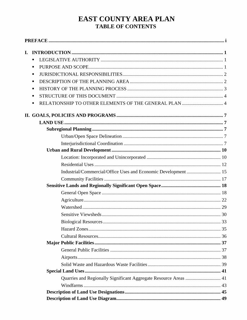
EAST COUNTY AREA PLANTABLE OF CONTENTS
PREFACE ................................................................................................................................................. i
I. INTRODUCTION ............................................................................................................................. 1 LEGISLATIVE AUTHORITY ..................................................................................................... 1 PURPOSE AND SCOPE............................................................................................................... 1 JURISDICTIONAL RESPONSIBILITIES................................................................................... 2 DESCRIPTION OF THE PLANNING AREA ............................................................................. 2 HISTORY OF THE PLANNING PROCESS ............................................................................... 3 STRUCTURE OF THIS DOCUMENT ........................................................................................ 4 RELATIONSHIP TO OTHER ELEMENTS OF THE GENERAL PLAN .................................. 4
II. GOALS, POLICIES AND PROGRAMS ........................................................................................ 7LAND USE ................................................................................................................................... 7
Subregional Planning ............................................................................................................ 7Urban/Open Space Delineation ................................................................................... 7Interjurisdictional Coordination .................................................................................. 7
Urban and Rural Development .......................................................................................... 10Location: Incorporated and Unincorporated ............................................................. 10Residential Uses ........................................................................................................ 12Industrial/Commercial/Office Uses and Economic Development ............................ 15Community Facilities ................................................................................................ 17
Sensitive Lands and Regionally Significant Open Space................................................. 18General Open Space .................................................................................................. 18Agriculture................................................................................................................. 22Watershed .................................................................................................................. 29Sensitive Viewsheds.................................................................................................. 30Biological Resources ................................................................................................. 33Hazard Zones............................................................................................................. 35Cultural Resources..................................................................................................... 36
Major Public Facilities ........................................................................................................ 37General Public Facilities ........................................................................................... 37Airports...................................................................................................................... 38Solid Waste and Hazardous Waste Facilities ............................................................ 39
Special Land Uses ................................................................................................................ 41Quarries and Regionally Significant Aggregate Resource Areas ............................. 41Windfarms ................................................................................................................. 43
Description of Land Use Designations............................................................................... 45Description of Land Use Diagram...................................................................................... 49
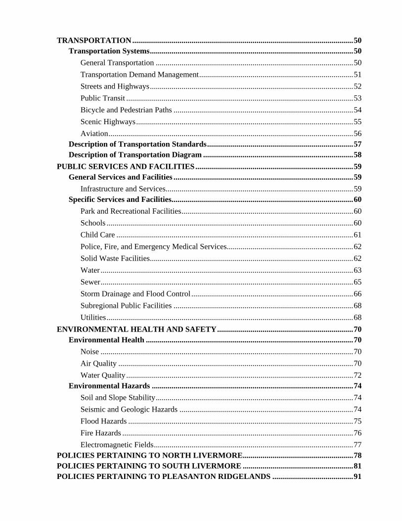
TRANSPORTATION................................................................................................................50Transportation Systems.......................................................................................................50
General Transportation ....................................................................................................50Transportation Demand Management..............................................................................51Streets and Highways.......................................................................................................52Public Transit ...................................................................................................................53Bicycle and Pedestrian Paths ...........................................................................................54Scenic Highways..............................................................................................................55Aviation............................................................................................................................56
Description of Transportation Standards..........................................................................57Description of Transportation Diagram ............................................................................58
PUBLIC SERVICES AND FACILITIES................................................................................59General Services and Facilities ...........................................................................................59
Infrastructure and Services...............................................................................................59Specific Services and Facilities............................................................................................60
Park and Recreational Facilities.......................................................................................60Schools .............................................................................................................................60Child Care ........................................................................................................................61Police, Fire, and Emergency Medical Services................................................................62Solid Waste Facilities.......................................................................................................62Water ................................................................................................................................63Sewer................................................................................................................................65Storm Drainage and Flood Control ..................................................................................66Subregional Public Facilities ...........................................................................................68Utilities.............................................................................................................................68
ENVIRONMENTAL HEALTH AND SAFETY.....................................................................70Environmental Health .........................................................................................................70
Noise ................................................................................................................................70Air Quality .......................................................................................................................70Water Quality ...................................................................................................................72
Environmental Hazards ......................................................................................................74Soil and Slope Stability....................................................................................................74Seismic and Geologic Hazards ........................................................................................74Flood Hazards ..................................................................................................................75Fire Hazards .....................................................................................................................76Electromagnetic Fields.....................................................................................................77
POLICIES PERTAINING TO NORTH LIVERMORE........................................................78POLICIES PERTAINING TO SOUTH LIVERMORE ........................................................81POLICIES PERTAINING TO PLEASANTON RIDGELANDS .........................................91
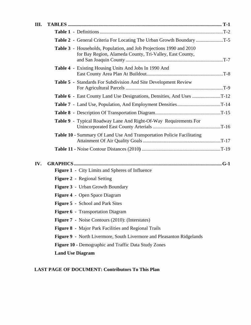
III. TABLES ............................................................................................................................. T-1Table 1 - Definitions ....................................................................................................T-2
Table 2 - General Criteria For Locating The Urban Growth Boundary ......................T-5
Table 3 - Households, Population, and Job Projections 1990 and 2010for Bay Region, Alameda County, Tri-Valley, East County,and San Joaquin County ...............................................................................T-7
Table 4 - Existing Housing Units And Jobs In 1990 AndEast County Area Plan At Buildout..............................................................T-8
Table 5 - Standards For Subdivision And Site Development Review For Agricultural Parcels ...............................................................................T-9
Table 6 - East County Land Use Designations, Densities, And Uses .......................T-12
Table 7 - Land Use, Population, And Employment Densities ...................................T-14
Table 8 - Description Of Transportation Diagram.....................................................T-15
Table 9 - Typical Roadway Lane And Right-Of-Way Requirements ForUnincorporated East County Arterials .......................................................T-16
Table 10 - Summary Of Land Use And Transportation Policie FacilitatingAttainment Of Air Quality Goals ...............................................................T-17
Table 11 - Noise Contour Distances (2010) ................................................................T-19
IV. GRAPHICS........................................................................................................................G-1Figure 1 - City Limits and Spheres of Influence
Figure 2 - Regional Setting
Figure 3 - Urban Growth Boundary
Figure 4 - Open Space Diagram
Figure 5 - School and Park Sites
Figure 6 - Transportation Diagram
Figure 7 - Noise Contours (2010): (Interstates)
Figure 8 - Major Park Facilities and Regional Trails
Figure 9 - North Livermore, South Livermore and Pleasanton Ridgelands
Figure 10 - Demographic and Traffic Data Study Zones
Land Use Diagram
LAST PAGE OF DOCUMENT: Contributors To This Plan


Preface – Measure D
East County Area Plan (Revised by Initiative Nov. 2000) i
PREFACE
PASSAGE OF THE MEASURE D INITIATIVE
In November 2000, the Alameda County electorate approved the Save Agriculture and Open Space LandsInitiative (Measure D; effective date, December 22, 2000). The Initiative amended portions of the CountyGeneral Plan, including the East County Area Plan (ECAP). This document incorporates the revisionscalled for by the Initiative. Policies, programs, tables and figures that have been added, revised, or enactedby the Initiative are prefaced in this document by an asterisk (“*”).
Note: As a result of these deletions and additions, the policies, programs and tables in this document havebeen renumbered.
GENERAL TERMS OF THE INITIATIVE
• The portions of the County General Plan revised or enacted under the Initiative may not be amendedexcept by voter approval, with the exception that the Board of Supervisors can impose more stringentrestrictions on development and land use.
• Existing and future County plans, zoning regulations, etc. must be consistent with the provisions of theordinance. Portions of the ECAP and other planning documents that were not amended or enacted bythe Initiative may still be modified without voter approval provided the modifications are consistentwith the provisions of the Initiative.
• Non-substantive changes within a plan document may be made by the Board for purposes of planconsistency, reorganization, and clarification as long as the changes are consistent with the Initiative.
MAJOR CHANGES TO ECAP POLICY
The Initiative has added, deleted, and revised more than 60 ECAP policies and programs in addition tochanges to the Urban Growth Boundary (Figure 3), land use diagram, and many of the tables.
Major changes to ECAP policy are summarized below:
• Reference to the year 2010 “planning period” has been deleted.
• General plan amendments for land use actions which increase the density or permit more developmentabove that permitted by the Plan as of February 1, 2000, or by the Initiative, whichever is less, willrequire voter approval.
• While the ordinance does not affect existing parcels, development, structures, and uses that were legalat the time it became effective, structures may not be enlarged or altered and uses expanded or changedinconsistent with the ordinance, except as authorized by State law.
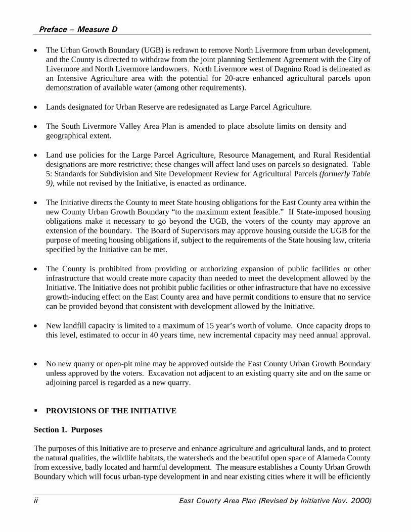
Preface – Measure D
ii East County Area Plan (Revised by Initiative Nov. 2000)
• The Urban Growth Boundary (UGB) is redrawn to remove North Livermore from urban development,and the County is directed to withdraw from the joint planning Settlement Agreement with the City ofLivermore and North Livermore landowners. North Livermore west of Dagnino Road is delineated asan Intensive Agriculture area with the potential for 20-acre enhanced agricultural parcels upondemonstration of available water (among other requirements).
• Lands designated for Urban Reserve are redesignated as Large Parcel Agriculture.
• The South Livermore Valley Area Plan is amended to place absolute limits on density andgeographical extent.
• Land use policies for the Large Parcel Agriculture, Resource Management, and Rural Residentialdesignations are more restrictive; these changes will affect land uses on parcels so designated. Table5: Standards for Subdivision and Site Development Review for Agricultural Parcels (formerly Table9), while not revised by the Initiative, is enacted as ordinance.
• The Initiative directs the County to meet State housing obligations for the East County area within thenew County Urban Growth Boundary “to the maximum extent feasible.” If State-imposed housingobligations make it necessary to go beyond the UGB, the voters of the county may approve anextension of the boundary. The Board of Supervisors may approve housing outside the UGB for thepurpose of meeting housing obligations if, subject to the requirements of the State housing law, criteriaspecified by the Initiative can be met.
• The County is prohibited from providing or authorizing expansion of public facilities or otherinfrastructure that would create more capacity than needed to meet the development allowed by theInitiative. The Initiative does not prohibit public facilities or other infrastructure that have no excessivegrowth-inducing effect on the East County area and have permit conditions to ensure that no servicecan be provided beyond that consistent with development allowed by the Initiative.
• New landfill capacity is limited to a maximum of 15 year’s worth of volume. Once capacity drops tothis level, estimated to occur in 40 years time, new incremental capacity may need annual approval.
• No new quarry or open-pit mine may be approved outside the East County Urban Growth Boundaryunless approved by the voters. Excavation not adjacent to an existing quarry site and on the same oradjoining parcel is regarded as a new quarry.
PROVISIONS OF THE INITIATIVE
Section 1. Purposes
The purposes of this Initiative are to preserve and enhance agriculture and agricultural lands, and to protectthe natural qualities, the wildlife habitats, the watersheds and the beautiful open space of Alameda Countyfrom excessive, badly located and harmful development. The measure establishes a County Urban GrowthBoundary which will focus urban-type development in and near existing cities where it will be efficiently

Preface – Measure D
East County Area Plan (Revised by Initiative Nov. 2000) iii
served by public facilities, thereby avoiding high costs to taxpayers and users as well as to the environment.The ordinance is designed to remove the County government from urban development outside the UrbanGrowth Boundary.
Section 2. Findings
(This section has been omitted because it is not directly relevant to the East County Area Plan)
Section 3. Protection of Legal Rights
Nothwithstanding their literal terms, the provisions of this ordinance do not apply to the extent, but onlyto the extent, that courts determine that if they were applied they would deprive any person of constitutionalor statutory rights or privileges, or otherwise would be inconsistent with the United States or Stateconstitutions or law. The purpose of this provision is to make certain that this ordinance does not violatenay person’s constitutional or legal rights.
To the extent that a provision or provisions of this ordinance do not apply because of this section, then onlythe minimum development required by law which is most consistent with the provisions and purposes ofthis ordinance shall be permitted.
Section 4. Agricultural, Resource management, Water Management and Rural Residential Areas
In areas outside the County Urban Growth Boundary designated Large Parcel Agriculture, ResourceManagement or Water Management Lands by the East County Area Plan on February 1, 2000, or by thisordinance, the number of parcels that may be created, the residential units permitted on each parcel, the sizeof the development envelope, the maximum floor areas and floor area ratios, and the uses permitted by thePlan on February 1, 2000, or by this ordinance, whichever is less, may not be increased. Rural DensityResidential designations may not be changed to a designation which permits more development.
(See Policies 96 and 97)
Section 5. Redesignation of Urban Reserve
Areas outside the County Urban Growth Boundary designated Urban Reserve in the East County Area Planon February 1, 2000, are redesignated large Parcel Agriculture, subject to the minimum parcel size, density,maximum development envelopes, building intensity, permissible uses and other restrictions that apply toareas under that designation. The Urban Reserve Land use designation is deleted from the text, Table 6(formerly Table 10) and from the Land Use Diagram of the Plan.
(See revised Land Use Diagram)
Section 6. South Livermore Valley Area PlanThis ordinance shall not supersede or change the provisions of the South Livermore Valley Area Plan inthe area to which the plan applied on February 1, 2000. The area to which the Plan applies may beexpanded, pursuant to Program 124, not to exceed 1 mile beyond the February 1, 2000, boundary, for
Preface – Measure D
iv East County Area Plan (Revised by Initiative Nov. 2000)
purposes of attaining the goal in Policy 339 of 5,000 acres of cultivated agriculture. The maximum densitybonus of 4 additional homesites per 100 acres in the Plan may not be increased.
(See Policy 339, and revised Programs 123 and 124)
Section 7. County Housing Obligations
Nothing in this ordinance shall be applied to preclude County compliance with housing obligations underState law. To the maximum extent feasible, the County shall meet State housing obligations for the EastCounty Area within the County Urban Growth Boundary. In providing required housing, the County shallprotect environmental values, enhance the quality of life of affected persons, and comply with policies andprograms of this ordinance to the maximum extent feasible.
If State-imposed housing obligations make it necessary to go beyond the Urban Growth Boundary, thevoters of the County may approve an extension of the Boundary. The Board of Supervisors may approvehousing beyond an Urban Growth Boundary only if:
(1) it is indisputable that there is no land within the Urban Growth Boundary to meet a State housingrequirement either through new development, more intensive development, or redevelopment; (2) no moreland is used outside the Urban Growth Boundary than is required by the affordable housing necessary tomeet a State obligation; (3) the area is adjacent to the Urban Growth Boundary, or to an existing urban orintensive residential area; (4) the percentage goals for low- and very low-income housing in Policy 36 willbe met in any housing approved; (5) there will be adequate public facilities and services for the housing;and (6) the development shall not be on prime agricultural lands, or lands designated, at least conditionally,for intensive agriculture, unless no other land is available under this policy.
In no case shall required housing be built on or which protrudes over hilltops or ridgelines, on slopes ofmore than 20 % critical wildlife habitat, or within 100 feet of a riparian corridor.
(See Policy 26)
Section 8. East County Area Plan Amendments
The Alameda County East County Area Plan is amended as follows below. Material deleted from the planis struck out; material added is underlined (except some subsection headings are underlined in the existingplan). Unchanged policies, programs and provisions of the plan are omitted from this ordinance.
(See revised policies, etc. in body of the plan document)
Section 9. Deletions from the East County Area Plan
Existing policies 10, 11, 11A, 11B, 15, 21, 23, 23A, 23B, 24, 25, 25A, 27, 28, 29, 30, 81A, 85, 99, 144,148, 202, 226, 245A and 282A, programs 1, 1A, 9A, 9B, 36, 137 and the description of Urban Reserve arehereby deleted from the East county Area Plan.
(These policies and programs have been deleted from the document)
Preface – Measure D
East County Area Plan (Revised by Initiative Nov. 2000) v
Section 10. Definitions
The following definitions are added to Table 1 of the East County Area Plan:
(See Table 1 for the text of the definitions added to the East County Area Plan by the Initiative)
Section 11. Tables in East County Area Plan
(a) The County shall bring the projection estimates in Tables 3, 4 (formerly Table 5), and A-1 (Table A-1has been deleted), and the readership assistance summary in Table 10 (formerly Table 14) intoaccordance with the East County Area Plan as amended by this ordinance.
(b) In Table 1, the definitions of Community Centers, Major New Urban Developments and Urban Reserveare deleted.
(c) In Table 1, the definitions for Agricultural Enhancing Commercial Uses, Compact Development,Development, Initiative, Intensive Agriculture, Moderate-, Low-, and Very Low-Income Households,and Secondary Units are enacted.
(d) Tables 6, 7 and 8 are deleted.
(e) The standards in Table 5 (formerly Table 9) are enacted.
(f) In Table 6 (formerly Table 10), a maximum floor area of 12,000 square feet is added for residential andresidential accessory buildings in Rural Density, Large Parcel Agriculture and Resource Management,and Water Management Lands; the floor area ratio (FAR) in Large Parcel Agriculture and ResourceManagement is changed by adding a minimum of not less than 20,000 square feet. For Rural Densitythe Allowable Gross Density is changed from less than 1unit/acre to 5 acre minimum parcel size, andTypical Uses from 1-100 acre to 5 acre or less.
(See Tables 1, 3, 4, 5, and 6 for the required revisions. Former Tables 6, 7, and 8 have been deleted fromthe document)
Section 12. Withdrawal from North Livermore Joint Planning Agreement
In view of the provisions of this ordinance, the County hereby withdraws from the joint planningSettlement Agreement of July 18, 1995, between the County, the City of Livermore, Shea Homes LimitedPartnership and Jennifer Lin. Responsible county officials shall give appropriate notice of this withdrawalto the other parties to the agreement.
Section 13. Castro Valley and Palomares Canyonlands
(This section has been omitted because it is irrelevant to the East County Area Plan)

Preface – Measure D
vi East County Area Plan (Revised by Initiative Nov. 2000)
Section 14. General Plan Open Space Element Amendment
(This section has been omitted because it is irrelevant to the East County Area Plan)
Section 15. Castro Valley Plan
(This section has been omitted because it is irrelevant to the East County Area Plan)
Section 16. General Plan for the Central Metropolitan-Eden-and Washington Planning Units
(This section has been omitted because it is irrelevant to the East County Area Plan)
Section 17. General Plan Park and Recreation Element
(This section has been omitted because it is irrelevant to the East County Area Plan)
Section 18. Agriculture Advisory Panel
The County shall periodically convene an advisory panel of experts to make recommendations to enhancethe economic viability of agriculture and ranching, and to minimize environmental impacts. The panelshall recommend new County policies and ways to strengthen the implementation of existing policies. Citizen input shall be solicited.
(See Program 36)
Section 19. Inconsistent County Plans, Ordinances and Action
(a) To prevent otherwise unavoidable inconsistency within the General Plan, once this ordinance issubmitted to the County Counsel for a title and summary, any subsequent amendments of the GeneralPlan, except as approved by the voters of Alameda County after the date this ordinance is approved,are superseded and nullified to the extent inconsistent with this ordinance.
(b) Except to the extent provided by State law, any provision of any existing or subsequently adopted areaor specific plan which is not part of the General Plan, and of any zoning regulation, or any otherordinance, resolution or policy of the County of Alameda which is not part of the General Plan isineffective to the extent that provision is inconsistent with this ordinance.
(c) Except as required by State law, no subdivision map, development agreement, development plan, usepermit, variance or any other discretionary administrative or quasi-administrative action which isinconsistent with this ordinance may be granted, approved, or taken.
Section 20. Compliance and Enforcement
The Board of Supervisors and other officials and employees of Alameda County shall carry out and enforcethe provisions of this ordinance and generally the provision of the East County Plan diligently and
Preface – Measure D
East County Area Plan (Revised by Initiative Nov. 2000) vii
effectually. They are mandated to use the most effective means available to prevent, abate and remedyviolations.
Section 21. Effective Date
This ordinance shall become operative as provided by statute, except that if all the General Planamendments permitted by law in the year in which the ordinance is approved by the voters have been made,the ordinance shall amend the Plan on January 1 of the following year.
Section 22. Application
(a) This ordinance does not affect existing parcels, development, structures, and uses that are legal at thetime it becomes effective. However, structures may not be enlarged or altered and uses expanded orchanged inconsistent with this ordinance, except as authorized by State law.
(b) Except to the extent there is a legal right to development, the restrictions and requirements imposed bythis ordinance shall apply to development or proposed development which has not received allnecessary discretionary County and other approvals and permits prior to the effective date of theordinance.
Section 23. Amendments
The provisions of this ordinance may be changed only by vote of the people of Alameda County, exceptthe Board of Supervisors may impose further restrictions on development and use of land. The Board mayalso make technical or nonsubstantive modifications to the terms of this ordinance, to the extent the termsare incorporated into the East County Area Plan, the Castro Valley Plan, the General Plan for the CentralMetropolitan-Eden-and Washington Planning Units, or the Open Space Element of the General Plan forpurposes of reorganization, clarification or formal consistency within a Plan. Any modifications must beconsistent with the purposes and substantive content of this ordinance.
Section 24. Severability
(This section has been omitted because it is irrelevant to the East County Area Plan)


Introduction
East County Area Plan (Revised by Initiative Nov. 2000) 1
I. INTRODUCTION LEGISLATIVE AUTHORITY
State planning law requires each city and county to prepare and adopt a comprehensive, long-term generalplan for its physical development (Government Code §65300 et.seq.) The plan must include a statementof development policies and a diagram or diagrams and text setting forth objectives, principles, standards,and plan proposals (Government Code §65302). At a minimum, the plan must address seven topical areas: land use, circulation, housing, conservation, open space, noise, and safety (Government Code §65302). At local discretion, the plan may also address other issues that relate to the physical development of thejurisdiction (Government Code §65303).
State law provides local government broad discretion in how it organizes its plan. The plan can beorganized as a single document or as a group of documents organized by subject matter or geographic areas(Government Code §65301). Regardless of the scope or structure of the general plan, the plan must beinternally consistent (Government Code §65300.5). This means that there must be no policy conflictswithin any element of the plan, between elements, between area plans and the jurisdiction-wide plan, orbetween text and diagrams in the plan.
Although the general plan is based on physical, environmental, economic, and political conditions in thejurisdiction at a fixed point in time, the plan is not a static document. As conditions in the planning areachange, the general plan should be amended or revised to reflect these changes. With the exception of thehousing element, which must be revised every five years, state law does not specify how often the generalplan should be reviewed and revised.
According to Government Code §65358(a), the general plan may only be amended "in the public interest." Each general plan amendment must be consistent with the rest of the general plan and appropriate changesmust be made to maintain consistency. Government Code §65358(b) limits the number of times themandatory elements of the general plan can be amended to four per year. However, there is no limit on thenumber of changes to the plan that can be included in each amendment. For each amendment andcomprehensive revision, the County must follow the notice and hearing procedures outlined in GovernmentCode §65350 et. seq.
The adopted general plan is to serve as a guide to day-to-day decision-making by the adopting jurisdiction. By virtue of state law and case law, all zoning, subdivision, and public works decisions must be consistentwith the general plan.
PURPOSE AND SCOPE
The purpose of the East County Area Plan is to present a clear statement of the County's intent concerningfuture development and resource conservation within East County. The policies introduced by the Initiativeare intended to stay in effect indefinitely, or until modified by Alameda County voters.
The goals and policies in the East County Area Plan are intended to inform decision-makers, the generalpublic, public agencies and those doing business in the County of the County's position on land use-relatedissues and to provide guidance for day-to-day decision-making. The programs that follow the policies
Introduction
2 East County Area Plan (Revised by Initiative Nov. 2000)
identify a set of specific actions the County will undertake to achieve the goals and policies of the plan. In addition to issues that directly address physical development, the plan also addresses social,environmental and economic issues related to land use considerations.
The plan identifies the need for public facilities and services, and provides the basis for County zoning andsubdivision approvals, as well as other regulatory actions. The plan also serves as an important source ofdetailed information regarding existing conditions and trends in the East County.
JURISDICTIONAL RESPONSIBILITIES
Alameda County has land use jurisdiction over the unincorporated portion of the East County, those areasoutside the boundaries of an incorporated city (see Figure 1). Each of the four cities within the East Countyhas land use jurisdiction within its own boundaries and has prepared its own general plan. The cities'planning efforts involve three different boundaries:
1) The current city limits encompass the incorporated area where land use is controlled by thecity.
2) The city's sphere of influence includes both incorporated and unincorporated areas and hasbeen determined by the Alameda County Local Agency Formation Commission (LAFCO)to be the city's "probable ultimate physical boundaries and service area".
3) The city's planning area boundary encompasses the area covered by the city's general plan. The planning area includes both incorporated and unincorporated areas which, in the city'sjudgement, "bears relation to its planning" as allowed by Government Code Section65301(a). The planning area may extend beyond the city's sphere of influence.
4) Although the unincorporated areas within a city's sphere of influence and planning area may be ofspecial interest to the city, the County retains control of land use in these areas unless or until they areannexed to the city. Figure 1 shows city limits and spheres of influence in the East County planningarea.
DESCRIPTION OF THE PLANNING AREA
The East County (formerly called the Livermore-Amador Valley Planning Unit) encompasses 418 squaremiles of eastern Alameda County and includes the cities of Dublin, Livermore, Pleasanton, and a portionof Hayward as well as surrounding unincorporated areas. The planning area extends from thePleasanton/Dublin ridgeline on the west to the San Joaquin County line on the east and from the ContraCosta County line on the north to the Santa Clara County line on the south. The East County is part of theTri-Valley subregion which includes incorporated and unincorporated areas of Contra Costa Countyincluding Danville, San Ramon, Blackhawk/Alamo and Dougherty and Tassajara Valleys. Figure 2 showsthe planning area's boundaries and its location in the region. In a regional context, the East County --situated between the denser urban areas surrounding the San Francisco Bay and the rapidly urbanizingCentral Valley east of Altamont Pass in San Joaquin County -- is experiencing significant growth pressure. With a population of approximately 133,000 in 1990, projected to exceed 250,000 by the year 2010 (an
Introduction
East County Area Plan (Revised by Initiative Nov. 2000) 3
increase of nearly 90 percent), growth and its effect on quality-of-life have become the central issues inEast County.
HISTORY OF THE PLANNING PROCESS
The East County Area Plan replaces the Livermore-Amador Valley Planning Unit General Plan, adoptedby the Alameda County Board of Supervisors on November 3, 1977. The East County Area Planincorporates the South Livermore Valley Area Plan (adopted by the Alameda County Board of Supervisorson February 3, 1993) in its entirety (see South Livermore Policies at the end of this plan). The preparationof this plan and accompanying environmental documents continue and elaborate upon earlier steps in theCounty's General Plan on-going review program. On December 12, 1989, the Board of Supervisorsadopted revisions to the Livermore-Amador Valley Planning Unit General Plan and Alameda County OpenSpace Element. In response to litigation, the Board, on February 6, 1990, referred the matter to the CountyPlanning Commission for further environmental review, reconsideration, and recommendation. On October30, 1990, the Board of Supervisors vacated its approval of the December 12, 1989, plan and certificationof the EIR; the Board took this action in anticipation that the ongoing reconsideration of the plan wouldresult in amendments that would supersede those revisions contained in the December 1989 plan.
Between February 1991 and July 1991, five public hearings were held to stimulate discussion and solicitcommunity input on several broad issues raised in a series of five issue papers prepared by County PlanningDepartment staff. These issue papers identified major trends and pressures in the planning area, examinedchanging conditions, and summarized policy directions and planning techniques available to address theidentified issues. Two work sessions with the Alameda County Planning Commission were held onOctober 7, 1991, and December 2, 1991, to discuss the proposed General Plan structure, format, andpreliminary policy direction formulated after the issue paper hearings. Information generated at thesehearings and workshops were used in developing the East County Area Plan.
The Draft East County Area Plan was published in February 1993, and the Draft Environmental ImpactReport (DEIR) was circulated for public review in June 1993. Extensive public testimony on both the draftplan and DEIR was received by the Planning Commission during a series of public hearings held betweenJuly 1993 and January 1994. On January 3, 1994, the Planning Commission recommended certificationof the EIR and adoption of the East County Area Plan and conforming amendments to other elements ofthe General Plan to maintain consistency. The Board of Supervisors then held a series of public hearingsbetween February and May 1994, and certified the EIR and adopted the plan and conforming amendmentson May 5, 1994.
Draft plan policies evolved through the different stages of environmental analysis and public review,culminating in the plan adopted by the Board of Supervisors on May 5, 1994. The planning processincluded public comment at each stage of policy development and refinement.
Minor policy amendments occurred in 1996 and 1998. In November 2000 the Plan was significantlymodified by passage of the Measure D Initiative (see Major Changes to ECAP Policy in the Preface).
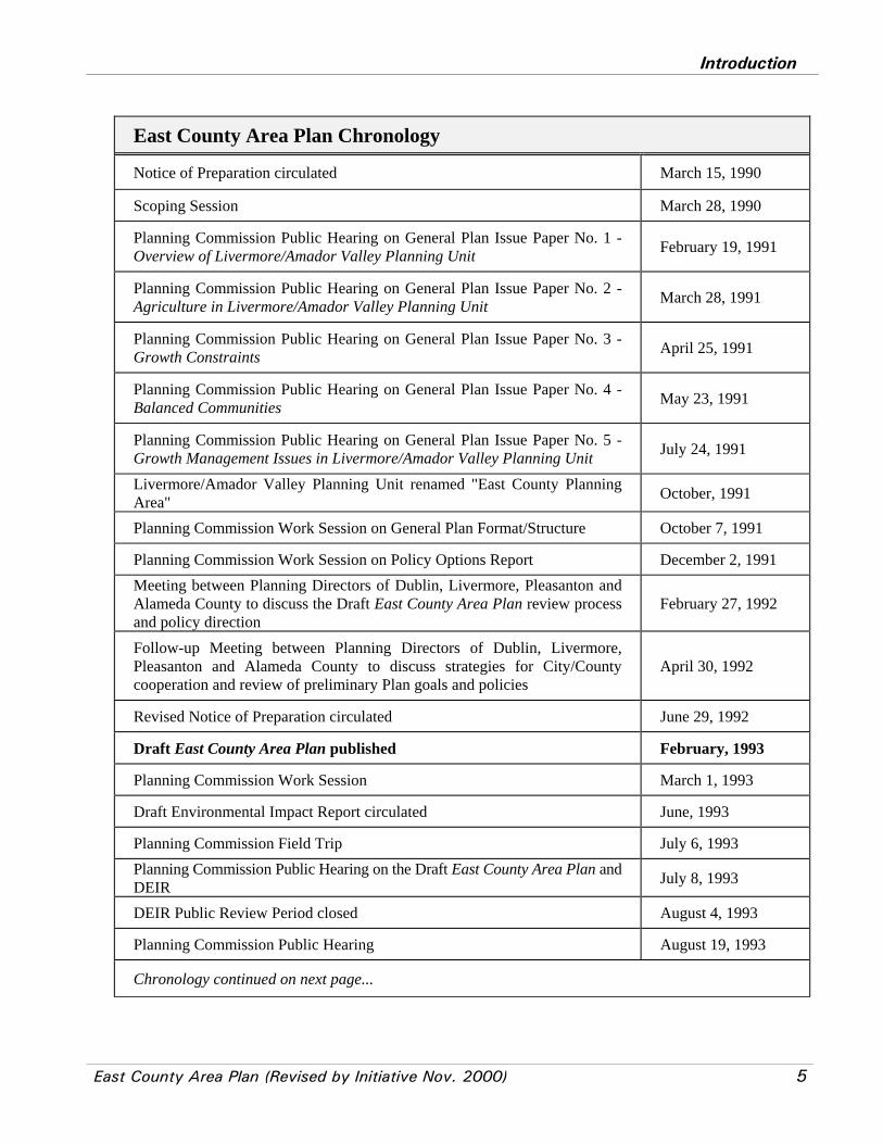
See the Chronology at the end of this chapter for more details about the planning process.

Introduction
4 East County Area Plan (Revised by Initiative Nov. 2000)
STRUCTURE OF THIS DOCUMENT
The East County Area Plan consists of two volumes: Volume 1: Goals, Policies and Programs, andVolume 2: Background Reports - Setting, Trends and Issues. Appendices at the end of the BackgroundReports contain detailed technical data. Bold typeface is used in Volume 1 to help the reader locate keywords and phrases used in the goals, policies and programs. A list of information sources can be found atthe end of each section in the Background Reports.
The Background Reports (Volume 2) are a compilation of reports that describe existing conditions as of1992 (unless otherwise specified) and trends based on changes occurring over the past few years and ongrowth projections. The Background Reports then identify planning issues arising from these trends. Dataand analysis contained in the Background Reports provide supporting documentation for the policies andprograms in the plan adopted in 1994.
The Goals, Policies and Programs (Volume 1) as adopted in 1994 originally expressed the County's intentwith respect to the policy implications arising from the Background Reports. However, subsequently, anumber of these goals, policies and programs have been modified by the provisions of the Measure DInitiative passed by the voters of Alameda County in November 2000. A goal is a general statement of acondition the County wants to achieve. Policies are focused statements of how the County will achievethe stated goals. Policies set standards that guide decision-makers and present a clear commitment toaction. Programs are discrete actions intended to implement the policies.
The land use diagram contained within this plan is a graphic expression of the plan's goals and policies. The diagram, which is parcel specific, specifically outlines the County Urban Growth Boundary (seeFigure 3) as defined under the Initiative, as well as illustrating general locations of land use designations. The State of California General Plan Guidelines (November 1990) state that the general plan diagram "...should be detailed enough so that the users of the plan...can reach the same general conclusion on theappropriate use of any parcel of land ..." while at the same time allowing "... a degree of flexibility indecision-making as times change."
RELATIONSHIP TO OTHER ELEMENTS OF THE GENERAL PLAN
The East County Area Plan is the first of three area plans covering the unincorporated county. Subsequentphases in the Alameda County General Plan review and update process will include preparation of twoother area plans, the Castro Valley Area Plan and the Eden Area Plan, as well as five updated andconsolidated countywide functional elements: 1) Regional Element; 2) Housing Element; 3) EnergyElement; 4) Natural Resources, Recreation and Open Space Element; and 5) Safety and Noise Element. Area plans address area specific issues (i.e., land use, open space, circulation, noise, seismic hazards,public facilities and services) that affect both unincorporated and incorporated areas, but have legalregulatory effect only within currently unincorporated areas. Functional elements address broader issueson a countywide basis and provide a comprehensive and consistent policy framework for the more specificarea plans.
Introduction
East County Area Plan (Revised by Initiative Nov. 2000) 5
East County Area Plan Chronology
Notice of Preparation circulated March 15, 1990
Scoping Session March 28, 1990
Planning Commission Public Hearing on General Plan Issue Paper No. 1 -Overview of Livermore/Amador Valley Planning Unit February 19, 1991
Planning Commission Public Hearing on General Plan Issue Paper No. 2 -Agriculture in Livermore/Amador Valley Planning Unit March 28, 1991
Planning Commission Public Hearing on General Plan Issue Paper No. 3 -Growth Constraints April 25, 1991
Planning Commission Public Hearing on General Plan Issue Paper No. 4 -Balanced Communities May 23, 1991
Planning Commission Public Hearing on General Plan Issue Paper No. 5 -Growth Management Issues in Livermore/Amador Valley Planning Unit July 24, 1991
Livermore/Amador Valley Planning Unit renamed "East County PlanningArea" October, 1991
Planning Commission Work Session on General Plan Format/Structure October 7, 1991
Planning Commission Work Session on Policy Options Report December 2, 1991Meeting between Planning Directors of Dublin, Livermore, Pleasanton andAlameda County to discuss the Draft East County Area Plan review processand policy direction
February 27, 1992
Follow-up Meeting between Planning Directors of Dublin, Livermore,Pleasanton and Alameda County to discuss strategies for City/Countycooperation and review of preliminary Plan goals and policies
April 30, 1992
Revised Notice of Preparation circulated June 29, 1992
Draft East County Area Plan published February, 1993
Planning Commission Work Session March 1, 1993
Draft Environmental Impact Report circulated June, 1993
Planning Commission Field Trip July 6, 1993Planning Commission Public Hearing on the Draft East County Area Plan andDEIR July 8, 1993
DEIR Public Review Period closed August 4, 1993
Planning Commission Public Hearing August 19, 1993
Chronology continued on next page...
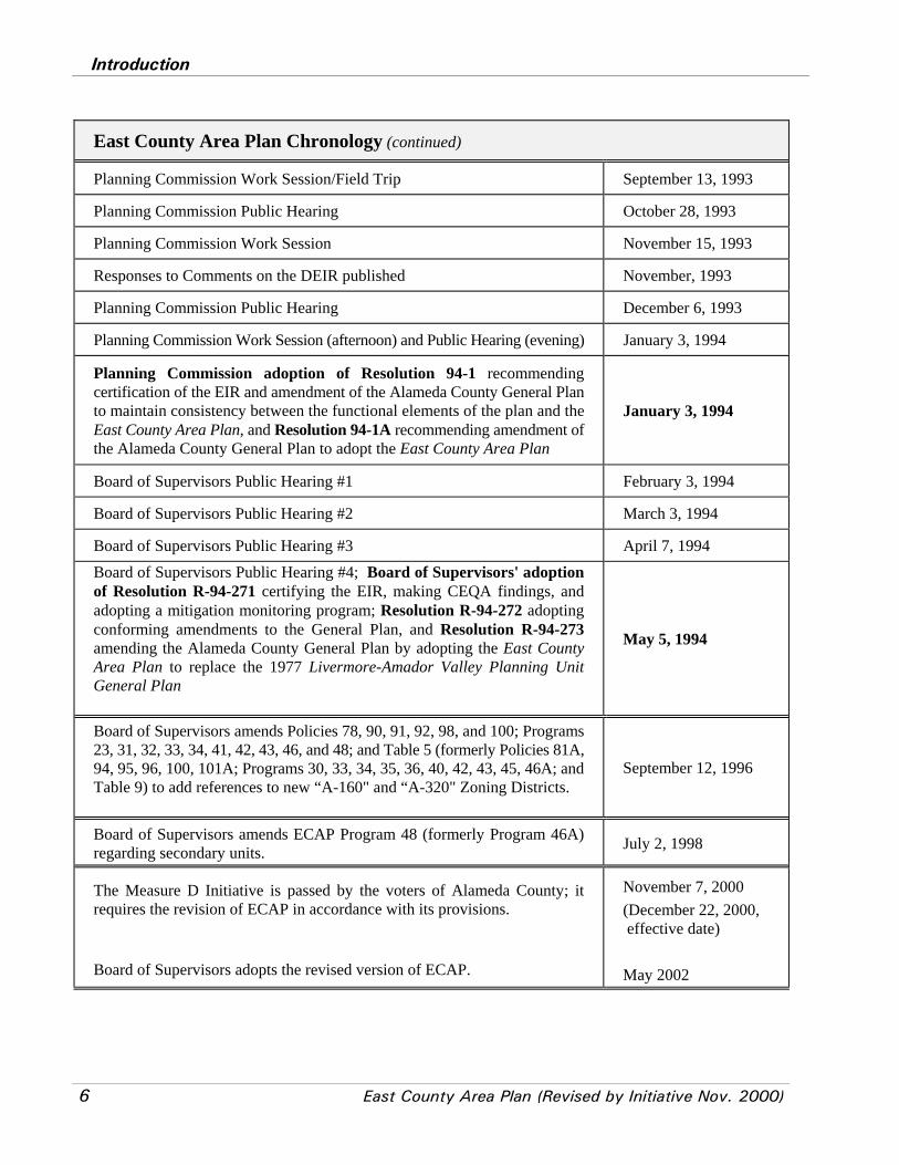
Introduction
6 East County Area Plan (Revised by Initiative Nov. 2000)
East County Area Plan Chronology (continued)
Planning Commission Work Session/Field Trip September 13, 1993
Planning Commission Public Hearing October 28, 1993
Planning Commission Work Session November 15, 1993
Responses to Comments on the DEIR published November, 1993
Planning Commission Public Hearing December 6, 1993
Planning Commission Work Session (afternoon) and Public Hearing (evening) January 3, 1994
Planning Commission adoption of Resolution 94-1 recommendingcertification of the EIR and amendment of the Alameda County General Planto maintain consistency between the functional elements of the plan and theEast County Area Plan, and Resolution 94-1A recommending amendment ofthe Alameda County General Plan to adopt the East County Area Plan
January 3, 1994
Board of Supervisors Public Hearing #1 February 3, 1994
Board of Supervisors Public Hearing #2 March 3, 1994
Board of Supervisors Public Hearing #3 April 7, 1994Board of Supervisors Public Hearing #4; Board of Supervisors' adoptionof Resolution R-94-271 certifying the EIR, making CEQA findings, andadopting a mitigation monitoring program; Resolution R-94-272 adoptingconforming amendments to the General Plan, and Resolution R-94-273amending the Alameda County General Plan by adopting the East CountyArea Plan to replace the 1977 Livermore-Amador Valley Planning UnitGeneral Plan
May 5, 1994
Board of Supervisors amends Policies 78, 90, 91, 92, 98, and 100; Programs23, 31, 32, 33, 34, 41, 42, 43, 46, and 48; and Table 5 (formerly Policies 81A,94, 95, 96, 100, 101A; Programs 30, 33, 34, 35, 36, 40, 42, 43, 45, 46A; andTable 9) to add references to new “A-160" and “A-320" Zoning Districts.
September 12, 1996
Board of Supervisors amends ECAP Program 48 (formerly Program 46A)regarding secondary units. July 2, 1998
The Measure D Initiative is passed by the voters of Alameda County; itrequires the revision of ECAP in accordance with its provisions.
Board of Supervisors adopts the revised version of ECAP.
November 7, 2000(December 22, 2000, effective date)
May 2002
Goals, Policies and Programs - Land Use
East County Area Plan (Revised by Initiative Nov. 2000) 7
II. GOALS, POLICIES AND PROGRAMS
Subregional PlanningUrban/Open Space Delineation
Goal: To clearly delineate areas suitable for urban development and open space areas for long-termprotection of natural resources, agriculture, and public safety.
Policies
*Policy 1: The County shall identify and maintain a County Urban Growth Boundary that divides areasinside the Boundary, next to existing cities, generally suitable for urban development from areas outsidesuitable for long-term protection of natural resources, agriculture, public health and safety, and buffersbetween communities. The County Urban Growth Boundary shall be the Urban Growth Boundary of theCity of Pleasanton starting at its eastern junction with U.S. I-580 clockwise to U.S. I-580, west to theboundary of the East County Area Plan, north to the proposed western Urban Growth Boundary for theCity of Dublin on the November 7, 2000 election ballot, to the Alameda-Contra Costa County line, eastto the eastern boundary of the East Dublin Specific Plan on February 1, 2000, south to U.S. I-580, east tothe city limits of the City of Livermore, the northern Livermore city limits, except where the northern citylimits are below U.S. I-580 the Boundary shall be I-580, to the eastern city limits of Livermore, to theproposed southern Urban Growth Boundary for Livermore on the March 7, 2000 election ballot to U.S.I-580, and west to the City of Pleasanton Urban Growth Boundary.
*Policy 2: The County shall identify urban designations on the Land Use Diagram (inclusive ofincorporated and unincorporated areas of East County) sufficient to accommodate projected growth. Urban designations in unincorporated areas shall be contained within the County Urban Growth Boundaryand shall not be expanded to accommodate lower than planned densities.
Interjurisdictional Coordination
Goal: To foster cooperative planning and implementation in East County.
Policies
Coordination
Policy 3: The County shall work with cities and other agencies in planning land use andinfrastructure to achieve the goals of the East County Area Plan using a cooperative approachthat recognizes those environmental, social, and economic characteristics of the subregion (seeFigure 2) that extend beyond jurisdictional boundaries.

Land Use
8 East County Area Plan (Revised by Initiative Nov. 2000)
Policy 4: The County shall actively consult with East County cities during formulation of Countyland use plans and projects that have potential subregional impacts, and shall encourage cities toreciprocate.
Policy 5: The County shall continue to participate in the Tri-Valley Council in an effort to shareinformation and coordinate land use and transportation planning.
Policy 6: The County shall work with cities to present a unified position representing East Countyinterests in whatever form of regional government that may be created by the CaliforniaLegislature.
Fiscal Equity
Policy 7: The County shall work with cities toward reducing the fiscal motives that currently driveland use and planning decisions throughout the subregion. To this end, the County shall work withcities in an effort to equalize the costs and benefits of development to encourage a regionallybeneficial land use pattern and minimize competition among local jurisdictions.
Policy 8: The County shall work with cities toward the equitable distribution of property taxrevenues and development fees based on the cost and location of services provided.
Policy 9: The County shall actively seek new revenue sources to achieve the goals of the EastCounty Area Plan but shall not encourage the allocation of a disproportionate share of the County'sfinancial resources to the East County planning area.
Implementation Programs:
Coordination
Program 1: The County shall work with cities and special districts to achieve consistency of local generalplans and service plans with the East County Area Plan, especially in terms of holding capacity limits,infrastructure requirements, jobs/housing balance, affordable housing targets and open space acquisitionprograms.
Program 2: The County shall promote consistency among local general plans in cooperation with cities andshall participate in efforts to create a common land use and environmental database, transportation model,performance standards for new development, and recommendations for a regional infill strategy thatincludes incentives for redesignating surplus commercial and industrial lands to meet housing needs.
Fiscal Equity
Program 3: The County shall review and revise its tax sharing policies in order to encourage cooperativeplanning which achieves the goals of the East County Area Plan. When a city applies to the AlamedaCounty Local Agency Formation Commission (LAFCO) to annex unincorporated land, the County willevaluate the conformance of the city-proposed land uses and infrastructure plans with the East County AreaPlan and may adjust the city/county tax share accordingly.

Goals, Policies and Programs - Land Use
East County Area Plan (Revised by Initiative Nov. 2000) 9
Program 4: The County shall work with cities to develop fee programs to fund subregional facilities (suchas public hospitals, jails, and government offices), affordable housing (for low- and very low-incomehouseholds), and open space to serve East County residents.
Land Use
10 East County Area Plan (Revised by Initiative Nov. 2000)
Urban and Rural Development
Location: Incorporated and Unincorporated
Goal: To achieve a balanced subregion featuring compact communities, a diverse economic base,affordable housing, and a full complement of public facilities and amenities.
Policies
Phasing
*Policy 10: The County shall require that development be phased according to the availability ofinfrastructure and public services allowed by the Initiative, and in conformance with policies whichencourage compact development.
Policy 11: The County shall support phased development in East Dublin to provide for theefficient planning of infrastructure and prevent urban sprawl in the Dublin Hills. The County shallencourage the City of Dublin to include the 600 acre Santa Rita property in the first phase ofdevelopment.
Policy 12: The County shall work with cities and service districts to plan adequate infrastructurecapacity to accommodate development consistent with the East County Area Plan. The level ofdevelopment in the East County Area Plan shall depend on the adequacy of transportation andinfrastructure improvements and the extent to which these improvements can be funded.
Policy 13: The County shall not provide nor authorize public facilities or other infrastructure inexcess of that needed for permissible development consistent with the Initiative. This policy shallnot bar 1) new, expanded or replacement infrastructure necessary to create adequate service for theEast County, 2) maintenance, repair or improvements of public facilities which do not increasecapacity, and 3) infrastructure such as pipelines, canals, and power transmission lines which haveno excessive growth-inducing effect on the East County area and have permit conditions to ensurethat no service can be provided beyond that consistent with development allowed by the Initiative. “Infrastructure” shall include public facilities, community facilities, and all structures anddevelopment necessary to the provision of public services and utilities.
Jobs/Housing
Policy 14: The County shall promote an approximate balance between jobs and housing withinEast County and shall further promote a range of housing types reflecting the income distributionof the local employment base.
Policy 15: The County shall evaluate all proposed major projects for their effect on the East Countyjobs/housing ratio and the provision of housing affordable to East County workers as well as thepotential impacts on adjacent counties, especially in terms of in-commuting. To the extent feasible,
Goals, Policies and Programs - Land Use
East County Area Plan (Revised by Initiative Nov. 2000) 11
the County shall impose measures on projects in the unincorporated County to reduce potentialimpacts arising from inadequate provision of housing, and shall encourage the cities to do the same.
Urban Growth Boundary
Policy 16: The County shall approve urban development (see definition in Table 1) only if it islocated within the Urban Growth Boundary.
Policy 17: The County shall support the eventual city annexation or incorporation of all existingand proposed urban development within the Urban Growth Boundary consistent with the EastCounty Area Plan.
Infill Development
Policy 18: The County shall encourage East County cities to promote infill development includingthe conversion of excess industrial and commercial land to residential uses.
Policy 19: The County shall encourage cities in west Alameda County to promote infilldevelopment (both residential and employment-generating) and the conversion of excess industrialand commercial land to residential uses.
Policy 20: The County shall encourage infill in unincorporated urban areas in Castro Valley andthe Eden area in west Alameda County.
Rural Residential Development
Policy 21: The County shall recognize existing rural residential development outside the UrbanGrowth Boundary including Sunol, Tesla Road, South Livermore, Midway, Mines Road, LittleValley Road, Welch Creek Road, and other existing rural residential areas.
Policy 22: The County shall work with the City of Dublin to exclude development from steephillsides (shown as Rural Residential in the Eastern Dublin Specific Plan) and from Doolan Canyonand establish programs to acquire these areas as part of a contiguous open space system.
Development Fees
Policy 23: The County shall recognize that compact development results in more efficient use ofland and infrastructure, less conversion of open space and more affordable housing, than low-density sprawl. To encourage compact development, the County shall provide economic incentivesto developers who provide higher densities and affordable housing.
Policy 24: The County shall encourage the Tri-Valley Transportation Council to reducesubregional transportation fees for qualifying high density housing projects constructed adjacentto transit stations.
Land Use
12 East County Area Plan (Revised by Initiative Nov. 2000)
Policy 25: The County shall require new developments in unincorporated areas to pay their fairshare of the costs for providing East County infrastructure, public facilities and services, openspace, affordable housing, and child care.
Implementation Programs:
Phasing
Program 5: The County shall encourage East County cities to modify their general plans, when they arebeing updated, to achieve consistency with East County Area Plan policies regarding affordable housing,and open space protection and acquisition.
*Program 6: The County shall work with cities to develop a Master Plan for public facilities, services, andamenities for East County, similar to Pleasanton's Municipal Facilities Master Plan. The Master Plan shalladdress the potential for shared use of public facilities, such as joint use of neighborhood parks and schoolplaygrounds.
Jobs/Housing Balance
Program 7: The County shall work with cities to develop an incentive system to provide a range of housingunit types which reflects the income distribution of the local employment base. The incentive system couldinclude density bonuses, use of low income housing fees, inclusionary zoning programs, fee waivers, low-income set asides within large projects, and joint development with non-profit housing corporations.
Development Fees
Program 8: The County shall develop, where possible, a sliding scale fee schedule for affordable housing,open space, and subregional facility fees required of developers. In order to encourage compact residentialdevelopment, discourage low density sprawl, and encourage the production of affordable housing, the feeschedule shall be based on a sliding scale in which fees would generally decrease as the density ofdevelopment and amount of affordable housing increases.
Residential Uses
*Goal: To provide an adequate supply of housing in a range of densities to meet State requirements, toaccommodate projected housing growth consistent with this Plan and to respond to the needs of allincome groups.
Policies
County Housing Obligations
*Policy 26: Nothing in the Initiative shall be applied to preclude County compliance with housingobligations under State law. To the maximum extent feasible, the County shall meet State housingobligations for the East County Area within the County Urban Growth Boundary. In providing

Goals, Policies and Programs - Land Use
East County Area Plan (Revised by Initiative Nov. 2000) 13
required housing, the County shall protect environmental values, enhance the quality of life ofaffected persons, and comply with policies and programs of the Initiative to the maximum extentfeasible.
If State-imposed housing obligations make it necessary to go beyond the Urban Growth Boundary,the voters of the County may approve an extension of the Boundary. The Board of Supervisors mayapprove housing beyond an Urban Growth Boundary only if:
1. it is indisputable that there is no land within the Urban Growth Boundary to meet a Statehousing requirement either through new development, more intensive development, orredevelopment;
2. no more land is used outside the Urban Growth Boundary than is required by the affordablehousing necessary to meet a State obligation;
3. the area is adjacent to the Urban Growth Boundary, or to an existing urban or intensiveresidential area;
4. the percentage goals for low- and very low-income housing in Policy 36 will be met in anyhousing approved;
5. there will be adequate public facilities and services for the housing; and 6. the development shall not be on prime agricultural lands, or lands designated, at least
conditionally, for intensive agriculture, unless no other land is available under this policy.
In no case shall required housing be built on or which protrudes over hilltops or ridgelines, onslopes of more than 20 % critical wildlife habitat, or within 100 feet of a riparian corridor.
Density
Policy 27: The County shall promote a diversity of housing types and densities within residentialareas, including a mix of high-, medium-, and low-densities.
Policy 28: The County shall encourage cities to increase maximum allowable densities and torequire residential projects within high density residential designations to achieve an averagedensity at or above the mid-point of the applicable density range in city general plans.
Policy 29: The County shall facilitate the development of high density housing near proposedBART stations. Such development may be considered for exemption or reduction of subregionaltransportation fees.
Type of Unit
Policy 30: The County shall encourage high density multiple family housing near transit and incommunity centers but shall also ensure that some multiple family housing is dispersed throughoutnew residential areas.*Policy 31: The County shall require a phasing plan for residential projects that determines whenaffordable housing units (including very-low, low-, and moderate-income units) will be built in
Land Use
14 East County Area Plan (Revised by Initiative Nov. 2000)
each residential project. The phasing plan shall ensure that the majority of multiple family andaffordable housing units are not postponed until the final phases of development. Affordable unitsshall be reasonably dispersed throughout the project. The County shall work with cities to requirethe same policies within incorporated areas.
Policy 32: The County shall work with housing developers to provide small, moderately pricedsingle family homes with expansion potential for sale to first time home buyers.
Owner and Rental Units
Policy 33: The County shall promote development of sufficient rental housing to meet theprojected needs of the population. To this end, the County shall encourage the production of rentalunits which meet the needs of very-low and low-income households throughout East County.
Policy 34: The County shall work with non-profit housing developers to provide very low- andlow-income rental units and low- and moderate-income for-sale units and shall encourage jointventures between for-profit and non-profit housing developers within East County.
Income Level
Policy 35: The County shall attempt to meet unincorporated East County regional housing shareobjectives for all income categories within East County to minimize the need for low- andmoderate-income households to seek housing in San Joaquin and Northern Contra Costa Counties.The County shall encourage cities to meet their respective incorporated city regional housing shareobjectives within East County.
*Policy 36: The County shall work with cities to attain the Association of Bay Area Governmentsregional housing share goal (established in the County Housing Element for East County) of 21percent moderate-income, 15 percent low-income, and 21 percent very low-income housing unitsthroughout East County.
*Policy 37: The County shall require each residential and non-residential project to contribute tomeeting the housing needs of very low-, low- and moderate-income households (see definitionin Table 1). All residential developments of 20 or more units, whether for rental or sale, mustinclude and maintain affordable housing units. Developers may choose the percentage of affordablehousing units depending on the degree of affordability provided; either 10 percent very low income,15 percent low income, or 20 percent moderate income, or a fraction of each of these adding to 1. Affordability must be permanently ensured through deed restrictions.
Policy 38: The County shall require that major residential projects (see definition in Table 1)contribute towards the goal of 21 percent very-low, 15 percent low- and 21 percent moderate-income housing units. Contributions towards achieving these goals should be made throughfinancial support together with subsidies from other sources (e.g., federal tax credits). Low- andmoderate-income units may be built in the project or elsewhere in East County.

Goals, Policies and Programs - Land Use
East County Area Plan (Revised by Initiative Nov. 2000) 15
Policy 39: The County shall work with the Tri-Valley Affordable Housing Committee to poolCounty and city resources to facilitate the development of low- and moderate-income housingwithin the Tri-Valley.
General
Policy 40: The County shall require all new residential development to meet County standards foradequate road access, sewer and water facilities, fire protection, building envelope location, visualcompatibility, and public services.
Policy 41: The County shall allow creation of new urban residential building sites only in areaslocated inside the Urban Growth Boundary which have public water and sewer service.
Implementation Programs:
Program 9: The County shall work with cities to adjust their general plan land use designations as necessaryto achieve a jobs/housing balance and density and affordable housing goals.
*Program 10: The County shall adopt an ordinance establishing a low- and very low-income housing feeto be applied to all new unincorporated market rate housing and non-residential development that do notdirectly provide their fair share of housing under Policy 37. For residential development, the fee shall aimgenerally at covering the cost of providing a fair share of low and very low income housing not otherwiseprovided proportionate to the size of the development. Non-residential development fees should be relatedto the affordable housing needs that can reasonably be attributed to the development. Payment of the in-lieu fee shall be made prior to the issuance of an occupancy certificate.
Program 11: The County shall adopt an ordinance establishing a low- and very low-income housing trustfund to accrue housing fee revenues and to disperse them for low- and very low-income housingdevelopment.
Industrial/Commercial/Office Uses and Economic Development
Goal: To promote economic development and to provide an adequate supply of industrial/commercial/office acreage to achieve an appropriate balance of jobs and housing.
Policies
Industrial/Commercial/Office Uses
*Policy 42: The County shall work with cities to designate an adequate, but not excessive, supplyof land for industrial, commercial, and office development to meet East County needs consistentwith the Initiative.
Land Use
16 East County Area Plan (Revised by Initiative Nov. 2000)
Policy 43: The County shall require new unincorporated industrial, commercial, and officedevelopments to pay their fair share of the costs for providing East County infrastructure, publicfacilities and services, open space, affordable housing, and child care.
Economic Development
Policy 44: The County shall encourage a diversity of job producing industries that reflect the skillsof the local labor force to locate in the East County area.
Policy 45: The County shall provide incentives, such as fee reductions, streamlined permitprocessing, and infrastructure placement, to existing industries to remain in the East Countyplanning area.
Policy 46: The County shall seek development of back office space to accommodate serviceindustry employment opportunities for low-skill workers.
Policy 47: The County shall recognize the Livermore Laboratories as a job-producing resourceof countywide and regional significance.
Implementation Programs:
Industrial/Commercial/Office Uses
Program 12: The County shall work with cities to adjust their general plan land use designations asnecessary to achieve a jobs/housing balance.
Program 13: The County shall work with cities to develop a program for industrial, commercial, and officedevelopments within incorporated and unincorporated areas to address the availability, affordability, andquality of child care.
Economic Development
Program 14: The County shall work with the Alameda County Economic Development Advisory Boardto coordinate industry recruitment for the East County planning area.
Program 15: The County shall work with the Alameda County Economic Development Advisory Boardto identify existing industries considering relocation outside the County and provide incentives, such asfee reductions, streamlined permit processing, and infrastructure placement for existing plant expansion.
Program 16: The County shall work with the Alameda County Economic Development Advisory Boardto promote investment in telecommunications and other technical infrastructure that will be required toattract service businesses to East County.
Program 17: The County shall work with the Alameda County Economic Development Advisory Boardto develop job training programs (e.g., computers, electronic technology),to improve the skills of thelocal labor force, and social programs (e.g., child care and job placement).

Goals, Policies and Programs - Land Use
East County Area Plan (Revised by Initiative Nov. 2000) 17
Community Facilities
Goal: To provide a full range of community facilities to maintain and improve service levels and thequality of life for existing and future residents.
Policies
Policy 48: The County shall promote the development of a full range of accessible neighborhoodfacilities including elementary schools, parks, and other amenities.
Policy 49: The County shall require new developments to pay their fair share of the costs ofproviding community facilities.
*Policy 50: The County shall promote the location of community facilities near majortransportation corridors and within existing city downtown areas.
Implementation Programs:
Program 18: The County shall work with cities to develop a subregional facility fee for all new EastCounty developments within incorporated and unincorporated areas to pay their fair share of the costs fornecessary future community facilities such as public hospitals, libraries, jails, and cultural facilities.

Land Use
18 East County Area Plan (Revised by Initiative Nov. 2000)
Sensitive Lands and Regionally Significant OpenSpace
General Open Space
Goal: To protect regionally significant open space and agricultural land from development
Policies
General Open Space
Policy 51: The County shall work with East County cities to preserve a continuous open spacesystem outside the Urban Growth Boundary with priority given to the permanent protection of theResource Management area between Dublin and North Livermore and the area north of the UrbanGrowth Boundary in North Livermore, as established through Program 19.
Policy 52: The County shall preserve open space areas for the protection of public health andsafety, provision of recreational opportunities, production of natural resources (e.g., agriculture,windpower, and mineral extraction), protection of sensitive viewsheds (see definition in Table 1),preservation of biological resources, and the physical separation between neighboring communities(see Figure 4).
Policy 53: The County shall preserve a continuous band of open space consisting of a variety ofplant communities and wildlife habitats to provide comprehensive, rather than piecemeal, habitatconservation for all of East County. This open space should, as much as possible, be outside of theUrban Growth Boundary and contiguous to large open space areas of Contra Costa, Santa Clara,and San Joaquin Counties.
Policy 54: The County shall approve only open space, park, recreational, agricultural, limitedinfrastructure, public facilities (e.g., limited infrastructure, hospitals, research facilities, landfillsites, jails, etc.) and other similar and compatible uses outside the Urban Growth Boundary.
Policy 55: The County shall use zoning and explore the use of other mechanisms such as purchaseor dedication of easements through density transfer or density bonuses and fee purchase to preserveopen space outside the Urban Growth Boundary.
*Policy 56: The County shall require all new developments to dedicate or acquire land for openspace and/or pay equivalent in-lieu fees which shall be committed to open space land acquisitionand management and shall encourage the cities to impose similar open space requirements ondevelopment in incorporated areas.
Policy 57: The County shall encourage the Alameda County Open Space Land Trust (see program21) to acquire fee title or easements on strategic parcels that would permanently secure the UrbanGrowth Boundary and complete the continuous open space system surrounding Eastern Dublin,

Goals, Policies and Programs - Land Use
East County Area Plan (Revised by Initiative Nov. 2000) 19
North Livermore, South Livermore, and the existing cities of Pleasanton, Dublin and Livermore.
Policy 58: The County shall encourage the Alameda County Open Space Land Trust (see definitionin Table 1) to acquire open space easements accompanied by agreements to carry out appropriatemanagement practices, whenever feasible, in lieu of fee acquisition in order to maintain open spaceland on property tax roles.
Policy 59: The County shall encourage the Alameda County Open Space Land Trust to acquireopen space land in fee title, through purchase or dedication, when it is necessary to provide publicaccess or to ensure suitable land management practices.
Policy 60: The County shall encourage active public use of publicly-owned open space lands closeto existing and planned communities in locations where such use does not conflict with theprotection of biological resources.
Policy 61: The County shall ensure that management objectives, funding and maintenanceresponsibilities are clearly identified for all open space lands to be acquired in fee or througheasements by the Alameda County Open Space Land Trust. The County shall work with the LandTrust to further ensure that adequate funds are available to carry out on-going open spacemanagement activities.
Policy 62: The County shall require that open space provided as part of a development project bedesigned to achieve open space objectives (e.g., recreation, viewshed, community separation,riparian protection, public safety).
Policy 63: The County shall require that open space within developed areas be designed andmaintained to minimize fire hazards and ensure compatibility between development and anysignificant biological resources.
Specific Open Space Areas
Policy 64: The County shall designate the Vargas Plateau and the Sheridan Road areas foragricultural and other open space uses. The County shall participate with the cities of Fremont andUnion City in their planning studies for the open space areas to the east of the cities' boundaries,and shall encourage Fremont and Union City to designate the areas as community separatorsbetween the cities and East County.
Policy 65: The County shall work cooperatively with the cities of Pleasanton and Hayward, theCastro Valley community, the East Bay Regional Park District (EBRPD), and landowners to retainPleasanton Ridgelands as permanent open space and reserve a regional trail corridor connectingSunol with the West Dublin hills. Accordingly, the County shall oppose city sphere of influenceexpansions and annexations outside the Urban Growth Boundary in this area for purposes of urbandevelopment.
Policy 66: The County shall encourage the City of Dublin to designate West Dublin for agriculturalor open space uses to serve as a community separator and to reserve a regional trail corridor

Land Use
20 East County Area Plan (Revised by Initiative Nov. 2000)
connecting the San Ramon westside hills with Pleasanton Ridge, consistent with the East CountyArea Plan.
Policy 67: The County shall recognize West Dublin as a valuable open space buffer separating thecommunity of Castro Valley from the East County planning area. The County shall encourage theCity of Dublin to retain this area as open space to be consistent with the County's designation ofthis area as "Large Parcel Agriculture."
Policy 68: The County shall encourage the City of Dublin to:
1. redesignate in the Eastern Dublin General Plan Amendment area all Rural Residential (RR)land designated by Dublin easterly of Fallon Road, as well as Doolan Canyon, as "ResourceManagement," consistent with the East County Area Plan. Allowable uses may includeagriculture, grazing, recreational, and open space uses. This shall not apply to any lands withurban designations as adopted in the Eastern Dublin Specific Plan.
2. work with the Alameda County Open Space Land Trust to acquire parcels designated by Dublinas "Rural Residential" in Eastern Dublin, through purchase of fee title or easements with openspace fees, by means of dedication and/or through density transfer or other fundingmechanisms.
3. require that land use activities conducted within this area adhere to management guidelinesdeveloped for the protection of biological resources.
Policy 69: The County shall work with San Joaquin, Contra Costa, and Santa Clara Counties toensure that land uses adjacent to Alameda County open space lands are compatible with open spaceuses. The County shall ensure that land uses within Alameda County adjacent to San Joaquin,Contra Costa, and Santa Clara Counties are compatible with adjacent open space lands in theseother counties.
Policy 70: The County shall work with the East Bay Regional Park District (EBRPD), theLivermore Area Recreation and Park District (LARPD), and other relevant agencies to ensure thatopen space trails adjacent to San Joaquin, Contra Costa, and Santa Clara Counties connect withtrail systems in these other counties.
Implementation Programs:
General Open Space
*Program 19: The County shall work with East County cities to develop a comprehensive open spacepreservation program, establish priorities, and identify feasible mechanisms for acquisition or dedicationof land in open space areas within two years of the effective date of the Initiative. In addition to impactfees on new urban development, the program shall analyze other land acquisition techniques includingdedication of easements in return for development rights and/or bonuses, transfer of development credits,and bonds or other fees/funds for land acquisition.
Goals, Policies and Programs - Land Use
East County Area Plan (Revised by Initiative Nov. 2000) 21
Program 20: The County shall adopt an open space dedication and/or in-lieu fee requirement applicableto all residential and industrial, commercial, and office developments within unincorporated areas to fundthe purchase of land within the continuous open space system and provide an endowment for on-goingmanagement of open space lands. The County shall work with cities to develop and adopt an open spacededication and in-lieu fee requirement consistent with the County requirement.
Program 21: The County shall work with cities to establish a non-profit Alameda County Open SpaceLand Trust to acquire lands within the East County open space system to other public agencies and, whereappropriate, convey title or easements to other public agencies. The Land Trust can use developerdedication, fee purchase, open space or access easements, and other mechanisms to acquire andpermanently preserve a continuous open space system outside the Urban Growth Boundary. Parcels forwhich fee title has been acquired should be conveyed to the appropriate public agency to expand watermanagement (see definition in Table 6) or regional park lands, when necessary to achieve the open spaceand resource management objectives of the East County Area Plan. In the event that a County Open SpaceLand Trust and a South Livermore Valley Agricultural Land Trust are both formed, administrative andother functions may be shared by the two trusts in order to reduce costs.
Program 22: The County shall develop management guidelines to implement specific resourcemanagement objectives for watershed and biological resource protection to apply to those lands designatedas "Resource Management" (see Figure 4).
Program 23: The County shall work with the Livermore Area Recreation and Park District (LARPD), theEast Bay Regional Park District (EBRPD), and the San Francisco Water Department to incorporatecontinuous open space areas outside the Urban Growth Boundary into the Bay Area Greenbelt system (seedefinition in Table 1). Program 24: The County shall work with the East Bay Regional Park District, the Livermore AreaRecreation and Park District, the San Francisco Water Department, California Department of Fish andGame, and cities to identify appropriate public and private uses that should be allowed within variousportions of the open space system, including active and passive recreation, and grazing.
Specific Open Space Areas
Program 25: The County shall work with East County cities and Hayward to complete the continuous openspace system in South Pleasanton, Pleasanton Ridge, and West Dublin using zoning, dedication, feepurchase, density transfer, and agriculture/open space easements.
Program 26: The County shall undertake a study of potential open space, recreational, and related uses inthe Pleasanton Ridge area.
Program 27: The County shall develop workable mechanisms to finance and acquire lands for public usein the Pleasanton Ridge area.

Land Use
22 East County Area Plan (Revised by Initiative Nov. 2000)
Agriculture
Goal: To maximize long-term productivity of East County's agricultural resources.
Policies
Preservation of Productive Soils
Policy 71: The County shall conserve prime soils (Class I and Class II, as defined by the USDASoil Conservation Service Land Capability Classification) and Farmland of Statewide Importanceand Unique Farmland (as defined by the California Department of Conservation Farmland Mappingand Monitoring Program) outside the Urban Growth Boundary.
Policy 72: The County shall preserve the Mountain House area for intensive agricultural use (seedefinition in Table 1).
Incompatible Uses
Policy 73: The County shall require buffers between those areas designated for agricultural use andnew non-agricultural uses within agricultural areas or abutting parcels. The size, configuration anddesign of buffers shall be determined based on the characteristics of the project site and theintensity of the adjacent agricultural uses, and if applicable, the anticipated timing of futureurbanization of adjacent agricultural land where such agricultural land is included in a phasedgrowth plan. The buffer shall be located on the parcel for which a permit is sought and shallprovide for the protection of the maximum amount of arable, pasture, and grazing land feasible.
Policy 74: The County shall require that, where conflicts between a new use and existing use areanticipated, the burden of mitigating the conflicts be the responsibility of the new use.
Policy 75: The County shall enforce the provisions of the Alameda County Right-to-FarmOrdinance on all lands within and adjacent to agricultural areas.
Policy 76: The County shall work with San Joaquin, Contra Costa, and Santa Clara Counties toensure that any development adjacent to Alameda County agricultural land mitigates impacts onagricultural land including air quality, water quality and incompatibilities with agricultural uses.In particular, measures to mitigate growth-inducing impacts of development on agricultural landin Alameda County shall be addressed through cooperative efforts among the counties. The Countyshall ensure that land uses within Alameda County adjacent to San Joaquin, Contra Costa, andSanta Clara Counties are compatible with adjacent agricultural uses in these other counties.
Agricultural Support Services
Policy 77: The County shall support the construction of accessory farm structures (e.g., barns,animal feed facilities, and silos) on agricultural parcels.
Goals, Policies and Programs - Land Use
East County Area Plan (Revised by Initiative Nov. 2000) 23
*Policy 78: In areas designated Large Parcel Agriculture, the County shall permit agriculturalprocessing facilities (for example wineries, olive presses) and limited agricultural support serviceuses that primarily support Alameda County agriculture, are not detrimental to existing or potentialagricultural uses, demonstrate an adequate and reliable water supply, and comply with the otherpolicies and programs of the Initiative.
Policy 79: The County shall require any proposal for agricultural support service uses withinareas designated "Large Parcel Agriculture" or "Resource Management" to meet at a minimum thefollowing criteria:
• The project will not require the extension of public sewer or water.
• The project will not detract from agricultural production on-site or in the area.
• The project will not create a concentration of commercial uses in the area.
• The project is compatible with and will not adversely affect surrounding uses.
Policy 80: The County shall support the construction of on-site housing for farm employees whorequire full-time, on-site residency. Potential impacts on agricultural uses, and biological andgeotechnical factors shall be taken into consideration in the siting of such housing.
Visitor-Serving Commercial Uses
Policy 81: The County shall give the highest priority in areas designated "Large ParcelAgriculture" to agricultural operations. Visitor-serving commercial facilities (such as wineries,inns, and food and beverage stores) shall be limited to facilities that promote agriculture and aresubordinate and directly related to the area's agricultural production.
*Policy 82: In areas designated Large Parcel Agriculture, the County shall permit limitedagriculture enhancing commercial uses that primarily support the area’s agricultural production,are not detrimental to existing or potential agricultural use, demonstrate an adequate and reliablewater supply, and comply with other policies and programs of the Initiative.
Policy 83: The County shall require any proposal for a visitor-serving commercial use in anagricultural area to meet all of the following criteria:
• The project will primarily promote agricultural products grown or processed in AlamedaCounty;
• The project is compatible with existing agricultural production activities in the area;
• The project mitigates, to the satisfaction of the County, all potential conflicts with surroundingagricultural uses and other environmental impacts; and
Land Use
24 East County Area Plan (Revised by Initiative Nov. 2000)
• The project can demonstrate an adequate and reliable water source that does not significantlydiminish the availability of water to serve existing or potential agricultural use.
Economic Incentives
Policy 84: The County shall provide incentives to landowners to stimulate agricultural investmentsand enhance the economic viability of agriculture.
Williamson Act Contracts
Policy 85: The County shall utilize provisions of the Williamson Act and other appropriateeconomic incentives to support agricultural uses.
*Policy 86: The County shall not approve cancellation of Williamson Act contracts within oroutside the County Urban Growth Boundary except where findings can be made in accordance withstate law, and the cancellation is consistent with the Initiative. In no case shall contracts outside theUrban Growth Boundary be canceled for purposes inconsistent with agricultural or public facilityuses. Prior to canceling any contract inside the County Urban Growth Boundary, the Board ofSupervisors shall specifically find that there is insufficient non-contract land available within theBoundary to satisfy state-mandated housing requirements. In making this finding, the County shallconsider land that can be made available through reuse and rezoning of non-contract land.
Preservation of Agricultural Lands Outside the Urban Growth Boundary
Policy 87: The County shall encourage the establishment and permanent protection of existing andnew cultivated agriculture through the use of homesite clustering, agricultural easements, densitybonuses, or other means.
Policy 88: The County shall encourage the cities in East County to adopt policies and programs(such as mitigation fees for the conversion of agricultural lands within city boundaries and on landsto be annexed to a city) to fund the Alameda County Open Space Land Trust for protection ofresources and the preservation of a continuous open space system outside the Urban GrowthBoundary.
Parcel Size Outside the Urban Growth Boundary
Policy 89: The County shall retain rangeland in large, contiguous blocks of sufficient size to enablecommercially viable grazing. Policy 90: The County shall determine the minimum parcel size of agricultural parcels throughan evaluation of individual circumstances of the property and surrounding land, but, except asfollows, the minimum parcel size shall not be smaller than that allowed under the County ZoningOrdinance (A-100, A-160, or A-320) in areas designated "Large Parcel Agriculture" or "ResourceManagement." Where conditions warrant, the County may require a larger parcel size through theland division process (see Table 5). Exceptions may apply within the South Livermore Valley, as

Goals, Policies and Programs - Land Use
East County Area Plan (Revised by Initiative Nov. 2000) 25
defined in "South Livermore Policies" at the end of this plan; in other areas that may be identifiedthrough Program 45; and where clustering of homesites is allowed.
Policy 91: The County shall continue to honor building site status on existing parcels of less than100 acres in the "A-100" (Agriculture - 100-acre minimum parcel size) District, less than 160 acresin the "A-160" (Agriculture - 160-acre minimum parcel size) District, or less than 320 acres in the"A-320" (Agriculture - 320-acre minimum parcel size) District only if the parcel is consistent withZoning Ordinance standards for legal building sites.
Policy 92: The County shall encourage the retention of existing large parcels of greater than 320acres in remote areas designated "Large Parcel Agriculture" or "Resource Management," where theparcels are not well served by roads, infrastructure, and services.
Policy 93: The County shall seek to stimulate agricultural investment and enhance the economicviability of existing or potential rural agricultural uses.
Development of Agricultural Land within the Urban Growth Boundary
Policy 94: The County shall require the geographic phasing of urban development within the UrbanGrowth Boundary to minimize the impacts of incompatible uses on continuing agriculturaloperations.
Rural Development
*Policy 95: Outside the Urban Growth Boundary, the County may approve divisions of parcelsonly to the extent consistent with the Initiative, and, if applicable, the criteria set forward in Table5 Standards for Subdivision and Site Development Review for Agricultural Parcels are met. Inevaluating a subdivision application, the analysis shall assume that each parcel includes a buildingenvelope which could be developed with a residence (even if a residence is not proposed as part ofthe application).
*Policy 96 : In areas outside the County Urban Growth Boundary designated Large ParcelAgriculture, Resource Management or Water Management Lands, the number of parcels that maybe created, the residential units permitted on each parcel, the size of the development envelope, themaximum floor areas and floor area ratios, and the uses permitted by the Plan on February 1,2000,or by the Initiative, whichever is less, may not be increased. See Description of Land UseDesignations and Table 6 for additional information.
*Policy 97: Rural Density Residential designations may not be changed to a designation whichpermits more development.
Policy 98: The County shall require Site Development Review for all proposed buildings, exceptaccessory uses related to agricultural production (see definition in Table 1), in the "A-100"(Agriculture - 100-acre minimum parcel size), "A-160" (Agriculture - 160-acre minimum parcelsize), or "A-320" (Agriculture - 320-acre minimum parcel size) Districts.
Land Use
26 East County Area Plan (Revised by Initiative Nov. 2000)
Policy 99: The County shall require all tentative maps in areas designated "Large ParcelAgriculture" or "Resource Management" to identify a building envelope of no more than two acreson each proposed parcel within which all residential development and residential accessory usesshall be located. On-site housing for farm employees who require full-time, on-site residency isconsidered an agricultural use and is not limited to the identified two-acre building envelope.
Policy 100: The County shall review applications for golf courses in the "A-100" (Agriculture -100-acre minimum parcel size), "A-160" (Agriculture - 160-acre minimum parcel size), or "A-320"(Agriculture - 320-acre minimum parcel size) Districts with the same level of analysis asdevelopment projects, since golf courses require grading, infrastructure, and water supply similarto urban development.
Implementation Programs:
Incompatible Uses
Program 28: The County shall amend the Zoning Ordinance to eliminate uses incompatible with agriculturein the "A-100" (Agriculture - 100-acre minimum parcel size), "A-160" (Agriculture - 160-acre minimumparcel size), and "A-320" (Agriculture - 320-acre minimum parcel size) Districts.
Program 29: The County shall develop guidelines for establishing buffers between existing agriculturaluses and potentially incompatible uses. Buffers may take the form of precluding incompatible uses withina certain distance of agricultural operations, erecting physical barriers to nuisances such as berms orfoliage, or mitigation of impacts to non-agricultural uses (e.g., noise insulation). Buffers may consist ofa topographic feature, a substantial tree stand, watercourse, or similar feature.
Program 30: The County shall adopt an ordinance requiring that a real estate disclosure notice be attachedto deeds informing owners of potential nuisances generated by adjacent agricultural uses. Such notices willbe required for all parcels designated as "Large Parcel Agriculture" and "Resource Management" (seedefinition in Table 6) and for parcels abutting any parcel in one of these designations, whenever theproperty is transferred to a new owner.
Agricultural Support Services
Program 31: The County shall establish development standards and procedures for agricultural supportservices allowed in the Large Parcel Agriculture designation.
Visitor-Serving Commercial Uses
Program 32: The County shall establish development standards and procedures for visitor servingcommercial uses allowed in the Large Parcel Agriculture designation.
Program 33: The County shall develop design guidelines for visitor-serving commercial uses allowed inthe Large Parcel Agriculture designation to maintain the rural character of the agricultural areas in whichthey would be located.

Goals, Policies and Programs - Land Use
East County Area Plan (Revised by Initiative Nov. 2000) 27
Single Family Clustering
*Program 34: Notwithstanding any other provision of the Initiative, the County may permit residential andother structures allowed on a parcel or adjoining parcels on land designated Large Parcel Agriculture,Resource Management or Water Management Lands on February 1, 2000, or by the Initiative, to beclustered on one or more of the parcels on adjacent development parcels not to exceed 2 acres each. Noadditional residential units may be built as a result of clustering, except a bonus of one residential unit foreach 5 residential units clustered may be permitted. For each residential unit clustered, an area equal to the minimum parcel size otherwise applicable to theparcel from which the unit was derived minus the area of the clustered parcel shall be protectedpermanently from further development, except for agricultural structures necessary for agricultural use, bydedication of a conservation easement on a single, continuous area to Alameda County or by othercomparably effective means. Except as provided in this program, all clustering shall comply with the provisions of the Initiative. Careshall be taken in permitting clustering not to impair existing or potential agricultural uses, water quality,or environmental or visual values. Consistent with those requirements, clustering shall be configured tomaximize the amount of contiguous agricultural acreage.
Program 35: The County shall develop a database system for tracking cluster parcel projects to maintainan inventory of the cluster parcels that are created.
Agricultural Advisory Committee
*Program 36: The County shall periodically convene an advisory panel of experts to makerecommendations to enhance the economic viability of agriculture and ranching, and to minimizeenvironmental impacts. The panel shall recommend new County policies and ways to strengthen theimplementation of existing policies. Citizen input shall be solicited.
Williamson Act Contracts
Program 37: The County shall review its Williamson Act guidelines and revise them as necessary to assureconsistency with State law and with the General Plan.
Preservation of Land Outside the Urban Growth Boundary
Program 38: The County shall investigate the feasibility of the transfer of development rights as amechanism to preserve agriculture and open space.
Program 39: The County shall support the efforts of the non-profit South Livermore Valley AgriculturalLand Trust and the Alameda County Open Space Land Trust to purchase or receive and hold fee title oragricultural easements as governed by its by-laws. The County shall support continued private ownershipand productive use of agricultural lands, and public acquisition of open space lands for public parkpurposes, outside the Urban Growth Boundary.
Land Use
28 East County Area Plan (Revised by Initiative Nov. 2000)
Parcel Size
*Program 40: The Zoning Ordinance shall have an "A-160" (Agriculture - 160-acre minimum parcel size)District and an "A-320" (Agriculture - 320-acre minimum parcel size) District. The "A-160" (Agriculture- 160-acre minimum parcel size) District shall cover the following area: the Wind Resource Area (seeFigure 4 - Open Space Diagram), except lands easterly of the California Aqueduct, and lands to the southof Tesla Road that are within one mile of Tesla Road between the San Joaquin County boundary and theSouth Livermore Valley Plan. The "A-320" (Agriculture - 320-acre minimum parcel size) District shallcover lands located generally to the south of the following boundary: parallel to and one mile south ofTesla Road from the San Joaquin County boundary to the South Livermore Valley Plan Area; the southernboundary of the South Livermore Valley Plan Area; parallel to and one mile south of Vallecitos Road fromthe South Livermore Valley Plan Area to the intersection of the one mile line with the northern boundaryof San Francisco Water Department lands surrounding San Antonio Reservoir; the northern boundary ofthe San Francisco Water Department lands to the north/south section line directly west of San AntonioReservoir; a line following the north/south section line to its intersection with Calaveras Road; and thenorthern boundary of the East Bay Regional Park District property located between Calaveras Road andthe western boundary of the East County planning area. The Zoning Ordinance shall include "grandfatherclauses" to recognize the rights of property owners. Lands rezoned to "A-160" and "A-320" shall maintainthe designations shown on the East County Area Plan Land Use Diagram. (See, generally, Figures 3 and 4.)
*Program 41: The Zoning Ordinance and Subdivision Ordinance shall specify that the 100 acre minimumparcel size permitted for the "A-100" (Agriculture - 100-acre minimum parcel size) District, the 160 acreminimum parcel size permitted for the "A-160" (Agriculture - 160-acre minimum parcel size) District, andthe 320 acre minimum parcel size permitted for the "A-320" (Agriculture - 320-acre minimum parcel size)District are minimums and that the actual size of agricultural parcels shall be determined through anevaluation of individual circumstances of the property and surrounding land and may be larger than 100acres in the "A-100" District, 160 acres in the "A-160" District, or 320 acres in the "A-320" District (seeTable 5). Exceptions to these minimum parcel sizes may apply under the South Livermore Valley Plan, inthe North Livermore Intensive Agriculture Area, and where clustering of homesites is allowed underProgram 34.
Program 42: The County shall develop new application submittal requirements for proposed uses anddivisions of land in the "A-100" (Agriculture - 100-acre minimum parcel size), "A-160" (Agriculture - 160-acre minimum parcel size), and "A-320" (Agriculture - 320-acre minimum parcel size) Districts to enabledetailed assessment of applications based on criteria developed in Table 5.
Program 43: The County shall amend the Zoning Ordinance and Subdivision Ordinance to include a setof required findings consistent with the Table 5 Standards for Subdivision and Site Development Reviewfor Agricultural Parcels, in addition to those required under the Subdivision Map Act, to be made beforeapproving a subdivision or conditional use permit in the "A-100" (Agriculture - 100-acre minimum parcelsize), "A-160" (Agriculture - 160-acre minimum parcel size), and "A-320" (Agriculture - 320-acreminimum parcel size) Districts. The findings shall address, at a minimum, parcel configuration, buildingenvelope, interference with agricultural uses on parcels in the vicinity, access, water availability,compatibility with the character of the surrounding area, interference with adopted plans for recreationalopen space, and environmental concerns.

Goals, Policies and Programs - Land Use
East County Area Plan (Revised by Initiative Nov. 2000) 29
Program 44: The County shall study possible amendments to the Zoning Ordinance to stimulate agriculturalinvestments and ensure the economic viability of existing rural agricultural uses in the Tesla Road area.
Program 45: The County shall undertake a study to determine additional agricultural areas in the Countywhere agricultural preservation and enhancement policies (such as those of the South Livermore ValleyArea Plan) may be appropriate to allow for 20-acre parcels, in exchange for a long-term commitment toagriculture.
Rural Development
Program 46: The County shall apply the Table 5 Standards for Subdivision and Site Development Reviewfor Agricultural Parcels in the Site Development Review process for residential development in the "A-100" (Agriculture - 100-acre minimum parcel size), "A-160" (Agriculture - 160-acre minimum parcel size),and "A-320" (Agriculture - 320-acre minimum parcel size) Districts; and in addition, shall develop criteriato assess visual impacts including building mass, construction materials, light and glare. These criteria shallbe used in determining the suitability of residential siting on agricultural parcels.
Program 47: The County shall prepare design and siting standards for residential uses on lands designated"Large Parcel Agriculture" and "Resource Management."
Program 48: The County shall amend the Zoning Ordinance and Alameda County Agricultural PreservesObjectives, Uniform Rules and Procedures to allow one secondary unit (see definition in Table 1) peragricultural parcel, having one, but no more than one, permanent dwelling unit on the parcel (with theexception of properly permitted farm worker housing) in the "A-100" (Agriculture - 100-acre minimumparcel size), "A-160" (Agriculture - 160-acre minimum parcel size), and "A-320" (Agriculture - 320-acreminimum parcel size) Districts, subject to policies and procedures as adopted by the County, consistentwith the intent and policies of ECAP.
Watershed
Goal: To protect watershed land from the direct and indirect effects of development.
Policies
Policy 101: The County shall encourage public water management agencies to explore recreationalopportunities on watershed lands, particularly reclaimed quarries, where recreational use wouldnot conflict with watershed protection objectives.
Policy 102: The County shall encourage the San Francisco Water Department to provide limitedpublic access on trail corridors through the watershed lands surrounding San Antonio andCalaveras Reservoirs, Sunol Watershed, and the Arroyo de la Laguna. The County shall work withthe East Bay Regional Park District to incorporate these watershed corridors into the regional trailsystem, where recreational use would not conflict with watershed protection objectives.
Land Use
30 East County Area Plan (Revised by Initiative Nov. 2000)
Policy 103: The County shall designate an area outside of the San Francisco Water Departmentlands that extends to the limit of the watershed boundary as "Resource Management". Within thisarea, the County shall encourage land use activities to adhere to management guidelines developedfor the protection of watershed lands and shall ensure that subdivisions of lands or quarryoperations and reclamation plans within this designation are approved only where such subdivisionsor quarry operations would not adversely affect the watershed protection objectives of the SanFrancisco Water Department.
Policy 104: The County shall preserve the area located between the Sunol/Ohlone Wilderness andSan Francisco's San Antonio and Calaveras Reservoir watershed lands for uses compatible withwatershed and recreational lands.
Implementation Programs:
Program 49: The County shall develop management guidelines for lands designated "ResourceManagement" for the purpose of protecting watershed lands from potential degradation resulting fromincompatible uses.
Sensitive Viewsheds
Goal: To preserve unique visual resources and protect sensitive viewsheds.
Policies
Ridgelines
Policy 105: The County shall preserve the following major visually-sensitive ridgelines largely inopen space use:
1. The ridgelines of Pleasanton, Main, and Sunol Ridges west of Pleasanton;
2. The ridgelines of Schafer, Shell, Skyline, Oak and Divide Ridges west of Dublin and theridgelines above Doolan Canyon east of Dublin;
3. The ridgelines above Collier Canyon and Vasco Road and the ridgelines surroundingBrushy Peak north of Livermore;
4. The ridgelines above the vineyards south of Livermore;
5. The ridgelines above Happy Valley south of Pleasanton.
*Policy 106: Structures may not be located on ridgelines or hilltops or where they will projectabove a ridgeline or hilltop as viewed from public roads, trails, parks and other public viewpointsunless there is no other site on the parcel for the structure or on a contiguous parcel in common

Goals, Policies and Programs - Land Use
East County Area Plan (Revised by Initiative Nov. 2000) 31
ownership on or subsequent to the date this ordinance becomes effective. New parcels may not becreated that have no building site other than a ridgeline or hilltop, or that would cause a structureto protrude above a ridgeline or hilltop, unless there is no other possible configuration.
Policy 107: The County shall permit no structure (e.g., housing unit, barn, or other building withfour walls) that projects above a visually-sensitive major ridgeline.
Visual Protection
*Policy 108: To the extent possible, including by clustering if necessary, structures shall be locatedon that part of a parcel or on contiguous parcels in common ownership on or subsequent to the datethis ordinance becomes effective, where the development is least visible to persons on public roads,trails, parks and other public viewpoints. This policy does not apply to agricultural structures tothe extent it is necessary for agricultural purposes that they be located in more visible areas.
Community Separators
Policy 109: The County shall preserve community separators largely in open space in thefollowing locations:
1. The Resource Management area of approximately 7,400 acres separating East Dublinand North Livermore;
2. The Chain of Lakes area which separates the cities of Pleasanton and Livermore;
3. The area on Pleasanton and Main Ridges above 670 feet which separates thecommunities of Pleasanton, Castro Valley, and Hayward;
4. The area west of Dublin which separates the communities of Dublin and Castro Valley;and
5. The Vargas Plateau and Sheridan Road areas which separate the communities ofFremont and Sunol.
Trees
Policy 110: The County shall require that developments are sited to avoid or, if avoidance isinfeasible, to minimize disturbance of large stands of mature, healthy trees and individual healthytrees of notable size and age. Where healthy trees will be removed, the County shall require a treereplacement program which includes a range of tree sizes, including specimen-sized trees, toachieve immediate visual effect while optimizing the long-term success of the replanting effort.
Policy 111: The County shall not allow any structure (e.g., housing unit, barn, or other buildingwith four walls) to exceed the height of the tree canopy in woodland areas.
Land Use
32 East County Area Plan (Revised by Initiative Nov. 2000)
Viewsheds
Policy 112: The County shall require development to maximize views of the following prominentvisual features:
1. The major ridgelines listed in Policy 105;
2. Brushy Peak, Donlan Peak, and Mount Diablo; and
3. Cresta Blanca, near Arroyo Road South of Livermore.
Policy 113: The County shall review development proposed adjacent to or near public parklandsto ensure that views from parks and trails are maintained.
Landscaping
Policy 114: The County shall require the use of landscaping in both rural and urban areas toenhance the scenic quality of the area and to screen undesirable views. Choice of plants should bebased on compatibility with surrounding vegetation, drought-tolerance, and suitability to siteconditions; and in rural areas, habitat value and fire retardance.
*Policy 115: In all cases appropriate building materials, landscaping and screening shall be requiredto minimize the visual impact of development. Development shall blend with and be subordinateto the environment and character of the area where located, so as to be as unobtrusive as possibleand not detract from the natural, open space or visual qualities of the area. To the maximum extentpracticable, all exterior lighting must be located, designed and shielded so as to confine direct raysto the parcel where the lighting is located.
Alteration of Landforms
*Policy 116: To the maximum extent possible, development shall be located and designed toconform with rather than change natural landforms. The alteration of natural topography,vegetation, and other characteristics by grading, excavating, filling or other development activityshall be minimized. To the extent feasible, access roads shall be consolidated and located wherethey are least visible from public view points.
Grading
Policy 117: The County shall require that where grading is necessary, the off-site visibility of cutand fill slopes and drainage improvements is minimized. Graded slopes shall be designed tosimulate natural contours and support vegetation to blend with surrounding undisturbed slopes.
Policy 118: The County shall require that grading avoid areas containing large stands of mature,healthy vegetation, scenic natural formations, or natural watercourses.
Policy 119: The County shall require that access roads be sited and designed to minimize grading.

Goals, Policies and Programs - Land Use
East County Area Plan (Revised by Initiative Nov. 2000) 33
Utilities
Policy 120: The County shall require that utility lines be placed underground whenever feasible.When located above ground, utility lines and supporting structures shall be sited to minimize theirvisual impact.
Implementation Programs:
Ridgelines and Community Separators
Program 50: The County shall use zoning, site development review, dedication, purchase, density transfer,and easements to preserve the ridgelines and community separators listed in Policies 105 and 109.
Program 51: The County shall work with LARPD and EBRPD to acquire and maintain the Brushy Peakarea as permanent public open space. The Brushy Peak open space area should be linked with the proposedLos Vaqueros Reservoir open space area in Contra Costa County.
Trees
Program 52: The County shall develop guidelines for tree replacement programs for new developments.The guidelines shall address, at a minimum, the conditions under which replacement will be required andthe number, size, and type of trees to be used as replacement trees. Replacement trees shall be selected forappearance, drought-tolerance, habitat value, fire retardance, and suitability to site conditions.
Landscaping
Program 53: The County shall establish landscape guidelines for both urban and rural development. Theguidelines shall include a list of extremely invasive non-native plants not suitable for use in landscaping.
Grading
Program 54: The County shall establish grading guidelines for the development of both structures andaccess roads.
Biological Resources
Goal: To preserve a variety of plant communities and wildlife habitat.
Policies
Policy 121: The County shall secure open space lands, through acquisition of easements or fee title,specifically for the preservation and protection of indigenous vegetation and wildlife.
Policy 122: The County shall encourage that wetland mitigation be consolidated in areas that arerelatively large and adjacent to or otherwise connected to open space. To the extent possible, these

Land Use
34 East County Area Plan (Revised by Initiative Nov. 2000)
areas should be included in, adjacent to, or linked through open space corridors with landsdesignated as "Resource Management" that are managed specifically for the preservation andenhancement of biological resources.
Policy 123: Where site-specific impacts on biological resources resulting from a proposed land useoutside the Urban Growth Boundary are identified, the County shall encourage that mitigation iscomplementary to the goals and objectives of the ECAP. To that end, the County shall recommendthat mitigation efforts occur in areas designated as "Resource Management" or on lands adjacentto or otherwise contiguous with these lands in order to establish a continuous open space systemin East County and to provide for long term protection of biological resources.
Policy 124: The County shall encourage the maintenance of biological diversity in East Countyby including a variety of plant communities and animal habitats in areas designated for open space.
Policy 125: The County shall encourage preservation of areas known to support special statusspecies.
Policy 126: The County shall encourage no net loss of riparian and seasonal wetlands.
Policy 127: The County shall encourage the preservation of East County's oak woodland plantcommunities.
Policy 128: The County shall ensure that, where quarries will be reclaimed as open space,reclamation plans are designed to restore biological value to sites through appropriate revegetation,contouring of lakes to simulate natural bodies of water, and protection or in-kind replacement ofsignificant trees.
Policy 129: The County shall protect existing riparian woodland habitat present along the ArroyoMocho, Arroyo Del Valle, Arroyo Las Positas, Arroyo de la Laguna; and Alamo, Tassajara, andAlameda Creeks. Exceptions to these requirements shall apply for those portions of the Arroyo delValle to be excavated for water transfer Lakes A and B under the Specific Plan for the Livermore-Amador Valley Quarry Area Reclamation, which shall instead be subject to riparian habitatrestoration as specified by Policies 128 and 164; and for any approved quarry operations inRegionally Significant Construction Aggregate Resource Sector C (Arroyo Mocho) or any otherstreambeds, which shall also be subject to habitat restoration under Policies 128 and 164, andaccording to applicable State Public Resources Code requirements, to the extent that proposedreclamation specifies riparian habitat as the end use.
Policy 130: The County shall preserve an open space corridor connecting the Bird's Beak Preservewith lands designated "Resource Management." This open space corridor shall vary in widthbetween 50 and 150 feet.
Policy 131: The County shall require that roadways be designed to minimize impacts to wildlifecorridor and regional trails. Where appropriate, grade-separated crossings and/or other featuresshall be used to maintain the viability of the affected corridor.
Goals, Policies and Programs - Land Use
East County Area Plan (Revised by Initiative Nov. 2000) 35
Policy 132: The County shall designate a zone of approximately 200 yards around the perimeterof the defined Bird's Beak Preserve in North Livermore as a Special Management Area. Withinthis zone, all proposed land uses and project designs shall be evaluated regarding their potential toeffect the viability of the Springtown valley sink scrub habitat, and mitigation shall be incorporatedinto the approval of detailed development plans within this 200 yard zone to avoid the impact. Mitigation may take the form of clustering development to avoid sensitive areas, managementpractices, land swap with the FCC Monitoring Station, or other appropriate measures. Policy 133: The County shall require that the impacts of wind turbine operations on birdpopulations are minimized.
Implementation Programs:
Program 55: The County shall develop management guidelines for lands designated "ResourceManagement" for the purpose of maintaining and/or enhancing existing plant communities and wildlifehabitats. The County shall identify organizations that may be suitable to manage the open space.
Program 56: The County shall develop specific biological survey protocols for special status plants andanimals to be used in evaluating proposed activities within the Urban Growth Boundary, in consultationwith federal and state resource agencies.
Program 57: The County shall establish mitigation measures for biological resources affected by activitiesand development within the Urban Growth Boundary. To this end, the County shall consult with federaland state resource agencies to establish mitigation measures for specific special status taxa identified withinthe Urban Growth Boundary (e.g., mitigation fees, relocation, recreation of habitat within open space).
Program 58: The County shall work with federal, state, and local agencies to establish feasible mitigationfor avian collisions with wind turbines. The County shall take a lead role in coordinating wind farmoperators and other agencies to develop feasible mitigations.
Hazard Zones
Goal: To minimize the risks to lives and property due to environmental hazards.
Policies
Policy 134: The County shall not approve new development in areas with potential naturalhazards (flooding, geologic, wildland fire, or other environmental hazards) unless the County candetermine that feasible measures will be implemented to reduce the potential risk to acceptablelevels, based on site-specific analysis.
Policy 135: The County, prior to approving new development, shall evaluate the degree to whichthe development could result in loss of lives or property, both within the development and beyondits boundaries, in the event of a natural disaster.(Note: See Policies 307 to 324 under Environmental Hazards)

Land Use
36 East County Area Plan (Revised by Initiative Nov. 2000)
Cultural Resources
Goal: To protect cultural resources from development.Policies
Policy 136: The County shall identify and preserve significant archaeological and historicalresources, including structures and sites which contribute to the heritage of East County.
Policy 137: The County shall require development to be designed to avoid cultural resources or,if avoidance is determined by the County to be infeasible, to include implement appropriatemitigation measures that offset the impacts.
Implementation Programs:
Program 59: The County shall require a background and records check of a project area if a project islocated within an extreme or high archaeological sensitivity zone as determined by the County. If thereis evidence of an archaeological site within a proposed project area, an archaeological survey by qualifiedprofessionals shall be required as a part of the environmental assessment process. If any archaeologicalsites are found during construction, all work in the immediate vicinity shall be suspended pending siteinvestigation by a qualified archaeology professional. Proposed structures or roads on property thatcontains archaeological sites should be sited in consultation with a professional archaeologist to avoiddamaging the archaeological sites. The County shall follow the California Environmental Quality Act(CEQA) Guidelines for cultural resource preservation procedures in reviewing development projectslocated near identified cultural resources. Appropriate measures for preserving an historic structure includerenovation or moving it to another location. Proposals to remove historic structures shall be reviewed byqualified professionals.

Goals, Policies and Programs - Land Use
East County Area Plan (Revised by Initiative Nov. 2000) 37
Major Public Facilities
General Public Facilities
Goal: To provide for the development, operation, and expansion of major public facilities and to ensurethe compatibility of adjacent land uses.
Policies
Policy 138: The County shall allow development and expansion of major public facilities (e.g.,hospitals, research facilities, landfill sites, jails, etc.) in appropriate locations inside and outside theUrban Growth Boundary consistent with the policies and Land Use Diagram of the East CountyArea Plan.
Policy 139: The County shall ensure that new major public facilities are properly sited to avoidland use conflicts and potential health and safety risks.
Policy 140: The County shall encourage the design of new or expanding public facilities to serveas models for the community. Features that should be incorporated into public facility designinclude drought tolerant landscaping, energy conserving features, public art, child care, open spaceusable by workers and the public, and accessibility to all members of the community. The Countyshall investigate the potential for shared use of public facilities, such as joint use of neighborhoodparks and school playgrounds.
Policy 141: The County shall ensure that all new uses approved near the Veterans Administration(VA) Hospital in South Livermore are compatible with hospital operations.
Policy 142: The County shall ensure that all new uses approved near the Federal CommunicationsCommission (FCC) station in North Livermore are compatible with FCC operations and thatdevelopment in the vicinity of the FCC station does not expose the public to potential healthhazards associated with high-frequency radio frequency (RF) radiation. Measures to ensurecompatibility and safety may include clustering of new development, re-siting of land uses,providing a buffer between new urban uses and the facility, and/or relocation or reconfiguration ofFCC facilities.
Policy 143: The County shall ensure that all new uses approved near the Santa Rita Jail in EasternDublin are compatible with jail operations.
Policy 144: The County shall ensure that all new uses approved near the Lawrence LivermoreNational Laboratories (LLNL) in East Livermore are compatible with Laboratory operations.
Policy 145: The County shall protect the Altamont and Vasco Road landfill sites fromencroachment by incompatible uses.
Land Use
38 East County Area Plan (Revised by Initiative Nov. 2000)
Policy 146: The County shall actively consult with other agencies to monitor expansion andrenovation plans for major public facilities and provide comments related to land use compatibilityand safety issues where appropriate.
Implementation Programs:
Program 60: The County shall consider existing and future operations and potential land use impacts inreviewing projects in the vicinity of the Veterans Administration Hospital, the FCC Station, Santa Rita Jail,and the Lawrence Livermore National Laboratories. The County shall consider the use of real estatedisclosure notices as a means to inform adjacent home buyers of the potential impacts generated by thesefacilities and reduce the number of complaints received by these facilities.
Airports
Goal: To provide for the operation and expansion of the Livermore Municipal Airport and to ensure thecompatibility of adjacent uses.
Policies
Policy 147: The County shall recognize the Livermore Municipal Airport as a regional resourceand provide for its limited expansion.
Policy 148: The County shall work with cities to ensure that all new uses approved within theLivermore Airport Land Use Commission (ALUC) referral area are consistent with the ALUCPolicy Plan.
Policy 149: The County shall protect noise sensitive land uses adjacent to the Livermore Airportthrough zoning, height restrictions, noise insulation, avigation easements, and other techniques.
Policy 150: The County shall recognize the Byron (East Contra Costa County) Airport as aregional resource, and shall work with Contra Costa County to ensure that land uses approved inAlameda County within the Byron Airport's referral area are compatible with the airport'soperations.
Implementation Programs:
Program 61: The County shall work with the City of Livermore to pursue FAA funding for an update ofthe Livermore Airport Master Plan to identify future operational and facility requirements.
Program 62: The County shall support the Airport Protection Area (APA), as adopted by the AlamedaCounty Airport Land Use Commission, and shall abide by the land use restrictions established within theAPA.
Goals, Policies and Programs - Land Use
East County Area Plan (Revised by Initiative Nov. 2000) 39
Program 63: The County shall delineate the boundaries of the Byron Airport's referral areas on AlamedaCounty land use and zoning maps to identify areas that are subject to airport compatibility review.
Program 64: The County shall refer all discretionary permit applications (e.g., Conditional Use Permits,Site Development Review, etc.), in addition to general plan amendments and zoning changes, that areproposed within the Byron Airport referral area to the Contra Costa County Airport Land Use Commissionfor review and comment. (This action shall not constitute a referral as described under state ALUC law,Public Utilities Code section 21676.) In addition, all discretionary permit applications in the referral areashall be required to include an aeronautical study and noise study (if the study(ies) are appropriate for thetype and scale of project being proposed) prepared by a qualified aviation consultant to determine if theproposed project would create a hazard to avigation or an adverse impact on airport operations. TheCounty may consider height restrictions on structures, marking or lighting of structures, noise impactanalyses, noise insulation in structures, avigation and/or noise easements, and other appropriate measuresto minimize or eliminate potential adverse impacts of development on avigation or airport operations. Therecommendations of both the Contra Costa County ALUC and the Federal Aviation Administration (FAA)will also be considered in formulating project conditions of approval in addition to the recommendationsin the aviation consultant's report. If a proposed project, including any mitigation measures, is determinedby the County, in consultation with Contra Costa County ALUC, the FAA, and other affected parties, tocreate a hazard to avigation or an adverse impact on airport operations, the County shall not approve theproject.
Solid Waste and Hazardous Waste Facilities
*Goal: To provide sufficient long-term landfill capacity for County residents, without impedingachievement of the recycling goals in the County Charter, and to ensure the compatibility of solid wastefacilities and adjacent uses.
Policies
*Policy 151: The County shall provide for minimum state requirements for landfill capacity. Permits for new landfills or landfill expansions shall be limited to 15 years’ capacity, except to theextent a longer period is necessary to meet State standards. “Capacity” for expansions shall bedetermined by disposal of waste from within Alameda County and San Francisco City and Countyin the landfill during the year prior to filing the permit application multiplied by the permit periodor by the average annual disposal of waste from within Alameda County and San Francisco in thelandfill over the 5 year period preceding the application multiplied by the permit period, in eithercase to be adjusted proportionately by the Recycling Board’s estimated percentage increase ordecrease of solid waste generation in the County during the permit period. “Capacity” for newlandfills shall be determined from then existing or reasonably projected contracts to use the newfacility for waste generated within Alameda County and San Francisco during the permit period,again adjusted by the Recycling Board’s estimated changes in solid waste generation. The Countyshall approve no new facility or expansion which would impede achievement of landfill diversiongoals according to the Recycling Board schedule. Nothing in this policy or the Initiative shall alteror affect the terms of the Altamont Landfill Expansion Settlement Agreement of December 5, 1999.
Land Use
40 East County Area Plan (Revised by Initiative Nov. 2000)
Policy 152: The County shall locate future solid waste facilities and/or expand existing solid wastefacilities in appropriate locations consistent with the Solid Waste Facility Siting Criteria containedin the Alameda County Integrated Waste Management Plan. Facilities shall be located outside theUrban Growth Boundary in areas that allow for compliance with all of the state minimum standardsfor solid waste management, and where the separation of the facility from residences and othersensitive uses is sufficient to permit adequate control of possible impacts of the solid waste facilityincluding, but not limited to, noise levels, odor and litter nuisances, traffic congestion, and diseasecarrying vectors.
Policy 153: The County shall not approve land uses adjacent to any designated solid waste facilityif the use would restrict or preclude the establishment, maintenance or potential expansion of thefacility due to its incompatibilities with the proposed use, or if development of the new use wouldresult in exposure of residential or other sensitive uses to possible adverse impacts of the solidwaste facility.
Policy 154: The County shall abide by the policies and Siting Criteria in the Alameda CountyHazardous Waste Management Plan to ensure the responsible handling of hazardous waste in theCounty.
Implementation Programs:
Program 65: The County shall amend the East County Area Plan as necessary to identify all sites requiredfor the establishment of new solid waste disposal facilities in accord with the Solid Waste Facility SitingCriteria contained in the Siting Element of the County's Integrated Waste Management Plan.
Program 66: The County shall amend the Zoning Ordinance to include performance standards to reduceor eliminate land use conflicts between solid waste facilities and existing and future adjacent land uses. Performance standards may include mandatory buffers, setbacks, and other screening techniques, andreclamation plans that promote visual compatibility with surrounding land.
Program 67: The County shall require adoption of findings of compliance with Policy 153 for all land usesproposed within one-half mile of sites designated as solid waste facilities.
Program 68: The County shall evaluate new development proposals for their ability to provide hazardouswaste collection points or other collection measures, such as curbside pick-up service, where the numberof households (as identified in the County Household Hazardous Waste Element) warrants this service. The County shall coordinate collection points with the Waste Management Authority.

Goals, Policies and Programs - Land Use
East County Area Plan (Revised by Initiative Nov. 2000) 41
Special Land Uses
Quarries and Regionally Significant Aggregate Resource Areas
Goal: To recognize the regional value of the County's construction aggregate resources and to ensurecompatibility between quarry operations and surrounding land uses.
Policies
*Policy 155: Except to the extent required by State law, no new quarry or other open-pit mine maybe approved by the County outside the Urban Growth Boundary, unless approved by the voters ofAlameda County. Excavation not adjacent to an existing quarry site and on the same or anadjoining parcel shall be regarded as a new quarry.
A quarry that has received all necessary discretionary County and other approvals and permits priorto the effective date of the ordinance — but has not yet exercised those approvals and permits —is to be considered an “existing” rather than a “new” quarry.
*Policy 156: The quarry currently planned by the San Francisco Public Utility Commission in theSunol area should not be established. If despite Policy 155 the quarry goes into operation, theCounty shall permit no related industrial or manufacturing uses, notwithstanding any otherprovision of the Initiative.
Policy 157: The County shall review proposals for development within or adjacent to state-designated Regionally Significant Construction Aggregate Resource Sectors. If the developmentis proposed on unincorporated land, the County shall consider the effects of such development onthe future or continued extraction of the resource and shall approve such development only ifconditions are applied to minimize the potential of the new use to preclude continued or futureaccess to the resource. If the development is proposed within a city, the County shall encourage thecity to do the same.
Policy 158: The County shall require that, where conflicts between a new use and existing quarryare anticipated, notifying future residents and mitigating the conflict shall be the responsibility ofthe new use.
Policy 159: The County shall impose conditions on approval of new Surface Mining Permits andReclamation Plans to protect nearby uses from potential traffic, noise, dust, health and safety,visual and other impacts generated by sand and gravel quarries. Conversely, the County shall notapprove land uses adjacent to any existing quarry or Regionally Significant Construction AggregateResource Sector if the development of the new uses would result in exposure of residential or othersensitive uses to possible adverse impacts of the quarry, unless the new uses can effectively mitigatethe significant adverse impacts and notify potential homeowners of the risk, as required by Policy158.
Land Use
42 East County Area Plan (Revised by Initiative Nov. 2000)
Policy 160: The County shall ensure that where quarry operations are located in areas designatedas Water Management, extraction of the aggregate resource shall be allowed in the short-term. Reclamation of the land for water management and other compatible uses shall occur subject toconditions of Surface Mining Permits and Reclamation Plans and consistent with the Specific Planfor Livermore-Amador Valley Quarry Area Reclamation or the comparable plan prepared for theSunol Valley/San Francisco Water Department watershed lands pursuant to Policy 161 and Program71, whichever is applicable.
Policy 161: The County shall participate with the San Francisco Water Department (SFWD) inits planning efforts for SFWD-owned watershed lands within the Sunol Valley to ensure that futurequarry activity is compatible with Sunol community interests and water management objectives.
Policy 162: The County shall allow manufacturing uses which make extensive use of harvestedaggregate to locate near sand and gravel quarries.
Policy 163: The County shall encourage concurrent mining and agricultural uses on sites whereaggregate deposits are overlain by agriculturally valuable soils to minimize the prematuredisturbance of such soils. To this end, the County shall consider phasing of quarry operations in theapproval of Surface Mining Permits and Reclamation Plans.
Policy 164: The County shall ensure that where quarry operations will be reclaimed as open space,reclamation plans are designed to restore biological value to sites through appropriate revegetation,contouring of lakes to simulate natural bodies of water, and protection or in-kind replacement ofsignificant trees.
Policy 165: The County shall require that water-conserving practices are incorporated into miningand reclamation operations.
Policy 166: The County shall require landscaping to reduce visibility of mining activity andancillary uses during all phases of quarry operations, in addition to landscaping for final sitereclamation. Landscaping should as closely as possible approximate the pre-existing naturalconditions prior to surface mining.
Policy 167: The County shall impose conditions of approval on new Petroleum ResourceExploration and Extraction conditional use permits to protect future onsite and nearby uses frompotential impacts resulting from petroleum exploration or extraction; potential impacts include butare not limited to traffic, noise, dust, health and safety, and visual impacts, as well as landcontamination, surface and groundwater contamination, improper disposal of petroleum wastes, andimproper site reclamation. The conditions should at least include, but not be limited to, thosedeveloped through the California Environmental Quality Act review process, and shall bemonitored accordingly.
Goals, Policies and Programs - Land Use
East County Area Plan (Revised by Initiative Nov. 2000) 43
Implementation Programs:
Program 69: The County shall amend the Surface Mining Ordinance to require permit applicants for anySurface Mining Permit and Reclamation Plan to provide appropriate buffering of quarry operations fromadjacent land uses, such as setbacks, landscaping, and use restrictions.
Program 70: The County shall amend the Surface Mining Ordinance to include reclamation guidelinesconsistent with the Surface Mining and Reclamation Act (SMARA).
Program 71: The County shall work with the San Francisco Water Department to develop a land use andreclamation master plan for San Francisco Water Department-owned land in the Sunol Valley. The planshall ensure the compatibility of the quarries with the Sunol Community during active mining andfollowing reclamation. Opportunities for habitat preservation and enhancement and recreational uses shouldbe explored in conjunction with reclaimed uses.
Program 72: The County shall require that if a development is approved within 1,000 feet of a state-designated Regionally Significant Construction Aggregate Resource Sector, a real estate disclosurenotice shall be included in deeds to notify purchasers and lenders of the proximity of the resource sectorand that, if the resource were mined in the future, there could be attendant nuisances associated with miningsuch as dust, noise, and unattractive physical appearance.
Windfarms
Goal: To maximize the production of wind generated energy.
Policies
Policy 168: The County shall recognize the importance of windpower as a clean, renewable sourceof energy.
Policy 169: The County shall allow for continued operation, new development, redevelopment, andexpansion of existing and planned windfarm facilities within the limits of environmentalconstraints.
Policy 170: The County shall protect nearby existing uses from potential traffic, noise, dust, visual,and other impacts generated by the construction and operation of windfarm facilities.
Policy 171: The County shall work with the wind energy industry, public utilities, other agencies,and energy experts to monitor trends in wind energy developments, technology, andenvironmental safeguards.
Policy 172: The County shall establish a mitigation program to minimize the impacts of windturbine operations on bird populations.
Land Use
44 East County Area Plan (Revised by Initiative Nov. 2000)
Policy 173: The County shall discourage the development of uses and structures that are not compatiblewith wind energy operations within the Wind Resource Area (as shown on Figure 4).
Policy 174: The County shall require that, where conflicts between a new use and an existingwindfarm use are anticipated, the burden of mitigating the conflicts be the responsibility of the newuse.
Policy 175: The County shall allow the dual operation of windfarms and landfills.
Implementation Programs:
Program 73: The County shall work with other agencies (federal, state, and local) to establish feasiblemitigation for avian collisions with wind turbines. The County will take a lead role with windfarmoperators and other agencies in developing and managing a Mitigation Monitoring Program in the WindResource Area.
Program 74: The County shall amend the Zoning Ordinance to incorporate siting and design standardsfor wind turbines to mitigate biological, visual, noise, and other impacts generated by windfarm operations.
Program 75: The County shall revise, as necessary, the conditions of existing conditional use permits forwind turbine operations at the time a permit is due for its five year review to mitigate the effects of windturbines.
Program 76: The County shall require that a real estate disclosure notice be included in property deedsfor properties with an active or expired conditional use permit for windfarm development and for propertieswithin 300 feet of such properties so that new owners may be informed of potential nuisances.

Goals, Policies and Programs - Land Use
East County Area Plan (Revised by Initiative Nov. 2000) 45
Description of Land Use Designations
East County Area Plan land use categories and their corresponding allowable uses, intensities, and densitiesare described below and summarized in Table 6. Residential densities, building intensities (floor-area-ratios), population, and employment generation rates are summarized in Table 7.
Residential densities are expressed in terms of an allowable range of housing units per gross acre,exclusive of secondary units. Gross acreage includes all land (including streets and rights-of-way) withina parcel, while net acreage excludes streets and rights-of-way. Net acreage is generally about 25 percentless than gross acreage.
Population densities are expressed in terms of persons per household. In calculating East County holdingcapacities, an average of 2.8 persons per household is assumed for all residential units, although householdsize typically varies by location, type of unit, and density. The 1990 Census for East County cities showsvariations from an average of 2.73 persons per household in Pleasanton, 2.74 in Livermore, and 2.86 inDublin.
Building intensities are expressed in terms of maximum floor-area-ratios (FARs), based on net acreagefor non-residential uses. An FAR is a ratio of the gross building square footage permitted on a lot to thenet square footage of the lot. For example, on a site with 10,000 square feet of net land area, an FAR of 1.0will allow 10,000 gross square feet of building floor area. On the same site, an FAR of 2.0 would allow20,000 square feet; and an FAR of .5 would allow 5,000 square feet.
Residential development may occur at any point within the specified density range. However, in Table 7the mid-point of the density range has been used to calculate holding capacity in all categories, exceptVery High Density Residential which is below the mid-point and assumes an average of 30 units per grossacre, based on recently proposed building types.
Non-residential development may occur at any point up to the specified maximum FAR. However, in Table7 assumed average intensities have been used to calculate holding capacity.
Description of Land Use Categories
*Rural Density Residential allows for densities of 0-.2 units/acre. No parcel may be created under thisdesignation which is less than 5 full acres. No more than 1 residential unit, plus any permissible secondaryunit, may be permitted on a parcel. Except for infrastructure under Policy 13, all buildings shall be locatedon a contiguous development envelope not to exceed 2 acres. Residential and residential accessorybuildings shall have a maximum floor space of 12,000 square feet. This designation permits single familydetached homes, secondary residential units, limited agricultural uses, public and quasi-public uses, andsimilar and compatible uses.
Low Density Residential allows for densities of 1.0 to 4.0 units per acre. This designation provides forsingle family detached and attached homes, secondary residential units, public and quasi-public uses,limited agricultural uses (e.g., nurseries, orchards, field crops), community and neighborhood commercial

Land Use
46 East County Area Plan (Revised by Initiative Nov. 2000)
uses (e.g., retail stores on sites up to 15 acres, with a maximum of .4 FAR), neighborhood support uses(e.g., child care facilities with a maximum of .4 FAR), and similar and compatible uses.
Medium Density Residential allows for densities of 4.1 to 8.0 units per acre. This designation providesfor single family detached and attached homes, multiple family residential units, group quarters, public andquasi-public uses, limited agricultural uses (e.g., nurseries, orchards, field crops), community andneighborhood commercial uses (e.g., retail stores on sites up to 15 acres, with a maximum of .4 FAR),neighborhood support uses (e.g., child care facilities with a maximum of .4 FAR), and similar andcompatible uses.
Medium/High Density Residential allows for densities of 8.1 to 12.0 units per acre. This designationprovides for single family detached and attached homes, multiple family residential units, group quarters,public and quasi-public uses, community and neighborhood commercial uses (e.g., retail stores on sites upto 15 acres, with a maximum of .4 FAR), neighborhood support uses (e.g., child care facilities with amaximum of .4 FAR), and similar and compatible uses.
High Density Residential allows for densities of 12.1 to 25.0 units per acre. This designation provides forsingle family detached and attached homes, multiple family residential units, group quarters, public andquasi-public uses, community and neighborhood commercial uses (e.g., retail stores on sites up to 15 acres,with a maximum of .4 FAR), neighborhood support uses (e.g., child care facilities with a maximum of .4FAR), and similar and compatible uses.
Very High Density Residential allows for densities of 25.1 units to 75.0 units per acre. This designationprovides for single family attached homes, multiple family residential units, group quarters, public andquasi-public uses, community and neighborhood commercial uses (e.g., retail stores on sites up to 15 acres,with a maximum of .4 FAR), neighborhood support uses (e.g., child care facilities with a maximum of .4FAR), and similar and compatible uses.
Major Commercial allows for a maximum building intensity of .6 FAR, except within 1/4 mile of a BARTstation or within downtown commercial areas where a maximum building intensity of 2.0 FAR is allowed.This designation provides for retail and wholesale commercial uses, offices, public and quasi-public uses,and similar and compatible uses.
Industrial allows for a maximum building intensity of .4 FAR except within 1/4 mile of a BART stationor within downtown commercial areas where a maximum building intensity of 1.0 FAR is allowed. Thisdesignation provides for industrial parks, warehouses, light and heavy manufacturing, assembly, storage,low intensity office uses, public and quasi-public uses, and similar and compatible uses.
Mixed Use allows for a maximum building intensity of .5 FAR except within 1/4 mile of a BART stationor within downtown commercial areas where a maximum building intensity of 2.0 FAR is allowed. Thisdesignation provides for offices, light industrial, retail and wholesale commercial, high density residential(with densities of 12.1 to 25.0 units per acre), public and quasi-public uses, and similar and compatibleuses.
Goals, Policies and Programs - Land Use
East County Area Plan (Revised by Initiative Nov. 2000) 47
Major Public allows for a maximum building intensity of .6 FAR. This designation provides forgovernment- owned regional and subregional facilities such as hospitals, jails, colleges, civic centers, andsimilar and compatible uses.
Major Parks allows for a maximum intensity of .02 FAR. This designation provides for existing andplanned public parks, open space, and recreational uses including community, subregional, and regionalfacilities.
*Large Parcel Agriculture requires a minimum parcel size of 100 acres, except as provided in Programs40 and 41. The maximum building intensity for non-residential buildings shall be .01 FAR (floor arearatio) but not less than 20,000 square feet. Where permitted, greenhouses shall have a maximum intensityof .025. One single family home per parcel is allowed provided that all other County standards are met foradequate road access, sewer and water facilities, building envelope location, visual protection, and publicservices. Residential and residential accessory buildings shall have a maximum floor space of 12,000square feet. Additional residential units may be allowed if they are occupied by farm employees requiredto reside on-site. Apart from infrastructure under Policy 13, all buildings shall be located on a contiguousdevelopment envelope not to exceed 2 acres except they may be located outside the envelope if necessaryfor security reasons or, if structures for agricultural use, necessary for agricultural use. Subject to theprovisions of the Initiative, this designation permits agricultural uses, agricultural processing facilities (forexample wineries, olive presses), limited agricultural support service uses (for example animal feedfacilities, silos, stables, and feed stores), secondary residential units, visitor-serving commercial facilities( by way of illustration, tasting rooms, fruit stands, bed and breakfast inns), recreational uses, public andquasi-public uses, solid waste landfills and related waste management facilities, quarries, windfarms andrelated facilities, utility corridors, and similar uses compatible with agriculture. Different provisions mayapply in the South Livermore Valley Plan Area, or in the North Livermore Intensive Agriculture Area.
*Resource Management requires a minimum parcel size of 100 acres and a maximum building intensityfor non-residential uses of .01 FAR but not less than 20,000 square feet. One single family home per parcelis allowed provided that all other County standards are met for adequate road access, sewer and waterfacilities, building envelope location, visual protection, and public services. Residential and residentialaccessory buildings shall have a maximum floor space of 12,000 square feet. Apart from infrastructureunder Policy 13, all buildings shall be located on a contiguous development envelope not to exceed 2 acres,except they may be located outside the envelope if necessary for security reasons or, if structures foragricultural use, necessary for agricultural use. Subject to the provisions of the Initiative, this designationpermits agricultural uses, recreational uses, habitat protection, watershed management, public and quasi-public uses, areas typically unsuitable for human occupation due to public health and safety hazards suchas earthquake faults, floodways, unstable soils, or areas containing wildlife habitat and otherenvironmentally sensitive features, secondary residential units, active sand and gravel and other quarries,reclaimed quarry lakes, and similar and compatible uses. Sand and gravel quarries allow a range of usesincluding sand and gravel processing, associated manufacturing and recycling uses requiring proximity toquarries, reclamation pits, and public use areas. This designation is intended mainly for land designatedfor long-term preservation as open space but may include low intensity agriculture, grazing, and very lowdensity residential use.
*Water Management Lands allows for a minimum parcel size of 100 acres and a maximum buildingintensity of .01 FAR. One single family home per parcel is allowed provided that all other County standards
Land Use
48 East County Area Plan (Revised by Initiative Nov. 2000)
are met for adequate road access, sewer and water facilities, building location, visual protection, and publicservices. Residential and residential accessory buildings shall have a maximum floor space of 12,000square feet. Apart from infrastructure under Policy 13, all buildings shall be located on a contiguousdevelopment envelope not to exceed 2 acres, except they may be located outside the envelope if necessaryfor security reasons or, if structures for agricultural use, necessary for agricultural use. Subject to theprovisions of the Initiative, this designation provides for sand and gravel quarries, reclaimed quarry lakes,watershed lands, arroyos, and similar and compatible uses. Sand and gravel quarries allow a range of usesincluding sand and gravel processing, associated manufacturing and recycling uses requiring proximity toquarries, reclamation pits, and public use areas.
Note: See individual reclamation plans for specific uses, planned public access, development, and quarryareas. Quarry lakes currently are used for quarrying operations as an interim use and are not open to thepublic but may be in the future. Watershed lands generally are not open to the public but serve as passiveopen space and are protected from development. Arroyos are typically used for flood control and may beaccessible for public use.

Goals, Policies and Programs - Land Use
East County Area Plan (Revised by Initiative Nov. 2000) 49
Description of Land Use Diagram
The East County Area Plan Land Use Diagram illustrates proposed East County land uses. The land usesconform to the categories described in the previous section.

Transportation
50 East County Area Plan (Revised by Initiative Nov. 2000)
Transportation SystemsGeneral Transportation
Goal: To create and maintain a balanced, multi-modal transportation system that provides for theefficient and safe movement of people, goods, and services.
Policies
Policy 176: The County shall allow development and expansion of transportation facilities (e.g.,streets and highways, public transit, bicycle and pedestrian paths, airports, etc.) in appropriatelocations inside and outside the Urban Growth Boundary consistent with the policies and LandUse Diagram of the East County Area Plan.
Policy 177: The County shall assign priority in funding decisions to arterial and transitimprovements that would improve local circulation, and to improvements that would facilitatemovement of commercial goods. Improvements that would expand the capacity of the AltamontPass and Vasco Road gateways leading into the planning area from San Joaquin and Contra CostaCounties would be inconsistent with the policies of this plan. This policy shall not preclude theCounty from supporting or approving any rail projects or improvements required for roadwaysafety.
Policy 178: The County shall cooperate with cities and regional agencies to design transportationfacilities and programs to accommodate East County Area Plan land uses.
*Policy 179: The County shall adhere to provisions of the Regional Transportation Plan,Countywide Transportation Plan, and County Congestion Management Program, insofar as theyare not inconsistent with the Initiative.
Policy 180: The County shall require that all new development in areas that are unincorporated asof the adoption of the East County Area Plan shall contribute their fair share towards the costs oftransportation improvements shown on the Transportation Diagram, subject to confirmation insubsequent traffic studies, as a condition of project approval.
Policy 181: The County shall work with the Tri-Valley Transportation Council in developing asubregional transportation fee to help finance unfunded transportation improvements in the Tri-Valley area.
Policy 182: The County shall support the existing Congestion Management Agency policy thatallocates transportation funding on the basis of population.
Implementation Programs:
Program 77: The County shall work with the Tri-Valley Transportation Council and cities to revisegeneral plan circulation elements according to traffic monitoring results.

Goals, Policies and Programs - Transportation
East County Area Plan (Revised by Initiative Nov. 2000) 51
Program 78: The County shall work with adjacent counties to share land use and transportationinformation and transportation modeling results.
Transportation Demand Management
Goal: To reduce East County traffic congestion.
Policies
Policy 183: The County shall seek to minimize traffic congestion levels throughout the East Countystreet and highway system.
Policy 184: The County shall seek to minimize the total number of Average Daily Traffic (ADT)trips throughout East County.
Policy 185: The County shall seek to minimize peak hour trips by exploring new methods thatwould discourage peak hour commuting and single vehicle occupancy trips.
Policy 186: The County shall develop Deficiency Plans in accordance with CongestionManagement Program (CMP) guidelines as a means to proactively address potential problemsbefore they occur. Where projected congestion affects more than one jurisdiction, or where theorigin of congestion is in one jurisdiction but is anticipated in another, the County shall seekcooperation in developing inter-agency Corridor Management Agreements with the otherjurisdictions.
Policy 187: The County shall monitor traffic levels according to East County Area Plan andCongestion Management Program objectives.
Policy 188: The County shall promote the use of transit, ridesharing, bicycling, and walking,through land use planning as well as transportation funding decisions.
Policy 189: The County shall require major projects (see definition in Table 1) to include featuresthat promote the use of transit, bicycle, and pedestrian systems. These features could include busturnouts, interconnected bicycle and pedestrian paths and sidewalks, and pedestrian-accessiblefeatures such as convenient local-serving retail and service uses (e.g., child care, neighborhoodgrocery stores, laundromats).
Policy 190: The County shall require new non-residential developments in unincorporated areasto incorporate Transportation Demand Management (TDM) measures and shall require newresidential developments to include site plan features that reduce traffic trips such as mixed usedevelopment and transit-oriented development projects.
Policy 191: The County shall work with cities and the Congestion Management Agency tocoordinate land use impact analyses.

Transportation
52 East County Area Plan (Revised by Initiative Nov. 2000)
Implementation Programs:
Program 79: The County shall work with the Tri-Valley Transportation Council and cities to review andconsider the results of traffic monitoring.
Program 80: The County shall work with the Tri-Valley Transportation Council to develop a Tri-ValleyTransportation Impact fee and/or funding share for needed roadway improvements not completely fundedby other sources.
Streets and Highways
Goal : To complete County-planned street and highway improvements which are attractively designedto integrate pedestrian and vehicle use.
Policies
Policy 192: The County shall work with Caltrans to improve the interstate and state highwaysystems and the County road system according to the street classifications shown on the EastCounty Area Plan Transportation Diagram (see Figure 6), consistent with Policy 177.
Policy 193: The County shall ensure that new development pays for roadway improvementsnecessary to mitigate the exceedance of traffic Level of Service standards (as described below)caused directly by the development. The County shall further ensure that new development isphased to coincide with roadway improvements so that (1) traffic volumes on intercity arterialssignificantly affected by the project do not exceed Level of Service D on major arterial segmentswithin unincorporated areas, and (2) that traffic volumes on Congestion Management Program(CMP) designated roadways (e.g., Interstate Highways 580 and 680 and State Highway 84)significantly affected by the project do not exceed Level of Service E within unincorporated areas. If LOS E is exceeded, Deficiency Plans for affected roadways shall be prepared in conjunctionwith the Congestion Management Agency. LOS shall be determined according to CongestionManagement Agency adopted methodology. The County shall encourage cities to ensure that theseLevels of Service standards are also met within unincorporated areas.
Policy 194: The County shall require traffic impact studies for all detailed development plans(e.g., specific plans) and major projects (see definition in Table 1) to determine compliance withLevel of Service standards.
Policy 195: The County shall design and locate intercity arterials to minimize impacts on adjacentuses and provide adequate local access to encourage local trips and reduce dependence onfreeways. The County shall provide for street rights-of-way that are large enough to accommodatelandscaping and street furniture such as bus shelters and light standards to maximize attractivenessto pedestrians, and where appropriate, to accommodate transit corridors.
Policy 196: The County shall oppose the construction of the privately sponsored "Mid-State TollRoad" within the Sunol-Antioch Corridor.

Goals, Policies and Programs - Transportation
East County Area Plan (Revised by Initiative Nov. 2000) 53
Policy 197: The County shall condition development approvals to require setbacks, landscaping,soundwalls, and other methods to protect adjacent land uses from traffic noise on East Countyarterials.
Policy 198: The County shall allow reductions in roadways widths (see Table 5 in areas ofcomplex topography, sensitive resources, or scenic value.
Implementation Programs:
Program 81: The County shall work with the Federal Highway Administration, Caltrans, MetropolitanTransportation Commission (MTC), the County Congestion Management Agency (CMA), the Tri-ValleyTransportation Council, and local agencies to fund and construct needed street, highway, and interchangeimprovements (see Figure 7), consistent with Policy 177.
Public Transit
Goal : To increase investment in and use of transit.
Policies
BART, Light Rail, and Bus Transit
Policy 199: The County shall support investment in transit as an alternative to automobile-intensive transportation improvements.
Policy 200: The County shall work with transit providers to complete transit improvements tomeet the demand for existing and future development.
*Policy 201: The County shall promote (1) trunkline transit service to serve local trips betweenregional job centers, major shopping areas, Las Positas College, major recreational destinations,South Livermore Wine Country, the North Livermore Intensive Agriculture Area, and East DublinBART, and (2) feeder transit service between East Dublin BART stations and major East Countyjob centers to facilitate commuting from west Alameda County.
Policy 202: The County shall encourage high-intensity development in locations convenient topublic transit facilities and along transit routes.
Policy 203: The County shall support construction of a light rail or other transit system along eitherthe I-680 corridor or the former Southern Pacific San Ramon branch line, or a combination ofeach, from Pleasanton to Walnut Creek, and, if feasible, along the County's TransportationCorridors and remaining Southern Pacific rail line from Tracy to Fremont, and rail extension of theBART system along the I-580 corridor.

Transportation
54 East County Area Plan (Revised by Initiative Nov. 2000)
Policy 204: The County shall work with transit providers to maintain and expand bus service tomeet projected demand, including special routes and exclusive lanes for buses.
Policy 205: The County shall encourage BART to locate new BART stations in areas that can bedeveloped at high densities and intensities to maximize transit patronage.
Policy 206: The County shall encourage BART to extend service to the Livermore area by theyear 2010. This could be facilitated by including a portion of the costs of the rail extension to theplanned Livermore stations using funds to be collected from the proposed subregionaltransportation fee being developed by the Tri-Valley Council.
Policy 207: The County shall require all new development to pay its fair share of the costs ofmeeting East County transit needs.
Policy 208: The County shall promote development of transit connections (e.g., shuttle buses)between BART stations and East County communities.
Policy 209: The County shall work with transit providers to address the special travel needs of theelderly, young, handicapped, and economically disadvantaged in public transit systems. TheCounty shall support efforts of the Contra Costa and Alameda Counties' Paratransit CoordinatingCouncils to coordinate the provision of paratransit services between the two counties.
Policy 210: The County shall encourage transit providers to serve routes linking schools, after-school child care facilities, libraries, parks, and recreational sites to facilitate mobility of school-agechildren.
Implementation Programs:
Program 82: The County shall work with East County cities to designate high density and high-intensityuses along major arterials and within walking distance of transit stops. The County shall work with citiesto designate land near proposed BART stations for high density residential uses and personal services (e.g.,child care).
Bicycle and Pedestrian Paths
Goal: To include a comprehensive network of bicycle and pedestrian paths in the local and subregionaltransportation network.
Policies
Policy 211: The County shall create and maintain a safe, convenient, and effective bicycle systemthat maximizes bicycle use.
Goals, Policies and Programs - Transportation
East County Area Plan (Revised by Initiative Nov. 2000) 55
Policy 212: The County shall create and maintain a safe and convenient pedestrian system thatlinks residential, commercial, and recreational uses and encourages walking as an alternative todriving.
Policy 213: The County shall support construction of multiple use trails (e.g., pedestrian andbicycle uses) along the "Iron Horse" (see definition in Table 1) and the Altamont Pass SouthernPacific rights-of-way only with assurances that public transit use will also be provided within thecorridor.
Policy 214: The County shall require that circulation and site plans for individual developmentsminimize barriers to access by pedestrians, the disabled, and bicycles (e.g., collectors or arterialsseparating schools or parks from residential neighborhoods).
Implementation Programs:
Program 83: The County shall work with the East Bay Regional Park District and the Livermore AreaRecreation and Park District to complete a regional trail system consistent with their respective MasterPlans and shall work with Zone 7 to complete the trail system identified in its Arroyo Management Plan.
Program 84: The County shall work with East County cities, bicycle advocacy groups, and local employersto develop an East County Bicycle Plan. This plan shall include components such as road/streetimprovements (e.g., bike lanes, traffic signal detector loops for bicycles, etc.), facilities for bicyclecommuters (e.g., showers, bicycle lockers, etc.) and shall encourage employers to provide programs (e.g.,employer-based bicycle clubs, effective cycling and safety training seminars, etc.) that promote bicyclingas a viable commute alternative. The Bicycle Plan shall also include a capital improvement programcomponent.
Scenic Highways
Goal: To preserve and enhance views within scenic corridors.
Policies
Policy 215: The County shall manage development and conservation of land within East Countyscenic highway corridors to maintain and enhance scenic values.
Implementation Programs:
Program 85: The County shall update the Scenic Route Element of the General Plan to include a revisedlist of scenic corridors within East County.
Transportation
56 East County Area Plan (Revised by Initiative Nov. 2000)
Aviation
Goal: To ensure the efficient, safe, and economically beneficial operation of the Livermore MunicipalAirport.
Policies
Policy 216: The County shall recognize the Livermore Municipal Airport as an importantregional facility and shall promote its continued use as a general aviation facility for local-servingand business use.
Policy 217: The County shall require that, where conflicts between a new use and the airport thatcould interfere with the airport's operations are anticipated, the burden of mitigating the conflictswill be the responsibility of the new use.

Goals, Policies and Programs - Transportation
East County Area Plan (Revised by Initiative Nov. 2000) 57
Description of Transportation Standards
The number of lanes required for various segments of all inter-city arterials within East County are shownin Table 8. Typical lane and right-of-way requirements are shown in Table 9.

Transportation
58 East County Area Plan (Revised by Initiative Nov. 2000)
Description of Transportation DiagramThe Transportation Diagram (see Figure 6) illustrates the long-range improvements needed toaccommodate development shown in the Land Use Diagram.
The alignment and classification of existing and proposed highways and major arterials are shown in theTransportation Diagram. Within city general plan planning areas, alignments for arterials and collectorsare consistent with those contained in the respective city's general plan.
Goals, Policies and Programs - Public Services and Facilities
East County Area Plan (Revised by Initiative Nov. 2000) 59
General Services and Facilities
Infrastructure and Services
Goal: To provide infrastructure and services necessary to accommodate East County holding capacitiesin a logical, cost-effective, and timely manner.
Policies
Policy 218: The County shall allow development and expansion of public facilities (e.g., parks andrecreational facilities; schools; child care facilities; police, fire, and emergency medical facilities;solid waste, water, storm drainage, flood control, subregional facilities; utilities etc.) in appropriatelocations inside and outside the Urban Growth Boundary consistent with the policies and LandUse Diagram of the East County Area Plan.
Policy 219: Basic urban services should normally be provided by cities and other existing publicservice agencies.
Policy 220: The County shall rely upon the availability of infrastructure as a major determinant ofdevelopment phasing.
Policy 221: Basic rural services should normally be provided by Alameda County and otherexisting service districts.
Policy 222: The County shall continue to provide rural services to development within existingrural residential areas including Sunol, Tesla Road, South Livermore, Midway, Mines Road, LittleValley Road, Welch Creek Road, and other rural locations.
Public Services and Facilities
60 East County Area Plan (Revised by Initiative Nov. 2000)
Specific Services and Facilities
Park and Recreational Facilities
Goal: To ensure the development of plentiful and well-designed local and regional parks throughoutthe planning area.
Policies
Policy 223: The County shall support expansion of the existing regional park system (see Figure9) according to the recreational facility standards contained in the East Bay Regional Park District(EBRPD) Master Plan, the Livermore Area Recreation and Park District (LARPD) Master Plan,and applicable County specific plans.
Policy 224: The County shall require new developments to provide trails consistent with EBRPDand LARPD regional trail plans.
Policy 225: The County shall integrate East County trail plans (see Figure 9) with the CaliforniaRecreational Trail System.
Policy 226: The County shall coordinate provision of regional park facilities and programsbetween existing special districts.
Policy 227: The County shall reserve a regional trail corridor through the "Chain-of-Lakes" areaconnecting Del Valle Regional Park with the Tassajara Creek open space corridor.
Policy 228: The County shall support the development of recreation facilities in close proximityto major employment centers.
Policy 229: The County shall encourage Zone 7 to manage the water supply system so as tomaintain water at Shadow Cliffs Regional Recreation Area at levels compatible with existingrecreational facilities, if feasible.
Schools
Goal: To ensure the development of adequate school facilities to meet the needs of East Countyresidents.
Policies
Policy 230: The County shall reserve adequate sites for elementary, middle, and high schools inunincorporated locations within East County (see Figure 5).
Goals, Policies and Programs - Public Services and Facilities
East County Area Plan (Revised by Initiative Nov. 2000) 61
Policy 231: The County shall work with school districts and developers to ensure that adequateschool capacity exists or is planned prior to approving new residential development. The Countyshall condition the approval of residential development plans on the availability of adequate schoolfacilities to meet the needs of future residents to the extent permitted by law. The adequacy ofschool facilities shall be based upon reasonable standards for housing students.
Policy 232: The County shall require all new residential developments to pay their fair share of thecosts of school sites and facilities. The County shall work with school districts in the planning areato identify, establish, and implement additional measures that may be necessary to adequatelyfinance school facilities.
Policy 233: The County shall support the location of school facilities adjacent to local parks andtrails and shall support the shared use of school facilities with recreation, child care, and otherpublic uses.
Policy 234: The County shall support the use of special school funding mechanisms such as localfees, assessment districts, and bond issues.
Policy 235: The County shall encourage school districts to take actions necessary to qualify forstate school funds.
Child Care
Goal: To encourage the provision of accessible, well designed, and affordable child care services.
Policies
Policy 236: The County shall support the inclusion of child care centers in major residential andcommercial developments and near transit, community centers, and schools.
Policy 237: The County shall work with the Economic Development Advisory Board and localresource and referral agencies to promote training for child care providers and employer use ofchild care benefit and information programs.
Policy 238: The County shall encourage major employers to contribute towards child carefacilities and/or programs to help attract and maintain a productive work force.
Policy 239: The County shall consider the effects of major development projects on the supply ofchild care through the environmental review process, and shall require mitigation if a significantimpact is identified. Mitigation may take the form of providing on-site or off-site facilities; in-lieufees to provide facilities and/or supplement child care provider training, salaries, or information andreferral services; or other measures to address supply, affordability or quality of child care.

Public Services and Facilities
62 East County Area Plan (Revised by Initiative Nov. 2000)
Policy 240: The County shall support state and federal legislation to promote affordable, safe andhigh quality child care, and shall advocate for state subsidies to assist children with special needs.
Implementation Programs:
Program 86: The County shall amend the Zoning Ordinance to include guidelines for child care centersto ensure compatibility with surrounding neighborhoods.
Program 87: The County shall inform employers of child care assistance programs (e.g., dependent carereimbursement, on-site facilities, and referral programs) for employees.
Police, Fire, and Emergency Medical Services
Goal: To ensure the prompt and efficient provision of police, fire, and emergency medical facility andservice needs.
Policies
Policy 241: The County shall provide effective law enforcement, fire, and emergency medicalservices to unincorporated areas.
Policy 242: The County shall reserve adequate sites for sheriff, fire, and emergency medicalfacilities in unincorporated locations within East County.
Policy 243: The County shall require new developments to pay their fair share of the costs forproviding police, fire, and emergency medical services and facilities.
Policy 244: The County shall require that new developments are designed to maximize safety andsecurity and minimize fire hazard risks to life and property.
Policy 245: The County shall adhere to the provisions of the Alameda County Fire ProtectionMaster Plan.
Policy 246: The County shall limit development to very low densities in areas where police, fire,and emergency medical response times will average more than 15 minutes.
Note: See also Policies 307 to 324 under Environmental Health and Safety.
Solid Waste Facilities
Goal: To ensure the safe and efficient disposal or recycling of wastes.
Goals, Policies and Programs - Public Services and Facilities
East County Area Plan (Revised by Initiative Nov. 2000) 63
Policies
*Policy 247: The County shall conform its solid waste policies and programs to the Recycling Planprepared by the Recycling Board, and generally coordinate its hazardous and solid wastemanagement with the Alameda County Waste Management Authority’s goals, policies, andplans, except to the extent that they are inconsistent with the Initiative or the Recycling Plan.
Policy 248: The County shall promote use of solid waste source reduction, recycling, composting,and environmentally-safe transformation of wastes.
Policy 249: The County shall support efforts to provide solid waste resource recovery facilitiesand household hazardous waste collection facilities convenient to residences, businesses, andindustries.
Policy 250: The County shall encourage development of innovative technologies to reclaimcontaminated soils and sewage sludge.
Implementation Programs:
Program 88: The County shall identify vendors who can supply recycled products to County departments,and shall establish vendor procurement criteria of minimum percentage recycled material products forinclusion in the County purchasing guidelines.
Program 89: The County shall amend the Zoning Ordinance as necessary to conditionally allow solidwaste resource recovery facilities and household hazardous waste collection facilities in locationsconvenient to residences, businesses and industries.
Program 90: The County shall amend the Zoning Ordinance as necessary to conditionally allow soiltreatment facilities and co-composting in conjunction with existing landfill sites or on other appropriatelocations.
Program 91: The County shall amend the Zoning Ordinance as necessary to specifically recognize bio-remediation of contaminated soils and co-composting of sewage sludge as industrial processes which cantake place in industrial areas of the County as a permitted or conditionally permitted land use.
Water
Goal: To provide an adequate, reliable, efficient, safe, and cost-effective water supply to the residents,businesses, institutions, and agricultural uses in East County.
Policies
Policy 251: The County shall work with the Alameda County Flood Control and ConservationDistrict (Zone 7), local water retailers, and cities to develop a comprehensive water plan to assureeffective management and long-term allocation of water resources, to develop a contingency plan
Public Services and Facilities
64 East County Area Plan (Revised by Initiative Nov. 2000)
for potential short-term water shortages, and to develop uniform water conservation programs. Thewater plan should include a groundwater pump monitoring and cost allocation system in order tofacilitate groundwater management and to recover the cost of purchased water stored in thegroundwater basin. In developing this plan, the East Bay Regional Park District (EBRPD) shall beconsulted regarding potential direct or indirect effects of water use on EBRPD recreation facilities.
*Policy 252: The County shall encourage Zone 7 to pursue new water supply sources and storagefacilities only to the extent necessary to serve the rates and levels of growth established by theInitiative and by the general plans of the cities within its service area.
*Policy 253: The County shall approve new development only upon verification that an adequate,long-term, sustainable, clearly identified water supply will be provided to serve thedevelopment, including in times of drought.
Policy 254: The County shall encourage Zone 7 and local water retailers to require newdevelopment to pay the full cost of securing, conveying, and storing new sources of water.
Policy 255: The County shall encourage Zone 7 to maximize use of the Chain-of-Lakes for watersupply development and groundwater management. Zone 7 is encouraged to stage implementationof the system so that each component may be utilized as it becomes available.
*Policy 256: The County shall discourage water service retailers from constructing new waterdistribution infrastructure which exceeds future water needs based on a level of developmentconsistent with the Initiative.
Policy 257: The County shall support more efficient use of water through such means asconservation and recycling, and shall encourage the development of water recycling facilities tohelp meet the growing needs of East County.
Policy 258: The County shall encourage Zone 7, water retailers, and cities to sign the CaliforniaUrban Water Conservation Council's Memorandum of Understanding which binds parties toimplement Best Management Practices where feasible.
Policy 259: The County shall include water conservation measures as conditions of approval forsubdivisions and other new development.
Policy 260: The County shall require major projects (see definition in Table 1) to mitigate projectedwater consumption by applying one or more Best Management Practices that reduce waterconsumption off-site.
Policy 261: The County shall encourage the efficient use of water for landscape irrigation,vineyards and other cultivated agriculture. To this end, the County shall encourage the use ofrecycled water, treated by the reverse osmosis or other process and meeting groundwater basinstandards set forth by the Regional Water Quality Control Board, for agricultural irrigation.

Goals, Policies and Programs - Public Services and Facilities
East County Area Plan (Revised by Initiative Nov. 2000) 65
Policy 262: The County shall encourage Zone 7 and the water retailers to require separate serviceconnections and meters where large quantities of water are used for special purposes such as golfcourses and landscape irrigation so that consumption of water for these uses can be managed intimes of drought. To this end, the County shall, if feasible, require the use of recycled water forgolf courses and shall encourage use of recycled water for non-residential landscaping, irrigatedagriculture, and groundwater recharge in accordance with Regional Water Quality Control Boardadopted standards.
Policy 263: The County shall continue to seek alternative methods for economic reuse ofwastewater in addition to those already considered.
Implementation Programs:
Program 92: The County Board of Supervisors shall sign the California Urban Water ConservationCouncil's Memorandum of Understanding which binds parties to implement Best Management Practiceswhere feasible.
Program 93: The County shall work with appropriate agencies (e.g., County Agricultural Commission, SoilConservation Service, and the University of California Experimental Station) to provide farmers withinformation about water conserving agricultural practices.
Program 94: The County shall prepare and adopt a water supply ordinance that provides for thedistribution of recycled water in designated areas. Areas to be considered for designation should includethe South Livermore Valley.
Sewer
Goal: To provide efficient and cost-effective sewer facilities and services.
Policies
Policy 264: The County shall encourage the Tri-Valley Wastewater Authority (TWA) to completeas soon as possible a viable export system for urban wastewater. Policy 265: The County shall work with TWA and other East County jurisdictions to ensure thatadditional export capacity and/or reclaimed water capacity is allocated so that the ECAPdevelopment pattern can occur.
Policy 266: The County shall consider the potential impacts of the proposed TWA export projecton the future ability to provide large-scale use of recycled water, prior to approval of the exportproject.
Policy 267: The County shall consider the cost of the proposed TWA export project, in comparisonto the estimated cost of a recycled water program, prior to committing to the export project.

Public Services and Facilities
66 East County Area Plan (Revised by Initiative Nov. 2000)
Policy 268: The County shall continue to pursue adequate sewage export capacity forunincorporated residential, commercial, and industrial development, consistent with the EastCounty Area Plan, through participation in the Tri-Valley Wastewater Authority or by other means.
Policy 269: The County shall require that the design of large-scale urban development utilizingTWA facilities take into account equalization basins for storage of untreated wastewater duringwet weather periods.
Policy 270: The County shall encourage development of water reclamation facilities, wherefeasible, in order to reduce wastewater export and to provide additional water to help meet thegrowing needs of the East County.
Policy 271: The County shall promote the use of reverse osmosis wastewater treatment and otherrecycling technologies at the Livermore Treatment Facility and other locations.
Policy 272: The County shall not approve new rural residential development utilizing septic tanksover the groundwater basin on lots of less than five acres. If clusters of five or more rural residencesare proposed for areas of less than 100 acres, special hydrologic studies may be required.
Policy 273: The County shall support Zone 7's policy which discourages commercial and industrialdevelopment using septic tanks.
Policy 274: The County shall require that all new discrete wastewater treatment plants be operatedand maintained by a public agency, and that sufficient funds for long-term operation andmaintenance are assured.
Policy 275: The County shall condition the approval of new development on verification thatadequate wastewater treatment and export and/or reclamation capacity exists to serve thedevelopment.
Policy 276: The County shall require new development to pay its fair share of the costs of EastCounty planned sewer system improvements including treatment, distribution, and export.
Implementation Programs:
Program 95: The County shall work with cities and special districts to develop an East County MasterInfrastructure Financing Plan that identifies funding generated by feasible land use development andpools resources from all East County jurisdictions.
Storm Drainage and Flood Control
Goal: To provide efficient, cost-effective, and environmentally sound storm drainage and flood controlfacilities.

Goals, Policies and Programs - Public Services and Facilities
East County Area Plan (Revised by Initiative Nov. 2000) 67
Policies
Policy 277: The County shall work with the Alameda County Flood Control and WaterConservation District (Zone 7) to provide for development of adequate storm drainage and floodcontrol systems to serve existing and future development.
Policy 278: The County shall promote flood control measures that advance the goals ofrecreation, resource conservation (including water quality and soil conservation), groundwaterrecharge, preservation of natural riparian vegetation and habitat, and the preservation of scenicvalues of the county's arroyos and creeks.
Policy 279: The County shall require new development to pay its fair share of the costs of EastCounty storm drainage and flood control improvements.
Policy 280: The County shall regulate new development on a case-by-case basis to ensure that,when appropriate, project storm drainage facilities shall be designed so that peak rate flow of stormwater from new development will not exceed the rate of runoff from the site in its undevelopedstate.
Policy 281: The County shall support and encourage the design of future flood control projects ina manner that preserves and/or restores and enhances riparian vegetation.
Policy 282: The County shall encourage use of natural or nonstructural storm water drainagesystems to preserve and enhance the natural features of a site.
Policy 283: The County shall ensure that development proposals within designated dam inundationareas are referred to the Office of Emergency Services and to appropriate local police departmentsfor evaluation and updating of emergency response and evacuation plans.
Implementation Programs:
Program 96: The County shall initiate a cooperative effort among interested agencies (e.g., CountyPlanning Department, County Public Works, Zone 7, California Department of Fish and Game, East BayRegional Park District, Livermore Area Recreation and Park District) that will integrate multi-useobjectives for storm drainage and flood control features.
Program 97: The County shall develop design criteria for on-site flood control features such as detentionand retention ponds and for stream channels improved for multi-use purposes. Criteria shall addressintegrating visual and other multi-use concerns into the physical design of flood control features and shallencourage use of permeable materials to enhance on-site percolation.
Program 98: The County shall require new development to set aside sufficient right-of-way and setbackareas to accommodate multi-use objectives for storm drainage and flood control features. Required rights-of-way and setback areas may exceed the 20 foot setback required under the County's WatercourseProtection Ordinance.

Public Services and Facilities
68 East County Area Plan (Revised by Initiative Nov. 2000)
Program 99: The County shall identify the agency responsible for maintenance of on-site retention anddetention basins prior to project approval.
Program 100: The County shall encourage Zone 7 to include upstream storm water detention measures andor a by-pass channel in its Flood Control Master Plan to reduce or eliminate the need for downstreamchannel improvements in order to preserve as much of the existing riparian habitat of the Arroyo de laLaguna south of the Bernal Bridge and along Alameda Creek as possible.
Subregional Public Facilities
Goal: To provide subregional facilities to maintain and improve service levels and the quality of life forexisting and future residents.
Policies
Policy 284: The County shall provide for the development and maintenance of subregionalfacilities such as public hospitals, jails, government offices, libraries and other facilities in EastCounty at a level comparable with other parts of Alameda County.
Implementation Programs:
Program 101: The County shall develop an East County Master Public Facilities Plan for public hospitals,jails, government offices, libraries, and other subregional facilities. The Master Plan shall address thepotential for shared use of public facilities, such as joint use of neighborhood parks and school playgrounds.
Program 102: The County shall develop a subregional facilities fee to be applied to all new developmentin East County to finance subregional facilities.
Program 103: The County shall work with cities to include recovery of County capital facility costs as partof city growth management programs.
Utilities
Goal: To provide efficient and cost-effective utilities.
Policies
Policy 285: The County shall facilitate the provision of adequate gas and electric service andfacilities to serve existing and future needs while minimizing noise, electromagnetic, and visualimpacts on existing and future residents.
Policy 286: The County shall work with PG&E to design and locate appropriate expansion of gasand electric systems.

Goals, Policies and Programs - Public Services and Facilities
East County Area Plan (Revised by Initiative Nov. 2000) 69
Policy 287: The County shall require new developments to locate utility lines underground,whenever feasible.
Environmental Health and Safety
70 East County Area Plan (Revised by Initiative Nov. 2000)
Environmental Health
Noise
Goal: To minimize East County residents' and workers' exposure to excessive noise.
Policies
Policy 288: The County shall endeavor to maintain acceptable noise levels throughout EastCounty.
Policy 289: The County shall limit or appropriately mitigate new noise-sensitive development inareas exposed to projected noise levels exceeding 60 Db based on the California Office of NoiseControl Land Use Compatibility Guidelines.
Policy 290: The County shall require noise studies as part of development review for projectslocated in areas exposed to high noise levels and in areas adjacent to existing residential or othersensitive land uses. Where noise studies show that noise levels in areas of existing housing willexceed "normally acceptable" standards (as defined by the California Office of Noise Control LandUse Compatibility Guidelines), major development projects shall contribute their prorated share tothe cost of noise mitigation measures such as those described in Program 104.
Implementation Programs:
Program 104: The County shall require the use of noise reduction techniques (such as buffers, buildingdesign modifications, lot orientation, soundwalls, earthberms, landscaping, building setbacks, and realestate disclosure notices) to mitigate noise impacts generated by transportation-related and stationarysources as specified in the California Office of Noise Control Land Use Compatibility Guidelines.
Air Quality
Goal: To ensure that air pollution levels do not threaten public health and safety, economicdevelopment, or future growth.
Policies (note: see Table 10 - Land Use and Transportation Policies Facilitating Air Quality Goals)
Policy 291: The County shall strive to meet federal and state air quality standards for local airpollutants of concern. In the event that standards are exceeded, the County shall require appropriatemitigation measures on new development.
Policy 292: The County shall coordinate subregional air quality planning and mitigation amongEast County cities using the results of the biennial monitoring report.
Goals, Policies and Programs - Environmental Health and Safety
East County Area Plan (Revised by Initiative Nov. 2000) 71
Policy 293: The County shall support the Bay Area Air Quality Management District (BAAQMD)in monitoring air pollutants of concern on a continuous basis.
Policy 294: The County shall require new development projects to include traffic and air pollutantreduction measures to help attain air quality standards. For non-residential projects, these measurescould include Transportation Demand Management programs such as ridesharing and transitpromotion; for residential projects, these measures could include site plan features to reduce traffictrip generation such as mixed use development and transit-oriented development.
Policy 295: The County shall require major projects of commercial or industrial nature to includebicycle storage facilities for employees and customers, shower/locker areas, and other facilitiesidentified in the East County Bicycle Plan (described in Program 84) for employees that commuteusing bicycles.
Policy 296: The County shall review the cumulative impact of proposed projects for their potentialeffect on air quality conditions.
Policy 297: The County shall coordinate air quality planning efforts with other local, regional andstate agencies.
Policy 298: The County shall address air quality as a factor in its Regional Element to assist citiesin their environmental review procedures.
Policy 299: The County shall require projects that generate high levels of air pollutants, such asmanufacturing facilities, hazardous waste handling operations, and drive-through restaurants andbanks, to incorporate air quality mitigations in their design.
Policy 300: The County shall review proposed projects for their potential to generate hazardousair pollutants.
Policy 301: The County shall only approve new air pollution point sources such as manufacturingand extracting facilities when they are located away from residential areas and sensitive receptors(see definition in Table 1).
Policy 302: The County shall include buffer zones within new residential and sensitive receptorsite plans to separate those uses from freeways, arterials, point sources and hazardous materiallocations.
Policy 303: The County shall incorporate the provisions of the Association of Bay AreaGovernment's (ABAG) Bay Area Air Quality Plan and the Bay Area Air Quality ManagementDistrict's (BAAQMD) Air Quality and Urban Development Guidelines into project reviewprocedures.
Policy 304: The County shall notify cities and the Bay Area Air Quality Management District(BAAQMD) of proposed projects which may significantly affect air quality.
Environmental Health and Safety
72 East County Area Plan (Revised by Initiative Nov. 2000)
Policy 305: The County shall cooperate with the BAAQMD and California Air Resources Boardin their enforcement of the provisions of the Clean Air Act, state and regional policies, andestablished standards for air quality.
Implementation Programs:
Program 105: The County shall include an evaluation of air quality projections according to adoptedstandards in its biennial monitoring report and revise East County Area Plan policies accordingly.
Program 106: The County shall work with the BAAQMD and cities to evaluate the results of continuousmonitoring at the Livermore BAAQMD station for ozone, carbon monoxide, nitrogen dioxide, sulfurdioxide, and particulates, to determine compliance with adopted standards.
Program 107: The County shall include evaluation of hazardous air pollutant emissions in developmentreview procedures of proposed land uses which may handle, store or transport lead, mercury, vinylchloride, benzene, asbestos, beryllium, and other hazardous materials.
Water Quality
Goal: To protect and enhance surface and groundwater quality.
Policies
Policy 306: The County shall protect surface and groundwater resources by:
• preserving areas with prime percolation capabilities and minimizing placement of potentialsources of pollution in such areas;
• minimizing sedimentation and erosion through control of grading, quarrying, cutting of trees,removal of vegetation, placement of roads and bridges, use of off-road vehicles, and animal-related disturbance of the soil;
• not allowing the development of septic systems, automobile dismantlers, waste disposalfacilities, industries utilizing toxic chemicals, and other potentially polluting substances increekside, reservoir, or high groundwater table areas when polluting substances could come incontact with flood waters, permanently or seasonally high groundwaters, flowing stream orcreek waters, or reservoir waters; and,
• avoiding establishment of excessive concentrations of septic systems over large land areas.
Implementation Programs:
Program 108: The County shall implement all federal, state and locally imposed statutes, regulations, andorders that apply to storm water quality. Examples of these include, but are not limited to:
Goals, Policies and Programs - Environmental Health and Safety
East County Area Plan (Revised by Initiative Nov. 2000) 73
• National Pollutant Discharge Elimination System (NPDES) stormwater permit issued by the CaliforniaRegional Water Quality Control Board (RWQCB) to the Alameda County Urban Runoff Clean WaterProgram and amendments thereto;
• State of California NPDES General Permit for Storm Water Discharges (General Industrial Permit,General Construction Permit) and amendments thereto;
• Coastal Zone Management Act;
• Coastal Zone Act Reauthorization Amendments;
• Water Quality Control Plan, San Francisco Bay Basin Region (Basin Plan) and amendments thereto; and
• Letters issued by the RWQCB under the California Porter-Cologne Water Quality Act.
Program 109: The County shall endeavor to minimize herbicide use by public agencies by reviewingexisting use and applying integrated pest management principles, such as mowing and mulching, inaddition to eliminating or scaling back the need for vegetation control in the design phase of a project.
Program 110: The County shall conform with Alameda County Flood Control and Water ConservationDistrict's (Zone 7) Wastewater Management Plan and the Regional Water Quality Control Board's SanFrancisco Bay Basin Plan.
Environmental Health and Safety
74 East County Area Plan (Revised by Initiative Nov. 2000)
Environmental Hazards
Soil and Slope Stability
Goal: To minimize the risks to lives and property due to soil and slope instability hazards.
Policies
Policy 307: The County shall encourage Zone 7, cities, and agricultural groundwater users to limitthe withdrawal of groundwater in order to minimize the potential for land subsidence.
Policy 308: The County shall not permit development within any area outside the Urban GrowthBoundary exceeding 25 percent slopes to minimize hazards associated with slope instability.
Seismic and Geologic Hazards
Goal: To minimize the risks to lives and property due to seismic and geologic hazards.
Policies
Policy 309: The County shall not approve new development in areas with potential for seismic andgeologic hazards unless the County can determine that feasible measures will be implemented toreduce the potential risk to acceptable levels, based on site-specific analysis. The County shallreview new development proposals in terms of the risk caused by seismic and geologic activity.
Policy 310: The County, prior to approving new development, shall evaluate the degree to whichthe development could result in loss of lives or property, both within the development and beyondits boundaries, in the event of a natural disaster.
Policy 311: The County shall ensure that new major public facilities, including emergencyresponse facilities (e.g., hospitals and fire stations), and water storage, wastewater treatment andcommunications facilities, are sited in areas of low geologic risk.
Policy 312: The County shall ensure that major transportation facilities and pipelines are designed,to the extent feasible, to avoid or minimize crossings of active fault traces and to accommodate faultdisplacement without major damage that could result in long-term disruption of service.
Policy 313: The County shall require development in hilly areas to minimize potential erosion anddisruption of natural slope stability which could result from grading, vegetation removal, irrigation,and drainage.

Goals, Policies and Programs - Environmental Health and Safety
East County Area Plan (Revised by Initiative Nov. 2000) 75
Policy 314: The County shall prohibit the construction of any structure intended for humanoccupancy within 50 feet on either side of the Calaveras, Greenville, or Verona earthquake faultzones as defined by the Alquist-Priolo Earthquake Fault Zoning Act.
Policy 315: The County shall require that buildings be designed and constructed to withstandgroundshaking forces of a minor earthquake without damage, of a moderate earthquake withoutstructural damage, and of a major earthquake without collapse of the structure. The County shallrequire that critical facilities and structures (e.g., hospitals, emergency operations centers) bedesigned and constructed to remain standing and functional following an earthquake.
Implementation Programs:
Program 111: The County shall delineate areas within East County where the potential for geologic hazards(including seismic hazards, landslides, and liquefaction) warrants preparation of detailed site specificgeologic hazard assessments. Areas shall be delineated based upon data from published sources and fieldinvestigations. Maps shall be maintained and updated as new data become available. These maps shall notbe used by the County to determine where hazardous conditions exist, but instead to identify the presenceof conditions which warrant further study.
Program 112: The County shall develop detailed guidelines for preparation of site-specific geologic hazardassessments. These guidelines shall be prepared in consultation with the County Building Official, theCounty Engineer, County Geologist, County Counsel, and the County Risk Manager, and shall ensure thatsite-specific assessments for development requiring discretionary permits are prepared according toconsistent criteria.
Flood Hazards
Goal: To minimize the risks to lives and property due to flood hazards.
Policies
Policy 316: The County shall require new residential, public, commercial, and industrialdevelopment to have protection from a 100-year flood.
Policy 317: The County shall endeavor to improve its rating under the National Flood Insuranceprogram so that flood insurance premiums for residents in flood areas may be reduced.
Implementation Programs:
Program 113: The County shall continue to participate in activities that prevent or reduce flood impactsto existing and future development as described under the Community Rating System program.

Environmental Health and Safety
76 East County Area Plan (Revised by Initiative Nov. 2000)
Program 114: The County shall periodically review regulatory standards and land use policies pertainingto development in the 100-year flood plain and flood prone areas, including the new development andconstruction site control component of the County's Storm Water Management Plan, and require higherflood protection standards where appropriate. To this end, the County shall amend the Flood InsuranceOrdinance as needed to conform to new flood control standards.
Fire Hazards
Goal: To minimize the risks to lives and property due to fire hazards.
Policies
Policy 318: The County shall limit residential development to very low densities in high firehazard zones as identified by the Fire Hazard Severity Scale (see definition in Table 1).
Policy 319: The County shall adhere to the provisions of the Alameda County Fire ProtectionMaster Plan and Fire Hazard Mitigation Plan.
Policy 320: The County shall consider, in reviewing development projects and subdivision ofagricultural lands, the severity of natural fire hazards, potential damage from wildland andstructural fires, the adequacy of fire protection services, road access, and the availability of anadequate water supply and pressure.
Policy 321: The County shall require all new homes in rural residential areas that are located in"high" and "very high" fire hazard areas to be sited and designed to minimize risks to life andproperty.
Policy 322: The County shall support fire service agencies in maintaining and improving existingInsurance Safety Organization (ISO) ratings.
Policy 323: The County shall refer development applications to the County Fire Patrol, or localfire district, for review and recommendation.
Policy 324: The County shall require the use of fire resistant building materials, fire-resistantlandscaping, and adequate clearance around structures in "high" and "very high" fire hazard areas.
Implementation Programs:
Program 115: The County shall develop wildland fire regulations including site criteria building setbacks,construction standards, minimum road widths, maximum road grades, and evacuation routes.
Program 116: The County shall adopt by ordinance the "Wildland Fire Safety Requirements" containedin the Alameda County Fire Protection Master Plan.
Goals, Policies and Programs - Environmental Health and Safety
East County Area Plan (Revised by Initiative Nov. 2000) 77
Program 117: The County shall work with the California Department of Forestry and Fire Protection todesignate "very high fire hazard severity zones" in conformance with AB 337 (1992). The County shallensure that all zones designated as such meet the standards and requirements contained in this legislation.
Program 118: The County shall prepare a comprehensive wildland fire prevention program includingfuelbreaks, brush management, controlled burning, and access for fire suppression equipment.
Program 119: The County shall prepare a disaster response plan for buildings exceeding three stories (or30 feet, which ever is less), public assembly facilities, and facilities housing dependent populations.
Program 120: The County shall update and coordinate implementation of its Disaster Management Plan,particularly as it relates to evacuation routes for fire and geologic hazards.
Electromagnetic Fields
Policies
Policy 325: The County shall not approve sensitive uses (e.g., hospitals, schools, and retirementhomes) within setbacks recommended by the California Department of Education from sources ofelectromagnetic fields such as major electrical transmission lines and substations. The County shallalso consider appropriate setbacks in siting residential subdivisions based on the best informationavailable at the time.
Implementation Programs:
Program 121: The County shall monitor emerging research concerning electromagnetic fields and developguidelines to reduce potential impacts. Until more definitive information is available, the guidelines shouldincorporate the setbacks recommended by the California Department of Education for the siting of newschools near high voltage electrical transmission lines for all sensitive land uses. The County shallperiodically revise these guidelines as new information becomes available.
North Livermore
78 East County Area Plan (Revised by Initiative Nov. 2000)
Policies Pertaining to North Livermore*Goal: To permit and encourage cultivated agriculture and to preclude urbanization in the NorthLivermore area without unduly impairing the open and natural qualities of the area.
*Policies
*Policy 326: In the area demarcated by Dublin’s Sphere of Influence boundary on February 1,2000, the County Urban Growth Boundary in North Livermore as established by the Measure DInitiative, Dagnino Road extended north to the Alameda/Contra Costa County line, and the Countyline, 20-acre minimum parcels may be created as a density bonus exception to the larger minimumparcel size that otherwise would be applicable.
Before any of these subsize parcels may be created, the Board of Supervisors shall hold publichearings and prepare and certify an environmental impact report and economic analysis for thedemarcated area with respect to the creation of the parcels and their use for cultivated agriculture.The Board of Supervisors must find for all or a significant part of the demarcated area that:
1) there will be an adequate, sustainable, safe supply of water for projected cultivated agricultureand other uses (see Policy 327 below);
2) cultivation and irrigation will not cause significant harm to groundwater, soil, biota, or otherenvironmental qualities; and
3) the parcels with cultivated agriculture will be economically viable before it may permit thecreation of subsize parcels in those areas. The Board shall establish standards to preventunnecessary or unjustifiable harm to the environment, including visual qualities, under thispolicy.
*Policy 327: A parcel authorized by this policy shall be allowed only if an adequate andpermanent agricultural water supply for permissible irrigation and other uses has beendemonstrated for the parcel and for any remainder parcel that would be smaller than the otherwiseapplicable minimum parcel size. An adequate and permanent water supply shall be deemeddemonstrated if a valid contract exists with an irrigation district, water agency or the City ofLivermore for necessary water, or water experts testify that an adequate and permanent groundwatersupply is assured. Groundwater shall not be regarded as an adequate supply if its use would violateany person’s legal right to water.
*Policy 328: A parcel may not be created under this policy unless 90% of the parcel has a slopeof 20% or less. Parcel boundaries shall be drawn to maximize productive use for cultivatedagriculture.
*Policy 329: Parcels may not be created under this policy unless owners transfer to a land trust aconservation easement that effectively and permanently bars any development not permitted by thispolicy. Owners shall contract with the County and the land trust, under the easement, and provide

Goals, Policies and Programs - North Livermore
East County Area Plan (Revised by Initiative Nov. 2000) 79
a bond or other appropriate guarantee that when water is available they will plant and maintain for8 or more years a cultivated agriculture crop on the portion of a parcel which may be irrigated,except on a development envelope not to exceed 2 acres.
The easement with its terms and undertakings, shall be duly recorded and shall be binding on theowners’ successors and assigns. If parcel division results in any remainder parcel smaller than theotherwise applicable minimum parcel size, that parcel also must be subject to a conservationeasement with a contract and guarantee as specified above.
*Policy 330: If no appropriate land trust is available, an agricultural land trust shall be createdby Alameda County. It shall be an independent nonprofit corporation qualified under State law toreceive conservation easements. The trust shall have 7 directors: 3 shall be appointed by theAlameda County Board of Supervisors, 3 by the City of Livermore, and 1 by the other members ofthe trust. If the City of Livermore fails to appoint any of its trustees within 3 months of a vacancy,the Alameda County Board of Supervisors shall appoint them. The County, the City of Livermore,parcel owners, and environmental and other community groups shall be represented on the Boardof Directors. The existing or new trust’s operations under this policy shall be financed, to the extentneed be, by the County. The County shall levy a fee on parcels created under this policy to defraythe costs. The trust shall monitor and may enforce owner contracts to plant and maintain areas incultivated agriculture. The panel of experts established in Program 36 shall also review thecultivated agriculture and suggest practices which will enhance its viability and minimize itsenvironmental impacts.
*Policy 331: One residence and residential accessory buildings may be built on each 20 acre orlarger parcel created under this policy south of May School Road and a line extended straight westand in Doolan and Collier Canyons. No residence or other non-agricultural structure is allowed ona parcel created under this policy in the remainder of the area demarcated under Policy 326.
*Policy 332: Land may not be cultivated or irrigated if the slope is greater than 20%, or to theextent that cultivation or irrigation would have a significant adverse effect on an environmentallysensitive area. Environmentally sensitive areas include but are not limited to any area which iscritical habitat for endangered or threatened species, wetlands, riparian corridors and other landwith important environmental values.
*Policy 333: Limited agriculture-enhancing commercial uses (for example, fruit stands, samplingrooms, restaurants and bed and breakfast establishments) may be permitted in the intensiveagricultural area provided that:
1) the use is functionally related to and will promote agricultural products grown or processed inAlameda County;
2) the use is compatible with agricultural production;
3) there is an adequate and reliable water supply that does not significantly diminish theavailability of water for agricultural use or violate any person’s water rights;

North Livermore
80 East County Area Plan (Revised by Initiative Nov. 2000)
4) all potential conflicts with surrounding agricultural uses and environmental impacts aremitigated to the satisfaction of the County; and,
5) the use will not create a concentration of commercial uses.
All bed and breakfast establishments shall be located in owner-occupied buildings.
*Policy 334: All residential, agricultural (including wineries, olive presses and other processingfacilities) and other buildings shall be located within a 2 acre contiguous development envelope.Subject to environmental constraints, development envelopes shall be located to maximizecultivated agriculture productivity. Wherever practicable, development envelopes shall be clusteredon one or more parcels in an area equal to 2 acres multiplied by the number of envelopes clustered.
*Policy 335: The floor area for all non-agricultural buildings, except restaurants, shall not exceed12,000 square feet; the floor area ratio for agricultural and agricultural processing buildings shallbe .01, but not less than 20,000 square feet.
*Policy 336: In all cases, siting of development envelopes and structures shall be controlled so thatviews from roads, trails and other public places are not substantially blocked and to minimizeenvironmental harm. No structures may be located on ridgelines or hilltops or so that they protrudeabove ridgelines or hilltops contrary to Policy 106, nor within 100 feet of riparian corridors, inFederal Emergency Management designated floodplains, or where they will have a significantadverse effect on an environmentally sensitive area as defined in Policy 332.
*Policy 337: The County shall establish a trail system in any intensive agriculture area to fosterpublic enjoyment of the open space. As a condition to approving subsize parcels authorized by thispolicy, the County shall require a trail easement.
*Policy 338: Unless contradictory to this policy, general County development and buildingstandards and fees shall apply to the parcels created under this policy including but not limitedto those relating to utilities, waste disposal, health, safety, building codes, site and structure design,earth moving, landscaping, visual protection, and historic site and structure preservation.

Goals, Policies and Programs - South Livermore
East County Area Plan (Revised by Initiative Nov. 2000) 81
Policies Pertaining to South Livermore
The East County Area Plan incorporates the South Livermore Valley Area Plan (as adopted by the Boardof Supervisors on February 3, 1993) in its entirety. However, the South Livermore Valley Area Plan hasbeen reorganized and in some cases editorially reworded to adapt to the format of the East County AreaPlan. The following goals, policies, and programs apply to the South Livermore Valley area, as shown inFigure 9. The South Livermore Valley area has been divided into four subareas, each with guiding landuse policies. The subareas are the Ruby Hill Area, the Vineyard Avenue Area, the Alden Lane Area, andthe Vineyard Area, as shown in Figure 9. The Ruby Hill and Vineyard Avenue Areas are within the Cityof Pleasanton, and the Alden Lane Area is within the City of Livermore. Most of the Vineyard Area ispresently unincorporated. The Measure D Initiative did not supersede or change the provisions of the SouthLivermore Valley Area Plan in the area to which the plan applied on February 1, 2000.
Goal: To take a proactive approach to protect, enhance, and increase viticulture and other cultivatedagriculture in the South Livermore Valley.
Policies
*Policy 339: The County shall encourage the expansion of cultivated agricultural, particularlyviticultural, use in the South Livermore Valley from the current 2,100 acres to the maximum acreagepossible within the Plan expansion limitation defined in Program 124 and with a minimumacceptable level of 5,000 acres.
Policy 340: The County shall prohibit additional development in the unincorporated portions ofthe South Livermore Valley unless it will directly further the purpose of expanding and enhancingcultivated agriculture.
Policy 341: The County shall encourage the establishment and permanent protection of existing andnew cultivated agriculture, through use of agricultural easements, density bonuses, or other means.
Policy 342: The County shall encourage the development of additional sources of irrigation waterfor vineyards and other cultivated agriculture by investigating wastewater reclamation anddevelopment of other supply and delivery resources, and by encouraging Zone 7 to considerdeveloping a pump monitoring and cost allocation system to cover the cost of new water in the eventthat additional supplies are needed.
Implementation Programs:
Program 122: Within the Vineyard Area, the County shall retain existing parcel size regulations as specifiedin the Alameda County Zoning Ordinance for the Agricultural (A) District, as of January 1, 1991, whichnormally set a 100 acre minimum per residence and permit agricultural uses that are compatible with thepromotion of the area as a Wine Region. The County shall retain agricultural worker housing as aconditional use on parcels greater than 100 acres.

South Livermore
82 East County Area Plan (Revised by Initiative Nov. 2000)
*Program 123: The County shall establish a "Cultivated Agriculture Overlay District," or equivalent,coterminous with the Vineyard Area shown in Figure 9. Permitted and accessory uses normally allowedunder the A (Agricultural) District shall be restricted to preclude incompatible uses within the OverlayDistrict. The Overlay District base density shall be 100 acres per homesite. A density bonus of up to fouradditional homesites per 100 acres (or a fraction thereof) may be granted for lands if and only if (1) theapplicant can demonstrate that the density bonus will contribute substantially to the goal of promotingviticulture or other cultivated agriculture and (2) if the land meets the criteria described below. Pursuantto the Initiative, the maximum density bonus of 4 additional homesites per 100 acres may not be increased.
The Overlay District shall specify the procedure by which the applicant may qualify for the density bonus. Prior to obtaining the density bonus, each application shall require review by Alameda County to determineconformance with the following minimum environmental and site design criteria:
a. The applicant must show, to the satisfaction of the County, that adequate water supplies areavailable to the proposed parcels for both domestic and irrigation needs, and that all proposedhomesites can be served by individual septic systems. The County shall consult with theappropriate water purveyor.
b. The applicant must provide evidence that the area has been surveyed by a qualified biologistto locate any potential plant or wildlife species of concern, and that a mitigation plan has beendeveloped to protect any sensitive or unique environmental characteristics, such as oak groves,riparian areas, or species of concern.
c. The applicant must guarantee that a minimum of 90% of the parcel shall be permanently setaside for viticulture or other cultivated agriculture, that the set-aside acreage shall be plantedin wine grapes or other cultivated agriculture, and that provisions are in place that will ensureits continued cultivated agricultural use, such as agricultural conservation easements, or otherequivalent means. At the discretion of the County, minor portions of a parcel included withinthe 90% permanent dedication area may be excluded from the cultivation requirement topreserve environmentally sensitive areas such as wetlands, arroyos, slopes in excess of 25%,oak groves, or areas with unique environmental characteristics. Agricultural operations thatcould be potentially high sources of nitrates, such as horse farms or cattle feed lots, shall bediscouraged.
d. The applicant must provide evidence that cultivated agriculture resulting from this program willbe maintained for a minimum of eight years, through use of CC&Rs, evidence of a long-termmaintenance contract with an experienced farm operator, or other means. Agriculturalpractices that minimize excess nitrate loading and utilize proper erosion and dust control shallbe encouraged. Water conserving best management practices, including the use of dripirrigation, shall be required wherever feasible.
e. The applicant must pay city or county fees then in place for such properties, such as, but notlimited to, in-lieu affordable housing fees and school fees.
f. The applicant must mitigate potential residential/agricultural conflicts by including a clause inthe sales contract of each home referencing the Alameda County Right to Farm ordinance and

Goals, Policies and Programs - South Livermore
East County Area Plan (Revised by Initiative Nov. 2000) 83
indicating that the residence is located near an agricultural operation and that the homeownerrecognizes that the property may be subject to noise, dust, odors, night operations, or otherimpacts resulting from the operation.
g. The applicant must meet the following site development review standards:
i. Parcels that include, or are adjacent to, arroyos shall maintain a minimum 100 footuncultivated and undeveloped buffer, as measured from top of bank.
ii. Building site envelopes for homes and ancillary uses shall be designated on the 10%portion of the parcel outside the required 90% set aside for agricultural areas, as describedabove. Building site envelopes shall not exceed 25% slope. Parcel lines and buildingenvelopes shall be sited to maximize productive use of the land for intensive cultivatedagriculture. Building envelopes shall be located outside of FEMA-designated floodplainareas, and shall be located a minimum of 100 feet from roadways, and a minimum of 200feet from major roadways, unless site-specific noise studies are conducted that show thatState noise guidelines can be met. Building envelopes located within areas known to besubject to landslide or seismic hazards shall require site-specific geotechnical studies toensure that structures can be safely constructed.
iii. New development shall be designed to minimize risks to life and property through theimplementation of the provisions of the Alameda County Fire Protection Master Plan.
iv. The location of building envelopes, parcel lines or cultivated agriculture shall not conflictwith or preclude proposed LARPD trails.
v. Any historical structures on-site shall be preserved and/or reused, wherever feasible, andthe project shall be designed to ensure that new development will not disturb any knownor potential archaeological sites.
Program 124: The County may expand the Vineyard Area not to exceed 1 mile beyond the SouthLivermore Valley Area Plan boundary on February 1, 2000, for purposes of seeking to attain the goal inPolicy 339 of 5,000 acres of cultivated agriculture. Expansion of the Vineyard Area within this parametermay proceed upon landowner request provided that the expansion area meets the following criteria:
a. It is contiguous to the existing Vineyard Area boundary.
b. It contains at least forty acres less than 25% in slope.
c. The applicant demonstrates the area’s significant agricultural potential.
d. The applicant submits a Planned Development (PD) District application satisfying the VineyardArea criteria contained in Programs 122, 123, 125, 127, 128, and 130.

South Livermore
84 East County Area Plan (Revised by Initiative Nov. 2000)
Goal: To promote the South Livermore Valley as a unique and historic Wine Region.
Policies
Policy 343: The County shall encourage the development of additional wineries with a range ofsizes, and other wine-country uses that promote the South Livermore Valley as a premier wine-producing area.
Policy 344: The County shall encourage the promotion of the South Livermore Valley as a premierwine-producing center by encouraging appropriate tourist attracting and supporting uses, such asbed and breakfast establishments, bicycle and equestrian facilities, a conference center, a winemuseum, or other uses., and by establishing clear, well-signed travel corridors from major highwaysto the area.
Implementation Programs:
Program 125: The County shall limit new commercial uses within the Cultivated Agricultural OverlayDistrict to appropriate small-scale uses that promote the area's image as a wine region, subject to issuanceof a conditional use permit. To this end, the County shall develop a full list of conditionally-permittedcommercial uses and standards. New commercial uses proposed as part of a bonus density applicationshould be limited to the 10% maximum area of each parcel not dedicated to cultivated agriculture, subjectto appropriate coverage limitations, and should be sited to maximize efficient use of cultivated lands. Wineries and small bed-and-breakfast establishments are examples of appropriate commercial uses. Bed-and-breakfast establishments shall be limited to existing homes or homes permitted under the SouthLivermore Valley Area Plan; construction of separate additional structures shall not be permitted. TheCounty shall require that proponents of new commercial development in rural areas show, to the satisfactionof the County and Zone 7, that development can be adequately served by a septic system and that adequatewater supplies are available for commercial needs.
Program 126: The County shall encourage appropriate design, landscaping and signage to establishGreenville Road, between I-580 and East Avenue, the future Isabel Avenue alignment, between I-580and Vallecitos Road, and roadways between I-680 and Vallecitos Road, via downtown Pleasanton andVineyard Avenue as important "wine region corridors" as development occurs. Existing land usedesignations and policies shall be retained.
Goal: To discourage and minimize development on lands with existing vineyards and on lands suitablefor viticulture.
Policies
Policy 345: The County shall strongly discourage the non-renewal or early termination ofWilliamson Act contracts in the South Livermore Valley. County agricultural preserve guidelinesand individual contracts may be modified to specifically accomplish the objectives of preserving andpromoting agriculture, in conformance with South Livermore Valley Area Plan policies.

Goals, Policies and Programs - South Livermore
East County Area Plan (Revised by Initiative Nov. 2000) 85
Implementation Programs:
Program 127: The County shall prohibit the subdivision of existing vineyards within the CultivatedAgricultural Overlay District if such subdivision results in a net loss of vineyards within the subdividedparcel and shall limit such subdivision to a maximum of 100 acres per year to maintain a market for newvineyards on presently uncultivated lands. The County shall allow the density bonus if new home sites onparcels with existing vineyards are located so that no vineyards are destroyed or divided, while stillmeeting minimum parcel size requirements of Zone 7 and the Williamson Act. If new homes, roads andother structures cannot be sited without the loss of existing vineyards, the density bonus shall be allowedonly if an equivalent vineyard acreage to that lost be planted and placed under easement within thesubdivided parcel.
Program 128: The County shall require that any subdivision of existing vineyards include provisions forany needed improvements to bring existing vineyard stock up to current industry standards for production,quality and resource use, including water and soil. Prior to subdivision approval the County shall requirethat improvements to existing vineyards be made, based on the recommendations of an experiencedviticulturalist following an inspection to ascertain vineyard health, vigor, productivity, and resource use.
Goal: To direct development and development speculation away from productive and potentiallyproductive agricultural land, particularly that land classified as having the better quality soil for grapes.
Policies
Policy 346: The County shall create a land trust to permanently protect productive and potentiallyproductive cultivated agricultural lands in the South Livermore Valley.
Policy 347: The County shall encourage Livermore and Pleasanton to adopt policies and programsestablishing other sources of funds for the Agricultural Land Trust, such as fees on appropriatedevelopment outside of the South Livermore Valley.
Implementation Programs:
Program 129: The County shall establish a South Livermore Valley Agricultural Land Trust as anautonomous non-profit corporation with Federal and State tax-exempt status. Alameda County, the Cityof Pleasanton, and the City of Livermore shall have appointment authority to the Trust Board of Directors. The Trust shall be enabled to purchase or accept donations of lands in the South Livermore Valley, in feeor easement, that will further the goals of the South Livermore Valley Area Plan , with reconveyancesubject to unanimous agreement by the Board of Directors. Agricultural mitigation funds required to bepaid by the Ruby Hill development, other future urban development in the South Livermore Valley, andother appropriate sources shall be used to fund Trust purchases.
Standards and priorities for acquisition of land or easements for the Trust shall be based on the followingconsiderations:
a. Development of a critical mass to sustain agricultural operation in the South Livermore Valley.
South Livermore
86 East County Area Plan (Revised by Initiative Nov. 2000)
b. Preservation of lands best suited for agriculture and most threatened by development pressures.
c. Preservation of contiguous tracts of agricultural land of a size large enough to maintaincommercial agricultural operations.
d. Minimization of conflicts with non-farm uses.
e. Creation of a permanent urban boundary.
f. Protection of critical habitat areas within the South Livermore Valley.
Goal: To preserve the South Livermore Valley's unique rural and scenic qualities.
Policies
Policy 348: The County shall maintain and enhance the visual quality of the South LivermoreValley by limiting inappropriate uses in viticultural areas and encouraging good design throughestablishment of appropriate design guidelines.
Implementation Programs:
Program 130: The County shall require new residential and commercial structures to be subject to sitedevelopment review and shall establish appropriate and comprehensive design guidelines for theCultivated Agricultural Overlay District for new rural structures that:
a. Emphasize the existing visual character, including use of appropriate materials, architecturalfeatures and careful siting so that structures are subordinate to the landscape and do not blockpublic views from adjacent roads.
b. Include fencing guidelines to limit or prohibit use of property line fences in existing vineyardareas.
c. Include standards for access, including limitations on access driveways onto Vallecitos orother major roads through use of joint driveways or other access routes.
d. Include standards for landscaping, screening and signage that emphasize the existing visualcharacter and reflect the objective of promoting the area as premium wine-producing region.
Program 131: The County shall designate two areas within the South Livermore Valley as "TransitionalAreas," due to their physical or visual isolation from the main part of the South Livermore Valley,adjacency and relationship to existing urbanized areas, and location within existing cities. These areas(shown on Figure 9) are the Vineyard Avenue Transitional Area in Pleasanton, and the Alden LaneTransitional Area in Livermore.
Program 132: The County shall work with the cities of Pleasanton and Livermore, as appropriate, toencourage new urban development in the Transitional Areas to provide a graceful transition between
Goals, Policies and Programs - South Livermore
East County Area Plan (Revised by Initiative Nov. 2000) 87
existing urban areas and the Vineyard Area, and to promote recognition of the area as a premium wine-producing region through structural design, appropriate landscaping and open space, and signage.
Goal: To coordinate land use planning in the South Livermore Valley between Alameda County and thecities of Livermore and Pleasanton, to increase certainty over future land uses and to reduce speculation.
Policies
Policy 349: The County shall work with Livermore and Pleasanton to limit further urbanizationin the South Livermore Valley to areas under City jurisdiction and to development that substantiallyenhances cultivated agriculture.
Policy 350: The County shall require that urban development within the South Livermore Valleymitigate impacts on and substantially enhance cultivated agriculture, by means of payingagricultural mitigation fees to the South Livermore Agricultural Land Trust, by the direct plantingof new vineyards, by dedicating agricultural easements on lands within the South Livermore Valley,and/or by including major wine-oriented attractions that would increase recognition of the SouthLivermore Valley as a premium wine-producing region.
Policy 351: The County shall encourage the creation of a permanent boundary and open spacebuffer between the cities of Livermore and Pleasanton in the South Livermore Valley.
Policy 352: The County shall encourage the cooperation of Alameda County, Livermore andPleasanton in reaching the goals and objectives of the South Livermore Valley Area Plan throughcoordination of land use plans, use of pre-annexation, development, joint powers, tax-sharing, orother agreements, or other appropriate devices to coordinate future land uses and appropriatemitigation measures.
Implementation Programs:
Program 133: The County shall require, through use of development agreements, pre-annexationagreements, or other means, that the Ruby Hill area in Pleasanton is developed according to the provisionsof reclassification approved by Alameda County in June, 1991. These provisions permit up to 850 homesand a golf course, and require 467 acres of vineyards to be planted, two wineries to be restored, and thepayment of a minimum of $8.5 million in agricultural mitigation fees that will be used to fund the SouthLivermore Agricultural Land Trust.
Program 134: The County shall work with the cities of Pleasanton and Livermore, as appropriate, to ensurethat new urban development in the Vineyard Avenue Transitional Area and the Alden LaneTransitional Area compensates for loss of cultivable or potentially cultivable soils through use ofagricultural mitigation fees to fund the South Livermore Agricultural Land Trust. Fees shall be calculatedbased on a one-to-one ratio between the cost per acre for agricultural easements to the Trust and the netacreage of potentially cultivable soils less than 25% in slope lost to development. Agricultural easementsare assumed to have an average value of $10,000/acre, and fees shall be adjusted annually, based onincreases in the Consumer Price Index. The County shall ensure collection and distribution of agricultural
South Livermore
88 East County Area Plan (Revised by Initiative Nov. 2000)
mitigation fees in Transitional Areas through use of joint powers, pre-annexation, tax-sharing, and/ordevelopment agreements, or other appropriate means.
Program 135: The County shall actively discourage the annexation of lands within the Vineyard Areaunless the following criteria are met:
a. An urban development project is proposed that would significantly contribute to the goal ofmaximizing the number of acres of permanently protected vineyards or other cultivated agriculturein the South Livermore Valley with a minimum acceptable level of 5,000 acres, and that meets thecriteria in Program 136.
b. To the extent that annexation is reasonably incidental to an annexation described in criteria a.above, properties may be annexed which are under agricultural easements that permanently limitdevelopment to a gross density of one residence per 20 acres, and 90% of the parcel is set aside andplanted in vineyards or other cultivated agriculture, as described in Program 123 for the VineyardArea;
Program 136: The County shall require any urban development proposal within the Vineyard Area to meetthe following criteria, at a minimum:
a. All necessary public utilities and services are available.
b. The project will contribute funds for a recycled water treatment system. Contributions shouldequal or exceed the cost of providing recycled water equal in volume to 120% of anticipated wateruse of the development.
c. The project will not require cancellation of a Williamson Act contract unless the developmentproponent can show, to the satisfaction of the City of Livermore, that cancellation will result in amore compact development pattern than development of proximate non-contracted lands, and thatan area within the Vineyard Area equal or greater in area to the parcel(s) on which cancellationwould occur will be cultivated and placed under permanent agricultural easement and a long-termmaintenance contract, prior to final approval of any cancellation.
d. The project site will not displace a significant amount of any actively farmed vineyards, definedas vineyards that produced and harvested wine grapes in 1991;
e. The project site is contiguous to existing development within the City of Livermore. As discussedin Program 139, the City of Livermore shall determine the exact location of urban developmentthrough the adoption of a specific plan and/or General Plan Amendment.
f. At a minimum, the project protects and promotes viticulture or other cultivated agriculturethrough the following means:
i. Development is located and clustered, to the maximum extent feasible, adjacent to existingCity boundaries to minimize loss of better quality soils for wine grapes, and is sited anddesigned to create a logical, permanent urban edge to Livermore;
Goals, Policies and Programs - South Livermore
East County Area Plan (Revised by Initiative Nov. 2000) 89
ii. To mitigate the loss of cultivable soils, a minimum of one acre in the Vineyard Area is plantedin new vineyards or other appropriate cultivated agriculture, and permanently protectedthrough dedication of agricultural easements for each acre developed. Mitigation acreagethus planted and protected should be contiguous to the extent possible to ensure mitigationacreage of sufficient size to form a viable agricultural unit;
iii. To enhance cultivated agriculture in the Vineyard Area, a minimum of one acre within theVineyard Area, in addition to acreage required in ii. above, is planted in vineyards or otherappropriate cultivated agriculture, and is permanently protected through dedication ofagricultural easements for each new dwelling unit permitted in the project. Mitigationacreage thus planted and protected should be contiguous to the extent possible to ensuremitigation acreage of sufficient size to form a viable agricultural unit;
iv. Mitigation acreage required under ii. and iii. above is not eligible for bonus densities, aspermitted under the Cultivated Agricultural Overlay District described above.
v. Mitigation acreage for urban development in the Vineyard Area is dedicated and planted,and evidence of a long-term maintenance contract (eight years or more) is given, prior toapproval of a final map. This requirement can be phased, as long as phasing is consistent withfinal map phasing.
vi. New cultivated agriculture resulting from South Livermore Valley Area Plan policies useswater conserving best management programs, including the use of drip irrigation whereverfeasible.
vii. Development includes at least one major draw or attraction that would increase recognitionof the South Livermore Valley as a premium wine-producing region. Examples ofappropriate attractions include a wine-related institute, research center or conference center,wine museum, cultural arts center or a resort hotel. Consideration should be given to creatinga "Wine Country Center" that would serve as a focal point for visitors to the region bycombining one or more major attractions with ancillary retail uses, such as restaurants, artgalleries or shops, bicycle rentals, delis, or other appropriate small-scale uses that wouldcomplement the major attraction. Ancillary retail uses would be limited, and should becarefully considered to complement businesses in Downtown Livermore. Retail uses and for-profit major attractions should be subject to an agricultural mitigation fee of $2.50 per squarefoot. Fee amounts should be adjusted annually to reflect changes in the Consumer PriceIndex.
Program 137: The County shall encourage the City of Livermore to reward development meeting thecriteria in Program 136 with sufficient flexibility in growth management awards to permit developmentin a timely and economical manner.
Program 138: The County shall ensure that appropriate development is considered by the City ofLivermore in a timely manner through use of joint powers, pre-annexation, tax-sharing, and/or developmentagreements, or other appropriate means.

South Livermore
90 East County Area Plan (Revised by Initiative Nov. 2000)
Program 139: The County shall encourage the City of Livermore to amend the City General Plan toinclude relevant policies for the South Livermore Valley within one year of adoption of the SouthLivermore Valley policies by the County. The City shall also be encouraged to adopt a Specific Planand/or a General Plan Amendment that would specify the amount, timing, and location of urbandevelopment in the Vineyard Area, consistent with County policies, within three years of an applicationfor urban development in the Vineyard Area. Failure of the City to meet these time limits would begrounds for the County to reconsider its South Livermore Valley policies.
Program 140: The County shall establish a monitoring program to biennially assess the on-goingeffectiveness of County South Livermore Valley policies by tracking cultivated acreage, easements, landtrust actions, development, mitigation fees collected, and other pertinent information. The biennialassessment shall be submitted to the Board of Supervisors for review and comment.

Goals, Policies and Programs – Pleasanton Ridgelands
East County Area Plan (Revised by Initiative Nov. 2000) 91
Policies Pertaining To Pleasanton RidgelandsThe following policies reflect those included in the "Agreement Covering the Ridgelands Area," as adoptedby the Alameda County Board of Supervisors on August 3, 1993. These policies apply only to that portionof the 13,000 acre Pleasanton Ridgelands area which lies within the East County Area Plan boundary, asshown in Figure 9.
Goal: To promote the permanent protection of open space in the Pleasanton Ridgelands Area.
Policies:
Policy 353: The County shall designate the Ridgelands Regional Park on the Land UseDiagram in the "Major Parks" land use category. The County shall designate the remainderof the Pleasanton Ridgelands Area under County jurisdiction in the "Large ParcelAgriculture" land use category, with a 100-acre minimum parcel size.
Policy 354: The County shall provide for the continuation of legal uses and thedevelopment of legal lots of record and legal building sites existing on August 3, 1993,according to applicable County regulations in effect at that time.
Policy 355: The County shall provide that complete applications for subdivisions, buildingpermits, and other improvements submitted as of May 10, 1993, may be processed andapproved according to the County planning, zoning, and other development regulations ineffect as of August 3, 1993.
Policy 356: The County shall attempt to exclude the Castro Valley Sphere of Influencefrom the Ridgelands area.
Policy 357: The County shall encourage the East Bay Regional Park District to providepublic access to Ridgelands Park from as many points as feasible, including Foothill Road,Palomares Road, and Dublin Canyon Road, in order to maximize public access and todistribute the traffic impacts of staging areas among surrounding jurisdictions.
Policy 358: The County shall encourage the East Bay Regional Park District to obtainpublic access to Ridgelands Park from either the northwest end of Palomares Road (e.g.,via Cowing Road) or from Dublin Canyon Road (e.g., in the vicinity of Shaeffer RanchRoad) which allows automobile access from I-580, and to work with property owners toobtain improvement of these access roads serving the park.
Policy 359: The County shall work with the Cities of Hayward and Pleasanton to provideemergency access from Santos Ranch Road (in Pleasanton), Foothill Road (in Sunol),Kilkare Road (in Sunol), and Palomares Road (via Cook Canyon Road in Hayward andAlameda County).
Policy 360: The County shall support efforts to provide pedestrian (hiking trail) access

Pleasanton Ridgelands
92 East County Area Plan (Revised by Initiative Nov. 2000)
to Ridgelands Park. Wherever feasible, new development within or adjacent to thePleasanton Ridgelands Area shall be required to provide access and/or a staging area toconnect with Ridgelands Park.
Policy 361: The County shall not designate Santos Ranch Road as an approved road forthe purposes of establishing legal building sites.
Policy 362: The County shall refer all proposals within the Pleasanton Ridgelands Area(land use action, private road approval, land purchase, public park plans, etc.) which mayaffect surrounding communities (including Dublin, Castro Valley, Fremont, or Union City)to the appropriate jurisdiction for review and comment, and will consult with the Cities ofHayward and Pleasanton and East Bay Regional Park District prior to the approval.
Policy 363: The County shall not amend these Pleasanton Ridgelands policies and programsunless the Cities of Hayward and Pleasanton also amend their general plans to incorporateany changes necessary to ensure consistency among the three general plans.
Implementation Programs:
Program 141: The County shall refer all proposals for development within the unincorporated PleasantonRidge Area (e.g., land use action, private road approval, land purchase, public park plans, etc.) to allpotentially affected local agencies for review and comment.
Program 142: The County shall consider an alternative agricultural clustering program to apply withinthe Pleasanton Ridgelands area only, to allow clustering of single family homes on parcels of 200 acres ormore that are zoned for a 100-acre-minimum parcel size. This program would provide for a maximumparcel size of 5 acres for each clustered unit, at an overall density of one home per 100 acres, with the useof the balance of the property limited by a required dedication of an agricultural/open space easement. Inall other areas zoned A-100, the provisions of program 36 would apply.
Program 143: The County shall work with the Cities of Hayward and Pleasanton to develop parallelcriteria for allowing creation of building sites and reviewing building permits for single family homes andother private uses within the Pleasanton Ridgelands Area.
Program 144: The County shall work with surrounding jurisdictions to determine which jurisdiction willprovide basic services (police, fire, water, etc.) to existing development within the Pleasanton RidgelandsArea.

East County Area Plan (Revised by Initiative Nov. 2000) T-1
III. TABLES

T-2 East County Area Plan (Revised by Initiative Nov. 2000)
*Table 1DEFINITIONS
Agricultural Accessory Uses: These are structures integral to agricultural operations such as barns, animalfeed facilities, silos, and on-site housing for farm employees who require full-time, on-site residency.
*Agricultural Enhancing Commercial Uses: These uses include stables, fruit stands, feed stores, samplingrooms, bed and breakfasts, and other uses which can demonstrate an economic connection to agriculturaluse or production.
Air Pollutants of Concern: In East County, these include carbon monoxide, ozone (a photochemicaloxidant), and PM-10 (Particulate Matter, 10 micron).
Airport Protection Area: This is a two dimensional geographic area surrounding an airport within whichairport operations may affect land uses and within which certain land use restrictions (e.g., residential userestrictions, real estate disclosure notices, or building insulation) may apply.
Alameda County Open Space Land Trust: This agency would be an autonomous non-profit corporationwith federal and state tax-exempt status. Alameda County, Dublin, Livermore, and Pleasanton should haveappointment authority to the Trust Board of Directors. The Trust would be empowered to purchase or acceptdonations of lands within Alameda County, in fee or easement, that will further the open space goals of theEast County Area Plan. Open Space fees collected from development in East County would be used to fundTrust purchases and to maintain open space land. In the event that a County Open Space Land Trust and aSouth Livermore Valley Agricultural Land Trust are both formed, administrative and other functions maybe shared by the two trusts in order to reduce costs.
Bay Area Greenbelt: This is an area of open space, parks, and trails which is planned to surround SanFrancisco Bay. Much of the proposed greenbelt is currently in public ownership but some remains to beacquired or otherwise secured for public use.
Chain-of-Lakes: This is a planned series of lakes which will be created following extraction of sand andgravel deposits in the Livermore-Amador Valley quarries, located between Pleasanton and Livermore.
*Compact Development: This is a type of development that is designed to emphasize higher density,pedestrian- and transit-oriented land uses in an interdependent pattern. This type of development typicallyfeatures a mix of land uses and densities, including high-, medium-, and low densities, to maximizeopportunities for living, working, and shopping within a given area.
Cultural Resources: These are manmade artifacts, structures, and sites possessing archaeological orhistorical significance such as a Native American burial ground, an architectural landmark, or a site on whichan important historical event occurred.
Density Transfer: This is mechanism used to transfer development from one portion of a parcel to another,or from one parcel to another parcel, within a given project. It differs from Transfer of Development Rights(TDR) in that density is transferred internally within a given project and does not rely on a market basedsystem for buying and selling development credits.

East County Area Plan (Revised by Initiative Nov. 2000) T-3
Table 1 (cont.)DEFINITIONS
Fire Hazard Severity Scale: This is a rating system developed by the California Department of Forestryfor wildland fires which factors in vegetation and slope as the determinants of the severity of potential firehazards.
Holding Capacity: This is the maximum amount of development, expressed in terms of population, housingunits, and employment, that can be accommodated within an area if all land uses shown on the Land UseDiagram were to be built at assumed mid-point densities.
*Initiative: The Save Agriculture and Open Space Lands Initiative passed by the electorate in November2000.
*Intensive Agriculture: This refers to high yield agricultural production including vineyards, orchards, androw crops as distinguished from low-intensity agriculture such as cattle and horse grazing.
Iron Horse Trail: This is a multiple use recreational trail planned by the EBRPD within the abandonedSouthern Pacific Railroad right-of-way in the San Ramon Valley.
Major Projects: These are residential projects containing 500 housing units or more or non-residentialprojects containing 500,000 square feet or more of building space.
Migration Corridors: These are open space corridors of sufficient width to allow the movement of wildlifebetween open space habitat areas.
*Moderate-, Low-, and Very Low-Income Households: These are defined by the U.S. Department ofHousing and Urban Development (HUD) as households earning 80-120% (Moderate), 50 to 80% (Low), andless than 50% (Very-Low) of the median household income within the Oakland Primary MetropolitanStatistical Area (PMSA) which includes Alameda and Contra Costa Counties). The percentages requiredto meet regional share allocations are derived from ABAG's Housing Needs Determination.
Multiple Family Housing: This is a type of structure which features common walls from ground to roof(e.g., condominiums, apartments, and some townhouses).
Noise Exposure Areas: These are locations generally exposed to noise levels exceeding 60 dBA CNEL(Community Noise Equivalent Level).
Noise Sensitive Land Uses: These include residential units, schools, hospitals, libraries, churches,convalescent homes, and other similar uses. The sensitivity of various uses varies according to specific noiseexposure levels, as defined in the Noise Compatibility Guidelines in the Noise Element.
Rural Residential Development: This refers to residential land uses of less than 1 unit per acre. Ruralresidential development areas include clusters of homes and supporting uses outside city spheres ofinfluence, including rural communities such as Sunol.
*Secondary Units: These are self-sufficient housing units that are typically (but not necessarily) attached,or part of, single family homes. These units are also known as "granny flats" or "in-law apartments." Theunits are typically small in size and contain a full service kitchen and bathroom.

T-4 East County Area Plan (Revised by Initiative Nov. 2000)
Table 1 (cont.)DEFINITIONS
Sensitive Receptors: These are facilities which are most likely to be used by the elderly or infirm, children,or persons with particular sensitivity to air pollutants, including hospitals, schools, convalescent homes, andsimilar uses.
Sensitive Viewsheds: These are natural areas that provide orientation and a sense of place within acommunity or region. These areas typically include ridgelines, hilltops, large contiguous open space areas,and woodlands.
Solid Waste Facilities: These include a solid waste transfer or processing station, a composting facility, aco-composting facility, a transformation facility, and a disposal facility.
South Livermore Valley Agricultural Land Trust: This is a separate agency from the County Open SpaceLand Trust but would also be an autonomous non-profit corporation with Federal and State tax-exemptstatus. Alameda County, Livermore, and Pleasanton should have appointment authority to the Trust Boardof Directors. The Trust would be empowered to purchase or accept donations of lands within the SouthLivermore Plan Area, in fee or easement, that will further the goals of the South Livermore Valley Area Plan. Agricultural mitigation fees collected from development in South Livermore would be used to fund Trustpurchases. In the event that a County Open Space Land Trust and a South Livermore Valley AgriculturalLand Trust are both formed, administrative and other functions may be shared by the two trusts to reducecosts.
Transfer of Development Rights: This is an open space preservation mechanism whereby an owner ofdesignated land (known as the "sending" area) can sell development rights to other land owners whoseproperty can support increased density (known as the "receiving" area). Once a property's developmentrights are sold, future use of the property is restricted by a permenent easement to agricultural or open spaceactivities.
Transit-Oriented Developments: These are concentrations of high density development clustered aroundtransit stations which are configured to encourage transit use and pedestrian circulation among land uses.
Transportation Demand Management (TDM): These are measures to reduce the number of peak hourautomobile trips to the workplace such as ridesharing, transit, and bicycle programs.
Urban Development: This generally includes all land use categories having a density of 1 unit per acre andhigher, including Low, Medium, and High Density Residential, Industrial, Major Commercial, BusinessPark, and supporting uses. Parks, open space, and similar uses may also be included within urbandevelopment areas.
Urban Growth Boundary: This defines areas generally suitable for urban development and areasgenerally suitable for long-term protection of open space, natural resources, agriculture and other productiveresources, recreation, buffers between communities, and public health and safety. The Urban GrowthBoundary is intended to be permanent and to define the line beyond which urban development shall not beallowed.
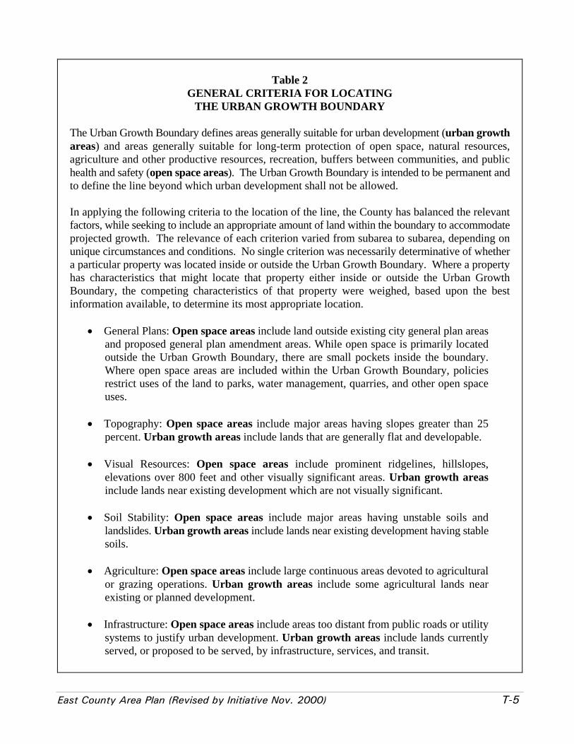
East County Area Plan (Revised by Initiative Nov. 2000) T-5
Table 2GENERAL CRITERIA FOR LOCATING
THE URBAN GROWTH BOUNDARY
The Urban Growth Boundary defines areas generally suitable for urban development (urban growthareas) and areas generally suitable for long-term protection of open space, natural resources,agriculture and other productive resources, recreation, buffers between communities, and publichealth and safety (open space areas). The Urban Growth Boundary is intended to be permanent andto define the line beyond which urban development shall not be allowed.
In applying the following criteria to the location of the line, the County has balanced the relevantfactors, while seeking to include an appropriate amount of land within the boundary to accommodateprojected growth. The relevance of each criterion varied from subarea to subarea, depending onunique circumstances and conditions. No single criterion was necessarily determinative of whethera particular property was located inside or outside the Urban Growth Boundary. Where a propertyhas characteristics that might locate that property either inside or outside the Urban GrowthBoundary, the competing characteristics of that property were weighed, based upon the bestinformation available, to determine its most appropriate location.
• General Plans: Open space areas include land outside existing city general plan areasand proposed general plan amendment areas. While open space is primarily locatedoutside the Urban Growth Boundary, there are small pockets inside the boundary.Where open space areas are included within the Urban Growth Boundary, policiesrestrict uses of the land to parks, water management, quarries, and other open spaceuses.
• Topography: Open space areas include major areas having slopes greater than 25percent. Urban growth areas include lands that are generally flat and developable.
• Visual Resources: Open space areas include prominent ridgelines, hillslopes,elevations over 800 feet and other visually significant areas. Urban growth areasinclude lands near existing development which are not visually significant.
• Soil Stability: Open space areas include major areas having unstable soils andlandslides. Urban growth areas include lands near existing development having stablesoils.
• Agriculture: Open space areas include large continuous areas devoted to agriculturalor grazing operations. Urban growth areas include some agricultural lands nearexisting or planned development.
• Infrastructure: Open space areas include areas too distant from public roads or utilitysystems to justify urban development. Urban growth areas include lands currentlyserved, or proposed to be served, by infrastructure, services, and transit.

T-6 East County Area Plan (Revised by Initiative Nov. 2000)
Table 2 (cont.)GENERAL CRITERIA FOR LOCATING
THE URBAN GROWTH BOUNDARY
• Public Lands: Open space areas include large public landholdings.
• Community Separation: Open space areas include open space buffers betweencommunities.
• Habitat: Open space areas include large, contiguous tracts of land that will providecontinued habitat for wildlife and plant species and protect the overall value of naturalcommunities.
• Ownership: Generally respects existing parcels. In cases where parcels are split,provides for density transfer to dedicate that portion lying outside the Urban GrowthBoundary to the County Land Trust for public use as open space.
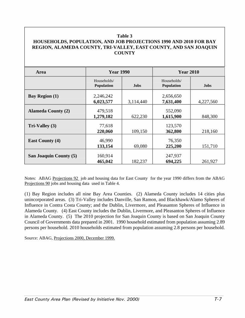
East County Area Plan (Revised by Initiative Nov. 2000) T-7
Table 3HOUSEHOLDS, POPULATION, AND JOB PROJECTIONS 1990 AND 2010 FOR BAYREGION, ALAMEDA COUNTY, TRI-VALLEY, EAST COUNTY, AND SAN JOAQUIN
COUNTY
Area Year 1990 Year 2010
Households/Population Jobs
Households/Population Jobs
Bay Region (1) 2,246,2426,023,577 3,114,440
2,656,6507,631,400 4,227,560
Alameda County (2) 479,5181,279,182 622,230
552,0901,615,900 848,300
Tri-Valley (3) 77,618 220,060 109,150
123,570362,800 218,160
East County (4) 46,990 133,154 69,080
76,350225,200 151,710
San Joaquin County (5) 160,914 465,042 182,237
247,937694,225 261,927
Notes: ABAG Projections 92 job and housing data for East County for the year 1990 differs from the ABAGProjections 90 jobs and housing data used in Table 4.
(1) Bay Region includes all nine Bay Area Counties. (2) Alameda County includes 14 cities plusunincorporated areas. (3) Tri-Valley includes Danville, San Ramon, and Blackhawk/Alamo Spheres ofInfluence in Contra Costa County; and the Dublin, Livermore, and Pleasanton Spheres of Influence inAlameda County. (4) East County includes the Dublin, Livermore, and Pleasanton Spheres of Influencein Alameda County. (5) The 2010 projection for San Joaquin County is based on San Joaquin CountyCouncil of Governments data prepared in 2001. 1990 household estimated from population assuming 2.89persons per household. 2010 households estimated from population assuming 2.8 persons per household.
Source: ABAG, Projections 2000, December 1999.
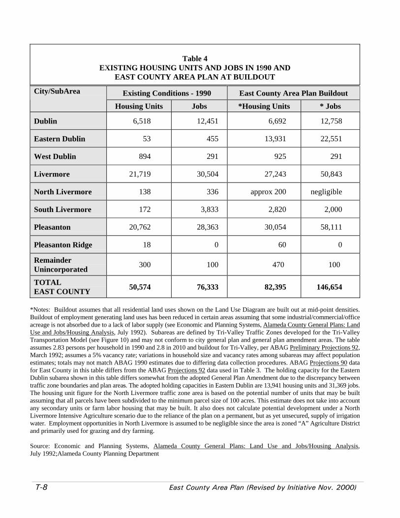
T-8 East County Area Plan (Revised by Initiative Nov. 2000)
Table 4EXISTING HOUSING UNITS AND JOBS IN 1990 AND
EAST COUNTY AREA PLAN AT BUILDOUT
Existing Conditions - 1990 East County Area Plan BuildoutCity/SubArea
Housing Units Jobs *Housing Units * Jobs
Dublin 6,518 12,451 6,692 12,758
Eastern Dublin 53 455 13,931 22,551
West Dublin 894 291 925 291
Livermore 21,719 30,504 27,243 50,843
North Livermore 138 336 approx 200 negligible
South Livermore 172 3,833 2,820 2,000
Pleasanton 20,762 28,363 30,054 58,111
Pleasanton Ridge 18 0 60 0
RemainderUnincorporated 300 100 470 100
TOTALEAST COUNTY 50,574 76,333 82,395 146,654
*Notes: Buildout assumes that all residential land uses shown on the Land Use Diagram are built out at mid-point densities.Buildout of employment generating land uses has been reduced in certain areas assuming that some industrial/commercial/officeacreage is not absorbed due to a lack of labor supply (see Economic and Planning Systems, Alameda County General Plans: LandUse and Jobs/Housing Analysis, July 1992). Subareas are defined by Tri-Valley Traffic Zones developed for the Tri-ValleyTransportation Model (see Figure 10) and may not conform to city general plan and general plan amendment areas. The tableassumes 2.83 persons per household in 1990 and 2.8 in 2010 and buildout for Tri-Valley, per ABAG Preliminary Projections 92,March 1992; assumes a 5% vacancy rate; variations in household size and vacancy rates among subareas may affect populationestimates; totals may not match ABAG 1990 estimates due to differing data collection procedures. ABAG Projections 90 datafor East County in this table differs from the ABAG Projections 92 data used in Table 3. The holding capacity for the EasternDublin subarea shown in this table differs somewhat from the adopted General Plan Amendment due to the discrepancy betweentraffic zone boundaries and plan areas. The adopted holding capacities in Eastern Dublin are 13,941 housing units and 31,369 jobs.The housing unit figure for the North Livermore traffic zone area is based on the potential number of units that may be builtassuming that all parcels have been subdivided to the minimum parcel size of 100 acres. This estimate does not take into accountany secondary units or farm labor housing that may be built. It also does not calculate potential development under a NorthLivermore Intensive Agriculture scenario due to the reliance of the plan on a permanent, but as yet unsecured, supply of irrigationwater. Employment opportunities in North Livermore is assumed to be negligible since the area is zoned “A” Agriculture Districtand primarily used for grazing and dry farming.
Source: Economic and Planning Systems, Alameda County General Plans: Land Use and Jobs/Housing Analysis,July 1992;Alameda County Planning Department
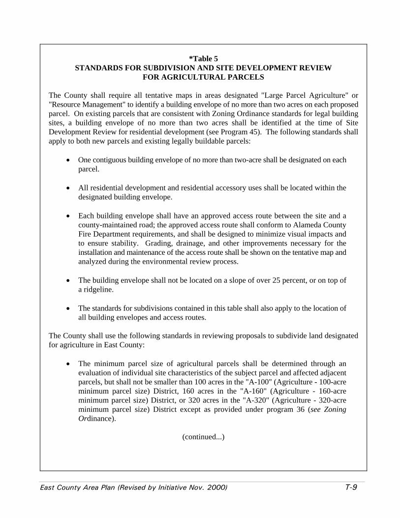
East County Area Plan (Revised by Initiative Nov. 2000) T-9
*Table 5STANDARDS FOR SUBDIVISION AND SITE DEVELOPMENT REVIEW
FOR AGRICULTURAL PARCELS
The County shall require all tentative maps in areas designated "Large Parcel Agriculture" or"Resource Management" to identify a building envelope of no more than two acres on each proposedparcel. On existing parcels that are consistent with Zoning Ordinance standards for legal buildingsites, a building envelope of no more than two acres shall be identified at the time of SiteDevelopment Review for residential development (see Program 45). The following standards shallapply to both new parcels and existing legally buildable parcels:
• One contiguous building envelope of no more than two-acre shall be designated on eachparcel.
• All residential development and residential accessory uses shall be located within thedesignated building envelope.
• Each building envelope shall have an approved access route between the site and acounty-maintained road; the approved access route shall conform to Alameda CountyFire Department requirements, and shall be designed to minimize visual impacts andto ensure stability. Grading, drainage, and other improvements necessary for theinstallation and maintenance of the access route shall be shown on the tentative map andanalyzed during the environmental review process.
• The building envelope shall not be located on a slope of over 25 percent, or on top ofa ridgeline.
• The standards for subdivisions contained in this table shall also apply to the location ofall building envelopes and access routes.
The County shall use the following standards in reviewing proposals to subdivide land designatedfor agriculture in East County:
• The minimum parcel size of agricultural parcels shall be determined through anevaluation of individual site characteristics of the subject parcel and affected adjacentparcels, but shall not be smaller than 100 acres in the "A-100" (Agriculture - 100-acreminimum parcel size) District, 160 acres in the "A-160" (Agriculture - 160-acreminimum parcel size) District, or 320 acres in the "A-320" (Agriculture - 320-acreminimum parcel size) District except as provided under program 36 (see ZoningOrdinance).
(continued...)
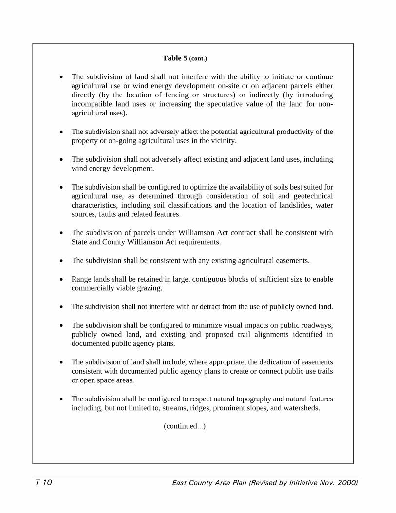
T-10 East County Area Plan (Revised by Initiative Nov. 2000)
Table 5 (cont.)
• The subdivision of land shall not interfere with the ability to initiate or continueagricultural use or wind energy development on-site or on adjacent parcels eitherdirectly (by the location of fencing or structures) or indirectly (by introducingincompatible land uses or increasing the speculative value of the land for non-agricultural uses).
• The subdivision shall not adversely affect the potential agricultural productivity of theproperty or on-going agricultural uses in the vicinity.
• The subdivision shall not adversely affect existing and adjacent land uses, includingwind energy development.
• The subdivision shall be configured to optimize the availability of soils best suited foragricultural use, as determined through consideration of soil and geotechnicalcharacteristics, including soil classifications and the location of landslides, watersources, faults and related features.
• The subdivision of parcels under Williamson Act contract shall be consistent withState and County Williamson Act requirements.
• The subdivision shall be consistent with any existing agricultural easements.
• Range lands shall be retained in large, contiguous blocks of sufficient size to enablecommercially viable grazing.
• The subdivision shall not interfere with or detract from the use of publicly owned land.
• The subdivision shall be configured to minimize visual impacts on public roadways,publicly owned land, and existing and proposed trail alignments identified indocumented public agency plans.
• The subdivision of land shall include, where appropriate, the dedication of easementsconsistent with documented public agency plans to create or connect public use trailsor open space areas.
• The subdivision shall be configured to respect natural topography and natural featuresincluding, but not limited to, streams, ridges, prominent slopes, and watersheds.
(continued...)

East County Area Plan (Revised by Initiative Nov. 2000) T-11
Table 5 (cont.)
• The subdivision shall be configured to avoid the significant loss of potential wildlife habitator significant natural vegetation. Neither the subdivision of land nor on-going or proposedagricultural uses on such subdivided land shall interfere with the ability of any identifiedspecies of concern to use the site as habitat or as a corridor linking identified habitat areas.
• The subdivision shall include access to each parcel that is consistent with Alameda CountyFire Department requirements, and shall be subject to reasonable response times foremergency services.
• The subdivision shall not significantly degrade surface or groundwater quality or publicly-owned watershed lands.
• Subdivision approval shall require proof of the availability of water sufficient to serveresidential uses, as permitted under the Zoning Ordinance; fire fighting needs; and on-goingor proposed agricultural uses.
• The subdivision shall be configured to minimize the creation of and susceptibility of thesubdivision and adjoining lands to fire hazards.
• The subdivision shall not substantially contribute to cumulative impacts resulting fromagricultural subdivisions.
• A real estate disclosure notice shall be attached to the deeds of all newly created agriculturalparcels at the time of subdivision and to the deeds of existing agricultural parcels as acondition of approval for non-agricultural development. The disclosure notice shall informowners of potential nuisances generated by adjacent agricultural uses, and by landfills orquarries in the vicinity. The disclosure notice shall also inform owners that the parcels arein an open space area with high fire risk, that public agencies are not liable for any damagecaused by wildfire, and that the parcels are subject to response times for emergency servicesthat are much longer than what can be expected in an urban area due to their remotelocations. For parcels created in the Wind Resource Area (as shown on Figure 4), the realestate disclosure shall also inform new owners of existing or potential future wind turbinesand associated facilities on adjacent or nearby properties.
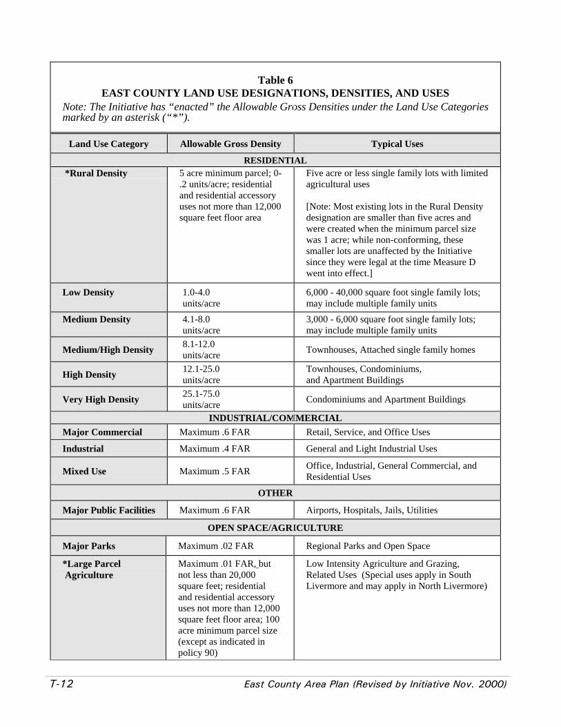
T-12 East County Area Plan (Revised by Initiative Nov. 2000)
Table 6EAST COUNTY LAND USE DESIGNATIONS, DENSITIES, AND USES
Note: The Initiative has “enacted” the Allowable Gross Densities under the Land Use Categoriesmarked by an asterisk (“*”).
Land Use Category Allowable Gross Density Typical Uses
RESIDENTIAL *Rural Density 5 acre minimum parcel; 0-
.2 units/acre; residentialand residential accessoryuses not more than 12,000square feet floor area
Five acre or less single family lots with limitedagricultural uses
[Note: Most existing lots in the Rural Densitydesignation are smaller than five acres andwere created when the minimum parcel sizewas 1 acre; while non-conforming, thesesmaller lots are unaffected by the Initiativesince they were legal at the time Measure Dwent into effect.]
Low Density 1.0-4.0units/acre
6,000 - 40,000 square foot single family lots;may include multiple family units
Medium Density 4.1-8.0units/acre
3,000 - 6,000 square foot single family lots;may include multiple family units
Medium/High Density 8.1-12.0units/acre Townhouses, Attached single family homes
High Density 12.1-25.0units/acre
Townhouses, Condominiums,and Apartment Buildings
Very High Density 25.1-75.0units/acre Condominiums and Apartment Buildings
INDUSTRIAL/COMMERCIALMajor Commercial Maximum .6 FAR Retail, Service, and Office Uses
Industrial Maximum .4 FAR General and Light Industrial Uses
Mixed Use Maximum .5 FAR Office, Industrial, General Commercial, andResidential Uses
OTHER
Major Public Facilities Maximum .6 FAR Airports, Hospitals, Jails, Utilities
OPEN SPACE/AGRICULTURE
Major Parks Maximum .02 FAR Regional Parks and Open Space
*Large Parcel Agriculture
Maximum .01 FAR, butnot less than 20,000square feet; residentialand residential accessoryuses not more than 12,000square feet floor area; 100acre minimum parcel size(except as indicated inpolicy 90)
Low Intensity Agriculture and Grazing,Related Uses (Special uses apply in SouthLivermore and may apply in North Livermore)
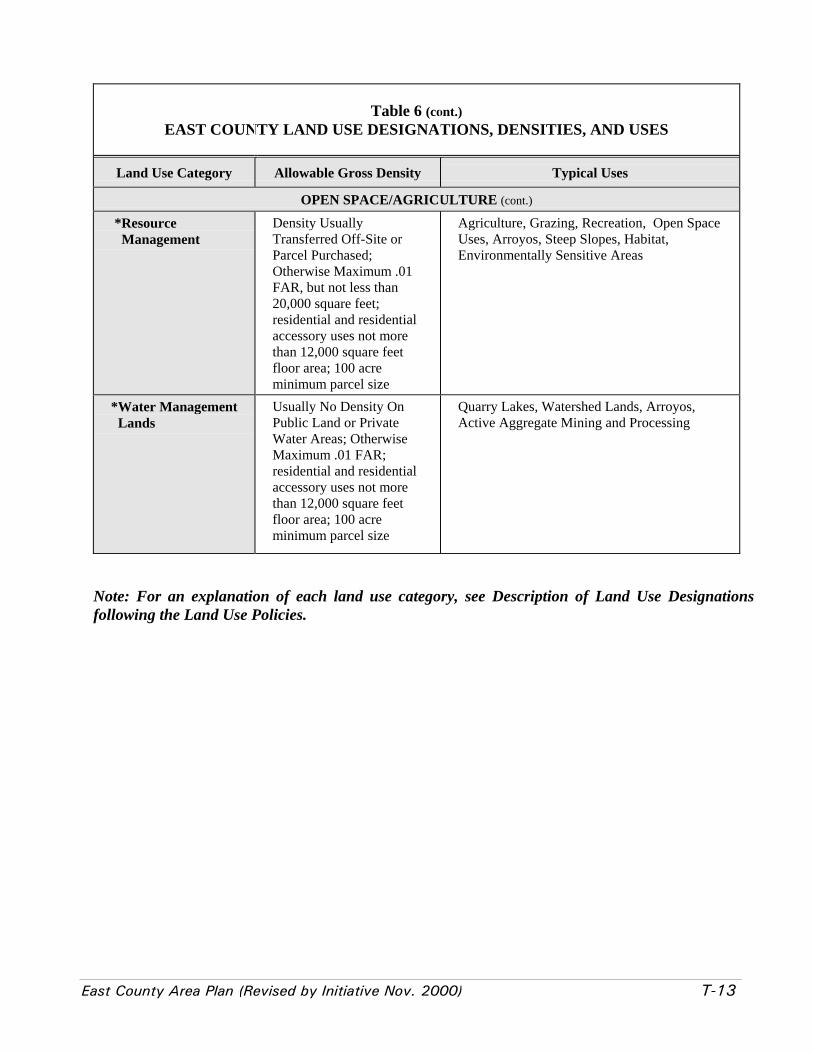
East County Area Plan (Revised by Initiative Nov. 2000) T-13
Table 6 (cont.)EAST COUNTY LAND USE DESIGNATIONS, DENSITIES, AND USES
Land Use Category Allowable Gross Density Typical Uses
OPEN SPACE/AGRICULTURE (cont.)
*Resource Management
Density UsuallyTransferred Off-Site orParcel Purchased;Otherwise Maximum .01FAR, but not less than20,000 square feet;residential and residentialaccessory uses not morethan 12,000 square feetfloor area; 100 acreminimum parcel size
Agriculture, Grazing, Recreation, Open SpaceUses, Arroyos, Steep Slopes, Habitat,Environmentally Sensitive Areas
*Water Management Lands
Usually No Density OnPublic Land or PrivateWater Areas; OtherwiseMaximum .01 FAR;residential and residentialaccessory uses not morethan 12,000 square feetfloor area; 100 acreminimum parcel size
Quarry Lakes, Watershed Lands, Arroyos,Active Aggregate Mining and Processing
Note: For an explanation of each land use category, see Description of Land Use Designationsfollowing the Land Use Policies.
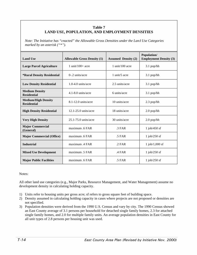
T-14 East County Area Plan (Revised by Initiative Nov. 2000)
Table 7LAND USE, POPULATION, AND EMPLOYMENT DENSITIES
Note: The Initiative has “enacted” the Allowable Gross Densities under the Land Use Categoriesmarked by an asterisk (“*”).
Land Use Allowable Gross Density (1) Assumed Density (2)Population/Employment Density (3)
Large Parcel Agriculture 1 unit/100+ acre 1 unit/100 acre 3.1 pop/hh
*Rural Density Residential 0-.2 units/acre 1 unit/5 acre 3.1 pop/hh
Low Density Residential 1.0-4.0 units/acre 2.5 units/acre 3.1 pop/hh
Medium DensityResidential 4.1-8.0 units/acre 6 units/acre 3.1 pop/hh
Medium/High DensityResidential 8.1-12.0 units/acre 10 units/acre 2.3 pop/hh
High Density Residential 12.1-25.0 units/acre 18 units/acre 2.0 pop/hh
Very High Density 25.1-75.0 units/acre 30 units/acre 2.0 pop/hh
Major Commercial(General) maximum .6 FAR .3 FAR 1 job/450 sf
Major Commercial (Office) maximum .6 FAR .5 FAR 1 job/250 sf
Industrial maximum .4 FAR .2 FAR 1 job/1,000 sf
Mixed Use Development maximum .5 FAR .4 FAR 1 job/250 sf
Major Public Facilities maximum .6 FAR .5 FAR 1 job/250 sf
Notes:
All other land use categories (e.g., Major Parks, Resource Management, and Water Management) assume nodevelopment density in calculating holding capacity.
1) Units refer to housing units per gross acre; sf refers to gross square feet of building space.2) Density assumed in calculating holding capacity in cases where projects are not proposed or densities are
not specified.3) Population densities were derived from the 1990 U.S. Census and vary by city. The 1990 Census showed
an East County average of 3.1 persons per household for detached single family homes, 2.3 for attachedsingle family homes, and 2.0 for multiple family units. An average population densities in East County forall unit types of 2.8 persons per housing unit was used.

East County Area Plan (Revised by Initiative Nov. 2000) T-15
Table 8DESCRIPTION OF TRANSPORTATION DIAGRAM
Major Roadway Segment (in unincorporated areas) Number of Lanes
Collier Canyon North Of Dublin Boulevard 2 Lanes
Doolan Canyon North of Dublin Boulevard 2 Lanes
Dublin Boulevard From Tassajara Road to Doolan Canyon Road 6 lanes
From I-580 to Stoneridge Drive 6 LanesEl Charro Road
From Stoneridge Drive to Busch Road 4 Lanes
Fallon Road From I-580 to Tassajara Road 6 Lanes
From I-580 to Patterson Pass Road 6 LanesGreenville Road
South of Patterson Pass Road 2 Lanes
Isabel Avenue From Vineyard Avenue to I-580 6 Lanes
Manning Road From Vasco Road to Contra Costa County Line 2 Lanes
North Livermore Ave. From I-580 to Manning 2 Lanes
From Vasco Road to Greenville Road 4 LanesPatterson Pass Road
East of Greenville Road 2 Lanes
Stanley Boulevard East of Valley Avenue 4 Lanes
I-580 to Dublin Boulevard 8 LanesTassajara Road
Dublin Boulevard to County Line 6 Lanes
Tesla Road From South Livermore Ave to San Joaquin Co. 2 Lanes
Vallecitos Road From I-680 to Vineyard Avenue 4 Lanes
From Cayetano Parkway to County Line 2 LanesVasco Road
South of East Avenue 2 Lanes

T-16 East County Area Plan (Revised by Initiative Nov. 2000)
Table 9TYPICAL ROADWAY LANE AND RIGHT-OF-WAY REQUIREMENTS FOR
UNINCORPORATED EAST COUNTY ARTERIALS
RoadwayClassification Lane Configuration Right-of-Way Range
6 Lane Arterial 6 Lanes with Raised Median 102 to 118 feet
4 Lane Arterial 4 Lanes with Raised Median 78 to 94 feet
3 Lane Collector 3 Lanes Including Two-Way Left Turn Lane
64 to 80 feet
2 Lane Collector2 Lanes with No Median 36 to 58 feet
Note: The County may allow reductions in roadway widths in areas of complex topography, sensitive resources, orscenic value. Right-of-ways may be wider to accommodate transit where appropriate.
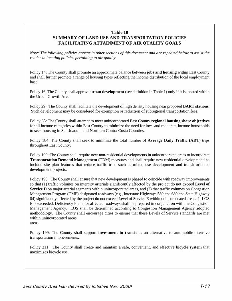
East County Area Plan (Revised by Initiative Nov. 2000) T-17
Table 10SUMMARY OF LAND USE AND TRANSPORTATION POLICIES
FACILITATING ATTAINMENT OF AIR QUALITY GOALS
Note: The following policies appear in other sections of this document and are repeated below to assist thereader in locating policies pertaining to air quality.
Policy 14: The County shall promote an approximate balance between jobs and housing within East Countyand shall further promote a range of housing types reflecting the income distribution of the local employmentbase.
Policy 16: The County shall approve urban development (see definition in Table 1) only if it is located withinthe Urban Growth Area.
Policy 29: The County shall facilitate the development of high density housing near proposed BART stations. Such development may be considered for exemption or reduction of subregional transportation fees.
Policy 35: The County shall attempt to meet unincorporated East County regional housing share objectivesfor all income categories within East County to minimize the need for low- and moderate-income householdsto seek housing in San Joaquin and Northern Contra Costa Counties.
Policy 184: The County shall seek to minimize the total number of Average Daily Traffic (ADT) tripsthroughout East County.
Policy 190: The County shall require new non-residential developments in unincorporated areas to incorporateTransportation Demand Management (TDM) measures and shall require new residential developments toinclude site plan features that reduce traffic trips such as mixed use development and transit-orienteddevelopment projects.
Policy 193: The County shall ensure that new development is phased to coincide with roadway improvementsso that (1) traffic volumes on intercity arterials significantly affected by the project do not exceed Level ofService D on major arterial segments within unincorporated areas, and (2) that traffic volumes on CongestionManagement Program (CMP) designated roadways (e.g., Interstate Highways 580 and 680 and State Highway84) significantly affected by the project do not exceed Level of Service E within unincorporated areas. If LOSE is exceeded, Deficiency Plans for affected roadways shall be prepared in conjunction with the CongestionManagement Agency. LOS shall be determined according to Congestion Management Agency adoptedmethodology. The County shall encourage cities to ensure that these Levels of Service standards are metwithin unincorporated areas.areas.
Policy 199: The County shall support investment in transit as an alternative to automobile-intensivetransportation improvements.
Policy 211: The County shall create and maintain a safe, convenient, and effective bicycle system thatmaximizes bicycle use.

T-18 East County Area Plan (Revised by Initiative Nov. 2000)
Table 10 (cont.)SUMMARY OF LAND USE AND TRANSPORTATION POLICIES FACILITATING
ATTAINMENT OF AIR QUALITY GOALS
Policy 212: The County shall create and maintain a safe and convenient pedestrian system that linksresidential, commercial, and recreational uses and encourages walking instead of driving.
Policy 295: The County shall require major projects of commercial or industrial nature to include bicyclestorage facilities for employees and customers, shower/locker areas, and other facilities identified in the EastCounty Bicycle Plan (described in Program 84) for employees that commute using bicycles.
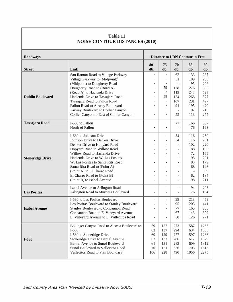
East County Area Plan (Revised by Initiative Nov. 2000) T-19
Table 11NOISE CONTOUR DISTANCES (2010)
Roadways Distance to LDN Contour in Feet
Street Link80
db.75db.
70db.
65 db.
60 db.
Dublin Boulevard
San Ramon Road to Village ParkwayVillage Parkway to (Midpoint)1
(Midpoint) to Dougherty RoadDougherty Road to (Road A)(Road A) to Hacienda DriveHacienda Drive to Tassajara RoadTassajara Road to Fallon RoadFallon Road to Airway BoulevardAirway Boulevard to Collier CanyonCollier Canyon to East of Collier Canyon
----------
---
595258
----
62 51
-128113124107 91
- 55
133109 95276243268231195 97118
287235206595523577497420210255
Tassajara Road I-580 to FallonNorth of Fallon
--
--
77-
16676
357163
Stoneridge Drive
I-680 to Johnson DriveJohnson Drive to Denker DriveDenker Drive to Hopyard RoadHopyard Road to Willow RoadWillow Road to Hacienda DriveHacienda Drive to W. Las PositasW. Las Positas to Santa Rits RoadSanta Rita Road to (Point A)(Point A) to El Charro RoadEl Charro Road to (Point B)(Point B) to Isabel Avenue
-----------
-----------
5454
---------
116116102 88 72 93 83 68
- 62 98
250251220190155201179146 89134211
Las PositasIsabel Avenue to Arlington RoadArlington Road to Murrieta Boulevard
--
--
--
94 76
203164
Isabel Avenue
I-580 to Las Positas BoulevardLas Positas Boulevard to Stanley BoulevardStanley Boulevard to Concannon RoadConcannon Road to E. Vineyard AvenueE. Vineyard Avenue to E. Vallecitos Road
-----
-----
99 95 77 67 58
213205165143126
459441355309271
I-680
Bollinger Canyon Road to Alcosta Boulevard toI-580I-580 to Stoneridge DriveStoneridge Drive to Bernal AvenueBernal Avenue to Sunol BoulevardSunol Boulevard to Vallecitos RoadVallecitos Road to Plan Boundary
596360626170
106
127137129133131151228
273294277286283326490
587634597617609703
1056
1265136612861329131215152275

T-20 East County Area Plan (Revised by Initiative Nov. 2000)
Table 11 (cont.)NOISE CONTOUR DISTANCES (2010)
Roadways Distance to LDN Contour in Feet
Street Link80db.
75 db.
70db.
65db.
60db.
I-580
Plan Boundary to FoothillFoothill Road to I-680I-680 to Dougherty RoadDoughterty Road to Tassajara RoadTassajara Road to Isabel AvenueIsabel Avenue to N. LivermoreN. Livermore to First Street (SR-84)First Street to Vasco RoadVasco Road to East of Vasco Road
106 93102111118105 96 99 83
228201219239255225207213179
490434471515549485447458387
1056934
1015110911831045963987833
227520132188239025502252207521271794
Union PacificRailroad
- - 100 240 5172
Notes:
1Midpoint, Road A and Point A, etc. typically represent a location midway between two consecutive roadways.
2Same as existing data
Roadway noise levels were calculated using the Federal Highway Administration's Traffic Noise Prediction Model (FHWA-RD-77-108). In order to accurately reflect noise levels on California roads, California Vehicle Noise Emission Level curveswere also incorporated into the model. Peak hour traffic volumes and average travel speeds were used to calculate the peakhour traffic volumes and average travel speeds were used to calculate the Peak Hour Leq, which was assumed to beequivalent to the day/night average sound level (DNL). Contour intervals were based on the calculated reference DNL at50 feet from the roadway centerline. By applying a 4.5 dB reduction for each doubling of distance from the roadwaycenterline, the 60, 65, 70, 75 and 80 dB intervals were calculated.
Source: Charles Salter Associates, 1993

East County Area Plan (Revised by Initiative Nov. 2000) G-1
IV. GRAPHICS


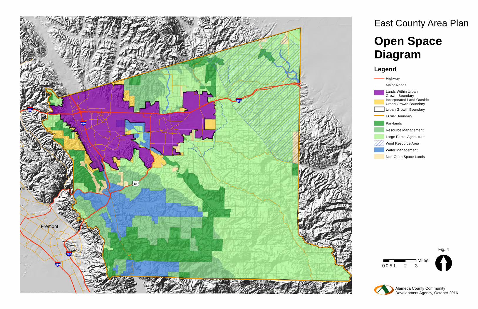
Fremont
Union City
580
84
680
580
880
680
East County Area PlanOpen SpaceDiagramLegend
Urban Growth BoundaryECAP BoundaryParklandsResource ManagementLarge Parcel Agriculture
Water ManagementNon-Open Space Lands
Wind Resource Area
Lands Within Urban Growth BoundaryIncorporated Land Outside Urban Growth Boundary
0 1 2 30.5Miles
Fig. 4
Alameda County CommunityDevelopment Agency, October 2016
HighwayMajor Roads
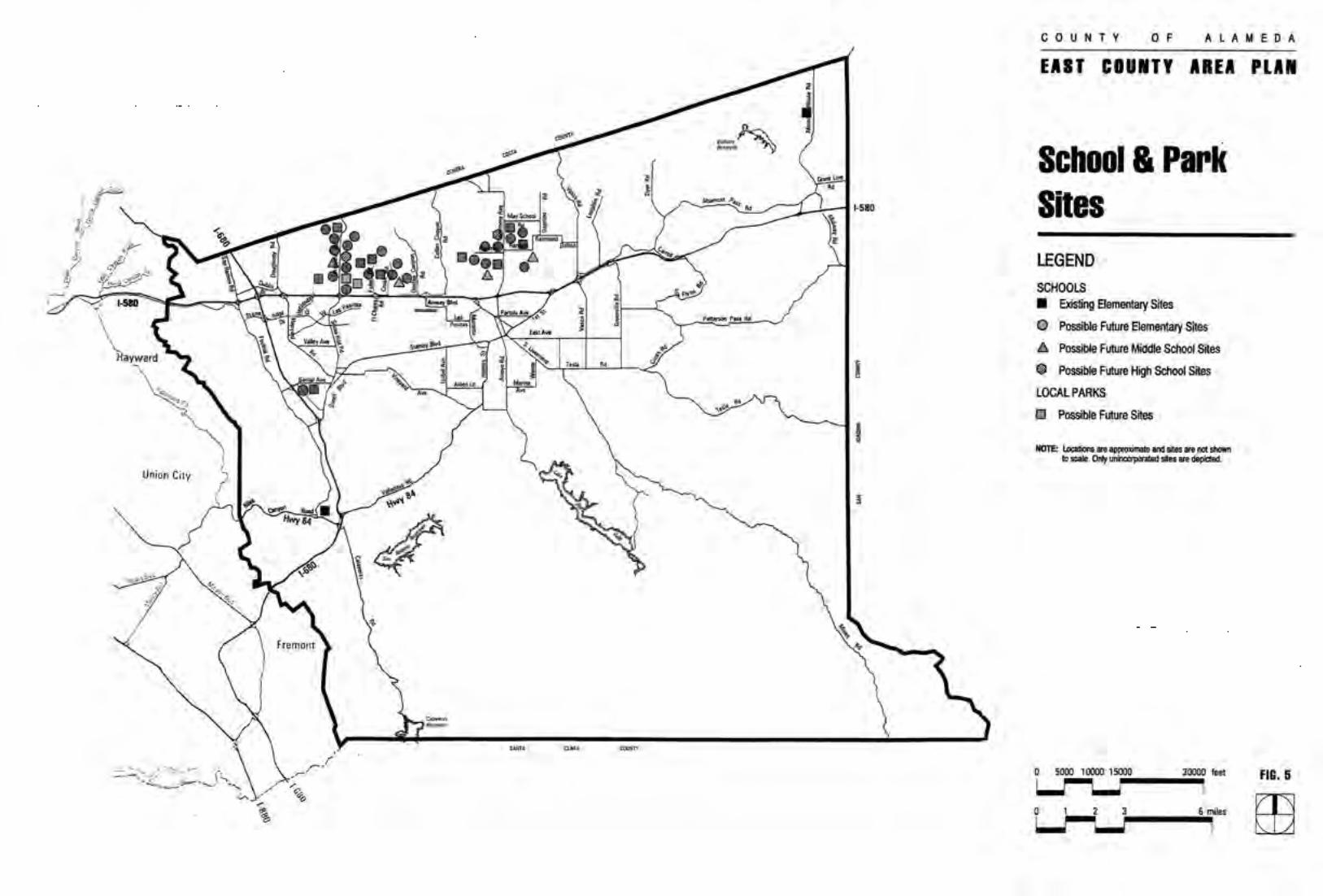
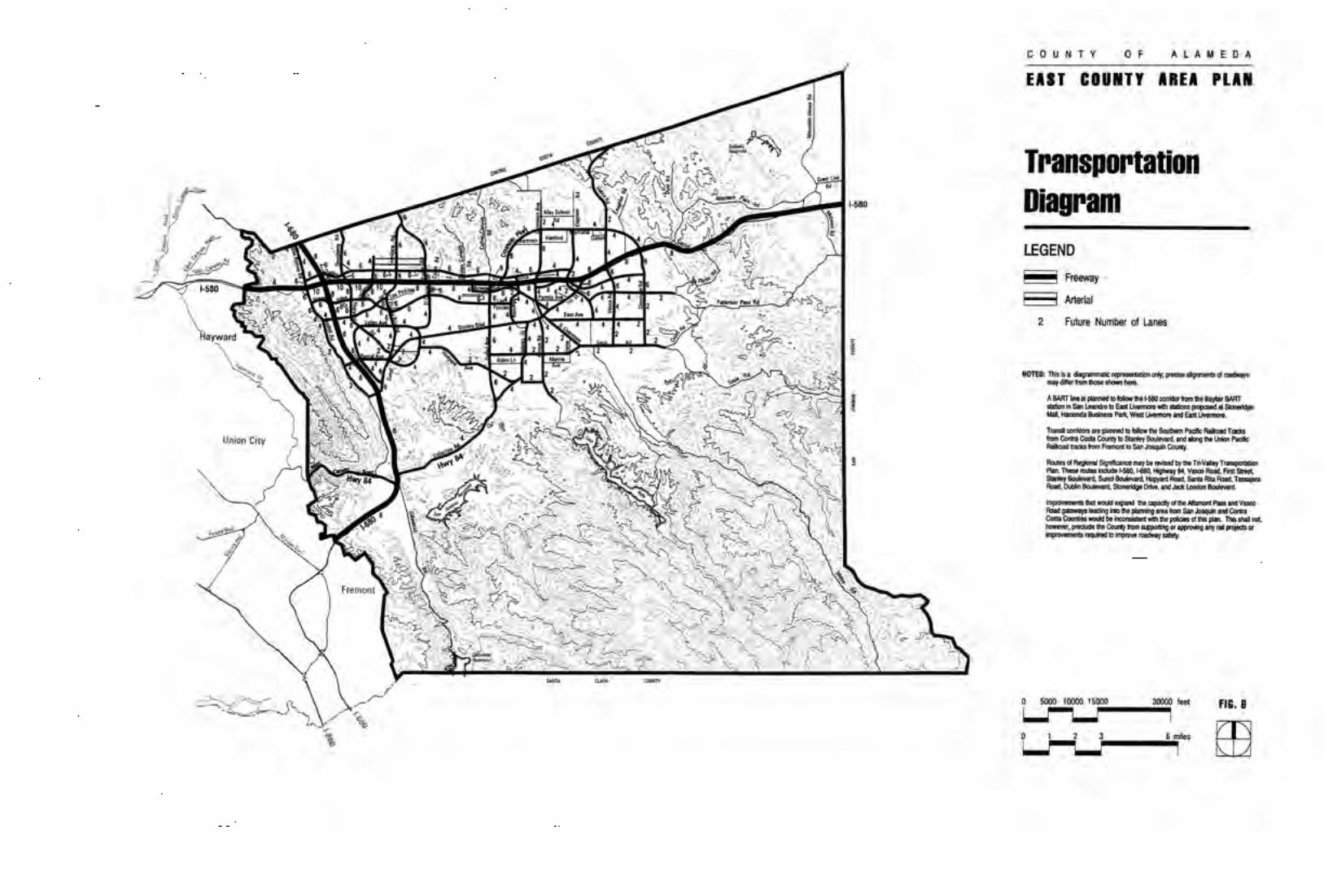

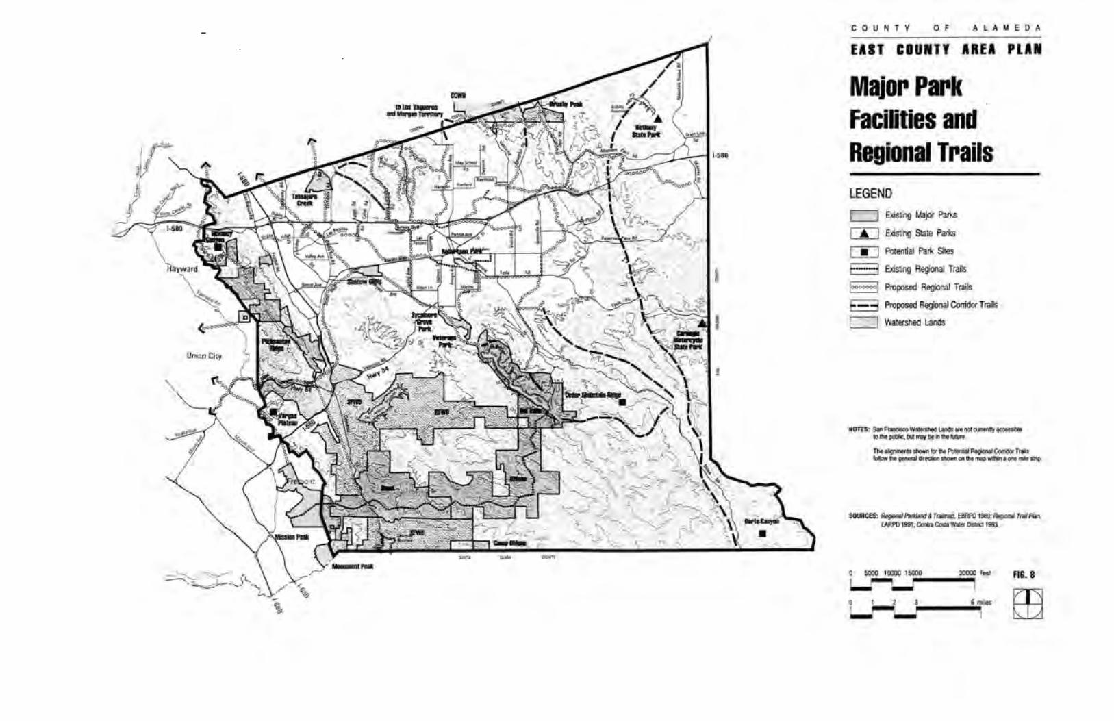
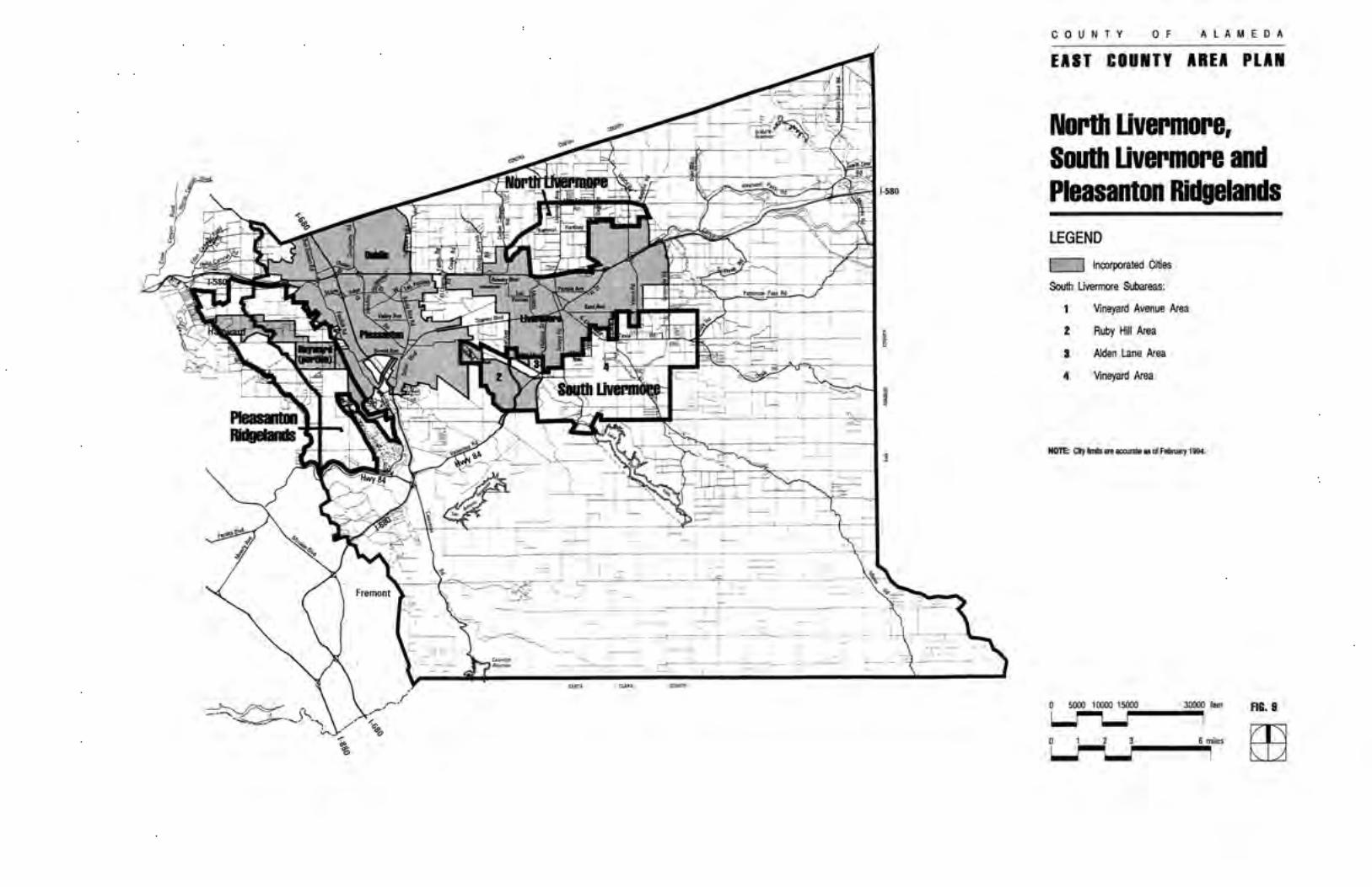

Fremont
Union City
580
84
680
580
880
680
East County Area PlanLand UseDiagramLegend
0 1 2 30.5Miles
Alameda County CommunityDevelopment Agency, October 2016
HighwayMajor RoadsLands Within City LimitsUrban Growth BoundaryECAP Boundary
Land Use
Low Density Residential
Medium Density Residential
Downtown SunolIndustrialMixed UseParklandsResource ManagementLarge Parcel AgricultureMajor PublicWater Management
Rural Density Residential(Maximum 1 Unit/5 Acres)
(1 - 4 Units/Acre)
(4.1 - 8 Units/Acre)
CONTRIBUTORS TO THIS PLANThe plan adopted in May 1994 was prepared under the direction of the Alameda County PlanningDepartment; Adolph Martinelli, Planning Director and Deborah Stein, Assistant Planning Director and byplanning staff and consultants listed below. The plan was later modified by the Measure D Initiative passedby the County electorate in November 2000.
Volume 1 - Goals, Policies and ProgramsPrincipal Authors: Deborah Stein
Liz McElligott, AICPAnnemarie Dietzgen, AICP, Environmental ConsultantChandler W. Lee, AICP, Planning Consultant
Contributors: Jim WalshStuart Cook, AICP
Bruce JensenDiane PierceChris BazarMark Hall (Graphics)J. Laurence Mintier & AssociatesLeslie Zander, Zander Associates
Volume 2 - Background Reports (Setting, Trends and Issues)Principal Authors: Annemarie Dietzgen, AICP, Environmental Consultant
Liz McElligott, AICPChris BazarJim Walsh
Contributors: Bruce JensenDiane PierceJohn DegeleMaureen TomsRonald GeeSandi RiveraMark Hall (Graphics)Joyce BrewerHolly JanvierEconomic & Planning Systems, Inc. (Population, Housing and Employment Data)David L. Gates & Associates (Graphics)Leslie Zander, Zander Associates (Biological Resources)Stuart Cook, AICP (Wastewater)Chandler W. Lee, AICP (Population, Housing and Employment)Harding Lawson Associates (Hydrology)Donald Ballanti, Certified Consulting Meteorologist (Air Quality)TJKM Transportation Consultants (Transportation)Barton-Aschman Associates (Transportation)Charles M. Salter Associates, Inc. (Noise)
ECAP Revised to Implement Measure D was prepared by:Chris Bazar, Assistant Planning DirectorSandi Rivera, Senior PlannerJanie Chambers, Administrative SpecialistAnnemarie Dietzgen, Planning Consultant