Embed Size (px)
Citation preview

EARTH SCIENCE
TEACHERS' ASSOCIATION
> " '. -.:-'. ,:' • " ..... ~
~~~
~----
8'<)l~ \L--S 3> Science f-y(LC I{Ne
of the Earth 11 - 14
.' ,-- "'
~'," ~ :-.. "
Earth1s surface features
Earth Science Teachers' Association: Science of the Earth 11-14 Earth's surface features
ESt: Patterns on the Earth - the nature and location of the major features of the Earth's surface. ES2: Is the Earth cracking up? - investigations into folding and faulting of rocks. ES3: Earth's moving surface - earthquakes and their relationship to the Earth's 'plate' boundaries.
Intended Use: Science courses for Key Stage 3, at Attainment Levels 6 to 8. Geography courses for Key Stage 3, at Attainment Levels 4 to 6. The Pack lays firm foundations for study of plate tectonics at Key Stage 4 in Science (see inside back cover).
Suggested Approach: Each Unit is intended to take two periods of about 40 minutes, with homework, or extension work for abler or faster pupils. The Units follow a progressive sequence from 1 to 3.
Resources: Included free with this Pack are: A postcard diagram showing the nature of 'plate' boundaries. A postcard-size map of the ocean floors. This postcard is a miniature version of a full size laminated 'Floor of the Oceans' map (69 x 100 cm), obtainable from the sole importers, EST A Promotions. EST A also stocks an excellent wall map called, 'This Dynamic Planet, world map of volcanoes, earthquakes and plate tectonics' (104 x 146 cm). The teaching of this Pack will be greatly enhanced if both maps are obtained from: EST A Promotions, 3 Ashington Drive, Bury, Lancs, BLB IfS. Further copies of both postcards may be purchased from Geo Supplies Ltd. (address below). Most of the other materials required are readily available in a school laboratory or may be purchased cheaply. The requirements for each Unit are given on the Teacher Sheets (TS). Specimens of some rocks are required for ES1. If not available locally, or already in the school, geological specimens may be purchased from suppliers such as:
Galli Geopac, 23 Woodhurst Lane, Oxted, Surrey RH8 9HN. Geo Supplies Ltd., 16 Station Road, Chapeltown, Sheffield S30 4XH. Offa Rocks, Lower Hengoed, Oswestry, Shropshire SY10 7 AB.
Overhead projector acetates: It is intended that the world maps in the Teacher Sheets for ES1 and ES3 should be reproduced as transparencies for the overhead projector. This may be done on a good school photocopier, or at an office equipment shop, using special acetate film.
Video: 'Mountain building', a video lasting 14 minutes, produced by the Geological Museum (address below). Software: 'Quake' - a program for BBC computers, where pupils plot the epicentres of earthquakes in the USA, available from: MJP, p.o. Box 23, St. Just, Cornwall, TR19 7JS.
Slide sets: 'Active faults' and 'Iceland on the edge of the plates', available from MJP. 'Plate Tectonics: Geology from Space' 12 transparencies showing aspects of plate tectonics viewed from satellites. EST A Promotions. Slides of Earth's surface features are ~vailable, singly or in sets, from Landform Slides, 38 Borrow Road, Lowestoft, Suffolk NR32 3PN.
Visit: 'The Story of the Earth' in the GeolOgical Museum, (now renamed the 'Earth Galleries' of the Natural History Museum), Exhibition Road, London SW7, telephone 071 938 9123.
Books: 'Earthquakes', S. van Rose, ISBN 0 11 884066 5 'Volcanoes', S. van Rose &: I. F. Mercer, ISBN 0 565 01080 8. These excellent full-rolour booklets are produced by the Geological Museum (address above). 'Earthquakes and Volcanoes', R. Muir Wood, Mitchell Beazley, ISBN 0 85533 657 9.
Teaching Units: Science of the Earth Unit 17, 'Earth's patchwork crust' contains further information about plate tectonics and continental drift. EST A Publications, ISBN 1 873266 00 6
Copyright: There is no copyright on original material published in these Units; if it is required for use within the laboratory or classroom. Copyright material reproduced by permission of other publishers rests with the originating publishers.
Acknowledgements Thanks are due to Alan Birchall, Sue Churchman, Dominic Greenall and Lewis Jones for artwork and cartoons. We are particularly grateful to many people and organisations who have located or supplied photographs for this Pack, as follows: Mr K. Ansdell (University of Saskatchewan); Or R. Butler &: Prof P. Nixon (University of Leeds); Drs A. Colling &: D. Edwards (Open University); Mr K. Gardner (Landform Slides); Or S. Hook aet Propulsion Laboratory, Pasadena); Prof N. Kusznir (University of Liverpool): Mr A. Cadman, Or P. Maguire &: Mr J. Mansfield (University of Leicester); Or R. Muir Wood &: Mitchell Beazley Ltd; US Geological Survey; Prof P. Vita-Finzi (University College London).
"Science of the Earth 11 to 14" Units are published by the Earth Science Teachers' Association, supported by Project Earth and by the Hertfordshire Science Teaching Scholarship. Project Earth is a joint initiative by EST A and the Centre for Science Education at the Open University, which is sponsored by: The Natural Environment Research Council, The Nuffield Foundation.
ISBN 1 873266 04 9 First published 1992.
ESTA publications are distributed by: Geo Supplies Ltd., 16 Station Road, Chapeltown, Sheffield, S30 4XH.

Earth1s surface features ES 1: Patterns on the Earth
Notes on teaching the Unit
This Unit is intended as an introduction to the series of three in the Pack and should not be taken in isolation.
1. Target Earth
South America is dearly visible on the photograph from space.
1.1 Answers will vary widely, but pupils should appreciate that this kind of problem of data-sampling applied in reverse, when the Moon landings were being planned in the 19608.
Very few pupils will suggest landing in the oceanic areas, yet these constitute about 71 % of the Earth's surface.
1

ES 1: Patterns on the Earth
2. Map the Earth
a) Map the dry land
The prepared acetate sheets should be used to draw attention to the major features of the Earth's land surface. Pupils colour in each type of feature and the key as it appears, using the prepared outline on their own map (OS}) for guidance. Acetates may be placed on the projector separately, or superimposed, or both.
2.1 The following order is suggested:
Figure T1 (page 3) - Outline map of the continents, showing their names. Major fold mountain belts (see Glossary on TS11 for the meaning of the terms, some of which could be explained at this point).
Figure T2 (page 4) - Older fold mountains and other sedimentary rocks.
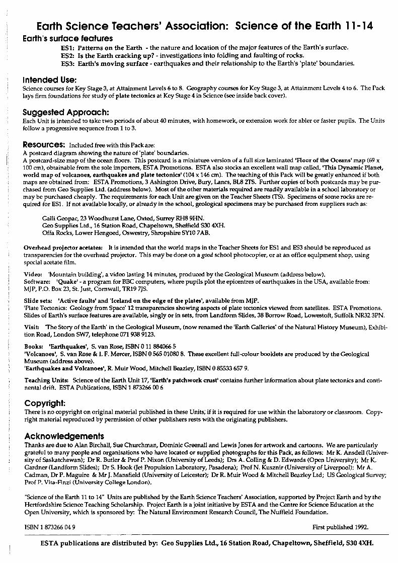
Figure T3 (page 5) - Rift valleys and regions underlain by very ancient rocks.
Iceland, and other volcanic islands of relatively recent origin are not shown in the Key.
b) Map the sea floor
Before showing the acetates, gather the class around the superb wall map recommended for use with this Unit, if available. Explain that, prior to the 1950s, our knowledge of the ocean floors was extremely sketchy. The introduction of the precision echo sounder enabled much more rapid, accurate surveying to be carried out, resulting in the production of maps such as the one on display.
The map is compiled from a wealth of accurate data, although the semi-pictorial cartography makes it readily understood by children. .
Pupils are usually quick to spot the various features. Of these, the oceanic ridges and the deep trenches are the most obvious and these are also depicted on the acetates, Figure T4 and T5 (pages 6 & 7). Perceptive pupils may notice that each ridge has a marked rift valley running along its crest. Most will also spot: continental shelves, abyssal (deep) plains, underwater seamounts and fractures transverse to the oceanic ridges (see glossary for meaning of tenns).
Attention should be drawn to the contrasts between the Atlantic and Pacific Oceans. In the Atlantic, the ridge is central to the ocean and there are only two, relatively minor, trenches. These are associated with the island arcs of the Caribbean in the North Atlantic and the South Sandwich Islands in the South Atlantic. In the Pacific, the main ridge lies in the eastern part of the main basin, whilst three quarters of the ocean is ringed by trenches and their associated island arcs or mountain belts.
2.2 Return to the overhead projector and allow pupils to shade in their own maps (051) from the acetates:
Figure T4 (page 6) - the major oceanic ridges Figure T5 (page 7) - the major deep trenches of the ocean floor.
Clearly, many other details covered in the discussion are not being plotted, to avoid confusion.
L-______________________________________ 2

Figure Tt The continents, showing the major fold mountain belts
w
'V
q.
~ d'
Ijlj:~\'))lll Fold mountain belts
o
~
CQ

,', '.:'
L
4
';. ....... ~.:: . . " . '. ,' .. . .
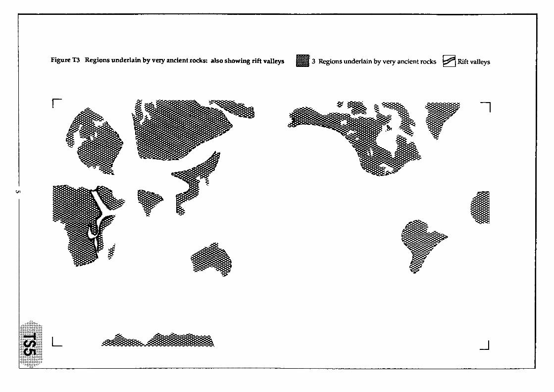
Figure T3 Regions underlain by very ancient rocks: also showing rift valleys 1111 3 Regions underlain by very ancient rocks ~ Rift valleys
I ~~ I" ~
I§ ~
(J1
• t
" L -.J

Figure T4 The major oceanic ridges ~~ 4 Oceanic ridges
I" r \
0\
L --J
Regrettably the postcard diagram showing the nature of 'plate' boundaries offered free with the Pack is no longer available
!S 0 ~
~ Q.I ~ 0 Q.I
0:5 ..... 0 <I) Q.I
..t: ~ s:: Q.I ~ Q.. Q.I Q.I '0
"" 0 'ji'
El Q.I
..t: E-t an E-t Q.I
"" ::s CO L .... ~
ERRATUM
Thi!: l'pnlal'es nrildnal nal!e 7.
,...
(
I
,-)
7


Figure T5 The major deep trenches of the ocean floor
I
l
~
'-,
L
(
115 Deep trenches
'- l' I'
I
~

200
300
400
500
600
ES 1: Patterns on the Earth
3. An active planet?
3.1 Pupils should try to delimit the main belts of volcanic activity, rather than plotting each separate volcano. Done this way, the exercise should take only a few minutes.
3.2 Project an acetate prepared from DS2 as a basis for discussion. Pupils should have found that most of the modern volcanic belts correspond to:
modern fold mountain ranges (except the Himalayas and Alps), island arcs, rift valleys on land, ocean ridges, especially beneath their median rift valleys. The volcanoes of the Hawaiian Islands correspond to none of these.
There are no volcanoes in the regions of very ancient rocks, nor on the sites of ancient fold mountain ranges. Such mountains exist in Great Britain, for instance, and geological evidence of equally ancient volcanoes is abundant, but sadly, not one is active today!
It may be premature to attempt a full explanation in terms of the plate tectonic theory, but the following information may be helpful to the teacher as background material.
It is believed that the Earth's crust, together with a portion of the upper mantle underneath, consists of a series of relatively rigid units, known as 'plates'. Plates move relative to each other a.."'ld the boundaries between them are sites of intense geological activity. Most modern volcanoes occur at the plate boundaries. Molten rock wells up from the mantle below, at the oceanic ridges, to form volcanoes. Near the deep-sea trenches, partial melting of rocks occurs as the edge of one plate is forced down beneath another, e.g. where the Pacific Plate is forced down under the Asian one deep below Japan. The molten material so formed rises to the surface to form volcanoes. (Figure T6)
Mountain range on active margin
of continent Oceanic trench
x xX Earthquakes
Continent being "carried" on
moving plate Oceanic
Continental crust crust
~ Volcanoes
Figure T6 Diagrammatic cross-section of a plate system
Oceanic
The Hawaiian Islands occur in the middle of the Pacific Plate as it moves bodily over a convective 'hot spot' with a rising 'plume' of magma from the mantle below.
8
Lithosphcre
Mantle

ES 1: Patterns on the Earth
Earthquakes are also far more frequent at plate boundaries than within the plates. This is discussed in more detail in Unit ES3 of this Pack ('Earth's moving surface'), and an earthquake distribution map is provided as DSl of that Unit (page 36). Figure T2 in ES3, (page 30), shows the main plates, on the same scale as Figures T1 to T5 in this Unit. Acetates may be prepared from both these maps, for use in summarising the whole Pack.
4. The Martians have landedl
4.1 Set up a central display, or a display per group of pupils, using copies of the photographs in Figure T7 (page 10) placed with specimens as available, following the suggestions below.
Specimen Photograph number
vesicular basalt 1 ('ropy' lava)
basalt 2 (pillow lava underwater)
granite 3 (ice-scoured land surface with shallow lakes)
limestone 4 (limestones on top of slates, with waterfall)
folded rock 5 (summit of fold mountain range)
(no specimen) 6 (fault scarp and floor of rift valley)
Answers to the matching exercise are:
A = East African Rift Valley (photo 6 with no rock specimen) B = 'platform' area of largely undeformed sedimentary rocks resting on upturned slates, Ingleton, North
Yorkshire (limestone and photo 4) C = underwater Mid-Atlantic Ridge (lava and photo 2) D = Hawaii (vesicular lava, i.e. one with gas holes, and photo 1) E = Swiss Alps (rock specimen showing folds and photo 5) F = Canadian Shield (granite and photo 3)
5. Return to Earth
This is a short exercise in retrodiction, (i.e. getting pupils to predict in the past).
5.1 Pupils may suggest any of the old fold mountain ranges as sites for former volcanoes, from their knowledge of the close association between volcanoes and the young fold mountains.
Former island arcs and rift valleys would be equally acceptable, but these are not shown on the map.
5.2 Pupils need a simple geological map of the U.K., e.g. in most school Atlases, or from a wall map. They may choose any of the areas in the British Isles where volcanic rocks occur. Most likely are: North Wales, the Lake District, the Midland Valley of Scotland, the Inner Hebrides or Northern Ireland.
5.3 None of these areas contains identifiable modern volcanic landforms, but the rocks consist of lavas, ashes, or other products of vulcanicity (see Science of the Earth 11 to 14: 'Magma').
5.4 This provides scope for pupils' imaginations to run riot! Any pictures of the mountainous parts of Britain, quarries etc. would help to stimulate thought.
L-----------------------------------9

ES1: Patterns on the Earth
1. This looks as though it has only just stopped flowing.
3. This aerial photograph shows several lakes that have formed in hollows cut by ice erosion in the tough old rocks beneath.
2. You'd get wet if you tried to see this one for yourself!
4. This area may be familiar to some.
6. There is another steep cliff, parallel to this one, about 50 km away in the distance.
Figure T7 Photographs of parts of the Earth's surface (to be photocopied and cut into separate photographs for display. Photographs 1 to 5 (with captions) should have appropriate rock specimens displayed with them as detailed on TS 9)
10

ES 1: Patterns on the Earth
Glossary
Land features:
Fold mountain belt: a range of high mountains, formed within the last 200 million years as intense pressure from colliding 'plates' buckled great thicknesses of sedimentary rocks. Rocks are often thrust in huge sheets over other layers and injected by later igneous rocks, e.g. The Alps.
Old fold mountain belt: an area where mountains were originally formed as above, more than 200 million years ago, but which has subsequently been eroded down to a lower altitude, e.g. The Lake District.
'Region underlain by very ancient rocks': this term is used here to cover shields and platforms together. A shield is a part of the Earth's crust, where the rocks are several thousand million years old and consist largely of crystalline rocks such as granite, and the banded metamorphic rock - gneiss, e.g. the Canadian Shield. Most true shields are partly covered by sedimentary rocks, forming stable 'platforms'.
Rift valley: a flat-floored valley, formed by a central block faulted down between two parallel fault systems, usually about 50 km apart, e.g. the East African Rift System.
Oceanic features:
Abyssal plain: very flat area of sea bed at great depth (about 6000 m below sea leveD, e.g. the Sohm abyssal plain, off the eastern U.S.A.
Continental shelf: an area of water depth of about 200 m or less, fringing the continents and underlain by continental crust, whose density is less than that of the oceanic crust. e.g. the North Sea floor.
Fracture: oceanic ridges are offset by fractures called transform faults. These are clearly shown on Figure 2 (page 14) and on the wall map of the ocean floors (see cover sheet).
Ocean basin: the major part of the ocean floors, underlain by basaltic oceanic crust, e.g. Pacific Ocean floor. The continental shelves are not included.
Oceanic ridge: linear structure, covering many hundreds of square kilometres and rising for several hundred metres above the deep ocean floors, e.g. Mid-Atlantic Ridge.
Oceanic trench: a narrow linear region where the water is exceptionally deep, usually forming arcuate shapes on the globe, e.g. the Marianas Trench, down to 11,000 m below sea level. Most trenches lie parallel to island arcs, or active mountain belts.
Seamount: underwater mound rising several hundred metres from the ocean floor and formed by underwater volcanic eruptions.
Plate tectonic features:
Hot spot or mantle plume: an area where an abnormal amount of heat is being brought to the surface from the deeper mantle, probably by convective processes.
Plate: a solid slab of lithosphere, some 100 km thick. The lithosphere consists of the Earth's crust plus the uppermost part of the underlying mantle. It is broken into several plates, which are rigid within themselves, but which can be moved relative to each other by currents within the upper mantle.
This Unit devised by:
Philip Lee, Queens' School, Bushey, Watford, and John Reynolds, formerly St. Augustine's Primary School, Meir, Stoke on Trent.
L----------------------------------------ll

ES 1: Patterns on the Earth
1. Target Earth In the 1960s and 70s, we were aiming at the moon. We wanted to find out as much about the moon as we could, so its surface was studied and mapped, through telescopes. Landing spots were chosen, with great care, and eventually people landed on the moon. From the studies, the maps, the measurements and the rocks brought back, we now know much more about the moon and how it formed than we did before the moon exploration programme began.
If you lived on the planet Mars and wanted to find out about the Earth, you would have to do exactly the same thing. Now be a Martian and target Earth to find out all you can about it. This is the view which you would get of part of planet Earth from space.
Figure 1 Part of the Earth, seen from space
L-------------------------------------- 12 ----------------------------~~

ES 1: Patterns on the Earth
2. Map the Earth
1.1 Your Martian crew is planning a mission to land on planet Earth. You can land at one place only, to find out as much as you can about the Earth.
a) Where would you plan to land your space craft?
b) Describe what you would expect to see, based on the picture in Figure 1.
When you compare notes with other crews, you will probably find that there are many differences between your planned landing sites. Is there anything in common between the findings of the various crews?
Some very important patterns exist on the Earth's surface. These patterns have been discovered over many centuries of exploration and mapping. In recent years, pictures from space have also added a great deal to our knowledge of our own planet.
a) Map the dry land In a picture from space, the Earth looks round, because it is sphere-shaped. You can draw maps of a sphere onto a flat piece of paper only by stretching the top and bottom. This has been done to make the flat map of the Earth on Data Sheet 1 (OSl). You probably chose to target your space craft on one of the land areas of the globe, even though the land makes up only 29% of the Earth's surface. So we shall begin with the land. You need the world map on OSl and a set of colours.
2.1 Follow your teacher's instructions and be careful how you colour or shade the various parts of the map, because there will be many different things to be shown.
b) Map the ocean floor If you ch"se to land your space craft in one of the big oceans on Earth, you would get very wet, but you would not learn much about the sea bed! Even Earth-dwellers knew very little about the ocean floors until fairly recently. Now, a great deal of work has been done from ships, using echo sounders and underwater T.V. cameras. The results are amazing and give us a picture of a whole new world under the waves (Figure 2).
2.2 Follow your teacher's instructions as you work on your map.
L-------------------------------------13 --------------------------~~~~~~
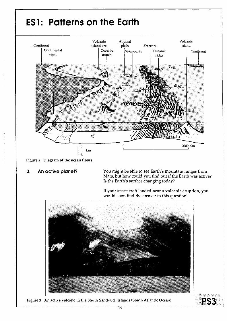
ES 1: Patterns on the Earth
[: km
Volcanic island arc
Oceanic trench
Abyssal plain
Seamounts
o ,
Fracture
Oceanic ridge
Volcanic island
2000 Km I
Figure 2 Diagram of the ocean floors
3. An active planet? You might be able to see Earth's mountain ranges from Mars, but how could you find out if the Earth was active? Is the Earth's surface changing today?
If your space craft landed near a volcanic eruption, you would soon find the answer to this question!
Figure 3 An active volcano in the South Sandwich Islands (South Atlantic Ocean)
14 ···· ••• ·.·aS3 •• ••·······

ES 1: Patterns on the Earth
How does the pattern of volcanoes on the Earth's surface compare with the features you have already plotted?
The map on Data Sheet 2 shows where the Earth's active volcanoes occur. An 'active' volcano is one which is actually erupting lava or ash, or is producing hot gases and steam. About 60 volcanoes erupt each year.
3.1 Use a piece of tracing paper to trace from DS2, where the main belts of volcanoes lie. Don't try to plot each volcano, but draw a shaded area; like the one which has been shaded in for the Atlantic Ocean.
3.2 Now stick down your tracing by one of its edges on top of your world outline map (DSl) and study the two maps carefully. Do the belts of volcanoes correspond with any of the features you have already coloured? Look at each of the following:
modern fold mountain ranges ancient fold mountain ranges rift valleys regiOns underlain by very ancient rocks ocean ridges deep trenches
a) Which of these features are linked with belts of volcanoes?
b) Are there volcanoes which are not linked to any of these things? If so, where are they?
3.3 The belts of volcanoes in the Pacific and Atlantic Oceans are linked to different features.
a) Which features are linked with which belt? b) Which belts contain the 'most volcanoes?
L--------------------------------------15 ----------------------------~=

I. t L,
r;
ES 1: Patterns on the Earth
4. The Martians have landedl
5. Return to Earth
L: '1',
I, i,
After all this planning and mapping of the Earth's surface from far off, any Martian scientist would be dying to lay hands on some Earth rock, to see what it is made of!
4.1 Landings have been made at the 6 places shown by letters on DSl. Rock specimens and photographs have been brought back to Mars from each site, but unfortunately, the labels became lost in the laboratory of M.A.S.A. - the Martian Aeronautics and Space Agency.
Study the rock specimens and photographs which have been brought back. Decide which ones belong to which of the sites shown on DSl. Write down your reasons.
You want to follow up your successful mission by making another landing on Earth. You have shown that active volcanoes occur in certain belts on the Earth's surface today. It might be possible to find evidence that volcanoes also existed in the past, in areas which are no longer active.
5.1 Where would you plan to visit, to test this idea?
5.2 There is a group of islands around Latitude 54° North, Longitude QO, which may help. Use a detailed map of these islands to choose one area where you could land to look for ancient volcanic rocks.
5.3 What kind of evidence would you look for to show that volcanoes used to be active there?
5.4 Write part of a log book for this second landing on Earth. Describe your adventures, using as many useful scientific terms as you can. Illustrate your log book with some pictures of yourself at work, finding out about the rocks of the Earth.

.... 'I
Figure DSl The major features of the Earth's surface
" 3 3
3 3
4
D 1 Fold mountain belts
D 2 Older fold mountains etc.
D 3 Regions underlain by very ancient rocks [S)] Rift vaUI:Y"1
D 4 Oceanic ridges
lis Deep trenches
~
4
p) 4
m fA -.I
• •
." Q .... .... (I) .... ::::J en o ::::J .... ::r (I)
m Q .... .... ::r

..... 00
Figure DS2 Active volcanoes of the Earth
+ + +
+
'\l
.,..". .,.
+ )(
)( &1"+ C\ +
+ ~ .,. .,.
d'rJ
KEY
+ Active volcano
Belts of active volcanoes (for you to finish shading)
++ +
~
.~ .,
m en .... • •
." Q = CD ... :::l en o :::l .... =r CD m Q =+ =r

Earth1s surface features ES2: Is the Earth cracking up?
Notes on teaching the Unit
1. As old as the hills?
This is merely a brief introduction to the subject; the thoughts may never have occurred to some pupils.
2. Push and pull
This two-part experiment may be conducted either by following the 'recipe' given, or pupils may be asked to devise their own investigation into the effects of putting sand under tension or of compressing it. In this case, PS1 to PS3 will only be needed to help the less able.
Only the minimal amount of flour or talcum powder need be used, e.g. 1 mm thickness sprinkled along the front of the model.
2.1 Pull The tensional forces should produce one or more normal faults, as shown in Figure Tt.
Nonnal .... ~ ... nfault plane
r.;.' :; .... ;.:.:.: .... : ... : .. :. : ..... : ......... . '<: ............ : .. ::: .. ::.:.:: ... : .. : .. : ............. .
Figure n 'Normal fault' in layers of flour and sand under lateral tension. 19 --------------------------------~==~~

ES2: Is the Earth cracking up?
2.2 Push As lateral compressional forces are applied, by pushing the board, the sand and flour layers begin to buckle and may produce an overfold, as in Figure 1'2.
Figure T2 Overfold produced by lateral compression.
Later, slip occurs along a clearly defined 'fault plane'. This is usually a low-angle thrust (where the angle between the fault and the horizontal is usually less than 45°) as shown in Figure T3.
Figure T3 'Thrust faults' produced by further lateral compression.
.....
Other similar faults may develop as the board is moved further along the box.
3. It's not your fault!
Ovcrfold
Thrust fault planes
3.1 The pictures in Figure 3 (PSS) match the results of the experiments shown in Figures T1 to T3 as follows:
Figure T1 (normal fault) matches Pictures 1 and 3; Figure 1'2 (overfold) matches Picture 2 Figure T3 (thrust fault) matches Picture 4
3.2 Pictures 1 and 3 show the results of tensional forces and 2 and 4 show the results of compressional forces.
3.3 The rift valleys in Pictures 5 and 6 were formed by tensional forces. Two boards would be needed for each sand box, if pupils are to try to reproduce the conditions.
4. How long does it take?
4.1 Rapid earth movements include: volcanic eruptions, landslides, mudflows, avalanches, earthquakes (see Unit ES3). Slower-acting process are usually seen in the weathering of building stones or the transport of large amounts of sediments in water or ice.
4.2 This part of the Atlantic is 5000 km wide. At a spreading rate of 4 cm per year, it would have taken 125 million years to grow to its present width.
If the wall map of the ocean floors has been obtained for use in ESl, it may usefully be referred to again here. The Mid-Atlantic Ridge is virtually central to the ocean and reinforces the idea that the continents on either side of it may once have been joined.
The rate at which the ocean floor has spread is largely derived by measuring the magnetic properties of the rocks of the sea floor and relating these to more accessible lavas in Iceland, which can be dated by radioisotopic means.
This Unit devised by: Peter Kennett, High Storrs School, Sheffield.
20
ES2: Is the Earth cracking up?
1. As old as the hills?
2. Push and pull
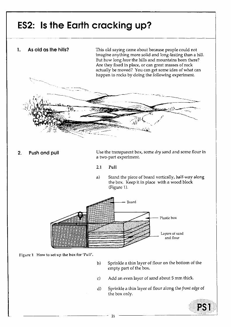
This old saying came about because people could not imagine anything more solid and long-lasting than a hill. But how long have the hills and mountains been there? Are they fixed in place, or can great masses of rock actually be moved? You can get some idea of what can happen to rocks by doing the following experiment.
Use the transparent box, some dry sand and some flour in a two-part experiment.
2.1 Pull
a) Stand the piece of board vertically, half-way along the box. Keep it in place with a wood block (Figure 1).
Board
~-- Plastic box
'~~~~~~III~~L_ Layers of sand ~ and floW"
Figure 1 How to set up the box for 'Pull'.
b) Sprinkle a thin layer of flour on the bottom of the empty part of the box.
c) Add an even layer of sand about 5 mm thick.
d) Sprinkle a thin layer of flour along the front edge of the box only.
21

ES2: Is the Earth cracking up?
1I.~::--=;~PlasticboX ~!!::::~!~::~;I ~~--- Layers of sand q and flour
Figure 2 How to set up the box for 'Push'.
22

ES2: Is the Earth cracking up?
---=---~
\Vhat kind of fault did he say it was?
d) Very carefully, push the vertical board across the box, so that it begins to compress the layers. When you notice the layers beginning to bend, stop pushing the board. Hold it upright, whilst other pupils draw a scaled diagram of the result.
e) Continue pushing the layers with the board until the sand is about to overflow the box. Keep the board upright with a wooden block and draw the final result.
f) Then, as you did for 2.1, add arrows to your diagrams to show the directions of the forces which were acting whilst you compressed the layers with the board.
g) Are the layers still horizontal, or are they bent or folded?
h) Did one set of layers slide over the rest?
If you have been careful, you will have produced another type of fault, known as a thrust fault, where layers of rock are pushed up and over other layers.
.... :.:.:.:::.::::::::::::::::::::::::.::.::.
23
ES2: Is the Earth cracking up?
3. It's not your fault!
4. How long does it take?
Look at the pictures in Figure 3 (PS5). One shows the results of other people's experiments with clay; the others are pictures of real rocks which have been folded and faulted by natural Earth forces.
3.1 Match each of the Pictures 1 to 4 with your own diagrams from the experiments with the box. Note the picture numbers beneath your diagrams.
3.2 Write down which of the features in Pictures 1 to 4 were formed by a) pull-apart (tensional) forces. b) push-together (compressional) forces.
Pictures 5 and 6 look like the results of one of your experiments, only there are two faults, one on either side. Between them, a block of land has been lowered down to form a valley. Such a structure is called a rift valley.
3.3 Are these rift valleys caused by tensional or by compressional forces?
How could you produce such a rift valley in your sand box? If you have time, you could try out your ideas.
When you made your folds and faults in the sand layers, it probably only took you about 5 minutes! How long does it take in the Earth?
4.1 Try to write down two things which show that Earth movements can happen:
i) very quickly indeed. (Hint - think of T. v. reports of some 'natural' disasters).
ii) very slowly indeed. (Hint - think of your visits to streams or the seaside or to look at building stones in towns and graveyards).
Recently, geologists have been able to work out how long it has taken for certain events to happen. Read the information about the Atlantic Ocean on sheet PS6. You will then be able to calculate the times for yourself:
24

ES2: Is the Earth cracking up?
1. The pale layers used to be continuous until the rocks were broken and the layers on the right were moved down.
O.5m
2m
3. A steep slope, caused by the rocks on the right side being moved down in great earthquakes, millions of years ago.
50 mm
Figure 3 Various types of faults and folds.
25
2. Some of the beds here are upside down.
4. The white beds in the cliff once used to match up.
5. This valley was made by earthquakes moving its floor downwards.
6. The results of an experiment with layers of wet clay placed on two moving boards.

N
t
ES2: Is the Earth cracking up?
Figure4A
Atlantic Ocean
o
The sea bed of the Atlantic Ocean is not fixed. Instead, it is being pulled apart at about the same rate as your finger nails grow. As it does so, molten rock rises from below and crystallises in the space. This means that the Atlantic Ocean is actually becoming wider by about 4 cm per year. This pulling apart has produced an underwater rift valley running right down the middle of the ocean.
The Atlantic Ocean now looks like the map shown in Figure 4A. A long time ago, the Atlantic Ocean did not exist; instead, the continents of Africa and South America were joined together, as shown in Figure 4B.
Figure 4B
6000 km ! I
Figure 4 Africa and South America A) separated by the Atlantic Ocean today; B) joined to form part of a supercontinent, in the past.
4.2 How old is the Atlantic Ocean floor? To find out:
a) Measure the width of the modern Atlantic Ocean from X to Y (in km) (Figure 4A).
b) Assume that South America and Africa were pulled apart at a steady 4 cm per year. How long did it take for the Atlantic Ocean to reach its present width? (Remember that there are 1 x 100 x 1000 = 100,000 cm in 1 km).
If this all seems rather slow to you, the pace hots up somewhat in Unit ES3, 'Earth's moving surface'!
26

Earth1s surface features ES3: Earth1s moving surface
.. ::::.:::::::::::::::::::.:.:<-:::::<".: -::/::::::::::>:::": .. :":".":" :>: .. "; :. ;-; ...... -:.:"<":::.:.:.... . -: '.' . ..
(:~rt(entS! .·>Mintr04~~tibl'l..to earth'lllitk~$.> :)?\>\)?:<>~/?::::::: ....... : ... ::::::-::: ... -:::::::::».: ... ;. .... >:>:: ::":::: . .:::. ::::::::"::::: :":.::: :" .. :.: :. "-:<::::>\.::."': "'. :::.::: .. ::"-::-:
Aifu!i~\.....T()rWi~~p'kil~.aw~reofS{)me~f the causes and effects of earthquakes. . .. . ..... .... .................. • .••..•...... < ..• ...'J:6~W1We ptlP~l~!pl'~ate the distribu tionof earthquakest60ther ·rrili.jor features of
... -. ; :":': :';.:;: ;".: ;.- ;":": . /"::-:: .:.: ««/\:thEfEar:th.'s::surfacEt:-::-·:-· ...... .. . "." . .
.:-:::.:::-.-::::::-:::::::::::-:-:: . .............. . ...... .. .... . ..... ......... . .............................. .
'rfirte~
.. :'::::::i)::>"· :·: .. \:://:>:i: .:: : .. ':.)::> .. :" .... .. , . ." .. :.;::::::.:<: .. "":: :.'.: :"'-:
'fwoperIoqiof35 to 40rriil11.l.tes~pl1.l.shornewOrk or extension work for abler pupils. .. ".. :::><»:::.:: "." "'::::::/(}C; .:i.: .:.:::.,. .... " ",: . .'. : ...... : . ...
Ql'gariiS~~9lFl'9Pilsstartwith individual work, readinganaccount of aneatthquake and relating .. ...... ... . ph6tograph,i(:evidence tp fa~lting.Theteacher gives a simple demonstration of
< .....•••.••••.••••••.•••.•••.••.••.•••.•.•••••.••••••.••••...••...••..••.•..•••••.••.•••••••...••..•.•••.•••.•••.•••.••.••.•.••.••.••••.••••.•••••.•.•.•.•••.•••.•.••••..••.••••.•.•..•.•...•..•..••.••.•••.••••••••••.•.•.••••.•.•.••••..•••• ~~:~j%~W~il:~~~~.::falt~·.~Ji~r~~~~~s~~·b~~e;i:~~h~;:::-la:~~ §ij#ace,alreaclYp~()tt(!din {JriitE;S 1. .....•...... •...... ........ ..... ....... ......... ........ ... .. . ...... .... ... . .... .
>< ••.•• ········<··/··\H9Iri~W91'1<,pfextensiol."\ worl< .consists. ofb~lerst\ldyofa recentBriti$hearthquake
R .••.•••. ··.t .••. ·q ••. U ..•..• · ...•. ·.u.: .•..•.• ·· ....•• • ...•. nt· ...• • ... • .. •• .. •.•.• ....•• ·.•.n •. ·.! .••.•.••.. :................. ~!~i.p~~:::'i .. rtI:>qUake beltstp p~",!i'ctriniC tl)e<>tY, ............... ' ..... 1(.". ............ ....... .
............ »........................> ............... '·.·.·.·.·.··.··· .. ··E~t1.l.~kJ.e· copigsof·the.l'upilSheets (p5>.··1···tO·$.·tpage.3i···to .3.5) and··bata· Sheet (OS).1 /?~pag(!2pf> ........ . .••.••••...•..•••.• ><................«
••· •• ·i ••.•.•.. i,lpA4she(;!t o~tqu:illgp(lper ...•. ....•..••.......... ...... . •••••......• ...•...... .. ..
11;·illllljii.li!!;)i;;i!tl:'i~:::::~:iluw~.~ap.taN.wt® me~, ·.i..(:~paJ:>!~pfPei~~~~in thehQrit0~~Ip()sjtioJ\ •... .. .. ...•.. ... ....... .... ..••.... . . .. ...•. .
.. ····«<pptlonal:·.asketcl'\lnapbased OilFigure IB(PS2), (:ut along the·fault plane· and stuCk ...•... <>t6tli~pricl%Pefoiethe lesson. (...... .. . ...•.•••....... . ·r .••.•.... •.. ..... .. ...... ...... .. . ....•...
. a wallffi,i,lpoftlle world sho\\,ing tM disn-i1:>utioriof earthquakes (see Cover Sheet fotq~t(lils), .. .... .. .. . . . . .
Notes on teaching the Unit
1. A moving experience
The real experiences of several people have been combined in this account.
Earthquake magnitude is measured instrumentally, using the Richter Scale. This is a logarithmic scale, i.e. an increase of each point on the scale (e.g. 4 to 5) means a ten-fold increase in energy released by the earthquake. It is not referred to in the Pupil Sheets, but some may have heard of it. The Alaskan earthquake of Easter 1964 measured 8.6 on the Richter Scale (compare with 8.3 for the disastrous San Francisco earthquake of 1906, when only half the energy of the Alaskan event was released).
2. Disasterl
2.1 Movement across the faults in the photographs (Figure 1, page 32) is approximately:
a) 1 m, down to the foreground
27

ES3: Earth1s moving surface
b) 16 m, along to the right as seen across the fault. Pupils should realise that faults can occur in any din~ction and with any attitude. Unless movement was extremely slow, earthquakes would accompany faulting.
2.2 Fences, roads and railways can all be displaced by faulting, sometimes in just a few seconds.
3. Quaking Earth
The demonstration is based on the Open University T.V. programme, 'Earthquakes - seismology at work', produced for the 5102 course. Parts of this film are suitable for children!
Set up the demonstration, using two clean house bricks, or similar objects, as shown in Figure Tl. The model can be embellished by a sketch map of the picture in Figure IB (page 32), cut along the 'fault plane' and stuck to the face of the bricks.
The fault which affected California had a vertical plane, but for our purpose, it is simpler to produce an horizontal 'fault plane' by placing one brick on top of the other, to ensure plenty of friction between the bricks. Pull gradually on the elastic, or the Newton meter, until the top brick suddenly slips along. It is this sudden release of energy which produces an earthquake.
A beaker of water standing on the bench near the bricks is also affected by the sudden shock. Ripples are transmitted across the water surface - a useful analogy with the transmission of seismic waves.
Beware: the top brick may come off altogether and could fall off the bench! The demonstration may be more easily controlled if the elastic is tightened by winding onto a spindle, rather than simply pulling it. Bend the hook closed, or tape it over, to avoid possible whiplash injury.
Sketch map of river valley on PS2, (page 32)drawn on two
cards and fixed to bricks string
Figure Tl The bricks set up ready for the 'faulting' demonstration.
elastic
In many unstable regions, one block of country steadily slips past another, almost imperceptibly. Elsewhere, the block sticks and the strain builds up until its sudden release generates a potentially disastrous earthquake.
28

ES3: Earth's moving surface
4. Danger zone
4.1 If pupils have already carried out the exercises in Unit ESl, ensure that the map on OSI (page 36) is photocopied at the same scale as the earlier maps. Pupils should use a different colour from any of their work inESl.
4.2 There is a strong correlation between the location of most earthquakes and the world's 'active' regions, as follows:
a) on land - (i) fold mountain belts and (iD rift valleys
b) in the ocean basins - (i) island arcs and their associated trenches, (iD oceanic ridges, (iii) 'hot spot' volcanoes, e.g. Hawaiian Islands.
Other earthquake events are mostly related to fracture belts, on land and under the sea, which are too complex to deal with here.
c) the main regions where earthquakes occur but volcanoes do not, are the Himalayas and related mountain ranges.
See the notes on page 8 and 9 in Unit ESl for further details.
5. Is Britain safe?
Earthquakes in Britain are rare and are mostly due to minor slippage along ancient fault lines. The most notable recent events were:
Date Location Magnitude
Dec 1979 Carlisle 4.8
July 1984 Lleyn Peninsula, North Wales 5.4
Nov 1986 North Wales 5.4
Apr 1990 Mid Wales 5.4
The extract on PS4 is reprinted by kind permission of the Powys County Times and Express, with slight amendments. It can be used as the basis for a number of comprehension exercises. Note that the main slippage which generates an earthquake occurs at the focus beneath the Earth's surface. The place on the Earth's surface immediately above the focus is called the epicentre.
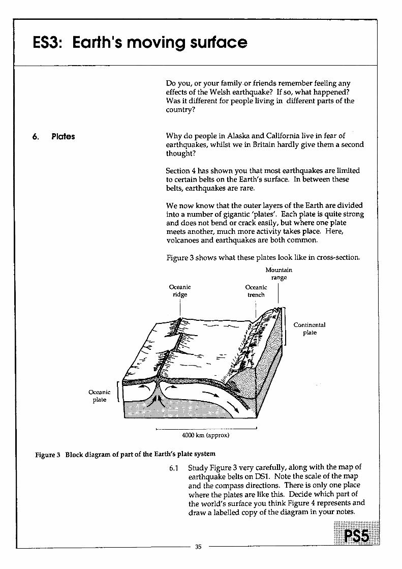
6. Plates
For teachers who wish to deal more thoroughly with plate tectonic theory at this stage, Figure T2 (page 30) gives a summary of the major divisions of the Earth's lithosphere. An overhead projector acetate prepared from Figure T2 may be used in conjunction with the maps from Unit ESl, which are on the same scale.
6.1 The drawing on PS5 (page 35) is of the Nazca Plate, in the eastern Pacific.
This Unit devised by: Peter Kennett, High Storrs School, Sheffield. 29 --------------------------~~

~
I I I
Eurasian Plate I
African Plate
/ /\ I \ \ I ~
\ \
/'
Plate boundary
" /'
I _----J ,," \
,," \
" \
Indo-Australian Plate
Antarctic Plate
- - - uncertain plate boundary
Pacific Plate
North American Plate
,,~---
/' I
I
, \ ",.---_ .....
Eurasian Plate
African Plate
Figure T2 The major 'plates' of the Earth
m en ~ • •
m Q ~ =r -en
3 ~ _. J
CC en c: =l Q o (I)

ES3: Earth1s moving surface
1. A moving experience
2. Disaster!
This is what actually happened on Good Friday, 1964 in Alaska, U.S.A.
1.1 Read the account and then write down what you think was happening. How would you have felt at the time?
"For as long as I live, I shan't forget Easter 1964. I'm a crane driver and I work in the docks in Seward, in Alaska. It was just beginning to get dark on Good Friday, and I had nearly finished my last shift before the holiday. All of a sudden, my crane started to move - and without me touching the controls! It wasn't long before the jib was flipping backwards and forwards like a long whip. Then, the wheels came off the track and the whole crane started walking about like some stiff-legged spider.
I never got out of that cab so quickly! By the time I reached the ground, the whole dock was cracking up and buildings were collapsing all around me.
My first thoughts were to get home, and I ran as fast as I could towards the town. At times, it was like trying to run across a rubber mattress. Once, I fell into a crack a metre wide. Only seconds after I got out, it closed up again.
At last, I reached safety, away from the buildings, and looked back. What an amazing sight! A great wall of water was rushing inland from the sea, carrying with it whole boats, trees, oil drums and all sorts of other debris. Only just ahead of it a car was being driven at 70 miles per hour along the airfield runway. The driver only just managed to escape.
I hope I never have to go through anything like that again!"
This story is a good reminder that geological events do not always take millions of years to happen! Sometimes, changes in the Earth take place very quickly and even disastrously.
The two photographs in Figure 1 show changes which happened in a very short time.
31

ES3: Earth1s moving surface
Figure 1B A river valley, displaced by movement along the San Andreas Fault in California.
Figure lA A miniature cliff, formed after an earthquake in Algeria in 1980.
In each case, the rocks on either side of a line have moved. This line marks a plane where a fault has occurred, rather like the model faults which you may have created in Unit ES2.
2.1 Study the photographs carefully. For each photograph:
a) estimate how much movement has taken place along the fault. Compare the two sides and use the scales on the photographs.
b) note in which direction the rocks on the two sides of the fault have moved: was the movement up and down, or sideways?
2.2 How do you think active faults could affect fences, roads and railways?
32

ES3: Earth1s moving surface
3. Quaking Earth
Figure 2 Destruction caused by an earthquake in Italy
4. Danger zone
How is the story in Section 1 linked to the pictures in Section 2? Almost certainly, the violent earthquake in Section 1 would have been caused by the rocks below ground moving along a fault, like the ones shown in the photographs. Such movements are sudden and often cause great damage (Figure 2).
We can find out how earthquakes happen using a simple model made from bricks.
3.1 Watch the demonstration and then answer the following:
a) Sketch the position of the bricks before and after the 'earthquake' .
b) Could this kind of movement explain the way the river course was diverted along the San Andreas Fault in California?
c) What happened in the demonstration before the movement actually took place?
d) If you used a Newton meter, how much force (in Newtons) was needed before the brick began to move? Is the same force always needed?
In the natural world, a similar build-up of strain (force) occurs before the rocks finally slip and cause an earthquake. This strain can be measured, and it is hoped that the measure-ments will give warning of the next big earthquake, in time to alert people to the danger ..
Which areas of the world are in the most danger of earthquakes? The map (Figure 4) on DS1 shows where the world's major earthquakes have occurred this century.
4.1 Fix a piece of tracing paper over the map. Using a coloured pencil, outline the major earthquakezo'nes on Earth. Don't try to plot single earthquakes, but draw lines around the main belts of earthquakes.
If you prepared your own map of the Earth's surface patterns in Unit ES1, you can now try comparing it with your tracing of the earthquake belts.
4.2 Put your earthquake tracing over your map of the major features of the Earth's surface, from ESl.
33

ES3: Earth1s moving surface
a) Which features of the land surface correspond to the earthquake belts?
b) Which features of the ocean basins correspond to the earthquake belts?
c) Are there any areas which experience earthquakes, but do not have volcanoes? If so, where?
5. Is Britain safe? 5.1 Look again at the map of earthquakes. Have any earthquakes been plotted in Britain?
We do not think of our country as being affected by earthquakes, but now and again, they do take place. It is very rare for any serious damage to occur. In 1990, a small earthquake occurred in mid-Wales.
5.2 Read the following cutting from a Welsh newspaper for April 7th, 1990.
County Times and Express, Powys, April 7th 1990
r~;;~~;~~~~;;;~;; .: .... : .. :: ... : Mid Wales prompted to detect.
startled people to evacuate The focus was eight :~: offices, schools and homes kilometres below rocky
.::: all over the region on ground which limited the I M=d."rutemoon. :==~~~=
. Despite the severity of the ground, the shock waves I ::~:!;::~~= :~~~~:a,::,:;;fiOO
::i:::!:::i,: ~e~?~ s~§;:~~~ Turbitt, aBGS seismologist.
I.il ~::~;cen::sof ~~~!;;~ ~~~ld~~;S :u::;:~sde~;
:111
Bishop's Castle and Clun. sediment then an earthquake It was felt as far away as is amplified a lot. London and Manchester and one of the worst affected areas was Shrewsbury.
Seismolo gists at the British Geological Survey, Edinburgh, revealed that the area had been lucky to
"That is why buildings in Shrewsbury and Wrexham were shaken very much more than at the epicentre."
Mr Turbitt said about 400 earthquakes were registered
34
The last earthquake to register 5.4 on the Richter scale was in North Wales in 1984.
"It is pretty rare," said Mr Turbitt. "One only expects an earthquake of this magnitude in Britain twice in a lifetime. To get two in six years is particularly interesting. "
He explained: "The basic reason for earthquakes in Britain is that the middle of the Atlantic is spreading out and as it does so it is crushing us towards the Alps.
"The rocks are under tremendous pressure and every day there is movement with something giving way."
ES3: Earth1s moving surface
6. Plates
Oceanic [ plate
Do you, or your family.or.fnends remember feeling any effects of the Welsh earthquake? If so, what happened? Was it different for people living in different parts of the country?
Why do people in Alaska and California live in fear of earthquakes, whilst we in Britain hardly give them a second thought?
Section 4 has shown you that most earthquakes are limited to certain belts on the Earth's surface. In between these belts, earthquakes are rare.
We now know that the outer layers of the Earth are divided into a number of gigantic 'plates'. Each plate is quite strong and does not bend or crack easily, but where one plate meets another, much more activity takes place. Here, volcanoes and earthquakes are both common.
Figure 3 shows what these plates look like in cross-section.
Mountain range
Oceanic Oceanic ridge trench
I -- __ Continental
plate
4000 km (approx)
Figure 3 Block diagram of part of the Earth's plate system
6.1 Study Figure 3 very carefully, along with the map of earthquake belts on OSl. Note the scale of the map and the compass directions. There is only one place where the plates are like this. Decide which part of the world's surface you think Figure 4 represents and draw a labelled copy of the diagram in your notes.
35

ES3: Earth1s moving surface
.to
.. \ ..... . :.
. ~ .. ' r·
.. ' . ',1 .. ; ~: . '': : .~:t: °0 ~.:,.
.....
.~. -:0' . .... • ..
36
'.:
'.1
. ..... : .. ".
'~" :-.
. ..
.. .(
.:
. . • •• ,·S ':l.·~
If.: ....
g ..
.:
. ,

Earth Science Teachers' Association: Science of the Earth 11-14
Coverage of Programmes of Study: The Units ESI to ES3 cover parts of the following Programmes of Study at Key Stage 3, in the National Curriculum for Science and for Geography:
ESt ES2 ES3
National Curriculum for Science
ATl Scientific investigation:
"Pupils should be encouraged to develop investigative skills and understanding of science through activities which: ... are set within their everyday experience and in wider contexts ... I I I
... encourage the search for patterns in data and the ability to make simple predictions based on findings." I I I
AT3 Materials and their properties:
Pupils should: "investigate ... the properties and formation of ... rocks, and link these to major features and changes on the Earth's surface". I I I
"be aware of the time-scales involved in the operation of geological processes ... " I I
AT4 Physical processes:
Pupils should: "discover that forces can act to change the shape of things .. .'! I I
National Curriculum for Geography
ATl Geographical skills:
Pupils should be taught to: "use satellite images to identify and interpret patterns in physical...geography" I
AT3 Physical geography:
Pupils should be taught: "the nature and effects of earthquakes and volcanic eruptions ... and to investigate the global distribution of earthquakes and volcanoes and how this relates to the boundaries of the crustal plates"; I I I
"physical processes which can give rise to one type of natural hazard and how people respond to that hazard." I I
Analysis of skills ESt ES2 ES3 Analysis of skills ESt ES2 ES3
Designing and planning an investigation Decision making exercise
Practical investigation I I Solving problems by applying results
Experimental investigation I Compiling a report I
Data collecting and recording Calculation I
Data plotting exercise I I Three-dimensional thinking I I I
Data manipulation exercise Thinking in the time dimension I I