Embed Size (px)
Citation preview

Labs
Earth Observation application to
Disaster Risk ManagementPresenter: Abby Baca, GFDRR Labs

Labs
Our mission is to use
science, technology and
innovation to inform
decision making; to reduce
the vulnerability of the
developing world to disasters
in a changing climate

Labs
DRM cycle

Labs
DRM cycle
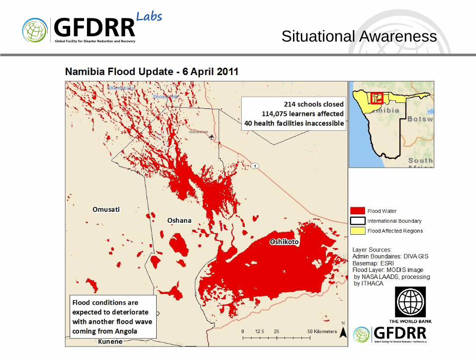
Situational
Awareness
Post Disaster Needs Assessment
Monitoring
Weather and
Land Conditions
Risk
Assessment
Monitoring
Reconstruction
Data Preparedness

Labs
DRM cycle
Situational
Awareness
Post Disaster Needs Assessment
Monitoring
Weather and
Land Conditions
Risk
Assessment
Monitoring
Reconstruction
Data Preparedness

Labs
DRM cycle
Situational
Awareness
Post Disaster Needs Assessment
Monitoring
Weather and
Land Conditions
Risk
Assessment
Monitoring
Reconstruction
Data Preparedness

Labs
DRM cycle
Situational
Awareness
Post Disaster Needs Assessment
Monitoring
Weather and
Land Conditions
Risk
Assessment
Monitoring
Reconstruction
Data Preparedness

Labs
DRM cycle
Situational
Awareness
Post Disaster Needs Assessment
Monitoring
Weather and
Land Conditions
Risk
Assessment
Monitoring
Reconstruction
Data Preparedness
Labs
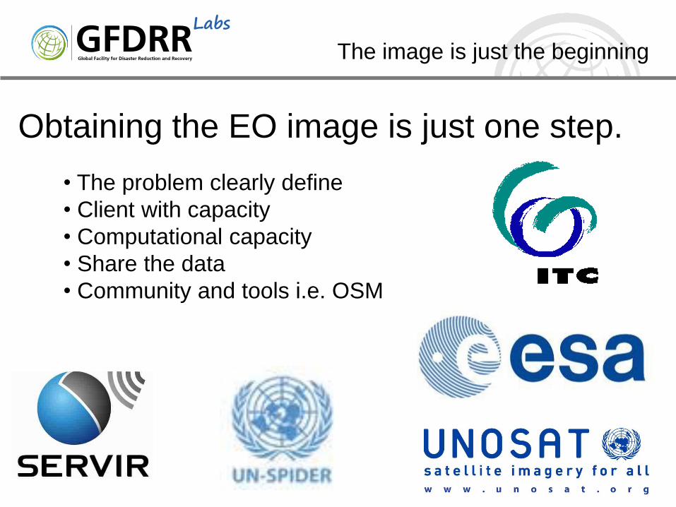
Obtaining the EO image is just one step.
The image is just the beginning
• The problem clearly define
• Client with capacity
• Computational capacity
• Share the data
• Community and tools i.e. OSM

Labs
DRM cycle
Situational
Awareness
Post Disaster Needs Assessment
Monitoring
Weather and
Land Conditions
Risk
Assessment
Monitoring
Reconstruction
Data Preparedness
Labs
Situational Awareness

Labs
DRM cycle
Situational
Awareness
Post Disaster Needs Assessment
Monitoring
Weather and
Land Conditions
Risk
Assessment
Monitoring
Reconstruction
Data Preparedness

LabsRisk Assessment:
Input Data
HazardSoil Maps
Topography
Bathymetry
Climate Observations
Vulnerability functionsPast Event Damage
ExposureBuilding Typology
Satellite Imagery

Labs
Hazard Assessment

Labs
Exposure Assessment
Top Down
Bottom Up

LabsExposure:
Community Engagement
• Working directly with
communities
• Creating multi-purpose
maps: poverty mapping,
disaster preparedness,
input for risk assessment

Labs
DRM cycle
Situational
Awareness
Post Disaster Needs Assessment
Monitoring
Weather and
Land Conditions
Risk
Assessment
Monitoring
Reconstruction
Data Preparedness
Labs
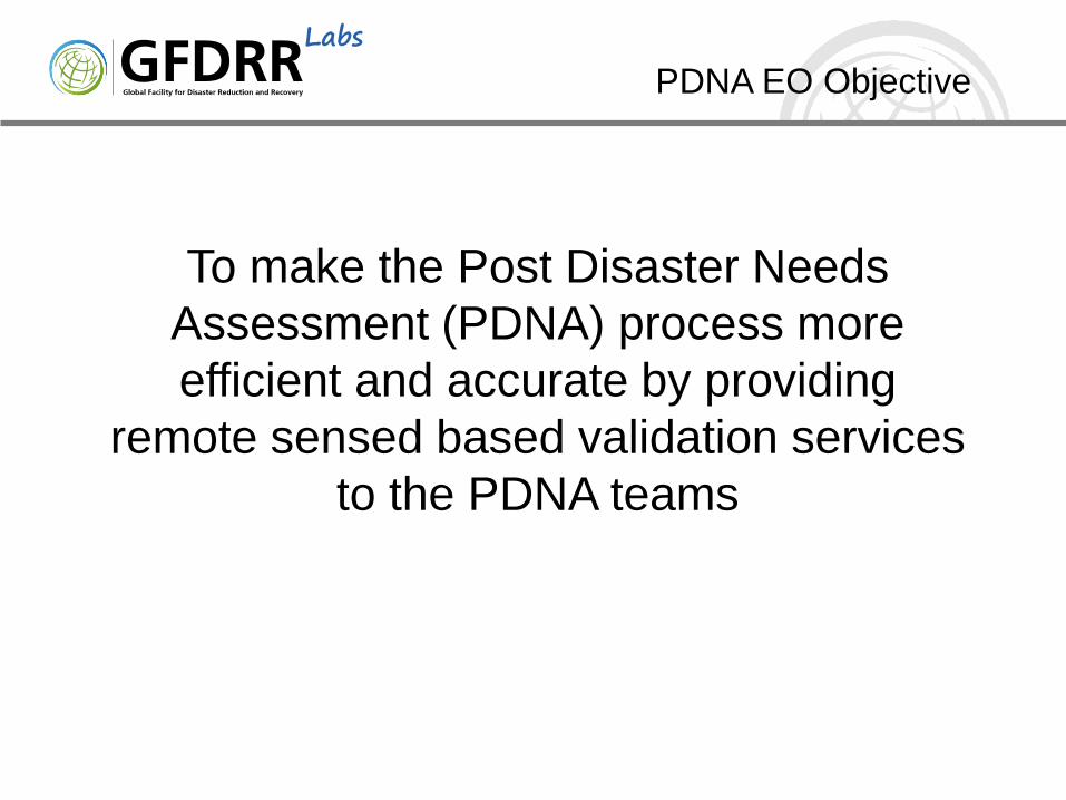
PDNA EO Objective
To make the Post Disaster Needs
Assessment (PDNA) process more
efficient and accurate by providing
remote sensed based validation services
to the PDNA teams

Labs
DNA: Chile
• 8.8 Magnitude
offshore earthquake
• Dichato, Tome
• 50 miles south of
epicenter
• Used pre and post
imagery to assess
the damage

Labs Remote Damage Assessment
Chile
GFDRR is able to help developing countries reduce their vulnerability to natural disasters and adapt to climate change, thanks to the continued support of our partners: ACP Secretariat,
Australia, Bangladesh, Belgium, Brazil, Canada, Denmark, European Commission, Finland, France, Germany, Haiti, India, International Federation of Red Cross and Red Crescent Societies,
Ireland, Italy, Japan, Luxembourg, Malawi, Mexico, the Netherlands, New Zealand, Norway, Saudi Arabia, Senegal, South Africa, South Korea, Spain, Sweden, Switzerland, Turkey, United
Kingdom, United Nations Development Programme, United States, UN International Strategy for Disaster Reduction, Vietnam, the World Bank, and Yemen.
Image before

LabsIdentify the buildings
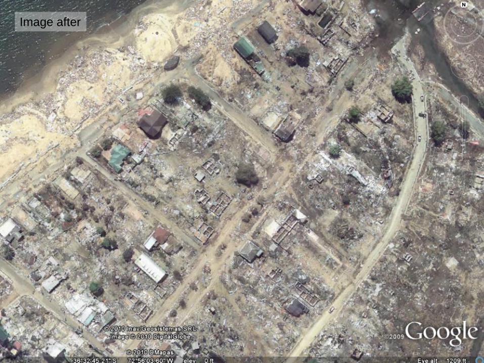
LabsImage after

Labs Remote Damage Assessment
Chile
GFDRR is able to help developing countries reduce their vulnerability to natural disasters and adapt to climate change, thanks to the continued support of our partners: ACP Secretariat,
Australia, Bangladesh, Belgium, Brazil, Canada, Denmark, European Commission, Finland, France, Germany, Haiti, India, International Federation of Red Cross and Red Crescent Societies,
Ireland, Italy, Japan, Luxembourg, Malawi, Mexico, the Netherlands, New Zealand, Norway, Saudi Arabia, Senegal, South Africa, South Korea, Spain, Sweden, Switzerland, Turkey, United
Kingdom, United Nations Development Programme, United States, UN International Strategy for Disaster Reduction, Vietnam, the World Bank, and Yemen.
Measure the damage
via the difference
Labs
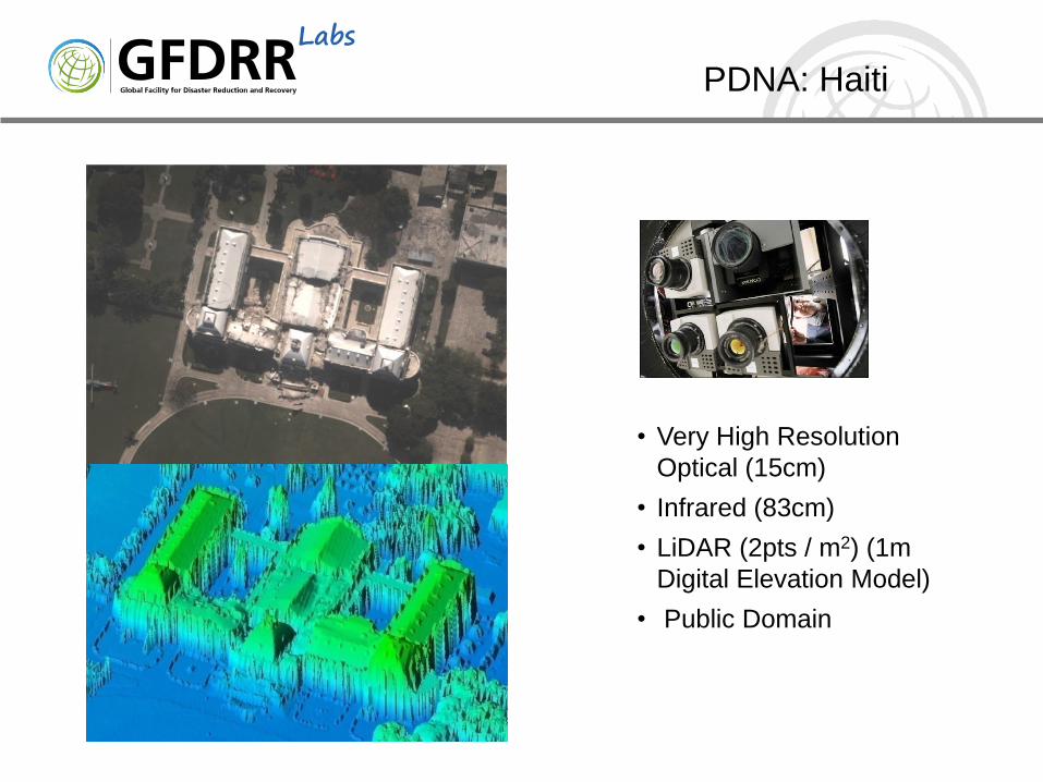
PDNA: Haiti
• Very High Resolution
Optical (15cm)
• Infrared (83cm)
• LiDAR (2pts / m2) (1m
Digital Elevation Model)
• Public Domain

Labs
PDNA: Haiti
• Over 600 scientists and engineers
• From 23 countries
• To assess the damage building-by-building
• In under one week
500m x 500m cells
Global Earth Observation –Catastrophe Assessment Network (GEO-CAN)

Labs
Spatial Resolution
A building in Port-au-Prince, Haiti, following the 2010
earthquake, shown with varying resolutions
~10% ~70% ~90%
Building level
damage identification
accuracy based on
subsequent ground survey

Labs
PDNA: Pakistan
• Partnered with the
Pakistan Space Agency
(SUPARCO)
• Used radar and optical
imagery to define the
maximum flood
inundation
• Identified what districted
to assess
• Validate field collected
damage data
• Sector-by-sector
• Housing
• Agriculture
• Transportation
• Irrigation

Labs
PDNA: the future
• Interferometric synthetic
aperture radar (InSAR)
• Rapid (1-day) damage
assessment
• Surface displacement
maps, fault trace maps,
subsurface slip models,
ground shaking
predictions

Labs
Data Intensive
HazardSoil Maps
Topography
Bathymetry
Climate Observations
Vulnerability functionsConstruction Codes
Past Event Damage
ExposurePopulation Census
Building Typology
Construction Costs
Satellite Imagery
Communication of Risk Assessment output

Labs
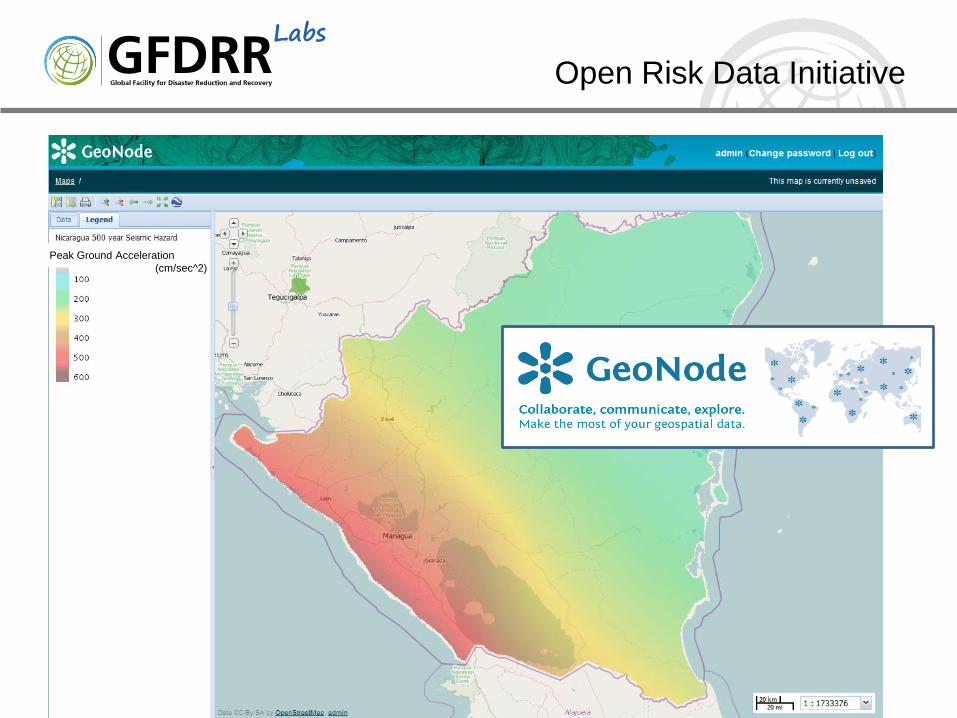
Open Risk Data Initiative
Sharing data is a critical step in
reducing risk
Freedom for others to innovate
with this data
Work with countries to enable them
manage and share their data
We need to lead by example to
create a global culture of open data
Labs
Peak Ground Acceleration
(cm/sec^2)
Open Risk Data Initiative

![˘ˇ ˆ · (EarthCARE) [2012] SGLI (GCOM-C) [2013] Climate SBA Greenhouse Gases Observation Sensor (GOSAT) [2009] Disaster SBA SAR (ALOS, disaster ... Solar Flux FTS TIR Solar Irradiance](https://img.dokumen.tips/doc/110x75/60571c2dcbd6546dda642f28/-earthcare-2012-sgli-gcom-c-2013-climate-sba-greenhouse-gases-observation.jpg)