Embed Size (px)
Citation preview

NEW MEXICO GEOLOGICAL SOCIETY '0' ELEVENTH FIELD CONFERENCE 113
EARLY EXPLORATIONS OF RIO ARRIBA COUNTY, NEW MEXICO
AND ADJACENT PARTS OF SOUTHERN COLORADO'CARLE H. DANE
U. S. Geological Survey,Washington, D. C.
Onate's conquest in 1598-9, with a temporary interruptionduring the decade of the Pueblo Revolt (1680-91 ). Onate'scapital city was at "San Juan" (in the general vicinity of thepresent San Juan) for several years following the conquest.The original plans to build a larger city at San Juan werelater abandoned in favor of the present location of thecapital at Santa Fe. There is little indication at this timeof exploration or knowledge of the country to the northoccupied by the Yutas. First communication with Yutasis said to have been made by Governor Otermin about1679 (Bancroft, 1889, p. 171).
Archeological investigations ( Roberts, 1930) show thatnumerous pueblo sites on the Piedra River in southwesternColorado and in several canyons to the south in northernRio Arriba County were occupied at some time during andfollowing the Pueblo Revolt (1680-1691) and the subse-quent reconquest. Presumably these sites were occupiedby Jemez people, perhaps those who were defeated duringone of the battles of the reconquest, and consequently fledto the Navajo country.
Some contact between these people and those whoremained in the original pueblos of the Rio Grande areaunder Spanish influence must surely be assumed.
DeVargas in 1694 led an expedition northward fromSanta Fe into the San Luis Valley of southern Coloradoby way of Taos but retwned southward along the westside of the Rio Grande via Ojo Caliente—and thereafterthis region remained within the zone of Spanish influence(Espinosa, 1939, p. 88).
THE SETTLEMENT OF ABIOUIUFor about a century and a half after the Onate con-
quest the northern frontier of Spanish occupation remainedessentially constant, the energies of the settlers beingfully consumed by consolidation of their area of control.In 1744, however, a settlement near present-day Abiquiu,on the west bank of the Chama about 15 miles northwestof its junction with' the Rio Grande, was recorded as " .occupied by 20 Spanish families living at Santa Rosa deAbiquiu, 10 leagues west of Santa Fe" (Menchero, JuanM., Declaration del P. Procurador, 1744, as quoted inAdams and Chavez, 1956).
The location of the original Spanish settlement ofAbiquiu was apparently about a mile and a quarter east ofthe site of the modern town, at a place where the ruins ofthe chapel of Santa Rosa de Abiquiu may still be seen ad-jacent to U. S. Highway 94 (fig. 2). Dominguez' descrip-tion of his visit to Abiquiu in 1776 distinguishes on the onehand between the pueblo, at a site recognizable from thedescription as being at the site of the modern town, and onthe other a mission that has charge of some settlers ofwhom ". . . part live to the east . . in a small plaza.In this direction there is a shrine of St. Rose of Lima be-longing to the settlers, where they buried their dead whenthere was no church in the pueblo" (Adams and Chavez,1956, p. 120, 121). • According to Adams and Chavez,Abiquiu was founded in 1754 as a settlement for "Christiangenizaro Indians and the church there was begun by FrayJuan Jose Toledo who came to Abiquiu in 1755, but thechurch was not finished until the 1770's." As stated by
INTRODUCTIONEarly American history is not all recorded in the chron-
icles of the States of the Atlantic Seaboard nor even in thestirring story of exploration and settlement along the mainlines of transcontinental migration westward. Even suchand until recently remote and quiet backwater as Rio ArribaCounty, New Mexico, has had its share in the events thatconstitute the story of our national development. Thefollowing brief summary of early explorations in RioArriba County comprises a selection by a geologist, writingfor other geologists, of a few items that it is hoped mayhave geographic and even geologic interest to them andto others.
It is less than 25 years since the first paved all-weatherroad crossed Rio Arriba County, and as recently as 1936,to the writer's personal knowledge, grain was threshed onsome isolated farms in the primitive fashion by the treadinghooves of goats driven round on hard puddled-clay floors.Yet this county included within its limits a capital city ofEuropean peoples a decade before the settlement ofJamestown, and its written history, though comparativelymeager, goes back for more than 400 years. Most of thistime it has been a real frontier—at first between the agri-cultural Indian tribes of the pueblo settlements and thenomadic tribes to the north and west, and later betweenthe Spanish-speaking peoples and their nomadic neighbors.The striking and sudden impact on the region of the English-speaking peoples from the East began only in the earlyyears of the nineteenth century, and until very recently hashad only superficial effect on the social, cultural, and eco-nomic background.
EARLIEST HISTORY"Rio Arriba", the region "upstream" along the Rio
Grande and its tributaries from their capital city of SantaFe, as it was known to the early Spanish settlers, includedthe northern group of the Rio Grande Indian pueblos andpresumably also the region to the north inhabited by no-madic Indian tribes, chiefly the Yutas, the present-dayUtes. The northern part of Rio Arriba had been occupiedby pueblo-dwelling Indians during prehistoric times, butduring the earliest European expeditions into northern NewMexico, those of Coronado in 1540, the most northerly in-habited pueblos of the Rio Grande region were apparentlylocated at or close to those that exist today. San Juanwas, and is, about 25 miles northwest of Santa Fe nearthe junction of the Rio Chama and the Rio Grande; SantaClara is on the west side of the Rio Grande a few milesbelow this junction; Taos is about 50 miles north-northeastof Santa Fe; and Jemez, in Sandoval County, is locatedabout 45 miles west of Santa Fe. (see figure 1).
Although the boundaries of Rio Arriba County havebeen changed considerably from time to time since itsestablishment in 1852, it now includes much of the areathat would have been regarded as "Rio Arriba" in earlydays. The pueblos of Santa Clara and San Juan fall withinthe county boundaries in its southeastern part. Spanishoccupation of the Rio Grande pueblos was continuous after
'Publication authorized by Director, U. S. Geological Survey.

°TaosINDIAN PUEBLOS
ike's stockadeof February1807
COLQ RADONEW MEXICO
9)-k Horse Lake
o4I
ofFARMINGTON
SANTA YE
•ALsuouelepuel
_j'i:ttjAkEL PASO TEXAS
INDEX MAP OP NEW MEXICOShowing location of area snown On largerscale and outline of Rio Atriba County
MAP SHOWING ROUTES OF SOME EARLY JOURNEYS ACROSSRIO ARRIBA COUNTY, NEW MEXICO AND ADJOINING REGION
OJO CALIECART,.
AbicuTu
EXPLANATION
Frs. Dominguez and Escalante 1776Z. M. Pike 8Antonio Armijo
1180297
B. Choteau 1848 Orville Pratt ---------------1849 --Choteau arid Pratt 1848,1849 – -J. S. Newberry 1859 — -•-- —E. D. Cope 1874
+1- -4-
Scale in Milesio O 10 20
Figure 1

NEW MEXICO GEOLOGICAL SOCIETY * ELEVENTH FIELD CONFERENCE 115
Dominguez (Adams and Chavez, p. 126), the dwellers atAbiquiu in 1776 and their progeny ". .. speak Spanish inthe manner described with respect to the Santa Fe genizarosfor they all come from the same source and these were takenfor this pueblo." The term genizaro (comparable to theEnglish "Janizary") came to be applied in New Mexico tonon-Pueblo Indians living in more or less Spanish fashion.Some of them were captives ransomed from the nomadictribes and their mixed New Mexico-born descendants in-herited the designation (Adams and Chaves, 1956, p. 42).Modern Abiquiu is probably located on the site of anabandoned Indian pueblo, but about three miles east ofthe site of the present town on the point of a gravel-cappedterrace 100 to 150 feet above the level of the ChamaRiver on the south side lie the extensive ruins of the puebloof Po-shu-ouinge, which was abandoned prior to the Span-ish occupation. The pottery found in the excavation of thisruin included a wide variety of pre-Spanish types—andthe association is believed to be explained by a traditionof the Pueblo Indians of Santa Clara and San Juan thatPo-shu-ouinge was a place where fairs were held andwhere many people came to trade and to have a fiesta(Jeancon, 1923, p. 34, 75-76). According to Mrs. Mar-jorie Ferguson Lambert (oral communication, 1957) of theSchool of American Research at Santa Fe, a similar mixtureof pottery types but including also European majolica wasalso formerly evident in the vicinity of the ruins of thechapel of Santa Rosa de Abuquiu. The custom of anannual fair at Abiquiu, to be first reported in 1776 by Fr.Dominguez, (Adams and Chavez, 1956, p. 252, 253) wasthus probably one that had carried over from pre-Spanishtimes.
The pueblo of Po-shu-ouinge was first described andexcavated during the Wheeler Georgraphical Surveys of1874 (Yarrow, 1879, p. 362-365). One of the collectorswas the noted vertebrate paleontologist, Professor E. D.Cope. The occiput of one exhumed skull was flattened,which suggests the possibility that the skeleton was notthat of a Pueblo Indian as was then supposed but of avisitor or captive (Yarrow, 1879, p. 396).
The frontier settlement of 1744 near Abiquiu was ex-posed to harassment from the nomadic Indian tribes. InOctober 1747, however, Governor Joaquin Codallos yRabal overtook the Comanches and Yutas north of Abiquiuand killed 107 and captured 206 with nearly 1,000 horses(Bancroft, 1889, p. 219). This military action may havebeen the decisive one in a temporary stabilization of thefrontier, for the permanent settlement at modern Abiquiuwas made seven years later in 1754.
During the two decades following establishment ofAbiquiu on its present site, much of the region to the northof Spanish New Mexico lying east of the Colorado Riverand south of the Gunnison River seems to have becomeknown in a general way to Spanish explorers and traders.Unlettered hunters, trappers, and traders doubtless traveledwidely through the country, leaving only ephemeral word-or-mouth reports of their journeys and they were followedby equally unlettered settlers in areas closest to the estab-lished settlements. Records of these earliest travelers andsettlers are meager but it is known that at a date variouslyrecorded as 1761 and 1765 Juan Maria de Rivera madean expedition northward from Santa Fe to the San JuanRiver, past the La Plata Mountains and northwest downthe Dolores River. In 1775 Pedro Mora, Gregorio Sandoval,
Figure 2. Ruins of chapel of Santa Rosa de Abiquiu (in 1957), a mile and a quartereast of present day Abiquiu on U. S. Highway 94 and on the south bankof Rio Chama. This chapel was built prior to 1754 and was visited byFrs. Dominguez and Escalante in 1776.

Figure 3a. 'Panoramic view looking southwest to northeast from center of sec. 29, T. 28 N., R. 1 E., across Stinking Lake.Westward-dipping rocks of Mesaverde group ahead at right near western end of La Puerta Grande. Whitemassively bedded sandstone at right center above lake is Point Lookout sandstone succeeded by Menefee for-mation and by La Ventana tongue of Cliff House sandstone at left center. Low hills of Animas formationand skyline ridge of Wasatch formation of authors at left.
Figure 3b. Panoramic view of Horse Lake looking northward from northern part of sec. 27, T. 30 N., R. 1 E. The PointLookout sandstone dips steeply northward along the ridge at right, Lewis shale is in'the valley in left background,and skyline background ridges are capped by sandstone of the Mesaverde group south of Monero•

NEW MEXICO GEOLOGICAL SOCIETY 0 ELEVENTH FIELD CONFERENCE 1 1 7
and Andres Muniz, who had been with Rivera's expedition,are also recorded as traveling northward to the mouth ofthe Uncompahgre River, where they examined the youngcottonwood carved, with a cross and the initials of hisname, by Rivera ten years earlier ( Bolton, 1950, p. 7).THE JOURNEY OF FATHERS DOMINGUEZ AND ESCALANTE
The scant record of these early explorations and ofmany subsequent ones makes more strikingly evident thegreat value of the detailed record that was made by thehistoric expedition of Fathers Dominguez and Escalante inthe fall' of 1776.
In the summer of 1775 Fray Francisco Atanasio Do-minguez had been sent from Mexico to New Mexico to makea report on the status of the New Mexico missions and tosearch for new routes to connect New Mexico and Cali-fornia. Monterey in California had been established in1770, but at that time had no overland connection withNew Mexico. Fray Silvestre Velez de Escalante, the missionfather at the pueblo of Zuni, was also interested in such anexpedition and the two friars planned to undertake thejourney in the summer of 1776, originally intending toleave Santa Fe on July 4, 1776, the historic date on whichthe Declaration of Independence was issued at Philadelphia.As it happened, their departure was delayed, and mean-while a land route to Monterey was opened by FatherGarces, traveling northwestward from Yuma, Arizona. Al-though word of the successful completion of this journeywas received in Santa Fe prior to their departure, Dominguezand Escalante, fortunately for history, decided that theirexpedition would still be of value and went ahead withtheir plans. Although the immediate results of their heroicjourney were negligible, their geographic discoveries werenotable, as they reached Great Salt Lake and traveledsouthward across the plateau and canyon country of centraland southern Utah, crossing the Colorado at the isolatedand difficult pasage now known as the Crossing of theFathers, from which ford they reached the Hopi villages inArizona and thence arrived at Zuni, New Mexico, onNovember 24, returning to Santa Fe on January 2, 1777.The meticulous diary kept by Father Escalante and theremarkable map of the country traversed by the expeditionthat was prepared by one of the members of the expedi-tion, Don Bernardo Miera y Pacheco, were the principalsources of geographic information on much of the regionfor more than 50 years, and many of the places that werevisited and seen by the friars were so clearly describedand so well located that they can be readily identified.
The first few days of the journey were across RioArriba County to the San Juan River in southern Colorado.Because of its intrinsic interest and because their route maybe traced with considerable accuracy by reference to thediary, the first few days of the diary are reproduced, withminor deletions, from the most recent translation (Bolton,1950, p. 133-139). The footnotes to the translation arenumbered and are reproduced as given by Bolton. (Dis-tances in the diary are given in leagues. The league usedwas presumably the old Spanish land league ( legua) usedin the southwest from Texas to California and equivalentto 2.63 miles according to Webster's International diction-ary).
0
DIARY AND ITINERARYOn the 29th day of July of the year 1776, under the patron-age of the Virgin Mary, Our Lady of the Immaculate Con-ception, and of the most holy patriarch Joseph her mosthappy spouse, we, Fray Francisco Atanasio Dominguez,
present commissary visitor of this Custodia of the Conversionof San Pablo of New Mexico, and Fray Francisco SilvestreVelez de Escalante, minister and teacher of the Christiandoctrine at the Mission of Nuestra Senora de Guadalupede Zuni, accompanied voluntarily by Don Juan Pedro Cis-neros, alcalde mayor of the said pueblo of Zuni; Don Ber-nardo Miera y Pacheco, retired militia captian and citizenof the town of Santa Fe; Don Joaquin Lain, citizen of thesame town; Lorenzo Olivares, citizen of the town of ElPaso; Lucrecio Muniz; Andres Muniz; Juan de Aguilar; andSimon Lucero; having implored the protection of our mostholy patrons and received the Holy Eucharist, we the personsnamed set out from the town of Santa Fe capital of thisKingdom of New Mexico; and having traveled nine leagueswe arrived at the pueblo of Santa Clara, where we spentthe night.' Today nine leagues.
July 30. We traveled nine leagues, more or less, andarrived at the pueblo of Santa Rosa de Abiquiu, 2 wherebecause of various circumstances we remained on the 31stwithout traveling, and where by means of a Solemn Masswe again implored the aid of our most holy patrons.
August 1. After having celebrated the holy sacrificeof the Mass, we set forth from the pueblo of Santa Rosa deAbiquiu toward the west along the bed of the Chama Riverand traveled in it a little less than two leagues. We thenturned northwest, and having gone about three and a halfleagues over a bad road, for in it there are some small andvery stony mesas, we halted for siesta on the north sideof the valley of La Piedra Alumbre, near Arroyo Seco. Theysay that on some mesas to the east and northeast of thisvalley, alum rock and transparent gypsum are found.In the afternoon we set out from Arroyo Seco toward thenorth. After going a short distance we turned northeastalong a wooded canyon and having traveled two leaguesover a very bad road we camped on the banks of thesame arroyo. 3 Today a good shower fell upon us, and wetraveled seven leagues.
August 2. We set forth up the same canyon towardthe northeast. After going a little more than four leagueswe turned north, and entered a wooded canyon . . . , thesame stream which lower down they call Arroyo del Can-jilon, or Arroyo Seco. Having passed through the grove, wecame to a small plain of abundant pasturage which is verypleasing to the sight, because it produces some flowerswhose color is between purple and white ... Where theseflowers begin the canyon is divided into two by a highmesa which enters it. In each branch there is a road, oneof which runs north and the other west. At the beginningof the latter and under the southern point of the mesathere is a little spring of good permanent water . . . Wecontinued our march by the western canyon and road andtraveled a league and a quarter to the north. Then, aftergoing less than half a league to the west, we turned north-west,oand having traveled a little more than three leaguesover good terrain we arrived at a small stream called Riode la Cebolla ... From here we went forward in the after-noon, turning north about a quarter of a league to getback to the road which we had left. We swung northwest,and having traveled a little more than three leagues overgood terrain we halted in a small plain on the bank ofanother arroyo, 4 which is called Rio de las Nutrias. Todayeight leagues.
' Santa Clara Pueblo, north of Santa Fe.2 Abiquiu still occupies the same site on the Chama River.3 South of Canjilon.4 Near Cebolla on Nutrias Creek.

118 NEW MEXICO GEOLOGICAL SOCIETY a ELEVENTH FIELD CONFERENCE
August 3. We went northwest from Arroyo de lasNutrias, entered a small grove of pines, and havingtraveled a little less than three leagues we descended tothe Rio de Chama. Then, along its pretty meadow wewent up to the north about a mile, crossed it ... The mea-dow of the river is about a league long from north to south,and is of good land for crops with opportunities for irri-gation. It produces much flax and good and abundantpasturage, and there are also the other advantages neces-sary for the founding and maintenance of a settlement. Herealso there is a good grove of white cottonwoods.
In the afternoon we went forward, and afterclimbing the western bank of the river we entered a smallvalley which we called Santo Domingo. Three large mesascoverd with pines, beginning with three small hills almostnorth of here, curve around it from north to south to forma semi-circle reaching to the river. They+ told us that tothe west of these mesas there are two lakes. The firstand more southerly one is west of the pass which from thisbank can be seen between the first and second mesas, andthe second is to the west of the next opening, which like-wise can be seen between the second and the third mesas.These lakes, as well as the valley, are very suitable forraising large and small stock. We continued through thevalley toward the northwest and entered a small groveof pines . . We had to camp on rough ground near thethree small hills already mentioned and which we namedthe Santisma Trinidad, 5 having traveled from the river onlytwo leagues to the northwest. In this place there was nopermanent water, although we found a little in an arroyonear the broken ground to the east-southeast . .. Todayfive leagues.
August 4. Setting out toward the north from the campof Santisima Trinidad, we traveled two leagues through thesame forest ... Two large mesas surround it, each forminga semi-circle, the north end of one almost meeting thesouth end of the other, the two being separated by a narrowgateway or pass. We traveled about a quarter of a leagueto the northwest and went through the pass where beginsanother lake which we called Laguna de Olivares. It mustbe about a' quarter of a league long and two hundredvaras* wide, more or less. Although its water has not avery pleasant taste it is fit to drink. From the lake andlittle pass we continued north half a league, then turnednortheast, leaving the road which goes to the Piedra Pa-rada** (a place known to those of us who have traveledthrough here). The guides directed us through a chamisethicket without any trail or path whatsoever, saying thaton the road we were now leaving there were three verybad hills, and that it was less direct than the route theywere taking. We traveled a little more than a league andin the same chamise thicket again turned west-northwest,entered the forest (which continues), and after half aleague swung northwest. We then traveled three and ahalf leagues through a valley with very luxuriant pasturageand came to a large meadow of the arroyo which on thePiedra Parado road they call Arroyo del Belduque.** * In
+ The companions who had been here previously5 About five miles northwest of Park View.* A vara is 33 inches.
** Standing Rock, still so-called.*** This name obviously commemorates some event involv-
ing a large knife.
6 Near Dulce.
the meadow we swung west and having traveled down thearroyo two leagues we camped in a canyon s which, onaccount of a certain incident, we called Canon del Engano.*Today nine and a quarter leagues. Here there is plentifulpasturage and water in pools.
August 5. We set out from camp in the Canon delEngano toward the southwest and having traveled halfa league arrived at Rio de Navajo, which rises in the Sierrade la Grulla and runs from northeast to southwest to thispoint, where it turns back toward the north for a littlemore than three leagues, and then joins another river whichthey call the San Juan. Here this Navajo River has lesswater than the Chama. Having crossed the river we con-tinued with difficulty toward the south in the same canyon,and after going about a league we turned to the southwestfor a quarter of a league, then three quarters of a leagueto the west through canyons, over hills, and through verydifficult brush. The guides lost the trail and even seemedto have forgotten the very slight knowledge which they hadappeared to have to this country. And so, in order notto go any farther south we turned northwest, travelel aboutthree leagues without a trail, climbing a hill ( monte)**high but with no very difficult grade, and saw the bed ofthe same river nearby. We descended to it down slopeswhich were somewhat rugged but nevertheless passable,and having traveled a little more than three leagues west-northwest, we crossed it at a good ford and camped onthe north bank. Here it has already united with the SanJuan River. The guides told us that a little higher up thesetwo rivers joined, so we decided to observe the latitude ofthis campsite and for this observation was made by themeridian of the sun, and we found the campsite, which wenamed Nuestra Senora de las Nieves, 7 to be in latitude37°51'. Fray Silvestre went to examine the place wherethe two rivers, the Navajo and the San Juan, join and foundit was three leagues as the crow flies almost due east ofLas Nieves, and that on the banks of both rivers, right atthe junction, there were good advantages for a fair-sizedsettlement. The San Juan River carries more water than theNavajo, and they say that farther north it has good andlarge meadows because it runs through more open country.Now joined, the two streams form a river as large as theRio del Norte in the month of July ... Today eight leagues.
August 6. In the afternoon we left the camp of Nues-tra Senora de las Nieves, going downstream toward thewest, and having traveled two and one-half leagues overbad terrain, we camped on the bank of the river. 8 Todaytwo leagues and a half.
August 7. We continued a little more than a leagueto the west along the bank of the river and on the slopes ofthe adjacent mesas, climbed a somewhat difficult hill,swung northwest, and after going one more league arrivedat another river which they call Rio de la Piedra Parada,at a point very close to its junction with the Navajo . . .This river rises to the north of the San Juan in the same Sierrade la Grulla, runs from north to south, and is a little smallerthan the Chama River where it passes through the puebloof Abiquiu. Having crossed this river we traveled west two
* Canyon of Deceit. Evidently someone had been de-ceived or mislead here.
**Monte generally means forest or brush, but here it clear-ly means hill.Camp was on the San Juan River near Carracas, justacross the Colorado state line.
8 About four miles east of Arboles.
NEW MEXICO GEOLOGICAL SOCIETY '0' ELEVENTH FIELD CONFERENCE 119
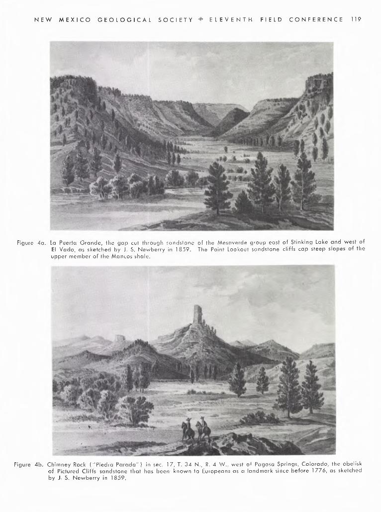
Figure 4a. La Puerta Grande, the gap cut through sandstone of the Mesaverde group east of Stinking Lake and west ofEl Vado, as sketched by J. S. Newberry in 1859. The Point Lookout sandstone cliffs cap steep slopes of theupper member of the Mancos shale.
Figure 4b. Chimney Rock ("Piedra Parada") in sec. 17, T. 34 N., R. 4 W., west of Pagosa Springs, Colorado, the obeliskof Pictured Cliffs sandstone that has been known to Europeans as a landmark since before 1776, as sketchedby J. S. Newberry in 1859.

120 NEW MEXICO GEOLOGICAL SOCIETY <> ELEVENTH FIELD CONFERENCE
leagues and somewhat over two more leagues to the west-northwest, and arrived at the east bank of the river whichthey call Rio de los Pinos ... Today a little more than sixleagues.
August 8. We set out from the Rio de los Pinos ... to-ward the west-northwest, and having traveled four leagueswe arrived at the Rio Florida, which is medium-sized andsmaller than the Rio de los Pinos. It rises in the samesierra but farther west. It flows in the same direction,from north to south, and where we crossed it there is alarge meadow of good land for crops with facilities forirrigation . . . Having crossed the Rio Florida we traveledwest two leagues and west-northwest somewhat over twoleagues more. We then descended a stony but not verylong slope and arrived at Rio de las Animas near the west-ern point of the Sierra de la Plata, in which it rises. Crossingit, we camped on the opposite ban k.10
Earlier translations of the Escalante diary (Harris,1909; Auerbach, 1943) afford supplemental information.
Comments on the correlation of the diary with geo-graphic and geologic features of the region follow, arrangedchronologically to facilitate reference:
July 29. The pueblo of Santa Clara where the friarsstopped on the first night of their journey is still located onthe west side of Rio Grande a few miles south of themodern town of Espanola.
July 30. As has been described briefly on foregoingpages, the pueblo of Abiquiu was then at the site of thepresent-day town.
August 1. The present road from Abiquiu to theupper valley of Rio Chama, U. S. Highway 84, goes north-ward up out of the Chama River Canyon a little more than5 miles west-northwest of Abiquiu and it is almost certainfrom he topography of the region that the Dominguezexpedition must have followed nearly the same route. Thetravelers Crossed the Llano Piedra Lumbre north of ArroyoSeco two miles to the northwest. The reference (as trans-lated) to "alum rock and transparent gypsum on somemesas to the east and northeast" must be to the extensiveexposures of gypsum in the Todilto north and east of theroad, but curiously there is no further reference to thegypsum in the Todilto although the travelers must havevery nearly crossed its actual outcrop a few miles farthernorth. The siesta stop for this day must have been not farfrom the Ghost Ranch in sections 11 and 12, T. 24 N., R.4 E., and the camp for the night was perhaps in the vicinityof Echo Campground along U. S. Highway 84, in section33, T. 25 N., R. 4 E. The geographic features mentionedare shown on U. S. Geological Survey topographic maps(1:24,000 series) of the Abiquiu, Ghost Ranch, and EchoAmphitheater quadrangles.
August 2. About 5 miles northeast of Echo Camp-ground the Canyon of Arroyo Seco (Canjilon Creek in theupper part of its course) is divided by a high southward-pointing escarpment capped by Dakota sandstone. Halfa mile north of the fork Navajo Canyon enters the west forkfrom the west. Ojo del Navajo (Navajo Spring) is shownon maps of the region as old as the map of the Macombexpedition of 1859 (Newberry, 1876). Dominguez andEscalante's route continued north past Navajo Canyon (seeU.S. Geological Survey Topographic map, (1:24,000 series)of the Canjilon quadrangle). The siesta stop for this daywas on Rio Cebolla apparently about 3 miles southwest of
'°Five miles south of Durango on Animas River and nearMoving Mountain.
the present-day village of Cebolla. A few miles north ofNavajo Canyon, the expedition apparently diverged to thewest from U.S. Highway 84, traveling northwest over the"good terrain" of the open plains on the lower part ofthe Mancos shale. The camp for the night may have beenon the lower course of Rio Nutrias only a mile or so eastof Rio Chama.
August 3. Six or eight miles north-northwest of thecamp on Rio Nutrias the travelers crossed Rio Chama at ElVado (the ford). The "three large mesas covered withpines." which they saw, are formed by sandstone of theMesaverde group and rimmed by the cliff of the basalPoint Lookout sandstone of that group. The first and moresoutherly lake (figure 3A) lying ". . west of the passwhich from this bank can be seen between the first andsecond mesas" is Stinking Lake (similarly Hedionda [fetid]Lake of the Wheeler Survey's map) west of La PuertaGrande (Figure 4A). The second lake is Boulder Lakeabout six miles farther north, also west of a breach throughthe cliff of the sandstone of the Mesaverde group. Anidealized sketch of La Puerta Grande "near Vado delChama" made more than 80 years after Escalante's des-cription is reproduced in Figure 4A. The " . .. three smallhills almost north of here" are quite likely Tecolote Mesa,a promontory of sandstone of the Mesaverde about 10miles north of El Vado Lake, and the two anticlinal hills ofDakota sandstone northeast and southwest of it ( Dane,1948; and U. S. Geological Survey topographic maps, 15-minute series, of Chama and Lumberton quadrangles). Thevalley that they "called Santo Domingo" is the valleyof Horse Lake Creek, up which they journeyed the followingday. Dominguez and Escalante apparently never saw eitherStinking or Boulder Lakes but these lakes were clearly wellknown to some of their associates from previous visits. Hadthe Dominguez party turned west through the inviting gapof La Puerta Grande, they could have followed an easyroute leading to Carracas Canyon and to the San Juan Riverthat later became part of the Old Spanish Trail, as shownon the map of this area made during the United StatesGeographical Surveys west of the 100th meridian (Topo-graphic Atlas Sheet, No. 69).
August 4. The expedition passed through the narrowgap in the sandstone of the Mesaverde group between thenorth end of the third mesa of the previous day's descriptionand the west end of Tecolote Mesa. They applied thename Laguna de Olivares (for a member of the party) tothe lake that is now known as Horse Lake (Figure 3b).They were now on the broad plain underlain by the Lewisshale, the formation overlying the rocks of the Mesaverdegroup, and this plain offered an easy route directly north-westward to the present site of Dulce on Amargo Arroyo,a place which they reached later in the day. Neverthelesstheir guides directed them to leave "the road which goes tothe Piedra Parada" (Chimney Rock in southwestern Colora-do) saying "... that on the road we were now leaving therewere three very bad hills and that it was less direct thanthe route they were taking." Conjecturally, the road thatthe guides knew was a route that leads directly westwardfrom Horse Lake over a steep escarpment of the Animasformation south of the Wirt Fire Lookout Tower in sec. 15,T. 30 N., R. 1 W., and might thence be followed to theroute of the Old Spanish Trail down Carracas Canyon aspreviously mentioned. In any event, the travelers tookneither this route nor the easy route along the wide valleyof Lewis shale directly to the vicinity of Dulce but turnednortheastward, "through a valley with luxuriant pasturage,"

NEW MEXICO GEOLOGICAL SOCIETY ELEVENTH FIELD CONFERENCE 121
which was evidently the little northwestward-trendingvalley with verdant meadows that is just south of the coalmining town of Monero. They came again to the spaciousplain underlain by the Lewis shale along the present-dayAmargo Arroyo "which on the Piedra Parada road theycall Arroyo del Belduque." Belduque, as indicated byBolton's footnote, was a large knife. More specifically apartial clue to the origin of its application to this arroyo issuggested by two passages in the addendum of "variousitems" to Father Dominguez' description of the Missions ofNew Mexico (Adams and Chavez, 1956). These pass-ages, under the headings Taos ( p. 252) and Abiquiu ( p.252, 253), are respectively: "The Comanches usually sellto our people of Taos) at this rate: a buffalo hide for abelduque or broad knife made entirely of iron which theycall a trading knife here" and "Every year between the endof October and the beginning of November many heathensof the Ute nation come to the vicinity of this pueblo ( Abi-quiu ) . They come very well laden with good deerskins, andthey celebrate their fair with them . . . They usuallysell deerskins for belduques only and they are given twoof the latter for a good one of the former." It is unfor-tunate that a place name with such a remarkably picturesqueetymology has been displaced. According to the dictionaryof the Spanish Academy, belduque, a large knife witha sharp pointed blade, has the same origin as balduque,from the place of origin of the knives. And balduque is,from this dictionary, "from Bois-le-duc, a city of Hollandwhich the Spanish call Bolduque and where they weavethese ribbons, i.e. narrow ribbon, in general red, which isused in offices for typing dockets" ( my translation). Bois-le-duc [now Hertogenbosch! (which means the same asBois-le-duc, i.e. the Duke's woods) according to the Colum-bia Lippincott Gazeteer], in the Netherlands, is still notedfor iron founding and manufacturing. Although the namewas obviously suggested by the use of belduques for tradingwith the Yutas, who presumably used this route to theannual fair at Abiquiu, geologists would like to believethat the name Belduque was imaginatively appied to thisparticular arroyo because of the meridional dark narrowdike ridges that transect the plain of Lewis shale alongthe arroyo.
The travelers followed Amargo Arroyo downstreamand camped where the arroyo leaves the Lewis shale plainand enters a canyon formed in the overlying more resistantLate Cretaceous and Tertiary formations.
August 5. The difficulties that were encountered onthis day leave one in as much doubt as to the route followedas was shown by Escalante, who commented that the guides"seemed to have forgotten the very slight knowledge whichthey had appeared to have of this country." It seems likelyhowever, that the guides turned south hoping to rejoin theroute they had left at Horse Lake. The party had followedAmargo Arroyo down to its junction with the Rio Navajo.The guides were aware that the Navajo here makes amarked swing to a northerly course toward its junctionwith the San Juan—and the statement that they crossedthe river here is inconsistent with all the directions and dis-ances recorded in the following twelve lines of the diary.Evidently they crossed Amargo Arroyo and went south, per-haps up Wirt or Tee Quee Canyons (Dane, 1948), intothe wooded, brushy, and hilly area in the vicinity of WellsLookout Tower in the southwestern part of T. 3 N., R. 2 W.,and thence traveled northwestward to the valley of theSan Juan River below its junction with the Navajo. (They
called the joined streams the Navajo or, as in the diary,the Rio Grande de Navajo and so would regard the presentSan Juan as the "same river" that they had left. Campwas near Caracas on the San Juan River just north of theColorado State line). The reference to good and largemeadows farther north suggests pretty clearly that pre-vious travelers were already aware of the open country inthe vicinity of the modern town of Pagosa Springs, and itis somewhat suprising that there is no reference to thespectacular hot spring known as "the Pagosa" from whichthe present town is named.
August 6. The travel west from Carracas was atleast partly on dissected steep slopes of the Wasatch for-mation, high hills of that formation coming close to theSan Juan river, especially on the north side.
August 7. The Rio de Piedra Parada, now calledsimply Piedra River, had been named previously to thisexpedition, perhaps by Rivera, from the obelisk-like spireof Chimney Rock, then called Piedra Parada, in T. 34N., R. 4 W., about 15 miles northeast of the junction of thePiedra and San Juan. This notable landmark (Figure 4B)a standing column of the Pictured Cliffs sandstone, wasnever seen by Dominguez or Escalante but was, then asnow, readily visible from a regularly traveled east-westroute along the general line of the present highway be-tween Pagosa Springs and Durango, Colorado. As Boltonhas noted, the expedition's camp for this night was alongthe Pine River just south of Ignacio.
Don Bernardo Miera y Pacheco, who accompanied theDominguez-Escalante expedition, prepared a map datedJanuary 3, 1777 (the final date of the "diario" made byEscalante) that probably accompanied the report that wasmade by the friars to their superiors. (This map is re-produced in Bolton, 1950, and the section included withinthe area discussed in these notes is reproduced as Map IIin Brand, 1937). This map shows "Lago de Olibares"and also the two other lakes mentioned in the "diario"(marked on the map the three mesas and the lakes of theTrinity).
Subsequent maps as late as Disturnell's map of 1847.which was used as the authoritative source of geographicinformation in treaty discussions at the close of thewar between Mexico and the United States, also drew theirinformation for this region primarily from the results of theexpedition of Dominguez and Escalante. Disturnell's mapshows S. Maria de las Nieves rather north of the San Juanand some distance east of its junction with the "Nabajoa,"thus corresponding more closely in position with what isnow Pagosa Springs. This map also shows Nutrias (in thegeneral vicinity of the modern Tierra Amarilla); El Bado,clearly the modern El Vado; and Lake Trinidad, obviouslyderived from the original "Las Tres Mesas y Lagunas de laTrinidad." Velasques is presumably an erroneous trans-literation of El Belduque which appears on the map ofMiera y Pacheco.
Some of these features are also shown on still earliermaps; for example, "A map of New Spain from 16° to 38°north latitude reduced from the large map drawn fromastronomical observations at Mexico in the year 1804, byAlexander de Humboldt" ( Humboldt, 1811). The lattermap has Trinity Lake, Velasquez, and S. Maria de las Nieves.
For more than 50 years after the Dominguez-Escalanteexpedition there are few records of exploration and travelof northwestern Rio Arriba County. As early as 1778orders were issued by the Spanish officials prohibiting un-

122 NEW MEXICO GEOLOGICAL SOCIETY ELEVENTH FIELD CONFERENCE
licensed travel to the Ute country for trade and barter, andrecords of the Spanish archives show proceedings againstcitizens of New Mexico for trading with the Utes in 1783,1785, and 1797. In 1813 a party of seven traders ledby Mauricio Arze and Lagos Garcia left Abiquiu in Marchand followed the general route of the Dominguez-Escalanteexpedition to northern Utah but there is apparently norecord of the course followed during the first part of theirjourney (Twitchell, 1914, II, 478 [doc. 18811).
THE JOURNEY OF LIEUTENANT Z. M. PIKEThirty years after the completion of the epic journey
of Dominguez and Escalante, the spreading wave of ex-ploration from the new English-speaking republic on theAtlantic Coast sent its first ripples to the borders of NewSpain and the margins of what is now Rio Arriba County.Following the Louisiana Purchase in 1803, the new Pro-vince of Louisiana was divided by Congress in March 1804,and the northern part, as the District of Louisiana, wasestablished north of the line of the 33rd parallel west ofthe Mississippi. In 1805 the Louisiana District became aTerritory, with its seat of government at St. Louis, and onJuly 15, 1806, Lieutenant Z. M. Pike left St. Louis underorders from that government to proceed to the headwatersof the Arkansas and Red Rivers ( Paxson, 1924, p. 141-143).On the 30th of January 1807, Pike's party arrived on thebanks of the Rio del Norte in the San Luis Valley in what isnow southern Colorado (supposing it to be the Red River)and started the construction of a fort in what was in realitySpanish territory. In the latter part of February Pike's partywas visited by Spanish officers in command of a consider-able armed force and they were conducted to Santa Fe andultimately to Chihuahua, Mexico, before being returnedto the United States (Pike, 1810, p. 192 et. seq.). Pikewas conducted south along the general route that is nowfollowed by U. S. Highway 285 along the west side of theRio Grande Valley and along the eastern boundary ofRio Arriba County to Ojo Caliente, which is just within theRio Arriba$County boundary. Pike described Ojo Calientesomewhat unflatteringly as a village of 500 souls which ata distance ".. . . presents to the eye a square enclosure ofmud walls, the houses forming the wall." He also reportedthat:
"The greatest natural curiousity is the warmsprings, which are two in number, about 10 yardsapart and each afford sufficient water for a millseat. They appeared to be impregnated withcopper and were more than 33° above bloodheat" ( Pike, 1810, p. 207-208).
He was from there taken down Ojo Caliente Creek "about12 miles" to its junction with the Chama (which he calledthe Conejos), thus reaching a point passed by Dominguezand Escalante on their way northward 30 years previously.Pike noted that the "Conejos" "was settled above itsjunction with the Agua Caliente, 12 miles" and thus re-corded that it was then settled upstream as far as thevicinity of Abiquiu, which, however, he located incorrectlyon his sketch map of the journey as being south of thejunction on the west side of the Rio Grande at about thesite of Santa Clara pueblo. Pike and his party were thenconducted to San Juan on the east side of the'Rio Grande,also in Rio Arriba County, and thence southward.
THE OLD SPANISH TRAILFor just less than two decades of its long and varied
history, Rio Arriba was traversed by the Old Spanish Trail,a remarkable main artery of commercial traffic. From 1829to 1848 this twelve-hundred-mile-long trail from Santa Feto California was followed by numerous pack mule caravansconnecting these northern outposts of Spanish-Mexican civil-ization. By the beginning of this period there were appar-ently three fairly well established routes from Santa Fenorthwest to the San Juan River by way of Abiquiu. Thefirst and most southerly of these routes was the one takenby the first commercial caravan to move over the trail. OnNovember 9, 1829, a party of New Mexico traders led byAntonio Armijo departed from Abiquiu with a train of packanimals and reached the San Gabriel Mission in Californiaon January 31, 1830. The party left California on thereturn trip March 1, and arrived at Jemez on April 25. Avery brief diary, hardly more than itinerary, of Armijo'strip, was published in 1830. As translated by Hafen (1950,p. 124, 125) it shows that the party traveled from Abiquiuup the Chama about 15 miles to the mouth of the RioPuerco on November 8, thence turning southwest up RioPuerco about 12 miles to the village of Arroyo del Agua(2 miles west of Coyote) in section 5, T. 22 N., R. 3 E., onNovember 9. (U. S. Geological Survey topographic mapof Arroyo del Agua quadrangle, 7 1/2 -minute series). Thenext day they followed the general course of what is nowU. S. Highway 96 to Capulin in section 14, T. 23 N., R.1 E. (U. S. Geological Survey topographic map of Cubaquadrangle, 15-minute series). On the 11th the partycontinued west across the Continental Divide to the head-waters of Canyon Largo, down which they traveled for 4days to the San Juan River and thence down the river. Theitinerary mentions Arroyo del Agua, Capulin, and the lakein Canyon Largo as places that were established or knownprior to the trip, but references to Indians suggest thatpart of this route was considered hazardous.
In any event the route by way of Canyon Largo wasabandoned as the principal route of the trail in favor of amore northerly one. The most northerly route from SantaFe to the San Juan then in somewhat general use wasprobably by way of El Vado, Horse Lake, Monero andnorthward across the Navajo River east of Archuleta Mesaand to Pagosa Springs and thence westward.
The principal route of the Old Spanish Trail, however,was quite probably the one shown as such on the WheelerTopographic Atlas Sheet No. 69. This route, now littletraveled and in part completely unused turned west fromEl Vado through La Puerta Grande, skirted the north shoreof Stinking Lake, and led westward and northwestwardto the vicinity of La Jara farms on the Jicarilla Apachereservation and down Carracas Canyon to the San Juanand thence west. Fortunately an accurate, though meagerrecord of this part of the trail was made by the trader Mr.B. Choteau, who gave a log and brief description of thetrail in Santa Fe in late August 1848 to Orville C. Pratt,an emissary of the U. S. Secretary of War. Chateau hadjust returned to Santa Fe after one of the last commercialtrips over the trail and his log and description were copiedinto Pratt's diary of the latters' own immediately ensuingtrip over the trail to California. The pertinent part ofChateau's description reads as follows (Hafen and Hafen,1954, p. 342, p. 344-346, and Appendix p. 365-369),with my interpolated comments in brackets.

NEW MEXICO GEOLOGICAL SOCIETY 4 ELEVENTH FIELD CONFERENCE 123
[Going Westward From New Mexico] *From Upp. Sett. of Ab. [Abiquiu] go to the Savoya
[Cebolla] riv. 12 m. Water on left of road in Kanion. 6 m.further a creek called Nourute [Nutria]. From there to theChama riv. is 19 m. Camp on this side atthe crossing. From there to the Lagona [La-guna, Stinking Lake] is 7 m. From that to losOjitis [los Ojitos, presumably the springs shown on theWheeler Atlas Sheet 69 as "Water Holes" 10 miles north-west of Hedionda (Stinking) Lake] is 8 m. Sp. Pass the1st Sp & about 1 m. further is 2d Sp. From that to thewallo [reads "Hollow" in the log] of the Corac is about15 m. It is the head of the Corac [Carracas] Wat. about1 m. from the head at the left of the road. Suff. for menbut not enough for an. From that to the St. John [SanJuan] 25 m.
Eutes plenty but friendly. no grass. take an. 1/2 m.down the creek to the side of the hill. dry grass. Camp onthis side. Go down this riv. 15 m. on opp. side. Can't campthere. After lea y . this riv. it is about 3 m. to Rock Cr.[Piedra River].
Pratt's diary, as recorded by Hafen and Hafen ( p. 345-346), shows that his party had considerable difficulty infollowing Choteau's instructions for this early part of thetrail, and that they repeated with some variations the diffi-culties experienced many years before by Dominguez andEscalante in following the route from El Vado to the SanJuan River that was already known to their guides. Prattleft Abiquiu the morning of August 31, apparently camp-ing that night on Cebolla Creek. The following day theycamped on the bottom near the Chama River, probably atEl Vado, noting "Fine grass and water." It seems some-what extraordinary, but as I interpret the Pratt diary, Ibelieve they followed precisely the course of the Domin-guez-Escalante expedition to the junction of Amargo Arroyoand Rio Navajo. The pertinent passages are quoted withmy interpolated comments in brackets.
"Saturday, September 2, 1848 . . ." Started at about11 o'clock & made 10 miles. Passed a small lake [HorseLake], surrounded by fine grass, but the water was inacces-sible to the animals [it had rained that morning and all theprevious night] & we had to move farther on to encamp.Found a fine spot—the best of grass, wood and water [sure-ly the "valley with very luxuriant pasturage" of the August4 entry in Escalante's dairy].
"Sunday, September 3, 1848, left camp about 9 o'clockand made a march of about 20 miles. Camped on the St.John [this was unquestionably the Rio Navajo, but by thedirect route north the Navajo is only 10 miles from theirprevious night's camp rather than the 20 recorded in thediary, so presumably Pratt's party took the longer route tothe Navajo down Amargo Arroyo as Dominguez and Es-calante had done].
Monday, September 4, 1848. This morning found our-selves some 20 miles or more out of the way. After packingup we retraced our steps about 15 miles to a lake [it seemslikely that they followed down the valley of the Lewis shalefrom Dulce south to Stinking Lake, where they were backon the trail as logged by Choteau. Surely Pratt would havespecified if it was the same "small lake" that they hadpassed on Sept. 2] & then bore off in a westerly direction.We traveled on until dark without finding water or grass.At length we came to water [Los Ojitos of the Choteaudescription?] & camped without grass.
"Tuesday, September 5, 1,848. At daylight this morn-
ing we commenced packing . . . stopped to encamp on theSt. John & get breakfast. Staid about 4 hours and thenmoved down the river about 5 miles to encamp for the night.
"Wednesday, September 6, 1848. Left camp thismorning at an early hour and traveled to Rock Cr. [PiedraRiver] and then encamped early in the day."
With the annexation of New Mexico and California bythe United States in 1848 following the war with Mexico,and with the discovery of gold in California in 1848 andthe ensuing development of east-west transcontinentalroutes of travel, the need for the Old Spanish Trail cameto an end and only those parts of it that served local needscontinued in use.
THE TIERRA AMARILLA GRANTA few years after Pike's enforced journey to Chihuahua
there ensued the disturbed decade of the Mexican Revolu-tion, which was closed by the formation of the MexicanRepublic in 1823. Shortly thereafter the gradual growth ofpopulation in the Rio Grande Valley and the lower part ofthe valley of Rio Chama led to another significant expan-sion of agricultural settlement northward. Abiquiu had apopulation of 3,557 in 1827, whereas in 1744 it had beendescribed as merely a rancho of 20 families (Bancroft,1889, p. 252 and 342). On April 23, 1832, a petitionof Manuel Martinez of Abiquiu was made to the corporationof Abiquiu stating "that having registered a tract of landfor cultivation and pasturage, situated on the banks ofthe Chama River, known as the Tierra Amarillo, bounded onthe east by the range of mountains, on the west on a linewith the mouth of the Laguna de los Cabal los, on the northby the Navajo River, and on the south by the Nutrias River;"he asks that this tract be granted. (Laguna de Caballos,i.e. Horse Lake, is a name so naturally applicable to anexcellent watering place that the fact that orally the lastpart of the Spanish name is not greatly different from aslurred "Laguna de Olivares" as the Lake was called by theDominguez party may well be only coincidental). Thetract that was so simply requested includes an area of morethan one thousand square miles chiefly in New Mexico butextending several miles northward between the NavajoRiver and San Juan Mountains into what is now Colorado.Martinez' petition was acted on favorably by the corpora-tion of Abiquiu, to whom the petition had been referred,and on July 20, 1832, the territorial deputation of NewMexico approved the grant.
In the treaty of Guadalupe Hidalgo in 1848 that con-cluded the war between the United States and Mexico, theUnited States acknowledged the prior rights of the privateholders of the Spanish and Mexican land grants, and in1854 the surveyor general of New Mexico was instructedto investigate the private and town claims and report themto Congress for confirmation. In 1856 the descendants ofthe original grantee applied for confirmation of the TierraAmarilla grant by the United States, and it was found thatthey had been in possession of the land for 21 years.The claim was reported on favorably in 1856, and con-firmed as a claim in 1860. The boundary was surveyed bySawyer and McBroom in July 1876, and a patent to thegrant issued in February 1881. (Docket No. 3 PrivateLand Claims, Files of the U. S. General Land Office).
Settlement in this new area to the north was, however,
* Reprinted by permission of the publishers, the ArthurH. Clark Company, from The Old Spanish Trail by LeRoy andAnn Hafen.

124 NEW MEXICO GEOLOGICAL SOCIETY * ELEVENTH FIELD CONFERENCE
attended by difficulties of the same type that had accom-panied the foundation of Abiquiu a century before, becausewe find written in July 1859 the statement "The TierraMaria (sic), a charming spot at the forks of the Chama,where the Mexicans had formerly a settlement, now aban-doned on account of the depredations of the Indians"(Newberry, 1876, p. 73). This original Tierra Amarilla wasthus perhaps located at the site of the present village ofBrazos at the junction of the Chama and the Brazos, whichwas formerly called the Chama Brazos or the East Branch.Macomb's report (Newberry, 1876, p. 5-7) says that in1859 Abiquiu was the outpost of settlement of the valleyof Rio Chama but that wagons had been over the roadto the upper valley of the Chama. San Juan and theother villages near the junction of the Chama and RioGrande had been the "outposts of settlement" for nearlya century and a half (1598-1744) and Abiquiu for almosta century more (1744-1 835) but the pressure for expansionof agricultural settlement could now no longer be restrainedby Indian depredations. Tierra Amarilla must have beenreestablished soon after 1859, for the Ute Indian Agencywas moved from Abiquiu to Tierra Amarillo in 1862.Shortly after the war between the States, anarmy post was established (November 6, 1866) as CampPlummer on the Chama River near the present site of TierraAmarillo. The name was changed to Fort Lowell on July13, 1868, and the post was abandoned June 26, 1869(written communication, May 1960, from Andrew Brown,U. S. Geological Survey, from information from Old RecordsSection, Adjutant General's office, National Archives andRecords Service). The location of old Fort Lowell is shownon the Wheeler Survey's Topographical Atlas Sheet 69.Only 15 years after Newberry's report of the abandonmentof "Tierra Maria," the United States Geographical Surveysof 1874 found settlements in this vicinity at Los Brazos, atLos Ojos, now Parkview, at Eensenada east of Los Brazos,and at Las Nutritas. The present Tierra Amarilla was madethe county seat of Rio Arriba County in 1880, the name ofthe settlement at this place having previously been LasNutritas (Bancroft, 1889, p. 785).
MILITARY RECONNAISSANCES OF THEMEXICAN WAR PERIOD
The earliest settlements in the upper Chama valleywere made under the Mexican flag---but possession soonpassed to the United States as a result of the Mexican War,which began in 1846. General Kearney entered SantaFe August 18, 1846, and in September a detachment fromhis force under Major Gilpin was dispatched to Abiquiu.Major Gilpin soon led an expedition into the Yuta Country,bringing back 60 leading men of the Yuta tribe to Santa Fewhere a treaty was signed with them on October 13th (Ban-croft, 1889, p. 421-422). Major Gilpin again left Abiquiuon the 22nd of October with his detachment, went up theChama, crossed to the San Juan and descended that riverinto northern Arizona to a subsequent meeting with ColonelDoniphan (Hughes, 1850). The travels and campaignsof Doniphan and his subordinates, though involving thefirst American explorations of a broad region, have ingeneral left in print but little of geographic or descriptivevalue (Bancroft, 1889, p. 466).
In 1849 a military reconnaissance from Santa Fe tothe Navajo Country crossed northern New Mexico to thesouth and west of Rio Arriba County. A detailed and re-markable journal of this reconnaissance was kept by Lieu-tenant James H. Simpson. Simpson, however, did not see
the country north of Ojos Calientes (Jemez Springs) a fewmiles north of Jemez Pueblo and about 20 miles south of theRio Arriba County line, and the map of the route of theexpedition shows the military outposts then at "Albiquiu"(sic) as located on the Chama River at close to the northern-most point shown on that part of the map (Simpson, 1852).
MACOMB'S EXPEDITIONIn 1859 an expedition from Santa Fe to the junction of
the Grand and Green Rivers under the command of Capt.J. N. Macomb, and accompanied by the geologist, ProfessorJ. S. Newberry, resulted in a planimetric and shaded reliefmap (the first reasonably accurate map of much of theregion traversed) and an extensive geologic report.
The expedition set out from Santa Fe in July 1859,and in its first days virtually retraced the route of theDominguez expedition 80 years previously, "crossing the RioGrande Bravo del Norte at the old Indian pueblo of SanJuan, and following up the valley of the Rio Chama, passingby the pueblo of Abiquiu." The first camp after leavingAbiquiu, Camp No. 5, was along Arroyo Seco not far fromthe siesta stop of the Dominguez party near the GhostRanch. It is interesting to compare Newberry's descriptionof this part of his journey with the corresponding part ofthe Escalante journal.
"At Arroyo Seco the trail we were following leavesthe river and enters a canon which cuts the plateau border-ing the valley from base to summit. Most of the sectionexposed in its walls is composed of the Triassic marls whichinclude beds of gypsum in some places 150 feet thick.Above the marls are the yellow sandstones—the base ofthe Cretaceous—which floor the plateau on either side.Pursuing a northerly course we gradually rose through theTrias, and at Navajo Springs reached the base of the Cre-taceous sandstones. Continuing our ascent we . . .emerged upon the plateau of which I have before spoken.This plateau extends northward to the Vada del Chama."Camp No. 6 was at Navajo Springs, No. 7 was on the RioNutria perhaps not far from where the friars had campedon August 2, 1776. Camp No. 8 was El Vado where New-berry sketched the striking view of La Puerta Grande (Fi-gure 4a) and described the setting, as follows, in a mannerstrikingly reminiscent of Escalante's description of August3, 1776.
"At the Vada del Chama we again encamped on thebanks of this stream in a very beautiful region .. . on theeast side of the river are high and broken hills ... coveredwith forests of splendid timber. These hills are mainlycomposed of the lower Cretaceous sandstones, having athickness of nearly 300 feet. Here, as farther west, theycontain beds of lignite, and the impressions of dicotyledon-ous leaves. They are considerably broken up, but havea general and rapid dip; toward the southwest. On theopposite side of the valley is a mesa with bold, nearlyperpendicular faces over 1,000 feet high, composed of themiddle and Upper Cretaceous rocks lying nearly horizontal.Between these elevated banks lies the excavated valleyof the river, with its narrow but fertile bottom-lands, itswinding stream of pure cold water, its groves of cotton-wood and its grassy meadows spangled with flowers"(Newberry, 1876, p. 70-72). Newberry's geologic sectionat this place is as follows:

NEW MEXICO GEOLOGICAL SOCIETY -0' ELEVENTH FIELD CONFERENCE 125
"Transverse section of the valley of the Chama at theVado
Feet1. Yellowish brown sandstone (Lower Cretaceous) 1252. Brown and black shales, often dark olive, with
beds of lignite 503. Sandstone similar to No. 1 704. Black shales with bands of light dove-colored
limestone. The upper of these shale beds isgreenish brown with bands of foliated sandylimestone, containing immense numbers of frag-mentary or entire fossils. These are principallyInoceramus problematicus, I. fragilis, Ostreacongesta, Baculites anceps, Scaphites warreni,S. laviformis, etc.
5. Bluish-black shales, with concretions and bandsof limestone containing a large undulated Ino-ceramus, the broken fragments of which arethickly set with Ostrea congesta 1,000The lithological characters of this division arenearly the same throughout but the limestonebands and fossils are nearly restricted to thelower portion. The layers of limestone are from6 to 12 inches in thickness, quite pure and com-pact, blue in color, but weathering reddish yel-low, and breaking on exposure in verticalprisms, like starch.
6. A light dove-colored sandy limestone or calcar-eous sandstone, weathering yellow, massive to-ward the top, foliated below, without fossils 200
7. This, the cap rock of the high mesa, is a highermember of the Cretaceous series than has be-
fore been met with in New Mexico. Our sub-sequent observations showed it to be the baseof the third great division of this formation asdeveloped on the Colorado Plateau.
8. Gravel hills, valley drift."In a general way, unit 1 represents the upper part of
the Morrison formation, units 2 and 3 represent the Dakotasandstone, unit 4 includes the Graneros shale, Greenhornlimestone, and Carlile shale members of the Mancos shale,unit 5 the Niobrara calcareous shale member and part ofthe overlying Mancos. Unit 6 is apparently the transitionalzone between the Mancos and Mesaverde, which is ratherstrikingly exposed in this vicinity and Unit 7 includes themore massive Point Lookout sandstone at the base of therocks of the Mesaverde group.
From El Vado the Macomb party made their way north-ward to their next camp south of Laguna de los Caballos(Lake of the Horses), close to the camp of Dominguezand Escalante on August 3, 1776. Newberry noted thatthe continental divide was nearby, the drainage towardthe west beginning a mile west of the Laguna (Newberry,J. S., 1876, idem., p. 72, 73).
The expedition followed the Dominguez route north-ward to Monero and Amargo Arroyo but from there con-tinued northward across the arroyo rather than westwarddown its course, thus leaving the route of the Dominguezexpedition for a much more readily traversible one. TheirCamp No. 10 was on the Rio Navajo just west of the gorgecut by that river through the sandstone of the Mesaverdegroup. Archuleta Mesa, then called Cerro Navajo, isdescribed by Newberry. The party continued northwardinto Colorado, crossing the Rio Blanco to their 12th campat "The Pagosa, one of the most remarkable hot springs
on the continent, well known, even famous, among theIndian tribes." Newberry amplifies his enthusiastic state-ment that "there is scarcely a more beautiful place on theface of the earth" by an apt description of the deep-blueseething water of the pool, the verdant meadow, the brightand rapid river, and the framework of craggy crests andforests slopes of the great mountains beyond (Newberry,1876, p. 74). From the camp of the 12th on the SanJuan River at the site of modern Pagosa Springs the partymoved westward, probably along a trail followed by theIndians long before the first Spanish travelers through thisarea, and after one intermediate camp, stopped on thePiedra River near Chimney Rock, the striking obelisk ofPictured Cliffs sandstone, which was sketched (Figure 4b)and described by Newberry, 1876, (p. 76-78). The ex-pedition continued westward an d northward to the regionof the junction of the Green and Colorado rivers, returningto the vicinity of the "Four Corners"of Arizona, Utah, NewMexico and Colorado, from which it continued up the SanJuan River to the mouth of Canon Largo and up that canyon,thus again entering Rio Arriba County, but in its north-western part. Proceeding southeastward they crossed theContinental Divide, a day later camped at San Jose Springin the northeastern corner of Sandoval County at thewestern foot of San Pedro Mountain, and thence proceededsouthward in the latter part of September 1859, on theirreturn to Santa Fe.
THE GEOGRAPHIC AND GEOLOGIC SURVEYSWEST OF THE 100th MERIDIAN
Further exploration of the Rio Arriba region was de-ferred during the Civil War and for some time thereafter.Beginning in 1872, however, there began the Comprehen-sive series of explorations of the west conducted as theGeographical and Geological Surveys west of the 100thmeridian in charge of George M. Wheeler. These extensiveand intensive investigations of the geography, geology,zoology, botany, archeology, and ethnology of the westfirst touched Rio Arriba County in 1873 during John J.Stevenson's examination of the geology of southern Colo-rado which included the area west from Del Norte throughthe Pagosa Springs region to the Animas River. Stevensonexamined briefly the area in the vicinity of Horse Lake, re-marking that ". . . an excellent pass leads from the RioChama to the Laguna de los Caballos and is known asHorse Lake Pass. It is very low and the grade is almostimperceptible. It is crossed by the old wagon road lead-ing from Animas Park to Abiquiu, which coincides mainlywith the homeward (correctly it should be outward) trailof Capt. J. N. Macomb, Corps of Topographical Engineersin his expedition of 1859."
The following year Captain Wheeler's party, comingfrom Fort Garland in the San Luis Valley, Colorado, crossedthe San Juan Mountains by way of the heads of ConejosCreek and San Juan River, and on September 3 reached" . . . a welcome trail, which proves to be the one leadingfrom the upper Rio Grande, at the mouth of its South Fork,to Pagosa Springs on the main San Juan, where a rendez-vous camp was established, and from which point exploringand surveying parties were despatched in all directions"(Wheeler, 1889, p. 79-81). One of these parties traveledfrom Pagosa to Tierra Amarillo and return, the outgoing trip
. by the westerly route crossing the mesa to the west ofthe Chama River at Horse Lake, returning by the routefollowing toward the head of the Chama, then crossing theheads of Navajo and Blanca Creeks reaching the eastern

126 NEW MEXICO GEOLOGICAL SOCIETY * ELEVENTH FIELD CONFERENCE
banks of the San Juan."Portions of this route had belonged to the old trail
from Santa Fe to the northwest and was followed by theEscalante exploring party in 1776 .. . The Blanca, nearlydry, was the first stream crossed, then the Little and a littlefarther on the Main Navajo, reaching the Chama, oppositethe Mexican settlement of Los Brazos . . . The name TierraAmarilla (yellow earth) (the name as applied by theWheeler Survey was to the general area of the group ofseveral settlements in this vicinity] is descriptive of the al-luvial soil washed from the persistent sandstone mesasfound on either hand."
Durin gthe same field season of 1874, the famedvertebrate paleontologist, Professor Edward D. Cope, tra-veled northward up the valley of the Chama past Abiquiuto Tierra Amarillo, following closely the early part of theroute traveled by the Dominguez-Escalante expedition andalso the route of J. S. Newberry. From Tierra Amarilla,however, Cope crossed the Ch\ama, traveled westward afew miles, and thence turned southward for 40 miles fol-lowing the valley along the outcrop of the Mancos shalebetween the ridge of Dakota sandstone to the east andthat of the sandstone of the Mesaverde group to the west.Crossing the divide that separates the drainage of Rio Gal-lin g from that at the head of the Puerco, the route con-tinued south to Nacimento (now Cuba) on the west sideof Sierra Nacimento (Cope, 1877, p. 1-19). Cope alsoascended the Canoncito de las Yeguas in T. 25 N., R. 1 W.and traveled to the open plateau to the west that stretchesaway to Canyon Largo and the San Juan River. Cope alsotraveled westward some twenty miles from the badlandescarpment at the head of Arroyo Almagre.
The Wheeler Surveys produced a remarkably goodmap of the region issued as Atlas Sheet 69 issued in 1882.Noteworthy is the representation of the three large naturallakes of the region for the first time since the Miera yPacheco map of more than a century before. Hedionda(Stinking) Lake is relatively too large, but a suggestion ofits correct outline is given. The course of the Old SpanishTrail across the region is shown and particularly strikingis the representation of two of the conspicuous dike ridgesthrough which the trail passed. The Old Spanish Trail wasshown crossing the Chama south of Los Ojos (Parkview).Another road shown leading from Parkview follows a route,still used, by way of Horse Lake to Monero, but from thereit trends directly northwestward, crossing the Navajo Riverat the east of Archuleta Mesa, called cerro Navajo onthis map (as it was called also by Newberry), and con-tinuing north to Pagosa Springs. Many of the smaller hillsand canyons of the region are shown with fidelity fromthe surveys of 1874. With the publication of this map in1882, the period of exploration may be considered closed,for in 1880 the expansion of population in the upper ChamaValley was such that Tierra Amarilla was designated as thecounty seat of Rio Arriba County, and in 1881 the narrowgauge railroad line of the Denver and Rio Grande WesternRailroad was completed "60 miles west on the San Juandivision" ( Bancroft, 1889, p. 772) and extended northwest-ward into Colorado.
SETTLEMENT OF THE NOMADIC INDIAN TRIBESThe end of the war with Mexico, the assumption of
authority by the military forces of the United States, andthe formation of the territorial government of New Mexicoin 1850, did not bring to an end the depredations of the
nomadic Indian tribes of the Rio Arriba region. The historyof the control and restriction of these tribes to reservationareas is a long and confused one, which continued virtuallyuntil the end of the exploratory period (Bancroft, 1889,p. 421-422, 655-678). The first treaty with the Utes wassigned at Abiquiu in 1849 and a treaty with the Jicarillaswas made in 1851. The Jicarilla Apache country was pro-perly east of the Rio Grande and the agency for theseApaches and also for one band of the Utes was openedat Taos in 1851. In 1861 it was moved to Cimarron onthe east side of the Sangre de Cristo Mountains and someIndians remained there until 1883. Other bands of Uteslived mostly west of the Rio Grande and northwestwardinto Colorado and Utah. The agency for there bandsand for some of the Jicarillas was at Abiquiu from 1853to 1872, but some Utes were under a special agent on theChama River in 1862, and at Tierra Amarillo in 1863. Theagency was moved from Abiquiu to Tierra Amarillo in1872. The Utes were removed to Colorado in 1878 butsome of the Jicarillas remained in charge of agents atTierra Amarillo until 1883, although in July 1878 thereservation on the Rio Navajo had been selected and someof the Jicarillas moved there. From 1883 to 1887 theywere at Fort Stanton, from where they finally returned tothe Rio Navajo reservation.
CADASTRAL AND BOUNDARY SURVEYSThe operation of the land laws of the United States
was extended to the territory of New Mexico by Act ofCongress in 1854, and a surveyor general was appointed.In the following year an initial point was established forbase and meridian lines. From this beginning surveys wereslowly advanced from year to year and a land office wasopened at Santa Fe in 1858 Bancroft, 1889, p. 646).
Large parts of the public land of the region were sur-veyed before 1890. These surveys are only approximatelyaccurate. Recent accurate surveys and resurveys havebeen made of parts of the region, particularly along theColorado State line and the boundary of the Tierra AmarilloGrant.
The territory of New Mexico, while administered as amilitary department after the close of the war with Mexico,included a substantial part of the San Luis Valley that isnow in Colorado east of the Continental Divide. This areacontinued to form part of Taos County, New Mexico, untilthe organization of Colorado Territory in February 1861.The southern boundary of Colorado as described in theenabling act of 1864 was the 37th parallel of latitude.
The southern boundary of Colorado west of the 103dmeridian was first surveyed in 1868 by E. N. Darling, pre-sumably on the 37th parallel. Subsequent investigationshowed that between the 6th and 8th astronomical monu-ments there were errors in alignment and masurement, therebeing an offset of nearly half a mile in the vicinity of the212th mile mark. In 1902-3 a resurvey of the entire south-ern boundary of Colorado was made by H. B. Carpenterunder authorization by Congress but the joint resolutionpassed by Congress for its acceptance as the legal boundarywas vetoed by the President in 1908 (Douglas, 1930, p.225), for the reason that Colorado would probably notaccept the line as it would take from that State a strip ofland for nearly its whole width. In 1925 the U. S. SupremeCourt ruled that the boundary between New Mexico andColorado was that marked by Darling in 1868. The linehas since been resurveyed.

NEW MEXICO GEOLOGICAL SOCIETY ELEVENTH FIELD CONFERENCE 127
REFERENCES
Adams, E. B., and Chavez, Fray Angelico, (1956), The mission of NewMexico, 1776, a description by Fray Francisco Atanasio Dominguez:Albuquerque, New Mexico, New Mexico University Press.
Auerbach, H. S., 1943, Father Escalante's journal 1776-77: Utah Hist.Quart.. v. 11, p.1-141.
Bancroft, H. H., (1889), History of Arizona and New Mexico 1530-1888:San Francisco, The History Company.
Bolton, H. E.. (1950), Pageant in the wilderness: Utah Hist Soc., v. 18.Brand, D. D., (1937), Tseh So, a small house ruin, Chaco Canyon: New
Mexico Univ. Bull., Anthropol. Ser., v. 2, no. 2.Columbia Lippincott Gazetteer of the World, 1952: New York.Cope, E. D., (1877), Report upon the extinct Vertebrata obtained in
New Mexico by parties of the expedition of 1874: United StatesGeo. Surveys west of the 100th meridian (Wheeler). v. 4, pt. 2.
Dane, C. H. (1948), Geologic map of part of eastern San Juan Basin,Rio Arriba County. New Mexico: U. S. Geol. Survey Oil and GasInv. Prelim. Map 78:
Diccionario de la Legua espanola, 119561: Madrid, Real AcademiaEspanola.
Disturnell, John, 1847, Map of New Mexico: New York ed.Douglas, E. M., (1930), Boundaries. areas, geographic centers and
altitudes of the United States and the several States: U. S. Geol.Survey Bull. 817, p. 225.
Espinosa, J. M., (1939 ) , Journal of the Vargas expedition into Colorado,1694: Colorado Mag., v. 16. no. 3, p. 81-90.
Hafen, L. R., (1950), Armijo's journal of 1829-30, The beginning oftrade between New Mexico and California: Colorado Mag., v. 27,no. 2 (April), p. 120-131.
Hafen, L. R.. and Hafen, A. W., (1954, Old Spanish Trail: Glendale,Calif., Arthur H. Clark Co., p. 1-369.
Harris, W. R., (1909), The Catholic Church in Utah: Salt Lake City,Intermountain Catholic Press.
Hughes, J. T., (1850), Doniphan's expedition: Cincinatti.
Humbodlt, Alexander de, (1811), Political essay on the Kingdom ofNew Spain: London.
Jeancon, J. A., (1923), Excavations in the Chama Valley, New Mexico:Smithsonian Inst.. Bur. Am. Ethnology Bull. 81, p. 1-80.
Newberry, J. S., (1876), Geological report, in Macomb, J. N., Reportof the exploring expedition from Santa Fe, New Mexico, to thejunction of the Grand and Green Rivers of the Great Colorado ofthe West in 1859: U. S. Army, Eng. Dept.. p. 9-118.
Paxson, F. L., 1924, History of the American frontier: New York, Hough-ton Mifflin Co., p. 1-598.
Pike, Z. M., (1810 ) , An account of expeditions to the sources of theMississippi and a tour through the interior parts of New Spain:Philadelphia. C. and A. Conrad Co.
Roberts, F. H. H.,, (1930), Early pueblo ruins in the Piedra districtsouthwestern Colorado: Bur Am. Ethnology Bull. 96.
Simpson, J. H., (1852,) Journal of a military reconnaissance from SantaFe New Mexico, to the Navajo country made with troops underthe command of Brevet Lt. Col. John M. Washington, Philadelphia.
Stevenson, J. J., (1 873 ) , Report on the geology of a portion ofColorado examined in 1873: U. S. Geog. and Geol. Explor. andSurveys west of the 100th meridian (Wheeler), v. 3, pt. 4
Twitchell, R. E., (1914), Spanish archives of New Mexico: Cedar Rapids.United States Geographical Surveys west of the 100th meridian(Wheeler), 1882, Topog. atlas sheet: no. 69.
Wheeler, G. M., (1889), Geographical report: U. S. Geog. Surveyswest of the 100th meridian (Wheeler), v. 1.
Yarrow, H. C., (1879), Notice of a ruined pueblo and an ancient burialplace in the valley of the Rio Chama: U. S. Geog. Surveys westof the 100th meridian (Wheeler), v. 7.