Embed Size (px)
Citation preview

Durham Research Online
Deposited in DRO:
20 April 2009
Version of attached �le:
Accepted Version
Peer-review status of attached �le:
Peer-reviewed
Citation for published item:
Scarre, C. (2002) 'A pattern of islands : the neolithic monuments of north-west Brittany.', European journal ofarchaeology., 5 (1). pp. 24-41.
Further information on publisher's website:
http://dx.doi.org/10.1177/1465712002005001827
Publisher's copyright statement:
The �nal de�nitive version of this article has been published in the Journal European journal of archaeology 5/1, 2002c© 2002 Sage Publications (London, Thousand Oaks, CA and New Delhi) and the European Association ofArchaeologists by SAGE Publications Ltd at the European journal of archaeology page: http://eja.sagepub.com/ onSAGE Journals Online: http://online.sagepub.com/
Additional information:
Use policy
The full-text may be used and/or reproduced, and given to third parties in any format or medium, without prior permission or charge, forpersonal research or study, educational, or not-for-pro�t purposes provided that:
• a full bibliographic reference is made to the original source
• a link is made to the metadata record in DRO
• the full-text is not changed in any way
The full-text must not be sold in any format or medium without the formal permission of the copyright holders.
Please consult the full DRO policy for further details.
Durham University Library, Stockton Road, Durham DH1 3LY, United KingdomTel : +44 (0)191 334 3042 | Fax : +44 (0)191 334 2971
http://dro.dur.ac.uk

1
A Pattern of Islands: the Neolithic monuments of north-
west Brittany
Chris Scarre, McDonald Institute for Archaeological Research, Cambridge UK
Abstract
Coastal distributions such as that of the Neolithic chambered tombs of Brittany raise
important questions about prehistoric beliefs and understandings relating to sea and
shoreline. Concepts of liminality come particularly to the fore where headlands and
islands are selected as places for the disposal of human remains. The density of
chambered tombs recorded by Du Châtellier on the islands of the Molène archipelago,
with its rocks, inlets and small islands exposed and covered by the tides, provides a
prominent example of this coastal emphasis. The analysis presented here includes
assessment of the reliability of the Du Châtellier inventory and of the topographic
changes resulting from sea-level rise. It is argued that the dramatic transformative effect
of the tides on the shallow waters of this archipelago will have enhanced the liminality of
the setting and may have endowed the islands with special mythological or symbolic
associations that may explain the density of the monuments. Ethnographic accounts of
coastal beliefs from North America and northern Europe provide additional indications of
the likely symbolic importance of such shoreline settings for Breton Neolithic
communities.
La répartition littorale des monuments funéraires néolithiques de Bretagne soulève des
questions essentielles quant aux croyances préhistoriques relatives à la mer et au rivage
marin. Le concept de liminalité est plus particulièrement pertinent lorsque des
promontoires ou des îles ont été choisies pour le dépôt de restes humaines. La densité
relativement importante de chambres funéraires qu‘a remarquée Du Châtellier sur les îles
de l‘archipel de Molène, avec ses rochers, ses anses et ses petites îles découvertes et
recouvertes par les marées, en constitue l'un des exemples parmi les plus impressionants.
La présente étude comprend une évaluation de la fiabilité de l‘inventaire publiée par Du
Châtellier. Elle prend en compte également les modifications du trait de côte entrainées
par la montée du niveau de la mer. Nous proposons ici une hypothèse selon laquelle
l'importance des changements induits par des marées de forte amplitude dans les eaux peu
profondes de cet archipel a dû magnifier le caractère liminal de cet endroit ; ce faisant,
elle a pu suggérer aux populations de ces îles des associations mythologiques ou
symboliques qui nous permettent d‘expliquer sa haute densité en monuments
néolithiques. Les récits ethnographiques qui nous parlent des croyances des sociétés

2
traditionelles des littoraux nord-américains et d‘Europe du nord offrent des indices
supplémentaires sur la signification symbolique qu‘ont pu porter les rivages atlantiques
pour les communautés néolithiques de la Bretagne.
Key words: Brittany, Neolithic, chambered tombs, coastal change, Molène archipelago,
liminality, cosmology, funerary beliefs
Coasts and shorelines possess natural characteristics which must have given them special
significance for early shore-dwellers. First and foremost they are liminal zones, the
boundary between the elements, and as such suggestive locations for contact and
communication between the different realms of the human cosmos. This transitional
character is heightened by the behaviour of certain species of animals that have the ability
to move between the different elements, such as seals and sea lions. Many traditional
beliefs of the coastal peoples place special significance on these and similar species. A
second characteristic of the coastal zone is as aural experience: from the gentle lapping of
waters to the crashing of breakers, or the low rumble that characterises the steady advance
and retreat of waves up a sand or shingle breach (Helskog 1999). Third and finally, the
shoreline is uniquely mutable owing to the phenomenon of the tides. Dry land becomes
sea, and vice versa, in a twice-daily cycle that underlines the transitional nature of this
interface between water and land. The impact is dramatically enhanced where the tidal
range is large and where gently shelving shorelines create vast intertidal zones. Such
zones may have been endowed with special significance. To interpret this significance in
a prehistoric context, however, we are reliant on material symbols which have been
sufficiently durable to withstand the destructive effects of these high-energy
environments.
Distribution maps of Neolithic chambered tombs in Brittany have long shown the
strongly coastal emphasis in their placement (Fig. 1). This is especially true in respect of
earlier types such as passage graves (c 4500-3500 BC); whereas the later allées couvertes,
with their more widespread distribution, may represent the first steps in an agricultural

3
colonisation of the interior during the Late Neolithic (c.3500-2500 BC) (Giot 1960; 1981;
Daniel 1960; L‘Helgouach 1965; Giot et al 1998; Scarre in press).
A striking element of the passage grave distribution is the location of many significant
cairns not only within the coastal zone but on headlands or islands along the shoreline
itself, or overlooking the sea edge. In his survey of Orkney tombs, Fraser noted a similar
pattern and suggested a utilitarian association: ―In any island-group, the shore is a focus
of activity for almost every human pursuit. Almost certainly, the same result would have
been obtained for the distribution of any human artefact in Orkney, from fields to
telephone boxes. Inland locations are avoided because they tend to be high, barren, and
inaccessible in comparison to the coastal fringe. Thus the coastal location of chambered
cairns is simply a reflection of the coastal location of human activity, and suggests that
the cairns were involved in everyday life.‖ (Fraser 1983, 306-308).
Yet tombs are not utilitarian structures, and burial places not merely for the convenient
disposal of the dead. Closer examination of the Breton passage graves suggests that
concerns very distinct from the purely utilitarian lay behind the placement of the tombs in
significant locations on or adjacent to the shoreline. Fraser himself noted that many of the
Orkney cairns were located close to rocky or cliff-girt coastlines, concluding ―It is thus
conceivable that the cairn builders preferentially located their monuments so as to ensure
that access by sea would be difficult.‖ (Fraser 1983, 309). There should be no surprise in
discovering that burial places were located not within but away from zones of everyday
activity. Alongside this must be considered the symbolic power of the coastline itself,
marking the boundary between land and sea just as tombs mark the boundary between the
living and the dead.
The placement of the dead at the margins of the world of the living is not an unusual
phenomenon (Parker Pearson 1999, 124ff). Headlands and islands may in this context be
regarded as places especially appropriate for the disposal of human (or ancestral remains),
since these are locations on the edge of the land, backed by open sea. Studies of the

4
Scottish island of Arran have suggested that its very marginality may account for its
relatively high number of Neolithic chambered tombs: ―Their monuments are thus placed
at the boundaries of familiar territory, in remoter regions and those which, visited more
rarely in the past, retained an aura of the untamed wilderness‖ (Hughes 1988, 52). The
role of the island as a source of Arran pitchstone, and hence a nodal point in maritime
exchange, may also have enhanced its symbolic or mythological importance, as may its
prominent mountains ―whose permanence precluded change, and whose height soared
above ordinary life into the realms of myth and legend of the heroes of the past.‖ (Hughes
1988, 52).
Ideas of marginality may have especially powerful on coastlines such as that of western
Brittany where the edge of the land gave way to the vast and apparently limitless
expanses of the Atlantic Ocean. It is may have been this – along with the westerly
direction of the setting sun – which gave rise to the notion that the dwelling-place of the
dead lay beyond the ocean ( e.g. the ‗Isles of the Blest‘ of Greek Mythology: Hesiod
Works & Days 170ff; or the Celtic land of Annwfn, variously ‗over the sea‘ or ‗under the
waves‘: Hastings 1909, II, 689).
The western isles
Coastal liminality is nowhere more pronounced than in the low-lying islands of the
Molène archipelago, off the north-west coast of Brittany (Fig. 2). The high concentration
of monuments on these islands is known to us largely through the inventory compiled by
Paul Du Châtellier during a short visit to the islands in 1901 (Fig. 3; Table 1). Many of
the monuments which he recorded have since been destroyed, even though farming
pressures on the relatively inaccessible islands have been much less than on the mainland.
Several of these islands, indeed, have experienced interrupted continuity of settlement,
but intermittent occupation has not always spared the prehistoric monuments. An 1835
report on Béniguet, for example, records that ―Cette île est restée inhabitée depuis de
longues époques; elle resta ainsi pendant les guerres que nous avons eu avec les Anglais.

5
Ce n‘est qu‘en 1815 que le fermier Corolleur y vint avec sa famille et y construisit les
édifices qui existent maintenant.‖ (Du Châtellier 1902, 205). The same text also records
how between 1815 and 1835, two allées couvertes were destroyed, presumably by this
very same farming family. Thus even on thinly-settled islands, archaeological sites –
even substantial structures such as allées couvertes which in these cases reportedly
measured 30 feet in length – have been vulnerable to demolition for farming in recent
centuries.
The sea itself constitutes a second agent of destruction. Giot has written on several
occasions about the loss of archaeological sites through coastal erosion, and has
excavated sites which were threatened in this way: notably Roc‘h-Avel (Giot et al. 1979)
and Ezer (Giot & Morzadec 1992). These were passage graves, but later monuments of
allée couverte type have been destroyed or threatened in a similar way, such as the allée
couverte on the shore at the south-eastern end of Ile Guennoc (Giot 1987, 137). The
vulnerability is demonstrated by the allées couvertes spectacularly situated on wide
shelving beaches at Kernic and Lerret, which are submerged at every high tide.
In terms of monument distributions, the greatest potential for distortion lies in the
extensive loss of land resulting from sea-level rise since the Neolithic. Thus the cluster of
monuments recorded on the islands by Du Châtellier, which appears so striking given
their small size, has to be qualified by estimates of what may have existed in the large
areas of former dry-land which have been flooded. It must be presumed that such areas
contained monuments which have now been destroyed. On the other hand, the known
distribution of passage graves, and in particular what Giot cites ―La loi des sommets
relatifs‖ (that most were placed in elevated locations within their local setting) may mean
that the drowned fringes of the islands had fewer monuments than their surviving central
cores (Giot 1987, 191).
A parallel may be drawn with chambered tombs on the Isles of Scilly, a comparable
archipelago of islands off the south-western point of Land‘s End. Ashbee notes how

6
tombs are generally located on ridges or headlands, with low-lying locations the
exception: only two of some fifty monuments at the foot of a slope, and one more on a
very low-lying island. He concludes ―that in the distribution of sites that can be seen in
present-day Scilly, low-lying ones seem to be the exception rather than the rule‖ (Ashbee
1974, 78). Recent survey has increased the number of tombs to 87, but the distribution
remains the same (Russell 1980). The location of the Scilly tombs in relation to low-lying
land lost to the sea confirms and illustrates this point (Ashbee 1982, fig. 1; Thomas 1985,
fig. 43). A similar pattern of location and loss may be proposed for the chambered tombs
of the Molène archipelago.
Reliability and interpretation
Du Châtellier‘s inventory of sites on the islands of the Molène archipelago is an
invaluable document, and records a surprisingly rich archaeological heritage on these tiny
areas of land. Questions of terminology and reliability must nonetheless be addressed in
seeking to interpret the cultural significance of this record.
Among the sites listed by Du Châtellier are a number of ‗cromlechs‘ (Fig. 3; Table 1).
One of these he locates on the small island now known as Lédénez Vraz, which he calls
‗Ile Lédénès de Molène‘. At the southern end of the island ―est un tertre de 15 mètres de
diamètre sur 1 mètre de haut; au sommet est un petit cromlec‘h de 6 mètres de diamètre,
au centre duquel est une chambre dolménique ruinée, monument bien intéressant‖ (Du
Châtellier 1902, 210). The term ‗cromlech‘ refers usually to a stone circle. We are told of
one, consisting of eight small menhirs, on the island of Triélen (Du Châtellier 1902, 205),
and another two near the south-western coast of the Ile Molène (Du Châtellier 1902, 209;
Fig. 4). Du Châtellier‘s description of the cromlech on Lédénez Vraz, however, suggests
the megalithic kerb around a passage grave rather than a free standing circle. It should be
noted, furthermore, that recent work on Er Lannic and other Breton stone ‗circles‘ has
shown that these are invariably arcs or horseshoes rather than complete stone circles of

7
the kind common in western and northern Britain (Gouezin & Le Gall 1993; Bailloud et
al. 1995). Recent excavations at Pen-ar-Lan, on the eastern headland of Ouessant,
revealed an ovoid arrangement of 18 small menhirs, with a narrow break on the western
side. This setting had lost the two central menhirs recorded by Du Châtellier, though
associated were found menhirs nearby (Briard & Le Goffic in Robic 1992, 49-52).
The most striking feature of Du Châtellier‘s island inventory is the large number of burial
chambers (mostly ―à ciel ouvert‖). At one point he states explicitly ―Il est bien entendu
que toutes les fois qu‘au cours de ce travail je dis chambre à ciel ouvert, cela s‘entend
d‘une chambre mégalithique à ciel ouvert.‖ (Du Châtellier 1902, footnote p.210). In other
places he refers to ‗chambres dolméniques‘ but does not clarify whether this is an
equivalent term. Only once does he refer to a capstone still in place (chambered tomb at
south-western end of Ile Triélen: Du Châtellier 1902, 206). In a small number of cases he
refers to a tumulus surrounding the chamber or chambers: a mound with two chambers on
Triélen, one with four chambers on Quéménès, two on Lédénez Vraz including an
―enceinte rectangulaire de 60 mètres de plus grand diamètre, dans laquelle sont trois
groupes de chambres à ciel ouvert‖ (Du Châtellier 1902, 210). These may be indications
of cairns containing multiple passage graves, such as those excavated by Giot on Ile
Guennoc, though the imprecision of Du Châtellier‘s description leave other
interpretations possible.
Doubts may legitimately be raised over some of the menhirs and alignments identified by
Du Châtellier. In several cases, the small size of the stones gives rise to uncertainty. We
may question whether some of these might be natural features, given the ubiquity of
naturally detached blocks in this granitic landscape. Giot remarked the presence of
several such ‗natural menhirs‘ on Ile Guennoc, including ―une petite pierre verticale,
d‘environ 0,80 m de haut, sorte de menhir miniature qui est peut-être en fait surtout un
monadnock dépassant la surface d‘érosion. Plus près au Sud-Ouest-Sud encore, d‘autres
blocs naturels dépassent tout juste comme d‘ailleurs encore au-dessus de la falaise
occidentale‖ (Giot 1987, 136). We must also recall, however, that a menhir is often

8
simply a natural stone set upright, and that recent study has clarified the manner in which
the Kerlescan alignments at Carnac are formed in part of just such ‗natural stones‘
(Sellier 1995). For prehistoric communities, the natural origin or human manipulation of
such stones may very well have been irrelevant to their significance.
The reliability of the Du Châtellier inventory has been explicitly addressed by the authors
of the recent survey of the Ile d‘Ouessant, one of the islands he visited (Robic 1992).
Robic concludes that though caution is necessary in relation to certain types of site
recorded by Du Châtellier and others, some types of monument, notably megalithic
monuments, were well understood at the period, and their identification can be accepted
with reasonable confidence: ―Aussi, même en restant sceptique vis-à-vis des descriptions
ou de l‘interprétation des enceintes et de certains tumuli, nous accordons une relative
confiance aux passages consacrés aux monuments mégalithiques, vestiges bien connus
dans la région et repérés depuis fort longtemps‖ (Robic 1992, 21). Furthermore, against
the possibility that Du Châtellier may in some cases have included doubtful monuments
in his list, we must reckon the likelihood that in his rapid visitation to these islands there
were other monuments that he did not see. One such may be the ‗English‘ cromlech on
Béniguet, a ring of standing stones sketched by the Chevalier de Fréminville in the early
19th century (Le Pontois 1929, 124; Burl 1993, 55). It may already have been destroyed
by the time of Du Châtellier‘s visit.
In sum, the pattern of sites recorded by Du Châtellier may be accepted, within certain
degrees of caution, as a representative record. How then may one explain his finding that
the density of Neolithic monuments was very much greater on the small, low-lying
islands than on cliff-girt Ouessant (Fig. 3)? The argument again may be put forward that
it was the particular character of coastlines that was a key factor in the placement of
monuments. Even during the Neolithic period, when sea-levels were lower, the gently
shelving edges of the small islands of the Molène archipelago must have been alternately
flooded and exposed by the changing tides. Ouessant, on the other hand, with its tall
cliffs, would not have been affected in this way. It may also be that the smaller islands
9
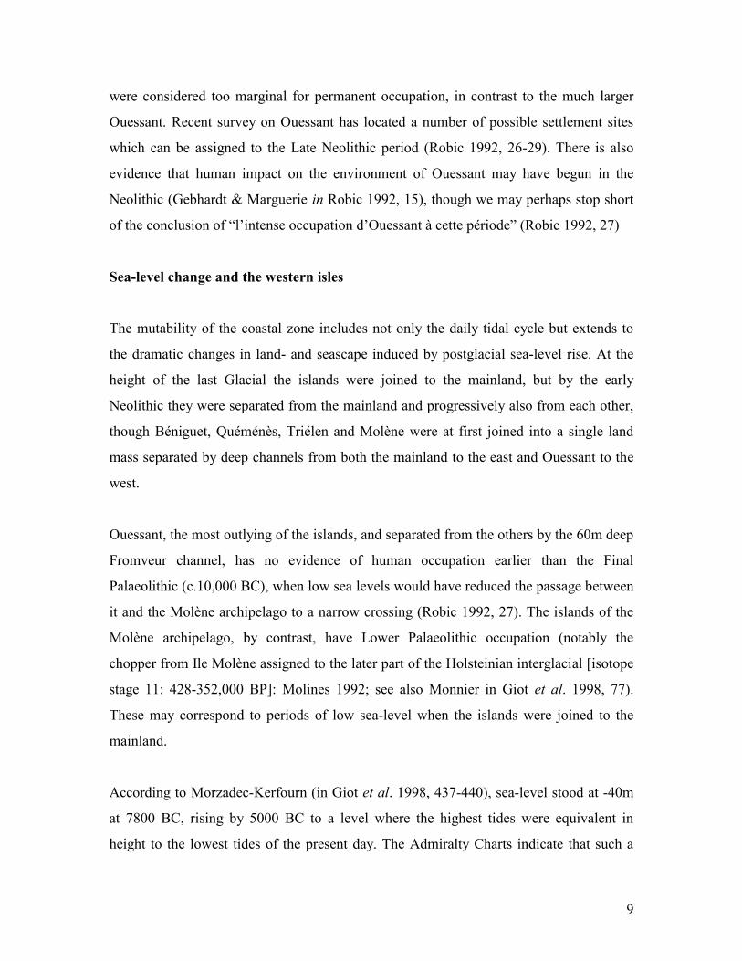
were considered too marginal for permanent occupation, in contrast to the much larger
Ouessant. Recent survey on Ouessant has located a number of possible settlement sites
which can be assigned to the Late Neolithic period (Robic 1992, 26-29). There is also
evidence that human impact on the environment of Ouessant may have begun in the
Neolithic (Gebhardt & Marguerie in Robic 1992, 15), though we may perhaps stop short
of the conclusion of ―l‘intense occupation d‘Ouessant à cette période‖ (Robic 1992, 27)
Sea-level change and the western isles
The mutability of the coastal zone includes not only the daily tidal cycle but extends to
the dramatic changes in land- and seascape induced by postglacial sea-level rise. At the
height of the last Glacial the islands were joined to the mainland, but by the early
Neolithic they were separated from the mainland and progressively also from each other,
though Béniguet, Quéménès, Triélen and Molène were at first joined into a single land
mass separated by deep channels from both the mainland to the east and Ouessant to the
west.
Ouessant, the most outlying of the islands, and separated from the others by the 60m deep
Fromveur channel, has no evidence of human occupation earlier than the Final
Palaeolithic (c.10,000 BC), when low sea levels would have reduced the passage between
it and the Molène archipelago to a narrow crossing (Robic 1992, 27). The islands of the
Molène archipelago, by contrast, have Lower Palaeolithic occupation (notably the
chopper from Ile Molène assigned to the later part of the Holsteinian interglacial [isotope
stage 11: 428-352,000 BP]: Molines 1992; see also Monnier in Giot et al. 1998, 77).
These may correspond to periods of low sea-level when the islands were joined to the
mainland.
According to Morzadec-Kerfourn (in Giot et al. 1998, 437-440), sea-level stood at -40m
at 7800 BC, rising by 5000 BC to a level where the highest tides were equivalent in
height to the lowest tides of the present day. The Admiralty Charts indicate that such a

10
rise in sea level would have opened up a narrow channel between the mainland and the
Molène archipelago (at a channel depth of up to 10.2 metres). It may also have divided
some of the islands from each other, though the moderating effect of coastal bars and
dunes would have had considerable bearing on the precise outcome. A key location in this
topographic reconstruction is the ‗Tournant de Lochrist‘ where the channel between the
mainland and the nearest of the islands becomes narrow and sinuous. This would have
been the narrowest point of the sea-channel separating the mainland from the islands,
since the strength of present-day currents on this section of coast suggests that it is
unlikely to have been closed by a sand bar.
Comparison may be drawn with the process of island formation in the Isles of Scilly off
Land‘s End. For Scilly, Ratcliffe and Straker have used calibrated radiocarbon date
ranges for selected intertidal peat samples to estimate a highest sea level of -2.5m OD at
5000 Cal BC, rising to a little below -1m OD at 3000 Cal BC (Ratcliffe & Straker 1996,
44-50). This supersedes the much steeper curve proposed by Thomas (1985, 22ff).
Morzadec-Kerfourn proposes a level for the highest seas of approximately -2 metres at
3000 BC, which conforms reasonably closely to the figure proposed for Scilly
(Morzadec-Kerfourn in Giot et al. 1998, diagram p. 438).
In Scilly, as in the Molène archipelago, large areas of shoreline are uncovered or only
thinly covered by the sea at low tide; it is on occasion possible to wade through the
shallow waters between the Isles of Scilly, and reports exist of submerged settlements –
some perhaps of Roman date – on the sea bed (Thomas 1985, pp.52ff). Thomas also
highlights the role of storm surges in breaching sand bars and reshaping the topography.
He postulates that one such westerly surge may have broken through a coastal dune
between Tresco and St Mary‘s and inundated the central lowlands of the original main
island (Thomas 1985, fig 41). The chronology which he proposes must be revised in the
light of the more recent evidence, but his model does help to illustrate the interaction
between sea-level, storm surges and coastal topography; and to underline, above all, the

11
marginal nature of these large tracts of low-lying land, threatened but not necessarily
flooded as sea-level rose to within 5 metres of its present level.
Reconstructing the shoreline of the western isles of Brittany during the Neolithic
indicates that extent of the intertidal zone some 7000 years ago was several times larger
than it is today (Fig. 5). The transformative action of the twice-daily tides would have
been correspondingly more dramatic. Whereas every coastline with a sea vista beyond
marks the boundary between the worlds of land, sky and water, it is rare to encounter
such an extensive intertidal zone, with its hints of hidden realms in the jagged rock
formations, alternatively submerged and exposed by the tides, that are characteristic of
this coast. The dramatic tidal range will have reinforced the liminal character of the
Molène archipelago, and may well be the key to understanding the proliferation of
Neolithic monuments on these islands. The much lesser density of such monuments on
Ouessant may be explained within the same model, given that the steep cliffs of Ouessant
preclude an extensive intertidal zone; the sea moves vertically rather than horizontally
with the tidal cycle, and little new land is exposed at low tide. The liminal quality of
Ouessant is hence very different, and arguably much less impressive, than that of the
neighbouring islands to the east.
The regional context
The island monuments of the Molène archipelago fit into a broader pattern of coastal
location among Neolithic monuments in Brittany. Along the northern coast, the published
literature (notably L‘Helgouach 1965 & Giot 1987) includes references to some 25 burial
mounds containing 50 separate passage graves. Some of these, such as Men-ar-Romped,
Ville-Pichard, Saint-Gonvel, Carn and Barnenez, are on coastal headlands; others,
including Ségal, Melon, Guennoc and Carn are on small offshore islands which were also
originally coastal headlands. At Brétouaré, the passage grave stands on a prominent hill
overlooking the coastal marsh of Ker Emma, and though the sea is clearly visible beyond
this the site is over a kilometre inland. The presence of the place name Enez Vihan

12
(‗enez‘ the Breton for island), however, suggests that the Ker Emma lowland was a
shallow marine bay up to historical times. The process of aggradation here may be
compared with recently documented for the Marais de Dol (Lautridou et al. 1995).
It would nonetheless be incorrect to suggest that all early passage graves of northern
Brittany were located in such close proximity to the sea. Tossen-ar-Run at Yvias is 5.5
kms inland, and out of sight of the sea. La Ville Hamon at Erquy is also relatively far
back from the sea edge, and views towards the sea are obscured by rising ground in most
directions. Furthermore, coastal change means that whereas Brétouaré may have been
nearer the coast in the Neolithic than it is today, in most cases the reverse will have been
the case. This is particularly true of sites today in estuarine situations such as Lingoz
(Henvic), Men-ar-Romped (Kerbors) and Crec‘h Bleiss (Penvenan). It remains the case,
however, that the great majority of these tombs have a closer connection with the sea than
being located simply within the coastal band.
The high density of Neolithic monuments is also a characteristic which the Molène
archipelago shares with other islands. The small island of Guennoc off the north coast of
Brittany has fifteen passage graves grouped within four cairns, yet measures only 400
metres from north to south (Giot 1987). Looking northwards, the Isles of Scilly have a
total of 87 Neolithic chambered tombs (Russell 1980), and over 80 are recorded on the
Orkney islands (Davidson & Henshall 1989). Attempts to explain these concentrations in
terms of better circumstances of preservation on offshore islands carry some weight but
may be judged inadequate to explain the pattern as a whole. Islands appear to have held a
special significance which made them especially appropriate for the placement of the
dead, perhaps by virtue of their marginality as in the study of Arran cited earlier (Hughes
1988). In a Bronze Age context, Bradley has noted how ship carvings in the Bohuslän
province of Sweden occur around hills capped by cairns; the suggestion that the ship
carvings represent water would make the effect to be to transform these hills into
conceptual islands. The cairns on inland ‗island‘ hilltops would hence parallel the coastal
cairns built on true islands (Bradley 2000, 141). These parallel cases indicate that the

13
importance of islands as burial places extends far beyond the Molène archipelago, and
helps to counter any residual doubts over the reliability of the Du Châtellier inventory.
Coastal beliefs
In order to understand better the kinds of beliefs and understandings which early societies
may have held of these coastal environments, it may be helpful to consider ethnographic
examples from a similar setting. Among the most fully recorded of the beliefs and
cosmologies of coastal peoples are those of the various peoples inhabiting the North-West
Coast of North America. These are well-known for their development of complex
societies without the adoption of agriculture, leading to their classification as ‗affluent
hunter-gatherers‘ (Ames & Maschner 1999). They inhabit villages, even though they may
shift the location of these settlements two or three times a year in a form of modified
sedentism. These societies are also famous ethnographically for engaging in potlatch
ceremonies, displays of conspicuous consumption which confirmed social ranking but
also had a religious role in relation to mortuary rituals or the propitiation of supernatural
forces, to restore the proper order of things when, for example, a ritual had been
incorrectly performed (Walens 1981). The North-West Coast societies, and especially the
Haida of the Queen Charlotte Islands, were also famous for their carving of totem poles,
some of which commemorated the dead. They could be erected in front of the house
where the deceased chief had lived or, less commonly, as a form of grave marker. The
possible parallel with the standing stones often associated with chambered tombs in
North-West Europe is striking, but may be misleading, though the idea that standing
stones in some way represent or commemorate the dead is persuasive.
The relevance of the Northwest Coast societies to the coastal Neolithic of northern
Brittany lies at a more general illustrative level. The Pacific coastline of Canada, like that
of Brittany, is deeply indented with estuaries, bays and offshore islands. Settlements are
on coasts or rivers, and much use is made of water transport. Marine and riverine

14
resources (notably seasonal salmon runs) play a key role in subsistence. Many of these
communities moved around their landscape during the course of the year, exploiting
resources as they became available. For coastally-based groups such as the Nootka,
however, the interior was a place of danger and mystery: ―To most of them, mountains
were objects to be lined up in ranges to locate offshore points, rather than localities to be
traversed and known intimately. It is consistent that the woods and mountains were
thought to be populated by vast numbers of dangerous and horrendous supernatural
beings, while the sea possessed fewer and less malignant spirits‖ (Drucker 1951, 151).
Something similar is implied in the Tsimshian myth of Asdiwal, subject of a classic
structuralist analysis by Claude Lévi-Strauss. Here Asdiwal is an accomplished hunter of
the hills and forests (in one dialect his name is Asi-hwil, ‗Crosser of Mountains‘), aided
by magic objects including bow and arrows which never miss, snowshoes and bark cape.
When he travels down to the coast and engages in a sea-hunt, however, he is abandoned
powerless on a reef in high seas and is taken to the subterranean home of the sea lions
where he comes as healer rather than hunter, and has to ask those who would be his prey
to help him back to land (Lévi-Strauss 1967). This myth clearly emphasises the
opposition between land and sea, land-hunt and sea-hunt, suggesting that the two are
separate realms. Among the Nootka there was a belief that wolves and killer whales were
the same beings, killer whales turning into wolves as they emerged from the sea (Drucker
1951, 152).
The transformative power of the land-sea boundary is shown also in beliefs about death.
Among peoples such as the Kwakiutl, burial underground was traditionally avoided, since
it prevented the soul of the dead person (when released by decomposition) from finding a
human body in which to be reborn. It represented the removal of the body from this world
to another, underground world, where rebirth in a human body was not possible (Walens
1981, 60). For that reason, the Kwakiutl placed bodies of the dead in trees, and other
North-West Coast peoples used rock-clefts and caves for the same purpose. The Northern
Coast Salish placed the dead body in a wooden mortuary box and set in a cave or rock
crevasse on a nearby island, or a site away from the village (Kennedy & Bouchard 1990).

15
Several peoples believed, however, that death involved a journey across water: ―When a
man was dead, he found himself on a trail, and, following it, came out upon the shores of
a sort of bay. On the other side of this bay was the Land of Souls. Then, standing upon the
bank, he called across, and was presently answered by the appearance of a person,
carrying a red walking-stick, who pushed a kind of raft from the farther side. This raft
looked as if it were composed of fine cedar-bark . . . It came of itself to the place where
the man was standing, and ferried him over (Swanton 1905, 34).
More general was a belief in the numinous nature of landscape features. Swanton gives a
long list of the so-called ‗Ocean People‘, the supernatural beings whom the Haida
believed to live along the coasts of the Queen Charlotte Islands (Swanton 1905, 19-22).
Boas remarks of the Tsimshian that ―All nature, the heavenly bodies, rocks and islands,
waterfalls, animals, and plants are beings of supernatural power whom a man can
approach with prayer, whose help he can ask, and to whom he may express his thanks‖
(Boas 1966, 155). The Haida conceived of their world as ―an expanse of sea upon which
two islands are floating, — Inland-Country or Haida-Land, and Seaward-Country or
Mainland. . . Although said to float, the Haida-Country, at least, has a firmer foundation
in the shape of a great supernatural being called Sacred-One-standing-and-moving . . .
He, in turn, rests upon a copper box, but what supports that they do not say. Neither do
they attempt to explain how Mainland is supported, apparently because that knowledge is
the business of mainland people‖ (Swanton 1905, 12).
These specific beliefs are not directly applicable to the Neolithic of northern Brittany.
They do emphasise a number of elements which might however be of relevance in
understanding the distribution of the tombs, notably the transformative nature of the
sea/land boundary and the character of the landscape as a world populated by spirits.
There was also a concept of an undersea world, where the sea-creatures lived, just like
human societies and sometimes in human form (Drucker 1951, 151). This ethnography
provides a general illustration of the way in which traditional coastal societies may
interpret or understand the shoreline on which they live, with forested hinterland behind

16
and rocks, islands and open sea in front. The mistrust of the interior expressed in Nootka
beliefs may well have been shared by early Neolithic societies of northern Brittany, who
appear on the whole to have avoided areas away from the coast, though they may
occasionally have travelled some distance inland in order to obtain special resources such
as Plussulien dolerite.
The ethnography of northernmost Europe and Siberia provides additional emphasis on the
importance of the shoreline (Bradley 2000; Helskog 1999).Helskog has invoked this
ethnography to interpret the location of prehistoric rock carvings in Karelia and northern
Russia in the intertidal zone. He cites cosmological beliefs traditional to the peoples of
this region, for whom the shoreline is the boundary between the three worlds of water,
land and sky. The middle world, that of the land, is inhabited by humans and animals,
whereas upper (sky) and lower (between water and land) worlds are the domain of spirits
and the dead. ―A main aim of rituals is to communicate with spirits and souls in the
different worlds. . . [T]he boundaries of the three natural zones and the three
cosmological worlds meet at the shore. In this sense the shore is a contact zone between
the worlds of the universe and could thereby contain an especially strong place for ritual
communication.‖ (Helskog 1999, 77).
Helskog uses insights drawn from northern ethnography to inform his study of the rock
carvings of the intertidal zone, both in terms of their placement and their subject matter.
To undertake this analysis, he postulates a certain degree of continuity between the beliefs
of the communities who made the rock carvings and the ethnographically documented
peoples of the region, such as the Saami, the Chukchi and the Samoyed. For the Breton
prehistoric case, the significance lies in the correspondence between certain of these
beliefs concerning the shoreline and the opposition between land, sea and sky, with those
of the native peoples of north-western North America. This opens the possibility that such
beliefs were considerably more widespread in the northern hemisphere before the
development of full-scale farming economies in the later prehistoric period.

17
The liminality of the shoreline is a theme taken up also by Pollard in the context of west
Scottish shell middens: ―The association of the beach itself with the transformation
between life and death would have been more than metaphorical; it is here that dead
animals, and perhaps more rarely even humans, would periodically be washed ashore
after dying at sea‖ (Pollard 1996, 204). Pollard comments also on the association of
chambered tombs in western Scotland with raised beaches, remarking ―It should not be
forgotten that raised beaches represent land which had once been sea, and this in itself
[may] have imbued these areas with a special meaning‖ and of the isostatic uplift
responsible for the raised beaches ―it is not unreasonable to suggest that people were
aware of this dramatic change, possibly through stories being passed down from one
generation to the next, perhaps in the form of creation myths, with the giving up of new
lands by the sea or the turning of the tide on a grand scale marking an important change in
the way that people lived their lives‖ (Pollard 1996, 206).
Whether the Neolithic communities of northern Brittany had any awareness of long-term
sea-level rise is perhaps hard to say, but that they were familiar with the twice-daily ebb
and flow of the tides must be beyond question. It is equally likely that the nature of the
islands and ideas about land, sea and shoreline played a crucial role in forming the beliefs
and attitudes of these prehistoric communities. Having accepted as much, it is only
logical to suppose that the placement and design of the tombs were related closely with
those beliefs. In the last analysis, however, whether such an interpretation is tenable
depends on the evidence of the monuments themselves. Their systematic location in the
liminal zone where the land meets the sea suggests a real concern with this symbolic
divide, a metaphor perhaps for life and death.
Acknowledgements
I am grateful to Professor Richard Bradley for comments on an earlier version of this
article.

18
References
Ames, K.M., & Maschner, H.D.G., 1999. Peoples of the Northwest Coast. Their
archaeology and prehistory. London: Thames & Hudson
Ashbee, P., 1974. Ancient Scilly from the First Farmers to the Early Christians: an
introduction and survey. Newton Abbot: David & Charles
Ashbee, P., 1982. Mesolithic megaliths? The Scillonian entrance graves: a new view.
Cornish Archaeology 21, 3-22
Bailloud, G., Boujot, C., Cassen, S., & Le Roux, C-T., 1995. Carnac. Les premières
architectures de pierre . Paris: CNRS
Boas, F., 1966. Kwakiutl Ethnography. Chicago: University of Chicago Press
Bradley, R., 2000. The Archaeology of Natural Places. London: Routledge
Burl, A., 1993. From Carnac to Callanish. The prehistoric stone rows and avenues of
Britain, Ireland and Brittany. New Haven: Yale University Press
Daniel, G., 1960. The Prehistoric Chamber Tombs of France. London: Thames &
Hudson
Davidson, J.L., & Henshall, A.S., 1989. The Chambered Cairns of Orkney. Edinburgh:
Edinburgh University Press

19
Drucker, P., 1951. The Northern and Central Nootkan Tribes. Smithsonian Institution
Bureau of American Ethnology Bulletin 144. Washington: US Government Printing
Office
Du Châtellier, P., 1902. Les monuments mégalithiques des îles du Finistère de Béniguet à
Ouessant. Bulletin Archéologique du Comité des Travaux Historiques et Scientifiques
(1902), 202-213
Fraser, D., 1983. Land and Society in Neolithic Orkney. Oxford: British Archaeological
Reports (British Series 117)
Giot, P-R., L‘Helgouach, J., & Briard, J., 1960. Brittany. London: Thames & Hudson
Giot, P-R., 1981. The megaliths of France, in Antiquity and Man (eds J.D. Evans, B.
Cunliffe & C. Renfrew). London: Thames & Hudson, 82-93
Giot, P-R., 1987. Barnenez, Carn, Guennoc. Rennes: Travaux du Laboratoire
d‘Anthropologie, Préhistoire, Protohistoire et Quaternaire Armoricains
Giot, P-R., Hallegouet, B., & Monnier, J-L., 1979. Le cairn au péril de la mer de l‘îlot de
Roc‘h Avel en Landéda (Finistère). Bulletin de la Société Archéologique du Finistère 57,
23-31
Giot, P-R., Monnier, J-L., & L‘Helgouach, J., 1998. Préhistoire de le Bretagne. (2nd ed.)
Rennes: Ouest-France
Giot, P-R., & Morzadec, H., 1992. Des dolmens à couloir au péril des mers actuelles.
Revue Archéologique de l’Ouest 9, 57-66

20
Gouezin, P., & Le Gall, E., 1993. Révision topographique du site mégalithique d‘Er
Lannic, commune d‘Arzon (56). Bulletin d’Information de l’Assocation Manche
Atlantique pour la Recherche Archéologique dans les Iles 6, 23-24
Hastings, J., (ed.) 1909. Encyclopaedia of Religion and Ethics. Edinburgh: Clark
Helskog, K., 1999. The shore connection. Cognitive landscape and communication with
rock carvings in northernmost Europe. Norwegian Archaeological Review 32, 73-94
Hughes, I., 1988. Megaliths: space, time and the landscape - A view from the Clyde.
Scottish Archaeological Review 5, 41-56
Kennedy, D.I.D., & Bouchard, R.T., 1990. Northern Coast Salish, in Handbook of North
American Indians, 7: Northwest Coast (ed. W. Suttles). Washington: Smithsonian
Institution, 441-452
Lautridou, J-P., Clet-Pellerin, M., & Morzadec-Kerfourn, M-T., 1995. Evolution de la
baie du Mont-Saint-Michel: Pléistocène et Holocène, in Baie du Mont-Saint-Michel et
Marais de Dol. Milieux naturels et peuplements dans le passé (eds. L. Langouet & M-T.
Morzadec-Kerfourn). Saint-Malo: Centre Régional d‘Archéologie d‘Alet, 27-31
L‘Helgouach, J., 1965. Les Sépultures Mégalithiques en Armorique. Rennes: Travaux du
Laboratoire d‘Anthropologie Préhistorique de la Faculté des Sciences
Le Pontois, B., 1929. Le Finistère Préhistorique. Paris:
Lévi-Strauss, C., 1967. The story of Asdiwal, in The Structural Study of Myth and
Totemism (ed. E. Leach). London: Tavistock Publications, 1-47

21
Molines, N., 1992. Le chopper de l‘île Molène et le chopper de l‘île Ilur. Bulletin
d’Information de l’Association Manche Atlantique pour la Recherche Archéologique
dans les Iles 5, 19-23
Parker Pearson, M., 1999. The Archaeology of Death and Burial. Stroud: Sutton
Pollard, T., 1996. Time and tide. Coastal environments, cosmology and ritual practice in
early prehistoric Scotland, in The Early Prehistory of Scotland (eds T. Pollard & A.
Morrison). Edinburgh: Edinburgh University Press, 198-210
Ratcliffe, J., & Straker, V., 1996. The Early Environment of Scilly. Truro: Cornwall
Archaeological Unit
Robic, J-Y., (ed.) 1992. L’Ile d’Ouessant depuis la Préhistoire. Apports de la
Prospection et de l’Archéologie. Rennes: Institut Culturel de la Bretagne
Russell, V., 1980. Isles of Scilly Survey. Redruth: Institute of Cornish Studies
Scarre, C., in press. Modelling prehistoric populations : the case of Neolithic Brittany.
Sellier, D., 1995. Eléments de reconstitution du paysage prémégalithique sur le site des
alignements de Kerlescan (Carnac, Morbihan) à partir de critères géomorphologiques.
Revue Archéologique de l’Ouest 12, 21-41
Swanton, J.R., 1905. Contributions to the Ethnology of the Haida. The Jessup North
Pacific Expedition. Memoir of the American Museum of Natural History V, Part I.
Leiden: Brill
Thomas, C., 1985. Exploration of a Drowned Landscape: archaeology and history of the
Isles of Scilly. London: B.T. Batsford

22
Walens, S., 1981. Feasting with Cannibals. An essay on Kwakiutl cosmology. Princeton:
Princeton University Press

23
Table
Table 1. Monuments on Ouessant and the islands of the Molène archipelago, as recorded
by Du Châtellier (1902).
Captions to figures
Figure 1. Distribution of early passage graves in Brittany, indicating location of the
islands shown in Fig. 2.
Figure 2. The islands of the Molène archipelago and Ouessant (Ushant) off the north-west
corner of Brittany.
Figure 3. Prehistoric monuments of the Molène archipelago and Ouessant, from the 1902
survey by Du Châtellier.
Figure 4. Prehistoric monuments on the island of Molène recorded by Du Châtellier.
Figure 5. The changing topography of the Molène archipelago. Stippled areas indicate the
present-day inter-tidal zone. The whole of this was dry land c.5000 BC, at which date the
inter-tidal zone extended outwards to the limits of the unshaded area (marked ―limit of
low tides c.5000 BC‖).