Embed Size (px)
Citation preview

POPLAR STREET WATER DRAINAGE IMPROVEMENT
DUDLEY PARK INCLUSIVE PUBLIC SPACE ENHANCEMENT
CO
UPL
ING
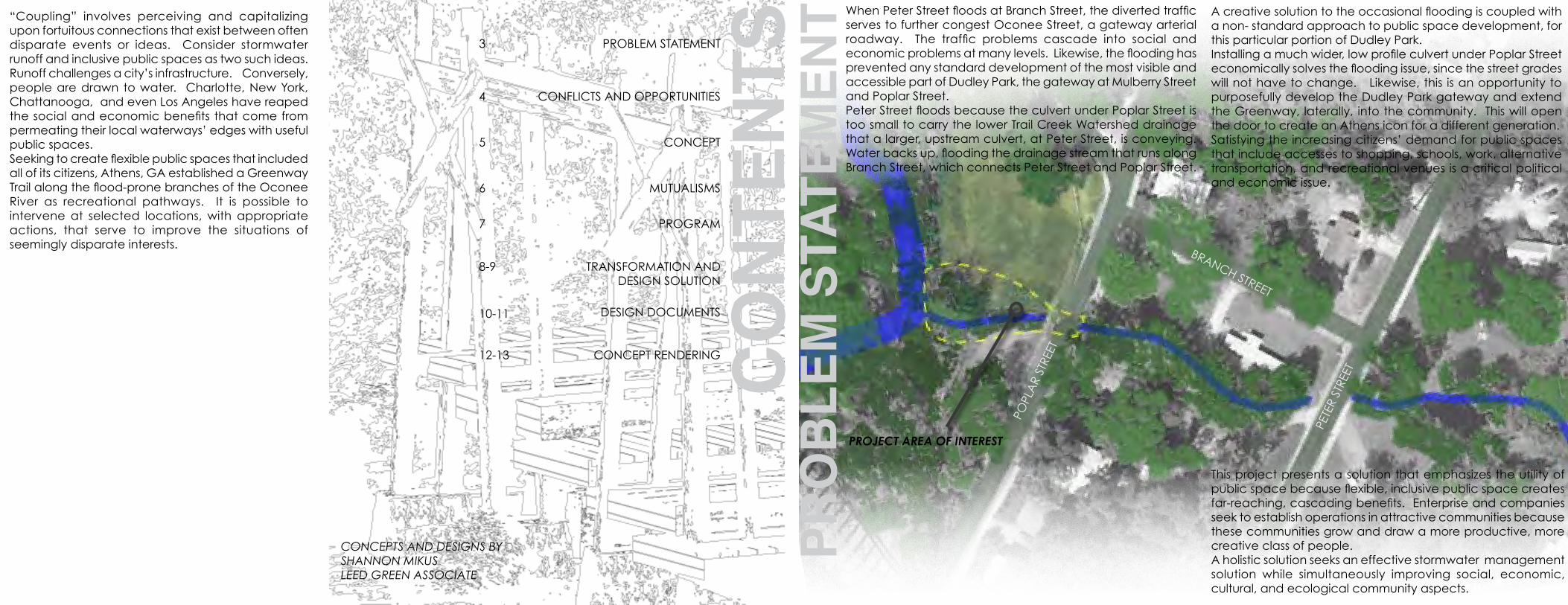
“Coupling” involves perceiving and capitalizing upon fortuitous connections that exist between often disparate events or ideas. Consider stormwater runoff and inclusive public spaces as two such ideas. Runoff challenges a city’s infrastructure. Conversely, people are drawn to water. Charlotte, New York, Chattanooga, and even Los Angeles have reaped the social and economic benefits that come from permeating their local waterways’ edges with useful public spaces. Seeking to create flexible public spaces that included all of its citizens, Athens, GA established a Greenway Trail along the flood-prone branches of the Oconee River as recreational pathways. It is possible to intervene at selected locations, with appropriate actions, that serve to improve the situations of seemingly disparate interests.
BRANCH STREET
POPL
AR
STRE
ET
PETE
R ST
REET
CONCEPTS AND DESIGNS BYSHANNON MIKUSLEED GREEN ASSOCIATE
CO
Nte
NtsCONFLICTS AND OPPORTUNITIES
PRO
BLe
M s
tAte
MeN
t
This project presents a solution that emphasizes the utility of public space because flexible, inclusive public space creates far-reaching, cascading benefits. Enterprise and companies seek to establish operations in attractive communities because these communities grow and draw a more productive, more creative class of people.A holistic solution seeks an effective stormwater management solution while simultaneously improving social, economic, cultural, and ecological community aspects.
MUTUALISMS
PROGRAM
TRANSFORMATION ANDDESIGN SOLUTION
DESIGN DOCUMENTS
CONCEPT RENDERING
When Peter Street floods at Branch Street, the diverted traffic serves to further congest Oconee Street, a gateway arterial roadway. The traffic problems cascade into social and economic problems at many levels. Likewise, the flooding has prevented any standard development of the most visible and accessible part of Dudley Park, the gateway at Mulberry Street and Poplar Street. Peter Street floods because the culvert under Poplar Street is too small to carry the lower Trail Creek Watershed drainage that a larger, upstream culvert, at Peter Street, is conveying. Water backs up, flooding the drainage stream that runs along Branch Street, which connects Peter Street and Poplar Street.
A creative solution to the occasional flooding is coupled with a non- standard approach to public space development, for this particular portion of Dudley Park.Installing a much wider, low profile culvert under Poplar Street economically solves the flooding issue, since the street grades will not have to change. Likewise, this is an opportunity to purposefully develop the Dudley Park gateway and extend the Greenway, laterally, into the community. This will open the door to create an Athens icon for a different generation.Satisfying the increasing citizens’ demand for public spaces that include accesses to shopping, schools, work, alternative transportation, and recreational venues is a critical political and economic issue.
4
6
7
8-9
10-11
12-13
PROJECT AREA OF INTEREST
CONCEPT5
PROBLEM STATEMENT3

ABC
DEFG
AB
C
D
E
F
G
ABCD
EFG
HIJ
A
B CD
D
E
F
G
G
G
G
G
G
H
I J
J J
J
J
CO
NF
LIC
TS
ALLEVIATING sTrEET fLoodING crEATEs AN opporTuNITy To
VIsIbLy ENGAGE cITIZENs WITH scENIc WATErWAys IN THE HIGHLy
pEdEsTrIAN dudLEy pArk ArEA OPP
OR
tUN
ItIe
s
THE WATErsHEd drAINAGE Is coNsTrIcTEd by AN uNdErsIZEd cuLVErT “b”, THAT Is EAsILy oVErcoME, cAusING pETEr sTrEET ANd popLAr sTrEET fLood
oLd rAILroAd GrAdE130 AcrE WATErsHEd
48” X 48” sEWEr boX
12” X 24” cuLVErT
fLood ArEA
4,500 cArs /dAy
1,000 cArs /dAy
dudLEy pArk doG ruN
fIrEfLy TrAIL
oLd TrEsTLE
HIGH dENsITy ApArTMENTs
MAMMA’S BOY
fAMILy HoMEs rEsTAurANTs
GrEENWAy TrAIL HEAd
TAILGATE fAcILITy
INcLusIVE spAcE
AN INcLusIVE spAcE for INTErAcTIoN AMoNG cHILdrEN ANd AduLTs Is AN ATTrAcTIVE AMENITy for THE NEIGHborHood
THE EXIsTING opEN spAcE Is prEsErVEd
A NATIVE sENsory GArdEN forMs A
NATurAL bArrIEr To THE sTrEAM
VIsITors cAN obsErVE THE
WATErWAys froM THE pLATforMs
VIsITors cAN INTErAcT
dIrEcTLy W
ITH THE WATErWAy
AN AdA pATHWAy coNNEcTs THE
AcTIVE ArEAs
TWo spEcIMEN bLAck oAks ArE
prEsErVEd As GATEWAy MArkErs
CO
NC
EP
T
ocoNEE sTrEET
pETEr sTr
EET
popLAr sTrEET
MuLbErry sTrEET
TrAIL crEEk
drAINAGE crEEk
dudLEy pArk

THE ICONIC, WOODEN RAILROAD TRESTLE, 200 FEET LONG AND 80 FEET HIGH, IS A PROMINENT BACKDROP, DOMINATING THE VIEW AND FORMING THE SPINE OF THE FIREFLY TRAIL
MU
tUA
LIsM
s
THE TRESTLE’S TEXTURES AND SHAPES INFORM MATERIALITY IN AN INCLUSIVE NATURAL EXPLORATION AREA
ACCESSIBILITY AND INCLUSIVITY GOVERN THE OVERALL DESIGN, CIRCULATION, INTERACTION, AND EXPLORATION
PEOPLE ACCESS AN INFLUENTIAL WATERWAY, EXPLORING AND UNDERSTANDING WATER’S ROLE IN
SHAPING THEIR COMMUNITY
PRO
GR
AM
OB
seRV
e
INte
RA
Ct
MA
NIP
ULA
te
CO
Nte
MPL
A te
COMMUNITY ENGAGEMENTCOMMUNITY EDUCATION
COMMUNITY AWARENESSCOMMUNITY ACTIVATION
FUN
FAMILYResPeCt
tRADItION

b
A
A B Des
IGN
drAINAGE sTrEAM
TrAIL crEEk
tRA
NsF
OR
MCREATE ICONIC VIEWS
THE spAcE Is dEsIGNEd To WITHsTANd fLoodING
pILINGs supporT pLATforMs AboVE THE sITE, ANd proTEcT THE bANk froM TrAffIc
TALL poLEs sEcurE THE pLATforMs ANd bEckoN To NEIGHborHood rEsIdENTs
CULVeRt UNDeR stReet
THE bANks ArE GrAdEd To HANdLE fLood sTAGE fLoWs. A GrAVEL ANd rock bEd Is LAId To cHANNEL dAILy fLoWs, ANd coNcrETE pILINGs EcHo THE pATH of THE fIrEfLy TRAIL’S LARGER TRESTLE
SOLUT IONRESTORES HYDROLOGIC FUNCTION
INSTALLING A LARGER CULVERT OF SIMILAR DEPTH, BUT MUCH GREATER WIDTH WILL PREVENT UPSTREAM FLOODING WHILE THE STREET GRADE OF POPLAR, PETER, BRANCH, AND MULBERRY STREETS REAMINS THE SAME, SAVING COSTS
sYNeRGY ON sIte
currENT cuLVErT
LArGEr cuLVErT
MODIFY THE CULVERT
currENT VIEW
proposEd VIEW
bAMboo fILLs THE coNGEsTEd sTrEAMWAy
TrEsTLE ANd VIEWING pLATforMs
AdA pATHWAy
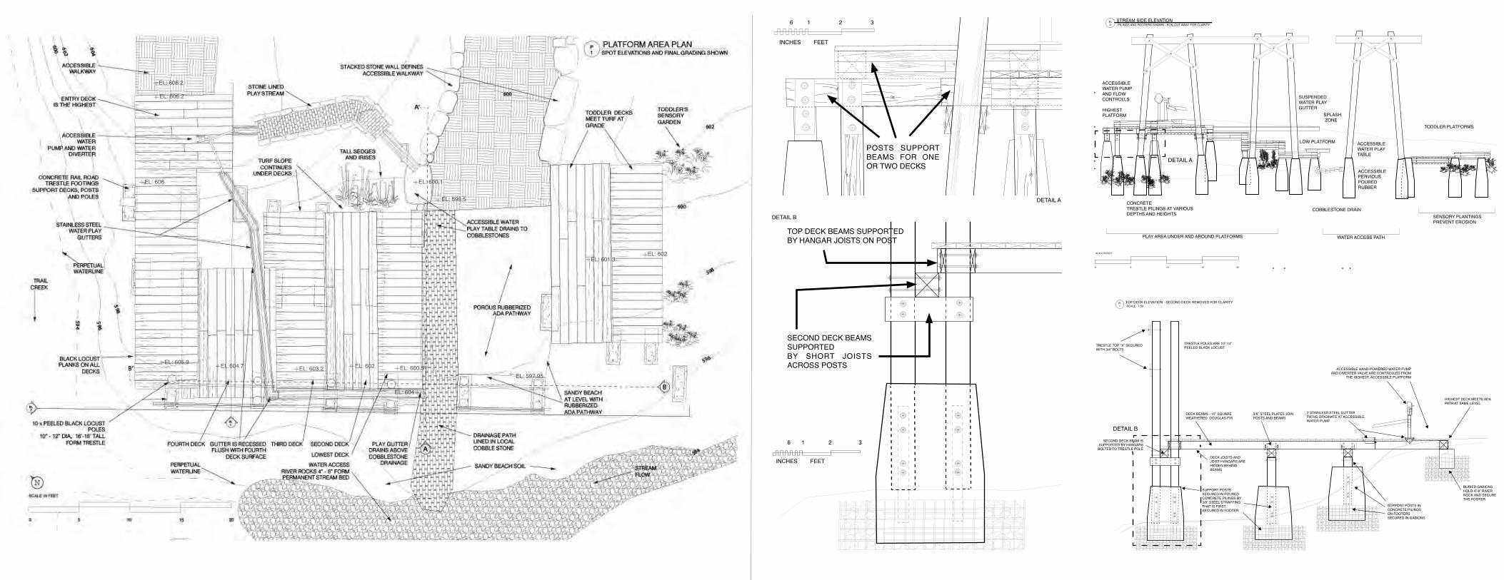
EL: 598.5
WATER ACCESS PATH
COBBLESTONE DRAIN
SUSPENDED WATER PLAYGUTTER
SPLASH ZONE
PLAY AREA UNDER AND AROUND PLATFORMS
ACCESSIBLE WATER PUMP AND FLOW CONTROLLS
ACCESSIBLE WATER PLAY TABLE
LOW PLATFORM
CONCRETE TRESTLE PILINGS AT VARIOUS DEPTHS AND HEIGHTS
TODDLER PLATFORMS
SENSORY PLANTINGS PREVENT EROSION
SCALE IN FEET
0 5 10 15 20
ACCESSIBLE PERVIOUS POUREDRUBBER
HIGHEST PLATFORM
STREAM SIDE ELEVATION PILINGS AND FOOTERS SHOWN - SOIL CUT AWAY FOR CLARITY
EL 2
TOP DECK ELEVATION - SECOND DECK REMOVED FOR CLARITY
TRESTLE TOP “X” SECURED WITH 3/4” BOLTS
TRESTLE POLES ARE 10”-14” PEELED BLACK LOCUST
DECK BEAMS - 10” SQUARE WEATHERED DOUGLAS FIR
3/8” STEEL PLATES JOIN POSTS AND BEAMS
2 STAINLESS STEEL GUTTERPATHS ORIGINATE AT ACCESSIBLE WATER PUMP
ACCESSIBLE HAND-POWERED WATER PUMP AND DIVERTER VALVE ARE CONTROLLED FROM
THE HIGHEST, ACCESSBILE PLATFORM
HIGHEST DECK MEETS ADA PATH AT SAME LEVEL
BURIED GABIONS HOLD 4”-8” RIVER ROCK AND SECURE THE FOOTER
SUPPORT POSTS IN CONCRETE PILINGS ON FOOTERS SECURED IN GABIONS
DECK JOISTS AND JOIST HANGARS ARE HIDDEN BEHIND BEAMS
SECOND DECK BEAM IS SUPPORTED BY HANGARS BOLTED TO TRESTLE POLE
SUPPORT POSTS SECURED IN POURED CONCRETE PILINGS BY 3/8” STEEL STRAPPING THAT IS FIRST SECURED IN FOOTER
SCALE - 1:50EL 1
6 1 2 3
INcHEs fEET
dETAIL A
dETAIL A
dETAIL b
dETAIL b
Top dEck bEAMs supporTEdby HANGAr JoIsTs oN posT
sEcoNd dEck bEAMs supporTEdby sHorT JoIsTs Across posTs
INcHEs fEET
6 1 2 3
posTs supporT bEAMs for oNE or TWo dEcks
EL: 606.2
EL: 606.2
EL: 606
EL: 605.9 EL:604.7 EL: 603.2 EL: 602 EL: 600.5EL: 597.95
EL: 601.3EL: 602
EL: 600.1
EL: 604
WATER ACCESS PATH
COBBLESTONE DRAIN
SUSPENDED WATER PLAYGUTTER
SPLASH ZONE
PLAY AREA UNDER AND AROUND PLATFORMS
ACCESSIBLE WATER PUMP AND FLOW CONTROLLS
ACCESSIBLE WATER PLAY TABLE
LOW PLATFORM
CONCRETE TRESTLE PILINGS AT VARIOUS DEPTHS AND HEIGHTS
TODDLER PLATFORMS
SENSORY PLANTINGS PREVENT EROSION
SCALE IN FEET
0 5 10 15 20
ACCESSIBLE PERVIOUS POUREDRUBBER
HIGHEST PLATFORM
STREAM SIDE ELEVATION PILINGS AND FOOTERS SHOWN - SOIL CUT AWAY FOR CLARITY
EL 2
AA’
B’b
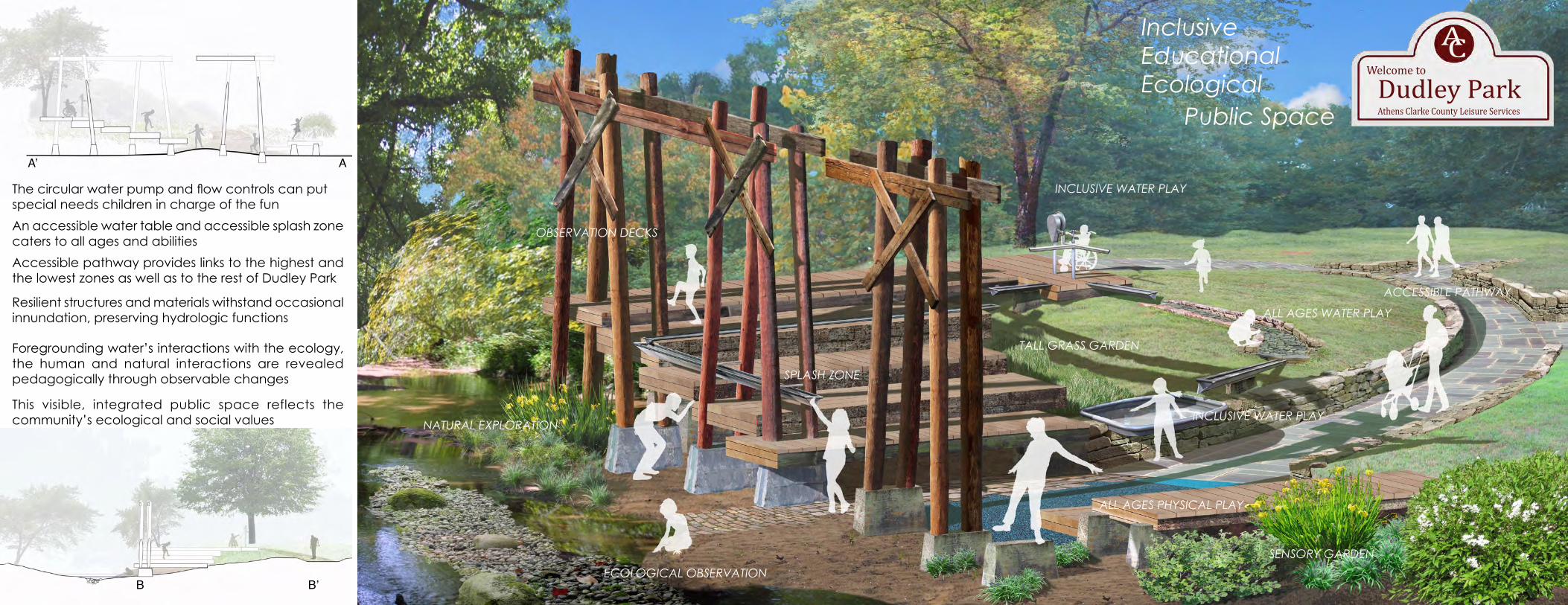
The circular water pump and flow controls can put special needs children in charge of the fun
An accessible water table and accessible splash zone caters to all ages and abilities
Accessible pathway provides links to the highest and the lowest zones as well as to the rest of Dudley Park
Resilient structures and materials withstand occasional innundation, preserving hydrologic functions
Foregrounding water’s interactions with the ecology, the human and natural interactions are revealed pedagogically through observable changes
INCLUSIVE WATER PLAY
TALL GRASS GARDEN
ALL AGES WATER PLAY
NATURAL EXPLORATIONINCLUSIVE WATER PLAY
ECOLOGICAL OBSERVATION
ALL AGES PHYSICAL PLAY
SENSORY GARDEN
ACCESSIBLE PATHWAY
This visible, integrated public space reflects the community’s ecological and social values
SPLASH ZONE
OBSERVATION DECKS
Welcome to
Dudley ParkAthens Clarke County Leisure Services
ACInclusiveEducationalEcological
Public Space