Embed Size (px)
Citation preview

Strategy 2000 - 2016
A Platform for Change
D u b l i n T r a n s p o r t a t i o n O f f i c e
Summary Report
A Platform for ChangeSummary Report
Summary of an integrated transportation strategy for the Greater Dublin Area 2000 to 2016
Dublin Transportation OfficeNovember 2001

The Contents
1. The Background 1
2. The Vision 1
3. The Challenge 4
4. The Technical Tasks 7
5. The Strategy 8
6. The Costs 19
7. The Benefits 20
8. The Programme 21
9. The Next Steps 26
Appendix: Steering Committees 28

1. The BackgroundThe Final Report of the Dublin Transportation Initiative (DTI) was published in August 1995. It recommended an integratedtransportation strategy for the Greater Dublin Area for the period up to 2011. The Government decided that the DTI Strategyshould provide the planning framework for the future development of the transport network in the Greater Dublin Area.
One of the key recommendations of the DTI Final Report was that the DTI Strategy should form the first phase of an ongoingtransportation planning process. The Dublin Transportation Office (DTO) was set up in 1995 to carry on that transportationplanning process. This report provides a summary of the first updating by the DTO of the original DTI Strategy and outlines theresulting DTO Strategy.
The Greater Dublin Area comprises the local authority areas of Dublin Corporation and the counties of Fingal, South Dublin andDún Laoghaire-Rathdown (the Dublin Region), and the counties of Kildare, Meath and Wicklow (the Mid-East Region).
The DTO Strategy outlined in this report has been prepared to support and complement the strategic land use planningframework described in the Strategic Planning Guidelines for the Greater Dublin Area, published in February 1999. TheGuidelines define the Metropolitan Area, which broadly corresponds with the built up area of Dublin, and the Hinterland Area,which is the rest of the Greater Dublin Area (see figure 1). The current Guidelines are the fundamental basis on which the DTOStrategy rests.
The Strategy also takes account of:
• the transport investment proposals in the National Development Plan 2000 to 2006;
• the development plans of the local authorities;
• the National Sustainable Development Strategy;
• the Green Paper on Sustainable Energy;
• the National Climate Change Strategy;
• the Dublin Suburban Rail Strategic Review;
• the Bus Network Strategy Appraisal for the Greater Dublin Area;
• the National Road Needs Study;
• the Eastern By-Pass Strategic Study;
• the ESRI’s Medium Term Review;
• the views of representative organisations and interested bodies.
2. The VisionTransportation is a means to an end. That is, people do not normally travel for the sake of travelling; they travel to achieve someother need or want. It is important, therefore, to put transportation in the context of the broader objectives for the city andregion. The starting point for the development of the DTO Strategy was, therefore, to ask the question: “what type of city andregion do we wish to live, work and relax in?”. We attempt to answer this question in a Statement, which, in broad terms,describes our Vision for Dublin.
Vision StatementThe Vision sees the Greater Dublin Area as:• a City and Region which embraces the principles of sustainability;
• encompassing a leading European City, proud of its heritage and looking to the future;
• having at its heart the National Capital, seat of government and national centres of excellence;
• a strong, competitive, dynamic and sustainable Region;
• a Living City and Region, on a human scale, accessible to all and providing a good quality of life for its citizens.
The next step was to translate that Vision into a series of more concrete, through still broad, objectives under five separateheadings.
1

The Regional Economy• improve accessibility and reduce congestion;
• sustain economic development and regeneration;
• consolidate existing economic activity;
• encourage a further increase in participation in the labour force, particularly by disadvantaged groups in society;
• enhance goods distribution in a sustainable way;
Quality of Life• reduce growth in the demand for transport, especially private transport;
• reduce the need for car commuting by improving the reliability, availability and quality of public transport;
• reduce travel times and congestion;
• ameliorate direct environmental effects of transport – noise, severance, air pollution and greenhouse gas emissions;
• promote cycling and walking as safe, sustainable and healthy means of transport;
• improve transport safety.
International and National Context • act consistently with Government, EU and UN policies;
• improve accessibility to ports and airports for passengers and goods;
• improve accessibility to and from the Greater Dublin Area;
• foster sustainable development.
Development of the City and Region • promote implementation of the Strategic Planning Guidelines for the Greater Dublin Area and the proposed National
Spatial Strategy;
• within the Region, consolidate growth in the Metropolitan Area;
• within the Hinterland Area, promote the self-sufficiency of the Development Centres.
Efficiency in Implementation• optimise the use of existing infrastructure and facilities;
• promote sustainable land use;
• ensure timely implementation to meet sustainable transport needs;
• ensure the efficient and cost-effective use of resources – public, EU and private sector;
• ensure that legislative, institutional and administrative structures optimise implementation;
• maximise self-enforcement;
• ensure minimum disruption during construction and implementation.
During the course of the update, the Steering Committee set two additional quantitative objectives:• reduce the level of congestion on the road network to 1991 levels, when the average speed in the morning peak hour
was 22kph;
• to provide adequate capacity for all journeys to work and education, which make up the vast majority of trips in the
morning peak hour.
2

3
Figure 1 STRATEGIC PLANNING GUIDELINES
4
3. The ChallengeIt is worthwhile to compare the 1995 DTI Strategy with the position today – firstly by looking at the progress made inimplementing the recommendations of the 1995 DTI study and secondly by looking at the changes in the demand fortransport. This leads to a better understanding of the challenge that the DTO Strategy will face.
Substantial progress has been made in implementing the recommendations of the 1995 DTI Strategy:
• Quality Bus Corridors (QBCs): Nine of the DTI’s eleven QBCs have been opened: Malahide Road, Swords (from
Whitehall to the city centre), Finglas, Blanchardstown, Lucan, North Clondalkin, Tallaght, Rathfarnham and the N11. The
remainder to the Swords QBC, South Clondalkin and an additional QBC from Ballymun are under construction. The
Orbital QBC (from Tallaght via Clondalkin and Blanchardstown to Dublin Airport) is at the design stage. The longer
established QBCs (Malahide, Lucan and N11) are now carrying more than twice as many people as a lane of general
traffic at their design speed of 22kph.
• DART/ Suburban Rail: Almost all the main elements of DART/Suburban Rail in the DTI Strategy have been
implemented. The Arrow service from Kildare to Heuston has been introduced. DART extensions to Greystones and
Malahide are open. New DART rolling stock is in service providing longer trains and increased capacity. There are new
stations at Clontarf Road and Grand Canal Dock and upgraded stations (eg at Dún Laoghaire). The twin-tracking of the
Maynooth line is completed. New diesel rolling stock is in service providing longer trains and increased frequency and
capacity. There is a new staion at Drumcondra.
• Light Rail (LUAS): Lines from Tallaght to Connolly Station and from Sandyford Industrial Estate to St Stephen’s Green
are under construction. They are expected to be in operation during 2003.
• Park and Ride: 2000 extra spaces have been provided at suburban rail stations.
• National Roads: the Northern Cross Route (M50), the Southern Cross Route (M50), the Balbriggan Bypass (M1), the
Leixlip-Maynooth-Kilcock Bypass (M4), the Finglas Bypass (N2) and junction improvements on the M50 are open. The
Southern Cross Route, the Northern Motorway (Airport to Five Roads), the Dublin Port Tunnel and the South-Eastern
Motorway are under construction.
• Traffic Management and Parking: Enforcement of, and accessibility to, on-street parking in the city centre has
improved radically - largely due to the introduction of clamping and tow-away vehicles. The computerised traffic signal
system in the city centre (SCATS) now covers 320 junctions. There is a new traffic control centre in Tallaght. Traffic cells
and traffic calming are widespread.
• Cycling: 160km of two-way cycle routes and 2500 cycle parking spaces have been provided.

There has, however, been considerable slippage in the implementation of elements of that Strategy, especially majorinfrastructure projects such as the QBCs, LUAS and the Dublin Port Tunnel.
There has been an unprecedented level of economic growth since the DTI Strategy was published in 1995. This has led tovery large increases in the levels of traffic, resulting in much greater congestion.
The main factors influencing increases in the demand for travel are economic growth, increases in population, the number ofhouseholds and the number of people at work, and growth in car ownership and use. All of these factors have shown majorincreases in recent years. Continuing growth is projected in the period up to 2016, though at a somewhat slower pace.
FACTORS INFLUENCING TRAFFIC GROWTH
Greater Dublin Area 1991 1996 1999 2016
Population (million) 1.35 1.41 1.46 1.75
Households ('000) 402 446 521 675
Employment ('000) 452 549 681 878
Unemployment rate 16% 12% 6% 5%
Car Ownership (per 1000 population) 247 292 342 480
% Growth in GDP since 1991 - 42% 79% 260%
A recent review of the Strategic Planning Guidelines indicates that the 2016 forecast of population was conservative by at least100,000 and the 2016 forecast of household numbers was conservative by up to 10%.
Growth to date has far outstripped the projections in the 1995 DTI Strategy:• The population of the original DTI Area has grown more rapidly than was projected in the original DTI Strategy. The
population predicted for 2001 was actually exceeded in 1997;
• GDP grew by 79% between 1991 and 1999, compared with a DTI forecast of 38%;
• the unemployment rate has already declined to less than 5% while DTI was forecasting a rate of 17% in 2001 and 12% in
2011;
• the number of employed persons predicted for 2011 was exceeded in 1996;
• car ownership rates have substantially exceeded those projected and are steadily increasing towards the European
average of 450 per 1000 population. Car ownership per 1000 population was 292 in 1996 and 342 in 1999, far
outstripping the original DTI forecast of 288 for the year 2001;
• total passenger numbers through Dublin Airport in 2000 (13.8m) exceeded those originally projected for 2011 (11.0m),
while the annual tonnage throughput at Dublin Port in 2000 (21.0m tonnes) was almost twice the projected level for 2011
(10.7m tonnes).
5

The consequence of this unexpected growth is that Dublin faces a rapidly increasing demand for travel, the scale of which isillustrated in the following table:
DEMAND FOR TRAVEL (Thousand person trips)
1991 1997 1999 2016
AM Peak Hour 172 250 283 488
Off Peak Hour 107 157 179 256
Total peak hour trips have grown by 78,000 or 45% between 1991 and 1997. However, the bulk of that growth has beenaccounted for by private car commuting (+71,000). In 1991 the private car accounted for 64% of peak hour trips; by 1997 thathad increased to 72%. The average journey time by car increased from 31 minutes in 1991 to 43 minutes in 1997, reflectinggreater congestion and longer journeys.
By 2016, total peak hour trips are forecast to be 488,000, a 95% increase on the 1997 level. Total trips in the off-peak hour in2016 will be 256,000. That is six thousand trips more than there were in the peak hour in 1997.
In addition to overall growth, the Strategy will also have to take account of changing patterns of travel. A comparison of journeydestinations in the morning peak hour shows significant changes between the surveys carried out in 1991 and 1997. In the1991 survey, the city centre was the primary destination. The 1997 survey showed that:
• the city centre continues to be the most popular destination;
• the south-east inner city remains a primary and growing destination;
• the fastest growing destination is Clondalkin/Tallaght. There was almost a fourfold increase in morning peak hour car
trips to this area between 1991 and 1997 and it is now the second highest trip destination;
• Dublin Airport is a major destination for trips from all parts of the Greater Dublin Area;
• there is an extensive two-way trip demand linking the western towns of Tallaght, Clondalkin, Blanchardstown and the
environs of Dublin Airport;
• other areas of growing importance as peak hour destinations include Sandyford and the area on the north fringe of
Dublin City and the south fringe of Fingal.
The challenge for the DTO is to prepare a transportation strategy that meets the objectives derived from the Vision Statementand the additional objectives set by the Steering Committee and that supports the development objectives of the StrategicPlanning Guidelines. It must do so in the context of:
• a rapid growth in population and households, leading to increasingly dispersed travel patterns;
• a substantial increase in employment leading to a large increase in the demand for travel in the peak hour;
• increasing car ownership resulting in additional commuting by car, which is economically inefficient and environmentally
unsustainable;
• an unprecedented and continuing high level of economic growth;
• slower than expected delivery of some of the major infrastructure projects recommended in the 1995 DTI Strategy.
6

4. The Technical TasksDeciding how to respond effectively to the transportation challenge required a great deal of detailed technical, transportationmodelling and evaluation work. This was carried out over the past two years by DTO staff, supported by specialist consultants.The following were the main elements of that work:
• updating of the DTO transportation model, taking account of transport infrastructure constructed since 1994, and
committed transport infrastructure (such as completion of the M50 and LUAS lines from Tallaght to Connolly Station and
from Sandyford Industrial Estate to St Stephen’s Green);
• updating the DTO transportation model to take account of the major changes in the volume and pattern of trip making;
• forecasting of 2016 transport demand for the DTO area;
• developing a conceptual high quality, high capacity public transport network for modelling purposes, consisting of a tight
mesh of radial and orbital links, centred on Dublin City centre. The conceptual network was designed so that, in general,
people in the Metropolitan Area of Dublin need walk no more than 10 minutes to a public transport service;
• testing how this conceptual public transport network would cope with the 2016 forecast transport demand, and using the
results to guide the development of an appropriate strategy for the period up to 2016.
The above technical work showed that, even with a comprehensive, high quality, high capacity public transport network,congestion on roads would be even worse than today. This is because many commuters would still choose to drive, evenwhen excellent public transport was available to them. Given the objective of reducing congestion to 1991 levels, it is clear thatany strategy that relies on the provision of additional infrastructure and improved services alone will not succeed. It follows thatsome form of demand management is necessary. Examples of demand management include designing new developments tominimise the need for motorised travel, reducing the number of workplace parking spaces, increasing the cost of long-stayparking, car sharing, teleworking and road-pricing or congestion charging.
Following the above work on the conceptual network, the next stage was to examine possible practical strategies. Theelements of the work carried out by the DTO were:
• establishment of the appropriate level of demand management to reduce congestion to 1991 levels;
• selection of the most appropriate public transport modes (bus, QBC, DART/Suburban/Rail, LUAS or METRO) for each
part of the conceptual network, based on the passenger flows;
• development of a set of viable transport strategies for Dublin in 2016, informed by strategic studies of the suburban rail
network, the bus network, the Eastern By-Pass and the national road network;
• exhaustive testing and refinement of the transport network options using the DTO transportation model;
• multi criteria evaluation of two alternative transport strategies in terms of the economic, accessibility, sustainability and
policy integration impacts;
• choice of a preliminary preferred strategy;
• sensitivity testing of the strategy with demands levels 20% higher and lower than forecast;
• further refinement of the preferred strategy, the conclusions of which are summarised in this report.
7

8
5. The StrategyThe DTO Strategy has two interdependent elements:
• Infrastructure and Service Improvements to increase the supply of transport, including a substantial expansion of the
public transport network, some strategic road construction and traffic management
• Demand Management, to reduce the growth in travel through the application of land use and other policies while
maintaining economic progress, and which is designed to encourage a transfer of trips, especially at peak periods, from
the private car to sustainable modes of transport (such as public transport, cycling and walking);
The DTO Strategy is an integrated one. It will only be effective when both elements are implemented together in a coherentway. Going ahead with the infrastructure element alone will not be enough. It must be accompanied by the demandmanagement element and the complementary policies if the Strategy is to achieve its overall objectives.
The rest of this Chapter briefly describes the principal components of the integrated transportation strategy. It includes:
• an integrated public transport network which provides for a radical transformation in the quality and quantity of services
provided;
• strategic, but limited, improvements to the road network which will be managed in a way which does not encourage peak
hour car commuting;
• traffic management policies which will optimise the use of the road network for all users, including car drivers and
passengers, public transport passengers, cyclists and pedestrians;
• a freight management policy designed to provide the basis for a detailed strategy to facilitate the movement of goods
and improve freight access to ports and airports;
• good quality cycling and pedestrian networks;
• a statement of policy on demand management which will provide the basis for the development of a detailed demand
management strategy;
• guidance on complementary land use policies.
PUBLIC TRANSPORTThe public transport elements of the Strategy will provide for approximately 300,000 trips in the morning peak hour in 2016,compared with about 70,000 today. To achieve this it will be necessary to create an integrated public transport networkcomprising the following principal components:
• an improved DART/Suburban rail network including improved passenger carrying capacity on the existing network and
the development of more tracks on existing alignments, an interconnector between Heuston Station and East Wall and
other new rail lines;
• an extension of the on-street light rail network (LUAS);
• the development of a higher capacity segregated light rail network (METRO);
• a much expanded bus network, comprising an integrated mesh of radial and orbital services and a substantial increase
in passenger carrying capacity;
• a package of measures designed to improve the integration and attractiveness of the public transport network, including
park and ride facilities, integrated fares and ticketing, quality interchange facilities and improved passenger information.
The role of the bus is likely to change quite substantially over time, particularly as the longer-term rail-based elements of theprogramme are put in place. In the short term, the bus will be the primary mode of public transport. As the rail-based networksare put in place, the bus will increasingly be used to feed passengers to rail services as well as carry them directly to theirultimate destination. The bus will also be used to fill in gaps in the mesh of public transport routes where a rail-based system isuneconomic, impractical or not feasible and also to extend the reach of the rail network.
The Strategy will make it possible to complete the bulk of public transport journeys in the Greater Dublin Area with not morethan one transfer, whether intra-modal (bus to bus) or inter-modal (bus to rail), and with only one ticket.
When the public transport strategy is in place, the great majority of people living in the Greater Dublin Area will be able toaccess the public transport network by walking 10 minutes or less. With this Strategy, public transport will be a viable option forthe large majority of trips.

Transport services in this Strategy will be accessible to all users. The particular needs of people with mobility impairments anddisabilities will be addressed by providing low-floor buses, level boarding on rail-based modes of public transport and highquality pedestrian facilities. This will consequently ensure a high quality of accessibility to public transport for all transport users.
BUS (see figure 2)
Buses are the most flexible form of public transport. The Bus is, consequently, the most extensive form of public transport inthe Strategy in terms of route length and geographic coverage. There will be a tight mesh of radial and orbital routes linking thesuburbs with each other and with the city centre. The network will comprise Quality Bus Corridors and extensive bus prioritymeasures on other parts of the network.
The Quality Bus Network (QBN) will consist of radial and orbital Quality Bus Corridors and additional bus priority measures. Ingeneral, the design of the network will offer a clear advantage to public transport over private vehicles so as to ensurecompetitive and reliable door-to-door journey times. The target design speed for public transport services in the Quality BusNetwork will remain at 22kph.
In the city centre, the QBN will allow radial bus routes to access all parts of the city centre and to interchange withDART/Suburban Rail stations, LUAS stops and METRO stations. It will also improve the reliability of cross-city services.
There will be bus priority measures apart from QBCs, in particular to access major residential, retail and employment centres.
Local bus services serving town centres in the Metropolitan Area and Development Centres in the Hinterland Area will beintroduced and given priority where needed.
9
Rathcoole
Cornelscourt
Shankill
Killiney
Bray
Dalkey
Clondalkin
Baldonnell
Walkinstown
Kimmage
Edmondstown
Ballinteer
Leopardstown
Dundrum
Jobstown
Tallaght West
Crumlin
Terenure
RathfarnhamDún Laoghaire
BlackrockBelfield
Kilmacud
StillorganKill O’ The Grange
Sandycove
Merrion
Irishtown
Sandymount
Foxrock
Castleknock
Cabra
Bluebell
Phoenix Park
Marino
Finglas
St. Annes Park Bull Island
Killester
Clontarf
Darndale
Coolock Sutton
Raheny
Dollymount
Corduff
Ronanstown
p
Lucan
Clonee
Swords
DublinAirport
Malahide
Portmarnock
Howth
Baldoyle
Monkstown
Blanchardstown
W
N
E
S
City CentreQBC Network
Santry
DolphinsBarn
TallaghtOld Bawn
Greenhills
Ballyboden
Fox & Geese
Sandyford
Milltown
Glasthule
Donnybrook
Ringsend
Fairview
WhitehallKilbarrack
LEGEND:
Bus Network
Figure 2 QBC/BUS PRIORITY NETWORK

DART/SUBURBAN RAIL (see figure 3)
Heavy rail systems, such as DART and Arrow, have high potential capacities but are very expensive to build. DART is nowexperiencing capacity problems during peak hours especially in the city centre. There is a severe bottleneck on the suburbanrail services on the northern and Maynooth lines approaching Connolly Station. The Arrow service from Kildare terminates atHeuston Station, which is more than 2km from the city centre.
The DART/suburban rail strategy is designed to make the maximum use of existing rail lines, in particular by eliminating thecapacity constraints in the existing system. This requires:• upgraded signalling on the Dundalk, Maynooth and Kildare lines to allow a substantial increase in the number of peak hour trains;
• lengthening of platforms to allow the operation of 8-car DART and Arrow trains;
• new platforms in Connolly Station;
• the removal of or restrictions on the use of level crossings on the DART and suburban rail lines;
• the segregation of intercity services from suburban services on the Dundalk and Kildare lines. This requires three- or four-tracking from
Connolly Station to north of Howth Junction and four-tracking from Cherry Orchard to Sallins.
The centre-piece of the DART/Suburban rail strategy is an underground interconnector linking Heuston Station with East Walljunction via Pearse Station and Docklands. This interconnector allows for through running from the Kildare line to the Maynoothline and/or the Dundalk line. It provides an eastern rail by-pass of the existing severe bottleneck approaching Connolly Station;it serves areas of high demand, especially the south-east inner city and Docklands; and it allows for the maximum use of theMaynooth and Kildare lines. Both of these lines will be electrified and this will permit a major extension to the present DARTsystem.
There will be new rail stations, particularly near areas of new development adjacent to the existing rail lines.
A new spur rail line will be constructed off the Maynooth line near Clonsilla to Navan.
10
Rathcoole
Cornelscourt
Shankill
Killiney
Dalkey
Tallaght
Clondalkin
Baldonnell
Fox & Geese
Walkinstown
Kimmage
Ballyboden
Edmondstown
BallinteerSandyford
Leopardstown
Dundrum
Greenhills
Old BawnJobstown
Citywest
Crumlin
Terenure Milltown
RathfarnhamDún Laoghaire
BlackrockBelfield
Kilmacud
StillorganKill O’ The Grange
Glasthule
Sandycove
Merrion
Irishtown
Sandymount
Foxrock
Whitehall
Castleknock
Cabra
Bluebell DolphinsBarn
Phoenix Park
Marino
Ringsend
Santry
Finglas
St. Annes Park Bull Island
Killester
Clontarf
Darndale
Coolock Sutton
Dollymount
Corduff
e Ronanstown
Leixlip
Lucan
Clonee
DublinAirport
Portmarnock
Howth
Baldoyle
Monkstown
Donnybrook
S
6
2
3
4
1
5
7
Fairview
Raheny
Kilbarrack
Blanchardstown
Suburban Rail on Surface
Underground Interconnector
Upgrade to 3 / 4 track fromConnolly to Howth Junction
Upgrade to twin track andelectrification of Maynooth line.
Upgrade to 3 / 4 track andelectrification of Kildare line.
Underground InterconnectorHeuston - East Wall Junction.
Resignalling and platformconstruction.
Spur to Navan.
Level Crossing Closures.
LEGEND:
1
2
3
5
4
6
7
Figure 3 DART/SUBURBAN RAIL NETWORK

LUAS (on-street light rail) (see figure 4)
The LUAS system is appropriate in corridors where passenger numbers are too high to be accommodated on bus but not highenough to justify the expense of DART/Suburban Rail or METRO.
The LUAS system in this Strategy is founded on LUAS lines that are already under construction. LUAS Line A (Tallaght toAbbey Street) is under construction. Line B (Sandyford Industrial Estate to St Stephen’s Green) is under construction as a LUASline but will be upgraded to METRO later (see under METRO). LUAS Line C (Abbey Street to Connolly Station) is underconstruction and will be extended to Docklands.
A new north-south line will be constructed from Ballymun via Whitehall, the city centre, Harold’s Cross, Terenure andRathfarnham to Dundrum. This will be extended north of Ballymun to Sillogue. It will interchange with the METRO at Sillogue, inthe north city centre, in the south city centre and at Dundrum. There will be a spur at Whitehall via Coolock to Kilbarrack whereit will interchange with DART.
A new east-west line will be constructed from Lucan via Ballyfermot, Dolphin’s Barn and the South City Centre to Docklands viathe proposed Macken Street Bridge.
11
le
Cornelscourt
Shankill
Killiney
Dalkey
Tallaght
Clondalkin
aldonnell
Fox & Geese
Walkinstown
Kimmage
Ballyboden
Edmondstown
BallinteerSandyford
Leopardstown
Greenhills
Old BawnJobstown
Tallaght West
Crumlin
Terenure Milltown
Dún LaoghaireBlackrockBelfield
Kilmacud
StillorganKill O’ The Grange
Glasthule
Sandycove
Merrion
Irishtown
Sandymount
Foxrock
Castleknock
Cabra
Phoenix ParkFairview
Marino
Ringsend
Santry
Finglas
St. Annes Park Bull Island
Killester
Clontarf
Darndale
Coolock SuttonKilbarrack
Raheny
Dollymount
Corduff
Ronanstown
nee
Swords
DublinAirport
Malahide
Portmarnock
Howth
Baldoyle
Monkstown
Donnybrook
Blanchardstown
W
N
E
S
Lucan
Bluebell
Whitehall
Rathfarnham
Dundrum
DolphinsBarn LEGEND:
On Street LUAS.
Figure 4 LUAS NETWORK

METRO (see figure 5)
METRO is a light rail system that is similar to LUAS except that it is completely segregated throughout its entire length (that is, ithas no on-street sections). This means that it can have long trains, operating at higher speeds and higher frequency andtherefore has the potential to provide very high passenger capacity. Tunnels are needed to maintain segregation in denselydeveloped areas.
The METRO system will have a spine from Swords to Shanganagh. This line will run via Dublin Airport, Finglas, Broadstone, thecity centre, Ranelagh, Sandyford and Cherrywood. The section between Broadstone and Ranelagh will be in tunnel and willinterchange with DART at Tara Street Station. Construction of this line will entail the upgrading of LUAS Line B to METRObetween the Sandyford Industrial Estate and Ranelagh.
There will be a line from Tallaght West via Tallaght and Kimmage, entering the city centre tunnel in the south city.
An orbital line will be formed from a spur off the Swords-Shanganagh spine route at Finglas via Blanchardstown and Clondalkinto Tallaght. This line will interchange with DART/suburban rail, and possibly with intercity trains, at Porterstown and Clondalkin.This will allow passengers from Sligo, Ballina, Westport, Galway, Limerick, Tralee, Cork, and Waterford trains to access DublinAirport with only one interchange.
12
Rathcoole
Shankill
Killiney
Bray
Dalkey
Tallaght
Clondalkin
Baldonnell
Fox & Geese
Walkinstown
Kimmage
Ballyboden
Edmondstown
BallinteerSandyford
Dundrum
Greenhills
Old BawnJobstown
Tallaght West
Crumlin
Terenure Milltown
RathfarnhamDún Laoghaire
BlackrockBelfield
Kilmacud
StillorganKill O’ The Grange
Glasthule
Sandycove
Merrion
Irishtown
Sandymount
Foxrock
Whitehall
Castleknock
Cabra
Bluebell DolphinsBarn
Phoenix ParkFairview
Marino
Ringsend
Santry
Finglas
St. Annes Park Bull Island
Killester
Clontarf
Darndale
Coolock SuttonKilbarrack
Raheny
Dollymount
Corduff
Ronanstown
p
Lucan
Clonee
Swords
DublinAirport
Malahide
Portmarnock
Howth
Baldoyle
Monkstown
Donnybrook
Blanchardstown
W
N
E
S
1
4
5
2
3
6
Leopardstown
Cornelscourt
LEGEND:
METRO on Surface
Underground METRO
Swords and Dublin Airportto City Centre Tunnel.
City Centre Tunnel viaTara St. DART
Upgrade from LUAS to METRO.
Extension to Shanganagh DART
Finglas via Blanchardstownand Clondalkin to Tallaght.
Tallaght West via Tallaght andKimmage to City Centre Tunnel.
1
2
3
4
5
6
Figure 5 METRO NETWORK

INTEGRATION (see figures 6 and 7)
The DTO Strategy is integrated across the various modes of transport.
There will be numerous interchange stations on the METRO, DART/Suburban Rail, LUAS and bus networks, particularly in thecity centre. There will be bus feeders to rail-based public transport. It will be possible to make almost all journeys on the publictransport networks with just one interchange.
All public transport networks will be fully accessible by people with mobility impairments and disabilities.
A series of public transport nodes will be developed in the city centre and in the northern, western and southern suburbs.
Real time travel information and public transport information services by telephone and on the internet will be introduced.
Park and Ride will integrate the car with public transport. There will be Park and Ride facilities for commuters at strategiclocations where the national road network meets the public transport networks. All proposed Park and Ride sites will beassessed to ensure that cars accessing them do not unduly add to congestion.
Cycle parking facilities will be provided at all Park and Ride sites, DART/suburban rail and METRO station, and at LUAS andbus stops where appropriate.
Integrated fares and ticketing will be introduced. This will allow all public transport users to complete a full journey with onlyone ticket, even if the journey involves more than one bus and/or LUAS and/or DART/suburban rail and /or METRO trip.
13
Rathcoole
CornelscourtKilliney
Bray
Dalkey
Clondalkin
Baldonnell
Walkinstown
Kimmage
Edmondstown
Ballinteer
Leopardstown
Greenhills
Jobstown
Tallaght West
Crumlin
Terenure Milltown
Dún LaoghaireBlackrockBelfield
Kilmacud
StillorganKill O’ The Grange
Sandycove
Merrion
Irishtown
Sandymount
Foxrock
Castleknock
Cabra
Phoenix Park
Marino
Ringsend
Finglas
St. Annes Park Bull Island
Killester
Clontarf
Darndale
Coolock Sutton
Dollymount
Corduff
p
Clonee
Swords
DublinAirport
Malahide
Portmarnock
Howth
Baldoyle
Monkstown
W
N
E
S
Lucan
Fox & Geese
Bluebell
Whitehall
Santry
Kilbarrack
Raheny
Fairview
Donnybrook
Shankill
Glasthule
Rathfarnham
Dundrum
Sandyford
Ballyboden
TallaghtOld Bawn
DolphinsBarn
Ronanstown
Blanchardstown
LEGEND:
Bus Network
Suburban Rail on Surface
Underground Interconnector
LUAS
METRO on Surface
Underground METRO
Figure 6 PUBLIC TRANSPORT NETWORKS

14
St.
Pearse
Killiney
Shankill
Kilcoole
Wicklow
Rathdrum
East Wall JunctionC nnollyo
Ballyfermot Coldcut
Lucan
Gra hamntSuir Road
Fatima
Harcourt
Kelly’sCorner
Pearse
Barrow St.
Lansdowne
Erne St.
Sheriff
The Point Depot
Moneen Cottage
Belgard
Cookstown
Hospital
Tallaght
Clondalkin Red Cow
Bluebell
Stephen’s GrPatrick St.
Clanbrassil
Warrenmount
New St.
Cornmarket
Church St.
Richmond Rd.
GriffithGrange Rd.Whitehall
DCUCollinsAve.
Ballymun Rd.
Balbutcher
Santry Demense
Naul
Cloghran
Forest Fields
Dublin Rd.
Main St. Swords
Cabra Rd.
TolkaJamestown Rd.
North Rd.
Harold’s X
Dundrum
Broadstone
Liffey Jtn
N2-M50
Heuston
Four Courts
Drumcondra
Howth
Dublin Airport Terminal
SwordsTerminus
Howth Jtn.
Malahide
Dundalk
Docklands
Sandymount
Sydney Parade
Clontarf
Killester
HarmonstownCroke Pk
Raheny
Kilbarrack
Newlands
RTC
Greenhills
Tymon
Kennington
Templeville
Manor
Kimmage
Poddle
Sundrive
Leinster Place
Rathfarnham
Willbrook
Churchtown
Mount Argus
Charlemont
Nassau
Rotunda
Abbey
Leeson
ClogherDolphin’sBarn
Brighton
Dodder
Terenure
Baggot Mount St.
SmithfieldMuseum
Watling Street
Jervis Busaras
Ranelagh
Beechwood
Cowper
Milltown
Windy Arbour
Balally
Kilmacud
Stillorgan
Sandyford
Gallops
Ballyogan
Carrickmines
Laughanstown
Loughlinstown
Cherrywood
ShankillVillage
Wellington
Belgard GrTallaght West
St. James
Rialto
Porterstown
Drimnagh
CherryOrchard
Kishoge
South Lucan
ewbridge
Hazelhatch
Sallins
Clonsilla
Lucan North
Leixlip
Confey
Dunboyne
Leixlip Louisa Br.
Dunshaughlin
Kilcock
Maynooth
Navan
West Park
Goldenbridge
Blackhorse
Neilstown
HarelawnBallyowen
Esker Lodge
KilmainhamInchicore
Coolmine River Road AshingtonCastleknock Ashtown BroombridgeProspect
Ardlea
Skelly’sLane
GracePark
Beaumont MillbrookCoolock
Brendan’s
Granby
Dorset
Cappagh
Sillogue
BallycoolinBernadette’sMulhuddartBlanchardstown
Shelerin
NCR
Whitethorn
Blackditch
Le Fanu
Canal
Ballyfermot
Kylemore
Kingswood
Kilmartin
Main St.
Rowlagh
Quarryvale
Liffey Valley Centre
Carpenterstown
Mayfield
Baldoyle
Portmarnock
Donabate
Rush
Skerries
Balbriggan
Gormanstown
Mosney
Laytown
Drogheda
Bayside Sutton
Booterstown
Blackrock
Seapoint
Salthill / Monkstown
Sandycove
Dalkey
Glenageary
Dún Laoghaire
Shanganagh
Greystones
Arklow
Bray
Tara St.
Leopardstown
Clonee
W
N
E
S
LEGEND:
Except for existing rail stations and planned LUAS Lines A, B and C stops, all other stations are for illustrative purposes only.
Note:
DART
METRO LUAS
Suburban Rail
Interchange
Regional Bus StationBusaras
Figure 7 RAIL NETWORK SCHEMATIC

ROADS (see figure 8)
The development of the national road network in the Greater Dublin Area meets national economic policy objectives and,accordingly, a number of national road projects are included in the DTO Strategy. The projects fall into two general categories.The first is the upgrading and completion of the orbital motorway around Dublin (M50, the Dublin Port Tunnel and Eastern By-Pass). The second comprises upgrading the arterial national routes outside the orbital motorway.
The Strategy includes a number of non–national road projects that have a strategic influence (as distinct from local impacts).The main criteria for inclusion are that the project should:• provide for proper management of access to the M50 and/or national arterial routes;
• complement the Strategic Planning Guidelines;
• serve critical economic development needs in the Metropolitan Area or in the development centres identified in the
Strategic Planning Guidelines;
• provide other environmental or safety benefits;
• increase capacity for public transport.
The principal road projects are listed in Chapter 8.
There will be no significant increase in road space on radial roads inside the M50 Motorway. Further, there will be no additionalroads to cater for car traffic passing through the Metropolitan Area, apart from those roads contained in the Strategy.
The construction of new and improved roads, especially by-passes, will be accompanied by the reallocation of road space onthe existing road network to pedestrians, cyclists and/or public transport users.
15
Rathcoole
Cornelscourt
Shankill
Killiney
Bray
Dalkey
Tallaght
Clondalkin
Baldonnell
Fox & Geese
Walkinstown
Kimmage
Ballyboden
Edmondstown
BallinteerSandyford
Leopardstown
Dundrum
Greenhills
Old BawnJobstown
Citywest
Crumlin
Terenure Milltown
RathfarnhamDún Laoghaire
BlackrockBelfield
StillorganKill O’ The Grange
Glasthule
Sandycove
Foxrock
Castleknock
Cabra
Bluebell DolphinsBarn
Phoenix Park
Santry
Finglas
St. Annes Park Bull Island
Killester
Clontarf
Darndale
Coolock SuttonKilbarrack
Raheny
Dollymount
Corduff
Leixlip
Lucan
Clonee
Swords
DublinAirport
Malahide
Portmarnock
Howth
Baldoyle
Monkstown
Donnybrook
W
N
E
S
2
6
11
1
1
11
1
4
5
8
3
6
67
9
10
1
Blanchardstown
Fairview
Marino
Whitehall
Ringsend
IrishtownSandymount
Merrion
Kilmacud
RonanstownStrategic Roads in DTO Strategy.Existing Strategic Roads
Upgrade M50 Motorway.
Southern Cross Route.
South Eastern Motorway.
Dublin Port Tunnel.
Eastern By-Pass.
Outer Ring Road.
Outer Orbital RouteNaas-Navan-DroghedaEnvirons.
M1 Northern Motorway.
N2 M50 - Ashbourne.
N3 Clonee - Kells
N7 Naas Road Improvements
LEGEND:
1
23456
7
8
9
10
11
Figure 8 STRATEGIC ROAD NETWORK

TRAFFIC MANAGEMENTThe primary objective of traffic management is to optimise the use of road space for all users. Traffic management will beparticularly important in the short term, before the high-capacity rail-based public transport schemes are completed. In 2006,there will be an additional 60,000 public transport users in the peak hour, most of them travelling by bus. This alone will requirethe traffic management system to provide additional bus priority as well as catering for the extra 120,000 pedestrian trips (ie60,000 at each end of the public transport journeys).
There will be a Regional Traffic Management Strategy, which will include:• the definition of a hierarchy of roads in the network, setting out the purposes and objectives for each level in the
hierarchy;
• a monitoring system, to measure how well the highway network is meeting its objectives;
• a control system, enabling adjustment of the network;
• a series of firm proposals comprising a traffic management policy.
There will be a vast improvement in the quality of pedestrian facilities. In the city centre, new walking corridors will form thebasis of a primary pedestrian network serving commerce, business, leisure and tourism trips, and linking primary commuterdestinations with public transport facilities. A Safer Routes to School (SRTS) programme will promote health and safety onchildren’s journeys to and from school.
The DTO Strategic Cycle Network will be completed. An extended network will include strategic cycle routes and links to publictransport facilities and main employment centres. There will be adequate cycle parking facilities.
There will be local traffic signal control centres in each of the four Dublin local authorities. They will have integrated trafficmanagement systems controlling traffic signals, remote fault detection, closed circuit TV and variable message signs. There will bea Regional Signal Control Plan that will co-ordinate traffic signal control on a regional basis and will seek to achieve broad goals,including the reduction of rat-running, pedestrian delays and congestion, while increasing bus speeds and improving safety.
There will be one motorway control centre for all the motorways within the Greater Dublin Area. The centre will have anintegrated suite of systems for the management and maintenance of the motorway system.
Enforcement systems will be increasingly automated, with camera recording and computer processing of violations. Clampingwill be extended to areas of high parking demand, especially retail centres. Towing will be extended to the additional main trafficroutes.
The local authorities and the utility companies will develop a more co-ordinated approach to the planning and management ofroad works. All non-emergency works will be planned with the objective of minimising disruption to traffic.
A Regional Freight Study will be undertaken to identify appropriate routes and restrictions for general goods distribution and forfreight trips to and from Dublin Port, Dún Laoghaire Port and Dublin Airport. It will also review the scope for improved goodsdistribution strategies, including consolidation centres, night-time deliveries, as well as considering pricing strategies, loading,layover and general distribution management.
The development of traffic cells in the city centre and traffic calming generally will continue. In the case of city centre cells,further attention will be given to the issues of severance at cell boundaries, access to car parks inside cells or at cellboundaries, links between cells for cyclists, pedestrians and public transport, the requirement to maintain and foster urbanvillages, and the enhancement of the unique character of some principal streets in the city.
Travel information systems (maps, kiosks, internet, phones etc.) will be developed to provide information to enable people tomake appropriate travel choices before they start their journeys. Within the transport networks, effective and comprehensivedirection signing, passenger and traffic information will be essential.
16

DEMAND MANAGEMENT Previous sections of this report have dealt with the first element of the Strategy, the supply of infrastructure and serviceimprovements. The second, interdependent element of the Strategy is demand management, which seeks to reduce thegrowth in the demand for travel while maintaining economic progress, and which is designed to encourage a transfer of trips tosustainable modes. The Strategic Planning Guidelines state that the success of the land use strategy for the Greater DublinArea is contingent on the introduction of effective demand management measures, since physical planning policies andmeasures can only partially reduce demand for travel. Analysis by the DTO shows that the introduction of the infrastructure andservice improvements element of the Strategy alone will not achieve the overall objectives.
A demand management strategy is therefore a critical element of this Strategy. A comprehensive Demand Management Studyis necessary to develop the strategy. The goals of the demand management strategy will include the following: • To reduce the growth in demand for travel by motorised modes;
• To reduce the number of peak hour car trips from 250,000 to 180,000 (ie by 28%) in 2016;
• To reduce the level of congestion on the road network to 1991 levels, when the average speed in the morning peak hour
was 22kph.
The following mechanisms exist in other countries and cities to manage travel demand, and are among those that will beexamined during the Demand Management Study:• Land Use Policies
• Economic/Fiscal Instruments
• Parking control
• Mobility Management
• Information Technology measures
• Reorganisation of work
Each demand management mechanism will generate different types and levels of behavioural reaction. Travellers may:• Retime journeys to travel outside busy periods;
• Transfer to a mode with sufficient capacity to ensure arrival at the preferred time;
• Change trip origin or destination (more likely over the longer term);
• Link trips to other trips that they wish to make to avoid travelling twice;
• Share a private vehicle with others for some or all of the trip;
• Decide to forego the trip entirely.
The Demand Management Study will quantify the likely impact on traveller behaviour and assess the feasibility of a package ofmechanisms.
GUIDANCE ON COMPLEMENTARY LAND USE POLICIESThe Strategic Planning Guidelines have determined that development will be consolidated within the Metropolitan Area and intodefined Development Centres in the Hinterland Area. In principle, development outside of these centres is to be restricted tonatural growth in the locality. The DTO Strategy complements this land use strategy. The following issues need to be addressedby the implementation agencies with the assistance of the DTO where appropriate.
New development should be concentrated within the Metropolitan Area and within the Hinterland Area development centres.
Within the Metropolitan Area, the use of public transport corridors should be maximised by concentrating development alongthese corridors at public transport nodes (stations, bus stops or interchanges). Development should be phased to maximisethe utility of existing public transport services and to avail of new services as they come on stream. Reservations for publictransport should be protected in the design of new developments. A study should be undertaken which identifies at the outsetthe appropriate locations for additional public transport nodes. Local Area Plans should be prepared around rail transport nodesand along quality bus corridors, which identify the appropriate development potential for these areas. Development nearinterchange nodes should be primarily reserved for large trip attractors such as major employers or town/district centres.Development of rail stations should support local residential areas by providing local services. Integrated Framework Plans forLand Use and Transportation should be developed for each of the Major Centres within the Metropolitan Area.
17

Within the Hinterland Area, development within the designated development centres should be consistent with the objective ofachieving self-sufficiency. Priority should be given to complementary development that supports the local transportation networkand is consistent with the objective of providing predominantly self sustaining development centres. An Integrated FrameworkPlan for Land Use and Transportation which will determine the future development of these areas should be prepared for eachdevelopment centre. Primarily people based employment activities should be located close to existing and future publictransport nodes.
Parking policies and standards should promote the use of sustainable modes of transport, so providing a competitiveadvantage for public transport. Parking policies need to be developed which are consistent across the region, complement theprovision of public transport, reduce car dependency, set maximum parking standards for each land use, allow for temporaryparking provision and locate parking to complement the policy of concentrating development.
In response to the DTO Strategy, the Strategic Planning Guidelines should be reviewed and should address a number of issuesincluding: maximising access to public transport infrastructure, facilitating high-density development by accelerating theprovision of public transport, reviewing development plans to reflect the DTO Strategy, disaggregating the Metropolitan Area intoappropriate development zones and clarifing what are acceptable levels of commuting between each of the designatedHinterland Area development centres and the Metropolitan Area.
The DTO will provide advice notes on relevant issues relating to land use and transportation.
18

19
6. The CostsMost of the costs of the Strategy relate to the infrastructure and service improvement element of the Strategy. The demandmanagement element will have some set-up costs, but these are likely to be relatively small.
The table below shows the breakdown of the capital costs of the infrastructure and service improvement element of theStrategy, in the period 2000-2006 and the period 2006 – 2016. The costs are in 2001 prices and include land costs,contingencies and VAT, which is assumed to be at 15% on average.
Capital Costs (£Million)
2000 - 2006 2007 - 2016 Total IR£m €m IR£m €m IR£m €m
METRO 1,000 1.270 4,687 5,951 5,687 7,221
LUAS 1,037 1,317 636 808 1,673 2,124
DART/Suburban Rail 1,817 2,307 2,579 3,275 4,396 5,582
QBN/ Bus Priority 486 617 150 190 636 808
Integration 155 197 155 197 309 392
Roads 3,256 4,134 972 1,234 4,228 5,368
Traffic Management 145 184 145 184 289 367
Total 7,896 10,026 9,323 11,838 17,218 21,862
Operating CostsThere will be significant operating and maintenance costs associated with the public transport infrastructure and serviceimprovements in the Strategy. There will be operating costs associated with the roads infrastructure and demand managementelements of the Strategy. The revenues from tolled road schemes, such as the Dublin Port Tunnel, will cover their operating andmaintenance costs. Revenue from possible economic and fiscal instruments of demand management, such as increasedparking charges and road pricing, would cover their costs and could provide significant surplus revenue.
As part of the Strategy work, we have estimated the operating costs and anticipated revenue for the public transport elementsof the Strategy in 2016. The anticipated revenue assumes that average fares remain the same in real terms as today. Theoperating costs and fare revenues will grow between now and 2016 as each new infrastructural element of the Strategy isadded, and as public transport patronage increases.
The rail operating costs are derived from the “Dublin Suburban Rail Strategic Review” produced for CIE by Arup Consulting Engineersin March 2000 and the “DTO Strategy, Cost and Programme Review” prepared for the DTO by Arup Consulting Engineers in July2000. They have been further updated by additional information received from Irish Rail. Operating costs for METRO, DART/SuburbanRail and LUAS include train operation and maintenance, track and station maintenance and ticketing costs.
Bus operating costs are based on the operating costs contained in the 1999 Dublin Bus Annual Report, with an allowance forthe extra buses required in 2016, compared to 1999.
Vehicle depreciation costs are included for bus (assuming a 10 year vehicle life) and for rail rolling stock (assuming a 20 yearrolling stock life).
Revenues assume a flat fare of 80 pence per trip. There is an allowance for discounted and concessionary fares (eg seasontickets) which is assumed to be an average of 81% in the peak hour and 75% in the off-peak hour.
Operating Costs and Revenues in 2016 (£Million in 2001 prices)
Operating costs Revenues
IR£m €m IR£m €m
QBC / Bus 194 246 149 189
METRO, LUAS, DART/suburban rail 354 450 289 367
TOTAL 548 696 438 556
This leaves a requirement for an annual subvention of approximately IR£110m (€140m) in 2016.

7. The BenefitsThe function of the Strategy is to meet the objectives set out under the Vision Statement in Chapter 2 and the additionalobjectives added by the Steering Committee. The benefits of the Strategy derive from meeting those objectives.
Because of the importance of having an objective analysis of the Strategy, the DTO employed independent consultants to carryout a multi-criteria analysis.
The multi-criteria evaluation showed that:• The Strategy is very effective in terms of its contribution to the economy. The economic benefits of the Strategy are very
substantial at £18.6bn (€23.7bn) in net present value terms. With a cost-benefit ratio of 3.08 and a rate of return of 15.8%,
the Strategy is efficient and provides good value for money.
• It improves social inclusion by providing a transport system that is accessible to all sectors of society and all
geographic districts in the Greater Dublin Area.
• It promotes sustainability by reducing polluting emissions, noise impacts and energy consumption.
• It supports policy integration with the Strategic Planning Guidelines and caters for longer-term transport needs.
It is worthwhile to describe some of the benefits in practical terms outside the strict terms of the multi-criteria analysis.• The transport system will have adequate capacity to cater for all journeys, in particular for all journeys to work and
education in the morning peak hour.
• There will be an extensive high-quality public transport system extending over a large catchment area. Most people will
live within 10 minutes walking distance of DART/suburban rail, METRO, LUAS or the Quality Bus Network.
• There will be an integrated public transport system. Most journeys will be possible on public transport with, at most,
one interchange and all journeys will be possible with only one ticket.
• The level of road congestion will be less than half what it would be if the Strategy were not implemented. The average
speed on the road network in the morning peak hour will be increased to 20kph, compared with 8kph without the
Strategy.
• Average journey times will reduce dramatically. The average journey time by bus and rail will be 37% and 53%
respectively less than the situation if the Strategy were not implemented. The average journey time reduction for car will
be 39%.
AVERAGE JOURNEY TIMES IN 2016 AM PEAK (Minutes)
Without the Strategy With the Strategy
Bus 47 29
Rail 38 18
Car 94 57
Weighted Average 76 34
• Public transport will gain an improved share of the market for travel. Public transport will have 63% of the total market
for travel in the Greater Dublin Area and 85% of those trips with destinations in the city centre. This compares very
favourably to the situation if the Strategy were not implemented, where public transport would carry only 35% of the total
market, and 72% of trips with destinations in the city centre.
MODE SPLIT IN THE AM PEAK HOUR (Person Trips)
1991 1997 2016
Bus 44,000 26% 47,000 19% 69,000 14%
Rail 18,000 10% 21,000 8% 239,000 49%
Car 110,000 64% 181,000 73% 180,000 37%
Total 172,000 100% 249,000 100% 488,000 100%
• Environmental benefits will be significant. Total energy consumed will reduce by 41%, and emissions will reduce by
20
34% compared with the Do-minimum situation.
• Urban centres within the Greater Dublin Area will become attractive focal points for business, leisure and retail activities.
• Residential areas will be safer and more pleasant places to live, and the negative impacts of car traffic will be reduced.
• Accidents will reduce by 35% compared with the Do-minimum situation because there will be less travel by car and a
higher proportion of car travel will be on motorways.
• Road space will be efficiently organised for the movement of people and goods. The allocation of road space to buses
and bicycles will improve the efficiency and reliability of bus services, increasing their market share. Cycling will become
safer and more convenient and will therefore be more attractive.
• Accessibility to work, leisure and retail opportunities will improve for most people. Accessibility to the City Centre and
to Dublin Airport will improve by 22% and 43% respectively in the morning peak period and by 11% and 20%
respectively in the off-peak period, compared with the Do-minimum situation.
• The competitive position of the Greater Dublin Area as a choice for locating employment will be maintained because of
increased accessibility of labour and markets.
8. The ProgrammeThe phasing of the Strategy is designed to address short term transportation needs and to put in place an integratedtransportation system which will meet the medium to longer term requirements of the Greater Dublin Area.
In the short term, the aim is to provide additional public transport capacity, primarily on the bus network, and to improve trafficmanagement, including better bus priority. In the medium to longer term, the emphasis will switch to rail–based public transport(LUAS, METRO and DART/Suburban rail) and demand management. The aim is to create an integrated transport network,which has sufficient capacity to meet the transportation requirements of the Greater Dublin Area well beyond the 2016 horizonof this Strategy.
The programme is divided into four phases:• PHASE 1: from the beginning of 2001 to the end of 2003;
• PHASE 2: from the beginning of 2004 to the end of 2006 (the end of the National Development Plan);
• PHASE 3: from the beginning of 2007 to the end of 2010;
• PHASE 4: from the beginning of 2011 to the end of 2016 (the horizon year of the Strategy);
The phasing of the programme is influenced by a range of factors, including:
• the urgency of the transportation demand (is the investment required to address a demand for transport which exists
now or one which will exist at some future date?);
• land use considerations (is the investment required to serve an existing development, a new development or to influence
the pattern of future development?);
• the current state of preparedness of the project (is the project only at the conceptual stage or has detailed planning and
design been completed?);
• operational issues (will the construction of the project interfere with existing transport services?)
• the physical scale and capital cost of the particular project;
• the lead time required for the planning, design, consultation and statutory approval process;
• whether the project involves the improvement of an existing infrastructure, facility or service or the provision of a new
one.
The following table sets out an indicative programme for the period 2001-2016.
21
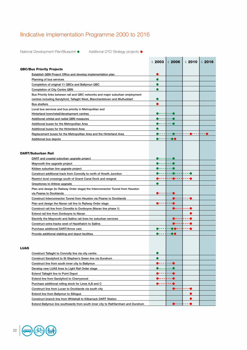
IIndicative Implementation Programme 2000 to 2016
National Development Plan/Blueprint Additional DTO Strategy projects
4 2003 4 2006 4 2010 4 2016
QBC/Bus Priority Projects
Establish QBN Project Office and develop implementation plan
Planning of bus services
Completion of original 11 QBCs and Ballymun QBC
Completion of City Centre QBN
Bus Priority links between rail and QBC networks and major suburban employment
centres including Sandyford, Tallaght West, Blanchardstown and Mulhuddart
Bus shelters
Local bus services and bus priority in Metropolitan and
Hinterland town/retail/development centres
Additional orbital and radial QBN measures
Additional buses for the Metropolitan Area
Additional buses for the Hinterland Area
Replacement buses for the Metropolitan Area and the Hinterland Area
Additional bus depots
DART/Suburban Rail
DART and coastal suburban upgrade project
Maynooth line upgrade project
Kildare suburban line upgrade project
Construct additional track from Connolly to north of Howth Junction
Restrict level crossings south of Grand Canal Dock and resignal
Greystones to Arklow upgrade
Plan and design (to Railway Order stage) the Interconnector Tunnel from Heuston
via Pearse to Docklands
Construct Interconnector Tunnel from Heuston via Pearse to Docklands
Plan and design the Navan rail line to Railway Order stage
Construct rail line from Clonsilla to Dunboyne (Navan line phase 1)
Extend rail line from Dunboyne to Navan
Electrify the Maynooth and Sallins rail lines for suburban services
Construct extra tracks west of Hazelhatch to Sallins
Purchase additional DART/Arrow cars
Provide additional stabling and depot facilities
LUAS
Construct Tallaght to Connolly line via city centre
Construct Sandyford to St Stephen’s Green line via Dundrum
Construct line from south inner city to Ballymun
Develop new LUAS lines to Light Rail Order stage
Extend Tallaght line to Point Depot
Extend line from Sandyford to Cherrywood
Purchase additional rolling stock for Lines A,B and C
Construct line from Lucan to Docklands via south city
Extend line from Ballymun to Sillogue
Construct branch line from Whitehall to Kilbarrack DART Station
Extend Ballymun line southwards from south inner city to Rathfarnham and Dundrum
22

National Development Plan/Blueprint Additional DTO Strategy projects
4 2003 4 2006 4 2010 4 2016
METRO
Plan and design METRO system to METRO Order stage
Construct Ranelagh to Airport and Swords line including City Centre Tunnel
Upgrade Sandyford/Cherrywood line to METRO and connect to City Centre Tunnel
Construct line from Finglas to Tallaght via Blanchardstown and Clondalkin with spur
to Tallaght West
Construct line from Tallaght to city centre via Kimmage and connect to
Sandyford/Swords line
Extend line from Cherrywood to Shanganagh
Integration
Implement integrated ticketing
Review and provide Park & Ride at strategic locations
Provide cycle parking at rail stations
Provide real time travel information system
Identify and establish key public transport interchange nodes
Integrated Framework Plans
Public transport service and timetable information
Cycling
Complete the DTO Strategic Cycle Network
Develop local networks and links to important trip destinations
Provide extensive cycle parking facilities in city centre and major retail and
employment centres
Review and extend Strategic Cycle Network
Walking
Review of pedestrian facilities
Commence pedestrian facilities improvement works
Demand Management
Develop Demand Management policy
Implement Demand Management in step with improvements in public transport supply
Traffic Management
Develop a Traffic Management Strategy for the Metropolitan Area and implement
through an integrated traffic control system
Freight and goods vehicle study
Environmental Traffic Cells
Safer Routes to School
Develop and implement on-street parking controls in Greater Dublin Area
Motorway management
Enforcement
23

24
National Development Plan/Blueprint Additional DTO Strategy projects
4 2003 4 2006 4 2010 4 2016
Advice and Strategy Promotion
Strategy promotion campaigns
Advice Notes and manuals for local authorities
Monitoring Projects
Monitoring of implementation of DTO Strategy on a quarterly basis
Monitoring the performance of DTO Strategy measures
Surveys and data collection
National Road Projects - Metropolitan Area
M1 Northern Motorway (Airport to Five Roads)
N2 improvement from M50 to north of Ashbourne
N4 Leixlip to M50
N7 Naas Road improvements
N11 junction improvements
M50 South Eastern Motorway
M50 upgrade and junction improvements
N81 Tallaght By-pass to N82 improvement
Dublin Port Tunnel
Eastern By-pass
National Road Projects - Hinterland Area
M1 Drogheda By-pass
N3 Clonee to north of Kells
M4 Kinnegad to Kilcock
N7 Naas Road improvements (Kildare)
M7 Kildare By-pass
M7 Monasterevin By-pass
N9 Kilcullen to Carlow
N11 Glen of the Downs
N11 Rathnew to Newtownmountkennedy
N11 Arklow By-pass to Rathnew
N51 Slane to Navan
N78 Athy Relief Road
N81 Blessington to N82 improvement
Drogheda/Navan/Newbridge Orbital - establish alignment and construct

National Development Plan/Blueprint Additional DTO Strategy projects
4 2003 4 2006 4 2010 4 2016
Non-National Road Projects - Metropolitan Area
Blackhall Place Bridge
Cork Street/The Coombe
East Wall Road (Tolka Quay to Sheriff Street)
Macken Street Bridge
North King Street
Cruiserath Road
Donabate By-pass
Jamestown Road to St Margaret’s Road
Ongar Road
Outer Ring Road - Lucan to N2
Ballycullen Road to Killinniny
Ballyboden Road to county boundary
Firhouse Road improvement
Greenhills Road improvement
Outer Ring Road - Cheeverstown to Lucan
Walkinstown to Saggart via Ballymount and Cookstown
Church Road Phase 3
Dundrum Main Street By-pass
Dún Laoghaire Port - improve access
Monkstown Ring Road
Wyckham By-pass extension
Celbridge interchange and ancillary roads
Greystones Southern Access
Ballymore-Pretty Bush-Mill Road
Non-National Road Projects - Hinterland Area
Lusk By-pass
Balbriggan Inner Relief Road (Stage 2)
Trim-Dublin improvement scheme (R154)
Trim-Navan improvement scheme (R161)
Athlumney (phase 1) (R161)
Plattin-Colp
Trim-Kilcock (R158)
Naas Ring Road/Inner Relief Road
Clane Inner Relief Road
Enfield - Edenderry (R402) improvement scheme
Barberstown Cross - Maynooth (R406) improvement scheme
Sallins - Killcock (R407) improvement scheme
Newtown Relief Road
Blessington Relief Road
Kilcoole Western Relief Road
Wicklow Port Access Route
25

9. The Next StepsProposed New Institutional Arrangements for Land Use and Transport
The Ministers for the Environment and Local Government and Public Enterprise recently published a Government consultationpaper in relation to the institutional arrangements for land use and transport in the Greater Dublin Area.
The consultation paper proposes the establishment of a Strategic Body for the Greater Dublin Area which will prepare long-termstrategies for land use and transport, monitor and enforce compliance with these strategies by the implementing agencies andallocate Exchequer finance for transport, other than national roads.
The new Strategic Body will act as the independent regulator of all Dublin public transport, setting detailed service requirementsand standards and procuring the provision of services through franchising, public service contracts and licensing. Thegovernance structure of the proposed Body will be similar to the Dublin Docklands Development Authority. A 3 to 5 memberExecutive Board is proposed which will be responsible for the day-to-day work of the Body, including the regulation of publictransport and there will be a larger representative Council responsible for policy.
The planned Railway Procurement Agency will operate on a stand-alone basis but will only undertake projects which areconsistent with the strategy adopted by the new Strategic Body and in accordance with the regulatory framework set by it.
The National Roads Authority will continue to carry out all its national road functions in the Greater Dublin Area, but will beobliged to adopt and implement a programme which is consistent with the strategy adopted by the new Strategic Body.
The paper also proposes a number of important reforms relating to programme and project implementation, particularly inrelation to traffic management and enforcement and suburban rail:• Traffic/demand management policy would be decided by the new Strategic Body. This would include the demand
management strategy and traffic management strategy that the DTO will develop following more detailed studies.
• The paper endorses the decision of the DTO and the Dublin local authorities that a single dedicated QBN project team be
established by the Director of Traffic to implement the Quality Bus Network on a ‘whole route’ basis for the Dublin area.
• Implementation of some other strategic or regional traffic management measures will be allocated to the Director of
Traffic (acting for the Greater Dublin Area or just Dublin City and County as appropriate). A review will be conducted to
identify appropriate functions.
• Local traffic management functions will remain with the local authorities but they will be asked to review their
implementation arrangements, having regard to the experience of the Director of Traffic.
• Measures to increase enforcement resources are proposed including more use of contracting-out, automated systems
and administrative sanctions and the ring fencing of Garda manpower. The Strategic Body will regularly report to the
Government on the adequacy of enforcement.
• A number of initiatives are already underway to address suburban rail delivery (including a high level review of Iarnród
Éireann, an internal Iarnród Éireann restructuring programme and the recruitment of project management expertise).
A cross Departmental team has been established to consider the outcome of the consultation process, prepare the necessarylegislation and address the detailed administrative arrangements for the new Strategic Body.
The Dublin Transportation Office welcomes the Government proposals which are broadly in line with the recommendations it setout in the outline document ‘A Platform for Change’, published in October 2000. The DTO will work with Government in thedevelopment and implementation of these proposals and will do everything it can to ensure a smooth transition to the newStrategic Body.
ImplementationThe DTO Strategy provides an overall planning framework for the development of the transport system in the Greater DublinArea. It is not, nor was it ever intended to be, a detailed blueprint for each of the individual projects and programmesrecommended for implementation. Each project will now have to be taken through a detailed planning process involving, asappropriate, route selection, technical feasibility studies, economic and environmental evaluations, detailed design, publicconsultation and statutory approval procedures.
26

The Short Term Action Plan, which is being prepared by the DTO, will set out a detailed planning and implementationprogramme for the major projects in the Strategy. In addition, the Government consultation paper proposes significantinstitutional and administrative reforms that will strengthen the arrangements for project planning and delivery.
The Short Term Action Plan will also identify a lead agency for each major project and programme. A dedicated project teamhas been, or will be appointed, with responsibility for planning and implementing individual projects.
This Strategy contains five major infrastructural projects and it is proposed that each should have a project team led by aparticular agency:
DART/Suburban Rail Iarnród ÉireannMETRO Light Rail Project Office/ Railway Procurement AgencyLUAS Light Rail Project Office/ Railway Procurement AgencyQBC/Bus priority QBN Project Team (Director of Traffic)Roads National Roads Authority (national roads) and Local Authorities (non-national roads).
Public Private Partnership (PPP)A number of major projects are suitable for implementation on a public private partnership (PPP) basis involving an appropriatecombination of design, build, maintain, operate and finance. It will be important for the PPP procurement process to ensure thatproject design, operation and management is consistent with the DTO Strategy. The Government has published legislation thatprovides for the establishment of a Railway Procurement Agency to procure PPPs for public transport. In the meantime, theDepartment of Public Enterprise and the Light Rail Project Office are carrying out preparatory work. The NRA has already put inplace effective arrangements for the delivery of PPPs for national roads.
The Government has already decided that the following projects should be implemented on a PPP basis:• LUAS lines from Tallaght to Abbey Street and from Sandyford to St Stephen’s Green (operation only);
• METRO (a combination of design, build, finance and/or operate).
The following projects are also recommended by the DTO as PPP projects:• The Eastern By-Pass;
• N3 – Clonee to Kells;
• M4 – Enfield to Kinnegad;
• the additional LUAS lines;
• the rail link to Navan;
• integrated ticketing and information systems.
27

Appendix: Steering CommitteesDTO Steering Committee
Mr. Conor McCarthy (Chair) Dublin Transportation OfficeMr. Derek Brady Dún Laoghaire-Rathdown County CouncilMr. Niall Callan Department of the Environment and Local GovernmentMr. John Henry Dublin Transportation OfficeMr. Joe Horan Meath County CouncilMr. Frank Kavanagh South Dublin County CouncilMr. Owen Keegan Dublin CorporationAsst. Commissioner Jim McHugh Garda SíochánaMr. Pat Mangan Department of Public EnterpriseCllr. Olivia Mitchel TD DTO Advisory CommitteeProf. Simon Perry DTO Advisory Committee Mr. William Soffe Fingal County CouncilMr. Michael Tobin National Roads AuthorityDr. Alan Westwell Córas Iompair Éireann
Steering Group for Strategy UpdateMr. Pat Mangan (Chair) Department of Public EnterpriseMr. Tim Brick Dublin Corporation Mr. Michael Cahill National Roads Authority Mr. John Devlin Department of the Environment and Local GovernmentMr. Owen Keegan Dublin CorporationMr. Conor McCarthy Dublin Transportation OfficeMr. Peter McEvoy Department of the Environment and Local GovernmentMr. Donal Mangan Córas Iompair ÉireannMr. William Murray Dún Laoghaire-Rathdown County Council Mr. Jim O’Brien Department of FinanceMr. Michael Reidy Córas Iompair ÉireannMr. Fintan Towey Department of Public Enterprise
28

DTO Advisory Committee
Prof. Simon Perry (Chair) Transport Studies Group – TCDAlderman Martin Brady Dublin CorporationCllr. Sean Kenny Dublin CorporationCllr. Gerry Lynam Fingal County CouncilCllr. Margaret Richardson Fingal County CouncilCllr. Paul Gogarty South Dublin County CouncilCllr. Charles O’Connor South Dublin County CouncilCllr. Maria Corrigan Dún Laoghaire-Rathdown County CouncilCllr. Olivia Mitchell TD Dún Laoghaire-Rathdown County CouncilCllr. Oliver Brooks Meath County CouncilCllr. Patsy O’Neill Meath County CouncilCllr. Michael Lawlor Wicklow County CouncilCllr. Derek Mitchell Wicklow County CouncilMr. Clive Brownlee Dublin Chamber of CommerceMr. Tom Coffey Dublin City Centre Business AssociationMs. Karen Gannon IBECMr. Hugh Geraghty ICTUMr. Joe Jones Dublin PortMr. Frank King Federation of Road Transport OperatorsMs. Tonia McMahon Earthwatch/VOICECllr. Eamon Ryan Dublin Cycling CampaignMs. Julie Twoomey Irish Wheelchair AssociationMs. Mary Warren-Darley Royal Town Planning InstituteMs. Christine Whyte National Disability Authority
29

30