Embed Size (px)
Citation preview

DRAFT Technical Information
for Preparing Water Transfer Proposals
(Water Transfer White Paper)
Information for Parties Preparing Proposals for Water Transfers
Requiring Department of Water Resources or Bureau of Reclamation Approval
December 2019
Prepared By: CALIFORNIA DEPARTMENT OF WATER RESOURCES
AND BUREAU OF RECLAMATION, MID-PACIFIC REGION

i
Table of Contents SECTION 1 GENERAL INFORMATION FOR WATER TRANSFERS ..............................................................1
1.1 INTRODUCTION ................................................................................................................................ 1 1.2 RISKS AND CONSTRAINTS ................................................................................................................... 4 1.3 PROPOSAL REVIEW ........................................................................................................................... 5 1.4 DEVELOPING A WATER TRANSFER PROPOSAL ....................................................................................... 6 1.5 ENVIRONMENTAL DOCUMENTATION ................................................................................................... 9 1.6 COST REIMBURSEMENT ..................................................................................................................... 9 1.7 CONTACTS ...................................................................................................................................... 9
SECTION 2 WATER TRANSFERS BASED ON CROPLAND IDLING AND CROP SHIFTING ........................... 11 2.1 ESTIMATION OF CONDITIONS THAT WOULD OCCUR ABSENT THE TRANSFER ............................................ 12
2.1.1 Large Water Districts ............................................................................................................. 13 2.1.2 Individual Farm Operations and Small Water Districts ......................................................... 14 2.1.3 Eligibility of Double-Cropped Fields ....................................................................................... 15
2.2 USE OF EVAPOTRANSPIRATION OF APPLIED WATER (ETAW) ................................................................ 15 2.2.1 What is ETAW? ...................................................................................................................... 15 2.2.2 Crops Suitable for Cropland Idling or Shifting and ETAW Values .......................................... 16 2.2.3 Rice Idling .............................................................................................................................. 16 2.2.4 Rice Straw Decomposition ..................................................................................................... 17 2.2.5 Limitations on Crops and Lands ............................................................................................ 17 2.2.6 Remnant Vegetation Control on Idled Land .......................................................................... 18
2.3 ESTIMATING WATER AVAILABLE FOR TRANSFER .................................................................................. 19 2.3.1 Large Water Districts ............................................................................................................. 19 2.3.2 Individual Farm Operations or Small Water Districts ............................................................ 20
2.4 POTENTIAL CROPLAND IDLING/CROP SHIFTING TRANSFERS IN THE DELTA/YOLO BYPASS REGION ................ 20 2.5 ADJUSTMENTS FOR WATER SHORTAGE YEARS ..................................................................................... 21 2.6 REPORTING ................................................................................................................................... 21
2.6.1 Acreage Calculation Methodology ........................................................................................ 22 2.6.2 Monitoring and Verification .................................................................................................. 22
2.7 LOCAL ECONOMIC EFFECTS .............................................................................................................. 23 2.8 ENVIRONMENTAL CONSIDERATIONS .................................................................................................. 24
2.8.1 DWR Considerations for Rice Land Idling Transfers .............................................................. 24 2.8.2 Reclamation’s ESA Considerations for Rice Land Idling Transfers ......................................... 24
SECTION 3 WATER TRANSFERS BASED ON GROUNDWATER SUBSTITUTION ....................................... 27 3.1 COMPLIANCE WITH THE GROUNDWATER SUSTAINABILITY PLANS AND COUNTY ORDINANCES ..................... 28 3.2 EVALUATION OF GROUNDWATER SUBSTITUTION TRANSFER PROPOSALS ................................................. 30 3.3 GROUNDWATER SUBSTITUTION WELLS .............................................................................................. 31
3.3.1 Information Requirements for Groundwater Substitution Wells .......................................... 31 3.4 DETERMINING THE AMOUNT OF TRANSFERABLE WATER ....................................................................... 33
3.4.1 Determining the Baseline Groundwater Pumping ................................................................ 34 3.4.2 Measuring Groundwater Pumped ......................................................................................... 34 3.4.3 Estimating the Effects of Transfer Operations on Streamflow .............................................. 35
3.5 MONITORING PROGRAM ................................................................................................................. 36 3.5.1 Monitoring Plan Objectives ................................................................................................... 37 3.5.2 Monitoring Program Elements .............................................................................................. 37
3.6 MITIGATION PLAN .......................................................................................................................... 40
ii
3.6.1 Objectives .............................................................................................................................. 40 3.6.2 Mitigation Plan Elements ...................................................................................................... 41
SECTION 4 RESERVOIR STORAGE RELEASE ......................................................................................... 43 4.1 REFILL CRITERIA ............................................................................................................................. 44
APPENDIX A POTENTIAL WATER TRANSFER EFFECTS ON THE PROJECTS ............................................. 45
APPENDIX B WATER TRANSFER INFORMATION CHECKLISTS .............................................................. 47 INFORMATION REQUIREMENTS FOR SELLERS PROPOSING TO TRANSFER WATER MADE AVAILABLE THROUGH CROP IDLING ....................................................................................................................................................... 47 INFORMATION REQUIREMENTS FOR SELLERS PROPOSING TO TRANSFER WATER MADE AVAILABLE THROUGH GROUNDWATER SUBSTITUTION ..................................................................................................................... 48 INFORMATION REQUIREMENTS FOR SELLERS PROPOSING TO TRANSFER WATER MADE AVAILABLE THROUGH RESERVOIR REOPERATION ............................................................................................................................................. 51
APPENDIX C LUNDBERG FARM: A CASE STUDY OF CULTURAL PRACTICES INVOLVING USE OF COVER CROPS FOLLOWING RICE CULTIVATION ............................................................................................. 53
APPENDIX D WELL ACCEPTANCE CRITERIA ........................................................................................ 55
List of Tables TABLE 1-1 TYPES OF TRANSFERS THAT WILL TYPICALLY BE CONSIDERED FOR APPROVAL ............................................ 4 TABLE 1-2 WATER TRANSFER PROCESS INVOLVING DWR, RECLAMATION, AND SWRCB ......................................... 8 TABLE 2-1 ESTIMATED ETAW VALUES (IN ACRE-FEET/ACRE) FOR CROPS SUITABLE FOR IDLING OR SHIFTING ............. 16 TABLE 2-2 CROPS NOT SUITABLE FOR SHIFTING OR IDLING .................................................................................. 17 TABLE 3-1 DESCRIPTION OF COUNTY ORDINANCES RELATED TO GROUNDWATER SUBSTITUTION TRANSFERS ................ 28 TABLE D-1 WELL ACCEPTANCE CRITERIA ......................................................................................................... 55
List of Figures FIGURE 1-1 FLOW CHART TO IDENTIFY AGENCY INVOLVED ................................................................................... 6 FIGURE 2-1 CROPLAND SHIFTING/CROPLAND IDLING TRANSFERS PROCESS IN THE SACRAMENTO VALLEY AND DELTA REGION ..................................................................................................................................................... 12

iii
List of Acronyms and Abbreviations
µS/cm micro Siemens/centimeter af acre-feet bgs below ground surface BMPs best management practices CEQA California Environmental Quality Act CESA CDFW
California Endangered Species Act California Department of Fish and Wildlife
COA Coordinated Operating Agreement CVP Central Valley Project CVPIA Central Valley Project Improvement Act D-1641 State Water Resources Control Board Decision 1641 Delta Sacramento-San Joaquin River Delta DWR California Department of Water Resources FESA Federal Endangered Species Act ETAW evapotranspiration of applied water GIS geographic information system GPS global positioning system GSA Groundwater Sustainability Agency GSP Groundwater Sustainability Plan NAD83 North American Datum 1983 NEPA National Environmental Policy Act NMFS National Marine Fisheries Service PG&E Pacific Gas and Electric POC point of contact Projects Central Valley Project and State Water Project Project Agencies California Department of Water Resources and Bureau of
Reclamation, Mid-Pacific Region Reclamation Bureau of Reclamation, Mid-Pacific Region SDF streamflow depletion factor SGMA Sustainable Groundwater Management Act SWP State Water Project SWRCB State Water Resources Control Board TDS total dissolved solids WTIMS Water Transfer Information Management System
https://info.water.ca.gov/wtims/ USFWS U.S. Fish and Wildlife Service

1
Section 1 General Information for Water Transfers
1.1 Introduction The California Department of Water Resources (DWR) and United States. Bureau of Reclamation, Interior Region 10-California Great Basin (Reclamation), referred to collectively as Project Agencies, prepared this technical information to help facilitate temporary water transfers1 (duration of up to 1 year) that require conveyance through Project Agencies’ facilities or otherwise require Project Agency approval. DWR operates the State Water Project (SWP) and Reclamation operates the Central Valley Project (CVP) (collectively Projects) that are comprised of storage, conveyance, and other facilities.
Transfer proponents are encouraged to use the online platform, Water Transfer Information Management System (WTIMS, https://info.water.ca.gov/wtims/), for submitting transfer proposals. WTIMS is consistent with the information in this document, and WTIMS can be used by both DWR and Reclamation to expedite the water transfer proposal submittal and review process. Project Agencies may require additional information beyond that specified in this document or WTIMS to allow for certain findings required under State or Federal Law. The Project Agencies evaluate each transfer on a case-by-case basis considering the specific water year and hydrologic conditions for each individual transfer.
Any transfer of non-Project water requiring conveyance through Project Agencies’ facilities will require a “conveyance agreement” or a “letter agreement” with the transfer proponent, the buyer, and either DWR or Reclamation. Transfer proponents who provide the technical information requested in this document will help Project Agencies review transfer proposals and develop their respective “conveyance agreements” or “letters agreement.” Project Agencies will review each water transfer proposal using the information provided by the transfer proponents and other available information including Reclamation’s and the San Luis & Delta-Mendota Water Authority’s Long-Term Water Transfers (Reclamation’s Long-Term Water Transfers Program) Final Environmental Impact Statement/Environmental Impact Report (EIS/EIR), as applicable.
The Reclamation’s Long-Term Water Transfers Program EIS/EIR addresses water transfers to CVP contractors south of the Sacramento-San Joaquin River Delta (Delta) and in the San Francisco Bay (Bay) area from CVP and non-CVP sources from north of the Delta. Water transfers can occur through various
1 While the technical information contained in this document may be used to inform the development of longer-term transfer proposals, multi-year or long-term transfers typically require the transfer proponents to provide a more rigorous analysis than that requested for temporary transfers.

2
methods such as groundwater substitution, cropland idling, reservoir release, and conservation, and would include individual transfers through 2024. The document is available for review at: http://www.usbr.gov/mp/nepa/nepa_projdetails.cfm?Project_ID=18361.
The basis upon which transfer approval is made by the Project Agencies and to which the information in this technical document relates are principally Project Agency water rights, Project Agency water supply, water service and/or repayment contracts, Section 3405(a) of the Central Valley Project Improvement Act (CVPIA), Water Code Section 1810, the Coordinated Operating Agreement (COA)2, and other State Water Project (SWP) contracts. Other legal requirements, such as the California Water Code, the National Environmental Policy Act (NEPA) and the California Environmental Quality Act (CEQA) may also apply to water transfers.3
The approval criterion to which the information in this document chiefly pertains is the avoidance of injury to other legal users of water, through the determination of whether the water proposed for transfer is transferable. Much of the information required in this document is necessary for the Project Agencies to determine if the proposed transfer would cause injury to other legal users of water. This determination, frequently referred to as a “new water or real water determination,” is the net addition of water to the downstream system that would not be available but for the transfer. This document describes the information necessary for water transfers based on crop idling or shifting, groundwater substitution, and reservoir reoperation. Only that portion of the proposed transfer that is determined to represent new (sometimes referred to as “real water”) water to the system is transferrable. Depending on the measures used to make water available for transfer, new water consists primarily of the transferor’s reduction in the evapotranspiration of applied water (ETAW), reduction in applied water lost to saline sinks or to other unusable sources, increased surface water available due to groundwater substitution pumping or increased releases from storage reservoirs. The amount of new water is the amount of surface water under the transferor’s right that can be transferred without injuring other users. As the above discussion demonstrates, new water determinations and potential injury determinations are essentially interchangeable terms.4
2 This is an agreement between the United States of America and the State of California for coordinated operations of the Central Valley Project and the State Water Project, dated November 24, 1986. An addendum to this agreement was entered on December 12, 2018.
3 Short-term transfers of post-1914 appropriative water rights require approval by the SWRCB under Water Code Section 1725 et seq. The approval criteria are virtually identical to those in Section 1810, so the information gathered here should also be helpful to transferring parties in that approval process.
4 New water determinations and legal injury from water transfers are further discussed in the article located on the DWR Water Transfer website, “Approving Water Transfers: Assuring Responsible Transfers.”

3
New water determinations by the Project Agencies are required, in the first instance, to protect their own water rights from infringement. The Project Agencies are the last diverters in the Sacramento-San Joaquin river system. They have shared responsibility for meeting Delta water quality and environmental requirements, and their water rights are junior to all lawful in-basin water diversions of natural flow under the watershed protection statutes. To the extent that water other than new water is transferred out of the system when the Delta is in balanced conditions — i.e., when Project operations are ensuring that Delta regulatory requirements are being met — it is water that is unlawfully taken from Project supply (see Appendix A).
Project Agencies conduct new water determinations for COA accounting purposes and for reviewing and approving transfers. In addition, Water Code Section 1810(d) requires the owner of conveyance facilities to ensure that the transfer will not cause injury to other water users. Water Code Section 1810(d) also requires that transfers result in (1) no unreasonable impacts on fish and wildlife and instream uses, and (2) no unreasonable economic or environmental impact on the county in which the transfer water originates.5 Project Agencies use new water determinations to satisfy the legal criterion of Water Code Section 1810(d).
Although this document seeks to identify the information needed for transfer approval in the clearest and most complete way possible, to both expedite that approval and to reduce participant uncertainty, each transfer is unique and must be considered on its individual factual merits. This requires using all the information that is available at the time of transfer approval and execution of the conveyance agreement or letter of agreement with the respective Project Agency in accordance with the applicable legal requirements. This document does not pre-determine those needs or those facts and does not foreclose the requirement and consideration of additional information. The general types of transfers that will be considered for proposals requiring the use of Project facilities are listed in Table 1-1. Transfer proposals based on methods not covered in Table 1-1, including agricultural or urban conservation measures, will be considered on a case-by-case basis. The same basic principles will be applied to the analysis of all transfer proposals; the transfer must result in new water being available at the new downstream point of diversion.
Transfer proponents should consult with Project Agencies prior to submitting their proposal.
5 To support the finding required under Water Code Section 1810(d) of no reasonable impact on fish and wildlife, DWR has required that measures patterned upon the Conservation Measures developed by the U.S. Fish and Wildlife Service for the giant garter snake under its most recent consultation with the Reclamation on water transfers be included in transfer proposals seeking to use SWP conveyance facilities.
4
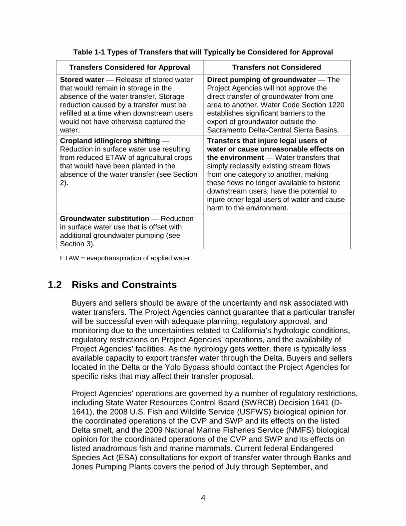
Table 1-1 Types of Transfers that will Typically be Considered for Approval
Transfers Considered for Approval Transfers not Considered Stored water — Release of stored water that would remain in storage in the absence of the water transfer. Storage reduction caused by a transfer must be refilled at a time when downstream users would not have otherwise captured the water.
Direct pumping of groundwater — The Project Agencies will not approve the direct transfer of groundwater from one area to another. Water Code Section 1220 establishes significant barriers to the export of groundwater outside the Sacramento Delta-Central Sierra Basins.
Cropland idling/crop shifting — Reduction in surface water use resulting from reduced ETAW of agricultural crops that would have been planted in the absence of the water transfer (see Section 2).
Transfers that injure legal users of water or cause unreasonable effects on the environment — Water transfers that simply reclassify existing stream flows from one category to another, making these flows no longer available to historic downstream users, have the potential to injure other legal users of water and cause harm to the environment.
Groundwater substitution — Reduction in surface water use that is offset with additional groundwater pumping (see Section 3).
ETAW = evapotranspiration of applied water.
1.2 Risks and Constraints Buyers and sellers should be aware of the uncertainty and risk associated with water transfers. The Project Agencies cannot guarantee that a particular transfer will be successful even with adequate planning, regulatory approval, and monitoring due to the uncertainties related to California’s hydrologic conditions, regulatory restrictions on Project Agencies’ operations, and the availability of Project Agencies’ facilities. As the hydrology gets wetter, there is typically less available capacity to export transfer water through the Delta. Buyers and sellers located in the Delta or the Yolo Bypass should contact the Project Agencies for specific risks that may affect their transfer proposal.
Project Agencies’ operations are governed by a number of regulatory restrictions, including State Water Resources Control Board (SWRCB) Decision 1641 (D-1641), the 2008 U.S. Fish and Wildlife Service (USFWS) biological opinion for the coordinated operations of the CVP and SWP and its effects on the listed Delta smelt, and the 2009 National Marine Fisheries Service (NMFS) biological opinion for the coordinated operations of the CVP and SWP and its effects on listed anadromous fish and marine mammals. Current federal Endangered Species Act (ESA) consultations for export of transfer water through Banks and Jones Pumping Plants covers the period of July through September, and

5
transfers will be limited to this interval. Limitations on CVP and SWP Delta operations in the early winter and spring months often result in the need to maximize Project exports during July through September, which can further limit the available export capacity for water transfers. The transfer proponents assume the risk that all, or a portion of, the water made available from the water transfer cannot be exported and may be lost.
Generally, Project power will not be provided for transfers of non-Project water utilizing Project facilities. The parties are required to provide any energy necessary to convey non-Project water through Project facilities or replace the value of the energy used to store and/or convey the non-Project water.
1.3 Proposal Review Figure 1-1 outlines the process for determining which agencies have review authority over the water transfer proposal. The Project Agencies work cooperatively to review water transfers requiring conveyance through SWP or CVP facilities.
Water transfers involving SWP facilities or SWP water supplies are subject to DWR’s consent. Reclamation has approval authority over water transfers involving CVP facilities or CVP water supplies. DWR and Reclamation must coordinate their accounting and operations for any transfer that involves use of Banks, Jones, or Barker Slough Pumping Plants. Public Law 102-575, the CVPIA, Section 3405(a) outlines the conditions under which CVP water may be transferred. Reclamation has developed interim implementing guidelines for the water transfer provisions of the CVPIA. These interim guidelines can be found at http://www.usbr.gov/mp/cvpia/3405a/docs/int_guide_imp_water_trans.pdf.
Depending on the nature of the water right, the seller may be required to file a petition for change with the SWRCB. Individual water right holders are responsible for obtaining changes to water rights from the SWRCB as needed. If a transfer requires SWRCB approval, the transfer proponent should submit a petition for change to the SWRCB as soon as possible. SWRCB approval must be obtained before any water can be transferred. Information on the SWRCB transfer program is available on the SWRCB website (http://www.waterboards.ca.gov/waterrights/water_issues/programs/water_transfers/)

6
Figure 1-1 Flow Chart to Identify Agency Involved
1.4 Developing a Water Transfer Proposal Transfer proponents are encouraged to work with local water agencies and districts to develop coordinated water transfer proposals capable of providing substantial quantities of water. The following should be considered in developing a water transfer proposal requiring conveyance through SWP or CVP facilities:
• The types of water transfers that the Project Agencies will consider are shown in Table 1-1. The transfer proponents should ensure that the transfer proposal is described in sufficient detail to allow for proper review by the Project Agencies, California Department of Fish and Wildlife (CDFW), USFWS, and NMFS, as appropriate.

7
• Figure 1-1 lists the agencies that may need to be consulted and Table 1-2 summarizes the corresponding steps.
• The amount of water made available for transfer by the seller is usually determined at the most downstream point of control of the transfer proponent. Losses beyond this point, including Delta carriage water and conveyance losses that reduce the total amount of transfer water delivered, are determined by the Project Agencies.
• Proposals, contract negotiations, and CEQA/NEPA documentation (if required) must be completed before the water can be transferred. Water transfers involving CVP water supplies or CVP facilities (or both) require the approval of Reclamation, and water transfers involving SWP water supplies or facilities (or both) require the approval of DWR.
• If SWRCB approval is required, sellers should obtain this approval as soon as possible.

8
Table 1-2 Water Transfer Process Involving DWR, Reclamation, and SWRCB
Step DWR Reclamation SWRCB 1. How to start agency process?
• Contact DWR with transfer proposal and request conveyance through SWP
• Agree to cost reimbursement
• Send letter of request for transfer with information on seller, buyer, type, amount, and timing of transfer
• Reclamation sends letter back with cost reimbursements
• Agencies agree to move forward
• File a Petition for Change with SWRCB, Temporary Urgency Change (urgent need), Temporary Change (WC §1725) or long-term (WC §1735)
• Applicable to post-1914 water rights
2. What technical information is required in submittal package?
Information identified in Water Transfer White Paper for specific type of transfer
Information listed in: • CVPIA Criteria
Checklist for a complete written Transfer Proposal
• Water Transfer Technical Information (crop shifting/cropland idling and groundwater substitution)
Information listed on SWRCB Petition for Change form and in Environmental Information form provided on SWRCB website
3. What regulatory compliance is required?
CEQA, ESA, CESA, SWRCB approval, as applicable, and local and regional requirements depending on the location of the proposed transfer
NEPA and ESA SWRCB approval of Petition for Change for all transfers of post-1914 water rights
4. What is acceptance of transfer proposals based on?
• Complete proposal submittal
• DWR determination of new water made available
• Availability of SWP capacity and determination that transfer will not result in impacts to SWP operations
• DWR findings under WC §1810(d)
• Compliance with CEQA and any other applicable regulatory requirements
• Complete Submittal Package
• Determination of new water and Project operation considerations
• CVPIA section 3405(a) – No adverse impacts on CVP contractors, water supply or operations, fish and wildlife obligations, and groundwater conditions in the transferor area
• NEPA
Determination that transfer will not result in injury to other legal users of water, or unreasonable impacts to fish, wildlife or other instream beneficial uses

9
1.5 Environmental Documentation In addition to steps listed in Table 1-2, transfer proponents must complete any required CEQA documentation and obtain all necessary California Endangered Species Act (CESA) and federal ESA compliance and any other regulatory approval for transfers related to State actions. Temporary transfers (one year duration or less) based on post-1914 appropriative water rights are required to obtain SWRCB approval consistent with the requirements of Water Code Section 1725 et seq. Water transfers approved by the SWRCB under Section 1725 are exempt from CEQA (see Water Code Section 1729).
Sections 794 and 801 of the California Code of Regulations requires water rights holders needing SWRCB approval of a temporary transfer request consultation with the CDFW regarding the potential effects of the proposed change(s) on fish and wildlife.(see https://nrmsecure.dfg.ca.gov/FileHandler.ashx?DocumentID=42132 ) CDFW recommends seeking consultation with the appropriate regional water rights coordinator early on in the transfer proposal development process.
For transfers requiring Reclamation approval, NEPA documentation and ESA compliance for through-Delta transfers is required. Reclamation will need to complete additional environmental analysis and documentation prior to providing contractual approvals for the transferred water to be conveyed in federal facilities to the appropriate turnouts of the identified water users.
1.6 Cost Reimbursement Project Agencies will require transfer proponents to reimburse the costs incurred by the Project Agencies associated with the review and approval of the transfer proposal, including NEPA or CEQA requirements, if necessary, and administration of their water transfer. These costs will vary depending on the size and complexity of the transfer proposed.
1.7 Contacts Parties with general questions on water transfers or who are interested in developing water transfer proposals that require conveyance through SWP facilities may contact:
Anna Fock Chief, Program Development and Water Supply and Transfers Branch DWR (916) 653-0190 [email protected]

10
Parties with general questions on water transfers or who are interested in developing water transfer proposals that require conveyance through Reclamation facilities may contact:
Sheri Looper Deputy Regional Resources Manager (916) 978-5556 [email protected]

11
Section 2 Water Transfers Based on Cropland Idling and Crop Shifting
This section provides a discussion of the information needed by DWR and Reclamation for the review of transfer proposals based on cropland idling/crop shifting that require conveyance through SWP or CVP facilities. Cropland idling includes the idling of land that would have been planted during the transfer period in the absence of the transfer. Crop shifting is the shifting from historically planted higher-water-intensive crops to lower-water-using crops. It does not include land fallowed as part of normal farm operations, which does not make new water available for transfer. Cropland idling or crop shifting water transfers make water available by reducing the consumptive use of surface water applied for irrigation. Each proposal needs to contain sufficient information to support the claimed reductions in consumptive use of applied surface water upon which the transfer is based. Figure 2-1 shows the overall cropland idling/crop shifting transfer information required, which is described in the subsequent sections.
This section was updated in November 2014, to address Senate Bill (SB) 749 (aka Wolk), that took effect January 1, 2014 which added Section 1018 to the California Water Code. Section 1018 encourages landowners to maintain wildlife habitat cover on fallowed lands participating in a bona-fide water transfer provided that all other transfer requirements are met. Consistent with Water Code Section 1018, the Project Agencies recognize that rice fields and irrigation/drainage ditches can provide habitat for terrestrial wildlife and waterfowl species. CDFW can advise landowners in the use of non-irrigated cover crops or other vegetation for wildlife habitat. Appendix C provides an example of a project implemented on rice acreage that provides habitat benefits while still meeting the necessary requirements of a water transfer.
The information requested for a cropland idling/crop shifting water transfer proposal is detailed in the Crop Idling Checklist (Appendix B). This information will help Project Agencies review the water transfer proposal and develop the appropriate conveyance contract or letter of agreement between the transfer proponents, buyers, and Project Agencies. Sellers are encouraged to work with their water purveyor (e.g., water district) to develop joint water transfer proposals.

12
Figure 2-1 Cropland Shifting/Cropland Idling Transfers Process in the Sacramento Valley and Delta Region
2.1 Estimation of Conditions That Would Occur Absent the Transfer A key element to the evaluation of a cropland idling and crop shifting water transfer is the determination of the conditions that would exist without the transfer. Predicting such conditions accurately is often difficult. The use of historical cropping patterns is currently the best method in most cases to estimate conditions that would exist absent the cropland idling/crop shifting transfer; however, in some instances, more information may be required. The crop history identifies the type of crops typically grown, the degree of land fallowing that typically takes place, and the crop rotation practices that typically occur.
To estimate conditions that would occur without a transfer, transfer proponent needs to provide the following information:
• Accurate crop records for the five years preceding the year of the proposed transfer unless otherwise coordinated with the Project Agencies. Crop acreage should be reported in net field acres of the actual farmed and irrigated acres. If only gross field acres are known (i.e., the county

13
parcel acres), then multiply the gross acres by 0.95 to estimate net acres. Crop acreage needs to be included for each crop (include fallowed lands, non-irrigated crops, and total farmable acres) for the water district or individual farm operation.
• Acreage that is in the process of shifting to an alternate crop or agricultural practice that might require the land remain idle for a certain transition period, such as shifting to organic cultivation, or permanent crops. Acreage that would otherwise remain idle will be excluded from the calculation of baseline.
• Maps showing district or farm operation boundary, current fields irrigated, fields routinely fallowed or not irrigated, fields enrolled in other programs such as conservation, habitat or mitigation programs, and fields to be idled as part of the proposed water transfer, in a format acceptable to the Project Agencies. The Project Agencies will consider information and maps submitted by a transfer proponent as well as other available information to independently determine field acreage. Project Agencies’ determined acreages will be used to calculate water made available for transfer.
• The basis of right (water right or contract supply) for use of surface water during the transfer period.
The following sections further describe how this information will be used to determine conditions without the transfer.
2.1.1 Large Water Districts The term “water district” is used in this document as shorthand to include any water company, district, agency, or other entity that provides water service to a group of landholders and can enter into a binding contract with a buyer. “Large water district” is defined as a legal entity serving multiple landowners. If only a few individual landowners within the water district wish to participate in the transfer, they should coordinate with their water district and refer to section 2.1.2 on methods to calculate expected water savings.
A water district’s previous year’s crop acreage is typically the best indication of the next year’s crop patterns, provided the market for the particular crops grown remains relatively stable, the water supply has not been affected by droughts, the acreage of the one or two crops with highest water use is typical of past years, the grower is not in the process of shifting to an alternate crop with a different ETAW or shifting to a crop or agricultural practice that might require the land remain idle for a transition period, such as shifting to organic cultivation, or permanent crops. The average acreages for the high-water-use crops in each district will be evaluated as follows:
• If acreage values for the crops with the highest water use for the immediate prior year are within 5 percent of the five-year average for

14
these crops and there have been no significant market changes for the crop, then the last year’s cropping patterns will be used as the base for calculating changes due to the cropland idling and crop shifting transfers.
• If acreage values for the crops with high water use fall outside this range, then another, more typical, year or an average of cropping patterns and acreages will be used, as mutually agreeable between the applicable Project Agency and the party proposing the water transfer.
• Fallowing a percentage of the total crop acreage is a normal agricultural practice. A significant shift in market prices, as has been seen in the rice market in recent years, can temporarily alter the typical fallowing pattern, resulting in a higher percentage of total acreage in production. The use of the prior year’s crop acreage as the baseline in this situation may not be appropriate after a series of consecutive years of elevated production. After a series of years, the Project Agencies may elect to use an alternate method to calculate baseline to account for the need to fallow a percentage of the total acreage as part of normal farming practices. Absent a change in market conditions or unusual hydrologic conditions, prior year cropping pattern will be used as the baseline if the acreage meets the conditions noted previously in this section. The issue of baseline will be evaluated each year.
The previous year’s data may also be used if additional explanation is provided to the Project Agencies and if the parties proposing the transfer and the Project Agencies agree that this is the best representation of conditions that would exist absent the cropland idling and crop shifting transfer. In this case, five years of crop data may not be needed. If the Project Agencies and the water district cannot reach agreement on an estimate of the conditions that would likely exist absent the cropland idling or crop shifting transfer, then the Project Agencies will not consider the water transfer proposal based on cropland idling or crop shifting.
2.1.2 Individual Farm Operations and Small Water Districts “Small water district” is defined as a legal entity that serves one or few landowners. For individual farm operations or small water districts, last year’s cropping patterns may be an inappropriate measure of likely future conditions absent the cropland idling/crop shifting transfer because of crop rotation patterns.
Small water districts and individual operations need to provide the previous five years of crop history for their entire district or operation to identify significant crop rotation cycles. Where crop rotation cycles are evident for the whole of the farm operation or small water district, either (1) a repeating crop pattern or (2) the five-year average should be used. In these cases, the potential participant has to identify specific fields to be enrolled in the transfer and provide the five-year crop history for these fields, at a minimum. Use of a repeating pattern to characterize routine land idling and crop rotation practices requires the proponent to provide an exact repeating pattern of cropland idling practices for the fields to be involved in the transfer. The lands considered routinely idled would correspond to those in

15
the subsequent year of the pattern. The Project Agencies must agree to use of a repeating pattern.
From this crop history, the proponent needs to calculate the five-year average of crop ETAW values, as indicated below, for each field. The five-year average ETAW values for each field would be used as the base for determining changes due to the proposed cropland idling/crop shifting transfer in the year of the transfer. Individual farms or small water districts must provide a statement that the land idled for water transfer is not “shifted” to other operations under their control.
2.1.3 Eligibility of Double-Cropped Fields If the seller has historically practiced double cropping of a winter crop such as wheat and a second crop grown during the transfer period, the seller may cultivate that winter crop and idle the field for transfer in that transfer year. The transfer proponent will need to provide evidence to the Project Agencies of the double cropping history verifiable by Farm Service Agency (FSA) acreage consistent with section 2.1 above, including a five-year crop history. The history needs to indicate which crop(s) were historically the second crop (thus assigning the appropriate ETAW) in order to determine the water available for transfer. Refer to Figure 2-1 for crops suitable for idling or shifting.
2.2 Use of Evapotranspiration of Applied Water (ETAW) 2.2.1 What is ETAW?
ETAW is defined as the portion of applied water that is evaporated from the soil and plant surfaces and actually used by the crop. The portion of the crop evapotranspiration met by precipitation during the growing season or stored as soil moisture within the root zone before the growing season does not qualify as transferable water. ETAW does not include applied water lost as deep percolation to groundwater or conveyance losses. Unless the acreage overlies an unusable groundwater basin or discharges to a saline sink, these depletions contribute to the overall water supply and are excluded from the calculation of transferable water.
Actual crop water requirements vary from one year to the next due to changing climatic conditions. It is not currently feasible to calculate ETAW for the specific conditions of each transfer year; therefore, ETAW values used for water transfer calculations are based upon crop water requirements reflecting average rainfall and evaporative demand. The calculation of water made available for transfer is based upon the quantity of surface water conserved for each qualifying idled acre of cropland and the appropriate ETAW associated with changes in the specific crops idled.

16
2.2.2 Crops Suitable for Cropland Idling or Shifting and ETAW Values Table 2-1 shows the crop ETAW values for the Sacramento Valley that are currently used by the Project Agencies to determine the amount of transfer water that can be made available without injuring other legal users of water provided the other conditions set forth in this section are followed. These values may be updated from time to time based on the best available information.
Table 2-1 Estimated ETAW Values (in acre-feet/acre) for Crops Suitable for Idling or Shifting
Crop ETAW (in acre-feet/acre)1 Alfalfa2 1.7 (July through September) Bean 1.5 Corn 1.8 Cotton 2.3 Melon 1.1 Milo 1.6 Onion 1.1 Pumpkin 1.1 Rice 2.9 Safflower (only eligible for idling) 0.7 Sudan grass 3.0 Sugar beets 2.5 Sunflower 1.4 Tomato 1.8 Vine seed/cucurbits 1.1 Wild rice 2.0 1 Only that portion of the estimated savings that can be directly exported or stored is eligible for transfer. For example, the ETAW for rice shown above represents the ETAW for May through September. If transfer water cannot be stored in May and June, the allowable ETAW would be 2.1 acre-feet/acre based on a monthly distribution of the ETAW of rice May through September of 18%, 23%, 24%, 21%, and 14%, respectively. 2 Only alfalfa grown in the Sacramento Valley floor north of the American River will be allowed for transfer. Fields must be disced on, or prior to, the start of the transfer period. A higher ETAW may apply if the transfer water is exported through a facility not limited to the transfer export window of July – September or if the transfer water can be stored prior to the start of the transfer window. Alfalfa acreage in the foothills or mountain areas is not eligible for transfers.
2.2.3 Rice Idling Rice idling has accounted for the majority of cropland idling transfers in recent years. The quantity of transfer water made available is currently calculated based on the pattern of ETAW. In the absence of technical information supporting an alternate method, the quantity of transfer water will continue to be calculated

17
based on ETAW for any rice idling. Acreage eligible for inclusion in a rice idling program is limited to that acreage that would have been planted to rice in the absence of the proposed transfer.
2.2.4 Rice Straw Decomposition The Project Agencies are not currently considering transfers based on potential water savings from rice straw decomposition, including the use of groundwater substitution for rice straw decomposition water or using mechanized or other straw removal methods.
2.2.5 Limitations on Crops and Lands Some crops are not eligible for idling or shifting transfers because it is too difficult to determine the amount of new water made available due of a lack of authoritative ETAW values, substantial variability in cultural practices, and other crop-specific issues. Table 2-2 lists the crops that are not acceptable to Project Agencies for idling or shifting transfers. The Project Agencies will not consider water transfers that propose idling or shifting of these crops.
Table 2-2 Crops not suitable for shifting or idling Crop
Pasture1
Mixed grasses1 Miscellaneous grasses including Bermuda grass1 Alfalfa (outside the Sacramento Valley floor)1 Orchard Vineyard
1 Idling of certain annual crops listed above may be considered if an adequate, site specific measurement and monitoring program, acceptable to the Project Agencies is implemented.
Some specific practices and proposals will not be considered for water transfers due to the difficulty in determining the amount of water made available or the uncertainty in what would have happened absent the transfer. These include:
• Removal of permanent crops. • Fields historically irrigated by groundwater. • Cropland idling on lands where groundwater is within 5 feet of the land
surface or where the crop root zone may extend into the groundwater table. In these areas, cropland idling transfers may be considered if a measurement and monitoring program approved by the Project Agencies is implemented to determine the water savings and ensure the projected water savings are achieved.
• A shift in cropping pattern resulting in an increase in cropped acreage in other portions of the water agency or transferring party’s holdings that would result in no net reduction in consumptive use within the water agency.

18
• Land being idled as part of a normal crop rotation, land participating in a conservation or mitigation program that is not irrigated on an annual basis, land transitioning from traditional to organic classification (until a normal cropping pattern is reestablished) and land being converted to permanent crops are not eligible to participate in a crop idling based transfer.
Some lands, like those listed below, may only be suitable for crop idling if an approved measurement and monitoring program, including instrumentation capable of measuring ETAW, is included as part of the transfer proposal. If an approved monitoring program is not included, then the lands are not suitable for inclusion in a water transfer proposal.
• Lands on which weed control cannot be managed with normal agricultural practices.
• Areas known to have high seepage or groundwater.
2.2.6 Remnant Vegetation Control on Idled Land In order to receive full credit for the expected water savings, idled land cannot be irrigated during the transfer season. Remnant vegetation (weeds, cover crop, and over-winter crop) that is supported only through precipitation or that has begun to senesce may remain on the fields to be idled. Site visits may be conducted to evaluate the state of the remnant vegetation to assure that remnant vegetation does not become excessive vegetation which could affect the amount of transfer water made available as discussed below.
The control of vegetation on idled fields in areas with high groundwater or significant seepage may present particularly difficult challenges in areas where native or over-wintered vegetation is retained for wildlife habitat benefits. Remnant vegetation has the potential to consume a portion of the estimated transfer water if that vegetation has access to seepage from adjacent canals or flooded fields, or shallow groundwater, and is actively growing during the transfer period, thus reducing the effective savings from the crop idling. Remnant vegetation that is actively evapotranspiring and is supported from the above water sources will be considered excessive vegetation and will affect the amount of transferrable water and must be avoided or accounted for. Below are recommendations for managing remnant vegetation in fields idled for a water transfer:
• Idled land cannot be irrigated during the transfer season. • The grower must be able to control excessive seepage on the fields to be
idled. Fields subject to excessive seepage or high groundwater will be acceptable only if the grower implements supplemental measurement and monitoring efforts to quantify the water made available for transfer.
• Remnant vegetation should not be actively transpiring and should have begun to senesce by the beginning of the transfer period. The onset of

19
senescence may be delayed by late season rains. Precipitation will be considered in evaluating whether remnant vegetation would affect the quantity of transfer water.
• If a seller proposes to leave remnant vegetation on the fields to be idled, the transfer proposal should identify the individual fields where vegetation will remain so that a baseline photo can be taken of each field. Two weeks prior to the start of the transfer period, Project Agencies will conduct inspections of participating fields to determine whether abatement of remnant vegetation is necessary.
• Remnant vegetation may be considered excessive vegetation if it is determined to be supported by seepage from irrigation supplies or shallow groundwater that has the potential to affect the amount of transfer water made available. If remnant vegetation is deemed to constitute excessive vegetation and abatement is determined to be necessary, Project Agencies will provide transfer proponents with notice and sufficient time to implement abatement measures.
• Excessive vegetation not abated after notification by the Project Agencies may result in a reduction in the verified quantity of water made available for transfer. The reduction in quantifiable water made available for the transfer will be cumulative estimated ETAW of the excessive vegetation, as determined by the Project Agency, from the beginning of the transfer period to the date that the excessive vegetation was abated or the date that the remnant vegetation has senesced and was no longer consuming water.
Consistent with the provisions contained in Water Code Section 1018, the Project Agencies recognize that rice fields and irrigation/drainage ditches can provide habitat for terrestrial wildlife and waterfowl species. Potential sellers are encouraged to incorporate measures in their crop idling proposal to protect habitat value in the areas to be idled. CDFW can advise landowners in the use of non-irrigated cover crops or natural vegetation as it applies to the provision of waterfowl, upland game bird and other wildlife habitat. Appendix C provides one example of agricultural practices currently being implemented on certain rice acreage, which provide habitat benefits while still meeting the conditions necessary to make water available for transfer.
2.3 Estimating Water Available for Transfer 2.3.1 Large Water Districts
Large water districts need to evaluate the crop acreage that would have been planted absent the transfer using the methods presented in section 2.1.1, including the acreage for each crop, historically idled lands, and all other district lands. Base-year ETAW values can be calculated using the baseline crop acreages and ETAW values in Table 2-1. The district should then determine the

20
acreages of each crop, fallowed lands, and other lands expected in the coming year with the water transfer. Using these acreages, the ETAW for the coming year is calculated by the same method used for the base year. The base-year and expected current-year crop acreages for the district should be checked to make sure they match. The difference between the base-year and current-year ETAW is used to estimate the water made available by the cropland idling/crop shifting transfer. Final eligible crop acreage will be determined by the Project Agencies. Each district will provide proof of declaration under penalty of perjury from landowners about their intent to plant specific crops and corresponding acreages absent the transfer.
2.3.2 Individual Farm Operations or Small Water Districts As stated in Section 2.1.2, individual farm operations and small water districts may exhibit significant crop rotation sequences and may wish to simply enroll specific land parcels into a cropland idling/crop shifting program. For these cases, section 2.1.2 describes the method to establish a baseline cropping pattern that will allow calculation of the baseline ETAW for each parcel. The ETAW for the parcel for the current year with the water transfer is then established. The difference between the base-year and current-year ETAW is used to estimate the water made available by the cropland idling/crop shifting transfer. Final eligible crop acreage will be determined by the Project Agencies. Each transfer proponent will provide proof of declaration under penalty of perjury about their intent to plant specific crops and corresponding acreages absent the transfer.
2.4 Potential Cropland Idling/Crop Shifting Transfers in the Delta/Yolo Bypass Region The Project Agencies are working to increase opportunities for transferable water via cropland idling/crop shifting, if they result in new water that can be made available at times and locations such that it can be exported by the Project Agencies. The Project Agencies will evaluate proposals for transfers originating in the Yolo Bypass/Tule Canal or Delta areas on a case-by-case basis. Many uncertainties exist with transfers originating from the Yolo Bypass/Tule Canal or Delta, including how much water can be made available and whether the transfer water can be exported by the projects. The SWRCB must concur in writing that the transfer water can be accounted for separately when determining compliance with the flow-related objectives in D-1641. The Project Agencies must also be assured that hydraulic connectivity with the Delta exists at all times during the transfer period. If written concurrence is obtained from the SWRCB, measurement, monitoring, and reporting requirements, acceptable to the Project Agencies and paid for by the transfer proponents, will be required for all Delta region transfers to determine and verify transferable water. Sellers must contact the Project Agencies for minimum measurement and monitoring requirements.

21
The Project Agencies will work with each seller on a case-by-case basis for any transfers from the Delta region.
2.5 Adjustments for Water Shortage Years The baseline to determine water available for transfer is typically developed using prior-year or five-year average cropping patterns within the water district or individual seller’s service area. If hydrologic conditions are sufficiently dry, sellers’ water supply allocations may be reduced, making it difficult to establish what the cropping pattern would have been in the absence of the transfer. The following approach will be used to determine baseline acreages; however, the Project Agencies will analyze the baseline for all transfers considering the seller’s unique circumstances.
Is the Seller Facing a Reduced Surface Water Supply During the Year of the Transfer?
1. No: If no, and the seller transferred water in the prior year, the baseline for the transfer is the prior year baseline unless there are circumstances, such as substantial changes in market or hydrologic conditions that would suggest a change in cropping patterns. If the seller did not transfer water in prior year, an appropriate baseline must be determined. Methods to determine the baselines are described in the previous sections.
2. Yes: If yes, will the reduced supply require reduced consumptive use?
If no, the transfer proponent will submit data to the Project Agencies to illustrate how the seller will accomplish meeting full consumptive use with reduced surface water supply; include historical diversion data, additional recycling, or other conservation measures. Additional groundwater pumping is an increase to the groundwater baseline for transfer purposes.
If yes, then the baseline for the seller will be based on a calculated ratio of the “district efficiency” or ETAW/diversions.
Under no circumstances will a seller be allowed to transfer more water through cropland idling/crop shifting than the difference between their surface water allocation and actual diversions.
2.6 Reporting Accurate reporting of the activities undertaken as part of a cropland idling/crop shifting transfer is an essential provision of any water transfer proposal. Reporting is the responsibility of the transfer proponent and needs to be acceptable to the Project Agencies.

22
2.6.1 Acreage Calculation Methodology Current-year FSA acreage will be used unless transfer proponents do not provide FSA acreage for the year of the water transfer. In order to be consistent, transfer proponents are required to provide FSA acreage for the year of the actual water transfer within two weeks of request by Project Agency staff. If FSA acreage for the year of the water transfer is not provided, the Project Agency will provide delineation of the seller’s property. Transfer proponents must reimburse Project Agencies for their costs incurred in delineation of field boundaries, in addition to other reimbursable costs.
2.6.2 Monitoring and Verification Verification of the actions taken to make water available in a cropland idling/crop shifting transfer will be conducted by the transfer proponents with the oversight of the Project Agencies. In addition to crop mapping, the following information or actions, as applicable, will need to be provided or completed by the transfer proponents.
Elements in a cropland idling/shifting monitoring program are listed below.
• Past-year(s) and current-year cropping data. • Map showing lands participating in the water transfer. • Confirmation of correct crop shift as specified in the proposal. • Previous and current-year diversions for district programs. • Verification that there is a reduction in soil moisture and no water leakage
onto idled lands. • Field checking for excessive vegetation on idled fields. Transfer proponent
shall notify the applicable Project Agency staff if areas of excessive vegetation (see Section 2.2.6) are observed, to request an assessment of the field. Final determinations and need for grower notification and/or abatement shall be made by the Project Agency.
• For fields with excessive vegetation during the typical irrigation season due to such causes as canal seepage or access to groundwater, excessive vegetation abatement measures will be required to prevent loss of transfer water. An alternative to conducting excessive vegetation abatement measures would be the use of instrumentation adequate to determine the cover crop’s transpiration and calculate reductions in conserved water savings as noted above.
• If, during the transfer period, excessive vegetation is identified, abatement efforts are to be undertaken within two weeks.
• In areas subject to high groundwater or excessive seepage, instrumentation acceptable to the Project Agencies that is adequate to determine soil evaporation and weed transpiration necessary to calculate reductions in conserved water savings.

23
• For areas or crops where calculation of transferable water may require in-field instrumentation, field data that can be used to verify how much water was actually made available by the transfer action(s) and to modify future proposals if warranted.
• Fields to be prepared for or planted to orchard (or permanent crops that require fields remain idle the season prior to planting) during the transfer period. If fields included in the transfer are found to have been prepared for or planted to trees (or other similar crop) during the transfer period, the transfer quantity shall be reduced by the estimated reduction in consumptive use for that field (i.e., field acreage × ETAW).
The transfer proponent will provide access to the fields that are part of the cropland idling/shifting transfer so that the Project Agency can perform field checks and determine soil moisture depletion if necessary. The Project Agencies will coordinate verification activities. Transfer proponents must reimburse Project Agencies for their costs incurred in monitoring and verification, in addition to other reimbursable costs.
2.7 Local Economic Effects Cropland idling/crop shifting transfers have the potential to affect the overall economy of the county from which the water is being transferred. Parties that depend on farming-related activities can experience decreases in business if land idling becomes extensive. Limiting cropland idling to 20 percent of the total irrigated land in a county has been shown to limit economic effects even in primarily agrarian counties in the Sacramento Valley (Environmental Water Account, Draft EIS/EIR, 2003). To minimize the socioeconomic effects on local areas and to minimize effects on special status species, Project Agencies will not approve water transfers via cropland idling if more than 20 percent of recent harvested crop acreage in the county for each eligible crop, including rice, would be idled unless the provisions of Water Code Section 1745.05(b) are implemented (see discussion below).
Transfer proponents and others participating in cropland idling/crop shifting transfers need to be sensitive to the possible economic impacts of their actions on their business partners and neighbors and of potential cumulative effects from water transfers in neighboring districts. Geographically distributing the fields that are idled can avoid or minimize possible economic effects.
Water Code Section 1745.05 (b) provides that if the amount of water made available by land fallowing (idling) exceeds 20 percent of the water that would have been applied absent the proposed water transfer, a public hearing by the water supply agency is required. In the past, cropland idling programs have stayed well below the 20 percent water delivery threshold for a hearing. Water supply agencies interested in participating in cropland idling/crop shifting

24
transfers need to be aware of this Water Code section and conduct a public hearing if they propose a transfer in which cropland idling would exceed the 20 percent threshold.
2.8 Environmental Considerations 2.8.1 DWR Considerations for Rice Land Idling Transfers
Rice fields and irrigation/drainage ditches can provide temporary or permanent forage and habitat for terrestrial wildlife and waterfowl species, including the giant garter snake, which is considered a threatened species under both the ESA and CESA. The Project Agencies will work with potential sellers who desire to leave remnant vegetation for habitat benefit on fields idled for transfer in order to resolve any outstanding questions related to potential impacts on the transfer (see Section 2.2.6).
Idling land dedicated to rice production for the purpose of water transfers has the potential to negatively impact the giant garter snake by removing important habitat. Accordingly, the issuance of a conveyance agreement by DWR will therefore be conditioned on the development of a transfer proposal that does not unreasonably impact the wildlife or environment of the area from which the transfer originated, among other criteria (see Section 1.1). In order for DWR to make a determination that the proposed transfer does not unreasonably impact these resources, the transfer proponent from rice land idling must incorporate conservation measures that minimize the impacts on the giant garter snake. It is DWR’s judgment that the conservation measures outlined in the Reclamation’s Long-Term Water Transfer Program represent the most current and best scientific information on protective measures for the giant garter snake. Accordingly, DWR encourages transfer proponents to incorporate in their transfer proposals those conservation measures from the most recent biological opinion relevant to crop idling. Incorporation of the conservation measures will aid DWR in making the findings required in Water Code Section 1810 related to effects on wildlife.
Adoption of these measures are believed to be necessary for all rice-land-idling-based transfer proposals to minimize impacts on the giant garter snake from rice idling. Adoption of these measures, however, does not necessarily constitute compliance with the federal ESA and CESA. It is the responsibility of transfer proponents to secure compliance with all local, state, and federal laws and regulations.
2.8.2 Reclamation’s ESA Considerations for Rice Land Idling Transfers Reclamation must consider the effects of idling rice acreage for the purpose of a water transfer on ESA-listed species, as terrestrial wildlife and waterfowl species may use irrigated croplands or water infrastructure for temporary or permanent forage and habitat. Specific practices that may need to be implemented to

25
transfer water would be similar to those found in the NEPA document for Reclamation’s Water Transfers Program summarized above.

27
Section 3 Water Transfers Based on Groundwater Substitution
This section provides technical information to prospective transfer proponents who wish to transfer water through groundwater substitution. Groundwater substitution transfers make surface water available for transfer by reducing surface water diversions and replacing that water with groundwater pumping. The direct pumping of groundwater in the Sacramento River watershed for the purpose of exporting that water is prohibited under Water Code Section 1220 without extensive local review and approval.
The rationale behind a groundwater substitution transfer is that surface water demands are reduced because a like amount of groundwater is used to meet the demands. The resulting increase in available surface water supplies can be transferred to other users. The net amount of additional surface water supply, or transferable water, created through groundwater substitution transfers must account for: (1) the amount of increased pumping that occurs in support of the transfer during the time that export facilities can convey the water, (2) the extent to which transfer-related groundwater pumping decreases streamflow (resulting from surface water-groundwater interaction), and (3) the timing of those decreases in available surface water supply.
A groundwater substitution transfer proposal generally consists of the following components:
• Documentation of surface water rights and the method used to quantify the amount of surface water available for the transfer.
• The location and characteristics of the wells proposed for use in pumping groundwater.
• The historic groundwater pumping in non-water transfer years to establish an appropriate baseline groundwater pumping volumes that would occur absent the transfer program.
• The proposed volume and schedule of transfer-related groundwater pumping.
• A monitoring plan designed to assess the effects of the transfer. • A mitigation plan designed to alleviate possible injury to other legal users
of water.
• Demonstration that the transfer is consistent with the local requirements and applicable GSP(s) of the groundwater basins where the additional groundwater pumping would occur under the transfer proposal; or written notification to the relevant Groundwater Sustainability Agency/Agencies

28
(GSA(s)) if a GSP has not been implemented at the time the transfer is being proposed.
An overview of the information needed for a groundwater substitution proposal is included in the groundwater substitution transfer checklist (Appendix B), the details of which are discussed later in this section.
3.1 Compliance with the Groundwater Sustainability Plans and County Ordinances Compliance with the Groundwater Sustainability Plans (GSPs) under the Sustainable Groundwater Management Act (SGMA) and local requirements (including ordinances relating to well drilling, well spacing, and groundwater extraction), as well as compliance with Water Code Section 1745 et seq., will be the responsibility of the entity proposing the groundwater substitution transfer.
The approval process associated with a proposed groundwater substitution transfer varies by county and/or groundwater basin or subbasin and may take a significant amount of time. Potential sellers are advised to contact the appropriate GSA(s) (https://sgma.water.ca.gov/portal/gsa/all) and counties early to discuss the requirements for water transfer approval. Table 3-1 provides brief descriptions of the water transfer requirements for individual counties, in geographic order from north to south.
Table 3-1 Description of county ordinances related to groundwater substitution transfers
County Description Sources for more information Shasta Ordinance pertaining to the Redding
Groundwater Basin portion of Shasta County requires a permit for extraction and export of groundwater, either directly or indirectly, for use outside the county. Application for a transfer permit should be submitted to the chief engineer of the Shasta County Water Agency.
Shasta County Water Agency (530) 225-5661 http://www.co.shasta.ca.us/index/pw_index/engineering/water_agency.aspx
Tehama Ordinance requires a permit to extract groundwater for off-parcel use, prohibits mining of groundwater, and restricts the radius of influence associated with the operation of a well participating in transfer operations to the parcel on which the well is located, among other requirements.
Tehama County Health Agency, Environmental Health Division (530) 385-1462 http://www.tehamacountypublicworks. ca.gov/Flood/

29
County Description Sources for more information Butte Ordinance requires permits for
groundwater extraction for use outside the county, and requires a permit for groundwater substitution pumping. Butte County also has a well spacing ordinance. The Butte County Water Commission advises the Board of Supervisors with technical information from the Butte County Water Advisory Committee and Technical Advisory Committee.
Butte County Department of Water and Resource Conservation (530) 538-4343 http://www.buttecounty.net/waterresourceconservation/Home.aspx
Glenn Ordinance uses basin management objectives of groundwater levels, groundwater quality, and land subsidence to help define safe yield and overdraft of the basin. The ordinance is enforced by the Glenn County Board of Supervisors.
Glenn County Department of Agriculture (530) 934-6501 https://www.countyofglenn.net/dept/agriculture/welcome
Colusa Ordinance requires a permit for extraction and export of groundwater, either directly or indirectly, for use outside the county. Application for a transfer permit is filed with the Colusa County Groundwater Commission, through the Department of Agriculture.
Colusa County Department of Agriculture (530) 458-0580 https://www.countyofcolusa.org/index.aspx?nid=656
Sutter Sutter County has no ordinance governing the extraction and export of groundwater. According to its general plan, Sutter County has a long-term interest in discouraging water transfer/export sales if they result in long-term supply losses.
Chief of Water Resources (530) 458-7709 http://www.co.sutter.ca.us/doc/ government/depts/cs/ps/gp/gp_home
Yolo Ordinance (Title 10, Chapter 7, Groundwater) requires a permit for extraction and export of groundwater, including the extraction of groundwater to replace a surface water supply. Application for a permit should be filed with the Director of Community Development.
Director of Planning and Public Works (530) 666-8775 http://www.yolocounty.org/home/ showdocument?id=1899

30
County Description Sources for more information Sacrament
o Ordinance (Title 3 section 3.40.090, Ground and Surface Water Export) requires a permit for groundwater or surface water to be transported in any manner outside the county. Application for a permit must be filed with the director of the Sacramento County Department of Water Resources.
Sacramento County Department of Water Resources (916) 874-6851 http://www.countycounsel.saccounty. net/Documents/Title3.pdf
Yuba At this time, Yuba County has no ordinance governing the extraction and export of groundwater. However, groundwater substitution transfers must be coordinated with Yuba County Water Agency (YCWA).
Yuba Water Agency (530) 741-5000 https://www.yubawater.org/
Solano At this time, Solano County has no ordinance governing the extraction and export of groundwater.
Solano County Water Agency (707) 451-6090 http://scwa2.com/
3.2 Evaluation of Groundwater Substitution Transfer Proposals Before beginning transfer operations, the transfer proponent will need to develop a groundwater substitution transfer proposal and provide it to the Project Agencies for evaluation.
As noted in Section 3.1 above, it is important that transfers are consistent with the applicable GSP(s) for the basin or subbasin in which the transfer originates. It is the responsibility of the transfer proponent to consult with the appropriate GSA(s) to determine whether the transfer is consistent with the applicable GSP(s). The Project Agencies require written concurrence from the GSAs involved, but will not be evaluating whether the transfer is in compliance with SGMA.
The Project Agencies will, however, review groundwater substitution transfer proposals to determine whether they meet the following objectives.
• Transfer will result in providing the agreed-upon amount of transfer water. • Transfer will not unreasonably affect fish, wildlife, other instream beneficial
uses, or the environment and will have no significant unmitigated environmental effects.
• Transfer will not injure other legal users of water. • Proposal shows that an adequate monitoring and mitigation plan is in
place prior to the transfer to document that the above conditions are met.

31
The Project Agencies need sufficient information to determine whether the transfer will meet the desired objectives. The following sections describe the information to be submitted with the proposal.
3.3 Groundwater Substitution Wells The Project Agencies will conduct a review to determine whether the proposed well(s) are suitable for use in a water transfer operation and meet the above objectives.
Transfer proponents must provide sufficient information, described below, to assist the Project Agencies in conducting the well review. Wells may be considered ineligible for transfer pumping if a review of location, construction or other data demonstrates that either of the following is true:
• A well is completed in an unconfined aquifer that is likely to be hydrologically connected to a streambed or other surface water feature.
• Sufficient information is not available to estimate a well’s potential effects on other groundwater users in the basin/subbasin.
3.3.1 Information Requirements for Groundwater Substitution Wells The Project Agencies need the information listed below to evaluate a groundwater substitution transfer proposal.
1. Name and contact information of overlying GSA(s). 2. Well identification: The well owner’s name, the well owner’s identification
number, the water district or agency where the well is located, and the water district or agency’s well identification number (if different from the well owner’s identification number).
3. Well location: a. Latitude and longitude. The location can be determined with a hand-
held global positioning system (GPS) unit or surveying instrument with greater measurement accuracy. Well coordinates need to be provided using the current DWR standard coordinate system and datum: latitude/longitude and datum (GCS, NAD83, decimal degrees).
b. A map, with at least as much hydrologic and physical detail as that of a 7.5-minute U.S. Geological Survey quadrangle, showing the location of all proposed transfer wells, monitoring wells, and non-transfer (third party) wells (labeled by type and well ID) in the vicinity of the transfer wells and the location of all surface water features within two miles of the district or transfer project service area boundary.
4. Historic operations: Operation records indicating the volume of water pumped from each participating transfer well during the three previous

32
non-transfer years prior to the proposed transfer. Totalizing flow meter records are preferred; however, records of power consumption along with a well pump efficiency test (conducted within the last two years) may be submitted in place of flow meter records.
5. Proposed operations: a. Description of the wells’ projected operations (e.g., is groundwater to be
applied to surrounding land, or is groundwater to be pumped into district canals) and the projected beneficial use of pumped groundwater.
b. Certification by a professional engineer or geologist of proper flow meter installation and calibration according to manufacturer’s specifications must be submitted for each proposed transfer well using propeller flow meters every two years. A copy of the manufacturer’s specification sheets for installation of the flow meter should be included with each well flow meter certification report. A different meter calibration schedule may be considered for other types of flow meters (such as electromagnetic meters) following review by Project Agency staff of the manufacturer’s recommendations for the specific meters in question.
6. Well construction: Provide total well depth, depth of annular surface seal, gravel pack intervals, casing size, casing perforation intervals (or open hole interval), and well’s construction method (cable tool, rotary gravel pack well, etc.). In the absence of an acceptable well log, other data sources providing the necessary information may be provided for consideration by the Project Agencies on a case by case basis.
7. Geologic log: Details of geologic materials described on the well log, where available.
8. Estimated well capacity: Estimate well capacity and describe method of determination.
9. Additional information: If available, provide results of a Pacific Gas and Electric (PG&E) (or equivalent) well pump efficiency test, independent well drawdown tests, water quality data, and site-specific studies that document aquifer properties surrounding the well or the extent of the well’s hydraulic connection with any surface waters.
10. Pump power: Wells powered by an electric source are eligible for use in transfers. Wells powered by diesel or natural gas engines are eligible for use in the transfer if applicable air quality and other environmental laws and regulations are complied with and appropriate mitigation is provided.
The amount of information submitted for each well will depend on its location relative to surface water features (criteria shown in Appendix D) and other areas that may be sensitive to groundwater pumping effects. Transfer proponents can resubmit data for wells used for groundwater substitution based transfers in prior years, for Project Agency consideration, if there have been no changes to the

33
wells. However, certification of proper flow meter installation and calibration needs to be submitted for each well consistent with item 4.b above. Additional information may be needed by the Project Agencies following review of the information submitted. The Project Agencies will need site access for field verification of the above information and collection of additional data during the program.
3.4 Determining the Amount of Transferable Water Transferable water equals the incremental increase in Sacramento River flow to the Delta created by transfer operations during balanced Delta conditions. Balanced Delta conditions occur when the Project Agencies agree that releases from upstream reservoirs plus unregulated flow approximately equal the water supply needed to meet Sacramento Valley in-basin uses plus exports. Sacramento River flow increases as sellers use groundwater pumped from wells to replace surface water provided by river diversions. The resulting increase in streamflow is reduced by varying degrees as transfer-related groundwater pumping affects streamflow.
Information provided in the water transfer proposal will be used in conjunction with previous monitoring reports and other available data to calculate the amount of water the transfer operations make available. The amount of transferable water credited to a groundwater substitution water transfer will be determined as follows.
1. Establish the baseline groundwater pumping for the transfer operation. 2. Determine the difference between the proposed groundwater substitution
pumping in the transfer year and the baseline. 3. Determine the reduction in streamflow during balanced Delta conditions
resulting from pumping groundwater to make surface water available for transfer (streamflow depletion factor).
4. Calculate the difference between 2 and 3, above. 5. The following formula summarizes the above four steps:
(Transfer Year Groundwater Substitution Pumping) – (Baseline Groundwater Pumping) = Gross Transfer Pumping.
Gross Transfer Pumping – (Estimated Streamflow Reduction) = (Surface Water Made Available for Transfer).
The following sections describe these steps.

34
3.4.1 Determining the Baseline Groundwater Pumping The baseline is the amount of groundwater pumping that would have occurred during the transfer period absent the transfer. The Project Agencies will use the records of groundwater pumping submitted by the transfer proponents for three years prior to the transfer to establish the baseline. Transfer proponents are requested to submit the following information for non-transfer pumping years.
• Identify all wells that discharge to the contiguous surface water delivery system within which a well is proposed for use in the transfer program.
• The amount of groundwater pumped monthly during the proposed transfer window for the three years prior to the transfer for each well that discharges to the contiguous surface water delivery system. Wells in operation less than three years should provide data available from the initial use.
Totalizing flow meter records are the most accurate way to determine baseline pumping; however, newly participating sellers may be allowed to use records of power consumption (KWH or engine hours) along with well pump efficiency test data (from a test conducted within the past two years) to estimate baseline groundwater pumping. The Project Agencies will calculate baseline groundwater pumping based on the total volume pumped in non-transfer years from all proposed participating transfer wells (typically July through September) that discharge to a contiguous surface water delivery system.
To participate in future groundwater substitution transfers, transfer and non-transfer wells that discharge to a contiguous surface water delivery system should be metered and recorded on a monthly basis during transfer and non-transfer years so that a representative groundwater pumping baseline can be properly established.
If sellers experienced cutbacks to their normal surface water allocation in the most recent non-transfer years or in the year of the transfer, the amount of baseline groundwater pumping will be determined on a case-by-case basis after consultation with the seller.
3.4.2 Measuring Groundwater Pumped Sellers should provide pumping records from all participating wells that discharge to a contiguous surface water delivery system used in groundwater substitution transfers. An instantaneous reading and totalizing flow meter shall be installed on each well participating in groundwater substitution transfers. The flow meter shall be installed such that:
• The flow meter is in good working order and properly sized, positioned, and oriented on the discharge piping to ensure accurately measured flows.
35
• Discharge piping is configured to ensure that full pipe flow conditions are met where the meter is installed.
• The manufacturer’s specifications for meter installation are followed.
Sellers should have a qualified professional engineer or professional geologist certify that the proposed transfer well’s flow meter is installed in accordance with the manufacturer’s specifications and calibrated prior to use, consistent with Section 3.3.1. Sellers may download the Flow Meter Certification Template from WTIMS. Sellers need to provide photographs clearly showing each participating well’s flow meter installation and associated piping. If flow straightening vanes are installed, the seller should provide the manufacturer’s specifications for installation, whether bolt-on or weld-in type, and model number in the certification report. Sellers should also certify that the installation of flow straightening vanes is consistent with the manufacturer’s specifications. Project Agencies may conduct independent field checks of flow meter installations to verify the information provided.
An exception to the above accounting method for groundwater substitution transfers applies to districts that can provide water from their own reservoir(s) and replace it with groundwater pumping. If a reservoir controls flow to a stream where gages and/or weirs are sufficiently accurate, and streamflow is sufficiently low that the Project Agencies can use stream gage and/or weir data to determine how much water is being provided for transfer, the stream gage or weir data may be used in place of totalizing flow meters on individual wells. In these cases, additional analysis of reservoir operations may be required to determine whether transfer operations must consider reservoir refill criteria (see Section 4). Data requirements for transfer proponents that can operate a groundwater basin in conjunction with their own reservoir will be determined on a case-by-case basis.
The development of a water transfer proposal must take into account that a district’s total diversion of surface water during the year shall not exceed the maximum amount provided under its water service or settlement contract with the United States, or its water service contract with DWR, or their appropriative water rights, less the total quantity of groundwater provided by wells within a district pumping under a groundwater substitution transfer agreement.
3.4.3 Estimating the Effects of Transfer Operations on Streamflow Groundwater pumping for transfer operations will yield water at the expense of current and future streamflow. Flow reduction in a river, stream, canal, or drain could injure other legal users of water if it occurs when the Delta is in balanced conditions (see Section 1.1) or there is limited streamflow in the channel from which the water is being transferred. However, if transfer-related streamflow losses occur when the Delta is in excess conditions and there is sufficient flow in the stream channel from which the water is being transferred, the streamflow depletions should not impact the water supply available to other legal users of water.

36
Although real-time streamflow depletion due to groundwater pumping cannot be directly measured, impacts on streamflow due to groundwater pumping can be estimated using analytical and numerical groundwater models. Project Agencies have incorporated the results from the modeling efforts conducted for the Reclamation’s Long-Term Water Transfers Program to establish an estimated average streamflow depletion factor (SDF) for single year transfers requiring the use of Project Facilities. To account for the anticipated streamflow depletion, Project Agencies will apply an SDF to the amount of water pumped pursuant to each transfer proposal in the Project Agency’s respective conveyance contract or letter of agreement.
Project Agencies will evaluate transfer proposals along with any available monitoring data. Project Agencies will apply a minimum13 percent SDF to each project meeting the criteria contained in this chapter unless available information analyzed by Project Agencies supports the need for the development of a site-specific SDF. Transfer proponents may submit site-specific technical analysis supporting a proposed SDF for review and consideration by Project Agencies. It is recommended that transfer proponents provide Project Agencies with adequate time to review proposed data supporting an alternate SDF.
Project Agencies are developing tools to more accurately evaluate the impacts of groundwater substitution transfers on streamflow. These tools may be implemented in the future and may include a site-specific analysis that could be applied to each transfer proposal.
3.5 Monitoring Program Groundwater substitution transfers have the potential to cause injury to local groundwater users due to the additional groundwater pumping needed to allow the substitution transfer to take place. Injury to other surface water users could also occur if the additional groundwater pumping results in a significant reduction in streamflow when those users need it.
The purpose of the seller’s groundwater substitution transfer monitoring program is to identify any changes in groundwater levels or quality so that the seller can take actions to avoid or mitigate any injury to legal users of water due to the water transfer. Sellers need to review and analyze the monitoring data as it is collected to make informed decisions and take action if needed. The Project Agencies can assist in the development of the monitoring program and need to approve the monitoring program; however, the development, funding and implementation of the monitoring program is the seller’s responsibility.
In order to provide adequate review time, transfer proponents should provide a monitoring plan to the Project Agencies along with the transfer proposal. In order to properly establish baseline groundwater levels, the groundwater level monitoring program should begin in March of the transfer year.

37
3.5.1 Monitoring Plan Objectives The monitoring plan needs to describe how the transfer proponent will collect, evaluate, and report the monitoring data in order to meet the following objectives.
• Accurately account for the quantity of groundwater pumped to replace surface water diversions.
• Determine the extent of surface water-groundwater interaction in the areas where groundwater is pumped for the transfer.
• Determine the direct effects of transfer pumping on the groundwater basin, observable through March of the year following the transfer.
• Assess the magnitude and potential significance of any effects on other legal users of water, instream beneficial uses, the environment, and the economy.
• Comply with federal and State laws, GSPs for the basins or subbasins, and local ordinances.
• Coordinate the transfer monitoring program with other established groundwater monitoring programs in the area.
3.5.2 Monitoring Program Elements To meet the objectives, a monitoring program will contain (at a minimum) the following elements.
Monitoring Well Network
The monitoring well network shall include a sufficient number of monitoring wells to accurately characterize groundwater levels in the area before, during, and after transfer-related groundwater pumping. The Project Agencies recommend the use of dedicated monitoring wells to the maximum extent possible. Sellers should evaluate the use of nearby non-transfer wells for inclusion in the proposed monitoring program. The seller should contact DWR if the use of DWR monitoring wells is contemplated as part of the seller’s proposed monitoring network.
Transfer proponents will submit detailed information, including:
• The location and construction of both proposed transfer wells and monitoring wells. In the absence of an acceptable monitoring well log, other data sources providing the necessary construction information may be provided for consideration by the Project Agencies on a case by case basis.
• Identification of known contaminated areas that could be affected by transfer pumping.

38
Groundwater Pumping Measurements
All wells pumping to replace surface water designated for transfer shall be configured with an instantaneous and totalizing flow meter (capable of measuring well discharge rate and volume) as described in Section 3.4.2 of this document. Flow meter readings will be recorded immediately prior to initiation of pumping and at designated times, but no less than monthly and as close as practical to the last day of the month, throughout the duration of the transfer period. The seller will report the readings and calculate and report the quantity of water pumped between successive readings. In addition, the seller will record electric meter readings (or diesel or natural gas engine hours, as applicable) and report them to the Project Agencies on appropriate forms.
To participate in future groundwater substitution transfers, participating wells should be metered, and pumping rates and volumes should be recorded during both transfer and non-transfer years so that the baseline groundwater pumping can be accurately established.
Groundwater Levels
Sellers will collect groundwater level measurements in both participating transfer wells and monitoring wells. Groundwater level monitoring will include measurements before, during, and after transfer-related pumping. The transfer proponent will measure groundwater levels as follows:
• Prior to transfer: Groundwater levels will be measured monthly from March of the transfer year until the start of transfer.
• Start of transfer: Groundwater levels will be measured on the same day that the transfer begins, prior to the pump being turned on. If transfer wells are turned on incrementally, all transfer and monitoring wells should be measured before the first transfer well is turned on.
• During transfer: Groundwater levels will be measured weekly throughout the transfer period for all wells, including those turned on incrementally.
• Post-transfer: Groundwater levels will be measured weekly for one month after the end of transfer pumping, after which groundwater levels will be measured monthly through March of the following year.
Sellers will include a monitoring schedule as part of the proposal submitted to the Project Agencies.
Groundwater Quality
Groundwater pumped by municipal sellers must meet water quality requirements of the California Department of Public Health under the California Code of Regulations, Title 22. Project Agencies may request that transfer proponents provide a three-year summary of all specific conductance and total dissolved solids (TDS) results for water samples from each proposed transfer well for

39
review prior to acceptance. The proponent should also identify known contaminated areas that could be affected by transfer pumping.
Transfer proponents with an agricultural groundwater source need to measure the field parameter specific conductance in samples from each participating transfer well. Samples shall be collected as follows.
• No later than the day that transfer pumping starts. • Monthly during the transfer period. • On the day transfer pumping stops, just prior to turning individual wells off.
Specific conductance measurements should be collected at the same time that groundwater level measurements are collected. The transfer proponent should record water quality measurements, water quality meter calibration information, and other site-specific information relevant to water quality on the field log provided by DWR.
Some wells may require more comprehensive water quality testing. These include wells in areas with known groundwater quality problems, municipal wells producing water exceeding specific conductance of 900 microSiemens/centimeter (µS/cm), (California Secondary Maximum Contaminant Level [Recommended]6) or agricultural wells producing water exceeding specific conductance of 700 µS/cm (Water Quality for Agricultural7). Where applicable, transfer proponents should provide a brief discussion of local groundwater quality issues to Project Agencies. Project Agencies and the seller will determine the appropriate level of groundwater quality monitoring prior to the start of transfer pumping in these areas.
Land Subsidence
The extent of required monitoring will depend on the susceptibility of the area to land subsidence. Areas with documented land subsidence may require more extensive monitoring than areas with no documented land subsidence. The Project Agencies will work with the transfer proponent to develop a mutually agreed upon subsidence monitoring program consistent with the Reclamation’s Long-Term Water Transfers Program EIS/EIR. The monitoring program could include periodic determination of land surface elevation at strategic locations throughout the transfer area up to and including installation and monitoring of extensometers and/or continuous GPS stations.
6 SWRCB website: https://www.waterboards.ca.gov/drinking_water/certlic/drinkingwater/Chemicalcontaminants.html 7 1985. Water Quality for Agriculture: http://www.fao.org/docrep/003/T0234E/T0234E00.htm .

40
Coordination Plan
The monitoring program needs to include a plan to coordinate the collection and organization of monitoring data and needs to identify the transfer proponent’s point of contact (POC). The POC will be responsible for communication with the well operators and other decision makers. The POC will be responsible for the monitoring and reporting of transfer-related data to the Project Agencies. The POC should be available to meet with the Project Agencies before the start of the transfer. Together, these parties may visit the participating transfer and monitoring wells at least one month prior to the start of pumping to measure pre-transfer groundwater levels, inspect flow meter installations, and record pre-transfer meter readings. Transfer proponents should coordinate their monitoring efforts with other local groundwater monitoring programs.
Evaluation and Reporting
The proposed monitoring program needs to describe the method of reporting monitoring data. At a minimum, transfer proponents need to evaluate the data and provide summary tables to the Project Agencies, both during and after transfer-related groundwater pumping. Post-transfer reporting will continue through March of the year following the transfer. Transfer proponents need to provide a final summary report to the Project Agencies evaluating the effects of the water transfer program. The final report needs to identify transfer-related impacts on groundwater and surface water (both during and after pumping), and the extent and significance, if any, of impacts to local groundwater users. It should include groundwater elevation contour maps using regional and transfer related monitoring data from transfer and monitoring wells for the local area in which transfer operations are occurring. Contour maps should show pre-transfer groundwater elevations, groundwater elevations at the end of the transfer just before the transfer wells are turned off and recovered groundwater elevations in March of the year following the transfer. The groundwater elevations in the transfer and monitoring wells should be noted on the maps adjacent to the individual wells. The contour maps should also note the date range of the water level measurements.
3.6 Mitigation Plan A mitigation plan is needed to ensure that groundwater substitution transfer pumping is conducted in a manner that does not injure other legal users of water or unreasonably affect the environment and economy of the county from which water is being transferred. Groundwater substitution transfer proponents need to mitigate any local impacts that would result in injury to legal users of water. A mitigation plan must be included in the water transfer proposal.
3.6.1 Objectives The transfer proponent needs to implement an effective mitigation program to evaluate and correct problems that could arise due to transfer-related

41
groundwater pumping. For transfers approved by Reclamation, mitigation and corrective actions are outlined in Reclamation’s Long-Term Water Transfers Program EIS/EIR. Potentially significant impacts identified in a water transfer proposal must be avoided or mitigated for a proposed water transfer to continue, including:
• Contribution to long-term conditions of overdraft. • Dewatering or substantially reducing water levels in non-transfer (third
party) wells. • Inelastic Land subsidence. • Degradation of groundwater quality that impairs beneficial uses or violates
water quality standards. • Affecting the hydrologic regime of wetlands or streams to the extent that
ecological health is impaired.
The transfer proponent needs to design and implement a mitigation plan and be responsible for mitigating any injury to other legal users of water and unreasonable environmental impacts that occur as a result of the water transfer. Mitigation actions could include:
• Curtailment of pumping until natural recharge corrects the issue. • Lowering of pump bowls in third-party wells affected by transfer pumping. • Reimbursement for significant increases in pumping costs due to the
additional groundwater substitution transfer pumping. • Other actions as appropriate.
3.6.2 Mitigation Plan Elements To ensure that the mitigation program is tailored to local conditions, the mitigation plan should include the following elements.
1. A procedure for the transfer proponent to receive reports of purported impacts to other legal users of water or environmental resources, including reports of potential subsidence.
2. A procedure and schedule for investigating any reported effect. 3. A procedure for developing mitigation options for legitimate effects and
schedule for implementing those options in cooperation with the affected third parties, including a strategy for conflict resolution.
4. Assurances that adequate financial resources are available to cover reasonably anticipated mitigation needs.
Transfer proponents need to submit a mitigation plan to the Project Agencies at least two months prior to the start of the groundwater substitution transfer.

42
If an effect is reported, the description of the effect and the transfer proponents’ proposed response needs to be submitted to the Project Agencies and, as required, to local agencies within five business days.
Mitigation measures are funded by the transfer proponents, unless an agreement is made otherwise.

43
Section 4 Reservoir Storage Release Water is made available for transfer by reservoir release when the seller releases water from their reservoir in excess of what would be released annually under normal operations. The water must also be released at a time when it can be captured and/or diverted downstream. Each storage facility is unique, and, therefore, each reservoir storage release (or reservoir reoperation) proposal must be evaluated on a case-by-case basis. Sufficient information must be provided to establish normal operating conditions and normal end-of-season storage as well as typical release patterns. Definitively establishing the without-transfer proposal conditions for a reservoir reoperation is difficult because normal conditions can vary substantially, depending on many factors such as annual hydrology, agency demand, and instream requirements. Sufficient information must be provided to ensure the water transfer proposal is providing additional storage withdrawal. Data spanning a variety of hydrologic conditions is necessary to develop without transfer proposal or “normal” operating conditions.
The information needed for evaluation of a reservoir storage release transfer is detailed in the reservoir reoperation transfer checklist (see Appendix B). At a minimum, the following information is needed to evaluate the without-transfer operating conditions:
• A minimum of five years’ reservoir operating data, including end-of-month storage.
• End-of-season reservoir storage • Historic and forecast inflows with monthly updates. • Historic and forecast water demands with monthly updates. • Historic reservoir releases. • Instream requirements. • Flood control diagram. • Reservoir Area-Capacity Curve, if available. • End-of-season target carryover storage, if any.
In addition to the information necessary to establish the without-transfer conditions, information will be required during the transfer period to verify delivery of the transfer water. Such information could include independent gage information downstream of the reservoir as well as reservoir release and storage data.

44
4.1 Refill Criteria Refill of the reservoir storage space vacated by the water transfer can adversely affect downstream water users if it is done at a time when other downstream legal users of water could have utilized reservoir releases. Refill criteria are required for all reservoir release water transfers to ensure that the transfer does not injure other legal users of water. In general, the refill of vacated space from a water transfer will be restricted to periods when the refill quantity is in excess of the needs of any legal user of water downstream of the point of diversion. For example, if a transfer of reservoir storage originates above another reservoir, refill will not be considered to occur until the downstream reservoir goes into flood control operations. Alternately, if a transfer source directly affects the inflows to the Delta, refill will not be considered to occur until the Delta is declared to be in excess conditions as defined in the COA between Reclamation and DWR. Each transfer proposal is unique; thus, refill criteria must be developed for each proposal and must be tailored to these unique circumstances. The refill criteria are typically developed in coordination with the SWP and CVP operations staff. The refill period can span a number of years if the hydrology in subsequent years is insufficient to allow refill.

45
Appendix A Potential Water Transfer Effects on the Projects
Apart from the interest of the Project Agencies in promoting responsible water transfers, they have another important interest in transfers: one that underlies much of what this technical document is about. Transfers through the Delta or affecting Delta water supply in the summer and fall have the inherent potential to adversely affect the SWP and the CVP physically and from a water accounting perspective. If water that is transferred by others is not new water to the system, it will necessarily come instead out of Project supply. As described more generally below, that is impermissible “legal injury.”
The Projects together have the shared responsibility for meeting Delta water quality requirements and are junior to all lawful in-basin water diversions of natural flow under the watershed protection statutes. Because the Projects only export natural flow after all in-basin uses have been met, and must operate to meet Delta flow-related standards, transfers that do not provide new water to the system (or insufficient new water) will require the SWP and CVP to release water from storage or curtail diversions in order to maintain regulatory compliance. This is the reason why the Projects must be assured that the water made available for transfer is new water that would not be in the system but for the transfer activity.
When the Projects contract to convey transferred water through their facilities, or otherwise weigh in on proposed transfers, they must be sure that the water supply to which their Project contractors are legally entitled is not unlawfully diminished by the transfer. If it is diminished, it is effectively an involuntary and uncompensated transfer of someone else’s water and constitutes legal injury.

47
Appendix B Water Transfer Information Checklists
The Project Agencies have developed checklists to aid sellers proposing to transfer water made available through crop idling, groundwater substitution and reservoir reoperation that will require conveyance by DWR or Reclamation through SWP or CVP facilities. The checklists summarize the information requirements contained in the Draft Technical Information for Preparing Water Transfer Proposals. The checklists are intended to assist sellers in developing a complete proposal which will facilitate review by the Project Agencies including the calculation of the amount of the water made available by the proposal. While the checklists summarize the information requirements, additional information may be required if questions arise during the review of a specific proposal.
Information Requirements for Sellers Proposing to Transfer Water Made Available Through Crop Idling
The following information should be submitted to the appropriate Project Agency for review and approval with any water transfer proposal based on crop idling or crop shifting. The information should be submitted by March 1 of the transfer year.
• Seller Contact Information. • Identify the surface water rights covering the proposed transfer.
o Type of appropriative right and Permit/License number if right is permitted by the State Water Resources Control Board.
o Historic surface water diversions. • Provide documentation demonstrating compliance with the California
Environmental Quality Act or the State Water Resources Control Board approval process as appropriate.
• Location Information (County, contact). • Seller acreage to be idled for transfer. • Historic Cropping Information – past 5 years cropping history.
o Total acreage. o Total farmable acreage. o Acreage by crop. o Identify any fields that were double-cropped in previous years and
identify the crops. o Acreage fallowed each year.

48
Provide explanation for idling, i.e., normal crop rotation, water transfer idling, land maintenance, weed control, conversion to organic farming, etc.
Land already being idled for other purposes in the year of the water transfer (i.e., for the purposes of converting the acreage to organic farming, conversion to orchard or other permanent crop, or normal crop rotation) is not eligible for transfer idling
o Non-irrigated cropped acreage. o Participating owner or growers. o Proposed crop for Transfer Year if proposal includes crop shifting.
• Maps showing: o Agency or farm boundary. o Field boundaries. o Field identification numbers (if applicable). o Fields currently irrigated. o Fields routinely irrigated. o Fields routinely not irrigated. o Fields to be idled as part of water transfer. o Current year FSA acreage of each field. o Areas known to have high seepage. o Areas adjacent to wildlife refuge or areas managed to provide wildlife
habitat outside the crop season. o Portion of any fields dedicated to non-cropping purposes such as
equipment storage. • Maintenance and Monitoring Proposal for idled acreage.
o Plan for remnant vegetation on idled land. o Conservation easements or similar restrictions on vegetation control
methods. o Actions to be taken to prevent seepage onto idled fields or control
vegetation in high water table or seepage areas.
Information Requirements for Sellers Proposing to Transfer Water Made Available Through Groundwater Substitution
The following information should be submitted to the appropriate Project Agency for review and approval with any water transfer proposal based on groundwater substitution. The information should be submitted by March 1 of the transfer year.

49
• Seller contact Information. • Surface water source that will be replaced by groundwater pumping. • Written concurrence from the corresponding GSAs on the proposal. • Identify the surface water rights covering the proposed transfer and
provide documentation demonstrating compliance with the California Environmental Quality Act or the State Water Resources Control Board approval process as appropriate.
• Location, construction details, and other relevant information for each proposed transfer well. o Well Identification: Well owner name and identification number, water
district, and district's well identification number o Well Location: Latitude and longitude (DWR standard coordinate
system and datum (GCS, NAD 83, decimal degrees)), map (similar detail to 7.5-minute USGS quad sheet) with well location and all surface water features within two miles of District boundary.
o Well Completion Report. o Well Construction: well depth, depth of annular surface seal, gravel
pack interval(s), casing size, casing perforation interval, and well's construction method.
o Geologic Log. o Estimated Well Capacity. o Photographic evidence of an instantaneous reading and totalizing
flow meter installed on each participating well. o Certification by a Professional Engineer or Professional Geologist of
flow meter installation consistent with the manufacturer’s specifications and calibrated in accordance with Section 3.3.1, Item 4.b (template can be downloaded from WTIMS).
o If applicable, for Project Agencies consideration, technical analysis that supports a streamflow depletion factor other than a minimum of 13 percent and/or information sufficient to demonstrate that a well likely does not have a significant hydraulic connection to the surface water system tributary to the Delta according to the well acceptance criteria (Appendix D). For this specific information, it is recommended transfer proponents provide adequate time for Project Agency review and consideration.
o Additional Information (If available): PG&E well pump efficiency test, independent well drawdown tests, water quality data, and/or site-specific studies with aquifer properties surrounding the well or extent of the well's hydrologic connection with any surface waters.
o Pump Power: Verification of an electric power source for each well, or if a pump is diesel or natural gas powered, verification of

50
compliance with California Air Resources Board or local Air Pollution Control District Rules and Regulations.
• Schedule and volume of water to be pumped. o Proposed Operations: Description of the well's projected operation
and the beneficial use of pumped groundwater. • Baseline from which the additional groundwater pumping will be
measured. • Historic Operations: Operation records indicating the volume of
groundwater pumped from each proposed transfer well for the three previous non- transfer years during the months when transfer pumping will occur; identify and document area(s) normally irrigated by wells.
Monitoring Program – submit the monitoring plan to the Project Agencies along with the transfer proposal. The seller shall begin monitoring groundwater levels in March of the transfer year.
• A monitoring well network that adequately covers the surface area and aquifer intervals within the affected pumping area. The Project Agencies recommend using dedicated monitoring wells to the maximum extent possible.
• Meter readings of instantaneous flow (gpm or cfs) and total discharge volume (af) at each of the transfer wells (collected as specified).
• Groundwater level measurements (collected as specified) • Groundwater quality monitoring (when groundwater pumping is initiated,
monthly during the transfer period, and at the termination of pumping). • Method to detect land subsidence or a determination that land subsidence
is unlikely to occur. • Plans to coordinate data collection and cooperate with regional monitoring
efforts. • Data evaluation and reporting.
Mitigation Plan – submit a mitigation plan to the Project Agencies at the time the transfer proposal is submitted.
• A procedure for the seller to receive reports of purported environmental or local economic effects and to report that information to the Project Agencies and, as required, to local agencies.
• A procedure for investigating any reported effect. • Development of mitigation options, in cooperation with the affected third
parties, for legitimate effects. • Assurances that adequate financial resources are available to cover
reasonably anticipated mitigation needs.

51
Information Requirements for Sellers Proposing to Transfer Water Made Available Through Reservoir Reoperation
The following information should be submitted to the appropriate Project Agency for review and approval with any water transfer proposal based on reservoir reoperation. Data should span a variety of hydrologic conditions sufficient to develop normal operating conditions for various hydrologic year types. The information should be submitted by March 1 of the transfer year.
• Seller contact information. • Identify the surface water rights covering the proposed transfer and
provide documentation demonstrating compliance with the California Environmental Quality Act or the State Water Resources Control Board approval process as appropriate.
• A minimum of 5 years’ reservoir operating data including: o Daily reservoir storage. o End of month storage. o Daily inflow and reservoir releases.
• Top of allowable conservation storage and Flood Control Diagram, if applicable.
• Instream flow requirements downstream of the reservoir. • Forecasted operations for the year of the transfer including projected
inflows. • Historic demands and forecasted water supply demands for the year of
the transfer. • End-of-Season target storage, if applicable. • Any regulatory or operational obligations affecting reservoir operations. • Location, type and ownership of proposed water measurement device
downstream of the reservoir. • Proposed schedule and volume of transfer water release. • Reservoir Area-Capacity curve, if available.
Reservoir operations data must be provided to the Project Agencies throughout the term of the transfer through the reservoir refill period to verify the transfer and account for any potential refill impacts.
Refill criteria are required for all reservoir release based water transfers to ensure that the transfer does not injure any other legal user of water, including the State Water Project and Central Valley Project. Refill criteria are developed based on the specific conditions for each project. Typically, reservoir storage space vacated by the transfer may only be refilled during periods when any downstream reservoir has filled or reached flood control operations or if there are no other

52
reservoirs downstream of the seller’s facility, when the Delta is in excess conditions.

53
Appendix C Lundberg Farm: A Case Study of Cultural Practices Involving Use of Cover Crops following Rice Cultivation
Based on DWR’s interview with Bryce Lundberg on Friday, July 25, 2014
Lundberg Farms began growing rice in the 1930s and has grown cover crops as part of their regular production plan. At that time, the Butte County Rice Growers Association (BUCRA) conducted a program for farmers utilizing oats with vetch as a cover crop during the winter following the rice harvest before the use of fertilizers became common. For many years, a portion of the Lundberg Farms rice acreage has been planted with a cover crop of oats and vetch. Cover crops such as vetch (a nitrogen fixer), decrease the need for fertilizer applications and help reduce soil erosion. Vetch also attracts insects and birds, and provides vegetation for geese and other water fowl.
Oats and vetch are planted in November after harvest and before the winter rains. While preparing fields for winter cover crops large outflow drains are also prepared for each rice check. Precipitation provides the water necessary for the vetch and oats. In April/May, the Vetch begins to senesce after the winter rains stop. If rice is to be planted the following summer, the cover crop is harvested or tilled under and the fields are prepared for the rice crop.
If Lundberg elects to transfer water instead of planting rice, the cover crop is allowed to remain on the field but it is not irrigated. Depending on conditions, oats can take approximately 130 days to dry out. Typically, by May 1st, oats are dry and vetch is done blooming (turning a tan color). However, if the weather remains cool and wet, oats may not dry until June and vetch may still appear to be green. If the field has been left idle, harvest of the cover crop may be delayed until July 1st to allow any birds to finish nesting. Harvest can be scheduled at any time during the summer to maximize the wildlife benefits of the cover crop.
Below is a list of other cover crops used in the past by Lundberg Farms that provide soil and/or wildlife benefits.
• Oats & Vetch – has hard seed. • Other Grains: Wheat and Barley. • Fava Beans (Windsors or Bell Beans; aka. Horse Beans). • Safflower – Deep roots. Helps prevent egg and bird predation. • Clover. • Other.

55
Appendix D Well Acceptance Criteria Table D-1 Well acceptance criteria
Well location Criteria for acceptance1
Between one and two miles from a major2 surface water tributary to the Delta or a delineated wetland
Well(s) may be accepted if:
• Sufficient information is submitted to demonstrate that the well likely does not have a significant hydraulic connection to the surface water system tributary to the Delta, or
• The well’s uppermost perforations start deeper than 50 feet below ground surface (bgs), or
• The well does not pose a risk of adversely affecting groundwater quality.
Within one mile of a major surface water tributary to the Delta or a delineated wetland
Well(s) may be accepted if:
• The uppermost perforation starts below 150 feet bgs; or
• The uppermost perforations start between 100 and 150 feet bgs and the well has a surface annular seal to at least 20 feet bgs, a total of at least 50 percent fine-grained materials in the interval above 100 feet bgs, and at least one fine-grained layer that exceeds 40 feet in thickness in the interval above 100 feet bgs; or
• Sufficient information is submitted to demonstrate that the well likely does not have a significant hydraulic connection to the surface water system tributary to the Delta.
Between one-half and one mile away from a minor3 surface water tributary to the Delta or a delineated wetland
Well(s) may be accepted if:
• Sufficient information is submitted to demonstrate that the well likely does not have a significant hydraulic connection to the surface water system tributary to the Delta, or
• The well’s uppermost perforations start deeper than 50 feet bgs, or
• The well does not pose a risk of adversely affecting groundwater quality.
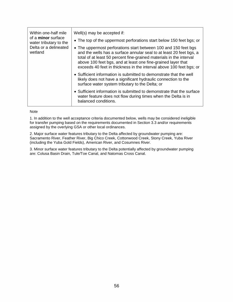
56
Within one-half mile of a minor surface water tributary to the Delta or a delineated wetland
Well(s) may be accepted if:
• The top of the uppermost perforations start below 150 feet bgs; or
• The uppermost perforations start between 100 and 150 feet bgs and the wells has a surface annular seal to at least 20 feet bgs, a total of at least 50 percent fine-grained materials in the interval above 100 feet bgs, and at least one fine-grained layer that exceeds 40 feet in thickness in the interval above 100 feet bgs; or
• Sufficient information is submitted to demonstrate that the well likely does not have a significant hydraulic connection to the surface water system tributary to the Delta; or
• Sufficient information is submitted to demonstrate that the surface water feature does not flow during times when the Delta is in balanced conditions.
Note
1. In addition to the well acceptance criteria documented below, wells may be considered ineligible for transfer pumping based on the requirements documented in Section 3.3 and/or requirements assigned by the overlying GSA or other local ordinances.
2. Major surface water features tributary to the Delta affected by groundwater pumping are: Sacramento River, Feather River, Big Chico Creek, Cottonwood Creek, Stony Creek, Yuba River (including the Yuba Gold Fields), American River, and Cosumnes River.
3. Minor surface water features tributary to the Delta potentially affected by groundwater pumping are: Colusa Basin Drain, Tule/Toe Canal, and Natomas Cross Canal.