Embed Size (px)
DESCRIPTION
iNews Cayman Island
Citation preview

1
PROPOSED GRAND CAYMAN WASTE MANAGEMENT FACILITY
ENVIRONMENTAL IMPACT ASSESSMENT
DRAFT TERMS OF REFERENCE
25 October 2012
Revision: EAB approved Draft

i
Contents
1 INTRODUCTION ................................................................................................................ 1
1.1 Project Brief ................................................................................................................ 1
1.2 Objectives ................................................................................................................... 3
1.3 Need and Alternatives ................................................................................................ 3
1.4 Policy and Legislative Framework .............................................................................. 4
1.5 EIA Technical Team ................................................................................................... 5
2 SITE AND THE SURROUNDINGS (the Study Area) ........................................................ 7
2.1 Site/Study Area Description ....................................................................................... 7
2.2 Access ........................................................................................................................ 8
2.3 Planning History ....................................................................................................... 10
3 PROPOSED PROJECT ................................................................................................... 13
3.1 Summary of WMF components ................................................................................ 14
3.2 WMF Environmental and Nuisance Controls ........................................................... 17
3.3 Design and Operational Information presented in the ES ....................................... 17
3.4 Description of the Site in relation to Natural Hazards .............................................. 17
4 CONSULTATION ............................................................................................................. 18
4.1 Proposed Consultation ............................................................................................. 18
5 POTENTIAL ENVIRONMENTAL EFFECTS ................................................................... 21
5.1 Economy, Population & Society ............................................................................... 21
5.2 Geology, hydrogeology, geotechnical information and climate ............................... 22
5.3 Traffic & Transportation ............................................................................................ 30

ii
5.4 Landscape & Visual Amenity .................................................................................... 31
5.5 Ecology & Conservation ........................................................................................... 34
5.6 Noise & Vibration ...................................................................................................... 35
5.7 Air.............................................................................................................................. 36
5.8 Facility Generated Waste ......................................................................................... 37
5.9 Utilities ...................................................................................................................... 38
5.10 Archaeology .............................................................................................................. 38
5.11 Amenity Impacts ....................................................................................................... 39
6 THE ENVIRONMENTAL STATEMENT ........................................................................... 40
Figures
Figure 1 - Proposed WMF Site Location ................................................................................... 1
Figure 2 - WMF Conceptual Site Layout ................................................................................... 2
Figure 3 - Aerial view of the proposed WMF site location ......................................................... 7
Figure 4 - Aerial view of the proposed WMF study area and site location ................................ 9
Figure 5 - Proposed WMF site location and access ................................................................ 10
Figure 6 - Current Planning Zones adjacent to the Proposed WMF Site ................................ 11
Figure 7 - Subdivision Parcels Granted in 2011 for the Proposed WMF Site ......................... 12
Figure 8 - Location of Existing and Proposed Geotechnical Investigations and Groundwater Monitoring Stations .................................................................................................................. 25
Figure 9 - Location of Proposed Surface Water Monitoring Stations (note the locations and extent are subject to change based on field conditions) ......................................................... 26
Figure 10 - Proposed viewpoints for visual assessment ......................................................... 33

iii
Tables
Table 1 – EIA study team .......................................................................................................... 6

iv
List of Acronyms
BMPs Best Management Practices
C&D Construction and Demolition
CFR USA Code of Federal Regulations
CIG Cayman Islands’ Government
DEH Department of Environmental Health
DOE Department of the Environment
DRCL Dart Realty (Cayman) Ltd
DRI Development of Regional Impact Guidelines
EAB Environmental Advisory Board
EIA Environmental Impact Assessment
ES Environmental Statement
ELVs End of Life Vehicles
FAC Florida Administrative Code
GTLF George Town Landfill Facility
IEEM Institute of Ecology and Environmental Management
NOI Notice of Intent
NTS Non-Technical Summary
NRA National Roads Authority
RAMSAR Convention on Wetlands of International Importance
SWMP Storm Water Management Plan
TIA Traffic Impact Analysis

v
ToR Terms of Reference
USEPA United States Environmental Protection Agency
WMF Waste Management Facility
WTE Waste to Energy Facility

1
1 INTRODUCTION
1.1 Project Brief
Dart Realty (Cayman) Ltd (“DRCL”) (the “Proponent”) proposes to undertake an Environmental Impact Assessment (“EIA”) for the proposed Grand Cayman Waste Management Facility (“WMF”) to manage municipal solid waste generated on Grand Cayman. DRCL is funding the conceptual design of the WMF master plan and EIA for the project as part of its offer to Cayman Islands Government (“CIG”) to support the establishment of the initial phase of the facility. The Environmental Advisory Board1 (“EAB”) has been formed from within government and statutory authorities to assist CIG to evaluate the environmental implications of the WMF proposal.
The location of the 110 acre proposed WMF site is depicted on Figure 1. The EIA will address a master-planned WMF as conceptually shown on Figure 2. The project is designed to provide a comprehensive waste management facility to accommodate waste treatment and disposal to address Grand Cayman’s current and future needs.
Figure 1 - Proposed WMF Site Location
1 EAB members include: Departments of Environment, Environmental Health and Planning, National Roads Authority, Petroleum Inspectorate, Water Authority Cayman.

2
The purpose of this Terms of Reference (“ToR”) document is to generally outline the scope of the EIA and to provide a general description of the information that will be considered in the Environmental Statement (“ES”). The ES will objectively present potential environmental impacts and options for the proposed WMF to assist decision-makers in their consideration of the project. The EIA also provides for public review and comment into this process, so that these comments may be addressed through the ES.
Figure 2 - WMF Conceptual Site Layout

3
A Business Case for the development of the WMF and assessment of the Value for Money of the development will be undertaken as part of a separate assessment.
A full assessment of institutional capacity/needs will be carried out as a separate exercise by government as part of the project development process. Recommendations may extend to new laws and regulations, intersectoral arrangement, management procedures and training, staffing, operation and maintenance training, budgeting and financial support.
1.2 Objectives
The objectives of the EIA are as follows:
• Pursuing Preventative Action – Avoidance of potential impacts is principally achieved by the consideration of alternatives and by the review of design modifications that may reduce or eliminate potential adverse environmental conditions.
• Informing the Decision making Process - The EIA takes place before the actual decision about consent is made. This enables the competent authority to reach a decision in the full knowledge of the project’s likely significant impacts on the environment, if any.
• Maintaining Environmental Focus and Scope – The formulation of an EIA aids the developer and decision makers to focus on relevant topics.
• Encouraging Public Participation - Public participation enhances the effectiveness and accountability of the process by encouraging the community engagement and facilitating informed debates.
1.3 Need and Alternatives
The need for the project will be assessed in the EIA; this will be described in the ES. At a minimum, this will involve analysis of the “No Action” alternative, which would include continuation of operations at the current facility in George Town.
The EIA for the WMF is limited to this site and its environs (the study area); the conceptual plan agreed with the Department of Environmental Health (DEH) will set the parameters for the scope of the project to be assessed in the EIA. A summary of the site selection study undertaken by DRCL (including selection criteria applied) will be contained in the ES.
4
1.4 Policy and Legislative Framework
The ES will identify the environmental and other specific regulatory approvals and legislation that are applicable to the development of the WMF.
Planning permission will be required for the waste management facility pursuant to regulation 13(1) of the Development and Planning Law (2011 Revision).
The Planning legislative framework for the environmental assessment of development applications in the Cayman Islands is provided as follows:
• Pursuant to Section 2.3 (b) of The Development Plan 1997, when considering applications for new development in mangrove areas or wetlands, the Planning Department may apply an environment analysis
• Section 6 of the Development and Planning Law (2011 Revision).
Section 34 of the Water Authority Law prohibits the discharge of any sewage effluent, trade effluent or other wastes into groundwater, into or onto the ground except with a permit issued by the Water Authority which may apply such terms and conditions as it deems fit. Application for such a permit will require a geological and hydrogeological study as described later on in this ToR. The permit will include a site specific monitoring programme of ground and surface water including compliance with specific standards that are protective of health and the environment.
In terms of international treaties, the Cayman Islands are a Party to two Conventions that will be taken into consideration as part of the EIA: specifically, the Convention on Wetlands of International Importance (“RAMSAR convention”) and the Convention on Biological Diversity.
Ramsar is an intergovernmental treaty which embodies the commitments of its member countries to maintain the ecological character of their Wetlands of International Importance and to plan for the "wise use", or sustainable use, of all of the wetlands in their territories. The site of the proposed WMF is not a formally designated Ramsar site, however, the objective of “working towards the wise use of wetlands” and “sustainable use” will be considered as part of the EIA. While there is currently no local legislation that gives effect to the provisions of either Convention, the Convention states that members should attempt to comply with the aims and objectives of the treaties to the greatest extent feasible.

5
The EIA will take into consideration the Draft Cayman Islands National Climate Change Policy (2011) which calls for adaptation and mitigation measures to address potential impacts of climate change.
There is no comprehensive legislated framework for the EIA process in the Cayman Islands. These ToR will guide the EIA process and are broadly based upon internationally recognised methodologies for conducting an EIA. The potential environmental effects (see Section 5 of the ToR) will be assessed, as outlined in the ToR. Any non-Cayman legislation and/or guidance referred to in these ToR will be applied only where applicable and relevant to the Cayman Islands; equivalent internationally recognised legislation and guidance may be used as an alternative, provided this is agreed by the EAB.
1.5 EIA Technical Team
The EIA will be undertaken by the EAB approved consultants who have indicated their ability to meet the following EAB-recommended criteria, namely:
• Requisite qualifications, expertise and experience to address the issues outlined in Section 5 of the ToR.
• 5+ years’ experience in the various disciplines outlined below and must be able to demonstrate examples of work carried out for similar projects.
The review areas to be completed by various members of the EIA Technical Team are shown in Table 1.

6
Topic Area Responsibility
Economy, Population & Society Cardno ENTRIX (Terry Clark, AICP, PMP)
Geology, hydrogeology, geotechnical
Cardno ENTRIX (Mike Waldron, P.G. )
Traffic & Transportation Cardno ENTRIX (Upik Suwarno, P.E. )
Landscape & Visual Amenity Cardno ENTRIX (Robert McGuinn)
Ecology & Conservation Cardno ENTRIX (Wendy Swindell / Drew Sanders)
Noise & Vibration Cardno ENTRIX (Chelsea Ayala)
Air Quality Cardno ENTRIX (Brad Boyes)
Project Generated Waste Cardno ENTRIX (Richard Thiel, P.E)
Utilities Cardno ENTRIX (Tom Burke, P.E. )
Archaeology Cardno ENTRIX (Paul Jones)
Amenity Impacts Cardno ENTRIX (Terry Clark, AICP, PMP )
Public Consultation Cardno ENTRIX (Douglas Durbin/Sharon Niemczyk)
Natural hazard vulnerability/climate change Cardno ENTRIX (Cassondra Thomas, PhD) Table 1 – EIA study team

7
2 SITE AND THE SURROUNDINGS (the Study Area)
2.1 Site/Study Area Description
2.1.1 Narrative Description
The site for the proposed WMF is located on Block 51A Parcel 23, as shown in Figure 3. It is located adjacent to operational quarries, Tarpon Springs Quarry to the east and Midland Acres to the west. The land is currently zoned Agricultural/Residential.
The ES will fully address all lands likely to be affected by the WMF and associated infrastructure, including access and facilities, and locate the study area graphically. The study area is defined as the land within 3000 feet (“ft”) of the 110 acre site (51A23) boundary and areas beyond the 3,000 ft boundary for visual amenity, traffic and ecology reviews. The description will include the following:
a) The legal land description b) The boundaries of the proposed development area c) A map that identifies the locations of all proposed development activities and phasing
within the WMF site d) A map showing the study area, see Section 2.1.2
Proposed WMF site location
Figure 3 - Aerial view of the proposed WMF site location

8
In addition to the points outlined above, the following elements will be described in the ES and graphically presented on maps:
a) Site Location b) Proximity of Housing and Centres of Population c) Land Use d) Infrastructure (roads and utilities) e) Projected Traffic Routes f) Access/Entrance to Waste Management Facility g) Tourism attractions h) Ecological designations/sensitive habitats i) Water bodies
2.1.2 Study Area
The Study Area, for the purposes of providing a contextual background for the site, is defined as the land within 3000 ft of the 110 acre site (51A23) boundary and areas beyond the 3,000 ft boundary for ground and surface water, ecological sampling, visual amenity, and traffic reviews. The WMF site and study area is shown in Figure 4.
2.2 Access
The access point from the nearest public roadway and the route for the access road are shown in Figure 5. For the purposes of the EIA, the construction of the East-West Arterial is not to be accounted for in the EIA.

9
Figure 4 - Aerial view of the proposed WMF study area and site location

10
Figure 5 - Proposed WMF site location and access
2.3 Planning History
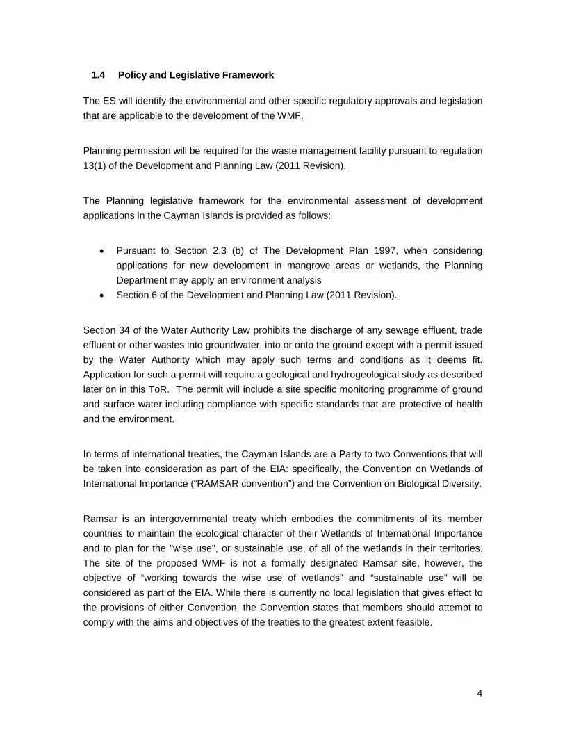
The current planning zones that apply to the WMF site and surrounding area are shown in Figure 6. During the EIA process past planning permissions will be reviewed. The CPA granted planning permission for the subdivision of parcels 51A2, 51A10 and 51A11 in October 2011 as shown in Figure 7.
11
Figure 6 - Current Planning Zones adjacent to the Proposed WMF Site

12
Figure 7 - Subdivision Parcels Granted in 2011 for the Proposed WMF Site

13
3 PROPOSED PROJECT
For the purposes of this ToR, the following information concerning the project description has been included for review and comment. It should be noted, however, that the details relating to this project description are subject to modification throughout the ToR review (based on regulatory and public input) and will not be considered final until such time as the EIA is completed.
The proposed WMF covers a 110 acre site and will comprise operational and recycling areas, municipal solid waste (Class I non-hazardous) landfill with future consideration of a Waste to Energy facility. The proposed operational hours are in line with the existing landfill in George Town (“GTLF”) -7am to 7pm except Sunday.
The sizing and design of the facility is based on the DEH 2011-2012 waste stream data. The DEH currently recycles approximately 20% of the waste at the GTLF. Existing recycling typically involves sorting of waste and storage until such a time when it is commercially favourable to commence shipment. Future increases in recycling are proposed to include yard waste and construction and demolition waste.
The planned life span of the facility is at least 20 years. The life span is calculated from the waste predictions and the available landfill airspace.
The 20 year life span is based on the WMF development sequence summarised as follows:
Years 1-2 • Key site infrastructure and operational areas complete • Civic recycling drop off areas open • Initial phase of leachate treatment plant complete • First lined landfill cell complete, filling of cell commences • Recycling facilities in place • Second landfill cell construction commences
Years 3-5 • Capping the first cell, construction of third and fourth cells • Gas monitoring of first cell to evaluate gas dispersion/flaring use • Yard waste composting introduced
Years 5-10 • Construction and demolition waste recycling introduced • Complete landfill cells capped, additional cells constructed

14
Years 10-20 • Landfilling continues with new cells constructed and completed cells capped • Leachate treatment plant expansion (if required)
The 20 year life span of the WMF would be extended significantly through the introduction of WTE at the site.
3.1 Summary of WMF components
A summary of the components proposed for the project based on the WMF conceptual masterplan is provided below. Detailed descriptions of the facility components will be provided in the ES.
1. Facility Administration Building: The administration building will house administration functions and a small on-site laboratory required for basic field monitoring. Adequate car parking is assigned for staff and visitors to the site.
2. Proposed Facility Entrance with Gate: The facility entrance and gate will be installed to ensure authorized access to the facility only. Perimeter fencing will be kept to a minimum as needs dictate to provide sufficient security for the facility.
3. Collections Fleet Parking, Truck Wash Building, Fuel Station and Truck Maintenance Building: Truck parking is included in the masterplan for the DEH collection fleet. A vehicle wash area and maintenance building will be provided at the site to provide regular maintenance.
4. Leachate Treatment Works and Collection System: Leachate generated within the landfill is mainly due to rain infiltration during a storm event on an opened landfill cell. Leachate storage and treatment has been designed to cater for the rain intensity criteria specified within the USA code of federal regulations (“CFR”) 40 CFR Part 258- Criteria for Municipal Solid Waste Landfills (Clause 258.26).
5. Truck Wheel Wash: The truck wheel wash is positioned to prevent migration of dust onto the road network outside the site. The wheel wash will be used by all collection vehicles prior to exiting the site as set out in the Operation Plan.
6. Landfill Gas System : The gas collection system and monitoring criteria will be selected according to the guidelines listed in the regulation 40 CFR, 60.752, and other related sections.

15
7. Weigh Scale Bridge: All trucks entering and exiting the facility will be required to use the weighbridge. The scale master will be responsible for monitoring traffic using the northern entrance. There will be provision for vehicles to bypass the weigh bridges but this will be closely monitored by the DEH.
8. Vegetated Perimeter Zone: As part of the design process a perimeter zone is incorporated around the landfill footprint. Buffers are intended to provide space or distance between an activity and a sensitive receptor for the purpose of mitigating an actual or potential environmental risk. The zone incorporates retention ponds for storage of stormwater runoff during heavy rainfall.
9. Yard Waste Composting Area: An area to accommodate future composting has been designated in the facility plan. A high percentage of waste can be diverted from disposal through composting of yard waste as it currently comprises 14% of the waste stream at the GTLF.
10. New road from Bodden Town Road: The road from Bodden Town Road will run north to the WMF site and provide access to adjacent sites as well as the WMF. The road will be designed to the National Roads Authority (NRA) requirements for Subdivision collector roads.
11. Construction Waste Separation Area Baling and Transfer Station and Recyclables
Storage Area: The construction and demolition (C&D) facility will accept wastes from building construction activities. The materials will be sorted and segregated. The materials collected from both the Civic Amenity Area and the C&D processing area will be either further processed on-site or transferred to the baling station for baling and wrapping, as necessary.
12. Derelict Autos Area: The derelict autos area will accommodate the processing and
storage of end of life vehicles (“ELV”). Vehicles will have hazardous items removed prior to crushing and storage until such a time that it is commercially favourable to ship them. The staging area will include a containment basin for the collection of waste oils if spilled.
13. Tyre Storage and Processing Area: Tyres will be shredded using a single pass tire shredder. Sufficient storage will be available to provide the operator with the option of shipment off island or reuse on Grand Cayman.
14. Civic Amenity Recycling Drop-Off Area: The Civic Amenity Area will house bins for the collection of glass, plastics, textiles, paper, household hazardous waste, etc.

16
15. Waste Oil Management Area: A storage area will be provided in accordance with current DEH practises. Waste oils will be stored in secure containers on a secondary containment pad. The DEH will arrange for regular shipments of the waste oil to the USA for processing.
16. Waste to Energy Facility: The details for the potential WTE facility have not been
confirmed; the EIA will include a high level, qualitative assessment of potential environmental impacts based on design criteria to be provided to the EIA Consultant by the DRCL team in collaboration with DEH.
17. Medical Waste Incinerator, Air Curtain Burner and Hazardous Liquids Storage: The
medical and infectious waste incinerator, air curtain burner and liquids storage areas will all be based on existing operational methods and data from the GTLF.
18. Engineered lined / capped landfill with berm: It is proposed that as the WMF landfill will be constructed in phases and over a period of 20 years. Land clearing will be carried out on an as-required basis. After deposition of residual waste, each phase will be temporarily capped. Allowing for settlement, the final capping will be installed and full restoration will take place.
19. Equipment maintenance, storage and welding shop, skip and equipment storage, paint booth: Equipment maintenance and welding shop buildings will be constructed to service the WMF. Additionally, the site will include a personnel building and staff parking.
20. Sediment Forebays, Retention Ponds and Stormwater Conveyance Including Internal Swales: The proposed structures for controlling, collecting and disposing of clean stormwater runoff will be sized in line with Florida Administrative Code 62-701, 40 CFR Part 258 and Grand Cayman (NRA design storm) best practice and guidance.
21. Internal Access Roads: Internal access roads are provided between the WMF components. The roads will be formed of compacted rock, the access road travel lanes will be surfaced.

17
22. Facility lighting: Lighting will be provided for security purposes and to allow access to the civic amenity area in the evenings. Lighting levels will be kept to a minimum as far as possible, whilst ensuring the safety of the public and site staff.
3.2 WMF Environmental and Nuisance Controls
The environmental controls proposed for the WMF include the control of dust, noise and windblown litter, as well as measures to manage stormwater, leachate and landfill gas. Several best management practices (BMPs) will be evaluated and mitigation may be proposed through the facility design within the ES. The ES will include detailed descriptions of BMP’s, as well as construction phase measures, including information for the Operation Plan for the site. Environmental monitoring specifics will be evaluated as part of the EIA and presented in the ES.
Other potential nuisance issues, such as potential for fires, control of vermin, and control of odor, dust, and noise will be assessed in the EIA, and the ES document will include a summary of BMP’s and other measures that may be implemented to mitigate factors, as required.
3.3 Design and Operational Information presented in the ES
The ES will provide a detailed project description that includes the topics referenced above, as well as details and data outlined in the site engineering design plans, site facility operational plans, construction and on-going monitoring required, and record keeping requirements.
3.4 Description of the Site in relation to Natural Hazards
The vulnerability of the project to natural hazards and potential climate change impacts including the frequency, magnitude and distribution of any natural hazard or possible climate change elements affecting the spatial or temporal boundaries of the proposed project will be evaluated as part of the EIA, and presented in the ES. The EIA will assemble, evaluate and present baseline data on the relevant natural hazard/climate change characteristics of the study area that are relevant to project design, or to the formulation of mitigation measures.

18
4 CONSULTATION
4.1 Proposed Consultation
The consultation process is intended to provide the Cayman government agencies, the
public and stakeholders an opportunity to engage in the ToR and EIA process. This
section provides a structure and chronology of events that will occur in relation to public
review and comment of the ToR, the EIA process and the development of the ES. The
EAB and CIG will make formal comments within the ToR and Draft ES commenting
periods in order to maintain a streamlined and concurrent EIA process and schedule.
4.1.1 Public consultation on the ToR will be as follows:
1. Upon EAB’s approval of the Draft ToR a Notice of Intent (NOI) will be advertised
to the public informing them that a new waste management facility is being
proposed. The NOI will be formally advertised and will state the availability of the
Draft ToR and an opportunity for public review and comment. The NOI will be
advertised in appropriate media outlets based on local knowledge of highest
impact probability. A weblink for accessing the full version of the Draft ToR will be
provided to the public and printed hard copies will be available at specific
locations including Cayman Government Administration Buildings.
a. The NOI will identify the following:
i. EAB
ii. Proponent
iii. Scope of general project description
iv. Duration of public comment period
v. Date of ToR Open House sessions in Bodden Town and George
Town
vi. Time, Location and address of Open House sessions
vii. Weblink for accessing full ToR and location of hard copies
viii. Brief description of comment submittal and response procedures
2. NOI public comment period will be open for 21 days (including weekends),
beginning on the date of filing and ending at close of business on day 21.

19
a. Two ToR Open House sessions (Bodden Town and George Town,
locations) will occur on two different days during the working week. The
focus of the ToR Open House sessions will be to gather public comments
on the ToR and to introduce the EIA process.
3. Addressing Public Comments
a. The EAB will receive all comments. The EIA Consultant (with input from
the Proponent and EAB) will coordinate the response to public comments.
The ToR may be revised based upon the nature of the public comments.
A summary and response to all ToR comments received will be provided
as an appendix to the Final ToR.
b. The EAB will approve the Final ToR.
4.1.2 Development of the Environmental Statement
The EIA Consultant will conduct the EIA process in accordance with the Final ToR and develop the ES.
4.1.3 Public consultation on the ES will be as follows:
a. A public notice will formally advertise the availability of the Draft ES for
public review and comment and advertisement of public comment
meetings. The public notice will identify similar information as outlined
above for the NOI.
i. A weblink for accessing the full version of the Draft ES will be
provided to the public and printed hard copies will be available at
specific locations including Cayman Government Administration
Buildings.
b. The Draft ES public comment period will be open for 21 days (including
weekends)
i. Public Meeting(s) for the Draft ES
1. The format of the public meetings associated with the Draft
ES will follow the same format and responsibilities as
outlined for the ToR Open House sessions.

20
c. The EAB will receive all comments. The EIA Consultant (with input from
the Proponent and EAB) will coordinate the response to public comments.
The Draft ES may be revised based upon the nature of the public
comments. A summary and response to all comments received on the
Draft ES will be provided as an appendix to the Final ES.
d. The EIA Consultant will revise the Draft ES and it will then be deemed the
Final ES
Final ES
a. The EIA Consultant will provide the final ES to the Proponent and the
EAB. The EAB will conduct a review of the ES and provide a written
statement to CIG and the Proponent.
b. The Proponent will submit the Final ES in conjunction with the EAB’s
written statement to the Planning Department as part of the process for
applying for planning permission.

21
5 POTENTIAL ENVIRONMENTAL EFFECTS
The EIA will assess the potential significant impacts associated with all phases of the proposal. As mentioned previously, the assessment for the WTE facility will be at a high level and qualitative. On procurement of the WTE when facility design is being undertaken, a more detailed environmental assessment will be required as part of a separate regulatory approval process.
The EIA will assemble, evaluate and present baseline data for each of the potential effects identified below. The analysis will distinguish between significant, positive and negative impacts, direct and indirect impacts, cumulative impacts, and immediate and long-term impacts. The EIA will discuss how and to what extent impacts can be avoided, reduced or mitigated. It will identify impacts which are unavoidable or irreversible and wherever possible quantify impacts. Climatic effects including climate change on the WMF will be addressed in the EIA. The analysis of potential impacts of the proposed project will include an assessment of potential exacerbations or reduction of natural hazard and climate change impacts, both on-and off-site, as well as an analysis of the potential impacts of climate change on the project.
The EIA will characterise the extent and quality of available data and the methods employed to carry out project specific studies to determine project specific data, explaining significant information deficiencies and any uncertainties associated with predictions of impact.
5.1 Economy, Population & Society
5.1.1 Context & Potential Impacts of the Proposed Development
The following data sets will be referred to during EIA. This list is not exhaustive and other documents will be used as the EIA is undertaken.
1999 Vision 2008- The Cayman Islands National Strategic Plan 1999-2008
2005 Population Features in the Cayman Islands by the Economics and Statistics Office
2008 National Assessment of Living Conditions (2006/2007) -Sept 2008
2011/12 DEH waste quantity statistics
2011 2010 Population and Housing Census Preliminary Report, Economics and Statistics Office

22
5.1.2 Proposed Scope of Assessment
The EIA will address potential impacts (both direct and indirect) of the proposed project such as the impact on the local economy; it will assess potential impacts due to construction and operation of the WMF including adverse impacts and economic benefits, employment data for communities and tourism activities. Based upon existing data, the EIA will evaluate factors such as, but not limited to, public services, tourism activities, schools, housing, and traffic patterns.
The ES will clearly identify the potential effects of the proposed project on the existing socio-economic conditions in terms of population dynamics, infrastructure, economic and business status, tourism and recreation. The potential effects will be assessed based on their nature (beneficial/adverse), their temporal extent (short-term/long-term) and their spatial nature (local/national).
A qualitative review of the likely effect on existing waste management businesses will be included in the ES.
5.2 Geology, hydrogeology, geotechnical information and climate
5.2.1 Context & Potential Impacts of the Proposed Development
The proposed WMF has the potential to impact the quality of groundwater, surface water, sediments and the subsurface soils, both of the property on which the WMF will be located and the surrounding area. Specific measures such as the leachate collection and treatment system, lined waste cells, management of storm water, and operational practices will be implemented to mitigate these effects. Specific monitoring of impacts on groundwater, surface water and the subsurface will be carried out to ensure that the WMF is guided primarily by Florida based practice and standards (where applicable and practicable) to mitigate potential negative impacts. A review of geotechnical conditions is essential to determine adequate design parameters of the facility and to address site specific ground conditions. In order to provide the context to evaluate potential impacts and to establish adequate monitoring systems, a site specific study of the geology, hydrogeology, geotechnical information, hazard vulnerability and climate impacts will be carried out to determine the related impacts and mitigation from the WMF.
Some geotechnical information for the site has already been obtained through installation of a deep well and trial pits across the site. This existing information will be supplemented by additional investigations, which will be included in the EIA. Initial surface and ground water
23
sampling has also been undertaken at the adjacent Tarpon Springs quarry and at a monitoring well installed at the WMF site.
5.2.2 Proposed Scope of Assessment
It should be noted that the location and specifications for monitoring stations proposed for groundwater and surface water sampling may be adjusted based on additional data collected through the EIA process.
The geology, hydrogeology, groundwater and surface water regimes of the project and surrounding area will be studied using published information and site specific investigations. Specific attention will be given to the presence of Karst features such as sinkholes, fractures and other subsurface conditions that facilitate rapid movement of potential contaminant releases. This assessment will determine sensitive receptors and their vulnerability to the facility’s potential for negative impacts on groundwater and surface water. A review of regional tectonic setting and seismic information will be undertaken as part of the assessment of the facilities vulnerability to natural hazards (refer also to Section 3.4). The geotechnical investigation defines the engineering properties of the site that are necessary for the design, construction, and support of the landfill and auxiliary infrastructure of the WMF. As the WMF is in a relatively low area, consideration will also be given to the effects of hurricanes and climate change.
The potential impacts of the proposed WMF on the site will be assessed using engineering and scientific judgment and experience. This will include a qualitative review of the inclusion of a WTE facility at the site. The baseline information, assessment of the impact and any mitigation measures will be recorded within the ES.
5.2.2.1 Geology and Geotechnical Information
A review of the related literature will be undertaken and a summary included in the ES. The summary will include a review of the data collected from the existing 250ft deep well installed at the site and the trial pits undertaken to date. Additional geotechnical investigations will be carried out to verify the subsoil conditions at the site as illustrated in Figure 8, in particular to confirm depth of peat and to determine the potential for subsurface zones vulnerable to the release of contaminants. This information will feed into the calculation of the volumes of material to be removed and imported..

24
The proposed location of groundwater and surface water monitoring stations (both existing and proposed) is shown on Figures 8 & 9. A summary of the investigation and findings will be reported in the ES. The ES will specifically assess foundation stability and report any potential foundation instabilities that may occur due to the natural rocks formation or manmade structure which could affect the facility’s infrastructural integrity, especially in areas where liner is provided. The presence of nearby quarry operations on geotechnical properties of the WMF site will be assessed as well. Upon confirmation of any potential foundation instabilities due to geological formation or manmade structure or operation, the mitigations of impacts proposed will be clearly stated and will follow acceptable engineering practice standards and clear confirmation that the proposed mitigation solutions are sound will be provided.

25
Figure 8 - Location of Existing and Proposed Geotechnical Investigations and Groundwater Monitoring Stations
(note the locations and extent are subject to change based on field conditions)

26
Figure 9 - Location of Proposed Surface Water Monitoring Stations (note the locations and extent are subject to change based on field conditions)

27
5.2.2.2 Meteorology
The climate of Grand Cayman and the site will be outlined within the ES. Information on wind (direction and speed), rainfall (daily volume and rainfall intensity), temperature (daily minimum, maximum and average), potential evapotranspiration and atmospheric humidity (daily) for the area will be requested from the National Weather Service for inclusion in a comprehensive review in the report. A meteorological station will be placed at the site to collect the same site specific climatic information and the data obtained from this station will be included and reviewed in the ES.
5.2.2.3 Ground Water Flows
A review of the related literature and historical data will be undertaken and a summary included in the ES. The existing results regarding the porosity and vertical permeability of the rock underlying the site will be utilized for meaningful predictions of groundwater flows.
Monitoring wells will be installed at the site to confirm as far as possible the baseline rate and direction of ground water flows (Figure 8). Data loggers will be used to record fluctuations in the water table. Data will be downloaded monthly, with a representative period of data to support the EIA. Weekly site based water testing will be undertaken using a YSI hand held probe to measure temperature, conductivity and pH which will feed into the analysis of the ground water flows.
5.2.2.4 Surface Water (within the site)
A review of the related literature and historical data will be undertaken and a summary included in the ES. Monitoring will be undertaken to confirm as far as possible the variations in the surface water at the site and its connectivity with the ground water. Data loggers will be installed in representative surface waters as shown on Figure 9. The data logger will be used to record fluctuations in the surface water levels. Data will be downloaded monthly, with a representative period of data to support the EIA. Monthly site based water testing will be undertaken using a YSI handheld probe to measure temperature, conductivity and pH which will feed into the analysis of the surface and ground water.
5.2.2.5 Stormwater Management and Stormwater Flooding
The management of stormwater and the impact of stormwater flooding at the site and within 3,000 ft of the site boundary will be evaluated as presented in the Stormwater Management Plan (“SWMP”). A summary of this plan will be included as an appendix to the ES. A

28
summary of the stormwater management and stormwater flood risk will be included within the ES.
The SWMP will set out the site infrastructure and best practice measures to be implemented to mitigate contamination of stormwater by landfill operations, such as the unintended mixing of stormwater with solid waste, the management of stormwater from closed landfill cells and the management of stormwater from any areas outside of the lined landfill cells where waste may be stored or processed including all proposed operational areas.
The stormwater criteria for the landfill will be as stipulated in the “USA Code of Federal Regulations, 40 CFR Part 258 - Criteria for Municipal Solid Waste Landfills (40 CFR Part 258)”. This is to a) to design, construct and maintain a run-on control system to prevent flow onto the active portion of the landfill during the peak discharge from a 25-year storm and b) to design, construct and maintain a run-off control system from the active portion of the landfill to collect and control at least the water volume resulting from a 24-hour, 25-year storm.
For the remainder of the site the National Roads Authority and Planning Department Stormwater Management Guidelines will apply. The proposed WMF stormwater drainage and stormwater flood risk assessment has the potential to be impacted by hurricanes and by potential climate change through the possible rise in sea level and predicted increases in the intensity of rainfall. These impacts will be taken into consideration in the SWMP and summarised within the ES including the proposed mitigation measures.
5.2.2.6 Ground and Surface Water Quality
Initial background (baseline) water quality at the proposed site will be determined by analysis of at least one water sample from each of the surface water monitoring sites and groundwater monitoring wells to be established as follows. Surface water will be collected, where feasible, from water bodies on the boundary of the site as shown on Figure 9.
The EIA will evaluate the geological data presented and collected to outline the location and specifications associated with future wells that may be installed for groundwater monitoring purposes.
Sample collection, preservation, holding time, onsite testing and laboratory testing will be carried out in accordance with the United States Environmental Protection Agency (“USEPA”) guidance. The laboratory carrying out the testing will have USEPA or equivalent

29
accreditation. Water quality testing will be carried out in accordance with analysis of constituents based on requirements within standard WMF facilities review in Florida. The ES will include a comprehensive summary of the baseline water quality results and complete laboratory reports included in an appendix.
Where appropriate and feasible, the same water bodies and wells will be incorporated into the long term water quality monitoring plan for the site.
5.2.2.7 Biological & Sediment Sampling
Based on the surface and ground water study and in consultation with the EAB, the locations, sampling procedures and parameters to be tested for sediment and biological sampling will be developed as part of the EIA. Sediment and biological sampling will be completed as part of the EIA process, and data will be presented in the ES document..
5.2.2.8 Receptor Identification
A review will be undertaken to identify all receptors within 3,000 ft of the site boundary. These receptors will be listed and summarised in the ES, and will include possible mitigation alternatives that may reduce potential future impacts to these receptors attributable to the construction or operation of the proposed WMF.
5.2.2.9 Surface and Ground Water Monitoring During Operation
The ES will make recommendations with regards the surface and ground water monitoring during the WMF operation. Monitoring (including any additional baseline and background sediment and flora/fauna monitoring) will be presented in detail by the operational / management plan for the site which will be included as an appendix to the ES. The plan will include the number, locations and depths of monitoring wells; selection of suitable locations to monitor surface water; and specifications for any sediment, flora, and fauna monitoring to be undertaken. Specification of parameters to be monitored and monitoring frequency will also be addressed. The references that will be taken into consideration in preparing this section are the “USA Code of Federal Regulations, 40 CFR Part 258 - Criteria for Municipal Solid Waste Landfills (40 CFR Part 258)” and the “Florida Administrative Code Chapter 62-701 Solid Waste Management Facilities (FAC 62-701).”

30
5.3 Traffic & Transportation
5.3.1 Context & Potential Impacts of the Proposed Development
The following existing information has been provided by the NRA to date:
1. 2009 traffic counts on Frank Sound Road 2. 2009 Long term road corridor projection per section 26 of the Roads Law 3. 2008 traffic counts on Anton Bodden Road 4. 2005 Approved East West arterial corridor per section 25 of the Roads Law (on NRA
website)
5.3.2 Proposed Scope of Assessment
The EIA will assess the traffic impacts associated with the WMF, the surrounding road network and assess all possible mitigation measures. The EIA needs to incorporate a study of the traffic impact on the surrounding transportation system, through a Traffic Impact Analysis (TIA). The purpose of this study is to determine what impact the site-generated traffic will have on the existing and proposed roadway network and what impact the existing and projected traffic on the roadway system will have on the proposed development.
5.3.2.1 Existing Data Collection, Review and Analysis
a) Coordinate with the NRA to identify current traffic counts that may be available and any previously prepared traffic studies
b) A tabulation of road improvements contemplated by the NRA within the study area c) Review all existing DEH data (weighbridge & public drop off records) on traffic to the
existing George Town Landfill
5.3.2.2 New Data Collection, Review and Analysis
a) Collect 24-hour machine counts at the locations as agreed with the NRA.
5.3.2.3 Identify / Describe Existing Conditions
a) Review traffic volumes, number of trips and levels of service at the existing George Town Landfill
b) Origin/Destination Characteristics – Based on the existing information and from field observations of the traffic patterns, estimate the origin/destination characteristics of

31
the various vehicular modes of travel (i.e., sanitary vehicles, cars, trucks, etc.) to and from the existing George Town Landfill
c) Capacity Analyses – Evaluate to determine the existing levels of service during two peak periods and for a 24-hour day.
5.3.2.4 Impact Analysis and Mitigation
a) Analyze predicted traffic as a result of project construction and identify reductions in current levels of service
b) Project Trip Generation - The scope of assessment for the traffic demands generated by the proposed facility should include both the near-term (Year 1 to 7) and overall long-term Master Plan in order to determine the resulting transportation impacts of the traffic operations of 1) the immediate surrounding road network and 2) on the downstream road corridors of Bodden Town and George Town particularly during the morning and afternoon peak hour conditions
c) Assess impact on transportation route(s) to and from the new facility d) Recommend roadway improvements or traffic management strategies, if necessary,
to mitigate unsafe conditions or increased traffic congestion e) Develop alternatives to avoid or minimize impacts
5.3.2.5 Implications of introducing Waste to Energy
A statement will be made in the ES regarding the potential impacts of a WTE facility on traffic and transportation. The EIA will include but not be limited to a review of the additional traffic movements associated with construction and operation of a WTE facility.
5.3.2.6 Assumptions
Traffic data will be collected on site with traffic counters. Existing infrastructure information will be available from the NRA and/or public utility companies
5.4 Landscape & Visual Amenity
5.4.1 Context & Potential Impacts of the Proposed Development
The site is located in a low lying area, with an average elevation of approximately 0.5-2 ft MSL. It is vegetated with a mixture of species to a maximum height of 15-20 feet. There are no structures on the site or in the immediate vicinity. There are two quarry ponds on adjacent properties as shown in Figure 3.

32
The development of the WMF has the potential to affect the visual appeal of a landscape through the development of structures, access roads, landfill and other functions such as screening.
5.4.2 Proposed Scope of Assessment
An assessment of the visual effects of the proposed WMF will be undertaken. The visual impact assessment will be based on ten viewpoints (refer to Figure 10). The viewpoints for consideration have been selected to be representative views of the proposed facility and at receptor locations where a person might view the waste management facility and be potentially affected by the proposal. Landforms will include all buildings and structures, as well as any buffers and berms that may be put into place to mitigate the visual effects of the landfill on receptors in the vicinity. The study area will include the WMF site within the property boundaries as well as any public or private properties and roads in the site-vicinity that may contain visual receptors. This can also be described as the zone of visual influence or area within which the proposed development may have an effect on visual amenities. The assessment will result in the production of all eleven visual simulation figures or photomontages that illustrate how the proposed facility (including WTE) will appear from the viewpoints.

33
Figure 10 - Proposed 10 viewpoints for visual assessment
34
5.5 Ecology & Conservation
5.5.1 Context and Potential Impacts of the Proposed Development
A desktop review of the vegetation map provided with “The Cayman Islands natural history and biogeography” Brunt and Davies (1994) indicates the site contains wetlands, transitional communities and some upland areas.
5.5.2 Proposed Scope of Assessment
The likely impacts of the proposed WMF on the ecological environment of the site and its surroundings will be assessed. Assessments relating to the terrestrial environment will be in accordance with the vegetation and wildlife (Section 12) portions of the Development of Regional Impact (“DRI”) guidelines within Chapter 380, Florida Statutes and where applicable the “Guidelines for Ecological Impact Assessment in the United Kingdom” (version 7 – July 2006) produced by the Institute of Ecology and Environmental Management (“IEEM”) or an equivalent standard agreed with the EAB. This will include consideration of the potential impacts of including WTE at the site.
This section will evaluate the existing ecological conditions within the proposed study area (with the noted exceptions outside of the study area identified on Figure 4 and explained in paragraph 2.1.2). This evaluation will include review and evaluation of existing data for the proposed WMF as provided by the DRCL and EAB. Upon completion of this literature review, additional site specific data will be collected. This section of the ES document will include analyses of the potential impacts of the proposed WMF to ecological resources, including, but not limited to, the following:
• Available map(s) and other site specific information generated that depicts the land
uses and vegetative communities within the study area;
• Evaluation of environmental data provided by the DoE and any other sources
regarding regulatory considerations currently proposed;
• Evaluation of ecological biodiversity and sustainability with respect to the
construction and operation of the WMF site
• Review and assess the proximity of the potential significant environs with respect to
ecological parameters such as surface and ground water flows, nutrient dynamics,
habitat integrity, wildlife productivity and usage, etc.

35
• Classification denoting intactness of vegetative communities present within the study
area;
• Descriptions of potential presence of rare or endangered species, observed and
potential wildlife usage, and documented wildlife corridors.
• Generation and compilation of maps and other data for inclusion into the draft ES
document.
Utilizing the existing ecological data for the proposed WMF, as well as any site specific data
collected during site reconnaissance, the ES will include an evaluation of potential
environmental impacts and existing regulatory requirements that may be applicable to the
proposed WMF construction and future operation. Based on the data collected, and the
analysis completed in the above tasks, the EIS document will include a section describing
potential alternatives to minimize potential ecological impacts throughout the construction
and operation of the proposed WMF. Additionally, the ES may provide information on
measures that may be undertaken to mitigate residual environmental impacts, if required.
5.6 Noise & Vibration
5.6.1 Context & Potential Impacts of the Proposed Development
The EIA will include a qualitative assessment of how the different types of equipment and machinery that would be used on site for all operations could contribute to noise or vibration impacts on surrounding receptors. The potential effect on receptors including, but not limited to, the facility employees and surrounding area occupants, will be evaluated and proposed mitigation measures should be clearly stated and referenced. This assessment will address both construction and the operational stages of the project.
5.6.2 Proposed Scope of Assessment
The potential for increased noise resulting from the WMF will be examined as follows:
1. Noise and vibration sources and sensitive receptors will be identified. 2. The implications of any increased noise and vibration levels upon receptors will
be described in qualitative terms.

36
3. Feasible mitigation options, considering such factors as intensity, magnitude, frequency, duration and time of day for noise and vibration will be provided.
Current USEPA 40 CFR “Protection of the Environment” guidelines on maximum allowable levels for noise and vibration, or any other U.S. government standards of same or higher quality will be identified. The recommended facility buffer zone size and configuration will be described considering factors such as, but not limited to, noise, flying debris and fugitive dust.
5.7 Air
5.7.1 Context & Potential Impacts of the Proposed Development
The WMF will incorporate various operations that generate emissions of criteria pollutants, greenhouse gases, air toxics, fugitive dust, and odors that would have the potential to impact air quality at the facility site as well as the surrounding areas. The master plan for the WMF contains a number of activities/facilities that have the potential to impact air quality, which include the following:
1. Waste acceptance and sorting operations
2. Hazardous (toxic) materials handling
3. Composting / Mulching
4. Landfilling
5. Incineration of medical and pathogenic wastes
6. Landfill gas collection and flaring operations
7. Waste-to-energy operations
Each of the above operations and any others that are identified during the EIA process will be addressed in a qualitative study which will characterize the various sources and associated types of emissions.
5.7.2 Proposed Scope of Assessment
With reference to the landfill component of the facility, the possible characteristics of landfill gas will be estimated based on U.S. EPA “AP-42” methodology (Chapter 2.4). Options available to manage landfill gas will be identified, and a qualitative assessment of the potential impacts of the various options will be completed and presented in the
37
Environmental Report. Characteristic emissions from incineration of medical and pathogenic waste, and from the specified mass burn WTE facility will also be qualitatively assessed based on U.S. EPA “AP42”methodology (Chapters 2.1 and 2.3).
The potential for local air quality impacts (particularly odours and dust) resulting from the Waste Management Facility will be examined. This information will be provided specifically for communities and sensitive receptors located close to the WMF.
If it is perceived that the quarry operations, or other adjacent activities, may contribute significant particulates to the surrounding areas, then a plan for baseline ambient fugitive dust sampling may be included. This plan will include setting up a station representative of sensitive receptors with sampling equipment located at sufficient height to account for nearby vegetation. The particulate data collected is correlated with the volume of air sampled to generate baseline particulate loading data. The post-construction monitoring can then provide an assessment of fugitive dust attributable to the WMF (although it should be noted that additional off-site construction and proposed projects may be a source of fugitive dust).
A general description of how air quality impacts, resulting from the Waste Management Facility, will be mitigated and any conceptual monitoring programmes that may be proposed for assessing air quality or the effectiveness of mitigation measures will be provided. All proposed mitigation will be identified and evaluated in accordance with any applicable U.S. or international standards or best practices and each should be properly referenced. The EAB recommends using U.S. EPA’s 40 CFR “Protection of the Environment” as general guidance for all proposed mitigation measures. An outline of appropriate ambient air and emissions monitoring at the WMF will be included in the EIA.
5.8 Facility Generated Waste
5.8.1 Context & Potential Impacts of the Proposed Development
In addition to wastes accepted at the WMF site the construction and operation of the WMF will generate waste including and not limited to vegetation from land clearing, construction waste, landfill leachate, and wastes from vehicle maintenance and washdown. For each process likely to generate waste during the construction or operation of the WMF, the quantity and character of the wastes will be described and the basis for estimates will be provided. Potential paths and receptors of contamination and its impacts will be identified.
38
5.8.2 Proposed Scope of Assessment
The scope of the assessment will cover all phases of the WMF from construction to closure and all likely paths and receptors of contamination from facility generated wastes. Options for mitigation of impacts will be described.
The ES will include a qualitative statement in relation to waste typically produced by a WTE facility, including but not limited to the ash produced as part of the incineration process.
5.9 Utilities
5.9.1 Context & Potential Impacts of the Proposed Development
The only existing utilities within the study area have been identified as electrical, water, and communications along Bodden Town Road.
5.9.2 Proposed Scope of Assessment
For all phases of the project, a full assessment will be undertaken to analyse potential impacts using the following methodology:
• Assessment of existing and proposed utility infrastructure • Assessment of the impact of the proposed project upon the existing utility
infrastructure • Identify positive and negative impacts • Identify, where necessary, mitigation measures and the results of the
proposed mitigation
The potential impacts of a WTE facility on existing utility infrastructure requirements will be assessed qualitatively.
5.10 Archaeology
5.10.1 Context & Potential Impacts of the Proposed Development
While the proposed WMF has the potential to impact archaeological resources, it is considered a low probability that archaeological resources will be identified on the primary WMF site, which is in a wetland. Archaeological resources, however, are known to be present on parcels adjacent to the highway and the current entry road to the proposed WMF site. These resources are considered likely to represent the remains of one or more historical homesteads dating from the early 19th Century, based on artifacts observed, and

39
samples collected, by the National Museum in the late 1990s. While the presence of such site(s) will not prevent development of the WMF, if sites are to be impacted, then some form of mitigation to record the sites, collect, catalog, conserve and curate the artifacts, as well as the preparation of a report, is recommended.
5.10.2 Proposed Scope of Assessment
Background historical research and an archaeological survey will be performed under the supervision of a registered professional archaeologist. These will allow a determination of presence or absence of archaeological resources, their location within the WMF project area, and identification of the nature and boundaries of sites known to be present in the adjacent coastal areas. It is recommended that adjacent sites be avoided, and that if they cannot be avoided and will be impacted, that appropriate mitigation measures be taken, which may include conducting additional archaeological investigations, or other appropriate measures in consultation with the CI Museum. The product of the survey will be a final archaeological survey report and may also include, if appropriate, site recording information, artifact collection, cataloging, conservation, and curation of materials to be deposited in the National Museum.
5.11 Amenity Impacts
5.11.1 Context & Potential Impacts of the Proposed Development
An assessment of the potential impacts of the development on issues such as planning, amenity and tourism will be provided.
5.11.2 Proposed Scope of Assessment
The EIA will assess the potential impacts and propose mitigation measures. In addition to air quality and noise, which will be addressed within other sections of the EIA, waste management facilities have the potential to cause environmental nuisance due to the generation of litter/wind-blown materials, or through the attraction of vermin and other pests to the site, as well as fires. These will be addressed in other sections of the ES (Section 3) and will be described also in this section of the ES.

40
6 THE ENVIRONMENTAL STATEMENT
The following is a list of required chapters in the Environmental Statement namely:-
1 INTRODUCTION
2 SITE AND THE SURROUNDINGS (the Study Area)
3 PLANNING HISTORY AND POLICY CONTEXT
4 PROPOSED PROJECT (INCLUDING NEED AND ALTERNATIVES)
5 CONSULTATION
6 POTENTIAL ENVIRONMENTAL EFFECTS AND ASSESSMENT OF IMPACTS
7 OVERALL PROJECT SUMMARY
8 APPENDICES (To include technical information/ public comments and responses)
Each topic of assessment (outlined in Section 5 of the ToR) will consider the impacts during both the construction and operation phase and also the cumulative impacts of the proposal. Each subject area will be discussed under a separate chapter within which the following matters will be addressed where relevant:-
• Introduction • Assessment Methodology • Baseline Conditions • Incorporated Enhancement and Mitigation • Identification and Evaluation of Key Impacts • Mitigation (including monitoring plans and any identified training required) • Residual Impacts • Summary
Project generated technical reports, assessments, public comments and responses to public comments will be submitted as appendices to the ES. A non-technical summary (“NTS”) will be prepared in light of the fact that the ES will be read by both the public and decision makers. The NTS will:
• Be a fair reflection of the main ES and cover all aspects of the EIA process and not just provide a summary of the impacts;
• Be available as a separate document; • Be written in non-technical language, and

41
• Inform people of the environmental effects of the project rather than concentrating on the measures to reduce environmental effects.