Embed Size (px)
Citation preview

DRAFT
Vallemar Bluffs
Botanical Survey Report
Prepared by:
Jodi McGraw, Ph.D.Principal Ecologist
Jodi McGraw ConsultingPO Box 221 ● Freedom, CA 95019
(831) [email protected]
Prepared for:
Moss Beach Associates, LLC612 Spring Street,
Santa Cruz, CA 95060
August 201

Vallemar Bluffs Botanical Survey Report
Table of Contents
List of Tables v
List of Figures v
1 Introduction 1
1.1 Overview..............................................................................................................................................................1
1.2 The Proposed Project...........................................................................................................................................11.2.1 Description ...................................................................................................................................................11.2.2 Permitting and Environmental Review ........................................................................................................2
1.3 The Survey ...........................................................................................................................................................2
1.4 Report ..................................................................................................................................................................3
2 Study Methods 4
2.1 Study Area ...........................................................................................................................................................42.1.1 Location........................................................................................................................................................42.1.2 Land Ownership ...........................................................................................................................................42.1.3 Topography and Elevation ...........................................................................................................................42.1.4 Geology and Soils .........................................................................................................................................42.1.5 Land Use Activities .......................................................................................................................................52.1.6 Vegetation....................................................................................................................................................52.1.7 Rare Plant Species........................................................................................................................................6
2.2 Survey Methods...................................................................................................................................................62.2.1 Floristic Survey .............................................................................................................................................62.2.2 Plant Community Classification and Mapping .............................................................................................72.2.3 Rare Plant Survey and Mapping...................................................................................................................8
2.2.3.1 Field Methods.......................................................................................................................................9
2.3 Project Impact Assessment................................................................................................................................10
3 Survey Results 12
3.1 Floristic Survey...................................................................................................................................................12
3.2 Plant Community Classification and Mapping ..................................................................................................123.2.1 Plant Community Structure .......................................................................................................................123.2.2 Plant Assemblages .....................................................................................................................................123.2.3 Vegetation Types .......................................................................................................................................13
3.2.3.1 Coastal Terrace Prairie........................................................................................................................133.2.3.2 Ruderal ...............................................................................................................................................163.2.3.3 Ornamental or Planted Areas .............................................................................................................163.2.3.4 Native and Exotic Dominance.............................................................................................................17
3.3 Rare Plants ........................................................................................................................................................173.3.1 Coast yellow leptosiphon...........................................................................................................................18
3.3.1.1 Distribution.........................................................................................................................................183.3.1.2 Abundance..........................................................................................................................................183.3.1.3 Abiotic and Biotic Habitat Factors ......................................................................................................193.3.1.4 Factors Affecting the Survey...............................................................................................................19
3.3.2 Blasdale’s bent grass ..................................................................................................................................20

Vallemar Bluffs Botanical Survey Report Contents
Jodi McGraw Consulting iii August 2018
3.3.2.1 Distribution.........................................................................................................................................203.3.2.2 Abundance..........................................................................................................................................203.3.2.3 Habitat Factors ...................................................................................................................................203.3.2.4 Factors Affecting the Survey...............................................................................................................21
3.3.3 Johnny Nip .................................................................................................................................................213.3.3.1 Abundance..........................................................................................................................................213.3.3.2 Habitat factors ....................................................................................................................................213.3.3.3 Factors Affecting the Survey...............................................................................................................21
3.3.4 Harlequin Lotus ..........................................................................................................................................223.3.4.1 Distribution.........................................................................................................................................223.3.4.2 Abundance..........................................................................................................................................223.3.4.3 Habitat Factors ...................................................................................................................................223.3.4.4 Factors Affecting the Survey...............................................................................................................22
4 Special-Status Plants and Communities 23
4.1 Rare Plants ........................................................................................................................................................234.1.1 Special-Status Plants ..................................................................................................................................23
4.1.1.1 Coast Yellow Leptosiphon ..................................................................................................................234.1.1.2 Blasdale’s bent grass ..........................................................................................................................24
4.1.2 “Watch List” Plants ....................................................................................................................................244.1.2.1 Johnny Nip ..........................................................................................................................................244.1.2.2 Harlequin Lotus ..................................................................................................................................25
4.2 Special-Status Natural Communities .................................................................................................................254.2.1 Definition ...................................................................................................................................................254.2.2 Regional Context and Significance .............................................................................................................26
5 Assessment of Potential Project Impacts and Benefits 27
5.1 Existing Project Measures to Limit Impacts.......................................................................................................275.1.1 Project Design ............................................................................................................................................275.1.2 Project Construction ..................................................................................................................................27
5.2 Direct Impacts ...................................................................................................................................................285.2.1 Impacts to Special-Status Communities and Rare Plants...........................................................................29
5.2.1.1 Coastal Terrace Prairie........................................................................................................................295.2.2 Harlequin Lotus ..........................................................................................................................................30
5.3 Indirect Impacts.................................................................................................................................................305.3.1 Exotic Plants ...............................................................................................................................................305.3.2 Altering Drainage and Soil Moisture Conditions ........................................................................................315.3.3 Trampling ...................................................................................................................................................32
5.4 Measures to Minimize and Mitigate Impacts....................................................................................................33
5.5 Summary of Net Effects of the Project ..............................................................................................................35
References 38
Tables 41
Figures 55
Appendix A: Rare Plant List 64

Vallemar Bluffs Botanical Survey Report Contents
Jodi McGraw Consulting iv August 2018
Appendix B: Results of Floristic Survey of Vallemar Bluffs 69

Vallemar Bluffs Botanical Survey Report Contents
Jodi McGraw Consulting v August 2018
List of Tables
Table 1: Community structure 41
Table 2: Plant Assemblages by Dominant and Subdominant Species in Three Community Types 42
Table 3: California Natural Communities found within the Study Area 44
Table 4: Plant Communities by Native/Exotic Dominance Categories 45
Table 5: Summary of Rare Plants Observed in the Vallemar Bluff Study Area¹ 46
Table 6: Rare Plant Occurrences within the Study Area 47
Table 7: Acres impacted in each proposed lot within the MBA Property 48
Table 8: Harlequin Lotus Habitat (in square feet) and Plants Within the Proposed Impact Areas 48
Table 9: Potential Restoration Areas 49
Table 10: Summary of the Effects of the Proposed Conservation and Development Project 50
List of Figures
Figure 1: Study Area 55
Figure 2: Historical Aerial Imagery of the Study Area 56
Figure 3: Plant Community (Vegetation) Structure 58
Figure 4: Plant Communities and Assemblages 59
Figure 5: Plant Communities by Native/Exotic Dominance Categories 60
Figure 6: Rare Plants 61
Figure 7: Impact Areas (showing communities and rare plants) 62
Figure 8: Conservation and Restoration Areas 63
Vallemar Bluffs Botanical Survey Report
Jodi McGraw Consulting 1 August 2018
1 Introduction
1.1 Overview
This report presents an analysis of the potential impacts and benefits of a proposed conservation anddevelopment project on special-status plants and natural communities within the Vallemar BluffProperty—a 2.35-acre1 property in Moss Beach, San Mateo County (Figure 1). The report was preparedto facilitate environmental review of a proposed development project that would build four homes onthe eastern portion of the property; the remaining area would be protected via a conservationeasement. The report was prepared based on the following:
1. A synthesis of existing information about the site; and
2. A survey of natural communities and plants conducted in spring and early summer 2018; and
3. An analysis of the potential impacts, both positive and negative, of the proposed conservationand development elements, on native plants and natural communities.
The survey was conducted and the report was prepared following the Protocols for Surveying andEvaluating Impacts to Special-Status Native Plant Populations and Natural Communities prepared by theCalifornia Department of Fish and Wildlife (CDFW 2009). It was developed to address questions andissues raised by CDFW (2018a) and the California Coastal Commission (CCC 2018) based on their reviewof the initial study/mitigated negative declaration (IS/MND) prepared by the County of San Mateo forthe proposed development application (County of San Mateo 2018). The report was prepared tofacilitate County revision of the IS/MND.
1.2 The Proposed Project
1.2.1 Description
Moss Beach Associates, LLC proposes to build four new single-family residences on a 2.35-acre propertylocated north and west of the intersection of Vallemar Street and Juliana Street in Moss Beach, anunincorporated community in coastal San Mateo County (Figure 1). The houses are proposed to bedeveloped on four parcels that would be reconfigured from the current seven legal parcels. A total of1.43 acres (61%) on the eastern portion of the property would be developed; the remaining 0.92 acres(39% of the property) would be permanently protected via a conservation easement that would berecorded across all four lots between the west facing sides of the houses and the coastal trail along theocean bluffs (Figure 1). The conservation area would adjoin the Fitzgerald Marine Reserve—a 402-acre,three-mile long natural resource area that is owned by the County of San Mateo and managed by theCounty Parks Department for conservation, recreation, and public education. Funding for managementof the conservation area would be provided on an annual basis through fees assessed by the VallemarBluffs Maintenance Association.
1 This acreage was derived in GIS from the survey data for the property and may differ slightly from the parcel arerecorded on the titles.

Vallemar Bluffs Botanical Survey Report Introduction
Jodi McGraw Consulting 2 August 2018
1.2.2 Permitting and Environmental Review
To implement the proposed project, Moss Beach Associates submitted to the County of San Mateo in2017 an application to obtain a Coastal Development Permit (CDP), Resource Management-Coastal Zone(RM-CZ) permit, Grading Permit, and Lot-Line Adjustment (LLA). The application, which included projectplans as well as a preliminary outline of the conservation strategy (JMc 2016), integrated the findings ofstudies of the site’s vegetation and plant species (Zander Associates 2015), drainage (Mesiti-MillerEngineering 2017), and geotechnical considerations (HKA 2016). The plans addressed community inputobtained through a series of public meetings including those held at the Midcoast Community Council.2
As part of the environmental review process under the California Environmental Quality Act (CEQA), theCounty of San Mateo (County) prepared an initial study/mitigated negative declaration for the projectapplication in January 2018 (County of San Mateo 2018). In February 2018, the California Department ofFish and Wildlife provided a letter commenting on the IS/MND (CDFW 2018a). The California CoastalCommission submitted a letter regarding the IS/MND in March 2018 (CCC 2018).
Several of the comments in the agency letters address issues related to the natural communities (i.e.,vegetation) and rare plant species within the site and the adjacent habitat in the Fitzgerald MarineReserve. Notably, the letters addressed concerns about the impacts of the proposed project on coastyellow leptosiphon (Leptosiphon croceus)—an annual plant known only from an estimated 1,800-square-foot area on the bluffs within the Fitzgerald Marine Reserve (CDFW 2017). Specifically, CDFW(2018b) stated that the prior vegetation mapping study (Zander Associates 2015) was not implementedusing a systematic survey methodology necessary to evaluate whether the property supports the rareplant, which a candidate for listing as endangered under the California Endangered Species Act. Theletter and accompanying staff report for the listing noted that one individual of coast yellowLeptosiphon was observed on the MBA project property (CDFW 2017).
During discussions with MBA and County staff in March 2018, CDFW recommended that MBA conduct asurvey of rare plant and natural communities following the CDFW protocols (2009).
1.3 The Survey
Between April and June 2018, Jodi McGraw Consulting (JMc) designed and implemented a survey of therare plants and natural communities atop Vallemar Bluff. The survey protocol was developed by JMcbased on the CDFW protocols (2009) and input from representatives of CDFW, CCC, and the County ofSan Mateo Parks Department, which manages the FMR. Input was also provided by Toni Corelli, abotanist with expertise in the flora of San Mateo and Santa Clara counties, who prepared the listingpetition for coast yellow leptosiphon (Corelli 2016).
The objectives of the survey were to:
1. Compile a list all of all plants within the study area;
2. Map the distribution and estimate the abundance of all rare plants within the study area; and
3. Classify and map the natural communities within the study area.
2 The Midcoast Community Council is an elected municipal advisory council to the San Mateo County Board ofSupervisors, representing the communities of Montara, Moss Beach, El Granada, Princeton, and Miramar.

Vallemar Bluffs Botanical Survey Report Introduction
Jodi McGraw Consulting 3 August 2018
1.4 Report
This report documents the methods (Section 2) and results (Section 3) of the survey. It then describesthe special-status plants and sensitive natural communities within the study area, and assesses theirregional context and significance for conservation (Section 4). Section 5 assesses the potential impacts,both positive and negative, of the proposed project on special-status plants and sensitive naturalcommunities, and for each, identifies measures that can be implemented to avoid, minimize andmitigate them; Section 5 concludes by providing an assessment of the net effects of the proposedconservation and development actions on the sensitive botanical resources in the study area (Section5.3).

Vallemar Bluffs Botanical Survey Report
Jodi McGraw Consulting 4 August 2018
2 Study Methods
This section describes existing information about the study area and the methods used to conduct thesurvey.
2.1 Study Area
2.1.1 Location
The survey and analysis in this report address a 3.04-acre area referred as Vallemar Bluff. It is boundedon the east by Vallemar Street and on the south by Juliana Street. The study area extended to the edgeof the bluff on the west; the northern edge of the study area extended to the MBA property line andincluded the adjacent bluff area (Figure 1).
2.1.2 Land Ownership
The study area includes a 2.35-acre property owned by Moss Beach Associates, which currently consistsof 7 assessors parcels that range between 0.26 and 0.63 acres. The adjacent area to the west is ownedby the County and is managed by the County Parks Department as part of the FMR. The study area alsoincludes a strip of land south and east of the MBA property and the adjoining streets, which isapparently part of the County road right-of-way (Figure 1).
The study area included the entire Vallemar Bluff top area, rather than just the MBA property, to ensurethat the analysis evaluated plants and communities that may be indirectly affected by the proposedproject.
2.1.3 Topography and Elevation
The study area consists of a coastal bluff or terrace, elevated above the Pacific Ocean. Elevation rangesbetween 41 feet above mean sea level (amsl) in the southwest and 73 feet amsl in the northeast. Thebluff slopes gently toward the coast (west) until the western border at the top of the bluff edge where itdrops off steeply to the beach below.
2.1.4 Geology and Soils
The study area is located on the edge of a Pleistocene marine terrace (Brabb and Pampeyan 1983). Soilsare mapped as part of two units identified by the USDA Soil Conservation Service (USDA undated):
1. Rock-outcrop orthents (30-75% slopes): soils derived from sedimentary, serpentine, andbasaltic volcanic rock that are found on escarpments (i.e., the bluff face);
2. Typic argiustolls, loamy-urban land association (5-15% slopes): dark grayish brown and grayishbrown sandy clay loam or sandy loam soils that occur on coastal (fluviomarine) terraces and thatare formed from coastal alluvium derived from sedimentary rock. The surface soils on lowerterraces, as in the study area, have higher clay content than those on higher terraces.
Vallemar Bluffs Botanical Survey Report Study Methods
Jodi McGraw Consulting 5 August 2018
The rock-outcrop orthent map unit occurs in the western half of the study area, while the argiustollsmap unit underlies the eastern half. The soil survey was mapped at the scale of 1:24,000 such that theaccuracy of the mapped units is not suitable for differentiating soil types within the study area (USDAundated).
The geotechnical survey for the MBA property included five exploratory test borings for the new homesites and five percolation test holes in the proposed drain fields of the five houses, which were originallyproposed to be built on the eastern half and southern portion of the study area (HKA 2016), rather thanexclusively on the eastern portion as current. The analysis found clay soil over either silty sand, clayeysand, sand with silt or a combination thereof; all soils overlay a hard bedrock formation encounteredapproximately 25 feet below the ground surface (HKA 2016).
2.1.5 Land Use Activities
The study area is not developed but features some improvements. Within the FMR, there are twobenches near the western end of the bluff; the northern of the two benches is installed on anapproximately five-foot-by-8-foot concrete pad. The FMR features a Bluff Trail that extends from JulianaStreet to the bluff north of the study area. The natural surface path varies in width from just three feetto up to ten feet, with an average width of approximately four feet. Visitors also use smaller (e.g. 1-3foot) paths to access the western bluff edge and the beach below.
On the MBA parcel, there is a manhole cover to an unused sewer line installed below the proposed roadand a domestic well that was drilled in 1999. A natural surface road that extended from the middle ofJuliana Street to the Bluff Trail, which is observed in the 1972 aerial image of the site (Figure 2a) is usedas a foot path to provide access to the Bluff Trail. Similarly, there is a trail providing access fromVallemar Street in the northeastern portion of the MBA property to the Bluff Trail; a bicycle jump wasconstructed along this trail through excavation and mounding of soil in an approximately 10-foot-by-10-foot area.
Between 2005 and 2008, the northwestern edge of the Monterey cypress stand that dominates theeastern portion of the study area (Figure 1) was cut back and the biomass was apparently chipped andscattered in the formerly treed area as well as the adjacent grassland (Figure 2). Base rock and woodchips are found along the southern portion of the MBA property where disturbance is also visible in the2008 image (Figure 2e); perhaps the artificial materials were installed to facilitate access by tree removalequipment or for other purposes.
Activities to construct Vallemar Street last century may have introduced fill material along the easternportion of the study area, where the slope is steeper and the cover of exotic plants is greater (Section3.2.3).
2.1.6 Vegetation
The original vegetation characterization and mapping report prepared by Zander Associates (2015)describes the MBA property as featuring two main vegetation types: remnant coastal prairie on thewest, and disturbed/ruderal grounds, mostly under a Monterey cypress (Hesperocyparis macrocarpa)canopy on the east and without tree cover on the southwest corner. The vegetation was mapped inthree categories (Zander Associates 2015):
Vallemar Bluffs Botanical Survey Report Study Methods
Jodi McGraw Consulting 6 August 2018
coastal prairie grassland: dominated (>75% cover) by native perennial bunchgrasses and nativeforbs found in coastal grasslands;
non-native area: the area under the Monterey cypress canopy, which features largely non-native understory species including ornamental plants (e.g., Pittosporum sp.) and areasfeaturing dense patches of ice plant (Carpobrotus edulis) as well as other invasive herbaceousplants; and
transitional area: areas featuring mostly sparse occurrences (<5%) of native species but that areotherwise dominated by exotic herbaceous plants and ice plant.
Smaller areas dominated by coastal terrace prairie species were mapped within the transitional area.
2.1.7 Rare Plant Species
The vegetation classification and mapping study included a floristic survey and plant species listcompiled through three spring surveys in 2013 and two spring surveys in 2015. The list and report notedthe occurrence of three rare plants within the study area, two of which were observed in 2015 in theMBA parcel. Johnny nip (Castilleja ambigua ssp. ambigua), which is on the ‘watch list’ on the CaliforniaRare Plant Inventory (California Rare Plant Rank [CRPR] 4.2; CNPS 2018a) was included in the descriptionof species found in the coastal prairie grassland mapped within the MBA property. The report specieslist includes harlequin lotus (Hosackia gracilis), also a CRPR 4.2 plant; however, the report text does notdescribe its occurrence within the property. Coast yellow leptosiphon, which is a CRPR 1B.1 plant at thetime of the survey and is now a candidate for listing as state endangered, was described as occurring onthe ‘promontory overlooking the ocean just offsite to the west (on public open space lands)’ but notwithin the MBA property (Zander Associates 2015).
The 2016 listing petition for coast yellow leptosiphon (Corelli 2016) described the species as co-occurring with Johnny nip as well as Blasdale’s bent grass (Agrostis blasdalei) a CRPR List 1B.2 speciesknown from the coastal strand between Santa Cruz and Mendocino counties. The listing petition statedthat harlequin lotus and Johnny nip occurred within the MBA property; however, it did not mention theoccurrence of coast yellow leptosiphon or Blasdale’s bent grass and instead, described it as beingconfined to a 60-foot-by-30-foot area on the edge of the cliff in the FMR (Corelli 2016).
The Status Review of Coast Yellow Leptosiphon (CDFW 2017) reported that “one individual plant wasalso identified outside of the mapped population on the MBA property on May 16, 2016 (T. Corelli pers.comm. 2016).” The map therein shows this occurrence as approximately 50 feet east of the main patch,or approximately 10 to 20 feet west of the Bluff Trail (CDFW 2017).
2.2 Survey Methods
2.2.1 Floristic Survey
One objective of this study was to compile a comprehensive list of plant species observed within thestudy area (Appendix A). On April 1, April 5, May 1, May 20, June 3, June 22, and August 1, Dr. JodiMcGraw walked through the project site and used the observations of plant species to compile a list ofplant taxa observed. The surveys were timed to observe plants with a range of phenologies (i.e., early to

Vallemar Bluffs Botanical Survey Report Study Methods
Jodi McGraw Consulting 7 August 2018
late season) including primarily during flowering or fruiting, to maximize detectability of species andfacilitate identification of plants using flowers or fruits. Specifically, the surveys were timed to observe:
Early-season species in flower (April);
Spring-flowering species in flower or early-season species in fruit (May and June); and
late-season species in flower (July and August).
The surveys were conducted by walking throughout the study area, and noting the occurrences of plantspecies. Upon completion of the study, the list was compiled with that of the 2015 assessment(Appendix B). An attempt was made to generally characterize the relative abundance of each plantwithin the two main portions of the study area, the MBA property and the FMR, based on the fieldobservations.
2.2.2 Plant Community Classification and Mapping
On May 20, 2018, Dr. Jodi McGraw examined plant species composition within the study area to classifyand map the natural communities. Dr. McGraw walked throughout the study area and examined plantspecies composition. Areas featuring notable changes in plant species composition were mapped on ahard-copy map featuring 2017 high-resolution (5.2-inchpixel) color aerial imagery, which were printed ata scale of 1 inches equals 50 feet. The locations of the boundaries were determined with a Trimbleglobal positioning system running ArcPad that featured the same aerial imagery (ESRI 2010). Where theboundary of a patch could not be differentiated on the hard copy map using aerial image interpretation,the GPS was used to record the boundary.
Each of the 58 vegetation patches (i.e., polygons) was photographed and the following were recordedregarding plant community structure and species composition:
Canopy cover: whether the vegetation features an overstory of trees;
Cover of Plant Species: Species that occur in one of three main abundance levels;
o High Cover: Species that occur at high cover, which was typically >50% absolute cover.These were referred to as visually dominant species.
o Moderate Cover: Species that occur at moderate levels of cover or from 10-50%.
o Low Cover: Other species that were observed in the patch but generally covered < 10%.
The boundaries were then heads-up digitized in ArcGIS (ESRI 2010) using the same aerial image base,with the aid of the GPS data collected for the boundaries that were difficult to locate.
The cover data were used to characterize each patch according to the following three factors:
Structure: woody (trees and shrubs) versus herbaceous/succulent;
Dominant-Subdominant Species: assemblages based on the dominant (high cover) andsubdominant (moderate cover) species;
Species’ Origin: Five categories based on the abundance of species native to California andnaturally occurring (excludes the planted Monterey cypress) versus those that are exotic:
o Native Dominated: patches for which only native species achieved high and moderatecover;

Vallemar Bluffs Botanical Survey Report Study Methods
Jodi McGraw Consulting 8 August 2018
o Native-Exotic Co-Dominated: patches that featured one or more native species in thehigh cover class, but also had exotic plant species in that class as well;
o Exotic-Dominated, Natives Subdominant: patches that featured only exotic species inthe high cover class but featured native species in the moderate cover class;
o Exotic-Dominated, Native Species Present: patches that featured only exotic plants inthe high and moderate cover classes, and for which one or more native species werenoted as having low cover; and
o Exotic-Dominated, No (or only very low) Natives Present: patches that featured onlyexotic plants in the high and moderate cover classes and for which no native specieswere noted in the patch, though they may have occurred at below-detectable levels.
An attempt made to crosswalk the natural communities based on dominant and subdominant species toalliances in A Manual of California Vegetation (Sawyer et al. 2009) using the most recent list of CaliforniaNatural Communities, which also includes pending additions (CDFW 2018a). The natural communitieswere also generally characterized based on plant community structure and species compositionaccording to vegetation types in the Terrestrial Vegetation of California (Barbour and Major 1995),California Vegetation (Holland and Keil 1995), and Preliminary Descriptions of Terrestrial NaturalCommunities of California (Holland 1986). All grasslands were broadly classified as coastal terrace prairiefor purposes of vegetation classification at the level of the site; however, as described in detail inSection 3.2.3.1, some assemblages might be more appropriately characterized as non-native grasslandor ice plant mats.
2.2.3 Rare Plant Survey and Mapping
The objectives of this study element were to: 1) map the occurrences of rare plants, 2) estimate theirabundance, and 3) assess factors influencing their distribution within the study area.
To inform the search, JMc compiled a list of rare plant species with the potential to occur on the site(Appendix A). First, a search of the literature and spatial databases was used to identify a draft list basedon the following:
1. The California Natural Diversity Database (CDFW 2018d), using records in five United StatesGeological Survey 7.5-minute quadrangles: Montara Mountain (the quad the site is in) and alladjacent quadrangles to the south (Half Moon Bay), north (San Francisco South), east (SanMateo), and southeast (Woodside);
2. Sensitive Plants of the California Coastal Prairie (Hayes 2003), which is a list of rare native plantsknown to occur in the coastal prairie community; and
3. The Zander Associates (2015) plant species list for the property based on the 2013 and 2015surveys (Section 2.1.6).
The list was circulated to CDFW, CCC, County Parks, and Toni Corelli, botanist and author of the Checklistof the Vascular Plants of San Mateo and Santa Clara Counties, California (Corelli 2011), who is also veryfamiliar with the site. Ms. Corelli provided a list rare plants that she has documented along the SanMateo Coast west of Highway 1. This feedback was appended to the composite list (Appendix A).

Vallemar Bluffs Botanical Survey Report Study Methods
Jodi McGraw Consulting 9 August 2018
The list was annotated to identify the flowering season for each species, which was used to plan thesurveys which coincided with the floristic survey, which as noted above were designed to span thephenology of plants at the site (Section 2.2.1).
2.2.3.1 Field Methods
During surveys conducted on May 1, May 20, and June 3, Dr. Jodi McGraw and Assistant Ecologist NicoleChrislock (May 20 and June 3 only) walked parallel transects approximately six feet apart to search forrare plants.
The initial mapping surveys and abundance estimation were conducted for the four rare plants on thefollowing dates, when the species were in flower:
harlequin lotus: May 1;
coast yellow leptosiphon: May 20;
Johnny nip: May 20 and June 3;
Blasdale’s bent grass: June 3 and 22.
The searches took approximately 4-person hours each, with additional time spent mapping andestimating the abundance of plants in each location, as outlined below.
2.2.3.1.1 Distribution Mapping
Once a rare plant was encountered, the biologists used flags to delimit each occurrence, which wasoperationally defined as plants that are within four feet of one another. Each occurrence was mappedusing the following approach:
1. Individual plants or patches of plants that were less than 10 square feet in area were mapped aspoints, which were recorded using a Trimble GPS running ArcPad, in which the point wasaveraged based on 100 readings. The approximate dimensions of the patch were recorded andused to convert the point occurrence to a patch for purposes of area estimation.
2. Patches of plants that were separated by no more than four feet and that occupied an areagreater than 10 square feet were mapped as minimum convex polygons by recording thevertices of the outer perimeter of the patch using a Trimble GPS running ArcPad.
All GPS data in this study were recorded in NAD83 datum.
The mapped occurrences were revisited on subsequent surveys to evaluate changes in the boundariesand adjustments were made when appropriate.
2.2.3.1.2 Abundance Estimation
To estimate abundance, the number of plants in each species-specific mapped location was counted andrecorded, except for coast yellow leptosiphon which was too abundant and for which a census wouldhave been too destructive.

Vallemar Bluffs Botanical Survey Report Study Methods
Jodi McGraw Consulting 10 August 2018
Notes were recorded about the microhabitat and habitat conditions in which each species occurred,including topography, soils, hydrology, and associated plant species. Photographs were collected toillustrate occurrences and representative habitat conditions.
The abundance of coast yellow leptosiphon individuals was difficult to estimate for three reasons:
The annual plant was fairly abundant, necessitating sampling rather than a complete census;
The plant was relatively dense within the mapped area, such that it was difficult to stand in thepatch without trampling coast yellow leptosiphon individuals; and
It is difficult to tell what constitutes an individual, without manually manipulating the plant in away that may be harmful as well as time consuming.
To estimate plant abundance without trampling the rare plant or causing harm to individuals throughextensive probing, Dr. Jodi McGraw implemented a sampling study. On May 20, 20, 0.25 m2 quadratswere randomly located within the mapped patch using a random number generator to select the flag onthe perimeter and the distance into the patch from the perimeter, which was measured using a metertape. Sample quadrat centers were flagged to avoid resampling the same area.
The quadrat was gently placed on the soil while Dr. McGraw stood in areas lacking coast yellowleptosiphon, which were mostly commonly gopher mounds. Within each quadrat, Dr. McGraw countedthe following:
number of flowers, which included fading flowers (i.e., those with wilted petals);
the number of buds (unopened flowers);
the number of leaf clusters lacking both flowers and buds.
To estimate the number of leaf clusters, flowers, and buds associated with each plant, the number ofeach were carefully counted on 75 haphazardly chosen plants located throughout the patch. Theseindividual morphometric data were used to calculate the total number of buds and flowers per leafcluster, and the number of leaf clusters per plant. These individual metrics were then used to estimatethe number of leaf clusters by dividing the total number of flowers and buds by the mean number offlowers and buds per leaf cluster and then adding that value to the number leaf clusters that werecounted in each quadrat. The total number of leaf clusters was then divided by the mean number of leafclusters per plant to estimate the number of plants per 0.25m2 quadrat. The value was averaged acrossall 20 quadrats, and the standard error was used to calculate a 95% confidence interval. This value wasthen scaled to the area of the mapped patch which was then summed with the estimate for theabundance in the mapped point which was confirmed to be the same as through a thorough count(n=6).
2.3 Project Impact Assessment
The assessment of direct impacts of the proposed development project was conducted in a GIS, byintersecting the data for the areal extent mapping for the rare plants and the community map with acomposite layer representing the following proposed aspects of the proposed conservation anddevelopment project at the site:

Vallemar Bluffs Botanical Survey Report Study Methods
Jodi McGraw Consulting 11 August 2018
new parcels (lots);
new conservation area, to be protected through a conservation easement dedicated to a501(c)(3) land trust;
Limits of grading, which encompass the area in which all soil disturbance and most constructionactivities will occur;
Infiltration spreader area, where perforated pipes will be installed in trenches below grade toprevent concentrated runoff.
Indirect effects were analyzed qualitatively by evaluating potential effects of the development projecton the rare plants and natural communities that can occur, over time, away from the immediateconstruction footprints (limits of grading and spreader areas).

Vallemar Bluffs Botanical Survey Report
Jodi McGraw Consulting 12 August 2018
3 Survey Results
3.1 Floristic Survey
In total, 104 plant species were observed in the study area during the 2018 survey, of which 94 wererecorded on the Moss Beach Property and 53 were recorded on the FMR property (Table B-1; AppendixB). An additional 12 species were reported as occurring in the study area in 2015 (Zander Associates2015), but were not detected in 2018; these species, which were primarily ornamentals, may still occurat low abundance (Appendix B-1). Of the total 116 species observed in 2015 and 2018, 55 are native toCalifornia while the remaining 61 are exotic; the latter group includes a mix of naturalized species foundin natural lands, and ornamental species that likely spread from nearby plantings/landscapes.
Table B-1 in Appendix B lists the plant species and their general relative abundance in late May and earlyJune within the two properties. This table was prepared based on general recollection of observationsrather than systematic separate floristic surveys of the two properties, such that some species may bemisclassified. However, the information generally illustrates the variation in species composition andabundance between the two sites which likely results in part to the varying abiotic conditions, as well asland use, between the FMR and the MBA property. Notably, of the 94 species observed in 2018, 41 wereobserved only in the MBA property, 10 were observed only in the FMR property, and 43 were detectedin both properties (Table B-1).
3.2 Plant Community Classification and Mapping
The study area features a mosaic of plant communities that likely reflect its varying soil conditions andland use, as well as perhaps other factors including microclimate.
3.2.1 Plant Community Structure
Of the 3.04 acres in the study area, 1.80 acres (59%) are dominated by low-growing herbaceous plantsor succulents while 1.17 acres (38%) are dominated by trees and shrubs; specifically, introducedMonterey cypress, Ngaio tree (Myoporum laetum) and Japanese pittosporum (Pittosporum tobira;Figure 3). The remaining 0.07 acres (2%) consists of the Bluff Trail and the area adjacent to the twobenches, which are largely denuded but feature sparse herbaceous plant cover. The trails connectingJuliana and Vallemar streets to the Bluff Trail are narrower and in places feature relatively high (>25%)plant cover, and therefore were not mapped as bare but herbaceous dominated (Figure 3).
Table 1 provides the breakdown of plant community structure within the properties in the study area.As illustrated, 47% (1.1 acers) of the MBA property is dominated by ornamental/planted shrubs andtrees, while the remaining 53% (1.24 acres) supports communities dominated by herbaceous plants andsucculents (Figure 3).
3.2.2 Plant Assemblages
The 61 vegetation patches delimited within the study area were classified into 43 assemblages based ontheir dominant and subdominant plant species, as described in Section 2.2.2 (Table 2, Figure 4). Only tenassemblages were mapped in more than one patch, reflecting both the fine-scale nature of theassessment and the variable species composition in the study area.

Vallemar Bluffs Botanical Survey Report Survey Results
Jodi McGraw Consulting 13 August 2018
As illustrated in Table 3, some of the assemblages defined based on dominant and subdominant speciescan be cross walked (i.e., matched) to nine associations and eight alliances in the California NaturalCommunities (Sawyer et al. 2009, CDFW 2018a). The remaining types appear to represent plantassemblages that have not yet been classified to the association or alliance level using this system.
3.2.3 Vegetation Types
While it was not possible to use the Manual of California Vegetation system to comprehensively classifyand map the vegetation within the study area, the dominant and subdominant plant species were usedto aggregate the mapped patches into one of three vegetation types based on Holland and Keil (1995),and Holland (1986) which are commonly used to classify vegetation on California’s coast, with remainingtypes put in a planted/ornamental category, reflecting the fact that these were planted or spread fromplantings.
Based on this, the study area features 1.42 acres (47%) of grasslands that were characterized broadly ascoastal terrace prairie, 0.296 acres (10%) ruderal communities, 1.26 acres (41%) of communitiesdominated by ornamental or planted species, and 0.07 acres (2%) of land that is frequently used forrecreation and thus largely lacks plant cover (Tables 2 and 4; Figure 4).
The following sections describe the plant species composition and factors influencing the distribution ofthe three mapped vegetation types.
3.2.3.1 Coastal Terrace Prairie
Within the study area, 1.42 acres (47%) of the land supports assemblages that were generally classifiedas coastal terrace prairie (Holland 1986), which is a short-statured form of Northern Coastal Grassland(Holland and Keil 1995) that occurs on coastal terraces—relatively flat areas along the coast that havebeen exposed over geologic time through uplift and declining sea level. Coastal terrace prairie occurspatchily between southern Oregon and the Channel Islands, on generally sandy loam soils of marineterraces near the coast that are within the zone of fog incursion, where the climate is cooler and moister(Heady et al. 1995). It typically features dense perennial grasses, including California oatgrass(Danthonia californica) coastal tufted hairgrass (Deschampsia cespitosa ssp. holciformis) as in the studyarea, and a mix of annual and perennial herbs (Stromberg et al. 2002).
The coastal terrace prairie in the study area is dominated by a mix of native and exotic plant species,which exhibit small-scale variation in their distribution and abundance that may reflect microclimate,variable soil conditions, including development and hydrology, and disturbance regimes, including landuse activities as well as natural disturbances.
Overall, the community is dominated by grasses, though the cover of native versus exotic grasses variesgreatly among the mapped assemblages (Table 2, Figure 4). Indeed, as described in greater detail below,some of the assemblages are dominated entirely by exotic grasses and lack native perennial grassescharacteristic of intact coastal terrace prairie.
Among the native species, coastal tufted hairgrass is the most widespread and abundant, whileCalifornia oatgrass, maritime brome (Bromus maritimus), and meadow barley (Hordeumbrachyantherum) are patchily dense but occur at far lower cover and frequency, in terms of the numberof mapped patches that were occupied. Italian ryegrass (Festuca perennis) is the most widespread exotic

Vallemar Bluffs Botanical Survey Report Survey Results
Jodi McGraw Consulting 14 August 2018
grass and is found throughout most of the coastal prairie east of the Bluff Trail; where it achieves highcover (>50%), the cover and diversity of native herbs is greatly reduced. Exotic annual grasses, includingrattail fescue (Festuca myuros), ripgut brome (Bromus diandrus), soft chess (Bromus hordeaceus), andhare barley (Hordeum murinum ssp. leporinum), are also patchily abundant within the coastal terraceprairie.
Native forbs in the coastal terrace prairie are diverse and also patchily abundant. Perennial species,which occur in and among the native perennial grasses, include sea thrift (Armeria maritima ssp.californica), purple cudweed (Gamochaeta ustulata), Pacific gumplant (Grindelia stricta ssp. platyphylla),and sea thrift (Armeria maritima ssp. californica). Native annual forbs, which primarily occur in areas ofgreater exotic plant cover, include coast tarweed (Madia sativa), which is patchily very abundant, andJohnny nip (Castilleja ambigua ssp. ambigua), which preferentially occurs in shorter-statured vegetationsuch as occurs along the trails.
Among the exotic forbs and within the coastal terrace prairie, rough cat’s ears (Hypochaeris radicata),cut leaf plantain (Plantago coronopus), English plaintain (Plantago lanceolata), are fairly widespread andpatchily abundant. The community type features freeway iceplant (Carpobrotus edulis) and sea fig(Carpobrutus chilensis), which form dense mats. The southern portion of the MBA property near thewell and along the southern border features higher density of bird’s-foot trefoil (Lotus corniculatus)prickly ox tongue (Helminthotheca echioides), common sow thistle (Sonchus oleraceus), and radish(Raphanus sativus) than in the north; perhaps these species invaded following disturbances in theseareas. The area where a portion of the Monterey cypress stand was removed and chipped between2005 and 2008 (Section 2.1.5; Figure 2e’ Patch 26 in Figure 4) similarly features a higher abundance ofannual exotic forbs including California bur clover (Medicago polymorpha), sour clover (Melilotusindicus), and little hop clover (Trifolium dubium), which may have established following the tree work.
As noted above, some areas of the coastal prairie are dominated by dense exotic plant species, includingmatts of freeway iceplant and sea fig. These assemblages featured one or more native forbscharacteristic of coastal prairie, and were therefore classified broadly as part of the coastal terraceprairie community type. However, these grassland patches could also be regarded as non-nativegrassland or iceplant mats, as they were by Zander Associates (2015). These degraded grassland areaswere lumped here along with assemblages that constitute more-intact coastal terrace prairie here asthey are part of the more general vegetation mapping and classification for the site.
3.2.3.1.1 Variation in Species Composition
The 0.343 acres of coastal terrace prairie located primarily west of the Bluff Trail, largely within the FMRproperty, but also on the western edge of the MBA property, supports plant assemblages that differ inspecies composition from those further inland (Table 2, Figure 4); this may reflect differences in soilconditions, disturbance regimes, and/or the influence of salt spray from the ocean, as described below.Plant cover along the bluff edge is sparser, and short-statured and supports coastal strand species likecoast buckwheat (Eriogonum latifolium), seaside daisy (Erigeron glaucus), sea lettuce (Dudleya farinosa),and saltgrass (Distichlis spicata) that are not found further inland, where common buttercup(Ranunculus californicus), sun cups (Taraxia ovata), checker mallow (Sidalcea malviflora ssp. malviflora),harlequin lotus (Hosackia gracilis), and blue eyed grass (Sisyrinchium bellum) occur, but are uncommonor not found west of the Bluff Trail. Other species like Pacific gumplant, coyote thistle (Erygiumarmatum), and purple cudweed are more abundant along the bluff edge than further inland. Nativeperennial grasses, which are much shorter in stature along the bluff edge than further inland, include

Vallemar Bluffs Botanical Survey Report Survey Results
Jodi McGraw Consulting 15 August 2018
primarily coastal tufted hairgrass, maritime brome, and the rare native Blasdale’s bent grass (Agrostisblasdalei); meadow barley and California oatgrass are far less common here than inland. Finally, thegrassland west of the trail includes native annuals not observed further inland, including farewell tospring (Clarkia amoena), Chilean trefoil (Acmispon wrangelianus), and coast yellow leptosiphon.
In addition to the differences in cover and diversity of native plants noted above, exotic grassesgenerally occur at only low to moderate cover and lower diversity on the coastal bluff edge; mostnotably, Italian rye grass, which dominates much of the grassland further inland, occurs at low coverwest of the trail. Perennial forbs like cut leaf plantain, rough cat’s ears, and English plantain, are fairlywidespread and patchily dense along the bluff edge, however, which also features dense patches of asthe succulents sea fig and both species of iceplant (i.e., C. edulis and C. chilensis).
3.2.3.1.2 Ecological Factors Influencing Variation in Species Composition
Differences in plant species composition between the coastal prairie along the bluff edge west of thetrail, on the FMR, compared to that further inland, including mostly that on the MBA property, couldreflect differences in climate, soils, and disturbance regimes. Because it is closer to the ocean, thegrassland vegetation along the immediate bluff edge likely receives more salt-laden moisture (i.e., saltspray) and may also be subject to greater influence of the wind. These factors may limit growth of exoticplants such as Italian ryegrass as well as native perennial species including blue-eyed grass and harlequinlotus found only further inland.
The coastal bluff edge is also subject to more frequent disturbance as a result of its proximity torecreators using the Bluff Trail and benches, and accessing the bluff edge to take in views and go to thebeach. The frequently trampled areas support an assemblage dominated by coyote thistle, cut leafplantain, sea thrift, and coastal tufted hairgrass; these perennial herbs may be relatively resilient tofrequent trampling and able to persist in the potentially more compacted soils.
Frequent disturbance by gophers may also play a role in influencing plant species compositiondifferences observed between the bluff edge and further inland. Most notably, the patch of coastalterrace prairie supporting coast yellow leptosiphon (Patch 25 in Figure 4) featured numerous gophermounds with varying heights and degrees of bare ground versus plant cover, that suggest they werecreated throughout the growing season. Such chronic disturbance by gophers can prevent dominance byperennial species and create and maintain loose soil that can promote establishment of annual plants,including so called disturbance-adapted species that preferentially occur in areas of recent disturbanceand are outcompeted by more dominant perennial species elsewhere.
Finally, observed variation in plant species composition may reflect different soil conditions, assuggested by observations made during the study. The area immediately adjacent to the coast andgenerally west of the Bluff Trail features light beige soil with a sandier/more gravelly texture than foundunderlying the coastal terrace prairie in the center of the study area, where the soil appears darker,greyer, and finer textured (i.e., less sand and gravel and more silt and clay). Soil differences within thecoastal prairie in the site could be a consequence of the different plant assemblages as a cause; overtime, denser plant cover, particularly that from fine-rooted grasses, contributes to soil development.
Differences in soil conditions as well as disturbance, including prior land-use activities, may also explainthe differences in plant species composition between the coastal terrace prairie and ruderalassemblages within the study area, as described below.

Vallemar Bluffs Botanical Survey Report Survey Results
Jodi McGraw Consulting 16 August 2018
3.2.3.2 Ruderal
The open, herb-dominated areas north and east of the Monterey cypress and also in the southwesternportion of the study area lack native perennial grasses and most of the other native species found in thecoastal prairie. There areas, which total 0.296 acres or 10% of the study area (or 0.265 ac, 11% of theMBA property), were characterized as ruderal, as they are dominated by exotic grasses and forbsincluding those commonly found in anthropogenically disturbed areas including roadsides. Exoticspecies composition in these areas differs somewhat from that in the coastal terrace prairie, withspecies like rattlesnake grass (Briza maxima), flax (Linum bienne), and panic veldt grass (Ehrharta erecta)being common in these communities but virtually absent from the coastal terrace prairie. The ruderalareas on the eastern portion of the study area also feature a fairly high cover of naturalized ornamentalspecies including pincushions (Scabiosa atropurpurea), pride of madeira (Echium candicans), pineechium (E. pininana), and tree houseleek (Aeonium sp.). These species may have spread from adjacentlandscaping areas, though some also have been historically planted. The ruderal areas feature a lowdiversity and abundance of native plants, which primarily just include beach strawberry (Fragariaciloensis) and coastal tarweed (Madia sativa), which is adapted to chronic disturbance.
Soils underlying the ruderal communities north and west of the Monterey cypress grove are darker andsomewhat browner than the light to medium-grey coastal terrace prairie soils. The soils under theruderal areas along Vallemar Street are also looser, and feature decomposed granite pieces. These soilsare likely part of the ‘fill wedge’ at the site associated with construction of Vallemar Street and Highway1 (HKA 2016). The absence of native coastal terrace prairie grasses and herbs in the ruderal area mayreflect the altered soil conditions, which may be unsuitable; alternatively, or additionally, it may be haveresulted from the historic disturbance associated with prior land uses, including road grading andconstruction and perhaps planting of the Monterey cypress (though these trees may have naturallyrecruited into the site). These activities may have introduced exotic plants that are more competitiveand thus exclude recolonization of the soils by native coastal prairie species.
The patch of ruderal vegetation in the southwestern portion of the study area (Figure 4) may reflectprior vegetation removal or other land use, though no such disturbance is discernable in the historicalaerial imagery dating back to 1972 (Figure 2a).
3.2.3.3 Ornamental or Planted Areas
A total of 1.26 acres (41%) of the study area feature trees, shrubs, and herbs that were either planteddeliberately, including through seeding, or that spread from other planted/landscaped areas. Theseinclude the stand of Monterey cypress, the patch of ornamental shrubs dominated by Ngaio tree on thecentral, northern border of the MBA property, and the drainage ditch in the County road right-of-waybetween the southern portion of the MBA property and Juliana Street. Collectively, the ornamental orplanted vegetation covers 1.1 acres or 47% of the MBA property (Table 2).
3.2.3.3.1 Monterey Cypress
Within the study area, 1.10 acres (36%) is dominated by Monterey cypress site, which have beenpresent at the site since before 1972 when mature trees were captured in the first-available historical

Vallemar Bluffs Botanical Survey Report Survey Results
Jodi McGraw Consulting 17 August 2018
imager of the site (Figure 2a). Native to just the Monterey Peninsula and Point Lobos in MontereyCounty, Monterey cypress were widely planted along the coast to create windbreaks and for generallandscaping; the species is naturalized outside of its native range as it can naturally recruit in areaswhere it was not planted (Bartel 2012).
Within the study area, the Monterey cypress understory primarily features a mix of ornamental species,including Japanese pittosporum (Pittosporum tobira), Ngaio tree, and Echium species, and naturalizedexotic plants including panic veldt grass, rattlesnake grass, freeway iceplant, and Cape ivy (Delaireaodorata). Native plants occur at low diversity and abundance in the understory of the Monterey cypressbut include goose grass (Galium aparine), beach strawberry, and California blackberry (Rubus ursinus).
3.2.3.3.2 Ornamental Shrubs
The northern border of the study area features an 0.7-acre stand of shrubs dominate by Ngaio tree(>60% cover) and that features coyote brush (Baccharis pilularis ssp. consanguinea) and Monterey pine(Pinus radiata), with beach strawberry and California blackberry in the understory. Like Montereycypress, Monterey pine is narrowly endemic to just four locations on the California and Baja Californiacoasts. While it has been widely planted and has spread along the coast of California, only individualswithin the original four locations are protected as special-status species.
3.2.3.3.3 Drainage Ditch
Located entirely within the County road right-of-way, the 0.88-acre drainage ditch north of JulianaStreet includes numerous upland and wetland species not otherwise found at the site such as beardlesswild rye (Elymus triticoides), purple needle grass (Stipa pulchra), yarrow (Achillea millefolium), andspreading rush (Juncus patens). Many of these species were likely seeded or planted as part of work toline the ditch with vegetation that would filter road runoff before it flows to the beach in thesouthwestern corner of the study area. Much of the cover consists of exotic species including cut leafplantain, bird’s foot trefoil, prickly ox-tongue, sheep sorrel (Rumex acetosella).
3.2.3.4 Native and Exotic Dominance
As noted above, the assemblages within each vegetation type vary greatly in terms of their native plantspecies composition. Table 4 and Figure 5 illustrate the area of mapped patches in each vegetation typeaccording to the five classifications based on whether they are dominated by plants native to Californiaand that naturally occur there (i.e., excludes Monterey cypress and Monterey pine) versus exotic plantsor ornamental/planted species, as described in Section 2.2.2.
Of the coastal terrace prairie assemblages within the site, 0.203 acres (7%) are dominated by nativeplants, 0.432 acres (14%) are co-dominated by native and exotic plants, another 0.368 acre (12%) aredominated by exotic plants but feature native species that are subdominant, and 0.415 acres (14%) areexotic dominated and feature natives at low abundance. As noted in 3.2.3.1.1, assemblages in this lattercategory could be classified as non-native grassland or alternatively, ice plant mats, as they feature lowdiversity and cover of native plants. These various conditions occur patchily within the landscape,reflecting the patchy nature of common exotic plants including ice plant and Italian ryegrass.
3.3 Rare Plants

Vallemar Bluffs Botanical Survey Report Survey Results
Jodi McGraw Consulting 18 August 2018
Four plant species that are included on the California Native Plant Society Rare Plant Inventory wereobserved within the study area during 2018 (Table 5). These include two plant species that are classifiedas ‘rare and endangered in California and elsewhere’ (though they are endemic to California), asindicated by their California Rare Plant Rank (RPR) of 1B: coast yellow leptosiphon (CRPR 1B.1) andBlasdale’s bent grass (CRPR 1B.2). The other two species, harlequin lotus and Johnny nip, are on a‘watch list’ (CRPR 4.2) owing to their limited distributions. All were observed within both the FMR andthe Moss Beach Associates property except coast yellow leptosiphon, which was only found on the FMR.None were found in the County right-of-way (Tables 5 and 6).
The following sections describe each species in terms of their distribution and abundance in the studyarea; they also describe abiotic and biotic habitat factors that appear to be associated with the species,and assess the conditions of the survey and other factors that can influence interpretation of the results.Section 4 describes context for the occurrence within the species’ range, while Section 5 assesses thepotential impacts, both positive and negative, of the proposed conservation and development projecton the species.
3.3.1 Coast yellow leptosiphon
3.3.1.1 Distribution
Coast yellow leptosiphon was mapped within a 746-sf (0.0171-acre) patch and one disjunct pointoccurrence 6 feet southeast which featured 6 plants in a 2-inch-by-11-inch (22-in2) area (Table 6, Figure6). The mapped patch is in the northern portion of the larger (est., 1,800 sf) patch depicted in the listingpetition (Corelli 2016); this is consistent with observations by Toni Corelli which suggest that theoccurrence is perhaps contracting northward/being eliminated from the southern part of its prior areaof occupation (T. Corelli, pers. comm. 2018). The patch in 2018 was larger than that mapped by Dr.McGraw in 2016 when the patch of just 306 square feet (0.007 acres) was delimited (Figure 6). Thatyear, mapping was conducted during a single site visit on May 11, 2018 rather than two visits in mid-May and early June during 2018, which may have underestimated its areal extent, such that the patchesare entirely comparable.
3.3.1.2 Abundance
The estimated abundance of coast yellow leptosiphon within the study area in 2018 was 23,750individuals (Table 6). The 95% confidence interval around the mean is 10,340 such that there is a 95%chance that the population is between 13,410 and 34,091 individuals. This abundance was based on anestimated 85.7 per 0.252 quadrat, with a standard deviation of 79.7 individuals. The high standarddeviation reflects the range of densities in the 20 quadrats, which had between 6 and 266 plants. Thedensities were based on plants having an average of 2.32 (SD = 1.24) flowers/buds per leaf cluster, andplants having an average of 1.36 (SD = 1.05) leaf clusters (see Section2.2.3.1.2 for a description of theabundance estimation methods).
The estimated abundance of leptosiphon in 2018 was 27 to 68 times greater than that estimated byCorelli in 2015, when a reported 500 plants were counted through a census. Interannual variability inabundance may also play a role in the difference reported here for 2018 and by Corelli for 2015;notably, the 2015 survey occurred in the fourth year of drought (2012-2015), which may have reduced

Vallemar Bluffs Botanical Survey Report Survey Results
Jodi McGraw Consulting 19 August 2018
the population. Conversely, the high rainfall in 2017 may have increased seed production and promotedestablishment and thus density in 2018.
However, the dramatic difference in abundance estimation is likely largely attributable to the differentestimation methods. In 2015, plants were counted using binoculars by standing on the perimeter of thepatch and counting the number of plants in 10 sections (Corelli 2016). It is unclear how individuals weredifferentiated using this method. The morphometric approach used in this study to estimate abundancebased on counts of flowers and the leaf clusters that subtend them likely contributes greatly to theincreased estimate of abundance relative to a complete census when plants growing close together mayhave been considered one plant. Sampling populations with high spatial variation in density can alsotend to result in less precise estimates of abundance.
Refining the methods to estimate the abundance of coast yellow leptosiphon accurately yet withoutimpacting individuals or their habitat, will help track changes in the population over time and relatethem to changes in habitat conditions and interannual variation in weather (e.g., precipitation),herbivory, or other factors that could influence individual demographic performance and thuspopulation density.
3.3.1.3 Abiotic and Biotic Habitat Factors
Coast-yellow leptosiphon co-dominants the coastal terrace prairie assemblage in which it occurs west ofthe Bluff Trail (#25 in Table 2 and Figure 4) with two exotic perennial forbs, cutleaf plantain and roughcat’s ear. Johnny nip, coastal tarweed, coastal tufted hairgrass, and sea thrift occur at moderate cover.Other notable native species include Blasdale’s bent grass, purple cudweed, coyote thistle, farewell tospring, maritime brome, meadow barley, and Chilean trefoil; additional exotic plants include Italianryegrass and English plantain. Plant height within this area is generally low (<15 cm), and roughly 5-10%of the area featured open soil lacking plant cover (bare ground).
The patch occurs approximately 20 feet from the bluff edge to the south, 10 feet from the bluff edge tothe west, 17 feet from the northern bench, and immediately adjacent to the Bluff Trail to the east(Figure 6); the patch is at an elevation of 48 feet above mean sea level.
Soil examined just outside of the patch (to avoid impacting coast yellow leptosiphon) was a relativelylight colored, as characteristic of the coastal bluff soils compared to the darker, greyer soils underlyingthe coastal terrace prairie in the middle of the study area. The coast yellow leptosiphon patch featuredhigh incidence of gopher mounds; an estimate 25% of the patch featured bare or nearly bare groundcreated from the gopher burrow castings. Such disturbances can promote populations of some nativeplants, particularly annual species, by creating and maintaining open sand soil which disturbance-adapted species require for germination and early seedling establishment (i.e., as a safe site sensuFowler 1988).
On its western border, the patch abuts a dense mat of sea fig that extends to the bluff edge; the patchwas not observed in the 1972 or 1986 aerial images and instead, first appears in the 2002 image sincewhich time the size of the patch does not appear to have expanded inland appreciably (Figure 2).
3.3.1.4 Factors Affecting the Survey
The survey was carefully timed to occur when coast yellow leptosiphon was in flower. On May 20, 2018,when the distribution was first mapped and when abundance was sampled, most plants featured

Vallemar Bluffs Botanical Survey Report Survey Results
Jodi McGraw Consulting 20 August 2018
flowers; however, 10 of the 75 individuals (13%) that were randomly chosen for the morphometricanalysis did not feature flowers, which make them very easy to locate, and 3 of these did not featurebuds that can aid in the location. For this reason, a second search of the entire study area wasconducted on June 3, 2018 when the patch was then remapped and the disjunct point location wasrecensused (resulting in the same count of 6 individuals). The geometry of the two patches wasexamined in GIS and were very similar, though the patch mapped on June 3 extended further north andeast than the patch mapped on May 20. The composite patch was used to depict the distribution (Figure6). No other flowering or vegetative plants were observed outside of the two mapped locations duringthe two intensive survey days (May 20 and June 3) or during the other surveys conducted at the site.Given the conspicuous nature of the plant (i.e., bright yellow flowers) and the thorough surveysconducted throughout the season, it is unlikely that the species occurs outside of the two mappedlocations.
3.3.2 Blasdale’s bent grass
3.3.2.1 Distribution
Blasdale’s bent grass was mapped in five locations on the western third of the study area, that rangebetween 0.17 and 365 sf and total 451.7 sf (0.0104 acres; Table 6, Figure 6). Four of the occurrences,which total 374 sf (0.009 acres), were near the bluff edge west of the Bluff Trail on the FMR property,between the northern of the two benches and the coast yellow leptosiphon patch. The fifth patch (78 sfor 0.002 acres) is on the MBA property where the trail from Juliana Street ties into the Bluff Trail (Figure6).
3.3.2.2 Abundance
A total of 221 Blasdale agrostis plants were counted in the census of the five patches, which hadbetween 5 plants (in the point occurrence) and 116 plants in the large polygon mapped in the coastyellow leptosiphon area. The patch on the MBA property featured 65 plants while the four patchesmapped within the FMR featured the remaining 156 individuals (Table 6, Figure 6).
3.3.2.3 Habitat Factors
Within the Study Area, Blasdale’s agrosis occurs in short-statured coastal terrace prairie dominated bycoastal tufted hairgrass, cut leaf plantain, and sea thrift. Native plants that co-occur with Blasdale’s bentgrass at moderate cover include Johnny nip, sea thrift, and coastal tarweed, while the exotic rough cat’sears occurs at moderate abundance as well. All occurrences featured a fair amount of bare ground (~10-30%). The open soil conditions are created and maintained by gopher mounds in the largest patchwhere Blasdale’s bent grass co-occurs within coast yellow leptosiphon, and trampling from recreationaluse, which occurs in the area next to the northern bench in the FMR and in the trail providing access tothe Bluff Trail from Juliana Street through the MBA property (Figure 6). This distribution patternsuggests the species may be competitively excluded in areas of denser plant cover, though it is possiblethat it requires some aspect of the disturbance to complete its life history (e.g., to create a safe site forseedling establishment).

Vallemar Bluffs Botanical Survey Report Survey Results
Jodi McGraw Consulting 21 August 2018
3.3.2.4 Factors Affecting the Survey
All plants censused were in flower during the June 3 survey and mapping of Blasdale’s bent grass. Thepresence of the inflorescence greatly aided detection of the species, which grows in areas of moderatecover from co-occurring species though some bare ground. The patches on the MBA property and thetwo small patches on the FMR property were recensused on June 22, with the same densities recordedas on June 3.
3.3.3 Johnny Nip
Johnny nip was mapped within 16 locations (10 patches and six point occurrences) in the western half ofthe study area that total 0.171 acres (Table 6, Figure 6). Of the total area supporting this rare plant,0.046 acres or 62% is within the MBA Property while 0.066 acres or 38% is in the FMR (Table 6).
3.3.3.1 Abundance
A total of 1,703 Johnny nip plants were counted within the study area. Of these, approximately 931(55%) were in the MBA property and 772 (45%) were in the FMR. For patches that straddled the twoproperties, the density in each property was estimated using the proportion of the mapped patch withineach property, such that the actual density of plants in each site may differ somewhat from thatestimated.
3.3.3.2 Habitat factors
Johnny nip generally occurs in shorter-statured coastal terrace prairie that features bare groundcreated/maintained by gopher disturbance and/or trampling from recreational use. The speciesprimarily occurs in the western portion of the study area (Figure 6), where soils appear generally lighterand coarser than in the center and east where they are darker and browner. Plant species that occur athigh cover in areas occupied by Johnny nip include the natives coyote thistle and coastal tuftedhairgrass, and the exotic species cut leaf plantain and rough cat’s ears. Species found at moderate coverwith Johnny nip include sea thrift and Italian rye grass. The distribution of Johnny nip may be influencedby that of its host plants, as the species is a hemi-parasite; however, Castilleja species can be generalistparasites, not host-specific, and parasitize a variety of grasses, legumes, and sagebrush. Moreover, thespecies may be able to establish and persist without a host if sufficient water is available (Les 2017).
3.3.3.3 Factors Affecting the Survey
Johnny nip was largely in flower during the survey on May 20th though some patches featured up to 50%vegetative plants. Though more difficult to detect than flowering plants, the vegetation plants featurepurple pigmented leaves that make them relatively easy to discern from the predominantly greenbiomass in the grasslands, such that the abundance estimate is likely relatively close to the actualpopulation. To increase accuracy of the mapping and census, the patches mapped on May 20 were re-examined on June 3 and modified slightly based on adjustments observed then. All patches where re-examined on June 22 as well to evaluate changes in distribution, though patch abundance was notrecensused. Small vegetative plants may have been missed such that the abundance could be greaterthan reported; however, no additional plants were found outside of the mapped patches and pointsfrom May 20 and June 3, suggesting the abundance estimate as well as distribution is fairly accurate.

Vallemar Bluffs Botanical Survey Report Survey Results
Jodi McGraw Consulting 22 August 2018
3.3.4 Harlequin Lotus
3.3.4.1 Distribution
Harlequin lotus was mapped in 31 locations that total 2,050 sf (0.047 acres; Table 6, Figure 6). Patchesranged between 1 sf (1 plant) and 727.9 sf and were located entirely within the MBA property (Table 6,Figure 6).
3.3.4.2 Abundance
A total of 133 harlequin lotus plants were counted in the patches and points mapped (Table 6).
3.3.4.3 Habitat Factors
Within the study area, harlequin lotus was generally observed in the center and eastern portion of thecoastal terrace prairie (Figure 6), where soils appeared to be darker grey suggesting greaterdevelopment. Unlike the other three rare plants in the study area, which occur in areas of greater bareground and shorter-statured vegetation, harlequin lotus occurred in areas of dense cover which mayreflect its preferential occurring in moister microsites. Plant species that occur at moderate abundancewith harlequin lotus include cut leaf plantain, Italian rye grass, rough cat’s ears, and Pacific gumplant.Other fairly abundance species include English plantain, purple cudweed, coastal tarweed, Californiaoatgrass, softchess, and freeway iceplant. Harlequin lotus was often found around the skirt of theMonterey cypress, where the species may benefit from partial shade and/or greater soil moisture fromfog and rainfall collecting on the tree branches and then falling on the plants and soil below.
3.3.4.4 Factors Affecting the Survey
The survey for harlequin lotus was conducted on May 1 when the plants were largely in flower. Themapped occurrences were rechecked against the distribution on May 20, when two additional pointoccurrences representing two total plants were added. Individual plants of this species exhibited onlylimited overlap in their canopies and thus were fairly easy to differentiate from one another, such thatthe estimate of adult (i.e., flowering plant) abundance is likely fairly close. No vegetative plants lackingflowers were observed; however. If plants in this species require more than one year to reproduce, theabundance estimate would be low as it excluded seedlings and juveniles.

Vallemar Bluffs Botanical Survey Report
Jodi McGraw Consulting 23 August 2018
4 Special-Status Plants and Communities
4.1 Rare Plants
According to the Department’s Protocols for Surveying and Evaluating Impacts to Special Status NativePlant Populations and Natural Communities (CDFW 2009), special-status plants are those that meet oneor more of the following criteria:
Listed or proposed for listing under the federal Endangered Species Act;
Listed or candidates for listing by the State of California as threatened or endangered under theCalifornia Endangered Species Act (CESA; Fish and Game Code Section 2050 et seq.)
Listed as rare under the California Native Plant Protection Act (Fish and Game Code Section1900 et seq.)
Meet the definition of rare or endangered under the California Environmental Quality ActSection 15380(b) and (d). Species that may meet the definition of rare or endangered includethe following:
o Species considered by the California Native Plant Society (CNPS) to be “rare, threatened,or endangered in California” (Lists 1A, 1B, and 2);
o Species that my warrant consideration on the basis of local significance or recentbiological information; and
o Some species included on the California Natural Diversity Database’s (CNDDB’s) SpecialPlants, Bryophytes, and Lichens List (California Department of Fish and Game 2018);
Considered a locally significant species, that is, a species that is not rare from a statewideperspective but is rare or uncommon in a local context, such as within a county or region, or isso designated in local or regional plans, policies, or ordinances (CEQA Guidelines Appendix G).Examples include a species at the outer limits of its known range or a species occurring on anuncommon soil type.
Based on the criteria above, the study area features two special-status plants: coast yellow leptosiphonand Blasdale’s bent grass. The following section discusses them as well as the two watch list plant,harlequin lotus and Johnny nip.
4.1.1 Special-Status Plants
4.1.1.1 Coast Yellow Leptosiphon
4.1.1.1.1 Status
Coast yellow leptosiphon is endemic to California where it is only known from the single occurrencewithin the study area (CDFW 2017). In recognition of the threat posed by such a limited distribution, thespecies is a candidate for listing as endangered under the California Endangered Species Act (CESA). Ithas been assigned a Global Rank of G1 and a State Rank of S1, indicating that it is critically imperiled inCalifornia and thus the word, since it is narrowly endemic. The species is listed a California Rare Plant

Vallemar Bluffs Botanical Survey Report Survey Results
Jodi McGraw Consulting 24 August 2018
Rank CRPR rank of 1B.1, which means it is rare or endangered in California and elsewhere (Rank 1B.x)and is seriously threatened (x.1; CNPS 2018a)
4.1.1.1.2 Regional Context and Significance
The occurrence of coast yellow leptosiphon within the study area is the utmost high significance for thepersistence of the species, given that it is the only known occurrence for this species in the world (CDFW2017).
4.1.1.2 Blasdale’s bent grass
Blasdale’s bent grass is endemic to the coastal strand of California where it is known from 58 elementoccurrences between Mendocino and Santa Cruz counties (CDFW 2018d). It has been assigned a NatureServe State Rank of S2 and a Global Rank of S2, both of which indicate its imperiled status (CDFW2018d). Blasdale’s bent grass has a rank of 1B.2 on the California Rare Plant Inventory (CNPS 2018a),meaning it rare, threatened, or endangered in California and elsewhere, and it is fairly threatened inCalifornia (x.2). It is regarded as threatened by agriculture, recreation, development, and competitionfrom non-native plants (CNPS 2018a).
4.1.1.2.1 Regional Context and Significance
The occurrence of within the study area is just one of three reported in San Mateo County (CalFlora2018, CDFW 2018d), the others are located near Pigeon Point Lighthouse and in Bean Hollow StateBeach. There is some potential for unreported occurrences to be found in other coastal strandcommunities in San Mateo County, particularly on private land which may have been less studied thanpublic lands. Other documented occurrences of Blasdale’s bent grass occur in the Swanton region inSanta Cruz County to the south, and in Point Reyes National Seashore in Marin County to the north.Given the relatively limited distribution and low number of known occurrences for this species in SanMateo County, which may be more widespread and abundant in counties further north (Marin toMendocino), this occurrence within the study area is considered of high local importance for persistenceof the species south of the Golden Gate. This assumes the species is not found in other protected landsfeaturing coastal grasslands in San Mateo County, which have been fairly intensively botanized withoutobservation of the species (Corelli 2011).
4.1.2 “Watch List” Plants
4.1.2.1 Johnny Nip
Johnny nip is found along the Pacific Coast between British Columbia and northern Monterey County inCalifornia. It has a State Rank of S4 and a Global Rank of G4T5, which mean the species is apparentlysecure considering populations outside of California and the variety is common, widespread, andabundant. The species is regarded as threatened by development (CNPS 2018a), perhaps owing to itsnarrow distribution along the coast, which is subject to intensive habitat conversion.

Vallemar Bluffs Botanical Survey Report Survey Results
Jodi McGraw Consulting 25 August 2018
4.1.2.1.1 Regional Context and Significance
Johnny nip has been collected or observed in 28 reported locations dotting much of the length of theSan Mateo County coast (CalFlora 2018)3. Relatively recent observations have been reported at BeanHollow, Pomponio, and Montara state beaches, as well as Año Nuevo State Park, which protect coastalstrand habitat. Johnny nip has been collected on the coastal terrace prairie grassland in and near theUniversity of California at Santa Cruz campus in Santa Cruz County, with numerous observationsreported for coastal Marin County (CalFlora 2018). Given this species’ fairly widespread distributionfrom Canada to northern Monterey County, and the numerous occurrences in protected habitatelsewhere in San Mateo County, the occurrence with the study area is likely of only limited localimportance to the species persistence.
4.1.2.2 Harlequin Lotus
Harlequin lotus is a CRPR 4.2 plant, reflecting that it has a limited distribution in California (Rank 4.x) andthat is fairly endangered in California (x.2). It has a state rank of S3, vulnerable, and a global rank ofG3G4, reflecting uncertainty as to whether it is at moderate risk of extinction due to a restricted range,very few populations, steep declines or other factors (G3) or apparently secure (G4), a ranking assignedto species that are uncommon but not rare, though there is some cause for long-term concern due todeclines or other factors, considering populations outside of California. Within California, harlequin lotusis found primarily in the coastal strand between Del Norte and northern San Luis Obispo counties. It isDesignated as Endangered in Canada, and reportedly threatened in California by development, grazing,feral pigs, habitat alteration, and competition (CNPS 2018a).
4.1.2.2.1 Regional Context and Significance
Harlequin lotus has been collected/observed in 29 locations in San Mateo County (CalFlora 2018), withoccurrences reported found in the following protected lands in San Mateo County: Año Nuevo StatePark, Butano State Park, Bean Hollow State Beach, Pescadero State Beach and Marsh Natural Preserve,and the Peninsula Watershed lands (Corelli 2011). Additional collections/observations have beenreported from the coastal terrace prairie in Santa Cruz County, with numerous observations found in theMarin County coastal grasslands (CalFlora). Given this species’ fairly widespread distribution fromCanada to northern San Luis Obispo County, and the numerous occurrences in protected habitatelsewhere in San Mateo County, the occurrence with the study area is likely of only limited localimportance to the species persistence.
4.2 Special-Status Natural Communities
4.2.1 Definition
Special-status natural communities are communities that are of limited distribution statewide or withina county or region and are often vulnerable to environmental effects of projects. These communities,which may or may not contain special-status species or their habitat, are listed on the List of California
3 Some of these collections/observations come from the same occurrence and not all are extant; the CaliforniaNatural Diversity Database (CNDDB) does not track occurrences for California Rare Plant Rank 4.2 plants (onlyCRPR 1B and 2).

Vallemar Bluffs Botanical Survey Report Survey Results
Jodi McGraw Consulting 26 August 2018
Terrestrial Natural Communities (CDFW 2018a), which provides the current state of the Californiaclassification.
As discussed previously here and further described by CDFW (2017), the communities within the studyarea have not fully been classified and described in the Manual of California Vegetation (Sawyer et al.2009) including on-line edition (CNPS 2018b) or reflected in the List of California Terrestrial NaturalCommunities. Table 3 lists the natural communities that were cross walked to the types mapped withinthe study area, of which four are classified as sensitive by CDFW (2018a). One of these, Montereycypress, refers only to natural occurrences found in two locations in Monterey County, and thereforedoes not apply to planted (or naturalized) stands such as occur within the study area (Section 3.2.3.3.1).The three other sensitive communities can be applied to the coastal terrace prairie, in the case of theCalifornia oatgrass prairie and tufted hair grass meadows (Table 3).
Coastal Terrace Prairie is also classified as rare in the Preliminary Descriptions of the Terrestrial NaturalCommunities of California (Holland 1986), which was superseded by the California Manual of Vegetation(Sawyer et al. 2009) and List of California Terrestrial Natural Communities (CDFW 2018a).
As described in Section 3.2.3.1.1, 0.415 acres of the coastal terrace prairie within the study area isdominated by exotic plants and features native plant species at low diversity and abundance. Thoughtreated as part of coastal terrace prairie, which as a broad classification type for vegetation in the site,the assemblages dominated by ice plant as well as those dominated by exotic grasses and forbs could beclassified as ice plant mats, and non-native grassland, respectively, and therefore would not beconsidered sensitive habitat.
4.2.2 Regional Context and Significance
As a vegetation type, coastal grasslands are rare both as a consequence of their limited distribution inregions featuring a maritime climate, and as a result of the widespread land use conversion thoseregions. Coastal terrace prairie communities such as found in the study area, which are underlain bysoils with greater silt and clay content and that occur on flat terraces, generally feature a greaterdiversity and abundance of coastal grassland-dependent species than grasslands found on more erosive,sandier soils in the southern part of San Mateo County (R. Morgan, pers. comm. 2012). These morediverse coastal terrace prairies may have been disproportionately converted, owing to their more fertilesoils and gentler terrain which make them more suitable for both agriculture and development. As aresult of their rich diversity of native plants and habitat for multiple rare plants, including coast yellowleptosiphon which is found nowhere else in the world, the remnant patch of coastal terrace prairiewithin the study area is of important regional conservation value.

Vallemar Bluffs Botanical Survey Report
Jodi McGraw Consulting 27 August 2018
5 Assessment of Potential Project Impacts and Benefits
This section assesses the potential benefits as well as negative impacts associated with the conservationand development project proposed for the MBA property.
5.1 Existing Project Measures to Limit Impacts
Recognizing the occurrence of sensitive natural resources within the MBA property, the projectproponents developed a combined conservation and development project that was designed and will beimplemented following measures that will limit impacts to the special-status plants and sensitive naturalcommunities. The following sections describe the existing measures.
5.1.1 Project Design
1. Site the project largely within the degraded habitat, including primarily the ruderal andplanted/ornamental vegetation on the east side of the property.
2. Minimize alteration of the site’s hydrology, including by using permeable pavers to increaseinfiltration of rainfall, and installing overflow spreaders in trenches to diffuse runoff.
3. Landscape with plant species native to the San Mateo Coast, to limit the potential for the spreadof non-native species into the adjacent habitat, and limit the need for irrigation and pesticideuse, which could influence nearby natural communities.
5.1.2 Project Construction
1. Prior to commencement of construction, all limits of construction will be delineated withtemporary construction fencing, and environmentally sensitive areas will be clearly flagged.
2. Entrance and exit from the construction site by construction equipment and other vehicles willoccur from Vallemar Street, and the point of access will be clearly identified.
3. An excavator with a swivel bucket will be used during construction. The excavator will have“street” tracks to minimize site disturbance.
4. Construction lay down areas will be located on the building envelopes not under activeconstruction or within other portions of the construction footprint.
5. Spoil material that will be hauled away may first be stored either on the building envelopes notin active construction or on the paved parking area on Vallemar Street, subject to anencroachment permit from San Mateo County Public Works.
6. A biological monitor will be present during ground disturbing activities to ensure thatencroachment into the flagged environmentally sensitive areas does not occur. The biologicalmonitor will have the authority to stop work in the event construction activities are encroachinginto environmentally sensitive areas.
7. The erosion control plan for the project includes the following best management practices(BMPs):

Vallemar Bluffs Botanical Survey Report Assessment of Potential Impacts and Benefits
Jodi McGraw Consulting 28 August 2018
a. Control and prevent the discharge of all potential pollutants, including pavement cuttingwastes, paints, concrete, petroleum products, chemicals, washwater or sediments, rinsewater from architectural copper, and non-stormwater discharges to storm drains andwatercourses.
b. Store, handle, and dispose of construction materials/wastes properly to prevent contactwith storm water.
c. Do not clean, fuel, or maintain vehicles on-site, except in a designated area where washwater is contained and treated.
d. Train and provide instruction to all employees/subcontractors RE: construction BMPs.
e. Protect all storm drain inlets in vicinity of site using sediment controls such as berms, fiberroles, or filters.
f. Limit construction access routes and stabilize designated access points.
g. Perform clearing and earthmoving activities only during dry weather.
h. Use sediment controls or filtration to remove sediment when dewatering and obtain allnecessary permits.
i. Trap sediment on site, using BMPs such as sediment basins or traps, earthen dikes or berms,silt fences, check dams, soil blankets or mats, covers for soil stockpiles, etc.
j. Divert on-site runoff around exposed areas; divert off-site runoff around the site (e.g. swellsand dikes).
k. Protect adjacent properties and undisturbed areas from construction impacts usingvegetative buffer strips, sediment barriers or filters, dikes, mulching, or other measures asappropriate.
l. No land clearing operations where grading operations may take place between October 15and April 15 unless a separate winter erosion control plan is approved prior to beginningsuch construction.
m. Erosion is to be controlled at all times. The specific measures shown are to be implementedat all times. Additional measures will be required for construction between October 15 andApril 15.
n. Erosion control measures shall be monitored, maintained, and replaced as needed toprevent escape of sediment from the site. No turbid runoff shall be allowed to leave theconstruction site.
5.2 Direct Impacts
Grading and construction of the four proposed residences will impact 0.900 acres within the MBAproperty while infiltration spreaders will temporarily disturb an additional 0.015 acres (Table 7, Figure 7.In total, of 0.915 acres or 39% of the 2.35-acre MBA Property and 30% of the entire 3.045-acre VallemarBluffs Study Area (all within the MBA property), will be directly affected by construction (Table 7, Figure7).

Vallemar Bluffs Botanical Survey Report Assessment of Potential Impacts and Benefits
Jodi McGraw Consulting 29 August 2018
The impacts within the limits of grading are generally anticipated to be permanent. Followingcompletion of the project, much of the area within the limits of grading will feature the buildings andhardscapes (i.e., driveways and decks) and will be affected by these features and uses. Whilelandscaping will incorporate native plants from the San Mateo Coast, the landscaped area will beavailable for residential use by the residences, rather than conserved, and is not considered restored.However, a 0.0069-acre (303 sf) area on the western edge of the limits of grading that is within theconservation area will be restored (Section 5.2).
In contrast, the area that will be disturbed through installation of the infiltration spreaders designed todiffuse run off from the development is regarded as temporarily impacted. This area, which will beentirely within the proposed conservation easement area, will be restored using active revegetationtechniques designed to establish coastal terrace prairie plants native to the site (Section 5.2).
5.2.1 Impacts to Special-Status Communities and Rare Plants
The two impact areas, the limits of grading and the infiltration spreader trenches, will occur within andthus directly, negatively impact 0.075 acres of land that supports degraded coastal terrace prairie, aspecial-status natural community, and 339 sf of habitat occupied by harlequin lotus. Though this speciesdoes not meet the CDFW criteria for special-status plant (CDFW 2009), impacts to this rare plant wereevaluated as part of this analysis to facilitate the design of its conservation element. Based on the 2018survey, the proposed project is unlikely to directly impact the other three rare plants, which occupyareas outside of the project development footprint (Figure 6).
5.2.1.1 Coastal Terrace Prairie
5.2.1.1.1 Limits of Grading
The limits of grading include 2,831 sf or 0.065 acres of vegetation classified broadly as part of the coastalterrace prairie vegetation type mapped on the site (Table 7, Figure 7). Most (74%) of this area, 0.048acres, is within Lot 1, where the area of grassland extends further east than in land within the otherthree proposed lots (Figure 7). Within Lot 1, the vegetation that will be impacted by the development ishighly degraded and dominated by exotic plants including freeway ice plant mats and dense cover ofexotic grasses and forbs. Specifically, 0.45 acres or 95% of the area is exotic dominated and featuresnative plants at only low diversity and abundance. This area completely lacks native perennial grassesand thus might not be classified as coastal terrace prairie by some. Most of the remaining 0.002 acres(5%) features some native plants as subdominant to more dominant exotic plants (Table 7).
The limits of grading in lots 2, 3, and 4 include 0.005 acres, 0.007 acres, and 0.006 acres of coastalterrace prairie grassland, respectively (Table 7). As in Lot 1, most of these areas are dominated byexotics and feature natives at only low abundance (Table 7). The only exception is in Lot 3 where thegrading area includes just over 0.002 acres of coastal terrace prairie vegetation that is dominated bynative plants including coastal tufted hairgrass.

Vallemar Bluffs Botanical Survey Report Assessment of Potential Impacts and Benefits
Jodi McGraw Consulting 30 August 2018
5.2.1.1.2 Infiltration Spreaders
Installation of the infiltration spreaders to diffuse runoff will temporarily disturb 420 sf (0.010 acres) ofcoastal terrace prairie habitat: 0.0034 acres in Lot 1, 0.0028 acres in Lot 2, 0.0035 acres in Lot 4 and<0.00001 acres in Lot 3 (Table 7, Figure 7). Of this area, 0.0038 acres (39%) is in patches where nativeand exotic plants codominate, 0.003 acres (36%) is in areas dominated by exotics but with nativesubdominant, and the remaining 25% (0.002 acres) is dominated by exotics with low cover of natives(Table 7, Figure 7).
5.2.2 Harlequin Lotus
As noted above, the project impact areas do not feature coast yellow leptosiphon, Blasdale’s bent grass,or Johnny nip, but do feature a small area mapped as supporting harlequin lotus. Although it is not aspecial-status species as defined by CDFW (2009), as further described in Section 4.1, the direct impactsto this rare plant were evaluated to facilitate the design of conservation element of the project.
The limits of grading overlap small portions of patches of habitat occupied by harlequin lotus in Lot 3 (82sf) and Lot 4 (202 sf), where a total of 284 sf of habitat occupied aboveground in 2018 would bepermanently impacted by the proposed development. These habitat patches contained an estimated 15plants in 2018: 3 in Lot 3 and 12 in Lot 4. These densities are approximate as they were calculated bymultiplying the proportion of the patch that is inside the limits of grading by the total patch density.
An additional 55.3 sf of occupied supporting approximately 5 harlequin lotus are located in theinfiltration spreader areas (Table 7, Figure 7). These occur primarily in Lot 4 where part of a patch as wellas two point occurrences within five feet of the spreaders were assumed to be impacted during diggingto install the spreaders.
5.3 Indirect Impacts
The proposed project has some limited potential to impact the two special-status plants and coastalprairie habitat located outside of the project disturbance envelope. Such indirect effects could occur viaone of three interrelated mechanisms:
1. Promoting the invasion and spread of exotic plants;
2. Altering soil moisture conditions; and
3. Increasing trampling associated with human activities including recreational use.
The following sections describe these potential indirect effects, which will be address in the projectdesign (Section 5.1) and proposed mitigations (Section 5.4).
5.3.1 Exotic Plants
Construction and maintenance of the houses and associated improvements including landscaping and,drainage facilities, has some potential to promote the invasion and spread of exotic plants not presentat the site. This can occur through a variety of mechanisms including:
1. Introduction of exotic plant seed on equipment and materials during construction and/or use ofthe houses, including landscaping materials (e.g., mulch and container plants);

Vallemar Bluffs Botanical Survey Report Assessment of Potential Impacts and Benefits
Jodi McGraw Consulting 31 August 2018
2. Disturbances that remove established plant cover and perhaps disturb the soil in ways that canpromote establishment of exotic plants that are adapted to open soil conditions;
3. Alteration of soil conditions that make them directly more favorable for exotic plants, such asthrough the addition of off-site soil, irrigation or altered drainage that can increase soilmoisture, and addition of fertilizers that increase nutrient availability; and
4. Deterioration of soil conditions for native plants, as could occur if soil moisture is reduced dueto inappropriate drainage, or if soil fertility is reduced through addition of off-site soil, resultingin declines in native plant populations that can invite colonization of the area by exotic plants.
Although already abundant within the study area, exotic plants can further degrade the coastal terraceprairie community and potentially reduce populations of the special-status plants within the study areaif their abundance is further increased, through a variety of mechanisms including:
1. Competing for resources aboveground (i.e., light) and belowground (i.e., soil moisture andnutrients);
2. Altering soil conditions, including nutrient availability (e.g., from nitrogen-fixing plants) in waysthat can promote other exotic plants, and tip the competitive balance further toward exoticplant species; and
3. Increasing the amount of litter or thatch on the soil surface, which can degrade habitat for manyherbaceous plants, particularly annual forbs.
Section 5.4 describes the measures recommended to prevent the invasion and spread of exotic plantsand avoid the impacts associated with their proliferation in the site in addition to the BMPs included inthe project design (Section 5.1).
5.3.2 Altering Drainage and Soil Moisture Conditions
Construction and habitation of the residences, along with their associated infrastructure, couldnegatively impact coastal terrace prairie community and the rare plant populations by altering thehydrology of study area in ways that influence soil moisture. Availability of water in the soil may play arole in the variation in plant species composition; it can affect the abundance of the rare plants directly,by influencing their soil-water relations, and also indirectly, by altering their competitive environment ascould occur if increased soil moisture promotes plants with greater water demands that are also morecompetitive (e.g., grow larger). Soil moisture conditions in the site could be altered if the buildings andhardscapes concentrate precipitation into a small area, leaving some areas wetter and other areas drier.Residential water use including landscape irrigation and hoses (e.g., used to wash cars in driveways)could increase soil moisture availability.
Increased or channelized runoff could also hasten coastal bluff erosion, which has occurred at a rate of0.45 feet per year since 1908 (HKA 2016) and may have reduced the amount of coastal blufftop habitatavailable for coast yellow leptosiphon, Blasdale’s bent grass, and Johnny nip, as well as perhapsharlequin lotus, though that species occurs further inland.
To minimize these potential indirect effects of altered drainage, the project features the followingdesign elements (MME 2016):
1. Infiltration trenches with overflow spreaders, that disperse the runoff over wide areas andmaintain the existing hydrology and soil moisture distribution within the site;

Vallemar Bluffs Botanical Survey Report Assessment of Potential Impacts and Benefits
Jodi McGraw Consulting 32 August 2018
2. Pervious pavers for driveways and parking areas, to minimize the impervious area on the site tojust 10, 850 sf (0.25 acres); and
3. Connections to the existing two-foot deep drainage channel on Juliana Street.
These measures are anticipated to minimize alterations to soil moisture conditions within the site.
5.3.3 Trampling
The development has some potential to increase trampling of the special-status plants and native plantswithin the coastal terrace prairie, by increasing the frequency of:
1. Recreation during and after construction; and
2. Other human activities that would entail walking atop the bluff, including infrastructuremaintenance and vegetation management.
The study area experiences relatively high frequency use for recreation, including hiking, dog walking,bicycling, off-leash dog exercising (e.g., throwing balls and frisbees), and picnicking, as well as access forfishing, surfing and kayaking in the ocean below. These and other activities were all observed to occuron the FMR and MBA properties during the course of plant survey. Visitors to the site included thosewalking in from the adjacent neighborhoods north and south, as well as many who drove to the site,parking along the north side of Juliana Street which provides a de facto parking area for access to thebluff and beach. Bicycles and pedestrians also access the site from Vallemar Street.
Areas of concentrated use, including the Bluff Trail and the trails accessing it from Juliana and Vallemarstreets, as well as the two benches on the FMR bluff edge, all feature sparser, and shorter-staturedplants. This altered community structure and species composition results from direct trampling, whichcan kill or reduce the size of plants, as well as soil compaction, which can limit the species that are ableto establish and persist.
Construction workers involved in development of the new residences could increase the frequency ofuse of the property, as could occur following completion of the four new single-family residences. Theproject could also intensify the use in the coastal terrace prairie in the MBA property, portions of whichwould be located in each of the new lots. For example, residents seeking to use these areas for theiroutdoor enjoyment might, for example, conduct vegetation management, such as weed whacking, orinstall outdoor furniture (e.g., chairs).
Although the incremental increase in trampling associated with the addition of four residences to thesite is anticipated to be limited, relative to the high frequency of use already at the site, Section 5.4identifies measures that are recommended to avoid and minimize human activity and associatedtrampling of the sensitive communities and special-status rare species.

Vallemar Bluffs Botanical Survey Report Assessment of Potential Impacts and Benefits
Jodi McGraw Consulting 33 August 2018
5.4 Measures to Minimize and Mitigate Impacts
The following measures are recommended to avoid, minimize, or mitigate the direct and indirectimpacts of the project. They are in addition to the existing project elements to protect sensitivecommunities and rare species (Section 5.1).
1. Site all construction materials and staging areas in converted (i.e., paved), ruderal, or planted,areas within the portion of the property proposed for development, to avoid impacts tospecial-status communities and species.
2. Implement measures to prevent indirect effects of the development project on the adjacentcoastal terrace prairie community and rare species during construction.
a. Fence the project disturbance envelop during construction using ESA fencing to clearlydelimit the area of work;
b. Erect signs on the fences and in other areas to prevent workers from entering themduring construction;
c. Conduct worker awareness training to educate construction personnel about thesensitive communities and special-status species, as well as the measures that must beimplemented to protect them;
d. Prevent erosion and manage drainage during construction to prevent concentratedrunoff and sediment deposition in the coastal terrace prairie, including by installing, siltfences where needed;
e. Monitor compliance with the protection measures during construction, to ensure thatfences and signage remain in places, and that the areas outside of the disturbanceenvelope are not disturbed or otherwise utilized during construction;
f. Monitor the site throughout construction period (and in perpetuity, per mitigationmeasure 5 below) and using early-detection/rapid response to eradicate any newoccurrences of exotic plant species.
3. Prior to disturbance within any portion of the project area that supports coastal terraceprairie dominated or co-dominated by native plants (Figure 6), including the spreader areasand limits of grading, salvage the sod, topsoil, seed, and individual native plants, whereappropriate and feasible. Use the salvaged material to restore areas of temporarydisturbance; if the salvaged area is to be permanently impacted, use the material to restoreother highly degraded habitat on site (e.g., ice plant mats) where appropriate.
4. Minimize the potential for indirect impacts to coastal terrace prairie and rare plant speciesthat could result from landscaping, by:
a. Avoiding landscaping elements that could degrade adjacent habitat, includingpesticides, herbicides, fertilizers, and irrigation beyond that required to establishplantings; and
b. Installing plants native to the coastal terrace prairie, coastal strand, and coastal scrubcommunities in San Mateo County. For plant species found in the native communities in

Vallemar Bluffs Botanical Survey Report Assessment of Potential Impacts and Benefits
Jodi McGraw Consulting 34 August 2018
the study area, use container stock from local (coastal San Mateo County) sources toavoid disrupting locally adapted genetic complexes (i.e., causing genetic erosion oroutbreeding depression) within the adjacent remaining habitat onsite and in the FMR.
5. Compensate for the impacts of the project on coastal terrace prairie by implementing thefollowing measures.
a. Permanently protect 0.92 acres of coastal terrace prairie, through dedication of aperpetual conservation easement to a tax–exempt nonprofit organization qualifiedunder Section 501(c)(3) of the Internal Revenue Code and qualified to do business inCalifornia that has as its primary purpose the preservation, protection, or enhancementof land in its natural, scenic, historical, agricultural, forested, or open–space condition oruse.
b. Restore an estimated 0.71 acres within the conservation easement area that featureplanted/ornamental species (i.e., Monterey cypress), are dominated by exotic plantspecies, and/or have been previously disturbed and feature unnatural topography ormaterials (e.g. wood chips. Table 9 and Figure 8 illustrate the acreages and approximatelocations of restoration treatment areas. The restoration should follow a specificrestoration plan that addresses the anthropogenic factors that have degrade nativeplant community structure and species composition. The restoration plan will alsodescribe how the areas in the conservation easement area that were graded andinstalled with spreaders will be restored. It will critically evaluate and use, whereappropriate, the following approaches:
i. Removing the planted/ornamental plant species and ice plant mats;
ii. Removing wood chips, base rock, or other non-native material covering the soil;
iii. Recreating the natural topography in areas where mounds or swales werecreated through prior excavation;
iv. Controlling other invasive plants (e.g., Italian rye grass and prickly sow thistle)that outcompete native plant species;
v. Managing the abundance of disturbance-adapted native plants such as coastaltarweed, where they are dominant (e.g., in the southeastern corner of theproperty) to promote the establishment and growth of a broader diversity ofnative grasses and forbs;
vi. Establishing native plants in areas previously used as trails to access the blufftrail;
vii. Salvaging seed and topsoil from coastal terrace prairie and areas supportingharlequin lotus prior to any ground-disturbing activities and using the materialin on-site restoration, where appropriate; and
viii. Increasing the cover and diversity of native coastal terrace prairie plant speciesby sowing native plant seed (or spreading topsoil, where available) intorestoration areas.
c. Manage and monitor, in perpetuity, the entire 0.92-acre conservation area to addressanthropogenic factors that degrade native plant community structure and speciescomposition. Management elements should be identified in a management plan

Vallemar Bluffs Botanical Survey Report Assessment of Potential Impacts and Benefits
Jodi McGraw Consulting 35 August 2018
developed for the conservation area based on the site conditions and the literaturedocumenting relevant conservation and management strategies, which are anticipatedto include the following:
i. Controlling exotic plants, and preventing the invasion and spread of new exoticplant species;
ii. Managing recreation and access on and adjacent to the conservation area,including by:
1. Installing fencing and signage to deter public access within theconservation area;
2. Recording in the CC&Rs for the site and in the conservation easement,prohibitions against recreational use and access that are not compatiblewith conservation and management natural community structure andspecies composition in the coastal terrace prairie and populations ofrare native plants. Installation of permanent or semi-permanentinfrastructure and play equipment such as law chairs, umbrellas,trampolines, or any other items that intensify use in one area should beprohibited.
3. Siting, constructing, and managing any public trails that are all orpartially within the conservation area so that the recreational use iscompatible with the protection of coastal terrace prairie and adjacentcostal bluff habitat;
4. Monitoring compliance with the measures to prevent tramplingassociated with recreational use and taking steps to increasecompliance when/if negative impacts are observed.
iii. Monitoring natural community structure and species composition and rare plantpopulations within coastal terrace prairie, to gauge the effectiveness ofmanagement and inform adjustments as part of the adaptive managementframework.
5.5 Summary of Net Effects of the Project
Implementing the measures designed to avoid and minimize project impacts will limit the negativeeffects on the project on coastal terrace prairie and rare plants. With mitigation, these impacts of thespecial-status species and communities are anticipated to be outweighed by the benefits of theconservation and mitigation measures, including protecting and managing and monitoring, inperpetuity, the.92 acres of habitat and restoring 0.71 acres that have been degraded (Sections 1.2.1 and5.2).
Table 10 summarizes the analysis of direct and indirect effects of the conservation and developmentelements of the project, and then assesses their net effects for each rare species and community (i.e.,coastal terrace prairie). The following provides some of the general rationale for conclusions outlined inin the table.

Vallemar Bluffs Botanical Survey Report Assessment of Potential Impacts and Benefits
Jodi McGraw Consulting 36 August 2018
Project Impacts are Largely Avoided through the Project Design: By siting the improvements onthe eastern portion of the property, in planted/ornamental and ruderal plant communities(Figure 7), the project avoids most direct impacts to the special-status species and sensitivenatural communities. The project will protect 89% (0.874 acres) of the 0.978 acres that werebroadly classified as coastal terrace prairie within the MBA property, though a large proportionof this area (0.068 acres or 92%) is dominated by exotic plants and native plants aresubdominant (0.011 acres) or occur at only low abundance (0.057 acres).
In terms of rare plants, it will protect 100% of the 78-sf area occupied by Blasdale’s bent grass,100% of the 0.105-acre area occupied by Johnny nip, and 83% (1,711 sf) of the total 2,050 sfarea occupied by harlequin lotus; coast yellow leptosiphon was not observed in the property in2018 and instead, its entire 746-sf patch is protected within the adjacent Fitzgerald MarineReserve.
A Suite of Avoidance and Minimization Measures will Further Limit Impacts: Aspects of projectdescription, combined with measures identify in this report, will further limit the impacts of theproject on the sensitive natural community and special-status species, including any indirecteffects (Section 5.1). Generally speaking, these elements include:
o Salvaging top soil, sod, and individual plants for use in restoration prior to construction;
o Implementing species protection measures and best management practices duringconstruction, including installing fencing and signage and conducting trainings andmonitoring by a biologist, to prevent the area of disturbance from expanding beyondthe designated impact areas (limits of grading and spreader installation areas); and
o Installing permeable pavers and infiltration spreaders to avoid altering the hydrology inways that could negatively affect the sensitive community and special-status speciesdirectly or indirectly, by altering plant species composition or causing bluff erosion.
The project compensates for its limited impacts to degraded coastal terrace prairie and alsoharlequin lotus, a watch list species, at high mitigation ratios, while avoiding direct impacts toall other sensitive resources in the study area. The 0.92-acre on-site conservation area, whichwill be protected through a conservation easement dedicated to a 501(c)(3) land trust, willprotect 0.874 acres of coastal prairie, offsetting the direct project impacts to just 0.074 acres ofexotic-dominated coastal terrace prairie at a ratio of more than 11:1. Likewise, the conservationarea will protect harlequin lotus habitat at a ratio of 5:1; for every one of the 339 square feetimpacted by development, 5 square feet (or a total of 1,711 sf) of habitat occupied by the rareherb will be protected. The ratio for individuals is nearly 6:1, as 113 individuals will be protectedfor the 20 in the development area; this ratio could be increased through the salvage of seed,sod, and/or topsoil prior to development for use in onsite restoration. As noted above, theproject will not directly impact Blasdale’s bent grass and Johnny-nip, the entire 78 sf and 4,589sf occupied by each within the property, respectively, will be protected in the conservationeasement area.
The restoration and management of the conservation area will buffer and expand habitatprotected within the FMR, and enhance habitat condition within the coastal terrace prairiecommunity atop Vallemar Bluffs. Protecting the 0.874 acres of coastal terrace prairie will morethan triple the current 0.427-acre area of coastal terrace prairie habitat protected in the FMR
Vallemar Bluffs Botanical Survey Report Assessment of Potential Impacts and Benefits
Jodi McGraw Consulting 37 August 2018
within the study area. Restoration of 0.71 acres with the conservation area, by restoringplanted/ornamental areas to prairie and reducing the dominance by exotic plant species such asice plant, will promote the diversity and abundance of native plants within the MBA property.Increasing their populations can enhance those within protected habitat in the FMR. Land in theFMR is also expected to benefit from active management and monitoring of the 0.92-acreconservation area pursuant a habitat management plan that will address exotic plants andprevent recreation that is not compatible with the coastal terrace prairie and the rare plantsthat it supports.
For these and other reasons more specifically described for the individual species and community inTable 10, implementation of the proposed conservation and development project may have a netbenefit for the coastal terrace prairie community and rare species atop Vallemar Bluffs, when comparedto the current conditions, in which the site is unmanaged and impacted by a variety of anthropogenicstressors including exotic plants.

Vallemar Bluffs Botanical Survey Report
Jodi McGraw Consulting 38 August 2018
References
Barbour, M. and J. Major. 1995. Terrestrial vegetation of California. Fourth Printing. California NativePlant Society. 1020 pages.
Bartel, J. A. 2012. Hesperocyparis macrocarpa, in Jepson Flora Project (eds.) Jepson eFlora. Accessed onJune 25, 2018. Accessed at: http://ucjeps.berkeley.edu/eflora/eflora_display.php?tid=89298.
Brabb, E. E. and E. H. Pampeyan. 1983 Geologic map of San Mateo County, California. United StatesGeological Survey. Accessed at: https://pubs.er.usgs.gov/publication/i1257A
Corelli, T. 2011. Checklist of the vascular plants of San Mateo and Santa Clara counties, California. SantaClara Valley Chapter of the California Native Plant Society. 162 pages.
Corelli, T. 2016. A petition to the State of California Fish and Game Commission to list coast yellowleptosiphon (Leptosiphon croceus) and endangered. May 23, 2016. 16 pages.
County of San Mateo. 2018. Initial Study/Mitigated Negative Declaration for Four Residences onVallemar @ Julianna, Moss Beach. County File Number PLN 2015-000380. January 17, 2018.Accessed at: https://planning.smcgov.org/ceqa-document/mitigated-negative-declaration-four-residences-vallemar-julianna-moss-beach
California Coastal Commission (CCC). Letter from Renee Ananda, Coastal Program Analyst, North CentralCoast District, to David Holbrook, Senior Planner, County of San Mateo Planning and BuildingDepartment Regarding Notice of Intent to Adopt Mitigated Negative Declaration Vallemar Bluffsat Vallemar Street and Juliana Avenue, Moss Beach (No. PLN2015-00380). March 1, 2018. 5pages.
California Department of Fish and Game (Wildlife; CDFW). 2009. Protocols for surveying and evaluatingimpacts to special status native plant populations and natural communities. State of CaliforniaNatural Resources Agency, Department of Fish and Game. November 24, 2009. Accessed at:https://nrm.dfg.ca.gov/FileHandler.ashx?DocumentID=18959
California Department of Fish and Wildlife (CDFW). 2017. Status review of coast yellow leptosiphon(Leptosiphon croceus). Report to the Fish and Game Commission. State of California NaturalResources Agency. Department of Fish and Wildlife. December 2017. 161 pages. Accessed at:https://nrm.dfg.ca.gov/FileHandler.ashx?DocumentID=153396.
California Department of Fish and Wildlife (CDFW). 2018a. List of California Terrestrial NaturalCommunities (California Natural Community List). January 24, 2018. Accessed at:https://nrm.dfg.ca.gov/FileHandler.ashx?DocumentID=153398&inline
California Department of Fish and Wildlife (CDFW). 2018b. Letter to Steve Monowitz, Director of thePlanning and Building Department, County of San Mateo, from Gregg Erickson, Acting RegionalManager, Bay Delta Region Regarding Four residences on Vallemar at Julianna, Moss Beach,Initial Study/Mitigated Negative Declaration, San Mateo County Case No. PLN2015-00380.. 14pages. Accessed at:https://planning.smcgov.org/sites/planning.smcgov.org/files/documents/files/PLN2015-

Vallemar Bluffs Botanical Survey Report Assessment of Potential Impacts and Benefits
Jodi McGraw Consulting 39 August 2018
00038%20Four%20Residences%20on%20Vallemar%20at%20Julianna-Monowitz-ADAIR020618.pdf
California Department of Fish and Wildlife (CDFW). 2018c. Special vascular plants, bryophytes, andlichens list. California Department of Fish and Wildlife. California Natural Diversity Database.April 2018. 139 pages. Accessed at:https://nrm.dfg.ca.gov/FileHandler.ashx?DocumentID=109383
California Department of Fish and Wildlife (CDFW). 2018d. California Natural Diversity Database. GISdata illustrating occurrences of sensitive natural communities and special status species. Lastaccessed June 5, 2018 at https://www.wildlife.ca.gov/Data/CNDDB/Data-Updates
Calflora. 2018. Information on California plants for education, research and conservation, with datacontributed by public and private institutions and individuals, including the Consortium ofCalifornia Herbaria. [web application]. 2018. Berkeley, California. The Calflora Database [a non-profit organization]. Most recently accessed Jun 25, 2018.Accessed at:http://www.calflora.org/
California Native Plant Society (CNPS). 2018a. Inventory of Rare and Endangered Plants of California(online edition, v8-03 0.39). Accessed last on: June 35, 2018. Accessed at:http://www.rareplants.cnps.org.
California Native Plant Society. 2018b. A Manual of California Vegetation, Online Edition. Sacramento,California. Accessed most recently June 25, 2018. Accessed at: http://vegetation.cnps.org/
Corelli, T. Conversation with Botanist Toni Corelli regarding the distribution of coast yellow leptosiphonwithin the Fitzgerald Marine Reserve, Vallemar Bluff, San Mateo County California. April 5, 2018
Environmental Systems Research Institute (ESRI). 2010. ArcView and ArcPad versions 10.2. Esri, Inc.Redlands, CA
Fowler, N. L. 1988. What is a safe site?: neighbor, litter, germination date, and patch effects. Ecology69:947-961.
Haro, Kasunich and Associates Inc (HKA). 2016. Geotechnical investigation for five home residentialdevelopment Vallemar Street and Juliana Avenue APN 037-086-23, -27, -27, -29 Lots A, D, E, F, GMoss Beach, CA. Prepared for Moss Beach Associates, LLC. August 2016. 101 pages. Accessed at:https://planning.smcgov.org/sites/planning.smcgov.org/files/P_Geotech-Report.pdf
Hayes, G. 2003. Sensitive plants of the California coastal prairie. Elkhorn Slough Coastal TrainingProgram Workshop. May 23, 2003.
Heady, H. F., Foin, T. C., Hektner, M. M. Taylor, D. W., Barbour, M. G., and W. J. Barry. Coastal prairieand northern coastal scrub. In Barbour, M., and J. Major, eds. Terrestrial Vegetation ofCalifornia. Pages 733 – 760. California Native Plant Society, Fourth Printing.
Holland, R. 1986. Preliminary Descriptions of the Terrestrial Natural Communities of California. State ofCalifornia Resources Agency Non-Game Heritage Program. California Department of Fish and

Vallemar Bluffs Botanical Survey Report Assessment of Potential Impacts and Benefits
Jodi McGraw Consulting 40 August 2018
Game (Wildlife). Sacramento, CA. 163 pages. Accessed at:https://nrm.dfg.ca.gov/FileHandler.ashx?DocumentID=75893
Holland, V. L. and D. J. Keil. California Vegetation. Kendal/Hunt Publish Company. Dubuque, IA. 516pages.
Les, D. 2017. Aquatic dicotyledons of North America: Ecology, m life history, and systematics. CRC Press
Mesiti-Miller Engineering, Inc (MME). Preliminary storm drainage report for Moss Beach Development.San Mateo County, California. Prepared for Moss Beach Associates, LLC. April 26, 2017. 197pages. Accessed at: https://planning.smcgov.org/sites/planning.smcgov.org/files/O_Storm-Drainage-Report.pdf
Morgan, R. 2012. Personal communication with Randal Morgan, biologist, Santa Cruz County California,regarding the conservation value and species composition of grasslands on the San Mateo andSanta Cruz county coasts.
Sawyer, J.O., T. Keeler-Wolf, and J.M. Evens. 2009. A Manual of California Vegetation, Second Edition.California Native Plant Society in Collaboration with the California Department of Fish andGame, Sacramento. 1300 pages.
Stromberg, M. R., Kephart, P., and V. Yadon. Composition, invasibility, and diversity in coastal Californiagrasslands. Madrono. 48: 236-252.
United States Department of Agriculture. Undated. Soil survey of San Mateo County, Eastern Part, andSan Francisco County, California. Soil Conservation Service. 131 pages. Accessed at:https://www.nrcs.usda.gov/Internet/FSE_MANUSCRIPTS/california/CA689/0/sanmateo.pdf
Zander Associates. 2015. Vegetation characterization and mapping of the Moss Beach Lots, Moss Beach,CA. Letter report prepared by Michael Zander, of Zander Associates for Owen Lawlor, Manager,Moss Beach Associates. May 21, 2015. Accessed at:https://planning.smcgov.org/sites/planning.smcgov.org/files/documents/files/Exhibit_B_Zander_2015.pdf

Vallemar Bluffs Botanical Survey Report
Jodi McGraw Consulting 41 August 2018
Tables
Table 1: Community structureFMR MBA Property ROW Total
Community Structure Acres % Acres % Acres % of Total Acres %Herbs (incl. Succulents) 0.44 87% 1.24 53% 0.12 64% 1.80 59%Shrubs and Trees 0% 1.10 47% 0.07 36% 1.17 38%Mostly Bare 0.07 13% 0.00 0% 0% 0.07 2%
Total 0.50 100% 2.35 100% 0.19 100% 3.04 100%

Vallemar Bluffs Botanical Survey Report
Jodi McGraw Consulting 42 August 2018
Table 2: Plant Assemblages by Dominant and Subdominant Species in Three Community Types
Map Label(Fig. 3)
FMR MBA Property ROW TotalPlant Assemblages by Community Type Acres % Acres % Acres % Acres %
Coastal Terrace PrairieBromus diandrus 1 0.00% 0.031 1.33% 0.00% 0.031 1.0%Bromus maritimus 2 0.008 1.64% 0.018 0.76% 0.00% 0.026 0.9%Carpobrotus chilensis 3 0.081 16.04% 0.00% 0.00% 0.081 2.7%Carpobrotus chilensis-Grindelia stricta/Bromus maritimus 4 0.002 0.42% 0.058 2.45% 0.00% 0.060 2.0%Carpobrotus edulis (CTP species present) 5 0.035 6.90% 0.038 1.60% 0.007 3.42% 0.079 2.6%Carpobrotus edulis/Carpobrotus chilensis-Lupinus variicolor 6 0.00% 0.046 1.95% 0.00% 0.046 1.5%Carpobrotus edulis-Bromus diandrus 7 0.00% 0.017 0.71% 0.00% 0.017 0.6%Carpobrotus edulis-Grindelia stricta/Bromus mariitimus 8 0.00% 0.017 0.74% 0.00% 0.017 0.6%Deschampsia cespitosa/Armeria maritima-Festucaperennis/Plantago coronopus 9 0.00% 0.005 0.23% 0.00% 0.005 0.2%Deschampsia cespitosa/Dantonia californica 10 0.002 0.37% 0.147 6.28% 0.00% 0.149 4.9%Deschampsia cespitosa-Plantago coronopus 11 0.061 12.19% 0.021 0.90% 0.00% 0.083 2.7%Eriogonum latifolium-Festuca perennis 12 0.037 7.40% 0.00% 0.00% 0.037 1.2%Eryngium armatum/Deschampsia cespitosa-Plantago coronopus 13 0.030 5.92% 0.001 0.03% 0.00% 0.031 1.0%Eryngium armatum-Plantago lanceolata 14 0.007 1.44% 0.00% 0.00% 0.007 0.2%Festuca perennis 15 0.006 1.14% 0.052 2.20% 0.00% 0.057 1.9%Festuca perennis/Brachypodium distachyon 16 0.00% 0.037 1.59% 0.00% 0.037 1.2%Festuca perennis/Bromus diandrus 17 0.00% 0.026 1.12% 0.00% 0.026 0.9%Festuca perennis/Plantago coronopus 18 0.00% 0.030 1.27% 0.00% 0.030 1.0%Festuca perennis-Bromus maritimus 19 0.025 4.90% 0.00% 0.00% 0.025 0.8%Festuca perennis-Hordeum brachyantherum/Madia sativa 20 0.015 2.89% 0.007 0.29% 0.00% 0.021 0.7%Festuca perennis-Madia sativa/Grindelia stricta 21 0.00% 0.036 1.53% 0.003 1.45% 0.039 1.3%Festuca perennis-Plantago coronopus-Danthonia californica 22 0.00% 0.151 6.42% 0.00% 0.151 5.0%Helminthotheca echioides-Madia sativa 23 0.00% 0.017 0.71% 0.002 0.87% 0.018 0.6%Hypochaeris radicata-Eriogonum latifolium 24 0.011 2.14% 0.00% 0.00% 0.011 0.4%Leptosiphon croceus-Plantago coronopus 25 0.060 11.96% 0.00% 0.00% 0.060 2.0%

Vallemar Bluffs Botanical Survey Report Assessment of Potential Impacts and Benefits
Jodi McGraw Consulting 43 August 2018
Table 2: Plant Assemblages by Dominant and Subdominant Species in Three Community Types
Map Label(Fig. 3)
FMR MBA Property ROW TotalPlant Assemblages by Community Type Acres % Acres % Acres % Acres %
Lupinus variicolor-Festuca perennis 26 0.00% 0.031 1.30% 0.00% 0.031 1.0%Madia sativa 27 0.009 1.73% 0.016 0.70% 0.002 1.23% 0.028 0.9%Madia sativa-Festuca perennis 28 0.006 1.17% 0.034 1.44% 0.00% 0.040 1.3%Madia sativa-Festuca perennis/Hypochaeris radicata 29 0.000 0.05% 0.112 4.79% 0.00% 0.113 3.7%Madia sativa-Hypochaeris radicata 30 0.00% 0.026 1.11% 0.00% 0.026 0.9%Plantago coronopus-Eriogonum latifolium 31 0.009 1.80% 0.00% 0.00% 0.009 0.3%Plantago coronopus-Eriogonum latifolium/Grindelia stricta 32 0.017 3.38% 0.00% 0.00% 0.017 0.6%Raphanus sativus/Festuca perennis 33 0.007 1.34% 0.004 0.19% 0.00% 0.011 0.4%
Subtotal: Coastal Terrace Prairie Assemblages 0.427 84.8% 0.978 41.6% 0.013 7.0% 1.418 46.6%Ruderal
Briza maxima/Festuca perennis 34 0.00% 0.072 3.06% 0.00% 0.072 2.4%Briza maxima/Scabiosa atropurpurea 35 0.00% 0.070 2.99% 0.015 8.02% 0.086 2.8%Carpobrotus edulis (no CTP Species Present) 36 0.00% 0.025 1.05% 0.00% 0.025 0.8%Festuca myuros/Festuca perennis 37 0.00% 0.047 2.02% 0.00% 0.047 1.6%Raphanus sativus/Avena barbata 38 0.009 1.75% 0.00% 0.00% 0.009 0.3%Scabiosa atropurpurea/Carpobrotus edulis 39 0.00% 0.051 2.18% 0.007 3.55% 0.058 1.9%
Subtotal: Ruderal Assemblages 0.009 1.8% 0.265 11.3% 0.022 11.6% 0.296 9.7%Planted
Heperocyparis macrocarpa 40 0.00% 1.034 44.01% 0.069 35.77% 1.103 36.2%mixed upland/wetland 41 0.000 0.03% 0.00% 0.088 45.68% 0.088 2.9%Myoporum laetum-Baccharis pilularis 42 0.00% 0.069 2.93% 0.00% 0.069 2.3%
Subtotal: Planted Assemblages 0.000 0.03% 1.103 47.0% 0.157 81.5% 1.260 41.4%Bluff Trail
Trail and Adjacent Disturbed Areas (largely denuded) 43 0.067 13.41% 0.003 0.12% 0.0% 0.070 2.3%Total 0.503 16.5% 2.349 77.2% 0.193 6.3% 3.045 100.0%

Vallemar Bluffs Botanical Survey Report
Jodi McGraw Consulting 44 August 2018
Table 3: California Natural Communities (CDFW 2018a, CNPS 2018b) found within the Study AreaAlliance Rank Association
GlobalRankAssociation Scientific Name Alliance Scientific Name Common Name
Mapped Vegetation Typeswithin the Study Area Global State Sensitive
Hesperocyparis macrocarpa Hesperocyparismacrocarpa
Monterey cypressstands
Non-Native Stands(Planted)
G1 S1 Yes
Brachypodium distachyon Bromus (diandrus,hordeaceus) –Brachypodium distachyon
Annual bromegrasslands
Coastal Terrace Prairie(exotic-dominated areas)
No
Bromus diandrus Bromus (diandrus,hordeaceus) –Brachypodium distachyon
Annual bromegrasslands
Coastal Terrace Prairie(exotic-dominated areas)
G5 No
Danthonia californica Danthonia californica California oat grassprairie
Coastal Terrace Prairie G4 S3 Yes
Deschampsia cespitosa –Eryngium armatum
Deschampsia cespitosa Tufted hair grassmeadows
Coastal Terrace Prairie G5 S4? Yes
Deschampsia cespitosa var.holciformis
Deschampsia cespitosa Tufted hair grassmeadows
Coastal Terrace Prairie G5 S4? Yes
Lolium perenne Lolium perenne Perennial rye grassfields
Coastal Terrace Prairie No
Lolium perenne Lolium perenne Perennial rye grassfields
Coastal Terrace Prairie No
Carpobrotus (edulis) Mesembryanthemum spp.– Carpobrotus spp.
Ice plant mats Coastal Terrace Prairie(exotic-dominated areas)
Unranked
Unranked No
Briza maxima Avena spp. – Bromus spp. Rattlesnake Grass Ruderal No
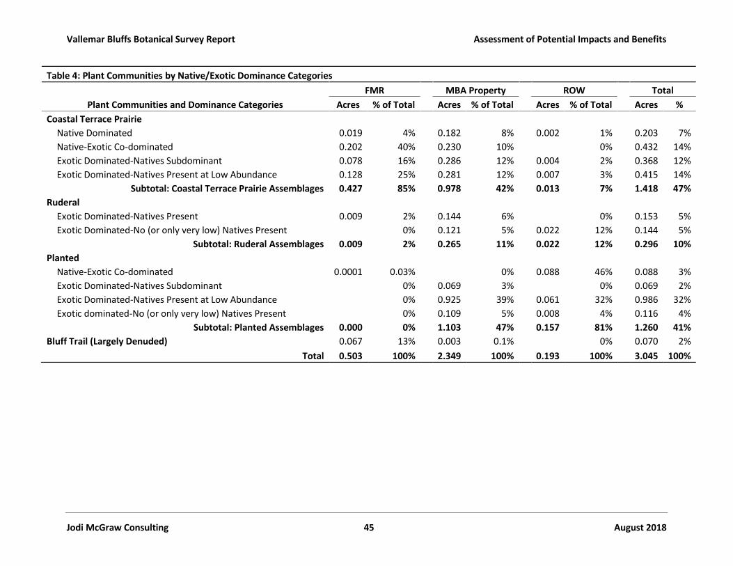
Vallemar Bluffs Botanical Survey Report Assessment of Potential Impacts and Benefits
Jodi McGraw Consulting 45 August 2018
Table 4: Plant Communities by Native/Exotic Dominance CategoriesFMR MBA Property ROW Total
Plant Communities and Dominance Categories Acres % of Total Acres % of Total Acres % of Total Acres %Coastal Terrace Prairie
Native Dominated 0.019 4% 0.182 8% 0.002 1% 0.203 7%Native-Exotic Co-dominated 0.202 40% 0.230 10% 0% 0.432 14%Exotic Dominated-Natives Subdominant 0.078 16% 0.286 12% 0.004 2% 0.368 12%Exotic Dominated-Natives Present at Low Abundance 0.128 25% 0.281 12% 0.007 3% 0.415 14%
Subtotal: Coastal Terrace Prairie Assemblages 0.427 85% 0.978 42% 0.013 7% 1.418 47%Ruderal
Exotic Dominated-Natives Present 0.009 2% 0.144 6% 0% 0.153 5%Exotic Dominated-No (or only very low) Natives Present 0% 0.121 5% 0.022 12% 0.144 5%
Subtotal: Ruderal Assemblages 0.009 2% 0.265 11% 0.022 12% 0.296 10%Planted
Native-Exotic Co-dominated 0.0001 0.03% 0% 0.088 46% 0.088 3%Exotic Dominated-Natives Subdominant 0% 0.069 3% 0% 0.069 2%Exotic Dominated-Natives Present at Low Abundance 0% 0.925 39% 0.061 32% 0.986 32%Exotic dominated-No (or only very low) Natives Present 0% 0.109 5% 0.008 4% 0.116 4%
Subtotal: Planted Assemblages 0.000 0% 1.103 47% 0.157 81% 1.260 41%Bluff Trail (Largely Denuded) 0.067 13% 0.003 0.1% 0% 0.070 2%
Total 0.503 100% 2.349 100% 0.193 100% 3.045 100%
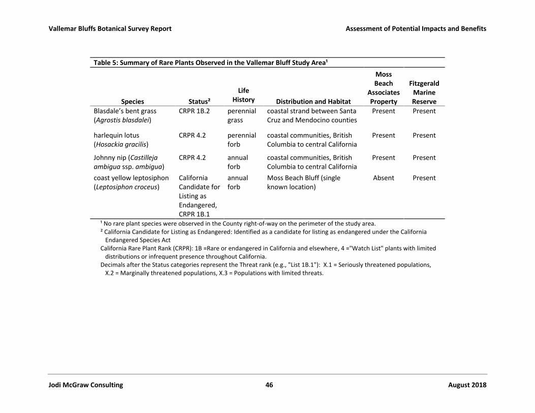
Vallemar Bluffs Botanical Survey Report Assessment of Potential Impacts and Benefits
Jodi McGraw Consulting 46 August 2018
Table 5: Summary of Rare Plants Observed in the Vallemar Bluff Study Area¹
Species Status²Life
History Distribution and Habitat
MossBeach
AssociatesProperty
FitzgeraldMarineReserve
Blasdale’s bent grass(Agrostis blasdalei)
CRPR 1B.2 perennialgrass
coastal strand between SantaCruz and Mendocino counties
Present Present
harlequin lotus(Hosackia gracilis)
CRPR 4.2 perennialforb
coastal communities, BritishColumbia to central California
Present Present
Johnny nip (Castillejaambigua ssp. ambigua)
CRPR 4.2 annualforb
coastal communities, BritishColumbia to central California
Present Present
coast yellow leptosiphon(Leptosiphon croceus)
CaliforniaCandidate forListing asEndangered,CRPR 1B.1
annualforb
Moss Beach Bluff (singleknown location)
Absent Present
¹ No rare plant species were observed in the County right-of-way on the perimeter of the study area.² California Candidate for Listing as Endangered: Identified as a candidate for listing as endangered under the California
Endangered Species ActCalifornia Rare Plant Rank (CRPR): 1B =Rare or endangered in California and elsewhere, 4 ="Watch List" plants with limited
distributions or infrequent presence throughout California.Decimals after the Status categories represent the Threat rank (e.g., "List 1B.1"): X.1 = Seriously threatened populations,
X.2 = Marginally threatened populations, X.3 = Populations with limited threats.

Vallemar Bluffs Botanical Survey Report Assessment of Potential Impacts and Benefits
Jodi McGraw Consulting 47 August 2018
Table 6: Rare Plant Occurrences within the Study Area
FMR MBA Totalsf ac Density sf ac Density sf ac Density
Blasdale’s bent grass 374 0.009 156 78 0.002 65 452 0.010 221coast yellow leptosiphon 746 0.017 13,416 - 34,097 ¹ 0 0.000 0 746 0.017 13,416 - 34,097 ¹Johnny nip 2,877 0.066 772 4,589 0.105 931 7,466 0.171 1,703harlequin lotus 0 0.000 2,050 0.047 133 2,050 0.047 133¹ No rare plant species were observed in the County right-of-way on the perimeter of the study area.
² Coast yellow leptosiphon abundance estimated coarsely through sampling of reproductive structures, and may not be accurate

Vallemar Bluffs Botanical Survey Report
Jodi McGraw Consulting 48 August 2018
Table 7: Acres within the limits of grading (LOG) and infiltration spreader area (spreader) in each Proposed MBA ParcelLot 1 Lot 2 Lot 3 Lot 4 All Parcels
Vegetation Type by Condition LOG Spreader LOG Spreader LOG Spreader LOG Spreader LOG Spreader TotalCoastal Terrace Prairie
Native Dominated 0.002 <0.001 0.002 <0.001 0.002Native-Exotic Co-dominated <0.001 0.003 <0.001 0.000 <0.001 0.004 0.004Exotic dominated-Natives Subdominant 0.002 <0.001 0.006 0.003 0.008 0.003 0.011Exotic Dominated-Natives Present 0.045 0.005 0.002 0.005 0.055 0.002 0.057
Subtotal: Coastal Terrace Prairie 0.048 0.003 0.005 0.003 0.007 0.000 0.006 0.003 0.065 0.010 0.074Ruderal 0.111 0.028 0.000 0.064 0.204 0.000 0.204Planted 0.053 0.166 0.001 0.240 0.003 0.173 0.000 0.632 0.005 0.637
Total 0.212 0.003 0.199 0.004 0.247 0.003 0.243 0.004 0.901 0.015 0.915
Table 8: Harlequin Lotus Habitat (in square feet) and Plants Within the Proposed Impact Areas
Lot 3 Lot 4 TotalImpact Area sf Est. Plants¹ sf Est. Plants¹ sf Est. Plants¹
Limits of Grading 81.5 3 202.0 12 283.5 15Spreader Area 2.8 0 52.5 5 55.3 5
Total 84.3 3 254.5 17 338.8 20¹ Density estimated based on the proportion of the total patch in the impact area and rounded to thenearest individual.No occupied habitat or individuals mapped in lots 1 and 2

Vallemar Bluffs Botanical Survey Report Assessment of Potential Impacts and Benefits
Jodi McGraw Consulting 49 August 2018
Table 9: Potential Restoration Areas (Figure 8)
Restoration Treatments Square Feet AcresAddress Unnatural Topography (Mound) 1,358 0.0312Address Unnatural Topography (Swale) 1,297 0.0298Control Dense Exotic Grasses and Forbs 10,568 0.2426Control Invasive Plants 1,700 0.0390Manage Native Disturbance-Adapted Plants 6,747 0.1549Remove Ice Plant Mats 5,991 0.1375Remove Planted/Ornamental Species 1,867 0.0429Remove Wood Chips 1,366 0.0314
Total 30,894 0.7092Establish Native Plants on De Facto Trails¹ 270 lineal feet¹ The trails overlap other restoration areas so their area was not included in the total
treatment area

Vallemar Bluffs Botanical Survey Report Assessment of Potential Impacts and Benefits
Jodi McGraw Consulting 50 August 2018
Table 10: Summary of the Effects of the Proposed Conservation and Development ProjectSpecial-Status
ResourceDirect Negative
Effects of ProjectIndirect NegativeEffects of Project
Benefits of Conservation andMitigation
Net Effects of theProject with Mitigation
CoastalTerracePrairie(sensitivenaturalcommunity)
0.065 ac. ofpermanentimpacts to largelydegraded (i.e.,exotic dominated)coastal terraceprairie located onthe westernperimeter ofdevelopmentfootprint
0.01 ac. ortemporaryimpacts to largelydegraded coastalterrace prairieresulting frominstallation of theinfiltrationspreaders; thehabitat will berestored followinginstallation anddescribed at right.
Potential to promote the invasionand spread of exotic plants,though they will be controlledduring implementation of therestoration and managementplans.
Potential to affect plant speciescomposition by altering drainageand thus soil moisture, though thiswill be limited through use ofpermeable pavers and installationof infiltration spreaders for runoff.
Potential to promote tramplingthrough additional recreationaluse, though impacts will be limitedthrough active recreationmanagement which is anticipatedto actually improve habitatconditions relative to currentconditions due to unmanagedpublic use.
Permanently protect 0.874acres of coastal terraceprairie.
Restore 0.71 acres ofhabitat by addressing asuite of anthopogenicfactors that havedegraded habitat (Table 9,Figure 8)
Active manage andmonitor habitat in theconservation area toaddress factors that coulddegrade it, includingexotic plants,incompatible recreation,and unanticipated indirecteffects of development.
The project will have a netbeneficial effect for coastalterrace prairie by:
Protecting coastal terraceprairie habitat at a ratio ofmore than 11:1. For everysquare foot of habitat thatwill be permanently ortemporarily impacted, 11.7square feet will be protectedand managed in perpetuity.
Restoring coastal terraceprairie habitat at a ratio ofmore than 9:1. For every 1square foot of coastal terraceprairie habitat to be impactedby the project, 9.5 acres willbe restored to increase nativeplant cover and diversity.
Managing and preventingfurther degradation ofhabitat that would otherwisebe expected to occur if thesite is not actively managedto address anthropogenicimpacts includingunrestricted public access.

Vallemar Bluffs Botanical Survey Report Assessment of Potential Impacts and Benefits
Jodi McGraw Consulting 51 August 2018
Table 10: Summary of the Effects of the Proposed Conservation and Development ProjectSpecial-Status
ResourceDirect Negative
Effects of ProjectIndirect NegativeEffects of Project
Benefits of Conservation andMitigation
Net Effects of theProject with Mitigation
CoastYellowLeptosiphon(CE, CRPR1B.1)
Likely None. Thisspecies was notobserved on theproject propertyduring 2018 orduring most prioryears (Corelli 2016).Habitat in thedevelopment area ishighly unsuitabledue to the densecover, includingwoody vegetation;soils are darker andbrowner and manynot be suitable aswell. The singleplant observed onthe property in 2016(CDFW 2017) mayhave resulted frommediated dispersalby neighbors whoreported dispersingseed atop VallemarBluffs to expand thepopulation.
There is a low likelihood of negativeindirect effects, which will bemitigated as described.
Potential to promote exotic plants(i.e. through disturbance andintroduction of seed in developedareas) will be mitigated throughimplementation of the restorationand management plans.
Potential for altered drainage toaffect soil moisture in ways thatcould impact the species directlyor indirectly, through increasedcompetition, will be reducedthrough use of permeable paversand installation of infiltrationspreaders.
The addition of four homes isunlikely to increase the frequencyor intensity of recreation on theFMR, which already receives highpublic use. Recreationmanagement, as outlined in themanagement plan, andenforcement of the easement, asnecessary, can help addressincompatible recreation uses.
Permanently protecting andmanaging the 0.92-acreconservation area, andrestoring 0.71 acres, includingby controlling exotic plants,will enhance coastal terraceprairie and may facilitateexpansion of this rare plant;however, much of the coastalterrace prairie in theconservation area supportstaller, denser grasses andforbs and features darker soilsthan observed in the currentlyoccupied area, such that itmay not ultimately be suitablefor this diminutive rare plantfound in light colored soilswith sparser plant cover.
The project may have a netbeneficial effect for this rareplant by reducing the abundanceof exotic plants, which likelycompete with the native plant,promoting management ofrecreation atop Vallemar Bluffs,may also benefit this species,though some level of disturbanceby recreators may help maintainsuitable habitat.

Vallemar Bluffs Botanical Survey Report Assessment of Potential Impacts and Benefits
Jodi McGraw Consulting 52 August 2018
Table 10: Summary of the Effects of the Proposed Conservation and Development ProjectSpecial-Status
ResourceDirect Negative
Effects of ProjectIndirect NegativeEffects of Project
Benefits of Conservation andMitigation
Net Effects of theProject with Mitigation
Blasdale’sbent grass(CRPR 1B.2)
Likely None. Thisspecies was notobserved in thedevelopment areaduring the 2018survey; the onlypatch on site is onthe western edge ofthe conservationarea where habitatis more open andshort-statured, ason the FMRproperty whichsupports the largeroccurrence. Thespecies generallyoccurs in shorter-statured grasslandsthat are largelyabsent from theimpact area;therefore, it isunlikely to bepresent in a below-ground seed bank inthe impact area.
Same as for coast yellow leptosiphon Permanently protectingthe 0.92-acre conservationarea, which includes a 78-sf occurrence of Blasdale’sbent grass featuring 65plants in 2018, will expandthe 374-sf area ofprotected, occupiedhabitat supporting 156plants in 2018 in the FMR.
Restoring 0.71 acres ofcoastal terrace prairie andmanaging the entire 0.92-acre conservation area, toaddress factors thatdegrade habitat forBlasdale’s bent grass,including incompatiblerecreation and denseexotic plants, will enhancehabitat for the rare plantand expand thepopulation, provided thecoastal terrace prairiehabitat within the site issuitable.
The project will benefitBlasdale’s bent grass, bycompleting avoiding impacts tothe species during development,protecting and managing 78 sf ofoccupied habitat and anadditional 0.92 acres ofpotentially suitable habitat.Restoration of the 0.71 acres ofcoastal terrace prairie in theconservation area may provideadditional opportunities forspecies expansion, though someof the habitat in the conservationarea may have unsuitable soils orotherwise prove unsuitable forthis taxon.

Vallemar Bluffs Botanical Survey Report Assessment of Potential Impacts and Benefits
Jodi McGraw Consulting 53 August 2018
Table 10: Summary of the Effects of the Proposed Conservation and Development ProjectSpecial-Status
ResourceDirect Negative
Effects of ProjectIndirect NegativeEffects of Project
Benefits of Conservation andMitigation
Net Effects of theProject with Mitigation
HarlequinLotus(CRPR 4.2)
Permanent loss of284 sf of occupiedhabitat supporting~15 individuals onthe western edgeof the limits ofgrading.
Temporary loss of55 sf of supporting~5 individualswithin the areaswhere infiltrationspreaders will beinstalled.
Same as for coast yellow leptosiphon(and Blasdale’s bent grass), though thepotential for indirect impacts isarguably higher for this taxon owing toits closer proximity to the proposeddevelopment. Nonetheless,implementation of the mitigationmeasures recommended here,including development andimplementation of management andrestoration plans prepared for thesite, is anticipated to limit thepotential for indirect, negative effectsof the development to impact thisspecies of limited distribution.
Permanently protectingthe 0.92-acre conservationarea, which includes a1,711 sf of occupiedharlequin lotus habitatsupporting 113 plants in2018.
Restoring 0.71 acres ofcoastal terrace prairie andmanaging the entire 0.92-acre conservation area toaddress factors thatdegrade habitat for thisspecies, includingincompatible recreationand dense exotic plants,may enhance habitat forthe rare plant and expandthe population, providedthe coastal terrace prairiehabitat within the site issuitable.
The project will have a netbenefit for harlequin lotus. The conservation area will
protect harlequin lotushabitat at a ratio of 5:1; forevery one of the 339 squarefeet impacted bydevelopment, 5 sf (1,711 sftotal) will be protected.
The ratio for individuals isnearly 6:1 (113 individualswill be protected for the 20 inthe development area); thiscould be increased throughthe salvage of seed, sod,and/or topsoil prior todevelopment for use inonsite restoration.Management and restorationof 0.92 acres and 0.71 acreswithin the site, respectively,will create opportunities forpopulation expansionincluding by reducingcompetition with denseexotic plants that mayoutcompete the native plant.
Johnny Nip(CRPR 4.2)
Likely None. Thisspecies was notobserved in the
Same as for coast yellow leptosiphon(and Blasdale’s bent grass), though thepotential for indirect impacts is
Permanently protectingthe 0.92-acre conservationarea, which features 0.105
The project will benefit Johnnynip by completing avoidingimpacts to the species during
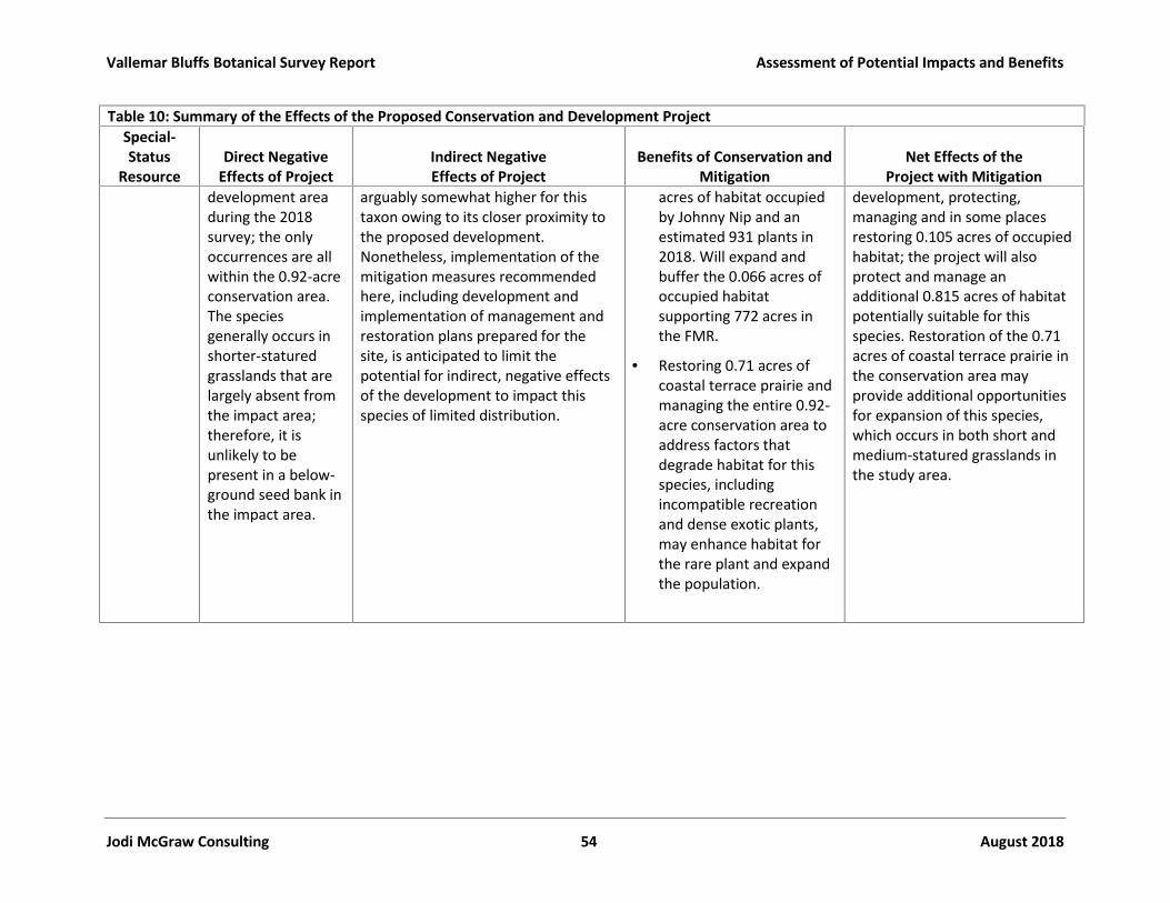
Vallemar Bluffs Botanical Survey Report Assessment of Potential Impacts and Benefits
Jodi McGraw Consulting 54 August 2018
Table 10: Summary of the Effects of the Proposed Conservation and Development ProjectSpecial-Status
ResourceDirect Negative
Effects of ProjectIndirect NegativeEffects of Project
Benefits of Conservation andMitigation
Net Effects of theProject with Mitigation
development areaduring the 2018survey; the onlyoccurrences are allwithin the 0.92-acreconservation area.The speciesgenerally occurs inshorter-staturedgrasslands that arelargely absent fromthe impact area;therefore, it isunlikely to bepresent in a below-ground seed bank inthe impact area.
arguably somewhat higher for thistaxon owing to its closer proximity tothe proposed development.Nonetheless, implementation of themitigation measures recommendedhere, including development andimplementation of management andrestoration plans prepared for thesite, is anticipated to limit thepotential for indirect, negative effectsof the development to impact thisspecies of limited distribution.
acres of habitat occupiedby Johnny Nip and anestimated 931 plants in2018. Will expand andbuffer the 0.066 acres ofoccupied habitatsupporting 772 acres inthe FMR.
Restoring 0.71 acres ofcoastal terrace prairie andmanaging the entire 0.92-acre conservation area toaddress factors thatdegrade habitat for thisspecies, includingincompatible recreationand dense exotic plants,may enhance habitat forthe rare plant and expandthe population.
development, protecting,managing and in some placesrestoring 0.105 acres of occupiedhabitat; the project will alsoprotect and manage anadditional 0.815 acres of habitatpotentially suitable for thisspecies. Restoration of the 0.71acres of coastal terrace prairie inthe conservation area mayprovide additional opportunitiesfor expansion of this species,which occurs in both short andmedium-statured grasslands inthe study area.
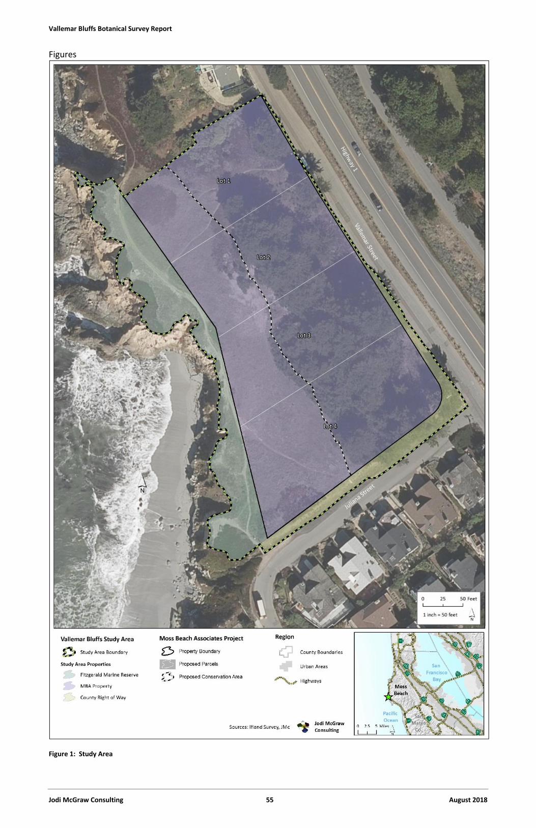
Vallemar Bluffs Botanical Survey Report
Jodi McGraw Consulting 55 August 2018
Figures
Figure 1: Study Area

Vallemar Bluffs Botanical Survey Report
Jodi McGraw Consulting 56 August 2018
Figure 2: Historical Aerial Imagery of the Study Area, showing: a) 1972 b) 1979, c) 2002, and d) 2005.

Vallemar Bluffs Botanical Survey Report Assessment of Potential Impacts and Benefits
Jodi McGraw Consulting 57 August 2018
Figure 2 (cont.): Historical Aerial Imagery of the Study Area, showing: e) 2008, f) 2009, g) 2010, and h) 2013.

Vallemar Bluffs Botanical Survey Report
Jodi McGraw Consulting 58 August 2018
Figure 3: Plant Community (Vegetation) Structure

Vallemar Bluffs Botanical Survey Report Assessment of Potential Impacts and Benefits
Jodi McGraw Consulting 59 August 2018
Figure 4: Plant Communities and Assemblages

Vallemar Bluffs Botanical Survey Report Assessment of Potential Impacts and Benefits
Jodi McGraw Consulting 60 August 2018
Figure 5: Plant Communities by Native/Exotic Dominance Categories

Vallemar Bluffs Botanical Survey Report Assessment of Potential Impacts and Benefits
Jodi McGraw Consulting 61 August 2018
Figure 6: Rare Plants
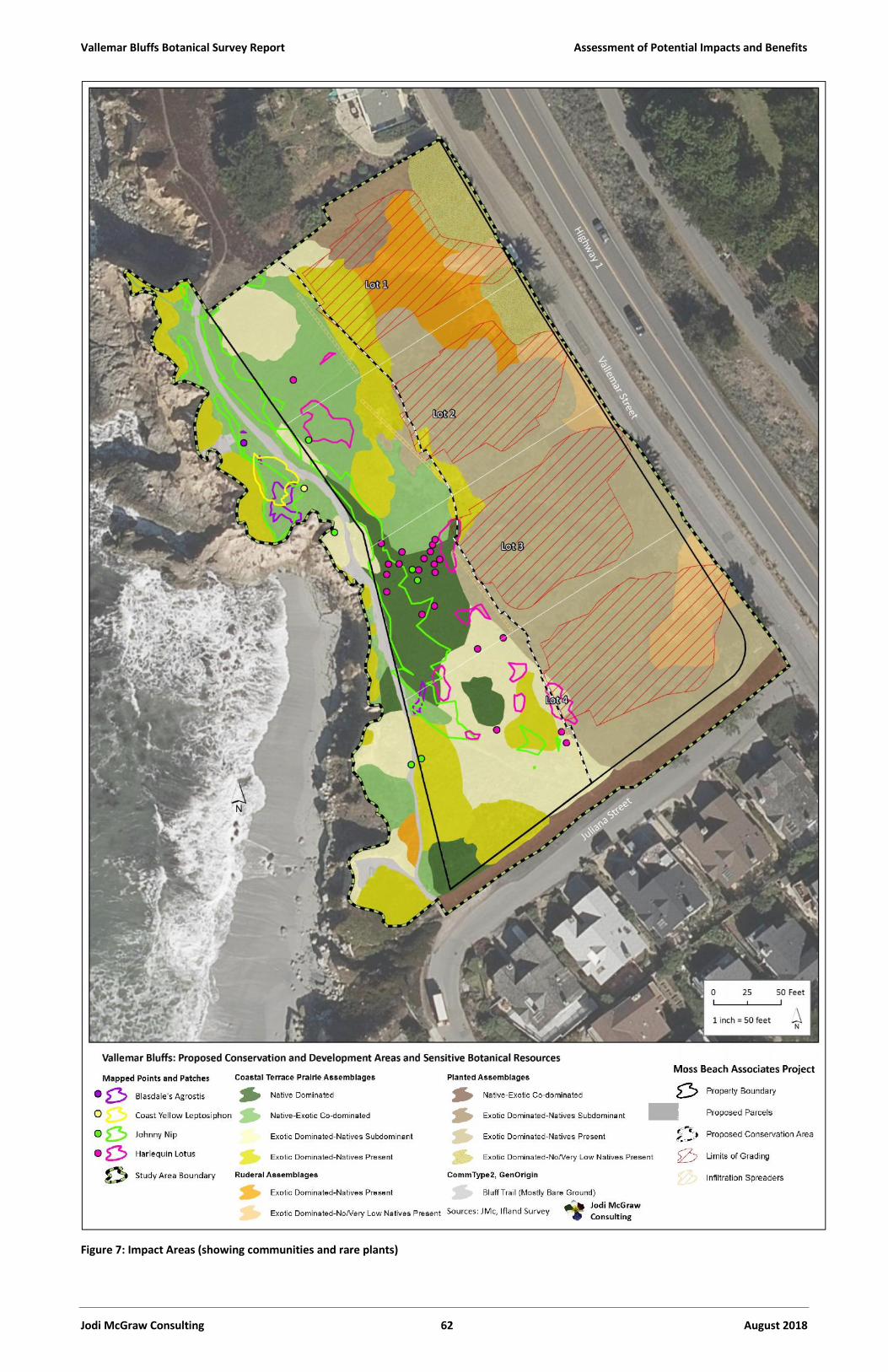
Vallemar Bluffs Botanical Survey Report Assessment of Potential Impacts and Benefits
Jodi McGraw Consulting 62 August 2018
Figure 7: Impact Areas (showing communities and rare plants)
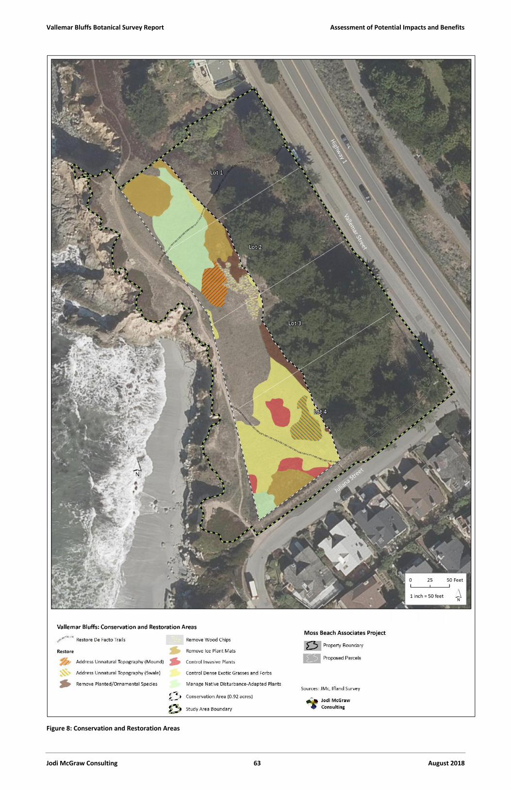
Vallemar Bluffs Botanical Survey Report Assessment of Potential Impacts and Benefits
Jodi McGraw Consulting 63 August 2018
Figure 8: Conservation and Restoration Areas
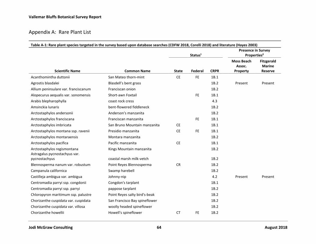
Vallemar Bluffs Botanical Survey Report
Jodi McGraw Consulting 64 August 2018
Appendix A: Rare Plant List
Table A-1: Rare plant species targeted in the survey based upon database searches (CDFW 2018, Corelli 2018) and literature (Hayes 2003)
Status¹Presence in Survey
Properties²
Scientific Name Common Name State Federal CRPR
Moss BeachAssoc.
Property
FitzgeraldMarineReserve
Acanthomintha duttonii San Mateo thorn-mint CE FE 1B.1Agrostis blasdalei Blasdell’s bent grass 1B.2 Present PresentAllium peninsulare var. franciscanum Franciscan onion 1B.2Alopecurus aequalis var. sonomensis Short-awn Foxtail FE 1B.1Arabis blepharophylla coast rock cress 4.3Amsinckia lunaris bent-flowered fiddleneck 1B.2Arctostaphylos andersonii Anderson's manzanita 1B.2Arctostaphylos franciscana Franciscan manzanita FE 1B.1Arctostaphylos imbricata San Bruno Mountain manzanita CE 1B.1Arctostaphylos montana ssp. ravenii Presidio manzanita CE FE 1B.1Arctostaphylos montaraensis Montara manzanita 1B.2Arctostaphylos pacifica Pacific manzanita CE 1B.1Arctostaphylos regismontana Kings Mountain manzanita 1B.2Astragalus pycnostachyus var.pycnostachyus coastal marsh milk-vetch 1B.2Blennosperma nanum var. robustum Point Reyes Blennosperma CR 1B.2Campanula californica Swamp harebell 1B.2Castilleja ambigua var. ambigua Johnny-nip 4.2 Present PresentCentromadia parryi ssp. congdonii Congdon's tarplant 1B.1Centromadia parryi ssp. parryi pappose tarplant 1B.2Chloropyron maritimum ssp. palustre Point Reyes salty bird's-beak 1B.2Chorizanthe cuspidata var. cuspidata San Francisco Bay spineflower 1B.2Chorizanthe cuspidata var. villosa woolly headed spineflower 1B.2Chorizanthe howellii Howell's spineflower CT FE 1B.2

Vallemar Bluffs Botanical Survey Report Appendix A: Initial Rare Plant List
Jodi McGraw Consulting 65 August 2018
Table A-1: Rare plant species targeted in the survey based upon database searches (CDFW 2018, Corelli 2018) and literature (Hayes 2003)
Status¹Presence in Survey
Properties²
Scientific Name Common Name State Federal CRPR
Moss BeachAssoc.
Property
FitzgeraldMarineReserve
Chorizanthe robusta var. hartwegii Scott's Valley spineflower FE 1B.1Chorizanthe robusta var. robusta robust spineflower FE 1B.1Chorizanthe valida Sonoma spineflower CE FE 1B.1Cirsium andrewsii Franciscan thistle 1B.2Cirsium fontinale var. fontinale Crystal Springs fountain thistle CE FE 1B.1Cirsium occidentale var. compactum compact cobwebby thistle 1B.2Collinsia multicolor San Francisco collinsia 1B.2Dirca occidentalis western leatherwood 1B.2Eriogonum luteolum var. caninum Tiburon buckwheat 1B.2Eriophyllum latilobum San Mateo woolly sunflower CE FE 1B.1Erysimum franciscanum San Francisco wallflower 4.2Fritillaria biflora var. ineziana Hillsborough chocolate lily 1B.1Fritillaria liliacea fragrant fritillary 1B.2Gilia capitata ssp. chamissonis blue coast gilia 1B.1Grindelia hirsutula var. maritima San Francisco gumplant 3.2Helianthella castanea Diablo helianthella 1B.2Hemizonia congesta ssp. congesta congested-headed hayfield tarplant 1B.2Hemizonia congesta ssp. tracyi Tracy's tarplant 4.3Hesperevax sparsiflora var. brevifolia short-leaved evax 1B.2Hesperocyparis macrocarpa Monterey cypress 1B.2 Present*Hesperolinon congestum Marin western flax CT FT 1B.1Holocarpha macradenia Santa Cruz tarplant CE FT 1B.1Horkelia cuneata var. sericea Kellogg's horkelia 1B.1Horkelia marinensis Point Reyes horkelia 1B.2Hosackia gracilis harlequin lotus 4.2 Present
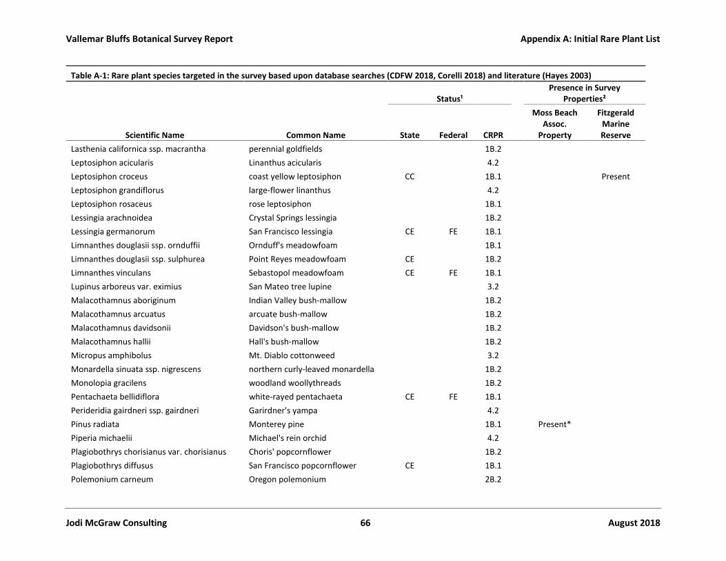
Vallemar Bluffs Botanical Survey Report Appendix A: Initial Rare Plant List
Jodi McGraw Consulting 66 August 2018
Table A-1: Rare plant species targeted in the survey based upon database searches (CDFW 2018, Corelli 2018) and literature (Hayes 2003)
Status¹Presence in Survey
Properties²
Scientific Name Common Name State Federal CRPR
Moss BeachAssoc.
Property
FitzgeraldMarineReserve
Lasthenia californica ssp. macrantha perennial goldfields 1B.2Leptosiphon acicularis Linanthus acicularis 4.2Leptosiphon croceus coast yellow leptosiphon CC 1B.1 PresentLeptosiphon grandiflorus large-flower linanthus 4.2Leptosiphon rosaceus rose leptosiphon 1B.1Lessingia arachnoidea Crystal Springs lessingia 1B.2Lessingia germanorum San Francisco lessingia CE FE 1B.1Limnanthes douglasii ssp. ornduffii Ornduff's meadowfoam 1B.1Limnanthes douglasii ssp. sulphurea Point Reyes meadowfoam CE 1B.2Limnanthes vinculans Sebastopol meadowfoam CE FE 1B.1Lupinus arboreus var. eximius San Mateo tree lupine 3.2Malacothamnus aboriginum Indian Valley bush-mallow 1B.2Malacothamnus arcuatus arcuate bush-mallow 1B.2Malacothamnus davidsonii Davidson's bush-mallow 1B.2Malacothamnus hallii Hall's bush-mallow 1B.2Micropus amphibolus Mt. Diablo cottonweed 3.2Monardella sinuata ssp. nigrescens northern curly-leaved monardella 1B.2Monolopia gracilens woodland woollythreads 1B.2Pentachaeta bellidiflora white-rayed pentachaeta CE FE 1B.1Perideridia gairdneri ssp. gairdneri Garirdner's yampa 4.2Pinus radiata Monterey pine 1B.1 Present*Piperia michaelii Michael's rein orchid 4.2Plagiobothrys chorisianus var. chorisianus Choris' popcornflower 1B.2Plagiobothrys diffusus San Francisco popcornflower CE 1B.1Polemonium carneum Oregon polemonium 2B.2

Vallemar Bluffs Botanical Survey Report Appendix A: Initial Rare Plant List
Jodi McGraw Consulting 67 August 2018
Table A-1: Rare plant species targeted in the survey based upon database searches (CDFW 2018, Corelli 2018) and literature (Hayes 2003)
Status¹Presence in Survey
Properties²
Scientific Name Common Name State Federal CRPR
Moss BeachAssoc.
Property
FitzgeraldMarineReserve
Polygonum hickmanii Scotts Valley Polygonum CE FE 1B.1Potentilla hickmanii Hickman's cinquefoil CE FE 1B.1Psilocarphus tenellus var. globiferus Round Woolly MarblesSanicula maritima adobe or maritime sanicle CR 1B.1Sidalcea calycosa ssp. rhizomata Pt. Reyes Checkerbloom 1B.2Silene verecunda ssp. verecunda San Francisco campion 1B.2Stebbinsoseris decipiens Santa Cruz microseris 1B.2Trifolium amoenum showy rancheria clover FE 1B.1Trifolium buckwestiorum Santa Cruz clover 1B.1Trifolium hydrophilum saline clover 1B.2Trifolium polyodon Pacific Grove clover CR 1B.1Triphysaria floribunda San Francisco owl's-clover 1B.2Triquetrella californica coastal triquetrella 1B.2Usnea longissima Methuselah's beard lichen 4.2
¹ Status DesignationsState: Status under California Endangered Species Act (endangered and threatened) or California Native Plant Protection Act (rare)
CE: EndangeredCT: ThreatenedCR: Rare
Federal: Status under Federal Endangered Species Act
FE: Endangered
FT: Threatened
California Rare Plant Rank (CRPR):
1B: Rare or endangered in California and elsewhere2B: Plants rare, threatened, or endangered in California but more common elsewhere3: Review List: Plants about which more information is needed

Vallemar Bluffs Botanical Survey Report Appendix A: Initial Rare Plant List
Jodi McGraw Consulting 68 August 2018
Table A-1: Rare plant species targeted in the survey based upon database searches (CDFW 2018, Corelli 2018) and literature (Hayes 2003)
Status¹Presence in Survey
Properties²
Scientific Name Common Name State Federal CRPR
Moss BeachAssoc.
Property
FitzgeraldMarineReserve
4 ="Watch List" plants with limited distributions or infrequent presence throughout California.Decimals after the Status categories represent the Threat rank (e.g., "List 1B.1"):
X.1 = Seriously threatened populations
X.2 = Marginally threatened populationsX.3 = Populations with limited threats.
² Presence in Survey PropertiesPresent: Found on site as part of a naturally occurring populationPresent*: Found on site but almost certainly planted or spread from prior planted area as individuals located outside of natural rangeAll blank cells represent species not observed on the property in question during the survey in 2018, or in the 2015 survey (Zander Assoc. 2015)

Vallemar Bluffs Botanical Survey Report
Jodi McGraw Consulting 69 August 2018
Appendix B: Results of Floristic Survey of Vallemar Bluffs
Table B-1: List of plant species observed in survey area
Name FamilyOrigin, Life Form, and
Special Status
Moss BeachAssoc.
Property
FitzgeraldMarineReserve
Achillea millefolium (Yarrow) Asteraceae Native Per. forb L N
Acmispon wrangelianus (Chilean trefoil) Fabaceae Native Ann. Forb L L
Aeonium sp. (tree houseleek) Crassulaceae Exotic succulent L N
Agrostis blasdalei (Blasdale’s bent grass) Poaceae Native Per. Grass(rhizome) (CRPR 1B.1)
L L
Allium triquetrum(White flowered onion)
Liliaceae Exotic Per. bulb N/R N
Aptenia cordifolia (baby sun-rose) Aizoaceae Exotic Succulent N/R N
Armeria maritima ssp. californica (Sea thrift) Plumbaginaceae Native Per. Forb M M
Avena barbata (Slim oat) Poaceae Exotic Ann. Or per. Grass L L
Avena fatua (Wild oat) Poaceae Exotic Ann. grass L L
Baccharis pilularis(Coyote brush)
Asteraceae Native Shrub L N
Brachypodium distachyon(False brome)
Poaceae Exotic Ann./per. Grass L L
Briza maxima(Rattlesnake grass)
Poaceae Exotic Ann. grass M N
Briza minor (Annual quaking grass, smallquaking grass)
Poaceae Exotic Ann. grass L N
Bromus carinatus var. carinatus (Californiabrome)
Poaceae Native Per. Grass N/R N
Bromus diandrus (Rip gut brome) Poaceae Exotic Ann. Grass M L
Bromus hordeaceus (Soft chess) Poaceae Exotic Ann. grass L L
Bromus maritimus (maritime brome)[formerly B. carinatus var. maritimus]
Poaceae Native per. Grass M M
Calandrinia ciliata (red maids) Montiaceae Native Ann. forb L L
Carduus pycnocephalus(Italian thistle)
Asteraceae Exotic Ann. Herb L N
Carex sp. Cyperaceae (likely) native per. herb L N
Carpobrotus chilensis (Sea fig) Aizoaceae Exotic Per. Forb(succulent)
M M
Carpobrotus edulis (Hottentot-fig) Aizoaceae Exotic Per. Forb(succulent)
H H
Castilleja ambigua ssp. ambigua (Johnnynip)
Orobranchaceae Native Ann. Forb (CRPR4.2)
M M
Cerastium glomeratum (Sticky mouse-earchickweed)
Caryophyllaceae Exotic Ann. Forb L N
Chasmanthe floribunda (chasmanthe) Iridaceae Exotic Per. Herb N/R N
Clarkia amoena Onagraceae Native N L

Vallemar Bluffs Botanical Survey Report Appendix B: Plant Species List
Jodi McGraw Consulting 70 August 2018
Table B-1: List of plant species observed in survey area
Name FamilyOrigin, Life Form, and
Special Status
Moss BeachAssoc.
Property
FitzgeraldMarineReserve
Conium maculatum (poison hemlock) Apiaceae Exotic Per. Herb L N
Cortaderia jubata (Jubata grass) Poaceae Exotic Per. Grass L N
Crocosmia crocosmiiflora (Montbretia) Iridaceae Exotic Per. Herb N/R N
Danthonia californica (California oatgrass) Poaceae Native Per. Grass L N
Daucus pusillus (wild carrot) Apiaceae Native Ann. Herb L L
Delairea odorata (Cape Ivy) Asteraceae Exotic Per. Herb (vine) L N
Deschampsia caespitosa ssp. holciformis(Pacific hairgrass or coastal tufted hairgrass)
Poaceae Native Per. Grass H H
Dudleya farinosa (bluff lettuce) Crassulaceae Native Per herb(succulent)
N L
Echium candicans (pride of Madeira) Boraginaceae Exotic Shrub L N
Echium pininan) pine echium Boraginaceae Exotic Shrub L N
Ehrharta erecta (Panic veldt grass) Poaceae Exotic Per. Grass M N
Elymus triticoides (beardless wild rye) Poaceae Native Per. Grass L* N
Erigeron canadensis (Canada horseweed) Asteraceae Native Ann. Herb N/R N
Erigeron glaucus (seaside daisy) Asteraceae Native Per. Herb(subshrub)
N L
Eriogonum latifolium (coast buckwheat) Polygonaceae Native per. Herb orsubshrub
N M
Eryngium armatum (coastal eryngo orcoyote thistle or coastal button celery)
Apiaceae Native per. Herb M M
Epilobium cf. brachycarpum (annualfireweed)
Onagraceae Native Ann. Herb L N
Euphorbia peplus Euphorbiaceae Exotic Ann. Herb L N
Festuca myuros (rattail fescue) Poaceae Exotic Ann. grass L L
Festuca perennis (Italian rye grass) Poaceae Exotic Ann./per. grass H M
Fragaria chiloensis (Beach strawberry) Rosaceae Native Per. Forb M M
Fumaria parviflora (fine leaved fumitory) Papaveraceae Exotic Ann. forb L N
Galium aparine Rubiaceae Native ann. Herb L N
Gamochaeta ustulata (purple cudweed, orfeatherweed)
Asteraceae Native Ann. Biennial. Orshort-lived per. forb
M M
Geranium dissectum (cut leaf geranium) Geraniaceae Exotic Ann. herb L L
Grindelia stricta var. platyphylla (gumplant) Asteraceae Native Per. Forb M M
Helminthotheca echioides (Picris echioides;Bristly ox tongue)
Asteraceae Exotic M L
Hesperocyparis macrocarpa Cupressaceae Native Tree (though notnative to the site)
H N
Holcus lanatus (velvet grass) Poaceae Exotic Per. Grass L* N

Vallemar Bluffs Botanical Survey Report Appendix B: Plant Species List
Jodi McGraw Consulting 71 August 2018
Table B-1: List of plant species observed in survey area
Name FamilyOrigin, Life Form, and
Special Status
Moss BeachAssoc.
Property
FitzgeraldMarineReserve
Hordeum brachyantherum (meadow barley) Poaceae Native Ann. Grass L L
Hordeum murinum ssp. leporinum (harebarley)
Poaceae Exotic Ann. Grass L L
Hosackia gracilis (Harlequin lotus) Fabaceae Native Per. Forb CRPR 4.2) L N
Hypochaeris radicata (Hairy cat’s ears) Asteraceae Exotic Per. Forb H H
Juncus bufonius (Common toad rush) Juncaceae Native Ann. Graminoid L* N
Juncus effusus (common bog rush) Juncaceae Native Per. Graminoid L* N
Juncus patens (spreading rush) Juncaceae Native Per. Graminoid L* N
Kickxia elatine (sharp point fluellin) Plantaginaceae Exotic per. Herb N/R N
Lepidium didymum (Lesser swine cress) Brassicaceae Exotic Ann. Herb N/R N
Leptosiphon croceus (Coast yellowleptosiphon)
Polemoniaceae Native Ann. Herb (CPRP1B.1), CE
N M
Linum bienne (flax) Linaceae Exotic biennial Herb L N
Lotus corniculatus (Birds foot trefoil) Fabaceae Exotic Per. Herb M N
Lupinus versicolor Fabaceae Native per. Herb or low-growing subshrub
M M
Lysimachia arvensis (Anagallis arvensis;Scarlet pimpernel)
Myrsinaceae Exotic Ann. Forb M L
Madia gracilis (slender tarweed; gumweed) Asteraceae Native Ann. forb N/R N
Madia sativa (Coastal tarweed) Asteraceae Native Ann. forb H M
Malva arborea Tree mallow) Malvaceae Exotic biennial to subshrub N L
Malva pseudolavatera (Cretan mallow) Malvaceae Exotic ann, biennial, orsubshrub
N L
Medicago polymorpha (Ca. bur clover) Fabaceae Exotic Ann. Forb M M
Melilotus indicus (sour clover) Fabaceae Exotic Ann. herb M M
Myoporum laetum (Ngaio tree) Myoporaceae Exotic Shrub/Tree M N
Nasturtium officinale (Watercress) Brassicaceae Native per herb (aquatic) L N
Oenothera cf. glazioviana Onagraceae Exotic per. Herb L L
Pinus radiata (Monterey pine) Pinaceae Native Tree (though notnative to the site)
L N
Pittosporum tobira (Japanese pittosporum) Pittosporaceae Exotic Shrub/Tree M N
Plantago coronopus (Cut leaf plantain) Plantaginaceae Exotic Ann. Or biennialForb
H H
Plantago lanceolata (English plantain) Plantaginaceae Exotic Per. Forb H H
Poa annua (Annual blue grass) Poaceae Exotic ann. grass L L
Poa douglasii (sand dune blue grass) Poaceae Native per. Grass N/R L

Vallemar Bluffs Botanical Survey Report Appendix B: Plant Species List
Jodi McGraw Consulting 72 August 2018
Table B-1: List of plant species observed in survey area
Name FamilyOrigin, Life Form, and
Special Status
Moss BeachAssoc.
Property
FitzgeraldMarineReserve
Poa unilateralis ssp. unilateralis (SanFrancisco bluegrass)
Poaceae Native per. Grass N/R L
Polygonum paronychia (dune knotweed) Polygonaceae Native per. Herb tosubshrub
N/R N
Polypogon monspeliensis (rabbitsfoot grass) Poaceae Exotic ann. Grass L N
Pseudognaphalium stramineum (Annualcudweed or Cottonballing plant)
Asteraceae Native ann. or biennialHerb
Y N
Ranunculus californicus (Californiabuttercup)
Ranunculaceae Native per. Herb M N
Raphanus sativus (wild radish) Brassicaceae Exotic ann. or biennialherb
M M
Rubus ursinus (California blackberry) Rosaceae Native Vine, shrub L N
Rumex acetosella (common sheep sorrel) Polygonaceae Exotic per. Herb L N
Rumex crispus (curly doc) Polygonaceae Exotic per. Herb L L
Rumex salicifolius (willow leaved dock) Polygonaceae Native per. Herb L N
Sagina apetala (dwarf pearlwort) Caryophyllaceae Native ann. herb N/R L
Scabiosa atropurpurea (pincushion flower) Dipsaceae Exotic Ann. herb M N
Scandix pecten-veneris Venus’ needle) Apiaceae Exotic ann. herb or vine N/R N
Senecio vulgaris (common groundsel) Asteraceae Exotic ann. herb N/R N
Sequoia sempervirens (coast redwood) Cupressaceae Native Tree (thoughunlikely native to the site)
L
Sidalcea malviflora ssp. malviflora (dwarfcheckerbloom)
Malvaceae Native per. Herb L L
Silene gallica (windmill pink, commoncatchfly)
Caryophyllaceae Exotic ann. herb L N
Silybum marianum (milk thistle) Asteraceae Exotic ann. or per. Herb L L
Sisyrinchium bellum (blue eyed grass) Iridaceae Native Per. Herb L N
Sonchus asper (spiny sowthistle) Asteraceae Exotic ann. forb L N
Sonchus oleraceus (Common sowthistle) Asteraceae Exotic Ann. forb L N
Spergularia macrotheca var. macrotheca(sticky sand spurrey)
Caryophyllaceae Native per. Herb L L
Stebbinsoseris decipiens (Stebbinsmicroseris)
Asteraceae Native Ann. herb CRPR1B.2
L N
Stellaria media (chickweed) Caryophyllaceae Exotic ann. forb L N
Stipa pulchra (purple needle grass) Poaceae Native per. Grass L* N
Symphyotrichum chilense (California aster)[formerly Aster chilensis]
Asteraceae Native per. Herb L N
Taraxacum officinale (dandelion) Asteraceae Exotic per. Herb L N

Vallemar Bluffs Botanical Survey Report Appendix B: Plant Species List
Jodi McGraw Consulting 73 August 2018
Table B-1: List of plant species observed in survey area
Name FamilyOrigin, Life Form, and
Special Status
Moss BeachAssoc.
Property
FitzgeraldMarineReserve
Taraxia ovata (sun cups) [formerlyOenothera ovata]
Onagraceae Native per. Herb L L
Trifolium dubium (little hop clover) Fabaceae Exotic ann. herb L N
Vicia sativa ssp. sativa (common vetch) Fabaceae Exotic ann. herb/vine L N
Zeltnera davyi (Davy’s centaury) Gentianaceae Native ann. herb L L
Presence IndicationsHigh (H): Present at relatively high abundanceModerate (M): Present at moderate abundanceLow (L): Present at relatively low abundanceNot Present (N): Species not present or not observed during surveyNot Present but Previously Recorded (N/R): Species not observed in 2018 survey by recorded by Zander Associates (2015)
* Observed only in County Right-of-Way adjacent to MBA property; separate column for the ROW was not included tosimplify the table