Embed Size (px)
Citation preview

11/21/05 Draft Project Report: Hollister Avenue Overcrossing Replacement Page iii
DRAFT PROJECT REPORT
1. INTRODUCTION .............................................................................................................1
2. RECOMMENDATION ....................................................................................................1
3. BACKGROUND................................................................................................................1
• Project History .................................................................................................1• Community Interaction ....................................................................................2• Existing Facility...............................................................................................2
4. NEED AND PURPOSE.....................................................................................................3
A. Problem, Deficiencies, Justification .......................................................................3B. Regional and System Planning ...............................................................................4
• Systems ............................................................................................................4• State Planning ..................................................................................................4• Regional Planning............................................................................................4• Local Planning .................................................................................................5
C. Traffic .......................................................................................................................5• Current and Forecasted Traffic ........................................................................5• Accident Rates .................................................................................................5
5. ALTERNATIVES .............................................................................................................6
A. Viable Alternatives ..................................................................................................6• Proposed Engineering Features .......................................................................6• Nonstandard Mandatory and Advisory Design Features .................................7• Utility and Other Owner Involvement .............................................................8• Railroad Involvement ......................................................................................8• Highway Planting ............................................................................................8• Erosion Control................................................................................................9• Non-Motorized and Pedestrian Features, etc. ..................................................9• Needed Roadway Rehabilitation and Upgrading...........................................10• Needed Structure Rehabilitation and Upgrading ...........................................10• Cost Estimates................................................................................................10• Right of Way Data .........................................................................................10
B. Rejected Alternatives.............................................................................................11
6. CONSIDERATIONS REQUIRING DISCUSSION.....................................................11
A. Hazardous Waste...................................................................................................11B. Value Analysis........................................................................................................11C. Resource Conservation..........................................................................................11D. Right of Way Issues ...............................................................................................12E. Environmental Issues ............................................................................................12F. Air Quality Conformity.........................................................................................13G. Title VI Considerations .........................................................................................14
7. OTHER CONSIDERATIONS AS APPROPRIATE ...................................................14
• Public Hearing Process ..................................................................................14• Route Matters.................................................................................................14• Permits ...........................................................................................................14

11/21/05 Draft Project Report: Hollister Avenue Overcrossing Replacement Page iv
• Cooperative Agreements................................................................................14• Transportation Management Plan for Use During Construction ...................15• Stage Construction.........................................................................................15• Accommodation of Oversize Loads...............................................................16• Graffiti Control ..............................................................................................16• Storm Water Quality ......................................................................................16
8. PROGRAMMING...........................................................................................................16
• Programming .................................................................................................16• Funding ..........................................................................................................17• Project Schedule ............................................................................................17
9. REVIEWS ........................................................................................................................17
10. PROJECT PERSONNEL...............................................................................................17
11. LIST OF ATTACHMENTS ...........................................................................................18

11/21/05 Draft Project Report: Hollister Avenue Overcrossing Replacement Page 1
1. INTRODUCTION
It is proposed to replace the structurally deficient Hollister Avenue Overcrossing onRoute 101 in Santa Barbara County in the City of Goleta. It is proposed to fund theproject from the Seismic Retrofit Phase 2 Program, Highway Bridge Replacement andRehabilitation Program (HBRR), and State Transportation Improvement ProgramRegional Improvement Program in the 2007/2008 fiscal year. This project has beenassigned the Project Development Processing Category 4B because it does not requiresubstantial new right of way and does not substantially increase traffic capacity.
There are two viable alternatives presented in this report. Alternative 1 proposes toreplace the Hollister Avenue Overcrossing at its present location. The new two-lanestructure cross section will consist of 3.6-meter lanes with 2.4-meter shoulders. The costof this alternative was estimated to be $2.9 million in November 2005, which includes$10,000 for right of way utility relocation.
Alternative 2 proposes to replace the Hollister Avenue Overcrossing and EllwoodOverhead on a new alignment that projects Cathedral Oaks Road over Route 101 to a “T”intersection with Hollister Avenue. The cross section of the new structures will consist ofa 3.6-meter lane and a 1.5-meter shoulder in each direction, a 3.6-meter center turn lane,a 1.8-meter sidewalk along the west side of the bridges, and realignment of thesouthbound Route 101 on-ramp and off-ramp. The cost of this alternative was estimatedto be $9.6 million in November 2005, which includes $350,000 for right of wayacquisition and utility relocation.
2. RECOMMENDATION
It is recommend to publicly circulate the draft environmental document and to schedule apublic hearing.
3. BACKGROUND
• Project History
A Project Study Report (PSR) was approved for the project in December1992 in which the two alternatives described above were presented. Theestimated project cost for Alternative 1 including the roadwork and structurewas $1,500,000.
Alternative 2 was initiated at the request of the County of Santa Barbara toimprove the local traffic circulation to facilitate residential and commercialdevelopment in the vicinity of the interchange. In March 1994, aMemorandum of Understanding (MOU) was entered into between the Stateand Santa Barbara County. The Department was to fund $1,500,000, theAlternative 1 cost, towards the construction of the overcrossing replacementcosts at the new location. The County became the lead agency responsiblefor funding 100 percent of all remaining project costs to construct theCathedral Oaks Road interchange.In March 1997, the MOU was developed into Cooperative Agreement 05-CA-0060 between the Department and the County.

11/21/05 Draft Project Report: Hollister Avenue Overcrossing Replacement Page 2
The County prepared environmental technical studies including noise impactstudy, initial site assessment, land use study, air quality impact study, waterquality impact study, and a natural environmental study. The Countyprepared a draft environmental assessment in accordance with the NationalEnvironmental Policy Act (NEPA) and an Initial Study in accordance withthe California Environmental Quality Act. Approval of these documents,along with the Draft Project Report, did not occur prior to the incorporationof the City of Goleta in February 2002. The project has since beendetermined to be Categorically Excluded from NEPA. Upon incorporationof Goleta, the County ceased all work on the project and transferred the aforementioned documents to the City along with construction contract documentsthat were in a stage of 60 percent completion.
In November 2003, the City was notified that the Department intended toreplace the structurally deficient Hollister Avenue OC on the Alternative 1alignment. In September 2004, the Department and the City entered into aMOU to further study Alternative 2. If Alternative 2 is selected as thepreferred alternative after a public hearing, the City agreed to fund theportion of project Alternative 2 costs that exceed the Department’s costs forAlternative 1. The City’s portion of the project will be funded under EA 05-0M1400 for expenditures incurred after completion of PA&ED. TheDepartment became the lead agency responsible for project approval, theenvironmental document, contract documents, and contract administration.The City agreed to be responsible for right of way acquisition, utilitycoordination, relocation, and railroad easements utilizing the Department astheir agent. On November 21, 2005 the Department and the City entered intoCooperative Agreement No. 05-CA-0178, the provisions of the agreementare similar to those described for the MOU.
• Community Interaction
When study of the proposed project was resumed, the City of Goleta wasadded as a member of the Project Development Team. In the summer of2004, an informal meeting was held with the Santa Barbara Bicycle Coalitionto present the range of proposed alternatives and answer questionsconcerning bikeways as a result of the project. The proposed project wasalso presented to the City of Goleta Design Review Board in the spring of2005. In November 2005, an informational meeting was held with thehomeowners association of the Winchester Commons housing development.The meeting was held to inform the residents of the amount and duration ofnighttime noise to expect with construction of the new overcrossing.
• Existing Facility
The Hollister Avenue/Route 101 interchange was constructed in 1961 as amodified diamond interchange. Route 101 within the project limits is a 4-

11/21/05 Draft Project Report: Hollister Avenue Overcrossing Replacement Page 3
lane freeway with 3.6-meter lanes, 2.4-meter outside shoulders, 1.2-meterinside shoulders, and median that varies in width from 10.4-meters to 14.0-meters. The state right of way line parallels the Union Pacific Railroad alongthe south side of the highway and follows Calle Real along the north side.The design speed of Hollister Avenue within the project limits is 37 km/h.The design speed is governed by a 61-meter radius horizontal curve that islocated between the Ellwood Overhead and the Hollister AvenueOvercrossing.
The existing Hollister Avenue Overcrossing (Br No 51-123) is a three bent,precast, prestressed concrete girder structure with a total span of 73.5-meters.The abutments are founded on a spread footing on the south end and piles onthe north end. The structure is striped for two 4.9-meter lanes withoutshoulders. There are no sidewalks on the structure or structure approaches.The vertical clearance is 5.0-meters over the southbound lanes and 4.9-meters over the northbound lanes.
The Ellwood Overhead (Br No 51C-130) was built in 1933 on HollisterAvenue along the original State Highway Route 2 alignment. This alignmentwas then adopted as the United States Route 101 alignment and thenrelinquished to Santa Barbara County with the realignment of Route 101 toits present location. The overhead spans the Union Pacific Railroad facilityin 69.6-meters and is a six bent combination reinforced concrete built-upsteel plate girder structure with spread footing abutments with two 5.2-meterlanes and no sidewalks.
The area surrounding the interchange is mostly rural in setting with arecently developed residential area, Winchester Commons, between CalleReal and Cathedral Oaks Road. The are also several small businesses, theSandpiper Golf Club, and Bacara Resort and Spa located along HollisterAvenue.
4. NEED AND PURPOSE
A. Problem, Deficiencies, Justification
The Hollister Avenue Overcrossing is listed in the Office of StructureMaintenance and Investigation 1992 Structure Replacement and ImprovementNeeds (STRAIN) Report as being structurally deficient. Concrete deteriorationinduced by chemical reactions between water and the reactive concrete aggregatehas adversely effected the substructure. The 1992 STRAIN designated thestructure sufficiency rating as 45.5 and lowered it to 39.8 in the 2005 STRAIN.Structures with a sufficiency rating of 50.0 or less qualify for replacement.
The 2005 STRAIN indicated that the rate of concrete deterioration continues toincrease, which could diminish the capacity of the structure.The Ellwood Overhead sufficiency rating was determined to be 73.0 in the 1992STRAIN. A sufficiency rating of 80.0 or less qualifies the structure forrehabilitation.

11/21/05 Draft Project Report: Hollister Avenue Overcrossing Replacement Page 4
Since the interchange was completed in 1961, the Winchester Common,Mountain View, and Towbes residential projects have been completed.Commercial developments completed in the project vicinity include the BacaraSpa and Resort, Sandpiper Golf Club, and the Camino Real Market Place. Thereis additional residential and commercial development forecasted for westernGoleta in the near future. The increase in traffic resulting from the developmentwill necessitate improvements to be made to the interchange to improve localtraffic circulation.
B. Regional and System Planning
• Systems
Route 101 is an urban principal arterial on the National Highway System(NHS) and on the Strategic Highway Corridor Network (STRAHNET). It ison the State Freeway and Expressway System (F&E), on the InterregionalRoad System (IRRS), and the National Truck Network, and is a StateHighway Extra Legal Load (SHELL) route and a Surface TransportationAssistance Act (STAA) route. This segment of Route 101 is identified as afocus route in the Caltrans Interregional Transportation Strategic Plan(ITSP). The entire segment of Route 101 in Santa Barbara County is eligiblefor designation as a Scenic Highway.
• State Planning
The 2001 Route Concept Report indicates that Route 101 in the SantaBarbara urban area currently operates at a peak/non-peak Level of Service(LOS) D/C. This segment of Route 101 does not currently carry the heavycommuter traffic typical of Route 101 in the City of Santa Barbara. By theyear 2020, the peak/non-peak LOS is anticipated to deteriorate but still holdat D/C.
• Regional Planning
This project was incorporated into the Santa Barbara Council ofGovernments (SBCAG) 2001 Regional Transportation Plan (RTP) and isanticipated to be in the 2005 RTP. This project has been identified as aregionally significant project to improve circulation in Goleta by realigningthe bridges.
In August 2004 SBCAG approved the moving of STIP (RIP) funds($1,201,000) from the Ekwill-Fowler Extension project to the replacement ofthe Ellwood OH of Alternative 2 by STIP amendment. The STIPamendment was approved by the CTC in January 2005.

11/21/05 Draft Project Report: Hollister Avenue Overcrossing Replacement Page 5
• Local Planning
The City of Goleta does not currently have an adopted General Plan.However, this project is consistent with the Land Use Element of the January2005 Draft General Plan because it should encourage traffic to remain on theprincipal arterials of Calle Real, Cathedral Oaks, and Hollister Avenue anddiscourage traffic through the adjacent northwest residential community.The proposed project maintains the link between Cathedral Oaks Road andHollister Avenue over Route 101 in regards to the Draft General Planplanned bikeway system.
C. Traffic
• Current and Forecasted Traffic
The following traffic volumes apply to the segment of Route 101 betweenGlen Annie/Storke Roads and Hollister Avenue. The source for vehicularcount volumes is the Caltrans Traffic and Vehicle Data Systems Unitwebsite. These volumes were grown at an average annual rate derived fromthe SBCAG model.
Design Year AADT(vehicle)
PercentTrucks
PeakHour (vehicle)
Peak HourDirectional Split
Current (2004) 35,000 7% 3,650 60%Forecast (2029) 79,000 7% 7,340 60%
The current peak hour demand on the interchange occurs during the morningcommute. During the peak hour 220 vehicles exit southbound Route 101,494 vehicles enter southbound Route 101, and 83 enter northbound Route101. Additionally, 612 vehicles travel south along Hollister Avenue overRoute 101 while 118 vehicles travel north along Hollister Avenue over Route101.
• Accident Rates
There were 16 collisions in the three-year period ending December 31, 2004on this section of Route 101. The collision rates are slightly higher than thestatewide average for similar highways.
During the same three-year period, there was one collision at the northboundoff-ramp to Calle Real and zero collisions at the northbound on-ramp fromHollister Ave. The collision rates for these ramps are lower than thestatewide averages for similar facilities.
At the southbound on-ramp from Hollister Ave there were seven collisionsand at the southbound off-ramp to Hollister Ave there were two collisionswith one fatality during the three-year collision study. The collision rates forthese ramps are higher than the statewide averages for similar facilities. The

11/21/05 Draft Project Report: Hollister Avenue Overcrossing Replacement Page 6
collisions at the southbound ramps intersection can be contributed to areduced sight distance caused by the 61-meter horizontal curve within theintersection in conjunction with bridge railing and metal beam guardrailing.
The collision rates (collisions per million vehicle miles) for the three-yearperiod ending December 31, 2004 are summarized below:
Actual AverageLocationFatal F+I Total Fatal F+I Total
MAINLINESB-101-26.5/27.1 (PM) 0.000 0.31 0.72 0.008 0.24 0.64RAMPSSB-101 NB Off to Calle Real 0.000 0.00 0.31 0.003 0.31 0.90SB-101 SB On from Hollister 0.000 0.00 2.44 0.002 0.32 0.80SB-101 NB On from Hollister 0.000 0.00 0.00 0.002 0.32 0.80SB-101 SB Off to Hollister 0.856 .86 1.71 0.005 0.61 1.50F+I = Fatal plus Injury
5. ALTERNATIVES
A. Viable Alternatives
• Proposed Engineering Features
Alternative 1 proposes a two-lane overcrossing paralleling the existingalignment with a typical cross section consisting of 3.6-meter traffic laneswith 2.4-meter outside shoulders. The design speed of the proposedovercrossing is 45km/h. To facilitate staging of the work, the horizontalalignment will be shifted 5.8-meters to the west. The alignment shift willrequire the replacement of a 61-meter radius curve with an 84-meter radiuscurve to conform to Hollister Avenue. The minimum vertical clearance ofthe overcrossing will increase from 4.9-meters to 5.4-meters. The cost of thisalternative was estimated to be $2.9 million in November 2005 and includes$10,000 for right of way items.
Alternative 2 proposes to replace the Hollister Avenue Overcrossing andEllwood Overhead on a new alignment that projects Cathedral Oaks Roadover Route 101 to a “T” intersection with Hollister Avenue and realignmentof the southbound Route 101 on-ramp and off-ramp.The design speed for Cathedral Oaks Road is 75 km/h. The cost of thisalternative was estimated in November 2005 to be $9.6 million that includes$350,000 for right of way acquisition and utility relocation.
The typical cross section of the new structures will consist of a 3.6-meterlane and a 1.5-meter shoulder in each direction, a 3.6-meter center-turn laneonto southbound Route 101, and a 1.8-meter sidewalk along the west side ofthe bridges. The minimum vertical clearances of the proposed structures are

11/21/05 Draft Project Report: Hollister Avenue Overcrossing Replacement Page 7
6.0-meters for the overcrossing above Route 101 and 8.9-meters for theoverhead above the railroad tracks. The horizontal alignment of thestructures, along the projection of Cathedral Oaks Road, will be tangentialwith a 220-meter vertical curve from Hollister Avenue to its conform withthe existing Cathedral Oaks Road alignment. The portion of Cathedral OaksRoad north of the Calle Real intersection to the conform will have a 3.6-meter lane and 1.5-meter shoulder in each direction.
The vertical alignment of Calle Real will be raised approximately 600-millimeters to intersect the new Cathedral Oaks Road profile with nomodification to the horizontal alignment. Calle Real will consist of a 3.6-meter lane and 1.5-meter shoulder in each direction and a 3.6-meter left-turnlane for westbound traffic east of the Cathedral Oaks Road intersection.
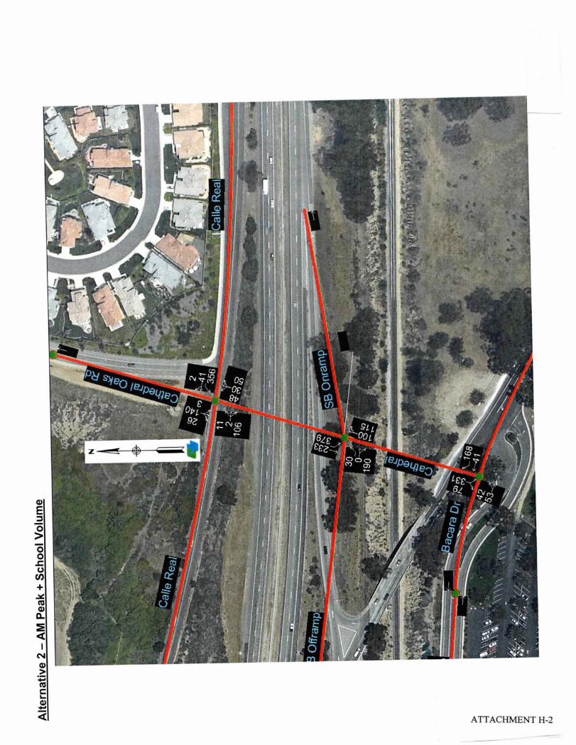
The existing single lane southbound off-ramp will be extended 200-meters tointersect with Cathedral Oaks Road. The ramp will transition into two 3.6-meter lanes, a 1.2-meter inside shoulder and a 2.4-meter outside shoulderalong the extension. The southbound Route 101 on-ramp will be realignedand consist of a 3.6-meter lane, 1.2-meter inside shoulder and 2.4-meteroutside shoulder. Earthwork for the on-ramp will be completed to providefor the future construction of a two-lane ramp-metering configuration.The reversing horizontal curves of the existing Bacara Drive that form a “T”intersection with Hollister Avenue will be removed and replaced with a 304-meter radius curve. The new Cathedral Oaks Road intersection will bewithin the afore referenced horizontal curve. Hollister Avenue will consistof a 3.6-meter lane and 1.5-meter shoulder in each direction with a 3.6-meterright-turn lane for westbound traffic onto Cathedral Oaks Road.
• Nonstandard Mandatory and Advisory Design Features
A fact sheet for exceptions to mandatory design standards is currently beingprepared. The existing design speed of Hollister Avenue is 35 km/h. Thedesign speed of Alternative 1 is 45km/h which is less than the mandatoryspeed of 55 km/h for local facilities connecting to freeway ramps.
The 45 km/h design speed is a result of the 85-meter radius horizontal curvethat is necessary to tie-in the new overcrossing with the existing Ellwoodoverhead and Hollister Avenue. The radius of the horizontal cure thatcurrently connects the two structures is 61 meters. The northbound off-rampwill require an advisory design exception for intersection skew.
Alternative 2 will require an exception to the mandatory design standard forspacing between the southbound ramp intersection and local intersections.The minimum distance between curb return of the ramps and HollisterAvenue and Calle Real is approximately 60 meters, which is less than theminimum standard of 125 meters. A fact sheet for an exception to anadvisory design standard for embankment slopes that are steeper than 1:4was approved on 12/15/05. Portions of the southbound on-ramp and off-ramp embankment slopes will need to be constructed at a slope ratio of 1:2.The steeper than standard slopes are necessary to avoid impacting biological

11/21/05 Draft Project Report: Hollister Avenue Overcrossing Replacement Page 8
resources and because a 1:4 slope would catch on the existing southboundRoute 101 outside shoulder.
• Utility and Other Owner Involvement
Utilities within the project area include electric (Southern California Edison),natural gas (Southern California Gas), telephone (Verizon), cable television(Cox), water and sewer (Goleta Water District), fiber optics (Level 3),petroleum (Veneco and Atlantic Richfield). Many of these are undergroundhigh- and low-risk facilities that cross Route 101 or run along HollisterAvenue, Calle Real and Cathedral Oaks Road and will require positivelocation (potholing) during design to ensure that they are unaffected byconstruction, or determine if there will be a conflict.
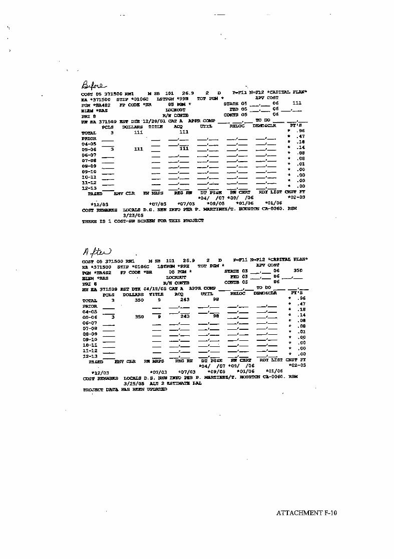
If Alternative 2 is selected as the preferred alternative, utility relocations andor adjustments will be required for construction at the new HollisterAvenue/Cathedral Oaks Road intersection and the modified CalleReal/Cathedral Oaks Road intersection. Utility owners will be required torelocate their facilities before and during construction, of both above andbelow ground utilities. It is anticipated that the above listed utility ownerswill require relocations and or adjustments. The project cost for utilityrelocation for Alternative 2 is estimated at $98,000, and is included in theRight of Way Data Sheets (Attachment F).
• Railroad Involvement
The Union Pacific Railroad runs adjacent to the southbound lanes of Route101 throughout the project limits and is used by both freight trains andAmtrak passenger trains. Construction of the overhead for Alternative 2 willrequire the acquisition of a transverse easement and relinquishment of theexisting easement with the railroad after the existing overhead is removed.Acquisition of the easement will add substantially to right of way lead-time.
• Highway Planting
There will be minimal impacts to existing vegetation associated withAlternative 1. Planting will consist of erosion control and replanting of treesand shrubs removed for construction with a one year plant establishmentperiod. Trees and shrubs will be truck watered.
Alternative 2 will require highway planting consistent with new interchangesor major modification to existing interchange projects. The Department’spolicy is to provide highway planting when adjacent properties have beendeveloped at the time the highway contract is accepted. Based on the extentof existing and proposed development adjacent to the proposed overcrossing,the entire interchange will include highway planting. However, excessivewater assessment fees could prevent the permanent irrigation and relatedhighway planting from being allowed by the Department.

11/21/05 Draft Project Report: Hollister Avenue Overcrossing Replacement Page 9
The local water district has identified a water assessment fee of $145,000 forthe use of potable or recycled water. This fee would apply to all optionsincluding extension of existing Caltrans recycled water lines east of theproject site, installation of a new recycled water meter at the project site, andinstallation of a new potable water meter at the site. This assessment is inexcess of the maximum of $9,625 (Based on $3,500/ha for 2008/09 FY)allowed by Caltrans. For the highway planting portion of the project to beapproved, the assessment fee would need to be reduced or the excess fundedby other sources.
If the assessment fees are brought within the maximum Caltrans allows, anew water meter would be installed as part of the bridge replacement project.Recycled water services exist adjacent to the project and will be used if thelocal water district determines it has an adequate supply of recycled water.This determination will be made during the PS&E phase. If recycled watersupplies are inadequate, then potable water would be considered.
Replacement of the overcrossing and overhead, intersection improvements atCathedral Oaks Road, and intersection improvements at Hollister Avenuethat are proposed in Alternative 2 will also result in new and replacementlandscaping located outside the State right of way.
Erosion control and the portion of landscaping outside the right of way willbe included with the bridge replacement contract having a maximum oneyear plant establishment period. New water meter(s), electrical service, andcrossovers for landscaping within the State right of way will be included inthe bridge project. The remainder of irrigation and planting within the Stateright of way will be a separate contract due to the estimated cost exceeding$200,000 and will have a plant establishment period of three years.
• Erosion Control
Hydroseeding will be provided at the demolition sites of structures for bothalternatives, on slopes adjacent to new structures, and areas adjacent toCathedral Oaks and Hollister Avenue (Alternative 2). Erosion controlblankets may be utilized on newly constructed slopes due to the designedinclination. Evaluation of the proposed slopes as candidates for erosioncontrol blankets will be made during the design phase of the project.
• Non-motorized and Pedestrian Features, etc.
Both alternatives propose to maintain the link that the Hollister Avenue OCprovides for non-motorized transportation and pedestrians between the northand south sides of Route 101. Alternative 1 will add a Class II Bikeway onthe overcrossing by providing 2.4-meter shoulders. Continuation of thebikeway to the south is controlled by the existing overhead that does nothave shoulders.

11/21/05 Draft Project Report: Hollister Avenue Overcrossing Replacement Page 10
Alternative 2 will provide 1.5-meter wide Class II Bikeways along CalleReal, Hollister Avenue, and Cathedral Oaks Road. The existing Class IBikeway adjacent to southbound Cathedral Oaks Road north of Calle Realwill be reconstructed due to the realignment of Cathedral Oaks Road. Asidewalk system will provide a course of travel for pedestrians wanting tocross over Route 101. Presently the sidewalk system within the project limitsis along Calle Real and Cathedral Oaks Road and terminates at theirintersection. Sidewalks will be constructed along the west side of theovercrossing and overhead and terminate at Hollister Avenue, they will be1.8-meter in width.
• Needed Roadway Rehabilitation and Upgrading
Roadway rehabilitation is not within the scope of the project funding source.A major rehabilitation project was completed within the project limits onRoute 101 in 1994.
• Needed Structure Rehabilitation and Upgrading
The Office of Structure Maintenance and Investigation determined thatrehabilitation of the Hollister Avenue Overcrossing is not a viable alternativedue to deterioration of the concrete substructure. Replacement of theEllwood Overhead is necessary to improve local circulation.
• Cost Estimates
Alternative 1 Alternative 2Roadway Items $ 738,000 $ 4,504,000Structure Items $ 2,129,000 $ 4,733,000Total Construction $ 2,867,000 $ 9,237,000Right of Way $ 10,000 $ 350,000Total Cost $ 2,877,000 $ 9,587,000
See Attachment E for detailed six page cost estimates for each alternative.
• Right of Way Data
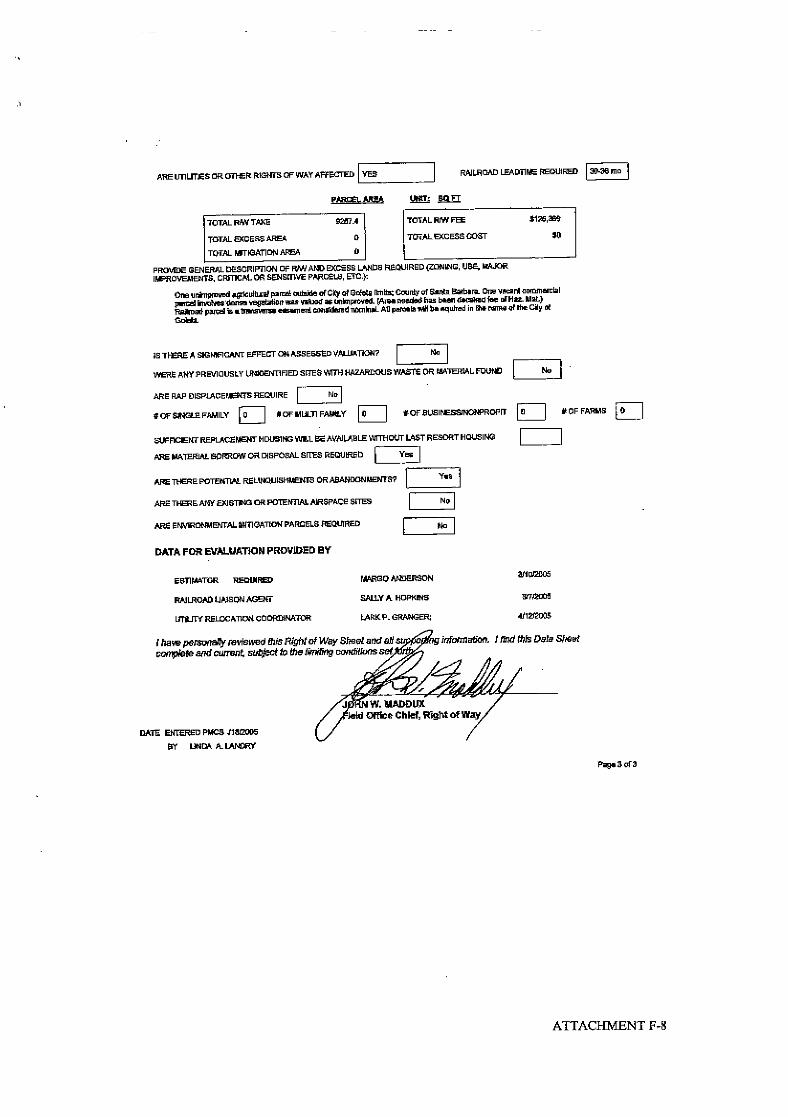
Alternative 1 will require a construction easement with the City of Goletawithin Calle Real for tying in the new overcrossing.
Alternative 2 will require the acquisition of one unimproved agriculturalparcel in the County of Santa Barbara, one vacant unimproved commercialparcel within Goleta, and a permanent railroad easement. All acquisitions

11/21/05 Draft Project Report: Hollister Avenue Overcrossing Replacement Page 11
will be made in the name of the City of Goleta. See Attachment F for Rightof Way Data Sheets.
B. Rejected Alternatives
“No-build”
The No-build alternative was rejected because it does not address the projectneed to replace the seismically deficient Hollister Avenue Overcrossing.
6. CONSIDERATIONS REQUIRING DISCUSSION
A. Hazardous Waste
There were no apparent indications of hazardous waste sites or impacts withinthe project limits during the Initial Site Assessment performed by theEnvironmental Planning Department.
An abandoned Chevron service station was located at 7952 Hollister Avenue. InMarch 1988, samples from borings detected hydrocarbons near the tank pit andpump islands in the upper 10.7-meters of the vadose zone. Ground water had notbeen encountered in any borings, which extend to depths of 15.2-meters. Avapor extraction system was formed by connecting vapor extraction wells thatwere installed in September 1988 and April 1993 to a catalytic oxidation unit.In January 1993, the two gasoline tanks and one oil tank were removed. The siteinvestigation and remedial action was deemed complete by the County of SantaBarbara Protection Services Division Hazardous Waste Unit in September 1997.
B. Value Analysis
A value analysis was not prepared for this project. The overcrossing has beendetermined to be structurally deficient with the sole remedial action beingreplacement.
C. Resource Conservation
Features and measures aimed at reducing wasteful, inefficient, and unnecessaryconsumption of energy and nonrenewable resources in construction, operationsand maintenance of the project will be included wherever possible.
• Features affecting energy requirements and energy use during constructionwill include the efficient staging of the construction sequencing and traffic-handling plan.
• Measures proposed to minimize the consumption, destruction, and disposalof nonrenewable resources, include recycling the existing structural sections

11/21/05 Draft Project Report: Hollister Avenue Overcrossing Replacement Page 12
and concrete structures as aggregate base through provisions in the contractdocuments.
D. Right of Way Issues
• Right of Way Required
There are no right of way requirements for Alternative 1.
Alternative 2 will require the acquisition of two parcels and easements fromthe Union Pacific Railroad. Acquisitions are needed at the northwest cornerof the Calle Real/Cathedral Oaks Road intersection and at the proposednortheast Hollister Avenue/Cathedral Oaks Road intersection. An easementwith the Union Pacific Railroad is needed for the new overhead structure; theexisting easement will be vacated upon project completion. All acquisitionswill be made in the name of the City of Goleta.
E. Environmental Issues
An Initial Study/Proposed Mitigated Negative Declaration (IS/PMND) has beenprepared for this project and is the appropriate California Environmental PolicyAct (CEQA) document for both alternatives.Additionally, both alternatives meet the criteria to be Categorically Excludedunder the National Environmental Policy Act (NEPA).
The IS/PMND contains detailed studies of the environmental issues of concernfor this proposal, some of which are briefly described below.
• Wetlands
The embankment slope ratios of the southbound on-ramp and off-ramp willbe modified to avoid all areas that have wetland indicators.
• Vegetation
There will be no significant impacts to sensitive vegetation. All disturbedareas will be treated with either landscape planting or erosion control.
• Biological
There is the potential to impact California red-legged frogs, Santa Barbarahoneysuckle, a bat roost, and raptor nests. Design features will beincorporated to minimize disturbance to the afore mentioned resources.
• Visual Impacts
The structures will receive aesthetic treatments consistent with otherovercrossings within the project corridor. Because the project is replacingexisting bridges, and because the bridges are a normal highway feature
11/21/05 Draft Project Report: Hollister Avenue Overcrossing Replacement Page 13
within the area, there will be no significant visual impacts resulting fromconstruction.
• Floodplain
The project is not located within a 100-year floodplain and is not expected toalter flood flows.
• Cultural
No cultural resources will be impacted as a result of this project.
F. Air Quality Conformity
The project alternatives will not induce growth and will not cause significantlong-term traffic emissions. They are consistent with the Santa Barbara CountyAir Pollution Control District Clean Air Plan (2002) which is the StateImplementation Plan for Santa Barbara County. The project was identified anddetermined to be in conformance with the Regional Transportation Plan and theFederal Regional Transportation Improvement Plan.
G. Title VI Considerations
Access to transportation facilities will be maintained as a result of Alternatives 1and 2. Improvements to existing facilities within the project limits include ClassII Bikeways for both alternatives and curb ramps and sidewalks for Alternative 2.
7. OTHER CONSIDERATIONS AS APPROPRIATE
• Public Hearing Process
It is recommended that a public hearing be scheduled presenting thedeveloped viable alternatives for public comment.
• Route Matters
The existing Freeway Agreement of December 1968, which contains asymbol exhibit map, will not need to be superseded because theimprovements proposed by both alternatives do not constitute a major changeto the agreement.
• Permits
Permits and approvals needed to complete the project include:

11/21/05 Draft Project Report: Hollister Avenue Overcrossing Replacement Page 14
A Coastal Development Permit from the California Coastal Commissionfor work within the coastal zone.
A National Pollutant Discharge Elimination System Permit forstormwater discharges to surface water from the Regional Water QualityControl Board.
Encroachment permits from Santa Barbara County and the City of Goletafor work on or across local streets.
• Cooperative Agreements
A MOU (MOU) was entered into between the Department and the City ofGoleta on September 17, 2004 contingent upon Alternative 2 being selectedas the preferred alternative after a public hear. The provisions of which areas follows:
The Department will perform the work required to complete and obtainapproval of the environmental documentation, draft project report, finalproject report, project design, award of construction contract, constructionengineering, and completion of project. The City of Goleta agreed tocoordinate right of way acquisitions, railroad and utility easements andpermits utilizing the Department as their agent.
The Department agreed to incur all costs associated with completion andapproval of the environmental document, draft project report, final projectreport, design and construction of the new overcrossing and removal of theexisting overcrossing.
The City of Goleta agreed to incur all costs associated with the design andconstruction of the new overhead, demolition of the existing overhead,design and construction related to realignment work required for ramps,Calle Real, Cathedral Oaks Road, and Hollister Avenue, right of wayacquisitions, railroad and utility easements and permits which will be fundedthrough EA 05-0M1400.
A joint-funded cooperative agreement was entered into between the City andthe Department on November 21, 2005. The provisions of the agreement aresimilar to those of the MOU with the City allocating $850,000 fordevelopment of Alternative 2 if it is selected as the preferred alternative.
• Transportation Management Plan for Use During Construction
Significant impacts to traffic during construction are not anticipated as aresult of either alternative. The Transportation Management Plans (TMP)will employ public awareness campaigns, motorist information strategies forlane closures, and traffic incident management by the California HighwayPatrol.
Alternative 2 will require the construction of a temporary southbound on-ramp during Stage One to maintain existing traffic circulation.
11/21/05 Draft Project Report: Hollister Avenue Overcrossing Replacement Page 15
• Stage Construction
Alternative 1 – It is anticipated that the overcrossing will be constructedin two stages. The existing structure will be utilized in Stage One fortwo-way traffic while a portion of the new bridge is built. Aftercompletion of Stage One, two-way traffic will be shifted onto the newstructure to allow for completion of the overcrossing.
Alternative 2 – It is anticipated that construction of the new overcrossing,overhead, ramp and road realignments will require three stages ofconstruction. During Stage One the new overcrossing, overhead,southbound on-ramp, and Cathedral Oaks Road/Calle Real tie-in north ofRoute 101 will be constructed. During Stage Two the southbound off-ramp will be constructed along with a portion of the HollisterAvenue/Cathedral Oaks Road intersection. Stage Three will involvecompletion of the Hollister Avenue/Cathedral Oaks Road intersectionand removal of the existing overcrossing and overhead.
• Accommodation of Oversize Loads
The segment of Route 101 within the project limits will be designed toprovide passage for vehicles of unrestricted height while moving in and outof an area. Oversize loads that cannot pass beneath the proposedovercrossing structures will need to make use of the freeway on-ramps andoff-ramps.
• Graffiti Control
Although Santa Barbara County is considered a graffiti-prone county, theexisting interchange located in western Goleta has not experienced a graffitiproblem. Signs will not be mounted on the proposed structures eliminatingthe need for protective devices. Typical targets of graffiti painters such asretaining walls and sound walls are not proposed features of the project.
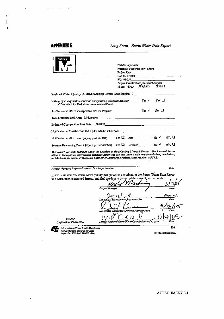
• Storm Water Quality
Storm water quality requirements for projects on State right of way aredesignated in the Caltrans’ National Pollutant Discharge Elimination System(NPDES) permit (Order No. 99-06-DWQ, No. CAS000003), and theCaltrans Storm Water Management Plan (SWMP) (May 2001).
A Storm Water Pollution Prevention Plan, developed by the contractor, willinclude Temporary Best Management Practices (BMPs) such as silt fences,hay bales, settling ponds, and sediment traps to control the discharge ofsediment into storm water during construction.
Design pollution prevention BMPs for stabilization of newly constructedslopes will include the application of erosion control such as hydroseedingand fiber rolls. Additionally energy dissipation devices at culvert outlets will

11/21/05 Draft Project Report: Hollister Avenue Overcrossing Replacement Page 16
be employed to reduce water velocity. Existing vegetation will be preservedas much as possible.
Proposed permanent treatment BMPs may include the use of biofiltrationswales and detention basins.
8. PROGRAMMING
• Programming
The Department’s portion of the proposed project is programmed in thePhase 2 Seismic Retrofit Program. Programming for the local portion of theproject will be through the State Transportation Improvement Program(STIP) Regional Improvement Program (RIP), Highway Bridge Replacementand Rehabilitation (HBRR) Program, and local funds.
• Funding
The project is programmed with $3,600,000 for construction from the Phase2 Seismic Retrofit Program under EA 05-371500.
The local funding of Alternative 2 under EA 05-0M1400 consists of$1,201,000 from the STIP(RIP), $6,560,500 from the HBRR program whichis a combination of the federal portion with local matching funds, and$850,000 from local funds. Right of way capital has been programmed with$111,000 coming from the STIP(RIP), $211,600 from the HBRR program,and $27,400 from local funds. These costs have been projected for the2007/2008 construction fiscal year.
• Project Schedule
Milestone Month/YearPA&ED 3/2006PS&E to HQ 8/2007Right of Way Certification 11/2008Ready to List 3/2009Complete Construction 1/2012
9. REVIEWS
The Project Development Team includes the following reviewers who have providedtheir input on the alternatives development.
Design Coordinator Ken CozadDesign Reviewer Mike Janzen

11/21/05 Draft Project Report: Hollister Avenue Overcrossing Replacement Page 17
Since this project is a reconstruction project on the National Highway System, it issubject to the Certification Acceptance (CA) level of FHWA involvement. This meansthat FHWA review is involved in the categorical exclusion, the Project Report, Right ofWay and Utility Certification, and final acceptance of the constructed project.
10. PROJECT PERSONNEL
Calnet PublicProject Manager Paul Martinez 8-629-3407 (805) 549-3407Design Manager John Fouche 8-629-3000 (805) 549-3330Project Engineer Steven Andris 8-629-3075 (805) 549-3075Environmental Manager Larry Newland 8-629-4603 (805) 542-4603Environmental Planner Paula Huddleston 8-629-3063 (805) 549-3063Right of Way Branch Connie Shellooe 8-629-3471 (805) 549-3471Landscape Architect Peter New 8-629-3357 (805) 549-3357
11. LIST OF ATTACHMENTS
Attachment A Initial Study/Proposed Mitigated Negative DeclarationAttachment B Vicinity MapAttachment C Project Maps and Typical SectionsAttachment D Structure Advance Planning StudiesAttachment E Cost EstimatesAttachment F Right of Way Data SheetsAttachment G Collision DataAttachment H Turning Movement DiagramsAttachment I Level-of-Service AnalysisAttachment J Storm Water Data SheetAttachment K Traffic Management PlanAttachment L Distribution List

ATTACHMENT A-1
The Draft Initial Study/Proposed Mitigated Negative Declaration, under separate cover, isreferenced here as Attachment A.

Hollister/Cathedral Oaks Overcrossing Replacement
City of GoletaSB-101 PM 26.5/27.1
05-371500/05-0M1400
Initial Study with Proposed Mitigated Negative Declaration
Prepared by the State of California Department of Transportation
November 2005


PROPOSED MITIGATED NEGATIVE DECLARATIONPursuant to the California Environmental Quality Act
Reconstruction of the Hollister Avenue/Cathedral Oaks Road Interchangeat Highway 101
PROJECT LOCATION: Cathedral Oaks Road/HollisterAvenue overcrossing of Highway 101 in the City ofGoleta, Santa Barbara County.
PROJECT DESCRIPTION: The project proposes toreplace the structurally deficient Hollister AvenueOvercrossing on Highway 101 in the City of Goleta. Thereare two viable alternatives presented in this report.Alternative 1 proposes to replace the Hollister AvenueOvercrossing at its present location. The new two-lanestructure cross section will consist of 3.6-meter (12-ft) lanes with 2.4-meter (8-ft) shoulders. Alternative 2proposes to replace the Hollister Avenue Overcrossing and Ellwood Overhead on a new alignment thatprojects Cathedral Oaks Road over Highway 101 to a “T” intersection with Hollister Avenue. The crosssection of the new structures will consist of a 3.6-meter (12-ft) lane and a 1.5-meter (5-ft) shoulder ineach direction, a 3.6-meter (12-ft) center turn lane, a 1.8-meter (6-ft) sidewalk along the west side of thebridges, and realignment of the southbound Highway 101 on-ramp and off-ramp.
DETERMINATION: An Initial Study was prepared and evaluated, and it has been determined that theproposed project COULD have a significant adverse impact on the environment. Therefore, the followingmeasures will be incorporated into the project to mitigate impacts to below the level of significance:
♦ The bridge shall be designed similarly to existing nearby bridges along Highway 101, with similaraesthetic treatments, so that it will better blend into the highway environment. The intersection willbe landscaped after construction to accommodate an urban setting, while including native specimens.Other stipulations shall be included, as outlined in the Visual Impact Assessment Addendum.
♦ Air quality during construction shall be maintained using Best Management Practices.♦ Pre-construction surveys for cliff swallows and California red-legged frog shall be conducted by a
qualified biologist. Swallows shall be prevented from nesting on the bridges prior to demolition andnests shall be destroyed outside of the nesting season.
♦ An Environmentally Sensitive Area shall be designated around the aquatic habitat for California red-legged frog. Other avoidance and minimization efforts shall be incorporated into the project, asoutlined in the Natural Environment Study.
♦ Trees to be removed from the project site shall be removed between August 15th and February 15th toavoid disturbance to nesting raptors.
♦ Prior to demolition, the structure(s) shall be treated with exclusionary devices to prevent bats fromroosting. If removed, the new overhead shall incorporate bat roosts into the design.
♦ An Environmentally Sensitive Area shall be designated to protect Santa Barbara honeysuckle withinthe project area.
♦ Noisier construction activities shall be limited to the hours between 0800 and 1800, Monday throughFriday.
♦ A Storm Water Pollution Plan shall be prepared to protect water quality during construction.
________________________________________ ______________________Larry Newland, AICP DateEnvironmental Branch Chief, Central Region California Department of Transportation
Project Location


Initial Study/Proposed Mitigated Negative Declaration, 05-371500/05-0M1400November 21, 2005Page 1
INITIAL STUDY CHECKLIST & REPORT
Reconstruction of the Hollister Avenue/Cathedral Oaks RoadInterchange at Highway 101
1.0 PROJECT DESCRIPTION1.1 Background Information
The existing Hollister Avenue interchange at Highway 101 was constructed in 1961 as a modified diamondinterchange. The existing freeway overcrossing is a concrete structure that spans a total 73.5 meters (241.1ft.). The vertical clearance of the overcrossing over the highway is approximately 5.0 meters (16.4 ft.) Thefreeway at the project site contains four lanes and a concrete median barrier. The existing Ellwood railroadoverhead was built in 1933 along Hollister Avenue and is a reinforced concrete/built-up steel plate girderstructure that spans a total of 69.6 meters (228.3 ft.).
The California Department of Transportation (Caltrans) originally proposed to replace the existing freewayovercrossing at its present location for seismic reasons. The existing freeway overcrossing suffers fromconcrete deterioration caused by chemical reactions involving reactive aggregate and water. The railroadoverhead is deteriorated due to age.
Construction of “missing links” along Cathedral Oaks Road north of the interchange was completed in2000. Hence, Cathedral Oaks Road is now a continuous major arterial from State Route 154 to Highway101.
The extension of Cathedral Oaks Road north of Calle Real to Winchester Canyon Road was approved as partof the Winchester Commons Project in 1989. Grading of the right-of-way for this two-lane divided roadwaywith Class II bike lanes was completed in 1997, and the road was constructed in 1999.
1.2 Project Alternatives
Alternative 1Alternative 1 was the original design proposal recommending replacement of the existing overcrossing atits present location with a two lane overcrossing. The overcrossing would incorporate a typical crosssection consisting of 3.6-meter (12-ft) traffic lanes with 2.4-meter (8-ft) outside shoulders. The minimumvertical clearance of the overcrossing will increase from 4.9-meters (16.0 ft) to 5.4 meters (17.7 ft.) Thecost of this alternative was estimated to be $2,864,000 in August 2005 and includes $10,000 for right ofway items. This project was initiated by Caltrans’ Office of Structures Maintenance and Investigations.
Alternative 2Alternative 2, suggested by the County of Santa Barbara, proposes to replace the Hollister AvenueOvercrossing and Ellwood Overhead on a new alignment that projects Cathedral Oaks Road over Highway101 to a “T” intersection with Hollister Avenue and realignment of the southbound Highway 101 on-rampand off-ramp. The design speed for Cathedral Oaks Road is 75 km/h (45 mph.) The cost of this alternativewas estimated in August 2005 to be $9,156,000, which includes $350,000 for right of way acquisition andutility relocation.
The typical cross section of the new structures will consist of a 3.6-meter (12-ft) lane and a 1.5-meter (5-ft)shoulder in each direction, a 3.6-meter (12-ft) left turn lane onto southbound Highway 101, and a 1.8-meter(6-ft) sidewalk along the west side of the bridges. The minimum vertical clearances of the proposedstructures are 6.0 meters (19.6 ft) for the overcrossing above Highway 101 and 8.9 meters (29.2 ft) for the

Initial Study/Proposed Mitigated Negative Declaration, 05-371500/05-0M1400November 21, 2005Page 2
overhead above the railroad tracks. The portion of Cathedral Oaks Road just north of the Calle Realintersection will have a 3.6-meter (12-ft) lane and 1.5-meter (5-ft) shoulder in each direction.
Calle Real will be raised approximately 600 millimeters (2 ft) to intersect with the new Cathedral Oaks Road.Calle Real will consist of a 3.6-meter (12-ft) lane and 1.5-meter (5-ft) shoulder in each direction and a 3.6-meter (12-ft) left turn lane for westbound traffic east of the Cathedral Oaks Road intersection.
The southbound off-ramp will be extended to intersect with Cathedral Oaks Road and the southboundHighway 101 on-ramp will be realigned. Earthwork for the on-ramp will be completed to provide for futurewidening to two lanes.
Hollister Avenue and Bacara Drive will be realigned slightly to accommodate the new design. HollisterAvenue will consist of a 3.6-meter (12-ft) lane and 1.5-meter (5-ft) shoulder in each direction with a 3.6-meter (12-ft) right turn lane for westbound traffic onto Cathedral Oaks Road.
No BuildUnder the “no build” alternative, the existing structures would remain in place and would not be modified forseismic purposes. The bridge would remain susceptible to seismic events and could result in a future closure.No improvements for traffic circulation would occur. Motorists would continue to use the existing HollisterOvercrossing. The level of service at the intersections associated with the current interchange would degradeto unacceptable levels in the next 20 years due to current and planned traffic volumes from nearby, already-approved development projects.
1.3 Costs and Funding Sources
The project is programmed with $3,600,000 for construction from the Phase 2 Seismic Retrofit Program,$860,400 from the State Transportation Improvement Plan (Regional Improvement Plan), $4,945,700from the HBRR program (which is a combination of the federal portion with local matching funds), and$53,400 from local funds. Right of way capital has been programmed with $111,000 coming from theSTIP (RIP) and $166,000 from the HBRR program. These costs have been projected for the 2008/2009construction fiscal year.
1.4 Right of Way Requirements
No new right of way would be required for Alternative 1. For Alternative 2, construction of the projectwill primarily occur within existing transportation rights-of-way owned by Caltrans (Highway 101), theCity of Goleta (Calle Real, Cathedral Oaks Road, and Hollister Ave), and Union Pacific Railroad. A smallacquisition would be required on the westerly corner of a parcel (APN 079-210-048) located at the site ofan old gas station along the north side of Hollister Avenue. In addition, a small amount of road easementwill also be required at the northwest corner of the intersection of Cathedral Oaks Road and Calle Real(APN 079-090-020). A new roadway easement, as well as a temporary construction easement, is neededfrom the Union Pacific Railroad. Upon completion of the project, the existing railroad easement would bevacated.
2.0 PROJECT LOCATIONThe project site is located primarily in State highway right-of-way, adjacent to the Sandpiper GolfCourse. The project site is located within the City of Goleta planning area and within the Coastal Zone.
2.1 Site InformationComprehensive PlanDesignation
Transportation Corridor

Initial Study/Proposed Mitigated Negative Declaration, 05-371500/05-0M1400November 21, 2005Page 3
2.1 Site InformationSite Size 17 acres = area of potential construction impactPresent Use &Development
Undeveloped land within state highway right-of-way, railroad right-of-way, and private land within the City of Goleta.
Surrounding Uses/Zoning North: Winchester Canyon Residential Development - Single-FamilyResidentialWest: Bell/Winchester Canyon – Agriculture IISouth: Sandpiper Golf Course – Recreation and Single-Family Residentialwith a Scenic OverlayEast: Vacant gas station lot between Hollister Avenue and the railroad –General Commercial, AND undeveloped land between Hollister Avenueand the railroad. Multi-family residential (proposed ChadmarDevelopment)
Access Cathedral Oaks Road, Hollister Avenue, Calle Real, and Highway 101
3.0 ENVIRONMENTAL SETTINGThe project site occurs in a semi-rural area of the City of Goleta with a mixture of land uses. The primaryland use in the area of potential impact is transportation, consisting of paved roadways, landscaped right-of-way, and a railroad corridor. Other land uses at or adjacent to the project site include the WinchesterCommons residential development, agricultural fields in Bell/Winchester Canyon, the Sandpiper GolfCourse, and undeveloped open space. The area at the southeast quadrant of the proposed Cathedral OaksRoad/Hollister Avenue interchange was formerly a service station and is currently vacant
The vegetation types at the project site are mainly non-native and typical of highway rights-of-way anddisturbed roadside areas. Four primary vegetation types were identified at the project site: non-nativegrassland, ruderal, eucalyptus grove, coyote brush scrub and coastal sage scrub. Ruderal vegetation domi-nates most of the area of potential effect including roadsides, embankments and the land north of HollisterAvenue. West of Cathedral Oaks is an area of native grasslands. There are no wetlands at the project site.
Wildlife habitat values are low at the project site due to the lack of native vegetation, the effects ofhighway maintenance activities and disturbance, and the effects of noise, automobile lights and traffic.
Two watercourses are located near the project site but outside the area of potential effect. DevereuxCreek is located approximately 350 meters (1150 ft.) east of the existing interchange. It flows fromWinchester Commons under Route 101 via a culvert, into a scour pool, and then west along the railroadtracks to Bell Canyon. Devereux Creek contains areas of riparian habitat. Bell Canyon Creek is locatedapproximately 600 meters (1970 ft.) west of the existing interchange. The proposed project facilities arelocated outside the 100-year floodplain of Bell/Winchester Canyon and Devereux Creek.
A portion of the area of potential effect traverses the margins of a known prehistoric archeological site,CA-SBA-70, at the intersection of Cathedral Oaks Road and Calle Real. However, the portion of the sitewithin the area of potential effect was subject to data recovery in 1995 within the alignment of the Cathe-dral Oaks Road extension, which has since been completed. Based on the result of data recovery, it wasconcluded that the portion of the site in the current area of potential effect did not contain archeologicalremains.
4.0 POTENTIALLY SIGNIFICANT EFFECTS CHECKLISTThe following checklist indicates the potential level of impact and is abbreviated as follows:
Known Signif.: Known significant environmental impacts.

Initial Study/Proposed Mitigated Negative Declaration, 05-371500/05-0M1400November 21, 2005Page 4
Unknown Poten. Signif.: Unknown potentially significant impacts which need further review todetermine significance level.
Poten. Signif. and Mitig.: Potentially significant impacts which can be mitigated to less than significantlevels.
Not Signif.: Impacts which are not considered significant.
4.1 AESTHETICS/VISUAL RESOURCES
Will the proposal result in:KnownSignif.
UnknownPoten.Signif.
Poten.Signif.
andMitig.
NotSignif.
a. The obstruction of any scenic vista or view open tothe public or the creation of an aestheticallyoffensive site open to public view?
X
b. Change to the visual character of an area? Xc. Glare or night lighting which may affect adjoining
areas?X
d. Visually incompatible structures? X
Site Conditions:
The proposed project is located in a semi-rural area with a highway corridor characterized by landscapingwith non-native plants (e.g., eucalyptus trees and oleander shrubs). There are no public viewing locationsor vistas at or near the project site (e.g, parks, trails, informal “pullouts”, rest stops, etc). Views fromHighway 101 are precluded by the high rate of speed, and the low elevation of Highway 101 at theexisting overcrossing relative to the surrounding landforms.
Alternative 1 would have no impact to visual quality. For Alternative 2, the nearest residences withprivate views of the project site are located in the Winchester Commons development on the north side ofHighway 101. Views from this development are mostly shielded from the Highway 101 corridor by asound wall along Calle Real. Views of the project site from Sandpiper Golf Course are mostly obscuredby eucalyptus trees along Hollister Avenue and the golf course parking lot.
The only notable visual and aesthetic features of the Alternative 2 project site consist of the largeeucalyptus trees on the south side of the highway corridor, many of which would be removed. However,these trees are not a unique or highly aesthetic visual feature because they are very common along theHighway 101 corridor from Gaviota to Goleta. Unsightly visual elements at the project site consist of thehighly eroded banks on either side of the railroad tracks.
Impact Discussion:
Item a) The proposed project alternatives will not affect any public scenic vista point, nor create a visuallydispleasing site. The removal of eucalyptus trees on the south side of the project site associated withAlternative 2 would not create an adverse view of Highway 101 from Hollister Avenue because it islocated at a lower elevation.
Item b) Neither of the proposed project alternatives will create a substantial change in visual characteralong the highway corridor or for the adjacent community. The size of the structures proposed with eitheralternative will be similar to that of the existing bridges, and no change in character scale is anticipated.

Initial Study/Proposed Mitigated Negative Declaration, 05-371500/05-0M1400November 21, 2005Page 5
The relocation of the overcrossing and ramps will not substantially degrade the existing visual characterof the project site which is dominated by highway facilities – e.g., paved roads, bridges, curbs, and roadcuts and fills. With Alternative 2, the reconfiguration of the Hollister intersection to the south and theCalle Real intersection to the north will result in a slightly larger scale roadway facility at those locationsand a more open, unified visual character as seen from the local roadways. The proposed projectalternatives will, however, represent only a minor modification of the visual setting, and suchmodification is not likely to create a long-term perceptible change in the nature of the landscape
The removal of large eucalyptus trees proposed with Alternative 2 will cause a minor reduction in thevegetated character of the setting. The majority of the existing mature eucalyptus trees in the vicinity willremain and will continue to provide spatial and skyline benefit to the highway corridor and thecommunity.
The areas between the ramps and the highway will be landscaped with trees and shrubs common to theright-of-way (e.g., annual grasses, coyote brush, and eucalyptus), and as such, will blend in with theexisting landscaping at the project site, and along most of the highway right-of-way in Goleta. With bothalternatives, the architectural treatment to the bridge rails will likely be similar to those used on the StorkeRoad overcrossing. Hence no new architectural themes or design will be introduced to the site, and theproposed treatment will be compatible with other highway structures.
Item c) Both of the proposed projects will increase the nighttime lighting in the area due to the addition ofstreet lighting at signalized intersections. However this lighting will not obscure or block scenicnighttime views (e.g., of the ocean, mountains or city). Residents of Winchester Commons cannot viewthe ocean or city from their homes, and their views of the mountains would be unaffected by the project.It should also be noted that there are overhead lights in the area along Calle Real and in front of SandpiperGolf Course.
Item d) The proposed project alternatives will result in the replacement of an older highway overcrossingwith either a new one in-place, or a new one at a nearby location. The proposed railroad bridgeassociated with Alternative 2 will replace the existing one. The proposed structures will be similar to theother bridge structures along the Highway 101 corridor in the region in terms of size, form, finish, andother visual elements. Hence, no new man-made or incompatible elements will be added to thelandscape.
Mitigation and Residual Impact:
The landscaping associated with the new interchange must be consistent with Caltrans’ Highway 101Corridor Master Landscape Plan. The project is located in Ellwod Unit 9, where key landscapingguidelines include: preserve the rural character of the area; emphasize native plants; provide variation inform and texture in the plantings; retain existing eucalyptus trees and add more eucalyptus trees(particularly on the north side of he highway); and use oak, sycamore, and bay trees when possible.
Along with the above design and planning measures, the following measures shall be implemented tominimize aesthetic impacts:
Measures common to both alternates:
1. Existing eucalyptus and other trees shall be preserved to the greatest extent possible.
2. Where existing roads are realigned or abandoned, the old road shall be completely removed,including asphalt, road base and sub-base. The old road bed shall be scarified.

Initial Study/Proposed Mitigated Negative Declaration, 05-371500/05-0M1400November 21, 2005Page 6
3. Reconstruction of local streets and roadways shall include the planting of street trees, if supported bythe local jurisdiction.
4. Replacement planting shall be designed and located to include visual benefits for the highway traveleras well as the local road user.
5. Replacement trees shall be planted from minimum 15-gallon container size, and shall include treestakes.
6. All replacement landscaping shall include a defined and funded plant establishment and maintenanceperiod, which will ensure the long-term success of the planting.
In addition to the measures above, the following apply to Alternative 2:
7. The landform of the removed or realign ramps, local roads and intersections shall be recontoured asnecessary to blend with the adjacent topography and setting.
8. The proposed highway overcrossing bridge and the railroad overcrossing structure shall be designedwith an aesthetic character compatible to one another.
With implementation of mitigation measures, changes to the visual setting associated with the projectalternatives will be less than significant.
Source: Visual Impact Assessment
4.2 AGRICULTURAL RESOURCES
Will the proposal: KnownSignif.
UnknownPoten.Signif.
Poten.Signif.
andMitig.
NotSignif.
a. Convert prime agricultural land to non-agricultural use,impair agricultural land productivity (whether prime or non-prime) or conflict with agricultural preserve programs?
X
b. An effect upon any unique or other farmland of State orLocal Importance?
X
Impact Discussion:
Item a) The project will not displace or occur adjacent to any existing farmlands or agricultural lands.The new interchange will not facilitate any changes in land use designations for adjacent parcels. Theproject will not affect any agriculturally zoned parcels, or parcels under a Williamson Act contract.
Item b) The project will not affect, displace, or occur adjacent to any Prime Farmland, Unique Farmland,or Farmland of Statewide Importance.
4.3 AIR QUALITY
Will the proposal result in: KnownSignif.
UnknownPoten.Signif.
Poten.Signif.And
Mitig.Not
Signif.

Initial Study/Proposed Mitigated Negative Declaration, 05-371500/05-0M1400November 21, 2005Page 7
Will the proposal result in: KnownSignif.
UnknownPoten.Signif.
Poten.Signif.And
Mitig.Not
Signif.a. The violation of any ambient air quality standard, a
substantial contribution to an existing or projected airquality violation including, CO hotspots, or exposure ofsensitive receptors to substantial pollutant concentrations(emissions from direct, indirect, mobile and stationarysources)?
X
b. The creation of objectionable smoke, ash or odors? Xc. Extensive dust generation? X
Setting:
Santa Barbara County’s air quality has periodically violated state and/or federal health standards for threepollutants: ozone, inhalable particulate matter (PM10)1, and hydrogen sulfide. In 2005, the county wasdesignated an attainment area for the federal ozone standard with the cancellation of the 1-hour ozonestandard. Santa Barbara County is currently designated non-attainment for the state ozone and PM10standards.
The County Air Pollution Control District (APCD) has established impact thresholds based on emissionsto determine significant impacts for CEQA purposes. The threshold of significance for long termemissions from a development project is the generation of 25 pounds per day of ozone precursors,including nitrogen oxides (NOx) and reactive organic compounds (ROC). No quantitative emissionthresholds have been established for short-term construction-related air quality impacts.
Impact Discussion:
Items a) and c) Construction of the new interchange will cause a short-term increase in emission of airpollutants. Reactive organic compounds (ROC) and NOx will be emitted from gasoline and diesel-powered heavy-duty construction equipment, as well as delivery vehicles, employee vehicles, vehiclestransporting fill and/or excavated materials to and from the construction site. ROC is also derived fromthe asphalt paving materials used. Construction activities will also result in fugitive dust emissions fromgrading and excavation.
Total construction emissions over the 18-month construction period for NOx and ROC are estimated to be4.4 and 0.3 tons respectively from Alternative 2, which has the largest impact. The average dailyemissions from Alternative 2 during the construction period would be 63 lbs/day of NOx and 10.4 lbs/dayof ROC. About one half the daily emissions of ROC would be from asphalt, and the paving activity isexpected to be completed in one quarter. Construction of Alternative 2 would involve the clearing andexcavation of approximately five acres of land for new pavement, fill and cut slopes, and temporaryaccess roads. Total PM10 emissions from fugitive dust during the 18-month construction period areestimated to be about 0.7 tons, with a daily average of 5.4 lbs/day.
Short-term impact significance thresholds for NOx and ROC construction emissions have not beenestablished by the County. In addition, no quantitative threshold has been established for short-termconstruction PM10. Construction-related emissions for the entire county have been estimated by theAPCD and included in the county-wide inventory of emissions in the 2001 and 2004 Clean Air Plans.Construction emissions are generally considered insignificant because they are short-term in nature andcomprise a very small fraction of the total county-wide emissions from all point, mobile, and areasources. Finally, the emissions from construction activities would be reduced using appropriate APCD 1 Ozone is the main constituent of smog. PM10 consists of particulate matter less than 10 microns in size.

Initial Study/Proposed Mitigated Negative Declaration, 05-371500/05-0M1400November 21, 2005Page 8
recommended emission controls from the list included under Minimization (see below). Based on theseconsiderations, the impacts of construction emissions, including fugitive dust, are considered adverse, butnot significant. No violations of state or federal air quality standards due to the project are anticipated.
Santa Barbara County violates the state PM10 standard and has historically violated both the state andfederal ozone standards. Currently, Santa Barbara County is considered in attainment of all nationalambient air quality standards (AAQS). The Santa Barbara County APCD promulgated a Clean Air Plan(2004) to address violations of the county AAQS. Their 2001 Clean Air Plan addresses maintenance ofnational AAQS. The construction emissions for the proposed project are included in the overall regionalconstruction emission estimates in the 2004 Clean Air Plan. Hence, the project will not create a netincrease in regional construction emissions, and will be consistent with the Clean Air Plan.
The project will not induce growth, nor will the project generate new traffic. Alternative 2 will redirectexisting traffic to a new location, but will not cause any new significant long-term traffic emissions.Hence, the operation of the project would be consistent with the current Clean Air Plan.
The project was identified in the Regional Transportation Plan and the Federal Regional TransportationImprovement Plan. The Santa Barbara County Association of Governments has determined that theseplans conform to the 2001 Clean Air Plan, which is the approved State Implementation Plan for SantaBarbara County.
Item b) The project will require the placement of asphalt throughout construction. This operation mayinvolve the short-term emissions of objectionable odors. However, the emissions would only occur forone or two days per event, and would be restricted to daytime hours. Residents in the nearby WinchesterCommons development may experience short-term annoyance. However, this impact would not beconsidered significant.
Minimization :
The following minimization measures are based on standard equipment and dust control measuresrecommended by Santa Barbara APCD in their CEQA Guidelines. While the project is not expected tohave any significant effects on either long- or short-term local air quality, implementation of appropriatemeasures from this list, at the discretion of the Resident Engineer, will further reduce emissions of fineparticulate and oxides of nitrogen, an ozone precursor during the construction period. Daily watering ofall disturbed areas is required by Caltrans Standard Specifications.
AQ-1. To minimize NOx emissions, the following measures shall be implemented as necessary for eachpiece of heavy-duty diesel construction equipment:
- The engine size of construction equipment shall be the minimum practical size.- Heavy-duty diesel-powered construction equipment manufactured after 1996 (with federally
mandated clean diesel engines) should be utilized wherever feasible.- The number of construction equipment operating simultaneously shall be minimized through
efficient management practices to ensure that the smallest number is operating.- Construction equipment operating onsite shall be equipped with two- to four-degree engine
timing retard or pre-combustion chamber engines.- Catalytic converters shall be installed on gasoline-powered equipment, if feasible.- Diesel catalytic converters shall be installed, if available.
AQ-2. To minimize dust/PM10 emissions:

Initial Study/Proposed Mitigated Negative Declaration, 05-371500/05-0M1400November 21, 2005Page 9
- After clearing, grading, earth moving or excavation is complete, the disturbed area must betreated with watering, or revegetating, or by spreading soil binders until the area is paved orotherwise developed so that dust generation will not occur.
- During construction, use water trucks or sprinkler systems to keep all areas of vehicle movementdamp enough to prevent dust from leaving the site. At a minimum, this shall include wettingdown such areas in the late morning and after work is completed for the day. Increased wateringfrequency shall be required whenever the wind speed exceeds 15 mph. Reclaimed water shall beused whenever possible.
- Minimize the amount of disturbed area and reduce on site vehicle speeds to 15 miles per hour orless.
- Gravel pads should be installed at all access points to prevent tracking of mud onto public roads.- If importation, exportation, and stockpiling of fill material is involved, soil stockpiled for more
than two days shall be covered, kept moist, or treated with soil binders to prevent dust generation.- Trucks transporting fill material to and from the site shall be tarped.- Dust control requirements shall be shown on all grading plans.- The Resident Engineer shall designate a person to monitor dust control and to order increased
watering, as necessary, to prevent transport of dust offsite. Duties shall include holiday andweekend periods when work may not be in progress. The name and telephone number of suchperson shall be provided to the APCD prior to construction.
Source: Air Quality Impact Study
4.4 BIOLOGICAL RESOURCES
Will the proposal: KnownSignif.
UnknownPoten.Signif.
Poten.Signif.And
Mitig.Not
Signif.a. Have a substantial adverse effect, either directly or
through habitat modifications, on any species identified asa candidate, sensitive, or special status species in local orregional plans, policies, or regulations, or by theCalifornia Department of Fish and Game or U.S. Fish andWildlife Service?
X
b. Have a substantial adverse effect on any riparian habitator other sensitive natural community identified in local orregional plans, policies, regulations or by the CaliforniaDepartment of Fish and Game or US Fish and WildlifeService?
X
c. Have a substantial adverse effect on federally protectedwetlands as defined by Section 404 of the Clean WaterAct (including, but not limited to, marsh, vernal pool,coastal, etc.) through direct removal, filling, hydrologicalinterruption, or other means?
X
d. Interfere substantially with the movement of any nativeresident or migratory fish or wildlife species or withestablished native resident or migratory wildlife corridors,or impede the use of native wildlife nursery sites?
X
e. Conflict with any local policies or ordinances protectingbiological resources, such as a tree preservation policy orordinance?
X
f. Conflict with the provisions of an adopted HabitatConservation Plan, Natural Community ConservationPlan, or other approved local, regional, or state habitatconservation plan?
X

Initial Study/Proposed Mitigated Negative Declaration, 05-371500/05-0M1400November 21, 2005Page 10
Site Conditions:Within the project limits, the area north of Cathedral Oaks Drive has patches of native perennial grasslandand central coastal scrub on west and north slopes. The railroad right-of-way has some patches of centralcoastal scrub. Coyote brush, along with some other central coastal scrub species, dominates the areasbetween the off-ramps and freeway lanes. The median and other flat areas next to the travel lanes aremown and dominated by ruderal vegetation. Eucalyptus trees dominate the highway right-of-way next tothe southbound lane. South of the railroad, eucalyptus trees dominate areas that are not landscaped.
A headwater branch of Devereux Creek flows through the project area, from Winchester Commons on thenorth side of 101, through a culvert, to the south side. It empties into a scour pool that appears to beperennial only because of the residential runoff. The pool extends into the railroad right-of-way, and thecreek continues along the tracks, eventually dropping into a culvert and into Bell Canyon Creek.
Biological surveys were performed to determine whether sensitive species could be present within theproject area. The surveys revealed the presence of the following: California red-legged frog (Ranaaurora draytonii, federally threatened), Santa Barbara honeysuckle (Lonicera subspicata var. subspicata,California Native Plant Society 1B2), and pallid bat (Antrozous pallidus, listed as sensitive by severalstate and federal agencies and protected by the California Department of Fish & Game.)
Impact Discussion:
Alternative 1 would have minimal biological impacts. There would be no impacts to sensitive species. Itcould affect small areas of coastal scrub that have grown on fill slopes next to the bridge abutments.
Alternative 2 would have greater biological impacts than Alternative 1, but none that could be consideredsignificant. Alternative 2 would permanently affect 1.36 acre of eucalyptus trees, 0.14 acre of grasslandand 0.78 acre central coastal scrub. Two small coast live oak trees (Quercus agrifolia) would be removedfrom the fill slope between the southbound off-ramp and the Highway 101 southbound lanes. There isalso potential for Alternative 2 to impact California red-legged frogs, Santa Barbara honeysuckle, a batroost, and raptor nests.
Because of the small size and location of the oak trees that could be removed, their loss would beconsidered an impact to visual quality, as opposed to biological resources, and would be mitigatedthrough landscape planting. (Re-planting is discussed under Section 4.1 Aesthetics/Visual Resources.)
One California red-legged frog (CRL frog) was observed in the Highway 101 Devereux Creek culvertoutlet pool in September 2001, across from Winchester Commons. CRL frog impacts could occur withAlternative 2 from the proposal to move the southbound on-ramp to the south, to within 40 feet of thepool. Potential impacts to CRL frogs required Section 7 consultation with the U.S. Department of Fishand Wildlife. Potential impacts have been minimized by design modifications that eliminated a culvertextension that would have displaced the pool. Also, an environmentally sensitive area (ESA) would beestablished to protect the aquatic habitat and minimize disturbance during construction to uplands within300 feet. The ESA would be off limits to all construction equipment and personnel. However, thecompleted project would place traffic slightly closer to the pool, potentially slightly increasing the risk ofCRL frog mortality on the highway.
Approximately 25 Santa Barbara honeysuckle plants were found in coastal scrub and grasslands north ofCalle Real and west of Cathedral Oaks Drive. Impacts to these plants from Alternative 2 would beavoided by using steeper fill slopes and by using ESA fencing to protect them during construction. 2 Rare, threatened or endangered in California and elsewhere

Initial Study/Proposed Mitigated Negative Declaration, 05-371500/05-0M1400November 21, 2005Page 11
Alternative 2 proposes removal of the railroad overhead, which supports a year-round pallid bat day roost.This roost is a large, maternity colony for Mexican free-tailed bats and at least a winter roost for pallidbats. It has four times the number of bats as other local bridges, and it may be regionally important formigrating bats from colder areas. To mitigate removal of the bat roost, bat habitat must be designed intothe new overhead.
Red-tailed hawk nests were observed in eucalyptus trees that would be removed with Alternative 2. Toavoid impacts to nesting hawks, the eucalyptus trees must be removed outside of the nesting season(August 15-February 15).
There will be no impacts to wetlands with either alternative. Wetlands were avoided by reconfiguring thesouthbound off ramp, and they will be protected during construction through the establishment ofEnvironmentally Sensitive Area fencing.
Mitigation and Residual Impact:
Potentially significant impacts to biological resources are not anticipated. The following measure will beincluded in the project to offset impacts.
BIO-1 Disturbed areas and areas where pavement will be permanently removed shall be replanted.Specific replanting information is included in Section 4.1 Aesthetics/Visual Resources.
BIO-2 The Caltrans biologist shall conduct a thorough search of the removed structure(s) prior toconstruction to determine if any cliff swallow nests are present. The nests shall be physicallydestroyed outside of nesting season but prior to the following spring (i.e., after August 1st andbefore February 14th ). In addition, exclusionary netting will be placed on the structures toprevent the birds from nesting again.
Plan Requirements: No plans requirements. Timing: Nest removal shall be limited to August1st through February 15th. Netting will be placed prior to the nesting season. Monitoring: TheCaltrans biologist shall record the timing of nest removal.
The following measures will be included in the project if Alternative 2 is selected.
BIO-3 An environmentally sensitive area (ESA) shall be established to protect the aquatic habitat ofCalifornia Red-legged frogs and minimize disturbance to uplands within 300 feet. The ESAwould be off-limits to all construction equipment and personnel. In addition to the ESA,avoidance and minimization efforts will be incorporated into the project, as outlined in theNatural Environment Study.
Plan Requirements: The boundary of the ESA shall be placed on the construction plans, whichwill note that activities in the ESA are prohibited. Timing: The ESA fencing shall be placed priorto any ground disturbing activities and prior to the introduction of any motorized equipment ormateriel stores onto the project site. Monitoring: The integrity of the ESA fence and theprohibition on construction activities in the ESA shall be monitored by the construction liaison orthe U.S. Fish & Wildlife Service-approved biologist.
BIO-4 The Caltrans biologist shall conduct a thorough search of the UPRR railroad right of way prior toconstruction to determine if California red-legged frogs are present within the work limits of theexisting and new railroad overheads. If frogs are detected, the biologist shall contact U.S. Fishand Wildlife Service to arrange for relocation of the frogs to Bell Canyon.
Initial Study/Proposed Mitigated Negative Declaration, 05-371500/05-0M1400November 21, 2005Page 12
Plan Requirements: The construction plans shall include a note concerning the pre-constructionfrog survey. Timing: Survey and relocation shall occur prior to the arrival of any equipment ormateriel, and prior to any ground disturbing activities. Monitoring: None required.
BIO-5 Eucalyptus trees shall be removed from the project site between August 15th and February 15th inorder to avoid disturbance to nesting raptors. If this avoidance is not desirable due to constructionscheduling constraints, then a biologist shall conduct a survey to determine if nesting is occurringat the project site. If nesting is not present at the project site, or would not be disturbed by treeremoval, then removal of the eucalyptus trees can proceed during the nesting season afterconsultation with California Department of Fish and Game.
Plan Requirements: The location of eucalyptus trees to be removed shall be placed on theconstruction plans, which will note that tree removal is seasonally restricted. Timing: Treeremoval shall be limited to August 15th through February 15th. Monitoring: The Caltransbiologist shall record the timing of tree removal.
BIO-6 The new Hollister Avenue railroad overhead shall incorporate bat habitat with crevice andcapacity space equal to that being removed. Bridge designers will work in cooperation with theDistrict biologist to develop an appropriate design. Prior to removing the existing bridge, thecrevices on the existing bridge shall be filled with expandable foam or otherwise made bat-proofduring October and November, at night, when bats have left the bridge.
Plan Requirements: Plans shall include details on the special design requirements for bathabitat. Timing: Crevices shall be filled at night during October and November. Monitoring:The Caltrans biologist shall record the completion of the bat-proofing.
BIO-7 An environmentally sensitive area (ESA) shall be established to protect Santa Barbarahoneysuckle. The ESA would be off-limits to all construction equipment and personnel.
Plan Requirements: The boundary of the ESA shall be placed on the construction plans, whichwill note that activities in the ESA are prohibited. Timing: The ESA fencing shall be placed priorto any ground disturbing activities and prior to the introduction of any motorized equipment ormateriel stores onto the project site. Monitoring: The integrity of the ESA fence and theprohibition on construction activities in the ESA shall be monitored by the construction liaison orthe district biologist.
Source: Natural Environment Study
4.5 CULTURAL RESOURCES
Will the proposal result in: KnownSignif.
UnknownPoten.Signif.
Poten.Signif.And
Mitig.Not
Signif.Archaeological Resourcesa. Disruption, alteration, destruction, or adverse effect on a
recorded prehistoric or historic archaeological site (note sitenumber below)?
X
b. Disruption or removal of human remains? Xc. Increased potential for trespassing, vandalizing, or
sabotaging archaeological resources?X

Initial Study/Proposed Mitigated Negative Declaration, 05-371500/05-0M1400November 21, 2005Page 13
Will the proposal result in: KnownSignif.
UnknownPoten.Signif.
Poten.Signif.And
Mitig.Not
Signif.d. Ground disturbances in an area with potential cultural
resource sensitivity based on the location of known historicor prehistoric sites?
X
Ethnic Resourcese. Disruption of or adverse effects upon a prehistoric or
historic archaeological site or property of historic or culturalsignificance to a community or ethnic group?
X
f. Increased potential for trespassing, vandalizing, orsabotaging ethnic, sacred, or ceremonial places?
X
g. The potential to conflict with or restrict existing religious,sacred, or educational use of the area?
X
Impact Discussion:
Items a, b, and d) No historic properties or archeological resources are present in the area of potentialeffect (APE). A portion of the APE would have traversed the margins of a significant prehistoricarcheological site, CA-SBA-70, at the intersection of Cathedral Oaks Road and Calle Real, but this sitewas removed during construction of a recent housing development project (Winchester Commons), afterCEQA mitigation.
Item c) Construction of the new interchange will not increase the access to the undisturbed portions ofthe known archeological site.
Items e, f, and g) No ethnic resources are present in the area of potential effect (APE) at the project site.
Source: Historic Property Survey Report (2005), Negative Archeological Survey Report (1998)
4.6 ENERGY
Will the proposal result in: KnownSignif.
UnknownPoten.Signif.
Poten.Signif.And
Mitig.Not
Signif.a. Substantial increase in demand, especially during peak
periods, upon existing sources of energy?X
b. Requirement for the development or extension of newsources of energy?
X
Impact Discussion:Items a, b) The proposed project would not require electrical services, or result in a need for increasedenergy sources.
4.7 FIRE PROTECTION
Will the proposal result in: KnownSignif.
UnknownPoten.Signif.
Poten.Signif.And
Mitig.Not
Signif.a. Introduction of development into an existing high fire
hazard area?X
b. Project-caused high fire hazard? X
Initial Study/Proposed Mitigated Negative Declaration, 05-371500/05-0M1400November 21, 2005Page 14
Will the proposal result in: KnownSignif.
UnknownPoten.Signif.
Poten.Signif.And
Mitig.Not
Signif.c. Introduction of development into an area without adequate
water pressure, fire hydrants or adequate access for firefighting?
X
d. Introduction of development that will hamper fireprevention techniques such as controlled burns or backfiringin high fire hazard areas?
X
e. Development of structures beyond safe Fire Dept. responsetime?
X
Impact Discussion:Items a, c, d) The project would not introduce a development into an existing high fire hazard area.
Item b) Construction of the new overcrossing would require construction equipment and personnel towork in a grassy area where the fire hazard can be moderate to high in the summer and fall. Hence, therewill be an increase in fire hazard over existing conditions for a short period of time. This hazard can bemitigated to less than significant levels through the application of standard fire prevention precautionsemployed during construction and maintenance.
Item e) Not applicable
4.8 GEOLOGIC PROCESSES
Will the proposal result in: KnownSignif.
UnknownPoten.Signif.
Poten.Signif.And
Mitig.Not
Signif.a. Exposure to or production of unstable earth conditions such
as landslides, earthquakes, liquefaction, soil creep,mudslides, ground failure (including expansive,compressible, collapsible soils), or similar hazards?
X
b. Disruption, displacement, compaction or overcovering ofthe soil by cuts, fills or extensive grading?
X
c. Permanent changes in topography? Xd. The destruction, covering or modification of any unique
geologic, paleontologic or physical features?X
e. Any increase in wind or water erosion of soils, either on oroff the site?
X
f. Changes in deposition or erosion of beach sands or dunes,or changes in siltation, deposition or erosion which maymodify the channel of a river, or stream, or the bed of theocean, or any bay, inlet or lake?
X
g. The placement of septic disposal systems in impermeablesoils with severe constraints to disposal of liquid effluent?
X
h. Extraction of mineral or ore? Xi. Excessive grading on slopes of over 20%? Xj. Sand or gravel removal or loss of topsoil? Xk. Vibrations, from short-term construction or long-term
operation, which may affect adjoining areas?X
l. Excessive spoils, tailings or over-burden? X
Impact Discussion:

Initial Study/Proposed Mitigated Negative Declaration, 05-371500/05-0M1400November 21, 2005Page 15
Items a, b) The project site is located on the alluvial plain of the Goleta Valley, gradually slopingsouthward to the ocean. The uppermost geologic material at the project site is the Santa BarbaraFormation, composed of yellowish-buff medium to fine grained quartzose sand with interlayered silts andclays. The surface soils at the project site are Milpitas-Positas fine sandy loams on 2-9 percent slopes.This soil has medium runoff rates and moderate erosion hazards. The soils have a low compressibility-collapsible rating, a moderate expansiveness rating, and a low liquefaction potential. The northern branchof the More Ranch earthquake fault is located on Sandpiper Golf Course, about 1,500 feet south of theproject site. This fault is considered potentially active with movement within the past 10,000 years. Themagnitude of the maximum probable earthquake for the fault is 6.8. The More Ranch fault is part of anextended fault system that includes the Mesa and Arroyo Parida faults to the east. The entire fault systemhas shown historic movement with a maximum credible earthquake magnitude of 7.5.
The proposed highway overcrossing and railroad overhead will be designed to meet current seismicstandards; as such, the project will not create a significant hazard to the public. The purpose of the projectis to eliminate the seismic hazard at the existing overcrossing which does not meet current seismic designstandards. The project will also be designed to avoid adverse effects of liquefaction, subsidence, andexpansive soils.
The cut banks along the railroad tracks currently are eroded due to the soft soil. Selection of Alternative 2will require removing the existing overhead abutments buried within these banks, disturbing largeamounts of soil. To reduce the potential for erosion at these locations, the cut slopes would be laid backat a 2:1 ratio and treated with erosion control.
Item c) Alternative 2 will result in permanent changes in the topography of the project site; however,these changes will be minimal, and new contours will be graded to transition into existing contours in asmooth and natural manner. The estimated cut for the project is about 12,000 cubic meters (15,000 cubicyards), and the estimated fill is about 29,800 cubic meters (39,000 cubic yards.)
Item d) No geological or paleontological features are present at the project site.
Item e) The banks on each side of the railroad tracks consist of very steep, unconsolidated material that iscurrently eroding due to rainfall and runoff. Construction of the new overhead with Alternative 2 will notrequire the grading or removal of these banks. However, minor earthwork will be required at the top ofthe banks to construct abutments for the overhead. In order to minimize erosion, the erosive soil on theembankments below the abutments will be secured with air-blown mortar.
Items f, g, h, l) Not applicable.
Item i) Slopes over 20 percent will not be graded.
Item j) No aggregate material will be excavated from the project site. All topsoil removed for gradingpurposes will be conserved on site and used in site restoration.
Item k) There may be minor vibrations experienced by residents of Winchester Commons Developmentduring certain construction activities north of the Alternative 2 interchange location (e.g., passage of largetrucks on Calle Real or Cathedral Oaks Road) during hauling periods. However, this impact would beminor and temporary, and similar in nature to the vibrations experienced due to other heavy truck trafficon these roads unrelated to the proposed project.
Source: Preliminary Geotechnical Report, Paleontology Report
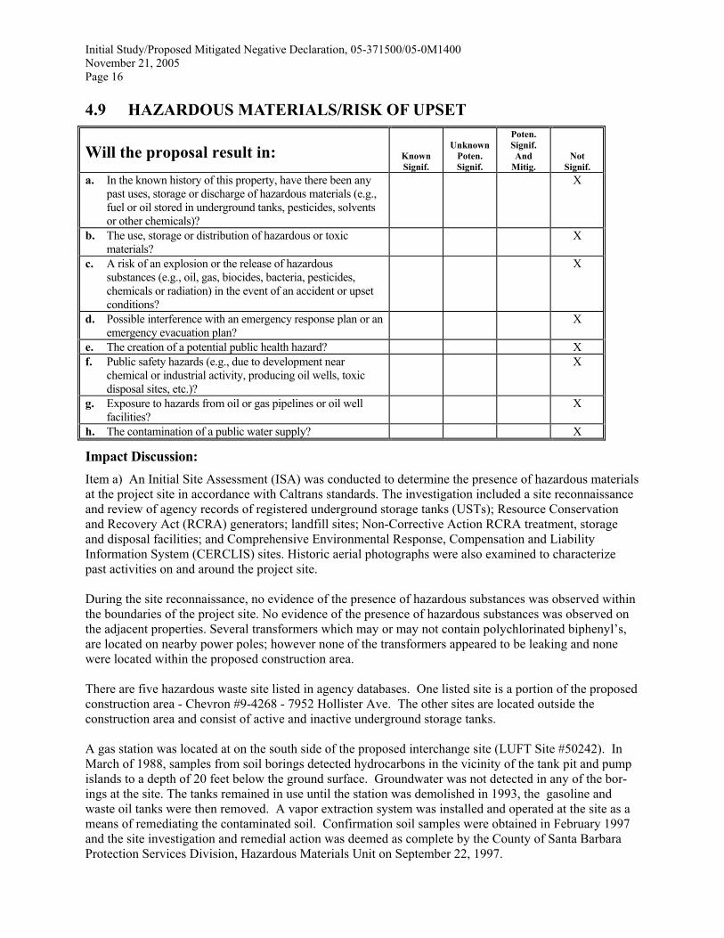
Initial Study/Proposed Mitigated Negative Declaration, 05-371500/05-0M1400November 21, 2005Page 16
4.9 HAZARDOUS MATERIALS/RISK OF UPSET
Will the proposal result in: KnownSignif.
UnknownPoten.Signif.
Poten.Signif.And
Mitig.Not
Signif.a. In the known history of this property, have there been any
past uses, storage or discharge of hazardous materials (e.g.,fuel or oil stored in underground tanks, pesticides, solventsor other chemicals)?
X
b. The use, storage or distribution of hazardous or toxicmaterials?
X
c. A risk of an explosion or the release of hazardoussubstances (e.g., oil, gas, biocides, bacteria, pesticides,chemicals or radiation) in the event of an accident or upsetconditions?
X
d. Possible interference with an emergency response plan or anemergency evacuation plan?
X
e. The creation of a potential public health hazard? Xf. Public safety hazards (e.g., due to development near
chemical or industrial activity, producing oil wells, toxicdisposal sites, etc.)?
X
g. Exposure to hazards from oil or gas pipelines or oil wellfacilities?
X
h. The contamination of a public water supply? X
Impact Discussion:Item a) An Initial Site Assessment (ISA) was conducted to determine the presence of hazardous materialsat the project site in accordance with Caltrans standards. The investigation included a site reconnaissanceand review of agency records of registered underground storage tanks (USTs); Resource Conservationand Recovery Act (RCRA) generators; landfill sites; Non-Corrective Action RCRA treatment, storageand disposal facilities; and Comprehensive Environmental Response, Compensation and LiabilityInformation System (CERCLIS) sites. Historic aerial photographs were also examined to characterizepast activities on and around the project site.
During the site reconnaissance, no evidence of the presence of hazardous substances was observed withinthe boundaries of the project site. No evidence of the presence of hazardous substances was observed onthe adjacent properties. Several transformers which may or may not contain polychlorinated biphenyl’s,are located on nearby power poles; however none of the transformers appeared to be leaking and nonewere located within the proposed construction area.
There are five hazardous waste site listed in agency databases. One listed site is a portion of the proposedconstruction area - Chevron #9-4268 - 7952 Hollister Ave. The other sites are located outside theconstruction area and consist of active and inactive underground storage tanks.
A gas station was located at on the south side of the proposed interchange site (LUFT Site #50242). InMarch of 1988, samples from soil borings detected hydrocarbons in the vicinity of the tank pit and pumpislands to a depth of 20 feet below the ground surface. Groundwater was not detected in any of the bor-ings at the site. The tanks remained in use until the station was demolished in 1993, the gasoline andwaste oil tanks were then removed. A vapor extraction system was installed and operated at the site as ameans of remediating the contaminated soil. Confirmation soil samples were obtained in February 1997and the site investigation and remedial action was deemed as complete by the County of Santa BarbaraProtection Services Division, Hazardous Materials Unit on September 22, 1997.

Initial Study/Proposed Mitigated Negative Declaration, 05-371500/05-0M1400November 21, 2005Page 17
A review of the site investigation reports indicated that the tanks and affected soils surrounding the tankswere located in the center of the parcel. Confirmation soils samples at, and adjacent to, the area affectedby the remediation indicated that no further action was required. Alternative 2 proposes to extend Cathe-dral Oaks Road, traversing the tip of the triangular shaped parcel at its west end, about 100 to 125 feetwest of the previous location of the underground tanks and affected soils. Hence, construction activitieswill avoid the previously contaminated (and now remediated) area.
Items b, c) The project will not generate hazardous emissions or involve the handling or storage ofacutely hazardous materials or wastes. The new interchange will increase traffic safety conditions becauseof smoother traffic operations, wider roads with greater visibility, and turn lanes. Hence, the movement ofany vehicles with hazardous materials through the new interchange will be safer than under current condi-tions.
Item d) The proposed project will improve circulation for emergency response vehicles. It will not affectany emergency response plan, nor limit options for future evacuation plans, including emergency re-sponses for incidents at Veneco Oil Facilities along Hollister Avenue. Access across Highway 101 will bemaintained at all times during construction.
Items e, f, g, h) Not applicable
Source: Phase I Initial Site Assessment
4.10 HISTORIC RESOURCES
Will the proposal result in: KnownSignif.
UnknownPoten.Signif.
Poten.Signif.And
Mitig.Not
Signif.a. Adverse physical or aesthetic impacts on a structure or
property at least 50 years old and/or of historic or culturalsignificance to the community, state or nation?
X
b. Beneficial impacts to an historic resource by providingrehabilitation, protection in a conservation/open easement,etc.?
X
Item a) No historic properties are present in the area of potential effect at the project site.
Item b) Not applicable
Source: Historic Property Survey Report and Negative Archeological Survey Report
4.11 LAND USE
Will the proposal result in: KnownSignif.
UnknownPoten.Signif.
Poten.Signif.And
Mitig.Not
Signif.a. Structures and/or land use incompatible with existing land
use?X
b. Conflict with any applicable land use plan, policy, orregulation of an agency with jurisdiction over the project(including, but not limited to the general plan, specificplan, local coastal program, or zoning ordinance) adoptedfor the purpose of avoiding of mitigating anenvironmental effect?
X

Initial Study/Proposed Mitigated Negative Declaration, 05-371500/05-0M1400November 21, 2005Page 18
Will the proposal result in: KnownSignif.
UnknownPoten.Signif.
Poten.Signif.And
Mitig.Not
Signif.c. The induction of substantial growth or concentration of
population?X
d. The extension of sewer trunk lines or access roads withcapacity to serve new development beyond this proposedproject?
X
e. Loss of existing affordable dwellings through demolition,conversion or removal?
X
f. Displacement of substantial numbers of existing housing,necessitating the construction of replacement housingelsewhere?
X
g. Displacement of substantial numbers of people,necessitating the construction of replacement housingelsewhere?
X
h. The loss of a substantial amount of open space? Xi. An economic or social effect that would result in a physical
change? (i.e. Closure of a freeway ramp results in isolationof an area, businesses located in the vicinity close,neighborhood degenerates, and buildings deteriorate. Or, ifconstruction of new freeway divides an existingcommunity, the construction would be the physical change,but the economic/social effect on the community would bethe basis for determining that the physical change would besignificant.)
X
j. Conflicts with adopted airport safety zones? X
Impact Discussion:
Item a) The proposed project would not represent a new or unusual land use at the project site because anexisting highway facility would be replaced with a new facility with the same function. However, Alter-native 2 would introduce a different physical presence at the project site due to the new locations of theovercrossing, overhead, and highway ramps; cut and fill slopes for ramps; and possibly the new controlsat the intersections. The replacement overcrossing structures, such as those being proposed, are commonalong Highway 101 in Santa Barbara County.
Construction of the proposed project may cause inconvenience to adjacent land uses because there wouldbe the temporary disruption of traffic and minor disruption to existing utilities along the right-of-way.However, this impact would be temporary, localized, and less than significant.
Item b) A detailed analysis of the project’s consistency with applicable local and regional plans is pro-vided in the Land Use Study. The results of the study indicated that the project is consistent with localplans.
The project is identified in the approved 1995 Regional Transportation Plan and the approved 1996 FederalTransportation Improvement program, both of which were prepared by the Santa Barbara County Associationof Governments.
The proposed project was designated a high priority project in the Goleta Transportation ImprovementPlan as an important link to other local roadway improvement projects such as the extension of CathedralOaks Road in the Winchester Commons residential development and the realignment of Hollister Avenuein the Sandpiper and Santa Barbara Club Resort & Spa Hotel developments.
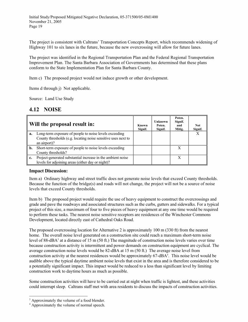
Initial Study/Proposed Mitigated Negative Declaration, 05-371500/05-0M1400November 21, 2005Page 19
The project is consistent with Caltrans’ Transportation Concepts Report, which recommends widening ofHighway 101 to six lanes in the future, because the new overcrossing will allow for future lanes.
The project was identified in the Regional Transportation Plan and the Federal Regional TransportationImprovement Plan. The Santa Barbara Association of Governments has determined that these plansconform to the State Implementation Plan for Santa Barbara County.
Item c) The proposed project would not induce growth or other development.
Items d through j) Not applicable.
Source: Land Use Study
4.12 NOISE
Will the proposal result in: KnownSignif.
UnknownPoten.Signif.
Poten.Signif.
andMitig.
NotSignif.
a. Long-term exposure of people to noise levels exceedingCounty thresholds (e.g. locating noise sensitive uses next toan airport)?
X
b. Short-term exposure of people to noise levels exceedingCounty thresholds?
X
c. Project-generated substantial increase in the ambient noiselevels for adjoining areas (either day or night)?
X
Impact Discussion:Item a) Ordinary highway and street traffic does not generate noise levels that exceed County thresholds.Because the function of the bridge(s) and roads will not change, the project will not be a source of noiselevels that exceed County thresholds.
Item b) The proposed project would require the use of heavy equipment to construct the overcrossings andgrade and pave the roadways and associated structures such as the curbs, gutters and sidewalks. For a typicalproject of this size, a maximum of four to five pieces of heavy equipment at any one time would be requiredto perform these tasks. The nearest noise sensitive receptors are residences of the Winchester CommonsDevelopment, located directly east of Cathedral Oaks Road.
The proposed overcrossing location for Alternative 2 is approximately 100 m (330 ft) from the nearesthome. The overall noise level generated on a construction site could reach a maximum short-term noiselevel of 88-dBA3 at a distance of 15 m (50 ft.) The magnitude of construction noise levels varies over timebecause construction activity is intermittent and power demands on construction equipment are cyclical. Theaverage construction noise levels would be 82-dBA at 15 m (50 ft.) The average noise level fromconstruction activity at the nearest residences would be approximately 67-dBA4. This noise level would beaudible above the typical daytime ambient noise levels that exist in the area and is therefore considered to bea potentially significant impact. This impact would be reduced to a less than significant level by limitingconstruction work to daytime hours as much as possible.
Some construction activities will have to be carried out at night when traffic is lightest, and these activitiescould interrupt sleep. Caltrans staff met with area residents to discuss the impacts of construction activities.
3 Approximately the volume of a food blender.4 Approximately the volume of normal speech.

Initial Study/Proposed Mitigated Negative Declaration, 05-371500/05-0M1400November 21, 2005Page 20
The most effective measure was determined to be ample notice of noisier construction activities that coulddisturb normal behaviors. An additional option might be to stagger these activities so they do not occur onconsecutive nights. In any case, the Resident Engineer will coordinate nighttime activities so that they causethe least disturbance possible, and maintain close communication with residents in order to address theirconcerns.
Item c) Construction of Alternative 1 would retain the bridge in its current location, and therefore traffic-related noise would be comparable to current levels. Construction of Alternative 2 would move bridgetraffic approximately 190 m (620 ft) closer to the homes at Winchester Commons. Since most of thevehicles accessing the bridge would also have to pass these homes via Calle Real or Cathedral Oaks, theirpresence on the bridge and the resultant traffic noise would not be noticeable. Noise levels could increaseslightly from bridge traffic travelling between Hollister and Calle Real (west of Hollister)/101, whichcurrently does not pass by Winchester Commons, but these traffic numbers are not high enough togenerate a substantial noise increase..
A noise model was used to determine the increase in ambient noise levels due to Alternative 2 at residencesin the Winchester Commons Development and at Sandpiper Golf Course. Future increases in traffic areexpected to increase ambient noise levels by 2 to 3 decibels by 2028 with or without the project. Alternative 2would raise noise levels by up to an additional 2 decibels in the vicinity of the new interchange only. Theresults of the noise modeling indicate that noise levels resulting from Alternative 2 would not be significant.
Neither the County of Santa Barbara’s 65-dBA CNEL noise standard nor the Caltrans 67-dBA Leq noisestandard would be exceeded at any of the modeled existing noise sensitive receptors. Also, noise level in-creases at noise sensitive receivers would not exceed any other significance criteria. Hence, the relocation ofthe interchange would not result in any significant noise impact on nearby noise-sensitive receptors.
Mitigation and Residual Impact:
NS-1 Construction activity for site preparation and major structural work shall be limited to the hoursbetween 8:00 a.m. and 6:00 p.m., Monday through Friday. No construction work shall occur on stateholidays. Non-noise generating construction activities are not subject to these restrictions. It isunderstood that some night time construction will be necessary to demolish and remove the existingstructure, and to construct portions of the new structure.
NS-2 Advanced notice of the project and the potential impacts from construction noise, dust, glare, andtraffic delays shall be placed in local news media at least 1 week in advance of the beginning ofconstruction. This notice is made by the District 5 Public Information Office after advance noticefrom the project’s Resident Engineer.
NS-3 The contractor shall be required to equip all construction vehicles and equipment with functioningand properly maintained muffler systems, including intake silencers where necessary.
NS-5 Additional reductions in noise impacts shall be provided by performing noisy operations, such asstockpiling and/or vehicle storage on site, as far away as practicable from the residences along thewestern and southwestern boundary of Winchester Commons.
Plan Requirements: Plans shall indicate the above restrictions. Timing: These restrictions shallapply during the duration of construction. Monitoring: The on-site foreman shall enforce therestrictions daily basis and document compliance on a weekly basis.

Initial Study/Proposed Mitigated Negative Declaration, 05-371500/05-0M1400November 21, 2005Page 21
4.13 PUBLIC FACILITIES
Will the proposal result in: KnownSignif.
UnknownPoten.Signif.
Poten.Signif.
andMitig.
NotSignif.
a. A need for new or altered police protection and/or healthcare services?
X
b. Student generation exceeding school capacity? Xc. Significant amounts of solid waste or breach any national,
state, or local standards or thresholds relating to solid wastedisposal and generation (including recycling facilities andexisting landfill capacity)?
X
d. A need for new or altered sewer system facilities (sewerlines, lift-stations, etc.)?
X
Impact Discussion:The proposed project would not create a need for additional public facilities.
4.14 RECREATION
Will the proposal result in: KnownSignif.
UnknownPoten.Signif.
Poten.Signif.
andMitig.
NotSignif.
a. Conflict with established recreational uses of the area? Xb. Conflict with biking, equestrian and hiking trails? Xc. Substantial impact on the quality or quantity of existing
recreational opportunities (e.g., overuse of an area withconstraints on numbers of people, vehicles, animals, etc.which might safely use the area)?
X
Impact Discussion:Item a) The project site is not used for recreational purposes; as such, the proposed project will not affectrecreation.
Item b) The alternative accommodate bike lanes; there will be no conflict with existing or future bikelanes. No hiking or equestrian trails are present at or near the project site.
Item c) The proposed project is not expected to increase the use of existing recreational facilities in theproject vicinity, such as Santa Barbara Shores Regional Park and Sandpiper Golf Course because it willnot provide a new access to these facilities, only a relocated access.
4.15 TRANSPORTATION/CIRCULATION
Will the proposal result in: KnownSignif.
UnknownPoten.Signif.
Poten.Signif.
andMitig.
NotSignif.
a. Generation of substantial additional vehicular movement(daily, peak-hour, etc.) in relation to existing traffic load andcapacity of the street system?
X
b. A need for private or public road maintenance, or need fornew road(s)?
X
c. Effects on existing parking facilities, or demand for newparking?
X

Initial Study/Proposed Mitigated Negative Declaration, 05-371500/05-0M1400November 21, 2005Page 22
Will the proposal result in: KnownSignif.
UnknownPoten.Signif.
Poten.Signif.
andMitig.
NotSignif.
d. Substantial impact upon existing transit systems (e.g. busservice) or alteration of present patterns of circulation ormovement of people and/or goods?
X
e. Alteration to waterborne, rail or air traffic? Xf. Increase in traffic hazards to motor vehicles, bicyclists or
pedestrians (including short-term construction and long-term operational)?
X
g. Inadequate sight distance? XIngress/egress? XGeneral road capacity? XEmergency access? X
h. Impacts to Congestion Management Plan system? X
Impact Discussion:Item a) The proposed project will not generate new traffic or otherwise increase the traffic volume. Theproposed Alternative 2 highway overcrossing and railroad overhead will have three lanes instead of thecurrent two lane structures; hence, traffic circulation will improve. The Alternative 2 reconfiguration ofthe intersections at Cathedral Oaks Road/Calle Road and Cathedral Oaks Road/Hollister Avenue will alsoremove existing turning movement conflicts and therefore, increase traffic circulation and safety.
Construction activities will cause periodic closures of ramps and the overcrossing at the interchange siteduring the 18-month construction period, with the exception of the northbound off-ramp at WinchesterCanyon Road, which will not be closed at any time. Traffic on both sides of the highway could be de-toured to the Glen Annie/Storke Road interchange. The detours will cause an inconvenience to motorists,but would be temporary and periodic in nature. Hence, this is considered a less than significant impact.
Item b) The proposed project represents a replacement of an existing structure and roadway; as such,there will be no net increase in maintenance requirements. The replacement of the structure will not resultin the need for new roads.
Item c) No parking areas will be affected by the project.
Item d) Existing transit stops will remain in place during and after construction. Alternative 2 will alterthe existing traffic circulation pattern by removing a circuitous route to cross Highway 101 and replacingit with a direct route. The overall operational efficiency of the interchange will improve, as well as thesafety factors. No new traffic safety hazards will be introduced.
Item e) Not applicable.
Item f) The proposed project will include Class II bike lanes on the overcrossing and overhead. All curbramps will conform with Americans with Disabilities Act and current state and county standards. Side-walks will also be provided on the overcrossing and overhead. These improvements will enhance safetyconditions for pedestrians and cyclists.
Item g) The proposed project will improve sight distance conditions, ingress/egress conditions, general roadcapacity, and emergency access compared to the existing roadway and overcrossing.
Item h) Not applicable.

Initial Study/Proposed Mitigated Negative Declaration, 05-371500/05-0M1400November 21, 2005Page 23
4.16 WATER RESOURCES/FLOODING
Will the proposal result in: KnownSignif.
UnknownPoten.Signif.
Poten.Signif.
andMitig.
NotSignif.
a. Changes in currents, or the course or direction of watermovements, in either marine or fresh waters?
X
b. Changes in percolation rates, drainage patterns or the rateand amount of surface water runoff?
X
c. Change in the amount of surface water in any water body? Xd. Discharge into surface waters, or alteration of surface water
quality, including but not limited to temperature, dissolvedoxygen, turbidity, or thermal water pollution?
X
e. Alterations to the course or flow of flood water or need forprivate or public flood control projects?
X
f. Exposure of people or property to water related hazardssuch as flooding (placement of project in 100 year floodplain), accelerated runoff or tsunamis?
X
g. Alteration of the direction or rate of flow of groundwater? Xh. Change in the quantity of groundwater, either through direct
additions or withdrawals, or through interception of anaquifer by cuts or excavations or recharge interference?
X
i. Overdraft or overcommitment of any groundwater basin?Or, a significant increase in the existing overdraft orovercommitment of any groundwater basin?
X
j. The substantial degradation of groundwater qualityincluding saltwater intrusion?
X
k. Substantial reduction in the amount of water otherwiseavailable for public water supplies?
X
Site Conditions:
The project site is primarily located within two watersheds, Devereux Creek and Bell/Winchester CanyonCreek. The UPRR railroad right of way east of the existing overhad drains to the east along the railroadbed. The drainage is highly ephemeral and does not resemble a creek. The drainage enters the Residencesat Sandpiper project site about one mile east of the project site. The Residences at Sandpiper project sitecontains a tributary to Devereux that traverses the property, extending from the UPRR right of way toHollister Avenue. This drainage has eroded banks and is vegetated by annual grasses, coyote brush, andscattered eucalyptus trees. It passes under Hollister Avenue through a 30-inch high square concrete cul-vert, then traverses a portion of the golf course.
The project site is also located in the Bell/Winchester Canyon watershed. Most of the site drains directlyor indirectly to Bell Canyon Creek. For example, the Winchester Commons area north of the highwayalong Calle Real drains to the highway right-of-way and is conveyed overland along the right-of-way tothe bottom of the canyon where it enters a storm drain to Bell Canyon Creek between Highway 101 andCalle Real. Runoff on the highway also is conveyed by overland flow to this same drain inlet. Runoff onthe railroad right-of-way is conveyed by overland flow and seepage in the alluvium to Bell CanyonCreek.
Bell Canyon Creek upstream of Highway 101 traverses an agricultural area with both orchards and rowcrops. It contains a very dense corridor of riparian woodland, containing willow and sycamore trees. Thecreek passes under Highway 101 through a large concrete arch culvert, then under the new bridge on theHyatt Hotel access road. The creek south of the highway also contains riparian woodland, although not asdense or continuous. The creekbed contains deep deposits of loose silt.

Initial Study/Proposed Mitigated Negative Declaration, 05-371500/05-0M1400November 21, 2005Page 24
Impact Discussion:
Items a, d) The project would involve soil excavation, removal of ground cover, and construction of fillslopes during at least one winter season, there is the potential for erosion with subsequent sedimentationthat could ultimately reach Bell Canyon and Devereux creeks. The construction disturbance area for Al-ternative 2 encompasses about 6.7 hectares (17.3 acres). About 3.5 hectares (7.8 acres) of this area wouldbe directly disturbed by grading or paving. The remainder of the construction zone would be mostly un-disturbed, except for possible equipment parking or access.
During and immediately after grading, cut and fill slopes would be subject to potential water erosion ifthere is a significant rain event. Other construction-related activities that have the potential to adverselyaffect water quality include asphalt paving of the roadway surface and concrete work. Paints, solvents,fuels, lubricants and other materials associated with the construction equipment and activities can alsoadversely affect water quality if improperly used or stored at the project site.
Because more than five acres of land area would be disturbed during construction of the project, the con-tractor must comply with the state General Permit to Discharge Storm Water Associated with Construc-tion Activity (General Construction Permit). The General Permit includes requirements to implementappropriate pollution prevention control measures and/or Best Management Practices (BMPs) to achievewater quality standards, monitor storm water discharges, maintain monitoring records, and prepare aStorm Water Pollution Prevention Plan (SWPPP) for the construction activities.
Implementation of a SWPPP prepared in accordance with the General Construction Permit requirementswould ensure that the water quality and beneficial uses of Bell Canyon and Devereux creeks downstreamof the project site are protected, and that any impact would be less than significant. Mitigation MeasureWQ-1 (see below) would provide additional assurances that significant construction-related sedimentationof Bell Canyons and Devereux creeks is avoided.
The proposed project would not increase the volume of traffic through the project site, nor would it intro-duce new types of vehicles (with potentially hazardous materials) that are not already allowed on theproject site roads. Hence, the pollutant loading from vehicles to stormwater runoff would be the same asunder current conditions.
Currently, runoff from the existing paved roadways drains by sheet flow onto the unvegetated median andthe unpaved areas of the right-of-way. Most of these areas drain to Bell Canyon Creek. Hence, storm-water pollutants which may be associated with the interchange runoff or potential spills of materials onthe roadways could reach Bell Canyon Creek. These discharges have the potential to adversely affectwater quality in the creek. The General Construction Permit requires management of post-constructionstormwater discharge which would include diverting stormwater runoff into grassy swales or vegetatedstrips for percolation and removal of pollutants and sediments during the operation of the new inter-change.
Based on the above considerations, impacts to the water quality and beneficial uses of Bell Canyon Creekare considered potentially adverse, but not significant. Mitigation Measure WQ-2 (see below) would pro-vide additional assurances that operational-related stormwater runoff into Bell Canyon Creek would notresult in significant water quality or biological impacts.
Item b) The proposed project would not alter local surface drainage and runoff patterns because it wouldnot create significant new topographic relief and fill slopes. The overall drainage patterns at the projectsite will not be affected because drainage will not be redirected, nor will any new drainage channels orconveyance be constructed.

Initial Study/Proposed Mitigated Negative Declaration, 05-371500/05-0M1400November 21, 2005Page 25
Alternative 2 will increase increasing the amount of impervious surfaces at the project site by 675 squaremeters (18,000 square feet). The small amount of new paved surface is not expected to significantlyincrease runoff at the project site, and therefore, to Bell Canyon Creek or Devereux Creek.
Item c) Not applicable.
Items e, f) The project would not occur in a 100-year floodplain as shown on the Federal Insurance RateMap or as mapped by FEMA. Hence, it would not alter the floodplain nor alter flood flows. In addition,the proposed project would not expose people to new flood hazards. The project site is not susceptible tosieches, tsunamis, or mudflows.
Items g through j) The project will not involve the use or extraction of groundwater, nor would the pro-ject involve excavations that would expose groundwater. Alternative 2 would increase the amount of im-pervious surfaces at the project site by 675 square meters (18,000 square feet). However, this reduction inpotential recharge area would be negligible and is not expected to adversely affect local or regionalgroundwater resources. Runoff from the impervious surfaces would be directed to grassy swales andearthen drainages before emptying into Bell Creek, thereby providing opportunity for recharge.
Item k) Not applicable.
Mitigation and Residual Impact:
The proposed project could cause a temporary increase in on-site erosion, potentially causing sedimenta-tion to Bell Canyon or Devereux Slough. In addition, runoff from the completed interchange may containvehicle-associated contaminants that may also reach these drainages. Significant water quality impactswould be avoided due to the water quality protection measures required as part of the General Construc-tion Stormwater Permit required by the State Water Resource Control Board. Additional water qualityprotection measures for construction- and operation-related impacts are provided in Mitigation MeasuresWQ-1 and WQ-2.
WQ-1 The Storm Water Pollution Prevention Plan to be prepared under the provisions of ConstructionGeneral Storm Water Permit should specifically include measures to: (1) prevent erosion from theconstruction site and from the post-construction site that could cause sedimentation into BellCanyon and Devereux creeks; and (2) prevent discharge of construction materials, contaminants,washings, concrete, fuels, and oils into Bell Canyon Creek or Devereux Creek. These measuresshould include, at a minimum, physical devices to prevent sedimentation and discharges (e.g., siltfencing, hay bales), and routine monitoring of these devices and the conditions of Bell Canyonand Devereux creeks downstream of the project site. BMPs should be developed based on thefollowing guidance manuals: California Storm Water Best Management Practice Handbook(Stormwater Quality Task Force, 1993) and Caltrans Storm Water Quality Handbook – Construc-tion Contractor’s Guide and Specifications (Caltrans, 1997).
Stockpile Management BMPs
• Provide silt fencing, straw logs, or hay bales around the base of the stockpiles to interceptsediment and inhibit the flow of sediment-laden runoff from the stockpiles.
• Construct diversions, containment berms or dikes around stockpiles to divert runoff aroundthe stockpiles and to prevent sedimentation of downslope areas.
• Hydroseed stockpiles with native grasses to provide a grass cover throughout the year to pre-vent wind and water erosion if the stockpiles will be inactive for more than 60 days.
• Use soil binders on stockpiles in lieu of temporary grass cover in the summer season ifwatering of the grass cover is infeasible.

Initial Study/Proposed Mitigated Negative Declaration, 05-371500/05-0M1400November 21, 2005Page 26
Grading and Filling BMPs
• Place silt fences, straw logs or hay bales around areas to be graded, especially cut and fillslopes to intercept any loose material that could erode onto the highway during construction.
• Place silt fences, straw logs or hay bales around the drain inlet to Bell Canyon Creek on thenorth side of Highway 101 and on the east bank of Bell Canyon Creek south of the highwayto prevent erodible material from entering the creek.
• Use soil binders, temporary mulches or erosion control blankets or hydroseeding for tempo-rary slopes that would be exposed to wind and water erosion prior to beginning work.
• Convey drainage from equipment laydown and parking areas through a sediment basin wheresediments and contaminants can be trapped and water quality can be monitored.
• Stabilize construction entrances to the project site with gravel. This will help prevent sedi-ment tracking from the construction area to paved roads.
• Install diversion dikes or ditches to divert runoff around active graded areas.
Dewatering BMPs
• Install sediment controls (either a sediment trap or sediment basin) to collect water from anydewatering operations. Filter out sediment from the sediment trap or sediment basin using asump pit and perforated or silt standpipe with holes and wrapped in filter
Waste Management BMPs
• All construction vehicles and equipment that enter the construction and grading areas will beproperly maintained (off-site) to prevent leaks of fuel, oil and other vehicle fluids.
• Conduct equipment and vehicle fueling off-site. If refueling is required at the project site, itwill be done within a bermed area with an impervious surface to collect spilled fluids.
• Prepare a spill prevention/spill response plan for the project site that includes training,equipment and procedures to address spills from equipment, stored fluids and other materials.
• Place all stored fuel, lubricants, paints and other construction liquids in secured and coveredcontainers within a bermed area.
• Conduct any mixing and storage of concrete and mortar in contained areas.• Ensure that all equipment washing and major maintenance is prohibited at the project site,
except for washdown of vehicles to remove dirt which must only occur in a bermed area.• Remove all refuse and excess material from the site as soon as possible
Plan Requirements: The construction plans and specification shall incorporate the Storm WaterPollution Prevention Plan. Timing: A SWPPP shall be completed as part of final plans and speci-fications. A Notice of Intent shall be submitted to the State Water Resources Control Board priorto construction. All BMPs shall be installed one month prior to anticipated winter rains, andmaintained throughout the construction period. Monitoring: A on-site erosion control managershall perform daily inspections during the winter, and document compliance with the SWPPP ona weekly basis.
WQ-2 The proposed roadways and ramps should include current Caltrans design features to reduce pol-lutant loads in stormwater runoff, such as vegetated drainage channels or grassy areas. Storm-water from new ramps and roadways should not be discharged directly into Bell Canyon Creek.
Plan Requirements: The construction plans and specification shall incorporate vegetated grassyswales that will assist in percolation of runoff and removal of roadway pollution. Timing: The

Initial Study/Proposed Mitigated Negative Declaration, 05-371500/05-0M1400November 21, 2005Page 27
plans for the swales shall be completed as part of final plans and specifications. Monitoring:Successful installation of these features shall be documented during final inspection.
Source: Water Quality Study
5.0 INFORMATION SOURCES5.1 County Departments Consulted
Police, Fire, Public Works, Flood Control, Parks, Environmental Health, Special Districts,Regional Programs, Other : ___________________________________________________
5.2 Comprehensive Plan
X Seismic Safety/Safety Element X Conservation ElementX Open Space Element X Noise ElementX Coastal Plan and Maps X Circulation ElementX ERME
5.3 Other Sources
X Field work Ag Preserve mapsX Calculations Flood Control mapsX Project plans X Other technical referencesX Traffic studies (reports, survey, etc.)
Records X Planning files, maps, reportsGrading plans X Zoning mapsElevation, architectural renderings X Soils maps/reportsPublished geological map/reports Plant maps
X Topographical maps X Archaeological maps and reports
The following reports were prepared by URS Greiner Woodward-Clyde for the County of SantaBarbara for a project consisting of only Alternative 2. Updates and revisions were made by Caltranstechnical staff to include information pertaining to Alternative 1.♦ Natural Environmental Study, January 1999 (revised by URS August 2001, Caltrans May 2005)♦ Air Quality Impact Study, August 1999 (updated by URS August 2001, Caltrans May 2005)♦ Noise Impact Study, January 1999 (updated by URS August 2001, Caltrans February 2005)♦ Water Quality Impact Study, August 1999 (updated by URS August 2001, Caltrans October 2004)♦ Phase I Initial Site Assessment, January 1999 (updated by URS August 2001)
The following reports were prepared by Caltrans technical staff for the proposed project:♦ Visual Impact Assessment Addendum (to the Initial Study), November 2004♦ Negative Historic Property Survey Report, 1998 (updated March 2005)♦ Preliminary Geotechnical Report, March 2005♦ Paleontology Study, May 2005
Other reports used: Winchester Commons Final EIR and Supplemental FEIR (S.B. County, 1987,1989), Sandpiper Golf Course Expansion EIR (S.B. County, 1995) ; Associated TransportationEngineers traffic analysis (appendix in Project Report.)
6.0 CUMULATIVE IMPACT SUMMARYThe project has the potential for significant impacts related to construction noise and construction-relatederosion. Because these impacts are short-term, they will not contribute to cumulative impacts.

Initial Study/Proposed Mitigated Negative Declaration, 05-371500/05-0M1400November 21, 2005Page 28
Alternative 2 has potential for significant impacts on California red-legged frog through displacement ofupland habitat and isolation of aquatic habitat. Construction of the Residences at Sandpiper would likelyhave similar impacts. The development would create a barrier to the south, leaving open the potentialfrog dispersal corridors to the east and west. Hollister Avenue may already substantially preventmovement between the golf course and the culvert outlet pool. The Residences at Sandpiper would alsodisplace upland habitat near the culvert outlet pool.
The proposed Hollister Overcrossing project would not further isolate aquatic habitat and, therefore,would not contribute to a cumulative loss of habitat connectivity. The proposed project would contributeto a cumulative loss of upland habitat surrounding the culvert outlet pool and overall habitat degradation,although this project’s contribution is very small and not considered signficant.
7.0 MANDATORY FINDINGS OF SIGNIFICANCE
KnownSignif.
UnknownPoten.Signif.
Poten.Signif.
andMitig.
NotSignif.
1. Does the project have the potential to substantially degradethe quality of the environment, substantially reduce thehabitat of a fish or wildlife species, cause a fish or wildlifepopulation to drop below self-sustaining levels, threaten toeliminate a plant or animal community, reduce the numberor restrict the range of a rare or endangered plant or animalor eliminate important examples of the major periods ofCalifornia history or prehistory?
X
2. Does the project have the potential to achieve short-term tothe disadvantage of long-term environmental goals?
X
3. Does the project have impacts that are individually limited,but cumulatively considerable? (“Cumulativelyconsiderable” means that the incremental effects of a projectare considerable when viewed in connection with the effectsof past projects, the effects of other current projects and theeffects of probable future projects.)
X
4. Does the project have environmental effects which willcause substantial adverse effects on human beings, eitherdirectly or indirectly?
X
Item 1) The proposed project will not result in an overall degradation of the environment because it willnot affect sensitive resources and will not substantially alter or modify the local environment. It will notsubstantially reduce fish and wildlife habitat and populations, significantly affect rare or endangered spe-cies, or affect archeological and historic resources.
Item 2) There is no expected disadvantage to long-term environmental goals for the area.
Item 3) The project would not result in any significant cumulative impacts with other nearby projects.There are two major projects near the project site – Sandpiper Golf Course Renovation and The Resi-dences at Sandpiper. The former involved the following improvements to the existing golf course withinits current boundaries: reconfigure course layout; regrade and replant most of the course; build a newclubhouse and golf school; reconfigure the parking lot; restore several sensitive habitats on the course;and subdivide the property for financing purposes. A CEQA document was prepared for this project andconstruction has been completed.
The undeveloped land between Hollister Avenue and the railroad are part of a project called TheResidences at Sandpiper. The project includes 119 units, with 20 percent reserved as affordable units.
Initial Study/Proposed Mitigated Negative Declaration, 05-371500/05-0M1400November 21, 2005Page 29
Permits are in process and the construction date is unknown at this time. The layout and planned landuses for The Residences at Sandpiper would not affect the lane configurations or intersection at HollisterAve and Cathedral Oaks Road. The western portion of the site would be accessed directly from HollisterAvenue and the eastern portion would take access from Las Armas Road. Perimeter walls would beconstructed on the northern boundary (next to the railroad and Highway 101 corridors) and westernboundaries (next to the new Hollister Avenue interchange) of the project site.
Item 4) The proposed project would affect human beings by nuisance impacts, including increased noise,dust, traffic, and delays during construction. These impacts are temporary and not considered substantial.
8.0 RECOMMENDATIONOn the basis of the Initial Study, I find that, although the proposed project could have a significant effect onthe environment, there will not be a significant effect in this case because the mitigation measuresincorporated into the project would successfully mitigate the potentially significant impacts. A MitigatedNegative Declaration will be prepared.
Larry Newland, AICP DateEnvironmental Branch Chief, Central Region
Paul P. Martinez DateProject Management, District 5
9.0 TITLE VIThe California Department of Transportation, under Title VI of the Civil Rights Act of 1964 and relatedstatues, ensures that no person in the State of California shall, on the grounds of race, color, nationalorigin, sex, disability, and age, be excluded from participation in, be denied the benefits of, or beotherwise subjected to discrimination under any program or activity it administers.
10.0 LIST OF PREPARERSThe following people were principally responsible for preparing the Initial Study and technical reports:
Caltrans
Paula Huddleston: Associate Environmental Planner. B.A. in Anthropology. Updated the Initial Study.
Dave Hacker: Associate Environmental Planner (Natural Sciences). B.S. Natural Resource Management.Updated the Natural Environment Study.
Terry Joslin: Associate Environmental Planner (Cultural Resources). B.S. Anthropology. Updated theHistoric Property Survey Report.

Initial Study/Proposed Mitigated Negative Declaration, 05-371500/05-0M1400November 21, 2005Page 30
Wayne Mills: Transportation Engineer. B.A. Social Science, B.A. Earth Science. Updated the AirQuality and Noise technical reports. Prepared the Paleontology Report.
Isaac Leyva: Engineering Geologist. B.S. Geology. Updated the Water Quality Impact Study.
Bob Carr: Landscape Architect. B.S. Landscape Architecture, registered Landscape Architect. Updatedthe study on visual quality impacts.
Ron Richman: Professional Engineer, Certified Engineering Geologist. B.S. in Geology, M.S. CivilEngineering. Prepared the Preliminary Geotechnical Report.
Consultants
URS Greiner Woodward-Clyde, Santa Barbara, CA. Prepared Initial Study and most technical studies.
Other members of the project team include:
Steve Andris: Transportation Engineer, registered Professional Engineer. B.S. Civil Engineering.
David Fapp: Senior Transportation Engineer, registered Professional Engineer. B.S. Civil Engineering.
Paul Martinez: Project Manager, registered Professional Engineer. B.S. Civil Engineering.
Larry Newland: Senior Environmental Planner. B.A. History; member American Institute of CertifiedPlanners.
11.0 ATTACHMENTSFigure 1 Location of Project Site Figure 2 Layouts


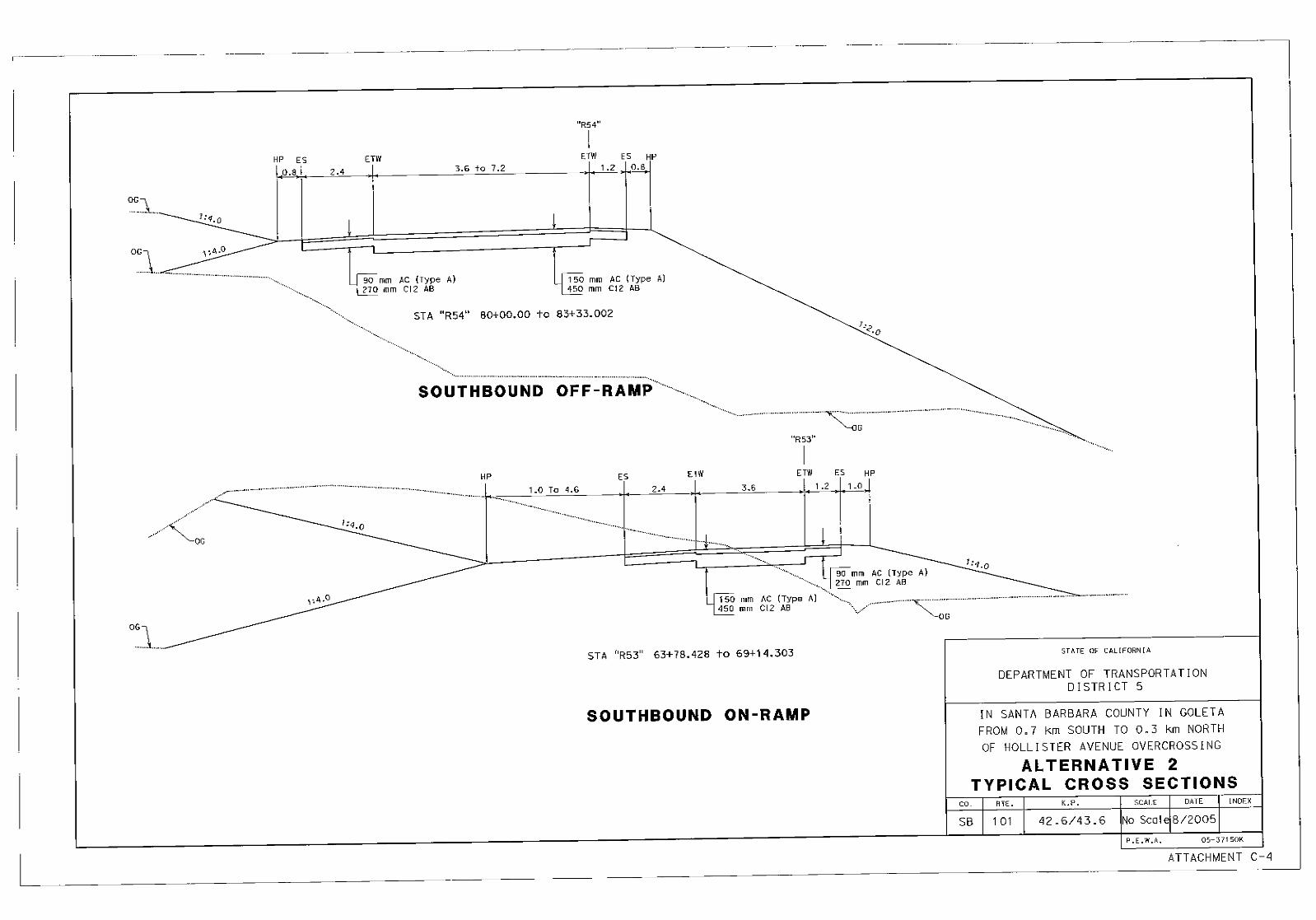


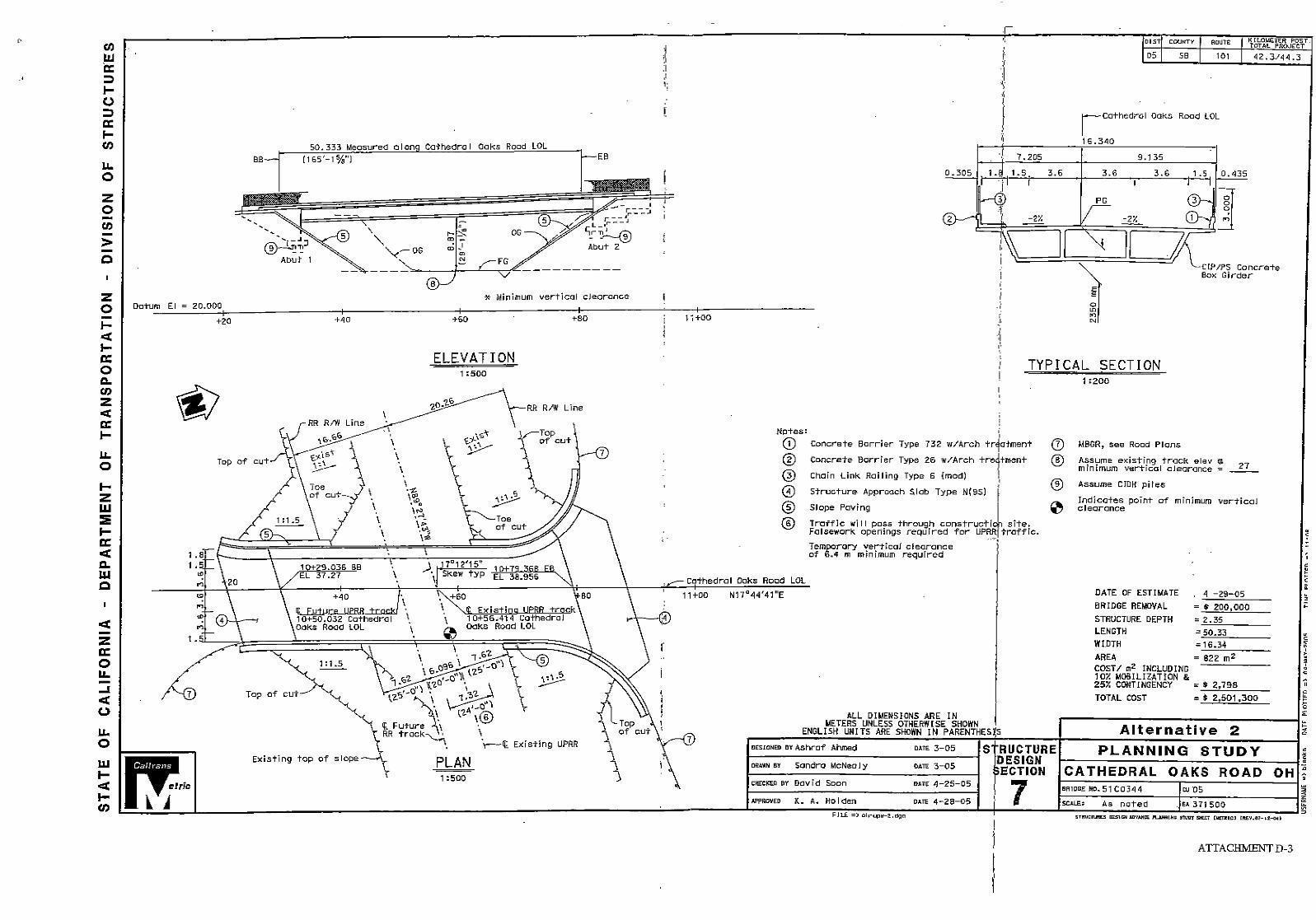


PROJECT REPORT COST ESTIMATE
Dist-Co-Rte 05-SB-101KP (PM) KP 42.6/43.6 (PM 26.5/27.1)
EA 05-371500Program Code 20.XX.202.381 (HA4S2)
etric
Caltrans
Unit300 m3 $20
1,400 m3 $201 LS $7,0001 LS $5,000
Subtotal Earthwork:
Depth m3 $0Depth m3 $0
800 Tonnes $80m3 $0m3 $0
760 m3 $35m3 $0m3 $0m2 $0m $0
Subtotal Structural Section:
LS $01 LS $25,000
$01 LS $25,000
(X-Drains, overside, etc.)100 m $15
mSidewalk (1.8m x 100 mm) m
Subtotal Drainage:
I. ROADWAY ITEMS
Section CostRoadway Excavation $6,000Imported Borrow $28,000
Section 1 - Earthwork Quantity Unit Price Item Cost
Clearing & Grubbing $7,000Develop Water Supply $5,000
$0$0
$46,000Section 2 - Structural Section*PCC Pvmt $0PCC Pvmt $0Asphalt Concrete $64,000Lean Concrete Base $0Cement-Treated Base $0Aggregate Base $26,600Treated Permeable Base $0Aggregate Subbase $0Pvmt Reinforcing Fabric $0Edge Drains $0
$0$0
$90,600Section 3 - DrainageLarge Drainage Facilities $0Storm Drains $25,000Pumping Plants $0Project Drainage $25,000
AC dike $1,500Type A2-150 Curb $0
$0$51,500
* Reference sketch showing typical structural section elements of the roadway. Include (if available) T.I., R-Value and date when tests were performed.
8/2005 ATTACHMENT E-2

PROJECT REPORT COST ESTIMATE
Dist-Co-Rte 05-SB-101KP (PM) KP 42.6/43.6 (PM 26.5/27.1)
EA 05-371500Program Code 20.XX.202.381 (HA4S2)
etric
Caltrans
Quantity Unit$0$0
1 LS $10,000$0
LS $01 LS $10,000
$0$0
1 LS $15,000$0
1 LS $10,000$0$0
1 $10,000EA
1 LS $10,000
Subtotal Specialty Items:
1 LS $9,0001 LS $10,000
LS $0LS $0LS $0
1 LS $100,0001 LS $50,0001 LS $20,0001 LS $5,0001 LS $50,000
Subtotal Traffic Items:
TOTAL SECTIONS 1 thru 5
Section 4 - Specialty Items Unit Price Item Cost Section CostRetaining Walls $0Noise Barriers $0Barriers and Guardrails $10,000Equipment/Animal Passes $0Highway Planting $0Replacement Planting $10,000Irrigation Modification $0Relocate Private Irrigation $0Erosion Control $15,000Slope Protection $0Water Pollution Control $10,000Haz Materials Mitigation $0Environmental Mitigation $0Resident Engineer Office $10,000Water Meter $0Plant Establishment (1-year) $10,000
$0$65,000
Section 5 - Traffic ItemsLighting Conduit (Bridge) $9,000Traffic Delineation $10,000Traffic Signals $0Overhead Sign Structures $0Roadside Signs $0Traffic Control Systems $100,000Traffic Management Plan $50,000Construction Area Signs $20,000Traffic Handling (CMS) $5,000Maintain Traffic $50,000
$244,000
$497,100
8/2005 ATTACHMENT E-3

PROJECT REPORT COST ESTIMATE
Dist-Co-Rte 05-SB-101KP (PM) KP 42.6/43.6 (PM 26.5/27.1)
EA 05-371500Program Code 20.XX.202.381 (HA4S2)
etric
Caltrans
Item Cost Section Cost
x 0.10 =(5 to 10%)
x 0.10 =(10%)
x 0.10 =(5 to 10%)
x 0.15 =(**%)
Phone: 11/17/05(Print Name) (Date)
Phone:(Print Name) (Date)
http://www.dot.ca.gov/hq/oppd/pdpm/pdpm.htm - pdpm
Estimate Checked by:
**Use appropriate percentage per PDPM, Part 3 Chapter 20.
(Subtotal Sections 1 thru 8)
Estimate Prepared by: Steve Andris 8-629-3075
(Subtotal Sections 1 thru 6)
TOTAL SECTION 8 ROADWAY ADDITIONS: $136,703
TOTAL ROADWAY ITEMS: $738,194
(Subtotal Sections 1 thru 6)
Contingencies$546,810 $82,022
Section 8 - Roadway Additions
Supplemental Work$546,810 $54,681
Section 6 - Minor Items
$497,100 $49,710(Subtotal Sections 1 thru 5)
TOTAL SECTION 6 MINOR ITEMS: $49,710
Section 7 - Roadway Mobilization
$546,810 $54,681(Subtotal Sections 1 thru 6)
TOTAL SECTION 7 MOBILIZATION ITEMS: $54,681
8/2005 ATTACHMENT E-4

PROJECT REPORT COST ESTIMATE
Dist-Co-Rte 05-SB-101KP (PM) KP 42.6/43.6 (PM 26.5/27.1)
EA 05-371500Program Code 20.XX.202.381 (HA4S2)
etric
Caltrans
No. 1 No. 2 No. 3Bridge Name Hollister Ave OC
51-0123
12.8759.46765Pile
$2,455$1,879,200
$250,000
COMMENTS:
Phone: 04/29/05(Print Name) (Date)
(If appropriate, attach additional pages as backup)
TOTAL STRUCTURES ITEMS $2,129,200
Estimate Prepared by: Ashraf Ahmed 8-498-9536
SUBTOTAL STRUCTURES ITEMS $2,129,200
Railroad Related Costs $0
Cost Per m2 (incl. 10% mobilization & 25% contingenciesTotal Cost for StructureBridge Removal
* Add additional structures as necessary
Width (out to out) - (m)Span Length - (m)Total Area - m2
Footing Type (pile/spread)
Structure Type CIP/PS Concrete Box
Girder
II. STRUCTURE ITEMSSTRUCTURE
8/2005 ATTACHMENT E-5

PROJECT REPORT COST ESTIMATE
Dist-Co-Rte 05-SB-101KP (PM) KP 42.6/43.6 (PM 26.5/27.1)
EA 05-371500Program Code 20.XX.202.381 (HA4S2)
etric
Caltrans
EscalationRates
5.0%
25.0% 0.0% 0.0% 5.0% 5.0%
02/11/07
Estimate Prepared by: Phone: 04/18/05(Print Name) (Date)
(If appropriate, attach additional pages and backup including Right of Way Data Sheet and Environmental Mitigation and Compliance Cost Estimate Sheet).
Date to which Values are Escalated:
* Escalated to assumed year of advertising.** Current total value for use on Sheet 1
Phil Acosta 8-629-3396
$6,813TOTAL RIGHT OF WAY** $10,203
ESCALLATED VALUE*
Expert Witness $0 $0Construction Contract Work $0 $0
RAP $0 $0Title and Escrow Fees $0 $0
Utility Relocation (State share) $5,250 $8,203Clearance/Demolition $0 $0
(Future Use) Values*Acquisition, including excess lands and damages to remainder(s) and Goodwill
2005 2007 (Rounded)
$1,563 $2,000
III. RIGHT OF WAY ITEMS
Current Values Escalated
8/2005 ATTACHMENT E-6

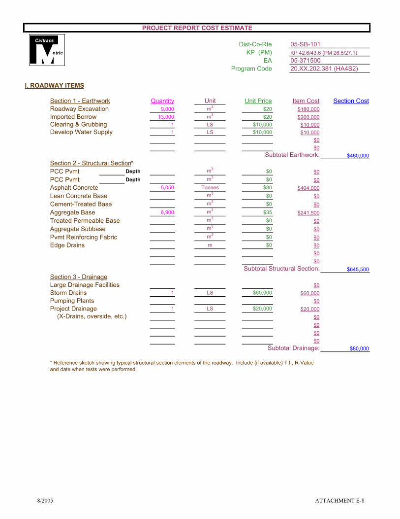
PROJECT REPORT COST ESTIMATE
Dist-Co-Rte 05-SB-101KP (PM) KP 42.6/43.6 (PM 26.5/27.1)
EA 05-371500Program Code 20.XX.202.381 (HA4S2)
etric
Caltrans
Unit9,000 m3 $20
13,000 m3 $201 LS $10,0001 LS $10,000
Subtotal Earthwork:
Depth m3 $0Depth m3 $0
5,050 Tonnes $80m3 $0m3 $0
6,900 m3 $35m3 $0m3 $0m2 $0m $0
Subtotal Structural Section:
1 LS $60,000
1 LS $20,000 (X-Drains, overside, etc.)
Subtotal Drainage:
Section CostSection 1 - Earthwork Quantity Item CostUnit Price
$645,500
$80,000
$20,000
$0$0$0
$0
$0$0
$0$60,000
$0$0$0$0
$0
$0
$0
$241,500
$0
$404,000$0
$260,000$10,000$10,000
$0
Storm DrainsPumping PlantsProject Drainage
Pvmt Reinforcing Fabric
Large Drainage Facilities
Develop Water Supply
Cement-Treated Base
Treated Permeable BaseAggregate Subbase
* Reference sketch showing typical structural section elements of the roadway. Include (if available) T.I., R-Value and date when tests were performed.
Section 3 - Drainage
Edge Drains
Asphalt ConcreteLean Concrete Base
Aggregate Base
PCC Pvmt
$180,000
$460,000Section 2 - Structural Section*
Roadway ExcavationImported BorrowClearing & Grubbing
I. ROADWAY ITEMS
PCC Pvmt
$0
8/2005 ATTACHMENT E-8

PROJECT REPORT COST ESTIMATE
Dist-Co-Rte 05-SB-101KP (PM) KP 42.6/43.6 (PM 26.5/27.1)
EA 05-371500Program Code 20.XX.202.381 (HA4S2)
etric
Caltrans
Quantity Unit4 EA $7,000
$01 LS $70,0001 LS $15,0001 LS $330,000
$01 LS $245,0001 LS $15,0001 LS $61,5401 LS $200,0001 LS $50,000
$01 LS $62,0001 $34,2501 EA $145,000
155 M $3001 LS $72,000
Subtotal Specialty Items:
1 LS $120,0001 LS $50,0001 LS $10,0001 LS $3,0001 LS $5,0001 LS $150,0001 LS $75,0001 LS $35,0001 LS $10,0001 LS $15,500
Subtotal Traffic Items:
TOTAL SECTIONS 1 thru 5
Unit Price Section CostItem Cost
$3,033,290
$5,000$150,000$75,000$35,000$10,000$15,500
$120,000$50,000$10,000$3,000
$145,000$46,500$72,000
$1,374,290
$50,000$0
$62,000$34,250
$245,000$15,000$61,540
$200,000
$70,000$15,000
$330,000$0
$28,000$0
Traffic Handling (CMS)Lighting Conduit (Bridge)
$473,500
Roadside SignsTraffic Control SystemsTraffic Management PlanConstruction Area Signs
Environmental MitigationResident Engineer Office
Highway Planting (Includes of RW)Replacement PlantingIrrigation (Includes of RW)Resident Engineer Office (Planting Project)
Section 4 - Specialty Items
Section 5 - Traffic Items
Maintenance Vehicle Pullouts (Br Project)Noise BarriersBarriers and GuardrailsWater Pollution Control (Planting Project)
Erosion ControlArchitectural TreatmentWater Pollution ControlHaz Materials Mitigation
Water Meter and Assessment FeeIrrigation X-overs (Bridge Project)Plant Establishment (3-year)
LightingTraffic DelineationTraffic Control Systems (Planting Project)Construction Area Signs (Planting Project)
8/2005 ATTACHMENT E-9

PROJECT REPORT COST ESTIMATE
Dist-Co-Rte 05-SB-101KP (PM) KP 42.6/43.6 (PM 26.5/27.1)
EA 05-371500Program Code 20.XX.202.381 (HA4S2)
etric
Caltrans
Item Cost Section Cost
x 0.10 =(5 to 10%)
x 0.10 =(10%)
x 0.10 =(5 to 10%)
x 0.15 =(**%)
Phone: 11/17/05(Print Name) (Date)
Phone:(Print Name) (Date)
TOTAL SECTION 8 ROADWAY ADDITIONS:
TOTAL ROADWAY ITEMS:
Estimate Prepared by:
$3,033,290 $303,329
$3,336,619 $333,662
$303,329
$333,662
8-629-3075Steve Andris
Section 7 - Roadway Mobilization
Section 8 - Roadway Additions
TOTAL SECTION 7 MOBILIZATION ITEMS:
$3,336,619 $500,493
$3,336,619
Section 6 - Minor Items
$834,155
$4,504,436(Subtotal Sections 1 thru 8)
$333,662Supplemental Work
Contingencies
TOTAL SECTION 6 MINOR ITEMS:
http://www.dot.ca.gov/hq/oppd/pdpm/pdpm.htm - pdpm
Estimate Checked by:
**Use appropriate percentage per PDPM, Part 3 Chapter 20.
(Subtotal Sections 1 thru 6)
(Subtotal Sections 1 thru 6)
(Subtotal Sections 1 thru 6)
(Subtotal Sections 1 thru 5)
8/2005 ATTACHMENT E-10

PROJECT REPORT COST ESTIMATE
Dist-Co-Rte 05-SB-101KP (PM) KP 42.6/43.6 (PM 26.5/27.1)
EA 05-371500Program Code 20.XX.202.381 (HA4S2)
etric
Caltrans
No. 1 No. 2 No. 3Bridge Name Cathedral Oaks Rd OC Cathedral Oaks Rd OH
51-0331 51-C0344
16.34 16.3451.74 50.33
845 822Pile Pile
$2,344 $2,798$1,981,700 $2,301,300
$250,000 $200,000
COMMENTS:
Phone: 04/29/05(Print Name) (Date)
SUBTOTAL STRUCTURES ITEMS
Width (out to out) - (m)Span Length - (m)
Footing Type (pile/spread)Cost Per m2 (incl. 10% mobilization & 25% contingencies
$4,733,000
Structure Type
$4,733,000
$0
(If appropriate, attach additional pages as backup)
Estimate Prepared by:
STRUCTURE
TOTAL STRUCTURES ITEMS
Railroad Related Costs
Total Cost for StructureBridge Removal
CIP/PS Concrete Box
Girder
Total Area - m2
II. STRUCTURE ITEMS
Ashraf Ahmed 8-498-9536
CIP/PS Concrete Box
Girder
* Add additional structures as necessary
8/2005 ATTACHMENT E-11

PROJECT REPORT COST ESTIMATE
Dist-Co-Rte 05-SB-101KP (PM) KP 42.6/43.6 (PM 26.5/27.1)
EA 05-371500Program Code 20.XX.202.381 (HA4S2)
etric
Caltrans
EscalationRates
5.0%
25.0%0.0%0.0%5.0%5.0%
02/11/07
Estimate Prepared by: Phone: 04/18/05(Print Name) (Date)
$349,617
$0
$69,000
RAPTitle and Escrow FeesExpert Witness
$0$9,000
Construction Contract Work $5,000 $5,000
$62,475$0$0
$8,523$62,500
Utility Relocation (State share)Clearance/Demolition
$296,459
$174,000
Values*Escalated
(Future Use)
$97,617
Current Values
Acquisition, including excess lands and damages to remainder(s) and Goodwill
$157,961
2007 (Rounded)
(If appropriate, attach additional pages and backup including Right of Way Data Sheet and Environmental Mitigation and Compliance Cost Estimate Sheet).
Margo Anderson 8-629-3076
III. RIGHT OF WAY ITEMS
ESCALLATED VALUE*Date to which Values are Escalated:
* Escalated to assumed year of advertising.
2005
TOTAL RIGHT OF WAY**
** Current total value for use on Sheet 1
8/2005 ATTACHMENT E-12