Embed Size (px)
Citation preview
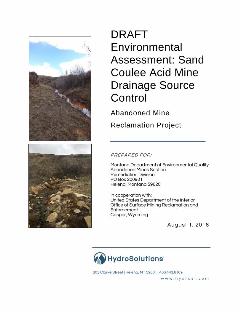
DRAFT Environmental Assessment: Sand Coulee Acid Mine Drainage Source Control
Abandoned Mine
Reclamation Project
Cascade County, Montana PREPARED FOR: Montana Department of Environmental Quality Abandoned Mines Section Remediation Division PO Box 200901 Helena, Montana 59620 In cooperation with: United States Department of the Interior Office of Surface Mining Reclamation and Enforcement Casper, Wyoming
August 1, 2016
303 Clarke Street | Helena, MT 59601 | 406.443.6169
w w w . h y d r o s i . c o m

Montana DEQ | Sand Coulee Source Control EA
2016.08.01 | Page i
Contents
1.0 Introduction ......................................................................................................... 1
1.1 Purpose and Need .............................................................................................. 1
1.2 Project Location .................................................................................................. 2
2.0 Description of the Proposed Project and Alternatives ......................................... 4
2.1 No Action ............................................................................................................ 4
2.2 Proposed Action .................................................................................................. 5
2.3 Alternatives Not Considered for Further Analysis ................................................ 8
3.0 Description of the Existing Environment ........................................................... 10
3.1 Project Background ............................................................................................... 10
3.2 Environmental Setting ........................................................................................... 12
4.0 Environmental Consequences .......................................................................... 24
4.1 No Action .......................................................................................................... 24
4.2 Proposed Action ................................................................................................ 25
5.0 Consultation and Coordination ......................................................................... 30
6.0 References Cited ............................................................................................. 31
List of Figures
Figure 1. Project location, Cascade County, Montana. ............................................................... 3
Figure 2. Locations of abandoned coal mines in the vicinity of Sand Coulee .............................. 4
Figure 3. Conceptual cross-section of subhorizontal well design ................................................ 6
Figure 4. Plan view of proposed subhorizontal well design......................................................... 7
Figure 5. Conceptual cross-section for vertical well design ........................................................ 8
Figure 6. Surface hydrology of the Sand Coulee project area, Cascade County, Montana. .......14
Figure 7. Geologic map of the Sand Coulee project area, Cascade County, Montana. .............16

Montana DEQ | Sand Coulee Source Control EA
2016.08.01 | Page i i
List of Tables
Table 1. Species identified by MT NHP as occurring within a five-mile radius of the proposed Sand
Coulee project area. ..................................................................................................................20
Table 2. Sand Coulee, Montana Data and Demographics as of July 1, 2015 ............................23
Attachments
Appendix A: State Historic Preservation Office Concurrence
Appendix B: Montana Natural Heritage Program Data Query

Montana DEQ | Sand Coulee Source Control EA
2016.08.01 | Page 1
1.0 Introduction
1.1 Purpose and Need
The objective of the Acid Mine Drainage (AMD) Source Control project is to mitigate ongoing
discharges of AMD from abandoned coal mines surrounding the community of Sand Coulee.
The abandoned mine workings in and around Sand Coulee act as groundwater drains which
dewater the overlying Kootenai sandstone and discharge contaminated water to tributaries of
Sand Coulee Creek. The AMD is extremely acidic and contains numerous metals, including
arsenic, cadmium, chromium, iron, manganese, nickel, thallium, and zinc at concentrations
exceeding Montana Department of Environmental Quality (DEQ) standards. DEQ has identified
this project for action because AMD has contaminated groundwater in the shallow aquifers
around Sand Coulee. Natural downward leakage, fractures, and abandoned well bores have
distributed the AMD to the underlying Madison Limestone aquifer as indicated by recent
groundwater investigations. The specific goals of the project are to reduce the loading of metals,
improve the surface water and groundwater quality in Sand Coulee, and mitigate the ongoing
loading of AMD to the Madison Limestone aquifer.
AMD source control would be the proposed action and includes intercepting groundwater in the
Kootenai sandstone before it enters the mine workings. Unimpacted groundwater would be
discharged to adjacent surface water drainages. The stratigraphy and hydrogeology of the area
are both favorable for this groundwater interception strategy. The site also presents an
opportunity to compare two prospective approaches. Two well designs would be constructed
and evaluated for effectiveness during this project. They consist of 1) a subhorizontal well
producing from the unimpacted basal Kootenai sandstone groundwater and discharging to
ground surface in an existing ditch, and 2) a vertical well discharging unimpacted groundwater
from the Kootenai sandstone into the Madison Limestone aquifer. While each design is
potentially effective, implementation in the field is necessary to test actual effectiveness which
would be quantified by reductions in the AMD discharges already evident on the surface. This
source control approach is the preferred alternative since it reduces the volume of groundwater
at the source instead of the symptoms of mine discharges. It provides a technically and
financially viable solution by reducing or eliminating expenditures required for continual
treatment of AMD. Increasing our understanding of the relative effectiveness of these options
would be helpful in determining best practices at other AMD sites throughout Montana and the
Rocky Mountain region.

Montana DEQ | Sand Coulee Source Control EA
2016.08.01 | Page 2
Information for this EA was obtained from several site-specific reports which DEQ and/or
HydroSolutions have written and prepared in the past. These reports are not continually cited
where text may be used verbatim in this EA. Information from sources other than the following
documents are cited as standard citations:
Montana DEQ. 2011. Environmental Assessment, Sand Coulee Water System, Water Supply Replacement; Abandoned Mine Reclamation Project; Cascade County, Montana. Prepared by Abandoned Mines Section; Remediation Division, in Cooperation with United States Department of the Interior; Office of Surface Mining Reclamation and Enforcement; Casper, Wyoming Field Office. August.
Montana DEQ. 2014. Sand Coulee Acid Mine Drainage Source Control. Grant application submitted to Montana Department of Natural Resource and Conservation Reclamation Development Grant Program. May.
HydroSolutions Inc. 2014. Sand Coulee Acid Mine Drainage, Groundwater Interception Investigation, Final Report. Prepared for Montana DEQ, Abandoned Mines Section, Remediation Division. April 30.
1.2 Project Location
Sand Coulee is located approximately 10 miles southeast of Great Falls in Cascade County,
Montana. The location is shown on Figure 1. The community is located on East Hunter Road
between State Secondary Routes 227 and 226 located to east and west of Sand Coulee. Sand
Coulee lies in Township 19N, Range 4E, in parts of sections 13 and 14 at a latitude and
longitude of 47.39952 and -111.16797 degrees. Sand Coulee is approximately 3,465 feet above
sea level. Adjacent small communities include the former coal mining communities of Belt,
Centerville, Stockett, and Tracy (DEQ 2014).
Sand Coulee was initially established as a coal mining town and is unincorporated. As an
unincorporated town, Sand Coulee is not served by a municipal government. The community
has a volunteer fire department and water is supplied to Sand Coulee by the legally
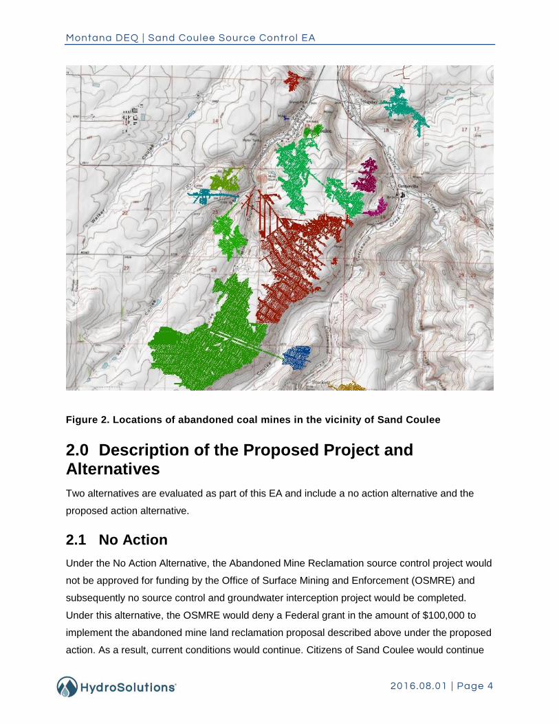
incorporated Sand Coulee Water District. The location of abandoned coal mines and degree of
underground workings in the vicinity of Sand Coulee are shown on Figure 2.

Montana DEQ | Sand Coulee Source Control EA
2016.08.01 | Page 3
Figure 1. Project location, Cascade County, Montana.
Montana DEQ | Sand Coulee Source Control EA
2016.08.01 | Page 4
Figure 2. Locations of abandoned coal mines in the vicinity of Sand Coulee
2.0 Description of the Proposed Project and Alternatives
Two alternatives are evaluated as part of this EA and include a no action alternative and the
proposed action alternative.
2.1 No Action
Under the No Action Alternative, the Abandoned Mine Reclamation source control project would
not be approved for funding by the Office of Surface Mining and Enforcement (OSMRE) and
subsequently no source control and groundwater interception project would be completed.
Under this alternative, the OSMRE would deny a Federal grant in the amount of $100,000 to
implement the abandoned mine land reclamation proposal described above under the proposed
action. As a result, current conditions would continue. Citizens of Sand Coulee would continue

Montana DEQ | Sand Coulee Source Control EA
2016.08.01 | Page 5
to be exposed to and threatened by contaminated mine drainage and the potential effectiveness
of the two proposed groundwater interception methods would go unproven. Grant funds from
the DNRC would be forfeited by DEQ.
Continual AMD from coal mine workings would have a negative impact on surface waters and
aquatic organisms within range of high concentrations of metals and low pH. Any potential
improvements expected to receive surface waters from a reduction of AMD waters and recharge
of clean water would not be realized. The overall contaminated waters would remain and may
increase AMD during periods of anomalous precipitation seasons and recharge to groundwater.
In addition, a continual adjustment in underground workings and subsurface collapsing may
expose more iron sulfide rich materials to leaching and perpetuate AMD contamination.
2.2 Proposed Action
Under this alternative, the OSMRE RD/FOD would authorize construction activities in the
amount of $100,000 for use by DEQ in implementing the abandoned mine land reclamation
proposal described herein. DEQ-Abandoned Mine Lands (AML) Program has identified
groundwater interception as the preferred source control alternative to implement and test at the
Sand Coulee site. This source control would be implemented by intercepting the groundwater in
the Kootenai sandstone before it enters the mine workings. A recently completed groundwater
flow modeling study assessed how interception wells would reduce the volume of AMD
discharging from nearby mines (HydroSolutions 2014). The investigation included multiple
modeling methods to assess expected withdrawal rates from the Kootenai sandstone aquifer,
and included frictional losses that may reduce production from a subhorizontal well.
Investigation results indicated that both subhorizontal and vertical drainage wells are technically
feasible and have the potential to reduce the amount of AMD produced by the abandoned
mines. Previous studies have shown the effectiveness of directionally drilled horizontal wells to
extract water for environmental remediation purposes including groundwater extraction for
pump-and-treat systems, total fluids extraction, air sparge, and groundwater
containment/migration control, as well as for water supply applications (Fournier 2005).
The results of the model indicate that a single 1,500 foot long subhorizontal well with a screened
interval of 500 feet of 4-inch to 6-inch diameter could produce a clean water discharge ranging
from 108 to 269 gallons per minute (gpm) (HydroSolutions 2014). A vertical drainage well

Montana DEQ | Sand Coulee Source Control EA
2016.08.01 | Page 6
connecting the Kootenai Sandstone aquifer in the Kootenai Formation directly to the Madison
Limestone aquifer could produce a discharge of 52 gpm for a single drainage well, and a
combined discharge of 88 gpm for two drainage wells. Vertical drainage wells would be of
considerable less expense than a subhorizontal well; however, production of any clean water to
the surface would be eliminated.
Both subhorizontal and vertical wells reduce the source (infiltration of groundwater) instead of
treating the symptoms (AMD) of the mine discharges. The results suggest that multiple up-
gradient drainage wells could be employed to decrease AMD outflow from the abandoned
mines. These wells provide a technically and financially viable solution by reducing the need for
continual treatment of the mine discharges. Both subhorizontal and vertical wells would be
installed and tested to determine the effectiveness of these alternatives to maximize AMD
reduction. A conceptual cross section of the subhorizontal well to be constructed is shown on
Figure 3. The proposed well location and lateral extent in plan view is shown on Figure 4. A
conceptual cross-section of the vertical drainage well design is shown on Figure 5.
Figure 3. Conceptual cross-section of subhorizontal well design

Montana DEQ | Sand Coulee Source Control EA
2016.08.01 | Page 7
Figure 4. Plan view of proposed subhorizontal well design

Montana DEQ | Sand Coulee Source Control EA
2016.08.01 | Page 8
Figure 5. Conceptual cross-section for vertical well design
2.3 Alternatives Not Considered for Further Analysis
Additional Source Control Measures Other source control measures include mechanisms to reduce or eliminate the AMD discharges
such as hydraulic plugging of mine workings. DEQ evaluated the hydraulic plugging approach in
2010 at the Anaconda coal mine in Belt. This approach was found not to be feasible due to
safety concerns associated with the stability of the mine roof. Given this experience, and the
similarities with shallow mining and concerns for roof instability, DEQ determined that this
approach could not be implemented safely in Sand Coulee. Furthermore, this approach would
be expected to potentially result in diffuse seepage of AMD through the coal, resulting in
vegetative voids along coal outcrop areas. This condition is apparent near Stockett, where
extensive areas of bare ground are visible at the coal seam elevation.

Montana DEQ | Sand Coulee Source Control EA
2016.08.01 | Page 9
Biological Uptake Montana DEQ is currently working with the Montana Salinity Control Association (MSCA) and
MBMG to investigate the use of deep-rooted grasses to reduce recharge of water into the Belt
Anaconda mine (Duame et al., 2011). Investigations are currently being conducted by MSCA at
this location (MBMG, 2012). In Sand Coulee, planting an alfalfa-grass mixture at the 532-acre
Chartier Ranch site was investigated. The Chartier Ranch site is located directly above the Old
Sand Coulee Mine workings, approximately one mile south of the community. The investigation
included soil moisture measurements and monitoring of discharges from the abandoned mines
from 1984 through 1986. The investigation indicated that the alfalfa plot at the Chartier Ranch
used almost all available moisture and developed extensive root systems. However, analysis of
nearby adit discharges did not identify a statistically significant reduction in flows (Osborne et
al., 1987).
Passive Treatment Passive treatment of AMD employs a treatment technology to improve water quality without
requiring continuous inputs of chemical reagents or routine operations and maintenance. DEQ’s
operating experience with the constructed wetlands indicated that they did not function as low
maintenance systems, or provide sufficient treatment of metals to comply with water quality
standards. Operational problems included fouling of buried pipe systems, winter freezing
resulting in short-circuiting, and plugging of limestone drains due to metal precipitation
(McCurley and Koerth, 1994). Guidance provided by OSMRE to DEQ indicated that success of
passive treatment methods was enhanced for water which was net alkaline. Using the Risk
Analysis Matrix (Pennsylvania Bureau of Abandoned Mine Reclamation, 2009 - Table 1),
passive treatment of Sand Coulee AMD is characterized by a high risk for premature failure
based on the iron and aluminum concentrations and the flow rate. At Sand Coulee, the use of
passive treatment methodologies was found to not be a feasible approach due to the lack of
alkalinity, the extreme acidity, the extremely high daily metal loads described above, the
extended winter season in the area, and lack of available space to implement this technology.
Active Treatment The results of the water treatment assessment indicated that lime-based treatment was able to
meet DEQ-7 water quality targets for all constituents in the Sand Coulee mine discharges with
the exception of thallium and fluoride (Hydrometrics, 2012). Additional treatment for fluoride and
thallium would be necessary to meet DEQ-7 standards and was included in the assessment.

Montana DEQ | Sand Coulee Source Control EA
2016.08.01 | Page 10
Identified treatment plant locations included Belt, Stockett, the Number 5 Coulee (southwest of
Stockett), and Sand Coulee. A Net Present Value (NPV) was calculated for each treatment site
using a discount interest rate of 3 percent and a return period of 100 years. A ranking system for
prioritization of the potential treatment sites was developed incorporating pollutant load,
receiving water impacts, human exposure potential, resource potential, treatment feasibility, and
treatment cost. Although Sand Coulee had the greatest pollutant load and most significant
impacts to receiving waters, Belt was identified as highest final priority site for potential water
treatment. Belt rated highest for exposure due to greater population density and proximity to
high-risk areas, and Belt Creek had the highest ranking for resource potential to support fishing,
boating, and swimming. DEQ recently completed an Engineering Evaluation/Cost Analysis
(EE/CA) for treatment of the AMD in Belt. Funding for treatment plants beyond the one in Belt is
currently financially infeasible based on the DEQ-AML’s predicted funding sources.
3.0 Description of the Existing Environment
3.1 Project Background
The Great Falls Coal Field (Sand Coulee Basin) is dominantly medium-grade bituminous coal
occurring at the top of the Morrison Formation of the Jurassic Period. In the Sand Coulee area,
the coal deposit averages 8½ feet thick, and decreases to 4½ feet thick in the Belt area, an
adjacent historical mining community located approximately 10 miles to the east. At Sand
Coulee, the coal is interbedded with layers of carbonaceous shale, shale, and clay. The coal
contained a high percentage of sulfur which occurred in the form of iron-pyrite nodules up to 4
inches in diameter. The sulfur accounted for approximately 3 percent of the coal mined, and is
the source of the AMD at Sand Coulee which has contaminated surface and groundwater.
Coal production from the Great Falls Coal Field exceeded the combined output from all other
Montana coal fields from the 1880s through the turn of the twentieth century. Coal production
was dominated by the Great Northern Railway Company (Great Northern) and the Anaconda
Copper Mining Company (ACM). In 1888, a branch line of the Montana Central Railway, a
predecessor-subsidiary of Great Northern, reached the coal beds of the Sand Coulee area. The
first large-scale commercial development of coal property in the field was performed by the
Sand Coulee Coal Company, an affiliate of Great Northern. The opening of the Sand Coulee
Coal Mine in 1888 marked the beginning of 60 years of coal mining by Great Northern

Montana DEQ | Sand Coulee Source Control EA
2016.08.01 | Page 11
subsidiaries that extended from Sand Coulee south to the town of Giffen. The coal was used
primarily by Great Northern for its railroad operations in Montana and along its mainline
extending from Minnesota west to Washington. Smaller businesses mined and shipped coal as
well, and numerous truck mines served the local trade.
Sand Coulee coal contained 10,000-11,000 BTUs, a caloric value suitable for locomotive fuel,
but not as useful for smelting applications, especially as smelting technology advanced. The
high ash content, 18-21%, proved to be a hindrance that limited the industrial and commercial
market for the coal. As reserves diminished and as industrial and residential dependence on
coal waned, the mines closed. Commercial coal mining ended in Sand Coulee in the 1940s. The
coal mining communities of Belt, Centerville, Sand Coulee, Stockett, and Tracy transitioned to
small agricultural centers.
In 1965 the State of Montana formed a Water Pollution Control Council. On May 26, 1966
biologist Ralph Boland investigated Sand Coulee Creek. Stream samples collected by Boland
showed Sand Coulee Creek flowing at pH 3.3 with an iron content of 740 ppm. Boland’s report
states: “Every bit of the water in coal mining area is badly polluted. Most is from old mines.” The
interactions between the AMD discharges, surface water, and groundwater in the area were
investigated by the Montana Bureau of Mines and Geology (MBMG) in 1983. The sandstone
unit at the base of the Kootenai sandstone which forms the roof of the coal mines was identified
as the primary source of groundwater leakage into the abandoned mines (Osborne et al., 1983).
An inventory of domestic wells indicated that approximately one-half of the residents obtained
their water supplies from the Madison Limestone aquifer. The alluvial groundwater in the area
was found to be contaminated by AMD. Seven Madison Limestone wells were identified as
potentially impacted by downward leakage of AMD based on elevated total dissolved solids and
sulfate concentrations (Osborne et al., 1983).
In 1987 MBMG conducted an investigation of water quality in the alluvial aquifer which indicated
that the aquifer was contaminated a distance of over 1,200 feet from Sand Coulee Creek
(Osborne et al. 1987). MBMG identified two source control measures to reduce the AMD
discharges including 1) reduction of local recharge to the mines using cropping practices to
reduce recharge, and 2) interception of groundwater flowing into the mines using subhorizontal
wells. The first approach investigated in Sand Coulee using alfalfa to reduce recharge in areas

Montana DEQ | Sand Coulee Source Control EA
2016.08.01 | Page 12
overlying the abandoned mines. The use of subhorizontal wells was not field tested due to lack
of available directional drilling contractors at the time (Osborne et al., 1987).
The United States Geological Survey (USGS) collected monthly water quality and streamflow
data at 27 sites in the Sand Coulee and Belt Creek basins from July 1994 through September
1996 (Karper, 1998). This study confirmed the persistence of the water quality problems in mine
discharges and in streams in these basins and characterized the seasonal variability in the
discharge rates. (Gammons et al. 2010) investigated the isotopic composition of sulfate in the
acid mine waters and sulfate in the adjacent sedimentary aquifers as a tool to determine the
extent of AMD leakage into the underlying Madison Limestone aquifer. (Gammons et al. 2013)
sampled twenty-six domestic water wells completed in the Madison Limestone near the former
coal mines. No mining-associated water quality problems were identified, such as low pH or
elevated concentrations of trace metals; however, sulfate isotope data indicated AMD incursion
in some of the wells.
In 2011 and 2012, DEQ conducted a Water Treatment Assessment of the Great Falls Coal
Field. The objective of this investigation was to quantify current flow rates and water quality of
adit discharges and streams, identify and prioritize potential groupings of AMD discharges for
treatment, evaluate treatability to DEQ-7 water quality standards using lime-based technologies,
and estimate costs for active water treatment (Hydrometrics, 2012).
In 2013 and 2014, DEQ evaluated the feasibility of groundwater interception using subhorizontal
and vertical wells (HydroSolutions, 2014). This evaluation was conducted to identify a location
to pilot test a subhorizontal drainage well and assess the productivity of interception wells and
potential reduction in the volume of AMD discharging from nearby mines resulting from the
drainage wells. Results indicated that both subhorizontal and vertical drainage wells are
technically feasible and have the potential to reduce the volume of AMD produced by the Sand
Coulee abandoned mines. The results suggest that multiple, up-gradient drainage wells could
be employed to significantly decrease AMD outflow from the abandoned mines (HydroSolutions,
2014).
3.2 Environmental Setting
The community of Sand Coulee is located in a valley floor with an average elevation of
approximately 3,465 feet above mean sea level with adjacent flat top terraces at elevations of

Montana DEQ | Sand Coulee Source Control EA
2016.08.01 | Page 13
approximately 3,700 feet. The surrounding area is generally agricultural and rangeland.
Adjacent communities include Tracy, Centerville, and Stockett, which were also developed as
coal mining towns at the turn of the century.
Surface Water Surface waters in the area include the tributary of Sand Coulee Creek (locally referred to as
Rusty Ditch) which flows through the town and is heavily contaminated with AMD. Surface
drainages in the San Coulee area are shown on Frigure 6. Rusty Ditch is heavily contaminated
with mine waste and AMD and flows orange in color. Streamflow is ephemeral and typically
ranges from 0 to 3 cubic feet per second (cfs) in the vicinity of the town. During much of the
year, this creek does not discharge to Sand Coulee Creek which lies to the northeast, but
infiltrates and recharges the underlying alluvial aquifer. Sand Coulee Creek is located northeast
of the community and flows north to the Missouri River. There are no lakes within the immediate
area. No wetlands exist within the Sand Coulee Water District as reported from the Department
of Natural Resources and Conservation (DNRC) interactive mapping program. The community
is located in an area determined to be outside the 500 year flood plain of Sand Coulee;
however, flooding attributable to clogged culverts in Rusty Ditch has been reported
(Hydrometrics, 1983).
AMD is a characteristic of the coal mines in the Great Falls Coal Field reflecting the presence of
pyrite, oxygen, and water in the abandoned coal mines. At Sand Coulee the mines were driven
up-dip to facilitate drainage and haulage when the mines were operating. This characteristic
now acts to facilitate discharges from the drainage tunnels developed during mining. The water
exiting the abandoned mines surrounding the Sand Coulee community contains approximately
500 milligrams per liter (mg/L) dissolved iron and has a pH of approximately 3. None of the mine
discharges in the Sand Coulee area meet federal or Montana primary and secondary drinking
water standards. Due to high acidity and high concentrations of total dissolved solids and
metals, the mine effluents are also unsuitable for irrigation and livestock use (Hydrometrics,
1982).

Montana DEQ | Sand Coulee Source Control EA
2016.08.01 | Page 14
Figure 6. Surface hydrology of the Sand Coulee project area, Cascade County,
Montana.
The US Geological Survey (USGS) collected monthly water quality and streamflow data at 27
sites in the Sand Coulee and Belt Creek basins from July 1994 through September 1996
(Karper, 1998). This study included establishing four monitoring stations for mining discharges
near the town of Sand Coulee (UGGS stations 14, 16, 19, and 20) and Rusty Ditch in the

Montana DEQ | Sand Coulee Source Control EA
2016.08.01 | Page 15
community (USGS station 4; Karper, 1998). The median pH of Rusty Ditch was 2.7, and median
concentrations of dissolved cadmium, chromium, iron, manganese, nickel, sulfate, zinc, and
total dissolved solids were 0.021, 0.11, 360, 4.0, 2.8, 4,500, 11.0, and 5,810 mg/L, respectively
(Karper, 1998). These levels exceed federal and state of Montana primary and secondary
drinking water standards.
Stream channels cut into the alluvium carry most of the AMD discharge. In the vicinity of Sand
Coulee, the alluvial deposits deepen, and stream flow is partially or entirely lost to the alluvium.
AMD is therefore a continuous source of contamination to the unconsolidated alluvial aquifer
(Osborne et al., 1983). Residents abandoned alluvial wells and consequently there are very few
existing domestic wells completed in this aquifer (Osborne et al., 1987). A groundwater
investigation conducted from 1985 through 1987 determined that the alluvial aquifer is
contaminated by Sand Coulee Creek over a distance greater than 1,200 feet from the creek
(Osborne et al., 1987).
Groundwater The basal Kootenai sandstone is an important aquifer in the area yielding water to domestic
wells and springs (Fisher 1909). A geologic map and simplified stratigraphic column of local site
conditions is shown in Figure 7. The Kootenai Formation is recharged by infiltration of
precipitation, with groundwater flowing generally to the northwest from regional recharge areas
located to the southeast in the Little Belt Mountains. Although historic coal mining does not
appear to have impacted the groundwater quality within this aquifer, the mine workings have
provided a drainage network which dewaters the Kootenai Formation. This dewatering is
facilitated by vertical fracturing of the Kootenai Formation, associated with the presence of a
major anticlinal structure, the South Arch, in the area. Recent fracturing of the Kootenai
Formation may have also developed during the coal removal activities and from ground
subsidence following the mining. The Gerber mine discharges AMD to Kate’s Coulee, which
discharges into Rusty Ditch and flows through the community. The Gerber mine is located south
of the Sand Coulee well field and is likely contributing to the dewatering of the Kootenai aquifer.

Montana DEQ | Sand Coulee Source Control EA
2016.08.01 | Page 16
Figure 7. Geologic map of the Sand Coulee project area, Cascade County, Montana.
Few wells are completed in the Swift Formation in the project area. Recharge to the Swift
Formation is limited by the low permeability shale beds in the overlying Morrison Formation and
by up-dip truncation of the Swift Formation along the little Belt Mountains (Goers 1968). Shallow
alluvial wells have been replaced by deeper bedrock wells constructed in the underlying Swift
sandstone and Madison Limestone to avoid AMD contamination. However, both aquifers show
Montana DEQ | Sand Coulee Source Control EA
2016.08.01 | Page 17
evidence of AMD contamination. (Osborne et al. 1983) reported that the fractured nature of the
underlying bedrock, the presence of solution cavities in the Madison Limestone, and the steep
vertical hydraulic gradients has distributed contaminated groundwater to the deeper bedrock
aquifers in the area. Elevated concentrations of TDS and sulfate indicate that seven of sixteen
wells completed in the Swift sandstone and Madison Limestone in the Sand Coulee area were
contaminated to some extent by downward leaking AMD.
Mine drainage has also dewatered much of the overlying Kootenai Formation, which under
normal conditions is a common source aquifer for groundwater development in the area. Drilling
records and the results of recent investigations indicate that the bottom 25 feet of the Kootenai
Formation are water saturated in the well field area. The Water District historically relied on
groundwater wells completed in lower Kootenai Formation sandstone and upper Morrison
Formation coal as the sole water source for the community water supply system. The Sand
Coulee Water District wells are completed in this coal unit of the upper Morrison and the coal
appears to be one of the sources of groundwater inflow to the wells. Recently, a new public
water supply well was drilled into the Madison Limestone to replace the Kootenai Formation
wells.
Geology The room and pillar coal mining which occurred from 1880s to the 1940s extracted coal from the
upper Jurassic Morrison Formation. The coal seam is approximately 6 to 8 feet thick in the area
and likely contains accumulations of iron-pyrite nodules left over from sorting work performed by
the coal miners. The high pyrite content of the coal results in elevated acid producing capacity
from the oxidation of the pyrite in the partially flooded mine workings. There are presently 29
abandoned mine sites within 1 mile of Sand Coulee, with 4 abandoned coal mines bordering the
community (see Figure 2) . These mines include the Sand Coulee Mine located to the south, the
Nelson No. 1 mine bordering the community to the south and east, the Gerber mine located to
the southwest, and the Nelson No. 2 mine located to the north. Open mine adits are present
west of the community; however, historical records indicate that the terrace directly west of
Sand Coulee was not mined extensively. Current and previous public water supply wells have
been drilled in this area.
The geology of the area consists of a gently dipping sequence of sedimentary rocks which slope
to the north and west exposing progressively older formations in the upstream drainages to the

Montana DEQ | Sand Coulee Source Control EA
2016.08.01 | Page 18
south. The Kootenai Formation underlies the upland terraces and forms the coulee walls
surrounding Sand Coulee and is comprised of interbedded shale and siltstone lenses with
discontinuous sandstone beds (Wilkie, 1983). Typical thickness of the Kootenai Formation in the
Sand Coulee area is approximately 180 feet (Hydrometrics, 2010). The basal member of the
Kootenai Formation is a coarse-grained, cross-bedded sandstone with beds of conglomeratic
pebble sandstone deposited in the channels of a major river system (Osborne et al 1983). The
basal Kootenai is typically 30 to 45 feet thick and is laterally continuous (Silverman and Harris,
1967). The basal Kootenai overlies the coal deposit of the Upper Morrison Formation on an
erosional unconformity, and forms the roof of most of the coal mines in the area (Osborne et al.,
1983).
The Morrison Formation consists of 120 to 180 feet of mudstone containing lenses of limestone,
sandstone, coal, and shale which were deposited in lacustrine and flood plain environments
(Silverman and Harris, 1967). Mining occurred in the Stockett Bed in the upper part of the
Morrison Formation, which includes medium-grade bituminous coal deposits and dark gray
carbonaceous shale at the upper contact with the Kootenai Formation. The coal seam contains
a high percentage of sulfur which occurred in the form of iron-pyrite nodules disseminated
throughout the coal.
The Morrison Formation is underlain by the Swift Formation, a calcareous, coarse- to fine-
grained sandstone with interbedded shale ranging from 0 to 40 feet thick in the Sand Coulee
area (Hydrometrics, 1982). The Swift Formation is underlain by the Madison Group Mission
Canyon and Lodgepole Formations, which are generally referred to together as the Madison
Limestone. The thickness of the Madison Limestone in the Great Falls area ranges from 1,200
to 1,700 feet (Smith, 2008) and consists of massive to thick-bedded limestone with thin chert
interbeds transitioning downward into thinner-bedded limestone and mudstone. Its top is
exposed locally along the bottom of Cottonwood Coulee, approximately one mile east of Sand
Coulee.
Unconsolidated Quaternary deposits overlie bedrock in valley bottoms. The unconsolidated
deposits are comprised of fluvial sand, silt and clay, windblown sand, older alluvial terrace
deposits, colluvium, landslide deposits, and lacustrine silt and clay. Generally, the thickness of
the Quaternary deposits is 30 feet or less in the small coulees. North of Tracy, alluvial deposits
interfinger with the outwash and lacustrine deposits of the ancient Missouri River channel. The

Montana DEQ | Sand Coulee Source Control EA
2016.08.01 | Page 19
glacio-lacustrine sediments in the ancestral Missouri channel currently occupied by lower Sand
Coulee Creek exceed 300 feet in thickness (Osborne et al., 1987).
Land Use The Sand Coulee area is primarily surrounded by agriculture and rangeland with urban
designation for the communities of Sand Coulee, Tracy, and Centerville. No significant changes
in land uses are anticipated in the proposed action area.
Cultural Resources In 2010, DEQ conducted a cultural resources inventory of Sand Coulee which included an
investigation of property ownership (RTI 2010). Property records indicated that the properties in
Sand Coulee are owned by private citizens; no corporate property ownership was identified (RTI
2010). One property was identified within the town of Sand Coulee, and several historic mine
sites were documented via a records search.
The Montana State Historical Preservation Office (SHPO) was contacted regarding known or
potential historical, archaeological, or cultural resources that may be impacted. The records
search covered Township 19N, Range 4E, Sections 13, 14, and 23 (SHPO, 2016). In addition to
the sites discussed in the 2010 inventory, two sites were identified in the NE quarter of Section
23 (24CA1611 and 24CA1607), and the Mount Oregon Mine (24CA0187) was located on the
southern border of Section 14 to the northwest of the project site. Site 24CA1611 is a lithic
material concentration (geologic site) located on private lands, but no data exist on its time
period. Site 24CA1607 is a historic structure.
SHPO indicated that any structure over fifty years of age is considered historic and is potentially
eligible for listing on the National Register of Historic Places. SHPO concluded that if there is no
disturbance to structures over 50 years of age, there is a low likelihood that cultural properties
would be impacted by the project. DEQ determined that no historic properties exist in the area
where subhorizontal and vertical drilling would occur and that the project would have no effect
on properties eligible for listing on the National Register. SHPO concurred with this
determination on April 18, 2016 (Murdo, 2016). Consultation related to SHPO is contained in
Appendix A.

Montana DEQ | Sand Coulee Source Control EA
2016.08.01 | Page 20
Fish and Wildlife The area around Sand Coulee is characterized by grassland ecology with areas of mixed grass
prairie interspersed among agricultural fields. Although the historic mining sites retain high
levels of disturbance, there are undisturbed areas of prairie capable of supporting wildlife. The
degraded water quality likely precludes any useable aquatic habitat in the drainage system for
tributaries to Sand Coulee and Sand Coulee although both are intact. Appendix B includes the
results from the Montana Natural Heritage Program (MT NHP) data request for special status
species occurrences within a five-mile radius of the project area. The MT NHP identified records
for five vertebrate species (3 birds, 1 reptile, and 1 mammal) and five plant species (Table 1).
No federally-listed species were identified. Most of the occurrences were centered on or near
the Missouri River corridor, including a single bald eagle nest near the Big Bend Fishing Access
Site (MT NHP 2016a). The only species of concern documented within a mile of the site is the
long-billed curlew. These birds may nest in the undeveloped prairie lands near the site.
Table 1. Species identified by MT NHP as occurring within a five-mile radius of the
proposed Sand Coulee project area.
Scientific Name Common Name Status Typical Habitat Habitat present in or near the project area?
Animals
Ardea herodius Great blue heron SOC1 Rivers and marshy areas
No
Haliaetus leucocephalis
Bald eagle Sensitive2 Forested areas along rivers and lakes
No
Numenius americanus
Long billed curlew SOC Mixed-grass prairie Yes
Lasiurus cinereus Hoary bat SOC Forested areas, feeds over water
No
Apalone spinifera Spiny softshell SOC Large river oxbows No
Plants
Psilocarphus brevissimus
Dwarf woolly-heads SOC Vernal pools during dry season
Possible
Pediomelum hypogaeum
Little Indian Breadroot
Potential SOC
Loose sandy soils, plains
Possible
Bacopa rotundifolia Roundleaf Water-hyssop
SOC Muddy pond shores No
Carex sychnocephala Many-headed sedge SOC Moist valley meadows
No
Najas guadalupensis Guadalupe Water-nymph
SOC Oxbows, sloughs No
1 Species of Concern in Montana 2Bald eagles are no longer considered a species of special concern. However, they retain protection
under the Bald and Golden Eagle Protection Act, 16 U.S.C. 668-668c.

Montana DEQ | Sand Coulee Source Control EA
2016.08.01 | Page 21
Greater sage-grouse (Centrocercus urophasianus) are a prairie species that is currently under
consideration for listing under the Endangered Species Act. Although they do occur in Choteau
County, the project area is outside of their documented range, and no generalized observations
for this species have been recorded in the area (MT NHP 2016b).
Soils Soils in the area where the proposed subhorizontal and vertical wells would be located are
primarily 1) Big Timber-Castner Complex with 8 to 30 percent slopes and 2) Bitton and Roy Soils
with 10 to 65 percent slopes. Neither soil type is considered prime farmland. Soils are considered
well drained with no frequency of flooding. The Big Timber-Castner Complex have a soil profiles
from 1 to 60 inches in depth of clay loam and gravelly clay loam overlying unweathered bedrock.
The Bitton and Roy soils have a profile from 1 to 60 inches in depth of stony loam to very stony
loam (NRCS 2016).
Seven other soils are classified in the immediate vicinity of the proposed wells including:
Absarokee clay loam 8 to 15 percent slopes Absarokee-Sinnigam complex 2 to 8 percent slopes Castner-Sinnigam complex 2 to 15 percent slopes Darret-Castner complex 2 to 8 percent slopes Ipano-Ticell loams 0 to 4 percent slopes Ipano-Ticell loams 4 to 10 percent slopes Twin Creek loam 2 to 8 percent slopes
The Twin Creek Loam is classified as farmland of statewide importance; however, no activity is
expected to occur on land with this soil type. The subhorizontal well and vertical drainage wells
installed as part of this investigation would be installed in soils classified as 1) Big Timber-Castner
Complex and 2) Bitton and Roy Soils
There are no lakes within the immediate area. No wetlands exist within the Sand Coulee Water
District as reported from the Department of Natural Resources and Conservation (DNRC)
interactive mapping program. The proposed reclamation project would have no impact on
wetlands or rare or endangered plants species.
These soil types do not exhibit properties that may be problematic with installation of
subhorizontal and vertical source control wells, in particular reclamation of any disturbance from
drilling activity. The proposed location for these wells are on sloping and benched agricultural
land that is currently used for grazing and grass hay crops.

Montana DEQ | Sand Coulee Source Control EA
2016.08.01 | Page 22
Recreational Resource Values The proposed source control wells are located entirely on private land where there is a public
easement. No wilderness areas, National Parks, Wild and Scenic Rivers or other recreational
resource areas are contained within the project area (Montana DEQ 2011). Open lands on the
edge of Sand Coulee are private property used for ranching and farming.
Air Quality Air quality in Cascade County is classified as “Unclassifiable/Attainment or Better than National
Standards” (40 CFR 81.327) for the National Ambient Air Quality Standards for all criteria
pollutants (Montana DEQ 2011).
Noise The proposed drill site is situated south of a small residential community and close to private
residences. Noise in the community is limited to noises associated with that residential use,
traffic noise associated with the county road that passes through the community, and any noise
that might intrude from nearby farming or ranching operations. Nearby farm dwellings are
closest to the proposed well locations.
Social and Economic Values Sand Coulee is a census-designated place and unincorporated community in Cascade County,
Montana, United States. Its population was 212 as of the 2010 census. As of July 1, 2015, the
population of Sand Coulee was 227. The formal boundaries for the Sand Coulee Census
Designated Place encompass a land area of 2.62 sq. miles and a water area of 0 sq. miles
(Sand Coulee Mt Profile 2016). There are 73 water service connections (Montana DEQ 2011).
Information on the population of Sand Coulee, income, and housing data as of July 1, 2015 are
provided on Table 2.
Conformance with Federal, State, Regional, and/or Local Land Use Plans, Programs and Policies Reclamation construction activities associated with the proposed action would comply with
Montana’s Abandoned Mine Reclamation State Plan and applicable State and Federal laws and
rules. Drilling and installation of source control wells with the purpose of reducing AMD
discharge would minimize threats to public health, general welfare, and the environment.

Montana DEQ | Sand Coulee Source Control EA
2016.08.01 | Page 23
Environmental Justice Based on United States Government Census figures, the median household income in Cascade
County is $40,434, and in Sand Coulee is $47,990. The dominant race in Cascade County is
“white” with 89% of the population. The next largest percentage of the population by race is
“American Indian” with 4.3 percent (Montana DEQ 2011).
The AMRB has prioritized the Sand Coulee Source Control Project in accordance with the
programmatic mandate that requires reclamation of eligible coal sites as the highest reclamation
priority. No consideration regarding the selection of this project was made in relation to income
or race.
Table 2. Sand Coulee, Montana Data and Demographics as of July 1, 2015.
Notes: 1Population Density = Total Population per square mile. 2The Diversity Index is a scale of 0 to 100 that represents the likelihood that two persons, chosen at random from the same area, belong to different race or ethnic groups. If an area's entire population belongs to one race AND one ethnic group, then the area has zero diversity. An area's diversity index increases to 100 when the population is evenly divided into two or more race/ethnic groups. Based on Census 2010 counts, the Diversity Index for the United States was 60.6 and it is expected to increase to 64.8 by July 1, 2018. Source: http://montana.hometownlocator.com/mt/cascade/sand-coulee.cfm
POPULATION
Total Population 227
Population in Households 227
Population in Families 188
Population in Group Qrtrs 0
Population Density1 87
Diversity Index2 13
HOUSEHOLDS
Total Households 95
Average Household Size 2.39
Family Households 67
Average Family Size 3
HOUSING
Total Housing Units 100 (100%)
Owner Occupied HU 77 (77.0%)
Renter Occupied HU 18 (18.0%)
Vacant Housing Units 5 (5.0%)
Median Home Value $177,941
Average Home Value $198,052
INCOME
Median Household Income $47,990
Average Household Income $59,831
Per Capita Income $25,392

Montana DEQ | Sand Coulee Source Control EA
2016.08.01 | Page 24
4.0 Environmental Consequences
This chapter evaluates the potential impacts to the physical environment including impacts to
geology, soils, water quality and quantity, air quality, terrestrial and aquatic wildlife, vegetation,
special status species, demands on environmental resources, historical and archaeological
sites, and aesthetics. It also reviews potential impacts to the human environment including
impacts to population, human health and safety, socioeconomic factors, demands for energy,
and transportation networks. No impacts were identified for social structures, housing, cultural
uniqueness, or recreation and wilderness.
4.1 No Action
Under the No Action Alternative current conditions would continue. The extent and degree of
change to each affected resource is described below. There would be no appreciable changes
to the following resource areas, geology, land use, soils, cultural resources, recreational
resource value, air quality, noise, or social and economic values under the No Action
Alternative.
Hydrology and Water Resources Under the No Action alternative, the discharges of AMD would continue unabated. The adverse
effects of AMD have impacted Sand Coulee for over a century. The water quality studies
conducted over the past 40 years indicate the continuing severe water quality impacts caused
by the AMD, so there is no evidence of any attenuation of the severity of the problem. Sand
Coulee is unique in the Great Falls Coal Field in that minimal surface water flows exist which do
not originate from abandoned mine adits. Sand Coulee (Rusty Ditch) has the water quality of
raw AMD as it passes through the community. Results from the Water Treatment Assessment
(Hydrometrics, 2012) indicate that DEQ-7 human health and/or aquatic life standards were
exceeded for arsenic, beryllium, cadmium, chromium, copper, fluoride, iron, manganese, nickel,
selenium, thallium and zinc in Sand Coulee. The loading analysis indicated that approximately
2,500 pounds of iron, 1,700 pounds of aluminum, and 20,600 pounds of sulfate are discharged
daily to Sand Coulee (Hydrometrics, 2012). The investigations indicate that the underlying
Madison Limestone aquifer is the ultimate receptor of the AMD discharges (Osborne et al.,
1983; Osborne et al., 1987; Gammons et al., 2013). Given the continuous nature of the
discharges and the existence of preferential flow paths in karst aquifers, the AMD poses a risk
of contamination to the Madison Limestone aquifer beyond the immediate Sand Coulee area.

Montana DEQ | Sand Coulee Source Control EA
2016.08.01 | Page 25
Fish and Wildlife Under the No Action Alternative, the AMD would continue to be a potential source of toxins to
fish, wildlife, and invertebrates in the area. The degraded condition of the surface water has
precluded establishment of any aquatic life, and these conditions would be expected to continue
in the absence of any remediation.
Conformance with Federal, State, Regional, and/or Local Land Use Plans, Programs and Policies The No Action Alternative would not be in accordance with the Montana Abandoned Mine
Reclamation Plan. Montana DEQ is responsible for regulating mining and the restoration of
lands disturbed by mining and responsible for administering abandoned mine reclamation
grants obtained from the federal government. The agency provides administrative personnel
and procures services related to abandoned mine reclamation. These grants are provided out of
funds collected from the coal mining industry under the Surface Mining Control and Reclamation
Act of 1977 (SMCRA). DEQ project managers are responsible for large individual operating
budgets for Montana’s many reclamation construction projects.
4.2 Proposed Action
Under this alternative, the OSMRE would authorize construction activities for the purposes of
implementing the abandoned mine land reclamation proposal described in Section 2.2 of this
document. The extent and degree of change to each affected resource due to the implementation
of the Proposed Action is described below.
Hydrology and Water Resources DEQ has determined that groundwater interception provides the logical source control
methodology to implement and test at this time. Source control is the preferred alternative as it
treats the source instead of the symptoms of the mine discharges. It provides a technically and
financially viable solution by reducing or eliminating expenditures required for continual
treatment of the mine discharges.
This source control would be implemented by intercepting the groundwater in the Kootenai
sandstone before it enters the mine workings. A recently completed investigation assessed the
potential reduction in the volume of AMD discharging from nearby mines resulting from

Montana DEQ | Sand Coulee Source Control EA
2016.08.01 | Page 26
interception wells (HydroSolutions, 2014). The investigation included multiple modeling methods
to assess expected withdrawal rates from the Kootenai sandstone aquifer, and included
frictional losses that may reduce production from a subhorizontal well. Investigation results
indicated that both subhorizontal and vertical drainage wells are technically feasible and have
the potential to reduce the amount of AMD produced by the abandoned mines.
The results of the modeling indicate that a single 1,500 foot long subhorizontal well with a
screened interval of 500 feet of 4-inch to 6-inch diameter could produce a discharge ranging
from 108 to 269 gpm (see Figure 4). In addition, a single vertical drainage well could capture up
to 52 gpm (see Figure 5). The results suggest that multiple up-gradient drainage wells could be
employed to significantly decrease AMD outflow from the abandoned mines (HydroSolutions,
2014).
Groundwater Groundwater impacts would be regionally beneficial for the long-term. The quality of
groundwater would improve as a result of interception prior to infiltration into mine workings. A
controlled reduction of volume of groundwater able to interact with acid-generating mine waste
in the underground workings would occur. In this case, any groundwater that continues to
migrate vertically downward into the Madison Limestone aquifer from the mine workings would
be minimal if interception occurs. The detrimental impacts on water quality in the Madison
Limestone aquifer would be reduced.
The quantity of water impacted during this project would be dependent upon the type of
interception wells and the proposed discharge of collected groundwater. The mines were driven
up-dip to facilitate drainage and haulage when the mines were operating. The mine workings
now act to facilitate uncontrolled discharges from the drainage tunnels developed during mining.
Installation of subhorizontal interception wells would collect clean groundwater prior to infiltration
into mine workings and discharge the clean water directly into tributaries to Sand Coulee. These
subhorizontal wells would reduce uncontrolled AMD discharge and increase the quantity of
unimpacted groundwater discharged to surface water bodies.
Installation of vertical interception wells would collect groundwater in the Kootenai Formation
and allow natural injection of the captured groundwater into the underlying Madison Limestone
aquifer. The volume of groundwater discharging to mine workings and thus into surface waters

Montana DEQ | Sand Coulee Source Control EA
2016.08.01 | Page 27
would be reduced. However, prior to mining, groundwater did not flow directly into surface water
bodies. The discharge of AMD-laden groundwater into surface water is an anthropogenic
consequence that would be remediated as part of these source control wells. Therefore, the
benefit of any impact to groundwater quantity from collection and injection wells likely outweighs
the existing negative impact to surface water quality. There would be no specialized mitigation
measures required to reduce impacts to groundwater.
Surface water Impacts would be beneficial in the long term to the regional surface water resource. A reduction
in AMD discharge and associated metals in the tributaries would benefit wildlife and aquatic
organisms, and potentially allow for beneficial use of surface waters further upstream than has
occurred since mine impacts. The water exiting the abandoned mines surrounding the Sand
Coulee community contains approximately 500 mg/L dissolved iron and has a pH of
approximately 3.0. None of the mine discharges in the Sand Coulee area meet federal or
Montana primary and secondary drinking water standards. Due to high acidity and high
concentrations of total dissolved solids and metals, the mine effluents are also unsuitable for
irrigation and livestock use (Hydrometrics, 1982). AMD is a continuous source of contamination
to the surface water and any reduction in discharge would be beneficial.
Land Use Although there are not likely to be any primary impacts to land use in the Sand Coulee area due
to the Proposed Action, over the long term, reducing or removing the source of AMD in the area
could lead to an improvement in land condition. Any impacts to land use would likely be
beneficial, long-term, and locally realized.
Cultural Resources The Montana State Historical Preservation Office (SHPO) was contacted regarding known or
potential historical, archaeological, or cultural resources that may be impacted. SHPO indicated
that any structure over fifty years of age would be considered historic and is potentially eligible for
listing on the National Register of Historic Places. SHPO concluded that if there is no disturbance
to structures over 50 years of age, there is a low likelihood that cultural properties would be
impacted by the project. The two identified sites in Section 23 are removed from the project area
and would not be disturbed by any on-the-ground activities initiated under the Proposed Action,
nor would the proposed horizontal well extend beneath the sites. SHPO requested that if
Montana DEQ | Sand Coulee Source Control EA
2016.08.01 | Page 28
structures need to be altered, or if cultural materials are inadvertently discovered during this
project that the State office be contacted and the site investigated Consultation related to SHPO
is contained in Appendix A.
Fish and Wildlife The potential impacts to plant and animal species of concern were assessed based on a query
of the Montana National Heritage Program (MT NHP). The query covered lands within a five-
mile radius of Township 19 North, Range 4 East, Section 23. Search results indicated that no
US Fish and Wildlife Service threatened or endangered plant or animal species have been
identified in the project area (USFWS 2016).
The MT NHP search identified 10 special status species, but only 1 species has been
documented within a mile of the project area (MT NHP, 2016a). Three potential sites for long-
billed curlew (Numenius americanus) were recorded in adjacent sections, but there are no
documented sightings within Section 23. Long-billed curlew are a Montana Species of Special
Concern (Table 1). They are a prairie grassland species, and prefer to nest in open, short-
statured grasslands and generally avoid areas with trees, dense shrubs, or tall, dense grasses
(Dugger and Dugger 2002). It is unlikely that the construction activities associated with the
project would have any detrimental effect on this species as their identified breeding sites are
removed from the project area. Search results are presented in Appendix B.
Improving the quality of surface water in the area would benefit any wildlife living in or traveling
through the area. If surface water quality could be improved to the point where aquatic life
support is possible, this would represent a significant benefit to the surrounding ecology.
Soils The abandoned mine reclamation project would have no effect on prime and unique farmland.
The proposed reclamation project would have no impact on wetlands or rare or endangered
plants species.
Recreational Resource Values This project would have no impact on recreational resources. The proposed reclamation project
occurs on private property.

Montana DEQ | Sand Coulee Source Control EA
2016.08.01 | Page 29
Air Quality The project is not anticipated to impact air quality.
Noise The Proposed Action would result in a slight increase in noise during the drilling and aquifer
testing phase for this project. Noise increase would be a result of drill rigs and site preparation
activities, the effect would be short-term, local, and minor. Drilling would be confined to daylight
activities. Pumping tests may be performed over a period of 3 to 5 days and may generate noise
from the power source and well pump.
Social and Economic Values The Proposed Action would mitigate public health and safety hazards by improving the surface
water for Sand Coulee residents. Sense of community would increase as Sand Coulee is
perceived as a suitable location with a more aesthetically pleasing environment. The
reclamation project would allow farming and ranching uses to continue, preserving existing
social and economic values.
Aesthetic property values in Sand Coulee may increase as a result of this proposed source
control activity. A reduction of AMD discharge to tributaries to Sand Coulee would provide a
more attractive environment for the community.
Conformance with Federal, State, Regional, and/or Local Land Use Programs The source control project and associated construction would be in accord with the Montana
Abandoned Mine Reclamation Plan, and State and Federal Regulations
Environmental Justice The Sand Coulee Source Control Project would have no disproportionate effect on any
demographic population with regard to either income level or minority status.

Montana DEQ | Sand Coulee Source Control EA
2016.08.01 | Page 30
5.0 Consultation and Coordination
In preparing this EA, the Montana Department of Environmental Quality Remediation Division
consulted with the following agencies:
State Historic Preservation on issues related to cultural resources and the eligibility of
properties for listing on the National Register of Historic Places.
Montana National Heritage Program on issues related to federally listed threatened and
endangered species.
MDEQ was assisted in preparation of this EA by David Donohue and Leanne Roulson,
HydroSolutions Inc, Helena, Montana

Montana DEQ | Sand Coulee Source Control EA
2016.08.01 | Page 31
6.0 References Cited
Duaime, T.E., Sandau, K., and Smith G., 2011. Agricultural practices used in source control of acid mine drainage problems, central Montana. Montana Bureau of Mines and Geology Open File Report 596, Butte, MT. Dugger, B. D. and K. M. Dugger. 2002. Long-billed curlew (Numenius americanus). The Birds of North America Online (A. Poole, Ed.). Ithaca: Cornell Lab of Ornithology. http://bna.birds.cornell.edu/bna/species/628/articles/introduction. Fisher, C. A., 1909. Geology of the Great Falls Coal Field Montana, United States Geological Survey Bulletin 356, Washington, DC. Fournier, L. 2005. Horizontal wells in water supply applications. Water Well Journal, National Groundwater Association. June Gammons, C. H., Duaime, T. E., Parker, S. R., Poulson, S. R., Kennelly, P., 2010. Geochemistry and stable isotope investigation of acid mine drainage associated with abandoned coal mines in central Montana, USA, Chemical Geology 269, 199-112. Gammons, C.H., Brown, A., Poulson, S.R., and T.H. Henderson, 2013. Using stable isotopes (S, O) of sulfate to track local contamination of the Madison karst aquifer, Montana, from abandoned coal mine drainage, Applied Geochemistry 31, 228-238. Goers, J. W., 1968. Geology and groundwater resources, Stockett-Smith River area, Montana, MS Thesis, University of Montana, Missoula, MT. Hydrometrics and Western Technology and Engineering, Inc., 1982. Master Plan: Abandoned Mine Lands Belt-Sand Coulee. Prepared for the Department of State Lands, Abandoned Mine Lands Program, Helena, MT. Hydrometrics, 1983. Comprehensive Reclamation and Engineering Plan Sand Coulee Drainage – Cascade Count, Montana, Phase I Reclamation Alternatives. Prepared for the Department of State Lands, Abandoned Mine Lands Program, Helena, MT. Hydrometrics, 2010. Water Supply Assessment. Prepared for the Department of Environmental Quality, Abandoned Mine Lands Program, Helena, MT. Hydrometrics, 2012. Water Treatment Assessment. Prepared for the Department of Environmental Quality, Abandoned Mine Lands Program, Helena, MT. HydroSolutions Inc. 2014. Sand Coulee Acid Mine Drainage, Groundwater Interception Investigation, Final Report. Prepared for Montana DEQ, Abandoned Mines Section, Remediation Division. April 30. Karper, P. L., 1998. Water-quality data (July 1994 through September 1996) and statistical summaries of data from surface water in the Sand Coulee coal area, Montana, U.S. Geological Survey. Surv., Open File Report 98-94.

Montana DEQ | Sand Coulee Source Control EA
2016.08.01 | Page 32
McCurley, E. and Koerth, J., 1994. Review and status report of four constructed wetlands in the Great Falls Coal Field, Cascade County, Montana. Proc. Natl. Assoc. Abandoned Mine Land Prog., 1994. Montana Bureau of Mines and Geology (MBMG). 2012. Belt Creek Acid Mine Discharge- Recharge Area Identification Near Belt, Montana Sampling And Analysis Plan, DEQ 319 Grant Application. Montana DEQ. 2011. Environmental Assessment, Sand Coulee Water System, Water Supply Replacement; Abandoned Mine Reclamation Project; Cascade County, Montana. Prepared by Abandoned Mines Section; Remediation Division, in Cooperation with United States Department of the Interior; Office Of Surface Mining Reclamation And Enforcement; Casper, Wyoming Field Office. August. Montana DEQ. 2014. Sand Coulee Acid Mine Drainage Source Control. Grant application submitted to Montana Department of Natural Resource and Conservation Reclamation Development Grant Program. May. Montana Natural Heritage Program (MT NHP). 2016a. Special status species report for occurrences within a five-mile radius of Township 19N, Range 4E, Section 23. Report date 3/15/2016. Helena, Montana. MT NHP. 2016b. Greater Sage-Grouse — Centrocercus urophasianus. Montana Field Guide. Montana Natural Heritage Program and Montana Fish, Wildlife and Parks. Retrieved on April 29, 2016, from http://FieldGuide.mt.gov/speciesDetail.aspx?elcode=ABNLC12010 Montana State Historic Preservation Office (SHPO). 2016. Cultural resources information system report for Township 19N, Range 4E, Sections 13, 14, and 23. Report date 4/18/2016. Helena, Montana. Murdo, D. SHPO Cultural Records Manager. Re: Sand Coulee Acid Mine Drainage Source Control. SHPO Project #: 2016041804. Cultural resources information system report for Township 19N, Range 4E, Sections 13, 14, and 23. April 18, 2016. Natural Resources Conservation Service (NRCS), 2016. Custom Soil Resource Report for Cascade County Area Montana. United States Department of Agriculture. April 17, 2016 Osborne, T. J., Donovan, J. J., Sonderegger, J. L., 1983. Interaction Between Groundwater and Surface Water Regimes and Mining-Induced Acid Mine Drainage in the Stockett-Sand Coulee Coal Field, Montana Bureau of Mines and Geology Open File Report 109, Butte, MT. Osborne, T. J., Zaluski, M. H., Harrison, B. J., Sonderegger, J. L., 1987. Acid Mine Drainage Control in the Sand Coulee Creek and Belt Creek Watersheds, Montana 1983-1987, Montana Bureau of Mines and Geology, Bulletin 197, Butte, MT. Pennsylvania Bureau of Abandoned Mine Reclamation, 2009. Acid Mine Drainage Set-Aside Program Implementation Guidelines, Final Draft – May 18, 2009. Renewable Technologies, Inc.(RTI), 2010. Cultural Resource Inventory. Prepared for the Department of Environmental Quality, Abandoned Mine Lands Program, Helena, MT.

Montana DEQ | Sand Coulee Source Control EA
2016.08.01 | Page 33
Sand Coulee, MT Profile: Facts, Map & Data. April 10, 2016. http://montana.hometownlocator.com/mt/cascade/sand-coulee.cfm. Silverman and Harris, Stratigraphy and Economic Geology of the Great Falls-Lewistown Coal Field, 1967. Smith, L., 2008. Altitude of the top of the Madison Group in part of Cascade County, Montana, Montana Ground-water Assessment Atlas 7, Part B, Map 3. US Fish and Wildlife Service (USFWS) 2016. Endangered, threatened, proposed, and candidate species by Montana counties. May 2016. USFWS, Ecological Services Montana Field Office, Helena, Montana. Wilkie, K.R., 1983. Appraisal of Water in Bedrock Aquifers, Northern Cascade County, Montana, USGS Open File Report 82-1025, Helena, MT.

Appendix A
State Historic Preservation Office Concurrence

1
Leanne Roulson
From: Murdo, Damon <[email protected]>Sent: Monday, April 18, 2016 2:53 PMTo: Leanne RoulsonSubject: RE: SHPO file search request- Sand Coulee areaAttachments: 2016041804.pdf; CRABS.pdf; CRIS.pdf
April 18, 2016 Leanne Roulson HydroSolutions 303 Clarke Street Helena MT 59601 RE: SAND COULEE ACID MINE DRAINAGE SOURCE CONTROL. SHPO Project #: 2016041804 Dear Leanne: I have conducted a cultural resource file search for the above‐cited project located in Sections 13, 14, 23, T19N R4E. According to our records there have been a few previously recorded sites within the designated search locales. In addition to the sites there have been a few previously conducted cultural resource inventories done in the areas. I’ve attached a list of these sites and reports. If you would like any further information regarding these sites or reports you may contact me at the number listed below. It is SHPO’s position that any structure over fifty years of age is considered historic and is potentially eligible for listing on the National Register of Historic Places. If any structures are to be altered and are over fifty years old we would recommend that they be recorded and a determination of their eligibility be made. As long as there will be no disturbance or alteration to structures over fifty years of age we feel that there is a low likelihood cultural properties will be impacted. We, therefore, feel that a recommendation for a cultural resource inventory is unwarranted at this time. However, should structures need to be altered or if cultural materials be inadvertently discovered during this project we would ask that our office be contacted and the site investigated. If you have any further questions or comments you may contact me at (406) 444‐7767 or by e‐mail at [email protected]. I have attached an invoice for the file search. Thank you for consulting with us. Sincerely, Damon Murdo Cultural Records Manager State Historic Preservation Office File: DEQ/AIR WATER WASTE MNG/2016

Appendix B
Montana Natural Heritage Program Data Query

Visit the Montana Natural Heritage Program at http://mtnhp.org
P.O. Box 201800 1515 East Sixth Avenue Helena, MT 59620-1800 fax 406.444.0266 tel 406.444.5354 http://mtnhp.org
March 15, 2016
Leanne Roulson
HydroSolutions
PO Box 1779
Helena, MT 59624
Dear Leanne,
I am writing in response to your recent request regarding Montana Species of Concern in the vicinity of the
Sand Coulee EA project, in Section 23, T19N, R04E, in Cascade County. I checked our databases for
information in this general area and have enclosed 8 species occurrence reports for 5 animal species of
concern, 5 species occurrence reports for 5 plant species of concern, a map depicting species of concern
locations, and explanatory material, including agency contacts that may have additional information about
the area. Note that the maps are in Adobe GeoPDF format. With the appropriate Adobe Reader, it
provides a convenient way to query and understand the information presented on the map. Documentation
is included.
Please keep in mind the following when using and interpreting the enclosed information and maps:
(1) These materials are the result of a search of our database for species of concern that occur in an area
defined by the requested township, range and section(s) with an additional five-mile buffer surrounding
the requested area. This is done to provide a more inclusive set of records and to capture records that
may be immediately adjacent to the requested area. Please let us know if a buffer greater than 5 miles
would be of use to your efforts. Reports are provided for the species of concern that are located in your
requested area with a five-mile buffer. Species of concern outside of this buffered area may be depicted
on the map due to the map extent, but are not selected for the SOC report.
(2) On the map, polygons represent one or more source features and possibly additional extents associated
with the source features. A source feature is a point, line, or polygon that is the basic mapping unit of a
Species Occurrence (SO) representation. In addition to the base unit, the polygon may include
additional extents tied to locational uncertainty (points always have locational uncertainty) and/or
breeding territory. The recorded location of the occurrence may vary from its true location due to many
factors, including the level of expertise of the data collector, differences in survey techniques and
equipment used, and the amount and type of information obtained. Therefore, this inaccuracy is
characterized as locational uncertainty, and is now incorporated in the representation of an SO. If the
extent of the source feature and uncertainty are smaller than published accounts of breeding territory
extent of a species, the polygons of some SOs will be buffered to encompass that extent. If you have a
question concerning a specific SO, please do not hesitate to contact us.

Visit the Montana Natural Heritage Program at http://mtnhp.org
(3) This report may include sensitive data, and is not intended for general distribution, publication, or for
use outside of your organization. In particular, public release of specific location information may
jeopardize the welfare of threatened, endangered, or sensitive species or biological communities.
(4) The accompanying map(s) display land management status, which may differ from ownership.
Features shown on this map do not imply public access to any lands.
(5) Additional biological data for the search area(s) may be available from other sources. We suggest you
contact the U.S. Fish and Wildlife Service for any additional information on threatened and endangered
species (406-449-5225). For additional fisheries information in your area of interest, you may wish to
contact Montana Fish, Wildlife, and Park’s Montana Fisheries Information System (phone: 406-444-
3373, or web site: http://fwp.mt.gov/fishing/mFish/).
(6) Additional information on species habitat, ecology and management is available on our web site
in the Plant, Animal, and ecological Systems Field Guides, which we encourage you to consult for
valuable information. You can access these guides at http://mtnhp.org. General information on
any species can be found by accessing the link to NatureServe Explorer.
The results of a data search by the Montana Natural Heritage Program reflect the current status of our data
collection efforts. These results are not intended as a final statement on sensitive species within a given
area, or as a substitute for on-site surveys, which may be required for environmental assessments. The
information is intended for project screening only with respect to species of concern, and not as a
determination of environmental impacts, which should be gained in consultation with appropriate agencies
and authorities.
In order to help us improve our services to you, we invite you to take a simple survey. The survey is
intended to gather some basic information on the value and quality of the information and services you
recently received from the Montana Natural Heritage Program. The survey is short and should not take
more than a few minutes to complete. All information will be kept confidential and will be used internally
to improve the delivery of services and to help document the value of our services. Use this link to go to the
survey: http://www.surveymonkey.com/s/RYN8Y8L.
I hope the enclosed information is helpful to you. Please feel free to contact me at (406) 444-3290 or via
my e-mail address, below, should you have any questions or require additional information.
Sincerely,
Martin P. Miller
Montana Natural Heritage Program

Species of Concern Data ReportTuesday, March 15, 2016
Visit http://mtnhp.org for additional information.
Report Date:Natural Resource Information System
Montana State Library
PO Box 201800
Helena, MT 59620-1800
(406)444-5354 [email protected]
Common Name:
Description:
Mapping Delineation:
View Species in MT Field Guide
General Habitat:Great Blue Heron
Birds
Riparian forest
Ardea herodias
Confrmed nestng area bufered by a minimum distance of 6,500 meters in order to be conservatve about encompassing the
areas commonly used for foraging near the breeding colony and otherwise bufered by the locatonal uncertainty associated with
the observaton up to a maximum distance of 10,000 meters.
Natural Heritage Ranks: Federal Agency Status:
Global: State: U.S. Fish & Wildlife Service:
U.S. Forest Service:
U.S. Bureau of Land Management:FWP SWAP Status:
MT PIF Code:
Click Status for ExplanationsSpecies Status
S3G5
SGCN3
First Observation Date:
Last Observation Date:
Species Occurence Map Label:
SO Number:
Acreage:
Species Occurrences
04/21/2011
04/21/2011 32,799
10119195
Common Name:
Description:
Mapping Delineation:
View Species in MT Field Guide
General Habitat:Bald Eagle
Birds
Riparian forest
Haliaeetus leucocephalus
Confrmed nestng area bufered by a minimum distance of 2,000 meters in order to be conservatve about encompassing the
breeding territory and area commonly used for renestng and otherwise bufered by the locatonal uncertainty associated with the
observaton up to a maximum distance of 10,000 meters.
Natural Heritage Ranks: Federal Agency Status:
Global: State: U.S. Fish & Wildlife Service:
U.S. Forest Service:
U.S. Bureau of Land Management:FWP SWAP Status:
MT PIF Code:
Click Status for ExplanationsSpecies Status
S4G5
2
DM; BGEPA; MBTA; BCC
SENSITIVE
SENSITIVE
First Observation Date:
Last Observation Date:
Species Occurence Map Label:
SO Number:
Acreage:
Species Occurrences
03/01/2001
09/01/2006 3,105
10136626
Montana Natural Heritage Program Species of Concern Report 3/15/2016 Page 1 of 3

Species of Concern Data ReportTuesday, March 15, 2016
Visit http://mtnhp.org for additional information.
Report Date:Natural Resource Information System
Montana State Library
PO Box 201800
Helena, MT 59620-1800
(406)444-5354 [email protected]
Common Name:
Description:
Mapping Delineation:
View Species in MT Field Guide
General Habitat:Long-billed Curlew
Birds
Grasslands
Numenius americanus
Confrmed breeding area based on the presence of a nest, chicks, or territorial adults during the breeding season. Point
observaton locaton is bufered by a minimum distance of 200 meters in order to approximate the breeding territory size reported
for the species in Idaho and otherwise is bufered by the locatonal uncertainty associated with the observaton up to a maximum
distance of 10,000 meters.
Natural Heritage Ranks: Federal Agency Status:
Global: State: U.S. Fish & Wildlife Service:
U.S. Forest Service:
U.S. Bureau of Land Management:FWP SWAP Status:
MT PIF Code:
Click Status for ExplanationsSpecies Status
S3BG5
SGCN3
2
SENSITIVE
First Observation Date:
Last Observation Date:
Species Occurence Map Label:
SO Number:
Acreage:
Species Occurrences
04/19/2012
04/19/2012 31
10123802
First Observation Date:
Last Observation Date:
Species Occurence Map Label:
SO Number:
Acreage:
04/19/2012
04/19/2012 31
10123803
First Observation Date:
Last Observation Date:
Species Occurence Map Label:
SO Number:
Acreage:
04/19/2012
04/19/2012 31
10123807
First Observation Date:
Last Observation Date:
Species Occurence Map Label:
SO Number:
Acreage:
04/19/2012
04/19/2012 58
10123806
Common Name:
Description:
Mapping Delineation:
View Species in MT Field Guide
General Habitat:Hoary Bat
Mammals
Riparian and forest
Lasiurus cinereus
Montana Natural Heritage Program Species of Concern Report 3/15/2016 Page 2 of 3

Species of Concern Data ReportTuesday, March 15, 2016
Visit http://mtnhp.org for additional information.
Report Date:Natural Resource Information System
Montana State Library
PO Box 201800
Helena, MT 59620-1800
(406)444-5354 [email protected]
Confrmed area of occupancy based on the documented presence (mistnet captures, defnitvely identfed acoustc recordings, and
defnitvely identfed roostng individuals) of adults or juveniles during the actve season. Point observaton locaton is bufered by
a minimum distance of 3,500 meters in order to be conservatve about encompassing the maximum reported foraging distance for
the congeneric Lasiurus borealis and otherwise bufered by the locatonal uncertainty associated with the observaton up to a
maximum distance of 10,000 meters.
Natural Heritage Ranks: Federal Agency Status:
Global: State: U.S. Fish & Wildlife Service:
U.S. Forest Service:
U.S. Bureau of Land Management:FWP SWAP Status:
MT PIF Code:
Click Status for ExplanationsSpecies Status
S3G5
SGCN3
First Observation Date:
Last Observation Date:
Species Occurence Map Label:
SO Number:
Acreage:
Species Occurrences
06/16/1999
06/16/1999 9,510
10138561
Common Name:
Description:
Mapping Delineation:
View Species in MT Field Guide
General Habitat:Spiny Softshell
Reptiles
Prairie rivers and larger streams
Apalone spinifera
Stream reaches where the species presence has been confrmed through direct capture or where they are believed to be present
based on the professional judgement of a biologist due to confrmed presence in adjacent areas. In order to refect the
importance of adjacent terrestrial habitats to survival, stream reaches are bufered 100 meters into the terrestrial habitat based on
PACFISH/INFISH Riparian Conservaton Area standards.
Natural Heritage Ranks: Federal Agency Status:
Global: State: U.S. Fish & Wildlife Service:
U.S. Forest Service:
U.S. Bureau of Land Management:FWP SWAP Status:
MT PIF Code:
Click Status for ExplanationsSpecies Status
S3G5
SGCN3 SENSITIVE
First Observation Date:
Last Observation Date:
Species Occurence Map Label:
SO Number:
Acreage:
Species Occurrences
07/22/2009
08/12/2010 8,493
10033190
Montana Natural Heritage Program Species of Concern Report 3/15/2016 Page 3 of 3

Species of Concern Data ReportTuesday, March 15, 2016
Visit http://mtnhp.org for additional information.
Report Date:Natural Resource Information System
Montana State Library
PO Box 201800
Helena, MT 59620-1800
(406)444-5354 [email protected]
Common Name:
Description:
Mapping Delineation:
View Species in MT Field Guide
General Habitat:Dwarf woolly-heads
Vascular Plants
Wetland/Riparian
Psilocarphus brevissimus
Individual occurrences are generally based upon a discretely mapped area provided by an observer and are not separated by any
pre-defned distance. Individual clusters of plants mapped at fne spatal scales (separated by less than approximately 25-50
meters) may be grouped together into one occurrence if they are not separated by distnct areas of habitat or terrain features.
Point observatons are bufered to encompass any locatonal uncertainty associated with the observaton.
Natural Heritage Ranks: Federal Agency Status:
Global:
State: U.S. Fish & Wildlife Service:
U.S. Forest Service:
U.S. Bureau of Land Management:
Click Status for ExplanationsSpecies Status
S2S3
G4 SENSITIVE
First Observation Date:
Last Observation Date:
Species Occurence Map Label:
SO Number:
SO Rank:
Species Occurrences
08/13/1891
08/13/1891
1
44596
Acreage: 9,616
H
Common Name:
Description:
Mapping Delineation:
View Species in MT Field Guide
General Habitat:Little Indian Breadroot
Vascular Plants
Grasslands/Woodlands (Open, sandy soil)
Pediomelum hypogaeum
Individual occurrences are generally based upon a discretely mapped area provided by an observer and are not separated by any
pre-defned distance. Individual clusters of plants mapped at fne spatal scales (separated by less than approximately 25-50
meters) may be grouped together into one occurrence if they are not separated by distnct areas of habitat or terrain features.
Point observatons are bufered to encompass any locatonal uncertainty associated with the observaton.
Natural Heritage Ranks: Federal Agency Status:
Global:
State: U.S. Fish & Wildlife Service:
U.S. Forest Service:
U.S. Bureau of Land Management:
Click Status for ExplanationsSpecies Status
S3S4
G5
First Observation Date:
Last Observation Date:
Species Occurence Map Label:
SO Number:
SO Rank:
Species Occurrences
06/20/1886
06/20/1886
19
56430
Acreage: 49,683
H
Common Name:
Description:
Mapping Delineation:
View Species in MT Field Guide
General Habitat:Roundleaf Water-hyssop
Vascular Plants
Wetland/Riparian
Bacopa rotundifolia
Montana Natural Heritage Program Species of Concern Report 3/15/2016 Page 1 of 3

Species of Concern Data ReportTuesday, March 15, 2016
Visit http://mtnhp.org for additional information.
Report Date:Natural Resource Information System
Montana State Library
PO Box 201800
Helena, MT 59620-1800
(406)444-5354 [email protected]
Individual occurrences are generally based upon a discretely mapped area provided by an observer and are not separated by any
pre-defned distance. Individual clusters of plants mapped at fne spatal scales (separated by less than approximately 25-50
meters) may be grouped together into one occurrence if they are not separated by distnct areas of habitat or terrain features.
Point observatons are bufered to encompass any locatonal uncertainty associated with the observaton.
Natural Heritage Ranks: Federal Agency Status:
Global:
State: U.S. Fish & Wildlife Service:
U.S. Forest Service:
U.S. Bureau of Land Management:
Click Status for ExplanationsSpecies Status
S3?
G5
First Observation Date:
Last Observation Date:
Species Occurence Map Label:
SO Number:
SO Rank:
Species Occurrences
08/13/1891
08/13/1891
3
44730
Acreage: 9,587
H
Common Name:
Description:
Mapping Delineation:
View Species in MT Field Guide
General Habitat:Many-headed Sedge
Vascular Plants
Wetland/Riparian
Carex sychnocephala
Individual occurrences are generally based upon a discretely mapped area provided by an observer and are not separated by any
pre-defned distance. Individual clusters of plants mapped at fne spatal scales (separated by less than approximately 25-50
meters) may be grouped together into one occurrence if they are not separated by distnct areas of habitat or terrain features.
Point observatons are bufered to encompass any locatonal uncertainty associated with the observaton.
Natural Heritage Ranks: Federal Agency Status:
Global:
State: U.S. Fish & Wildlife Service:
U.S. Forest Service:
U.S. Bureau of Land Management:
Click Status for ExplanationsSpecies Status
S1S2
G4
First Observation Date:
Last Observation Date:
Species Occurence Map Label:
SO Number:
SO Rank:
Species Occurrences
09/08/1891
09/08/1891
1
31877
Acreage: 49,683
H
Common Name:
Description:
Mapping Delineation:
View Species in MT Field Guide
General Habitat:Guadalupe Water-nymph
Vascular Plants
Aquatic
Najas guadalupensis
Individual occurrences are generally based upon a discretely mapped area provided by an observer and are not separated by any
pre-defned distance. Individual clusters of plants mapped at fne spatal scales (separated by less than approximately 25-50
meters) may be grouped together into one occurrence if they are not separated by distnct areas of habitat or terrain features.
Point observatons are bufered to encompass any locatonal uncertainty associated with the observaton.
Montana Natural Heritage Program Species of Concern Report 3/15/2016 Page 2 of 3

Species of Concern Data ReportTuesday, March 15, 2016
Visit http://mtnhp.org for additional information.
Report Date:Natural Resource Information System
Montana State Library
PO Box 201800
Helena, MT 59620-1800
(406)444-5354 [email protected]
Natural Heritage Ranks: Federal Agency Status:
Global:
State: U.S. Fish & Wildlife Service:
U.S. Forest Service:
U.S. Bureau of Land Management:
Click Status for ExplanationsSpecies Status
S2S3
G5
First Observation Date:
Last Observation Date:
Species Occurence Map Label:
SO Number:
SO Rank:
Species Occurrences
08/25/1891
08/25/1891
2
44597
Acreage: 9,604
H
Montana Natural Heritage Program Species of Concern Report 3/15/2016 Page 3 of 3

Montana Species of ConcernSand Coulee EA
Map Document: K:\REQUESTS\Requests\16\DEQ\16deq0090\16deq0090.mxd (3/15/2016)
Montana State Library
Montana Natural Heritage Program, Montana State Library1515 East Sixth Ave., Helena, MT 59620-1800406 444-3290 http://mtnhp.org [email protected]
10138547
10138561
10119195
1012380210123803
1012380610123807
10135134
10135494
10136437
10136626
10033190
31877
56430 44730
4459644597
Big BendFishingAccess Site
White BearFishing
Access Site
Montana State Library
SPECIES OCCURRENCE: A polygon feature representing only what isknown from direct observation with a defined level of certaintyregarding the spatial location of the feature.
LichensBryophytesVascular PlantsInvertebratesAmphibiansFishReptilesBirdsMammals
SitesSites
Wetland TypesLakeRiverFreshwater PondFreshwater Emergent WetlandFreshwater Scrub-Shrub WetlandFreshwater Forested WetlandRiparian EmergentRiparian Scrub-ShrubRiparian Forested
0 2 4 6 81Miles
Not all legend items may occur on the map.Features shown on this map do not imply public access toany lands.Land ownership information shown on this map is not suitable for legal purposes.