Embed Size (px)
Citation preview

Hart State Park – EA
November 2017
Draft
Environmental Assessment for Hart State Park Lake Hartwell Hartwell, Hart County, Georgia
Prepared by:
November 2017

Hart State Park – EA
November 2017
TABLE OF CONTENTS 1.0 INTRODUCTION 2.0 PURPOSE AND NEED 3.0 PROPOSED FEDERAL ACTION 4.0 ALTERNATIVES
4.1 Alternatives to the Proposed Action 4.2 Selection of Proposed Action
5.0 EXISTING ENVIRONMENT 5.1 Air Quality 5.2 Cultural Resources 5.3 Noise 5.4 Geology, Soils and Farmland 5.5 Threatened and Endangered Species 5.6 Wetland and Floodplain Resources 5.7 Water/Wastewater Management 5.8 Facilities 5.9 Socioeconomics 5.10 Environmental Justice and Protection of Children 5.11 Energy 5.12 Land Use 5.13 Hazardous Materials/Hazardous Waste 5.14 Traffic and Transportation
6.0 ENVIRONMENTAL CONSEQUENCES – NO ACTION 6.1 Air Quality 6.2 Cultural Resources 6.3 Noise 6.4 Geology, Soils and Farmland 6.5 Threatened and Endangered Species 6.6 Wetland and Floodplain Resources 6.7 Water/Wastewater Management 6.8 Facilities 6.9 Socioeconomics 6.10 Environmental Justice and Protection of Children 6.11 Energy 6.12 Land Use 6.13 Hazardous Materials/Hazardous Waste 6.14 Traffic and Transportation
7.0 ENVIRONMENTAL CONSEQUENCES – PREFERRED ALTERNATIVE 7.1 Air Quality 7.2 Cultural Resources 7.3 Noise 7.4 Geology, Soils and Farmland 7.5 Threatened and Endangered Species 7.6 Wetland and Floodplain Resources
Hart State Park – EA
November 2017
7.7 Water/Wastewater Management 7.8 Facilities 7.9 Socioeconomics 7.10 Environmental Justice and Protection of Children 7.11 Energy 7.12 Land Use 7.13 Hazardous Materials/Hazardous Waste 7.14 Traffic and Transportation
8.0 CONCLUSIONS 9.0 LIST OF REFERENCES 10.0 LIST OF ACROYNMS List of Figures: Figure 1: Current Hart State Park Recreation Plan Figure 2: Aerial Location Map Figure 3: USGS Topographic Map Figure 4: National Wetland Inventory Map Figure 5: Soil Survey Map Figure 6: FEMA Floodplain Map Appendices: Appendix A – Existing Conditions Plan Proposed Master Plan – June 26, 2017 Conceptual Utility Plan Utility Plan Details Appendix B – Site Photographs Appendix C – C.1: Market Study C.2: Feasibility Study Appendix D – IPAC Report and GADNR HUC-8 Species List Appendix E – Cultural Resources Summary and Literature Review Report Appendix F – Inadvertent Discoveries Plan for Cultural Resources Appendix G – Radius Map Report and UST Documents Appendix H – Existing and Previous Master Plan Drawings Appendix I – Agency Consultation Appendix J – Public Comments/Public Participation
Hart State Park – EA
November 2017
1
ENVIRONMENTAL ASSESSMENT PROPOSED MASTER PLAN
HART STATE PARK, LAKE HARTWELL HARTWELL, HART COUNTY, GEORGIA
1.0 INTRODUCTION This environmental assessment (EA) was prepared utilizing a systematic, interdisciplinary approach integrating the natural and social sciences and the design arts with planning and decision-making. The proposed action and its alternatives are evaluated in multiple contexts for short-term and long-term effects and for adverse and beneficial effects. This assessment indicates the effects on the human environment are well known and do not involve unique or unknown risks. It is not anticipated that this is a precedent-setting action. This EA was conducted in accordance with the National Environmental Policy Act (NEPA), the Council on Environmental Quality (CEQ) regulations implementing NEPA [40 Code of Federal Regulations (CFR) 1500-1508], and Engineer Regulation 200-2-2. A public review period for this action will be conducted prior to the issuance of any Finding by posting the Draft EA on the U.S. Army Corps of Engineers website. This EA is intended to address the proposed lease of the Park, Development Plan, and change to the existing Hartwell Project Masterplan. The Development Plan has been prepared to meet the future growth needs of Hart State Park. In general, the proposed plan includes utility, road and common area infrastructure upgrades, additional and improved camping facilities, new cabins, a water front restaurant, various outdoor activities, wedding and other event venues, outdoor amphitheaters, and a future lodge. The intent of this EA is to assess potential environmental impacts from these proposed actions as further outlined below. Hart State Park is located in the City of Hartwell and is located on 147 acres of wooded, rolling topography with over two miles of shoreline. The land is currently leased to the Georgia Department of Natural Resources (DNR) for use as a State Park through a Recreational Outgrant issued by the U.S. Army Corps of Engineers (USACE). Located on the property are five cottages, 62 tent/trailer/RV serviced campsites and 16 primitive camp sites, two boat ramps and other support facilities. Despite having significant public demand, decreases in state funding caused state services to be cut at the facility in 2009 and the rental cottages are currently closed. Currently, the park functions as a State Outdoor Recreation Area open seasonally between March and September. The campground is offered as self-registration only, available on a first‐come, first‐served basis. The property is notably underutilized and does not meet the demand for recreational opportunities in the region.

Hart State Park – EA
November 2017
2
2.0 PURPOSE AND NEED The proposed lease and plan has been developed to provide improved and additional outdoor recreation opportunities while also creating additional revenue generating activities to support the maintenance and management of the existing and planned facilities. With the consent of DNR, the City of Hartwell is proposing to obtain a direct recreational lease with the USACE for the purpose of implementing facility and infrastructure improvements necessary to meet public demand for recreation in the region as supported by the attached Market Study by PKF Consulting. Should a Finding of No Significant Impact be issued following this environmental assessment process and a lease is issued by the USACE, the City of Hartwell will ask DNR to terminate its lease with the Corps whereupon a new lease between USACE and the City of Hartwell would be contemporaneously executed. The following narrative and attached exhibits outlines the existing facilities, those which would be removed or enhanced, and future planned facilities, amenities and other infrastructure within the park. In summary, the city intends to phase-in utility, road and common area infrastructure that will support private sector sublessees who would operate and finance the following: additional and improved camping opportunities, new cabins for overnight accommodations, a water front restaurant, various outdoor activities such as zip lines and kayak rentals, wedding and other event venues, outdoor amphitheaters, and a future lodge once further market study supports it, among other things.
3.0 PROPOSED FEDERAL ACTION The proposed action consists of a new Development Plan for Hart State Park and change to the existing Hartwell Project Masterplan. The Development Plan has been prepared to meet the future growth needs of Hart State Park. In general, the proposed plan includes utility, road and common area infrastructure upgrades, additional and improved camping facilities, new cabins, a water front restaurant, various outdoor activities, wedding and other event venues, outdoor amphitheaters, and a future lodge. A detailed discussion of the proposed federal actions is provided below. The proposed actions have been grouped together by resource area for clarity.
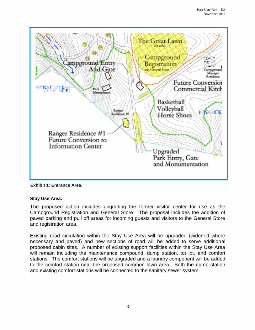
Entrance Area:
The park is located at the end of Hart Park Road, approximately 0.3 miles from its intersection with Ridge Road and 1.7 miles from downtown Hartwell. Currently a small, unmanned gate house and two lane entry road serve as the arrival point for the park. The proposed plans call for an upgraded park entry with a new gate house, a divided entrance road and new signage. In addition, the existing ranger residence will be converted to an Information Center serving the entire park.
Hart State Park – EA
November 2017
3
Exhibit 1: Entrance Area.
Stay Use Area:
The proposed action includes upgrading the former visitor center for use as the Campground Registration and General Store. The proposal includes the addition of paved parking and pull off areas for incoming guests and visitors to the General Store and registration area. Existing road circulation within the Stay Use Area will be upgraded (widened where necessary and paved) and new sections of road will be added to serve additional proposed cabin sites. A number of existing support facilities within the Stay Use Area will remain including the maintenance compound, dump station, tot lot, and comfort stations. The comfort stations will be upgraded and a laundry component will be added to the comfort station near the proposed common lawn area. Both the dump station and existing comfort stations will be connected to the sanitary sewer system.

Hart State Park – EA
November 2017
4
The proposed Camper’s Park will be located on the peninsula that presently contains a primitive camping area. The Camper’s Park will include a pavilion, restroom facility, picnic tables, a small beach area with a mod-u-dock swim enclosure and a four slip courtesy dock. These areas will be for the exclusive use of the Stay Use Area guests. Further, the proposed actions include upgrading and lengthening the existing boat ramp. Proposed boat ramp renovations will include additional paving for vehicle circulation/access and a trailer parking area with 10 spaces will be added nearby for short term storage of boat trailers. Two, four slip courtesy docks will be added adjacent to the boat ramp. The proposed actions include removing the existing pavilion near the boat ramp to allow for this expansion. Two other, four slip courtesy docks will be located within the Stay Use Area for short term use of guests and the three existing docks will remain. Proposed actions include the removal of the existing Cricket Theater and Pavilion area due to conflicts with the proposed facilities/upgrades. Other proposed, common use facilities in the Stay Use Area will include a common lawn, with fire pit, suitable for small gatherings and a swimming pool. A variety of accommodation opportunities will be offered in the Stay Use Area. Of the existing 76 camping and RV sites, 54 will remain and 15 new sites are proposed bringing the total to 69. The majority of the waterfront RV sites will remain but will be upgraded with improved paving and upgraded utility hook ups. All the camping and RV sites will be accessed through existing roads which will be upgraded, as necessary. A new cabin product is proposed and the master plan can accommodate up to 60 cabins in three areas of the Stay Use Area. Twenty-three new cabins (1 – 23) are planned for an area along the existing loop road that served the lakeside tent camping area. Cabin sites 14 thru 38 are proposed for a ridge line located near the existing tent camping area and west of Hart Park Road. The third area of cabins (39 thru 60) are proposed for the southwest portion of the park near the existing RV sites. Each cabin is scheduled to have two paved parking spaces. The proposed action includes the construction of a small waterfront store with docks. The developer envisions day use rentals of various water sport activities including paddle boards, kayaks, paddle boats and wind surf boards. An inflatable water obstacle and wakeboard course will be added in this area. A small parking area and beach with mod-u-dock swim enclosure are planned as ancillary facilities, and will provide separation from the adjacent cabins and RV sites. Additionally, located near this area will be an Adventure Course and Outdoor Activities area, which will include zip lines, ropes course and other outdoor activities. A small support building and parking area will serve the guests using these activities. Chickees will be erected on sites 5-9 and 17-20, most of which are currently used for overnight camping. These open-sided wooden huts have no impervious surface and do not incorporate any plumbing or electricity, other than pedestals, which already exist at most, if not all, of these sites. Chickees consist of wooden floors, suspended bedding areas, and natural materials used on the roofs such as palms or palmettos. The footprint of the Chickees is consistent with that of the existing campsites, approximately 100-200 square feet. This style of camping has grown in popularity

Hart State Park – EA
November 2017
5
throughout the country, particularly in south Florida. Each cabin and Chickee site is scheduled to have two paved parking spaces.
Exhibit 2: Stay Use Area.
Day Use Area:
The Day Use Area contains approximately 63 acres and is proposed to serve as a venue for a variety of private and public functions from small intimate weddings to large community events and concerts. The Day Use Area includes the property along both sides of Beach Road from its intersection with Hart State Park Road. The Great Lawn, Terraces and Cricket Theater are proposed as outdoor venues with adaptability for a variety of events and functions. The Cricket Theater will replace the existing facility and serve as both a stage area for larger functions and as a 50 to 100 seat venue for smaller functions. Paved access from Hart State Park Road to the stage area will be provided for the purpose of setup and breakdown logistics. Depending on the size of the event, the lower and middle Terraces will accommodate 500 to 1,500 guests based on lawn chair or blanket seating. The Terraces will have an amphitheater feel with elevated views of the stage area and the lake beyond.
Hart State Park – EA
November 2017
6
The Great Lawn is proposed as a 2.8-acre area that will be graded and grassed. The Great Lawn will act as overflow parking for all events in the park, accommodating approximately 400 vehicles. As an event venue, the Great Lawn will be used for festivals and other community gatherings. Utility hookups will also be installed in support of the variety of functions and events that will utilize the Great Lawn. Additionally, the Great Lawn will initially serve as the drip field for effluent disposal from treatment of the sanitary sewer flow. Plans for the northeastern peninsula include the development of a restaurant that will feature grand views of the lake. The restaurant is proposed as a two-story building with additional outdoor seating areas and parking. A 12 slip courtesy dock is planned for the eastern side of this peninsula for public access and use of the restaurant facility as well as a docking point for a future dinner boat cruise launching point. The existing building located on the peninsula as well as the existing boat ramp will ultimately be removed from this area. A beach, with mod-u-doc swim enclosure and picnic area is proposed in the cove near the existing picnic area for public use. This area will share parking with the restaurant during the day. In addition to the restaurant facility, the northern most peninsula will also be developed with the Event/Wedding Venues. Five event/wedding venues (Valley, Woodlands, Cabins, Coveside, and Lakeside) with various improvements and themes with seating ranging from 50 to 200 guests are proposed at various locations. Restroom facilities would be attached to/associated with these structures as needed. Several parking lots and access roads will be added to accommodate multiple functions occurring at the same time. Two eight-slip courtesy docks will be added in addition to 2 existing docks that will remain. The Open Air Event Facility is proposed as a multi-use event center located to the east of Beach Road. Adjacent to the east of the Open Air Event Facility will be the Event Lawn and Open Air Pavilion/Chapel, which will overlook the lake on a prominent ridge and provide seating for approximately 400 guests. The proposed Master Plan includes the addition of an access road and parking to service the event center. The proposed Master Plan includes upgrading the five existing cabins located east of Beach Road. These cabins will be made available for use in conjunction with the four outdoor pavilions planned for the eastern side of the site. Two additional parking areas are planned east of Beach Road to support these venues. The Day Use Area will also include areas for basketball and volley ball courts and a horseshoe pit. The Campground Manager’s Residence (formerly Ranger Residence #2) will be upgraded for staff use. Proposed as a future improvement and, although not supported by current market data, a Hotel & Conference Center consisting of 156 rooms, conference/meeting space, pool/outdoor function space and ancillary facilities is proposed for a prominent location just west of Beach Road. This development will also include support facilities for the hotel including additional parking spaces and a 12 slip courtesy dock.

Hart State Park – EA
November 2017
7
Exhibit 3: Day Use Area.
Utilities:
The expanded use of the park as an overnight designation will require the expansion of basic utilities. Where practical, utilities will be buried to minimize visual obstructions. Further details are provided below. Electrical Service - Existing electrical service in the park is provided by Hart EMC through a combination of overhead and underground facilities. Three phase service is available from the entrance area to the beginning of the RV camping area. The existing service consists of ten service poles, twelve ground mounted transformers and five
Hart State Park – EA
November 2017
8
street lights. Fifty-amp electrical service is available at all RV camping locations and most other campsites have 20 amp services. Future service would most likely be provided from the existing facilities with upgrades where necessary. We anticipate additional transformers and individual camp site services will be required as well as service to the new cabins and the future hotel. Cost for these will vary depending on the use of overhead versus underground in the different locations where required. Sanitary Sewer - The existing sanitary sewer needs are served through a series of traditional septic systems located throughout the park. Some locations are served by common systems with a few individual pump systems utilized. Locations of these septic fields were not verified but verbal information was received from Margaret Haley, a former Park Ranger. Future sanitary service is proposed as a central septic system with a community leach field located at the Great Lawn location. Individual EONE type grinder pumps will manifold into a pressured force main for transmission to the community treatment facility and leach field. To serve the potential future addition of the hotel in Phase 2, a pump station and force main will be required to provide the necessary sewer capacity. A gravity sewer line will connect the hotel to the pump station and the Phase 1 flows will be redirected from the community treatment facility via a gravity sewer line to the pump station. The proposed pump station and service road is located in proximity of the new Cricket Theater location and will be designed to accept flows that previously were served by the community septic system. The force main will deliver flow to the City owned treatment system through a manhole located at Nancy Drive. At total of approximately 9,100 lf of force main will be required to reach the City’s manhole. About 7,200 lf of the sewer will be located off-site, and will be located within the existing rights-of-way of Hart Park Road and Ridge Road. Domestic Water - The existing water service in the park consists of a 4-inch water main along Hart State Park Road to the Welcome Center building. From this point, a network of smaller diameter lines (estimated at 2” diameter) serve the park and camping areas. Future service will require an extension and looping of the 6” water main from Ridge Road and throughout the park for domestic water needs and fire protection. All cabins and camping sites will have a ¾” service to individual sites. Approximately 1,400 lf of offsite water main extension will be required. The off-site water line will be installed along existing right-of-way of Hart Park Road and will connect with an existing water line that is located along Ridge Road. Storm Sewer - The existing storm sewer serving the park is limited to small diameter culverts with rock or block headwalls. Future storm sewer needs will include upgraded culverts and headwalls and water quality and channel protection measures that mitigate the impacts of the increased impervious areas planned. Due to the project location, with storm water being directed to Lake Hartwell, separate storm water detention facilities to manage storm water volumes are not anticipated to be needed for the park.

Hart State Park – EA
November 2017
9
Communications - Existing telephone service is located along the electrical service corridors in limited locations. Future telephone and cable/internet will follow existing and new electric service corridors and will have little additional impact. Internal Circulation/Site Access - Existing roads will be upgraded and repaired where needed and new paved roads (20’ – asphalt) will be added to serve new and expanded areas of the park. A series of multi-use paths and natural trails will be developed throughout the park to provide pedestrian connectivity between different areas of the park. The multi-use paths are proposed a 10’ wide concrete or asphalt surfaces primarily located adjacent to roadways. The natural trails are proposed as 6’ wide mulch or graveled surfaces that provide various distance options for hiking and nature viewing. Several trail heads will be planned at the beginning or ending areas for the trail system. A copy of the Proposed Development Plan has been included in Appendix A. Also included in Appendix A, are maps of the planned on-site and off-site utility improvements.
4.0 ALTERNATIVES Under NEPA, Federal agencies are required to consider the proposed action and evaluate the impacts compared to other alternatives, including the alternative of taking no action. There is no requirement for a specific number of alternatives to be included in an EA. The discussion of the proposed action and the no action alternative allows a reviewer to establish a baseline for comparing the impacts of the proposed action. The EA presents the environmental impacts of the proposed action and alternatives to provide a basis for evaluation about whether to proceed with the proposed action. The objective of this alternative analysis is to identify reasonable alternatives to improve and enhance Hart State Park. Alternatives are evaluated relative to the ability to satisfy the objectives outlined in the Purpose and Need and the potential effects on the surrounding environment. The environmental consequences of maintaining the park in its current layout will be evaluated as the no action alternative. The environmental consequences of implementing the Proposed Development Plan will be evaluated as the proposed action.
4.1 Alternatives to the Proposed Action This section presents information used in evaluating and assessing alternative actions. This review helps identify a preferred alternative by evaluating comparable alternatives using the following criteria:
Will the Alternative meet the project needs? Is the Alternative feasible, prudent and practical?
Hart State Park – EA
November 2017
10
What effect will the Alternative have on environmental factors?
4.1.1 No Action Alternative (Alternative A) As evaluated in this EA, the “No-Action” alternative would consist only of maintenance of the existing facilities and infrastructure, as currently being managed. Regardless of whether improvements or modifications are made to Hart State Park, the demand for outdoor recreation opportunities will likely continue to grow. Under the “No Action” alternative, the plan would not satisfy the demand for additional outdoor recreation activities and facilities. Based on the 2015 Transition and Trend Report prepared by Georgia DNR, camping occupancy has increased from under 64,000 to over 116,000 from Financial Year (FY) 2013 to FY2015. Visitation to the park has increased 11% over the same period. It is anticipated that this trend will continue. Disadvantages of this alternative are the continued degradation of facilities would likely result from the minimal maintenance and upkeep at the park. Further, the No Action alternative would not provide for improved and additional outdoor recreational opportunities, and community amenities. The primary advantage of this alternative would be the lack of disturbance to the environment that will occur from the considered improvements. 4.1.2 Proposed Development Plan Improvements (Alternative B)
The proposed Development Plan Improvements alternative was developed to meet the project needs of providing improved and additional outdoor recreation opportunities while also creating additional revenue generating activities to support the maintenance and management of the existing and planned facilities. The proposed Development Plan includes additional rental cabins, indoor and outdoor wedding/event venues, a restaurant, beach and picnic areas, event lawns, camping sites, courtesy docks, parking areas, pedestrian trails, adventure course, improved/upgraded utilities, and other supporting infrastructure. In addition, once supported by the market study, a hotel and conference center would be added. 4.1.3 Minimal Improvement/Maintenance Plan (Alternative C)
This alternative would include continued operation and management of Hart State Park, with some minor improvements and maintenance of the existing facilities. The minor improvements would include clearing overgrown vegetation, upgrades to the cabins and other structures, and general facility upkeep. No new structures, facilities, or utilities would be installed. While this alternative does provide for an improvement of the existing structures and facilities, this alternative does not allow for new or improved outdoor activities. Therefore, this alternative does not allow for a sufficient increase in revenue generating activities or additional recreation opportunities and does not satisfy the project purpose and need. As such, this alternative was not further evaluated.

Hart State Park – EA
November 2017
11
Below provides a comparison of Alternatives B and C: Alternative B Upgrades to existing cabins Additional rental cabins Indoor and outdoor wedding/event
venues Restaurant Beach and picnic areas Event lawns Additional camping sites Courtesy docks Additional parking areas and drives New pedestrian trails Adventure course Improved/upgraded utilities &
supporting infrastructure Potential future hotel and conference
center Regular maintenance and upkeep
Alternative C Clearing overgrown vegetation Upgrades to existing cabins Upgrades/maintenance of pavilions
and bath facilities Regular maintenance
4.2 Selection of Proposed Action Based on a review of the alternatives to the proposed action, while not likely resulting in significant environmental effects, Alternative C was eliminated from further consideration because it did not meet the project purpose and need. Alternative B was specifically designed to maintain and expand the outdoor recreation opportunities at Hart State Park, while also providing additional revenue generating options to support the costs of continued management and maintenance of the park. Alternative B (proposed Development Plan) was selected as the preferred alternative, as it met the project needs and is anticipated to result in minimal impact on the natural and human environment. The alternatives assessment, therefore, has identified Alternative B as the plan that meets the purpose and need with the lowest adverse environmental impact.
5.0 EXISTING ENVIRONMENT This section provides background information on the existing physical, natural and cultural environments within and surrounding Hart State Park. Sources of this information include multiple research documents, site survey information, field data collection, and the Hart State Park Master Plan. Hart State Park is located only 1.5 miles from downtown Hartwell, Georgia and approximately 40 miles northeast of Athens, Georgia. The property is accessible via a

Hart State Park – EA
November 2017
12
two-lane paved road located off Ridge Road in Hartwell, Georgia. The primary access to the Project Site is via Hart Park Road. Figure 1, Figure 2, and Figure 3 identify the location of the project and are attached to this document. The project study area includes the existing footprint of Hart State Park and its immediate surrounding vicinity. The total project area is 147.45 acres. The project study area is defined in Figure 1. The project study area is used for a general reference to gather existing data/conditions of the area and to formulate the information contained in this section. The area is also used to evaluate any potential environmental impacts that will be discussed in Section 6.0, Environmental Consequences.
5.1 Air Quality Hart State Park is located near the City of Hartwell, within Hart County, which is located in the humid subtropical climate zone of the Southeastern United States. The average temperature range in the Hartwell area is 41 degrees to 81 degrees Fahrenheit. High temperatures in the summer months typically reach over 90 degrees, while the winter months can find temperatures below 30 degrees with occasional snow and freezing rain. The prevailing wind direction is generally out of the west and northwest. Hartwell averages 51.96 inches of precipitation annually. Hart State Park is located within Hart County, Georgia which is not located in the greater Atlanta nonattainment zone for ozone and particulate matter. The nonattainment is primarily due to vehicular emissions and particulate matter. Current activities at Hart State Park do not significantly contribute to the greater Atlanta nonattainment condition. The State of Georgia is currently working on a State Implementation Plan to mitigate the identified air nonattainment conditions.
5.2 Cultural Resources 5.2.1 Historic Buildings and Archeological Resources
A literature review and research of the Project Site area was conducted by a professional cultural resource firm, R.S. Webb & Associates, to determine if any of the previously identified historic and/or archaeological sites were located within the Project Area. The research included reviewing files at the State Historic Preservation Office (SHPO), which included the National Register of Historic Places (NRHP), Hart County historic resources survey records, Identified Sites files, and Centennial Farms records. Georgia’s Natural, Archeological, and Historic Resources Geographic Information System (GNAHRGIS) as well as the Georgia Archaeological Site Files at the University of Georgia (Athens) were also reviewed. The literature review identified only one NRHP-listed property, the Jackson Morrison House, within one mile of Hart State Park. This property was located on the north side of the City of Hartwell, approximately 0.9 mile from the park. Based on the Hart County
Hart State Park – EA
November 2017
13
historic survey, the nearest surveyed historic property is the Milltown Church Cemetery, which is approximately 1,500 feet southeast of the park. Three recorded archaeological sites are located within a one-mile radius of the park. The closest of these was approximately 600 feet west of the park. Based on this information, no previously identified NRHP listed or eligible properties have been identified within the boundaries of Hart State Park. A copy of the Literature Review is included in Appendix E. In addition to the literature review of state records, information was also obtained from the Savannah District archaeology office. Based on the information obtained, a Phase I Archaeological Assessment of an area within Hart State Park was conducted in 1990. The survey area was conducted at the location of the existing cabins and associated roads, prior to construction of the cabins. A total of 16 shovel tests were excavated as part of the survey. No cultural materials were encountered in the shovel tests; therefore, no concern for archaeological resources was identified. Additional cultural resource surveys will be conducted prior to construction in areas that have not been previously surveyed and show no signs of previous ground disturbance. 5.2.2 Native American Resources
In accordance with the Native American Graves Protection and Repatriation Act of 1990 and 43 CFR 10, the following provision must be observed. In the unlikely event that an inadvertent discovery of previously unknown cultural resources or potential human remains are uncovered during construction, all work must cease, the discovery must be protected, and the Savannah District Archaeologist, the Lake Hartwell project manager, as well as the Georgia State Archaeologist must be contacted immediately. A copy of the Inadvertent Discoveries Plan for Cultural Resources is included in Appendix F.
5.3 Noise The facilities at Hart State Park are relatively isolated and therefore do not routinely disrupt typical day to day activities on the properties surrounding the lease. There are no significant noise sources that routinely occur at Hart State Park. Potential sources for noise at the park and the surrounding properties would be primarily from vehicular and boat traffic and typical maintenance activities (vehicle, engine repair, lawn mowers, leaf blowers, etc.).
5.4 Geology, Soils and Farmland 5.4.1 Soils
Hart State Park is located within the Piedmont Physiographic Province, where soil conditions include a mix of sands, silts, and clays over partially-weather rock (PWR) and competent bedrock at varying depths. Depth to competent bedrock in this region

Hart State Park – EA
November 2017
14
can range from near the surface to over 100 feet deep. The surface soils were weathered from igneous and metamorphic rocks and include tan to brown sandy loams to reddish-brown silt and clay loams. The United States Department of Agriculture (USDA) National Resources Conservation Service (NRCS) indicated the following soils mapped on the Project Site: Alluvial land, Grover sandy loam (2 to 6 percent slopes, eroded and 6 to 10 percent slopes, eroded), Madison gravelly sandy loam, thin solum (10 to 15 percent slopes, eroded), Madison sandy loam (2 to 6 percent slopes, eroded; 6 to 10 percent slopes, eroded; and 10 to 15 percent slopes, eroded), and Madison sandy clay loam (6 to 10 percent slopes, severely eroded and 10 to 15 percent slopes, severely eroded). A copy of the Soil Survey Map for Hart State Park is attached as Figure 5. The soil types mapped on the Park are not included on either the local or the national hydric soils lists. Due to past farming activities, much of the topsoil in this area has eroded away. In areas where reforestation has occurred, a few inches of topsoil is usually present. Several erosional gullies were observed on the Park, as evidence of the past farming activities and poor soil management. Some bank scour and erosion is present along the shoreline due to wave action. Generally, the soils on the Park have a moderate erosion potential, but are suitable for building construction with standard engineering practices. Appropriate sediment and erosion controls and other best management practices should be suitable for proper soil management. 5.4.2 Farmland
The Farmland Protection Policy Act (FPPA) regulates Federal actions with the potential to convert farmland to non-agricultural uses. The FPPA is intended to minimize the impact federal programs have on the unnecessary and irreversible conversion of farmland to nonagricultural uses. Projects are subject to FPPA requirements if they may irreversibly convert farmland (directly or indirectly) to nonagricultural use and are completed by a federal agency or with assistance from a federal agency. For the purpose of FPPA, farmland includes prime farmland, unique farmland, and land of statewide or local importance. Farmland subject to FPPA requirements does not have to be currently used for cropland. It can be forest land, pastureland, cropland, or other land, but not water or urban built-up land. However, the Corps does not consider any lands within Hart State Park as being farmland, as the Hartwell Project Masterplan identifies the land use for the park. 5.4.3 Geology/Topography
The Project Site is located in the Piedmont Physiographic Province of Georgia, which is characterized by medium- to high-grade metamorphic rocks and scattered igneous intrusions. Topography in the province is variable and ranges from gently rolling hills in the south to moderate to steep hills in the north. Based on the United States Geological Survey (USGS) 7.5-minute topographic quadrangle map of the area, Hartwell, GA, 1972 and Reed Creek, GA-SC, 1981 elevations in the vicinity of the Project Site had an approximate elevation range from 680 feet above mean sea level (ft amsl) to 740 ft amsl. The topography across the majority of the Park consist of gently

Hart State Park – EA
November 2017
15
rolling hills. The metamorphic rocks comprising the Piedmont were formed when older “parent” rocks were subjected to high temperatures and/or pressures during regional metamorphism that occurred during the creation of the Appalachian Mountains. The same high temperatures and pressures also caused some “parent” rocks to fully melt and subsequently re-crystallize as intrusive igneous rocks. According to the Geologic Map of Georgia, the rock types underlying the general area of the Project Site have been mapped as Sillimanite Schist/ Gneiss/ Amphibolite.
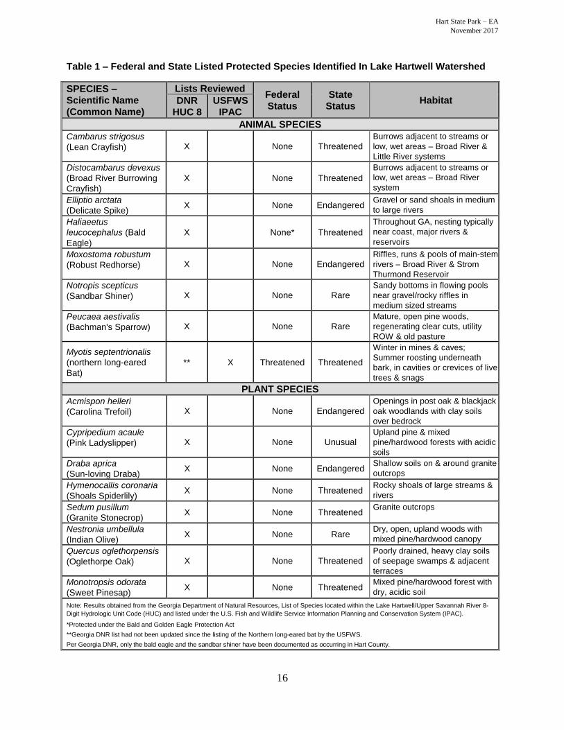
5.5 Threatened and Endangered Species The Georgia DNR Wildlife website was searched for at-risk animal and plant species occurring in the HUC 8 watershed that includes Lake Hartwell. At-risk species are those that are identified by the U.S. Fish and Wildlife Service (FWS) or the State of Georgia as endangered, threatened, rare, unusual, or candidate species for listing. Federally listed threatened and endangered species are protected under the Endangered Species Act of 1973. This Act was designed to protect critically imperiled species from extinction due to "the consequences of economic growth and development untempered by adequate concern and conservation". The State of Georgia has its own lists of plants and animals (as developed by the Georgia DNR and approved by the legislature) that are considered threatened or endangered and may also be protected under state law. The listed species and their status are included below in Table 1.
Hart State Park – EA
November 2017
16
Table 1 – Federal and State Listed Protected Species Identified In Lake Hartwell Watershed
SPECIES –
Scientific Name
(Common Name)
Lists Reviewed Federal
Status
State
Status Habitat DNR
HUC 8
USFWS
IPAC
ANIMAL SPECIES
Cambarus strigosus
(Lean Crayfish) X None Threatened Burrows adjacent to streams or
low, wet areas – Broad River &
Little River systems
Distocambarus devexus
(Broad River Burrowing
Crayfish)
X None Threatened
Burrows adjacent to streams or
low, wet areas – Broad River
system
Elliptio arctata
(Delicate Spike) X None Endangered
Gravel or sand shoals in medium
to large rivers
Haliaeetus
leucocephalus (Bald
Eagle)
X None* Threatened
Throughout GA, nesting typically
near coast, major rivers &
reservoirs
Moxostoma robustum
(Robust Redhorse) X
None Endangered Riffles, runs & pools of main-stem
rivers – Broad River & Strom
Thurmond Reservoir
Notropis scepticus
(Sandbar Shiner) X None Rare Sandy bottoms in flowing pools
near gravel/rocky riffles in
medium sized streams
Peucaea aestivalis
(Bachman's Sparrow) X None Rare Mature, open pine woods,
regenerating clear cuts, utility
ROW & old pasture
Myotis septentrionalis
(northern long-eared
Bat)
** X Threatened Threatened
Winter in mines & caves;
Summer roosting underneath
bark, in cavities or crevices of live
trees & snags
PLANT SPECIES
Acmispon helleri
(Carolina Trefoil) X None Endangered Openings in post oak & blackjack
oak woodlands with clay soils
over bedrock
Cypripedium acaule
(Pink Ladyslipper) X None Unusual Upland pine & mixed
pine/hardwood forests with acidic
soils
Draba aprica
(Sun-loving Draba) X None Endangered
Shallow soils on & around granite
outcrops
Hymenocallis coronaria
(Shoals Spiderlily) X None Threatened
Rocky shoals of large streams &
rivers
Sedum pusillum
(Granite Stonecrop) X None Threatened
Granite outcrops
Nestronia umbellula
(Indian Olive) X None Rare
Dry, open, upland woods with
mixed pine/hardwood canopy
Quercus oglethorpensis
(Oglethorpe Oak) X None Threatened Poorly drained, heavy clay soils
of seepage swamps & adjacent
terraces
Monotropsis odorata
(Sweet Pinesap) X None Threatened
Mixed pine/hardwood forest with
dry, acidic soil
Note: Results obtained from the Georgia Department of Natural Resources, List of Species located within the Lake Hartwell/Upper Savannah River 8-
Digit Hydrologic Unit Code (HUC) and listed under the U.S. Fish and Wildlife Service Information Planning and Conservation System (IPAC).
*Protected under the Bald and Golden Eagle Protection Act
**Georgia DNR list had not been updated since the listing of the Northern long-eared bat by the USFWS.
Per Georgia DNR, only the bald eagle and the sandbar shiner have been documented as occurring in Hart County.
Hart State Park – EA
November 2017
17
One federally listed threatened species (northern long-eared bat) was identified in the IPAC report for Hart County, Georgia and potentially occurring in the Park. Eight Georgia protected animals and eight Georgia protect plants were identified within the watershed of the Project Site. Some of these state species are only listed as ‘rare’ or ‘unusual’. A copy of the IPAC report and the HUC-8 Species List are provided in Appendix D. Following research and review of the species list, the habitat requirements for the identified species was evaluated. This evaluation included a review of the known ranges for the species as well as a comparison of the species habitat relative to the habitat conditions present within the Park. Based on the initial evaluation, it was determined that suitable habitat for the majority of the species was not present within the Park, as there was no medium to large rivers, open pine woods, or rock outcrops. It was determined that potential habitat may exist within the Park for two of the animal species (bald eagle and northern long-eared bat), and four of the plant species (pink ladyslipper, Indian olive, sweet pinesap, and Oglethorpe oak). Following the initial evaluation, a field investigation was conducted on the property by wildlife biologist Mr. David P. Huetter with United Consulting in April of 2015. The site investigation included walking portions of the site, generally along trails through undeveloped portions of the Park, and observing the habitat conditions and looking for the presence of the listed species or suitable habitat. During the field investigation, one small seepage wetland system was observed on the site and low terraces were present along some of the streams. These areas could provide habitat for the Oglethorpe oak; however, the soils in these areas were more sandy loam type soils and not the heavy clay soils preferred by the Oglethorpe oak. No specimens were observed on the site. Based on these observations, it is unlikely that Oglethorpe oak is present within the Park. Three of the plant species occur in upland, mixed pine/hardwood forest. This forest community is present within the Park, although the prominent forest community is a climax hardwood forest. The site visit was conducted during April, which is generally within the preferred survey time for these species. None of these species were observed during the field visit. No bald eagles or eagle nests were observed during the site visit. While bald eagles have been reported on Lake Hartwell for the past several years, we are not aware of eagle nests within the Park. The mature trees with the park could provide suitable nest sites for bald eagles and the surrounding lake could be utilized as feeding grounds for bald eagles. The northern long-eared bat (NLEB) hibernates in caves in the winter, but utilizes forested areas to roost in the summer. NLEBs have been documented to roost underneath bark, in cavities or in crevices of both live trees and snags (dead trees). Preferred habitat seems to be snags with large plates of flaking bark or live trees with deeply furrowed or flaky bark. Several snags with cavities and flaking bark were

Hart State Park – EA
November 2017
18
observed within the forested areas across Hart State Park. These trees could provide nesting habitat for northern long-eared bats during the summer months.
5.6 Wetland and Floodplain Resources 5.6.1 Wetlands
A preliminary wetland investigation was performed on the Project Site by a wetland biologist from United Consulting. The wetland investigation included a review of available wetland map, soils map, and an on-site field evaluation. A summary of the map review and site investigation is provided below. The National Wetland Inventory (NWI) map of the Project Site did not indicate previously mapped wetland areas on the Project Site. Lake Hartwell is mapped as a palustrine permanently flooded aquatic system, and would be classified as a deep water habitat. The soil survey map for the Park indicated the following mapped soils: Alluvial land, Grover sandy loam (2 to 6 percent slopes, eroded; 6 to 10 percent slopes, eroded), Madison gravelly sandy loam, thin solum (10 to 15 percent slopes, eroded), Madison sandy loam (2 to 6 percent slopes, eroded; 6 to 10 percent slopes, eroded; 10 to 15 percent slopes, eroded), and Madison sandy clay loam (6 to 10 percent slopes, severely eroded; 10 to 15 percent slopes, severely eroded). These soil types are not included on either the local or the national hydric soils lists. Copies of the NWI map and soil survey map are included as Figures 4 and 5, respectively. Although the NWI map and Soil Survey map did not indicate previously mapped wetlands, based on United Consulting’s site reconnaissance of the Project Site in April of 2015 by a qualified wetlands biologist, a wetland seep was identified within the Project Site. The identified wetland seep was located within a small area on the southwestern portion of the Project Site just south of the southernmost cove. Areas within and along the wetlands were wooded and undeveloped. In addition, three intermittent streams were noted on the southwestern portion of the Project Site and one on the east-central portion of the Project Site. 5.6.2 Floodplains
The local FEMA Floodplain maps (13147C0050C and 13147C0125C) were reviewed. Based on the map review, the 100-year flood plain is located on small areas of the Project Site adjoining to Lake Hartwell. In addition, the majority of the far northern peninsula of the Project Site is also within the 100-year floodplain. The flood effects along Lake Hartwell are managed through discharges from Hartwell Dam. A copy of the floodplain map is included as Figure 6. The design of the spillway will allow pools up to 674 feet above mean sea level (amsl), but the standard project flood is calculated to be at 668 feet amsl. The top of the flood

Hart State Park – EA
November 2017
19
gate elevation in a closed position for Lake Hartwell is 665 feet amsl. Since construction of the lake, the lake levels has been above 665 feet amsl on only five occasions, with the maximum level being at 665.45 feet amsl.
5.7 Water/Wastewater Management 5.7.1 Water Resources
Three watersheds are located in Hart County: Upper Savannah River watershed, Broad River watershed, and Tugaloo River watershed. Hart State Park is located within Hydrologic Unit Code 03060103 of the Upper Savannah River watershed. Lake Hartwell was identified on the Draft 2014 Integrated 305(b)/303(d) List as a lake not supporting designated uses. Lake Hartwell was listed on the 303(d) list due to fish consumption guidelines associated with polychlorinated biphenyls (PCBs) and a potential cause was identified as industrial sources. No Section 303(d) listed streams are located on the Park. The 55,900-acre Lake Hartwell was built between 1955 and 1963. The original authorized uses of the lake were for flood control, hydropower, and navigation; however, recreation, water quality, water supply, and fish/wildlife management were subsequently added as authorized uses (Corps 2015). The average lake elevation is 657.5 feet mean sea level and the shoreline encompasses 962 miles. Accessibility to public parks, campgrounds, and marinas makes Lake Hartwell one of the most visited Corps lakes in the nation. Hart State Park is one of the many public access parks located adjoining to Lake Hartwell. The park currently offers recreational access to the lake, providing beach areas, two boat ramps, and eleven docks. 5.7.2 Water/Wastewater Infrastructure/Treatment
Hart County Water and Sewer supplies many of residents within Hart County water and wastewater services; however, many areas still utilize private drinking water wells and septic systems. Hart State Park uses Hart County water, but not wastewater services. Due to the expense associated with installing sewer lines for wastewater service in the area, the park uses septic systems for wastewater disposal at the current facilities.
5.8 Facilities Currently, Hart State Park contains two boat ramps, three boat docks, restroom and shower houses, 78 primitive and RV campsites, a house for park staff, office, laundry and maintenance facilities, two miles of multi-use/nature trails, a small outdoor theater, two playgrounds and various covered pavilions and picnic areas. There are also five existing cabins that are not currently in use. The current park master plan also shows 9 additional boat docks, but these docks have not been constructed. All other facilities shown on the current plan have been constructed.
Hart State Park – EA
November 2017
20
Surrounding properties are generally developed with single family residences and one self-storage facility. The remaining surrounding area consists of rural, pastureland or wooded land. Public facilities and services at the Park and the surrounding area are limited, given the area’s rural nature. Potable water is provided by Hart County Water and Sewer, while the facility utilizes on-site septic systems. Emergency services are provided in the area by the Hart County Fire Department and Sheriff’s office.
5.9 Socioeconomics The Park is currently a minor contributor to the economic activity in Hart County, as the facility has been under funded by the state. The day users and overnight campers expend funds for supplies, which add to the local economy. Based on the trend report, current usage (FY2015) for camping was approximately 75,000 and total visitation was 116,202. The trend shows an increase in usage over the past two years. 5.9.1 Income
The 2010 census states that Hart County had a population of 25,213 residents. The per capita income in the County was $19,124 according to the 2010 census. The median household income in Hart County was $47,774, compared to the median household income of $66,620 in the State of Georgia. Looking at income distribution, there is a wide range of incomes for households in Hart County. The largest grouping of household income occurs in the $50,000- $74,999 range; however, the 2010 Census stated that approximately 23.5% of households were below the poverty rate. 5.9.2 Population
Based on information from the U.S. Census Bureau (http://factfinder.census.gov/), Hart County had a population of 25,213 residents in 2010, with 50.6% female and 49.4% male. Approximately 22.3% of residents were under the age of 18, 59.8% were age 18 to 64, and 17.96% were age 65 or over. The largest racial/ethnic groups were White at 77.4% and Black/African America at 18.68%. 5.9.3 Employment
The 2010 census states that Hart County had a population of 25,213 residents. In 2010, the unemployment rate was 11.9%. However, since 2010, the unemployment rate has steadily dropped, with the rate being around 7% in 2015.

Hart State Park – EA
November 2017
21
5.10 Environmental Justice and Protection of Children 5.10.1 Environmental Justice
To address environmental justice (EJ) concerns, the President issued Executive Order (EO) 12898, Federal Actions to Address Environmental Justice in Minority and Low-Income Populations, on February 11, 1994. EO 12898 requires Federal Agencies to address, as appropriate, “disproportionately high and adverse human health and environmental effects on minority and low-income populations.” The primary objective of an environmental justice analysis is to ensure that vulnerable populations do not bear a disproportionately high and adverse share of human health or environmental effects from proposed federal actions. Hart State Park does not appear to be located in an area with a high population of minority or low-income persons. According to the EPA Environmental Justice website (EJSCREEN Mapper), there is an area approximately one-half mile southwest of the Park that is listed as within the 70-80 percentile for minority populations and 80-90 percentile for low income. 5.10.2 Protection of Children
EO 13045 of April 21, 1997 requires, to the extent permitted by law and mission, identifying and assessing environmental health and safety risks to children posed by a proposed action. As this area is utilized by families and children, playgrounds and other family activities are present around the Park.
5.11 Energy Energy consumption is a major infrastructure and budgetary challenge. The generation, transmission, and use of power have significant economic, environmental, and mission implications. The current Park operations that utilize local energy resources include RV camp sites, Ranger residences, and bathroom/support structures. The current energy usage at the Park appears to be minimal. Existing electrical service in the park is provided by Hart EMC through a combination of overhead and underground facilities.
5.12 Land Use Currently, Hart State Park is utilized as a day use area for recreation, night use area for camping, boating access, and general outdoor recreation. The site has been developed accordingly, and includes parking areas, boat ramps, docks, restroom and shower houses, 78 primitive and RV campsites, a house for park staff, office, laundry, and maintenance facilities. Surrounding lands are generally developed with single family residences and one self-storage facility. The remaining surrounding land consists of rural, pastureland or wooded land. Other lake recreation properties are located nearby along the shores of Lake Hartwell and include Gum Branch Park and Hartwell Marina.
Hart State Park – EA
November 2017
22
5.13 Hazardous Materials/Hazardous Wastes 5.13.1 Petroleum and Hazardous Substances
A review of federal and state environmental regulatory databases conducted by United Consulting personnel identified Hart State Park as a current and former operator of underground storage tanks (USTs). According to Georgia Environmental Protection Division (EPD) files, one UST has been removed from the property. Low concentrations of petroleum constituents were identified in the soil and groundwater during removal of the tank. The Georgia EPD issued ‘No Further Action’ letter for the removed tank. In addition to the removed tank, one gasoline UST, approximately 2,500 gallons in size, is still located in the maintenance area of the Park. This tank is listed as temporarily out of service, but has not been removed from the ground. No testing data was available for this tank. There was another listing for tanks associated with Hart State Park, but based on document review and a site visit conducted by Breakpoint Consulting staff, it was determined that the other tank location is about 3,500 feet from the Park, at the terminus of Vickery Street Ext., on other U.S. Government owned property. This other tank listing is not located on Hart State Park. During the site visit conducted by United Consulting personnel, a few small containers of gasoline, oil, paint, and other materials utilized for Park maintenance were observed within the maintenance buildings on the Park. No visual indications of petroleum or hazardous substance contamination, such as stained soil, stressed vegetation, or chemical odors were observed on the Park. 5.13.2 Solid Waste
No indications of dumping, landfills, or excessive trash accumulation was observed on the Park. Typical trash receptacles are present throughout the Park for waste collection. Trash is currently collected and hauled to an off-site location for disposal. There is one licensed landfill located within Hart County; this landfill is not located in close proximity to the Park and does not represent a waste or contamination concern.
5.14 Traffic and Transportation Hart State Park is located along Hart Park Road and the park also includes Hart State Park Road and Cottage Circle Road. Development/properties along these roads are single-family residential, rural pastureland, wooded land, and self-storage. Current vehicular traffic is limited to local residents, self-storage users and recreational users of the Park and lake. Currently, the Georgia Department of Transportation does not maintain traffic counts along Hart Park Road or Ridge Road. According to the Trend Report, Hart State Park had approximately 116,000 visitors during FY2015. Based on an estimated average of 2.5 persons per vehicle, there is an average of about 127 vehicles per day. This number would be higher during the summer months when the campgrounds are open and lower in the winter months when usage of the Park and lake is lower.

Hart State Park – EA
November 2017
23
6.0 ENVIRONMENTAL CONSEQUENCES – NO ACTION ALTERNATIVE The following sections evaluate the direct, indirect, and cumulative impacts of the no action alternative.
6.1 Air Quality Direct Under the No Action Alternative, no direct changes or impacts would occur to Air Quality. Indirect
Under the No Action Alternative, no indirect changes or impacts would occur to Air Quality. Cumulative Under the No Action Alternative, no cumulative changes or impacts would occur to Air Quality.
6.2 Cultural Resources 6.2.1 Historic Buildings and Archeological Resources
Direct Under the No Action Alternative, no direct changes or impacts would occur to Historic Buildings or Archeological Resources. Indirect Under the No Action Alternative, no indirect changes or impacts would occur to Historic Buildings or Archeological Resources. Cumulative Under the No Action Alternative, no cumulative changes or impacts would occur to Historic Buildings or Archeological Resources. 6.2.2 Native American Resources
Direct Under the No Action Alternative, no direct changes or impacts would occur to Native American Resources. Indirect Under the No Action Alternative, no indirect changes or impacts would occur to Native American Resources.

Hart State Park – EA
November 2017
24
Cumulative Under the No Action Alternative, no cumulative changes or impacts would occur to Native American Resources.
6.3 Noise Direct Under the No Action Alternative, no direct changes or impacts would occur to Noise. Indirect Under the No Action Alternative, no indirect changes or impacts would occur to Noise. Cumulative
Under the No Action Alternative, no cumulative changes or impacts would occur to Noise.
6.4 Geology, Soils and Farmland 6.4.1 Soils
Direct Under the No Action Alternative, no direct changes or impacts would occur to Soils. Indirect Under the No Action Alternative, no indirect changes or impacts would occur to Soils. Cumulative
Under the No Action Alternative, no cumulative changes or impacts would occur to Soils. 6.4.2 Farmland
Direct Under the No Action Alternative, no direct changes or impacts would occur to Farmland. Indirect Under the No Action Alternative, no indirect changes or impacts would occur to Farmland. Cumulative Under the No Action Alternative, no cumulative changes or impacts would occur to Farmland.

Hart State Park – EA
November 2017
25
6.4.3 Geology/Topography
Direct Under the No Action Alternative, no direct changes or impacts would occur to Geology/Topography. Indirect Under the No Action Alternative, no indirect changes or impacts would occur to Geology/Topography. Cumulative Under the No Action Alternative, no cumulative changes or impacts would occur to Geology/Topography.
6.5 Threatened and Endangered Species Direct Under the No Action Alternative, no direct changes or impacts would occur to Threatened and Endangered Species. Indirect Under the No Action Alternative, no indirect changes or impacts would occur to Threatened and Endangered Species. Cumulative Under the No Action Alternative, no cumulative changes or impacts would occur to Threatened and Endangered Species.
6.6 Wetland and Floodplain Resources 6.6.1 Wetland Resources
Direct Under the No Action Alternative, no direct changes or impacts would occur to Wetland Resources. Indirect Under the No Action Alternative, no indirect changes or impacts would occur to Wetland Resources. Cumulative Under the No Action Alternative, no cumulative changes or impacts would occur to Wetland Resources.

Hart State Park – EA
November 2017
26
6.6.2 Floodplains
Direct Under the No Action Alternative, no direct changes or impacts would occur to Floodplains. Indirect Under the No Action Alternative, no indirect changes or impacts would occur to Floodplains. Cumulative Under the No Action Alternative, no cumulative changes or impacts would occur to Floodplains.
6.7 Water/Wastewater Management 6.7.1 Water Resources
Direct Under the No Action Alternative, no direct changes or impacts would occur to Water Resources Management. Indirect Under the No Action Alternative, no indirect changes or impacts would occur to Water Resources Management. Cumulative Under the No Action Alternative, no cumulative changes or impacts would occur to Water Resources Management. 6.7.2 Water/Wastewater Infrastructure/Treatment
Direct Under the No Action Alternative, no direct changes or impacts would occur to Water/Wastewater Infrastructure/Treatment. Indirect Under the No Action Alternative, no indirect changes or impacts would occur to Water/Wastewater Infrastructure/Treatment. Cumulative Under the No Action Alternative, no cumulative changes or impacts would occur to Water/Wastewater Infrastructure/Treatment.

Hart State Park – EA
November 2017
27
6.8 Facilities Direct Under the No Action Alternative, no direct changes or impacts would occur to Facilities. Indirect Under the No Action Alternative, no indirect changes or impacts would occur to Facilities. Cumulative Under the No Action Alternative, no cumulative changes or impacts would occur to Facilities.
6.9 Socioeconomics 6.9.1 Income
Direct Under the No Action Alternative, no direct changes or impacts would occur to Income. Indirect Under the No Action Alternative, no indirect changes or impacts would occur to Income. Cumulative Under the No Action Alternative, no cumulative changes or impacts would occur to Income. 6.9.2 Population
Direct Under the No Action Alternative, no direct changes or impacts would occur to Population. Indirect Under the No Action Alternative, no indirect changes or impacts would occur to Population. Cumulative
Under the No Action Alternative, no cumulative changes or impacts would occur to Population. 6.9.3 Employment
Direct Under the No Action Alternative, no direct changes or impacts would occur to Employment.
Hart State Park – EA
November 2017
28
Indirect Under the No Action Alternative, no indirect changes or impacts would occur to Employment. Cumulative Under the No Action Alternative, no cumulative changes or impacts would occur to Employment.
6.10 Environmental Justice and Protection of Children 6.10.1 Environmental Justice
Direct Under the No Action Alternative, no direct changes or impacts would occur concerning Environmental Justice. Indirect Under the No Action Alternative, no indirect changes or impacts would occur concerning Environmental Justice. Cumulative Under the No Action Alternative, no cumulative changes or impacts would occur concerning Environmental Justice. 6.10.2 Protection of Children
Direct Under the No Action Alternative, no direct changes or impacts would occur concerning Protection of Children. Indirect Under the No Action Alternative, no indirect changes or impacts would occur concerning Protection of Children. Cumulative Under the No Action Alternative, no cumulative changes or impacts would occur concerning Protection of Children.
6.11 Energy Direct Under the No Action Alternative, no direct changes or impacts would occur to Energy. Indirect Under the No Action Alternative, no indirect changes or impacts would occur to Energy.
Hart State Park – EA
November 2017
29
Cumulative Under the No Action Alternative, no cumulative changes or impacts would occur to Energy.
6.12 Land Use Direct Under the No Action Alternative, no direct changes or impacts would occur concerning Land Use. Indirect Under the No Action Alternative, no indirect changes or impacts would occur concerning Land Use. Cumulative Ongoing developments within the County, while relatively minor, are contributing to land use becoming more suburban in some areas. This trend is expected to continue over time.
6.13 Hazardous Materials/Hazardous Wastes 6.13.1 Petroleum and Hazardous Substances
Direct Under the No Action Alternative, no direct changes or impacts would occur concerning Petroleum and Hazardous Substances. The present operations at the Park result in the use and temporary storage of small amounts of materials such as cleaning supplies, motor oils, etc. These materials are stored at the Park in small volumes that do not require special agency approvals. The existing UST on the Park will likely remain and may not be removed. Indirect Under the No Action Alternative, no indirect changes or impacts would occur concerning Petroleum and Hazardous Substances. Cumulative Under the No Action Alternative, no cumulative changes or impacts would occur concerning Petroleum and Hazardous Substances. 6.13.2 Solid Waste
Direct Under the No Action Alternative, no direct changes or impacts would occur concerning Solid Waste.

Hart State Park – EA
November 2017
30
Indirect Under the No Action Alternative, no indirect changes or impacts would occur concerning Solid Waste. Cumulative Under the No Action Alternative, no cumulative changes or impacts would occur concerning Solid Waste.
6.14 Traffic and Transportation Direct Under the No Action Alternative, no direct changes or impacts would occur to Traffic and Transportation. Indirect Under the No Action Alternative, no indirect changes or impacts would occur to Traffic and Transportation. Cumulative Under the No Action Alternative, vehicular traffic is expected to increase in the County as a result of continuing increases in population and increasing demand for outdoor recreation use.
7.0 ENVIRONMENTAL CONSEQUENCES – PREFERRED ALTERNATIVE (ALTERNATIVE B) The following sections evaluate the direct, indirect, and cumulative impacts of the proposed alternative (Alternative B).
7.1 Air Quality Direct Hart State Park is not located in the greater Atlanta nonattainment zone for ozone and particulate matter. The proposed action is likely to result in additional vehicle emissions due to increased park use. Those increases are anticipated to be variable, with more use during weekends and holidays. Park use is also anticipated to be seasonal, with more park use expected during summer months. This additional traffic may directly affect air quality in the project study area but this potential increase in traffic is only anticipated to occur in short segments (i.e., weekends) and for short periods of time (i.e., day light hours). The additional emissions are not expected to result in the County becoming a “Non-Attainment Area”. Construction of the proposed action is also expected to directly impact air quality. Portions of the Park would be cleared and excavated during construction. A direct effect of this will be short term air impacts related to excavation and land clearing activities from the associated fugitive dust and emissions from construction equipment.
Hart State Park – EA
November 2017
31
To mitigate short term impacts to air quality, BMPs will be used during the excavation process, such as watering down dirt roads. In addition, the phasing of the project will also spread out the air impacts by extending the construction over a longer period. Indirect Park visitation is anticipated to increase as a result of the proposed action. As a result of increased park visitation, vehicular traffic will increase as well. Even though visitation/traffic will increase, it is not anticipated to affect the attainment level status of Hart County. Cumulative The minor and temporary impacts associated with construction are not anticipated to adversely affect the ambient air quality of the area. No release or discharge of contaminants into the air is proposed from construction of the project or from daily operations that would significantly impact the ambient air quality. Impacts to air quality from other activities in the area are not expected to be significant. Therefore, no long-term adverse impacts to air quality are anticipated as a result of the proposed action.
7.2 Cultural Resources 7.2.1 Historic Buildings and Archeological Resources
Direct A detailed literature review was conducted for the Park. No historic or archeological resources were identified during the research. Further, based on review of historic aerial photographs and the determined age of the structures within the Park, none of the existing structures on the Park are considered to meet the criteria for listing on the NRHP, so no direct effects are expected on historic resources. Cultural resource surveys will be conducted prior to construction in areas that have not been previously surveyed and show no signs of previous ground disturbance. In the event of an inadvertent discovery during the proposed construction, all work will cease. The Corps’ Hartwell Project Office will be notified immediately and work may not continue within the area of the finding until the site is examined and the Corps has given approval to proceed. Indirect Since no cultural resources have been identified within the Park or immediately adjacent to the Park, no indirect effects are expected on historic and archaeological resources from implementation of the proposed action. Cumulative Since no direct or indirect impacts to historic and archaeological resources are expected, implementation of the proposed action would not result in any adverse cumulative impacts to historic and archaeological resources.
Hart State Park – EA
November 2017
32
7.2.2 Native American Resources
Direct Native American Resources have not previously been identified within the Park. No direct impacts to Native American Resources are anticipated from the proposed action. In the unlikely event that an inadvertent discovery of previously unknown Native American resources are uncovered during construction, all work must cease in the affected area, the discovery must be protected, and the Corps’ Lake Hartwell project manager and the Georgia State Archaeologist must be contacted immediately. Indirect Since no Native American resources are anticipated within the potential impact area, indirect impacts are not anticipated from the proposed action. Cumulative Since no direct or indirect impacts to Native American resources are expected, the proposed action would not produce any cumulative impacts to these resources.
7.3 Noise Direct
Noise emissions from equipment during construction periods would be intermittent and temporary. The other potential increase in noise levels would be from the expected increase in park use and at times during special events. However, these increases are anticipated to be seasonal (e.g., increased park use during summer months versus winter months) as well as intermittent (e.g., increased park use during weekend days versus weekday use). The nearest residential community is located just outside the park entrance along Hart Park Road, but is located approximately 400 yards from the proposed outdoor theater area. Other proposed improvements that would generate noise such as the campgrounds and event venues are located 300 or more yards from the nearest residence. These areas are shielded from the residential homes by forested areas. The additional noise levels would not be sustained for long periods of time and noise impacts are anticipated to be minor. Indirect
No indirect effects from noise impacts are anticipated from the proposed action because no unacceptable noise levels are expected beyond the boundary of the Park. Cumulative
Construction noise will be generated by various work vehicles and other equipment that will be used to transport materials and construct the improvements. This equipment is similar to those used during construction of highways and range in noise levels from 70 – 92 dBA at 50 feet according to information published by the FHWA. Construction noise associated with the expansion will be temporary and minor due to project design and should not go beyond the proposed boundary of the site. Therefore, no reasonably foreseeable cumulative noise impacts are anticipated from the proposed action.
Hart State Park – EA
November 2017
33
7.4 Geology, Soils and Farmland 7.4.1 Soils
Direct Soils types mapped across Hart State Park include Alluvial land, Grover sandy loam, Madison gravelly sandy loam, Madison sandy loam, and Madison sandy clay loam. The Alluvial land soils were generally located along drainage features where no disturbance is proposed. The remaining soils are typical Piedmont upland soils. Direct soil impacts will include typical earthwork grading such as cut and fill. The soils on the Park are suitable for typical construction activities. BMPs will be utilized during implementation of the proposed plan to minimize run-off and soil erosion. A Stormwater and Erosion Control Plan will be prepared and implemented during construction to minimize erosion during the construction period. Indirect No indirect impacts to soils are anticipated due to the proposed action. Cumulative During the field evaluation, no evidence of active soil erosion was noted, other than typical shoreline erosion caused by wave action. While disturbance to the site soils will occur during construction activities, the site soils are suitable for construction activities and excessive soil erosion is not anticipated through the use of BMPs, such as appropriate sediment and erosion control measures. The proposed action would have only minor reasonably foreseeable cumulative effects to the soils in the area. 7.4.2 Farmland
Direct As the Hartwell Project Masterplan identifies the land use for the park, the Corps does not consider any lands within Hart State Park as being farmland. Therefore, the proposed action will not directly impact areas of designated ‘prime farmland’ and/or ‘farmland of statewide importance’. Indirect The Hartwell Project Masterplan identifies the land use for the park and none of the areas within the park are currently farmed; the Corps does not consider any lands within Hart State Park as being farmland. Further, most of the nearby properties are developed with residential homes or are forested, with limited surrounding farmland. Therefore, the proposed action should not indirectly affect farmland resources. Cumulative No direct impacts will occur to farmland, and indirect effects are not anticipated from the proposed action. Minimal active farmland or potential future farmland is located near the Project Site. The proposed action is not anticipated to result in additional future

Hart State Park – EA
November 2017
34
development on surrounding properties beyond what would occur without the park improvements. Other development projects in the county could have the potential for impacts on farmland resources; however, such development would occur regardless of whether or not the project is constructed. While the proposed action would contribute to this trend, the proposed action is considered to be minor and significant cumulative effects to farmland resources are not expected. 7.4.3 Geology/Topography
Direct Direct impacts to the topography at Park will include minor alterations of the existing grades for construction of roads, structures and other site improvements. The layout has been designed to minimize cut and fill and the grading will be kept to the minimum necessary for site development. Although geotechnical soil borings have not been conducted, difficult excavation and grading due to underlying rock is not anticipated. The proposed action should not affect the site geology or topography, and the proposed actions should not be effected by these site conditions. Indirect No indirect impacts to geology/topography are anticipated. Cumulative As noted above, significant impacts to geology and topography are not anticipated either directly or indirectly. Further, additional development within the project area and county is not anticipated to occur as a result of the proposed action. Therefore, the proposed action would have only minor reasonably foreseeable cumulative effects to the geology and topography due to grading changes during development. Appropriate BMPs will minimize the minor effects.
7.5 Threatened and Endangered Species Direct As previously discussed, based on research and review of the site habitat, it was determined that potential habitat may exist within the Park for two of the animal species (bald eagle and northern long-eared bat), and four of the plant species (pink ladyslipper, Indian olive, sweet pinesap, and Oglethorpe oak). These four plant species are not Federally listed under the Endangered Species Act and only two of the plant species are listed as state threatened, the other two (Indian olive and pink ladyslipper) are listed as rare and unusual, respectively. Of these species, only the bald eagle has been documented by Georgia DNR as occurring in Hart County. Based on the natural communities observed and the soil types noted in the park, it was determined that it is unlikely that Oglethorpe oak is present within the Park. The other three plant species occur in upland, mixed pine/hardwood forest. This forest

Hart State Park – EA
November 2017
35
community is present within the Park, although the prominent forest community is a climax hardwood forest. The site visit was conducted during April, which is generally within the preferred survey time for these species. None of these species were observed during the field visit. No bald eagles or eagle nests were observed during the site visit. While bald eagles have been reported on Lake Hartwell for the past several years, we are not aware of eagle nests within the Park. The mature trees with the park could provide suitable nest sites for bald eagles and the surrounding lake could be utilized as feeding grounds for bald eagles. The northern long-eared bat (NLEB) hibernates in caves in the winter, but utilizes forested areas to roost in the summer. NLEBs have been documented to roost underneath bark, in cavities or in crevices of both live trees and snags (dead trees). Preferred habitat seems to be snags with large plates of flaking bark or live trees with deeply furrowed or flaky bark. Several snags with cavities and flaking bark were observed within the forested areas across Hart State Park. These trees could provide nesting habitat for northern long-eared bats during the summer months. No observations of the State or Federal listed species for the project area were noted during the field investigation. As direct impacts are not proposed to streams, wetlands or other aquatic systems, impacts to the listed aquatic species are not expected. Potential habitat was identified for the following faunal species: bald eagle and northern long-eared bat. No observations of these species were made during field efforts. None of the listed plants were Federally protected and none were observed during the field visit. Follow up surveys will be completed prior to construction in areas where previous land disturbance has not occurred to further assess the presence/absence of these listed species. If specimens or evidence of these species are identified during those follow up surveys, mitigation for the species may include re-design of the proposed site plan and/or delay of construction start. Appropriate consultation with the U.S. Fish and Wildlife Service and Georgia DNR will be conducted. Indirect Only the northern long-eared bat was listed in the FWS IPAC report as potentially occurring in the project area. Indirect impacts to the northern long-eared bat could occur through modification of habitat on the Project Site, if project areas are utilized for traveling and feeding. Studies are on-going to further assess the distribution and numbers of long-eared bats in Georgia and modifications of the range maps are probable. While occurrence records and distribution is not well known, habitat use in the project area would likely be limited to summer roosting and feeding. Further assessment for this species or project modification will be conducted as deemed necessary based on additional species information becoming available.

Hart State Park – EA
November 2017
36
Cumulative No critical habitat has been identified within the project study area for any State or Federally protected species. In addition, no species were identified during the field investigation. The IPAC report only identified the northern long-eared bat as potentially occurring in the project area and the DNR records (Quarter Quad data: Reed Creek, GA-SC – SE quarter-quad and Hartwell, GA – NE quarter-quad) did not identify documented occurrences of protected species in the project area. Based on this information, it is unlikely that the listed species are present in the project area. Therefore, no reasonably foreseeable cumulative impacts to threatened and endangered species are anticipated by the proposed action. Should any threatened, endangered or protected species be discovered during construction, all activities within the area must cease and the Hartwell Project Office must be notified immediately. Activities within the immediate vicinity of the species will not proceed until the area is surveyed and approval is provided by the Hartwell Project Office.
7.6 Wetland and Floodplain Resources 7.6.1 Wetlands/Waters of the U.S.
Direct Streams and a small area of wetlands are located on the Park, as well as the inlets and adjoining areas of the Lake. The limits of the streams and wetlands were determined by qualified personnel with United Consulting. The limits of the wetlands were identified and mapped using a Trimble GeoXH global positioning system. The location of the streams and wetlands are shown on the Site Map (Figure 1) and also on the Conceptual Development Plan (proposed Development Plan). These waters would be considered Federal jurisdictional waters (Waters of the U.S) and are regulated under the Clean Water Act. No encroachment into the streams or wetlands is proposed; therefore, no direct impacts to streams or wetlands are anticipated. The only direct disturbance to the Lake will be for installation of docks (floating courtesy docks and anchored Mod-U docks) and for upgrades to the existing boat ramp. Impacts for this work are anticipated to be minor, through the use of best management practices and due to the small amount of disturbance that is proposed. Indirect The proposed action will cause an increase in the area of impervious surfaces which in turn can cause an increase in the amount of surface runoff being discharged into Waters of the U.S. However, these impacts would be mitigated with the use of BMPs and proper engineering design. Design criteria would follow the Georgia storm water discharge permit specifications. Therefore, no unacceptable indirect impacts are anticipated from the implementation of the proposed action. Cumulative Minor increases in growth and development are occurring in Hart County; however, the proposed action is not anticipated to significantly increase this growth. Further, future development that impacts streams and/or wetlands must comply with state and federal

Hart State Park – EA
November 2017
37
regulations for impacts to jurisdictional Waters of the U.S. Therefore, the project is not considered to have a reasonably foreseeable cumulative impact to Waters of the U.S. 7.6.2 Floodplains Direct The design of the spillway will allow pools up to 674 feet above mean sea level (amsl) but the standard project flood is calculated to be at 668 feet amsl. The top of the flood gate elevation in a closed position for Lake Hartwell is 665 feet amsl. Since construction of the lake, the lake levels has been above 665 feet amsl on only five occasions, with the maximum level being at 665.45 feet amsl. Based on the history of the lake level and the low probability of the lake level exceeding the flood gate elevation, the project was designed considering that elevation. The 665 elevation line is included on the Proposed Development Plan. Only the periphery of the Park is located below this elevation with the exception of the northern peninsula, where the narrow access to and portions of the peninsula are below this flood elevation. The proposed action will include minor grading to areas below this flood elevation for access points to the lake (boat ramps, beaches, walkways), for some of the camp sites, and for portions of the parking area and Lakeside Pavillion on the northern peninsula. It is anticipated that development in these areas will follow the existing grades and significant fill placement in the floodplain is not expected. As such, the proposed action would result in only minor impact to floodplains. Indirect The proposed action should not indirectly result in other disturbance or development within the floodplain. Further, as the floodplain disturbance will be minor and flood control is maintained by the Hartwell dam and flood gates, the proposed action would not indirectly impact the flood elevation. Cumulative The proposed action would not result in adverse impacts to floodplain functions or result in significant fill placement or increased runoff that would increase flood elevations. Therefore, the proposed action would have no cumulative impact on floodplains.
7.7 Water/Wastewater Management 7.7.1 Water Resources
Direct Direct impacts are those which will result in impacts to the water resources provided by Lake Hartwell. The lake is managed for flood control, hydropower, navigation, recreation, water quality, water supply, and fish/wildlife management. The project will provide additional recreational opportunities at the lake. During construction, minor impacts to water quality could result due to storm water runoff. These impacts should
Hart State Park – EA
November 2017
38
be minimized through the use of BMPs are not anticipated to be significant. Construction implementation design will include a storm water and erosion control plan. Indirect Following completion of the project, minor increases in the volume of storm water runoff could occur as a result of an increase in impervious surfaces. Again, these impacts will be minimized through the use of BMPs, storm water management facilities, outlet/channel protection, and/or directing storm water to natural areas to create sheet flow conditions that will slow runoff rates and provide pollutant filtering. Cumulative The proposed action will not contribute to changes in hydropower, flood control, navigation, or water supply. Impacts to other project purposes would be minimal and not significant when combined with similar impacts that would result from nearby projects. 7.7.2 Water/Wastewater Infrastructure/Treatment
Direct Implementation of the proposed action will result in an increased demand for potable water over current usage. Additional water supply infrastructure will be needed for construction of the event venues, camp sites, potential future conference center, and other improvements. In addition, additional wastewater management facilities and upgrades will be needed for the park improvements. These facilities are being incorporated into the park plans as outlined in the Proposed Federal Action section of this report (Section 3.0). Planned facilities include upgrades to the water lines, new sewer piping system and a centralized septic system. The location of new water and sewer piping and the septic system has been incorporated into design of the other Park upgrades. The project will include the construction of about 7,200 lf of off-site, force main sewer. In addition, approximately 1,400 lf of offsite water main extension will be required. The sewer will be located within the existing rights-of-way of Hart Park Road and Ridge Road. The off-site water line will be installed along existing right-of-way of Hart Park Road and will connect with an existing water line that is located along Ridge Road. Based on a review of the site conditions of these areas, and the location within previously disturbed areas in the existing right-of-way, environmental impact from the water and wastewater upgrades is not expected. Indirect Improvements to the Park facilities should increase visitation at the park. As noted above, additional visitors would result in increased water demand and the need for wastewater treatment. Therefore, project implementation is anticipated to have minor indirect effects to Hart County’s Water/Wastewater Infrastructure/Treatment. Cumulative Initial improvements at the park will not result in a significant increase in the demand for
Hart State Park – EA
November 2017
39
water services and wastewater services will be handled on-site through a new septic system. Phase 2 development of the park will result in a greater increase in the water use and wastewater treatment needs. At that point, additional wastewater infrastructure will be installed, which includes a new pump station and connection to the County sewer system. These improvements should not result in a significant increase in the needs for treatment capacity at County facilities. Further, the improvements at the Park are not expected to result in significant increases in development within the county or additional demands for water or wastewater treatment services.
7.8 Facilities Direct A significant improvement to the on-site facilities will occur as a result of the proposed actions. These include new boat ramps, additional parking, event venues, camping areas, and other supporting infrastructure. In addition to the new facilities, improvements to the site utilities will occur to support the facilities. The proposed action does not include additional property acquisition, so all improvements will be conducted within the existing Park boundaries. Phase 2 of the plan will include the installation of new sewer lines, which will extend off-site along the main entrance road. The proposed action is anticipated to have a positive impact on the site facilities. Indirect All of the proposed facilities associated with Phase 1 would be constructed within the Park boundaries, so no indirect impacts to local community facilities are anticipated. Phase 2 improvements will include the installation of new, off-site sewer lines, but the new sewer lines are planned to be located along existing right-of-way. The new sewer lines will direct sewage to the municipal sewer plant. At the time of implementation of Phase 2, assessment of the sewer plant capacity will be evaluated to ensure the necessary capacity is available. Cumulative As previously stated, expansion and improvement of the Park facilities is not anticipated to result in significant additional growth within the County. Further, since the proposed action will occur primarily within the existing Park boundaries, no cumulative effects are anticipated with the implementation of the proposed action.
7.9 Socioeconomics 7.9.1 Income
Direct Implementation of the proposed action should not have a substantial long term direct effect on income of county residents. Implementation of the proposed action would beneficially impact the local economy through increased Park revenue. Based on the market study analysis, it is anticipated that the proposed project will result in approximately 15,000 to 25,000 additional visitors to the Park each year. In addition, it
Hart State Park – EA
November 2017
40
is estimated that by year three, the restaurant will average around 26,000 patrons per year. While many of the patrons to the restaurant will be persons already visiting the park or those boating on the lake, the restaurant is estimated to generate $1.1 million in total revenue. Indirect The increased recreational use of the Park should also increase the number of visitors that patronize surrounding businesses. That additional visitation should increase the revenues of those businesses. Cumulative No significant cumulative impacts to income are expected to occur if this proposed action is implemented. 7.9.2 Population
Direct Implementation of the proposed action would have no significant direct effect on the residential population of Hart County. Indirect Implementation of the proposed action would have negligible indirect effects to the population of Hart County. Cumulative Implementation of the proposed action would not have a reasonably foreseeable cumulative effect on the population of Hart County. 7.9.3 Employment
Direct Implementation of the proposed action should result in additional employment opportunities in the area. It is anticipated that a slight increase in the number of on-site staff will be needed for the expansion of the park facilities. In addition, short term employment would be provided during the proposed construction phases. Additional long term employment opportunities would occur as Part of Phase 2, for operation and maintenance associated with the potential conference center. It is anticipated that the proposed project will generate the need for 30 to 40 additional employees. Indirect No significant indirect impact is expected on employment levels. Cumulative A negligible positive cumulative impact is expected on employment levels.

Hart State Park – EA
November 2017
41
7.10 Environmental Justice and Protection of Children 7.10.1 Environmental Justice
Direct Implementation of the proposed action should not have a notable direct effect on low-income or minority populations as the Park is not located in an area with a high proportion of minority or low-income households. The nearest low-income or minority area is approximately one-half mile southwest of the Park that is listed as within the 70-80 percentile for minority populations and 80-90 percentile for low income. No disturbance or alteration to this community is proposed. Indirect
Significant negative indirect impacts to minority and low-income populations are not anticipated. The proposed action will provide additional, low-cost outdoor recreation options. The proposed action will likely provide beneficial effects by increasing recreational opportunities and providing employment opportunities. Cumulative Implementation of the proposed action may cause a positive, cumulative effect for minority and low-income populations. Additional recreational and employment opportunities will be provided by the proposed actions that could result in improved quality of life for local populations. 7.10.2 Protection of Children
Direct The proposed action will include the addition of children and family activities. These should provide a positive impact on local residents and patrons of the park. During construction, appropriate safety measures, such as fencing and signage will be utilized to protect children. Therefore, the proposed action should not adversely impact children. Indirect Safety measures to protect children would be implemented during construction. As a result, children living in the vicinity of the Park would not be indirectly, adversely impacted by the proposed action. Cumulative Implementation of the proposed action would not result in adverse cumulative impacts on children.
Hart State Park – EA
November 2017
42
7.11 Energy Direct
The construction phases of the proposed action will result in an increased demand on energy resources; however, this increase usage would be short term. The use of the event venues, cabins, and other proposed park improvements will also result in additional energy uses. These increases would likely be seasonal and short term. Operation and maintenance of the potential conference center (Phase 2) will also require an increase in energy consumption. Indirect
The proposed action would have no indirect effects on the supply of energy supplies. Cumulative
Although energy use would increase over the present condition, no significant cumulative adverse effects on energy resources would occur as a result of the proposed action.
7.12 Land Use Direct Currently, Hart State Park operates as an outdoor recreation area with opportunities for camping, boating, hiking, and other outdoor activities. The property has operated as a state park since the 1960s. No significant changes to the current land use are proposed except to provide additional recreation and outdoor opportunities. The proposed actions will result in the removal of some native vegetation and conversion of forested areas to other recreational and event uses. Indirect Properties surrounding the Park are primarily forest land and residential homes. The proposed action will not result in alteration of the surrounding properties, and is not anticipated to cause a change in the surrounding land uses. Cumulative Direct impacts will result in minor land use changes at the Park, but these changes are not expected to affect surrounding land uses. Some additional residential development could occur in surrounding areas, but it is expected that the surrounding area will continue to be mostly rural with low density residential uses. Therefore, the proposed action will not have significant reasonably foreseeable cumulative impacts on land use in the surrounding area.

Hart State Park – EA
November 2017
43
7.13 Hazardous Materials/Solid Wastes 7.13.1 Petroleum and Hazardous Substances
Direct No known hazardous substances are located in the Park area other than small quantities of typical cleaning and maintenance chemicals/fluids. A gasoline UST is currently located within the maintenance area of the park. It is not known if releases have occurred from the tank. It is anticipated that the existing UST will be removed prior to or concurrent with implementation of the proposed action. Appropriate tank closure testing and documentation would be completed in accordance with state rules. Additional development of the Park is likely to result in use and temporary storage of additional small amounts of materials such as cleaning supplies, paints, and petroleum products as needed for normal maintenance operations. These materials would be stored at the Park in small volumes that do not require special agency approvals or permits. Indirect The activities associated with the planned action would not result in conditions requiring environmental regulatory actions for petroleum or hazardous substances. Therefore, indirect effects from petroleum and hazardous materials are not anticipated from the implementation of the proposed action. Cumulative The proposed action is anticipated to increase operations and usage at the Park. However, the proposed action is not anticipated to create significant petroleum or hazardous substances. Therefore, the proposed action is not anticipated to result in cumulative effects from hazardous materials. 7.13.2 Solid Waste
Direct An increase in solid waste is anticipated from implementation of the proposed action through increased park use and construction activities. This additional waste generation would directly impact municipal services, as additional waste collection and disposal would be needed. Construction waste generation would be only temporary in nature and would be disposed of properly. Impacts from these waste resources are anticipated to be minor. Waste generated from daily operations would be handled and disposed of in accordance with standard practices. The City of Hartwell has confirmed that they have the resources and infrastructure to handle the solid waste and other utility requirements of the proposed action. Indirect The proposed action is not anticipated to indirectly affect waste generation/disposal requirements outside of the direct effects within the Park.

Hart State Park – EA
November 2017
44
Cumulative Implementation of the proposed action would cause a reasonable foreseeable cumulative effect for solid waste generation. Additional solid waste generated by the Park would need to be disposed of with solid waste produced as a result of current and future growth in the project area.
7.14 Traffic and Transportation Direct Expansion and facility improvements at Hart State Park are expected to result in additional recreational opportunities and additional usage by residents and visitors to the area. That additional visitation will increase traffic on area roads. According to the Trend Report, Hart State Park had approximately 116,000 visitors during FY2015. Based on an estimated average of 2.5 persons per vehicle, the Park currently averages about 127 vehicles per day. This average would be greater during the summer months, and less during winter months. Based on the market and feasibility studies, we estimate that the proposed plan (less the hotel and conference center) will result in a total increase of 20,000 to 30,000 visitors. That’s an average increase of between 20 to 35 vehicles per day, based on an estimate of 2.5 persons per vehicle. Full build-out of the potential hotel and conference center is anticipated to generate an average of an additional 100 vehicles per day. Transportation resources are likely to be directly affected by the proposed action; however, these impacts are only anticipated to be minor direct impacts based on the numbers above and the because of the rural nature of the area. Using ITE (Institute of Traffic Engineers) Trip Generation Rates for State Parks, the maximum ADT (Average Daily Traffic) for the Park should not exceed 415 trips. The maximum ADT is well within the capacity of the existing infrastructure serving the Park. Indirect Hart State Park is located in a relatively rural area, but close to the City of Hartwell. Sufficient roadway infrastructure is present in the project area. Implementation of the proposed action is expected to result in only minor foreseeable indirect impacts. Cumulative Vehicular traffic is likely to increase in the area around the Park and on local feeder roads leading to the Park. Direct and indirect impacts are cumulatively going to affect transportation in the area. However, the impacts should be seasonal and variable, with more use during weekends, holidays and large special events. This potential increase in traffic in the project area is only anticipated to occur in short segments (i.e., weekends) and for short periods of time (i.e., day light hours). Therefore, the proposed action will have reasonably foreseeable minor effects on traffic and transportation as a result of the proposed action.

Hart State Park – EA
November 2017
45
8.0 CONCLUSIONS The table on the three following pages provides a summary comparison of the alternatives (Preferred Alternative and No Action Alternative) with respect to the resources discussed in this EA. Based on a review of the information in this document, Alternative B appears to be the best course of action and is the Preferred Alternative to meet the project goals and result in only minimal adverse impacts. The proposed actions would increase development of Hart State Park to provide for additional outdoor recreation opportunities and increase revenue generation.
Table 2 – Summary of the Findings and Impacts
Summary of the
Findings and Impacts
Resources
Alternative B -
(Preferred Alternative) No Action Alternative
8.1 Air Quality
Direct Minor adverse impacts No impact
Indirect Minor adverse impacts No impact
Cumulative Minor adverse impacts No impact
8.2 Cultural Resources
8.2.1 Historic Buildings and Archaeological Resources
Direct No effects expected No impact
Indirect No effects expected No impact
Cumulative No effects expected No impact
8.2.2 Native American Resources
Direct No effects expected No impact
Indirect No effects expected No impact
Cumulative No effects expected No impact
8.3 Noise
Direct Minor adverse effects No impact
Indirect No effects expected No impact
Cumulative Negligible effect expected No impact
8.4 Geology, Soils and Farmland
8.4.1 Soils
Direct Minor effect expected No impact
Indirect No effects expected No impact
Cumulative Minor effect expected No impact
8.4.2 Farmland
Direct Minor effect expected No impact
Indirect No effects expected No impact
Cumulative Minor effect expected No impact
8.4.3 Geology/Topography
Direct Minor effect expected No impact
Indirect No effects expected No impact
Cumulative Minor effect expected No impact

Hart State Park – EA
November 2017
46
8.5 Threatened and Endangered Species
Direct No effects expected No impact
Indirect No effects expected No impact
Cumulative No effects expected No impact
8.6 Wetland and Floodplain Resources
8.6.1 Wetlands/Waters of the U.S.
Direct Negligible effect expected No impact
Indirect No effects expected No impact
Cumulative Negligible effect expected No impact
8.6.2 Floodplain
Direct Minor effects expected No impact
Indirect No effects expected No impact
Cumulative No effects expected No impact
8.7 Water/Wastewater Management
8.7.1 Water Resources
Direct Negligible effect expected No impact
Indirect Negligible effect expected No impact
Cumulative Negligible effect expected No impact
8.7.2 Water/Wastewater Infrastructure/Treatment
Direct No effects expected No impact
Indirect Minor effects expected No impact
Cumulative Negligible effect expected No impact
8.8 Facilities
Direct Minor positive effect No impact
Indirect No effects expected No impact
Cumulative No effects expected No impact
8.9 Socioeconomics
8.9.1 Income
Direct Minor positive effect No impact
Indirect Minor positive effect No impact
Cumulative Minor positive effect No impact
8.9.2 Population
Direct No effects expected No impact
Indirect No effects expected No impact
Cumulative No effects expected No impact
8.9.3 Employment
Direct Minor positive effect No impact
Indirect No effects expected No impact
Cumulative Negligible effects
expected No impact
8.10 Environmental Justice and Protection of Children
8.10.1 Environmental Justice
Direct No effects expected No impact
Indirect Minor positive effect No impact
Cumulative Negligible effects
expected No impact
8.10.2 Protection of Children
Direct No effects expected No impact

Hart State Park – EA
November 2017
47
Indirect No effects expected No impact
Cumulative No effects expected No impact
8.11 Energy
Direct Minor adverse effect No impact
Indirect No effects expected No impact
Cumulative Negligible adverse effect No impact
8.12 Land Use
Direct Minor adverse effect No impact
Indirect No effects expected No impact
Cumulative Negligible adverse effect No impact
8.13 Hazardous Materials/Solid Wastes
8.13.1 Petroleum/Hazardous Substances
Direct Negligible adverse effect No impact
Indirect No effects expected No impact
Cumulative No effects expected No impact
8.13.2 Solid Waste
Direct Minor adverse effect No impact
Indirect No effects expected No impact
Cumulative Negligible adverse effect No impact
8.14 Traffic and Transportation
Direct Minor adverse effect No impact
Indirect Minor adverse effect No impact
Cumulative Minor adverse effect No impact
9.0 REFERENCES Geologic Map of Georgia U.S. Army Corps of Engineers (USACE), Wetland Delineation Manual, 1987. USACE, Regional Supplement to the Corps of Engineers Wetland Delineation Manual: Eastern Mountains and Piedmont Region (Version 2.0), April 2012. United States Fish and Wildlife Service (USFWS) National Wetland Inventory (NWI) map United States Department of Agriculture, Soil Conservation Service, Soil Survey of Hart County Federal Emergency Management Agency, National Flood Insurance Program, Flood Insurance Rate Map, Hart County, Georgia. Department of Natural Resources (DNR), Natural Heritage Inventory Program (NHIP) – endangered species/species profiles
Hart State Park – EA
November 2017
48
www.edrnet.com: Environmental Regulatory Databases USGS Topographic Maps
Aerial Photographs USGS 7.5-minute series quadrangle topographic map Reed Creek, GA-SC USGS 7.5-minute series quadrangle topographic map Hartwell, GA National Register of Historic Places, Georgia’s Natural, Archeological and Historic Resources Geographic Information System (GNAHRGIS) – historic preservation Source U.S. Census Bureau: State and County QuickFacts. Data derived from Population Estimates, American Community Survey, Census of Population and Housing, State and County Housing Unit Estimates, County Business Patterns, Nonemployer Statistics, Economic Census, Survey of Business Owners, Building Permits https://en.wikipedia.org/wiki/Hartwell,_Georgia https://en.wikipedia.org/wiki/Hart_County,_Georgia http://www.hartcountyga.gov/employment.html http://gastateparks.org/Hart http://gastateparks.org/item/67911#hart
10.0 LIST OF ACRONYMS ADT – Average Daily Traffic
AMSL – above mean sea level
BMPs – Best Management Practices
CEQ – Council on Environmental Quality
CFR – Code of Federal Regulations
DNR – Department of Natural Resources
EA – Environmental Assessment
EPA – United States Environmental Protection Agency
EPD – Environmental Protection Division (Georgia)
EJ – Environmental Justice
EMC – Electric Membership Cooperative
EO – Executive Order
FEMA – Federal Emergency Management Agency
FHWA – Federal Highway Administration

Hart State Park – EA
November 2017
49
FPPA – Farmland Protection Policy Act
FWS – United States Fish and Wildlife Service
FY – Financial Year
GNAHRGIS – Georgia’s Natural, Archeological and Historic Resources Geographic Information System
HUC – Hydrologic Unit Code
IPAC – Information Planning and Conservation System
NEPA – National Environmental Policy Act
NHIP – Natural Heritage Inventory Program
NLEB – Northern long eared bat
NRCS – National Resources Conservation Service
NRHP – National Register of Historic Places
NWI – National Wetland Inventory
PCB – polychlorinated biphenyls
PWR – partially weathered rock
RV – Recreational Vehicle
SHPO – State Historic Preservation Office
USACE – United States Army Corps of Engineers
USDA – United States Department of Agriculture
UST – Underground Storage Tank
USGS – United States Geological Survey

Draft FINDING OF NO SIGNIFICANT IMPACT (FONSI)
Hart State Park, Lake Hartwell Hart County, Georgia
1. Background: Hart State Park is located in the City of Hartwell and is located on 147 acres of wooded, rolling topography with over two miles of shoreline. The land is currently leased to the Georgia Department of Natural Resources for use as a State Park through a Recreational Outgrant issued by the U.S. Army Corps of Engineers (USACE). Located on the property are five cottages, 62 tent/trailer/RV serviced campsites and 16 primitive camp sites, two boat ramps and other support facilities. Despite having significant public demand, decreases in state funding caused state services to be cut at the facility in 2009 and the rental cottages are currently closed. The park currently functions as a State Outdoor Recreation Area that is open between March and September. The campground is offered as self-registration only, available on a first‐come, first‐served basis. The property is underused and does not fully serve the demands for recreational opportunities in the region.
2. Description of Proposed Action: The proposed plan has been developed to improve and increase outdoor recreation opportunities at the Park. The proposed action consists of a new Development Plan for Hart State Park and a change to the 1981 Hartwell Project Masterplan. The updated Development Plan would allow the Park to provide additional recreation opportunities for the region. The proposed plan includes utility, road and common area infrastructure upgrades, additional and improved camping facilities, new cabins, a water front restaurant, various outdoor activities, wedding and other event venues, outdoor amphitheaters, and a future lodge. The City of Hartwell intends to ask the Georgia Department of Natural Resources to terminate the State’s lease with the USACE so that it could enter into a new lease with USACE to improve and operate the Park.
3. Factors Considered in Determination: Savannah District has assessed the
impacts of the proposed action on important resources, including wetlands and floodplain resources, wildlife, threatened, endangered and protected species, cultural, and air quality. No significant adverse impacts were identified for any of the important resources with the proposed design and it was determined that the risk of encountering or producing Hazardous Toxic and Radioactive Waste is low. No impacts were identified that would require compensatory mitigation. A database search revealed there are no archaeological or historic sites listed or eligible for listing in the National Register of Historic Places (NRHP) that would be affected by a decision to update the Development Plan for Hart State Park and change the 1981 Hartwell Project Master Plan. Cultural resources investigations have been conducted only in the developed areas of Hart State

Park. Should the leasee enter into a development stage for areas that have not been previously investigated for cultural resources, cultural resources surveys and NRHP resources would be further addressed through site-specific analysis and consultations under the National Historic Preservation Act, as appropriate. In addition, Savannah District will concur with or resolve all Fish and Wildlife Coordination Act recommendations.
4. Environmental Design Commitments. The following commitments are an
integral part of the proposed action:
1. If the proposed action is changed significantly or is not implemented within one year, Savanah District will reassess potential impacts to Federally-listed threatened or endangered species, and their critical habitat to ensure no adverse impacts would occur.
2. If any unrecorded cultural resources are determined to exist within the proposed project boundaries and ground disturbance is required, no excavation would occur at the site containing the cultural resource until a Savanah District staff archeologist has been notified and additional coordination with the State Historic Preservation Officer has been completed.
5. Public Involvement. The proposed action will be coordinated with appropriate federal, state, and local agencies and businesses, organizations, and individuals through distribution of a draft Environmental Assessment for their review and comment. Copies of the Draft EA and Draft Finding of No Significant Impact (FONSI) will be distributed to all appropriate parties that may have an interest in the project. In addition, the availability of these documents will be posted on the Savannah District website. All comments will be considered in the final determination of impacts.
6. Conclusion. USACE Savannah District has assessed the potential
environmental impacts of the proposed action. Based on this assessment, a review of the comments made on the EA, Savannah District could conclude that the proposed action may not result in a significant impact on the human environment. Therefore, an Environmental Impact Statement may not be prepared.
Date Marvin L. Griffin, P.E.
Colonel, U.S. Army Commanding