Embed Size (px)
Citation preview

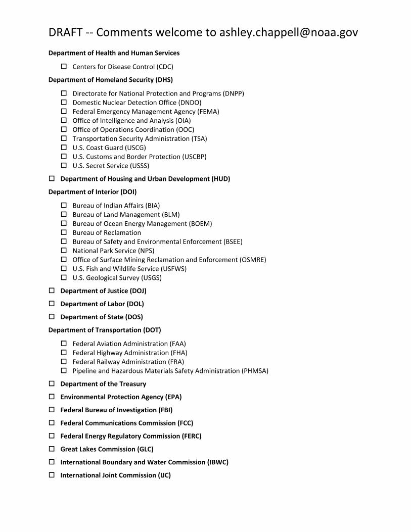
DRAFT ‐‐ Comments welcome to [email protected]
3D Nation Requirements and Benefits Study OMB Control Number:
Expiration Date:
Introduction
This questionnaire is sponsored by the National Oceanic and Atmospheric Administration (NOAA) Office
of Coast Survey (OCS) and the U.S. Geological Survey (USGS) National Geospatial Program (NGP). The
questionnaire covers a wide range of business uses that depend on 3D data to inform policy, regulation, scientific research, and management decisions. For purposes of this questionnaire, 3D data refers to
topographic data (precise three‐dimensional measurements of the terrestrial terrain) and bathymetric data (three‐dimensional surface of the underwater terrain). Questions will be asked about how 3D data
relate to other data types, such as the shoreline; characteristics of tides, currents, and waves; and the physical and chemical properties of the water, itself. A series of questions will be asked as they relate to specific Mission Critical Activities. These will include questions about the area (geographic extent), 3D data accuracy requirements, linkages to other data to support a wide range of analysis, and benefits of having the required data.
We are working to improve our technology systems, data, and services that provide information about
3D data and related applications within the United States. By learning more about your business uses and associated benefits that would be realized from improved 3D data, we will be able to prioritize and direct investments that will best serve your needs. This questionnaire is part of an effort to develop and
refine future program alternatives that would provide enhanced 3D data to meet many Federal, State, and other national business needs.
Because 3D data are collected and used to meet a wide range of mission critical needs, we are seeking
input from managers and data users from a variety of government entities (e.g., Federal, State, local,
Tribal) as well as not‐for‐profit, academic, and private/commercial entities). The findings are expected
to establish a baseline of national business needs and associated benefits for 3D data and associated technologies. This baseline will enhance the responsiveness of NOAA, USGS, and partner agency programs to stakeholder needs, and inform the design of directed future programs that balance requirements, benefits, and costs at a national scale.
We would like to thank you in advance for participating in this study. We will aggregate collected responses at the agency and national levels. We will not distribute responses associated with you as an individual. We ask you for some basic organizational and contact information to help us interpret the results and, if needed, to contact you for clarification.
Instructions
Add any additional specific instructions that are specific to the survey software used
This questionnaire should not take more than xx minutes to complete. This will include the time that you may need to read explanatory FAQs and supporting information that will help you to respond to the questionnaire. Although you are not expected to spend a great deal of time researching the response for each question, you will have the option to exit the questionnaire and return at a later time.

DRAFT ‐‐ Comments welcome to [email protected]
The responses to the questions are in two formats – open‐ended and single (or multiple) response. Responses to the open‐ended questions will be entered in a text box below the question. All single (or multiple) response questions will be entered by using drop‐down or check boxes where you will choose the best response(s) for your agency and data uses.
It is recommended that you first review two tutorials available from this web site:
1. The first is a list of frequently asked questions (FAQs) pertaining to 3D data terms used throughout the questionnaire. Even if all the terms in the FAQs are familiar to you, reviewing this material will help ensure that all respondents are thinking of the same definitions when answering the questions.
2. The second tutorial provides examples of the kinds of benefits one might receive from improved topographic and/or bathymetric information. These benefits are organized into three categories: (1) Operational Improvements, (2) Customer Service Improvements, and (3) Societal Benefits. This tutorial also demonstrates methods for estimating financial benefits, which you will be asked to assess in dollar amounts wherever possible.
Part 1: A Little About You and Your Agency or Organization
Please tell us a little about yourself so that we can contact you for clarification, if needed, and so we can
aggregate responses by Agency, program, State, organization, etc.
Question 1. Please enter your contact information.
Your name (Last, First, MI).
Last: First: Middle Initial:
Your Agency, State, or organization.
Name of your program supported by 3D data (topographic and/or bathymetric
data/information).
Your job title.
Your telephone number. Enter text as xxx‐xxx‐xxxx (ext.)

DRAFT ‐‐ Comments welcome to [email protected]
Your email address.
Question 2. Which type of organization do you represent? Please select one of the following seven options.
Federal Agencies and Commissions (link to Questions 2a and 2b) State or U.S. Territorial government (link to Questions 2c) Tribal government (link to Question 2d) Regional, County, City or other local government (link to Questions 2e) Academic or Not‐for‐Profit (link to Question 2f) Private or Commercial (link to Question 2g)
Question 2a. What is the name of the Federal agency or Commission for which you are defining 3D3D data/information requirements? Please select one from the list. If you do not see your Agency listed, please choose “Other” and enter your Agency name.
Department of Agriculture (USDA)
Agricultural Research Service (ARS) Animal and Plant Health Inspection Service (APHIS) Farm Service Agency (FSA) Foreign Agriculture Service (FAS) Natural Resources Conservation Service (NRCS) U.S. Forest Service (USFS)
Department of Commerce (DOC)
Economic Development Administration National Institute of Standards and Technology (NIST) National Oceanic and Atmospheric Administration (NOAA) National Telecommunications and Information Administration (NTIA) U.S. Census Bureau (USCB)
Department of Defense (DOD)
Defense Installations Spatial Data Infrastructure (DISDI) Defense Threat Reduction Agency (DTRA) Department of the Navy National Geospatial‐Intelligence Agency (NGA) U.S. Army Corps of Engineers (USACE)
Department of Energy (DOE)
Bonneville Power Administration (BPA) Office of Energy Efficiency and Renewable Energy (EERE) Southeastern Power Administration (SEPA) Southwestern Power Administration (SWPA) Western Area Power Administration (WAPA)
DRAFT ‐‐ Comments welcome to [email protected]
Department of Health and Human Services
Centers for Disease Control (CDC)
Department of Homeland Security (DHS)
Directorate for National Protection and Programs (DNPP) Domestic Nuclear Detection Office (DNDO) Federal Emergency Management Agency (FEMA) Office of Intelligence and Analysis (OIA) Office of Operations Coordination (OOC) Transportation Security Administration (TSA) U.S. Coast Guard (USCG) U.S. Customs and Border Protection (USCBP) U.S. Secret Service (USSS)
Department of Housing and Urban Development (HUD)
Department of Interior (DOI)
Bureau of Indian Affairs (BIA) Bureau of Land Management (BLM) Bureau of Ocean Energy Management (BOEM) Bureau of Reclamation Bureau of Safety and Environmental Enforcement (BSEE) National Park Service (NPS) Office of Surface Mining Reclamation and Enforcement (OSMRE) U.S. Fish and Wildlife Service (USFWS) U.S. Geological Survey (USGS)
Department of Justice (DOJ)
Department of Labor (DOL)
Department of State (DOS)
Department of Transportation (DOT)
Federal Aviation Administration (FAA) Federal Highway Administration (FHA) Federal Railway Administration (FRA) Pipeline and Hazardous Materials Safety Administration (PHMSA)
Department of the Treasury
Environmental Protection Agency (EPA)
Federal Bureau of Investigation (FBI)
Federal Communications Commission (FCC)
Federal Energy Regulatory Commission (FERC)
Great Lakes Commission (GLC)
International Boundary and Water Commission (IBWC)
International Joint Commission (IJC)

DRAFT ‐‐ Comments welcome to [email protected]
Marine Mammal Commission (MMC)
National Aeronautics and Space Administration (NASA)
National Science Foundation (NSF)
Nuclear Regulatory Commission (NRC)
U.S. Agency for International Development (USAID)
U.S. Arctic Research Commission
Tennessee Valley Authority (TVA)
Other Federal Agency (please specify)
Question 2b. What is the name of the sub‐agency, division, department and/or branch for which your requirements pertain? Please enter text.
Question 2c. What is the name of your State, territory, or Washington, D.C.? Please select one.
Alabama
Alaska
American Samoa
Arizona
Arkansas
California
Colorado
Connecticut
Delaware
Florida
Georgia
Guam
Hawaii
Idaho
Illinois
Indiana
Iowa
Kansas
Kentucky
Louisiana
Maine
Maryland
Massachusetts
Michigan
Minnesota
Mississippi
Missouri
Montana
Nebraska
Nevada
New Hampshire
New Jersey
New Mexico
New York
North Carolina
North Dakota
Northern Mariana
Islands
Ohio
Oklahoma
Oregon
Pennsylvania
Puerto Rico
Rhode Island
South Carolina
South Dakota
Tennessee
Texas
Utah
Vermont
Virgin Islands
Virginia
Washington
Washington D.C.
West Virginia
Wisconsin
Wyoming
Question 2d. What is your Tribal name? Please enter text.
DRAFT ‐‐ Comments welcome to [email protected]
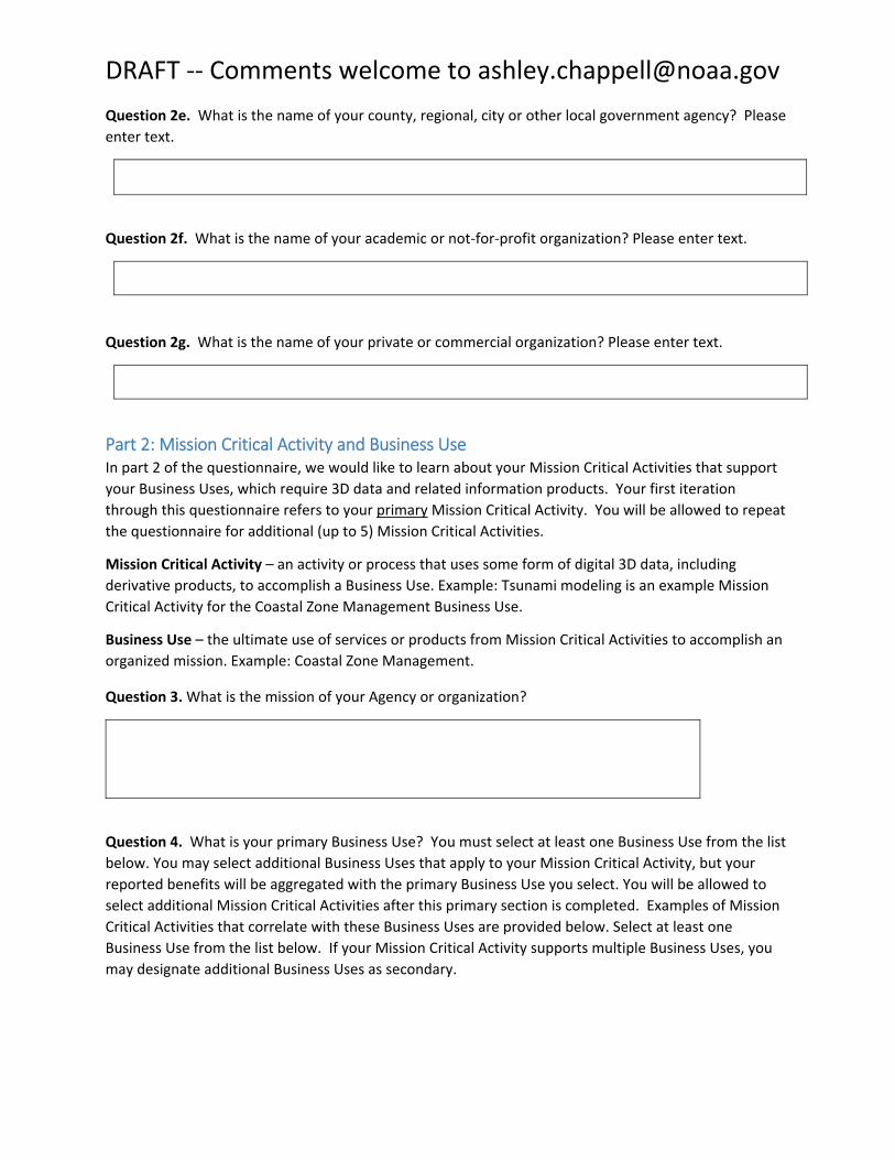
Question 2e. What is the name of your county, regional, city or other local government agency? Please enter text.
Question 2f. What is the name of your academic or not‐for‐profit organization? Please enter text.
Question 2g. What is the name of your private or commercial organization? Please enter text.
Part 2: Mission Critical Activity and Business Use In part 2 of the questionnaire, we would like to learn about your Mission Critical Activities that support your Business Uses, which require 3D data and related information products. Your first iteration through this questionnaire refers to your primary Mission Critical Activity. You will be allowed to repeat the questionnaire for additional (up to 5) Mission Critical Activities.
Mission Critical Activity – an activity or process that uses some form of digital 3D data, including
derivative products, to accomplish a Business Use. Example: Tsunami modeling is an example Mission Critical Activity for the Coastal Zone Management Business Use.
Business Use – the ultimate use of services or products from Mission Critical Activities to accomplish an
organized mission. Example: Coastal Zone Management.
Question 3. What is the mission of your Agency or organization?
Question 4. What is your primary Business Use? You must select at least one Business Use from the list below. You may select additional Business Uses that apply to your Mission Critical Activity, but your reported benefits will be aggregated with the primary Business Use you select. You will be allowed to select additional Mission Critical Activities after this primary section is completed. Examples of Mission
Critical Activities that correlate with these Business Uses are provided below. Select at least one
Business Use from the list below. If your Mission Critical Activity supports multiple Business Uses, you may designate additional Business Uses as secondary.

DRAFT ‐‐ Comments welcome to [email protected]
Business Uses Examples of Mission Critical Activities 1st 2nd
BU 1 ‐ Natural Resources
Conservation
Conservation engineering. Soils and wetlands
mapping and characterization. Modeling of
biological and ecological systems. Erosion control.
Rainfall penetration studies, impervious surfaces.
Assessment of blue carbon stocks.
O O
BU 02 ‐ Water Supply and
Quality Fate and transport of contaminants. Pollution risk
mitigation. Runoff and sedimentation analyses. Non‐
point source pollution modeling. Management of
contaminants and marine debris ‐ point, non‐point,
vessel, and atmospheric pollution; spills; trash.
O O
BU 03 – Riverine Ecosystem Management
Stream channel analysis and mapping. Stream bank erosion analysis. Aquatic and terrestrial species
habitat management. Environmental management.
O O
BU 04 ‐ Coastal Zone
Management Analysis of coastal erosion and inundation.
Hurricane storm surge and wind damage modeling and assessment. Coastal hazard modeling and
mapping. Coastal hazard mitigation. Tsunami
modeling. Land use and environmental planning. Coastal resiliency. Oil spill modeling.
O O
BU 05 – Forest Resources
Management Forest health assessment. Determination of standing inventory of forest resources. Prescribed burn
planning. Analysis of carbon stocks for trade. Harvest systems planning.
O O
BU 06 – Rangeland
Management Assessment of rangeland health. Mapping for soil
erosion potential due to grazing.
O O
BU 07 – Wildlife and Habitat
Management Conservation planning for wildlife refuges and
marine sanctuaries. Conservation of critical habitats.
Management of diverse migratory bird habitats,
coral reef and coral communities, marine mammals,
protected fish species, and trust resources.
O O
BU 08 – Agriculture and Precision Farming
Farm pond design. Irrigation system design. Detailed site analysis to support precision farming. Analysis of
farm sedimentation and runoff. Calibration of
fertilizer application, fertilizer management, and
irrigation planning. Optimized terraforming.
O O
BU 09 – Aquaculture and Fish Farming
Management of fisheries. Sustainable aquaculture. O O

DRAFT ‐‐ Comments welcome to [email protected]
Business Uses Examples of Mission Critical Activities 1st 2nd
BU 10 – Geologic Resource
Assessment and Hazard
Mitigation
Geologic mapping and analysis. Sinkhole and
steephead mapping, monitoring, and analysis.
Identification of geomorphologic units. Landslide
hazard mapping and assessment. Karst mapping,
including springs and caves. Aquifer recharge.
O O
BU 11 – Resource Mining Sediment management. Monitoring sand as a local resource. Offshore mineral extraction. Open mine volume computations. Stockpile analysis.
Environmental impact assessment and site
restoration.
O O
BU 12 – Renewable Energy Resources
Alternate energy development – solar, tidal, wind, wave, and ocean current. Assessment of rooftops for
solar energy potential. Analysis of wind energy potential and turbine placement. Low head power potential for hydropower.
O O
BU 13 – Oil and Gas Resources Oil and gas exploration and production. Pipeline and route selection. Facility siting to mitigate geologic
hazards. Construction planning. Environmental impact assessment and mitigation. Regulatory
compliance.
O O
BU 14 ‐ Cultural Resources Preservation and Management
Discovery and analysis of underwater archaeological and historical cultural sites. Site protection and preservation planning. Discovery and analysis of
Native American and other historical cultural sites and subsistence activities.
O O
BU 15 – Flood Risk Management
Flood risk modeling and mapping of riverine and coastal areas. Dam/dike/levee safety analysis.
Emergency management. Flood forecasts.
O O
BU 16 – Sea Level Rise and Subsidence
Modeling and mapping the effects of sea level rise or subsidence. Population and economic vulnerability assessments. Coastal inundation and infrastructure assessment.
O O
BU 17 – Wildfire Management,
Planning, and Response Determination of forest fuel and fire susceptibility.
Fire behavior modeling to support wildfire suppression activities. Wildland/urban interface building identification. Post fire analysis to
determine landslide prone areas.
O O

DRAFT ‐‐ Comments welcome to [email protected]
Business Uses Examples of Mission Critical Activities 1st 2nd
BU 18 – Homeland Security,
Law Enforcement, Disaster
Response, and Emergency Management
Infrastructure and border protection. Coastal search
and rescue. Population dynamics. Emergency fuel supply and movement. Line of sight analysis in urban areas. Disaster response. Flood risk analysis resulting
from acts of terrorism.
O O
BU 19 – Land Navigation and Safety
Route selection for new roads. Slope analysis for autonomous cars. GPS navigation visualization.
O O
BU 20 – Marine and Riverine Navigation and Safety
Nautical charting. Bathymetric measurements of
near‐shore submerged coastal topography.
Identification of hazards to navigation. Sediment management at coastal navigation projects. Precision marine navigation. Movement of goods
and fishing vessels.
O O
BU 21 – Aviation Navigation and Safety
Determination of in‐flight hazards and path
obstructions. Aeronautical charting. Runway construction and repair.
O O
BU 22 – Infrastructure and Construction Management
Marine construction. Bridge design and construction. Engineering and construction of dams, levees, dikes, reservoirs, and coastal structures.
Shipyard and port construction. Water, sewer, or
power line planning and vegetation analysis. Pump, drain, and well placement. Stormwater modeling. Cut and fill analysis for earth‐moving. Building site analysis. Road infrastructure. Infrastructure
hardening or mitigation for climate change effects, e.g. sea level change.
O O
BU 23 – Urban and Regional Planning
Land development and zoning. Municipal mapping of building footprints and elevations. Port resilience
planning. Parks and transportation planning. Virtual city creation. Urban ecology planning.
O O
BU 24 – Health and Human Services
Health emergency response. Habitat modeling and
disease prevention. Health advisories for swimming and fishing. Marine‐based bioproducts and
pharmaceuticals. Public health and safety.
Prevention of waterborne diseases.
O O
BU 25 – Real Estate, Banking,
Mortgage, and Insurance Assessment of risk for natural hazards (e.g.,
sinkholes, flooding) to inform insurance policy rates and the determination of mandatory insurance. Building permit compliance.
O O

DRAFT ‐‐ Comments welcome to [email protected]
Business Uses Examples of Mission Critical Activities 1st 2nd
BU 26 – Education K‐12 and Beyond, Basic Research
Development of 3‐D visualizations to help students understand the Earth they live on. Understanding of continental‐scale climate change impacts. Ocean
science. Ocean education. Scientific research. Data
dissemination. Development of training simulators.
O O
BU 27 – Recreation Planning and development of recreational facilities
such as rafting, boating, swimming, diving, and fishing areas; ski slopes, and golf courses. Location‐
based products and services such as maps and
guides. Tourism. Trail and vista site planning. Orienteering.
O O
BU 28 ‐ Telecommunications Telecommunication tower site selection. Design of
radio and radar systems. Interference analysis. Path
profiles. Undersea telecommunication route
selection and deployment.
O O
BU 29 ‐ Military Tactical military operations. Strategic defense.
Amphibious landings and logistics over‐the‐shore. Operation of ships and submarines. Weapons system testing. Management of flight facilities and
offshore launch areas.
O O
BU 30 – Maritime and Land Boundary Management
Delimitation of legal and other coastal boundaries, inland boundaries, and ordinary high water lines
(OHWL).
O O
Question 5. What is the name of the program supported by your specified Mission Critical Activity? This question is about Mission Critical Activities that are performed by your organization. Mission Critical is defined herein as “indispensable for mission accomplishment and/or essential for effective/efficient operations in accomplishing the core mission of the organization.” Using examples from above as a guide, describe your primary Mission Critical Activity in your own words. We prefer a higher level activity, e.g., coastal hazard mitigation, rather than a lower level activity, e.g., SLOSH modeling (used in coastal hazard mitigation).

DRAFT ‐‐ Comments welcome to [email protected]
Question 6. What is the name of the program supported by your specified Mission Critical Activity? A program is a major component of your organization that has a well‐defined mission and goals and which is supported by one or more Mission Critical Activities
Question 7. What is the approximate total annual program budget supported by this Mission Critical Activity? The program budget includes all annual operating expenses to include staff, equipment, travel, materials, overhead, etc. Enter number without dollar sign.
Question 8. In this section, please identify your geographic area requirements for the Mission Critical Activity described above. We need to understand geographic area requirements for each Mission Critical Activity. Questionnaire respondents are encouraged to describe their geographic (area of
coverage) requirements using the provided administrative and watershed boundary pick lists. Alternatively, shapefiles for your geographic areas of interest may be provided. My geographic area
requirements are:
Nationwide, terrestrial (go to Question 8a) One or more national maritime boundaries (go to Question 8b ) One or more states, territories, or counties, including waters offshore (go to Question 8c) One or more Watersheds (go to question 8d) Federally‐owned lands nationwide or select large land holding agencies (go to Question 8e) Marine sanctuaries and marine national monuments (go to Question 8f ) None of the above; I will provide my own shapefile or geodatabase (go to question 8g)
Question 8a. If your geographic area requirements for 3D data for your Mission Critical Activity are nationwide, please check the items below that best represent your nationwide requirements. Please
select all that apply.
48 conterminous states Alaska Hawaii American Samoa Guam Northern Mariana Islands Puerto Rico Virgin Islands
Question 8b. If your geographic area requirements pertain to maritime boundaries, please designate from the list below. Please select all that are required.
State waters Federal waters Navigationally significant areas

DRAFT ‐‐ Comments welcome to [email protected]
Territorial sea (12 nautical miles) Contiguous zone (24 nautical miles) Outer Continental Shelf Exclusive Economic Zone (200 nautical miles)
Question 8c. If your geographic area requirements for 3D data for your Mission Critical Activity are for one or more states or counties, please check the state(s) below that are required. After you select the state(s) you will be allowed to identify sub‐regions (counties) where 3D data are required.
Alabama Louisiana Ohio
Alaska Maine Oklahoma
Arizona Maryland Oregon
Arkansas Massachusetts Pennsylvania
California Michigan Rhode Island
Colorado Minnesota South Carolina
Connecticut Mississippi South Dakota
Delaware Missouri Tennessee
Florida Montana Texas
Georgia Nebraska Utah
Hawaii Nevada Vermont
Idaho New Hampshire Virginia
Illinois New Jersey Washington
Indiana New Mexico Washington D.C.
Iowa New York West Virginia
Kansas North Carolina Wisconsin
Kentucky North Dakota Wyoming
When a state is selected, there will be an option to list counties in a text box
Question 8d. If your geographic area requirements pertain to hydrologic units, please check the major
basin area (HUC‐2) below. This will lead you to select individual HUC‐4 codes for your specific hydrologic
units.
01 New England 08 Lower Mississippi 15 Lower Colorado
02 Mid Atlantic 09 Souris‐Red‐Rainy 16 Great Basin
03 South Atlantic‐Gulf 10 Missouri 17 Pacific Northwest
04 Great Lakes 11 Arkansas‐White‐Red 18 California
05 Ohio 12 Texas – Gulf 19 Alaska
06 Tennessee 13 Rio Grande 20 Hawaii
07 Upper Mississippi 14 Upper Colorado 21 Caribbean
22 Pacific Islands
Expanded list of watersheds not shown here – HUC 4 watersheds can be an additional drop down menu that is associated with each HUC 2 watershed above.

DRAFT ‐‐ Comments welcome to [email protected]
Question 8e. If your geographic area requirements pertain to selected Federally‐owned lands, please designate below. Please select all that are required.
All Federally owned lands All lands of U.S. Tribes Bureau of Land Management (BLM) Bureau of Reclamation Department of Defense (DOD) National Park Service (NPS) Tennessee Valley Authority (TVA) U.S. Forest Service (USFS) U.S. Fish and Wildlife Service (USFWS) Other (enter name and or description)
Question 8f. If your geographic area requirements pertain to marine sanctuaries and/or marine national
monuments, please designate from the list below. Please select all that are required.
American Samoa Channel Islands Cordell Bank Florida Keys Flower Garden Banks Gray’s Reef Greater Farallones Hawaiian Islands Humpback Whale Monitor Monterey Bay Olympic Coast Papahanaumokuakea Rose Atoll Stellwagen Thunder Bay
Question 8g. If Applicable, please submit your geographic area requirements by posting your shapefile(s) to the project site at xxxxxxxxxxx and provide a unique filename that includes your name and organization, or abbreviations thereof. The projection and datum (.prj file) information must be included. Please enter the filename below.
Part 3: 3D Data Requirements In this section you will identify your mission critical requirements for 3D data. Mission Critical is defined as “indispensable for mission accomplishment and/or essential for effective/efficient operations in
accomplishing the core mission of the organization.” Therefore, please do not specify a requirement

DRAFT ‐‐ Comments welcome to [email protected]
that is “nice to have” (unless requested) but focus instead on what you must have to support your Mission Critical Activity.
Question 9. For your Mission Critical Activity, how would you characterize the area for which you need 3D data? Check all that apply.
Inland, including inland waters Nearshore/Beaches Offshore/Outer Continental Shelf/EEZ
Question 10. For your Mission Critical Activity, what do you need/want to measure in 3D? Check all that apply.
Bare earth ground Tops of buildings, structures, objects (including submerged) Tops of vegetation (including submerged) Subcanopy of vegetation/understory River/lake bottom Nearshore elevation Ocean/sea bottom
Question 11. What is the approximate size of the features you trying to resolve in 3D? Check all that
apply.
Survey‐level features (less than 1 meter) Individual features (1‐3 meters) Plot‐level scales (3‐10 meters) Regional scales (features 10‐30 meters) Other (please specify)

DRAFT ‐‐ Comments welcome to [email protected]
Question 12. What is the average size of the area you work with on a day to day basis for your Mission Critical Activity?
Individual Feature (e.g. single tree, single structure) Plot County State Regional National
Question 13. What is the needed horizontal accuracy of your 3D data? Check one.
Better than 10 cm of 'actual ground position'
Within 10 cm of 'actual ground position' Within 20 cm of 'actual ground position' Within .5 meter of 'actual ground position' Within 1 meter of 'actual ground position' Within 10 meters of ‘actual ground position’ Within 20 meters of ‘actual ground position’ Within 50 meters of ‘actual ground position’
Question 14. What is the needed vertical accuracy of your 3D data? Check one.
Less than 5 cm 5 cm 10 cm 20 cm 0.5 m 1 m Greater than 1 m
Question 15. For the Mission Critical Activity that you specified, how frequently do the 3D data need to be updated to satisfy your requirements? Stated another way, your Mission Critical Activity requires
data no older than:
Annually (one year) 2‐3 years 4‐5 years 6‐10 years >10 years Event driven – Data need to coincide with a specific event
Question 16. For the Mission Critical Activity that you specified, please describe the importance of seamless integration of your topographic, bathymetric and/or topobathymetric datasets.
Required Highly desirable Nice to have
DRAFT ‐‐ Comments welcome to [email protected]
Not required
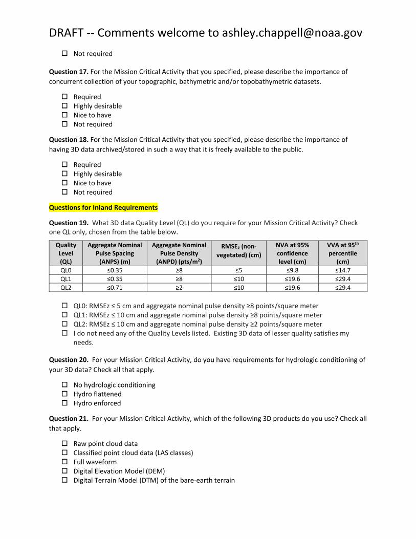
Question 17. For the Mission Critical Activity that you specified, please describe the importance of concurrent collection of your topographic, bathymetric and/or topobathymetric datasets.
Required Highly desirable Nice to have Not required
Question 18. For the Mission Critical Activity that you specified, please describe the importance of having 3D data archived/stored in such a way that it is freely available to the public.
Required Highly desirable Nice to have Not required
Questions for Inland Requirements
Question 19. What 3D data Quality Level (QL) do you require for your Mission Critical Activity? Check one QL only, chosen from the table below.
Quality Level (QL)
Aggregate Nominal Pulse Spacing (ANPS) (m)
Aggregate Nominal Pulse Density (ANPD) (pts/m2)
RMSEz (non‐
vegetated) (cm)
NVA at 95% confidence level (cm)
VVA at 95th
percentile (cm)
QL0 ≤0.35 ≥8 ≤5 ≤9.8 ≤14.7 QL1 ≤0.35 ≥8 ≤10 ≤19.6 ≤29.4 QL2 ≤0.71 ≥2 ≤10 ≤19.6 ≤29.4
QL0: RMSEz ≤ 5 cm and aggregate nominal pulse density ≥8 points/square meter QL1: RMSEz ≤ 10 cm and aggregate nominal pulse density ≥8 points/square meter QL2: RMSEz ≤ 10 cm and aggregate nominal pulse density ≥2 points/square meter I do not need any of the Quality Levels listed. Existing 3D data of lesser quality satisfies my needs.
Question 20. For your Mission Critical Activity, do you have requirements for hydrologic conditioning of your 3D data? Check all that apply.
No hydrologic conditioning Hydro flattened Hydro enforced
Question 21. For your Mission Critical Activity, which of the following 3D products do you use? Check all that apply.
Raw point cloud data Classified point cloud data (LAS classes) Full waveform Digital Elevation Model (DEM) Digital Terrain Model (DTM) of the bare‐earth terrain
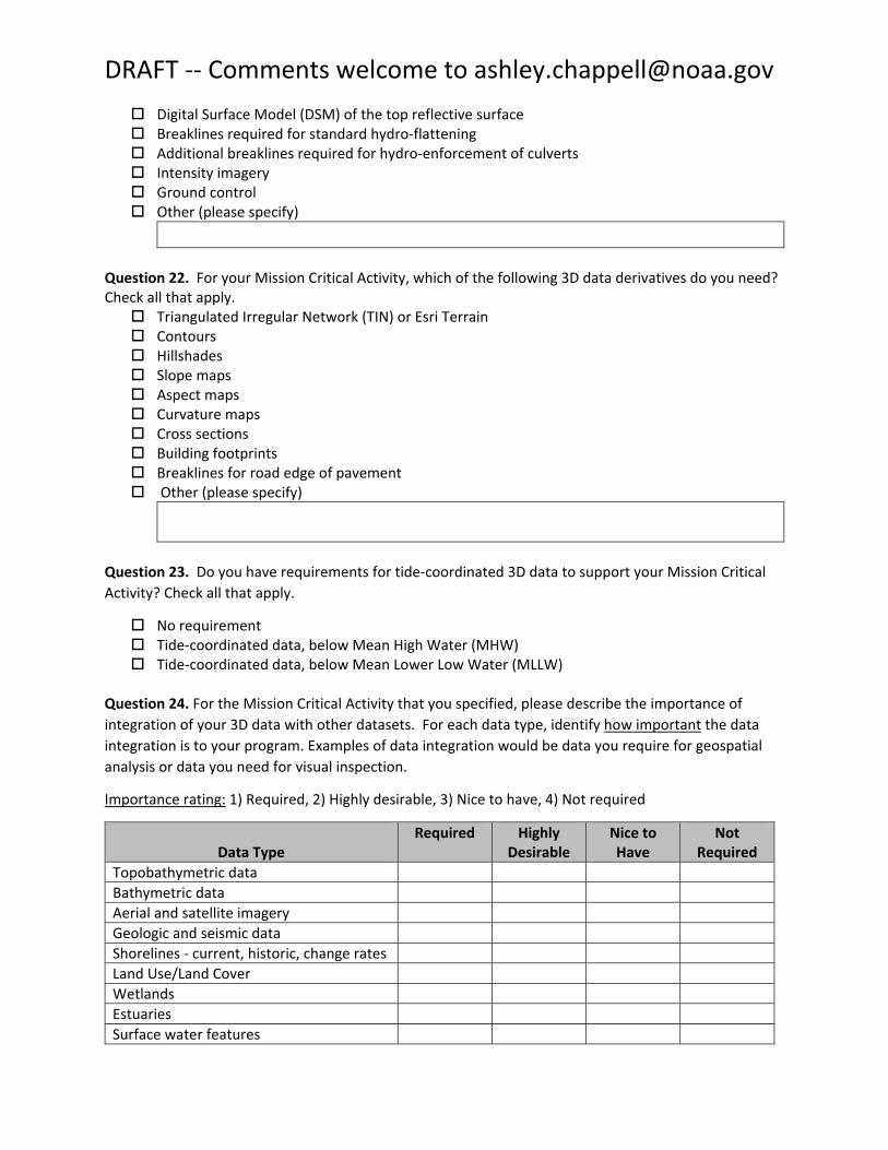
DRAFT ‐‐ Comments welcome to [email protected]
Digital Surface Model (DSM) of the top reflective surface Breaklines required for standard hydro‐flattening Additional breaklines required for hydro‐enforcement of culverts Intensity imagery Ground control Other (please specify)
Question 22. For your Mission Critical Activity, which of the following 3D data derivatives do you need? Check all that apply. Triangulated Irregular Network (TIN) or Esri Terrain Contours Hillshades Slope maps Aspect maps Curvature maps Cross sections Building footprints Breaklines for road edge of pavement Other (please specify)
Question 23. Do you have requirements for tide‐coordinated 3D data to support your Mission Critical Activity? Check all that apply.
No requirement Tide‐coordinated data, below Mean High Water (MHW) Tide‐coordinated data, below Mean Lower Low Water (MLLW)
Question 24. For the Mission Critical Activity that you specified, please describe the importance of integration of your 3D data with other datasets. For each data type, identify how important the data integration is to your program. Examples of data integration would be data you require for geospatial analysis or data you need for visual inspection.
Importance rating: 1) Required, 2) Highly desirable, 3) Nice to have, 4) Not required
Data Type Required Highly
Desirable Nice to Have
Not Required
Topobathymetric data Bathymetric data Aerial and satellite imagery Geologic and seismic data Shorelines ‐ current, historic, change rates Land Use/Land Cover Wetlands Estuaries Surface water features

DRAFT ‐‐ Comments welcome to [email protected]
Data Type Required Highly
Desirable Nice to Have
Not Required
Bridges/culverts Landmark features Cultural resources Coastal and riverine structures ‐ shoreline stabilization structures, levees, dams, jetties, piers, weirs, etc.
Lowest floor elevation of buildings Other (please specify)
Question 25. Do you require bathymetry for inland water features (e.g. lakes, reservoirs, large rivers)?
Yes No
If “yes,” go to question 32 for bathymetry requirements.
Questions for Nearshore Requirements
Question 26. What bathymetric or topobathymetric Quality Level (QLB) do you require for your Mission Critical Activity? Check one QLB only, chosen from the table below. Note that QL0B and QL1B are equivalent to the International Hydrographic Organization (IHO) Special Order standard, and the vertical accuracy specification for QL4B is equivalent to the IHO Order 1 standard for vertical accuracy.
QL0B QL1B QL2B QL3B QL4B Aggregate Nominal Pulse Spacing
≤0.7m ≤2.0 m ≤0.7 m ≤2.0 m ≤5.0 m
Aggregate Nominal Pulse Density
≥2.0 pts/m2 ≥0.25 pts/m2 ≥2.0 pts/m2 ≥0.25 pts/m2 ≥0.04 pts/m2
Depth Examples (m)
Depth Accuracy at 95% Confidence Level (cm)
0 25.0 25.0 30.0 30.0 50.0
10 26.1 26.1 32.7 32.7 51.7
20 29.2 29.2 39.7 39.7 56.4
Applications
Detailed site surveys requiring the highest accuracy and highest resolution seafloor definition; dredging and inshore engineering surveys; high‐resolution surveys of
ports and harbors
Charting surveys; regional sediment management; general bathymetric mapping; coastal science and
management applications; change analysis; deep water surveys; environmental analyses
Recon/planning; all general
applications not requiring higher resolution and accuracy
QL0B QL1B QL2B QL3B

DRAFT ‐‐ Comments welcome to [email protected]
QL4B
Question 27. For your Mission Critical Activity, do you have requirements for hydrologic conditioning of your 3D data? Check all that apply.
No hydrologic conditioning Hydro flattened Hydro enforced
Question 28. For your Mission Critical Activity, which of the following 3D products do you use? Check all that apply.
Raw point cloud data Classified point cloud data (LAS classes) Full waveform Digital Elevation Model (DEM) Digital Terrain Model (DTM) of the bare‐earth terrain Digital Surface Model (DSM) of the top reflective surface National Vertical Datum Transformation Tool (V‐Datum) Tide Predictions Tidal Constituent And Residual Interpolation (TCARI) required for standard hydro‐flattening Additional breaklines required for hydro‐enforcement of culverts Intensity imagery Ground control Other (please specify)
Question 29. For your Mission Critical Activity, which of the following 3D data derivatives do you need? Check all that apply. Triangulated Irregular Network (TIN) or Esri Terrain Contours Hillshades Slope maps Aspect maps Curvature maps Cross sections Building footprints Breaklines for road edge of pavement Other (please specify)
Question 30. Do you have requirements for tide‐coordinated 3D data to support your Mission Critical Activity? Check all that apply.
No requirement

DRAFT ‐‐ Comments welcome to [email protected]
Tide‐coordinated data, below Mean High Water (MHW) Tide‐coordinated data, below Mean Lower Low Water (MLLW)
Question 31. For the Mission Critical Activity that you specified, please describe the importance of integration of your 3D data with other datasets. For each data type, identify how important the data integration is to your program. Examples of data integration would be data you require for geospatial analysis or data you need for visual inspection.
Importance rating: 1) Required, 2) Highly desirable, 3) Nice to have, 4) Not required
Data Type Required Highly Desirable
Nice to Have
Not Required
Topographic data Bathymetric data Hydrographic survey data Nautical and/or navigation charts Acoustic imagery of the seafloor Aerial and satellite imagery Underwater videography Bottom texture Bottom type ‐ roughness and hardness, sediment type, density, grain size, color, contaminants, composition (organic, shell and mineral, sand percentage)
Submerged features ‐ shipwrecks, archaeological sites, rock outcrops, debris, pipelines, cables, wellheads, piles,
Subbottom characteristics
Geologic and seismic data Water column properties – Physical properties
Water column properties – Chemical properties Water column properties – Biological properties Currents Tide heights, wave heights Sea ice conditions Habitat distribution and classification ‐ submerged vegetation, seafloor‐dwelling organisms, fish stocks Boundaries – Exclusive Economic Zone (EEZ), continental shelf, marine sanctuaries and parks, Coastal Barrier Resources System (CBRS), archaeological and historic properties, restricted areas Offshore cadastral

DRAFT ‐‐ Comments welcome to [email protected]
Data Type Required Highly Desirable
Nice to Have
Not Required
Lease areas – Outer Continental Shelf (OCS), oil and gas, or sand resource lease blocks; renewable energy leases; dredge areas
Fixed obstructions – aids to navigation, beacons, landmarks, wind turbines, drilling platforms and equipment,
Floating observation and navigation systems – buoys, monitoring stations, etc. Shorelines ‐ current, historic, change rates Land Use/ Land Cover Wetlands Estuaries Surface water features Bridges/culverts Landmark features Cultural resources Coastal and riverine structures ‐ shoreline stabilization structures, levees, dams, jetties, piers, weirs, etc.
Overhead structures – bridge, overhead cable, overhead pipeline, etc. Lowest floor elevation of buildings Other (please specify)
Questions for Offshore Requirements
Question 32. Does your Mission Critical Activity require data that meet International Hydrographic Organization charting standards?
Yes (go to Question 18a) No I don’t know
Question 32a. What IHO Order do you require for your Mission Critical Activity? Check one Order only, chosen from the table below.
IHO Order Special 1a 1b 2 Total Horizontal Uncertainty (THU) (95% Confidence Level)
2m 5m + 5% of depth 5m + 5% of depth 20m + 10% of depth
Total Vertical Uncertainty
(TVU)1
(95% Confidence Level)
a = 0.25m b = 0.0075
a = 0.5m b = 0.013
a = 0.5m b = 0.013
a = 1.0m b = 0.023
Full Seafloor Search Required Required Not required Not required

DRAFT ‐‐ Comments welcome to [email protected]
IHO Order Special 1a 1b 2
Feature Detection Capability
Cubic features > 1m
Cubic features > 2m in depths up to 40m; 10% of depth beyond 40m
Not applicable Not applicable
Maximum Line Spacing
Not applicable, as 100% search is required
Not applicable, as 100% search is required
3 x average depth or 25m, whichever is greater
4 x average depth
Applications
Harbors, berthing areas, and
associated critical channels where under‐keel clearance is critical
Harbors, harbor approach channels,
recommended
tracks, and some
coastal areas with
depths up to 100
Areas shallower
than 100 m where under‐keel
clearance is not considered to be an issue for the type of surface
Areas generally
deeper than 100
m where a
general
description of the sea floor is
considered m where under‐
keel clearance is
less critical but of
concern to surface
shipping may exist.
shipping expected
to transit the
area.
adequate.
1 The formula below is to be used to compute, at the 95% confidence level, the maximum allowable TVU. The parameters “a” and “b” for each Order, together with the depth “d” are used to calculate the maximum allowable TVU for a specific depth:
Where: a represents that portion of the uncertainty that does not vary with depth b is a coefficient which represents that portion of the uncertainty that varies with depth d is the depth b x d represents that portion of the uncertainty that varies with depth
Special Order Order 1a Order 1b Order 2
Question 33. For your Mission Critical Activity, which of the following 3D products do you use? Check all
that apply.
Raw point cloud data Classified point cloud data (LAS classes) Full waveform Digital Elevation Model (DEM) Digital Terrain Model (DTM) of the bare‐earth terrain Digital Surface Model (DSM) of the top reflective surface National Vertical Datum Transformation Tool (V‐Datum)

DRAFT ‐‐ Comments welcome to [email protected]
Tide Predictions Tidal Constituent And Residual Interpolation (TCARI) Intensity imagery Other (please specify)
Question 34. For your Mission Critical Activity, which of the following 3D data derivatives do you need? Check all that apply. Triangulated Irregular Network (TIN) or Esri Terrain Contours Hillshades Slope maps Aspect maps Curvature maps Cross sections Other (please specify)
Question 35. Do you have a requirement for data to be tide corrected?
No requirement for tide correction Tide correction using Mean High Water (MHW) Tide correction using Mean Sea Level (MSL) Tide correction using Mean Lower Low Water (MLLW) Tide correction using other datum (please specify)
Question 36. For the Mission Critical Activity that you specified, please describe the importance of integration of your 3D data with other datasets. For each data type, identify how important the data integration is to your program. Examples of data integration would be data you require for geospatial analysis or data you need for visual inspection.
Importance rating: 1) Required, 2) Highly desirable, 3) Nice to have, 4) Not required
Data Type Required Highly Desirable
Nice to Have
Not Required
Topobathymetric data Bathymetric data
Hydrographic survey data Nautical and/or navigation charts Acoustic imagery of the seafloor Aerial and satellite imagery Underwater videography Bottom texture

DRAFT ‐‐ Comments welcome to [email protected]
Data Type Required Highly Desirable
Nice to Have
Not Required
Bottom type ‐ roughness and hardness, sediment type, density, grain size, color, contaminants, composition (organic, shell and mineral, sand percentage)
Submerged features ‐ shipwrecks, archaeological sites, rock outcrops, debris, pipelines, cables, wellheads, piles,
Subbottom characteristics
Geologic and seismic data
Water column properties – Physical properties
Water column properties – Chemical properties Water column properties – Biological properties Currents Tide heights, wave heights Sea ice conditions
Habitat distribution and classification ‐ submerged vegetation, seafloor‐dwelling organisms, fish stocks Boundaries – Exclusive Economic Zone (EEZ), continental shelf, marine sanctuaries and parks, Coastal Barrier Resources System (CBRS), archaeological and historic properties, restricted areas Routes – shipping, ferries, other vessel traffic routes
Offshore cadastral
Lease areas – Outer Continental Shelf (OCS), oil and gas, or sand resource lease blocks; renewable energy leases; dredge areas
Fixed obstructions – aids to navigation, beacons, landmarks, wind turbines, drilling platforms and equipment,
Floating observation and navigation systems – buoys, monitoring stations, etc. Shorelines ‐ current, historic, change rates
Land Use/ Land Cover
Wetlands Estuaries Surface water features Other (please specify)

DRAFT ‐‐ Comments welcome to [email protected]
Part 4: Benefits Question 37. What benefits relative to your program budget are you now realizing from currently
available 3D data? Check the box that most closely describes the benefits for each benefit type.
Current Benefits from existing 3D data Major Moderate Minor None Don’t know
Time or cost savings (operational benefits)
Mission compliance (operational benefits)
Products or services (customer service benefits)
Response or timeliness (customer service
benefits)
Customer experience (customer service benefits)
Education or public safety (societal benefits)
Environmental benefits (societal benefits)
Human lives saved (societal benefits)
Other:
Question 38. What annual dollar benefits do you receive from currently available 3D data that are
supporting your information needs for the selected Mission Critical Activity? Enter value below, without dollar sign.
Question 39. What benefits relative to your program budget would you likely receive from improved 3D
data if all of your requirements could be met for the selected Mission Critical Activity? Check the box that most closely describes the benefits for each benefit type.
Future Benefits from improved 3D data Major Moderate Minor None Don’t know
Time or cost savings (operational)
Improved mission compliance (operational)
Improved products or services (customer
service)

DRAFT ‐‐ Comments welcome to [email protected]
Future Benefits from improved 3D data Major Moderate Minor None Don’t know
Improved response or timeliness (customer
service)
Improved customer experience (customer
service)
Improved education or public safety
(societal benefit)
Environmental benefits (societal benefits)
Human lives saved (societal benefits)
Other:
Question 40. Briefly describe any major new benefits from the prior question. Enter text below.
Question 41. What annual dollar benefits would you likely receive from improved 3D data if all of your requirements could be met for the selected Mission Critical Activity? Enter value below, without dollar sign. This is one of your most important responses to this survey and will help build the business case for improving topographic and bathymetric data and information. Careful consideration should be given to identifying potential benefits.
Question 42. Which of these aspects of your 3D data requirements is the most important? Please rank the options from most important (1) to least important (3).
Rank
Requirement 1 (Most
Important)
2 (Moderately Important)
3 (Least
Important)
Geographic coverage O O O
Vertical accuracy O O O
Update frequency O O O
Question 43. Do you have additional Mission Critical Activities requiring 3D data?
Yes (go to Question 4)

DRAFT ‐‐ Comments welcome to [email protected]
No (go to Question 44)
Repeat Questions 4 through 43 referring to additional rather than primary Mission Critical Activities
Part 6: Required Data/Information Access Methods As information technology evolves, the Federal government has worked to keep pace with the most
appropriate ways for provisioning 3D data and related information. This last series of questions apply to your program in general and not to the individual Mission Critical Activities.
Question 44. For your program (all identified Mission Critical Activities), which 3D data sources are you currently using to address your elevation information needs? Please select all that apply.
USGS DEMs (i.e. elevation data from The National Map) USGS lidar point cloud data NOAA coastal lidar data Bathymetric Attributed Grid (BAG) files USACE coastal and/or inland lidar point clouds and DEMs National Ocean Service Hydrographic Database (NOSHDB) MultiBeam Bathymetric Database (MBBDB) NOAA nautical charts, including electronic charts USACE Inland Electronic Navigation Charts Rap sheets Smooth sheets Sidescan sonar mosaics
Other (please specify) Marine Minerals Program GIS (MMP GIS)
Question 45. For your program (all identified Mission Critical Activities), what geographic extents would best address your access requirements? Please select all that are required.
Watershed State or Territory Conterminous United States Nationwide including Alaska and Hawaii State waters Federal waters Coastal swath (beach/nearshore, including lakes) Navigationally significant areas Marine sanctuaries and marine national monuments Territorial sea (12 nautical miles) Contiguous zone (24 nautical miles) Exclusive Economic Zone (200 nautical miles) Lease areas User defined map extent User defined irregular area (polygon) Other (please specify) I don’t know
DRAFT ‐‐ Comments welcome to [email protected]
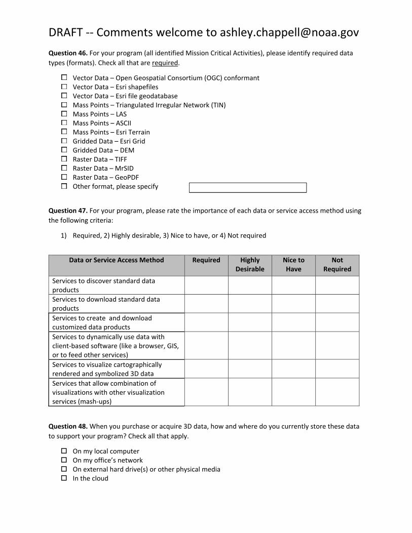
Question 46. For your program (all identified Mission Critical Activities), please identify required data
types (formats). Check all that are required.
Vector Data – Open Geospatial Consortium (OGC) conformant Vector Data – Esri shapefiles Vector Data – Esri file geodatabase Mass Points – Triangulated Irregular Network (TIN) Mass Points – LAS Mass Points – ASCII Mass Points – Esri Terrain Gridded Data – Esri Grid Gridded Data – DEM Raster Data – TIFF Raster Data – MrSID Raster Data – GeoPDF Other format, please specify
Question 47. For your program, please rate the importance of each data or service access method using
the following criteria:
1) Required, 2) Highly desirable, 3) Nice to have, or 4) Not required
Data or Service Access Method Required Highly Desirable
Nice to Have
Not Required
Services to discover standard data products Services to download standard data products Services to create and download customized data products Services to dynamically use data with client‐based software (like a browser, GIS, or to feed other services) Services to visualize cartographically rendered and symbolized 3D data Services that allow combination of visualizations with other visualization services (mash‐ups)
Question 48. When you purchase or acquire 3D data, how and where do you currently store these data to support your program? Check all that apply.
On my local computer On my office’s network On external hard drive(s) or other physical media In the cloud
Submit to NOAA Digital Coast for distribution to others
DRAFT ‐‐ Comments welcome to [email protected]
On my agency’s enterprise geospatial system Submit to my state’s data repository for use by others Submit to the National Center for Environmental Information (NCEI) for use by others Submit to USGS for distribution to others (e.g. via The National Map) Submit to Marine Cadastre for distribution to others Other (please specify)
Question 49. When you generate products or analyses using 3D data, how and where do you store these results to support your program? Check all that apply.
On my local computer On my office’s network On external hard drive(s) or other physical media In the cloud On my agency’s enterprise geospatial system Submit to my state’s data repository for use by others Submit to the National Center for Environmental Information (NCEI) for use by others Submit to USGS for distribution to others (e.g. via The National Map) Submit to Marine Cadastre for distribution to others Submit to NOAA Digital Coast for distribution to others Other (please specify)
Question 50. Are there other aspects of using 3D data for which you need help?
Metadata creation Data archiving Training Other (please specify)
Please provide any final comments that you wish to make that were not covered in the questions asked above:
Thank you for responding to this 3D Nation requirements and benefits questionnaire. The information that you have provided will be summarized for the Federal Agency, State, Territory, Tribe, or non‐governmental organization that you represent. The Point of Contact for your organization will then have
an opportunity to review and edit the summary requirements that will feed into the final study report.

DRAFT ‐‐ Comments welcome to [email protected]
The final study report will be the primary source of information used to develop recommendations for a 3D Nation program.