Embed Size (px)
Citation preview

DRAFT
ARROYA AVENUE BRIDGE OVER DELTA CANAL REPLACEMENT PROJECT
INITIAL STUDY/MITIGATED NEGATIVE DECLARATION
PREPARED FOR:
Merced County Department of Public Works 715 Martin Luther King Jr. Way Merced, CA 95341
PREPARED BY:
GPA Consulting 2600 Capital Avenue, Suite 100 Sacramento, CA 95816
January 2020


Arroya Avenue Bridge over Delta Canal Replacement Project Merced County Initial Study Mitigated Negative Declaration January 2020
Page i
TABLE OF CONTENTS 1. Introduction ...................................................................................................................1
1.1 Legal Authority and Findings ........................................................................................... 1 1.2 Document Purpose .......................................................................................................... 1 1.3 Document Organization ................................................................................................... 2 1.4 Terminology ..................................................................................................................... 2
2. Environmental Checklist .................................................................................................5 2.1 Environmental Factors Potentially Affected .................................................................. 13 2.2 Determination ............................................................................................................... 14 2.3 Evaluation of Environmental Impacts ............................................................................ 15
3. Evaluation of Environmental Impacts ............................................................................ 16 I. Aesthetics ...................................................................................................................... 16 II. Agricultural and Forestry Resources .............................................................................. 19 III. Air Quality ...................................................................................................................... 23 IV. Biological Resources ...................................................................................................... 29 V. Cultural Resources ......................................................................................................... 41 VI. Energy ............................................................................................................................ 45 VII. Geology and Soils ........................................................................................................... 46 VIII. Greenhouse Gas Emissions ............................................................................................ 51 IX. Hazards and Hazardous Materials ................................................................................. 54 X. Hydrology and Water Quality ........................................................................................ 60 XI. Land Use and Planning................................................................................................... 67 XII. Mineral Resources ......................................................................................................... 69 XIII. Noise .............................................................................................................................. 71 XIV. Population and Housing ................................................................................................ 77 XV. Public Services ............................................................................................................... 78 XVI. Recreation ...................................................................................................................... 81 XVII. Transportation ............................................................................................................... 82 XVIII. Tribal Cultural Resources ............................................................................................... 85 XIX. Utilities and Service Systems ......................................................................................... 87 XX. Wildfire .......................................................................................................................... 90 XXI. Mandatory Findings of Significance ............................................................................... 92
4. References ................................................................................................................... 95 5. Preparers and Contributors ........................................................................................... 98 6. Mitigation Monitoring or Reporting Plan (MMRP) ......................................................... 99
Appendices Appendix A: Cumulative Project List ................................................................................... 113

Arroya Avenue Bridge over Delta Canal Replacement Project Merced County Initial Study Mitigated Negative Declaration January 2020
Page ii
TABLE OF FIGURES FIGURE 1. REGIONAL LOCATION .........................................................................................................6 FIGURE 2. PROJECT VICINITY...............................................................................................................7 FIGURE 3. PROJECT AREA ...................................................................................................................8 FIGURE 4. BIOLOGICAL STUDY AREA ................................................................................................. 34 FIGURE 5. PROJECT IMPACTS ............................................................................................................ 38
TABLE OF TABLES TABLE 1. DESIGNATED FARMLAND REQUIRED FOR ACQUISITION OF RIGHT OF WAY OR TEMPORARY
CONSTRUCTION EASEMENTS .............................................................................................. 21 TABLE 2. JURISDICTIONAL WATERS DELINEATED IN THE BIOLOGICAL STUDY AREA ............................ 37 TABLE 3. TEMPORARY IMPACTS ON JURISDICTIONAL FEATURES ....................................................... 39 TABLE 4. PERMANENT IMPACTS ON JURISDICTIONAL FEATURES ....................................................... 39 TABLE 5. CONSTRUCTION NOISE EQUIPMENT ................................................................................... 73 TABLE 6. SUMMARY OF GROUNDBORNE VIBRATION LEVELS AND POTENTIAL EFFECTS ...................... 74 TABLE 7. REPRESENTATIVE VIBRATION LEVELS FOR CONSTRUCTION EQUIPMENT .............................. 75

Arroya Avenue Bridge over Delta Canal Replacement Project Merced County Initial Study Mitigated Negative Declaration January 2020
Page iii
Acronyms and Abbreviations
Acronyms Abbreviations AB Assembly Bill ACCM Asbestos Containing construction material ADT Average Daily Traffic bgs below ground surface BMP Best Management Practices BSA Biological Study Area California PRC California Public Resources Code CAA Clean Air Act CAAQS California Ambient Air Quality Standards Caltrans California Department of Transportation CARB California Air Resources Board CBC California Building Standards Code CCR California Code of Regulations CDFW California Department of Fish and Wildlife CDOC California Department of Conservation CDPH California Department of Public Health CEQA California Environmental Quality Act CERCLA Comprehensive Environmental Response, Compensation, and Liability Act CFR Code of Federal Regulations CH4 Methane CNDDB California Natural Diversity Database CO Carbon Monoxide County County of Merced CPUC California Public Utilities Commission CRHR California Register of Historical Resources CWA Clean Water Act dB decibel dBA A-weighted decibels DOT Department of Transportation DPM Diesel Particulate Matter DTSC Department of Toxic Substances Control EIR Environmental Impact Report EPA Environmental Protection Agency FESA Federal Endangered Species Act FFRMS Federal Flood Risk Management Standard FHWA Federal Highway Administration GHG Greenhouse Gases H2S Hydrogen Sulfide
Arroya Avenue Bridge over Delta Canal Replacement Project Merced County Initial Study Mitigated Negative Declaration January 2020
Page iv
HFC Hydrofluorocarbons HSC California Health and Safety Code HWCL Hazardous Waste Control Law I Interstate I-5 Interstate 5 in/sec Inches per second IS Initial Study ISA Initial Site Assessment ISMND Initial Study with Mitigated Negative Declaration Leq Continuous Sound Level Lmax Maximum Sound Level MCAG Merced County Association of Governments MCLs Maximum Contaminant Levels MMRP Mitigation Monitoring or Reporting Plan MND Mitigated Negative Declaration MSWG Merced Storm Water Group NAAQS National Ambient Air Quality Standards NAHC Native American Heritage Commission ND Negative Determination NESMI Natural Environment Study Minimal Impact NO2 Nitrogen dioxide NOx Nitrogen NRCS Natural Resources Conservation Service NRHP National Register of Historic Places O3 Ozone OHWM Ordinary High Water Mark Pb Lead Pb O3 Lead Ozone PFC Perfluorocarbons PFCPb Perfluorocarbons Lead PM Particulate Matter PM10 Particulate Matter 10 micrometers and smaller PM2.5 Particulate Matter 2.5 micrometers and smaller RCRA Resource Conservation and Recovery Act ROW Right Of Way RWQCB Central Valley Regional Water Quality Control Board SAA Streambed Alteration Agreement SF6 Sulfur Hexafluoride SIP State Implementation Plan SJVAB San Joaquin Valley Air Basin SJVAPCD San Joaquin Valley Air Pollution Control District SLCA San Luis Canal Authority

Arroya Avenue Bridge over Delta Canal Replacement Project Merced County Initial Study Mitigated Negative Declaration January 2020
Page v
SO2 Sulfur Dioxide SR State Route SR 152 State Route 152 SWMP Merced County Storm Water Management Program SWRCB State Water Resources Control Board TCE Temporary Construction Easement U.S. United States USACE United States Army Corps of Engineers USDA United States Department of Agriculture VDE Visible Dust Emissions VOC Volatile Organic Compounds

Arroya Avenue Bridge over Delta Canal Replacement Project Merced County Initial Study/Mitigated Negative Declaration January 2020
Page vi
This page intentionally left blank.

Arroya Avenue Bridge over Delta Canal Replacement Project Merced County Initial Study/Mitigated Negative Declaration January 2020
Page 1
1. Introduction The County of Merced (County) proposes to replace the Arroya Avenue structure (Bridge No. 39C-0275) over Delta Canal (project or proposed project), located approximately 0.9 mile north of State Route 152 (SR 152), near the community of Dos Palos in Merced County. As required by the California Environmental Quality Act (CEQA) (California Public Resources Code [PRC] Sections 21000 et seq.), the County has prepared this Initial Study (IS) to determine whether the project may have a significant effect on the environment.
1.1 Legal Authority and Findings The County has prepared this Initial Study with Mitigated Negative Declaration (ISMND) in accordance with the Guidelines for the Implementation of CEQA (CEQA Guidelines) (California Code of Regulations (CCR), Title 14, Chapter 3, Sections 15000 et seq.). In accordance with the provisions of CEQA and the State and local CEQA Guidelines, as the Lead Agency, the County would be responsible for reviewing the potential environmental effects, and after consideration, approving or denying the project.
1.2 Document Purpose Section 15063(c) of the CEQA Guidelines defines an IS as the proper preliminary method of analyzing the potential environmental consequences of a project. The purposes of an IS are:
• To provide the Lead Agency with the necessary information to decide whether to prepare an Environmental Impact Report (EIR), a Mitigated Negative Declaration (MND), or a Negative Declaration (ND);
• To enable the Lead Agency to modify a project and mitigate adverse impacts, thus avoiding the need to prepare an EIR; and
• To provide sufficient technical analysis of the environmental effects of a project to permit a judgment based on the record as a whole, that the environmental effects of a project have been adequately mitigated.
• Section 15070 of the CEQA Guidelines states that a public agency must prepare a ND or a Mitigated Negative Declaration (MND) for a project subject to CEQA when:
o The IS shows that there is no substantial evidence, considering the whole record before the agency, that the project may have a significant effect on the environment; or
o The IS identifies potentially significant effects but:
Revisions in the project plans or proposals made by, or agreed to by the applicant before a proposed MND and IS are released for public review would avoid the effects or mitigate the effects to a point where clearly no significant effects would occur; and
There is no substantial evidence, considering the whole record before the agency, that the project as revised may have a significant effect on the environment.
An ISMND may be used to satisfy the requirements of CEQA when a proposed project would have no significant unmitigable effects on the environment. As discussed further in subsequent sections of this document, implementation of the proposed project would not result in any

Arroya Avenue Bridge over Delta Canal Replacement Project Merced County Initial Study/Mitigated Negative Declaration January 2020
Page 2
significant effects on the environment that cannot be reduced to a level below significance with the mitigation measures included herein.
1.3 Document Organization This ISMND contains six sections:
• Chapter 1. Introduction. This section provides an overview of the proposed project and the CEQA environmental documentation process.
• Chapter 2. Environmental Checklist. This section provides a summary of the project impacts and the CEQA determination.
• Chapter 3. Evaluation of Environmental Impacts. This section presents the CEQA checklist for all impact areas and mandatory findings of significance.
• Chapter 4. References. This section provides a list of reference materials used during the preparation of the ISMND.
• Chapter 5. Preparers and Contributors. This section provides a list of key personnel involved in the preparation of the ISMND.
• Chapter 6. Mitigation Monitoring or Reporting Plan (MMRP). This section incorporates any avoidance, minimization, or mitigation measures throughout the ISMND.
1.4 Terminology A “significant effect” is defined by Section 15382 of the CEQA Guidelines as “a substantial, or potentially substantial, adverse change in any of the physical conditions within the area affected by a project, including land, air, water, minerals, flora, fauna, ambient noise, and objects of historic or aesthetic significance.” According to Section 15358 of the CEQA Guidelines, “an economic or social change by itself shall not be considered a significant effect on the environment but may be considered in determining whether the physical change is significant.”

Arroya Avenue Bridge over Delta Canal Replacement Project Merced County Initial Study/Mitigated Negative Declaration January 2020
Page 5
2. Environmental Checklist 1. Project Title:
Arroya Avenue Bridge over Delta Canal Replacement Project
2. Lead Agency Name and Address
Merced County Department of Public Works 715 Martin Luther King Jr. Way Merced, CA 9534
3. Contact Person and Phone Number
Maitel Holloway, Project Engineer (209) 385-7601 [email protected]
4. Project Location
Arroya Avenue over Delta Canal Merced County, California
5. Project Proponent’s Name and Address
Merced County Department of Public Works 715 Martin Luther King Jr. Way Merced, CA 95341
6. General Plan Designation
County Right of Way (ROW) and Agricultural (County of Merced, n.d.)
7. Zoning
County ROW and A-1 (General Agricultural) (County of Merced, n.d.)
8. Project Description
Merced County (County) proposes to replace the Arroya Avenue Bridge structure (Bridge No. 39C-0275), over Delta Canal (project or proposed project), located approximately 0.9 mile north of State Route 152 (SR 152), near the community of Dos Palos in Merced County (project area) (see Figure 1, Regional Location, Figure 2, Project Vicinity, and Figure 3, Project Area).
The existing single-lane bridge is rated Functionally Obsolete and does not adequately handle the current average daily traffic. The County proposes to replace the existing single-lane structure with a two-lane bridge to accommodate existing and future traffic volumes. In addition, the existing bridge would be lengthened to correct a hydrologic restriction. The new bridge would also include barrier rails to prevent vehicles from leaving the bridge and entering the canal.
The project is included in the Merced County Association of Governments (MCAG) 2015 Federal Transportation Improvement Program Formal Amendment #1 (Federal Project ID BRLO-5939[103]). The County would utilize federal Highway Bridge Program funding to complete the project. The County is the Lead Agency pursuant to CEQA.

_̂
Dos Palos
FIGURE 1. REGIONAL LOCATIONArroya Avenue over Delta Canal Bridge Replacement Project
Project Location(Arroya Avenue Bridge)
Merced County
Location in California
Service Layer Credits: Content may not reflect National Geographic's currentmap policy. Sources: National Geographic, Esri, DeLorme, HERE, UNEP-WCMC,USGS, NASA, ESA, METI, NRCAN, GEBCO, NOAA, increment P Corp.
0 1 2Miles Z
·|}þ152

Project Location(Arroya Avenue Bridge)
Service Layer Credits: Content may not reflect National Geographic's currentmap policy. Sources: National Geographic, Esri, DeLorme, HERE, UNEP-WCMC,USGS, NASA, ESA, METI, NRCAN, GEBCO, NOAA, increment P Corp.
FIGURE 2. PROJECT VICINITYArroya Avenue Bridge over Delta Canal Replacement Project
0 1,000 2,000Feet Z
Delta
Canal
·|}þ152

Service Layer Credits: Source: Esri, DigitalGlobe, GeoEye, EarthstarGeographics, CNES/Airbus DS, USDA, USGS, AeroGRID, IGN, and the GIS UserCommunity
FIGURE 3. PROJECT AREAArroya Avenue Bridge over Delta Canal Replacement Project
0 50Feet Z
ARROYA AVE
ARROYA AVE Existing Weir
Existing Pump Facility
LEVEE ROAD
LEVEE ROAD
LEVEE ROAD
LEGENDProposed BridgeProposed Roadway
West Delta CanalARROYA AVENUE
BRIDGE

Arroya Avenue Bridge over Delta Canal Replacement Project Merced County Initial Study/Mitigated Negative Declaration January 2020
Page 9
The primary objective of the project is to replace a structurally deficient bridge to improve public safety. The existing bridge is a three-span reinforced T-beam structure built in 1930. The bridge does not meet current design standards for travel width and shoulders, and currently has no barrier rails. The bridge is too narrow for the current Average Daily Traffic and is heavily used by agricultural vehicles, resulting in unsafe driving conditions.
The purpose of the project is to:
• Remove the existing structure and reconstruct a bridge that will provide adequate and safe vehicle access; and
• Provide a new structure that will be wider and meet current design standards for the traffic utilizing this roadway.
The County proposes to replace the existing single-lane bridge with a wider, longer two-lane bridge with barrier rails. The replacement bridge would span the Delta Canal and would measure 31 feet, eight inches wide, and 53 feet long. Two alternatives were considered for the new bridge:
• Alternative 1: Single Span Precast/Prestressed Concrete Slab Bridge (Preferred)
• Alternative 2: Single Span Cast-in-Place/Prestressed Concrete Slab Bridge
Alternative 1 is the preferred alternative because it would avoid impacts and/or alteration of Delta Channel.
Alternative 1: Single Span Precast/Prestressed Concrete Slab Bridge
Under Alternative 1, the existing bridge would be replaced with a single span precast concrete slab, which is desirable due to reduced construction time and reduced environmental impacts. The new tangent bridge alignment makes a precast slab type structure a viable type. Precast slab structures do not require temporary supports within the canal and are relatively fast to construct. The structure depth required for a precast span would be nominally deeper than a slab alternative. Depending on the design water surface elevation, changes to the roadway profile will be required.
Alternative 2: Single Span Cast-in-Place/Prestressed Concrete Slab Bridge
Under Alternative 2, the existing bridge would be replaced with a single span cast-in-place prestressed concrete slab, which is desirable due to its small structure depth. The structure depth required for a single span would be deeper than multi-span alternatives but would eliminate supports within the canal. Depending on the freeboard requirements of San Luis Canal Authority (SLCA), the new profile may be slightly higher than the existing bridge profile.
No Build Alternative
Under this alternative, the Arroya Avenue Bridge over Delta Canal would not be replaced and the existing bridge would continue to be structurally deficient and provide inadequate and unsafe vehicle access. The No Build Alternative would not meet the project purpose and need and therefore is not considered a feasible alternative.
Anticipated Construction Methods and Schedule
The following describes the anticipated construction methods and schedule associated with Alternatives 1 and 2.
The existing abutments would remain in place since they are part of the existing weir system. The bridge would be supported by reinforced concrete abutments placed on driven or drilled piles. In order

Arroya Avenue Bridge over Delta Canal Replacement Project Merced County Initial Study/Mitigated Negative Declaration January 2020
Page 10
to construct the new abutments, temporary shoring (e.g., sheet piling) may need to be installed downstream of the existing abutments, which would remain in place allowing the contractor to work behind them without the need for a full diversion. With the proposed shoring strategy, water in the canal would be largely unimpeded from free flow conditions. The weir structure south of the bridge would not be modified by the construction of the new bridge.
Construction of the bridge would require the bridge approaches to be raised approximately six inches to meet the hydraulic requirements of the SLCA/Henry Miller Reclamation District No. 2131. The SLCA/Henry Miller Reclamation District No. 2131 requires that the new bridge soffit elevation matches the existing soffit elevation. The roadway approaches would be 157 feet to the east and 163 feet to the south and would be widened to meet the new bridge width.
In addition to the construction of the new roadway approaches, levee access would need to be aligned at three of the four quadrants. The structure would have low profile bridge railing with modified end treatments to limit realignment on to the access roads. Access to the levee roads must be preserved for maintenance of the canal and access for the SLCA//Henry Miller Reclamation District No. 2131.
Demolition and Construction
The existing bridge deck and portions of the abutments would be demolished as the first item of work. To support the weir structure south of the bridge, portions of the existing abutments would need to remain in place.
Due to the irrigation demands and requirements to provide water to properties year-round, the project would not install a diversion. However, it is anticipated that temporary shoring (e.g., sheet piling) would be required downstream of the existing abutments to construct the new abutments because construction would occur during the summer months when the irrigation flows are at their highest. For the most part the existing abutments would remain in place allowing the contractor to work behind them without the need for a full diversion. No other restriction to the flows is anticipated other than the temporary shoring.
Construction of the project is anticipated to take approximately six months and would be completed in the following order and durations. All days are in workdays with an assumed 20 workdays per month:
• Mobilization (5 days);
• Bridge removal (20 days);
• Abutment construction (30 days);
• Superstructure construction (30 to 40 days); and
• Roadway approaches construction (10 days).
Construction staging would occur within the existing and proposed ROW. Temporary construction easements (TCEs) would not be required.
Utilities
There are no overhead or observed underground service utilities within the project area. A weir structure, which is used to control the water level of the canal and is critical to the canal operations, is attached to the southern side of the existing bridge. The weir would remain in place during construction. In addition to the weir, there is a pump facility located at the southeast quadrant of the bridge. However, impacts on the pump facility are not anticipated.

Arroya Avenue Bridge over Delta Canal Replacement Project Merced County Initial Study/Mitigated Negative Declaration January 2020
Page 11
One underground pipe was identified on the east side of the bridge. This pipe appears to supply water to the adjacent agricultural land. The project would require extending the pipe because the existing outlet would be covered by the new roadway approach.
Right-of-Way
The new bridge would increase the approach widths. The increased width on the westside of the bridge would result in the ROW acquisition from the adjacent property (APN 085-180-024) to provide a smooth turning radius. The east approach to the bridge has been defined by a County Road Easement of 60-feet per Document No. 2014-041788. The canal is also within an established ROW that is approximately 100 feet in width. Coordination between the County and the SLCA/Henry Miller Reclamation District No. 2131 would be required for the construction of the bridge. A County Road Easement was recorded in Volume 490 official records, page 383 for the roadway west of the canal and south of the existing bridge. The width of this roadway easement was not defined in the record document.
Detour Route
The County has indicated that Arroya Avenue can be closed during all construction activities, and a temporary crossing would not be required. However, access would be maintained for local residents during construction. The detour routes around the project would be a maximum of four miles long and include San Juan Road and SR 152.
9. Surrounding Land Uses and Setting
The project area is in unincorporated Merced County, approximately 0.9 mile north of SR 152, near the community of Dos Palos in Merced County. Merced County is in the Central Valley area of California, a flat valley that dominates the central portion of the state. The Central Valley is a major agricultural region. The immediate area surrounding the project area consists of agricultural fields with sparse agricultural-residential development. There are two residences near the project area, located more than 1,800 feet east of the project area.
Delta Canal is a channelized, unlined waterway with gravel/dirt canal access roads. A weir structure that is used to control the water level of the canal is attached to the southern side of the existing bridge. There are small irrigation ditches on the perimeters of the adjacent agricultural fields that provide water to the crops in each plot.
10. Other Public Agencies whose Approval is Required
• Various County construction, grading, and encroachment permits. • California Department of Transportation (Caltrans): National Environmental Policy Act,
Conformity Finding (23 USC 327), Natural Environment Study Minimal Impact (NESMI) • United States Army Corps of Engineers (USACE): Section 404 Nationwide Permit • Central Valley Regional Water Quality Control Board (RWQCB): Section 401 Water Quality
Certification, NPDES Permit • California Department of Fish and Wildlife (CDFW): Section 1602 Streambed Alteration
Agreement • Natural Resources Conservation Service (NRCS): Form AD 1006

Arroya Avenue Bridge over Delta Canal Replacement Project Merced County Initial Study/Mitigated Negative Declaration January 2020
Page 12
11. Assembly Bill 52 [Public Resources Code Section 21080.3.1]
Native American Tribes contact list was provided and the listed tribes were notified of the project via mail on February 6, 2018. Follow-up calls were made on February 20, 2018. One contacted Tribe, Picayune Rancheria of Chukchansi Indians, indicated potential for tribal cultural resources in the project area. The records search conducted for the project area came back negative for cultural resources. Picayune Rancheria of Chukchansi Indians requested copies of any future information available regarding tribal cultural resources including the final Archaeological Survey Report, field photos, and maps.

Arroya Avenue Bridge over Delta Canal Replacement Project Merced County Initial Study/Mitigated Negative Declaration January 2020
Page 13
2.1 Environmental Factors Potentially Affected The environmental factors checked below would be potentially affected by the project, involving at least one impact that is a “Potentially Significant Impact” or a “Potentially Significant Unless Mitigation is Incorporated” as indicated by the checklist on the following pages.
Aesthetics Mandatory Findings of Significance
Population & Housing
Agriculture & Forestry Resources
Greenhouse Gas Emissions
Public Services
Air Quality Hazards & Hazardous Materials
Recreation
Biological Resources Hydrology & Water Quality
Transportation
Cultural Resources Land Use & Planning Wildfire
Energy
Mineral Resources Tribal and Cultural Resources
Geology & Soils
Noise Utilities & Service Systems

Arroya Avenue Bridge over Delta Canal Replacement Project Merced County Initial Study/Mitigated Negative Declaration January 2020
Page 14
2.2 Determination On the basis of this initial evaluation:
I find that the project COULD NOT have a significant effect on the environment, and a NEGATIVE DECLARATION will be prepared.
I find that although the project could have a significant effect on the environment, there will not be a significant effect in this case because revisions in the project have been made by or agreed to by the project proponent. A MITIGATED NEGATIVE DECLARATION will be prepared.
I find that the project MAY have a significant effect on the environment, and an ENVIRONMENTAL IMPACT REPORT is required.
I find that the project MAY have a “potentially significant impact” or “potentially significant unless mitigated” impact on the environment, but at least one effect 1) has been adequately analyzed in an earlier document pursuant to applicable legal standards, and 2) has been addressed by mitigation measures based on the earlier analysis as described on attached sheets. An ENVIRONMENTAL IMPACT REPORT is required, but it must analyze only the effects that remain to be addressed.
I find that although the project could have a significant effect on the environment, because all potentially significant effects (a) have been analyzed adequately in an earlier EIR or NEGATIVE DECLARATION pursuant to applicable standards, and (b) have been avoided or mitigated pursuant to that earlier EIR or NEGATIVE DECLARATION, including revisions or mitigation measures that are imposed upon the proposed project, nothing further is required.
Signature Date Dana Hertfelder, Public Works Director Merced County Printed Name For

Arroya Avenue Bridge over Delta Canal Replacement Project Merced County Initial Study/Mitigated Negative Declaration January 2020
Page 15
2.3 Evaluation of Environmental Impacts Potential environmental effects of the project are classified and described within the CEQA Environmental Checklist under the following general headings:
“No Impact” applies where the impact simply does not apply to projects like the one involved. For example, if the project area is not located in a fault rupture zone, then the item asking whether the project would result in or expose people to potential impacts involving fault rupture should be marked as “No Impact.”
“Less Than Significant Impact” applies where the impact would occur, but the magnitude of the impact is considered insignificant or negligible. For example, a development which would only slightly increase the amount of surface water runoff generated at a project area would be considered to have a less than significant impact on surface water runoff.
“Potentially Significant Unless Mitigation Incorporated” applies where the incorporation of mitigation measures has reduced an effect from “Potentially Significant Impact” to a “Less Than Significant Impact.” Incorporated mitigation measures should be outlined within the checklist and a discussion should be provided which explains how the measures reduce the impact to a less than significant level. This designation is appropriate for a Mitigated Negative Declaration, where all potentially significant issues have been analyzed and mitigation measures have been recommended that reduces all impacts to levels that are less than significant.
“Potentially Significant Impact” applies where the project has the potential to cause a significant and unmitigable environmental impact. If there are one or more items marked as “Potentially Significant Impact,” an EIR is required.

Arroya Avenue Bridge over Delta Canal Replacement Project Merced County Initial Study/Mitigated Negative Declaration January 2020
Page 16
3. Evaluation of Environmental Impacts I. AESTHETICS
Potentially Significant
Impact
Less than Significant
with Mitigation
Incorporated
Less than Significant
Impact
No Impact
Except as provided in Public Resources Code Section 21099, would the project:
a. Have a substantial adverse effect on a scenic vista?
b. Substantially damage scenic resources, including, but not limited to, trees, rock outcroppings, and historic buildings along a scenic highway?
c. In non-urbanized areas, substantially degrade the existing visual character or quality of public views of the site and its surroundings? (Public views are those that are experienced from a publicly accessible vantage point). If the project is in an urbanized area, would the project conflict with applicable zoning and other regulations governing scenic quality?
d. Create a new source of substantial light or glare that would adversely affect daytime or nighttime views in the area?
REGULATORY SETTING
Local Regulations
2030 Merced County General Plan The Natural Resources Element of the 2030 Merced County General Plan identifies the following policies as they relate to aesthetics for the project. (County of Merced, 2013):
• Policy NR-4.1: Scenic Resource Preservation- Promote the preservation of agricultural land, ranch land, and other open space areas as a means of protecting the county’s scenic resources.
• Policy NR-4.4: New Roads - Consider the surrounding landscape, topography, and existing scenic values when determining the location and construction of new roads.

Arroya Avenue Bridge over Delta Canal Replacement Project Merced County Initial Study/Mitigated Negative Declaration January 2020
Page 17
ENVIRONMENTAL CONSEQUENCES
a) Would the project have a substantial adverse effect on a scenic vista?
No Impact: A scenic vista is a viewpoint that provides expansive views of a highly valued landscape for the benefit of the general public. A substantial adverse effect on a scenic vista is one that would degrade the view from a designated scenic view spot.
The project is located in an agricultural area with sparse residential development. The topography within and surrounding the project area is flat. There are no high vertical structures in the immediate project area, which allows for open views of the bridge and the surrounding area. The most dominant visual elements in the viewshed from the project area are: 1) Arroya Avenue, which is a two-lane paved and unpaved roadway extending in an easterly direction from the bridge to San Juan Road and to the south from the bridge to State Highway 152/33; 2) the Delta Canal, which is a channelized, unlined waterway with gravel/dirt canal access roads; and 3) wide expanses of agricultural fields consisting of crop rows. Other visual elements in the viewshed include a residence with ornamental landscaping, approximately 1,700 feet east of the project area. There are distant views of mountains in the Sierra Nevada Mountain Range to the east of the project area. The viewshed towards the project area includes the Arroya Avenue Bridge structure; the weir attached to the bridge; the roadway on the bridge; and the agricultural fields across the bridge. While the project area provides an attractive rural, agricultural landscape for motorists passing through the project area, the project area does not meet the definition of a scenic resource. Therefore, the project would have no impact on scenic vistas.
b) Would the project substantially damage scenic resources, including, but not limited to, trees, rock outcroppings, and historic buildings within a state scenic highway?
No Impact: According to the current Caltrans List of Officially Designated State Scenic Highways, there are two officially designated state scenic highways within Merced County: Interstate 5 (I-5) in western Merced County (north of SR 152) and SR 152 (west of I-5) (California Department of Transportation, 2015). I-5 is approximately 17 miles west of the project area, and SR 152 is approximately 17 miles west of the project area. Because the project area is not located within a state scenic highway, and is not visible from a state scenic highway there would be no impacts to scenic resources.
c) In non-urbanized areas, substantially degrade the existing visual character or quality of public views of the site and its surroundings? (Public views are those that are experienced from a publicly accessible vantage point). If the project is in an urbanized area, would the project conflict with applicable zoning and other regulations governing scenic quality?
Less than Significant: The project area is located in a rural setting surrounded by agricultural fields. The topography along the roadway is flat and views from the roadway are agricultural fields. No roadside trees exist within the project area and roadside vegetation is sparse. The project would not result in removal of roadside trees or substantial modification to roadside vegetation. The existing bridge would be replaced with a new bridge on the same alignment and elevation and the design of the new bridge would be similar to the existing bridge. The project would not significantly change the visual character or quality of the area and would be compatible with the existing visual character and quality of the area. Therefore, project operation would result in less than significant.

Arroya Avenue Bridge over Delta Canal Replacement Project Merced County Initial Study/Mitigated Negative Declaration January 2020
Page 18
During construction of the project, there could be temporary visual impacts associated with onsite storage of construction materials and debris. Following construction, the area would be restored to pre-project conditions to the greatest extent feasible. Therefore, project construction would result in less than significant impacts to the existing visual character or quality of public views of the project area.
d) Would the project create a new source of substantial light or glare which would adversely affect day or nighttime views in the area?
No Impact: Existing sources of light or glare in the project area are primarily associated with vehicles traveling on the exiting roadway. The project would include the replacement of an existing bridge with a similar bridge and would not increase the traffic capacity of the bridge. As such, the project would not create new sources of light or glare. Therefore, there no impacts to daytime or nighttime views in the area would occur.

Arroya Avenue Bridge over Delta Canal Replacement Project Merced County Initial Study/Mitigated Negative Declaration January 2020
Page 19
II. AGRICULTURAL AND FORESTRY RESOURCES
Potentially Significant
Impact
Less than Significant
with Mitigation
Incorporated
Less than Significant
Impact
No Impact
In determining whether impacts on agricultural resources are significant environmental effects, lead agencies may refer to the California Agricultural Land Evaluation and Site Assessment Model (1997) prepared by the California Department of Conservation (CDOC) as an optional model to use in assessing impacts on agriculture and farmland. In determining whether impacts on forest resources, including timberland, are significant environmental effects, lead agencies may refer to information compiled by the California Department of Forestry and Fire Protection regarding the state’s inventory of forest land, including the Forest and Range Assessment Project and the Forest Legacy Assessment Project, and forest carbon measurement methodology provided in the Forest Protocols adopted by the California Air Resources Board. Would the project:
a. Convert Prime Farmland, Unique Farmland, or Farmland of Statewide Importance (Farmland), as shown on the maps prepared pursuant to the Farmland Mapping and Monitoring Program of the California Resources Agency, to non- agricultural use?
b. Conflict with existing zoning for agricultural use or conflict with a Williamson Act contract?
c. Conflict with existing zoning for, or cause rezoning of forest land (as defined in Public Resources Code Section 12220(g)), timberland (as defined by Public Resources Code Section 4526), or timberland zoned Timberland Production (as defined by Government Code Section 51104(g))?
d. Result in the loss of forest land or conversion of forest land to non-forest use?
e. Involve other changes in the existing environment that, due to their location or nature, could result in conversion of Farmland to non-agricultural use or conversion of forest land to non-forest use?
The following discussion incorporates information from the Farmland Study for the Arroya Avenue Over Delta Canal Bridge Replacement Project (GPA Consulting, 2019).

Arroya Avenue Bridge over Delta Canal Replacement Project Merced County Initial Study/Mitigated Negative Declaration January 2020
Page 20
REGULATORY SETTING
State Regulations
The California Land Conservation Act of 1965, commonly referred to as the Williamson Act, enables local governments to enter into contracts with private landowners for the purpose of restricting specific parcels of land to agricultural or related open space use. In return, landowners receive property tax assessments which are much lower than normal because they are based upon farming and open space uses as opposed to full market value (California Department of Conservation, 2015). The intent of the Williamson Act is to encourage voluntary land conservation, particularly conservation of agricultural land in California.
Local Regulations
2030 Merced County General Plan
The Agricultural Element of the 2030 Merced County General Plan identifies the following policies as they relate to agriculture and forestry resources for the project (County of Merced, 2013).
• Policy AG-2.4: Preservation Programs- Encourage property owner participation in programs that preserve farmland, including the Williamson Act, conservation easements, and United States Department of Agriculture (USDA)-funded conservation practices.
• Policy AG-2.9: Infrastructure Extension- Oppose the extension of urban services, such as sewer lines, water lines, or other urban infrastructure, into areas designated for agricultural use, unless necessary to protect public health, safety, and welfare.
ENVIRONMENTAL CONSEQUENCES
a) Would the project convert Prime Farmland, Unique Farmland, or Farmland of Statewide Importance (Farmland), as shown on the maps prepared pursuant to the Farmland Mapping and Monitoring Program of the California Resources Agency, to non-agricultural use?
Less Than Significant Impact: According to the 2016 Merced County Important Farmland Map issued by the CDOC, all parcels within and surrounding the project area are designated as Prime Farmland (California Department of Conservation, 2016). Prime Farmland is defined as having the best combination of physical and chemical features able to sustain long-term agricultural production.
As shown in Table 1 below, the project would require a permanent ROW acquisition of approximately 0.16 acre from one parcel (085-180-024) designated as Prime Farmland to accommodate the slightly wider roadway approaching the new, slightly wider bridge over Delta Canal.

Arroya Avenue Bridge over Delta Canal Replacement Project Merced County Initial Study/Mitigated Negative Declaration January 2020
Page 21
Table 1. Designated Farmland Required for Acquisition of Right of Way or Temporary Construction Easements
Assessor’s Parcel Number Total Parcel Size (acres)
Right of Way (acres)
Temporary Construction Easement
(acres) Prime Farmland
085-180-024 28 0.16 0.0
Total Designated Farmland: 28 0.16 0.0 Sources: CDOC, 2017
There are approximately 600,358 acres of important farmland in Merced County (California Department of Conservation , 2016). The 0.16 acres of prime farmland proposed for acquisition represents 0.00003 percent of the important farmland in the County. In addition, the land is adjacent to Arroya Avenue and would not affect the ability of the remaining portions of the parcel to be used for farming. These impacts are considered less than significant.
b) Would the project conflict with existing zoning for agricultural use, or a Williamson Act contract?
Less Than Significant Impact: Williamson Act contracts are contracts with counties and cities to restrict land use to agricultural and compatible open space uses, for the purpose of discouraging conversion to urban uses. According to the 2013/2014 CDOC Williamson Act Map, one parcel within the project area (APN 058-180-024) is enrolled in a Williamson Act contract. As shown in Table 1 above, the project would require permanent ROW acquisition of 0.16 acre of land from this parcel to accommodate the slightly wider roadway approaching the new, slightly wider bridge over Delta Canal.
Section 51295 of the California Government Code states:
When an action to condemn or acquire an interest that is less than all of a parcel of land subject to a [Williamson Act] contract is commenced, the contract shall be deemed null and void as to the land actually condemned or acquired and shall be disregarded in the valuation process only as to the land actually being taken, unless the remaining land subject to contract will be adversely affected by the condemnation, in which case the value of that damage shall be computed without regard to the contract.
As discussed above, approximately 0.16 acre or less than one percent of the 28-acre parcel (APN 058-180-024) under Williamson Act protection would be acquired and removed from Williamson Act contract protection. Most of the parcel (approximately 27.84 acres or more than 99 percent) would remain under contract protection. Compared to the total parcel acreage, the amount to land required for ROW acquisition would not be substantial. In addition, the project would not with farming activities on the remaining portion of the parcel or result in indirect conversion of the remaining land. Therefore, the project would not conflict with the Williamson Act contract in place for the remainder of this parcel, and impacts would be less than significant impacts.
Parcels within and adjacent to the project area are zoned as General Agricultural (A-1) and subject to local agricultural zoning requirements and agricultural land preservation under goals and policies of the County General Plan (County of Merced, 2013). The A-1 zoning designation allows for agricultural commercial and/or industrial uses on parcels between 20 to 40 acres dependent on proximity to urban areas or location in sparsely populated low traffic areas. The project would be completed within and adjacent to the existing

Arroya Avenue Bridge over Delta Canal Replacement Project Merced County Initial Study/Mitigated Negative Declaration January 2020
Page 22
roadway and neighboring farmland is not anticipated to be affected, with the exception the one parcel (APN 058-180-024), discussed above. The continued use of Arroya Ave bridge as a roadway would be compatible with the existing use of the adjacent agricultural parcels and would not conflict with existing zoning for agricultural use of adjacent parcels. Therefore, impacts would be less than significant.
c) Would the project conflict with existing zoning for, or cause rezoning of, forest land (as defined in Public Resources Code section 12220(g)), timberland (as defined by Public Resources Code section 4526), or timberland zoned Timberland Production (as defined by Government Code section 51104(g))?
No Impact: There are no forest or timber resources in the project area and the project area is not zoned for forest land or timberland. Therefore, there would be no impact.
d) Would the project result in the loss of forest land or conversion of forest land to non-forest use?
No Impact: As stated in Discussion c) above, there are no forest resources within or surrounding the project area. Therefore, there would be no impact.
e) Would the project involve other changes in the existing environment which, due to their location or nature, could result in conversion of Farmland, to non-agricultural use or conversion of forest land to non-forest use?
Less Than Significant Impact: The project is the replacement of an existing bridge and the project area would continue to function as a roadway following construction. As stated in Discussion b) above, a small amount (0.16 acre) of farmland located adjacent to Arroya Avenue would be converted to non-agricultural use to accommodate the project. The remainder of the parcel would continue to be available for agricultural use and no additional acreage would be indirectly impacted. The project would not result in other changes to the existing environment that could result in indirect conversion of agricultural land to non-agricultural use. As stated in Discussion c) above, there is no forest land within or surrounding the project area. Therefore, impacts would be less than significant.

Arroya Avenue Bridge over Delta Canal Replacement Project Merced County Initial Study/Mitigated Negative Declaration January 2020
Page 23
III. AIR QUALITY
Potentially Significant
Impact
Less than Significant
with Mitigation
Incorporated
Less than Significant
Impact
No Impact
When available, the significance criteria established by the applicable air quality management district or air pollution control district may be relied upon to make the following determinations. Would the project:
a. Conflict with or obstruct implementation of the applicable air quality plan?
b. Result in a cumulatively considerable net increase of any criteria pollutant for which the project region is non- attainment under an applicable federal or state ambient air quality standard?
c. Expose sensitive receptors to substantial pollutant concentrations?
d. Result in other emissions (such as those leading to odors) adversely affecting a substantial number of people?
REGULATORY SETTING
Federal and State Regulations
The United States Environmental Protection Agency (EPA) is responsible for national and interstate air pollution issues and policies. The EPA sets national vehicle and stationary source emission standards, oversees approval of all State Implementation Plans (SIPs), and provides research and guidance for air pollution programs, and sets National Ambient Air Quality Standards (NAAQS), also known as federal standards. The NAAQs were established by the Clean Air Act (CAA) of 1970, as amended in 1977 and 1990. The six criteria pollutants for which NAAQS have been established are carbon monoxide (CO), lead (PB), nitrogen dioxide (NO2), ozone (O3), sulfur dioxide (SO2), particulate matter equal to or smaller than 10 microns (PM10) or 2.5 microns (PM2.5).
In 1959, California enacted legislation requiring the state Department of Health to establish air quality standards and necessary controls for motor vehicle emissions. The California Ambient Air Quality Standards (CAAQS) were established in 1962. The California Air Resources Board (CARB) was created by the legislature in 1967 and the CAAQS that had been set by the Department of Public Health were subsequently adopted by CARB in 1969. Thus, the CAAQS predate the NAAQS set by the EPA. California law continues to mandate CAAQS, although attainment of NAAQS has precedence over attainment of CAAQS due to federal penalties for failure to meet federal attainment deadlines. California law continues to mandate CAAQS, which are often more stringent than the NAAQS (California Air Resources Board, 2019).

Arroya Avenue Bridge over Delta Canal Replacement Project Merced County Initial Study/Mitigated Negative Declaration January 2020
Page 24
A SIP is a document prepared by each state describing existing air quality conditions and measures that will be followed to attain and maintain federal standards. The SIP for the State of California is administered by the CARB, which has overall responsibility for statewide air quality maintenance and air pollution prevention. California’s SIP incorporates individual federal attainment plans for regional air districts – these air districts prepare their federal attainment plans, which are sent to CARB to be approved and incorporated into the California SIP. Federal attainment plans include the technical foundation for understanding air quality (e.g., emission inventories and air quality monitoring), control measures and strategies, and enforcement mechanisms.
Local Regulations
San Joaquin Valley Air Basin The project is located in the San Joaquin Valley Air Basin (SJVAB), which is under the jurisdiction of the San Joaquin Valley Air Quality Management District (SJVAQMD). The SJVAPD is the agency primarily responsible for assuring that NAAQS and CAAQS are not exceeded and that air quality conditions are maintained in the SJVAB. The following San Joaquin Valley Air Pollution Control District (SJVAPCD) air quality rules and regulations are applicable to the proposed project:
Rule 4101 — Visible Emissions. The purpose of this rule is to prohibit the emissions of visible air contaminants to the atmosphere. The provisions of this rule shall apply to any source operation which emits or may emit air contaminants. A person shall not discharge into the atmosphere from any single source of emission whatsoever, any air contaminant, other than uncombined water vapor, for a period or periods aggregating more than three (3) minutes in any one (1) hour which is:
1. As dark or darker in shade as that designated as No. 1 on the Ringelmann Chart, as published by the United States Bureau of Mines.
2. Of such opacity as to obscure an observer's view to a degree equal to or greater than the smoke described in Section 5.1 of this rule.
Rule 4102 — Nuisance. The purpose of this rule is to protect the health and safety of the public. This rule shall apply to any source operation which emits or may emit air contaminants or other materials. A person shall not discharge from any source whatsoever such quantities of air contaminants or other materials which cause injury, detriment, nuisance or annoyance to any considerable number of persons or to the public or which endanger the comfort, repose, health or safety of any such person or the public or which cause or have a natural tendency to cause injury or damage to business or property.
Rule 4201 — Particulate Matter Concentration. The purpose of this rule is to protect the ambient air quality by establishing a particulate matter emission standard. This rule shall apply to any source operation which emits or may emit dust, fumes, or total suspended particulate matter. A person shall not release or discharge into the atmosphere from any single source operation, dust, fumes, or total suspended particulate matter emissions in excess of 0.1 grain per cubic foot of gas at dry standard conditions, as determined by the test methods in Section 4.0 of the Rule.
Rule 8021 — Construction, Demolition, Excavation, Extraction, and other Earthmoving Activities. The purpose of this rule is to limit fugitive dust emissions from construction, demolition, excavation, extraction, and other earthmoving activities. This rule applies to any construction, demolition, excavation, extraction, and other earthmoving activities, including, but not limited to, land clearing, grubbing, scraping, travel on site, and travel on access roads to and from the site. This rule also applies to the construction of new landfill disposal sites or modification to existing landfill disposal sites prior to commencement of landfilling activities. In addition to the requirements of this rule, a person shall comply with all other applicable

Arroya Avenue Bridge over Delta Canal Replacement Project Merced County Initial Study/Mitigated Negative Declaration January 2020
Page 25
requirements of Regulation VIII (Fugitive PM10 Prohibition). A person shall control the fugitive dust emissions to meet the following requirements:
• Pre-Activity: Pre-water site sufficient to limit Visible Dust Emissions (VDE) to 20 percient opacity, and A2 Phase work to reduce the amount of disturbed surface area at any one time.
• During Active Operations:
• B1. Apply water or chemical/organic stabilizers/suppressants sufficient to limit VDE to 20% opacity; or
• B2. Construct and maintain wind barriers sufficient to limit VDE to 20 percent capacity. If utilizing wind barriers, control measure B1, above, shall also be implemented.
• B3. Apply water or chemical/organic stabilizers/suppressants to unpaved haul/access roads and unpaved vehicle/equipment traffic areas sufficient to limit VDE to 20 percent opacity and meet the conditions of a stabilized unpaved road surface.
• Temporary Stabilization During Periods of Inactivity:
• C1. Restrict vehicular access to the area; and
• C2. Apply water or chemical/organic stabilizers/suppressants, sufficient to comply with the conditions of a stabilized surface. If an area having 0.5 acre or more of disturbed surface area remains unused for seven or more days, the area must comply with the conditions for a stabilized surface area as defined in section 3.58 of Rule 8011.
Rule 4641 — Cutback, Slow Cure, and Emulsified Asphalt, Paving, and Maintenance Operations. The purpose of this rule is to limit volatile organic compounds (VOC) emissions by restricting the application and manufacturing of certain types of asphalt for paving and maintenance operations. This rule applies to the manufacture and use of cutback asphalt, slow cure asphalt and emulsified asphalt for paving and maintenance operations.
Rule 8041 — Carryout and Trackout. The purpose of this rule is to prevent or limit fugitive dust emissions from carryout and trackout. This rule applies to all sites that are subject to any of the following rules where carryout or trackout has occurred or may occur on paved public roads or the paved shoulders of a paved public road: Rules 8021 (Construction, Demolition, Excavation, Extraction, and other Earthmoving Activities), 8031 (Bulk Materials), 8061 (Paved and Unpaved Roads), and 8071 (Unpaved Vehicle and Equipment Traffic Areas). The use of blower devices, or dry rotary brushes or brooms, for removal of carryout and trackout on public roads is expressly prohibited. The removal of carryout and trackout from paved public roads does not exempt an owner/operator from obtaining state or local agency permits which may be required for the cleanup of mud and dirt on paved public roads.
Rule 8061 — Paved and Unpaved Roads. The purpose of this rule is to limit fugitive dust emissions from paved and unpaved roads by implementing control measures and design criteria. This rule applies to any new or existing public or private paved or unpaved road, road construction project, or road modification project.
2030 Merced County General Plan The Air Quality Element of the 2030 Merced County General Plan identifies the following policies that are applicable to the project. (County of Merced, 2013):

Arroya Avenue Bridge over Delta Canal Replacement Project Merced County Initial Study/Mitigated Negative Declaration January 2020
Page 26
• Policy AQ-2.1: Air Quality Plan Compliance. Require all development projects to comply with applicable regional air quality plans and policies.
• Policy AQ-2.2: Development Review Process. Use the development review process to achieve measurable reductions in criteria pollutant, toxic air contaminants, and greenhouse gas emissions.
• Policy AQ-2.4: Mitigation. Require that local and regional air quality impacts identified during CEQA review for projects reviewed and approved by the county are consistently and fairly mitigated.
ENVIRONMENTAL CONSEQUENCES
a) Would the project conflict with or obstruct implementation of the applicable air quality plan?
Less Than Significant Impact: According to the Caltrans Table of Conformity Areas, Merced County is designated as a NAAQS nonattainment area for O3 and PM2.5 standards, and a maintenance area for PM10 standards (Caltrans, 2019). In addition, Merced county is designated as a CAAQS non-attainment area for PM10 and PM2.5 standards (Merced County Association of Governments, 2019). The SJVAPCD has developed the following air quality plans to work towards attainment of O3, PM2.5, and PM10:
• 2004 Extreme Ozone Attainment Demonstration Plan;
• 2007 Ozone Plan;
• 2009 Reasonably Available Control Technology SIP;
• 2013 Plan for the Revoked 1-Hour Ozone Standard;
• 2014 Reasonably Available Control Technology Demonstration for the 8-Hour Ozone SIP;
• 2016 Plan for the 2008 8-Hour Ozone Standard;
• 2008 PM2.5 Plan;
• 2012 PM2.5 Plan;
• 2008 PM2.5 Plan;
• 2015 Plan for the 1997 PM2.5 Standard;
• 2016 Moderate Area Plan for the 2012 PM2.5 Standard; and
• 2007 PM10 Maintenance Plan.
Operation of the project would not generate new stationary or mobile sources of emissions because the project would maintain the same number of through lanes (one in each direction) and would not increase the capacity of the roadway. Therefore, no long-term air quality impacts would result from the project.
Project construction would be subject to the following SJVAPCD rules and regulations:
• SJVAPCD Rule 4102 – Nuisance;
• SJVAPCD Rule 4641 – Cutback, Slow Cure, and Emulsified Asphalt, Paving, and Maintenance Operations;
• SJVAPCD Rule 8021 – Construction, Demolition, Excavation, Extraction and Other Earthmoving Activities;

Arroya Avenue Bridge over Delta Canal Replacement Project Merced County Initial Study/Mitigated Negative Declaration January 2020
Page 27
• SJVAPCD Rule 8041 – Carryout and Trackout; and
• SJVAPCD Rule 8061 – Paved and Unpaved Roads.
Construction of the project would generate temporary, short-term emissions of various air pollutants. Pollutant emissions would vary from day to day depending on the intensity and type of construction activity. The types of construction emissions that could result from the project are fugitive dust emissions and mobile source emissions. Fugitive dust emissions include any solid PM that is lifted into the ambient air. Construction activities with the potential to result in fugitive dust emissions include demolition and earth-moving activities. Mobile source emissions primarily include nitrous oxide (NOx), CO, VOC, PM10, PM2.5, and diesel particulate matter (DPM). Emissions could also lead to the formation of O3, which is a regional pollutant that is derived from NOx and VOCs in the presence of sunlight and heat. Construction activities that have the potential to result in mobile source emissions include the use of construction equipment (bulldozers, trucks, and scrapers), truck delivery of construction materials, hauling of construction debris, and workers commuting to and from the project area. Mobile source emissions from construction equipment are highest during use of heavy-duty, diesel-fueled equipment.
CARB has adopted numerous regulations to reduce the public’s exposure to DPM and NOx emissions. For example, the In-Use Off-Road Diesel Vehicle Regulation includes enforceable elements, such as limits on vehicle idling to no more than five consecutive minutes and equipment reporting and labeling. Construction activities for the project would comply with applicable SJVAPCD and CARB regulations would be consistent with applicable air quality plans. Therefore, project construction would result in less than significant air quality impacts.
b) Would the project result in a cumulatively considerable net increase of any criteria pollutant for which the project region is non- attainment under an applicable federal or state ambient air quality standard?
Less Than Significant Impact: As described in Response III a), the County is designated as a nonattainment area for the O3 and PM2.5 NAAQS, and a maintenance area for PM10 standard.
Existing air pollutant sources in the project area include emissions from vehicles traveling on Arroya Avenue. Operation of the project would not generate new stationary or mobile sources of emissions because the project would maintain the same number of through lanes (one in each direction) and would not increase the capacity of the bridge. Therefore, no long-term air quality impacts would result from the project.
As described in Response IIIa), construction of the project would generate temporary, short-term emissions of various air pollutants including NOx, CO, VOC, PM10, PM2.5, and DPM. CARB has passed numerous regulations to reduce the public’s exposure to DPM and NOx emissions. For example, the In-Use Off-Road Diesel Vehicle Regulation includes enforceable elements, such as limits on vehicle idling to no more than five consecutive minutes, and equipment reporting and labeling. Construction activities for the project would be required to comply with these regulations. Project construction would also be subject to SJVAPCD rules and regulations. Therefore, the project’s contributions to nonattainment air quality conditions would not be cumulatively considerable, and impacts would be less than significant.
c) Would the project expose sensitive receptors to substantial pollutant concentrations?
Less Than Significant Impact: Sensitive receptors are persons who are more susceptible to air pollution than the general population, such as children, athletes, the elderly, and the chronically ill. Typical land uses where substantial numbers of sensitive receptors are often found are schools, daycare centers, parks,
Arroya Avenue Bridge over Delta Canal Replacement Project Merced County Initial Study/Mitigated Negative Declaration January 2020
Page 28
recreation areas, medical facilities, nursing homes, and convalescent care facilities. Residential areas are also considered to be sensitive to air pollution because residents (including children and the elderly) tend to be at home for extended periods of time, resulting in sustained exposure to pollutants.
Potentially sensitive receptors in the vicinity of the project area consist predominantly of rural residential dwellings. The nearest residential dwelling is located approximately 155 feet north of the project area, adjacent to and east of Arroya Avenue. A residential dwelling is also located approximately 472 feet west of the project area.
The project is not expected to increase criteria pollutant emissions during operation because the project would maintain the same number of through lanes (one in each direction) and would not increase the capacity of the bridge. Therefore, no long-term air quality impacts would result from the project.
Construction of the project would be short-term and intermittent, and the project would comply with standard measures and applicable regulations to minimize construction emissions. In addition, construction would be completed during the daytime and weekdays, when most people are away from their homes, which would minimize the number of people potentially affected. Therefore, impacts would be less than significant.
d) Result in other emissions (such as those leading to odors) adversely affecting a substantial number of people?
Less Than Significant Impact: There are two residences adjacent to the project area that are potential sensitive receptors for odors. Operation of construction equipment (diesel exhaust) and paving operations could generate odors. However, generation of emissions, such as those that could lead to odors, would be temporary, would be completed during daytime hours only, and would be isolated within the immediate vicinity of construction activities. Therefore, potential emissions would not affect a substantial number of people, and impacts would be less than significant.

Arroya Avenue Bridge over Delta Canal Replacement Project Merced County Initial Study/Mitigated Negative Declaration January 2020
Page 29
IV. BIOLOGICAL RESOURCES
Potentially Significant
Impact
Less than Significant
with Mitigation
Incorporated
Less than Significant
Impact
No Impact
Would the project:
a. Have a substantial adverse effect, either directly or through habitat modifications, on any species identified as a candidate, sensitive, or special- status species in local or regional plans, policies, or regulations, or by the California Department of Fish and Game or U.S. Fish and Wildlife Service?
b. Have a substantial adverse effect on any riparian
habitat or other sensitive natural community identified in local or regional plans, policies, or regulations, or by the California Department of Fish and Game or U.S. Fish and Wildlife Service?
c. Have a substantial adverse effect on state or
federally protected wetlands (including, but not limited to, marshes, vernal pools, coastal wetlands, etc.) through direct removal, filling, hydrological interruption, or other means?
d. Interfere substantially with the movement of any
native resident or migratory fish or wildlife species or with established native resident or migratory wildlife corridors, or impede the use of native wildlife nursery sites?
e. Conflict with any local policies or ordinances
protecting biological resources, such as a tree preservation policy or ordinance?
f. Conflict with the provisions of an adopted habitat
conservation plan, natural community conservation plan, or other approved local, regional, or state habitat conservation plan?
The following discussion incorporates the results of the Natural Environment Study (Minimal Impacts) that was prepared for the project (GPA, 2018).

Arroya Avenue Bridge over Delta Canal Replacement Project Merced County Initial Study/Mitigated Negative Declaration January 2020
Page 30
REGULATORY SETTING
Federal Regulations
Clean Water Act
The United States Army Corps of Engineers (USACE) regulates the placement of dredged and fill material into waters of the United States (U.S.), including wetlands, under Section 404 of the Clean Water Act (CWA). No discharge of dredged or fill material into jurisdictional features is permitted unless authorized under an USACE Nationwide Permit or Individual Permit. For all work subject to an USACE Section 404 permit, project proponents must obtain a Water Quality Certification from the applicable Regional Water Quality Control Board (RWQCB) under CWA Section 401 stating that the project would comply with applicable water quality regulations.
The USACE Regulatory Program regulates activities within federal wetlands and waters of the U.S. pursuant to Section 404 of the CWA. Waters of the U.S. are divided into several categories as defined by the Code of Federal Regulations (CFR). Under the CFR (CFR 33 Section 328.3), waters of the U.S. include, but are not limited to:
1. All waters which are currently used, or were used in the past, or may be susceptible to use in interstate or foreign commerce (including sightseeing or hunting), including all waters subject to the ebb and flow of the tide;
2. All interstate waters including interstate wetlands;
3. All other waters such as intrastate lakes, rivers, streams (including intermittent streams), mudflats; sand flats; wetlands; sloughs; prairie potholes; wet meadows; playa lakes; or natural ponds where the use, degradation, or destruction of which could affect interstate or foreign commerce. This includes any such waters which are or could be used by interstate or foreign travelers for recreational or other purposes, and from which fish or shellfish could be taken and sold in interstate or foreign commerce, or which are used or could be used for industrial purposes in interstate commerce.
In streams and rivers where adjacent wetlands are absent, the USACE jurisdiction extends to the ordinary high water mark (OHWM). The OHWM is defined as “the line on the shore established by the fluctuations of water and indicated by physical characteristics such as a clear, natural line impressed on the bank, shelving, changes in the character of the soil, destruction of terrestrial vegetation, the presence of litter and debris, or other appropriate means that consider the characteristics of the surrounding areas” (33 CFR Section 328.3[e]). If the OHWM is not readily distinguishable, the USACE jurisdiction within streams extends to the “bankfull discharge” elevation, which is the level at which water begins to leave the channel and move into the floodplain (Rosgen, 1996) This level is reached at a discharge which generally has a recurrence interval of approximately 1.5 to two years on the annual flood series (Leopold, 1994).
Federal wetlands are transitional areas between well-drained upland habitats and permanently flooded (deepwater) aquatic habitats and are defined differently by different resource agencies. The USACE and the EPA define wetlands as “those areas that are inundated or saturated by surface or groundwater at a frequency and duration sufficient to support, and under normal circumstances, do support a prevalence of vegetation typically adapted for life in saturated soil conditions” (33 CFR Section 328.3[b]).

Arroya Avenue Bridge over Delta Canal Replacement Project Merced County Initial Study/Mitigated Negative Declaration January 2020
Page 31
Federal Endangered Species Act
The Federal Endangered Species Act (FESA) was established in 1973 to provide a framework to conserve and protect endangered and threatened species and their habitat. Section 7 of the FESA requires federal agencies to ensure that actions they engage in, permit, or fund do not jeopardize the continued existence of endangered or threatened species or result in the destruction or adverse modification of designated critical habitat for these species. Section 7 consultation provides for the “incidental take” of endangered and threatened wildlife species by federal entities if adverse effects to species cannot be avoided. Incidental take is defined by the FESA as take that is incidental to, and not the purpose of, the carrying out of an otherwise lawful activity. The term “take” means to harass, harm, pursue, hunt, shoot, wound, kill, trap, capture, or collect, or to attempt to engage in any such conduct.
Migratory Bird Treaty Act
The Migratory Bird Treaty Act (50 CFR Part 10 and Part 21) protects migratory birds, their occupied nests, and their eggs from disturbance and/or destruction. “Migratory birds” include all bird species listed in 50 CFR Part 10.13, as updated in December 2013 (United States Fish and Wildlife Service, 2013). “Migratory birds” include all nongame, wild birds found in the U.S., with the exception of the house sparrow (Passer domesticus), European starling (Sturnus vulgaris), and rock pigeon (Columba livia).
Executive Order 13112
Executive Order 13112 directs all federal agencies to refrain from authorizing, funding, or carrying out actions or projects that may spread invasive species. This order further directs federal agencies to prevent the introduction of invasive species, control and monitor existing invasive species populations, restore native species to invaded ecosystems, research and develop prevention and control methods for invasive species, and promote public education on invasive species.
State Regulations
California Water Code Section 13050(e)
The term “waters of the state,” under jurisdiction of the RWQCB, is defined by California Water Code as “any surface water or groundwater, including saline waters, within the boundaries of the state” (California Water Code Section 13050(e)).
Currently, the RWQCB relies upon the definition used in the CWA to define wetlands. However, the State Water Resources Control Board is in the process of redefining wetlands as part of their proposed Procedures for Discharges of Dredged or Fill Material to Waters of the State (State Water Resource Control Board, 2017). The new definition, which is currently not adopted, is “an area is wetland if, under normal circumstances, 1) the area has continuous or recurrent saturation of the upper substrate caused by groundwater, or shallow surface water, or both; 2) the duration of such saturation is sufficient to cause anaerobic conditions in the upper substrate; and 3) the area’s vegetation is dominated by hydrophytes or the area lacks vegetation.” This report uses the current definition of wetlands.
The CDFW also has jurisdictional authority over waters of the state, including wetlands. In practice, CDFW follows the United States Fish and Wildlife Service (USFWS) definition of wetlands in Cowardin’s Classification of Wetlands and Deepwater Habitats of the United States: “Wetlands are lands transitional between terrestrial and aquatic systems where the water table is usually at or near the surface or the land

Arroya Avenue Bridge over Delta Canal Replacement Project Merced County Initial Study/Mitigated Negative Declaration January 2020
Page 32
is covered by shallow water. For purposes of this classification, wetlands must have one or more of the following three attributes: 1) at least periodically, the land supports hydrophytes; 2) the substrate is predominantly undrained hydric soil; and 3) the substrate is non-soil and is saturated with water or covered by shallow water at some time during the growing season of each year" (L. M. Cowardin, 1979).
California Fish and Game Code
Section 1602 of the California Fish and Game Code governs construction activities that substantially divert or obstruct natural stream flow or substantially change the bed, channel, or bank of any river, stream, or lake under the jurisdiction of CDFW. Under the California Fish and Game Code, the limits of CDFW’s jurisdiction within streams and other drainages extends from the top of the stream bank to the top of the opposite bank, to the outer drip line in areas containing riparian vegetation, and/or within the 100-year floodplain of a stream or river system containing fish or wildlife resources. Streams are defined in the CCR (14 CCR Section 1.72) as “a body of water that follows at least periodically or intermittently through a bed or channel having banks and that support fish or other aquatic life. This includes watercourses having surface or subsurface flow that supports or has supported riparian vegetation.” Under Section 1602, a Streambed Alteration Agreement (SAA) must be issued by the CDFW prior to the initiation of construction activities that may substantially divert or obstruct the natural flow of any river, stream, or lake; substantially change or use any material from the bed, channel, or bank, of any river, stream, or lake; or deposit debris, waste, or other materials that could pass into any river, stream, or lake under CDFW’s jurisdiction.
The CDFW has jurisdictional authority over waters of the state, including wetlands. In practice, CDFW follows the USFWS definition of wetlands in Cowardin’s Classification of Wetlands and Deepwater Habitats of the United States: “Wetlands are lands transitional between terrestrial and aquatic systems where the water table is usually at or near the surface or the land is covered by shallow water. For purposes of this classification, wetlands must have one or more of the following three attributes: 1) at least periodically, the land supports hydrophytes; 2) the substrate is predominantly undrained hydric soil; and 3) the substrate is non-soil and is saturated with water or covered by shallow water at some time during the growing season of each year” (L. M. Cowardin, 1979).
Section 2126 of the California Fish and Game Code states that it is unlawful for any person to take any mammals that are identified within Section 2118, including all species of bats.
Sections 3503, 3513, and 3800 of the California Fish and Game Code prohibit the take of birds protected under the Migratory Bird Treaty Act and protects their occupied nests. State-listed species and those petitioned for listing by the CDFW are fully protected under the California Endangered Species Act. Under Section 2080.1 of the California Fish and Game Code, if a project would result in take of a species that is both federally and state listed, a consistency determination with the findings of the FESA determination is required. Under Section 2081, if a project would result in take of a species that is state-only listed as threatened or endangered, then an incidental take permit from the CDFW is required.
Sections 3511, 4700, 5050, and 5515 of the California Fish and Game Code prohibit the take or possession of 37 fully protected bird, mammal, reptile, amphibian, and fish species. Each of the statutes states that no provision of this code or any other law shall be construed to authorize the issuance of permits or licenses to “take” the species, and states that no previously issued permit or licenses for take of the species “shall

Arroya Avenue Bridge over Delta Canal Replacement Project Merced County Initial Study/Mitigated Negative Declaration January 2020
Page 33
have any force or effect” for authorizing take or possession. The CDFW will not authorize incidental take of fully protected species when activities are proposed in areas inhabited by those species.
Local Regulations
Merced County General Plan
The Natural Resources Element of the County’s General Plan identified the following policies related to biological resources that are applicable to the project (County of Merced, 2013).
• Policy NR-1.3: Forest Protection. Preserve forests, particularly oak woodlands, to protect them from degradation, encroachment, or loss.
• Policy NR-1.4: Important Vegetative Resource Protection. Minimize the removal of vegetative resources which stabilize slopes, reduce surface water runoff, erosion, and sedimentation.
• Policy NR-1.5: Wetland and Riparian Habitat Buffer. Identify wetlands and riparian habitat areas and designate a buffer zone around each area sufficient to protect them from degradation, encroachment, or loss.
• Policy NR-1.12: Wetland Avoidance. Avoid or minimize loss of existing wetland resources by careful placement and construction of any necessary new public utilities and facilities, including roads, railroads, high speed rail, sewage disposal ponds, gas lines, electrical lines, and water/wastewater systems.
ENVIRONMENTAL CONSEQUENCES
a) Would the project have a substantial adverse effect, either directly or through habitat modifications, on any species identified as a candidate, sensitive, or special status species in local or regional plans, policies, or regulations, or by the California Department of Fish and Game or U.S. Fish and Wildlife Service?
Less Than Significant With Mitigation: The Biological Study Area (BSA) includes the direct project limits and a buffer for indirect impacts. The BSA encompasses approximately 3.17 acres and includes the Arroya Avenue Bridge over the canal; approximately 360 feet of Arroya Avenue to the northeast of the bridge; approximately 235 feet along the canal downstream of the bridge; and approximately 300 feet along the canal upstream of the bridge. The BSA also includes approximately 50 feet on either side of the canal and approximately 0.88 acre of agricultural land to the northeast of the bridge (see Figure 4, Biological Study Area).
A search of the USFWS species list and the California Natural Diversity Database (CNDDB) was conducted, and there are 21 special-status plant and 44 special-status wildlife species with potential to be in the BSA, based on geographic distribution. Biological reconnaissance surveys were conducted for the project on May 19, 2016 and September 20, 2016, and no special-status plant or wildlife species were observed.
Based on research regarding existing populations and habitat requirements, and the results of project level surveys, no special-status plant species are expected to be in the BSA. Therefore, there would be no impact on special status plant species.

Service Layer Credits: © 2018 Microsoft Corporation© 2018 DigitalGlobe ©CNES (2018) Distribution
FIGURE 4. BIOLOGICAL STUDY AREA Arroya Avenue Bridge over Delta Canal Replacement Project
0 100Feet Z
LegendBiological Study Area

Arroya Avenue Bridge over Delta Canal Replacement Project Merced County Initial Study/Mitigated Negative Declaration January 2020
Page 35
No federally or state threatened or endangered wildlife species were observed during the biological survey. There is no potential for federally threatened or endangered species to be within the BSA. However, foraging habitat for the state threatened Swainson’s hawk (Buteo swainsoni) is located within the agricultural fields in the BSA. Agricultural areas and areas of bare ground (nesting habitat) within the BSA.
There are also suitable habitat for the mountain plover and the black tern, both state species of special concern. There is also potential for the yellow-headed blackbird (Xanthocephalus xanthocephalus), a state species of special concern; double-crested cormorant (Phalacrocorax auritus), a species on the CDFW Watch List; great egret (Ardea alba), great blue heron (Ardea hordias), and snowy egret (Egretta thula), all imperiled species with a state ranking of S4 by the CDFW, and cackling goose (Branta hutchinsii), a vulnerable species with a state ranking of S3 by the CDFW, to forage in the BSA. Because the Swainson’s hawk, yellow-headed blackbird, double-crested cormorant, great egret, great blue heron, and snowy egret are not expected to nest in the BSA, the project would not result in any direct impacts on these species.
Temporary noise-generating activities, such as piling driving, demolition, and excavation could result in an increase in noise and vibration levels, which could result in indirect impacts on individuals, including foraging disruption. However, once construction is initiated, any birds foraging in the vicinity would be expected to move away and there are other portions of the canal in which they could forage. Construction activities could result in direct impacts on the mountain plover and black tern, including nest abandonment, if they are nesting in the BSA at that time. However, with implementation of the proposed avoidance and minimization measures discussed below, adverse impacts on the mountain plover and black tern would not be anticipated.
According to the CNDDB and the USFWS searches, five special status natural communities have potential to be in the BSA, including Cismontane Alkali Marsh, Coastal and Valley Freshwater Marsh, Northern Claypan Vernal Pool, Valley Sacaton Grassland, and Valley Sink Scrub, based on recorded geographical distribution. No special status natural communities or habitats of concern, including vernal pools, wetlands, riparian, grassland, or woodlands, were identified in the BSA during field surveys.
Avoidance, Minimization, and/or Mitigation Measures
To avoid and minimize impacts on nesting birds and raptors, the following measures would be implemented:
BIO-1 Construction in areas with trees or vegetation that may provide nesting habitat for birds and raptors would be reduced to the maximum extent feasible.
BIO-2 Construction during bird nesting season (typically February 1 to September 14) would be avoided to the extent feasible.
BIO-3 Trimming and removal of vegetation and trees would be minimized and performed outside of the nesting season (typically September 15 to January 31) to the extent feasible.
BIO-4 For construction scheduled to begin during bird nesting season, nesting bird surveys would be completed no more than 48 hours prior to construction to determine if nesting birds or active nests are within 300 feet (500 feet for potential raptor nests) of the construction area. Surveys would be repeated if construction activities are suspended for five days or more.

Arroya Avenue Bridge over Delta Canal Replacement Project Merced County Initial Study/Mitigated Negative Declaration January 2020
Page 36
BIO-5 If nesting birds are found in the construction zone, measures to ensure that the birds and/or their nests are not harmed would be implemented, including but not limited to, installation and maintenance of appropriate buffers (typically 300 feet for song birds and 500 feet for raptors) until nesting activity has ended.
Timing/Implementation: Prior to and throughout project construction
Enforcement/Monitoring: Merced County
The following measure should be implemented to avoid impacts on swallows and other birds that could be nesting on the bridge:
BIO-6 Prior to construction, any inactive swallow nests and other nests would be removed under supervision of a qualified biologist during the non-breeding season (typically October 1 to January 31). The inactive nests would also be checked for bats prior to removal. During the nesting season (typically February 1 to September 30), the BSA would be monitored as necessary to ensure that no new nests are built, and any partially built nests would be removed from the bridge during construction to prevent swallows from nesting on the bridge structure. Monitoring and nesting deterrence would continue until birds no longer attempt to nest.
To avoid and/or minimize impacts on foraging birds and raptors, the following measure would be implemented:
BIO-7 In the event that a bird is observed foraging within the construction zone, it would be allowed to move away from the site prior to initiating any construction activities that could result in direct injury or disturbance of the individual.
The following standard measures should be implemented to prevent the spread of invasive species:
BIO-8 Vegetation removed from the BSA would be treated and disposed of in a manner that would prevent the spread of invasive species onsite or offsite.
BIO-9 New landscaping materials, including erosion control seed mixes and other plantings, would be composed of non-invasive species and would be clear of weeds, and all erosion control and landscape planting would be conducted in a manner that would not result in the spread of invasive species.
BIO-10 Plants listed in the Pest Ratings of Noxious Weed Species and Noxious Weed Seed (California Department of Food and Agriculture, 2003) would not be used as part of the project.
Timing/Implementation: Prior to and throughout project construction
Enforcement/Monitoring: Merced County
b) Would the project have a substantial adverse effect on any riparian habitat or other sensitive natural community identified in local or regional plans, policies, regulations or by the California Department of Fish and Game or US Fish and Wildlife Service?

Arroya Avenue Bridge over Delta Canal Replacement Project Merced County Initial Study/Mitigated Negative Declaration January 2020
Page 37
Less Than Significant With Mitigation : There are no special-status natural communities within the BSA. However, jurisdictional features regulated by the USACE, RWQCB, and CDFW are located within the BSA. These are described below.
United States Army Corps of Engineers: The BSA was evaluated for waters under jurisdiction of the USACE by delineating the OHWM of existing waterways and determining connectivity of waterways within the BSA to navigable waters. The canal appears to be connected to navigable waters downstream; therefore, it is expected to fall under USACE jurisdiction. The USACE will have final authority and discretion as to whether this area meets the “significant nexus” criteria required to establish USACE jurisdiction over this waterway. Approximately 0.52 acre of jurisdictional non-wetland waters of the U.S. was delineated in the canal (see Table 2). No wetlands were observed within the BSA.
Table 2. Jurisdictional Waters Delineated in the Biological Study Area
Regulatory Agency Non-wetland Jurisdictional Waters within
the BSA (acres)
United States Army Corps of Engineers 0.52
Regional Water Quality Control Board 0.52
California Department of Fish and Wildlife 0.59
Regional Water Quality Control Board: The BSA was evaluated for waters under jurisdiction of the RWQCB by delineating the OHWM of the existing waterways. The canal in the BSA had surface waters during the biological surveys; therefore, the canal is expected to fall under RWQCB jurisdiction. Approximately 0.52 acre of jurisdictional non-wetland waters of the state were delineated the canal (see Table 2).
California Department of Fish and Wildlife: The BSA was evaluated for waters under jurisdiction of the CDFW by delineating areas from the top of the east bank to the top of the west bank. The canal had a defined bed and bank and is anticipated to fall under CDFW jurisdiction. Approximately 0.59 acre within CDFW jurisdiction was delineated in the canal (see Table 2).
Project Impacts
Temporary Impacts
The project would result in temporary impacts on approximately 0.01 acre of waters under jurisdiction of the USACE, RWQCB, and the CDFW (see Table 3 and Figure 5). Construction activities would require work at the edges of the canal banks and there is potential for erosion of the banks, and dust/soil to fall into the canal, resulting in water quality impacts. However, with implementation of avoidance and minimization measures discussed below, adverse impacts on jurisdictional features, including water quality, are not anticipated.

ARROYA ROAD
DELT
A C
ANAL
Service Layer Credits: Source: Esri, DigitalGlobe,GeoEye, Earthstar Geographics, CNES/Airbus DS,USDA, USGS, AeroGRID, IGN, and the GIS UserCommunity
FIGURE 5. PROJECT IMPACTSArroya Avenue Bridge over Delta Canal Replacement Project
0 25 50Feet Z
LegendBiological Study AreaExisting Weir StructureLimits of ImpactsPermanent Impacts on Potential California Department of Fish and Wildlife Jurisdiction (0.01 acre)Temporary Impacts on Potential United States Army Corps of Engineers and Regional Water Quality Control Board, and California Department of Fish and Wildlife Jurisdiction ( 0.01 acre)Potential United States Army Corps of Engineers and Regional Water Quality Control Board Jurisdiction ( 0.52 acre)Potential California Department of Fish and Wildlife Jurisdiction ( 0.59 acre)

Arroya Avenue Bridge over Delta Canal Replacement Project Merced County Initial Study/Mitigated Negative Declaration January 2020
Page 39
Table 3. Temporary Impacts on Jurisdictional Features
Regulatory Agency Jurisdictional Non-wetlands within the BSA
(acres)
United States Army Corps of Engineers 0.01
Regional Water Quality Control Board 0.01
California Department of Fish and Wildlife 0.01
Permanent Impacts
The project would not result in permanent impacts on waters under jurisdiction of the USACE or the RWQCB. Permanent impacts on waters under jurisdiction of the CDFW would result from shading of the canal (see Table 4 and Figure 5). Because the new bridge would replace an existing bridge, the net increase in permanent impact area would be limited to the new area of the widened bridge (approximately 0.01 acre).
Table 4. Permanent Impacts on Jurisdictional Features
Regulatory Agency Jurisdictional Non-wetlands within the BSA
(acres)
United States Army Corps of Engineers N/A
Regional Water Quality Control Board N/A
California Department of Fish and Wildlife 0.01
Avoidance, Minimization, and/or Mitigation Measures
To avoid and/or minimize potential impacts on jurisdictional waters, the following measures would be implemented:
BIO-11 Work areas would be reduced to the maximum extent feasible, and staging areas would be located away from the canal.
BIO-12 Best management practices (BMPs), such as silt fencing, fiber rolls, straw bales, or other measures would be implemented during construction to minimize dust, dirt, and construction debris from entering the canal and/or leaving the construction area.
BIO-13 Appropriate hazardous material BMPs would be implemented to reduce the potential for chemical spills or contaminant releases into the canal, including any non-stormwater discharge.
BIO-14 All equipment refueling and maintenance would be conducted in the staging area away from the canal. In addition, vehicles and equipment would be checked daily for fluid and fuel leaks, and drip pans would be placed under all equipment that is parked and not in operation.
BIO-15 Temporarily disturbed areas would be re-contoured and re-vegetated using native species. Any re-vegetation or erosion control implemented would be completed using non-invasive species.
BIO-16 Invasive plant species in the construction zone would be removed and disposed of in a manner that minimizes the potential for their reestablishment. Invasive plants would be identified by a
Arroya Avenue Bridge over Delta Canal Replacement Project Merced County Initial Study/Mitigated Negative Declaration January 2020
Page 40
biologist prior to their removal and control methods would follow the recommendations of the California Invasive Plant Council (Cal-IPC, 2012). If herbicides are applied, they would be applied in compliance with applicable state and federal laws.
c) Would the project have a substantial adverse effect on state or federally protected wetlands (including, but not limited to, marsh, vernal pool, coastal, etc.) through direct removal, filling, hydrological interruption, or other means?
Less Than Significant With Mitigation: See Discussion b) above. The project would result in impacts on wetlands and other waters of the U.S. and State. The project would permanently impact less than 0.01 acre of jurisdictional waters, and the project is expected to be permitted under Section 404 Nationwide Permit 14 for linear transportation projects. Because the project would require a Section 404 Permit, a Section 401 Water Quality Certification would also be required. Work would be required within the canal, which is under jurisdiction of the CDFW; therefore, a Section 1602 SAA would be required as well. Permit applications and/or notifications would be submitted to the regulatory agencies prior to construction. With implementation of measures listed in Discussion b), and adherence to regulatory permits, impacts would be less than significant.
d) Would the project interfere substantially with the movement of any native resident or migratory fish or wildlife species or with established native resident or migratory wildlife corridors, or impede the use of native wildlife nursery sites?
Less Than Significant With Mitigation: The land surrounding the BSA is used for agricultural practices and there are no areas designated as open space near the BSA. According to the CDFW, Biogeographic Information and Observation System, there are no essential wildlife connectivity areas or natural landscape blocks in the BSA. The BSA is not likely to be used as a migration or travel corridor but may be used for local wildlife movement and foraging.
Temporary noise-generating activities, such as demolition of the existing bridge and construction of the new bridge, could result in temporary indirect impacts on migratory or native resident wildlife species, such as nesting birds, if the activities are loud enough to cause disturbance. These impacts could be potentially significant unless avoidance and minimization measures are incorporated; therefore, with implementation of avoidance and minimization measures listed in Discussion a, impacts would be less than significant.
e) Would the project conflict with any local policies or ordinances protecting biological resources, such as a tree preservation policy or ordinance?
No Impact: The County General plan offers forest protection under Policy NR-1.3. The policy preserves forest, particularly oak woodlands, to protect them from degradation, encroachment or loss. There are no oak trees in the project area, and the project would not conflict with any local policies or ordinances protecting biological resources; therefore, there would be no impact.
f) Would the project conflict with the provisions of an adopted Habitat Conservation Plan, Natural Community Conservation Plan, or other approved local, regional, or state habitat conservation plan?
No Impact: The project area is not located within the limits of a regional conservation plan such as a Habitat Conservation Plan or Natural Community Conservation Plan; therefore, there would be no impact.

Arroya Avenue Bridge over Delta Canal Replacement Project Merced County Initial Study/Mitigated Negative Declaration January 2020
Page 41
V. CULTURAL RESOURCES
Potentially Significant Impact
Less than Significant with Mitigation Incorporated
Less than Significant Impact
No Impact
Would the project: a. Cause a substantial adverse change in the significance
of a historical resource pursuant to Section 15064.5?
b. Cause a substantial adverse change in the significance of an archaeological resource pursuant to Section 15064.5?
c. Disturb any human remains, including those interred
outside of dedicated cemeteries?
The following discussion incorporates the results of the Historical Property Survey Report/Archaeological Survey Report that was prepared for the project (INCONTEXT, 2018). The following regulations are applicable to the project area. REGULATORY SETTING
State Regulations
The term “cultural resources,” as used in this document, refers to the “built environment” (e.g., structures, bridges, railroads, and water conveyance systems), places of traditional or cultural importance, and archaeological sites (both prehistoric and historic), regardless of significance. Under federal and state laws, cultural resources that meet certain criteria of significance are referred to by various terms including “historic properties,” “historic sites,” “historical resources,” and “tribal cultural resources.”
Historical Resources (California Public Resources Code 5024.1) California PRC Section 5024.1 established the California Register of Historical Resources (CRHR) and outlined the necessary criteria for a cultural resource to be considered eligible for listing in the CRHR and, therefore, a historical resource. Historical resources are defined in California PRC Section 5020.1(j). In 2014, Assembly Bill 52 (AB 52) added the term “tribal cultural resources” to CEQA (California PRC Section 21080.3.1), and AB 52 is commonly referenced instead of CEQA when discussing the process to identify tribal cultural resources (as well as identifying measures to avoid, preserve, or mitigate effects to them). Defined in California PRC Section 21074(a), a tribal cultural resource is a CRHR or local register eligible site, feature, place, cultural landscape, or object that has a cultural value to a California Native American tribe. Tribal cultural resources must also meet the definition of a historical resource. Unique archaeological resources are referenced in California PRC Section 21083.2.
Archaeological, Paleontological, and Historical Resources (California Public Resources Code 21083.2, 5097.5, 30244, and 21084.1) According to California PRC 21083.2 (a), if archaeological resources are determined to be significant, then the impacts on that resource should be addressed. California PRC 5097.5 prohibits the excavation

Arroya Avenue Bridge over Delta Canal Replacement Project Merced County Initial Study/Mitigated Negative Declaration January 2020
Page 42
and/or the removal of a “vertebrate paleontological site, including fossilized footprints, inscriptions made by human agency, or any other archaeological, paleontological or historical feature, situated on public lands, except with the express permission of the public agency having jurisdiction over such lands.” California PRC 30244 requires reasonable mitigation of adverse impacts on paleontological resources resulting from development on public land.
California PRC 21084.1 gives the lead agency power to determine that a resource is a historical resource, even if the resource is not listed or eligible for listing in the California Register of Historical Resources or a local register of historical places. In addition, the lead agency can also determine that a resource is a historical resource, even if it is not deemed significant in a historical resource survey.
Native American Heritage Act (California Public Resources Code 5097.9) The Native American Heritage Act, passed by California in 1976, established the Native American Heritage Commission (NAHC) for protecting Native American religious values on state property. The NAHC not only protects the heritage of Native Americans, but also ensures their participation in matters concerning heritage sites. The commission’s duty is to assist both federal and state agencies in protecting Native American sacred places and provide recommendations concerning Native American heritage in accordance with environmental law and policy. The act protects burials from disturbance, vandalism, and accidental destruction. It also stipulates which specific procedures laid out in the California Health and Safety Code (HSC) must be implemented if a Native American burial is uncovered during project construction or archaeological data recovery.
Assembly Bill 52 (California Public Resources Code 21080.1, 21080.3.1, and 21080.3.2) As of July 1, 2015, AB 52 requires public agencies to consult with California Native American tribes identified by the NAHC for the purpose of mitigating impacts on tribal cultural resources. The specific directives of the bill are as follows:
“Within 14 days of determining that an application for a project is complete or a decision by a public agency to undertake a project, the lead agency shall provide formal notification to the designated contact of, or a tribal representative of, traditionally and culturally affiliated California Native American tribes that have requested notice, which shall be accomplished by means of at least one written notification that includes a brief description of the project and its location, the lead agency contact information, and a notification that the California Native American tribe has 30 days to request consultation pursuant to this section (California PRC Section 21080.1(d)).”
Human Remains (California Health and Safety Code Section 7050.5) The California HSC Section 7050.5 requires that if human remains are discovered during ground disturbing activities, the County Coroner must be notified, and no further disturbance is authorized to occur until the County Coroner has made a determination of origin and disposition of the remains. If the human remains are determined to be prehistoric, the coroner must notify the NAHC, who will determine and notify a Most Likely Descendant. The Most Likely Descendant then inspects the site and may recommend scientific removal and nondestructive analysis of human remains and items associated with Native American burials.
Local Regulations
2030 Merced County General Plan Several goals and policies are identified in the 2030 Merced County General Plan that pertain to potential cultural resources in the project area (County of Merced, 2013). The following goals and policies are related to the project.

Arroya Avenue Bridge over Delta Canal Replacement Project Merced County Initial Study/Mitigated Negative Declaration January 2020
Page 43
• Goal RCR-2: Protect and preserve the cultural, archeological, and historic resources of the County in order to maintain its unique character.
• Policy RCR-2.1: Require development projects that affect archeological sites and artifacts to avoid disturbance or damage to these sites.
• Policy RCR-2.2: Support the preservation of historical structures and areas, particularly those listed on the National Registrar of Historic Places and CRHP.
• Policy RCR-2.3: Require that the original architectural character of significant State- and Federally-listed historic structures be maintained in compliance with preservation standards and regulations.
• Policy RCR-2.5: Require that, in the event of the discovery of human remains on any project construction site, all work in the vicinity of the find will cease and the County Coroner and NAHC will be notified.
• Policy RCR-2.10: Consult with Native American tribes regarding proposed development projects and land use policy changes consistent with Planning and Zoning Law at Government Code Section 65351, and the Office of Planning and Research Tribal Consultation Guidelines (2005).
ENVIRONMENTAL CONSEQUENCES
a) Would the project cause a substantial adverse change in the significance of a historical resource pursuant to §15064.5?
No Impact: The project would include the removal and replacement of the Arroya Avenue Bridge over the Delta Canal. According to the Caltrans Historical Bridge Inventory, the Arroya Avenue Bridge is not eligible for the National Register of Historic Places (NRHP) (California Department of Transportation, 2014). According to the National Park Service database, there are no properties listed on the NRHP within or adjacent to the project area (National Park Service, 2014). Cultural record searches and site investigations completed for the project did not identify any historic resources within the project area. Therefore, there would be no impacts on historical resources.
b) Would the project cause a substantial adverse change in the significance of an archaeological resource pursuant to §15064.5?
Less Than Significant with Mitigation: According to cultural record searches and site investigations completed for the project, there are no known archaeological sites within the project area, and the area has been previously disturbed, so there is a low potential for cultural resources to be in the project area (InContext, 2018). Construction of the new bridge structure would require some ground disturbance, with excavation to a maximum depth of eight feet below ground surface (bgs). While much of the area has been previously disturbed from the construction of the existing bridge, there is the potential for construction to extend beyond previously disturbed areas. Although not anticipated, there is a potential for archaeological resources to be discovered during construction, which could result in disturbance of the resources. However, with implementation of mitigation measures listed below, impacts would be less than significant.

Arroya Avenue Bridge over Delta Canal Replacement Project Merced County Initial Study/Mitigated Negative Declaration January 2020
Page 44
c) Would the project disturb any human remains, including those interred outside of formal cemeteries?
Less Than Significant with Mitigation: See Discussion b) above. It is not anticipated that human remains are present in the project area; however, with any subsurface work, there is a chance that human remains interred outside of formal cemeteries may be present. Unanticipated disturbance of human remains during project construction would be a potentially significant impact; however, with implementation of mitigation measures identified below, impacts would be less than significant.
Avoidance, Minimization, and Mitigation Measures
To mitigate impacts on archaeological resources, the following measure will be implemented:
CUL-1 If archaeological resources, paleontological resources, or unique geologic features are encountered during construction, all ground-disturbing work will be stopped until an archaeologist or monitor can properly assess the resources(s) and identify the appropriate measures to ensure that the resources will not be adversely affected.
Timing/Implementation: Throughout project construction
Enforcement/Monitoring: Merced County
After implementation of the following mitigation measures, impacts would be less than significant.
CUL-2 If human remains are uncovered during construction activities, ground disturbing activities in the area will stop, and the County Coroner will be notified pursuant to the requirements of the California Health and Safety Code Section 7050.5. No further disturbance in the area will occur until the County Coroner has made a determination of origin and disposition of the remains. If the human remains are determined to be prehistoric, the coroner will notify the NAHC, who will determine and notify the Most Likely Descendent. The County will coordinate with the Most Likely Descendent to identify appropriate analyses and treatment or disposition of the remains and any items associated with Native American burials.
Timing/Implementation: Throughout project construction
Enforcement/Monitoring: Merced County

Arroya Avenue Bridge over Delta Canal Replacement Project Merced County Initial Study/Mitigated Negative Declaration January 2020
Page 45
VI. ENERGY
Potentially Significant
Impact
Less than Significant
with Mitigation
Incorporated
Less than Significant
Impact
No Impact
Would the project: a. Result in potentially significant environmental impact
due to wasteful, inefficient, or unnecessary consumption of energy resources, during project construction or operation?
b. Conflict with or obstruct a state or local plan for renewable energy or energy efficiency?
REGULATORY SETTING
The California Public Utilities Commission (CPUC) adopted an Energy Efficiency Strategic Plan in September of 2008 outlining a roadmap to maximum energy savings for California’s groups and sectors (California Public Utilities Commission, 2011).
Privately owned companies that provide electricity, and natural gas, are regulated by the CPUC. The CPUC is available to help resolve disputes and work through issues unresolvable through the service provider.
ENVIRONMENTAL CONSEQUENCES
a) Result in potentially significant environmental impact due to wasteful inefficient, or unnecessary consumption of energy resources, during project construction or operation?
Less Than Significant Impact: Operation of the project would not require an energy input beyond that which is currently required because the project would not increase vehicle use. However, the project would require the use of equipment that requires fuel or electricity to operate. The use of this equipment would be temporary and intermittent throughout the project and limited to minor energy needs, such as gasoline or diesel for worker vehicles, small pieces of maintenance equipment, and generators used to power equipment. As such, the project would not result in significant impacts of wasteful or inefficient energy consumption. Therefore, impacts would be less than significant.
b) Conflict with or obstruct a state or local plan for renewable energy or energy efficiency?
No Impact: There are no known state or local plans for renewable energy or energy efficiency that would apply to the project. Therefore, there would be no impact.

Arroya Avenue Bridge over Delta Canal Replacement Project Merced County Initial Study/Mitigated Negative Declaration January 2020
Page 46
VII. GEOLOGY AND SOILS
Potentially Significant
Impact
Less than Significant
with Mitigation
Incorporated
Less than Significant
Impact
No Impact
Would the project:
a. Directly or indirectly cause potential substantial adverse effects, including the risk of loss, injury, or death involving:
i. Rupture of a known earthquake fault, as delineated on the most recent Alquist-Priolo Earthquake Fault Zoning Map issued by the State Geologist for the area or based on other substantial evidence of a known fault? Refer to Division of Mines and Geology Special Publication 42.
ii. Strong seismic ground shaking?
iii. Seismic-related ground failure, including liquefaction?
iv. Landslides?
b. Result in substantial soil erosion or the loss of topsoil?
c. Be located on a geologic unit or soil that is unstable
or that would become unstable as a result of the project and potentially result in an onsite or offsite landslide, lateral spreading, subsidence, liquefaction, or collapse?
d. Be located on expansive soil, as defined in Table 18-1-B of the Uniform Building Code (1994), creating substantial direct or indirect risks to life or property?
e. Have soils incapable of adequately supporting the use of septic tanks or alternative wastewater disposal systems in areas where sewers are not available for the disposal of wastewater?

Arroya Avenue Bridge over Delta Canal Replacement Project Merced County Initial Study/Mitigated Negative Declaration January 2020
Page 47
f. Directly or indirectly destroy a unique paleontological resource or site or unique geological feature?
REGULATORY SETTING
State Regulations
Alquist-Priolo Earthquake Fault Zoning Act The Alquist-Priolo Earthquake Fault Zoning Act (California PRC Sections 2621 to 2630) was passed in 1972 to provide a statewide mechanism for reducing the hazard of surface fault rupture to structures used for human occupancy. The main purpose of the Act is to prevent the siting of buildings used for human occupancy across the traces of active faults. It should be noted that the Act addresses the potential hazard of surface fault rupture and is not directed toward other earthquake hazards, such as seismically induced ground shaking or landslides.
The law requires the State Geologist to identify regulatory zones (known as Earthquake Fault Zones or Alquist-Priolo Zones) around the surface traces of active faults, and to depict these zones on topographic base maps, typically at a scale of one inch to 2,000 feet. Earthquake Fault Zones vary in width, although they are often 0.75 mile wide. Once published, the maps are distributed to the affected cities, counties, and State agencies for their use in planning and controlling new or renewed construction. With the exception of single-family wood-frame and steel-frame dwellings that are not part of a larger development (i.e. four units or more), local agencies are required to regulate development within the mapped zones. In general, construction within 50 feet of an active fault zone is prohibited.
Seismic Hazards Mapping Act The Seismic Hazards Mapping Act (California PRC Sections 2690 to 2699.6), which was passed in 1990, addresses earthquake hazards other than surface fault rupture. These hazards include strong ground shaking, earthquake-induced landslides, liquefaction, or other ground failures. Much like the Alquist-Priolo Earthquake Fault Zoning Act discussed above, these seismic hazard zones are mapped by the State Geologist to assist local government in the land use planning process. The Act states, “It is necessary to identify and map seismic hazard zones in order for cities and counties to adequately prepare the safety element of their general plans and to encourage land use management policies and regulations to reduce and mitigate those hazards to protect public health and safety.” The Act also states, “Cities and counties shall require, prior to the approval of a project located in a seismic hazard zone, a geotechnical report defining and delineating any seismic hazard.”
California Building Code The State of California provides minimum standards for building design through the California Building Standards Code (CCR, Title 24). Where no other building codes apply, Chapter 29 regulates excavation, foundations, and retaining walls. The California Building Standards Code (CBC) applies to building design and construction in the state and is based on the federal Uniform Building Code used widely throughout the country (generally adopted on a state-by-state or district-by-district basis). The CBC has been modified for California conditions with more detailed and/or more stringent regulations.
The State earthquake protection law (HSC Section 19100, et seq.) requires that structures be designed to resist stresses produced by lateral forces caused by wind and earthquakes. Specific minimum seismic safety

Arroya Avenue Bridge over Delta Canal Replacement Project Merced County Initial Study/Mitigated Negative Declaration January 2020
Page 48
and structural design requirements are set forth in Chapter 16 of the CBC. The CBC identifies seismic factors that must be considered in structural design. Chapter 18 of the CBC regulates the excavation of foundations and retaining walls, and Appendix Chapter A33 regulates grading activities, including drainage and erosion control and construction on unstable soils, such as expansive soils and areas subject to liquefaction. The CBC is updated every three years, and the current 2013 CBC took effect January 1, 2014.
Local Regulations
2030 Merced County General Plan
The Health and Safety Element of the 2030 Merced County General Plan contains the following policies that are applicable to the project. (County of Merced, 2013):
• Goal HS-1: Minimize the loss of life, injury, and property damage of county residents due to seismic and geologic hazards.
• Policy HS-1.4: Ensure Earthquake Resistant Design. Require earthquake resistant design for proposed critical structures such as hospitals, fire stations, emergency communication centers, private schools, high occupancy buildings, bridges and freeway overpasses, and dams that are subject to county permitting requirements.
• Policy HS-1.9: Unstable Soils. Require and enforce all standards contained in the International Building Code related to construction on unstable soils.
ENVIRONMENTAL CONSEQUENCES
a) Would the project directly or indirectly cause potential substantial adverse effects, including the risk of loss, injury, or death involving:
i) Rupture of a known earthquake fault, as delineated on the most recent Alquist-Priolo Earthquake Fault Zoning Map issued by the State Geologist for the area or based on other substantial evidence of a known fault? Refer to Division of Mines and Geology Special Publication 42.
No Impact: The project area is outside of the Alquist-Priolo Fault Zone, and there are no Alquist-Priolo faults in Merced County. The only known active earthquake fault in Merced County is the Ortigalita fault, approximately 20 miles southwest of the project area (County of Merced, 2012). Because the project area is outside of the Alquist-Priolo fault zone, the potential for surface fault rupture is considered low. In addition, project design would be consistent with standard engineering practices and would adhere to applicable standards related to seismic safety, in accordance with the geotechnical evaluation conducted for the project. Therefore, the project would result in no impacts.
ii) Strong seismic ground shaking?
Less Than Significant Impact: There are several active faults that affect seismic activity in the county, including the San Andreas Fault, approximately 15 miles west of the county; the Hayward, Greenville, and Calaveras Faults, approximately 15 miles northwest of the county; and the Bear Mountain Fault Zone, approximately five miles east of the county (County of Merced, 2012). The Ortigalita Fault, approximately 40 miles southeast of the project area, has not been active in the last 1,800 years; however, there is potential that the fault could become active again. Therefore, the project area could

Arroya Avenue Bridge over Delta Canal Replacement Project Merced County Initial Study/Mitigated Negative Declaration January 2020
Page 49
be subject to seismic ground shaking. If seismic ground shaking were to occur, there could be a risk of bridge structure collapse.
The project would replace a structurally deficient bridge to improve public safety. Project construction would be consistent with standard engineering practices and would adhere to applicable standards related to seismic safety. Because the project would be designed to withstand anticipated seismic ground shaking that may occur, there a low risk of loss, injury, or death resulting from structure failure, and impacts would be less than significant.
iii) Seismic-related ground failure, including liquefaction?
No Impact: Soil liquefaction occurs when a saturated or partially saturated soil substantially loses strength and stiffness in response to an applied stress, usually earthquake shaking or other sudden change in stress condition, causing it to behave like a liquid. No liquefaction hazard areas have been identified in the county. However, according to the County’s General Plan, there is potential for liquefaction throughout the San Joaquin Valley where unconsolidated sediments and a high water table coincide (County of Merced, 2012). According to geology of the region, the project area is not susceptible to liquefaction (California Department of Conservation, 2015). Therefore, the project would result in no impacts.
iv) Landslides?
No Impact: Landslides are the sliding down of a mass of earth or rock from a mountain or cliff. Factors that contribute to landslide potential are steep slopes, unstable terrain, and proximity to earthquake faults. There are currently no landslide inventory maps that cover the county; however, landslide risks are considered low because the majority of the county, including the project area, is within the low-lying areas of the Central Valley basin (County of Merced, 2012).
The project area is in a relatively flat area. The potential for seismically induced slope instability along the creek banks is considered low. The project would include replacing the existing bridge with a more stable bridge and would not expose people or structures to potential substantial adverse effects involving landslides. Therefore, the project would result in no impacts.
b) Would the project result in substantial soil erosion or the loss of topsoil?
Less Than Significant Impact: The USDA Web Soil Survey rates the erosion hazard of soils based on soil erosion factor K. Erosion factor K indicates the susceptibility of soil to erosion by water, with values ranging from 0.02 to 0.69. Other factors being equal, the higher the rating, the more susceptible the soil is to erosion by water. The rating of factor K for soils (whole soil) in the project area ranges from 0.28 to 0.37, indicating a low susceptibility to erosion, which means that substantial erosion of these soils is unlikely under ordinary climatic conditions (United States Department of Agriculture, 2017).
Project construction would require the removal of vegetation. Cut and fill, and excavation down to a maximum of eight feet bgs, would also be required. Standard BMPs would be implemented to minimize the potential for soil erosion during construction, and after construction is complete, exposed soils would either be paved or stabilized through compaction or re-vegetation. Operation of the project would not result in soil erosion or loss of topsoil. Therefore, impacts would be less than significant.
c) Would the project be located on a geologic unit or soil that is unstable, or that would become unstable as a result of the project, and potentially result in on- or off-site landslide, lateral spreading, subsidence, liquefaction or collapse?

Arroya Avenue Bridge over Delta Canal Replacement Project Merced County Initial Study/Mitigated Negative Declaration January 2020
Page 50
No Impact: There have been no problems related to on-site or off-site landslides, lateral spreading, subsidence, liquefaction, or collapse in the project area since the existing bridge was constructed. The project would replace a structurally deficient bridge to improve public safety and would be consistent with standard engineering practices and standards. Therefore, the project would not increase risks from soil instability and would result in no impact.
d) Would the project be located on expansive soil, as defined in Table 18-1-B of the Uniform Building Code (1994), creating substantial direct or indirect risks to life or property?
No Impact: Expansive soils are prone to large volume changes (swelling and shrinking) from changes in water content — with higher moisture levels the soils will swell and with lower moisture levels the soils will shrink. According to Table 18-1-B of the CBC, special foundation design is required if the Expansion Index (which predicts the swelling potential of compacted soils) is higher than 20. Based on the United States Geological Survey’s Swelling Clays Map of the Conterminous United States, the project area is located in an area with little or no swelling clay (United States Geological Survey, 1989).
Measurements of linear extensibility are also used to determine the shrink-swell potential of soils. The shrink-swell potential is low if soil has a linear extensibility of less than 3 percent; moderate if 3 to 6 percent; high if 6 to 9 percent; and very high if more than 9 percent. If linear extensibility is more than 3 percent, shrinking and swelling can cause damage to buildings, roads, and other structures.
According to the NRCS Web Soil Survey, soils in the project area have linear extensibility of 1.5 to 4.5 percent, indicating a low to moderate shrink-swell potential (National Resources Conservation Service, 2018). The project would include demolition and replacement of an existing bridge. The project would comply with all applicable construction and safety codes, which would ensure the project design accommodates soil conditions of the site. Therefore, no impact related to expansive soil would result from the project.
e) Would the project have soils incapable of adequately supporting the use of septic tanks or alternative wastewater disposal systems where sewers are not available for the disposal of waste water?
No Impact: The project would replace an existing bridge and would not require the installation of septic tanks or alternative wastewater disposal systems. Therefore, there would be no impact.
f) Directly or indirectly destroy a unique paleontological resource or site or unique geological feature?
Less Than Significant with Mitigation: See Discussion V. b). The project area was not considered sensitive for paleontological resources. Due to the historic lack of paleontological resource discovery and prehistory of the project area, the project area was not identified as potential site for future paleontological discovery. Because excavation would not extend below eight feet bgs and the project area has been previously disturbed, it is unlikely that paleontological resources would be encountered during excavation activities. However, the discovery of paleontological or unique geologic features is a possibility during sub-surface work, which could result in disturbance of the resources. If paleontological resources are discovered during construction, the project would comply with Measure CUL-1 described in Section V., above. Therefore, impacts to paleontological resources would be less than significant.

Arroya Avenue Bridge over Delta Canal Replacement Project Merced County Initial Study/Mitigated Negative Declaration January 2020
Page 51
VIII. GREENHOUSE GAS EMISSIONS
Potentially Significant
Impact
Less than Significant
with Mitigation
Incorporated
Less than Significant
Impact
No Impact
Would the project: a. Generate greenhouse gas emissions, either directly or
indirectly, that may have a significant impact on the environment?
b. Conflict with an applicable plan, policy, or regulation adopted for the purpose of reducing the emissions of greenhouse gases?
REGULATORY SETTING
Federal Regulations
Greenhouse Gas Endangerment
On December 7, 2009, the EPA signed two distinct findings regarding greenhouse gases (GHG) under Section 202(a) of the CAA:
• The EPA finds that the current and projected concentrations of the mix of six key GHGs—carbon dioxide (CO2), methane (CH4), nitrous oxide (N2O), hydrofluorocarbons (HFC), perfluorocarbons (PFC), and sulfur hexafluoride (SF6)—in the atmosphere threaten the public health and welfare of current and future generations. This is referred to as the endangerment finding.
• The EPA finds that the combined emissions of CO2, CH4, N2O, and HFCs from new motor vehicles and motor vehicle engines contribute to the atmospheric concentrations of these key GHGs and hence to the threat of climate change. This is referred to as the cause or contribute finding.
The findings do not include any proposed regulations.
State Regulations
There are numerous state plans, policies, regulations, and laws related to GHG and global climate change that: 1) establish overall state policies and GHG reduction targets; 2) require state or local actions that result in direct or indirect GHG emission reductions for the project; 3) require CEQA analysis of GHG emissions; and 4) provide generally-accepted guidance in performing GHG analyses. The major components of California’s climate change policy are reviewed below.
Assembly Bill 32 Assembly Bill 32 (AB 32), or the California Global Warming Solutions Act of 2006, was passed to establish regulations that reduce GHG emissions in California to 1990 levels by 2020, and to monitor and enforce

Arroya Avenue Bridge over Delta Canal Replacement Project Merced County Initial Study/Mitigated Negative Declaration January 2020
Page 52
compliance with the program. As part of AB 32, a scoping plan was created to outline the strategies for meeting emissions goals (CARB, 2017a).
Senate Bill 97 and Amendments to the State CEQA Guidelines As directed by Senate Bill 97, the California Natural Resources Agency adopted amendments to the State CEQA Guidelines on December 30, 2009, adding a new Section 15064.4, “Determining the Significance of Impacts from Greenhouse Gas Emissions,” and a new Section 15126.4(c), “Mitigation Measures Related to Greenhouse Gas Emissions.” The amendments became effective on March 18, 2010.
CARB GHG Emissions Data and Scoping Plan AB 32 requires CARB to develop a scoping plan to lower the state’s GHG emissions to meet the 2020 limit. The AB 32 Scoping Plan was approved at the December 2008 CARB meeting, and the First Update to the Assembly Bill 32 Scoping Plan was approved in May 2014 (CARB, 2014). Key elements of the scoping plan include expanding and strengthening existing energy efficiency programs and building and appliance standards; achieving a statewide renewable energy mix of 33 percent; developing a California cap and trade program linked with other similar programs; establishing targets for transportation-related GHG emissions for regions throughout California, and pursuing policies and incentives to achieve those targets; implementing existing laws and standards, such as California’s clean car standards, goods movement measures, and the Low Carbon Fuel Standard; and issuing targeted fees to fund the state’s long-term commitment to AB 32 administration.
Local Regulations
2030 Merced County General Plan To implement AB 32, the SJVAPCD has adopted emission reduction targets and BMPs that must be met by each jurisdiction in the district, including the County. The Air Quality Element of County General Plan also includes GHG reduction and climate change adaptation policies, with the goal of reducing air pollutants and GHG emissions and facilitating adaptation in anticipation of consequences from future global and local climate change. Policies set forth in the General Plan include the following.
• Policy CIR-1.3: Encourage transportation programs that result in more efficient energy use, reduce greenhouse gas emissions and noise levels, and improve air quality.
• Policy AQ-1.3: Promote greenhouse gas emission reductions by encouraging agricultural operators to use carbon efficient farming methods (e.g., no-till farming, crop rotation, cover cropping); install renewable energy technologies; protect grasslands, open space, oak woodlands, riparian forest and farmlands from conversion to other uses; and develop energy-efficient structures.
• Policy AQ-2.2: Use the development review process to achieve measurable reductions in criteria pollutant, toxic air contaminants, and greenhouse gas emissions.
ENVIRONMENTAL CONSEQUENCES
a) Would the project generate greenhouse gas emissions, either directly or indirectly, that may have a significant impact on the environment?
Less than Significant Impact: GHGs are gases that trap heat in the atmosphere. The transportation sector (i.e., the movement of people and goods by cars, trucks, trains, ships, airplanes, and other vehicles) accounts for 41 percent of total GHG emissions in California (CARB, 2018). The majority of GHG from transportation are carbon dioxide emissions resulting from the combustion of petroleum-based products,

Arroya Avenue Bridge over Delta Canal Replacement Project Merced County Initial Study/Mitigated Negative Declaration January 2020
Page 53
like gasoline, in internal combustion engines (EPA, 2018). The largest sources of transportation-related GHG emissions include passenger cars and light-duty trucks, which account for over half of the emissions from the sector.
During construction, the use of construction equipment, delivery of construction materials and waste, and worker commutes would contribute to the generation of GHGs. Because construction would be temporary and short term, the contribution of construction GHG emissions to climate change would be minimal. Therefore, impacts would be less than significant.
Operation of the project is not expected to increase GHG emissions because it would maintain the same number of through lanes (one in each direction) and would not increase capacity or result in additional cars on the bridge. Therefore, impacts would be less than significant.
b) Would the project conflict with an applicable plan, policy or regulation adopted for the purpose of reducing the emissions of greenhouse gases?
No Impact: Currently, statewide GHG emissions are regulated through AB 32, which requires the state’s GHG emissions to be reduced to 1990 levels by 2020. To implement AB 32, the SJVAPCD has adopted emission reduction targets and BMPs that must be met by each jurisdiction in the district, including the County. The Air Quality Element of County General Plan also includes GHG reduction and climate change adaptation policies, with the goal of reducing air pollutants and greenhouse gas emissions and facilitating adaptation in anticipation of consequences from future global and local climate change.
As discussed in Response VII a) above, operation of the project is not expected to increase GHG emissions, and construction of the project would contribute to minimal increases in GHG emissions. Therefore, the project is not expected to conflict with any local or state targets for GHG emissions reduction, and there would be no impacts.

Arroya Avenue Bridge over Delta Canal Replacement Project Merced County Initial Study/Mitigated Negative Declaration January 2020
Page 54
IX. HAZARDS AND HAZARDOUS MATERIALS
Potentially Significant
Impact
Less than Significant
with Mitigation
Incorporated
Less than Significant
Impact
No Impact
Would the project: a. Create a significant hazard to the public or the
environment through the routine transport, use, or disposal of hazardous materials?
b. Create a significant hazard to the public or the environment through reasonably foreseeable upset and accident conditions involving the release of hazardous materials into the environment?
c. Emit hazardous emissions or involve handling hazardous or acutely hazardous materials, substances, or waste within one-quarter mile of an existing or proposed school?
d. Be located on a site that is included on a list of hazardous materials sites compiled pursuant to Government Code Section 65962.5 and, as a result, would it create a significant hazard to the public or the environment?
e. For a project located within an airport land use plan or, where such a plan has not been adopted, within two miles of a public airport or public use airport, would the project result in a safety hazard for people residing or working in the project area?
f. Impair implementation of or physically interfere with
an adopted emergency response plan or emergency evacuation plan?
g. Would this project expose people or structures, either directly or indirectly, to a significant risk of loss, injury or death involving wildland fires?
The following discussion incorporates the results of the Initial Site Assessment (ISA) that was prepared for the project (Crawford, 2018).

Arroya Avenue Bridge over Delta Canal Replacement Project Merced County Initial Study/Mitigated Negative Declaration January 2020
Page 55
REGULATORY SETTING
Federal Regulations
Comprehensive Environmental Response, Comprehension, and Liability Act/ Superfund Amendments and Reauthorization Act The Comprehensive Environmental Response, Comprehension and Liability Act (CERCLA), also known as Superfund, was enacted in 1990 to cleanup uncontrolled or abandoned hazardous waste sites and other emergency releases of pollutants and contaminants into the environment. CERCLA was amended by the Superfund Amendments and Reauthorization Act in 1886.
Resource Conservation and Recovery Act The Resource Conservation and Recovery Act (RCRA) Subtitle C addresses hazardous waste generation, handling, transportation, storage, treatment, and disposal. RCRA establishes a system that uses hazardous waste manifests to track the movement of hazardous waste from generation to disposal (cradle-to-grave). The 1984 amendments to RCRA created a national priority for waste minimization. Subtitle D establishes national minimum requirements for solid waste disposal sites and practices. It requires States to develop plans for the management of wastes within their jurisdictions. Subtitle I requires monitoring and containment systems for underground storage tanks (USTs) that hold hazardous materials. Owners of USTs must demonstrate financial assurance for the cleanup of a potential leaking tank.
State Regulations
Hazardous Waste and Substances Site List - Site Cleanup (Cortese List) The Hazardous Waste and Substances Sites (Cortese) List is a planning document used by the State, local agencies and developers to comply with the CEQA requirements in providing information about the location of hazardous materials release sites. Government Code section 65962.5 requires the California Environmental Protection Agency (CalEPA) to develop at least annually an updated Cortese List. California Department of Toxic Substances Control (DTSC) is responsible for a portion of the information contained in the Cortese List. Other State and local government agencies are required to provide additional hazardous material release information for the Cortese List.
Department of Toxic Substances Control (EnviroStor/Haznet) The mission of the DTSC is to provide the highest level of safety, and to protect public health and the environment from toxic harm. DTSC, which is part of CalEPA, provides a listing of all existing information on permits and corrective action at hazardous waste facilities, as well as site cleanup projects.
The California Hazardous Waste Control Law The Hazardous Waste Control Law (HWCL) is the primary hazardous waste statute in the State of California. HWCL implements RCRA as a “cradle-to-grave” waste management system in the State. The law states that generators have the primary duty to determine whether their wastes are hazardous and to ensure their proper management. HWCL also establishes criteria for the reuse and recycling of hazardous wastes. The law exceeds federal requirements by mandating source reduction planning, and a much broader requirement for permitting facilities that treat hazardous waste. It also regulates a number of types of wastes and waste management activities that are not covered by RCRA.
California Code of Regulations Most state and federal regulations and requirements that apply to generators of hazardous waste are spelled out in the CCR, Title 22, Division 4.5. Title 22 contains detailed compliance requirements for

Arroya Avenue Bridge over Delta Canal Replacement Project Merced County Initial Study/Mitigated Negative Declaration January 2020
Page 56
hazardous waste generators and transporters, and treatment, storage, and disposal facilities. Because California is a fully authorized State according to RCRA, most RCRA regulations (those contained in 40 CFR 260, et seq.) have been duplicated and integrated into Title 22. However, because the DTSC regulates hazardous waste more stringently than the EPA, Title 22 contains fewer exemptions and exclusions than 40 CFR 260. Title 22 also regulates a wider range of waste types and waste management activities than RCRA regulations in 40 CFR 260. To make regulatory requirements more accessible and easier to follow, California compiled the hazardous materials, waste, and toxics-related regulations contained in CCR, Titles 3, 8, 13, 17, 19, 22, 23, 24, and 27 into one consolidated CCR Title 26 “Toxics.” However, California hazardous waste regulations are still commonly referred to as Title 22.
Local Regulations
2030 Merced County General Plan The Health and Safety Element of the 2030 Merced County General Plan contains the following policies that are applicable to the project (County of Merced, 2013):
• Policy HS-5.1: Compliance with Safety Standards. Require that hazardous materials are used, stored, transported, and disposed of in a safe manner, in compliance with local, State, and Federal safety standards.
• Policy HS-5.4: Contamination Prevention. Require new development and redevelopment proposals that have suspected or historic contamination to address hazards concerns and protect soils, surface water, and groundwater from hazardous materials contamination by conducting Phase I Environmental Site Assessments according to the American Society for Testing and Materials standards and applicable DTSC remediation guidelines. Also, complete additional Phase II Environmental Site Assessments and soil investigations, and any identified or needed remediation when preliminary studies determine such studies are recommended.
ENVIRONMENTAL CONSEQUENCES
a) Would the project create a significant hazard to the public or the environment through the routine transport, use, or disposal of hazardous materials?
Less Than Significant with Mitigation: A hazardous material is any substance or material that could adversely affect the safety of the public, handlers, or transportation carriers. An ISA was completed for the project. It evaluated the potential for hazardous materials within the study area. The ISA was based on regulatory agency databases, topographic maps, aerial photographs, and a visual site survey conducted on March 13, 2018. The following summarizes the findings of the ISA. The ISA indicated that the bridge deck is concrete, and the bridge approaches are not paved. No paint was observed on the bridge structure. No guard rails are present on the bridge or approaches. No utility boxes, wires, pipes, subgrade vaults, or manhole covers were observed in the bridge vicinity. A fenced compound and aboveground tank are present south of Arroya Avenue approximately 20 feet east of the bridge, in the northwest corner of APN 085-170-004. The compound houses a well that appears plumbed to supply water to the canal. The pump is driven by a diesel-powered internal combustion motor. Staining was observed on the concrete pad beneath the engine, as was a small can filled with what appeared to be diesel (appeared to be leaking from a filter housing on the front of the motor). Adsorbent material had been spread on the concrete pad around and beneath the engine; the adsorbent appeared saturated. Soil adjacent to the compound and beneath the south end of the above ground storage tank was stained and smelled of diesel. Chemically treated

Arroya Avenue Bridge over Delta Canal Replacement Project Merced County Initial Study/Mitigated Negative Declaration January 2020
Page 57
wood, mining activities, pits, lagoons, hazardous materials containers, wells, rock outcrops, or indications of naturally occurring asbestos were not observed at the project area.
The project would include demolition of the existing bridge. Structures built before 1978 have the potential to contain asbestos-containing materials and/or lead- and chromium-based paint. Because the bridge was constructed in 1972, there is potential for asbestos-containing material to be in bridge joints and concrete piping, and potential that lead- and chromium-based paint could be in pavement markings. Written notification to the Air Quality Management District of demolition or renovation operations on structures is required at least 10 business days prior to conducting the work, regardless of the presence or absence of asbestos in the bridge materials. If asbestos or Asbestos Containing Construction Material (ACCM) were identified on the bridge, this material would need to be handled in accordance with Caltrans 2015 Standard Special Provision 14-11.16.
Adjacent properties surrounding the project are developed for agriculture. Agricultural chemical mixing equipment was not observed within the project area vicinity. However, given the present and historical use of adjacent land for both row/field crops, soil within the proposed construction limits be screened for the presence of agricultural chemicals at concentrations sufficient to be an exposure hazard. In accordance with Measure HAZ-1, soil within the proposed construction limits will be screened for the presence of agricultural chemicals. If asbestos or AACM is identified on the bridge, this material would be handled in accordance with Caltrans 2015 Standard Special Provision 14-11.16. Written notification to the SJVAQMD of demolition or renovation operations on structures is required at least 10 business days.
Site reconnaissance observed likely diesel staining in the vicinity of the pump compound and AST. In accordance with Measure HAZ-2, soil within the proposed construction limits would be screened for the presence of petroleum hydrocarbons. If hazardous substances are identified, plans for avoidance or remediation would be prepared. If any remediation required by the proposed project would be included in the Plans, Specifications, and Estimates (PS&E) phase.
With implementation of Measures HAZ-1 and HAZ-2, the project would have a less than significant impact to the public or the environment through the routine transport, use, or disposal of hazardous materials.
Avoidance, Minimization, and/or Mitigation Measures
HAZ-1 Bridge components will be tested for the presence of ACCM before the start of construction. If asbestos or ACCM is identified on the bridge, this material would be handled in accordance with Caltrans 2015 Standard Special Provision 14-11.16. Written notification to the SJVAQMD of demolition or renovation operations on structures is required at least 10 business days.
Timing/Implementation: At least 10 days prior to initiating construction activities and throughout project construction
Enforcement/Monitoring: County of Merced
HAZ-2 Soil within the proposed construction limits will be screened for the presence of agricultural chemicals and petroleum hydrocarbons.
Timing/Implementation: Prior to initiation of construction activities and throughout project construction
Enforcement/Monitoring: County of Merced

Arroya Avenue Bridge over Delta Canal Replacement Project Merced County Initial Study/Mitigated Negative Declaration January 2020
Page 58
b) Would the project create a significant hazard to the public or the environment through reasonably foreseeable upset and accident conditions involving the release of hazardous materials into the environment?
Less Than Significant with Mitigation: See Response VIII a) above. Operation of the project would not involve the use or release of hazardous materials into the environment. Hazardous materials used or generated during construction would be transported, managed, used, stored, and disposed of according to county, state, and federal regulations. With adherence to existing construction standards and requirements, there is a low risk that hazardous materials would be released into the environment. In addition, with implementation of the mitigation measures listed above to address potential hazardous impacts would be less than significant.
c) Would the project emit hazardous emissions or handle hazardous or acutely hazardous materials, substances, or waste within one-quarter mile of an existing or proposed school?
No Impact: The project area is located over five miles away from a school. The project would not emit hazardous emissions or handle hazardous materials within one-quarter mile of a school; therefore, there would be no impact.
d) Would the project be located on a site which is included on a list of hazardous materials sites compiled pursuant to Government Code Section 65962.5 and, as a result, would it create a significant hazard to the public or the environment?
No Impact: According to the California State Water Resources Control Board (SWRCB), there are no recognized hazardous materials and/or hazardous waste sites in or adjacent to the project area (State Water Resources Control Board, 2019). The nearest hazardous waste cleanup site, Western Farm Service (T10000001167), is approximately 0.75 mile to the southeast of the project area. Therefore, there would be no impact.
e) For a project located within an airport land use plan or, where such a plan has not been adopted, within two miles of a public airport or public use airport, would the project result in a safety hazard for people residing or working in the project area?
No Impact: There are no public airports within two miles of the project area. The project area is approximately seven miles northwest of the nearest airport, the Dos Palos Airport. In addition, the project would not include tall vertical structures or create new sources of light or glare that could result in airport safety hazards. Therefore, there would be no impact.
f) Would the project impair implementation of or physically interfere with an adopted emergency response plan or emergency evacuation plan?
Less Than Significant Impact: Arroya Avenue is classified as a Rural Minor Collector and it is unlikely that it would be used as a primary evacuation route for Merced County residents. Because the project would include replacing and existing bridge, the project would not include features that would impede emergency access or obstruct emergency evacuation routes in the project area during operation. During construction Arroya Avenue would be closed to through traffic. However, a detour rote, approximately five miles in length, would be available to through traffic during that time and access would be restored following construction. Therefore, impacts would be less than significant.
g) Would this project expose people or structures, either directly or indirectly, to a significant risk of loss, injury or death involving wildland fires?

Arroya Avenue Bridge over Delta Canal Replacement Project Merced County Initial Study/Mitigated Negative Declaration January 2020
Page 59
No Impact: The project area is surrounded by orchards and sparse residential development and is not in a wildland area. The project would include the removal and replacement of an existing bridge, which would be designed according to current building and engineering standards. The project would not expose people or structures to risks involving wildland fires, and there would be no impacts.
During construction, wildland fires could start from construction equipment or the use of flammable materials. However, fire hazards would be minimized through the implementation of standard BMPs. Therefore, there would be no impacts related to wildland fires.

Arroya Avenue Bridge over Delta Canal Replacement Project Merced County Initial Study/Mitigated Negative Declaration January 2020
Page 60
X. HYDROLOGY AND WATER QUALITY
Potentially Significant
Impact
Less than Significant
with Mitigation
Incorporated
Less than Significant
Impact No
Impact
Would the project:
a. Violate any water quality standards or waste discharge requirements or otherwise substantially degrade surface or ground water quality?
b. Substantially decrease groundwater supplies or
interfere substantially with groundwater recharge such that the project may impede sustainable groundwater management of the basin?
c. Substantially alter the existing drainage pattern of the site or area, including through the alteration of the course of a stream or river or through the addition of impervious surfaces, in a manner that would : i) result in substantial erosion or siltation on- or
off-site; ii) substantially increase the rate or amount of
surface runoff in a manner which would result in flooding on- or offsite;
iii) create or contribute runoff water which would exceed the capacity of existing or planned stormwater drainage systems or provide substantial additional sources of polluted runoff; or
iv) impede or redirect flood flows?
d. In flood hazard, tsunami, or seiche zones, risk release of pollutants due to project inundation?
e. Conflict with or obstruct implementation of a
water quality control plan or sustainable groundwater management plan?
The following discussion incorporates the results of the Natural Environment Study (Minimal Impacts) that was prepared for the project (GPA, 2018). The following regulations are applicable to water resources in the project area.

Arroya Avenue Bridge over Delta Canal Replacement Project Merced County Initial Study/Mitigated Negative Declaration January 2020
Page 61
REGULATORY SETTING
Federal Regulations
Federal Clean Water Act The CWA establishes the basic structure for regulating discharges of pollutants into the waters of the U.S. and regulating quality standards for surface waters, including waters of the state. Section 404 of the CWA requires a permit for discharges of dredged or fill material into the navigable waters of the U.S. from the USACE. Section 401 of the CWA requires that any applicant for a federal permit for an activity that may result in any discharge into navigable waters shall provide the permitting agency with a certification from the applicable state agency that such discharge would comply with state water quality requirements. In California, the applicable state agency is the SWRCB, which supports the regulatory activities of nine RWQCBs. The RWQCB that oversees water quality compliance in the project area is the Central Valley RWQCB.
Safe Drinking Water Act Under the Safe Drinking Water Act (Public Law 93-523), passed in 1974, the EPA regulates contaminants of concern to domestic water supply. Contaminants of concern relevant to domestic water supply are defined as those that pose a public health threat or that alter the aesthetic acceptability of the water. These types of contaminants are regulated by the EPA’s primary and secondary maximum contaminant levels (MCLs), which are applicable to treated water supplies delivered to a distribution system. MCLs and the process for setting these standards are reviewed triennially. Amendments to the Safe Drinking Water Act enacted in 1986 established an accelerated schedule for setting MCLs for drinking water.
The EPA has delegated to the California Department of Public Health (CDPH) the responsibility for administering California’s drinking-water program. The CDPH is accountable to the EPA for program implementation and for adopting standards and regulations that are at least as stringent as those developed by the EPA. The applicable state primary and secondary MCLs are set forth in Title 22, Division 4, Chapter 15, Article 4 of the CCR.
Executive Order 11988 (Floodplain Management, 1977) Executive Order 11988 (Floodplain Management) directs all federal agencies to avoid, to the extent possible, long- and short-term adverse impacts associated with the occupancy and modification of floodplains, and to avoid direct and indirect support of floodplain development wherever there is a practicable alternative. Requirements for compliance are outlined in Title 23, CFR, Part 650, Subpart A (23 CFR 650A) titled “Location and Hydraulic Design of Encroachment on Floodplains” (2015).
If the preferred alternative involves significant encroachment onto the floodplain, the final environmental document (final Environmental Impact Statement or finding of no significant impact) must include:
• The reasons why the proposed action must be located in the floodplain;
• The alternatives considered and why they were not practicable; and
• A statement indicating whether the action conforms to applicable state or local floodplain protection standards.
Executive Order 13690 (Establishing a Federal Flood Risk Management Standard and a Process for Further Soliciting and Considering Stakeholder Input) The Federal Flood Risk Management Standard (FFRMS) is the national flood risk management standard established by Executive Order 13690 to be incorporated into existing processes used to implement

Arroya Avenue Bridge over Delta Canal Replacement Project Merced County Initial Study/Mitigated Negative Declaration January 2020
Page 62
Executive Order 11988. Executive Order 13690 amends “Executive Order 11988, Floodplain Management,” and directs all federal agencies to avoid conducting, allowing, or supporting construction in the base floodplain. The executive order also directs federal agencies to take action to reduce the risk of flood loss, minimize the impact of floods on human safety, health, and welfare, and restore and preserve the natural and beneficial values served by the floodplain. The floodplain elevation and flood hazard area should be the result of using a climate-informed science approach.
The FFRMS requires all future federal investments in and affecting floodplains to meet the level of resilience as established by the Executive Order 13690. The vertical flood elevation and corresponding horizontal floodplain determined using the approaches in the FFRMS establish the level to which a structure or facility must be resilient. This may include using structural or nonstructural methods to reduce or prevent damage; elevating a structure; or, where appropriate, designing it to adapt to, withstand, and rapidly recover from a flood event. The implementation of the Executive Order 13690 for floodplains gives agencies the flexibility to select one of the following approaches for establishing the flood elevation and hazard area used in siting, design, and construction:
• Use data and methods informed by best-available actionable hydrologic and hydraulic data and methods that integrate correct and future changes in flooding based on climate-informed science;
• Build two feet above the 100-year (one percent chance annually) flood elevation for standard non-critical projects, and three feet above the 100-year flood elevation for critical projects, such as hospitals and evacuation centers;
• Build to the 500-year (0.2 percent chance annually) flood elevation; or
• Build to an elevation and flood hazard area that results from using any other method identified in an update to the FFRMS.
Executive Order 13690 is not a self-implementing requirement. Both the U.S. Department of Transportation (DOT) and the Federal Highway Administration (FHWA) have to take actions to update their procedures before they apply to FHWA projects. The U.S. DOT has been working on an implementation plan to comply with Executive Order 13690. However, no FHWA programs should deviate from the existing requirements (23 CFR 650A) until promulgation of any new/revised regulation, policies, and guidance for compliance with the Executive Order 13690.
On August 15, 2017, an Executive Order was signed revoking Executive Order 13690 in its entirety. Therefore, the project will continue to be compliant with FHWA regulations contained in 23 CFR 650A, “Location and Hydraulic Design of Encroachments on Flood Plains.” These regulations are the FHWA’s current method for implementing the Executive Order 11988, which relates to Floodplain Management.
State Regulations
Porter-Cologne Water Quality Control Act The Porter-Cologne Water Quality Control Act, enacted in 1969, provides the legal basis for water quality regulation within California. This act requires a “Report of Waste Discharge” for any discharge of waste (liquid, solid, or gaseous) to land or surface waters that may impair beneficial uses for surface and/or groundwater of the state. It predates the CWA and regulates discharges to waters of the state. Waters of the state include groundwater and surface waters not considered waters of the U.S. Discharges under the Porter-Cologne Act are permitted by Waste Discharge Requirements and may be required even when the discharge is already permitted or exempt under the CWA. California Fish and Game Code, Section 1602

Arroya Avenue Bridge over Delta Canal Replacement Project Merced County Initial Study/Mitigated Negative Declaration January 2020
Page 63
Section 1602 of the California Fish and Game Code governs construction activities that substantially divert or obstruct natural stream flow or substantially change the bed, channel, or bank of any river, stream, or lake under the jurisdiction of CDFW. Under Section 1602, a SAA must be issued by the CDFW prior to the initiation of construction activities that may substantially modify a river, stream, or lake under CDFW’s jurisdiction. Under the California Fish and Game Code, the limits of CDFW’s jurisdiction within streams and other drainages extends from the top of the stream bank to the top of the opposite bank, to the outer drip line in areas containing riparian vegetation, and/or within the 100-year floodplain of a stream or river system containing fish or wildlife resources.
Local Regulations
Merced County Storm Water Management Program The Merced County Storm Water Management Program (SWMP) was developed to limit the discharge of pollutants from the Merced Storm Water Group (MSWG) storm sewer system. The MSWG is a coalition of municipalities acting as co-permittees consisting of the City of Atwater, City of Merced, the County, and the Merced Irrigation District. For the County, the SWMP includes a public outreach program, an illicit discharge detection and elimination program, a construction site storm water runoff control program, a post-construction storm water management in new development and redevelopment program, and a pollution prevention/good housekeeping for municipal operations program. Merced County Storm Water Ordinance The County adopted Storm Water Ordinance No. 1923 in August 2014 that regulates stormwater in Merced County. The purpose of the ordinance is to ensure the health, safety, and general welfare of citizens, and protect and enhance the water quality of watercourses and water bodies pursuant to and consist with the CWA. The ordinance aims to ensure the reduction of pollutants in storm water discharges to the maximum extent practicable and to prohibit non-storm water discharges to the storm drain system. 2030 Merced County General Plan The County’s General Plan contains the County’s goals and desires concerning land use and is designed to serve as the basis for development decisions (County of Merced, 2013). The following goals and policies from the County’s General Plan, Water Element are applicable to the project:
• Goal W-2: Protect the quality of surface and groundwater resources to meet the needs of all users.
• Policy W-2-2: Prepare updated development regulations, such as BMPs, that prevent adverse effects on water resources from construction and development activities.
• Policy W-2-7: Monitor and enforce provisions of the EPA NPDES program to control non-point source water pollution.
• Policy W-2-8: Coordinate with the SWRCB, RWQCB, and other responsible agencies to ensure that sources of water contamination (including boron, salt, selenium and other trace element concentrations) do not enter agricultural or domestic water supplies and will be reduced where water quality is already affected.

Arroya Avenue Bridge over Delta Canal Replacement Project Merced County Initial Study/Mitigated Negative Declaration January 2020
Page 64
ENVIRONMENTAL CONSEQUENCES
a) Would the project violate any water quality standards or waste discharge requirements or otherwise substantially degrade surface or ground water quality?
Less Than Significant Impact with Mitigation: Construction activities would require work at the edges of the canal banks and there is potential for erosion of the banks, and dust/soil to fall into the canal, which could result in a temporary increase in turbidity. In addition, bridge demolition and replacement, grading, and equipment storage and fueling would generate construction debris, wastes, loose soils, and fuels that could potentially enter the canal if not properly contained. If these pollutants were to enter the canal, they could impact water quality and violate existing standard discharge requirements. A CWA Section 401 Water Quality Certification from the RWQCB and a Section 1602 Streambed Alteration Agreement from the CDFW would be required for the project. The project would also comply with the requirements of the Section 404 Nationwide Permit 14. With implementation of measures BIO-11 through BIO-16 and compliance with the regulatory permits required for the project, impacts on water quality would be less than significant.
b) Would the project substantially decrease groundwater supplies or interfere substantially with groundwater recharge such that the project may impede sustainable groundwater management of the basin?
No Impact: The project area is located within the San Joaquin Valley Groundwater Basin in the San Joaquin Valley – Delta Mendota Sub-Basin. Based on data available on Department of Water Resources’ Groundwater Information Center Interactive Map Application, groundwater flow in the site vicinity during both Spring and Fall 2017 was generally southwesterly, toward a groundwater low near the Fresno/Merced County line, adjacent to the Coast Range foothills (Crawford, 2018). During Spring 2017 groundwater was approximately 70 feet bgs. During Fall 2017, groundwater was approximately seven feet bgs. The project would not require excavation to depths that would have the potential to reach groundwater.
Operation of the project would result in a minor increase of approximately 0.25 acre of impervious surface area from the widened bridge deck. Although the project would result in increased runoff flows, the increase would be minimal, and the existing hydrology would not be substantially altered. Therefore, the project is not anticipated to interfere with groundwater recharge. Additionally, the project would not require the use of ground water during construction or operation of the project. Therefore, there would be no impacts related to groundwater.
c) Substantially alter the existing drainage pattern of the site or area, including through the alteration of the course of a stream or river or through the addition of impervious surfaces, in a manner which would:
(i) result in substantial erosion or siltation on- or off-site;
Less Than Significant with Mitigation: Construction activities would require work at the edges of the canal banks and there is potential for erosion of the banks. However, the project would be conducted in compliance with applicable water quality regulations and required permits (Section 404 Permit, Section 401 Water Quality Certification, and Section 1602 SAA). In addition, with implementation of mitigation measures listed above that would protect water quality during construction, impacts would be less than significant.
The project would result in a minor increase of approximately 0.25 acre of impervious surface area from the widened bridge deck. This would result in a slight increase in surface runoff. However,

Arroya Avenue Bridge over Delta Canal Replacement Project Merced County Initial Study/Mitigated Negative Declaration January 2020
Page 65
drainage patterns in the project would remain similar to existing conditions would not result in substantial erosion or siltation onsite or offsite.
(ii) substantially increase the rate or amount of surface runoff in a manner which would result in flooding on- or offsite;
Less Than Significant Impact: The project would result in a minor increase of approximately 0.25 acre of impervious surface area, which could result in a slight increase in surface runoff. However, the project would be designed to accommodate existing and anticipated runoff levels and would not result in substantial increases in runoff that would result in flooding onsite or offsite. Therefore, impacts would be less than significant.
(iii) create or contribute runoff water which would exceed the capacity of existing or planned stormwater drainage systems or provide substantial additional sources of polluted runoff; or
Less Than Significant Impact: The project would result in a minor increase of approximately 0.25 acre of impervious surface area from installation of the new bridge. This would likely result in a slight increase in surface runoff. However, the project would be designed to accommodate existing and anticipated runoff levels and drainage patterns in the project area would remain largely unchanged from existing conditions. The project would not result in increased traffic volume on the bridge and would therefore not result in increased pollutant runoff from vehicles. Therefore, impacts would be less than significant.
(iv) impede or redirect flood flows?
No Impact: The project area is within Federal Emergency Management Agency Flood Insurance Rate Map Number 06047C0875G and is located in Zone X. This zone is an area determined to be outside of the 0.2 percent annual chance floodplain. A water diversion would not be required for the project and flows would be unimpeded during construction. In addition, the bridge approaches would be raised approximately six inches to meet the hydraulic requirements of the San Luis Canal Authority. Therefore, the project would not impede or redirect flood flows.
d) In flood hazard, tsunami, or seiche zones, risk release of pollutants due to project inundation?
No Impact: As mentioned above, the project area is Zone X and is outside of the 0.2 percent annual chance floodplain. Therefore, the project is not located within a flood hazard area and there would be no risk of release of pollutants from project inundation.
A tsunami is a large ocean wave associated with a seismic event; and a mudflow is the rapid, downhill movement of a large mass of mud formed from loose soil and water. The project area is not in proximity to the ocean and would therefore not be impacted by tsunamis. In addition, the project area and vicinity are relatively flat and are not a high-risk area for mudflows. Therefore, there would be no impact.
A seiche is an oscillation of a land-locked water body, such as a lake or dam. The bridge extends over the canal, which is not a land-locked water body subject to seiche. Therefore, there would be no impact.
e) Conflict with or obstruct implementation of a water quality control plan or sustainable groundwater management plan?
Less Than Significant with Mitigation: The project area is subject to the Merced County SWMP, General Plan policies, and County ordinances. As described under Response X b), project construction would not have the potential to reach groundwater and project construction and operation would not require

Arroya Avenue Bridge over Delta Canal Replacement Project Merced County Initial Study/Mitigated Negative Declaration January 2020
Page 66
groundwater use. Construction debris, wastes, loose soils, and fuels generated by the project could potentially enter the canal and impact water quality. However, with implementation of standard BMPs and implementation of measures BIO-11 through BIO-16, impacts would be less than significant.

Arroya Avenue Bridge over Delta Canal Replacement Project Merced County Initial Study/Mitigated Negative Declaration January 2020
Page 67
XI. LAND USE AND PLANNING
Potentially Significant
Impact
Less than Significant
with Mitigation
Incorporated
Less than Significant
Impact
No Impact
Would the project: a. Physically divide an established community?
b. Cause a significant environmental impact due to a
conflict with any land use plan, policy, or regulation adopted for the purpose of avoiding or mitigating an environmental effect?
REGULATORY SETTING
State Regulations
California Government Code Section 65300 et seq. establishes the obligation of cities and counties to adopt and implement general plans. The general plan is a comprehensive, long-term, and general document that describes plans for the physical development of a city or county and of any land outside its boundaries that, in the city’s or county’s judgment, bears relation to its planning. The general plan addresses a broad range of topics, including at a minimum land use, circulation, housing, conservation, open space, noise, and safety. In addressing these topics, the general plan identifies the goals, objectives, policies, principles, standards, and plan proposals that support the city’s or county’s vision for the area.
The State Zoning Law (California Government Code Section 65800 et seq.) establishes that zoning ordinances, which are laws that define allowable land uses within a specific zone district, are required to be consistent with the general plan.
Local Regulations
2030 Merced County General Plan The Merced County 2030 General Plan Land Use Element includes land use standards, goals, and policies that are designed to maintain a healthy balance of competing land uses within Merced County. Land Use goals and policies related to the project are described below.
• Goal CIR-1: Maintain an efficient roadway system for the movement of people and goods that enhances the physical, economic, and social environment while being safe, efficient, and cost-effective.
• Policy AG-2.4: Preservation Programs. Encourage property owner participation in programs that preserve farmland, including the Williamson Act, conservation easements, and USDA-funded conservation practices.

Arroya Avenue Bridge over Delta Canal Replacement Project Merced County Initial Study/Mitigated Negative Declaration January 2020
Page 68
• Policy LU-1.11: Ensure that new development does not erode current levels of County service and that demands on public facilities and services from new development do not result in an unreasonable and inequitable burden on existing residents and property owners.
• Policy LU-2-3: Limit allowed land use within Agricultural and Foothill Pasture areas to agricultural crop production, farm support operations, and grazing and open space uses.
• Policy LU-2-4: Except as otherwise provided by law, limit ancillary uses in Agricultural and Foothill Pasture areas to include secondary single-family residences, farm worker housing, agricultural tourism related uses, and agricultural support services, provided that such uses do not interfere with historic agricultural practices, result in adverse health risks, or conflict with sensitive habitats or other biological resources.
ENVIRONMENTAL CONSEQUENCES
a) Would the project physically divide an established community?
No Impact: The project would include replacing an existing bridge. Therefore, operation of the project would not divide the existing community. Arroya Avenue would be closed to through traffic for the duration of construction. However, a detour of approximately five miles would be required to allow traffic access around the project area. Following construction, access would be restored. Therefore, there would be no impacts.
b) Cause a significant environmental impact due to a conflict with any land use plan, policy, or regulation adopted for the purpose of avoiding or mitigating an environmental effect?
Less Than Significant Impact: The project would replace a structurally deficient bridge to improve public safety. The project is consistent with plans and goals established by the community, including goals and policies outlined in the draft 2030 Merced County General Plan and the current Capital Improvement Plan.
The project area consists of an existing bridge and is designated as County ROW and Agricultural on the County’s General Plan Land Use Map, and County ROW and A-1 (General Agricultural) on the County’s Zoning Map. Adjacent and surrounding land is designated as Agricultural and zoned as A-1. Arroya Avenue would be closed to through traffic for the duration of construction. However, a detour route of approximately five would be required to allow traffic access around the project area. The entire existing roadway is within existing County ROW; however, minor amounts of additional ROW would be required to complete the project. TCEs) would not be required.
Implementation of the project would require conversion of approximately 0.16 acre of farmland to non-agricultural use as ROW for Arroya Avenue.
Based on aerial photographs of the project area, farmland that would be permanently converted to non-agricultural use is located adjacent to Arroya Avenue and is currently used as a dirt access road. This land is currently not being used for agricultural purposes. Compared to the total acreage of the parcels (28 acres), the amount of land to be converted to non-agricultural use (0.16 acre) would not be substantial.
During project operation, the remaining land on the parcels would still be farmable, and no additional acreage would be indirectly affected. In addition, implementation of the project would be compatible with surrounding farmland and would not result in an indirect conversion of neighboring farmland as a result of incompatibility. Therefore, impacts would be less than significant.

Arroya Avenue Bridge over Delta Canal Replacement Project Merced County Initial Study/Mitigated Negative Declaration January 2020
Page 69
XII. MINERAL RESOURCES
Potentially Significant
Impact
Less than Significant
with Mitigation
Incorporated
Less than Significant
Impact
No Impact
Would the project: a. Result in the loss of availability of a known mineral
resource that would be of value to the region and the residents of the state?
b. Result in the loss of availability of a locally important mineral resource recovery site delineated on a local general plan, specific plan, or other land use plan?
REGULATORY SETTING
Local Regulations
2030 Merced County General Plan The County’s General Plan identifies goal and policies concerning mineral resources and is designed to serve as the basis for development decisions. The following goals and policies from the County’s General Plan Soil and Mineral Resources Section are applicable to the project:
• Goal NR-3: Facilitate orderly development and extraction of mineral resources while preserving open space, natural resources, and soil resources and avoiding or mitigating significant adverse impacts.
• Policy NR-3.5: Require areas identified with mineral deposits on either the State Mine Land Classification Maps provided by the State Mining and Geology Board's Classification Report, or site-specific information, remain protected for possible future mineral extraction. Impose conditions upon new incompatible land uses in areas surrounding identified mineral deposits for the purpose of mitigating significant land use conflicts prior to approving a use that would otherwise be incompatible with mineral extraction. The identified mineral deposit may be determined by the classification maps, Classification Report, separate County maps, or on a site-specific basis.
ENVIRONMENTAL CONSEQUENCES
a) Would the project result in the loss of availability of a known mineral resource that would be of value to the region and the residents of the state?
No Impact: Mineral resources are geological deposits in or on the Earth’s crust that may have economic value, and include fuels (e.g., coal, oil, and natural gas), metals (e.g., iron, copper, and aluminum) and non-metals (e.g., salt, gypsum, clay, sand, and phosphates). The California Surface Mining and Reclamation Act of 1975 requires the State Geologist to classify land into Mineral Resource Zones according to the known or inferred mineral potential of that land. The process is based solely on geology, without regard to existing

Arroya Avenue Bridge over Delta Canal Replacement Project Merced County Initial Study/Mitigated Negative Declaration January 2020
Page 70
land use or land ownership. The primary goal of mineral land classification is to ensure that the mineral resource potential of land is recognized by local government decision-makers and considered before land-use decisions that could preclude mining are made.
The County General Plan identifies sand and gravel as the primary mineral resources found in the County (Merced County, 2013). All improvements would be made within the existing county ROW and that no land conversion would be needed for this project. No mineral resources that would be of value to the region or residents of the state have been identified in the vicinity of the project area. Therefore, no impacts resulting from the loss of mineral resources are anticipated.
b) Would the project result in the loss of availability of a locally-important mineral resource recovery site delineated on a local general plan, specific plan or other land use plan?
No Impact: The project area does not include any important mineral resource recovery sites delineated in the County’s General Plan. Therefore, there would be no impact.

Arroya Avenue Bridge over Delta Canal Replacement Project Merced County Initial Study/Mitigated Negative Declaration January 2020
Page 71
XIII. NOISE
Potentially Significant
Impact
Less than Significant
with Mitigation
Incorporated
Less than Significant
Impact
No Impact
Would the project result in: a. Generation of a substantial temporary or permanent
increase in ambient noise levels in the vicinity of the project in excess of standards established in the local general plan or noise ordinance, or applicable standards of other agencies?
b. Generation of excessive groundborne vibration or groundborne noise levels?
c. For a project located within the vicinity of a private airstrip or an airport land use plan or, where such a plan has not been adopted, within two miles of a public airport or public use airport, would the project expose people residing or working in the project area to excessive noise levels?
The following discussion incorporates the results of the Construction Noise & Groundborne Vibration Technical Memorandum that was conducted for the project (Ambient Air Quality & Noise Consulting, 2018). REGULATORY SETTING
Federal Regulations
Federal Aid Policy Guide – Procedures for Abatement of Hight Traffic Noise and Construction Noise
FHWA under 23 CFR 772 provides procedures for preparing operational and construction noise studies and evaluating noise abatement considered for federal and federal-aid highway projects. FHWA requires that construction noise impacts be identified but does not specify specific methods or abatement criteria for evaluating construction noise.
State Regulations
The California Department of Transportation’s Traffic Noise Analysis Protocol for New Highway Construction and Reconstruction Projects (2011 Protocol) specifies the policies, procedures, and practices to be used by agencies that sponsor new construction or reconstruction of federal or federal-aid highway projects. The noise abatement criteria specified in the 2011 Protocol are the same as those specified in 23 CFR 772.

Arroya Avenue Bridge over Delta Canal Replacement Project Merced County Initial Study/Mitigated Negative Declaration January 2020
Page 72
Caltrans Standard Specifications Section 14-8.02 Caltrans Standard Specifications Section 14-8.02, Noise Control, requires the following mandatory noise abatement measures:
• Per Section 14-8.02, Noise Control, do not exceed 86 A-weighted decibels (dBA) at 50 feet from the job site activities from 9 p.m. to 6 a.m.
• Each internal combustion engine, used for any purpose on the job, or related to the job, shall be equipped with a muffler of a type recommended by the manufacturer. No internal combustion engine shall be operated on the job site without an appropriate muffler.
Local Regulations
Merced County Noise Control Ordinance The County’s Noise Control Ordinance (Merced County Code, Title 10, Public Peace, Morals and Welfare) includes restrictions for the control of noise from non-transportation sources. In accordance with the County’s Noise Control Ordinance, noise from construction activities between the daytime hours of 7:00 a.m. and 6:00 p.m. are typically exempt from the noise control restrictions. The ordinance also requires that construction be properly muffled and maintained.
ENVIRONMENTAL CONSEQUENCES
a) Generation of a substantial temporary or permanent increase in ambient noise levels in the vicinity of the project in excess of standards established in the local general plan or noise ordinance, or applicable standards of other agencies?
Less Than Significant with Mitigation: The project would not increase the roadway capacity, and it would not change the bridge or roadway alignment. Therefore, the project would not result in increases in ambient noise levels or bring traffic noise sources closer to sensitive noise receptors.
Adjacent land consists of agricultural fields, and the surrounding area is sparsely developed. There are two rural residences near the project area, which are located approximately 1,700 feet northeast of the existing bridge. Construction of the project may result in short-term and intermittent increases in noise levels at local residences. Construction noise levels would fluctuate depending on construction activity, equipment type, duration of use, and the distance between noise source and receiver. Table 5 summarizes noise levels produced by construction equipment commonly used on roadway and bridge construction projects.

Arroya Avenue Bridge over Delta Canal Replacement Project Merced County Initial Study/Mitigated Negative Declaration January 2020
Page 73
Table 5. Construction Noise Equipment
Equipment Noise Level (dBA at 50 feet)
Lmax Leq
Auger Drill Rig 84 77
Backhoes 78 74
Bulldozers 82 78
Compressors 78 74
Cranes 81 73
Concrete Pump Truck 81 74
Dump Trucks 77 73
Grader 85 81
Hydraulic Break Rams 90 80
Front End Loaders 79 75
Pile Drivers 101 94
Pneumatic Tools 85 82
Pumps 81 78
Rollers 80 73
Scrapers 84 80 Source: Federal Highway Administration (FHWA), 2008
Based on the levels depicted in Table 5, construction equipment could be expected to generate noise levels ranging from approximately 77 to 101 dBA maximum sound level (Lmax) at a distance of 50 feet. Noise produced by construction equipment decreases at a rate of about six decibel (dB) per doubling of distance from the source. Based on this attenuation rate, the equipment noise levels identified in Table 5, and assuming multiple pieces of equipment operating simultaneously, predicted average-hourly noise levels at the nearest residential dwelling would range from approximately 46 to 67 dBA continuous sound level (Leq). Pile driving could be required during project construction. Intermittent noise levels could reach levels of approximately 50 to 71 dBA Lmax for brief periods of time. Actual noise levels will vary depending on various factors, including the type and number of pieces of equipment used and duration of use.
Construction noise may disturb the nearby residence; however, the project would be constructed in compliance with the County’s Noise Control Ordinance and Caltrans Standard Specifications Section 14-8.02. The project would result in less than significant impacts.
Avoidance, Minimization, and/or Mitigation Measures
The following measures will be implemented to reduce impacts to the extent feasible.
NOI-1 Construction activities, excluding activities that would pose a significant safety risk to workers or citizens, will be limited to between the daytime hours of 7:00 a.m. and 6:00 p.m.
Timing/Implementation: Throughout project construction

Arroya Avenue Bridge over Delta Canal Replacement Project Merced County Initial Study/Mitigated Negative Declaration January 2020
Page 74
Enforcement/Monitoring: Merced County
NOI-2 Appropriate noise abatement measures will be implemented, including, but not limited to, siting stationary construction equipment away from sensitive noise receptors to the greatest extent feasible, turning off idling equipment after no more than five minutes of inactivity, rescheduling construction activity to avoid noise-sensitive days (i.e., holidays) or times, and/or installing acoustic barriers around stationary construction noise sources noise levels cannot otherwise be reduced to an acceptable levels.
Timing/Implementation: Throughout project construction
Enforcement/Monitoring: Merced County
b) Generation of excessive groundborne vibration or groundborne noise levels? Less Than Significant Impact: The project consists of the demolition and replacement of the Arroya Avenue Bridge. The project would not increase the roadway capacity. Therefore, the operation of the project would not change the existing groundborne vibration or noise environment in the project vicinity.
The project would result in noise and ground born vibration during construction of the abutments, which require driven or drilled pile and the installation of temporary sheet piling around the construction area. Groundborne noise and vibration from project construction would be intermittent and would be localized near the project area. Adjacent land consists of agricultural fields, and the nearest noise receptor is approximately 155 feet north of the project construction area. There are no federal, state, or local regulatory standards for ground-borne vibration. However, Caltrans has developed vibration criteria based on potential structural damage risks and human annoyance. Caltrans-recommended criteria for the evaluation of groundborne vibration levels with regard to structural damage and human annoyance are summarized in Table 6. Vibration levels are listed as peak particle velocity in inches per second (in/sec ppv).
Table 6. Summary of Groundborne Vibration Levels and Potential Effects Vibration Level
(in/sec ppv) Human Reaction Effect on Buildings
0.006-0.019 Threshold of perception; possibility of intrusion
Vibrations unlikely to cause damage of any type
0.08 Vibrations readily perceptible Recommended upper level of the vibration to which ruins and ancient monuments should be subjected
0.10
Level at which continuous vibrations begin to annoy people
Virtually no risk of “architectural” damage to normal buildings
0.20
Vibrations annoying to people in buildings (this agrees with the levels established for people standing on bridges and subjected to relative short periods of vibrations)
Threshold at which there is a risk of “architectural” damage to normal dwelling - houses with plastered walls and ceilings. Special types of finish such as lining of walls, flexible ceiling treatment, etc., would minimize “architectural” damage

Arroya Avenue Bridge over Delta Canal Replacement Project Merced County Initial Study/Mitigated Negative Declaration January 2020
Page 75
Table 6. Summary of Groundborne Vibration Levels and Potential Effects Vibration Level
(in/sec ppv) Human Reaction Effect on Buildings
0.4-0.6
Vibrations considered unpleasant by people subjected to continuous vibrations and unacceptable to some people walking on bridges
Vibrations at a greater level than normally expected from traffic but would cause “architectural” damage and possibly minor structural damage.
The vibration levels are based on peak particle velocity in the vertical direction for continuous vibration sources, which includes most construction activities, with the exception of transient or intermittent construction activities, such as pile driving. For pile driving, the minimum criterion level is typically considered to be 0.2 in/sec peak particle velocity (ppv). Source: Caltrans, 2002
Groundborne vibration levels commonly associated with roadway construction equipment are summarized in Table 7. As indicated, the highest groundborne vibration levels are typically generated by the use of pile drivers and vibratory rollers. Actual vibration levels vary depending on ground conditions and the specific equipment to be used.
Table 7. Representative Vibration Levels for Construction Equipment
Equipment Peak Particle Velocity at 25 Feet (in/sec)
Pile Driver (Impact) Upper Range 1.518
Typical 0.644
Vibratory Roller 0.210
Hoe Ram 0.089
Large Bulldozers 0.089
Loaded Trucks 0.076
Jackhammer 0.035
Small Bulldozers 0.003
Source: Federal Transit Administration (FTA), 2006; Caltrans, 2004
The new bridge would be supported by reinforced concrete abutments placed on either driven or drilled piles. In addition, construction of the new abutments may require installation of temporary sheet piling around the construction area. Groundborne vibration levels commonly associated with pile drivers and other off-road equipment commonly used on roadway and bridge construction projects are summarized in Table 7. As indicated, the highest groundborne vibration levels would be associated with the use of pile drivers, which would generate groundborne vibration levels of 0.644 to 1.518 in/sec ppv at 25 feet. Vibratory rollers, which would likely be used during construction of the reconfigured roadway approaches, would generate groundborne vibration levels of approximately 0.21 in/sec ppv at 25 feet. Other construction equipment, such as bulldozers, hoe rams, jackhammers, and trucks, typically generate vibration levels of approximately 0.089 in/sec ppv, or less, at 25 feet.
Arroya Avenue Bridge over Delta Canal Replacement Project Merced County Initial Study/Mitigated Negative Declaration January 2020
Page 76
The nearest residential structures are located approximately 1,700 feet from the project. Based on this distance and the upper range of vibration levels for pile drivers (i.e., 1.518 in/sec ppv), the highest predicted groundborne vibration levels at the nearest residences would be approximately 0.006 in/sec ppv. In the event that drilled piles are used, predicted groundborne vibration levels at these nearest structures would be approximately 0.001 in/sec ppv. Predicted groundborne vibration levels associated with other construction activities (e.g., excavation, road construction, bridge demolition, etc.) would be approximately 0.003 in/sec ppv, or less. Predicted groundborne vibration levels associated with project construction would not exceed recommended criteria for structural damage or human annoyance (i.e., 0.2 in/sec ppv). Therefore, impacts would be less than significant.
c) For a project located within the vicinity of a private airstrip or an airport land use plan or, where such a plan has not been adopted, within two miles of a public airport or public use airport, would the project expose people residing or working in the project area to excessive noise levels?
No Impact: There are no public airports within two miles of the project area. The nearest public or private airport is approximately seven miles southeast of the project. Because the project area is not near an airport or private airstrip, people working in the project area would not be exposed to excessive noise levels from air traffic. Therefore, there would be no impacts.

Arroya Avenue Bridge over Delta Canal Replacement Project Merced County Initial Study/Mitigated Negative Declaration January 2020
Page 77
XIV. POPULATION AND HOUSING
Potentially Significant
Impact
Less than Significant
with Mitigation
Incorporated
Less than Significant
Impact
No Impact
Would the project: a. Induce substantial unplanned population growth in
an area, either directly (e.g., by proposing new homes and businesses) or indirectly (e.g., through extension of roads or other infrastructure)?
b. Displace substantial numbers of existing people or housing units, necessitating the construction of replacement housing elsewhere?
REGULATORY SETTING
No federal, state or local plans, policies, regulations, or laws related to population and housing are applicable to the project.
ENVIRONMENTAL CONSEQUENCES
a) Would the project induce unplanned substantial population growth in an area, either directly (for example, by proposing new homes and businesses) or indirectly (for example, through extension of roads or other infrastructure)?
No Impact: The project would replace an existing bridge and would not increase the bridge capacity. The project would not include the extension of roads or infrastructure to undeveloped areas. In addition, the project does not include new homes or businesses. Therefore, there would be no impact on population growth.
b) Would the project displace substantial numbers of existing people or housing, necessitating the construction of replacement housing elsewhere?
No Impact: The project would require acquisition of approximately 0.16 acre of ROW. However, the project would not displace any people or housing units and the construction of replacement housing would not be required. Temporary construction easements (TCEs) would not be required. Therefore, there would be no impact.

Arroya Avenue Bridge over Delta Canal Replacement Project Merced County Initial Study/Mitigated Negative Declaration January 2020
Page 78
XV. PUBLIC SERVICES
Potentially Significant
Impact
Less than Significant
with Mitigation
Incorporated
Less than Significant
Impact
No Impact
Would the project: a. Result in substantial adverse physical impacts
associated with the provision of new or physically altered governmental facilities or a need for new or physically altered governmental facilities, the construction of which could cause significant environmental impacts, in order to maintain acceptable service ratios, response times, or other performance objectives for any of the following public services: Fire Protection? Police Protection? Schools? Parks? Other public facilities?
REGULATORY SETTING
Several goals and policies are identified in the 2030 County of Merced General Plan that pertain to public services that serve the project area (Merced County, 2013). The following goals and policies are related to the project.
• Goal PFS-6: Ensure the provision of timely and adequate law enforcement through proper management and staffing of the Sheriff Department in Merced County.
• Policy PFS-6.2: Strive to achieve and maintain appropriate Sheriff Department response times for all call priority levels to provide adequate law enforcement services for all County residents.
• Goal PFS-7: Provide adequate fire and emergency medical facilities and services to protect County residents from injury and loss of life, and to protect property from fire.
• Policy PFS-1: Strive to maintain fire department staffing levels and response times consistent with National Fire Protection Association standards.

Arroya Avenue Bridge over Delta Canal Replacement Project Merced County Initial Study/Mitigated Negative Declaration January 2020
Page 79
ENVIRONMENTAL CONSEQUENCES
a) Would the project result in substantial adverse physical impacts associated with the provision of new or physically altered governmental facilities, need for new or physically altered governmental facilities, the construction of which could cause significant environmental impacts, in order to maintain acceptable service ratios, response times or other performance objectives for any of the public services:
i) Fire protection?
Less than Significant Impact. The nearest fire station is Merced County Fire Department located in Dos Palos, approximately 2.4 miles southeast of the project area. The project would replace an existing bridge and would not increase the capacity of the roadway. Therefore, operation of the project would not impact fire protection service ratios, response times, or personnel and facility requirements.
It is expected that the bridge would be closed for the duration of construction. A 5-mile detour route would be required during construction to allow through traffic access around the project area. A Traffic Control Plan would be developed to detail duration of road closures and to identify appropriate detour routes and required signage. As part of the Traffic Control Plan, emergency service providers that serve the area would be notified of the closure and detour route so that service would not be disrupted. There could be a minor, short-term decrease in response times for fire protection vehicles in the immediate project vicinity during construction. Following construction, the roadway would be restored to existing conditions. Therefore, impacts would be less than significant.
ii) Police protection?
Less than Significant Impact. The nearest police department is located 6.5 miles southeast of the project area. The project would replace an existing bridge and would not increase the capacity of the roadway. Therefore, operation of the project would not increase demand for police protection services.
As described above, it is expected that the bridge would be closed for the duration of construction. A 5-mile detour route would be required during construction to allow through traffic access around the project area. A Traffic Control Plan would be developed to detail duration of road closures and to identify appropriate detour routes and required signage. As part of the Traffic Control Plan, emergency service providers that serve the area would be notified of the closure and detour route so that service would not be disrupted. There could be a minor, short-term decrease in response times for police protection vehicles in the immediate project vicinity during construction. Following construction, the roadway would be restored to existing conditions. Therefore, impacts would be less than significant.
iii) Schools?
No Impact. The nearest school is the Dos Palos Elementary School, located over 6 miles southeast of the project area. The project would not result in the development of residential dwellings or contribute to an increase in the school-aged child population, necessitating the construction or expansion of nearby schools. Therefore, there would be no impacts on schools.
iv) Parks?
No Impact. The nearest parks are the Los Banos Wildlife Are located 4.25 miles west of the project area and O’Banion Park located 5.75 miles southeast of the project area. The project would not create new

Arroya Avenue Bridge over Delta Canal Replacement Project Merced County Initial Study/Mitigated Negative Declaration January 2020
Page 80
housing units or induce population growth due to employment, and thus, would not result in the need for new or expanded parks. Therefore, there would be no impacts on parks.
v) Other public facilities?
No Impact. The project would not create new housing units or induce population growth due to employment, and thus, would not result in the need for new or expanded public facilities. Therefore, there would be no impacts on public facilities.

Arroya Avenue Bridge over Delta Canal Replacement Project Merced County Initial Study/Mitigated Negative Declaration January 2020
Page 81
XVI. RECREATION
Potentially Significant
Impact
Less than Significant
with Mitigation
Incorporated
Less than Significant
Impact
No Impact
Would the project: a. Increase the use of existing neighborhood and
regional parks or other recreational facilities such that substantial physical deterioration of the facility would occur or be accelerated?
b. Include recreational facilities or require the construction or expansion of recreational facilities that might have an adverse physical effect on the environment?
REGULATORY SETTING
Local Regulations
2030 Merced County General Plan
The Recreation and Cultural Resources Element of the 2030 Merced County General Plan identifies the following goal as applicable to the project (Merced County, 2013):
• Goal RCR-1: Preserve, enhance, expand, and manage Merced County’s diverse system of regional parks, trails, recreation areas, and natural resources for the enjoyment of present and future residents and park visitors.
ENVIRONMENTAL CONSEQUENCES
a) Would the project increase the use of existing neighborhood and regional parks or other recreational facilities such that substantial physical deterioration of the facility would occur or be accelerated?
No Impact: The project is not located within or adjacent to any parks or recreational facilities. The project would replace an existing bridge and would not increase the capacity of the roadway. In addition, the project would not create new housing units or induce new population growth that would accelerate the deterioration of these existing parks and recreational areas. Therefore, there would be no impacts on parks and recreational facilities.
b) Does the project include recreational facilities or require the construction or expansion of recreational facilities which might have an adverse physical effect on the environment?
No Impact: The project would replace an existing bridge and is not located within or adjacent to any parks or recreational facilities. The project would not include the construction of new recreational facilities or require the expansion of existing recreational facilities. Therefore, there would be no impacts related to recreational facilities.

Arroya Avenue Bridge over Delta Canal Replacement Project Merced County Initial Study/Mitigated Negative Declaration January 2020
Page 82
XVII. TRANSPORTATION
Potentially Significant
Impact
Less than Significant
with Mitigation
Incorporated
Less than Significant
Impact
No Impact
Would the project: a. Conflict with a program, plan, ordinance, or policy
addressing the circulation system, including transit, roadway, bicycle and pedestrian facilities?
b. Would the project conflict or be inconsistent with CEQA Guidelines section 15064.3, subdivision (b)?
c. Substantially increase hazards due to a geometric
design feature (e.g., sharp curves or dangerous intersections) or incompatible uses (e.g., farm equipment)?
d. Result in inadequate emergency access?
REGULATORY SETTING
Federal Regulations
The Federal Highway Administration’s Highway Safety Improvement Program
The goal of the program is to achieve a significant reduction in traffic fatalities and serious injuries on all public roads, including non-State-owned public roads and roads on tribal lands. The Highway Safety Improvement Program requires a data-driven, strategic approach to improving highway safety on all public roads that focuses on performance.
Local Regulations
MCAG 2018 RTP/SCS
The MCAG 2018 Regional Transportation Plan/Sustainable Communities Strategy (RTP/SCS) is a long-range planning document that includes goals for providing a “good system of roads that are well maintained, safe, efficient, and meet the transportation demands of people and freight” (Merced County Association of Governments, 2018). The following goals and objectives identified in the MCAG 2018 RTP/SCS are related to the project:
• Goal 1, Highways, Streets, and Roads: Provide a safe and efficient regional road system that accommodates the demand for movement of people and goods.
• Objective 1.1: Maintain a Level of Service D on all regionally significant roads.
• Objective 1.3: Use the existing street and road system in the most efficient possible manner to improve local circulation.

Arroya Avenue Bridge over Delta Canal Replacement Project Merced County Initial Study/Mitigated Negative Declaration January 2020
Page 83
• Goal 11, Outreach and Coordination: Provide a forum for participation and cooperation in transportation planning and facilitate relationships for transportation issues that transcend jurisdictional boundaries.
• Goal 15, Safety for all Roadway Users: Achieve a significant reduction in traffic fatalities and serious injuries on all public roads.
2030 Merced County General Plan The Transportation and Circulation Element of the 2030 Merced County General Plan identifies the following goal and policies that are applicable to the project (County of Merced, 2013):
• Goal CIR-1: Maintain an efficient roadway system for the movement of people and goods that enhances the physical, economic, and social environment while being safe, efficient, and cost-effective.
• Policy CIR-1.9: Roadway Maintenance and Improvement. Require that roadways are maintained and improved consistent with established peak period level of service.
• Policy CIR-1.10: Road System Coordination. Cooperate with the cities within the county, adjacent counties, and State and Federal transportation agencies to coordinate the countywide roadway system, including right-of-way dedication and roadway improvements.
• Policy CIR-1.13: Cost-Effective Roadway Maintenance and Improvement. Support all methods to achieve cost-effective design, construction, and maintenance of existing and future roadways.
ENVIRONMENTAL CONSEQUENCES
a) Conflict with a program, plan, ordinance, or policy addressing the circulation system, including transit, roadway, bicycle and pedestrian facilities?
Less Than Significant Impact: Arroya Avenue is classified as a local rural roadway. According to the 2030 Merced County General Plan a local rural roadway primarily provides access to adjacent land and provides service to travel over relatively short distances, compared to collectors or other higher system roadways, and are not designed to accommodate large volumes of truck traffic (County of Merced, 2013).
The Transportation and Circulation Element of the 2030 Merced County General Plan outlines the County’s vision for the “safe and efficient circulation of people, vehicles, and goods” (Merced County, 2013). Policy CIR-1.9, Roadway Maintenance and Improvement, requires that roadways are maintained and improved consistent with established peak period level of service. In addition, the MCAG 2018 Regional Transportation Plan/Sustainable Communities Strategy (RTP/SCS) is a long-range planning document that includes goals for providing a “good system of roads that are well maintained, safe, efficient, and meet the transportation demands of people and freight” (Merced County Association of Governments, 2018). The project would include long-term roadway safety improvements that would be consistent with the goals of the County’s General Plan and the MCAG 2018 RTP/SCS.
The project would replace an existing structurally deficient bridge to improve public safety. The proposed bridge would meet American Association of State Highway and Transportation Officials requirements with respect to roadway width and would have the same capacity and horizontal alignment as the existing bridge, which is sufficient to accommodate existing and future traffic. The project would not affect existing congestion management measures employed by MCAG because it would replace a structurally deficient

Arroya Avenue Bridge over Delta Canal Replacement Project Merced County Initial Study/Mitigated Negative Declaration January 2020
Page 84
bridge with a new bridge that is sufficient to accommodate existing and future traffic levels. Therefore, the project would comply with General Plan Policy CIR-1.9, and impacts would be less than significant.
The project is subject to MCAG Congestion Management Programs. There are currently no public transit, bicycle, or pedestrian facilities in the project area and no policies, plans, or programs related to public transit, bicycle, or pedestrian facilities apply to the project area. The existing bridge has one lane in each direction, with no bicycle lanes or sidewalks. Arroya Avenue near the bridge is not designated as a bikeway and does not serve as a public transit route on the Merced County Transit system. Therefore, the project would have no impacts to bicycle and pedestrian facilities.
b) Would the project conflict or be inconsistent with CEQA Guidelines section 15064.3, subdivision (b)?
No Impact: The project would replace the existing bride and would maintain the same number of lanes (one in each direction). Therefore, the project would not increase capacity or result in additional vehicles on the roadway. Therefore, the project would not conflict with CEQA Guidelines section 15064.3, subdivision (b) and there would be no impact.
c) Substantially increase hazards due to a geometric design feature (e.g., sharp curves or dangerous intersections) or incompatible uses (e.g., farm equipment)?
No Impact: The new bridge would be constructed on the same alignment and using a similar design as the existing bridge. Therefore, the operation of the project would not substantially increase hazards due to a geometric design feature or incompatible use, and there would be no impact.
d) Would the project result in inadequate emergency access?
Less Than Significant Impact: It is expected that the bridge would be closed for the duration of construction and a detour of approximately five miles would be required to allow for through traffic access around the project area. A Traffic Control Plan would be developed to detail duration of road closures and to identify appropriate detour routes and required signage. As part of the Traffic Control Plan, emergency service providers that serve the area would be notified of the closure and detour route so that service would not be disrupted. Following construction, the roadway would be restored to existing conditions, and emergency access would not be affected during project operation. Therefore, impacts would be less than significant.

Arroya Avenue Bridge over Delta Canal Replacement Project Merced County Initial Study/Mitigated Negative Declaration January 2020
Page 85
XVIII. TRIBAL CULTURAL RESOURCES
Potentially Significant
Impact
Less than Significant
with Mitigation
Incorporated
Less than Significant
Impact
No Impact
Would the project cause a substantial adverse change in the significance of a tribal cultural resource, defined in Public Resources Code section 21074 as either a site, feature, place, cultural landscape that is geographically defined in terms of the size and scope of the landscape, sacred place, or object with cultural value to a California Native American Tribe, and that is:
a. Listed or eligible for listing in the California Register of Historical Resources, or in a local register of historical resources as defined in Public Resources Code Section 5020.1(k)?
b. A resource determined by the lead agency, in its discretion and supported by substantial evidence, to be significant pursuant to criteria set forth in subdivision (c) of Public Resources Code Section 5024.1. In applying the criteria set forth in subdivision (c) of Public Resources Code Section 5024.1, the lead agency shall consider the significance of the resource to a California Native American tribe?
REGULATORY SETTING
In 2014, AB 52 added the term “tribal cultural resources” to CEQA, and AB 52 is commonly referenced instead of CEQA when discussing the process to identify tribal cultural resources (as well as identifying measures to avoid, preserve, or mitigate effects to them). Defined in California PRC Section 21074(a), a tribal cultural resource is a CRHR or local register eligible site, feature, place, cultural landscape, or object which has a cultural value to a California Native American tribe. Tribal cultural resources must also meet the definition of a historical resource.
ENVIRONMENTAL CONSEQUENCES
a) Would the project cause a substantial adverse change in the significance of a tribal cultural resource that is listed or eligible for listing in the California Register of Historical Resources, or in a local register of historical resources as defined in Public Resources Code Section 5020.1(k)?
Less Than Significant Impact with Mitigation. A records search was conducted through the California Historical Resources Information System in January 2018. The results of the record search indicated that one built environment resource, the Delta Canal, extends into the project area, but is outside and below the study area extents. Another built environment resource, the Belmont Drain, is located east of the study area and within the one-mile search radius. Portions of both resources that lay outside of the search radius have been recorded and were recommended not eligible for listing on the NRHP under any criteria.

Arroya Avenue Bridge over Delta Canal Replacement Project Merced County Initial Study/Mitigated Negative Declaration January 2020
Page 86
However, no documentation regarding a determination or State Historic Preservation Officer concurrence for these resources has been found. Neither of these resources would be directly or indirectly impacted by the project. No further resources were identified under the California Register of Historic Places or local register during the project record search.
Outreach to Native American Tribes was initiated on February 6, 2018. Follow-up calls were made on February 20, 2018. One contacted Tribe, Picayune Rancheria of Chukchansi Indians, indicated potential for tribal cultural resources in the project area. The records search conducted for the project area had come back negative for cultural resources. Picayune Rancheria of Chukchansi Indians requested copies of any future information available regarding tribal cultural resources including the final Archaeological Survey Report, field photos, and maps. The request would be fulfilled under measure TR-1, below. If human remains are identified at any point during project construction, all activity would stop and measure CUL-2 (see Section V) would be implemented. With implementation of identified measure, the project would result in less than significant impacts.
b) Would the project cause a substantial adverse change in the significance of a tribal cultural resource that is determined by the lead agency, in its discretion and supported by substantial evidence, to be significant pursuant to criteria set forth in subdivision (c) of Public Resources Code Section 5024.1. In applying the criteria set forth in subdivision (c) of Public Resources Code Section 5024.1, the lead agency shall consider the significance of the resource to a California Native American tribe?
Less Than Significant Impact with Mitigation. The study area includes mostly built environment consisting of the paved bridge, bladed Arroya Avenue, gravel roads atop the built-up levees, and small portions of agricultural lands approximately five feet below the levees. The agricultural lands in and adjacent the study area are active and irrigated with water from the Delta Canal, which passes below the vertical study area. The project area is considered to have low potential for buried archeological resources due to existing disturbance of the study area. In the unlikely event that ground disturbance would uncover tribal cultural resources during project construction, measures CUL-1, CUL-2, and TR-1 would be implemented and impacts would be less than significant.
AVOIDANCE, MINIMIZATION, AND/OR MITIGATION MEASURES
TR-1 Picayune Rancheria of Chukchansi Indians will be provided copies of any future information available regarding tribal cultural resources including the final Archaeological Survey Report, field photos, and maps.

Arroya Avenue Bridge over Delta Canal Replacement Project Merced County Initial Study/Mitigated Negative Declaration January 2020
Page 87
XIX. UTILITIES AND SERVICE SYSTEMS
Potentially Significant
Impact
Less than Significant
with Mitigation
Incorporated
Less than Significant
Impact
No Impact
Would the project: a. Require or result in the relocation or construction of
new or expanded water, wastewater treatment or storm water drainage, electric power, natural gas, or telecommunications facilities, the construction or relocation of which could cause significant environmental effects?
b. Have sufficient water supplies available to serve the project and reasonably foreseeable future development during normal, dry and multiple dry years?
c. Result in a determination by the wastewater treatment provider which serves or may serve the project that it has adequate capacity to serve the project’s projected demand in addition to the provider’s existing commitments?
d. Generate solid waste in excess of State or local standards, or in excess of the capacity of local infrastructure, or otherwise impair the attainment of solid waste reduction goals?
e. Comply with federal, state, and local management and reduction statutes and regulations related to solid waste?
REGULATORY SETTING
Federal and State Regulations
No federal or state plans, policies, regulations, or laws related to utilities and service systems are applicable to the project.
Local Regulations
2030 Merced County General Plan
The Public Facilities and Services Element of the 2030 Merced County General Plan identifies the following policies that are applicable to the project (Merced County, 2013):

Arroya Avenue Bridge over Delta Canal Replacement Project Merced County Initial Study/Mitigated Negative Declaration January 2020
Page 88
• Policy PFS-3.1: Stormwater Management Plans. Require stormwater management plans for all Urban Communities to reduce flood risk, protect soils from erosion, control stormwater runoff, and minimize impacts on existing drainage facilities.
• Policy PFS-3.4: Agency Coordination. Coordinate with the U.S. Army Corps of Engineers and other appropriate agencies to develop stormwater detention/retention facilities and recharge facilities that enhance flood protection and improve groundwater recharge.
• Policy PFS-3.6: Retention/Detention Facility. Encourage stormwater detention/retention project designs that minimize drainage concentrations and impervious coverage, avoid floodplain areas, are visually unobtrusive and, where feasible, provide a natural watercourse appearance and a secondary use, such as recreation.
• Policy PFS-4.6: Solid Waste Reduction. Support and promote feasible waste reduction, recycling, and composting efforts.
Merced Irrigation District Water Resources Management Plan
The Merced Irrigation District Water Resources Management Plan is an in-depth study of the District’s water resources, delivery system, and operations. The Water Resources Management Plan is essentially a long-range business plan for the District. It will give practical, specific recommendations for system and operational improvements that will ensure reliable quality service to its customers and comply with CEQA.
Storm Water Management Program
The Storm Water Management Plan (SWMP) has been developed to meet the terms of the General Permit and consists of the six minimum control measures established by SWRCB for Phase II storm water discharges. Implementation of these control measures are expected to result in significant reductions of pollutants discharged into receiving water bodies. The following control measure is applicable to the project:
• Illicit Discharge Detection and Elimination Program”, which is intended to minimize illicit discharges into the storm sewer system. Illicit discharges are discharges that are not composed entirely of storm water. Storm sewer systems are not designed to accept process or discharge such non-storm water wastes. Minimizing these discharges can help to prevent high levels of pollutants from entering receiving waters. The BMPs in this section include; storm sewer system map, storm water ordinance, dry weather screening program, public information program, and employee training program.
ENVIRONMENTAL CONSEQUENCES
a) Require or result in the relocation or construction of new or expanded water, wastewater treatment or storm water drainage, electric power, natural gas, or telecommunications facilities, the construction or relocation of which could cause significant environmental effects?
No Impact: The project consists of the replacement of an existing bridge. The capacity of the roadway would remain the same, and the project would not induce population growth or generate additional water, wastewater, electric power, natural gas, or telecommunication needs that would result in the construction of new or expanded water or wastewater treatment facilities. The project would be designed to

Arroya Avenue Bridge over Delta Canal Replacement Project Merced County Initial Study/Mitigated Negative Declaration January 2020
Page 89
accommodate existing and anticipated storm water runoff and would not require additional storm water drainage facilities or expansion of existing facilities. Therefore, there would be no impacts.
b) Have sufficient water supplies available to serve the project and reasonably foreseeable future development during normal, dry and multiple dry years?
No Impact: The project would not induce population growth or require any water supplies for long-term operation. The project would require a small amount of water during construction (e.g., mixing cement and watering soils to control dust). However, there are sufficient water supplies available to serve the minor water needs of the project. Therefore, there would be no impacts.
c) Result in a determination by the wastewater treatment provider which serves or may serve the project that it has adequate capacity to serve the project’s projected demand in addition to the provider’s existing commitments?
No Impact: The project would not induce population growth or require additional wastewater treatment. The project would not require any wastewater treatment during operation or construction. Therefore, there would be no impacts.
d) Generate solid waste in excess of State or local standards, or in excess of the capacity of local infrastructure, or otherwise impair the attainment of solid waste reduction goals?
Less Than Significant Impact: Solid waste would be generated during construction. However, it would be accommodated by the existing landfill, Highway 59 Landfill, which has a maximum permitted capacity of approximately 30 million cubic yards and is permitted to receive up to 1,115 tons per day (United States Army Corps of Engineers, 2008). Operation of the project would not generate solid waste or require the need for solid waste disposal. Therefore, impacts would be less than significant.
e) Comply with federal, state, and local management and reduction statutes and regulations related to solid waste?
No Impact: Project construction would generate solid waste including, but not limited to, construction and demolition debris materials. The project would comply with applicable federal, state, and local laws and regulations pertaining to the safe handing, transport, and disposal of solid waste. Therefore, there would be less than significant.

Arroya Avenue Bridge over Delta Canal Replacement Project Merced County Initial Study/Mitigated Negative Declaration January 2020
Page 90
XX. WILDFIRE
If located in or near state responsibility areas or lands classified as very high fire hazard severity zones, would the project:
Potentially Significant Impact
Less than Significant with Mitigation Incorporated
Less than Significant Impact
No Impact
a. Substantially impair an adopted emergency response plan or emergency evacuation plan?
b. Due to slope, prevailing winds, and other factors, exacerbate wildfire risks, and thereby expose project occupants to, pollutant concentrations from a wildfire or the uncontrolled spread of a wildfire?
c. Require the installation or maintenance of associated infrastructure (such as roads, fuel breaks, emergency water sources, power lines or other utilities) that may exacerbate fire risk or that may result in temporary or ongoing impacts to the environment?
d. Expose people or structures to significant risks, including downslope or downstream flooding or landslides, as a result of runoff, post-fire slope instability, or drainage changes?
AFFECTED ENVIRONMENT
Merced County contains an estimated 35 percent of State Responsibility area, which is defined as an area that the State has the primary responsibility for the prevention and suppression of wildland fires (California Board of Forestry and Fire Protection 2010). The north-eastern portion of the county is identified as a moderate fire severity zone and the south-western portion of the county contains moderate and high fire severity zones (Calfire, 2007). ENVIRONMENTAL CONSEQUENCES
a) Would the project substantially impair an adopted emergency response plan or emergency evacuation plan?
Less Than Significant Impact: The project area is near SR 152, a major local highway that could be used as an evacuation route. It is expected that the bridge would be closed for the duration of construction, and a detour of approximately five miles would be required to allow through traffic access around the project area. A Traffic Control Plan would be developed to detail duration of road closures and to identify appropriate detour routes and required signage. As part of the Traffic Control Plan, emergency service providers that serve the area would be notified of the closure and detour route so that service would not be disrupted. Following construction, the roadway would be restored to existing conditions, and emergency access would not be affected during project operation. Therefore, impacts would be less than significant.
b) Due to slope, prevailing winds, and other factors, exacerbate wildfire risks, and thereby expose project occupants to, pollutant concentrations from a wildfire or the uncontrolled spread of a wildfire?

Arroya Avenue Bridge over Delta Canal Replacement Project Merced County Initial Study/Mitigated Negative Declaration January 2020
Page 91
No Impact. Project activities would be limited to replacement of an existing bridge. The project would not exacerbate wildfire risks that would expose people to pollutant concentrations from wildfire or uncontrolled spread of wildfire. Therefore, there would be no impact.
c) Require the installation or maintenance of associated infrastructure (such as roads, fuel breaks, emergency water sources, power lines or other utilities) that may exacerbate fire risk or that may result in temporary or ongoing impacts to the environment?
No Impact. The project would not require the installation or maintenance of any associated infrastructure that may exacerbate fire risk or result in temporary or ongoing impacts to the environment. Therefore, there would be no impact.
d) Expose people or structures to significant risks, including downslope or downstream flooding or landslides, as a result of runoff, post-fire slope instability, or drainage changes?
Less Than Significant Impact: Implementation of the project would not result in a substantial alteration of existing drainage patterns in the project area. The project would result in a minor increase of approximately 0.25 acre of impervious surface area, which could result in a slight increase in surface runoff. However, the project would be designed to accommodate existing and anticipated runoff levels. In addition, the project would not result in substantial increases in runoff or drainage changes that would result in downslope or downstream flooding or landslides. Therefore, the project would result in less than significant impacts.

Arroya Avenue Bridge over Delta Canal Replacement Project Merced County Initial Study/Mitigated Negative Declaration January 2020
Page 92
XXI. MANDATORY FINDINGS OF SIGNIFICANCE
Potentially Significant
Impact
Less than Significant
with Mitigation
Incorporated
Less than Significant
Impact
No Impact
a. Does the project have the potential to substantially degrade the quality of the environment, substantially reduce the habitat of a fish or wildlife species, cause a fish or wildlife population to drop below self-sustaining levels, threaten to eliminate a plant or animal community, substantially reduce the number or restrict the range of a rare or endangered plant or animal, or eliminate important examples of the major periods of California history or prehistory?
b. Does the project have impacts that are individually limited but cumulatively considerable? (“Cumulatively considerable” means that the incremental effects of a project are considerable when viewed in connection with the effects of past projects, the effects of other current projects, and the effects of probable future projects)?
c. Does the project have environmental effects that will cause substantial adverse effects on human beings, either directly or indirectly?
ENVIRONMENTAL CONSEQUENCES:
a) Does the project have the potential to substantially degrade the quality of the environment, substantially reduce the habitat of a fish or wildlife species, cause a fish or wildlife population to drop below self-sustaining levels, threaten to eliminate a plant or animal community, substantially reduce the number or restrict the range of a rare or endangered plant or animal, or eliminate important examples of the major periods of California history or prehistory?
Less Than Significant with Mitigation: There is potential for the project to degrade the quality of the environment during construction through accidental release of hazardous materials, or through impacts to water quality. With implementation of mitigation measures listed in Section 8. Hazards and Hazardous Materials, and Section 9. Hydrology and Water Quality, and compliance with regulatory permits, impacts would be less than significant.
There is habitat for various wildlife species in the project area. However, no special-status fish or wildlife species were observed during field surveys. There is potential for the project to impact wildlife during construction. Implementation of avoidance, minimization, and mitigation measures BIO-1 through BIO-3 would reduce impacts to wildlife during construction. Therefore, the project would not substantially reduce the habitat of a fish or wildlife species; cause a fish or wildlife population to drop below self-sustaining

Arroya Avenue Bridge over Delta Canal Replacement Project Merced County Initial Study/Mitigated Negative Declaration January 2020
Page 93
levels; threaten to eliminate a plant or animal community or substantially reduce the number or restrict the range of a rare or endangered plant or animal. Therefore, impacts would be less than significant.
There are no known archaeological or historical sites within the project area, and the area has been previously disturbed. Therefore, the potential for cultural resources to be in the project are is considered low. Implementation of avoidance, minimization, and mitigation measures CUL-1 and CUL-2 impacts would be less than significant.
b) Does the project have impacts that are individually limited, but cumulatively considerable? ("Cumulatively considerable" means that the incremental effects of a project are considerable when viewed in connection with the effects of past projects, the effects of other current projects, and the effects of probable future projects)?
Less Than Significant Impact with Mitigation: A cumulative impact could occur if the project would result in an incrementally considerable contribution to a significant cumulative impact in consideration of past, present, and reasonably foreseeable future projects.
The cumulative study area differs depending on the resource. The following summarizes the cumulative study areas for the different resource areas evaluated in this document:
• Hazards and hazardous materials, noise, and transportation/traffic — the immediate residential community where the project area is located.
• Biological resources — range for identified species potentially present in the BSA;
• Cultural resources and tribal cultural resources — study area
• Hydrology and water quality — San Joaquin Watershed; and
• Air quality and GHG emissions — SJVAB.
The project area is surrounded by orchards and sparse residential development. The project area is located approximately 0.5 mile east of the City of Merced. A query of the CEQAnet environmental database was conducted for projects dating from May 2018 through May 2019 (California Office of Planning and Research, 2019). Based on this research, a list was compiled of recent and future development projects in Merced County (see Appendix B). As shown in Appendix B, 126 CEQA actions are currently or have recently been under environmental review in Merced County. These cumulative projects include the following:
• Infrastructure: Bridge repair and replacement; sidewalk and roadway improvement; rail infrastructure improvement; highway safety and improvement; utility construction/improvement (e.g., communications, pipelines, wind and solar facilities, and electric charging stations), and drainage rehabilitation projects.
• Development: Expansion of commercial centers and educational facilities, construction/expansion of industrial facilities, lot subdivisions, and community and master plan updates.
• Other: Habitat restoration, erosion repair, and invasive species eradication projects.
Of the CEQA actions included in the CEQAnet review, there are six unique bridge projects that were identified. Other past, present, and reasonably foreseeable future projects would be expected to comply with all local, state, and federal rules and regulations, as well as develop avoidance, minimization, and

Arroya Avenue Bridge over Delta Canal Replacement Project Merced County Initial Study/Mitigated Negative Declaration January 2020
Page 94
mitigation measures to reduce potential impacts to less than significant levels. Therefore, potential cumulatively considerable impacts of the project would be less than significant with mitigation.
c) Does the project have environmental effects which will cause substantial adverse effects on human beings, either directly or indirectly?
Less Than Significant: The project would comply with all local, state, and federal rules and regulations and would incorporate measures to avoid and minimize impacts. As discussed above, the project would result in less than significant impacts on resources that would directly or indirectly impact human beings, including air quality, GHG emissions, hazards and hazardous materials, hydrology and water quality, noise, and transportation/traffic. Therefore, the project would not have environmental effects that would cause substantial adverse effects on human beings, either directly or indirectly. As a result, impacts would be less than significant.

Arroya Avenue Bridge over Delta Canal Replacement Project Merced County Initial Study/Mitigated Negative Declaration January 2020
Page 95
4. References Ambient Air Quality & Noise Consulting. (2018). Construction Noise & Groundborne Vibration Technical
Memorandum – Arroya Avenue Over Delta Canal Bridge Replacement Project.
Calfire. (2007). Fire Hazard Severity Zones in SRA.
California Air Resources Board. (2019). California Ambient Air Quality Standards. Retrieved from https://www.arb.ca.gov/research/aaqs/caaqs/caaqs.htm
California Board of Forestry and Fire Protection. (2010). State Responsibility Area Viewer. Retrieved January 2019, from http://www.fire.ca.gov/firepreventionfee/sraviewer_launch
California Department of Conservation . (2016). Farmland Mapping and Monitoring Program. Retrieved from Land Use Conversion Table for Merced County: https://www.conservation.ca.gov/dlrp/fmmp/Pages/Merced.aspx
California Department of Conservation. (2015). Regulatory Maps. Retrieved from https://maps.conservation.ca.gov/cgs/informationwarehouse/index.html?map=regulatorymaps
California Department of Conservation. (2016). Merced County Important Farmland Map. Sheet 2 of 2. Retrieved February 9, 2016, from California Department of Conservation Website: ftp://ftp.consrv.ca.gov/pub/dlrp/FMMP/pdf/2016/mer16_so.pdf
California Department of Conservation, D. o. (2015, November 3). The Land Conservation Act. Retrieved from http://www.conservation.ca.gov/dlrp/lca
California Department of Transportation. (2014). Structure Maintenance and Investigations, Historical Significance – Local Agency Bridges. Retrieved June 1, 2014 , from California Department of Transportation: http://www.dot.ca.gov/hq/structur/strmaint/hs_local.pdf
California Department of Transportation. (2015). California Scenic Highways Mapping System. Retrieved October 27, 2015, from California Department of Transportation Website: http://www.dot.ca.gov/hq/LandArch/16_livability/scenic_highways/index.htm
California Office of Planning and Research. (2019, May 29). Query of the CEQAnet Database. Retrieved February 11, 2016, from California Office of Planning and Research Website: http://www.ceqanet.ca.gov/QueryForm.asp
California Public Utilities Commission. (2011). Energy Efficiency Strategic Plan.
Cal-IPC. (2012). Preventing Spread of Invasive Plants: Best Management Practices for Transportation and Utility Corridors. Retrieved from Cal-IPC: www.cal-ipc.org
Caltrans. (2019). Federal Nonattainment Areas Table. Retrieved from http://www.dot.ca.gov/env/air/nonattainment-areas-table.html
CARB. (2014, May 22). First Update to the AB 32 Scoping Plan. Retrieved October 7, 2015, from http://www.arb.ca.gov/cc/scopingplan/document/updatedscopingplan2013.htm

Arroya Avenue Bridge over Delta Canal Replacement Project Merced County Initial Study/Mitigated Negative Declaration January 2020
Page 96
CARB. (2017a, January 20). The 2017 Climate Change Scoping Plan Update. Retrieved December 18, 2018, from AB 32 Scoping Plan: https://www.arb.ca.gov/cc/scopingplan/2030sp_pp_final.pdf
CARB. (2018, July 11). California Greenhouse Gas Emission Inventory - 2018 Edition. Retrieved December 18, 2018, from http://www.arb.ca.gov/cc/inventory/data/data.htm
County of Merced. (2012). 2030 Merced County General Plan Update, Draft Program Environmental Impact Report. Retrieved June 1, 2014, from County of Merced Website: http://web2.co.merced.ca.us/pdfs/planning/generalplan/DraftGP/DEIR/10_geosoilsminerals_2012_11_23f.pdf
County of Merced. (2013, December 10). 2030 Merced County General Plan. Califonria: Merced County.
County of Merced. (n.d.). Merced County Online Interactive Map. Retrieved October 27, 2015, from Merced County Website: http://www.co.merced.ca.us/index.aspx?NID=441
Crawford. (2018). Draft Initial Site Assessment, Arroya Avenue Bidge at Delta Canal, Existing Bridge No. 39C-0350, Merced County, California. Merced County: Crawford.
EPA. (2018, October 9). Sources of Greenhouse Gas Emissions. Retrieved December 18, 2018, from http://www3.epa.gov/climatechange/ghgemissions/sources/transportation.html
Federal Emergency Management Agency. (2009, October 16). Issued Flood Map 0604735G and 060470445G. Retrieved April 25, 2013, from https://msc.fema.gov/webapp/wcs/stores/servlet/CategoryDisplay?catalogId=10001&storeId=10001&categoryId=12001&langId=-1&userType=G&type=1&dfirmCatId=12009&future=false
GPA. (2018). Arroya Avenue over Canal Bridge Replacement Project NES(MI). El Segundo: GPA.
GPA Consulting. (2019). Arroya Avenue Over Delta Canal Bridge Replacement Project Farmland Study. Merced County.
InContext. (2018). Arroya Avenue over Delta Canal Bridge Replacement Project, HPSR/ASR. Fair Oaks: InContext.
L. M. Cowardin, V. C. (1979). Classification of Wetlands and Deepwater Habitats of the United States. U.S. Department of the Interior Fish and Wildlife Service.
Leopold, B. L. (1994). A View of the River. Cambridge : Harvard University Press.
Merced County. (2013, December 10). 2030 Merced County General Plan. Retrieved December 18, 2018, from Merced County: http://www.co.merced.ca.us/DocumentCenter/View/6766
Merced County Association of Governments. (2018, August 16). 2018 Regional Transportation Plan and Sustainable Communities Strategy. Retrieved December 18, 2018, from https://www.mcagov.org/307/2018-RTP
Merced County Association of Governments. (2019). Air Quality. Retrieved from https://mcagov.org/144/Air-Quality

Arroya Avenue Bridge over Delta Canal Replacement Project Merced County Initial Study/Mitigated Negative Declaration January 2020
Page 97
National Park Service. (2014). National Register of Historic Places. Retrieved June 6, 2014, from National Park Service Website: http://nrhp.focus.nps.gov/natreghome.do
National Resources Conservation Service. (2018). Web Soil Survey. Retrieved September 6, 2017, from https://websoilsurvey.sc.egov.usda.gov/App/HomePage.htm
Rosgen, D. (1996). Applied River Morphology. Pagosa Springs, CO: Wildland Hydrology.
State Water Resource Control Board. (2017). Final Draft State Wetland and Procedures for Discharges of Dredged or Fill Materials to Water of the State [Proposed in the Water Quality Control Plans for Inland Surface Water and Enclosed Bays and Estuaries and Ocean Water of California]. Retrieved from waterboards.ca.gov: https://www.waterboards.ca.gov/water_issues/programs/cwa401/wrapp.html
State Water Resources Control Board. (2019, February 11). Geotracker. Retrieved from State Water Resources Control Board: http://geotracker.waterboards.ca.gov/MAP/?CMD=runreport&myaddress=
United States Army Corps of Engineers. (2008, November). UC Merced and University Community Project Draft EIS/EIR. Retrieved June 3, 2013, from United States Army Corps of Engineers Website: http://ppdc.ucmerced.edu/sites/ppdc/files/public/documents/4_14_Utilities_ServiceSystems.pdf
United States Department of Agriculture. (2017). Web Soils Survey. Retrieved June 10, 2014, from United States Department of Agriculture Website: http://websoilsurvey.sc.egov.usda.gov/App/HomePage.htm.
United States Fish and Wildlife Service. (2013). Migratory Bird Treaty Act Protected Species (10.13 List). Retrieved from Fish and Wildlife Service: https://www.fws.gov/birds/management/managed-species/migratory-bird-treaty-act-protected-species.php
United States Geological Survey. (1989). Swelling clays map of the conterminous United State. Retrieved August 29, 2017, from https://ngmdb.usgs.gov/Prodesc/proddesc_10014.htm

Arroya Avenue Bridge over Delta Canal Replacement Project Merced County Initial Study/Mitigated Negative Declaration January 2020
Page 98
5. Preparers and Contributors Melissa Logue, Quality Assurance/Quality Control
Catrina Gomez, Project Manager
Danielle Thayer, Associate Environmental Planner
Nicole Greenfield, Associate Environmental Planner
Jennifer Johnson, Senior Biologist

Arroya Avenue Bridge over Delta Canal Replacement Project Merced County Initial Study/Mitigated Negative Declaration January 2020
Page 99
6. Mitigation Monitoring or Reporting Plan (MMRP)

Arroya Avenue Bridge over Delta Canal Replacement Project Merced County Initial Study/Mitigated Negative Declaration January 2020
Page 100

ARROYA AVENUE BRIDGE OVER DELTA CANAL REPLACEMENT
PROJECT
California Environmental Quality Act Mitigation Monitoring and Reporting Program
Prepared by: GPA Consulting
2600 Capitol Ave, Suite 100 Sacramento, CA 95816 Contact: Catrina Gomez
January 2020


Arroya Avenue Bridge over Delta Canal Replacement Project Mitigation Monitoring and Reporting Program
Merced County 103
Mitigation Monitoring and Reporting Program CEQA requires that a reporting or monitoring program be adopted for the conditions of project approval that are necessary to mitigate or avoid significant effects on the environment (Public Resources Code 21081.6). The mitigation monitoring and reporting program is designed to ensure compliance with adopted mitigation measures during project implementation.
For each mitigation measure recommended in the Mitigated Negative Declaration (MND), specifications are made herein that identify the action required and the monitoring that must occur. In addition, a responsible agency is identified for verifying compliance with individual conditions of approval contained in the Mitigation Monitoring and Reporting Program (MMRP).
To implement this MMRP, Merced County will designate a Project Mitigation Monitoring and Reporting Coordinator (“Coordinator”). The Coordinator will be responsible for ensuring that the mitigation measures incorporated into the project are complied with during project implementation.
The following table will be used as the Coordinator’s checklist to determine compliance with required mitigation measures.

Arroya Avenue Bridge over Delta Canal Replacement Project Mitigation Monitoring and Reporting Program
Merced County 104

Arroya Avenue Bridge over Delta Canal Replacement Project Mitigation Monitoring and Reporting Program
Merced County 105
TABLE 1 MITIGATION MONITORING AND REPORTING PROGRAM
MITIGATION MEASURE
ACTION REQUIRED
TIMING/PHASE
MONITORING FREQUENCY
RESPONSIBLE AGENCY OR
PARTY
COMPLIANCE VERIFICATION
INITIAL
DATE
COMMENTS
BIOLOGICAL RESOURCES
BIO-1 Construction in areas with trees or vegetation that may provide nesting habitat for birds and raptors would be reduced to the maximum extent feasible.
Avoid construction in nesting bird habitat
Construction during nesting bird season
Continuous during nesting bird season
Merced County
BIO-2 Construction during bird nesting season (typically February 1 to September 14) would be avoided to the extent feasible.
Avoid construction during nesting bird season
Construction during nesting bird season
Continuous during nesting bird season
Merced County
BIO-3 Trimming and removal of vegetation and trees would be minimized and performed outside of the nesting season (typically September 15 to January 31) to the extent feasible.
Minimize vegetation and tree removal during nesting season
Construction during nesting bird season
Continuous during nesting bird season
Merced County
BIO-4 For construction scheduled to begin during the bird nesting season, nesting bird surveys would be completed no more than 48 hours prior to construction to determine if nesting birds or active nests are within 300 feet (500 feet for potential raptor nests) of the construction area. Surveys would be repeated if construction activities are suspended for five days or more.
Biologist to conduct nesting bird surveys
Prior to construction during nesting bird season
Conduct surveys 48 hours prior to construction
Repeat surveys if construction activities are suspended for five days or more
Merced County

Arroya Avenue Bridge over Delta Canal Replacement Project Mitigation Monitoring and Reporting Program
Merced County 106
MITIGATION MEASURE
ACTION REQUIRED
TIMING/PHASE
MONITORING FREQUENCY
RESPONSIBLE AGENCY OR
PARTY
COMPLIANCE VERIFICATION
INITIAL
DATE
COMMENTS
BIO-5 If nesting birds are found in the construction zone, measures to ensure that the birds and/or their nests are not harmed would be implemented, including but not limited to, installation and maintenance of appropriate buffers (typically 300 feet for song birds and 500 feet for raptors) until nesting activity has ended.
Biologist to implement measures to ensure nesting birds are not harmed
Prior to construction Continuous until nesting activity has ended
Merced County
BIO-6 Prior to construction, any inactive swallow nests and other nests would be removed under supervision of a qualified biologist during the non-breeding season (typically October 1 to January 31). The inactive nests would also be checked for bats prior to removal.
During the nesting season (typically February 1 to September 30), the BSA would be monitored as necessary to ensure that no new nests are built, and any partially built nests would be removed from the bridge during construction to prevent swallows from nesting on the bridge structure. Monitoring and nesting deterrence would continue until birds no longer attempt to nest.
Remove inactive nests
Monitor the BSA to ensure no new nests are built and remove partially built nests
Prior to Construction during the non-breeding season
Construction during nesting season
Once
Continuous during nesting season
Merced County
BIO-7 In the event that a bird is observed foraging within the construction zone, it would be allowed to move away from the site prior to initiating any construction activities that could result in direct injury or disturbance of the individual.
Avoid direct injury of disturbance of foraging birds and raptors
During construction Continuous Merced County
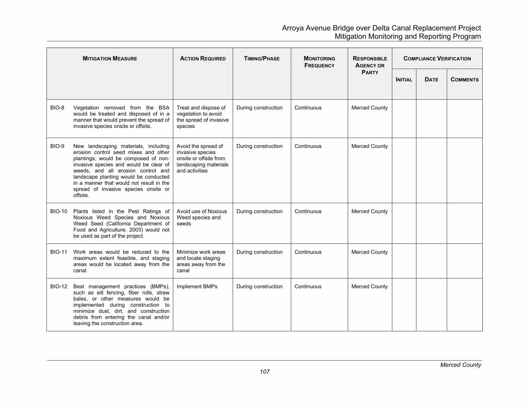
Arroya Avenue Bridge over Delta Canal Replacement Project Mitigation Monitoring and Reporting Program
Merced County 107
MITIGATION MEASURE
ACTION REQUIRED
TIMING/PHASE
MONITORING FREQUENCY
RESPONSIBLE AGENCY OR
PARTY
COMPLIANCE VERIFICATION
INITIAL
DATE
COMMENTS
BIO-8 Vegetation removed from the BSA would be treated and disposed of in a manner that would prevent the spread of invasive species onsite or offsite.
Treat and dispose of vegetation to avoid the spread of invasive species
During construction Continuous Merced County
BIO-9 New landscaping materials, including erosion control seed mixes and other plantings, would be composed of non-invasive species and would be clear of weeds, and all erosion control and landscape planting would be conducted in a manner that would not result in the spread of invasive species onsite or offsite.
Avoid the spread of invasive species onsite or offsite from landscaping materials and activities
During construction Continuous Merced County
BIO-10 Plants listed in the Pest Ratings of Noxious Weed Species and Noxious Weed Seed (California Department of Food and Agriculture, 2003) would not be used as part of the project.
Avoid use of Noxious Weed species and seeds
During construction Continuous Merced County
BIO-11 Work areas would be reduced to the maximum extent feasible, and staging areas would be located away from the canal.
Minimize work areas and locate staging areas away from the canal
During construction Continuous Merced County
BIO-12 Best management practices (BMPs), such as silt fencing, fiber rolls, straw bales, or other measures would be implemented during construction to minimize dust, dirt, and construction debris from entering the canal and/or leaving the construction area.
Implement BMPs During construction Continuous Merced County

Arroya Avenue Bridge over Delta Canal Replacement Project Mitigation Monitoring and Reporting Program
Merced County 108
MITIGATION MEASURE
ACTION REQUIRED
TIMING/PHASE
MONITORING FREQUENCY
RESPONSIBLE AGENCY OR
PARTY
COMPLIANCE VERIFICATION
INITIAL
DATE
COMMENTS
BIO-13 Appropriate hazardous materials BMPs would be implemented to reduce the potential for chemical spills or contaminant releases into the canal, including any non-stormwater discharge.
Implement hazardous materials BMPs
Prior to construction Once Merced County
BIO-14 All equipment refueling and maintenance would be conducted in the staging area away from the canal. In addition, vehicles and equipment would be checked daily for fluid and fuel leaks, and drip pans would be placed under all equipment that is parked and not in operation.
Conduct equipment refueling/maintenance away from the canal
Check vehicles/equipment daily
During construction Continuous
Daily
Merced County
BIO-15 Temporarily disturbed areas would be re-contoured and re-vegetated using native species. Any re-vegetation or erosion control implemented would be completed using non-invasive species.
Use native species for revegetation or erosion control
During construction Continuous Merced County
BIO-16 Invasive plant species in the construction zone would be removed and disposed of in a manner that minimizes the potential for further reestablishment. Invasive plants would be identified by a biologist prior to their removal and control methods would follow the recommendations of the California Invasive Plant Council (Cal-IPC, 2012). If herbicides are applied, they would be applied in compliance with applicable state and federal laws.
Remove invasive plant species in the construction zone
During construction Continuous Merced County

Arroya Avenue Bridge over Delta Canal Replacement Project Mitigation Monitoring and Reporting Program
Merced County 109
MITIGATION MEASURE
ACTION REQUIRED
TIMING/PHASE
MONITORING FREQUENCY
RESPONSIBLE AGENCY OR
PARTY
COMPLIANCE VERIFICATION
INITIAL
DATE
COMMENTS
CULTURAL RESOURCES
CUL-1 If archaeological resources, paleontological resources, or unique geologic features are encountered during construction, all ground-disturbing work will be stopped until an archaeologist or monitor can properly assess the resources(s) and identify the appropriate measures to ensure that the resources will not be adversely affected.
Stop-ground disturbing activities if archaeological resources, paleontological resources, or unique geologic features are encountered
During ground-disturbing construction activities
During ground-disturbing activities
Merced County
CUL-2 If human remains are uncovered during construction activities, ground disturbing activities in the area will stop, and the County Coroner will be notified pursuant to the requirements of the California Health and Safety Code Section 7050.5. No further disturbance in the area will occur until the County Coroner has made a determination of origin and disposition of the remains. If the human remains are determined to be prehistoric, the coroner will notify the NAHC, who will determine and notify the Most Likely Descendent. The County will coordinate with the Most Likely Descendent to identify appropriate analyses and treatment or disposition of the remains and any items associated with Native American burials.
Stop-ground disturbing activities and notify the County Coroner if human remains are encountered
During ground-disturbing construction activities
During ground-disturbing activities
Merced County

Arroya Avenue Bridge over Delta Canal Replacement Project Mitigation Monitoring and Reporting Program
Merced County 110
MITIGATION MEASURE
ACTION REQUIRED
TIMING/PHASE
MONITORING FREQUENCY
RESPONSIBLE AGENCY OR
PARTY
COMPLIANCE VERIFICATION
INITIAL
DATE
COMMENTS
HAZARDS AND HAZARDOUS MATERIALS
HAZ-1: Bridge components will be tested for the presence of Asbestos Containing Materials (ACCM) before the start of construction. If asbestos or ACCM is identified on the bridge, this material would be handled in accordance with Caltrans 2015 Standard Special Provision 14-11.16.
Written notification to the San Joaquin Valley Air Quality Management District (SJVAQMD) of demolition or renovation operations on structures is required at least 10 business days.
Test for ACCM
Notify SJVAQMD
At least 10 days prior to initiating construction activities and throughout project construction
Prior to demolition/renovation operations
Continuous
Once
Merced County
HAZ-2: Soil within the proposed construction limits will be screened for the presence of agricultural chemicals and petroleum hydrocarbons.
Test for agricultural chemicals and petroleum hydrocarbons
Prior to and throughout construction
Continuous Merced County
NOISE
NOI-1: Construction activities, excluding activities that would pose a significant safety risk to workers or citizens, will be limited to between the daytime hours of 7:00 a.m. and 6:00 p.m.
Limit construction activities daytime hours
During construction Continuous Merced County

Arroya Avenue Bridge over Delta Canal Replacement Project Mitigation Monitoring and Reporting Program
Merced County 111
MITIGATION MEASURE
ACTION REQUIRED
TIMING/PHASE
MONITORING FREQUENCY
RESPONSIBLE AGENCY OR
PARTY
COMPLIANCE VERIFICATION
INITIAL
DATE
COMMENTS
NOI-2: Appropriate noise abatement measures will be implemented, including, but not limited to, siting stationary construction equipment away from sensitive noise receptors to the greatest extent feasible, turning off idling equipment after no more than five minutes of inactivity, rescheduling construction activity to avoid noise-sensitive days (i.e., holidays) or times, and/or installing acoustic barriers around stationary construction noise sources noise levels cannot otherwise be reduced to an acceptable levels.
Implement noise abatement measures
During construction Continuous Merced County
TRIBAL AND CULTURAL RESOURCES
TR-1 Picayune Rancheria of Chukchansi Indians will be provided copies of any future information available regarding tribal cultural resources including the final Archaeological Survey Report, field photos, and maps.
Provide tribal cultural resources information to the Picayune Rancheria of Chukchansi Indians
As needed As needed Merced County

Arroya Avenue Bridge over Delta Canal Replacement Project Mitigation Monitoring and Reporting Program
Merced County 112

Arroya Avenue Bridge over Delta Canal Replacement Project Merced County Initial Study/Mitigated Negative Declaration January 2020
Page 113
Appendix A: Cumulative Project List

Arroya Avenue Bridge over Delta Canal Replacement Project Merced County Initial Study/Mitigated Negative Declaration January 2020
Page 114


![OSL and radiocarbon dating of a pre-Angkorian canal in the ... · PDF fileOSL and radiocarbon dating of a pre-Angkorian canal in the Mekong delta, southern Cambodia ... Paris’s [28,29]](https://img.dokumen.tips/doc/110x75/5a78cbbb7f8b9a70238c9009/osl-and-radiocarbon-dating-of-a-pre-angkorian-canal-in-the-and-radiocarbon-dating.jpg)


