Embed Size (px)
Citation preview

HYDRO NEPAL SPECIAL ISSUE APRIL 2012 23
Introduction
In Nepal, as elsewhere, migration trends from rural to urban areas are growing. As a result, the population
of urban centers, especially Kathmandu is increasing at a rapid rate. Meeting water demands in Kathmandu is therefore a major challenge for the government. There are nearly 2.2 million people living in the Kathmandu valley and their daily drinking water demand is about 220 million liters (MWSDB 2008). Recent project document has reported that their daily demand is 330 million liters. National Population Census (CBS 2011) reported that the population of Kathmandu valley is nearly 3.5 million including fl oating population. Daily available water, however, within Kathmandu valley is about 90 million liters in the dry season and 130 million liters in the wet season (MWSDB 2008). Hence, the Government of Nepal (GON), the donor community and Non-governmental organizations are involved in fi nding alternative water sources to tackle the water scarcity crisis in Kathmandu. The Melamchi Water Supply Project (MWSP) was identifi ed as a potential solution in 1973. The GON started the implementation of the Melamchi Water Supply Project in 1998 and originally, expected the project to be completed by 2008. However, due to various problems including the issue of downstream hydrological impacts, it is still diffi cult to predict whether the project will be completed by the extended date of completion; i.e., 2015.
The Melamchi River is located about 50 km North-East of the Kathmandu valley and is one of the tributaries of the Indrawati River. The Indrawati basin is a sub-basin within the Koshi basin (Figure 1). The MWSP diversion points of all stages are situated in the Indrawati River Basin which has a catchment area of 1,228 km2. Melamchi, Yangri and Larke Rivers are major tributaries of the Indrawati River and have about 323, 117 and 116 km2 catchment area respectively. The project plans to divert 170 MLD (1.97 m3/s) of water from Melamchi river in Stage-I and an additional 170 MLD each from Yangri and Larke tributaries
of the Indrawati River in Stage-II and III (Bhattarai, Pant et al 2002; Mishra and Shilpakar 2001). The project is important and has attracted a lot of attention and interest not only because it is seen as a solution to the drinking water crisis in Kathmandu but also because this is inter-basin water transfer project that is in the process of being implemented in Nepal.
At present, the available water in the Melamchi river basin is being used for irrigation, drinking water supply and sanitation, consumption for forest and vegetation, micro-hydropower generation and water mills (MWSDB 2008). The project has a high level of skepticism among the local community and stakeholders, despite the project compensation package as well as the inclusion of minimum fl ows of 34.56 MLD (0.4 m3/s) to be released downstream of the diversion (Bhattarai, Pant et al 2002; IUCN 1999; MWSDB 2008). So far, the project has paid about NRs. 880 million to the local community living in project affected areas as cash compensation (MWSDB 2008) and recent project document has reported that project has spent NRs. 900 million till 2011. The demand and grievances of local people plus political circumstances and challenges in engaging the private sector partner have all contributed to delay the completion of the project (Khadka and Khanal 2008).
Although the insuffi ciency of the prescribed minimum fl ow releases is one of the main critiques of the project, the few studies that have been carried out to look at water accounting have only focused on the Indrawati River basin (Bhattarai, Pant et al 2002; Mishra and Shilpakar 2001; Sharma 2002). Therefore, this study makes use of the hydrological model developed for the entire Koshi basin to look at the hydrological impacts of the MWSP until the outlet of the Koshi basin at Chatara (Figure 1) under current and future climate change projections. Furthermore, the impact of water transfers on the crop water requirement within the Melamchi River command area was also evaluated.
Luna BharatiPabitra Gurung
Pabitra Gurung and Luna Bharati
Downstream Impacts of the Melamchi Inter-Basin Water Transfer Plan (MIWTP) Under Current and Future Climate Change Projections
Abstract: The Melamchi Water Supply Project (MWSP) is designed to minimize the shortage of drinking water in the Kathmandu valley. Although the project was supposed to be completed by 2008, due to various problems, it is still diffi cult to forecast the exact date of completion. This paper quantifi es the downstream effects of diverting water from the Melamchi (Stage-I),Yangri (Stage-II) and Larke (Stage-III) rivers under current as well as future climate scenarios. The Soil Water Assessment Tool (SWAT) was used in the analysis. Result shows that in the Stage-I water transfer plan, average infl ow reduction in the immediate downstream sub-basin in the dry and wet seasons are 36% and 7% respectively, where as in Stage-II the infl ow reductions are 38% for the dry season and 8% for the wet season. In Stage-III, infl ow reductions are 38% in the dry season and 7% in the wet season.
The impact of the water transfer schemes on various changes in water management within the Melamchi River irrigation command area was also tested. BUDGET (soil, water and salt balance) model was used to quantify crop water requirement of Melamchi River command area when the irrigated area is increased and the cropping pattern is changed. Simulation results of crop water requirement in intensive water use conditions show that present Melamchi River command area can be increased by 2.2 times under current climate projection, whereas the area can be increased 1.4 times in 2030s and by 2.0 times in 2050s.
Key words: Inter-basin water transfer, climate change, SWAT, BUDGET, Koshi basin, Melamchi, Nepal
HYDRO NEPAL SPECIAL ISSUE APRIL 2012 24
Data and MethodQuantification of water availability
The Soil and Water Assessment Tool (SWAT) model was setup for the Koshi basin as a part of the Indo-Ganges Basin Focal project (www.slideshare.net/cpwfbfp/indoganges-basin-focal-project). SWAT is a continuous, physically based, semi-distributed hydrological public domain model jointly developed by USDA Agricultural Research Service (USDA-ARS) and Texas AgriLife Research, part of Texas A&M University System. SWAT is a river basin-scale model to quantify impact of land management practices on water quantity, sediment and water quality in large complex watersheds with varying soils, land use and management conditions over a long period of time (Arnold, Srinivasan et al 1998; Bharati, Pant et al 2011; Neitsch, Arnold et al 2005). For this study, the Koshi basin is divided into 79 sub-basins and delineated with the basin outlet at Chatara-Kothu. Detailed description of the methodology as well as results from the water balance analysis of the whole Koshi basin is in preparation. Therefore, in this paper, only the results related to the downstream impacts of the MWSP will be discussed.
Simulation of Crop Water Requirement (CWR)BUDGET (soil, water and salt balance) model was used
to simulate net crop water requirement for agricultural command area of the Melamchi River. BUDGET is a fi eld based model developed by faculty of applied bioscience and engineering, Katholieke Universiteit of Leuven, Belgium. BUDGET requires length and crop coeffi cient (K
c) for the
four growth stages: initial, crop development, mid-season and late season stage (Shrestha, Geerts et al 2010). Reference evapo-transpiration (E T
0), rainfall, crop parameters and
soil type are essential parameters to evaluate net irrigation
requirement (NIR). In this study, 80% dependable rainfall ( ) is taken to evaluate NIR, where is mean rainfall and is standard deviation. Likewise, ET
0 is evaluated from climate data (temperature, wind
speed, sunshine hour and vapor pressure) using New LocClim (local climate estimator) developed by FAO in 2005. Henceforth, comparison between gross irrigation requirement (GIR) and water available in the stream was done in different scenarios.
Downscaled climate dataIn this study, MarkSim weather generator was used
to downscale climate data from Global Circulation Model (GCM) (gismap.ciat.cgiar.org/MarkSimGCM/) (Jones, Thornton et al 2002). GCMs used to generate daily climate data are CNRM-CM3, CSIRO-Mk3.5, ECHam5, and MIROC3.2 and the projected data are average of these four GCMs. In addition, statistical downscaled daily climate data is also used in this study. Scenarios families of the Special Report on Emissions Scenarios (SRES), period of projection and climate variables considered in this study are presented in Table 1. Therefore, fi ve projected scenarios in total (two from MarkSim and three from statistical) are considered to simulate future water availability. Future projected climate data from MarkSim downscaled techniques are A2 and B1; and from Statistical downscaled techniques are A1B, A2 and B1 of the SRES families. In the study, period of future simulation are 2030s (average from 2016 to 2045) and 2050s (average from 2036 to 2065), whereas period of base line (BL) is 2000s (from 1971 to 2000).
The Melamchi Water Supply Project (MWSP)The downstream impact study is carried out for 11
Figu re 1. The Study Basin and Observed Climate and Flow Sta� ons.
HYDRO NEPAL SPECIAL ISSUE APRIL 2012 25
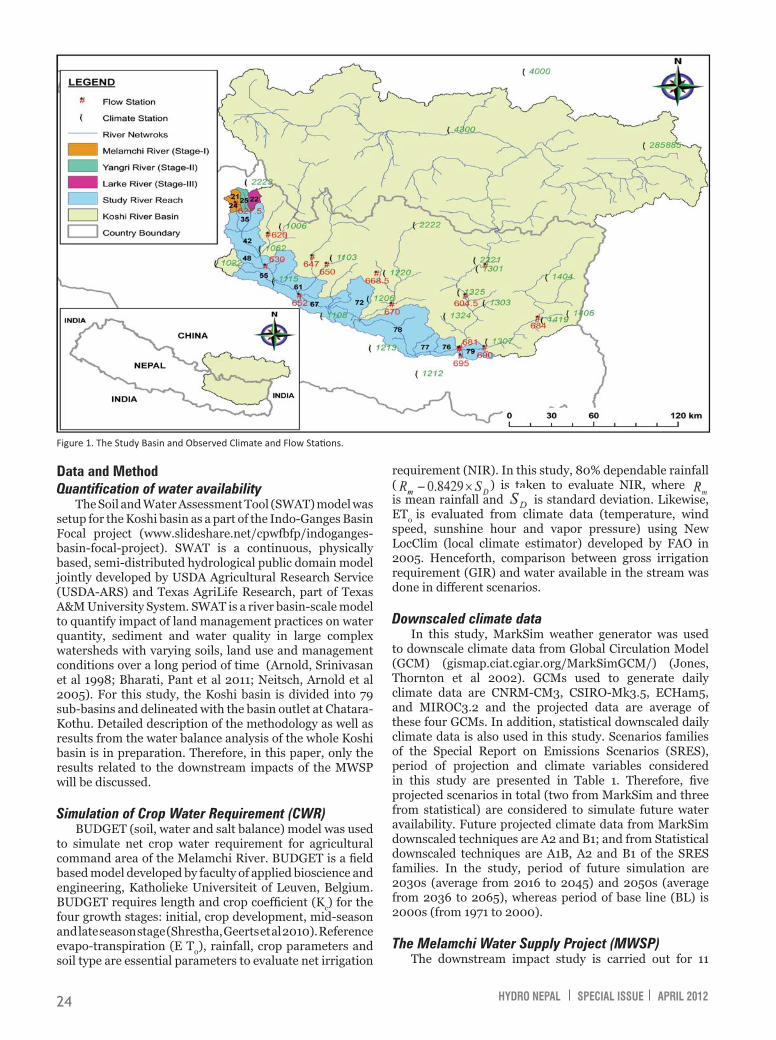
among 79 sub-basins of the Koshi basin. The sequential order of 15 sub-basins and sub-basin numbers are in Figure 2. The study river reach starts from sub-basin 35 and ends at sub-basin 79. The Indrawati, Sun Koshi, Rosi, Tama Koshi, Likhu, Dudh Koshi, Arun and Tamor Rivers fl ows into the main river reach (Figure 2). The location of water transfer in Stages I, II and III are at the outlet of sub-basins 24 in Melamchi, 25 in Yangri and 22 in Larke rivers respectively (Figure 2). In Stage-I, the calibrated model is re-run by setting planned monthly water transfer in sub-basin 24 by using the water use option in the SWAT model. The model is then re-run according to the monthly water transfer plan from sub-basins 25 and 22 respectively in Stages II and III.
Result and DiscussionWater availability in headwork of MWSP in current climate scenario
As explained above, the outlets of sub-basins number 24, 25 and 22 are the locations for MWSP’s water transfer sites in Stages I, II and III respectively. The effective catchment areas of these three transfer stages are 148, 110 and 114 km2 respectively. Figure 3 represents fl ow duration curves and monthly fl ow volume at the
three water transfer locations. The study result show that downstream fl ow availability at the driest month will be approximately more than 13% of the river fl ow of that month. The total available annual simulated water is 499 MCM, 443 MCM and 448 MCM respectively in Melamchi, Yangri and Larke river sub-basins (Table 2). The fl ow volume of 401 MCM, 348 MCM and 355 MCM occurred within fi ve monsoonal months (June to October). Therefore, seasonal water fl ow varies signifi cantly in the rivers and more than 80% of the total annual fl ow occurred within these monsoonal months. Hence in the study, June to October is considered as wet season and the other seven months are dry season.
Downstream impact on reaches of Koshi Basin in
Fi gure 2. Melamchi Inter-basin Water Transfer Plan and Flow Network in the Koshi Basin (The numbers in the fi gure refer to sub-basin numbers, which can also be seen in Figure 1).
current climate scenarioThe three rivers Melamchi, Yangri
and Larke meet at sub-basin 35. Therefore, water transfer in all stages will infl uence sub-basin 35 as well as the downstream sub-basins. Figure 4 shows the comparison of annual and seasonal average water fl ow. Reduction in fl ows will occur in sub-basin 24 after Stage-I and subsequently it will occur in sub-basin 25 and 22 after Stages II and III. Once the MWSP becomes operational, the annual average discharges fl owing into sub-basin 35 will reduce by 12%, 14% and 14% due to the water transfer plan of Stages I, II and III respectively (Figure 4). Likewise, in the Koshi basin outlet, at Chatara-Kothu, cumulative effects of all water transfer Stages (I, II and III) on
GCMs Downscaled Statistical DownscaledSRES families BL, A2 and B1 BL, A1B, A2 and B1Period of projection
2000s (1971-2000) for BL2030s (2016-2045) for A2 and B12050s (2036-2065) for A2 and B1
(1971-2000) for BL(2001-2100) for A1B, A2 and B1
Climate variable Rainfall, Temperature (Max and Min), Solar Radiation
Rainfall, Temperature (Max and Min), Solar Radiation, Relative Humidity and Wind Speed
T able 1. SRES Families and Projec� on Period of Downscaled Climate Data.
Fig ure 3. Flow Dura� on Curve and Monthly Flow Volumes Derived from Simulated Monthly Flows at all three stages of the MIWTP in Current Climate Scenario.

HYDRO NEPAL SPECIAL ISSUE APRIL 2012 26
7% respectively, whereas in Stage-II the infl ow reduction are 38% for the dry season and 8% for the wet season. In Stage-III, fl ow reductions are 38% in the dry season and 7% in the wet season (Figure 4). Furthermore, in the Koshi basin outlet, at Chatara-Kothu, cumulative effects of all water transfer stages (I, II and III) on average fl ow reduction in the dry and wet seasons are 1.0% and 0.2% respectively.
Water availability in headwork of MWSP in future climate scenarios
The annual simulated fl ow under the current climate and the range of projected fl ows under climate change scenarios are presented in Table 2. The water availability ranges and means of projected fl ows as shown in Table 2 represent the results from fi ve projected future climate scenarios (two from MarkSim and three from statistical downscaled data) for A2, B1 and A1B scenarios. Results show that on an average, fl ows in the rivers will decrease in the projection period of 2030s and 2050s when compared to the current fl ows.
Current fl ow (MCM)
Range and Mean of projected fl ow (MCM)
(1976-2005) 2030s 2050sBefore MWSP:Melamchi river 499 312 - 347 (333) 316 - 359 (340)Yangri river 443 306 - 336 (324) 306 - 340 (325)Larke river 448 302 - 342 (323) 299 - 349 (322)After MWSP:Melamchi river 437 250 - 285 (271) 254 - 297 (278)Yangri river 381 244 - 274 (262) 244 - 278 (263)Larke river 386 240 - 280 (261) 237 - 287 (260)Table 2. Range of Change on Annual Water Availability in Future Climate Change Scenario.
Downstream impact on reaches of Koshi Basin in future climate scenarios
Figure 5 illustrates change in water availability in the sub-basins falling within the MWSP sub-basins under future climate change projections from 2030s and 2050s under SRES scenario A2 (downscaled using Marksim). Results of future projection in 2030s (Figure 5 (a)) show that annual fl ow in the Melamchi, Yangri and Larke rivers will change by +1%, +2% and +2% respectively than the current fl ows, whereas the wet season fl ow will change by -1%, 0% and +2% and dry season fl ow by +5%, +10% and +2% respectively. Similarly, in 2050s (Figure 5 (b)), the annual
Figure 4. Percent Flow Reduc� on Due to MIWTP in Aff ected Sub-basins for Annual, Dry Season (Nov-May) and Wet Season (Jun-Oct).
fl ow in the Melamchi, Yangri and Larke rivers will change by +3%, +4% and +5% than the current fl ows, whereas the wet season fl ow will change by +2%, +2% and +6% and dry
Figure 5 . Percentage Change of Projected Flow in Aff ected Sub-basins for Annual, Dry Season (Nov-May) and Wet Season (Jun-Oct), (a) in 2030s and (b) in 2050s; under Climate Change Projec� on Scenario of Marksim-A2.
annual average fl ow is 0.4%. Seasonal results show that in the Stage-I water transfer plan, average infl ow reduction in sub-basin 35 in the dry and wet seasons are 36% and
HYDRO NEPAL SPECIAL ISSUE APRIL 2012 27
do not have considerable impact on irrigation systems because spring sources (ground water) are used for drinking purposes and water used in mills is immediately returned to the river (MWSDB 2008). In addition, tributaries of Melamchi River are adding more water to the river before the confl uence of Indrawati river (MWSDB 2008).
Figure 8 depicts comparative scenarios of gross irrigation requirement with 40% overall irrigation effi ciency and change in Melamchi River command area. The plots are demand versus supply curves. Each plot represent water use in four scenarios; (i) existing cropping pattern before operation of MWSP, (ii) existing cropping pattern after operation of MWSP, (iii) recommended cropping pattern before operation of MWSP, and (iv) recommended cropping pattern after operation of MWSP. Under the recommended cropping pattern, results show that the present Melamchi River command area can be increased by 120% under current climate scenarios (Figure 8(a)), whereas the area can be increased by 40% in 2030s (Figure 8(b))and by 97% in 2050s climate projection scenarios (Figure 8(c)).
Table 3. Exis� ng Cropping Pa� ern and Crop Calendar of the Melamchi River Command Area (top) and the Cropping Pa� ern Recommended by Department of Irriga� on (DOI) (bo� om) Scenario.
season fl ow by +5%, +10% and +2% respectively. Likewise, in the Koshi basin outlet, at Chatara-Kothu, annual outfl ow will change by -2% in 2030s and +1% in 2050s climate change projection. Similarly, wet season outfl ow from Koshi basin will change by -9% in 2030s and -6% in 2050s, whereas dry season outfl ow will reduce by 21% in 2030s and 19% in 2050s climate change projections.
Impact on agricultural command area of Melamchi River in current and future scenario
According to simulation results, MIWTP will not have considerable impact on the hydrology of downstream sub-basins except in immediate sub-basins 35 and 42 (Figure 4). After implementation of the project, dry season fl ows (Nov-May) will drop by 24.1% and 19.7% in sub-basins 35 and 42 respectively. Therefore, in this study only impact of Stage-I water transfer plan on the exiting irrigation system in Melamchi River basin is evaluated. At present, nearly 289 hectares (MWSDB 2008) of downstream agricultural lands are irrigating from Melamchi River.
Figure 6. C omparison of 80% Dependable Rainfall and Monthly Crop Water Requirement for Crops in Melamchi River Command Area.
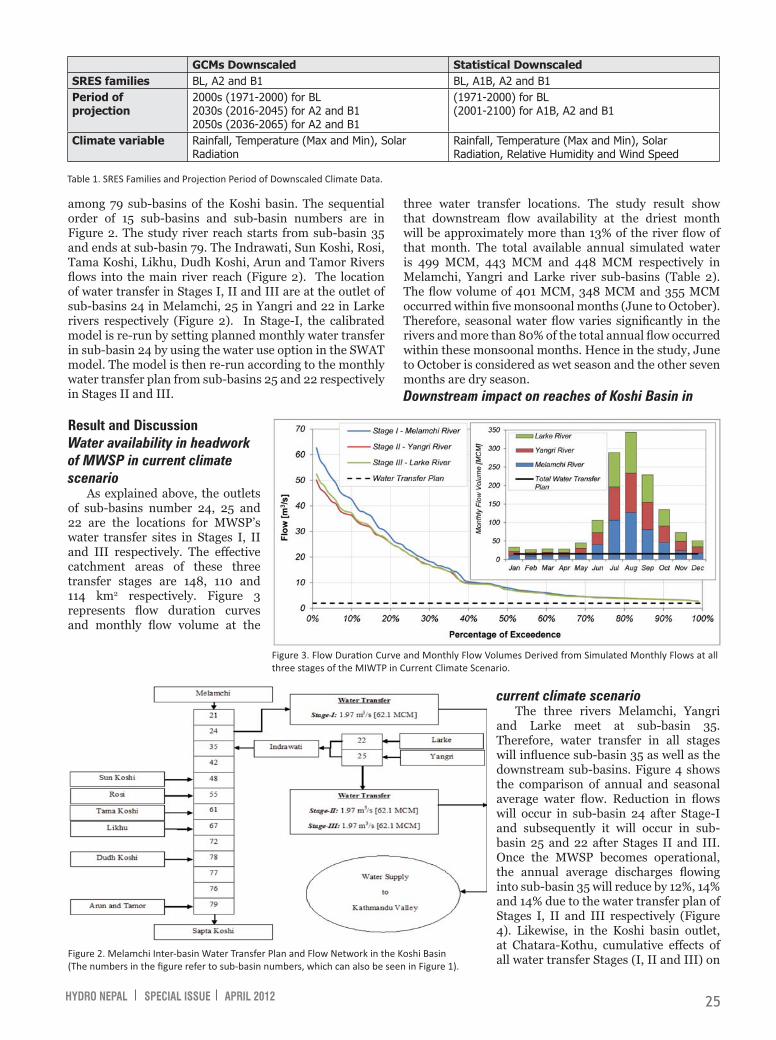
pattern as well as the recommended cropping pattern scenarios. Figure 6 shows that irrigation is only required in the dry season. In the existing cropping pattern scenario, intensive irrigation is required in April (130 mm). In the recommended cropping pattern, irrigation is required in March (158 mm).
Results show that the water scarcity is only during the dry season. Figure 7 shows that water for irrigation is suffi cient in driest month even after implementation of MWSP. Other water uses such as drinking water and operating water mills are not accounted in this study. These demands
The cropping pattern, area and calendar were used to evaluate crop water requirement in the agricultural command area of the Melamchi River (Table 3). The existing cropping pattern in the study area was identifi ed through farmer discussions, statistical information on Nepalese Agriculture (2005). The recommend cropping patterns are from the Department of Irrigation for the Melamchi command area. The crop characteristics and crop duration are taken from Raes (2002) and McDonald (1990). For simulation, initial soil water content is considered to be 50% of Total Available Water (TAW), where TAW is difference between fi eld capacity and wilting point.
Figure 6 illustrates simulated monthly Crop Water Requirement (CWR) for the existing cropping

HYDRO NEPAL SPECIAL ISSUE APRIL 2012 28
ConclusionAlthough the debate on
downstream hydrological impacts of the MIWTP is affecting the progress of the project, detailed quantifi cation of the impacts in downstream sub-basins have not been done. Therefore, this paper serves to fi ll this gap. The simulated results show that in the Stage-I water transfer plan, average infl ow reduction in sub-basin 35 in the dry and wet seasons are 36% and 7% respectively, whereas in Stage-II the infl ow reduction are 38% for the dry season and 8% for the wet season. In Stage-III, infl ow reductions are 38% in the dry season and 7% in the wet season. Furthermore, in the Koshi basin outlet, at Chatara-Kothu, cumulative effects of all water transfer Stages (I, II and III) on average outfl ow reduction in the dry and wet seasons are 1.0% and 0.2% respectively. Therefore, MIWTP has considerable hydrological impacts on the sub-basin that is immediately downstream of the transfer points but not further downstream towards the basin outlet.
Simulation results of crop water requirements show that water stress problem will not occur in the Melamchi River command area under current and future climate scenarios, if the command area remains the same as present. Furthermore, by changing the cropping pattern to the recommended cropping pattern from DOI, present Melamchi River command area can be increased by 2.2 times under the current climate scenario, by 1.4 times under climate change projections from 2030s and by 2.0 times under climate change projections from 2050s. As water availability is only a constraint during
Figure 7 . C omparison between Gross Irriga� on Requirement and Stream Flow in April.
Figure 8. Compar ison between Gross Irriga� on Requirement and Stream Flow in the Driest Month (April) with Change in the Melamchi River Command Area under (a) Current Climate Scenario, (b) Future Climate Scenario in 2030s, and (c) Future Climate Scenario in 2050s.

HYDRO NEPAL SPECIAL ISSUE APRIL 2012 29
IUCN, 1999, Environmental Impact Assessment (EIA) of Melamchi Water Supply Project, Kathmandu: IUCN (World Conservation Union) in association with METCON for the Melamchi Water Supply Development Board, Government of Nepal.
Jones, P.G., P.K. Thornton, W. Diaz, P.W. Wilkens, and A.L. Jones, 2002, MarkSim–A Computer Tool That Generates Simulated Weather Data for Crop Modeling and Risk Assessment (Version 1), Cali, Colombia: International Center for Tropical Agriculture (CIAT).
Khadka, R.B. and A.B. Khanal, 2008, ‘Environmental Management Plan (EMP) for Melamchi Water Supply Project, Nepal’, Environmental Monitoring and Assessment, Earth and Environmental Science 146(1-3):225-234.
MacDonald, M. and Partners Ltd., 1990. Hydrology and Agro-metrology Manual, M3, Design Manuals for Irrigation Projects in Nepal, Kathmandu: Department of Irrigation.
MWSDB, 2008, Work Plan and Annual Progress Report of Melamchi Water Supply Project (Melamchi Project Document), Kathmandu: Melamchi Water Supply Development Board, Government of Nepal.
Mishra, V.S. and R.L. Shilpakar, 2001, ‘Water Accounting for Indrawati River Basin, Nepal’, a paper presented at the workshop on ‘Integrated Development and Management of Nepal’s Water Resources for Productive and Equitable Use’, Kathmandu, organized by the Nepal Water and Energy Commission Secretariat (WECS/Government of Nepal) and the International Water Management Institute (IWMI) Nepal.
CBS, 2011, National Population Census 2011: Preliminary Result on National Population and Housing Census, Kathmandu: Central Bureau of Statistics and National Planning Commission Secretariat, Government of Nepal
Neitsch, S.L., J.G. Arnold, J.R. Kiniry and J.R. Williams, 2005, Soil and Water Assessment Tool Theoretical Documentation, Temple, TX, USA: Grassland, Soil and Water Research Laboratory, Agricultural Research Service, and Blackland Research Center, Texas Agricultural Experiment Station.
Raes, D., 2002, Reference Manual of BUDGET: A Soil Water and Salt Balance Model (Version 5.0), Leuven, Belgium: Faculty of Agricultural and Applied Biological Sciences, Institute for Land and Water Management, Katholieke Universiteit.
Sharma, C., 2002, ‘Effect of Melamchi Water Supply Project on Soil and water conservation in the Indrawati River Basin, Nepal’, in Proceedings of the 12th ISCO Conference, Beijing, ‘Sustainable Utilization of Global Soil and Water Resources’, organized by the Ministry of Water Resources, People’s Republic of China.
Shrestha, N., S. Geerts, D. Raes, S. Horemans, S. Soentjens, F. Maupas and P. Clouet, 2010, ‘Yield response of sugar beets to water stress under Western European conditions’, Agricultural Water Management 97(2):346-350.
dry months, if in system water storage methods are introduced to reserve excess water of the wet season, the command area can be further increased. In this case, the available of cultivable land might be the constraining factor.
- -
Pabitra Gurung, MSc, Research Offi cer, International Water Management Institute, IWMI-Nepal. Mr. Gurung has over six years working experience in the fi eld of water resources. He has a Bachelor degree in civil engineering from Tribhuvan University, Nepal and a Master Degree in Water Resources Engineering degree from Katholieke Universiteit Leuven, Belgium. He has worked in projects in Nepal, India and Belgium. His key area of interest and expertise are: hydrological analysis and modeling, crop water modeling, hydraulic design and climate change impact studies on water resources.Corresponding address: [email protected]
Luna Bharati, PhD, has over 15 years of experience in projects related to natural resources and land and water management. She has a Masters in Water Resources and a Doctorate from the Faculty of Agriculture focusing on surface hydrology, erosion and pollutant transport. She has worked in projects in Nepal, USA, Germany, India, Bangladesh, China, Ghana and Burkina Faso. The key areas of her interests and expertise are in: Field investigation and modeling of erosion and nutrient transport and the impacts on water quality (models used: AGNPS, Erosion 3D), Modeling the water balance of a catchment and the infl uence of climate and land use change using distributed watershed models (e.g.,WaSim-ETH, SWAT, GeoSFM, WEAP), Developing integrated environmental and economic models for calculating optimal water use and allocation for decision support systems, Calculating environmental fl ow requirements in the context of basin water allocation strategies. Currently, Dr. Bharati is a Senior Researcher in Hydrology and Water Resources and the Head of the International Water Management Institute (IWMI)-Nepal offi ce.Corresponding Address: [email protected].
ReferenceArnold, J.G., R. Srinivasan, R.S. Muttiah and J.R. Williams,
1998, ‘Large area hydrologic modeling and assessment, Part I: Model development’, Journal of the American Water Resources Association 34(1):73-89.
Bharati, L., G. Lacombe, P. Gurung, P. Jayakody, C.T. Hoanh and V. Smakhtin, 2011, The Impacts of Water Infrastructure and Climate Change on the Hydrology of the Upper Ganges River Basin, IWMI Research Report 142, Colombo, Sri Lanka: International Water Management Institute. URL: doi: 10.5337/2011.210.
Bhattarai, M., D. Pant, V.S. Mishra, H. Devkota, S. Pun, R.N. Kayastha and D. Molden, 2002, Integrated Development and Management of Water Resources for Productive and Equitable Use in the Indrawati River Basin, Nepal, Working Paper 41, Colombo, Sri Lanka: International Water Management Institute.