Embed Size (px)
Citation preview
Cover
DOVER/KENT COUNTY METROPOLITAN PLANNING ORGANIZATION
Vision 2040 - Metropolitan Transportation Plan
2017 UPDATE


Page Introduction 1 Existing Conditions 3 Projected Conditions 16 Goals and Objectives 17 Operational and Management Strategies 27 Environmental Mitigation Analysis 37 Air Quality Conformity Analysis 40 Financial Investment Plan 42 Financially Reasonable Projects 45 Public Involvement 53 Acknowledgements 56
Table of Contents
i

List of Tables
Page Table 1 - Journey To Work Data 6 Table 2 - Vehicle Miles Traveled By Classification 7 Table 3 - Kent County Roadway Condition 7 Table 4 - Primary Congested Intersections 8 Table 5 - Kent County Transit Ridership 10 Table 6 - Kent County Population Projections 16 Table 7 - State Investment Level Areas 19 Table 8 - Delmarva Freight Plan Recommendations 31 Table 9 - Performance Management Measures 36 Table 10 - Kent County Development Activity 37 Table 11 - Financially Reasonable Projects (Roadway) 45 Table 12 - Financially Reasonable Projects (Bike/Ped/Transit) 48 Table 13 - Potential Planning Studies 52
Table of Contents
ii

List of Figures
Page
Figure 1 - MPO Region 2 Figure 2 - Existing Land Use 5 Figure 3 - Existing Traffic Volumes 9 Figure 4 - Existing Transit Routes 11 Figure 5 - Existing Freight Routes 13 Figure 6 - Existing Bicycle and Pedestrian Facilities 15 Figure 7 - State Strategies for Policies and Spending 20 Figure 8 - Air Quality Conformity Analysis (NOx) 41 Figure 9 - Air Quality Conformity Analysis (VOC) 41 Figure 10 - Total DelDOT Expenditures By County 42 Figure 11 - Financially Reasonable Projects (Roadway) 50 Figure 12 - Financially Reasonable Projects (Bike/Ped/Transit) 51
Table of Contents
iii

CAAA Clean Air Act Amendments CFR Code of Federal Regulations CMP Congestion Management Process CTP Capital Transportation Program DEFAC Delaware Economic and Financial Advisory Council DelDOT Delaware Department of Transportation DNREC Delaware Department of Natural Resources and Environmental Control DPC Delaware Population Consortium DTC Delaware Transit Corporation EDC Every Day Counts EPA Environmental Protection Agency FAST Fix America’s Surface Transportation Act FHWA Federal Highway Administration FTA Federal Transit Administration HSIP Highway Safety Improvement Program ITMS Integrated Transportation Management System LOS Level of Service MAP-21 Moving Ahead for Progress in the 21st Century Act MPO Metropolitan Planning Organization MTP Metropolitan Transportation Plan NEPA National Environmental Policy Act TIP Transportation Improvement Program TPM Transportation Performance Management VMT Vehicle Miles Traveled
List of Acronyms
iv

Who is the Dover/Kent County Metropolitan Planning Organization? The Dover/Kent County Metropolitan Planning Organization (MPO) is the Federally-mandated agency responsible for coordinating transportation planning and investments in the Kent County, Delaware metropolitan area. The MPO region includes all of Kent County, as well as the portions of Smyrna and Milford that lie within New Castle County and Sussex County, respectively (Figure 1). MPO’s are required in urbanized areas that have a population greater than 50,000 people. MPO’s are required by the Federal government, as a prerequisite for states to re-ceive Federal transportation funds.
What is the 2040 Metropolitan Transportation Plan? The 2040 Metropolitan Transportation Plan (MTP), known as Vision 2040, is the long-range transportation plan for the Dover/Kent County MPO region. The MTP identifies transportation needs, provides strategies to address those needs, guides transportation investment, and provides measurable goals for the region’s transportation sys-tem over the next 23 years. The Plan, which is updated every 4 years, is required of all MPO’s, as only projects found in the MTP are eligible for Federal funding. The Dover/Kent County MPO prepared its initial long-range transportation plan in 1996, and Vision 2040 is the 5th update to the original plan. Long range planning is important for several reasons. The plan provides an overall direction for what policy-makers and residents desire the transportation system to look like in the future, based on projected land use, economic development strategies, and financial projections. The plan also serves to identify transportation strategies that address local needs, in keeping with the character of the area’s social and natural environments. Finally, the MTP identifies specific transportation projects, as identified by a variety of sources, including local municipalities (through their comprehensive plans), a transportation planning study, or an interested community.
What’s Changed from the Last MTP Update? Since the last MTP was updated in January 2013, there have been significant changes in transportation funding levels and Federal transportation policy, and new areas and innovations have been emphasized over the last four years. Listed below is a brief summary of some of the primary changes: Federal transportation legislation - In December 2015, the new Federal transportation legislation, entitled Fix America’s Surface Transportation Act (FAST), was signed into law. The new legislation facilitates spending obli-gations through FY 2020. In FY 2016, it provided a 5% and 8% increase in highway and transit spending, respec-tively. Spending would increase by over 2% per year for both highway and transit projects after FY 2016. Decreased transportation funding - Based on declining revenues resulting from an economic recession, Delaware raised fees and tolls in 2015 to provide additional revenue for maintenance and capital transportation projects. Performance-based planning - The previous Federal transportation legislation (MAP-21) included requirements for transportation departments to incorporate performance measurements into their investment and decision-making process. The MPO and the Delaware Department of Transportation (DelDOT) will be establishing criteria for measuring the performance of various components of the transportation system in Delaware. Greater emphasis on freight - Federal directives outlined in MAP-21 noted the economic importance of regional freight planning. DelDOT has also recognized this and in 2015 became one of the first states to adopt a regional freight plan, incorporating the freight priorities of Delaware, Maryland, and Virginia into an overall plan.
Introduction
1

2
Figure 1 - MPO Region

MPO Region - Demographics The Dover/Kent County MPO region is located in the central part of the state of Delaware. Kent County has the smallest population of Delaware’s three counties, with a 2015 estimated population of approximately 173,000 peo-ple (as projected by the Delaware Population Consortium). In addition to the County government, the MPO region has 20 municipalities, which range from a population of approximately 74 people in Hartly to over 37,000 people in the capital city of Dover. Kent County comprises the Dover, Delaware Metropolitan Statistical Area (MSA), which are geographic areas used by the U.S. Census Bureau for statistical reporting purposes. According to the 2010 U.S. Census, there were nearly 78,000 jobs within the MPO region. The top employer in the MPO region is the Dover Air Force Base, a major military installation that currently employees over 6,500 people. Other major employers, in order of number of employees, include the State of Delaware, Bayhealth Hos-pital, Perdue Farms, Dover Downs Hotel and Casino, and the Capital School District.
MPO Region - Land Use The MPO region, situated between the predominantly rural Sussex County and the more intensely developed New Castle County, consists of a wide variety of land uses. The land use in the eastern and western parts of the re-gion are primarily rural, consisting of agricultural uses (including grain farming and poultry operations), forested areas, and environmentally-sensitive areas such as pristine wetlands. Bombay Hook National Wildlife Refuge, a 16,000-acre property owned by the Federal government, is located in the northeastern part of the region. Kent County currently has about 170,000 acres of farmland, which makes up the majority of the region’s land use (about 40%). Through the Delaware Agricultural Lands Preservation Program, the State of Delaware has perma-nently preserved over 61,000 acres of Kent County farmland through the purchase of development rights, or over 35% of its farmland. In the 2008 Kent County Comprehensive Plan, the County established a growth zone that promotes future devel-opment and infrastructure in the areas in and adjacent to the municipalities. These are areas where growth has already occurred, and the infrastructure such as sewer and transportation facilities are essentially in place and can be readily expanded as necessary to accommodate future development. As shown on Figure 2, the County growth zone generally lies between Delaware Route 1 and U.S. 13, and is consistent with the growth plans of the existing municipalities. In recent years, significant residential development has occurred in the growth zone, par-ticularly in the area south of Smyrna, west of Magnolia, and within the Milford municipal limits.
Existing Conditions - Land Use
Residential Development Near Smyrna Farmland Near Smyrna
3
The central portion of the MPO region, generally situated between U.S. 13 on the west and Delaware Route 1 on the east, is more developed and contains all of the County’s larger municipalities. The City of Dover is located in the central part of the County, and is the hub of economic activity for the MPO region. Major commercial and institutional land uses within the Dover area include the Dover Air Force Base, Dover Downs Racetrack and Casino, Dover Mall, Delaware State University, Kraft Foods, Energizer-Playtex, and Bayhealth Hospital. As the capital of Delaware, the Dover area has numerous State, County, and local government facilities as well. Other larger municipalities in the MPO region include (all populations are from 2010):
Smyrna (population - 10,023) Milford (population - 9,559) Harrington (population - 3,562) Camden (population - 3,464)
The U.S. 13 corridor in particular provides access to significant residential and commercial development, as it traverses most of the region’s larger municipalities (including Smyrna, Dover, Camden, and Harrington) and serves as the primary north-south commercial corridor in the county. U.S. 13 is a traditional strip-development corridor, originally designed to facilitate high-speed regional through- traffic but over time has had reduced capacity due to numerous access points, traffic signals, and increased local traffic. Other areas with significant amounts of commercial activity include the U.S. Route 113 corridor in Milford and Route 8 on the western side of Dover. In recent years, the State of Delaware, in cooperation with Kent County and the local municipalities, have concen-trated economic development efforts in revitalizing the traditional downtown areas of the region’s cities and towns. Dover, Smyrna, and Milford have all experienced significant growth and revitalization through public fund-ing, policies, and incentives put forth by the State and local governments, as a means to encourage private invest-ment. In 2013, Walnut Street in Milford was named a “Great American Place” by the American Planning Associa-tion, a national recognition of the successful transformation that has recently occurred in downtown Milford.
In 2015, the City of Dover was designated one of the three initial recipients of the Downtown Devel- opment District grants from the State of Dela- ware. The grants provide for significant develop- ment incentives and benefits to spur private in- vestment and community development opportuni- ties in downtown areas.
Existing Conditions - Land Use
U.S. Route 13 (Smyrna)
4
Walnut Street (Milford)

5
Figure 2 - Existing Land Use

The Dover/Kent County MPO region has a variety of transportation facilities serving the residents and businesses of the area. The primary surface transportation facilities include a wide range of roadways, sidewalks, bicycle facilities, public transit, and railroads. As noted in the most recent information gathered by DelDOT in their 2013 DelDOT Fact Book, the vast majority of trips in the region (over 95%) are taken by the automobile. Table 1 provides a sampling of information taken from the most recent U.S. Census Journey to Work data, reflecting commuting patterns in Kent County.
Roadways DelDOT is the state agency responsible for maintaining the vast majority of the roads within the MPO region (nearly 90%) The state owns and maintains roadways ranging from freeways (such as Delaware Route 1) to collec-tor roads (Route 12) to hundreds of local roads that dominate the rural areas of the region. DelDOT also main-tains State routes that traverse cities and towns. Local streets within the municipalities, such as Dover, Milford, Harrington, Smyrna, and Camden, are maintained by the local government. There are no County-maintained roads within the region. There are two U.S. Routes in the region, U.S. 13 and U.S. 113. As noted on page 9, U.S. 13 is a regional north-south route that runs the entire length of the County, traversing numerous cities and towns along the way includ-ing Smyrna, Dover, Camden, and Harrington. As the primary commercial corridor in the MPO region, U.S. 13 pro-vides direct access to hundreds of businesses while facilitating local and through traffic throughout the mid-Atlantic region. U.S. 113 begins in Milford, connecting Route 1 and continuing south into Sussex County and the eastern shore of Maryland. There are also two Alternate U.S. Routes in the Dover area, U.S. 13A and U.S. 113A, which are commonly known by their local road designations of Governors Avenue and State Street, respectively. Delaware Route 1, which provides access from I-95 in New Castle County to the resort areas in eastern Sussex County, is the only limited-access freeway located in Kent County. In addition to Route 1, there are 14 other State Routes within the MPO region (Routes 6, 8, 9, 10, 11, 12, 14, 15, 16, 30, 36, 42, 44, and 300).
Existing Conditions - Transportation Facilities
6
Route 10 (approaching DAFB)
Table 1 - Journey to Work (2011 - 2013)
Mode Percentage
Single-occupant vehicle 78.3%
Multi-occupant vehicle 17.6%
Walked 2.7%
Public bus 1.1%
Bicycle 0.4%
Source: DelDOT 2013 Fact Book

The Federal Highway Administration (FHWA) classifies all roadways based on the character of the traffic they carry (through versus local) and the degree of land access they allow. There are three functional classifications of roads - arterials, collectors, and local roads. Examples of arterials include U.S. 13 and Route 8 through Dover, while collector roads include Route 9 in Little Creek and Route 42 in Cheswold. The vast majority of roads in the MPO region are classified as local roads, which are generally low-volume roads that primarily serve low-density land uses. Listed in Table 2 are the functional classification percentages for the roadway network in Kent County, as well as the daily vehicle miles traveled for each functional classification.
Arterial roads account for about 12% of the roadway miles in Kent County, but about 70% of the daily vehicle miles traveled. Local roads make up the vast majority of roadway miles (over 67%), but account for the least amount of vehicle miles traveled per day (about 11%). DelDOT conducts a detailed analysis of pavement and roadway conditions for all of the roads within the state. Based on the DelDOT roadway condition data analysis, 9 out of 10 roads in Kent County are rated in “good” condition. The results are shown in Table 3.
Existing Conditions - Transportation Facilities
Route 42 (Cheswold)
7
Todds Mill Road (West of Dover)
Table 2 - Vehicle Miles Traveled By Functional Classification
Functional Classification Miles Daily Vehicle Miles Traveled
Arterials (includes Freeways) 175 (11.8%) 3.2 Million (70.1%)
Collectors 307 (20.7%) 0.8 Million (18.5%)
Local 1,002 (67.5%) 0.5 Million (11.4%)
Total 1,484 Miles 4.5 Million Miles/Day
Table 3 - Kent County Roadway Condition Data
Roadway Condition Percentage
Good 91%
Fair 8%
Poor 1%
Source: DelDOT 2014 Highway Performance Monitoring System (HPMS)
Source: DelDOT 2014 HPMS

Roadways in the MPO region serve a variety of transportation needs. A significant number of local roads within the County provide access primarily for agricultural vehicles and low-density residential uses, and have average daily traffic volumes less than 1,000 vehicles per day. State routes in rural areas, such as Route 10 west of Cam-den, and Route 14 west of Harrington, provide both local and regional access for motorists, as well as facilitating goods movement via trucks and other commercial vehicles. These routes generally have average daily traffic vol-umes between 5,000 and 10,000 vehicles per day.
State routes in urban areas, such as Route 6 in Smyrna and Route 8 in Dover, transition from a high- speed rural setting to a low-speed, high-volume sec- tion in the towns. They provide access to a wide vari- ety of residential and commercial land uses, and con- tain relatively large volumes of commercial vehicles as well. Based on 2015 data, Route 6 carries over 15,000 vehicles per day through Smyrna, while Route 8 in Dover accommodates more than 21,000 vehicles per day. The region’s three primary north-south routes (U.S. 13, U.S. 113, and Route 1) carry the highest traffic volumes in the MPO region.
Listed below is a summary of the average daily traffic volumes that use these routes, based on 2015 data pro-vided by DelDOT. U.S. 13 - 21,000 vehicles/day (near Harrington) to 70,000 vehicles/day (Leipsic Road in Dover) U.S. 113 - 28,000 vehicles/day (through Milford) Route 1 - 44,000 vehicles/day (between Dover and Smyrna) Generally, the existing highway network facilitates the movement of traffic in and around the county with few corridors that would be considered as operating at an unacceptable level of service (LOS). Level of service is a classification based primarily on vehicular delay, with LOS A representing free-flow conditions and LOS F indicat-ing that the traffic volumes exceed the roadway capacity to accommodate the traffic without significant queues. There are specific areas along major corridors (particularly U.S. 13 in Dover and Camden) that experience volumes that approach or exceed capacity during peak morning and afternoon periods. Based on 2012 data provided by DelDOT, U.S. 13 between Camden and the south limits of Dover has a failing LOS during the peak periods. Additional analysis conducted by DelDOT in 2014 indicated that several intersections along U.S. 13, Bay Road, and State Street are currently experiencing LOS D or E during peak traffic periods, as listed in Table 4.
Existing Conditions - Transportation Facilities
Route 8 (Dover)
8
Table 4 - Primary Congested Intersections
U.S. 13/Delaware State University
U.S. 13/College Road
U.S. 13/Division Street
U.S. 13/South State Street
Bay Road/MLK Boulevard
State Street/Governors Avenue

9
Figure 3 - Existing Traffic Volumes

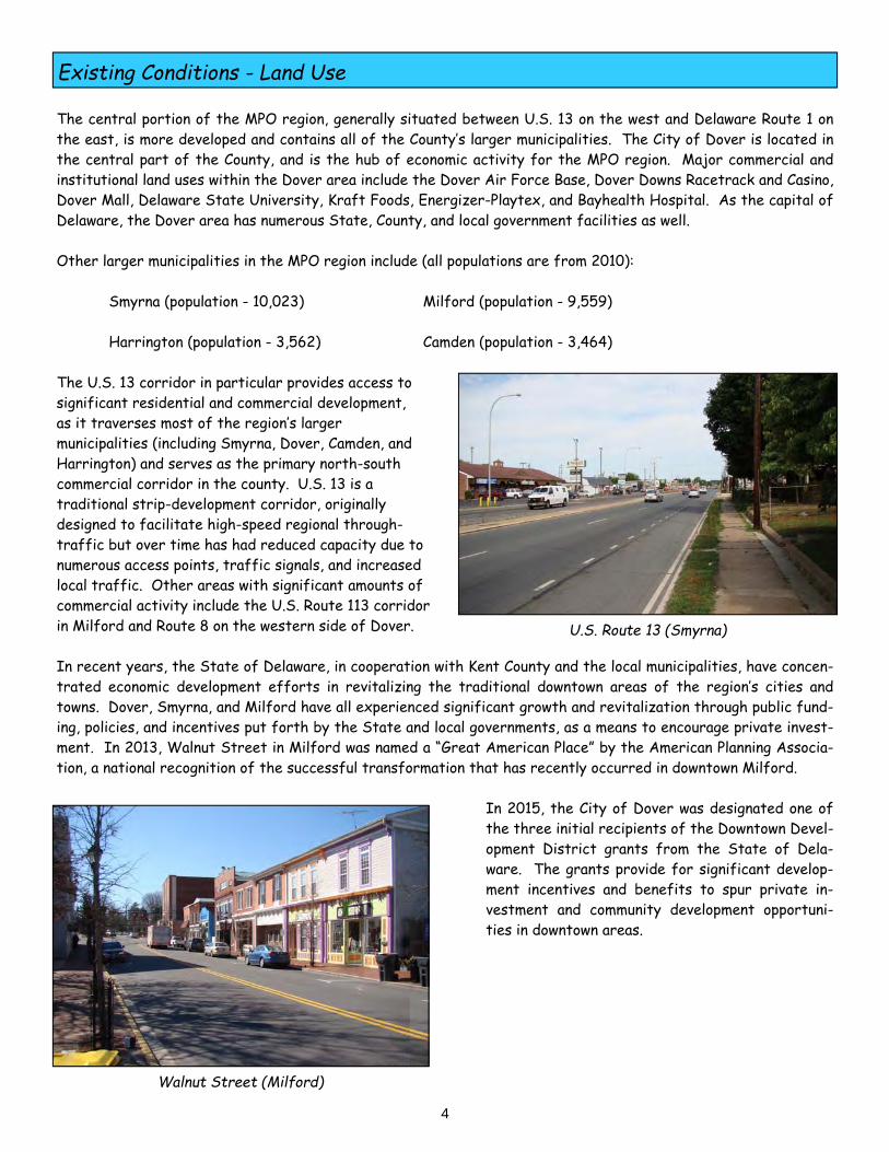
Transit The Delaware Transportation Corporation (DTC), an operating division with the Department of Transportation, is the entity responsible for providing public transportation services within the MPO region. DART First State is the operator of the service. Within Kent County, there are 13 bus routes that provide fixed-route, weekday transit service throughout the central portion of the county. Five of those routes also provide Saturday service. As shown on Figure 4, the existing DART First State service is concentrated primarily in the Dover area, with a particular emphasis on the U.S. 13 corridor. The transit hub for Kent County is located in central Dover, along Water Street. The DART routes provide service to key points in the Dover area, including the Dover Mall, Delaware Technical & Community College, and Dover Downs, as well as providing transportation options for those who live in senior housing or lower-income public housing. Transit service is also provided to Camden, Smyrna, and Harrington via various routes that utilize U.S. 13. There are three inter-county routes that travel through Kent County. Route 301 provides weekday daily service from Wilmington to Dover, while Route 303 provides weekday daily service from Dover to Georgetown in Sussex County. During the summer, Route 305 provides weekend service from Wilmington and Dover to Rehoboth Beach.
Existing Conditions - Transportation Facilities
10
Kent County Transit Hub
Table 5 - Kent County Transit Ridership
Route Number FY 2015 Ridership % Change (FY 2012 - 2015)
101 48,900 -20.1%
102 41,500 -7.0%
103 40,300 -11.7%
104 76,700 0.5%
105 24,600 -32.5%
106 24,400 -1.5%
107 40,400 -40.0%
108 33,000 -14.5%
109 75,100 -10.9%
112 41,600 2.6%
113 35,200 -3.9%
117 26,300 16.1%
120 75,600 -6.8%
100 12,000 15.0%
Total 595,500 -11.2%
FY 2012 Ridership
10,500
61,200
44,600
45,600
76,300
36,400
24,800
67,400
38,500
84,300
40,500
36,700
22,700
81,100
670,600
11
Figure 4 - Existing Transit Routes

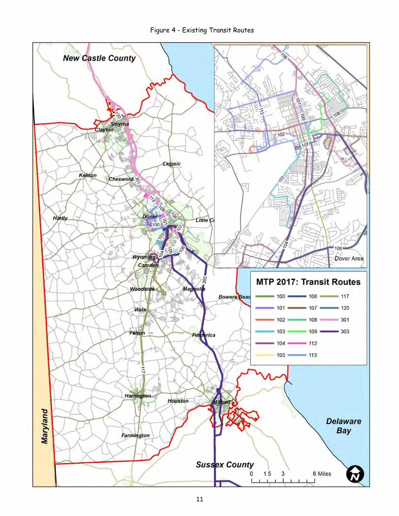
Freight In March 2015, DelDOT, Maryland and Virginia completed the Delmarva Freight Plan in accordance with the provi-sions of the MAP-21 Federal transportation legislation. As noted in the executive summary, the Freight Plan “summarizes current and future freight planning and transportation needs to enhance freight and goods move-ment and related economic opportunities on the 14‐county tri-state area of the Delmarva Peninsula. It supports a regional perspective of freight flows, targets freight issues relevant to the local and regional economies, inte-grates commodity flow modeling and performance-based scenario planning, and ultimately provides insights to help inform future decision-making, freight infrastructure investments, and related policy guidance. The plan recog-nizes and supports the need for multimodal freight planning collaboration within regional jurisdictions and across economic corridors to enhance mobility at the local, state, multi-state, and national level.” Based on research conducted as part of the Freight Plan, the vast majority (80%) of the freight in the region travels by truck. Primary freight commodities include chemicals, agricultural products, food products, coal and petroleum, and secondary traffic (which includes products delivered to retailers such as Wal-Mart). Agriculture remains the primary industry in Kent County, and the farming community is a major user of the high-way and rail network to transport agricultural products for processing and receive imported grain for the poultry industry. Kent County is highly supportive of agriculture, and continues to look for ways to preserve and promote the agricultural industry, through farmland preservation efforts as well as initiating a Food Innovation District (FID) program to enhance the local food processing industry. Kent County has several large industries that are heavily dependent upon the freight network for delivery of goods and products. These include the Wal-Mart Distribution Center in Smyrna, as well as Energizer-Playtex and Kraft Foods in Dover. The Dover Air Force Base is also a major military facility that is dependent upon the exist-ing roadway network (particularly Route 1) for the delivery of military-related freight. In addition, trucks utilize U.S. 13 extensively for local freight deliveries to the hundreds of businesses that front the highway. Norfolk Southern operates the region’s only railroad facility. The rail line runs north-south through the entire county, with an east-west spur line between Harrington and Milford. Primary commodities include coal and agri-cultural products. As noted in the Freight Plan, the region contains a robust network of highways that serve as primary freight routes. The Freight Plan denotes 6 primary freight corridors throughout the Delmarva Peninsula. One of these corridors, known as the Coastal Corridor, is located in Kent County. The Coastal Corridor (mapped on Figure 5) is composed of the following 4 north-south highways: Route 1 U.S. 13 U.S. 113
State Street
Existing Conditions - Transportation Facilities
12
Kent County Grain Storage Facility
13
Figure 5 - Existing Freight Routes
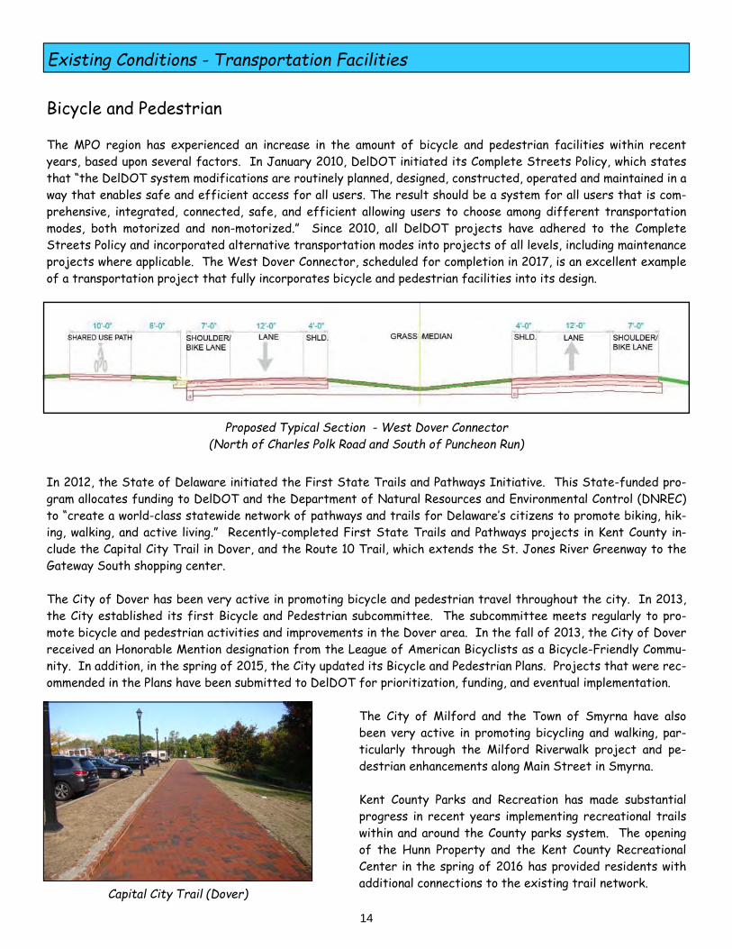
Bicycle and Pedestrian The MPO region has experienced an increase in the amount of bicycle and pedestrian facilities within recent years, based upon several factors. In January 2010, DelDOT initiated its Complete Streets Policy, which states that “the DelDOT system modifications are routinely planned, designed, constructed, operated and maintained in a way that enables safe and efficient access for all users. The result should be a system for all users that is com-prehensive, integrated, connected, safe, and efficient allowing users to choose among different transportation modes, both motorized and non-motorized.” Since 2010, all DelDOT projects have adhered to the Complete Streets Policy and incorporated alternative transportation modes into projects of all levels, including maintenance projects where applicable. The West Dover Connector, scheduled for completion in 2017, is an excellent example of a transportation project that fully incorporates bicycle and pedestrian facilities into its design.
In 2012, the State of Delaware initiated the First State Trails and Pathways Initiative. This State-funded pro-gram allocates funding to DelDOT and the Department of Natural Resources and Environmental Control (DNREC) to “create a world-class statewide network of pathways and trails for Delaware’s citizens to promote biking, hik-ing, walking, and active living.” Recently-completed First State Trails and Pathways projects in Kent County in-clude the Capital City Trail in Dover, and the Route 10 Trail, which extends the St. Jones River Greenway to the Gateway South shopping center.
The City of Dover has been very active in promoting bicycle and pedestrian travel throughout the city. In 2013, the City established its first Bicycle and Pedestrian subcommittee. The subcommittee meets regularly to pro-mote bicycle and pedestrian activities and improvements in the Dover area. In the fall of 2013, the City of Dover received an Honorable Mention designation from the League of American Bicyclists as a Bicycle-Friendly Commu-nity. In addition, in the spring of 2015, the City updated its Bicycle and Pedestrian Plans. Projects that were rec-ommended in the Plans have been submitted to DelDOT for prioritization, funding, and eventual implementation.
The City of Milford and the Town of Smyrna have also been very active in promoting bicycling and walking, par- ticularly through the Milford Riverwalk project and pe- destrian enhancements along Main Street in Smyrna. Kent County Parks and Recreation has made substantial progress in recent years implementing recreational trails within and around the County parks system. The opening of the Hunn Property and the Kent County Recreational Center in the spring of 2016 has provided residents with additional connections to the existing trail network.
Existing Conditions - Transportation Facilities
14
Proposed Typical Section - West Dover Connector (North of Charles Polk Road and South of Puncheon Run)
Capital City Trail (Dover)
15
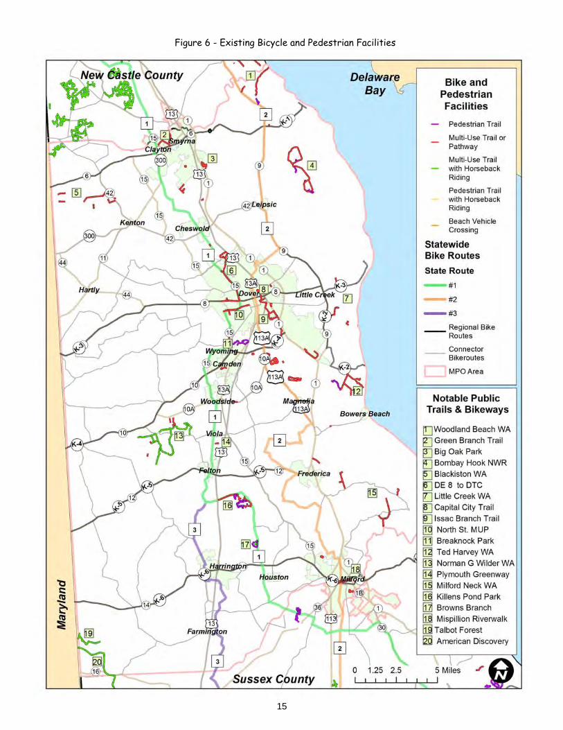
Figure 6 - Existing Bicycle and Pedestrian Facilities

Projected Demographics As noted on its web site, “the Delaware Population Consortium (DPC) is an informal, cooperative organization in-cluding state, county, and local governments that works year-round to produce and share an annual, common set of population and household projections for the state of Delaware, New Castle, Kent and Sussex Counties, and major municipalities in Delaware.” On November 5, 2015, the DPC released its Population Projection Series through the year 2040. The Population Projection Series estimates population, number of households, and total employment for each county in the state, in 5-year intervals. The Kent County 2040 projections are shown below in Table 6.
Projected Land Use Based on information provided by Kent County Planning, the peak period for subdivision activity was 2005-2006, when 65 major subdivisions (representing 9,800 new lots) were processed within Kent County’s jurisdiction alone. Following the recession that began in 2008, development activity dwindled substantially, as evidenced by the fact that in 2011 and 2012, only 2 major residential subdivisions were processed (representing about 450 new lots). Residential permits have increased from 448 in FY 2009 (the low) to 716 in FY 2015. This represents about half of the 1,338 residential permits that were issued in FY 2006, during the peak of the economic boom. Many of the lots that were approved in the early 2000’s remain undeveloped, as there were over 11,000 vacant lots in approved subdivisions as of the fall of 2015. Based on historical trends, Kent County representatives indi-cated that the 11,000 vacant lots would represent a build-out occurring over a 15 to 20-year time period. The County anticipates that most residential growth will occur in approved but un-built subdivisions. Significant resi-dential growth is also anticipated in recently annexed areas of Milford, Smyrna, Cheswold, and Clayton.
Projected Conditions - Demographics and Land Use
16
2015 2040 Increase
Population 174,000 208,700 34,700
Households 62,500 83,000 20,500
Labor Force 77,000 82,000 5,000
Table 6 - Kent County Population Projections
Kent County Projections (2015 - 2040)
Population increase - 20%
Household increase - 33%
Employment increase - 6%
Source: Delaware Population Consortium (November 2015)
Vacant Subdivision

Goals and Objectives The MTP sets the vision for the region’s transportation future through the year 2040. The goals and objectives set forth in Vision 2040 were developed in conjunction with the visions outlined by the various planning agencies that make up the MPO region. These agency visions are outlined in the following documents:
Office of State Planning Coordination’s Strategies for State Policies and Spending (2016) Delaware Department of Transportation Long Range Transportation Plan (2011) Kent County Comprehensive Plan (2008) Municipal Comprehensive Plans (such as the City of Dover, City of Milford, Town of Smyrna)
Based on the goals outlined by the MPO’s partner agencies in the documents noted above, the MPO has developed three broad goals that aim to address the transportation needs of the region over the next 20 years.
Goals and Objectives
Proposed Improvements - Downtown Dover Main Street (Smyrna)
17
Vision 2040 Goals
Goal 1 - Move People Safely and Efficiently Goal 2 - Strengthen Communities Goal 3 - Promote Economic Development
As noted on page 17, the Vision 2040 goals were developed to be consistent with the goals outlined by the State of Delaware (through the Office of State Planning Coordination and the Department of Transportation) as well as the planning goals stated by the Kent County Levy Court and various municipalities. A sampling of the goals and objectives as they relate to long-range infrastructure planning are noted below.
Goals and Objectives
18
“State government will make appropri-ate, cost-effective investments...in or-der to promote efficient development patterns, encourage sustainable eco-nomic development, and protect agri-culture and open space...”
Strategies for State Policies and Spending Office of State Planning Coordination
“DelDOT’s vision is to make every trip...safe, reliable, and convenient for people and commerce.”
Delaware Department of Transportation Mission Statement
Kent County Comprehensive Plan Vision Statement
“To preserve the rural and community charac-ter of Kent County by encouraging the most appropriate use of land, water, and other re-sources that protects the County’s natural, historic, and cultural resources, allows for economic opportunity, preserves farmland, manages growth, and provides a safe sustain-able environment for its citizens.”
Strategies for State Policies and Spending Office of State Planning Coordination
“These strategies will guide the invest-ments made by state agencies and en-sure that those public investments are efficient, equitable, and promote com-pact growth and resource conservation.”

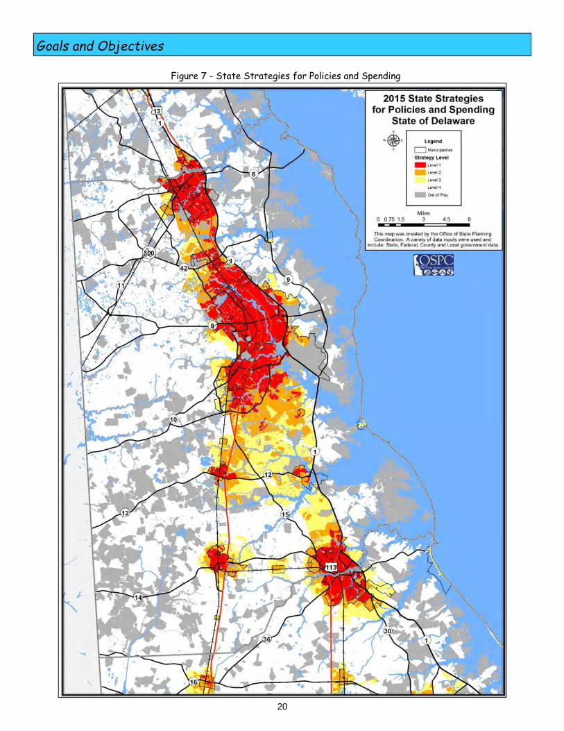
State Strategies for Policies and Spending The State Strategies for Policies and Spending, updated by the Office of State Planning Coordination in April 2016, serves as the guiding principles for financial investment by State agencies in Delaware. As noted in the document, the primary purpose of the Strategies is “to coordinate land-use decision-making with the provision of infrastructure and services in a manner that makes the best use of our natural and fiscal resources.” A key component of the Strategies is the designation of four investment levels throughout the state - Invest-ment Levels 1, 2, 3, 4, as well as areas considered as Out Of Play for future development (such as farms with agri-cultural preservation easements or State park lands). The Investment Level designations differentiate between the priority of State infrastructure investment. A brief description of each Investment Level is provided below. Level 1 - Level 1 areas are in municipalities and urban portions of the County. The Strategies indicate that “in Level 1 Areas, state investments and policies should support and encourage a wide range of uses and densities, promote a variety of transportation options, foster efficient use of existing public and private investments, and enhance community identity and integrity.” These are the State’s top priority area for focusing transportation investment, particularly in terms of preserving existing facilities, improving safety, developing context-sensitive solutions, enhancing transit, and promoting alternatives to the motor vehicle. Level 2 - According to the Strategies, “Level 2 areas serve as the transition between Level 1 and the more open, less populated areas.” These areas consist of suburban lands adjacent to municipalities (with public utilities), less developed areas of municipalities, and smaller towns with a consistent growth pattern. In terms of transportation investment, the Strategies indicate that Level 2 areas should be a recipient of funding to promote planned growth and economic development, address safety and efficiency issues, and enhance non-motorized transportation. Level 3 - The Strategies note that there are two categories of Level 3 areas - “lands that are in the long-term growth plans of counties or municipalities where development is not necessary to accommodate expected popula-tion growth during this five-year planning period (or longer) and... lands that are adjacent to or intermingled with fast-growing areas within counties or municipalities that are otherwise categorized as Investment Levels 1 or 2.” Level 4 - These areas are the rural areas of the county, and are composed of farmland, forests, nature preserves, State and County parks, and small settlements. The State intends to discourage suburban development in these areas. The Strategies state that the focus of transportation investment “is to preserve and maintain existing facilities in safe working order, corridor-capacity preservation, and the enhancement of transportation facilities to support agricultural business.”
Goals and Objectives
19
Table 7 - State Investment Levels (Kent County)
Investment Level Percentage
Level 1 7.3%
Level 2 5.3%
Level 3 6.0%
Level 4 41.6%
Out of Play 39.8%
Acres
27,990
20,031
23,058
159,188
152,163
Loockerman Street (Dover)
Source: Office of State Planning Coordination
Goals and Objectives
20
Figure 7 - State Strategies for Policies and Spending

Goal 1 - Move People Safely and Efficiently The primary goal of a transportation system is to move people as safely and efficiently as possible, for all modes of travel. Safe and efficient transportation is inextricably linked to improved quality of life, reduced delays, and increased economic development opportunities. This goal has several primary objectives to ensure that future transportation projects included in the long range plan enable people to continue to move safely and efficiently. Maintain existing infrastructure - Ensuring that the existing transportation system is well-maintained is a pri-mary objective of all levels of government, from the Federal Highway Administration to local municipalities, and is consistent with the overall approach of DelDOT. Through the federal transportation legislation, the FHWA re-quires states to have State of Good Repair and Asset Management programs, to ensure that existing physical as-sets are sustained for their useful service life through maintenance, preservation, and replacement. Major assets within Delaware include bridges, drainage systems, pavement, transit vehicles, signs, traffic signals, and facilities. As existing facilities age, it is vital that a continued source of funding is in place to ensure that existing infra-structure is maintained. Through its State of Good Repair, DelDOT has instituted numerous programs that are designed to maintain existing facilities. Examples of these include the Bridge Preservation Program, Pavement and Rehabilitation, Railroad Preservation, and the Transit Vehicle Replacement Program. As noted in the FY 2016 - 2021 CTP, Kent County had 13 projects in the Bridge Preservation Program, with an estimated cost of nearly $12 million. During the same 6-year timeframe, Kent County was slated to replace numerous transit and paratransit vehicles, with an estimated cost of over $21 million. Of all of DelDOT’s Statewide Programs, the Pavement and Rehabilitation Program is by far the state’s largest, with over $500 million dollars allocated to that program dur-ing the 6-year CTP funding cycle. Shorten project delivery - Through FHWA initiatives such as Every Day Counts (EDC), the federal government is encouraging states to speed up the delivery of highway projects and to address the challenges presented by limited budgets. According to the FHWA, “EDC is a state-based model to identify and rapidly deploy proven but underutilized innovations to shorten the project delivery process, enhance roadway safety, reduce congestion and improve environmental sustainability.” FAST, the current Federal transportation legislation, looks to further shorten project delivery times in the project development stage by reducing duplication, encouraging program-matic agreements, delegating regulatory responsibilities to the states, streamlining the environmental review process for bridge repair projects, and coordinating environmental agency reviews. These are all components that will collectively lead to projects being constructed in as timely a manner as possible.
Goals and Objectives
21
Wyoming Mill Road (Wyoming)
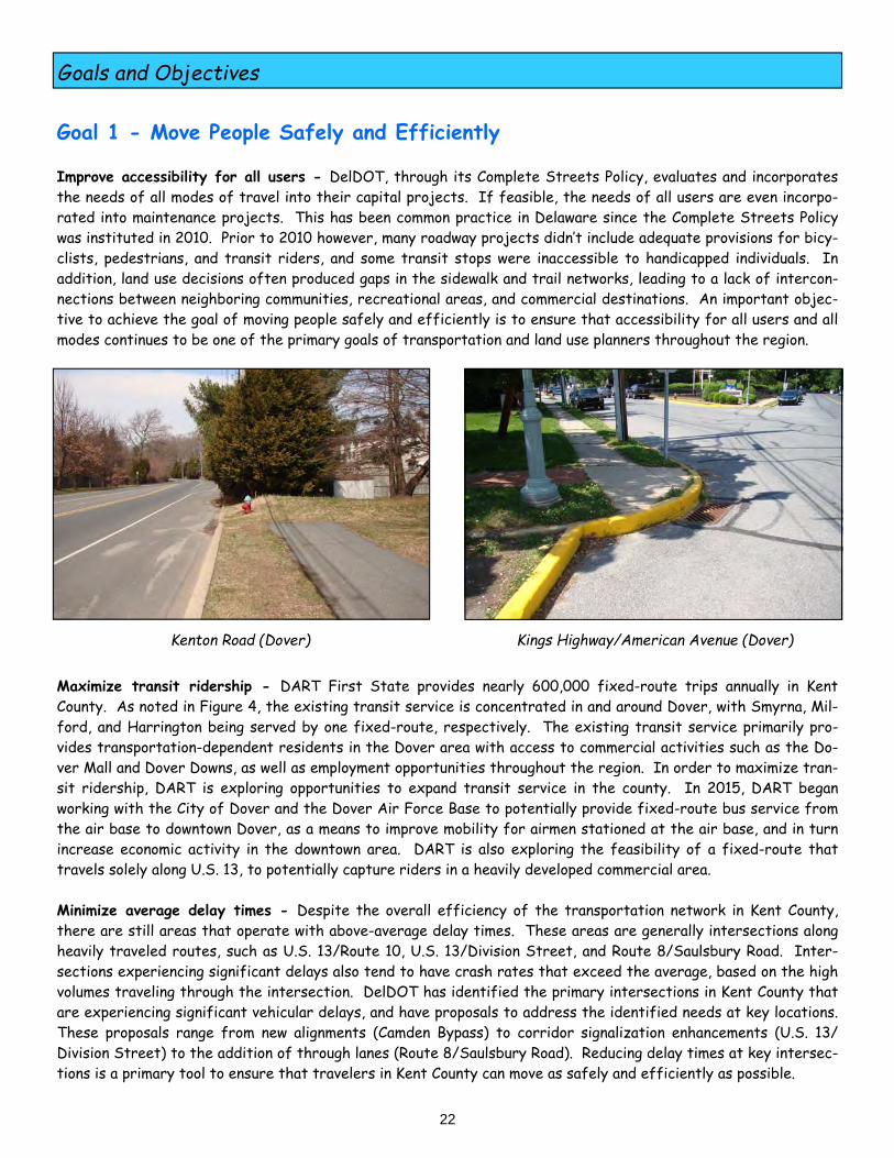
Goal 1 - Move People Safely and Efficiently Improve accessibility for all users - DelDOT, through its Complete Streets Policy, evaluates and incorporates the needs of all modes of travel into their capital projects. If feasible, the needs of all users are even incorpo-rated into maintenance projects. This has been common practice in Delaware since the Complete Streets Policy was instituted in 2010. Prior to 2010 however, many roadway projects didn’t include adequate provisions for bicy-clists, pedestrians, and transit riders, and some transit stops were inaccessible to handicapped individuals. In addition, land use decisions often produced gaps in the sidewalk and trail networks, leading to a lack of intercon-nections between neighboring communities, recreational areas, and commercial destinations. An important objec-tive to achieve the goal of moving people safely and efficiently is to ensure that accessibility for all users and all modes continues to be one of the primary goals of transportation and land use planners throughout the region.
Maximize transit ridership - DART First State provides nearly 600,000 fixed-route trips annually in Kent County. As noted in Figure 4, the existing transit service is concentrated in and around Dover, with Smyrna, Mil-ford, and Harrington being served by one fixed-route, respectively. The existing transit service primarily pro-vides transportation-dependent residents in the Dover area with access to commercial activities such as the Do-ver Mall and Dover Downs, as well as employment opportunities throughout the region. In order to maximize tran-sit ridership, DART is exploring opportunities to expand transit service in the county. In 2015, DART began working with the City of Dover and the Dover Air Force Base to potentially provide fixed-route bus service from the air base to downtown Dover, as a means to improve mobility for airmen stationed at the air base, and in turn increase economic activity in the downtown area. DART is also exploring the feasibility of a fixed-route that travels solely along U.S. 13, to potentially capture riders in a heavily developed commercial area. Minimize average delay times - Despite the overall efficiency of the transportation network in Kent County, there are still areas that operate with above-average delay times. These areas are generally intersections along heavily traveled routes, such as U.S. 13/Route 10, U.S. 13/Division Street, and Route 8/Saulsbury Road. Inter-sections experiencing significant delays also tend to have crash rates that exceed the average, based on the high volumes traveling through the intersection. DelDOT has identified the primary intersections in Kent County that are experiencing significant vehicular delays, and have proposals to address the identified needs at key locations. These proposals range from new alignments (Camden Bypass) to corridor signalization enhancements (U.S. 13/Division Street) to the addition of through lanes (Route 8/Saulsbury Road). Reducing delay times at key intersec-tions is a primary tool to ensure that travelers in Kent County can move as safely and efficiently as possible.
Goals and Objectives
Kenton Road (Dover) Kings Highway/American Avenue (Dover)
22

Goal 2 - Strengthen Communities A transportation system is at its most effective when it safely moves people and goods as efficiently as possible, with minimal delay and disruption to the user. However, a transportation network is also a vital component to a strong, active, and vibrant community. An ineffective transportation system undoubtedly has an adverse impact on an area’s quality of life. The profound influences of transportation on the human and natural environments can be found in some of the following areas: Enhance human health - Communities that are walkable and bicycle-friendly can contribute to a healthier life-style for its residents. Mixed-use communities, where commercial and retail uses are located in close proximity to residential land uses, allow for high pedestrian activity and less reliance on motor vehicles. This in turn can reduce vehicular emissions, which are a contributor to human health problems (respiratory) as well as climate change and the myriad of adverse impacts associated with rising global temperatures. DelDOT, working in conjunction with DNREC, has been very active in recent years funding alternative transporta-tion projects as part of the First State Trails and Pathways Program. DelDOT continues to work with the MPO and local municipalities to identify bicycle and pedestrian needs throughout the county, and has prioritized a num-ber of bike/pedestrian projects for funding and eventual implementation. Local municipalities should continue to identify bicycle and pedestrian needs in their communities, as the City of Dover has successfully done in recent years. The development of Bicycle and Pedestrian Plans has led to a number of projects in Dover that have been constructed, are in design, or have been funded for design. The Complete Streets Policy has also lead to signifi-cant gains in the amount of bicycle, pedestrian, and transit facilities constructed within the region as part of roadway improvement projects. The MPO strongly supports land use design and infrastructure projects that provide residents with transporta-tion alternatives to the motor vehicle, thus providing benefits to human health as well as the natural environment. The evaluation and inclusion of non-motorized transportation alternatives should be included in every project noted in this long-range plan, in accordance with the Complete Streets Policy and those mandated by local govern-ments as part of the land development approval process.
Goals and Objectives
Route 10 Pathway
23
Human Health Objectives
Reduce the impacts of motor vehicle emissions
Increase the mileage of trails and pathways
Develop a low-stress bike network
Encourage mixed-use development
Reduce vehicle miles traveled

Goal 2 - Strengthen Communities Preserve natural resources/Enhance community resources - In the past, the relationship between transporta-tion projects and their impact on a community was not as widely understood as it is today. Transportation pro-jects today are designed in a context-sensitive manner, taking into consideration the historic, community, natural, and aesthetic resources of an area, and ensuring that the transportation improvement is consistent with the over-all community setting. Transportation projects, particularly those in urban settings, can enhance a community through the inclusion of streetscape features, landscaping, community art, and other aesthetic enhancements that reflect the local char-acter of an area. DelDOT, through the Transportation Alternatives Program (originally known as the Transporta-tion Enhancements Program), has provided numerous enhancement projects throughout Kent County, including suc-cessful projects in Smyrna, Dover, Camden, and Milford in recent years. Successful projects have included the Riverwalk in downtown Milford, the U.S. 13 median beautification in Smyrna, and the North Street streetscape project in downtown Dover. In rural areas, scenic byways can be used to enhance the roadway setting and serve as an asset to preserve the natural and cultural environments. DelDOT manages the Delaware Byways program, which provides “official rec-ognition of the special nature of a roadway corridor. This designation will heighten awareness and recognition of the community seeking the designation and help to boost community pride.” In Kent County, there are two desig-nated Byways, the Harriet Tubman Underground Railroad Byway and the Bayshore Byway. The former runs from Wilmington into Maryland, traversing both urban and rural areas of the county, while the latter runs along rural areas (primarily Route 9) from the City of New Castle to south of the Dover Air Force Base. The MPO encour-ages the continued development of the Byways Program as a means to promote and preserve the unique natural and cultural qualities of Kent County. In order to reduce the adverse impacts of transportation projects on the natural and man-made environments, projects that are in Level 4 Investment Levels should be limited to preservation projects (maintenance of existing facilities) and those that address an identified safety need. System expansion projects should be limited to ar-eas that are already developed, particularly in Level 1 and 2 Investment Level areas. In addition, system expan-sion projects should be avoided within environmentally-sensitive areas of the county, regardless of Investment Level.
Goals and Objectives
North Street (Dover)
24
Preserve/Enhance Resource Objectives
Limit projects in Level 4 areas to maintenance and safety improvements
Continue developing the Transportation
Alternatives Program
Implement recommendations from the Corridor Management Plans of each Byway

Goal 3 - Promote Economic Development Transportation is undoubtedly one of the key components to the success or failure of a community’s economy, whether on a local, regional, or national level. Access to key freight routes, highways that are free of congestion, the ability to receive and ship materials in a timely fashion, and even the ability for workers to safely walk to work, are all vital for businesses to succeed in today’s global economy. The MPO region has a diverse economy. While agriculture remains the top industry in Kent County, there are sev-eral other primary components of the region’s economy, all of which are dependent upon the transportation net-work for continued success and expansion. Kent County is the home to large industries such as Kraft Foods, Ener-gizer-Playtex, Perdue Farms, Proctor and Gamble, and ILC Dover, each of which employs hundred of employees and relies on trucks for the receiving and distribution of products. In addition, the WalMart Distribution Center in Smyrna employs over 700 people, and is a major generator of truck commerce throughout the region. The Do-ver Air Force Base is the region’s top employer, with over 6,500 personnel working at the base. Dover is the economic hub of the region, home to the county’s primary medical facility (Bayhealth), a regional mall (Dover Mall), and several industrial parks. Government facilities and several colleges and universities are located in Dover, which contribute to the diversity of the local economy. Other towns which have seen significant eco-nomic activity in recent years include Milford and Smyrna, particularly in their downtown areas. As described below, there are several specific goals that this Plan sets forth as it relates to the inter-relationship between transportation and economic development. Maintain effective transportation networks - With the exception of the U.S. 13 corridor in Dover and Camden during peak periods, the region has few areas that would be considered to be deficient from an operational per-spective. However, it is vitally important that the transportation system continually be monitored and improve-ments implemented that address identified needs, so that the transportation network can continue to function at acceptable levels for existing and planned economic development. Building new highways or providing major expan-sions to existing highways are likely going to be done infrequently in the future, due to high costs, social and envi-ronmental concerns, impacts of urban land acquisition, etc., so managing and maintaining the existing network will be the primary objective for future planners. There are numerous tools for managing the existing system to ensure that congestion does not adversely impact the region’s existing and planned economic development. Several of the tools currently used by DelDOT are listed below: Traffic-adaptive signal timings Video monitoring of intersections Synchronized signal timings Real-time messaging (Web/cell phone) Incident response coordination
Goals and Objectives
DelDOT Transportation Management Center
25

Goal 3 - Promote Economic Development Ensure that economic development is considered in project prioritization - As part of the DelDOT and MPO project prioritization processes for the Capital Transportation Program (CTP) and Transportation Improvement Program (TIP), respectively, economic development is one of the rating factors used to rank individual projects. Per the DelDOT prioritization process, economic development considers “the ability of a project to facilitate or support business development and employment.” The following factors are considered by DelDOT when ranking projects: Located within a Transportation Improvement District Located along a Freight Corridor Cost-sharing support
With regards to economic development, the MPO prioritization process considers “the extent to which a project provides or enhances access to planned economic opportunities that are endorsed by local entities.” It also con-siders freight as a separate rating category, based on a project’s relationship to the recommendations noted in the Delmarva Freight Plan. The MPO’s Technical Advisory Committee (TAC) includes a representative from the Delaware Economic Develop-ment Office who provides insight from a job creation and revenue generation perspective. In addition, the Cen-tral Delaware Chamber of Commerce has a Transportation Committee who actively coordinates with DelDOT with respect to transportation priorities from the region’s business community. Evaluate the transportation needs of designated and proposed economic growth areas - As noted, Kent County has several areas designated for future economic growth. These include the Garrison Oak Technical Park located within the City of Dover and the Kent County Aero Park near the Dover Air Force Base. Other areas slated for future economic growth include existing industrial parks in Milford and Smyrna, the Regional Sports Complex near Frederica, and continued in-fill commercial development along U.S. 13 in Dover. As these areas potentially develop in the future, the traffic impacts of the development must be monitored to ensure that the transportation sys-tem meets the projected needs of the development, and to mitigate any adverse commercial-related traffic on adjacent property owners. There are several projects that will facilitate planned economic growth in the county, particularly the grade-separated intersection planned at Route 1 at Tub Mill Road/Milford Neck Road. This project will provide direct access to the proposed Sports Complex while ensuring that capacity along Route 1 is maintained. Other potential projects listed in this Plan that have an economic development focus include: U.S. 13 local road connections in Dover Garrison Oak Technical Park Connector Road Loockerman Street/Forest Street Improvements
Goals and Objectives
Kent County Regional Sports Complex
26
Operational and Management Strategies
27
There are a number of operational and management strategies that planners can utilize to address the variety of transportation needs within the MPO region., and ultimately support the goals and objectives identified in Vision 2040. Listed below is a description of each strategy and the associated benefits on the transportation system.
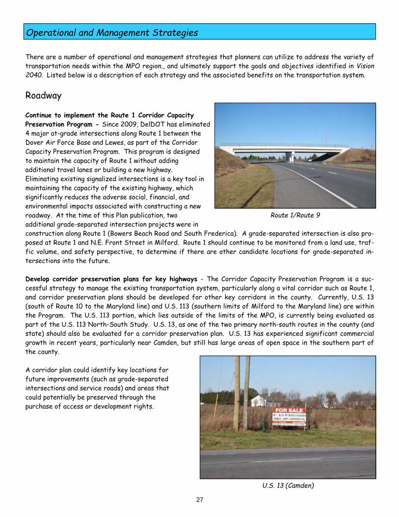
Roadway Continue to implement the Route 1 Corridor Capacity Preservation Program - Since 2009, DelDOT has eliminated 4 major at-grade intersections along Route 1 between the Dover Air Force Base and Lewes, as part of the Corridor Capacity Preservation Program. This program is designed to maintain the capacity of Route 1 without adding additional travel lanes or building a new highway. Eliminating existing signalized intersections is a key tool in maintaining the capacity of the existing highway, which significantly reduces the adverse social, financial, and environmental impacts associated with constructing a new roadway. At the time of this Plan publication, two additional grade-separated intersection projects were in construction along Route 1 (Bowers Beach Road and South Frederica). A grade-separated intersection is also pro-posed at Route 1 and N.E. Front Street in Milford. Route 1 should continue to be monitored from a land use, traf-fic volume, and safety perspective, to determine if there are other candidate locations for grade-separated in-tersections into the future. Develop corridor preservation plans for key highways - The Corridor Capacity Preservation Program is a suc-cessful strategy to manage the existing transportation system, particularly along a vital corridor such as Route 1, and corridor preservation plans should be developed for other key corridors in the county. Currently, U.S. 13 (south of Route 10 to the Maryland line) and U.S. 113 (southern limits of Milford to the Maryland line) are within the Program. The U.S. 113 portion, which lies outside of the limits of the MPO, is currently being evaluated as part of the U.S. 113 North-South Study. U.S. 13, as one of the two primary north-south routes in the county (and state) should also be evaluated for a corridor preservation plan. U.S. 13 has experienced significant commercial growth in recent years, particularly near Camden, but still has large areas of open space in the southern part of the county. A corridor plan could identify key locations for future improvements (such as grade-separated intersections and service roads) and areas that could potentially be preserved through the purchase of access or development rights.
Route 1/Route 9
U.S. 13 (Camden)

Operational and Management Strategies
28
Roadway (continued) Continue to focus on comprehensive safety improvements to reduce crashes - Motor vehicle crashes have con-sistently been the leading cause of accidental deaths in the United States for a number of years. In 2013 and 2014, there were 70 fatal crashes and over 270 serious injury crashes in Kent County. Ten of the fatal crashes involved a pedestrian. Based on 2014 statistics, the State of Delaware has the highest pedestrian fatality rate per capita in the nation. It is vital that transportation projects in the MTP be planned, designed, and constructed to enhance safety to the maximum extent possible. DelDOT, in conjunction with the Department of Safety and Homeland Security, has updated the Delaware Strategic Highway Safety Plan, with a stated goal of reducing the number of fatalities and serious injuries by 50% by 2035. The Safety Plan provides a comprehensive analysis of safety emphasis areas, which include reducing crashes associated with intersections, impaired driving, pedestri-ans, motorcycles, speeding, roadway departure, and unrestrained motorists. Specific recommendations for ad-dressing each emphasis area are included in the Safety Plan. DelDOT has a very active Highway Safety Improvement Program (HSIP) that continually reviews crash data and crash rates throughout the state. Through the HSIP, the Department identifies roadway segments and intersec-tions that have higher than average crash rates, notes the primary contributing circumstances for the crashes, and develops recommendations to address the identified safety needs. Recommendations can typically range from signing and striping improvements to major roadway widening. The HSIP, which is a Federally-funded program, is DelDOT’s primary means of identifying and addressing safety needs.
The MPO region typically has several locations on the HSIP project list annually. Since 2013, re- cent HSIP projects that have been completed include the South State Street/Sorghum Mill Road and U.S. 13/Carpenter Bridge Road inter- sections. Future HSIP projects that are funded for design and construction include the U.S. 13 widening project (Puncheon Run Connector to Lochmeath Way), Route 8/Saulsbury Road, and Route 10/ Route 15.
Based on 2012 - 2014 crash data, DelDOT ranked 266 intersections throughout the state in terms of factors such as number of crashes, fatal crashes, and property damage crashes. Of the 266 analyzed intersections, 36 of them were in Kent County (13%). Of the 36 Kent County intersections that were identified, the vast majority (69%) were located along U.S. 13. The Route 8/Saulsbury Road intersection was the highest-ranked intersection in the region, ranking at #11 on the statewide list.
Route 10/Route 15
Route 8/Saulsbury Road

Operational and Management Strategies
29
Roadway (continued) Provide local connections to provide alternative routes - The ability to continue to build new highways to allevi-ate congestion has become increasingly difficult based on factors such as land availability, adverse social and envi-ronmental impacts, and high costs. In addition, new roadways often lead directly to further suburban sprawl, as formerly undeveloped lands become more accessible with highway or interchange access. Providing local roadway connections is an important technique for relieving congestion and promoting mobility along major roadway corri-dors, without adding travel lanes or building a bypass. Several recent MPO planning studies along the U.S. 13 and Route 8 corridors identified numerous local roadway connections that would increase connectivity and provide al-ternative access, particularly for local motorists. The proposed extension of Crawford Carroll Road, which would provide a direct connection from Scarborough Road to the Dover Mall, is a prime example of a local road connection that eliminates the need for motorists to travel along U.S. 13. These local road connections can also provide a lower stress route for bicyclists and pedestrians, as an alternative to high-speed, high-volume corridors such as U.S. 13 and Route 8. Potential local road connections that have been identified in planning studies should continue to be evaluated and prioritized as part of the DelDOT and MPO project prioritization processes. Ensure that local roads are upgraded consistent with future growth - In the early 2000’s, the region experi-enced unprecedented residential growth. The growth occurred almost exclusively in previously agricultural areas, where the road network was originally designed to accommodate very low volumes of farm-related traffic. While the residential growth has subsided somewhat from the previous levels due to economic recession, there are still large numbers of recorded but un-built residential lots throughout in the county. These areas are primarily lo-cated within the growth zone and include south Smyrna (Brenford Road corridor), west Magnolia (Irish Hill Road corridor), and areas on the outer limits of Milford. Through DelDOT’s development coordination process, develop-ers are required to mitigate any transportation-related impacts of their developments. These improvements often can be localized enhancements (such as an individual intersection) and not necessarily a system-wide improvement (such as the addition of shoulders beyond the limits of the new development). The sheer magnitude of development has led to a significant increase in traffic, as generated by thousands of new homes built along rural roads lacking shoulders or adequate intersection designs. Conditions along local roads should continue to be monitored and potential improvements identified, to ensure that the typical sections of these local roadways are consistent with the projected traffic volumes.
Proposed Crawford Carroll Road Extension
Peachtree Run (Magnolia)
U.S. 13
Dover Mall Lowes
Proposed Roadway
Del. State

Operational and Management Strategies
30
U.S. 13 Bus Stop (Camden)
Transit Adjust the transit system to address local needs - As shown in Table 5, transit ridership on 10 of the 14 DART routes decreased between FY 2012 and FY 2015. While some routes have seen significant increases, transit rid-ership overall decreased 11% during that timeframe. In 2015, DTC conducted an Origin-Destination Study of the existing fixed-route transit system along U.S. 13 (south of Dover) in Kent and Sussex Counties, as well as other routes in the Kent County transit system. The purpose of the study was to determine the best methods to serve existing and future travel demand along this corridor, particularly in the more rural areas. In addition, the study provided comprehensive information on existing transit ridership within central Kent County, as a means to identify potential enhancements to the transit network. In attempting to re-design the transit system to develop a “right-fit” for the region, DTC has identified the fol-lowing goals: Develop a core transit system along U.S. 13 Provide access to areas with greater employment opportunities Develop guidelines for transit feasibility based on land use Identify key locations along U.S. 13 to establish bus stops Fill frequency gaps in existing service DTC will use the results of the study to determine if it’s feasible to develop new transit routes, such as a route that travels solely along U.S. 13, while adjusting, consolidating, or eliminating routes that aren’t serving the needs of the public. In early 2016, in response to locally identified transit needs, DTC added a bus stop at the Eden Hill Medical Cen-ter in Dover as part of enhancements to its existing fixed-route system.
Kent County has one primary intercity bus service, pro- vided by Greyhound. The bus line currently only provides a single curbside stop at a 7-11 convenience store near the transit hub in downtown Dover and does not have a full service bus station in the area. There have been discus- sions between Greyhound and DTC to provide a ticket fa- cility at the transit hub along Water Street. However, as of the spring of 2016, there are no plans to provide a Greyhound ticket facility at the transit hub until a mixed- use building is built on the site.
Eden Hill Medical Center

Operational and Management Strategies
31
Freight Implement the recommendations from the Delmarva Freight Plan - As part of the Delmarva Freight Plan, the project team conducted a comprehensive analysis of existing freight conditions, which included an assessment of the existing freight network, the movements of goods throughout the region (both locally and regionally) and an inventory of the needs of major freight providers. The Delmarva Freight Plan also completed an evaluation of a variety of potential scenarios that could affect freight movement in the future, such as a reduction in coal freight on the Delmarva Peninsula or a significant increase in truck traffic based on projected growth. Based on the analysis conducted as part of the Delmarva Freight Plan, there were numerous freight-related rec-ommendations for the MPO region. The recommendations, which can be found at www.wilmapco.org/freight/Delmarva, are delineated into 3 categories: Road/Rail projects, Interchange/Bridge projects, and Area studies. The recommendations are listed in Table 8 below.
Future freight-related projects should also ensure that the “last-mile” distribution of goods is adequately ad-dressed. The “last-mile” is a term used to describe a product’s delivery from a regional transportation hub to its final destination. Planners will also need to address truck traffic on local roads that may be generated by future growth at existing industrial parks such as the Garrison Oak Technical Park or the Kent County Aero Park. As of 2016, both of these industrial parks generated minimal truck traffic, but future economic growth could facilitate the need for im-proved roadways and/or alternative means to access these areas.
Table 8 - Delmarva Freight Plan Recommendations
Road/Rail Projects Interchange/Bridge Projects Area Studies
Smyrna Road Upgrades (Carter Road &
Sunnyside Road)
Virtual Weight Station on U.S. 13
Dover Area Freight Management Study
Dover Road Upgrades (Denney’s Road, College Road,
Kenton Road)
Virtual Weight Station on Route 1
Air Cargo Ramp (DAFB)
Route 1 Corridor Plan Virtual Weight Station on Route 6
Harrington Road Upgrades (Route 14 through town)
Virtual Weight Station on Route 300

Operational and Management Strategies
32
Bicycle & Pedestrian Evaluate strategies to reduce pedestrian crashes - Based on data from 2012 to 2014, Delaware had the highest pedestrian fatality rate in the United States, nearly double the national average. In 2014, there were 9 pedes-trian fatalities in Kent County, which represented 33% of the statewide total. This also represented the highest number of pedestrian fatalities in Kent County in at least a decade. In addition, there were 7 crashes that in-volved a serious pedestrian injury. While the pedestrian crashes were relatively scattered throughout the region, there was a concentration of crashes along U.S. 13 between Dover and Camden. DelDOT addressed that issue through the use of variable mes-sage boards along the highway, alerting motorists to heavy pedestrian volumes throughout the corridor.
The DelDOT Traffic Section has been proactive in identifying areas of higher than average pe- destrian crash rates and developing solutions to reduce the number of pedestrian crashes. The Department, in conjunction with other state pub- lic safety agencies such as the Office of Highway Safety, the University of Delaware Depart- ment of Public Safety, and the Delaware State Police, have assembled a working group that meets regularly to address specific corridors throughout the state. This effort should be continued and expanded to include other corridors such as U.S. 13 if warranted.
DelDOT has also recently installed a HAWK signal along Route 8 at Dover High School, which is a pedestrian-activated traffic signal that allows for a controlled crossing of the highway. DelDOT is working with municipali-ties to address local needs, such as reducing pedestrian crashes that have occurred along South State Street in front of Bayhealth Hospital. A rectangular rapid flash beacon, which is a new tool in Delaware, is proposed for this location to improve the crossing for pedestrians. Continue to implement the recommendations from the Dover Bicycle and Pedestrian Plans - In 2015, the City of Dover updated its Bicycle Plan and Pedestrian Plan. The Plans provide a detailed assessment of existing condi-tions, an identification of bicycle and pedestrian needs, and a prioritized listing of specific recommendations. At the time of this publication, DelDOT has included several of the primary recommendations into its funding cycle for design and construction. These projects include:
North Street Trail maintenance West Street Pathway U.S. 13 Sidewalk gaps Senator Bikeway
DelDOT has included the remainder of the bike and pedestrian recommendations into its prioritization process. It is recommended that funding continue to be provided for the highest-ranked projects, so design and construction can be scheduled accordingly.
West Street (Dover)
Route 8 HAWK Signal (Dover)

Operational and Management Strategies
33
Bicycle & Pedestrian (continued) Develop a low-stress bicycle network - As defined by the Mineta Transportation Institute, “for a bicycling net-work to attract the widest possible segment of the population, its most fundamental attribute should be low-stress connectivity, that is, providing routes between people’s origins and destinations that do not require cyclists to use links that exceed their tolerance for traffic stress, and that do not involve an undue level of detour.” Ac-cording to various research, up to 60% of the population is interested in bicycling but concerned about safety due to potential conflict points with motor vehicles. In 2015, DelDOT began analyzing different areas throughout the state to determine existing levels of stress based on specific roadway characteristics (typical section, traffic volumes, and vehicular speeds). As noted in the City of Dover Bicycle Plan, the ultimate plan is to provide a low-stress 12-mile bicycle loop around the City, which would link the downtown with off-road facilities to the south and west. Portions of the low-stress network are already in place, notably the Isaac Branch Trail and the Capital City Trail, which link to each other at U.S. 13/Public Safety Boulevard. Other portions, such as the bicycle facili-ties being constructed as part of the West Dover Connector, will be open upon its completion in 2017. It is rec-ommended that the bicycle network outlined in the City of Dover Bicycle Plan (particularly along Route 8 as part of the proposed Senator Bikeway project) continue to be implemented so that a continuous, low-stress facility can be provided for both recreational and transportation purposes.
Capital City Trail (Dover)

Operational and Management Strategies
34
Policy & Programs Implement a Congestion Management Process - According to the FHWA, a Congestion Management Process (CMP), formerly known as a Congestion Management System, is “a systematic approach, collaboratively developed and implemented throughout a metropolitan region, that provides for the safe and effective management and operation of new and existing transportation facilities through the use of demand reduction and operational management strategies.” CMP’s are required in urbanized areas with a population over 200,000 people, such as New Castle County, where the Wilmington Area Planning Council (Wilmapco) manages the CMP. As part of the CMP, there is a significant traffic data collection and analysis effort that results in an identification of deficient highway sections and intersections (from a level of service perspective) and a description of potential mitigation strategies. In the FY 2017 Unified Planning Work Program, the MPO recommends the initiation of a CMP for its region, which would be particularly useful from a traffic data collection and project prioritization standpoint. In 2015, Wilmapco began the process of initiating a statewide CMP, which would include Kent and Sussex Counties.
Continue to incorporate the Complete Streets Policy - Since 2010, DelDOT has incorporated the Complete Streets Policy into nearly all of its road- way projects throughout the region, as bicycle, pe- destrian, and transit amenities have been evaluated and included in large-scale expansion projects such as the West Dover Connector. Roadway reconstruc- tion projects such as Carter Road in Smyrna and South Governors Avenue in Dover have also been designed to ensure that all modes of transportation are included in the final product. Incorporating all modes has numerous benefits for the overall trans- portation system, as it provides a healthy alterna- tive to the automobile, reduces vehicle emissions,
potentially reduces congestion, and ensures equitable access for bicyclists, pedestrians, and transit users. Con-tinued inclusion of all modes of transportation in every project (including maintenance where feasible) is an impor-tant strategy with a variety of benefits to the overall network. Focus funding in Level 1 and Level 2 Investment Level Areas - As noted throughout this Plan, State agencies are directed to focus their limited financial resources in areas that are developed and have infrastructure in place to accommodate in-fill development and re-development of existing properties. Transportation funding should be directed towards the municipal areas and identified growth zones, to help facilitate planned develop-ment. The primary purpose of the State Investment Level designations is to steer future development towards the growth zones and prevent sprawl. System expansion projects should be funded primarily in Level 1 and Level 2 Areas, while transportation projects in Level 4 areas should be limited to maintenance and safety projects only.
U.S. 13/MLK Boulevard (Dover)
South Governors Avenue (Dover)

Operational and Management Strategies
35
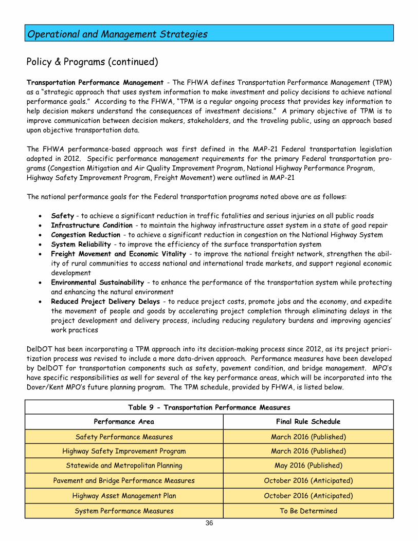
Policy & Programs (continued) Pursue Transportation Improvement Districts - DelDOT notes that a Transportation Improvement District (TID) is “a geographic area defined for the purpose of securing required improvements to transportation facili-ties in the area. TIDs comprehensively coordinate land use and transportation within a specific geographical area.” As noted in the publication Transportation Improvement Districts: A Guide for Delaware Local Governments, TID’s are a transportation-based impact fee that “equitably distributes the cost of development-related growth and infrastructure improvements to the private sector that benefits from the facilities.” Traditionally, individual developers prepare Traffic Impact Studies (TIS), which provided an analysis of the transportation impacts of singular developments. The TIS process has limitations (reactive, potential funding in-equity, tedious review process), so DelDOT has worked with local governments to establish TID’s in several areas throughout the state. In TID’s, a master transportation plan is initially prepared by the Department, which indi-cates the specific transportation improvements necessary to accommodate planned development. Funding formu-las are determined so that developers are aware upfront of the required infrastructure improvements and the cost associated with those improvements. In 2014, DelDOT and the City of Dover entered into an agreement establishing the first TID in Kent County. This TID consists of the following corridors: U.S. 13 (Scarborough Road to Puncheon Run Connector) Bay Road (U.S. 13 to Route 10)
DelDOT has completed the U.S. 13 traffic analysis based on existing land use scenarios. Land use projections, future traffic analysis, and developer funding formulas are anticipated to be completed as part of the ongoing TID effort. As Kent County updates its Comprehensive Plan (due in 2018), it is anticipated that the implementation of other TID’s will be examined. In its current 2008 Comprehensive Plan, 11 potential TID’s are identified. Continue expanding the ITMS Program - DelDOT’s Integrated Transportation Management System (ITMS) is a multi-faceted, statewide approach to using technology as a means to manage the entire transportation system in the most efficient manner possible. Given the fact that building new roads to address congestion is not as feasi-ble as it once was, the ITMS extends the life of the existing system and enhances its efficiency. There are a
number of techniques that DelDOT uses as part of the ITMS Program, some of which are described on page 25. In Kent County, an extensive traffic data collection ef- fort is anticipated as part of the proposal to initiate a statewide Congestion Management Process. This process will greatly assist in the prioritization of future projects. In addition, U.S. 13 from Smyrna to Camden has been identified by DelDOT as a high-priority Signal Improve- ment Corridor, which will likely lead to signalization en- hancements along this vital corridor in the coming years.
U.S. 13 Potential Development (Dover)
U.S. 13 (Camden)
Operational and Management Strategies
36
Policy & Programs (continued) Transportation Performance Management - The FHWA defines Transportation Performance Management (TPM) as a “strategic approach that uses system information to make investment and policy decisions to achieve national performance goals.” According to the FHWA, “TPM is a regular ongoing process that provides key information to help decision makers understand the consequences of investment decisions.” A primary objective of TPM is to improve communication between decision makers, stakeholders, and the traveling public, using an approach based upon objective transportation data. The FHWA performance-based approach was first defined in the MAP-21 Federal transportation legislation adopted in 2012. Specific performance management requirements for the primary Federal transportation pro-grams (Congestion Mitigation and Air Quality Improvement Program, National Highway Performance Program, Highway Safety Improvement Program, Freight Movement) were outlined in MAP-21 The national performance goals for the Federal transportation programs noted above are as follows:
Safety - to achieve a significant reduction in traffic fatalities and serious injuries on all public roads Infrastructure Condition - to maintain the highway infrastructure asset system in a state of good repair Congestion Reduction - to achieve a significant reduction in congestion on the National Highway System System Reliability - to improve the efficiency of the surface transportation system Freight Movement and Economic Vitality - to improve the national freight network, strengthen the abil-
ity of rural communities to access national and international trade markets, and support regional economic development
Environmental Sustainability - to enhance the performance of the transportation system while protecting and enhancing the natural environment
Reduced Project Delivery Delays - to reduce project costs, promote jobs and the economy, and expedite the movement of people and goods by accelerating project completion through eliminating delays in the project development and delivery process, including reducing regulatory burdens and improving agencies’ work practices
DelDOT has been incorporating a TPM approach into its decision-making process since 2012, as its project priori-tization process was revised to include a more data-driven approach. Performance measures have been developed by DelDOT for transportation components such as safety, pavement condition, and bridge management. MPO’s have specific responsibilities as well for several of the key performance areas, which will be incorporated into the Dover/Kent MPO’s future planning program. The TPM schedule, provided by FHWA, is listed below.
Table 9 - Transportation Performance Measures
Performance Area Final Rule Schedule
Safety Performance Measures March 2016 (Published)
Highway Safety Improvement Program March 2016 (Published)
Statewide and Metropolitan Planning May 2016 (Published)
Pavement and Bridge Performance Measures October 2016 (Anticipated)
Highway Asset Management Plan October 2016 (Anticipated)
System Performance Measures To Be Determined

Environmental Mitigation Activities
37
The Kent County Comprehensive Plan’s vision statement notes that the primary goal of the Plan is to preserve the rural character of the county, by protecting natural resources and preserving farmland This overall vision is re-flected as one of the key objectives of Goal 2 (Strengthen Communities) of the Metropolitan Transportation Plan, ensuring that the natural environment in the MPO region is protected and preserved. Transportation projects, particularly new highways and roadway widenings, can have significant impacts on the natural, historic, and cultural environments of the region. As a result, all transportation projects are reviewed by DelDOT’s Environmental Section, which regularly works in conjunction with Federal and State environmental regu-latory agencies to identify environmental resources, minimize potential adverse impacts, and develop mitigation plans. This review is done as part of the DelDOT project development process and is required as part of the Fed-eral National Environmental Policy Act (NEPA) process. Transportation improvements can also have one of the most profound impacts on land use and the subsequent conversion from non-developed land uses to developed land uses. New highways through undeveloped, rural areas can directly contribute to land use conversions by providing new access to properties and increasing development pressure on these properties. Roadway widening that provides additional highway capacity can also have the same effect in rural areas, facilitating additional traffic volumes and increasing the potential for property owners to sell undeveloped land for commercial or residential purposes. In addition to the DelDOT environmental review process that’s conducted on an individual project basis, there are several important environmental mitigation activities that are underway in the MPO region and should be continued as a means to preserve the area’s natural, historic, and cultural environments. State Strategies for Policies and Spending - As noted in the State Strategies for Policies and Spending, the State is discouraging local governments from ap-proving additional suburban development in Level 4 areas. These are generally the rural, undeveloped areas out-side of the County Growth Zone, where agriculture and preservation of natural resources is strongly encouraged. The Strategies note that the State will only fund transportation projects that “preserve and maintain existing facilities in safe working order”. System expansion projects, such as roadway widening, are not to be funded by the State in Level 4 areas. This strategy should be continued as a means to preserve the natural environment in the County’s rural areas, by discouraging suburban sprawl associated with highway expansions and eliminating the direct adverse impacts of transportation improvement projects. Table 10 shows that the vast majority of new development activity (in terms of building permits) has occurred in Level 1 and 2 areas, despite significantly less acreage in these areas.
Farmland Near Smyrna
Table 10 - Kent County Development Activity (2009 - 2014 Building Permits)
Investment Level
Residential
Non- Residential
Level 1 & 2 76.0% 92.0%
Level 3 4.5% 1.7%
Level 4 19.4% 6.3%
Source: Office of State Planning Coordination

Environmental Mitigation Activities
38
Complete Communities - The University of Delaware, in conjunction with the Office of State Planning Coordina-tion, DelDOT, and the Delaware Association of Realtors, has been active in promoting Complete Communities throughout the state. Complete Communities have five distinct characteristics:
Complete Streets
Efficient Land Use
Healthy and Livable
Inclusive and Active
Sustainable and Resilient The compact, mixed-use land development, combined with pedestrian and bike-friendly design features, serves several environmental benefits as well. Mixed-use, walkable communities have residents that rely less on their motor vehicles for daily trips, which could potentially lead to a reduction in vehicle miles traveled (VMT). This would lead to air quality benefits on a local level. In addition, Complete Communities are built to tie into existing infrastructure such as public sewer and water, which are generally located in developed areas such as Investment Level 1 or 2 areas. The MPO strongly encourages the continued development of Complete Communities in Kent County, from the standpoints of environmental preservation and promoting alternative transportation modes.
Agricultural Lands Preservation Program - The State of Delaware has one of the most successful agricul- tural lands preservation programs in the country, based on percent of farmland preserved. Since the program was initiated in 1996, Kent County has the highest num- ber of farms and the most farmland acreage perma- nently preserved in the state. As of October 2015, the state has purchased the development rights of 404 Kent County farms, for a total acreage of over 61,000 permanently preserved acres. This represents 53% of the preserved farmland acreage in the state. The MPO strongly supports the Department of Agriculture’s con- tinued efforts in preserving farmland and forestland throughout the county, particularly in Level 4 Invest- ment Level Areas. Farmland Near Dover
Bayard Plaza (Dover)
S.E. Front Street (Milford)

Environmental Mitigation Activities
39
Climate Change and Sea Level Rise - An important component of a long range plan is an assessment of capital investment and the development of strategies to preserve the existing and future transportation system and re-duce the vulnerability of the transportation infrastructure to natural disasters. The State of Delaware has been very proactive in recognizing the potential impacts of natural disasters on a wide variety of infrastructure, par-ticularly as it pertains to the effects of flooding related to climate change and sea level rise. DNREC has been working on assessing the potential impacts of sea level rise in Delaware since the early 2000’s. Three reports have been written that describe the potential impacts on existing and future resources, and offer a myriad of recommendations for adapting to sea level rise: Sea Level Rise Vulnerability Assessment (July 2012) - The Assessment provides a detailed evaluation of the po-tential impacts of sea level rise on a variety of natural and man-made resources, based on different sea level rise scenarios. Based on a 1.5-meter sea level rise scenario, up to 3% of the roads and 7% of the evacuation routes in the county could be inundated, while 11% of the land in the state could be lost to rising sea levels by 2100. Recommendations for Adapting to Sea Level Rise in Delaware (October 2013) - This report documents 55 recom-mendations that are critical for Delawareans to implement as the state adapts to rising sea levels. The recom-mendations focused on 5 broad areas: improving governmental communication and coordination, providing in-creased regulatory flexibility, providing consistent policies for future investment, increasing public awareness of sea level rise, and improving the availability of data. Interim Implementation Plan - (September 2014) - The Plan provides a variety of specific recommendations relat-ing to land use, transportation and infrastructure, water resources, and natural habitats. Regarding transporta-tion, the plan provides recommendations such as: Incorporating sea level rise into regional planning efforts Including sea level rise in DelDOT design manuals Developing a statewide infrastructure retreat policy Gathering additional data to plan future investments Developing costs for adaption options Several of the region’s coastal communities have experienced the impacts of flooding, particularly the towns of Bowers, Little Creek, and Frederica. DNREC has been working with Bowers to develop a Coastal Resiliency Action Plan, to protect the town from the impacts of rising sea levels and associated coastal flooding that frequently affects homes, businesses, and roads within the area. In 2015, the Town of Frederica became the first town in Delaware to include the impacts of sea level rise into their Comprehensive Plan. The Town of Little Creek is also including sea level rise impacts into their 2016 Comprehensive Plan update. Hubbard Avenue (Bowers)
Route 9 (East of Smyrna)

Air Quality Conformity Analysis
40
The 1990 federal Clean Air Act Amendments (CAAA) require MPO’s within air quality nonattainment areas to per-form air quality conformity determinations prior to the approval of Long-Range Transportation Plans. A nonattain-ment area is a region that the United States Environmental Protection Agency (EPA) has designated as not meet-ing certain air quality standards.
A conformity determination is a demonstration that an MPO’s plans, programs, and projects are consistent with the State Implementation Plan (SIP) for attaining federal air quality standards. The SIP is developed by DNREC, and provides the air quality “budget” for the region. The federal CAAA requirement to perform a conformity de-termination ensures that the federal government approves and funds only those transportation activities that are consistent with air quality goals. This requirement is set forth in federal regulations (40 CFR Part 93). Kent County is part of the Philadelphia-Wilmington-Trenton non-attainment area, though it is currently consid-ered to be in attainment based on recent air quality data. The MPO region, however, includes the portion of Smyrna in New Castle County and the portion of Milford in Sussex County, both of which are considered non-attainment counties. One of the most important considerations regarding air quality conformity is to evaluate the effect of regionally-significant, non-exempt projects on the area’s air quality. An example of a project that’s considered to be region-ally-significant and non-exempt is the West Dover Connector. As noted in the MPO’s FY 2016-2019 TIP, a statewide conformity working group determined in 2015 that no re-gionally-significant, non-exempt projects have been added to the MPO’s program. As such, the previous regional emissions analysis conducted for the 2013 MTP remain valid. An EPA publication, Guidance for the Use of Latest Planning Assumptions in the Transportation Conformity Determination, confirms that “MPO’s can rely on a previ-ous emissions analysis if the requirements of 40 CFR 93.122 (g) are met (no regionally significant projects have changed, no more than 4 years have elapsed since the last regional emissions analysis).” As displayed on Figure 8 and Figure 9, transportation emissions for nitrogen oxides (NOx) and volatile organic compounds (VOC) are forecasted to be reduced by about 52% by 2040, when compared with 2012 emissions. The EPA website notes that the “Clean Air Act required the EPA to issue rules to reduce pollution from vehicle ex-haust, refueling emissions and evaporating gasoline. As a result, emissions from a new car purchased today are well over 90 percent cleaner than a new vehicle purchased in 1970. These reductions would not be possible without cleaner, very low sulfur gasoline and diesel fuel. In addition to their direct emissions benefits, cleaner fuels en-able sophisticated emission control devices to effectively control pollution.”
In 2015, DNREC initiated the Delaware Clean Transportation Incentive Program. As noted on the DNREC web site, the Program’s goals are “to promote deployment, wider use and acceptance of clean-alternative fuel vehicles, and to boost investment in clean transporta-tion fuel infrastructure.” The Clean Transportation Incentive Pro-gram has five components: Electric Vehicle Charging Equipment Rebate Program, Heavy-Duty Vehicle Rebate Program, Clean Vehicle Rebate Program, Alternative Fueling Infrastructure Grants, and Innovative Transportation Greenhouse Gas Reduction Grants. As of 2016, the Program had nearly $3 million available to provide incentives for residents and businesses to participate in clean transportation initiatives.
Alternative Fueling Station

Air Quality Conformity Analysis
41
f y
4000
3500
3000
2500
2000
1500
1000
500
0
2640
1082
Kent County – Annual NOx Tons/Year
12531370
P db D lDOT Pl i / WRA 11 7 12
2012 2020 2030 2040
f y
1061
Kent County – Annual VOC Tons/Year
P db D lDOT Pl i / WRA 11 7 12
1600
1400
1200
1000
1200
1000
800
600
400
200
0
518477
621
2012 2020 2030 2040
Figure 8 - Projected Nitrogen Oxide Emissions
Figure 9 - Projected Volatile Organic Compound Oxide Emissions

Financial Investment Plan
42
Based on a review of the CTP from FY 2011 through FY 2015, approximately 8.0% of the total transportation funding expended in Delaware was allocated to Kent County projects during that period of time. When the State-wide Programs (which include projects such as Paving and Rehabilitation, Transportation Alternatives Program, and Bicycle and Pedestrian Improvements) are factored in to include the Kent County expenditures, the MPO region is allocated about 10.1% of the total transportation funds in the state. The graphic in Figure 10 below summarizes the 5-year total expenditures by county.
Transportation financial forecasts are dependent upon a variety of factors, including gas tax receipts, fuel effi-ciency, vehicle miles traveled, and the general economic status of the State. Based on a decline in per capita gas consumption (spurred by increased vehicular fuel efficiency and a general reduction in vehicle miles traveled), gasoline taxes have not provided the funds required to provide for identified transportation projects. This has led to a backlog of transportation projects that have either been delayed or shelved. In 2015, the General As-sembly approved a DelDOT proposal to increase revenues, primarily through increased Division of Motor Vehicle fees, without raising the gas tax. This proposal was expected to bring in an additional $24 million annually, to provide direct funds for transportation infrastructure projects. As part of the revenue increase package approved in 2015, the Department also shifted operational costs, in-creased oversize permit fees, and increased its borrowing to accrue an additional $31 million annually. This reve-nue increase enabled some project phases that were previously delayed (such as the right-of-way acquisition for the proposed Route 1/N.E. Front Street grade-separated intersection) to become active.
New Castle County Statewide Programs Sussex County Kent County Joint Kent & Sussex
Figure 10 - Total DelDOT Expenditures By County (FY 2011 - FY 2015)
Source: DelDOT Finance
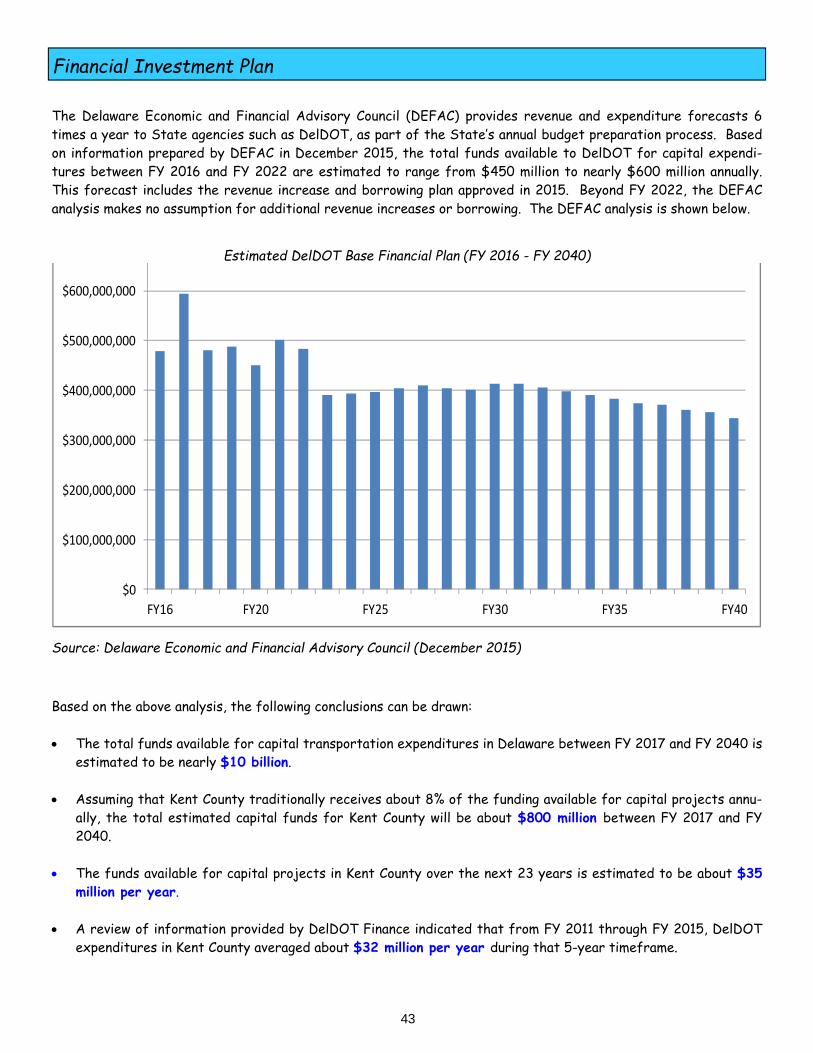
Financial Investment Plan
43
The Delaware Economic and Financial Advisory Council (DEFAC) provides revenue and expenditure forecasts 6 times a year to State agencies such as DelDOT, as part of the State’s annual budget preparation process. Based on information prepared by DEFAC in December 2015, the total funds available to DelDOT for capital expendi-tures between FY 2016 and FY 2022 are estimated to range from $450 million to nearly $600 million annually. This forecast includes the revenue increase and borrowing plan approved in 2015. Beyond FY 2022, the DEFAC analysis makes no assumption for additional revenue increases or borrowing. The DEFAC analysis is shown below.
Based on the above analysis, the following conclusions can be drawn: The total funds available for capital transportation expenditures in Delaware between FY 2017 and FY 2040 is
estimated to be nearly $10 billion. Assuming that Kent County traditionally receives about 8% of the funding available for capital projects annu-
ally, the total estimated capital funds for Kent County will be about $800 million between FY 2017 and FY 2040.
The funds available for capital projects in Kent County over the next 23 years is estimated to be about $35
million per year. A review of information provided by DelDOT Finance indicated that from FY 2011 through FY 2015, DelDOT
expenditures in Kent County averaged about $32 million per year during that 5-year timeframe.
Estimated DelDOT Base Financial Plan (FY 2016 - FY 2040)
Source: Delaware Economic and Financial Advisory Council (December 2015)
$0
$100,000,000
$200,000,000
$300,000,000
$400,000,000
$500,000,000
$600,000,000
FY16 FY20 FY25 FY30 FY35 FY40
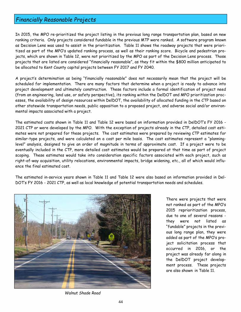
Financially Reasonable Projects
44
In 2015, the MPO re-prioritized the project listing in the previous long range transportation plan, based on new ranking criteria. Only projects considered fundable in the previous MTP were ranked. A software program known as Decision Lens was used to assist in the prioritization. Table 11 shows the roadway projects that were priori-tized as part of the MPO’s updated ranking process, as well as their ranking score. Bicycle and pedestrian pro-jects, which are shown in Table 12, were not prioritized by the MPO as part of the Decision Lens process. Those projects that are listed are considered “financially reasonable”, as they fit within the $800 million anticipated to be allocated to Kent County capital projects between FY 2017 and FY 2040. A project’s determination as being “financially reasonable” does not necessarily mean that the project will be scheduled for implementation. There are many factors that determine when a project is ready to advance into project development and ultimately construction. These factors include a formal identification of project need (from an engineering, land use, or safety perspective), its ranking within the DelDOT and MPO prioritization proc-esses, the availability of design resources within DelDOT, the availability of allocated funding in the CTP based on other statewide transportation needs, public opposition to a proposed project, and adverse social and/or environ-mental impacts associated with a project. The estimated costs shown in Table 11 and Table 12 were based on information provided in DelDOT’s FY 2016 - 2021 CTP or were developed by the MPO. With the exception of projects already in the CTP, detailed cost esti-mates were not prepared for these projects. The cost estimates were prepared by reviewing CTP estimates for similar-type projects, and were calculated on a cost per mile basis. The cost estimates represent a “planning-level” analysis, designed to give an order of magnitude in terms of approximate cost. If a project were to be eventually included in the CTP, more detailed cost estimates would be prepared at that time as part of project scoping. These estimates would take into consideration specific factors associated with each project, such as right-of-way acquisition, utility relocations, environmental impacts, bridge widening, etc., all of which would influ-ence the final estimated cost. The estimated in-service years shown in Table 11 and Table 12 were also based on information provided in Del-DOT’s FY 2016 - 2021 CTP, as well as local knowledge of potential transportation needs and schedules.
There were projects that were not ranked as part of the MPO’s 2015 reprioritization process, due to one of several reasons - they were not listed as “fundable” projects in the previ- ous long range plan, they were added as part of the MPO’s pro- ject solicitation process that occurred in 2016, or the project was already far along in the DelDOT project develop- ment process. These projects are also shown in Table 11.
Walnut Shade Road

Financially Reasonable Projects (Roadway)
45
Table 11 - Financially Reasonable Projects (Roadway)
Map #
Project
Limits
Description
Est. Cost
Score
In Service
1 Crawford Carroll Road Extension
West Rustic Lane to U.S. 13
Extend existing service road
$3.6 M 0.875 Mid Term
2 Camden Bypass Rising Sun Road to South Street
New roadway south side of Camden
$13.2 M 0.863 Mid Term
3
Front Street
Rehoboth Boulevard
to Route 1
Upgrade to functional classification, add bike/ped facilities
$3.0 M
0.855
Long Term
4
Kenton Road
Chestnut Grove Road
to Route 8
Upgrade to functional classification, add bike/ped facilities
$5.3 M
0.813
Mid Term
5 Loockerman Street/Forest Street
Loockerman Street to Division Street
Streetscape & roundabout
$4.1 M 0.803 Near Term
6
Walnut Shade Road
Peachtree Run
to U.S. 13
Upgrade to functional classification, add bike/ped facilities
$11.9 M
0.768
Mid Term
7 Route 1/ N.E. Front Street
Intersection Grade-separated intersection
$16.0 M 0.762 Near Term
8
U.S. 13 Collector Road and Scarborough Road/ Route 1 interchange
realignment
Scarborough Road to Leipsic Road
New collector road east of Dover Downs/
Dover Mall. New Scarborough Road/Route 1 interchange
$20.0 M
0.749
Long Term
9
Canterbury Road
Andrews Lake Road
to U.S. 13
Upgrade to functional classification, add bike/ped facilities
$6.0 M
0.740
Long Term
10
Hazlettville Road/Route 8 Connector
Hazlettville Road
to Route 8
New north-south connection near
high school
$4.5 M
0.738
Long Term
11 Camden Bypass North Street Extended to Route 10
New alignment south side of Camden
$4.4 M 0.735 Long Term
12 South State Street Intersections
Route 1 to U.S. 13
Improvements at 8 intersections
$8.0 M 0.735 Long Term
13 Duck Creek Parkway
Bassett Street to Main Street
Add bike/ped facilities
$5.0 M 0.731 Long Term
Mid Term: 2022 - 2030 Long Term: 2031 - 2040 Near Term: 2017 - 2021

Financially Reasonable Projects (Roadway)
46
Table 11 - Financially Reasonable Projects (Roadway)
Map #
Project
Limits
Description
Est. Cost
Score
In Service
14 West Street Queen Street to North Street
Add bike/ped facilities
$1.3 M 0.728 Mid Term
15
Garrison Oak Connector Road
White Oak Road to Route 8
Provide new road to technology park
$4.0 M 0.715 Mid Term
16 Greentree Connector Road
Independence Blvd. to Kenton Road
Provide a new east-west connection
$2.0 M 0.701 Long Term
17
Route 8
Interconnections
Various locations
Provide local connections
outlined in the Route 8 Operations Study
$11.0 M
0.679
Long Term
18
Barratts Chapel
Road
McGinnis Pond Road
to Route 1
Upgrade to functional classification, add bike/ped facilities
$35.0 M
0.661
Long Term
19
Irish Hill Road
South State Street
to U.S. 13
Upgrade to functional classification, add bike/ped facilities
$30.0 M
0.623
Long Term
20 Lepore Road Realignment
U.S. 13 to Jefferic Boulevard
Roadway realignment $9.5 M 0.613 Long Term
21 Route 10/ Route 15
Intersection Install a roundabout
$1.0 M N/A Near Term
22 Route 14/ Killens Pond Road
Intersection Safety improvements
$0.3 M N/A Near Term
23 U.S. 13 Widening Puncheon Run to Lochmeath Way
Add a third through lane
$72.5 M N/A Mid Term
24 U.S. 13 Widening Lochmeath Way to Walnut Shade Road
Add a third through lane
$17.5 M N/A Mid Term
25 Saulsbury Road/ Route 8
Intersection Add 2nd through lane on Saulsbury Road
$11.0 M N/A Mid Term
26 Bowers Beach Road Town of Bowers to Route 1
Provide continuous shoulders
$10.0 M N/A Mid Term
Near Term: 2017 - 2021 Mid Term: 2022 - 2030 Long Term: 2031 - 2040
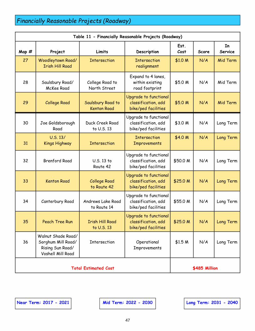
Financially Reasonable Projects (Roadway)
47
Table 11 - Financially Reasonable Projects (Roadway)
Map #
Project
Limits
Description
Est. Cost
Score
In Service
27 Woodleytown Road/ Irish Hill Road
Intersection Intersection realignment
$1.0 M N/A Mid Term
28
Saulsbury Road/
McKee Road
College Road to North Street
Expand to 4 lanes, within existing road footprint
$5.0 M
N/A
Mid Term
29
College Road
Saulsbury Road to
Kenton Road
Upgrade to functional classification, add bike/ped facilities
$5.0 M
N/A
Mid Term
30
Joe Goldsborough
Road
Duck Creek Road
to U.S. 13
Upgrade to functional classification, add bike/ped facilities
$3.0 M
N/A
Long Term
31
U.S. 13/ Kings Highway
Intersection
Intersection Improvements
$4.0 M N/A Long Term
32
Brenford Road
U.S. 13 to Route 42
Upgrade to functional classification, add bike/ped facilities
$50.0 M
N/A
Long Term
33
Kenton Road
College Road to Route 42
Upgrade to functional classification, add bike/ped facilities
$25.0 M
N/A
Long Term
34
Canterbury Road
Andrews Lake Road
to Route 14
Upgrade to functional classification, add bike/ped facilities
$55.0 M
N/A
Long Term
35
Peach Tree Run
Irish Hill Road
to U.S. 13
Upgrade to functional classification, add bike/ped facilities
$25.0 M
N/A
Long Term
36
Walnut Shade Road/Sorghum Mill Road/
Rising Sun Road/ Voshell Mill Road
Intersection
Operational
Improvements
$1.5 M
N/A
Long Term
Total Estimated Cost
$485 Million
Near Term: 2017 - 2021 Long Term: 2031 - 2040 Mid Term: 2022 - 2030

Financially Reasonable Projects (Bike, Pedestrian, Transit)
48
Near Term: 2017 - 2021 Mid Term: 2022 - 2030 Long Term: 2031 - 2040
Table 12 - Financially Reasonable Projects (Bicycle, Pedestrian, and Transit Facilities)
Map #
Project
Limits
Description
Est. Cost
In Service
1 U.S. 13 Sidewalks (Dover)
Townsend Boulevard to Leipsic Road
Fill in sidewalk gaps
$1.0 M Near Term
2 Route 8 Sidewalks Dover High School to Mifflin Road
Add sidewalks (south side)
$0.5 M Near Term
3
Senator Bikeway
Dover High School
to U.S. 13
Provide an improved bike facility using on-
road and off-road facilities
$3.5 M
Near Term
4 Hunn Property Bike Trail
Route 10 to Hunn Property
New bike trail $0.5 M Near Term
5 South Little Creek Road Sidewalks
Babb Drive to School View
Fill in sidewalk gaps $0.3 M Near Term
6 U.S. 13 Sidewalks (Smyrna)
Duck Creek to Route 1
Fill in sidewalk gaps in priority areas
$8.5 M Mid Term
7
Route 10 Trail
Gateway South Shopping Center to
Brecknock Park
Provide new off-
route bike facility
$7.5 M
Mid Term
8 U.S. 13 Sidewalks (Dover)
Leipsic Road to Rustic Lane
Fill in sidewalk gaps $2.0 M
Mid Term
9
New Burton Road
Kesselring Avenue to Kent County
Recreational Center
Provide continuous shoulders or a bike trail
$1.5 M
Mid Term
10
Big Oak Park
Bike Trail
Smyrna to Big
Oak Park
New bike trail from downtown to Big Oak Park
$3.0 M
Long Term
11
Walker Road
State Street to Saulsbury Road
Provide improved conditions for
bicyclists
$1.5 M
Long Term
12
Mifflin Road
Sidewalks
Hazlettville Road
to Route 8
Add sidewalks along both sides of
the road
$2.5 M
Long Term

Financially Reasonable Projects (Bike, Pedestrian, Transit)
49
Near Term: 2017 - 2021 Mid Term: 2022 - 2030 Long Term: 2031 - 2040
Table 12 - Financially Reasonable Projects (Bicycle, Pedestrian, and Transit Facilities)
Map #
Project
Limits
Description
Est. Cost
In Service
13
North State Street
Walker Road to
U.S. 13
Provide improved conditions for
bicyclists
$4.5 M
Long Term
14
South Little Creek Road
U.S. 13 to Babb Drive
Provide improved conditions for
bicyclists
$1.0 M
Long Term
15
Dover Transit
Center
Water Street/ West Street
Construct new facility on
existing transit hub
$8.5 M
Long Term
Total Estimated Cost
$47 Million
As noted in Table 11, the total estimated cost of the financially reasonable capital roadway projects in Kent County is approximately $485 million. The total estimated cost of the financially reasonable bicycle, pedestrian, and transit facility projects in Kent County is approximately $47 million, as noted in Table 12. The total estimated cost of all of the capital projects considered to be financially reasonable at this time is $532 million, which is lower than the estimated $800 million anticipated to be available for Kent County transportation projects between FY 2017 and FY 2040. This figure is for capital projects only, and does not include funding allo-cated for Statewide programs such as the Bridge Preservation Program, the Pavement and Rehabilitation Program, and the Community Transportation Program. Kent County receives an apportionment of funding from each of the numerous Statewide programs within DelDOT’s budget. Roadway projects that are considered financially reasonable are shown in Figure 11, while the financially reason-able bicycle, pedestrian, and transit facility projects are displayed in Figure 12.
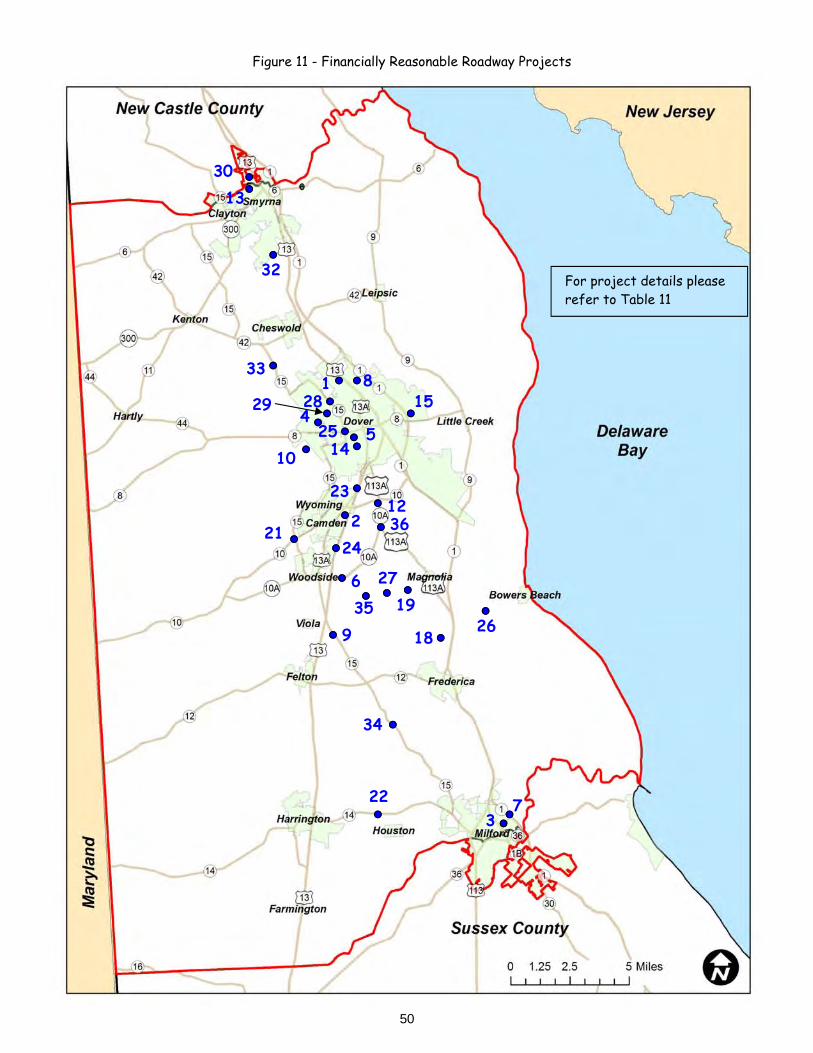
50
Figure 11 - Financially Reasonable Roadway Projects
For project details please refer to Table 11
1
2
3 7
4 5
6
8
9
10
12
13
14
15
18
27
21
22
23
24
25
19
28 29
30
32
33
34
35
36
26

51
Figure 12 - Financially Reasonable Bicycle, Pedestrian, and Transit Projects
1 2
3
4
5
6
7
8
10
11
9
12 14 15
For project details please refer to Table 12

Route 8 Near Dover High School
Potential Planning Studies
52
Table 13 - Recommended Planning/Project Development Studies
Project Limits Source
Route 8 Dover to Maryland Line Central Delaware Chamber of Commerce
U.S. 13 Dover to New Castle County Line
Central Delaware Chamber of Commerce
Duck Creek Parkway Bassett Street to Main Street
Central Delaware Chamber of Commerce
North Main Street (Smyrna)
Duck Creek Parkway to Commerce Street
Central Delaware Chamber of Commerce
Paddock Road Route 1 to U.S. 13 Central Delaware Chamber of Commerce
Route 6/Route 300 Intersection Central Delaware Chamber of Commerce
In addition to providing a listing of the projects that could potentially be funded over the next 20+ years, this Plan describes the need to conduct planning studies at various locations throughout the MPO region. These areas have a transportation need that has been identified by an economic development proponent (the Central Delaware Chamber of Commerce), as well as by the MPO. Planning studies would be required to identify the transportation need, to determine potential solutions, and rec-ommend a preferred alternative, all within the context of a comprehensive public involvement effort.
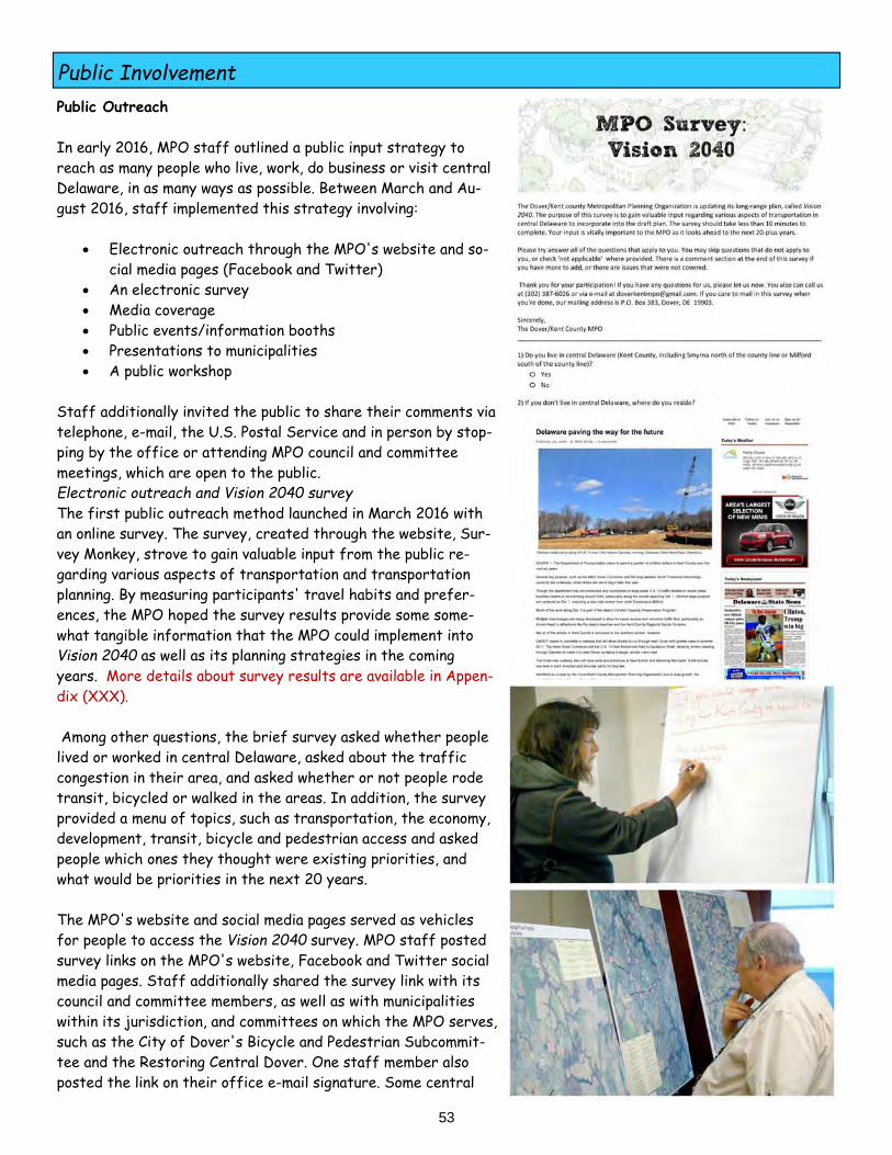
Public Involvement
53
Public Outreach In early 2016, MPO staff outlined a public input strategy to reach as many people who live, work, do business or visit central Delaware, in as many ways as possible. Between March and Au-gust 2016, staff implemented this strategy involving:
Electronic outreach through the MPO's website and so-cial media pages (Facebook and Twitter)
An electronic survey Media coverage Public events/information booths Presentations to municipalities A public workshop
Staff additionally invited the public to share their comments via telephone, e-mail, the U.S. Postal Service and in person by stop-ping by the office or attending MPO council and committee meetings, which are open to the public. Electronic outreach and Vision 2040 survey The first public outreach method launched in March 2016 with an online survey. The survey, created through the website, Sur-vey Monkey, strove to gain valuable input from the public re-garding various aspects of transportation and transportation planning. By measuring participants' travel habits and prefer-ences, the MPO hoped the survey results provide some some-what tangible information that the MPO could implement into Vision 2040 as well as its planning strategies in the coming years. More details about survey results are available in Appen-dix (XXX). Among other questions, the brief survey asked whether people lived or worked in central Delaware, asked about the traffic congestion in their area, and asked whether or not people rode transit, bicycled or walked in the areas. In addition, the survey provided a menu of topics, such as transportation, the economy, development, transit, bicycle and pedestrian access and asked people which ones they thought were existing priorities, and what would be priorities in the next 20 years. The MPO's website and social media pages served as vehicles for people to access the Vision 2040 survey. MPO staff posted survey links on the MPO's website, Facebook and Twitter social media pages. Staff additionally shared the survey link with its council and committee members, as well as with municipalities within its jurisdiction, and committees on which the MPO serves, such as the City of Dover's Bicycle and Pedestrian Subcommit-tee and the Restoring Central Dover. One staff member also posted the link on their office e-mail signature. Some central
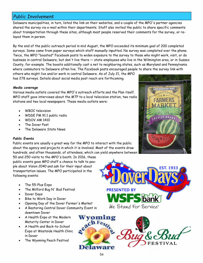
Public Involvement
54
Delaware municipalities, in turn, listed the link on their websites, and a couple of the MPO's partner agencies shared the survey via e-mail within their departments. Staff also invited the public to share specific comments about transportation through these sites, although most people reserved their comments for the survey, or re-layed them in person. By the end of the public outreach period in mid August, the MPO exceeded its minimum goal of 200 completed surveys. Some came from paper surveys which staff manually inputted. No survey was completed over the phone. Twice, the MPO "boosted" Facebook posts to widen exposure to the survey to those who might work, visit, or do business in central Delaware, but don't live there — state employees who live in the Wilmington area, or in Sussex County, for example. The boosts additionally cast a net to neighboring states, such as Maryland and Pennsylvania where commuters to Delaware often live. The Facebook posts encouraged people to share the survey link with others who might live and/or work in central Delaware. As of July 21, the MPO has 278 surveys. Details about social media post reach are forthcoming. Media coverage Various media outlets covered the MPO's outreach efforts and the Plan itself. MPO staff gave interviews about the MTP to a local television station, two radio stations and two local newspapers. These media outlets were:
WBOC television WDDE FM 91.1 public radio WDOV AM 1410 The Dover Post The Delaware State News
Public Events Public events are usually a great way for the MPO to interact with the public about the agency and projects in which it is involved. Most of the events draw hundreds, and often thousands, of attendees, which can yield anywhere between 50 and 250 visits to the MPO's booth. In 2016, these public events gave MPO staff a chance to talk to peo-ple about Vision 2040 and ask for their input about transportation issues. The MPO participated in the following events:
The 55-Plus Expo The Milford Bug N' Bud Festival Dover Days Bike to Work Day in Dover Opening Day of the Dover Farmer's Market A Restoring Central Dover Community Event in
downtown Dover A Health Expo at the Modern
Maturity Center in Dover A Health and Back-to-School
Expo at Westside Health Clinic in Dover
The Wyoming Peach Festival

Public Involvement
55
Staff had paper copies of the Vision 2040 survey available, along with paper comment sheets and index cards bearing the MPO's website address and telephone number. People could take the survey or fill out a comment sheet and turn it in at the booth, or take the items home and mail them to the office. The index cards offered people the option to take the survey later online, or call the office to take the survey or provide comments over the phone. MPO staff brought these items along during the MPO's Transportation Improvement Program bus tour, held on April 20. At the 55-Plus Expo, held April 12, and the June 8 public workshop, the MPO had a laptop computer available for people to take the survey online, or to record verbal comments about transportation issues. Presentations and public workshop In early 2016, the MPO sent a letter to all municipalities within its jurisdiction to let them know that the agency would be looking for public input for the long-term plan, and that staff would be available to give presentations to any municipality that wanted to know more about the plan. Hoping to at least hit the larger municipalities, and county government, staff made appointments to give presentations during their regular meetings. Between March and June 2016, staff gave presentations to:
The City of Milford The Town of Smyrna Kent County Levy Court The Town of Camden The Town of Bowers Beach The City of Dover The City of Harrington The Town of Wyoming
Presentations hit the highlights of the MTP, included information about the federal transportation bill, Fixing America's Surface Transportation Act (FAST), and included information as to how people could give their input to the MPO. Staff collected transportation-related comments and requests from municipal officials and audience members directly after the presentations. On June 8, the MPO held a public workshop from 4-7 p.m. at the Dover Public Library. Nearly 20 people attended the event, which featured, maps, information boards about the MTP and upcoming transportation projects, as well as information about the survey, and paper flip charts on which people could write comments.

MPO Council MPO Staff Bradley Eaby, Chairman Rich Vetter, P.E., ACIP Kent County Levy Court Commissioner Executive Director Robin Christiansen James Galvin, AICP Mayor, City of Dover Principal Planner Justin King Kate Layton Mayor, Town of Camden Outreach Manager Terry Pepper Catherine Samardza Department of Safety and Homeland Security Executive Secretary (Governor’s Representative) Drew Boyce, P.E. Director of Planning Delaware Department of Transportation John Sisson Executive Director Delaware Transit Corporation Endorsed by the Technical Advisory Committee on December ??, 2016. Endorsed by the Public Advisory Committee on December ??, 2016. Adopted by the MPO Council on January ??, 2017 The preparation of this document was financed in part with funds provided by the Federal Government, including the Federal Transit Administration and the Federal Highway Administration of the United States Department of Transportation.
Acknowledgements
56


Dover/Kent County Metropolitan Planning Organization
2040 Metropolitan Transportation Plan
www.doverkentmpo.org
1783 Friends Way Camden, DE 19934
302-387-6030