Embed Size (px)
Citation preview

DOE/EIS-0485 Final Environmental Impact Statement Interconnection of the Grande Prairie Wind Farm Holt County, Nebraska December 2014


COVER SHEET
LEAD FEDERAL AGENCY: U.S. Department of Energy (DOE), Western Area Power Administration (Western)
TITLE: Interconnection of the Grande Prairie Wind Farm, Holt County, Nebraska, DOE/EIS‐0485
CONTACT: For additional information on this Final Environmental Impact Statement (FEIS), contact: Matt Marsh Environmental Protection Specialist Western Area Power Administration Upper Great Plains Region 2900 4th Avenue North P.O. Box 35800 Billings, MT 59107-5800 Telephone: 406-255-2811 E-mail: [email protected]
For additional information on DOE National Environmental Policy Act (NEPA) activities, contact: Carol Borgstrom Director of NEPA Policy and Compliance U.S. Department of Energy 1000 Independence Avenue SW Washington, DC 20585 Telephone: (800) 472-2756 DOE NEPA Web Site: http://energy.gov/ nepa/office-nepa-policy-and-compliance
ABSTRACT: Grande Prairie Wind, LLC (Grande Prairie Wind), a majority-owned subsidiary of Geronimo Wind Energy, LLC d/b/a Geronimo Energy1, is proposing to construct a commercial, utility‐scale wind energy generation facility near O’Neill, Nebraska, in Holt County. At full build‐out, the Grande Prairie Wind Farm (Project) would include up to 266 wind turbines with a combined generating capacity of up to 400 megawatts (MW) of renewable energy. Other proposed Project facilities would include access roads, temporary crane paths, underground power collection lines, aboveground generation-tie (gen-tie) line, two collector substations, one interconnection switchyard, six or more permanent meteorological towers, temporary meteorological towers, and an operations and maintenance building. Grande Prairie Wind has applied to Western to interconnect the proposed Project to Western’s 345-kilovolt (kV) Fort Thompson to Grand Island transmission line at a new switchyard. The Final Environmental Impact Statement (FEIS) includes a description of Western’s proposed Federal action and an analysis of environmental effects that would occur as a result of proposed Project alternatives, including a No Action alternative.
Following issuance of this FEIS, Western will publish the Record of Decision (ROD) documenting its decision on whether to issue the interconnection agreement no earlier than 30 days after the FEIS is published
1 Midwest Wind Energy previously owned Grande Prairie Wind and made the original interconnection requests on August 22, 2007 (0117) and September 26, 2007 (0718) now being considered as a single request.
Grande Prairie Wind Farm Final Environmental Impact Statement

This page intentionally left blank.
Grande Prairie Wind Farm Final Environmental Impact Statement

TABLE OF CONTENTS
Executive Summary ........................................................................................................................ 1
ES.1 Introduction ..................................................................................................................... 1
ES.2 Purpose and Need for Agency Action ............................................................................ 1
ES.2.1 Western’s Purpose and Need ................................................................................. 1
ES.2.2 Applicant’s Purpose and Need .............................................................................. 1
ES.3 Proposed Action and Alternatives .................................................................................. 5
ES.3.1 Western’s Proposed Action ................................................................................... 5
ES.3.2 Grande Prairie Wind’s Proposed Action ............................................................... 5
ES.3.3 No Action Alternative ......................................................................................... 11
ES.4 Public Involvement, Consultation, and Coordination ................................................... 11
ES.4.1 Public Scoping..................................................................................................... 12
ES.4.2 Public Hearing ..................................................................................................... 13
ES.5 Comparison of Effects to Resources for Project Alternatives ...................................... 13
Chapter 1 Project Overview and Background ........................................................................ 1-1
1.1 Introduction .................................................................................................................. 1-1
1.2 Project Summary .......................................................................................................... 1-1
1.3 Purpose and Need for Agency Action ......................................................................... 1-5
1.4 Grande Prairie Wind’s Purpose and Need ................................................................... 1-5
1.5 Regulatory and Legal Framework ............................................................................... 1-5
1.5.1 Federal and State Statutes and Regulations ........................................................... 1-5
1.5.2 County Regulations ................................................................................................ 1-8
1.5.3 Consultation and Regulatory Compliance History .............................................. 1-10
1.6 Scoping ...................................................................................................................... 1-11
1.6.1 Issues Raised During 2012 Public Scoping Period .............................................. 1-12
1.7 Draft EIS Public Review ............................................................................................ 1-13
Chapter 2 Proposed Action and Alternatives ....................................................................... 2-15
2.1 Western's Proposed Federal Action (Preferred Alternative) ...................................... 2-15
2.2 Grande Prairie Wind’s Proposed Action.................................................................... 2-15
2.2.1 Project Components ............................................................................................. 2-15
2.2.2 Construction ......................................................................................................... 2-24
2.2.3 Operations and Maintenance ................................................................................ 2-25
2.2.4 Decommissioning ................................................................................................ 2-26
2.3 No Action Alternative ................................................................................................ 2-27
Grande Prairie Wind Farm Final Environmental Impact Statement i

Chapter 3 Affected Environment .......................................................................................... 3-29
3.1 Geology and Topography .......................................................................................... 3-29
3.1.1 Scope of Analysis ................................................................................................ 3-29
3.1.2 Existing Conditions .............................................................................................. 3-29
3.2 Soils............................................................................................................................ 3-30
3.2.1 Scope of Analysis ................................................................................................ 3-30
3.2.2 Existing Conditions .............................................................................................. 3-30
3.3 Surface Water and Groundwater ................................................................................ 3-31
3.3.1 Scope of Analysis ................................................................................................ 3-31
3.3.2 Existing Conditions .............................................................................................. 3-31
3.4 Air Quality and Climate ............................................................................................. 3-32
3.4.1 Scope of Analysis ................................................................................................ 3-32
3.4.2 Existing Conditions .............................................................................................. 3-32
3.4.3 Greenhouse Gases ................................................................................................ 3-33
3.5 Vegetation .................................................................................................................. 3-34
3.5.1 Scope of Analysis ................................................................................................ 3-34
3.5.2 Existing Conditions .............................................................................................. 3-34
3.6 Wetlands .................................................................................................................... 3-39
3.6.1 Scope of Analysis ................................................................................................ 3-39
3.6.2 Existing Conditions .............................................................................................. 3-39
3.7 Wildlife ...................................................................................................................... 3-40
3.7.1 Scope of Analysis ................................................................................................ 3-40
3.7.2 Existing Conditions .............................................................................................. 3-41
3.8 Threatened and Endangered Species ......................................................................... 3-50
3.8.1 Scope of Analysis ................................................................................................ 3-50
3.8.2 Existing Conditions .............................................................................................. 3-51
3.9 Cultural and Historic Resources ................................................................................ 3-72
3.9.1 Scope of Analysis ................................................................................................ 3-72
3.9.2 Existing Conditions .............................................................................................. 3-72
3.10 Land Use .................................................................................................................... 3-74
3.10.1 Scope of Analysis ................................................................................................ 3-74
3.10.2 Existing Conditions .............................................................................................. 3-74
3.11 Visual Resources ........................................................................................................ 3-79
3.11.1 Scope of Analysis ................................................................................................ 3-79
Grande Prairie Wind Farm Final Environmental Impact Statement ii

3.11.2 Existing Conditions .............................................................................................. 3-79
3.12 Noise .......................................................................................................................... 3-80
3.12.1 Scope of Analysis ................................................................................................ 3-80
3.12.2 Existing Conditions .............................................................................................. 3-80
3.13 Socioeconomics and Environmental Justice .............................................................. 3-81
3.13.1 Scope of Analysis ................................................................................................ 3-81
3.13.2 Existing Conditions .............................................................................................. 3-82
3.14 Transportation ............................................................................................................ 3-84
3.14.1 Scope of Analysis ................................................................................................ 3-84
3.14.2 Existing Conditions .............................................................................................. 3-84
3.15 Hazardous Materials .................................................................................................. 3-85
3.15.1 Scope of Analysis ................................................................................................ 3-85
3.15.2 Existing Conditions .............................................................................................. 3-85
3.16 Communications ........................................................................................................ 3-87
3.16.1 Scope of Analysis ................................................................................................ 3-87
3.16.2 Existing Conditions .............................................................................................. 3-87
3.17 Health and Safety ....................................................................................................... 3-88
3.17.1 Scope of Analysis ................................................................................................ 3-88
3.17.2 Existing Conditions .............................................................................................. 3-88
Chapter 4 Environmental Consequences .............................................................................. 4-91
4.1 Geology and Topography .......................................................................................... 4-92
4.1.1 Proposed Action ................................................................................................... 4-92
4.1.2 No Action Alternative .......................................................................................... 4-93
4.2 Soils............................................................................................................................ 4-93
4.2.1 Proposed Action ................................................................................................... 4-93
4.2.2 No Action Alternative .......................................................................................... 4-95
4.3 Surface Water and Groundwater ................................................................................ 4-96
4.3.1 Proposed Action ................................................................................................... 4-96
4.3.2 No Action Alternative .......................................................................................... 4-97
4.4 Air Quality and Climate ............................................................................................. 4-97
4.4.1 Proposed Action ................................................................................................... 4-97
4.4.2 No Action Alternative .......................................................................................... 4-99
4.5 Vegetation .................................................................................................................. 4-99
4.5.1 Proposed Action ................................................................................................... 4-99
Grande Prairie Wind Farm Final Environmental Impact Statement iii

4.5.2 No Action Alternative ........................................................................................ 4-101
4.6 Wetlands .................................................................................................................. 4-102
4.6.1 Proposed Action ................................................................................................. 4-102
4.6.2 No Action Alternative ........................................................................................ 4-103
4.7 Wildlife and Fisheries .............................................................................................. 4-103
4.7.1 Proposed Action ................................................................................................. 4-103
4.7.2 No Action Alternative ........................................................................................ 4-122
4.8 Threatened and Endangered Species ....................................................................... 4-123
4.8.1 Proposed Action ................................................................................................. 4-123
4.8.2 No Action Alternative ........................................................................................ 4-140
4.9 Cultural and Historic Resources .............................................................................. 4-141
4.9.1 Proposed Action ................................................................................................. 4-141
4.9.2 No Action Alternative ........................................................................................ 4-147
4.10 Land Use .................................................................................................................. 4-147
4.10.1 Proposed Action ................................................................................................. 4-147
4.10.2 No Action Alternative ........................................................................................ 4-149
4.11 Visual Resources ...................................................................................................... 4-149
4.11.1 Proposed Action ................................................................................................. 4-149
4.11.2 No Action Alternative ........................................................................................ 4-160
4.12 Noise ........................................................................................................................ 4-160
4.12.1 Proposed Action ................................................................................................. 4-160
4.12.2 No Action Alternative ........................................................................................ 4-166
4.13 Socioeconomics and Environmental Justice ............................................................ 4-166
4.13.1 Proposed Action ................................................................................................. 4-166
4.13.2 No Action Alternative ........................................................................................ 4-168
4.14 Transportation .......................................................................................................... 4-168
4.14.1 Proposed Action ................................................................................................. 4-168
4.14.2 No Action Alternative ........................................................................................ 4-170
4.15 Hazardous Materials ................................................................................................ 4-170
4.15.1 Proposed Action ................................................................................................. 4-171
4.15.2 No-Action Alternative ....................................................................................... 4-174
4.16 Communications ...................................................................................................... 4-174
4.16.1 Proposed Action ................................................................................................. 4-174
4.16.2 No Action Alternative ........................................................................................ 4-176
Grande Prairie Wind Farm Final Environmental Impact Statement iv

4.17 Health and Safety ..................................................................................................... 4-176
4.17.1 Proposed Action ................................................................................................. 4-176
4.17.2 No Action Alternative ........................................................................................ 4-181
4.18 Cumulative Effects ................................................................................................... 4-181
4.18.1 Methodology for Cumulative Effects Analysis ................................................. 4-182
4.18.2 Bats .................................................................................................................... 4-183
4.18.3 Northern Long-eared Bat ................................................................................... 4-187
4.18.4 Birds ................................................................................................................... 4-190
4.18.5 Whooping Crane ................................................................................................ 4-197
4.18.6 Bald Eagle .......................................................................................................... 4-201
4.18.7 American Burying Beetle .................................................................................. 4-201
4.18.8 Visual Resources ................................................................................................ 4-203
4.19 Unavoidable Adverse Effects .................................................................................. 4-204
4.20 Short-Term Uses and Long-Term Productivity ....................................................... 4-204
4.21 Irreversible and Irretrievable Commitment of Resources ........................................ 4-205
Chapter 5 Consultation and Coordination .......................................................................... 5-207
5.1 Consultation and Coordination ................................................................................ 5-207
5.1.1 Distribution of the Draft EIS.............................................................................. 5-207
Chapter 6 List of Preparers ................................................................................................. 6-209
Chapter 7 Literature Cited .................................................................................................. 7-211
Chapter 8 Disclosure Statement ......................................................................................... 8-227
Chapter 9 Glossary ............................................................................................................. 9-229
Chapter 10 Index ................................................................................................................ 10-241
Grande Prairie Wind Farm Final Environmental Impact Statement v

LIST OF TABLES
Table ES.5-1 Comparison of Effects to Resources for Project Alternatives ..............................13 Table 1.5.1-1 Summary of Key Authorizations and Approvals ............................................... 1-6 Table 3.7.2-1 Bat Species Whose Geographic Distributions Overlap with the Grande
Prairie Wind Farm Project Area, Holt County, NE .......................................... 3-41 Table 3.7.2-2 Birds Recorded During the Breeding Bird Survey, June 4-11, 2012, in the
Grande Prairie Wind Farm Project Area, Holt County, NE ............................. 3-44 Table 3.10.2-1 Holt County Agricultural Profile (2007 U.S. Census of Agriculture) .............. 3-74 Table 3.12.2-1 Common Sound Levels/Sources and Subjective Responses ............................ 3-81 Table 3.13.2-1 Historical Population Change (2000 and 2010 U.S. Census Data) .................. 3-82 Table 3.13.2-2 Population Characteristics (2010 U.S. Census Data) ....................................... 3-83 Table 3.13.2-3 Racial Composition (2010 U.S. Census Data) ................................................. 3-83 Table 3.13.2-4 Income (2000 U.S. Census Data) ..................................................................... 3-84 Table 3.15.2-1 Orphan Site Results of Federal, State, Local, and Tribal Database Search,
Grande Prairie Wind Farm Project Area, Holt County, NE ............................. 3-85 Table 4.2.1-1 Calculation of temporary and permanent soil impacts. .................................... 4-94 Table 4.7.1-1 Results of publically available post-construction bat mortality monitoring
studies in Nebraska and surrounding states. ................................................... 4-107 Table 4.7.1-2 Results of publically available post-construction bird mortality monitoring
studies in Nebraska and surrounding states. ................................................... 4-112 Table 4.8.1-1 Temporary and permanent impacts used for calculation of conservative
impacts to American burying beetle habitat at the Grande Prairie Wind Farm, Holt County, Nebraska. ........................................................................ 4-128
Table 4.8.1-2 Temporary and permanent impacts from the Grande Prairie Wind Farm, Holt County, Nebraska on American burying beetle habitat, as determined by the 2014 habitat survey. ............................................................................. 4-129
Table 4.8.1-3 Estimated take of American burying beetles during construction and decommissioning of the Grande Prairie Wind Farm (Holt County, NE) based on the 2014 habitat assessment. ........................................................... 4-130
Table 4.8.1-4 Estimated take of American burying beetles during construction of the Grande Prairie Wind Farm (Holt County, NE) based on the 2014 habitat assessment and assuming construction occurs in 2016 rather than 2015. ...... 4-131
Table 4.11.1-1 Annual shadow flicker hours expected at potentially inhabited building locations within one mile of Project turbines. ................................................ 4-159
Table 4.12.1-1 Average Maximum Sound Levels (Lmax) of Representative Construction Equipment used in Construction of a Typical Wind Energy Facility1 ........... 4-160
Table 4.12.1-2 Results of Acoustical Analysis for the Grande Prairie Wind Farm ............... 4-165 Table 4.15.1-1 Hazardous materials typically associated with construction, operations and
maintenance, and decommissioning of a wind farm. ..................................... 4-171 Table 4.18.1-1 Summary of Cumulative Effects of the Project .............................................. 4-182 Table 4.18.4-1 Estimated annual avian mortality from anthropogenic causes in the United
States. ............................................................................................................. 4-194
Grande Prairie Wind Farm Final Environmental Impact Statement vi

LIST OF FIGURES
Figure ES.1-1 Transmission and Interconnect ...............................................................................3 Figure 1.2-1 Project Area Location ......................................................................................... 1-3 Figure 2.2-1 Project Layout .................................................................................................. 2-17 Figure 2.2-2 Transmission and Interconnect ......................................................................... 2-21 Figure 3.5-1 National Land Cover Database ......................................................................... 3-37 Figure 3.8-1 Whooping Crane Migration Corridor ............................................................... 3-53 Figure 3.8-2 Index of the Sensitivity of Wildlife Habitats in Nebraska to Wind Energy
Development .................................................................................................... 3-59 Figure 3.8-3 Wetlands in Project Area and 5-Mile Buffer .................................................... 3-61 Figure 3.8-4 American Burying Beetle Range within Nebraska .......................................... 3-65 Figure 3.10-1 Conservation Area ............................................................................................ 3-77 Figure 4.9-1 Historic Structures and Project Layout .......................................................... 4-145 Figure 4.11-1 Photosimulation Locations ............................................................................. 4-151 Figure 4.11-2 Shadow Flicker Analysis ................................................................................ 4-157 Figure 4.12-1 Sound Analysis ............................................................................................... 4-163 Figure 4.18-1 Partners in Flight Physiographic Regions ...................................................... 4-191
Grande Prairie Wind Farm Final Environmental Impact Statement vii

ABBREVIATIONS AND ACRONYMS
µT microteslas AIRFA American Indian Religious Freedom Act APE area of potential effect APLIC Avian Power Line Interaction Committee APP Avian Protection Plan AWBP Aransas-Wood Buffalo Population BBCS Bird and Bat Conservation Strategy BGEPA Bald and Golden Eagle Protection Act BMPs Best Management Practices BOP Balance of Plant BUL Biologically Unique Landscape CAA Clean Air Act CEQ Council on Environmental Quality CFR Code of Federal Regulations CH4 Methane CO2 carbon dioxide CRP Conservation Reserve Program CV coefficient of variance CWA Clean Water Act CWFA County Warning and Forecast Area dB decibel dBA decibel A weighting d/b/a Doing business as dbh diameter at breast height DBS Direct Broadcast Service DOE U.S. Department of Energy ECP Eagle Conservation Plan ECP Guidance Eagle Conservation Plan Guidance EDR Environmental Data Resources EIS Environmental Impact Statement EMF electromagnetic fields EPA U.S. Environmental Protection Agency ESA Endangered Species Act
Grande Prairie Wind Farm Final Environmental Impact Statement viii

ETP Eagle Take Permit FAA Federal Aviation Administration FCC Federal Communications Commission FEIS Final Environmental Impact Statement FEMA Federal Emergency Management Agency FPPA Farmland Protection Policy Act FR Federal Register GAP Gap Analysis Program gen-tie generation-tie Geronimo Energy Geronimo Wind Energy, LLC d/b/a Geronimo Energy GHGs greenhouse gases Grande Prairie Wind Grande Prairie Wind, LLC HCP Habitat Conservation Plan HFCs hydrofluorocarbons ICNIRP International Commission on Non-Ionizing Radiation Protection kV kilovolt kV/m kilovolts per meter LIDAR light detection and ranging Lmax average maximum sound level LWEG Land Based Wind Energy Guidelines MBTA Migratory Bird Treaty Act MET meteorological MW megawatt MWh megawatt-hours NAC Nebraska Administrative Code NDEQ Nebraska Department of Environmental Quality NDNR Nebraska Department of Natural Resources NDOL Nebraska Department of Labor NDOR Nebraska Department of Roads Neb. Rev. Stat. Nebraska Revised Statutes NEFO U.S. Fish and Wildlife Service Nebraska Field Office NEPA National Environmental Policy Act NESA Nebraska Nongame and Endangered Species Conservation Act NeSHPO Nebraska State Historic Preservation Office NGPC Nebraska Game and Parks Commission
Grande Prairie Wind Farm Final Environmental Impact Statement ix

NHPA National Historic Preservation Act NOA Notice of Availability NOAA National Oceanic and Atmospheric Administration NOI Notice of Intent N2O nitrous oxide NPDES National Pollutant Discharge Elimination System NPPD Nebraska Public Power District NPS National Park Service NRCS Natural Resources Conservation Service NREL National Renewable Energy Laboratory NRHP National Register of Historic Places NSHS Nebraska State Historical Society NWAP Nebraska’s Wildlife Action Plan NWI National Wetlands Inventory NWR National Wildlife Refuge NWS National Weather Service O&M Operations and Maintenance OSHA Occupational Safety and Health Administration PIF Partners in Flight PFCs perfluorocarbons PPA Power Purchase Agreement Project Grande Prairie Wind Farm RCRA Resource Conservation and Recovery Act Rivers Act Wild and Scenic Rivers Act ROW right-of-way SCADA Supervisory Control and Data Acquisition SEC Plan Sediment and Erosion Control Plan SF6 sulfur hexafluoride SODAR sonic detection and ranging SPCC Plan Spill Prevention, Control, and Countermeasure Plan Stantec Stantec Consulting Services Inc. SWPPP Stormwater Pollution Prevention Plan Tariff Open Access Transmission Tariff TCP Traditional Cultural Property USACE U.S. Army Corps of Engineers
Grande Prairie Wind Farm Final Environmental Impact Statement x

USC United States Code USDA U.S. Department of Agriculture USFWS U.S. Fish and Wildlife Service USGS U.S. Geological Survey WCS Wildlife Conservation Strategy WECS wind energy conversion systems Western Western Area Power Administration WMAs Wildlife Management Areas WNS white-nose syndrome
Grande Prairie Wind Farm Final Environmental Impact Statement xi

This page intentionally left blank.
Grande Prairie Wind Farm Final Environmental Impact Statement

EXECUTIVE SUMMARY
ES.1 Introduction
Grande Prairie Wind, LLC (Grande Prairie Wind), a subsidiary of Geronimo Wind Energy, LLC d/b/a Geronimo Energy (Geronimo Energy), proposes to construct and operate an up to 400-megawatt (MW) wind energy generation facility in Holt County in northern Nebraska (the Project) (Figure ES.1-1).
The proposed Project would interconnect to the Western Area Power Administration’s (Western) 345-kilovolt (kV) Fort Thompson to Grand Island transmission line at a new switchyard constructed, owned, and operated by Western. The Project area would occupy approximately 54,250 acres in Holt County. Grande Prairie Wind proposes to build up to 266 wind turbines, along with access roads, an underground electrical power collection system, a 14-mile overhead transmission line, and other associated ancillary facilities. The proposed Project would be located on public and private cropland and pasture ground. The public lands are owned by the State of Nebraska Board of Education Lands and Funds. Grande Prairie Wind proposes to begin on-site construction in early 2015. The life of the Project is anticipated to be a minimum of 20 years.
Grande Prairie Wind is requesting interconnection access to Western’s existing Fort Thompson to Grand Island transmission line, approximately 7 miles east of O’Neill, Nebraska. Grande Prairie Wind, LLC filed an interconnection request as a part of their proposed Project.
ES.2 Purpose and Need for Agency Action
ES.2.1 Western’s Purpose and Need
Grande Prairie Wind requests to interconnect its proposed Project with Western’s Transmission System at Western's Fort Thompson to Grand Island transmission line (see Section 2.2.1.4 for interconnection location). Western’s purpose and need is to consider and respond to the interconnection request in accordance with its Open Access Transmission Tariff (Tariff) and the Federal Power Act.
Under the Tariff, Western offers capacity on its transmission system to deliver electricity when capacity is available. The Tariff also contains terms for processing requests for the interconnection of generation facilities to Western’s transmission system. In reviewing interconnection requests, Western must ensure that existing reliability and service is not degraded. Western’s Tariff provides for transmission and system studies to ensure that system reliability and service to existing customers are not adversely affected by new interconnections. These studies also identify system upgrades or additions necessary to accommodate the proposed Project and address whether the upgrades/additions are within the project scope.
ES.2.2 Applicant’s Purpose and Need
Grande Prairie Wind, LLC is a Delaware Limited Liability Company - formed as a single purpose entity to construct, own, operate and maintain the Project.
Grande Prairie Wind Farm Final Environmental Impact Statement 1

The Project is being proposed in order to meet the growing demand for energy production from clean, environmentally friendly, renewable sources. The specific Project location was selected after a series of wind resource, transmission, and desktop environmental fatal flaw analyses (e.g., reviewing protected species habitat) indicated that the area north and east of O’Neill in Holt County could support a 400-MW wind farm. Continuous study of the wind resource since 2008 has proven this Project area to be one of Nebraska’s premier wind development sites, thereby allowing the proposed Project to compete with projects in other States. The Project has a Power Purchase Agreement (PPA) with Omaha Public Power District for all 400 MW.
Grande Prairie Wind Farm Final Environmental Impact Statement 2

Figure ES.1-1 Transmission and Interconnect
Grande Prairie Wind Farm Final Environmental Impact Statement 3

This page intentionally left blank.
Grande Prairie Wind Farm Final Environmental Impact Statement 4

ES.3 Proposed Action and Alternatives
ES.3.1 Western’s Proposed Action
Western's proposed Federal action is to execute an interconnection agreement with Grande Prairie Wind to interconnect the proposed Project to Western's transmission system and to construct, own, operate, and maintain a new switchyard adjacent to its Fort Thompson to Grand Island transmission line to accommodate that interconnection.
ES.3.2 Grande Prairie Wind’s Proposed Action
ES.3.2.1 Project Components
Grande Prairie Wind has sited wind turbine generators and supporting infrastructure to optimize wind and land resources in the area while minimizing environmental impacts to the extent practicable. The Project has been designed to comply with all local zoning requirements, including setbacks from residences, roads, and existing transmission and distribution lines (see Section 1.5.2 for Holt County Wind Energy Conversion Systems (WECS) zoning regulations). Grande Prairie Wind has coordinated with Holt County to explore the possibility of locating turbines closer to some dwellings than the required 0.5-mile setback. Grande Prairie Wind requested and was granted a Conditional Use Permit (CUP) for the Project and variances to dwelling setbacks, with the consent of the affected landowners, as part of the Holt County CUP’s approval process in September 2014. Those landowners signed waivers allowing Grande Prairie Wind to encroach into the 0.5-mile turbine setback from occupied dwellings, allowing Grande Prairie Wind to place turbines as close as 1,200 feet from the dwelling.
ES.3.2.2 Turbines
The Project may include up to 266 wind turbines. A total of 317 locations have been selected, including 266 primary locations and 51 alternate turbine locations. Individual alternate turbine locations may be used in place of primary turbine locations if the primary turbine locations are not used. Grande Prairie is considering a variety of wind turbine generator types, with capacities ranging from 1.5 to 3.3 MW. Each wind turbine generator would be mounted on a tubular tower between 262 feet and 329 feet tall, and have a rotor diameter ranging from 252 feet to 410 feet, depending on the wind turbine generator model selected. Approximate total height would be between 388 feet and 521 feet when the tip of the blade is at the 12 o’clock position. No matter which turbine model is chosen for this Project, the turbines would be a three-bladed, upwind, horizontal-axis turbine. The turbine rotor and nacelle would be mounted on top of a tubular tower and would employ an active yaw control, designed to steer the machine with respect to the wind direction. It would also contain an active blade pitch control (designed to regulate turbine rotor speed) and a generator/power electronic converter system.
Construction of each turbine would require a temporary construction laydown area. This area would extend out to an approximately 150 to 400-foot radius from the center of the turbine foundation and would have enough area for the temporary crane pad and temporary laydown area at each turbine location. Turbines located at the end of an access road (end circuit turbines) would require additional disturbed area to accommodate turnarounds of large delivery and erection equipment.
Grande Prairie Wind Farm Final Environmental Impact Statement 5

Permanent disturbance for each wind turbine generator location would be approximately 0.06 acre. Contained within this area, below ground level, would be a cone-shaped foundation designed to support the turbine with the necessary anchors and conduit needed to connect the turbine to the rest of the Project.
Project turbines would be marked/lighted in accordance with Federal Aviation Administration (FAA) Advisory circular 70/7460-1 K Change 2, Obstruction Marking and Lighting, white paint/synchronized red lights – Chapters 4, 12, and 13 (Turbines).
ES.3.2.3 Access Roads and Crane Paths
For up to 266 turbines, between 45 and 85 miles of new access roads would be constructed but their exact location and design is underway and dependent upon final design. New roads are located in consultation with landowners to minimize disturbance, maximize transportation efficiency, and avoid cropland damage to the extent feasible. New roads are also located to minimize impacts to environmental resources like wetlands or archaeological resources. The temporary width of access roads would be approximately 45 feet as a result of construction activities; the permanent width of access roads would be up to 20 feet. Surface disturbance would be contained within road rights-of-way (ROWs), which would average a width of 40 to 60 feet along turbine/crane path access roads. All widening of roads to accommodate turning of over-length vehicles that Grande Prairie can reasonably foresee are included in the above impact descriptions.
Additionally, between 30 and 160 miles of existing roads would be temporarily maintained to serve as access roads for the Project to facilitate component deliveries, Project construction, and operations and maintenance activities. The roads, which would be maintained, would all be within the existing ROWs. Prior to the start of Project construction, Grande Prairie Wind would negotiate a County Road Agreement with Holt County for public road maintenance. The County Road Agreement would provide for the restoration of any roads damaged due to use associated with Project construction to a condition at or better than when construction began.
The Project would create temporary disturbances from the crane paths between the turbines, both during construction and periodically for maintenance of the turbines. The crane path's temporary disturbance width is up to 45 feet. For up to 266 turbines, 14 miles of crane path are in addition to the temporary impacts for access road and collection line.
ES.3.2.4 Underground Electrical Collection System
For up to 266 turbines, the underground electrical collection system for the Project would consist of 100 to 155 miles of trenching with a minimum depth of 36 inches. The collection systems would consist of three individual 6-inch insulated circuits rated at 34.5kV; collection routes would be “daisy chained” to connect the turbines in each chain. Additionally, each trench would contain a low voltage fiber optic communications cable. This fiber optic cable would be separated from the collection system cable by 6 or 12 inches. The collection system would not interfere with normal farming operations in the Project area. Construction of collection line would require a temporary construction trench up to 25 feet wide.
Grande Prairie Wind Farm Final Environmental Impact Statement 6

It may be necessary at some locations to install a junction box that either joins two separate electrical circuits into one, or splices together two pieces of an electrical circuit (i.e., if a long stretch of cable is needed and the spool on which it is supplied runs out). The junction box is an approximately 3'x3' plastic enclosure and would be installed underground where possible.
ES.3.2.5 Collector Substations and Interconnection Switchyard
The proposed Project would interconnect to Western’s 345-kV Fort Thompson to Grand Island transmission line. The Project proposes up to three electrical substations: two collector substations to “step-up” the electricity from the collector system voltage (likely 34.5-kV) to the voltage of the Project generation-tie (gen-tie) line and one interconnection switchyard to make the connection to Western’s 345-kV transmission line. Each of the collector substations would occupy between 7 and 10 acres and be of similar size and shape as the interconnection switchyard located near the existing 345-kV line.
ES.3.2.6 Generation-tie Line
The Project would install an above-ground gen-tie line with potential voltage ranging from 115kV to 345kV, and 14 miles in length to connect the collector substations and the interconnection switchyard. The structures for the gen-tie line would be self-supporting galvanized or weathering steel, wood or concrete. They would be designed to best blend with the broader visual environment and would be between 65 and 120 feet tall with spacing intervals of between 400 and 1,000 feet. The structures would carry three conductor wires and one fiber optic and shield wire. The fiber optic and shield wire would be marked with bird diverters at intervals of 20 feet. Where two shield wires are required the bird diverters would be placed at alternating intervals of 40 feet such that the over-all interval between bird diverters on both wires is 20 feet. The conductor wires would be attached to the poles via davit arms, brace post or post mount insulators and arms as needed to meet local utility practice and rural utility specifications. All conductor wire spacing and other features would follow the guidelines developed by the Avian Power Line Interaction Committee (APLIC) working group guidelines as they are written at the time of installation.
ES.3.2.7 Meteorological Towers
Up to eight permanent meteorological (MET) towers would be installed within the Project area. The permanent MET towers would be free standing (un-guyed), painted and lit lattice structures extending to a height of 260 to 350 feet, with a 36-square-foot foundation. Towers would be fit with red-strobed, white-strobed lighting and/or painted per FAA regulations. A sonic detection and ranging (SODAR) unit or a light detection and ranging (LIDAR) unit would be installed at the MET towers and would have a small concrete pad (6 feet by 6 feet) for a foundation or sit on a mobile trailer. The permanent MET towers would be used for the measurement of wind flow and direction, vertical turbulence structure, and wind profile in and around the Project site. Data collected at these towers would contribute to energy forecasting and performance optimization of the Project.
Periodically throughout the life of the Project, up to two temporary monitoring stations would need to be installed to assess the productivity of the Project at different locations depending upon
Grande Prairie Wind Farm Final Environmental Impact Statement 7

turbine performance. These mobile SODAR or LIDAR systems would be mounted on trailers approximately 15 feet long by six feet wide and would typically be in place for a year or less, depending upon turbine performance. These stations are not included in impact calculations since they are mobile trailers that would be moved throughout the Project to locations unknown at this time. Towers would be fit with red-strobed, white-strobed lighting and/or painted per FAA regulations. Any temporary, guyed meteorological towers requiring lighting would also be marked at 15-ft intervals with bird diverters or aviation marker balls (as required by the State of Nebraska).
ES.3.2.8 Operations and Maintenance Facility
The Project Operations and Maintenance (O&M) facility would be approximately 2,000 to 5,000 square feet in size. The facility may require up to 35 acres of temporary disturbance, including any parking facilities and outdoor storage yards. The O&M building may be a new structure and building site or may make use of an existing building site in or around the Project area. The O&M facility would include fiber optic or radio communication facilities that would connect the Project’s Supervisory Control and Data Acquisition (SCADA) system to the Project control center. The permanent size of the O&M facility may be up to 14 acres.
ES.3.2.9 Other Associated Facilities
Central laydown area: The Project may have one temporary central laydown area where tower sections, turbine blades, nacelles, cranes, trucks, temporary office buildings, and other large components would be staged during construction. The central laydown yard typically comprises up to 10 acres depending on the number of turbines served from the area.
Temporary staging areas: The Project may have up to two temporary staging areas that would be smaller in nature than a central laydown area. Temporary staging areas typically comprise 5 to 10 acres and may host a smaller number of tower sections, turbine blades, or nacelles that are scheduled for installation within 3 or 4 miles of the Project construction sites.
On-site concrete batch plants: Due to the need for each turbine foundation to have a continuous pour of concrete, the Project may have one or more temporary on-site concrete batch plants. These batch plant(s) may be located within one of the central laydown or temporary staging areas or, depending on the Project’s logistical needs, up to one batch plant may be placed on its own 5-acre site.
ES.3.2.10 Construction
Grande Prairie Wind proposes to begin on-site construction in early 2015. Commercial operation is anticipated by the end of 2015. The Project would be constructed using standard construction procedures and equipment used for other wind farms and would follow this general process:
• Initial mobilization would focus on the construction of the laydown/staging areas. From there, existing road improvements would take place along with build-out and the access roads, crane paths and crane pad construction. These activities would begin sometime during spring 2015, dependent upon weather and road restrictions;
Grande Prairie Wind Farm Final Environmental Impact Statement 8

• Once substantial infrastructure is in place, focus would center on material deliveries,excavation and construction of the foundations for turbine towers, meteorological towers,and transformers. Again, based on spring weather and dependent on the roads being inplace, this work is roughly scheduled to begin in mid to late spring and continue into latesummer / early fall;
• Construction of the gen-tie line would begin in late spring with the structure foundations,then delivery and assembly of structures, next setting of the structures which shouldoccur mid-summer and finishing with the terminations of the line at the end of thesummer;
• The trenching and placement of underground collection and communications cableswould be an ongoing effort, as turbine foundations are formed these lines are placed andcan then begin to be installed along the route to one of two substations that collect thepower produced. At the same time, beginning in early spring the construction of the (2)substations would begin with grading and foundations, then material deliveries andequipment installations, ending with cable terminations and testing around the beginningof fall;
• The turbine tower and component activities would begin mid-summer with deliveries ofroughly 15 units per week. Tower erection would begin and move through the project ina coordinated manner that minimizes road usage and maximizes crane/crew usage (thiswould be determined by erection contractor along with delivery schedule). This installprocess is a multi-step process that utilizes crews for base and mid tower erection, top-off erection that includes setting of the nacelle, hub and blades and a final crew preps theunit for commissioning and start-up activities;
• At the same time, the turbine commissioning would begin as dictated withinterconnection power availability. This process would allow specific turbines to beginproduction. This process would begin in mid- to late-fall and continue into thewinter. As turbines are brought on-line and into production, all temporary pads/areaswould be removed and de-compaction, seeding and reestablishment of stabilizationefforts would commence. The final road preparation, erosion control removal,reclamation and site restoration would proceed through fall, winter and into spring of2016 and beyond as weather allows and dictates.
A construction staging and laydown area, including temporary Project offices, equipment, and temporary employee parking areas would be developed and utilized throughout Project construction. Construction, including restoration activities, is expected to take approximately 18 to 24 months to complete.
Following the start of Project operation, topsoil removed during construction would be replaced in all areas of temporary disturbance and seeded, in non-cropped areas, to promote re-vegetation. Best Management Practices (BMPs) would be followed at all times during Project construction. Stormwater Pollution Prevention Plan (SWPPP) permits would be obtained by the Balance of Plant (BOP) contractor.
Grande Prairie Wind Farm Final Environmental Impact Statement 9

ES.3.2.11 Operations and Maintenance
A permanent, local staff of 20 to 30 would operate out of the on-site O&M building and provide support activities for the life of the Project. Typical operations and maintenance activities would include regular turbine inspections, implementation of a preventative maintenance schedule, and other maintenance activities as required. Some repair activities may require the use of heavy equipment, such as cranes, to assist in the repairs of components such as the rotor, turbine blades, and nacelle components. Periodic mowing may also be necessary to maintain previously cleared areas associated with Project infrastructure (e.g., access roads, turbine pads).
ES.3.2.12 Post-Construction Mortality Monitoring
Grande Prairie Wind would conduct a bird and bat post-construction mortality study for a minimum of 1 year following Project commissioning using a protocol developed in coordination with the Nebraska Game and Parks Commission (NGPC) and the U.S. Fish and Wildlife Service (USFWS), as well as industry standard methods. This protocol can be found in the Project’s current version of the Wildlife Conservation Strategy (WCS) (available online at: http://www.wapa.gov/ugp/Environment/GrandePrairie.htm). In coordination with the NGPC and USFWS, Grande Prairie Wind would evaluate the need for subsequent surveys using the Land-based Wind Energy Guidelines (LWEG; USFWS 2012a) for Tier 4 surveys.
ES.3.2.13 Decommissioning
The life of the Project is expected to be a minimum of 20 years, which is the term of the PPA, with a potential Project life of up to 30 or 40 years. The Holt County zoning regulations specifically require that once the useful life of the turbines has ended, Grande Prairie Wind would assess the viability of either repowering the Project by installing new or refurbished turbines or completely decommissioning the Project. Based on experience in the WECS industry, the decommissioning process for the Project is assumed to be as follows:
• Mobilize a crane to the site for decommissioning of the wind turbines.
• Dismantle and remove the rotor, nacelle, and towers and transport entire wind turbine generator off-site.
• Expose applicable portions of each foundation using an excavator. Then with an air hammer or comparable equipment, remove the concrete foundations and transformer pads to 5 feet below ground surface.
• Within the foundation excavation limits, remove the metal and cable to a depth of 5 feet below ground surface. Where possible, separate and recycle the metal and cable items.
• Backfill the holes with the soil that was excavated and regrade the foundation areas to as close as reasonably possible to the original ground contours.
• Remove and restore to preconstruction conditions access roads owned by the wind plant operator, other than those roads that the landowners wish to retain. Regrade areas as close as reasonably possible to the original ground contours. For the purposes of the decommissioning cost estimate, it is assumed that all the site access roads would be removed.
Grande Prairie Wind Farm Final Environmental Impact Statement 10

• Remove from the site the transformer and all other substation equipment associated with the Project. Remove all concrete foundations, gravel and fencing, and regrade area as close as reasonably possible to the original substation conditions.
• Underground cable circuits are anticipated to be buried at a depth of 5 feet below grade. All cable would be cut off and abandoned in place. For the purposes of the decommissioning cost estimates, it is assumed that the facility equipment would be removed to a depth of 5 feet below ground surface.
• Recycle or resell materials and components that can be salvaged.
In addition to the foregoing, all decommissioned gearboxes, transformers, and hydraulic systems would be drained of fluids and placed in appropriate containers before dismantling and would be transported and disposed of in accordance with all Federal and State environmental regulations. Moreover, to the extent that it is determined that it is more cost-effective to remove the turbine foundations using blasting techniques, a Blasting Plan would be developed and prior approval would be obtained from Holt County. All blasting operations would be conducted in accordance with State Fire Marshall and Occupational Safety and Health Administration (OSHA) rules and regulations.
ES.3.3 No Action Alternative
Under the No Action Alternative, Western would not execute an interconnection contract with Grande Prairie Wind. For the purposes of impact analysis and comparison in this Environmental Impact Statement (EIS), it is assumed that the proposed Project would not be built and that the environmental impacts associated with construction and operation of the proposed Project would not occur.
ES.4 Public Involvement, Consultation, and Coordination
Scoping is a public participation process that constitutes a crucial step in the early planning stage of a National Environmental Policy Act (NEPA) document. The objectives of scoping are to determine issues to be addressed in the NEPA document and to help identify significant issues related to the Proposed Action.
On April 16, 2012, Western began the 30-day scoping process for this EIS with publication in the Federal Register (FR) of a Notice of Intent (NOI) to prepare an EIS (77 FR 22569-22571). Western issued the NOI to inform the public and interested parties about Western’s intent to prepare an EIS, conduct a public scoping process, and invite the public to comment on the scope, Proposed Action, alternatives, and other issues to be addressed in the EIS. The NOI also served as a notice of proposed floodplain or wetland action in accordance with DOE floodplain and wetland environmental review requirements.
Western mailed scoping meeting notices directly to Federal and State agencies, Native American Tribes, and special interest groups to gain information regarding environmental impacts that could potentially occur as a result of the Proposed Action. Additionally, Western announced the scoping meeting by publishing display advertisements in two local newspapers in the affected region (Norfolk Daily News and O’Neill Frontier Holt County Independent), airing an advertisement on the local radio station (KBRX) and on the station’s website, and placing flyers
Grande Prairie Wind Farm Final Environmental Impact Statement 11

advertising the meeting in shops, restaurants, post offices, and other public buildings in Holt County and Boyd County.
ES.4.1 Public Scoping
A public scoping meeting was held at the Community Center in O’Neill, Nebraska on April 24, 2012. Fifty-five individuals signed in at the scoping meeting. The scoping meeting was conducted in an open house format. Representatives from Western and Grande Prairie Wind were available to answer questions about the Project and the NEPA process.
The scoping period began on April 16, 2012, and closed on May 16, 2012. Twenty-one written responses were received during the scoping period, 8 from the public and 13 from Federal, State, and local agencies (available online at: http://www.wapa.gov/ugp/Environment/ GrandePrairie.htm).
Comments received from the public included requests to be added to the Project mailing list, requests for copies of the EIS, and/or statements in support of the Project in general and for economic reasons. One comment expressed concerns regarding the ability of the Project to meet its production capacity and future obsolescence.
Comments received from Federal, State, and local agencies included requests to be added to the Project mailing list, requests for copies of the EIS, and/or notifications of regulations to consider in the Project planning and permitting processes. Specifically,
• The U.S. Army Corp of Engineers (USACE) provided information regarding section 404permitting requirements.
• The U.S. Environmental Protection Agency (EPA) noted the importance of coordinationwith the USFWS, National Park Service (NPS), and the USACE throughout developmentand permitting of the Project.
• The Nebraska Department of Roads commented that any Project road plans within Statehighway ROW would need review and that a permit would likely be required for thetransport of wind turbine generators on State highways.
• The Nebraska State Historical Society (NSHS) noted the presence of historic propertieswithin the Project boundary and provided information for consultation with the StateHistoric Preservation Office (NeSHPO).
• The NPS commented that the Project would be in the vicinity of the Missouri NationalRecreational River and an assessment of Project impacts would be required.
• The USDA Office of Rural Development stated that the Project as proposed in thescoping letter would have no impacts on the Office of Rural Development or its projects.
• The U.S. Department of Agriculture (USDA) Farm Service Agency noted that there maybe some Conservation Reserve Program (CRP) land within the Project area and providedinformation on current CRP policy for wind turbines.
Grande Prairie Wind Farm Final Environmental Impact Statement 12

ES.4.2 Public Hearing
The Draft EIS was published in the Federal Register for public review on June 20, 2014 (79 FR 35346) in accordance with requirements set forth in the NEPA and its implementing regulations (40 CFR parts 1500-1508). Public comments were accepted during a 45-day period following publication of the Federal Register Notice of Availability (NOA). A formal public hearing was held during the 45-day comment period at the Community Center in O’Neill, Nebraska, on July 1, 2014. Eighty-one individuals signed in at the hearing. Representatives from Western and Grande Prairie Wind were present at the hearing. A representative from Western presided over the hearing and comments were recorded by a court reporter. A full transcript of the public hearing can be found in the Comments Received on the Draft EIS and Responses document (available online at: http://www.wapa.gov/ugp/Environment/GrandePrairie.htm).
ES.5 Comparison of Effects to Resources for Project Alternatives
Table ES.5-1 summarizes the environmental resources components evaluated and the environmental impacts of the proposed Project, and no action alternative.
Table ES.5-1 Comparison of Effects to Resources for Project Alternatives
Resource Proposed Action No Action Alternative
Geology and Topography
Construction and decommissioning activities would have minor effects to geologic resources and topography (see Section 4.1).
No changes to existing geology and topography (see Section 4.1).
Soils
Construction and decommissioning activities would have short-term and localized effects on soils and geologic resources. Significant soil erosion is not expected due to implementation of BMPs, SWPPP and Sediment and Erosion Control Plans (SEC Plans); therefore, effects to soils are expected to be minor (see Section 4.2).
No changes to soils (see Section 4.2).
Surface and Groundwater
The Proposed Action would have no adverse effects to surface or groundwater (see Section 4.3).
No changes to surface or groundwater (see Section 4.3).
Air Quality and Climate
Annual carbon offset of approximately 798,000 metric tons. The Proposed Action is not expected to exceed the air quality standards specified for pollutants in Title 129 Neb. Rev. Stat. §§ 81-1504 and 81-1505 nor have adverse effects to air quality or climate conditions in Holt County (see Section 4.4).
No negative impacts to air quality; however, there would be no benefit associated with electricity produced from generators that emit no carbon and the annual carbon offset of approximately 798,000 metric tons would not occur (see Section 4.4).
Vegetation
Impacts to vegetation would occur primarily in pasture and cultivated crop land and are expected to be minor as a result of implementation of Grande Prairie Wind’s SEC Plan (see Section 4.5).
No changes to vegetation (see Section 4.5).
Wetlands The Proposed Action is not likely to cause adverse effects to wetlands (see Section 4.6).
No changes to wetlands (see Section 4.6).
Grande Prairie Wind Farm Final Environmental Impact Statement 13

Resource Proposed Action No Action Alternative
Wildlife and Fisheries
Common, disturbance-adapted terrestrial species found within the Project area may experience minor, temporary displacement effects associated with noise and human activity during construction, maintenance, and decommissioning. No substantial disturbance or displacement impacts or mortality of bats is expected to occur as a result of Project construction, maintenance, or decommissioning. The loss of small areas of disturbed, agricultural and pasture habitat is likely to be inconsequential for the local bat community within the Project area. Mortality of bats is expected to occur as a result of Project operation; in particular, tree bats migrating through the Project area during fall are expected to be at risk. However, the Project is not expected to cause above-average bat mortality. Mortality of birds due to Project construction would be limited to juvenile birds and is not expected to be substantial due to the mobility of adult birds, the limited suitability of nesting habitat in the cropland areas, and the small acreage of anticipated disturbance. Certain bird species may be displaced as a result of Project construction, operations and maintenance, and decommissioning, particularly in areas of grassland pasture habitat within the Project area. Mortality of birds is expected to occur as a result of Project operation; in particular, passerines migrating through the Project area during periods of inclement weather are expected to be at risk. However, the Project is not expected to cause above-average bird mortality. The Project is not expected to cause naturally occurring populations of bat or bird species to be reduced to numbers below levels needed to maintain viability at local or regional scales (see Section 4.7). Eagle use surveys are on-going at the Project site, and an eagle nest is known to exist within the Project area. Although the possibility for eagle take does occur, after implementation of minimization and avoidance measures detailed in the Wildlife Conservation Strategy, the Project is not expected to result in significant impact to the local eagle population (see Section 4.7.1.4).
No effects to wildlife or fisheries (see Section 4.7).
Grande Prairie Wind Farm Final Environmental Impact Statement 14

Resource Proposed Action No Action Alternative
Threatened and Endangered
Species
Project activities, including construction, operations and maintenance, or decommissioning, may affect but would not adversely affect the interior least tern, rufa red knot, or piping plover (see Sections 4.8.1.1, 4.8.1.2 and 4.8.1.3). Based on the lack of hydric soils in the Project area and the limited amount and isolated nature of potential stopover habitat in the Project area, regular or consistent stopovers by migrating whooping cranes in the Project area and vicinity are very unlikely. Potential displacement from marginal stopover habitat within the Project area is not expected to have significant consequences for whooping cranes (see Section 4.8.1.4). In the rare event that whooping cranes do pass through the vicinity of the Project area during migration, it is expected they would see and avoid the wind turbines. Based on this and the avoidance measures Grande Prairie Wind would implement, no adverse impacts to whooping cranes are anticipated (see Section 4.8.1.4). Based on surveys conducted in the Project area, the American burying beetle is present in the Project area. Therefore, construction, operation and maintenance, and decommissioning would adversely affect the American burying beetle (see Section 4.8.1.5) through direct mortality and habitat loss. Construction, maintenance and decommissioning of the Project are not expected to disturb, displace, or cause mortality of northern long-eared bats due to the lack of available maternity, roosting, foraging, fall swarming, and hibernacula for northern long-eared bats within the Project area (see Section 4.8.1.6). Operation of the Project is expected to cause northern long-eared bat mortality (see Section 4.8.1.6). Although northern long-eared bat mortality is expected as a result of operation of the Project, the level of mortality is not expected to have a significant adverse effect on northern long-eared bats at the population level (see Section 4.8.1.6). Based on two years of negative survey results in areas of suitable habitat, Project activities, including construction, operations and maintenance, and decommissioning may affect but would not adversely affect the western prairie fringed orchid or the small white lady’s slipper (see Sections 4.8.1.7 and 4.8.1.8).
No impacts to threatened or endangered species (see Section 4.8).
Grande Prairie Wind Farm Final Environmental Impact Statement 15

Resource Proposed Action No Action Alternative
Cultural and Historic
Resources
The Project is expected to have adverse visual effects to cultural resources; however, Grande Prairie Wind is committed to mitigating for these impacts. Grande Prairie Wind is also committed to mitigating visual effects to historic structures (see Section 4.9). Prior to the initiation of any construction activities that could potentially disturb or damage archaeological resources, Grande Prairie Wind carried out archaeological investigations. These investigations were completed spring/summer/fall 2014 and the results of the pedestrian archaeological investigations are in Section 4.9). Using the results from the pedestrian archaeological investigations, Grande Prairie Wind and Western are consulting with NSHS.
No effects to cultural and historic resources (see Section 4.9).
Land Use The Proposed Action does not include activities that would be inconsistent with local land use, County zoning, or future planned development (see Section 4.10).
No effects to land use (see Section 4.10)
Visual Resources
The construction, operation, and decommissioning of the Project turbines would not impact sensitive receptors using Niobrara State Park or points on the Niobrara River within the Missouri National Recreational River Area. The addition of 266 turbines would have a significant effect on local viewsheds that could be considered adverse or favorable depending on the viewer (see Section 4.11).
No new or prominent visual elements added to the landscape (see Section 4.11).
Noise Based on the noise modeling, Project operations would not exceed the noise limits set forth by Holt County to protect occupied structures (see Section 4.12).
No effect on the sound environment (see Section 4.12).
Socioeconomics and
Environmental Justice
The potential effects of the Project, both positive and negative, would be neither disproportionately gained nor borne by minority or low-income populations. The Project is expected to have significant beneficial impacts to socioeconomic conditions in Holt County and Nebraska (see Section 4.13).
County and State economies would not receive the significant beneficial impacts from the Project (see Section 4.13). The current socioeconomic conditions and trends in the County and State would be expected to continue.
Transportation The Project is not expected to cause adverse effects to transportation facilities (see Section 4.14).
No impacts to local and regional traffic, nor would improvements be made to local roads to accommodate large vehicles (see Section 4.14).
Hazardous Materials
Under the Proposed Action, construction, operations and maintenance, and decommissioning activities would necessitate the use of various hazardous materials. Grande Prairie Wind and all staff would follow all applicable Federal and State regulations for handling hazardous materials. In the event of a release, hazardous materials would have minor effects to public health and the environment (see Section 4.15).
No impacts to public health or the environment associated with hazardous materials (see Section 4.15).
Grande Prairie Wind Farm Final Environmental Impact Statement 16

Resource Proposed Action No Action Alternative
Communications
The construction, operation, maintenance, and decommissioning of the Proposed Action would not have significant adverse effects to communications services in the region (see Section 4.16).
No effects to communications (see Section 4.16).
Health and Safety The Project is not expected to cause adverse effects to worker or public health and safety (see Section 4.17).
No changes to public health and safety (see Section 4.17).
Grande Prairie Wind Farm Final Environmental Impact Statement 17

This page intentionally left blank.
Grande Prairie Wind Farm Final Environmental Impact Statement

CHAPTER 1 PROJECT OVERVIEW AND BACKGROUND
1.1 Introduction
Western Area Power Administration (Western), an agency within the U.S. Department of Energy (DOE), markets Federal hydroelectric power to preference customers, as specified by law. These customers include municipalities, cooperatives, irrigation districts, Federal and State agencies, and Native American tribes. Western’s service territory covers 15 western States, including Nebraska. Western owns and operates more than 17,000 circuit miles of high-voltage transmission lines. Western offers capacity to deliver electricity on its transmission system, when such capacity is available, under Western’s Open Access Transmission Service Tariff (Tariff)2.
Grande Prairie Wind, LLC (Grande Prairie Wind), a subsidiary of Geronimo Wind Energy, LLC d/b/a Geronimo Energy (Geronimo Energy), has applied to Western to interconnect their proposed wind energy generation project, Grande Prairie Wind Farm (Project), to Western’s power transmission system. Headquartered in Edina, Minnesota, Geronimo Energy has active wind farms in Minnesota and a number of wind and solar projects in various stages of development throughout the United States.
Grande Prairie Wind, LLC is requesting interconnection access to Western’s existing Fort Thompson to Grand Island 345-kilovolt (kV) transmission line, approximately seven miles east of O’Neill Nebraska. Grande Prairie Wind filed the interconnection request as a result of their proposed Project. To connect the Project to the transmission system, Grande Prairie Wind, LLC is also proposing to construct 14 miles of new 115 kV or 345 kV generation-tie (gen-tie) line from the Project collector substations to the Fort Thompson to Grand Island transmission line.
Western's proposed Federal action is to execute an interconnection agreement with Grande Prairie Wind to interconnect the proposed Project to Western's transmission system and to construct, own, operate, and maintain a new switchyard adjacent to its Fort Thompson to Grand Island transmission line to accommodate that interconnection.
1.2 Project Summary
Grande Prairie Wind proposes to construct and operate an up to 400-megawatt (MW) wind energy generation facility in Holt County in northern Nebraska (Figure 1.2-1). The proposed Project would interconnect to Western’s Fort Thompson to Grand Island transmission line at a new switchyard that would be constructed, owned, and operated by Western.
2 More information on Western’s Open Access Transmission Tariff can be found at http://www.oasis.oati.com/ WAPA/WAPAdocs/WAPA-Tariff-Docs.htm.
Grande Prairie Wind Farm Final Environmental Impact Statement 1-1

This page intentionally left blank.
Grande Prairie Wind Farm Final Environmental Impact Statement 1-2

Figure 1.2-1 Project Area Location
Grande Prairie Wind Farm Final Environmental Impact Statement 1-3

This page intentionally left blank.
Grande Prairie Wind Farm Final Environmental Impact Statement 1-4

The Project area would occupy approximately 54,250 acres in Holt County in portions of Willowdale, Antelope, Grattan, Iowa, Scott, and Steel Creek Townships. Grande Prairie Wind proposes to build up to 266 wind turbines, along with access roads, an underground electrical power collection system, a 14-mile overhead transmission line and other associated ancillary facilities (see Section 2). Grande Prairie Wind would site wind turbine generators and supporting infrastructure to optimize wind and land resources in the area while minimizing environmental impacts to the extent practicable. The proposed Project would be located on public and private cropland and pasture ground. The public lands are owned by the State of Nebraska Board of Education Lands and Funds. Grande Prairie Wind proposes to begin on-site construction in early 2015. The life of the Project is anticipated to be a minimum of 20 years.
1.3 Purpose and Need for Agency Action
Grande Prairie Wind requests to interconnect its proposed Project with Western’s transmission system at Western's Fort Thompson to Grand Island transmission line (see Section 2.2.1.4 for interconnection location). Western’s purpose and need is to consider and respond to the interconnection request in accordance with its Tariff and the Federal Power Act.
Under the Tariff, Western offers capacity on its transmission system to deliver electricity when capacity is available. The Tariff also contains terms for processing requests for the interconnection of generation facilities to Western’s transmission system. In reviewing interconnection requests, Western must ensure that existing reliability and service is not degraded. Western’s Tariff provides for transmission and system studies to ensure that system reliability and service to existing customers are not adversely affected by new interconnections. These studies also identify system upgrades or additions necessary to accommodate the proposed Project and address whether the upgrades/additions are within the project scope.
1.4 Grande Prairie Wind’s Purpose and Need
Grande Prairie Wind, LLC is a Delaware Limited Liability Company formed as a single purpose entity to construct, own, operate and maintain the proposed Project.
The Project is being proposed in order to meet the growing demand for energy production from clean, environmentally friendly, renewable sources. The specific Project location was selected after a series of wind resource, transmission, and desktop environmental fatal flaw analyses (e.g. reviewing protected species habitat) indicated that the area north and east of O’Neill in Holt County could support a 400-MW wind farm. Continuous study of the wind resource since 2008 has proven this Project area to be one of Nebraska’s premier wind development sites, thereby allowing the proposed Project to compete with projects in other States. The Project has a Power Purchase Agreement (PPA) with Omaha Public Power District for all 400 MWs.
1.5 Regulatory and Legal Framework
1.5.1 Federal and State Statutes and Regulations
Below is a summary of relevant Federal and State regulations or authorizations (Table 1.5-1).
Grande Prairie Wind Farm Final Environmental Impact Statement 1-5

Table 1.5-1 Summary of Key Authorizations and Approvals
Entity Regulation and/or Authorization Summary Federal Regulations
U.S Department of Energy (DOE) - Western Area Power Administration (Western)
National Environmental Policy Act (NEPA)
Requires Federal agencies to evaluate and disclose the effects of their proposed actions on the natural and human environment; creation of an Environmental Impact Statement (EIS).
Council on Environmental Quality (CEQ) Regulations
Regulations applicable to and binding on all Federal agencies for implementing the procedural provisions of NEPA.
10 CFR part 1021 DOE procedures for complying with CEQ regulations and for implementing the procedural provisions of NEPA.
Executive Order 11990 - Wetlands Protection
Requires Federal agencies to consider alternatives to wetland sites and limit potential damage if any activity affecting a wetland cannot be avoided.
Executive Order 11988 - Floodplain Management
Requires Federal agencies to avoid, to the extent possible, the long-term and short-term adverse impacts associated with the occupancy and modifications of floodplains.
Executive Order 12898 – Federal Actions to Address Environmental Justice in Minority Populations and Low-Income Populations
Requires Federal agencies to identify and address disproportionately high and adverse human health or environmental effects of its programs, policies and activities on minority populations and low-income populations.
National Historic Preservation Act (NHPA), Section 106
Federal agencies are required to take into account the impact of Federal undertakings upon historic properties in the area of the undertaking.
Endangered Species Act (ESA) – Section 7
Requires all Federal agencies, in consultation with USFWS, to ensure that any Federal action will not jeopardize the continued existence of any endangered or threatened species.
Farmland Protection Policy Act (FPPA) Requires Federal actions to minimize the unnecessary and irreversible conversion of farmland to nonagricultural purposes.
U.S. Army Corp of Engineers (USACE) Clean Water Act (CWA)
Regulates the placement of fill or dredged material into wetlands and other waters of the United States.
National Park Service (NPS) Wild and Scenic Rivers Act (Rivers Act)
Preserves certain rivers with outstanding natural, cultural, and recreational value in a free-flowing condition for the enjoyment of present and future generations.
Grande Prairie Wind Farm Final Environmental Impact Statement 1-6

Entity Regulation and/or Authorization Summary
United States Fish and Wildlife Service (USFWS)
ESA - Section 9 Prohibits the "take" of any fish or wildlife species listed under the ESA as endangered.
Migratory Bird Treaty Act (MBTA) Prohibits the taking, killing, injuring, or capture of listed migratory birds.
Bald and Golden Eagle Protection Act (BGEPA)
Provides additional protection to bald eagles (Haliaeetus leucocephalus) and golden eagles (Aquila chrysaetos) such that it is unlawful to take an eagle.
Eagle Permit Rule
Issues limited permits for the take of bald and golden eagles when associated with an otherwise lawful activity, and when such take cannot be practicably avoided.
State Regulations Nebraska Game and Parks Commission (NGPC)
Nebraska Nongame and Endangered Species Conservation Act (NESA)
Prohibits take, exportation, and possession of all species listed under the act.
Nebraska Department of Environmental Quality (NDEQ)
Title 117 - Nebraska Surface Water Quality Standards
Contains standards for the quality of water for human consumption, wildlife, fish and other aquatic life, industry, recreation, and other uses.
Title 129 - Nebraska Air Quality Regulations
Ensures that the State is meeting the requirements of the federal CAA.
Title 1238 - Nebraska Hazardous Waste Regulations
Ensures that the State is meeting the requirements of the Federal Resource Conservation and Recovery Act (RCRA).
Title 119 - Rules and Regulations Pertaining to the Issuance of Permits Under the National Pollutant Discharge Elimination System (NPDES)
Title 119 provides that stormwater discharges associated with construction activity that discharge pollutants to waters of the State must be authorized by a NPDES permit.
Nebraska Department of Natural Resources (NDNR)
Title 457 Department of Natural Resources Rules for Surface Water
Requires a permit or water right for any diversion or use of the waters of a natural stream or lake.
Nebraska Department of Roads (NDOR) Neb. Rev. Stat. §39-1359
Requires written consent of the NDOR to physically or functionally encroach upon State highway rights-of-way.
U.S. Department of Agriculture (USDA) Natural Resource Conservation Service (NRCS)
Noxious Weeds Control Act It is the duty of the landowner or land controller to effectively control noxious weeds on lands.
Nebraska State Historic Preservation Officer (NeSHPO)
Unmarked Human Burial Sites and Skeletal Remains Protection Act
Prohibits the disturbance of unmarked graves and human remains and has provisions for the treatment of these sites should they be detected in association with a project.
Grande Prairie Wind Farm Final Environmental Impact Statement 1-7

1.5.2 County Regulations
Article 5 of the Holt County zoning regulations for wind energy conversion facilities states that commercial/utility grade wind energy systems shall be permitted as a Conditional Use within any district where the use is listed and allowed if all requirements and information are met and supplied for the CUP. Article 5 lists the required turbine setbacks and special safety and design standards for wind energy conversion systems (WECS).
All towers shall adhere to the setbacks, as measured from the hub, established in Table 1.5-2.
Table 1.5-2 Tower setbacks
Resource WECS, Wind Turbines, Commercial/Utility WECS
Meteorological Towers
Property lines One-half diameter 1.1 times the total height
Neighboring dwelling units* One-half mile 1.1 times the total height
Road rights-of-way** One-half diameter 1.1 times the total height
Other rights-of-way One-half diameter plus applicable building setback
1.1 times the total height
Public Conservation Lands including Wildlife Management Areas and State Recreation Areas
Diameter 1.1 times the total height
Wetlands, USFWS Types III, IV, and V 300 feet 1.1 times the total height
Other structures not on the applicant’s site One-half diameter 1.1 times the total height
Other existing WECS under different ownership
To be considered based on: Relative size of the existing and proposed WECS; Alignment of the WECS relative to the predominant winds; Topography; Extent of wake interference impacts on existing WECS; Other setbacks required; Waived for internal setbacks in multiple turbine projects including aggregated projects
N/A
River bluffs of over 15 feet One-half diameter N/A * The setback for dwelling units shall be reciprocal in that no dwelling unit shall be constructed within the same distance required for a commercial/utility wind energy system. **The setback shall be measured from any future right-of-way if a planned change or expanded right-of-way is known. All towers shall adhere to the following safety and design standards as per Holt County Zoning Resolution Article 5:
1) Clearance of rotor blades or airfoils must maintain a minimum of 12 feet of clearance between their lowest point and the ground.
Grande Prairie Wind Farm Final Environmental Impact Statement 1-8

2) All Commercial/Utility WECS shall have a sign or signs posted on the tower, transformer and substation, warning of high voltage. Other signs shall be posted on the turbine with emergency contact information.
3) All wind turbines, which are a part of a commercial/utility WECS, shall be installed with a tubular, monopole type tower.
4) All wind turbines and towers that are part of a commercial/utility WECS shall be white, gray or another non-obtrusive color. Blades may be black in order to facilitate de-icing. Finishes shall be matte or non-reflective.
5) Lighting, including lighting intensity and frequency of strobe, shall adhere to but are not required to exceed requirements established by the Federal Aviation Administration (FAA) permits and regulations. Red strobe lights shall be used during nighttime illumination to reduce impacts on neighboring uses and migratory birds. Red pulsating incandescent lights should be avoided.
6) All communications and feeder lines installed as part of a WECS shall be buried, where feasible. Feeder lines installed as part of a WECS shall not be considered an essential service.
7) Discontinuation and Decommissioning
a. A WECS shall be considered a discontinued use after 1 year without energy production, unless a plan is developed and submitted to the Zoning Administrator outlining the steps and schedule for returning the WECS to service. All WECS and accessory facilities shall be removed to 5 feet below ground level, or as negotiated between landowner and developer, within 90 days, weather permitting, of the discontinuation of use.
b. Each commercial/utility WECS shall have a decommissioning plan outlining the anticipated means and cost of removing WECS at the end of their serviceable life or upon being discontinued in use. The cost estimates shall be made by a competent party; such as a professional engineer, a contractor capable of decommissioning, or a person with suitable expertise or experience with decommissioning. The plan shall also identify the financial resources that would be available to pay for decommissioning and removal of the WECS and accessory facilities.
8) No Commercial/Utility WECS shall exceed 50 decibels using A-weighting (dBA) at the nearest structure or occupied dwelling.3
9) The applicant shall minimize or mitigate interference with electromagnetic communications, such as radio, telephone, microwaves, or television signals caused by
3 The definition of “nearest structure or occupied dwelling” was verified by Holt County as a structure that is an inhabited home or place of business where people are regularly present and working within (M. Durre, Holt County Zoning Administrator, personal communication).
Grande Prairie Wind Farm Final Environmental Impact Statement 1-9

any WECS. The applicant shall notify all communication tower operators within 5 miles of the proposed WECS location upon application to the county for permits.
10) Applicants shall:
a. Identify all county, municipal, or township roads to be used for the purpose of transporting WECS, substation parts, cement, and/or equipment for construction, operation, or maintenance of the WECS and obtain applicable weight and size permits from the impacted jurisdictions prior to construction.
b. Conduct a pre-construction survey in coordination with the appropriate jurisdictions to determine existing road conditions. The survey shall include photographs and a written agreement to document the condition of the public facility.
c. Be responsible for restoring the road(s) and bridges to pre-construction conditions.
11) The applicant shall be responsible for immediate repair of damage to public drainage systems stemming from construction, operation or maintenance of the WECS.
1.5.3 Consultation and Regulatory Compliance History
Consultation with appropriate Federal, State, and local agencies is being conducted as part of the proposed Project and all applicable Federal, State, and local permits would be obtained as required.
Consultation with the U.S. Fish and Wildlife Service (USFWS) was initiated on April 25, 2012. A meeting was held at the USFWS Nebraska Field Office (NEFO) in Grand Island with the USFWS and the Nebraska Game and Parks Commission (NGPC) to discuss biological concerns and potential issues associated with the proposed Project. The discussion focused on habitat for the American burying beetle (Nicrophorus americanus; federally endangered, State endangered), survey requirements, potential consequences for the Project, and possible avoidance, minimization, and mitigation options. A strategy for assessing potential whooping crane (Grus americana; federally endangered, State endangered) issues was outlined, and possible development of an Avian Protection Plan (APP) (later referred to as a Bird and Bat Conservation Strategy [BBCS], and now a Wildlife Conservation Strategy [WCS]); (available online at: http://www.wapa.gov /ugp/Environment/GrandePrairie.htm) for reducing potential Project impacts to all birds in general was considered. Additional topics included habitat and survey requirements for other listed species, including the western prairie fringed orchid (Platanthera praeclara; federally threatened, State threatened) and the small white lady’s slipper (Cypripedium candidum; State threatened), as well as the greater prairie-chicken (Tympanuchus cupido; State species of concern). In addition, Western attended a biology meeting on August 16, 2012, at various locations within the Project boundary to help identify areas of concern in coordination with the USFWS and NGPC biologists.
The USFWS provided a preliminary technical assistance letter for the Project, dated December 17, 2012 (available online at: http://www.wapa.gov/ugp/Environment/GrandePrairie.htm), which identified five federally listed endangered and threatened species: whooping crane, American burying beetle, interior least tern (Sterna antillarum), piping plover (Charadrius melodus), and
Grande Prairie Wind Farm Final Environmental Impact Statement 1-10

western prairie fringed orchid. The letter requested an analysis of both direct and indirect potential effects from construction and operation of the Project. In addition to the Endangered Species Act (ESA), the letter identified other Fish and Wildlife Statutes applicable to the Project, including the Bald and Golden Eagle Protection Act (BGEPA) and the Migratory Bird Treaty Act (MBTA), and provided recommendations for compliance.
The USFWS provided confirmation of initiation of formal section 7 consultation and conferencing in a letter dated November 5, 2014 (available online at: http://www.wapa.gov/ugp/Environment/GrandePrairie.htm), which acknowledged receipt of the Biological Assessment on October 1, 2014, concerning the federally listed whooping crane, American burying beetle, interior least tern, piping plover, western prairie fringed orchid, gray wolf (Canis lupus), and black-footed ferret (Mustela nigripes) and the federally proposed northern long-eared bat (Myotis septentrionalis) and rufa red knot (Calidris canutus rufa). A biological opinion is expected within 135 days (no later than February 13, 2015) as per 50 CFR § 402.
Consultation with the Tribes was initiated through a letter sent out on April 16, 2012, to 13 Tribes within the Upper Great Plains Region of Western:
• Iowa Tribe of Kansas and Nebraska • Iowa Tribe of Oklahoma • Omaha Tribe of Nebraska • Otoe-Missouria Tribe of Indians • Pawnee Nation of Oklahoma • Ponca Tribe of Indians of Oklahoma • Ponca Tribe of Nebraska
• Sac & Fox Nation – Oklahoma • Sac & Fox Nation of Missouri in Kansas
and Nebraska • Sac & Fox Tribe of the Mississippi in Iowa • Santee Sioux Nation • Winnebago Tribe of Nebraska • Yankton Sioux Tribe of South Dakota
To date, the Tribes have not provided to Western any written or verbal information regarding possible traditional cultural properties (TCPs) and sacred sites or sites of cultural or religious significance within the Project area. Western arranged for two consultation meetings and a tour of the Project area; however, both meetings and the tour were canceled due to the lack of tribal participation. Western will continue to consult with the Tribes by providing them with Project documentation for review and comment.
1.6 Scoping
Scoping is a public participation process that constitutes a crucial step in the early planning stage of a National Environmental Policy Act (NEPA) document. The objectives of scoping are to determine issues to be addressed in the NEPA document and to help identify significant issues related to the Proposed Action.
On April 16, 2012, Western began the scoping process for this Environmental Impact Statement (EIS) with publication in the Federal Register (FR) of a Notice of Intent (NOI) to prepare an EIS (77 FR 22569-22571). Western issued the NOI to inform the public and interested parties about Western’s intent to prepare an EIS, conduct a public scoping process, and invite the public to comment on the scope, Proposed Action, alternatives, and other issues to be addressed in the
Grande Prairie Wind Farm Final Environmental Impact Statement 1-11

EIS. The NOI also served as a notice of proposed floodplain or wetland action in accordance with DOE floodplain and wetland environmental review requirements.
Western mailed scoping meeting notices directly to Federal and State agencies, Native American Tribes, and special interest groups to gain information regarding environmental impacts that could potentially occur as a result of the Proposed Action. Additionally, Western announced the scoping meeting by publishing display advertisements in two local newspapers in the affected region (Norfolk Daily News and O’Neill Frontier Holt County Independent), airing an advertisement on the local radio station (KBRX) and on the station’s website, and placing flyers advertising the meeting in shops, restaurants, post offices, and other public buildings in Holt County and Boyd County.
A public scoping meeting was held at the Community Center in O’Neill, Nebraska, on April 24, 2012. Fifty-five individuals signed in at the scoping meeting. The scoping meeting was conducted in an open house format. Representatives from Western and Grande Prairie Wind were available to answer questions about the Project and the NEPA process.
1.6.1 Issues Raised During 2012 Public Scoping Period
During the scoping period, 21 written responses were received: 8 from the public and 13 from Federal, State, and local agencies (available online at: http://www.wapa.gov/ugp/Environment/ GrandePrairie.htm).
The scoping period began on April 16, 2012, and closed on May 16, 2012. Comments received from the public included requests to be added to the Project mailing list, requests for copies of the EIS, and/or statements in support of the Project in general and for economic reasons. One comment expressed concerns regarding the ability of the Project to meet its production capacity and future obsolescence.
Comments received from Federal, State, and local agencies included requests to be added to the Project mailing list, requests for copies of the EIS, and/or notifications of regulations to consider in the Project planning and permitting processes. Specifically,
• The U.S. Army Corp of Engineers (USACE) provided information regarding section 404 permitting requirements.
• The U.S. Environmental Protection Agency (EPA) noted the importance of coordination with the USFWS, National Park Service (NPS), and the USACE throughout development and permitting of the Project.
• The Nebraska Department of Roads commented that any Project road plans within State highway rights-of-way (ROW) would need review and that a permit would likely be required for the transport of wind turbine generators on State highways.
• The Nebraska State Historical Society (NSHS) noted the presence of historic properties within the Project boundary and provided information for consultation with the Nebraska State Historic Preservation Office (NeSHPO).
Grande Prairie Wind Farm Final Environmental Impact Statement 1-12

• The NPS commented that the Project would be in the vicinity of the Missouri National Recreational River and an assessment of Project impacts would be required.
• The USDA Office of Rural Development stated that the Project as proposed in the scoping letter would have no impacts on the Office of Rural Development or its projects.
• The U.S. Department of Agriculture (USDA) Farm Service Agency noted that there may be some Conservation Reserve Program (CRP) land within the Project area and provided information on current CRP policy for wind turbines.
1.7 Draft EIS Public Review
The Draft EIS was published in the Federal Register for public review on June 20, 2014 (79 FR 35346) in accordance with requirements set forth in the NEPA and its implementing regulations (40 CFR parts 1500-1508). Public comments were accepted during a 45-day period following publication of the Federal Register Notice of Availability (NOA). One public hearing was held during the comment period, on July 1, 2014 in O’Neill, Nebraska. Comments received during the comment period were taken into account in assessing Project impacts and potential mitigation and resulted in some modifications in this FEIS. Responses to substantive comments on the Draft EIS can be found in the Comments Received on the Draft EIS and Responses document (available online at: http://www.wapa.gov/ugp/Environment/GrandePrairie.htm).
Following issuance of this FEIS, Western will publish the Record of Decision (ROD) documenting its decision on whether to issue the interconnection agreement no earlier than 30 days after the FEIS is published.
Grande Prairie Wind Farm Final Environmental Impact Statement 1-13

This page intentionally left blank.
Grande Prairie Wind Farm Final Environmental Impact Statement 1-14

CHAPTER 2 PROPOSED ACTION AND ALTERNATIVES
2.1 Western's Proposed Federal Action (Preferred Alternative)
Western's proposed Federal action is to execute an interconnection agreement with Grande Prairie Wind to interconnect the proposed Project to Western's transmission system and to construct, own, operate, and maintain a new switchyard adjacent to its Fort Thompson to Grand Island transmission line to accommodate that interconnection.
2.2 Grande Prairie Wind’s Proposed Action
Grande Prairie Wind proposes to construct and operate a wind farm northeast of the town of O’Neill in Holt County, Nebraska. The proposed Project would be an up to 400-MW facility located over approximately 54,250 acres of land in portions of Willowdale, Antelope, Grattan, Iowa, Scott, and Steel Creek Townships, including:
Township 31 North, Range 10 West
Township 31 North, Range 9 West
Township 30 North, Range 11 West
Township 30 North, Range 10 West
Township 30 North, Range 9 West
Township 29 North, Range 10 West
All Sixth Principle Meridian.
The Project would be located on public and private cropland and pasture ground. Figure 1.2-1 shows the location of the proposed Project.
2.2.1 Project Components
Grande Prairie Wind has sited wind turbine generators and supporting infrastructure to optimize wind and land resources in the area while minimizing environmental impacts to the extent practicable. The Project has been designed to comply with all local zoning requirements, including setbacks from residences, roads, and existing transmission and distribution lines (see Section 1.5.2 for Holt County WECS zoning regulations). Grande Prairie Wind has coordinated with Holt County to explore the possibility of locating turbines closer to some dwellings than the required 0.5-mile setback. In some instances, Grande Prairie Wind requested and was granted a variance to a dwelling setback, with the consent of the landowner, as part of the Holt County Conditional Use Permit approval process in September 2014. Those landowners signed waivers allowing Grande Prairie Wind to encroach into the 0.5 mile turbine setback from occupied dwellings, allowing Grande Prairie Wind to place turbines as close as 1,200 feet from the dwelling.
Grande Prairie Wind Farm Final Environmental Impact Statement 2-15

2.2.1.1 Turbines
The Project may include up to 266 wind turbines. A total of 317 locations have been selected, including 266 primary locations and 51 alternate turbine locations (Figure 2.2-1). Individual alternate turbine locations may be used in place of primary turbine locations if the primary turbine locations are not used. Grande Prairie is considering a variety of wind turbine generator types, with capacities ranging from 1.5 to 3.3 MW. Each wind turbine generator would be mounted on a tubular tower between 262 feet and 329 feet tall, and have a rotor diameter ranging from 252 feet to 410 feet, depending on the wind turbine generator model selected. Approximate total height would be between 388 feet and 521 feet when the tip of the blade is at the 12 o’clock position. No matter which turbine model is chosen for this Project, the turbines would be a three-bladed, upwind, horizontal-axis turbine. The turbine rotor and nacelle would be mounted on top of a tubular tower and would employ an active yaw control, designed to steer the machine with respect to the wind direction. It would also contain an active blade pitch control (designed to regulate turbine rotor speed) and a generator/power electronic converter system.
Construction of each turbine would require a temporary construction laydown area. This area would extend out to an approximately 150 to 400-foot radius from the center of the turbine foundation and would have enough area for the temporary crane pad and temporary laydown area at each turbine location. Turbines located at the end of an access road (end circuit turbines) would require additional disturbed area to accommodate turnarounds of large delivery and erection equipment.
Permanent disturbance for each wind turbine generator location would be approximately 0.06 acre. Contained within this area, below ground level, would be a cone-shaped foundation designed to support the turbine with the necessary anchors and conduit needed to connect the turbine to the rest of the Project.
Project turbines would be marked/lighted in accordance with FAA Advisory circular 70/7460-1 K Change 2, Obstruction Marking and Lighting, white paint/synchronized red lights – Chapters 4, 12, and 13 (Turbines).
2.2.1.2 Access Roads and Crane Paths
For up to 266 turbines, between 45 and 85 miles of new access roads would be constructed but their exact location and design is underway and dependent upon final design. New roads are located in consultation with landowners to minimize disturbance, maximize transportation efficiency, and avoid cropland damage to the extent feasible. New roads are also located to minimize impacts to environmental resources like wetlands or archaeological resources. The temporary width of access roads would be approximately 45 feet as a result of construction activities; the permanent width of access roads would be up to 20 feet. Surface disturbance would be contained within road ROWs, which would average a width of 40 to 60 feet along turbine/crane path access roads. All widening of roads to accommodate turning of over-length vehicles that Grande Prairie can reasonably foresee are included.
Grande Prairie Wind Farm Final Environmental Impact Statement 2-16

Figure 2.2-1 Project Layout
Grande Prairie Wind Farm Final Environmental Impact Statement 2-17

This page intentionally left blank.
Grande Prairie Wind Farm Final Environmental Impact Statement 2-18

Additionally, between 30 and 160 miles of existing roads would be temporarily maintained to serve as access roads for the Project to facilitate component deliveries, Project construction, and operations and maintenance activities. The roads which would be maintained would all be within the existing road ROW. Prior to the start of Project construction, Grande Prairie Wind would negotiate a County Road Agreement with Holt County for public road maintenance. The County Road Agreement would provide for the restoration of any roads damaged due to use associated with Project construction to a condition at or better than when construction began.
The Project would create temporary disturbances from the crane paths between the turbines, both during construction and periodically for maintenance of the turbines. The crane path's temporary disturbance width is up to 45 feet. For up to 266 turbines, 14 miles of crane path are not contained within the temporary impacts for access road and collection line.
2.2.1.3 Underground Electrical Collection System
For up to 266 turbines, the underground electrical collection system for the Project would consist of 100 to 155 miles of trenching with a minimum depth of 36 inches. The collection systems would consist of three individual 6-inch insulated circuits rated at 34.5kV; collection routes would be “daisy chained” to connect the turbines in each chain. Additionally, each trench would contain a low voltage fiber optic communications cable. This fiber optic cable would be separated from the collection system cable by 6 or 12 inches. The collection system would not interfere with normal farming operations in the Project area. Construction of collection line would require a temporary construction trench up to 25 feet wide.
It may be necessary at some locations to install a junction box that either joins two separate electrical circuits into one, or splices together two pieces of an electrical circuit (i.e. if a long stretch of cable is needed and the spool on which it is supplied runs out). The junction box is an approximately 3'x3' plastic enclosure and would be installed underground where possible.
2.2.1.4 Collector Substations and Interconnection Switchyard
The proposed Project would interconnect to Western’s 345-kV Fort Thompson to Grand Island transmission line. The Project proposes up to three electrical substations (Figure 2.2-2): two collector substations to “step-up” the electricity from the collector system voltage (likely 34.5-kV) to the voltage of the Project gen-tie line and one interconnection switchyard to make the connection to Western’s 345-kV transmission line. Each of the collector substations would occupy between 7 and 10 acres and be of similar size and shape as the interconnection switchyard located near the existing 345-kV line.
Grande Prairie Wind Farm Final Environmental Impact Statement 2-19

This page intentionally left blank.
Grande Prairie Wind Farm Final Environmental Impact Statement 2-20

Figure 2.2-2 Transmission and Interconnect
Grande Prairie Wind Farm Final Environmental Impact Statement 2-21

This page intentionally left blank.
Grande Prairie Wind Farm Final Environmental Impact Statement 2-22

2.2.1.5 Generation-tie Line
The Project would install an above-ground gen-tie line with potential voltage ranging from 115kV to 345kV, and 14 miles in length to connect the collector substations and the interconnection switchyard (Figure 2.2-2). The structures for the gen-tie line would be self-supporting galvanized or weathering steel, wood or concrete. They would be designed to best blend with the broader visual environment and would be between 65 and 120 feet tall with spacing intervals of between 400 and 1,000 feet. The structures would carry three conductor wires and one fiber optic and shield wire. The fiber optic and shield wire would be marked with bird diverters at intervals of 20 feet. Where two shield wires are required the bird diverters would be placed at alternating intervals of 40 feet such that the over-all interval between bird diverters on both wires is 20 feet. The conductor wires would be attached to the poles via davit arms, brace post or post mount insulators and arms as needed to meet local utility practice and rural utility specifications. All conductor wire spacing and other features would follow the guidelines developed by the Avian Power Line Interaction Committee (APLIC) working group guidelines as they are written at the time of installation.
2.2.1.6 Meteorological Towers
Up to eight permanent meteorological (MET) towers would be installed within the Project area. The permanent MET towers would be free standing (un-guyed), painted and lit lattice structures extending to a height of 260 to 350 feet, with a 36-square-foot foundation. Towers would be fit with red-strobed, white-strobed lighting and/or painted per FAA regulations. A sonic detection and ranging (SODAR) unit or a light detection and ranging (LIDAR) unit would be installed at the MET towers and would have a small concrete pad (6 feet by 6 feet) for a foundation or sit on a mobile trailer. The permanent MET towers would be used for the measurement of wind flow and direction, vertical turbulence structure, and wind profile in and around the Project site. Data collected at these towers would contribute to energy forecasting and performance optimization of the Project.
Periodically throughout the life of the Project, up to two temporary monitoring stations would need to be installed to assess the productivity of the Project at different locations depending upon turbine performance. These mobile SODAR or LIDAR systems would be mounted on trailers approximately 15 feet long by six feet wide and would typically be in place for a year or less, depending upon turbine performance. These stations are not included in impact calculations since they are mobile trailers that would be moved throughout the Project to locations unknown at this time. Towers would be fit with red-strobed, white-strobed lighting and/or painted per FAA regulations. Any temporary, guyed meteorological towers requiring lighting would also be marked at 15-ft intervals with bird diverters or aviation marker balls (as required by the State of Nebraska).
2.2.1.7 Operations and Maintenance Facility
The Project Operations and Maintenance (O&M) building would be approximately 2,000 to 5,000 square feet in size. The facility would require up to 35 acres of temporary disturbance, including any parking facilities and outdoor storage yards. The O&M building may be a new structure and building site or may make use of an existing building site in or around the Project
Grande Prairie Wind Farm Final Environmental Impact Statement 2-23

area. The O&M facility would include fiber optic or radio communication facilities that would connect the Project’s Supervisory Control and Data Acquisition (SCADA) system to the Project control center. The permanent size of the O&M facility would be up to 14 acres.
2.2.1.8 Other Associated Facilities
Central laydown area: The Project may have one temporary central laydown area where tower sections, turbine blades, nacelles, cranes, trucks, temporary office buildings, and other large components would be staged during construction. The central laydown yard typically comprises up to 10 acres depending on the number of turbines served from the area.
Temporary staging areas: The Project may have up to two temporary staging areas that would be smaller in nature than a central laydown area. Temporary staging areas typically comprise 5 to 10 acres and may host a smaller number of tower sections, turbine blades, or nacelles that are scheduled for installation within 3 or 4 miles of the Project construction sites.
On-site concrete batch plants: Due to the need for each turbine foundation to have a continuous pour of concrete, the Project may have one or more temporary on-site concrete batch plants. These batch plant(s) may be located within one of the central laydown or temporary staging areas or, depending on the Project’s logistical needs, up to one batch plant may be placed on its own 5-acre site.
2.2.2 Construction
Grande Prairie Wind proposes to begin on-site construction in early 2015. Commercial operation is anticipated by the end of 2015. The Project would be constructed using standard construction procedures and equipment used for other wind farms and would follow this general process:
• Initial mobilization would focus on the construction of the laydown/staging areas. From there, existing road improvements would take place along with build-out and the access roads, crane paths and crane pad construction. These activities would begin sometime during spring 2015, dependent upon weather and road restrictions;
• Once substantial infrastructure is in place, focus would center on material deliveries, excavation and construction of the foundations for turbine towers, meteorological towers, and transformers. Again, based on spring weather and dependent on the roads being in place, this work is roughly scheduled to begin in mid to late spring and continue into late summer / early fall;
• Construction of the gen-tie line would begin in late spring with the structure foundations, then delivery and assembly of structures, next setting of the structures which should occur mid-summer and finishing with the terminations of the line at the end of the summer;
Grande Prairie Wind Farm Final Environmental Impact Statement 2-24

• The trenching and placement of underground collection and communications cables would be an ongoing effort as turbine foundations are formed these lines are placed and can then begin to be installed along the route to one of two substations that collect the power produced. At the same time, beginning in early spring the construction of the 2 substations would begin with grading and foundations, then material deliveries and equipment installations, ending with cable terminations and testing around the beginning of fall;
• The turbine tower and component activities would begin mid-summer with deliveries of roughly 15 units per week. Tower erection would begin and move through the project in a coordinated manner that minimizes road usage and maximizes crane/crew usage (this would be determined by erection contractor along with delivery schedule). This install process is a multi-step process that utilizes crews for base and mid tower erection, top-off erection that includes setting of the nacelle, hub and blades and a final crew preps the unit for commissioning and start-up activities;
• At the same time, the turbine commissioning would begin as dictated with interconnection power availability. This process would allow specific turbines to begin production. This process would begin in mid- to late-fall and continue into the winter. As turbines are brought on-line and into production, all temporary pads/areas would be removed and de-compaction, seeding and reestablishment of stabilization efforts would commence. The final road preparation, erosion control removal, reclamation and site restoration would proceed through fall, winter and into spring of 2016 and beyond as weather allows and dictates.
A construction staging and laydown area, including temporary Project offices, equipment, and temporary employee parking areas would be developed and utilized throughout Project construction. Construction, including restoration activities, is expected to take approximately 18 to 24 months to complete.
Following the start of Project operation, topsoil removed during construction would be replaced in all areas of temporary disturbance and seeded, in non-cropped areas, to promote re-vegetation. Best Management Practices (BMPs); (available online at: http://www.wapa.gov/ugp/ Environment/GrandePrairie.htm) would be followed at all times during Project construction. Stormwater Pollution Prevention Plan (SWPPP) permits would be obtained by the Balance of Plant (BOP) contractor.
2.2.3 Operations and Maintenance
A permanent, local staff of 20 – 30 would operate out of the on-site operations and maintenance building and provide support activities for the life of the Project. Typical operations and maintenance activities would include regular turbine inspections, implementation of a preventative maintenance schedule, and other maintenance activities as required. Some repair activities may require the use of heavy equipment, such as cranes, to assist in the repairs of components such as the rotor, turbine blades, and nacelle components. Periodic mowing may also be necessary to maintain previously cleared areas associated with Project infrastructure (e.g., access roads, turbine pads).
Grande Prairie Wind Farm Final Environmental Impact Statement 2-25

2.2.3.1 Post-Construction Mortality Monitoring
Grande Prairie Wind would conduct a bird and bat post-construction mortality study for a minimum of 1 year following Project commissioning using a protocol developed in coordination with NGPC and USFWS as well as industry standard methods. This protocol can be found in the Project’s current version of the WCS (available online at: http://www.wapa.gov/ugp/Environment/GrandePrairie.htm). In coordination with the NGPC and USFWS, Grande Prairie Wind would evaluate the need for subsequent surveys using the Land-based Wind Energy Guidelines (LWEG) (USFWS 2012a) for Tier 4 surveys.
2.2.4 Decommissioning
The life of the Project is expected to be a minimum of 20 years, which is the term of the PPA, with a potential Project life of up to 30 or 40 years. The Holt County zoning regulations specifically require that once the useful life of the turbines has ended, Grande Prairie Wind would assess the viability of either repowering the Project by installing new or refurbished turbines or completely decommissioning the Project. Based on experience in the WECS industry, the decommissioning process for the Project is assumed to be as follows:
1) Mobilize a crane to the site for decommissioning of the wind turbines.
2) Dismantle and remove the rotor, nacelle, and towers and transport entire wind turbine generator off-site.
3) Expose applicable portions of each foundation using an excavator. Then with an air hammer or comparable equipment, remove the concrete foundations and transformer pads to 5 feet below ground surface.
4) Within the foundation excavation limits, remove the metal and cable to a depth of 5 feet below ground surface. Where possible, separate and recycle the metal and cable items.
5) Backfill the holes with the soil that was excavated and regrade the foundation areas to as close as reasonably possible to the original ground contours.
6) Remove and restore to preconstruction conditions access roads owned by the wind plant operator, other than those roads that the landowners wish to retain. Regrade areas as close as reasonably possible to the original ground contours. For the purposes of the decommissioning cost estimate, it is assumed that all the site access roads would be removed.
7) Remove from the site the transformer and all other substation equipment associated with the Project. Remove all concrete foundations, gravel and fencing, and regrade area as close as reasonably possible to the original substation conditions.
8) Underground cable circuits are anticipated to be buried at a depth of 5 feet below grade. All cable would be cut off and abandoned in place. For the purposes of the decommissioning cost estimates, it is assumed that the facility equipment would be removed to a depth of 5 feet below ground surface.
9) Remove from the site aboveground transmission lines and poles to 4 feet below the ground surface. Backfill the holes to as close as reasonably possible to the original ground contours.
Grande Prairie Wind Farm Final Environmental Impact Statement 2-26

10) Recycle or resell materials and components that can be salvaged.
In addition to the foregoing, all decommissioned gearboxes, transformers, and hydraulic systems would be drained of fluids and placed in appropriate containers before dismantling and would be transported and disposed of in accordance with all Federal and State environmental regulations. Moreover, to the extent that it is determined that it is more cost-effective to remove the turbine foundations using blasting techniques, a Blasting Plan would be developed and prior approval would be obtained from Holt County. All blasting operations would be conducted in accordance with State Fire Marshal and Occupational Safety and Health Administration (OSHA) rules and regulations.
2.3 No Action Alternative
Under the No Action Alternative, Western would not execute an interconnection contract with Grande Prairie Wind. For the purposes of impact analysis and comparison in this EIS, it is assumed that the proposed Project would not be built and that the environmental impacts associated with construction and operation of the proposed Project would not occur.
Grande Prairie Wind Farm Final Environmental Impact Statement 2-27

This page intentionally left blank.
Grande Prairie Wind Farm Final Environmental Impact Statement 2-28
CHAPTER 3 AFFECTED ENVIRONMENT
This chapter provides an overview of the existing conditions within the Project area and surrounding vicinity that have the potential to be affected by the Project. Impacts of the Project on these resources are described in Chapter 4 (Environmental Consequences). For the purposes of this EIS, resources were assessed using different spatial extents depending on the character of the resource and the extent to which construction and operation of the Project may potentially affect the resource. The spatial extent used for the analysis of each resource in this chapter is noted at the beginning of the discussion of each resource.
3.1 Geology and Topography
3.1.1 Scope of Analysis
This section describes the existing topography and geologic resources in the Project area, including topographic region, bedrock features, and geologic history. The topography and geology analysis in this EIS is based on information publicly available in online databases and/or documents produced by the U.S. Geological Survey (USGS), USDA, and the University of Nebraska-Lincoln School of Natural Resources.
3.1.2 Existing Conditions
The Project area is located within the eastern border of the High Plains region in the Great Plains province. The Great Plains formed as sediment eroded from the uplifting Rocky Mountains was deposited into huge alluvial fans in the Early Tertiary, beginning roughly 65 million years ago. The upraised plains are now being eroded, especially on the eastern margin, by many east-flowing rivers. From east to west, the Great Plains rise in elevation from approximately 1,160 feet to over 7,800 feet.
The general topography across the Project area is flat or gently sloped in the southern and central portions and is undulating with gentle to moderate slopes in the western, northern, and eastern portions. Elevation within the Project area ranges from approximately 1,950 feet above mean sea level in the central and southern portions to approximately 1,850 feet above mean sea level in the western, northern, and eastern portions where valleys form intermittent and perennial drainages. General surface flow direction across the Project area is north/northeast toward the Niobrara River.
Upper Tertiary rocks of the Ogallala formation comprise the bedrock within the Project area (University of Nebraska 2012). Although considered bedrock, the Ogallala formation is often in unconsolidated or slightly consolidated form (Ragon et al. 1983). Unconsolidated sediment comprising sand, gravel, silt, and clay of Quaternary age overlay the bedrock (Ragon et al. 1983). The Ogallala formation’s maximum thickness is approximately 650 feet (USGS 2012).
Grande Prairie Wind Farm Final Environmental Impact Statement 3-29

3.2 Soils
3.2.1 Scope of Analysis
This section describes the existing soil resources in the Project area, including hydric and farmland classifications. The soils analysis in this EIS is based on information publicly available in online databases and/or documents produced by the USDA’s Natural Resources Conservation Service (NRCS).
3.2.2 Existing Conditions
The Project area includes a variety of soil types. The northern section is dominated by O’Neill-Meadin fine sandy loams but Jansen loam, Jansen-Meadin loams, and Anselmo-O’Neill sandy loams are also common. Southern sections of the Project area are dominated by O’Neill loam and O’Neill fine sandy loam but Valentine-Dunday loamy sands, Elsmere loamy fine sands, and Elsmere-Ipage loamy fine sands are also common. Pivot loamy sand is also fairly common throughout the Project area. Ragon et al. (1983) classify Jansen loam and Anselmo-O’Neill sandy loams as prime farmland soils. Areas possessing O’Neill fine sandy loam and O’Neill loam are classified as farmland of Statewide importance (Ragon et al. 1983).
Soils mapped as hydric or containing hydric inclusions are found in the Project area and the surrounding vicinity. Hydric soils in the Project area occur primarily along small streams and creeks (see the Wetland, Waterway, and Habitat Evaluation report, available online at: http://www.wapa.gov/ugp/Environment/GrandePrairie.htm, for mapped locations of the hydric soils). Hydric soils within the Project area include:
• Fillmore silt loam, occasionally ponded;
• Blackloup loam, rarely flooded;
• Blackloup loam, occasionally flooded;
• Loup fine sandy loam, 0-1% slopes;
• Loup fine sandy loam, frequently ponded;
• Marlake fine sandy loam, frequently ponded;
• Barney-Boel-Calamus complex, channeled; and
• Fluvaquents, sandy-Fluvaquents, loamy complex, frequently flooded
According to the NRCS Web Soil Survey, these hydric soils have depths-to-water-table of between 0 and 9 inches.
Refer to the Wetland, Waterway, and Habitat Evaluation report (available online at: http://www.wapa.gov/ugp/Environment/GrandePrairie.htm) for a complete list of soil types within the Project area.
Grande Prairie Wind Farm Final Environmental Impact Statement 3-30

3.3 Surface Water and Groundwater
3.3.1 Scope of Analysis
Water resources include groundwater and surface water. Groundwater is the subsurface hydrologic resource that is used for potable water consumption, agricultural irrigation, and industrial applications and is described in this EIS in terms of depth to aquifer, aquifer capacity, and aquifer discharge and recharge. Surface water resources described in this EIS include watersheds, streams, rivers, floodplains, and ponds.
The water resources analysis in this EIS is based on information from publicly available online databases and/or documents produced by the USGS, Federal Emergency Management Agency (FEMA), and the University of Nebraska Omaha Campus.
3.3.2 Existing Conditions
3.3.2.1 Surface Water
Many creeks and drainages occur within the Project area; all are direct or indirect tributaries of the Niobrara River (Figure 1.2-1). Four are identified as perennial streams on USGS topographic maps (2011 edition): a tributary of Redbird Creek, Louse Creek, Steel Creek, and North Branch Verdigre Creek. Intermittent streams within the Project area include Spring Creek, Sandy Creek, Squaw Creek, and Lamb Creek. Other waterways located within the Project area include: unnamed tributaries of Redbird Creek, Spring Creek, Louse Creek, Squaw Creek, Steel Creek, and North Branch Verdigre Creek. Refer to the Wetland, Waterway, and Habitat Evaluation report (available online at: http://www.wapa.gov/ugp/Environment/GrandePrairie.htm) for descriptions of the named waterways within the Project area. A few small farm ponds are also scattered throughout the Project area. The Niobrara River is approximately 5.5 miles north of the Project area and the Elkhorn River is approximately 7 miles southwest of the Project area (Figure 1.2-1).
Wild and Scenic Rivers
The Niobrara River is designated as a Wild and Scenic River from Borman Bridge to the confluence with Chimney Creek, from the confluence with Rock Creek to State Highway 137, and from the western boundary of Knox County (immediately east of Holt County) to the confluence with the Missouri River. The portion of the Niobrara River between the western boundary of Knox County and the Missouri River confluence is managed by the NPS as part of the 39-Mile District of the Missouri National Recreational River and is located approximately 5 miles north and east of the Project area.
3.3.2.2 Floodplain
The Project area is located in the Lower Niobrara watershed (USGS Hydrological Unit Code 10150007) of the Niobrara River Basin. Water from the Niobrara River Basin eventually flows into the Missouri River. FEMA defines flood zones according to varying levels of flood risk and provides Flood Hazard Boundary Maps. However, maps are not available for most of Holt County, including the Project area. The Nebraska Department of Natural Resources (NDNR)
Grande Prairie Wind Farm Final Environmental Impact Statement 3-31

Interactive Floodplain Zone map does not show any effective flood zones within the Project area. The Project’s elevation is much higher than the Niobrara River and the Elkhorn River and consequently, the Project is not within the floodplain of any major river. The several smaller creeks and drainages within the Project area have floodplains but these smaller waterways have minor flooding impacts and are not usually represented on floodplain maps.
3.3.2.3 Groundwater
The Project area is located above the High Plains aquifer, also referred to as the Ogallala aquifer. The High Plains aquifer underlies about 174,050 square miles in parts of eight States: Colorado, Kansas, Nebraska, New Mexico, Oklahoma, South Dakota, Texas, and Wyoming (Dugan et al. 1994). The aquifer provides a groundwater irrigation source for several of the most agricultural areas in the United States. Recharge to the aquifer is primarily from precipitation, but other sources of recharge include seepage from streams, canals, and reservoirs, and irrigation return flows. Water-level declines began in parts of the High Plains aquifer soon after the beginning of substantial irrigation with groundwater in the aquifer area; long-term declines have been due to an imbalance between discharge and recharge. The area of the aquifer under the Project area has not experienced substantial water-level changes from pre-development through 2009 (McGuire 2011). The aquifer is between 100 feet and 300 feet thick and lies approximately 30 feet to 100 feet below ground surface where it occurs below the Project area (University of Nebraska 2004).
3.4 Air Quality and Climate
3.4.1 Scope of Analysis
Because air quality and climate extend over broad geographic areas and are regulated and managed at the County and State levels, this section describes the existing air quality and climate conditions in the State of Nebraska and Holt County. This section includes air quality standards, temperature and precipitation patterns, and extreme weather. The air quality and climate analysis in this EIS is based on information publicly available in online databases and/or documents produced by the following Federal and State agencies: EPA, Nebraska Department of Environmental Quality (NDEQ), and National Oceanic and Atmospheric Administration (NOAA) National Weather Service (NWS).
3.4.2 Existing Conditions
Nebraska air regulations are primarily based on regulations developed by the EPA to address the Clean Air Act requirements. Nebraska air quality regulations are found in Title 129 of the Nebraska Administrative Code (NAC). The NDEQ’s Air Quality Division is responsible for maintaining ambient air quality standards, protecting the quality of the air in areas of Nebraska that have air cleaner than the standards, and implementing air quality rules and regulations.
Holt County is not included in the Air Quality Division’s statistical areas for ambient air monitoring (NDEQ Air Quality Division 2010). These statistical areas include only metropolitan (cities or urbanized areas with populations >100,000) and micropolitan (cities with populations of 10,000-50,000) regions of the State, as these regions include the highest densities of pollution sources and consequently have the highest pollution levels in the State. Air monitoring is not conducted in areas of demonstrated compliance with the State standards.
Grande Prairie Wind Farm Final Environmental Impact Statement 3-32

Nebraska has a continental climate, with highly variable temperatures across seasons and years. Between 1971 and 2000, average daily temperatures in O’Neill ranged from 19.1 °F in January to 74.5 °F in July and monthly total precipitation ranged from 0.5 inch in January to 3.75 inches in May, averaging 24 inches of precipitation annually (NOAA NWS 2010).
Holt County is within the NWS’s North Platte County Warning and Forecast Area (CWFA). From 1950 to 2005, the North Platte CWFA averaged 11 tornado days per year. Tornado occurrences typically begin in April, peak in June, and decline through the fall. The NWS reports that Holt County experienced 71 tornadoes between January 1950 and June 2005 (Keck 2011).
3.4.3 Greenhouse Gases
Greenhouse gases (GHGs) are gases that warm the earth’s atmosphere by absorbing solar radiation reflected from the earth’s surface. The most common greenhouse gases are carbon dioxide (CO2), methane (CH4), nitrous oxide (N2O), hydrofluorocarbons (HFCs), perfluorocarbons (PFCs), and sulfur hexafluoride (SF6). According to the EPA,4 scientists know that increasing greenhouse gas concentrations are warming the planet, and rising temperatures may, in turn, produce changes in precipitation patterns, storm severity, and sea level, commonly referred to as “climate change.”
The atmospheric buildup of CO2 and other greenhouse gases is largely the result of human (anthropogenic) activities, such as the burning of fossil fuels (USEPA 2013). Of the total amount of United States greenhouse gases emitted in 2010, approximately 87% were energy-related, and 91% of those energy-related gases were CO2 from the combustion of fossil fuels.5 Global carbon emissions from fossil fuels have significantly increased since 1900. In addition to carbon, combustion of fossil fuels also produces other air pollutants, such as nitrogen oxides, sulfur dioxide, volatile organic compounds, and heavy metals, which negatively affect human health, along with air and water quality.
Electric power generation is the largest source of energy-related CO2 emissions in the United States, accounting for 40% of the nation’s total energy-related CO2 emissions in 2011.6 Nationwide, the United States currently obtains 72% of its electricity from fossil fuels, with 49.6% coming from coal.7 Coal has the highest CO2 content per unit of electricity produced of all fossil fuels used to provide electricity in the United States.8 Emissions from coal-fired power plants account for approximately 80% of carbon dioxide emissions by electric power plants.9 Nebraska relies heavily upon coal for its electrical generation, with 66% of electricity generated
4 http://www.epa.gov/climatechange/science/ 5 http://www.eia.gov/energy_in_brief/greenhouse_gas.cfm 6 Ibid 7 http://www.epa.gov/cleanenergy/energy-and-you/index.html 8 http://www.eia.gov/tools/faqs/faq.cfm?id=73&t=11 9 http://www.eia.gov/oiaf/1605/ggrpt/carbon.html
Grande Prairie Wind Farm Final Environmental Impact Statement 3-33
in 2012 produced from coal.10 Among all States, Nebraska ranks 34th in terms of tons of carbon dioxide emissions produced annually.
3.5 Vegetation
3.5.1 Scope of Analysis
This section of the EIS describes vegetation within the Project area. The description includes a spatial layout of cover types and details on botanical character and composition of habitats found in the Project area. This section does not discuss threatened or endangered plant species; these species are discussed in Section 3.8 of this EIS. The vegetation analysis in this EIS is based on information from publicly available databases and documents through credible internet sources (e.g., USGS, USDA, NGPC) and on fieldwork conducted within the Project area by Olsson Associates.
3.5.2 Existing Conditions
The Project area is located within the Mixedgrass Prairie Ecoregion of Nebraska (Schneider et al. 2011). Based upon National Land Cover Database information, vegetation within the Project area consists of two main communities: grasslands (covering approximately 61.5% of the Project area) and cultivated crops (covering approximately 32.2% of the Project area) (Figure 3.5-1). Additional vegetative communities present include hay/pasture (1.5%), woody wetlands (0.9%), deciduous forest (0.5%), and emergent herbaceous wetlands (0.2%). The remaining land cover is comprised of open water (0.1%) and developed land (3.2%).
In the central and southern parts of the Project area, land has predominantly been converted to cultivated farmland for corn (Zea mays) and soybean (Glycine max) production, irrigated by center pivots. Small, fragmented tracts of grassland are present but these habitats have been modified to serve as pasture through the introduction of forage species, including smooth brome (Bromus inermis) and Kentucky bluegrass (Poa pratensis).
Conversely, the western, northern, and eastern parts of the Project area include mostly native or remnant-native mixedgrass prairies and riparian corridors, with small areas of modified grasslands, cultivated farmland, and wooded ravines scattered throughout. In the native and remnant-native mixedgrass prairies, needleandthread (Hesperostipa comata), indiangrass (Sorghastrum nutans), and little bluestem (Schizachyrium scoparium) are the dominant species. The riparian corridors include large wetland complexes dominated by flooded and subirrigated sedge meadows with minor inclusions of ponds (livestock impoundments), scrub-shrub, and forested wetlands. In the uplands, the small (<100 acres), widely scattered woodlands are typically dominated by eastern red cedar (Juniperus virginiana) and elm species (Ulmus spp.) and mostly occur as planted shelterbelts near farmsteads and pastures. Forested wetlands throughout the riparian corridors are dominated by peachleaf willow (Salix amygdaloides) and cottonwood (Populus deltoides).
10 http://www.eia.gov/beta/state/?sid=NE
Grande Prairie Wind Farm Final Environmental Impact Statement 3-34

3.5.2.1 Biologically Unique Landscape
The eastern half of the Project area is located within the Verdigris-Bazile Biologically Unique Landscape (BUL) as established by the Nebraska Natural Legacy Project (Schneider et al. 2011). The Verdigris-Bazile BUL consists primarily of a mosaic of cropland, restored native grasslands, native tall-grass and mixedgrass prairie, and exotic cool-season grasslands. A total of 18 at-risk terrestrial communities are known to exist within the Verdigris-Bazile BUL. One at-risk community, freshwater seep, occurs within the Project area and is a conservation priority for the Verdigris-Bazile BUL. One seep was observed and several more suspected along the south-facing slopes of North Branch Verdigre Creek during the Wetland, Waterway, and Habitat Evaluation in the Project area (see report available online at: http://www.wapa.gov/ugp/ Environment/GrandePrairie.htm). Remnants of two other at-risk communities were also observed within the Project area: dry-mesic bur oak forest and woodland and cottonwood-peachleaf willow riparian woodland. However, these remnants were not identified as conservation priorities for the Verdigris-Bazile BUL, probably because they did not meet criteria established for targeting intact at-risk communities, as explained in Schneider et al. (2011).
Grande Prairie Wind Farm Final Environmental Impact Statement 3-35

This page intentionally left blank.
Grande Prairie Wind Farm Final Environmental Impact Statement 3-36

Figure 3.5-1 National Land Cover Database
Grande Prairie Wind Farm Final Environmental Impact Statement 3-37

This page intentionally left blank.
Grande Prairie Wind Farm Final Environmental Impact Statement 3-38

3.6 Wetlands
3.6.1 Scope of Analysis
This section of the EIS describes wetlands within the Project area. The description includes a spatial layout of wetlands and details on wetland characteristics and associations, as well as historical wetlands found in the Project area.
The wetlands resource analysis in this EIS is based on information from publicly available online databases and/or documents produced by the USGS, National Wetlands Inventory (NWI), and NGPC, as well as on fieldwork conducted within the Project area by Olsson Associates and TetraTech.
3.6.2 Existing Conditions
The western and central sections of the Project area overlap with border areas of the Sandhills regional wetland complex. Sandhills wetlands are mostly freshwater and include saturated wet meadows, shallow marshes, and open-water lakes. The majority (80%) of these wetlands are estimated to be less than 10 acres in size. The Sandhills wetland complex has experienced a high amount of wetland loss, and historical wetlands may no longer be present throughout much of the complex (LaGrange 2005). However, these wetlands are exceedingly variable and can change dramatically depending on annual precipitation amounts or even individual events. The remainder of the Project area is located outside of any regional wetland complex designation.
NWI data indicate the presence of small wetlands scattered throughout the Project area and vicinity. Historically, this region of Nebraska would have contained a large number of prairie wetlands; however, like many areas, Nebraska has lost most of its natural wetlands.
A wetland survey was conducted by Olsson Associates as part of the Wetland, Waterway, and Habitat Evaluation (see report available online at: http://www.wapa.gov/ugp/Environment/ GrandePrairie.htm) in June 2012 to ground-truth and describe wetlands within the Project area. The survey identified a total of 465 wetland areas covering approximately 1,718 acres, or approximately 3% of the Project area. The wetland areas include the following palustrine (freshwater wetlands < 6.6 feet deep not within rivers or lakes) wetland types: aquatic bed, emergent, forested, scrub shrub, unconsolidated bottom, and unconsolidated shore (Cowardin et al. 1979). A total of 150 wetland areas not depicted in the NWI data were identified and their boundaries delineated; these wetlands included farm ponds and impoundments, wetlands created by overflow from cattle tanks, small depression areas, riparian and hay meadow, and wetlands in roadside ditches. In other instances, wetlands depicted in the NWI data, mostly those on cultivated lands in the center and southern portions of the Project area, were found to be diminished or absent during the field verification: delineations were conducted to adjust the boundaries of these wetlands.
Although most wetlands in the interior of the Project area are small and scattered, large, continuous wetland complexes occur along several riparian corridors where they approach the Project area boundary, including a tributary of Redbird Creek, Spring Creek, Louse Creek, Steel Creek, and North Branch Verdigre Creek; these complexes are largely comprised of several wetland areas as well as isolated pockets of uplands. Refer to the Wetland, Waterway and
Grande Prairie Wind Farm Final Environmental Impact Statement 3-39

Habitat Evaluation (available online at: http://www.wapa.gov/ugp/Environment/ GrandePrairie.htm) for figures of the wetlands and a description of the characteristics of each wetland.
Grande Prairie Wind conducted additional wetland delineations in 2014 (June 2, 2014 through June 10, 2014; June 24, 2014 through July 1, 2014; August 14, 2014 through August 21, 2014; October 6 through October 12, 2014). A jurisdictional waters delineation survey was conducted by Tetra Tech (Jurisdictional Waters Delineation, available online at: http://www.wapa.gov/ugp/ Environment/GrandePrairie.htm). The survey was conducted for the complete Project layout including turbines, access roads, collection lines, crane paths, laydown and staging areas, substations and the gen-tie line to determine the presence of wetlands and other waters of the U.S. A total of 92 hydrologic features were identified, including 70 wetlands, 2 non-relatively permanent waters, 2 relatively permanent waters, and 18 ponds, Of these features, 54 were determined to potentially have a hydrologic connection to the Missouri River (39 wetlands, 2 non-relatively permanent waters, 2 relatively permanent waters, and 11 ponds), and may fall under the regulatory jurisdiction of the USACE.
3.7 Wildlife
3.7.1 Scope of Analysis
This EIS describes the existing wildlife resources within the Project area. This section does not discuss threatened or endangered wildlife species; these species are discussed in Section 3.8 of this EIS. The wildlife analysis in this EIS is based on data from NGPC, USFWS, and Nebraska’s Wildlife Action Plan (NWAP) (Schneider et al. 2011); site-specific biological surveys; and biological literature for the region (Connelly et al. 1998, Nebraska Bird Partnership 2010, Johnson et al. 2011, Nebraska Bird Library 2013). To establish baseline information regarding wildlife use of the Project area and to evaluate the potential impacts from construction and operation of the Project, a number of wildlife studies were conducted according to survey plans that were developed in coordination with NGPC, USFWS, and in accordance with the LWEG (USFWS 2012a). These are listed below and summarized in the following sections. Study reports are available online at: http://www.wapa.gov/ugp/Environment/GrandePrairie.htm.
• Wetland, Waterway, and Habitat Evaluation
• Wetland Delineation/Orchid Survey Results Memo
• Pre-Construction Impact Assessment of Wind Development on Bats
• Breeding Bird Survey for Spring 2012 Report
• Raptor Nest Survey for Spring 2012 Report
• Prairie-Grouse Lek Survey for Spring 2012 Report
• Aerial Nest Survey Results for the Grande Prairie Wind Farm – Technical Memorandum
• Stage 1 Initial Site Assessment of Eagle Use/Risk
Grande Prairie Wind Farm Final Environmental Impact Statement 3-40

• Bald Eagle Nest Monitoring Results at the Grande Prairie Wind Farm
3.7.2 Existing Conditions
3.7.2.1 Terrestrial and Aquatic Wildlife
Wildlife habitat within the Project area consists primarily of agricultural fields and pasture/hay fields. The fields and modified grasslands in the southern parts of the Project area are of limited habitat quality, but may be used by bird and mammal species tolerant of human disturbance, such as deer (Odocoileus virginianus, Odocoileus hemionus), raccoon (Procyon lotor), coyote (Canis latrans), black-tailed prairie dog (Cynomys ludovicianus), mice (Peromyscus spp., Reithrodontomys spp.), and wild turkey (Meleagris gallopavo). The more intact, native grasslands in the northern parts of the Project area may provide habitat for a greater variety of grassland birds and other wildlife species. Fencerows and other woodlands adjacent to fields in the Project area may provide cover and other resources for these species. Streams and riparian corridors within the Project area may provide habitat for many species of fish, amphibians, and reptiles and serve as a water source for many other wildlife. Mammals such as muskrat (Ondatra zibethicus) and beaver (Castor canadensis) may also use the streams; woodland mammal and bird species are likely to use forested habitat within the riparian corridors. Other wetlands within the Project area may provide habitat for amphibians and reptiles.
3.7.2.2 Bats
Eight bat species have geographic ranges that overlap the Project area (Table 3.7-1), including three species listed as Tier II (at-risk within Nebraska but stable globally or nationally) species of concern in NWAP (Schneider et al. 2011). The Project area is not located within the range of any federally listed bat species or species listed as Tier I (globally or nationally at-risk) species of concern in NWAP (Schneider et al 2011). However, the Project area is within the range of the northern long-eared bat. On October 2, 2013, the USFWS announced a 12-month finding on a petition to list the northern long-eared bat as endangered or threatened under the ESA, as amended, and to designate critical habitat (78 FR 61046 – 61080). After review of the best available scientific and commercial information, the USFWS proposes to list the northern long-eared bat as endangered throughout its range. No critical habitat is designated at this time. The USFWS took comments on the proposed listing through January 2, 2014, and reopened the comment period from June 30 through August 29, 2014, extending the listing determination to on or before April 2, 2015 (79 FR 36698-36699).
Table 3.7-1 Bat Species Whose Geographic Distributions Overlap with the Grande Prairie Wind Farm Project Area, Holt County, NE
Common Name Scientific Name Tier1 Distribution2
Big brown bat Eptesicus fuscus Broadly distributed throughout Holt County; occur in forests but also in open habitats with buildings for roost sites.
Evening bat Nycticeius humeralis II Occurrence in Holt County; limited to larger forests near Niobrara and Elkhorn Rivers and their tributaries.
Grande Prairie Wind Farm Final Environmental Impact Statement 3-41

Common Name Scientific Name Tier1 Distribution2
Eastern red bat Lasiurus borealis Broadly distributed throughout Holt County; occur in all forest types.
Hoary bat Lasiurus cinereus
Occur mostly in larger forests near Niobrara and Elkhorn Rivers and their tributaries but also some occurrence in isolated woodlots in Holt County.
Silver-haired bat Lasionycteris noctivagans
Occurrence in Holt County limited to larger forests near Niobrara and Elkhorn Rivers and their tributaries.
Northern long-eared bat3 Myotis septentrionalis II Occurrence in Holt County mostly limited to larger forests near Niobrara and Elkhorn Rivers and their tributaries.
Little brown bat Myotis lucifugus
Scarce in northeastern Nebraska; occurrence in Holt County limited to larger forests near Niobrara and Elkhorn Rivers and their tributaries. If breeding populations exist, probably occur in barns near Niobrara and Elkhorn Rivers.
Tri-colored bat Perimyotis subflavus II
Scarce in northeastern Nebraska; occurrence in Holt County limited to larger forests near Niobrara and Elkhorn Rivers and their tributaries.
1 Nebraska species of conservation concern listed in Schneider et al. 2011. 2 Dr. Russell Benedict, personal communication. Distributions primarily based on breeding habitat requirements; bats may occur throughout Holt County during migration. 3Proposed for federal listing.
Although the Project area is primarily composed of pasture and agricultural lands, these areas may provide foraging habitat for some bat species. The streams and riparian corridors that traverse the Project area likely provide foraging habitat and drinking sources for bat species. Additionally, the fencerows, windbreaks, and other linear woodlands scattered throughout the Project area may provide roosting habitat and/or habitat for tree-roosting bats to commute across the Project area. Decrepit and abandoned dwellings, barns, and other structures in the Project area may provide roosting and/or maternity habitat for species such as big brown bat (Eptesicus fuscus) and little brown bat (Myotis lucifugus).
Acoustic Survey
During pre-construction acoustic surveys, hoary bats (Lasiurus cinereus) were the dominant species identified at all six microphones and accounted for 72% of all the bat activity identified to species (NEES 2013; available online at: http://www.wapa.gov/ugp/Environment/ GrandePrairie.htm). Myotis bats and evening bats accounted for just over 1% of the total bat activity.
NEES (2013) documented peak bat activity in mid-October. One week of sampling in mid-October accounted for over 50% of the entire documented bat activity for the study period (March to December). This peak in bat activity suggests mid-October may be the peak of
Grande Prairie Wind Farm Final Environmental Impact Statement 3-42
migration in the Project area, which is relatively late compared to that seen at other wind projects in the region based on bat mortality data from post-construction surveys.
Most of the variation in bat activity was seasonal, with low levels of bat activity through the spring (1.68 calls/detector-night) and summer (1.40 calls/detector-night), and moderately high levels in fall (3.31 calls/detector-night). The variation in bat activity attributable to sampling location in the Project area was relatively small compared to the seasonal and species-level variation.
3.7.2.3 Birds
Migratory birds are those species that migrate to areas north of the Tropic of Cancer (i.e., the United States and Canada) during the summer months to breed, but spend winter months south of that latitude in areas such as Mexico, Central America, South America, or the Caribbean. Migratory birds are protected by the MBTA of 1918 (16 U.S.C. 703-711).
Species of migratory birds that are protected under the MBTA include all species listed within 50 CFR part 10.13. These include songbirds, raptors, ducks, waterbirds, and others.11 The MBTA generally prohibits the taking (both intentional and unintentional) of migratory birds, the destruction or disturbance of migratory bird nests, or the disturbance of any eggs or young of migratory birds without prior authorization from the USFWS.
Breeding bird surveys, raptor nest surveys, and lek surveys were conducted within the Project area. No federally listed or State-listed migratory bird species were observed during the surveys. Six species listed as Tier I (globally or nationally at-risk) or Tier II (at-risk within Nebraska but stable globally or nationally) species of concern in NWAP (Schneider et al. 2011) were observed:
• greater prairie-chicken (Tier I);
• burrowing owl (Athene cunicularia) (Tier I);
• loggerhead shrike (Lanius ludovicianus) (Tier I);
• Henslow’s sparrow (Ammodramus henslowii) (Tier I);
• Swainson’s hawk (Buteo swainsoni) (Tier II); and
• Wilson’s snipe (Gallinago delicata) (Tier II).
Although not observed during the surveys, the federally listed whooping crane, piping plover and interior least tern, and the federally proposed rufa red knot, may occasionally pass through the
11 For a complete list of the birds protected, refer to http://www.fws.gov/migratorybirds/RegulationsPolicies/mbta/ mbtintro.html.
Grande Prairie Wind Farm Final Environmental Impact Statement 3-43

Project area during migration, based on the species’ known ranges. The potential for whooping cranes to occur in the Project area is discussed further in Section 3.8.2.1, below.
Breeding Bird Survey
Between June 4 and June 11, 2012, 1,579 individual birds comprising 50 species were detected at 175 point counts during the breeding bird survey conducted by Curry & Kerlinger, LLC and Olsson Associates (available online at: http://www.wapa.gov/ugp/Environment/ GrandePrairie.htm). Table 3.7-2 provides a summary of birds recorded during the 2012 survey. Another six species were observed outside of point count areas or at times when point counts were not being conducted. The five most numerous species were western meadowlark (Sturnella neglecta), dickcissel (Spiza americana), grasshopper sparrow (Ammodramus savannarum), brown-headed cowbird (Molothrus ater), and mourning dove (Zenaida macroura).
Table 3.7-2 Birds Recorded During the Breeding Bird Survey, June 4-11, 2012, in the Grande Prairie Wind Farm Project Area, Holt County, NE
Common Name Scientific Name Tier1 Number
Recorded Density, birds/square
kilometer Canada goose Branta canadensis 26 0.1 + 0.0, CV=0.6% Mallard Anas platyrhynchos 3 <<1.0 Northern bobwhite Colinus virginianus 8 0.9 + 0.0, CV=0.9% Ring-necked pheasant Phasianus colchicus 16 1.8 + 0.0, CV=0.6% Greater prairie-chicken Tympanuchus cupido I 9 1.0 + 0.0, CV=1.0% Great blue heron Ardea herodias Incidental2 Wild turkey Meleagris gallopavo 4 <<1.0 Turkey vulture Cathartes aura 2 <<1.0 Northern harrier Circus cyaneus Incidental2 Swainson's hawk Buteo swainsoni II Incidental2 Red-tailed hawk Buteo jamaicensis 3 <<1.0 American kestrel Falco sparverius Incidental2 Killdeer Charadrius vociferus 15 1.8 + 0.1, CV=7.2% Upland sandpiper Bartramia longicauda 72 11.4 + 4.0, CV=35.5% Wilson's snipe Gallinago delicata II 1 <<1.0 European collared-dove Streptopelia decaocto 3 <<1.0 Mourning dove Zenaida macroura 82 7.3 + 0.7, CV=9.0% Burrowing owl Athene cunicularia I Incidental2 Common nighthawk Chordeiles minor 16 2.4 + 0.6, CV=25.2% Red-headed woodpecker Melanerpes erythrocephalus 7 1.2 + 0.2, CV=14.3% Hairy woodpecker Picoides villosus 2 <<1.0 Northern flicker Colaptes auratus 10 1.1 + 0.1, CV=11.1% Eastern wood-pewee Contopus virens 3 <<1.0 Great-crested flycatcher Myiarchus crinitus 1 <<1.0 Eastern kingbird Tyrannus tyrannus 9 8.5 + 3.9, CV=46.3% Loggerhead shrike Lanius ludovicianus I 1 <<1.0 Blue jay Cyanocitta cristata 1 <<1.0 American crow Corvus brachyrhynchos 32 1.2 + 0.3, CV=22.2% Horned lark Eremophila alpestris 52 7.6 + 0.7, CV=8.9% Barn swallow Hirundo rustica 22 20.7 + 3.8, CV=18.4% Black-capped chickadee Poecile atricapilla 1 <<1.0
Grande Prairie Wind Farm Final Environmental Impact Statement 3-44

Common Name Scientific Name Tier1 Number
Recorded Density, birds/square
kilometer Eastern bluebird Sialia sialis 2 <<1.0 American robin Turdus migratorius 60 9.3 + 1.0, CV=10.5% Gray catbird Dumetella carolinensis 1 <<1.0 Brown thrasher Toxostoma rufum 11 2.9 + 0.6, CV=21.3% Yellow warbler Dendroica petechia 12 2.2 + 0.0, CV=0.7% Common yellowthroat Geothlypis trichas 3 <<1.0 Chipping sparrow Spizella passerina 3 <<1.0 Field sparrow Spizella pusilla 30 6.0 + 0.7, CV=11.5% Vesper sparrow Pooecetes gramineus 1 <<1.0 Lark sparrow Chondestes grammacus 15 24.1 + 20.3, CV=84.3% Grasshopper sparrow Ammodramus savannarum 151 53.4 + 3.7, CV=6.9% Henslow's sparrow Ammodramus henslowii I 1 <<1.0 Scarlet tanager Piranga olivacea Incidental2 Blue grosbeak Passerina caerulea 1 <<1.0 Indigo bunting Passerina cyanea 3 <<1.0 Dickcissel Spiza americana 163 33.0 + 2.3, CV=6.9% Bobolink Dolichonyx oryzivorus 21 4.5 + 0.8, CV=17.3% Red-winged blackbird Agelaius phoeniceus 50 15.5 + 3.0, CV=19.4% Eastern meadowlark Sturnella magna 2 <<1.0 Western meadowlark Sturnella neglecta 465 100.6 + 3.3, CV=3.3% Common grackle Quiscalus quiscula 23 5.7 + 1.6, CV=27.6% Brown-headed cowbird Molothrus ater 108 43.4 + 6.8, CV=15.7% Orchard oriole Icterus spurius 23 6.4 + 0.7, CV=10.4% Baltimore oriole Icterus galbula 7 1.2 + 0.0, CV=0.6% American goldfinch Carduelis tristis 2 <<1.0 Unidentified bird 14 6.3 + 1.6, CV=25.7% Unidentified duck 2 <<1.0 Unidentified sparrow 2 <<1.0 Unidentified woodpecker 2 <<1.0 56 species 1,579 346.3 + 6.7, CV=1.9%
1 Nebraska species of conservation concern listed in Schneider et al. 2011. 2 Species recorded outside of point count areas or at times when point counts were not being conducted The overall density within the Project area (grassland and farmland habitat combined) was estimated to be 346.3 + 6.7 birds/square kilometer,12 (coefficient of variance [CV] = 1.9%). Avian density in grassland (398.1 + 8.4, CV = 2.1%) was estimated to be about 12% greater than in areas classified as farmland (353.1 + 13.4, CV = 3.8%). Certain grassland species exhibited a much greater difference in density between the two habitat types; for example, grasshopper sparrow (Ammodramus savannarum) was estimated to be 10 times more abundant in grassland than in farmland. In general, the Breeding Bird Survey found avian species occurrence and densities within the Project area to be similar to those reported for other studies conducted in mixed-grass prairie (Helzer and Jelinski 1999, Fritcher et al. 2004). Notably, certain disturbance-adapted species (e.g., western meadowlark, red-winged blackbird [Agelaius phoeniceus])
12 1square kilometer = 247 acres
Grande Prairie Wind Farm Final Environmental Impact Statement 3-45
exhibited relatively high densities within the Project area, likely due to the abundance of cultivated land. Refer to the Breeding Bird Survey for Spring 2012 Report (available online at: http://www.wapa.gov/ugp/Environment/GrandePrairie.htm) for a more detailed discussion.
Raptor Nest Surveys
Aerial and ground-based raptor nest surveys conducted by Curry & Kerlinger, LLC and Olsson Associates in April 2012 (available online at: http://www.wapa.gov/ugp/Environment/ GrandePrairie.htm) within the Project area and a 0.6-mile buffer, per the NGPC and USFWS draft voluntary guidance (NGPC and USFWS 2012), found a total of 10 active or probably occupied raptor nests and seven unoccupied raptor nests. Of the 17 nests discovered, 6 were located within the Project area:
• Three active, probable burrowing owl nests;
• One active, confirmed red-tailed hawk (Buteo jamaicensis) nest; and
• Two unoccupied, unknown nests.
Four nests were located outside of the Project area but within the 0.6-mile buffer:
• One active, confirmed red-tailed hawk nest;
• One active, probable red-tailed hawk nest; and
• Two unoccupied, unknown nests.
The remaining nests were located outside of the 0.6-mile buffer: • Four active or probably occupied, unknown nests; and
• Three unoccupied, unknown nests.
Raptor species recorded on-site included: turkey vulture (Cathartes aura), northern harrier (Circus cyaneus), bald eagle, Swainson’s hawk, red-tailed hawk, and American kestrel (Falco sparverius). Refer to the Raptor Nest Survey for Spring 2012 Report (available online at: http://www.wapa.gov/ugp/Environment/GrandePrairie.htm) for a more detailed discussion.
A second round of raptor nest surveys was conducted by Western EcoSystems Technology, Inc. within the Project boundary and a 2-mile buffer, with the exception of the north side of the Project area where the survey buffer extends 6 - 7 miles north of the Project boundary to encompass the Niobrara River. An aerial survey was conducted on April 4, 2014, and a ground survey was conducted on May 29, 2014 at the site of a potential bald eagle nest along Lamb Creek. Seven raptor nests (five red-tailed hawks and two great horned owls) were found within the survey buffer, three of which are located within the Project area (all red-tailed hawk nests). An additional occupied bald eagle nest was discovered in June 2014 within the Project area near the headwaters of Steel Creek. Western EcoSystems Technology, Inc. confirmed occupancy of the nest on June 14 and documented two bald eagle fledglings and monitored activity at the nest from June 21, 2014 through August 15, 2014.
Grande Prairie Wind Farm Final Environmental Impact Statement 3-46
Lek Surveys
Although not listed under the ESA or by the NGPC, the greater prairie-chicken and the sharp-tailed grouse (Tympanuchus phasianellus) are considered by the USFWS and NGPC to be species of concern for wind development in Nebraska due to the species’ sensitivity to human development and disturbance. Aerial and ground-based lek (breeding display site) surveys for the greater prairie-chicken and the sharp-tailed grouse were conducted by Curry & Kerlinger, LLC and Olsson Associates within the Project area and a 1-kilometer (0.6-mile) buffer, per the NGPC and USFWS draft guidance for bird surveys at wind projects (NGPC and USFWS 2012), between April 3 and April 26, 2012. Refer to the Prairie-Grouse Lek Survey for Spring 2012 Report (available online at: http://www.wapa.gov/ugp/Environment/GrandePrairie.htm) for a more detailed discussion.
3.7.2.4 Greater Prairie-Chicken
Greater prairie-chickens prefer open sweeps of permanent high grass and minimal brush, trees, and vertical structures. In eastern Nebraska, the species is heavily dependent on CRP grasslands. Prairie-chickens gather communally in spring at leks, areas where males perform elaborate displays to attract and mate with females (Nebraska Bird Partnership 2010).
Curry & Kerlinger, LLC and Olsson Associates conducted a lek survey (available online at: http://www.wapa.gov/ugp/Environment/GrandePrairie.htm) which recorded 56 greater prairie-chicken leks during the 2012 survey. Of these leks, 45 were believed to be active (i.e., traditional or regularly attended), and 11 were considered marginal (i.e., nontraditional or irregularly attended by small numbers of birds). The maximum number of males at active leks averaged 11.5 + 0.9, and the maximum number of all birds averaged 15.1 + 1.2. When the maximum number of males and all birds at all leks (active and marginal) were summed, the Project area and 0.6-mile buffer was found to have a population of 538 males and 713 total birds (males, females, and birds of unknown sex). These numbers are only an estimate, however, because not all birds attend leks simultaneously. This population estimate yields a density of 1.5 males/100 hectares,13 which is close to the lower end of the density range for this species (Johnson et al. 2011). Greater prairie-chicken leks were mostly located outside of irrigated crop circles, which accounted for roughly 50% of the Project area and 0.6-mile buffer. The greatest density of leks occurred in the northernmost portion of the Project area, where there were more hills and pastureland, and almost no center-pivot irrigation. When irrigated areas were excluded, male greater prairie-chicken density increased to about 3.0 males/100 hectares.
3.7.2.5 Sharp-Tailed Grouse
Sharp-tailed grouse occur in open grasslands with few or no trees or other vertical structures. The species is primarily found north of the Platte River in western Nebraska. Like the prairie-chicken, sharp-tailed grouse gather at leks during the spring mating season (Nebraska Bird Library 2013).
13 100 hectares = 247 acres
Grande Prairie Wind Farm Final Environmental Impact Statement 3-47

Compared with the greater prairie-chicken, the sharp-tailed grouse was relatively scarce in the study area. Only three leks were found, two active and one marginal. Two of those leks appeared to be mixed with greater prairie-chicken leks. The maximum number of males at active leks averaged 6.0 ± 1.0, and the maximum number of all birds averaged 8.5 ± 0.5. When the maximum number of males and all birds at all leks (active and marginal) were summed, the Project area and 0.6-mile buffer was found to have a population of 17 males and 22 total birds (males, females, and birds of unknown sex). As with the greater prairie-chicken, these numbers are only an estimate, however, because not all birds attend leks simultaneously.
Connelly et al. (1998) reported that lek density for sharp-tailed grouse in Nebraska has been measured at 0.02-0.25 leks/100 hectares. The two active leks found in the Project area and 1-kilometer buffer yield a density of 0.01 leks/100 hectares, which is below the range reported in Connelly et al (1998). The two leks were found in the northern half of the Project area where grassland habitat was least fragmented by irrigation and cropland. Overall, sharp-tailed grouse were much less abundant than greater prairie-chicken in the Project area; this is likely because the Project area is well within the current year-round range of the greater prairie-chicken (Johnson et al. 2011) but it is at the southeastern edge of the current range of the sharp-tailed grouse (Connelly et al. 1998).
3.7.2.6 Eagles
On May 2nd, 2013, the Service announced the availability of the Eagle Conservation Plan Guidance: Module 1 – Land-based Wind Energy, Version 2 (USFWS 2013a) (ECP Guidance). The ECP Guidance provides a means of compliance with the BGEPA by providing recommendations and in-depth guidance for:
1) Conducting early pre-construction assessments to identify important eagle use areas;
2) Avoiding, minimizing, and/or compensating for potential adverse effects to eagles; and
3) Monitoring for impacts to eagles during construction and operation.
The ECP Guidance interprets and clarifies the permit requirements in the regulations at 50 CFR parts 22.26 and 22.27, and does not impose any binding requirements beyond those specified in the regulations.
Two species of eagles, the golden eagle and the bald eagle, can occur within the state of Nebraska. It was determined through a preliminary site evaluation that bald eagles are more widespread and common near the Project area, and that golden eagles are primarily found in the western portion of the state, and are unlikely to occur within the Project area (survey report available online at: http://www.wapa.gov/ugp/Environment/GrandePrairie.htm). The bald eagle is currently considered an uncommon breeder and summer visitor statewide in Nebraska (Jorgensen et al. 2010, as cited in Jorgensen and Dinan 2013), with 102 active nests recorded during 2013 nest surveys throughout the state (Jorgensen and Dinan 2013).
An initial site assessment, raptor nest surveys, specific eagle stick nest surveys, and fixed-point eagle use surveys have been or are currently being conducted within the Project area.
Grande Prairie Wind Farm Final Environmental Impact Statement 3-48

Initial Site Assessment
Western EcoSystems Technology, Inc. conducted an Initial Site Assessment (available online at: http://www.wapa.gov/ugp/Environment/GrandePrairie.htm) following the guidelines set forth for Stage 1 in the ECP Guidance (USFWS 2013a). There were no important eagle use areas or migration concentration sites documented or thought to occur in the Project area. Additionally, there is not currently any information suggesting habitat for abundant bald eagle prey within the Project, including a lack of large waterbodies which would concentrate fish or waterfowl. The Project area was found to be less likely than the surrounding areas to support high bald eagle use because the biological resources eagles rely on are found primarily outside of the Project area, especially to the north along the Missouri and Niobrara Rivers. There had been one bald eagle nest documented approximately 0.8 mile from the Project boundary, and additional potential nesting habitat does exist along some of the limited riparian habitat associated with the tributaries of the Niobrara River that penetrate the Project area.
Raptor Nest Survey
Aerial and ground-based raptor nest surveys were conducted by Curry & Kerlinger, LLC and Olsson Associates in April 2012 (survey report available online at: http://www.wapa.gov/ugp/ Environment/GrandePrairie.htm) within the Project area and a 0.6-mile buffer. Two bald eagles were observed in the vicinity of one of the unoccupied nests located along the eastern border of the Project area; it was suspected that the birds were territorial but no nesting was observed.
Eagle Stick-Nest Survey
Specific bald eagle nest surveys were conducted by Western EcoSystems Technology, Inc. per the USFWS’s recommendations included in the ECP Guidance for a Stage 2 study (USFWS 2013a) and recommendations of the NEFO regarding buffer area size. The eagle stick nest surveys/monitoring are designed to document the presence of bald eagle and other large raptor nests within the Project boundary and a 2 mile buffer, with the exception of the north side of the Project area where the stick-nest survey buffer extends 6 - 7 miles north of the Project boundary to encompass the Niobrara River. The first stick-nest survey was conducted during the first week of April 2014 and documented three occupied bald eagle nests along the Niobrara River. Two unoccupied potential bald eagle nests were also identified, one along the Niobrara River and one approximately 0.6 mile to the east of the Project boundary in the southeast corner of the survey buffer. A follow-up ground survey was conducted on May 29, 2014 at the site of a potential bald eagle nest along Lamb Creek. This survey confirmed that the nest was unoccupied in 2014.
An additional occupied bald eagle nest was discovered in June 2014 near the headwaters of Steel Creek in the northwest portion of the Project area. This nest was confirmed occupied by biologists on June 14, 2014 and two bald eagle fledglings were seen near the nest. Activity at the nest was monitored from June 21, 2014 through August 15, 2014 (Bald Eagle Nest Monitoring Results at the Grande Prairie Wind Farm – Technical Memorandum, available online at: http://www.wapa.gov/ugp/Environment/GrandePrairie.htm). Four 800-m points were monitored in all cardinal directions around the nest in order to document flight paths to determine the nesting territory and use of the surrounding area within the Project area. During 187 survey observation hours, two bald eagle fledglings and two adult bald eagles were documented at the
Grande Prairie Wind Farm Final Environmental Impact Statement 3-49

nest. The majority of juvenile bald eagle flights were clumsy, low height flights from the nest tree to nearby trees. Adult bald eagles were most commonly seen perching near the nest tree or conducting short flights between trees near the nest. When further from the nest, the adult bald eagles were generally to the east and southeast of the nest, utilizing Steel Creek to forage. The nearest proposed turbine is located approximately 880 feet from this nest.
Eagle Use Survey
Western EcoSystems Technology, Inc. began conducting fixed-point eagle use surveys in February 2014. The objective of the fixed-point eagle use survey is to provide information regarding levels of use by eagles and other large bird species for use in calculating an eagle take estimate. These surveys will be conducted for one year and will consist of monitoring 40 point count locations within the Project area. During the first three visits from February through April of 2014, a total of eight bald eagles were observed. This survey is currently ongoing through January 2015.
3.8 Threatened and Endangered Species
3.8.1 Scope of Analysis
The threatened and endangered species analysis in this EIS considers plant and animal species that are federally listed as threatened, endangered, candidate, proposed, and species of concern and that are State-listed as threatened, endangered, or special concern. This analysis considered plant and animal species that could potentially occur within the Project area as well as animal species that could potentially occur within the surrounding vicinity because most wildlife resources are mobile and are able to move in and out of the Project area. Information collected or reviewed for this analysis includes USFWS and NGPC correspondence with Western and Grande Prairie Wind and documents available on the USFWS and NGPC websites. Documents specific to threatened and endangered species are listed below and summarized in the following sections. Survey reports are available online at: http://www.wapa.gov/ugp/Environment/ GrandePrairie.htm.
• American Burying Beetle Survey (2012)
• American Burying Beetle Survey (2014)
• Northern Long-eared Bat Phase 1 Habitat Assessment
• Northern Long-eared Bat Acoustic Monitoring
• Wetland, Waterway, and Habitat Evaluation
• Wetland Delineation/Orchid Survey Results Memo
• Whooping Crane Desktop Stopover Risk Assessment
Grande Prairie Wind Farm Final Environmental Impact Statement 3-50

3.8.2 Existing Conditions
3.8.2.1 Federally Listed and Proposed Species
Seven listed species are indicated on the USFWS Endangered Species Program website as “known or believed to occur” within Holt County14:
• gray wolf,
• black-footed ferret,
• whooping crane,
• interior least tern,
• piping plover,
• American burying beetle, and
• western prairie fringed orchid.
Of the species listed above, critical habitat has been designated for the piping plover (67 FR 57638 57717), whooping crane (43 FR 20938 20942), and the gray wolf (43 FR 9607 9615). None of these species have critical habitat within Holt County, Nebraska.
In addition, two species proposed for federal listing have ranges that include Holt County:
• rufa red knot (Calidris canutus rufa), and
• northern long-eared bat.
Of these nine species, five are not expected to occur within the Project area, based on habitat requirements and known distributions: gray wolf, black-footed ferret, interior least tern, rufa red knot and piping plover. The gray wolf and black-footed ferret are listed on the USFWS website as potentially occurring in Holt County. However, these two species were not mentioned as species of potential concern by USFWS in their preliminary technical assistance letter for the Project dated December 17, 2012. The interior least tern and piping plover are listed on the USFWS website for Holt County and are known to occur along the Niobrara River, which forms the northern border of the County. However, these two bird species nest only along major river systems in Nebraska or alkali wetlands (piping plover) and the Project area does not include suitable nesting habitat for either species. Both species are migratory. Interior populations of least tern migrate along major river basins to the Mississippi River before flying south to the Gulf of Mexico (Thompson et al. 1997) and are therefore not expected to migrate through the
14 http://ecos.fws.gov/tess_public/countySearch!speciesByCountyReport.action?fips=31089
Grande Prairie Wind Farm Final Environmental Impact Statement 3-51

Project area based on known migration routes. Specific migration routes of interior populations of piping plovers are not known; however, piping plovers migrate nonstop to the Gulf of Mexico and stopovers by plovers are very rare (Elliott-Smith and Haig 2004).
The rufa red knot is currently proposed for listing as threatened by the USFWS (78 FR 189) across its entire range, including along the interior migration pathways which may pass through Nebraska. A county level range within the state has not yet been determined, however the red knot is considered to be a rare transient throughout the upper Great Plains, and would select wetland habitats similar to those selected by other shorebirds such as the interior least tern and piping plover. Rufa red knots migrate at heights of 1,000 feet to 13,000 feet in elevation (Smithsonian 1998), which is well above the height of wind turbine rotors or transmission lines. The Project area does not include any key stopover or wintering habitat for the rufa red knot. The USFWS has determined that direct habitat loss, habitat degradation, or displacement of the rufa red knot due to wind energy development would occur only if key stopover or wintering habitats were affected (USFWS 2013b).
Western has initiated consultation with the USFWS (Section 1.5.3) to determine whether or not the Project would affect the federally listed whooping crane, American burying beetle or western prairie fringed orchid. Western has initiated conferencing with the USFWS to determine whether or not the Project would affect the federally proposed northern long-eared bat. These species are described below.
Whooping Crane
The whooping crane was listed as endangered by the USFWS on June 2, 1970 (35 FR 8495). A USFWS Whooping Crane Recovery Plan was developed and signed on January 23, 1980. Revisions to the recovery plan were approved in 1986 and 1994. The third revision was approved on May 29, 2007 (72 FR 29544) (CWS and USFWS 2007). Critical habitat has been designated for the whooping crane. Final ruling for critical habitat for the whooping crane was published on August 17, 1978 (43 FR 36588-36590). The whooping crane is also currently listed as endangered by the State of Nebraska. State-listed species are protected under the Nebraska Nongame and Endangered Species Conservation Act and regulatory authority under State law lies with the NGPC.
The proposed Project is located within the migration corridor of the only self-sustaining wild population of the whooping crane, the Aransas-Wood Buffalo Population (AWBP), which has the potential to occur in Holt County (Figure 3.8-1). Specifically the Project is located within the band encompassing 95% of confirmed whooping crane sightings used in an analysis conducted by the Service in 2008. The Project is also within the whooping crane migration use area as established by the NGPC (see Figure 3, Whooping Crane Desktop Stopover Risk Assessment, available online at: http://www.wapa.gov/ugp/Environment/GrandePrairie.htm). The closest
Grande Prairie Wind Farm Final Environmental Impact Statement 3-52

Figure 3.8-1 Whooping Crane Migration Corridor
Grande Prairie Wind Farm Final Environmental Impact Statement 3-53

This page intentionally left blank.
Grande Prairie Wind Farm Final Environmental Impact Statement 3-54
confirmed whooping crane records to the Project area are located in the vicinity of the Niobrara and Elkhorn rivers (see Figure 2, Whooping Crane Desktop Stopover Risk Assessment, available online at: http://www.wapa.gov/ugp/Environment/GrandePrairie.htm). At their closest point, the Niobrara River is located approximately 5.5 miles north of the Project and the Elkhorn River is located approximately 7 miles southwest of the project. Although there are no confirmed records within the Project area, USFWS (2009) notes that a lack of sightings does not represent lack of use by whooping cranes. It is estimated that only about 4% of whooping crane stopovers are documented as confirmed each year (USFWS 2009).
Cranes of the AWBP pass through Nebraska twice annually as they migrate between wintering grounds at the Aransas National Wildlife Refuge (NWR) in Austwell, Texas and their breeding grounds in the wetlands of Wood Buffalo National Park in Alberta and the Northwest Territories of northern Canada (USFWS 2009). As of December 2012, the NGPC and USFWS (2012) estimated the AWBP to be approximately 257 individuals. Spring migration generally begins between March 25 and April 15, with the last cranes usually leaving Aransas NWR by May 1, and is completed over 2 to 4 weeks. The fall migration normally begins mid-September; most cranes arrive in Aransas NWR between late October and mid-November (USFWS 2009).
Whooping cranes are most frequently observed migrating in small groups of one to three individuals (73% of all sightings) (Armbruster 1990); however groups of approximately 30 individuals have been observed twice since 2005 (M. Carlisle, USFWS NEFO, personal communication). Whooping cranes are diurnal (daytime) migrants, primarily migrating between 9:30 a.m. and 5:00 p.m. (USFWS 2009). Migrating cranes make temporary stopovers for nighttime roosting, during periods of inclement weather, and for short periods of resting or foraging (Armbruster 1990). Stopover periods generally include at least one night but may be limited to less than 24 hours or may last for a few weeks. Migration flights are generally at altitudes between 1,000 feet and 6,000 feet above the ground, but whooping cranes fly at lower altitudes when starting or ending a migration flight, especially when thermal currents are minimal, or when making brief mid-day stopovers to forage (USFWS 2009).
Stopover habitat for whooping cranes consists primarily of palustrine wetlands (i.e., water depth <6.6 feet) and riverine systems, with riverine systems being used much more commonly in Nebraska than in other States along the AWBP migration corridor. In Nebraska, 56% of State records occurred in palustrine wetlands and 39.6% occurred in riverine systems, together accounting for 95.6% of all records in the State (Austin and Richert 2001). However, whooping cranes have been observed roosting and foraging in stock ponds, flooded crop fields, wet meadows, and the shores of lacustrine wetlands and reservoirs, and potential use of these areas is possible (M. Carlisle, USFWS NEFO, personal communication).
Riverine roost sites in Nebraska have primarily been recorded along the Platte, Niobrara, and North and Middle Loup Rivers. Whooping cranes have most commonly been observed in wetlands having seasonal and semi-permanent water regimes. Average depth of water at wetland roosting and foraging sites has been 7.1 + 4.2 inches (Austin and Richert 2001).
Cranes have been observed in wetlands of highly varied size and on rivers of varying widths (Austin and Richert 2001). Seventy-five percent of recorded wetland roost sites were less than
Grande Prairie Wind Farm Final Environmental Impact Statement 3-55

10 acres in size, with 40% being less than 1.24 acres. Areas characterized by wetland mosaics appear to provide the most suitable stopover habitat (USFWS 2009).
Whooping cranes are opportunistic feeders and will forage in a variety of agricultural crops adjacent to wetland or riverine roosting sites. Armbruster (1990) found that foraging and roosting sites were generally within 0.6 mile of one another, while Austin and Richert (2001) detected no patterns in distance between roost and the closest feeding sites. Visibility at upland and wetland foraging sites has been consistently observed to be unobstructed to 0.25 mile (Armbruster 1990, Austin and Richert 2001).
The NGPC has identified areas in Nebraska that may be sensitive to wind energy development (Figure 3.8-2). The Project site is not located in one of these areas. Stopover sites for whooping cranes are rated as highly sensitive. The proposed Project is located in an area rated as low to moderate sensitivity (see Figure 4, Whooping Crane Desktop Stopover Risk Assessment, available online at: http://www.wapa.gov/ugp/Environment/GrandePrairie.htm). However, even in low sensitivity areas there may be specific locations where siting a wind farm may negatively impact resources for whooping cranes.
Portions of the Central Platte River between Lexington and Shelton have been designated as critical habitat for whooping cranes (43 FR 36588-36590; shown in Figure 3, Whooping Crane Desktop Stopover Risk Assessment, available online at: http://www.wapa.gov/ugp/Environment/ GrandePrairie.htm). This habitat is located more than 100 miles from the Project area. The Niobrara River is located approximately 5.5 miles north of the Project and the Elkhorn River is located approximately 7 miles southwest of the Project (Figure 1.2-1). Both rivers have the potential to provide roosting sites for whooping cranes but are not known to support high numbers of whooping crane stopovers. The NGPC rates the Niobrara River as wildlife habitat that is highly sensitive to wind energy development where the river runs through the primary migration corridor in Keya Paha, Brown, and Rock counties (NGPC 2011; see Figure 4, Whooping Crane Desktop Stopover Risk Assessment, available online at: http://www.wapa.gov/ ugp/Environment/GrandePrairie.htm). However, the NGPC rates the river as moderately sensitive habitat where it runs north of the Project area (NGPC 2011; see Figure 4, Whooping Crane Desktop Stopover Risk Assessment, available online at: http://www.wapa.gov/ugp/ Environment/GrandePrairie.htm). The Elkhorn River is also an area of moderate sensitivity. The NGPC’s sensitivity index is based on expert knowledge and species occurrence data for selected at-risk species, including the whooping crane.
Three state conservation areas are located within 5 miles of the Project area (see Section 3.10.2). These areas are small in size and include: Redbird Wildlife Management Area, Greenvale Wildlife Management Area, and O. John Emerson Wildlife Management Area. The O. John Emerson Wildlife Management Area is the closest and within 1 mile of the Project boundary. The nearest federal conservation area is the Missouri National Recreational River designation which extends approximately 10 miles along the Niobrara River from its juncture with the Missouri River. Recreational use is permitted on Wildlife Management Areas (WMAs) in Nebraska and Missouri National Recreational River. None of the WMAs located within 5 miles of the Project area are associated with major wetland systems or were established to provide whooping crane stopover habitat (LaGrange 2005).
Grande Prairie Wind Farm Final Environmental Impact Statement 3-56

Within the Project area, a total of 465 wetlands comprising 1,718 acres are present and cover approximately 3% of the Project area (Wetland, Waterway and Habitat Evaluation, available online at: http://www.wapa.gov/ugp/Environment/GrandePrairie.htm). The majority of these wetlands are located adjacent to riparian corridors and tributaries of various streams within the Project area (Figure 3.8-3). The rest of the wetlands are isolated, shallow depressions in cropland or pasture, or agricultural impoundments located in pastures that are connected to swales.
Grande Prairie Wind Farm Final Environmental Impact Statement 3-57

This page intentionally left blank.
Grande Prairie Wind Farm Final Environmental Impact Statement 3-58

Figure 3.8-2 Index of the Sensitivity of Wildlife Habitats in Nebraska to Wind Energy Development
Grande Prairie Wind Farm Final Environmental Impact Statement 3-59

This page intentionally left blank
Grande Prairie Wind Farm Final Environmental Impact Statement 3-60

Figure 3.8-3 Wetlands in Project Area and 5-Mile Buffer
Grande Prairie Wind Farm Final Environmental Impact Statement 3-61

This page intentionally left blank.
Grande Prairie Wind Farm Final Environmental Impact Statement 3-62

Project representatives met with biologists from Western, USFWS, and NGPC for a site visit on August 16, 2012. The group visited wetlands and potential biologically significant areas within the Project area that had been identified through the wetland delineation and habitat evaluation of the Project area. Three potential wetland complexes were pre-chosen by USFWS and NGPC to be visited based on the potential for future use as whooping crane stopover sites (see Figure 5, Whooping Crane Desktop Stopover Risk Assessment, available online at: http://www.wapa.gov/ ugp/Environment/GrandePrairie.htm). The site visit enabled the group to further evaluate the three areas:
1) Site 1 - Suspected playa wetland complex located northwest of the intersection of 501 Avenue and 878 Road in Section 21, Township 30 North, Range 10 West. NWI mapping identified several Palustrine Emergent Temporarily Flooded and Palustrine Emergent Seasonally Flooded wetlands scattered throughout this location. The site specific wetland delineation identified no wetland in this location (see Figure 5, Wetland, Waterway and Habitat Evaluation, available online at: http://www.wapa.gov/ugp/Environment/ GrandePrairie.htm). Soils in the area are mapped as Fillmore silt loam, occasionally ponded, which occurs predominantly in playas. The fields at this location are cultivated. The landowner was present to field questions regarding hydrology of the area; he stated that the area was not artificially drained. The landowner explained that the wet signatures shown on a 2010 aerial photograph of the area were the result of a heavy rain event of several inches, and aside from the 2010 rain event, the fields had been dry for the past 10 or more years. While additional heavy rain events will likely occur over the next 40-years, it is not possible at this time to predict whether these events will occur frequently enough or for long enough duration to sustain wetland in this area, thereby providing stopover habitat. At present, this area is of poor quality and likely low potential for stopover use by whooping cranes based on the lack of wetland hydrology and the lack of other wetland in the vicinity.
2) Site 2 - Broad riverine riparian corridor with an associated multi-functional wetland complex near the headwaters of North Branch Verdigre Creek located in the southeast corner of the Project area, in parts of Sections 20, 21, 22, 28, and 29, Township 30 North, Range 9 West. NWI maps indicate wetlands scattered throughout the vicinity of this area. The site specific wetland delineation found subirrigated sedge meadows to be the dominant wetland type in this area (see Figure 5, Wetland, Waterway and Habitat Evaluation, available online at: http://www.wapa.gov/ugp/Environment/ GrandePrairie.htm). Soils in the area are mapped as mostly Loup fine sandy loam.
This area is considered to be potentially suitable whooping crane stopover habitat based on the following characteristics:
a. Reliable hydrology during the spring and fall whooping crane migration periods, including riverine and large intact riparian wetlands of multiple hydrologic regimes, including emergent wetlands that were either temporarily or semi-permanently flooded and impoundments with aquatic beds that were intermittently exposed,
b. Open landscape,
c. Adjacent forage opportunities, including cropland and mesic prairie, and
Grande Prairie Wind Farm Final Environmental Impact Statement 3-63

d. Low level of human activity and disturbance.
Northeast of this area, North Branch Verdigre Creek transitions into a deeper valley with a greater amount of trees and becomes less suitable for whooping cranes, which prefer open landscapes.
3) Site 3 - Suspected playa wetland complex located northwest of the intersection of 503 Avenue and 883 Road, in Section 2, Township 30 North, Range 10 West (Wetland, Waterway and Habitat Evaluation, available online at: http://www.wapa.gov/ugp/ Environment/GrandePrairie.htm). Playa wetlands were suspected in this area based on NWI mapping showing Palustrine Emergent Temporarily Flooded and Palustrine Emergent Seasonally Flooded wetlands scattered throughout this location. The site specific wetland delineation identified no wetland in this location (see Figure 5, Wetland, Waterway and Habitat Evaluation, available online at: http://www.wapa.gov/ugp/ Environment/GrandePrairie.htm). Soils in the area are mapped as Fillmore silt loam, occasionally ponded, which occur predominantly in playas. The fields at this location are cultivated. This area is of poor quality and likely of low potential for stopover use by whooping cranes based on the lack of wetland hydrology and the lack of other wetland in the vicinity.
Occasional whooping crane use is possible in the wetland complex near the headwaters of the North Branch Verdigre Creek in the southeast corner of the Project area. Conversely, the other wetlands within the Project area and further northeast along North Branch Verdigre Creek are of marginal suitability as stopover habitat. Therefore, regular or consistent stopovers by migrating whooping cranes in the Project area and vicinity is unlikely based on the limited amount and isolated nature of suitable stopover habitat.
American Burying Beetle
The American burying beetle was listed as endangered by the USFWS on July 13, 1989 (54 FR 29652). A USFWS American Burying Beetle Recovery Plan was developed and signed on September 27, 1991 (USFWS 1991). No critical habitat rules have been published by the USFWS for the American burying beetle. The American burying beetle is also currently listed as endangered by the State of Nebraska. State-listed species are protected under the Nebraska Nongame and Endangered Species Conservation Act (NESA) and regulatory authority under State law lies with the NGPC.
The Project area lies within the known range of the American burying beetle (Figure 3.8-4), and, the beetles occur in high numbers in other parts of Holt County. In Nebraska, the USFWS recommends a survey to establish presence of American burying beetle especially in areas that have received limited trapping. Recent modeling work found that American burying beetles occur in sandy and sandy-loam soils while not often occurring in loam soils.
Grande Prairie Wind Farm Final Environmental Impact Statement 3-64

Figure 3.8-4 American Burying Beetle Range within Nebraska
Grande Prairie Wind Farm Final Environmental Impact Statement 3-65

This page intentionally left blank.
Grande Prairie Wind Farm Final Environmental Impact Statement 3-66

A pitfall trapping survey was conducted by Dr. Wyatt Hoback (University of Nebraska-Kearney) from June 12 to 17, 2012, to assess beetle use of the Project area. Fifteen traps were placed on road ROWs in the Project area and baited with previously frozen laboratory rats that had been allowed to rot for 4 to 5 days prior to the survey. The expected effective trap radius of each trap was 0.5 mile; traps were placed so that all areas of the Project rated as “good” or “prime” habitat were surveyed. During the survey, weather conditions were generally suitable for American burying beetle activity.
Traps were checked each morning before 12 noon and all carrion beetles were identified and released. A total of 1,852 carrion beetles belonging to 11 species were captured. No American burying beetles were captured. However, other nocturnally active species including roundneck sexton beetle (Nicrophorus orbicollis) (53), a Sexton burying beetle (Nicrophorus pustulatus) (3), and red-lined carrion beetle (Necroides surinamensis) (120) were captured. As with most early season surveys, margined burying beetle (Nicrophorus marginatus) (977) and tomentose burying beetle (Nicrophorus tomentosus) (339) were captured most frequently. Control traps were set in an area of known American burying beetle occurrence near Chambers, Nebraska, during the same survey period. A total of 98 American burying beetles were caught between the four control traps. Based on this observation of American burying beetle activity at control sites located approximately 30 miles from the Project area and the simultaneous lack of American burying beetles recorded during the on-site survey, it was concluded that the species does not appear to occur in the Project area.
However, because the negative survey results in 2012 expired in 2013 additional surveys were conducted in 2014 to in an attempt to confirm presence or probable absence of American burying beetles in the Project area. Western EcoSystems Technology, Inc. and Dr. Wyatt Hoback conducted a habitat assessment and classified habitat within the Project area into one of five habitat types:
• Poor: Both sides of the survey route contain row crop agriculture or habitat with the potential for large amounts of light pollution or disturbance associated with town or city edge.
• Marginal: Potential habitat on one side of the survey route, with row crop or unsuitable habitat on the other side.
• Fair: Grassland with exotic species, soil moisture lower than for prime or good habitat, row crop agriculture within one-mile.
• Good: Native grassland species with forbs. Low wetland meadows grazed by cattle or used for haying. Trees (such as cottonwood) present. Sources of water within a mile, but some cropland or sources of light pollution within a mile.
• Prime: Undeveloped wet meadows with some trees or forest areas visible. Water sources such as the presence of a river, stream, or sub-irrigated soils. Cropland not visible or is at a distance of greater than 2 miles.
Grande Prairie Wind Farm Final Environmental Impact Statement 3-67

No “prime” habitat was found in the Project area, but there is approximately 5,375 acres of “good” habitat (7.0%), 10,205 acres of “fair” habitat (13.4%), 23,611 acres of “marginal” habitat (30.9%), and 37,215 acres of poor habitat (48.7%).
Pitfall surveys were conducted from June 20 to 25, 2014. A total of 20 traps were placed within suitable habitat within the Project area. Two individual American burying beetles were captured during the survey, one in the northwest portion of the Project area, and one in the southeast section of the Project area. The individuals were captured on June 21 (mature female) and June 23 (mature male). Four control traps were set outside of the Project area, which captured 45 American burying beetles over the five survey nights. Based upon the results of both the 2012 and 2014 surveys within the Project area and control sites, Dr. Hoback concluded the Project area does not appear to support a large population of American burying beetles.
Western Prairie Fringed Orchid
The western prairie fringed orchid was listed as threatened by the USFWS on September 28, 1989 (54 FR 39857). A USFWS Western Prairie Fringed Orchid Recovery Plan was developed and signed on September 30, 1996 (USFWS 1996). No critical habitat rules have been published by the USFWS for the western prairie fringed orchid. The orchid is also currently listed as threatened by the State of Nebraska. State-listed species are protected under the NESA and regulatory authority under State law lies with the NGPC.
The western prairie fringed orchid occurs most frequently in sedge meadows and remnant tallgrass native prairies that often include big bluestem (Andropogon gerardii), little bluestem, switchgrass (Panicum virgatum), indiangrass, and northern reedgrass (Calamagrostis stricta) assemblages. The orchid requires a constant source of reliable hydrology, such as subirrigated sedge meadows that rely on near-surface groundwater. The border of the estimated range of the western prairie fringed orchid falls approximately 1 mile southwest of the Project area; given this proximity, the NGPC requested that orchid surveys be conducted.
Western prairie fringed orchid surveys were conducted by Olsson Associates in the Project area from June 4 to 8, 2012, during the species’ 2012 blooming period as determined through coordination with the NGPC (see Wetland, Waterway and Habitat Evaluation, available online at: http://www.wapa.gov/ugp/Environment/GrandePrairie.htm). The transect-based surveys focused in areas of subirrigated hydric soils (see Section 3.2 above) in sedge meadows scattered throughout the Project area, primarily along the riparian corridors of the major streams. Although several areas within the Project area were identified as potentially suitable habitat and surveyed, no western prairie fringed orchids were observed during the surveys. While no orchids were observed during the surveys, it is important to note that not all orchids bloom annually, due to various biotic and abiotic factors. A second round of surveys was conducted in July 2014 by Tetra Tech (Small White Lady’s Slipper and Western Prairie Fringed Orchid Surveys, available online at: http://www.wapa.gov/ugp/Environment/GrandePrairie.htm) in the portion of the suitable orchid habitat established in 2012 that may be affected by temporary or permanent disturbance. No orchids were found during the 2014 survey.
Grande Prairie Wind Farm Final Environmental Impact Statement 3-68
Northern Long-eared Bat The northern long-eared bat is a medium sized, dark brown bat in the genus Myotis weighing between 0.2 to 0.3 ounces. The forearm length has a range of 1.3 to 1.5 inches. The average body length ranges from 3.0 to 3.7 inches with females tending to be slightly larger than males (USFWS 2013c). Its appearance most closely resembles that of the little brown bat; however, it can be distinguished from the little brown bat by its long ears (average 0.7 inch), which when laid forward extend beyond the nose but less than 0.2 inch beyond the muzzle. The northern long-eared bat has a longer tail and wing area than other Myotis of the same mass.
On October 2, 2013, the USFWS proposed listing the northern long-eared bat as endangered (78 FR 61046-61080; USFWS 2013c). The USFWS has not yet determined critical habitat for this bat. The period for public comments on the proposal to list the northern long-eared bat closed on January 2, 2014.
Primary threats to the continued existence of the northern long-eared bat include commercialization of caves leading to an increase in disturbance, pesticides and other contaminants, the loss or degradation of hibernacula, destruction of summer habitat such as the loss of forest cover and degradation of forested habitats, human encroachment and disruption to the crucial events of gestation, postnatal development and post-weaning maturation, and hibernation, and the impacts of disease (e.g., rabies, white-nose syndrome [WNS], etc.). Of particular recent concern is the impact of WNS, an emerging infectious disease caused by a fungus that is responsible for unprecedented mortality in some hibernating insectivorous bats in the northeastern U.S., including dramatic and rapid population declines in northern long-eared bat populations of up to 99% from pre-WNS levels. WNS is spreading rapidly throughout the eastern U.S. and is currently spreading into the Midwest. The fungus has not yet been found in Nebraska, but has been found in Minnesota and Iowa.15
The northern long-eared bat ranges throughout much of the forested portions of the eastern and Midwestern portion of the United States as well as all Canadian provinces west to the southern Yukon Territory and eastern British Columbia. Historically, it has been observed most in the northeastern United States and Canadian provinces with sightings more common during swarming and hibernation (USFWS 2013c). This species is a very commonly captured bat during summer mist surveys in the Midwest, but uncommonly encountered during hibernacula surveys.
The northern long-eared bat primarily hibernates in caves and abandoned mines. These hibernacula generally have larger entrances and passages than those required by other species, constant cooler temperatures (32° - 48° F), high humidity, and little to no air currents (USFWS 2013c). Inside hibernacula, northern long-eared bats typically roost in small cracks and crevices singularly or with several other individuals.
15 http://www.whitenosesyndrome.org/about/where-is-it-now
Grande Prairie Wind Farm Final Environmental Impact Statement 3-69

There are no known hibernacula in Holt County; however, little is known about hibernation of this species in Nebraska (K. Geluso, Univ. of Nebraska-Kearney, and R. Benedict, Central College, personal communications). There are few natural caves for winter hibernation in Nebraska and there are no caves or mines located near the Project area (M. Fritz, NGPC, personal comm., as cited by North East Ecological Services in the Pre-Construction Impact Assessment report for the Project [available online at: http://www.wapa.gov/ugp/Environment/ GrandePrairie.htm]). The closest mines to the Project area that are known to serve as winter hibernacula for bats would be several limestone mines in Cass, Lancaster, and Sarpy counties; these mines are located over 125 miles southeast of the Project area (Pre-Construction Impact Assessment of Wind Development on Bats, available online at: http://www.wapa.gov/ugp/ Environment/GrandePrairie.htm).
During the summer maternity season, northern long-eared bats generally roost in trees, which may be any species, live or dead, that have exfoliating bark, cracks, or crevices. The northern long-eared bat is more opportunistic than the other Myotis species roosting in trees as small as 3 inches diameter at breast height (dbh). Northern long-eared bats generally roost under the bark or in cavities, in both live and dead snags. They have also been found roosting in manmade structures such as barns and buildings, or cooler locations such as caves or mines (USFWS 2013c). They will roost both singly or in colonies. Overall, forested habitat for the northern long-eared bat has been characterized as having mixed deciduous species with interspersed open areas and edge habitat for foraging and travel (Owen et al. 2003). Studies reported female home range sizes ranging from 47 to 425 acres (Lacki et al. 2009) and averages of 161 acres (Owen et al. 2003) and 179 acres (Lacki et al. 2009). Fidelity to night roosts and hibernation sites has been observed (Tigner and Stukel 2003).
Migratory habits are not well understood, though this species is not known to migrate long distances such as other Myotis. Primarily a short-distance migratory bat, the northern long-eared bat has been found to migrate between 35 to 55 miles between summer roosts and winter hibernacula (USFWS 2013c). During migration, the northern long-eared bat tends to utilize edge habitats with partial canopy protection rather than shorter open area routes.
The northern long-eared bat breeds in late-summer and early-fall when large numbers of bats congregate in and near the entrances of caves and mines (i.e., swarming). Females will store sperm during hibernation as the gestation period ranges between 50 and 60 days. Females give birth to one pup the following spring.
The northern long-eared bat forages on a variety of insects, and the most common insects found in their diet include moths, beetles, and spiders (Brack and Whitaker 2001, Feldhammer et al 2009). Northern long-eared bats forage primarily above the understory within forested habitats (Nagorsen and Brigham 1993 as cited in USFWS 2013c). Foraging techniques include hawking (catching insects in flight) and gleaning (Ratcliffe and Dawson 2003, Feldhamer et al. 2009). Northern long-eared bats have shown a preference for forested hillsides and ridges, as opposed to riparian areas (LaVal et al. 1977, Brack and Whitaker 2001). This preference corresponds with the suggestion in Caceres and Pybus (1998 as cited in ASRD and ACA 2009) that mature forests are important foraging habitat for northern long-eared bats, though recent capture efforts have found northern long-eared bats in young stands and disturbed forests (Crampton and Barclay 1998, Foster and Kurta 1999, Cryan et al. 2001, Menzel et al. 2002, Henderson and Broders
Grande Prairie Wind Farm Final Environmental Impact Statement 3-70

2008, Henderson et al. 2008, ASRD and ACA 2009). Studies have suggested that they seem to prefer feeding within the canopy of the forest and at much lower heights within the canopy than other Myotis (Brack and Whitaker 2001, LaVal et al 1977).
The proposed Project contains limited suitable foraging habitat for the northern long-eared bat, and no hibernacula habitat. A desktop assessment for northern long-eared bat habitat showed that a moderate density of patches of forested habitats that could be used for foraging, roosting, and commuting habitat occurs within the Project boundary, with a higher concentration of these habitats within the eastern half of the Project. Desktop analysis for northern long-eared bat habitat revealed approximately 2,496 acres of woodlots, 1,441 acres of forested riparian habitat, and 305 acres of shelterbelts (approximately 5.6% of Project area) (Northern Long-eared Bat – Phase 1 Habitat Assessment, available online at: http://www.wapa.gov/ugp/Environment/ GrandePrairie.htm).
Acoustic presence/absence surveys were conducted by Western EcoSystems Technology, Inc. in a representative subset of these areas of suitable habitat from June 11 to June 23, 2014 to determine whether northern long-eared bats were occupying the potential summer habitat. Northern long-eared bats were determined to be present at 5 of the 7 sites surveyed with acoustic detectors.
3.8.2.2 Nebraska State-Listed Species
Small White Lady’s Slipper
The small white lady’s slipper (an orchid) is listed as threatened by the State of Nebraska. State-listed species are protected under the NESA and regulatory authority under State law lies with the NGPC. The primary habitat for small white lady’s slipper in Nebraska is mid- to high-quality native wet hay meadow or roadside ditches adjacent to wet hay meadows. This species is rarely associated with areas that are grazed annually. Similar to the western prairie fringed orchid, the small white lady’s slipper requires a constant source of reliable hydrology, such as subirrigated sedge meadows that rely on near-surface groundwater. The border of the estimated range of the small white lady’s slipper falls approximately 1 mile southwest of the Project area; given this proximity, the NGPC requested that orchid surveys be conducted.
Small white lady’s slipper surveys were conducted by Olsson Associates from May 15 to 18, 2012, during the species’ 2012 blooming period as determined through coordination with the NGPC (Wetland, Waterway and Habitat Evaluation, available online at: http://www.wapa.gov/ ugp/Environment/GrandePrairie.htm). The transect-based small white lady’s slipper surveys also focused in areas of subirrigated hydric soils (see Section 3.2 above) in sedge meadows scattered throughout the Project area, primarily along the riparian corridors of the major streams. Although several areas within the Project area were identified as potentially suitable habitat and surveyed, no small white lady’s slippers were observed during the surveys. As mentioned above, it is important to note that not all orchids bloom annually, due to various biotic and abiotic factors. A second round of surveys was conducted in June 2014by Tetra Tech, and no small white lady’s slippers were observed (Small White Lady’s Slipper and Western Prairie Fringed Orchid Surveys, available online at: http://www.wapa.gov/ugp/Environment/GrandePrairie.htm).
Grande Prairie Wind Farm Final Environmental Impact Statement 3-71

3.9 Cultural and Historic Resources
3.9.1 Scope of Analysis
This section of the EIS describes the cultural and historic resources within the Project area and a 2-mile buffer. Grande Prairie Wind requested that the NSHS provide previously recorded cultural resources, both archeological and historic standing structures, within the Project area and a 2-mile buffer. The cultural and historic resources analysis in this EIS is based on the NSHS records, NSHS archaeological site files, and on-site identification and evaluation of the NSHS records. Additionally, a Phase I Cultural Resource Survey was conducted by Tetra Tech from June 11 through July 12, 2014, August 14 through August 22, 2014, and October 6 through October 12, 2014, including a pedestrian survey of the proposed Project layout. Grande Prairie Wind is currently micrositing to avoid and minimize impacts to archaeological resources identified by Tetra Tech. For archaeological sites that could not be avoided, shovel testing will occur in the fall of 2014.
3.9.2 Existing Conditions
Under the National Historic Preservation Act (NHPA) (1966, as amended), “historic property" or "historic resource" means any prehistoric or historic district, site, building, structure, or object included in, or eligible for inclusion on the National Register [of Historic Places], including artifacts, records, and material remains related to such a property or resource (16 U.S.C. § 470, TITLE III, Section 301(5); 36 CFR part 800.15(l)(1)).
3.9.2.1 Archaeological Investigations
On November 18, 2013, Stantec Consulting Services Inc. (Stantec) reviewed records of the NSHS master files, Nebraska Historic Resources Survey and Inventory records, and National Register of Historic Places (NRHP) database for previously recorded archaeological resources located in the Project area and within 1 mile of the Project boundary. The database search revealed that four Phase I investigations (reconnaissance/field investigations) have been conducted within the Project area, and one Phase I survey has been conducted within a 1 mile radius of the Project area. On September 26, 2014, Tetra Tech updated this record review and determined that no additional archaeological investigations had been conducted within the Project area or within 1 mile of the Project area.
There are no known records for archaeological resources within the Project area. The database review identified four archaeological resources located within 1 mile of the Project boundary. These four sites are all associated with the late 19th Century and early 20th Century historic Euro-American settlement of Dorsey (Apple Creek). The review also identified three cemeteries within the Project boundary and two cemeteries within 1 mile of the Project boundary.
The Project area and its vicinity have the potential for unrecorded prehistoric and historic archaeological resources, including along a stage and freight route between O’Neill and Niobrara, former buildings associated with the hamlets of Opportunity, Mineola, Star, Scottville, and Dorsey (Apple Creek), and former rural schoolhouses. Grande Prairie Wind is coordinating and consulting with the NSHS on their cultural resource screening and 2014 Phase I archaeological surveys of areas potentially impacted by Project facilities . During the pedestrian
Grande Prairie Wind Farm Final Environmental Impact Statement 3-72

survey, a total of 27 previously unrecorded archaeological sites and 1 previously unrecorded isolated find were documented within the survey corridor.
Historic Structures
In general, a property must be at least 50 years old and possess both historic significance and integrity to be considered eligible for listing in the NRHP.
The NeSHPO records search returned 26 historic standing properties within the Project area previously identified in the Nebraska Historic Resources Survey and Inventory. During summer and fall 2012, Cultural Resources Consulting completed field identification and evaluations of all 26 historic structures within the Project area and 2-mile buffer. In addition, Cultural Resources Consulting evaluated all other clearly visible standing structures that were 50 years old or older relative to their eligibility for listing in the NRHP, using the legal definition and in consultation with the NeSHPO.
During the summer 2012 survey, 11 of the previously recorded historic standing structures within the Project area were found to be no longer extant. Cultural Resources Consulting identified and evaluated four previously unrecorded properties that met the minimum survey requirements established by the NeSHPO. Several rural cemeteries were observed within the Project area and 2-mile buffer. However, none of the cemeteries meet the Criterion Consideration requirements as detailed in National Register Bulletin 15 and were not considered eligible for listing in the NRHP. As a result of the 2012 survey, seven properties located within the study area were recommended eligible for listing in the NRHP, including three historic schools, one individual farmhouse, and three farmsteads. These seven properties were re-evaluated in 2014 and it was determined that six of the seven remain eligible for listing on the NRHP; however, one property, a farmhouse, was demolished in 2013 and the property is no longer eligible for listing on the NRHP.
3.9.2.2 Tribal Resources
The Project area includes both private and State school lands. However, pursuant to the NHPA and the American Indian Religious Freedom Act (AIRFA) of 1978, and in an effort to identify any other significant cultural resources that may be affected by the Project, Western initiated consultation with Native American Tribes that may have an historical interest in the Project area. A letter inviting comments regarding any religious or cultural significance of the Project location was sent out on April 16, 2012, to 13 Tribes within the Upper Great Plains Region of Western:
• Iowa Tribe of Kansas and Nebraska • Iowa Tribe of Oklahoma • Omaha Tribe of Nebraska • Otoe-Missouria Tribe of Indians • Pawnee Nation of Oklahoma • Ponca Tribe of Indians of Oklahoma • Ponca Tribe of Nebraska
• Sac & Fox Nation—Oklahoma • Sac & Fox Nation of Missouri in Kansas
and Nebraska • Sac & Fox Tribe of the Mississippi in Iowa • Santee Sioux Nation • Winnebago Tribe of Nebraska • Yankton Sioux Tribe of South Dakota
Grande Prairie Wind Farm Final Environmental Impact Statement 3-73

To date, the Tribes have not provided to Western any written or verbal information regarding possible TCPs or sites of cultural or religious significance within the Project area. Western arranged for two consultation meetings and a tour of the Project area; however, both meetings and the tour were canceled due to the lack of tribal participation. Western will continue to consult with the Tribes by providing them with Project documentation for review and comment.
3.10 Land Use
3.10.1 Scope of Analysis
The land use analysis for this EIS provides a discussion of past and current agricultural programming in Holt County; current land use in the Project area; incorporated areas within the Project area; State conservation areas within 5 miles of the Project area; and the State and Federal parks nearest to the Project area. The land use analysis is based on publically available USDA data and USGS Gap Analysis Program (GAP) Protected Areas Database of the United States.
3.10.2 Existing Conditions
According to the 2007 U.S. Census of Agriculture (USDA 2009), 99.3% of the land in Holt County is contained in farms. Of the land in farms, 37.4% is harvested cropland, primarily corn and soybeans, and 57.2% is used as pastureland; other uses of farm land in Holt County include non-harvested/non-pasture cropland, non-pasture woodland, and developed land. Table 3.10-1 provides an agricultural profile of Holt County, demonstrating that many parameters of agricultural production increased between 2002 and 2007 in the County.
Table 3.10-1 Holt County Agricultural Profile (2007 U.S. Census of Agriculture)
Parameter 2002 2007 % Change Number of Farms 1,166 1,171 +0.4 Land in Farms, acres 1,481,135 1,532,629 +3.5 Average size of Farm, acres 1,270 1,309 +3.1 Crop Sales $76,580,000 $184,957,000 +141.5 Livestock Sales $129,670,000 $188,666,000 +45.5 Total Market Value of Products Sold $206,251,000 $373,623,000 +81.1 Average per Farm $176,887 $319,063 +80.4 Government Payments $7,513,000 $8,615,000 +15.4 Average per Farm Receiving Payments $13,181 $12,688 -3.7
Land use in the central and southern parts of the Project area is primarily agricultural, center-pivot irrigated corn and soybeans. In the western, northern, and eastern parts of the Project area, land use consists of pasture for livestock (cattle) grazing and hay production. Farmsteads and rural homes are scattered throughout the Project area, but overall development is low. County
Grande Prairie Wind Farm Final Environmental Impact Statement 3-74

roads, mostly dirt, transect the Project area. The Project area does not include any incorporated villages or towns.
3.10.2.1 Prime Farmland
Prime farmland is one of several land types classified and recognized by the USDA. Prime farmland is land that is best suited for crops. The land is used for cultivation, pasture, woodland or other production, but it is not urban land or water areas. This type of land produces the highest yields with minimal inputs of energy and economic resources. Therefore, when possible, the optimal land use strategy places industrial and residential development on the marginal lands while keeping prime farmland available for production. Approximately 8% (123,010 acres) of Holt County meets the soil requirements for prime farmland (Ragon et al. 1983), and prime farmland soils occur in the Project area (as described in Section 3.2.2).
3.10.2.2 State Conservation Areas
Three State conservation areas are located within 5 miles of the Project area (Figure 3.10-1). These areas are small in size and include: Redbird Wildlife Management Area (433 acres), Greenvale Wildlife Management Area (200 acres), and O. John Emerson Wildlife Management Area (160 acres). O. John Emerson Wildlife Management Area is located within 1 mile of the Project boundary. Recreational use is permitted on Wildlife Management Areas in Nebraska. None of the Wildlife Management Areas within 5 miles of the Project area are associated with major wetland systems (LaGrange 2005). Niobrara State Park (1,647 acres) is located at the confluence of the Niobrara and Missouri Rivers approximately 18 miles north and east of the Project area.
Grande Prairie Wind Farm Final Environmental Impact Statement 3-75

This page intentionally left blank.
Grande Prairie Wind Farm Final Environmental Impact Statement 3-76

Figure 3.10-1 Conservation Area
Grande Prairie Wind Farm Final Environmental Impact Statement 3-77

This page intentionally left blank.
Grande Prairie Wind Farm Final Environmental Impact Statement 3-78

3.10.2.3 Federal Conservation Areas
The nearest Federal conservation area to the Project area is the Missouri National Recreational River designation, managed by the NPS, is located approximately 18 miles from the Project area and extends approximately 10 miles along the Niobrara River from its juncture with the Missouri River (Figure 3.10-1). Recreational use is permitted on the Missouri National Recreational River. Based on title work completed in 2012, the Project area does not include lands enrolled in the Federal CRP. Also, NGPC’s public access atlas currently does not show CRP lands within the Project area’s boundary (NGPC 2012).
3.11 Visual Resources
3.11.1 Scope of Analysis
Because visual resources extend over the landscape and are dependent on topography, this section describes the existing visual resources within the Project area and the surrounding viewshed. This section includes a description of the topography, landscape, visual features, sensitive visual areas, and potential viewers of the Project. The visual resources analysis in this EIS is based on publically available data from USGS, recent aerial photographs, conditions observed on-site, correspondence with NPS, and a viewshed analysis conducted by Stantec (Viewshed Analysis, available online at: http://www.wapa.gov/ugp/Environment/ GrandePrairie.htm).
3.11.2 Existing Conditions
The general topography across the Project area is flat or gently sloping in the southern and central portions and undulating with gentle to moderate slopes in the western, northern, and eastern portions. Elevation within the Project area ranges from approximately 1,950 feet above mean sea level in the central and southern portions to approximately 1,850 feet above mean sea level in the western, northern, and eastern portions where valleys form intermittent and perennial drainages. Gradual slopes and gentle differences in elevation create wide, open views across much of the Project area. Agriculture comprises much of the landscape within the Project area: center-pivot irrigated croplands in the southern and central areas, pasture and hayfields in the western, northern, and eastern areas. Rural homes and farmsteads, wetlands, waterways, woodlands, and County roads, mostly dirt, are dispersed throughout. Currently, the only sources of anthropogenic light within the Project area are rural residences, road traffic, and farm equipment when operated at night. Currently, no wind turbines are located within the Project area or within a 1-mile radius of the Project area.
The Visual Area of Potential Effect (APE) includes resources (sites and locations) that are potentially sensitive to changes in the visual landscape:
1) Historic Sites: Six properties recommended eligible for the NRHP (see Section 3.9.2.2).
2) Resources that are regionally or locally significant, such as schools, churches, and cemeteries
3) Natural Areas: Niobrara State Park and the NPS-managed Missouri National Recreational River (see Sections 3.10.2.2 and 3.10.2.3).
Grande Prairie Wind Farm Final Environmental Impact Statement 3-79

Potential viewers of the Project can be classified into two general groups: (1) local residents who would view the Project on a daily basis; and (2) visitors to the area who would view the Project while visiting or travelling through the Project area and vicinity, particularly those recreating in Niobrara State Park or on the Missouri National Recreational River.
3.11.2.1 Shadow Flicker
Shadow flicker from wind turbines can occur when moving turbine blades pass in front of the sun, creating alternating changes in light intensity or shadows. These flickering shadows can cause an annoyance when cast on nearby inhabited buildings (“receptors”). The distance between a wind turbine and a receptor, along with weather characteristics such as wind direction and sunshine probability are key factors related to shadow flicker impacts. Additional factors diminishing the impact of shadow flicker include obstructions such as buildings and vegetation near the receptor and the location and orientation of the receptor’s windows.
3.12 Noise
3.12.1 Scope of Analysis
This section describes the existing noise resources in the Project area and to roughly two miles outside the Project boundary, including the location and identification of sources of noise and noise receptors. The noise analysis in this EIS is based on conditions observed on-site and on an acoustical analysis conducted by Stantec (See Section 4.12 below).
3.12.2 Existing Conditions
Sources of noise within and in proximity to the Project area are currently limited to those associated with agricultural production, livestock, rural residences, and rural road traffic. Table 3.12-1 illustrates ranges of sound levels for common noise sources using the decibel (dB) scale adjusted with A-weighting. A-weighting (abbreviated dBA) slightly boosts high frequency sound, while reducing low-frequency components to provide a better indicator of perceived loudness at relatively modest volumes. Article 5 of the Holt County zoning regulations for WECS states that “no Commercial/Utility WECS shall exceed 50 dBA at the nearest structure or occupied dwelling.”
Grande Prairie Wind Farm Final Environmental Impact Statement 3-80

Table 3.12-1 Common Sound Levels/Sources and Subjective Responses
Thresholds/Noise Sources Noise Level (dBA) Subjective Human Threshold of Pain 140
Deafening
Carrier jet takeoff (50 feet) Siren (100 feet) 130 Loud rock band Jet takeoff (200 feet) 120 Auto horn (3 feet) Chain saw 110 Noisy snowmobile Lawn mower (3 feet) 100
Very Loud Noisy motorcycle (50 feet) Heavy truck (50 feet) 90 Pneumatic drill (50 feet) 80
Loud Busy urban street, daytime Normal automobile at 50 mph 70 Vacuum cleaner (3 feet) Large air conditioning unit (20 feet) 60
Moderate Conversation (3 feet) Quiet residential area 50 Light auto traffic (100 feet) Library 40
Faint Quiet home Soft whisper 30 Slight rustling of leaves 20
Very Faint Broadcasting Studio 10 Threshold of Human Hearing 0
Potential receptors within the Project area include occupied and unoccupied dwellings (homes), barns, and other farm buildings. It is understood that the Holt County zoning regulations’ noise threshold for commercial/utility WECS is intended to be protective of homes, businesses, and other similarly sensitive “occupied dwelling” receptors. Structures, such as barns, grain storage bins, and other farm buildings, are not covered by the ordinance (M. Durre, Holt County Zoning Administrator, personal communication). For purposes of the analysis in this EIS, potentially occupied buildings, including residences, commercial businesses and community resources (churches, schools, etc.) were identified and included in the sound model.
3.13 Socioeconomics and Environmental Justice
3.13.1 Scope of Analysis
U.S. Census 2000 and 2010 data were obtained for the State of Nebraska, Holt County, the five townships in which the Project is located (Willowdale, Antelope, Grattan, Iowa, Scott, and Steel Creek), and the city of O’Neill, the nearest incorporated community to the Project area. The
Grande Prairie Wind Farm Final Environmental Impact Statement 3-81

U.S. Census Bureau’s American Fact Finder database16 was queried for total population, age and sex population distribution, median income, median household income, and persons below poverty level for each of the communities listed above. Data on unemployment rates for the State of Nebraska and Holt County were obtained from Nebraska Department of Labor (NDOL).
Executive Order 12898, Federal Actions to Address Environmental Justice in Minority Populations and Low-Income Populations, states that “each Federal agency shall make achieving environmental justice part of its mission by identifying and addressing, as appropriate, disproportionately high and adverse human health or environmental effects of its programs, policies and activities on minority populations and low-income populations.” Environmental justice requirements were assessed by identifying and analyzing minority and low-income populations within the Project area based on census data.
3.13.2 Existing Conditions
Population growth trends based on 2000 and 2010 U.S. Census data are summarized in Table 3.13-1. Although the population of Nebraska increased between 2000 and 2010, the populations of Holt County and O’Neill declined; populations of townships within the Project area experienced declines of up to 43%.
Table 3.13-1 Historical Population Change (2000 and 2010 U.S. Census Data)
Community 2000 Population 2010 Population % Change
Nebraska 1,711,263 1,826,341 +6.7 Holt County 11,551 10,435 -9.7 O’Neill City 3,733 3,705 -0.7 Willowdale Township 83 53 -36.1 Antelope Township 54 31 -42.6 Grattan Township 847 817 -3.5 Iowa Township 66 45 -31.8 Scott Township 65 38 -41.5 Steel Creek Township 48 32 -33.3
Current population characteristics for communities within and near the Project area are presented in Table 3.13-2 and Table 3.13-3. The median ages of Holt County, O’Neill, and townships within the Project area are much older than the State median age. Holt County, O’Neill, and the townships within the Project area are less racially diverse than the State; Grattan Township is the only community within the Project area with a reported minority population.
16 http://factfinder2.census.gov/faces/nav/jsf/pages/index.xhtml
Grande Prairie Wind Farm Final Environmental Impact Statement 3-82

Table 3.13-2 Population Characteristics (2010 U.S. Census Data)
Community 2010 Population Persons under 18
Persons 18 through 64
Persons 65 and Older
Median Age
Nebraska 1,826,341 459,221 1,120,443 246,677 36.2 Holt County 10,435 2,449 5,843 2,143 46.1 O’Neill City 3,705 920 2,035 750 42.8 Willowdale Township 53 17 33 3 43.2 Antelope Township 31 1 21 9 50.3 Grattan Township 817 211 474 132 44.3 Iowa Township 45 10 32 3 45.5 Scott Township 38 9 16 13 48.0 Steel Creek Township 32 3 25 4 55.0
Table 3.13-3 Racial Composition (2010 U.S. Census Data)
Com
mun
ity
Whi
te
Bla
ck
Am
eric
an
Indi
an
Asi
an
Nat
ive
Haw
aiia
n
Oth
er1
His
pani
c2
Tot
al3
% M
inor
ity
Nebraska 1,572,838 82,885 18,427 32,293 1,279 118,619 167,405 1,826,341 13.9 Holt County 10,132 16 29 18 8 232 305 10,435 2.9 O’Neill City 3,491 7 18 6 7 176 241 3,705 5.8
Willowdale Township 53 0 0 0 0 0 0 53 0
Antelope Township 31 0 0 0 0 0 0 31 0
Grattan Township 788 3 0 2 0 24 32 817 3.5
Iowa Township 45 0 0 0 0 0 4 45 0
Scott Township 38 0 0 0 0 0 0 38 0
Steel Creek Township 32 0 0 0 0 0 0 32 0
1 Other indicates some other race or those persons of mixed descent. 2 Hispanic can be of any race. 3 Total does not include Hispanic
Agriculture comprises the majority of the economy in Holt County. Income data for communities within and near the Project area are presented in Table 3.13-4 and are based on 2000 U.S. Census data. The median household income for the State of Nebraska was $39,250, while the median household incomes for townships within the Project area varied greatly, from $21,563 to $48,750. Although the median family incomes for townships within the Project area also varied greatly, only Antelope Township’s median family income was above the State
Grande Prairie Wind Farm Final Environmental Impact Statement 3-83

median family income. Both the median household incomes and the median family incomes of Holt County and O’Neill were below the State median income levels. The percentage of people below the poverty level in Holt County (13.0%) and in the townships of Willowdale (12.2%), Grattan (12.6%) and Iowa (15.8%) was higher than the State average (9.7%). The City of O’Neill (8.5%) and the townships of Antelope (5.4%), Scott (8.2%), and Steel Creek (0.0%) had lower poverty levels than the State average.
Table 3.13-4 Income (2000 U.S. Census Data)
Community Median Household Income
Median Family Income
Persons Below Poverty Level (%)
Nebraska $39,250 $48,032 161,269 (9.7) Holt County $30,738 $37,463 1,477 (13.0) O’Neill City $30,815 $40,063 299 (8.5) Willowdale Township $30,833 $38,750 12 (12.2) Antelope Township $48,750 $58,333 2 (5.4) Grattan Township $42,543 $45,125 116 (12.6) Iowa Township $21,563 $23,333 9 (15.8) Scott Township $30,000 $30,833 5 (8.2) Steel Creek Township $23,125 $21,500 0 (0.0)
NDOL estimated the State preliminary unemployment rate for November 2013 at 3.7%, seasonally adjusted (NDOL 2013a). The preliminary June 2012 unemployment rate for Holt County was estimated at 2.4%, not seasonally adjusted (NDOL 2013b). The seasonally adjusted national unemployment rate in November 2013 was 7.0% (NDOL 2013a).
3.14 Transportation
3.14.1 Scope of Analysis
This section of the EIS describes the existing transportation facilities within and adjacent to the Project area. This analysis area was used to account for the potential regional effects of the Project on transportation infrastructure. The transportation analysis in this EIS is based on review of USGS maps and Bing Maps aerial photographs and publicly available information from Holt County.
3.14.2 Existing Conditions
Roadways provide the primary source of transportation in this region (Figure 1.2-1). Roadways are used to reach commercial airports such as Sioux Gateway Airport Colonel Bud Day Field in Sioux City, approximately 135 miles east of the Project, and Eppley Airfield in Omaha, approximately 200 miles southeast of the Project. The O’Neill Municipal Airport (John L. Baker Field) provides limited air service to the O’Neill community; however, no scheduled passenger service is provided.
Grande Prairie Wind Farm Final Environmental Impact Statement 3-84

U.S. Highway 20, in most areas a two-lane highway, provides the primary east-west route through Holt County. U.S. Highway 281, also in most areas a two-lane highway, provides the primary north-south route through the County. The two highways intersect in the City of O’Neill to the southwest of the Project area. U.S. Highway 20 connects the Project area to Sioux City and U.S. Highway 275 connects the Project area to Omaha, the nearest major metropolitan area.
In the Project area, county roads and farm roads make up the transportation network. No railroad lines occur within the Project area. There are no designated bikeways, scheduled public transit routes, or State-designated public recreational trails located within the Project area. The Cowboy Trail, a State recreational trail managed by the NGPC, parallels Highway 275 from Norfolk to O’Neill (81 miles). The Project area is approximately 8 miles north and east of the Cowboy Trail where it passes through O’Neill.
3.15 Hazardous Materials
3.15.1 Scope of Analysis
This section describes the existing hazardous materials resources in the Project area and a 1-mile buffer, including the location and identification of all known hazardous materials sites. The hazardous materials analysis in this EIS is based on the written and mapped results of a database search of Federal, State, local, and tribal records conducted by Environmental Data Resources (EDR) (EDR Report, available online at: http://www.wapa.gov/ugp/Environment/ GrandePrairie.htm).
3.15.2 Existing Conditions
No mapped sites were found in EDR’s search of available (“reasonably ascertainable”) government records within the Project area and 1-mile buffer. A total of 43 orphan (unmappable) sites were found in EDR’s search (EDR Report, available online at: http://www.wapa.gov/ugp/Environment/GrandePrairie.htm); these sites are listed by database in Table 3.15-1. Note that the database total, 51, is greater than 43 because some sites were listed in more than one database. Refer to EDR Report, available online at: http://www.wapa.gov/ugp/ Environment/GrandePrairie.htm, for more detail.
Table 3.15-1 Orphan Site Results of Federal, State, Local, and Tribal Database Search, Grande Prairie Wind Farm Project Area, Holt County, NE
Database Database Information Number of Sites Identified1
Federal Records CERCLIS – NFRAP (Comprehensive Environmental Response, Liability and Information System – No Further Remedial Action Planned)
Sites that have been removed from the CERCLIS database and archived. Assessment at these sites is complete and no further steps will be taken to list it on the National Priorities List (NPL).
1
RCRA – CESQG (Resource Conservation and Recovery Act – Conditionally Exempt Small Quantity Generators)
This database includes selective information on sites that generate, store, treat or dispose of hazardous materials. Small quantity generators generate between 100 kg and 1,000 kg per month.
2
Grande Prairie Wind Farm Final Environmental Impact Statement 3-85

Database Database Information Number of Sites Identified1
RCRA – Non-Gen (RCRA – Non-Generators)
Non-generators do not currently generate hazardous waste. 1
FTTS (FIFRA/TSCA Tracking System)
FIFRA (Federal Insecticide, Fungicide, & Rodenticide Act), TSCA (Toxic Substances Control Act) Regional system used to track compliance monitoring and enforcement activities
1
HIST FTTS FIFRA/TSCA Tracking System Administrative Case Listings 1
ICIS (Integrated Compliance Information System)
Provides web access to enforcement and compliance assurance data to the EPA and State agencies 1
SSTS (Section 7 Tracking System)
Section 7 of the Federal Insecticide, Fungicide and Rodenticide Act, as amended (92 Stat. 829) requires all registered pesticide-producing establishments to submit a report to the EPA by March 1 each year. Each establishment must report the types and amounts of pesticides, active ingredients and devices being produced, and those having been produced and sold or distributed in the past year.
3
FINDS (Facility Index System)
FINDS contains facility information and provides other sources of materials that may give more site details.
5
State and Local Records NPDES Sites (National Pollutant Discharge Elimination System)
NPDES permit listing 4
UST Sites (Underground Storage Tank List)
State-registered underground storage tanks (facility and tank data) 14
HIST UST Underground storage tank database listing 3
SHWS (Superfund State Program List)
Superfunds are sites with known or suspected contamination at inactive commercial/industrial/ military facilities or so-called “uncontrolled hazardous waste or abandoned sites”
2
UIC (Underground Injection Control Database)
The Underground Injection Control Program issues and reviews permits, conducts inspections, and performs compliance reviews for wells used to inject fluids into the subsurface
3
AIRS Current permitted sources and emissions inventory information. 8
Tier 2 Facility Listing A listing of facilities that store or manufacture hazardous materials and that submit a chemical inventory report.
2
1 Refer to EDR Report, available online at: http://www.wapa.gov/ugp/Environment/GrandePrairie.htm, for details about location including addresses where known.
Grande Prairie Wind Farm Final Environmental Impact Statement 3-86

3.16 Communications
3.16.1 Scope of Analysis
This section of the EIS describes the communication facilities that may be present within the Project area, including radio and television broadcast signals, microwave, and both cellular telephone and two-way radio communications. The existing conditions presented here are based on publically available information sources.
3.16.2 Existing Conditions
3.16.2.1 Microwave Paths
Microwave telecommunications systems transmit and receive line-of-sight signals across the Project area. The microwave band beam range is generally 960 megahertz to 23 gigahertz frequency band range. Comsearch (2013a) reported there are no microwave paths intersecting the Project area.
3.16.2.2 Television
Comsearch (2013b) reported there are nine database records for stations within approximately 47 miles of the Project, all of which are low-power stations or translators. Translator stations are low-power stations that receive signals from distant broadcasters and retransmit the signal to a local audience (Comsearch 2013b). These stations serve local audiences and have limited range, which is a function of their transmit power and the height of their transmit antenna (Comsearch 2013b).
Two of the nine stations have coverage areas that overlap with the Project area (Comsearch 2013b). Both are located in O’Neill southwest of the proposed turbines. One station transmits at a higher power, and its coverage contour encompasses the entire proposed Project and extends beyond the Project area to the north and east. Conversely, the coverage contour of the lower power station extends only as far as the southwest section of the Project area.
3.16.2.3 Cellular and Two-Way Radio
Cellular and two-way radio signals are transmitted through the Project area.
3.16.2.4 Wireless Internet
Wireless internet connections are influenced by the strength of incoming signals, which rely on line-of-sight between antennae for maximum signal strength. Some households within the Project area receive wireless internet service from a local provider; however, the number and location of wireless internet systems within the Project area are unknown.
Grande Prairie Wind Farm Final Environmental Impact Statement 3-87

3.17 Health and Safety
3.17.1 Scope of Analysis
This section describes the issues related to public health and safety as they relate to a wind power facility located in a rural agricultural setting. The safety issues described in this section are primarily related to operation and/or failure of one or more Project components and are limited to the Project area. The health and safety analysis is based on information from scientific studies and data generated from wind projects currently operating in the United States.
Public safety concerns associated with a wind facility may arise during Project construction, operation, or decommissioning, and are largely due to the potential for falling overhead objects. Examples include ice shedding, tower collapse, and blade failure. Other health and safety concerns may include stray voltage, fire, and lightning strikes. Wind turbine noise is also a concern and is discussed in Section 4.12.
3.17.2 Existing Conditions
3.17.2.1 Structural Failure and Ice Shedding
Turbine structural failure includes turbine collapse and blade shear. Blade shear occurs when a turbine blade detaches and is thrown due to the spinning motion. Under certain weather conditions, ice can build up on the rotor blades and/or sensors, slowing its rotational speed and potentially creating an imbalance in the weights of the blades. Ice shedding occurs when ice builds up on a turbine blade and either sheds straight to the ground or is thrown by the spinning motion. The Project’s turbine control systems would be designed to sense such effects of ice accumulation and to shut down the turbine until the ice melts.
3.17.2.2 Lightning Strikes
Wind turbines are susceptible to lightning strikes due to their height and metal/carbon components. Although blade failure from lightning strikes is uncommon, the energy discharged during a lightning strike can cause severe damage to blades, which may lead to complete blade failure. All modern wind turbines include lightning protection systems which are designed to prevent catastrophic blade failure. To protect wind turbines from damage caused by lightning strikes and to provide grounding for the electrical components of the turbine, each turbine would be equipped with an electrical grounding system.
Lightning strikes are known to have caused turbine fires at various sites across the United States, including at the Crofton Bluffs wind farm in Knox County in northeast Nebraska in October 2012. Lightning struck a turbine at the Elkhorn Ridge wind farm in Knox County in northeast Nebraska in August 2010, damaging a turbine blade and causing a small, short-lived turbine fire. A small explosion and turbine fire of unknown cause also occurred at the Elkhorn Ridge site in December 2008.
Grande Prairie Wind Farm Final Environmental Impact Statement 3-88

3.17.2.3 Fire and Fuels
Although wind turbines contain relatively few flammable components, the presence of electrical generating equipment and electrical cables, along with storage and use of various oils such as diesel fuels, lubricating oils, and hydraulic fluids, can create the potential for fire or medical emergencies. This potential may exist within the tower or the nacelle or in places where various oils may be stored, such as the substation, electrical transmission structures, staging area(s), and the operations and maintenance building.
3.17.2.4 Stray Voltage and Electromagnetic Fields
Stray voltage can occur from electrical systems that are improperly installed or grounded or those that become damaged due to weather events, accidents, or improper maintenance.
Electric fields are produced by electric charges (changes in voltage) and exist even when there is no current flowing. Magnetic fields are produced when electrical currents flow through wires or electrical devices. Electromagnetic fields (EMF) are invisible and surround any electrical device that is charged and has electricity flowing.
The current EMF research has focused on long-term, low-level exposure and potential biological responses. Although some studies have shown evidence for biological response to EMF (e.g., childhood leukemia), the relationships have been weak (NIEHS 2002, Kheifets et al. 2010). Studies alone typically cannot establish clear cause and effect relationships; they detect only statistical associations between exposure and disease, which may or may not have been caused by the exposure. Currently, most human health authorities agree that the biological effects of low-level electromagnetic fields, such as those associated with electrical utilities, are likely to be very small (NIEHS 2002, WHO 2007).
There are no Federal standards limiting occupational or residential exposure to EMF associated with power lines. Any safety standards for exposure to EMF are typically taken from those set by the International Commission on Non-Ionizing Radiation Protection (ICNIRP). The ICNIRP’s exposure limits for the public are 5 kiloVolts per meter (kV/m) for electric field and 100 microteslas (µT) for magnetic field. Electric field levels directly beneath electricity transmission lines can be as high as 10 kV/m. These levels rapidly diminish within short distances (less than 300 feet) because the electric fields become weaker as the distance from the transmission line increases. In addition, house walls, buildings, and trees can substantially reduce the electric field levels.
Grande Prairie Wind Farm Final Environmental Impact Statement 3-89

This page intentionally left blank.
Grande Prairie Wind Farm Final Environmental Impact Statement 3-90
CHAPTER 4 ENVIRONMENTAL CONSEQUENCES
This chapter describes the potential direct, indirect, and cumulative effects of both the Proposed Action and No Action Alternatives. As per 40 CFR part 1508.8, direct effects are those that are caused by an action and occur at the same time and place as the action. Indirect effects are those that are caused by the action and occur later in time or farther removed in place but are still reasonably foreseeable. Long-term impacts would persist throughout the life of a project; short-term impacts would be limited in time and duration. Cumulative effects are those that result from the incremental impact of an action when added to other past, present, and reasonably foreseeable future actions, regardless of the agency or person implementing these actions.
Under the Proposed Action, Western would enter into an interconnection agreement for the proposed Project to interconnect to Western’s Fort Thompson to Grand Island transmission line. Grande Prairie Wind would construct and operate the up to 400-MW Project northeast of O’Neill in Holt County, Nebraska. Under the No Action Alternative, Western would not enter into an interconnection agreement and would not construct an interconnection switchyard for the proposed Project at Western’s Fort Thompson to Grand Island transmission line. Although Grande Prairie Wind could still construct and operate the Project, the Project would need to rely on different means of power transmission. Therefore, for the purposes of this EIS, the No Action Alternative assumes that the proposed Project would not be built.
The chapter is organized by resource sections consistent with Chapter 3. Each resource section is structured as follows.
Proposed Action Alternative: potential direct and indirect effects associated with implementation of the interconnection agreement and construction and operation of the Project and associated infrastructure. Effects are organized by Project activity:
• Construction effects;
• Operations and maintenance effects;
• Decommissioning effects;
• Avoidance, minimization, and mitigation measures; and
• Effects summary.
Measures that are integrated into the Project design, construction, and operation practices that would reduce or avoid potential environmental impacts are described in Chapter 2. These design features, BMPs, avoidance and minimization measures are considered an integral part of the proposed Project to be implemented by Grande Prairie Wind as requirements of their agreement with their construction contractor. In addition, such measures applicable to operations and maintenance activities would be incorporated in the O&M Plan for the Project, and those related to decommissioning would be incorporated in the Decommissioning Plan. Such measures, apart from BMPs and design features, would also be required by law, regulation, or permit conditions and compliance would be overseen by the responsible regulatory authorities. While Western has no authority or jurisdiction over Grande Prairie Wind's proposed Project, Western's decision to
Grande Prairie Wind Farm Final Environmental Impact Statement 4-91

execute an interconnection agreement would consider Grande Prairie Wind's commitments to implement these BMPs, design features, and measures to reduce environmental impacts that would result.
Each resource section provides specific avoidance and minimization measures to address potential impacts of the proposed Project on that resource. Avoidance and minimization measures agreed to by Grande Prairie Wind have been incorporated into the planning and Project description found in this EIS.
No Action Alternative: potential direct and indirect effects associated with Western not entering into an interconnection agreement and not constructing an interconnection switchyard.
The Cumulative Effects analysis follows all of the individual resource sections; the potential incremental effects of the Project in context with the effects of other Federal and non-Federal actions over time. The cumulative effects analysis is organized by resource. Each resource section examines the potential effects to individual resources from the proposed Project in combination with other past, present, and reasonably foreseeable future projects. The spatial and temporal scales of the cumulative effects analysis are defined for each resource as appropriate.
Subsequent sections in this chapter include Unavoidable Adverse Impacts, Relationship of Short-Term Uses and Long-Term Productivity, and Irreversible or Irretrievable Commitment of Resources in accordance with 40 CFR part 1502.16.
4.1 Geology and Topography
4.1.1 Proposed Action
4.1.1.1 Construction Effects
Construction activities, including restoration activities, would take place over 18 to 24 months. Impacts would be limited largely to surface soil disturbance. Construction would not impact karst formations or caves. The Project is located in a low-level earthquake risk zone.17 Construction would not significantly change topography. All disturbed areas would be graded to the approximate original contour.
4.1.1.2 Operations and Maintenance Effects
No effects to geological resources are anticipated from Project operations and maintenance.
4.1.1.3 Decommissioning Effects
Impacts to geology associated with decommissioning would be comparable to other construction-related impacts. The decommissioning process for the Project would include the
17 http://earthquake.usgs.gov/hazards/products/conterminous/2008/maps/ceus/ceus.2pc50.5hz.jpg
Grande Prairie Wind Farm Final Environmental Impact Statement 4-92

steps described in Section 2.2.4. Turbine sites, access roads, and substation sites would be restored to preconstruction conditions except those roads landowners wish to retain. All areas would be regraded as close as reasonably possible to the original ground contours. Project components would be removed; Grande Prairie Wind plans to recycle or resell materials and components that can be salvaged.
4.1.1.4 Avoidance, Minimization, and Mitigation Measures
The Proposed Action is not anticipated to have adverse impacts to geologic resources and topography. Grande Prairie Wind is not proposing any specific measures for protecting geologic resources and topography.
4.1.1.5 Summary
Under the Proposed Action, construction and decommissioning activities would have minor effects to geologic resources and topography.
4.1.2 No Action Alternative
Under the No Action Alternative, Western would not execute an interconnection contract with Grande Prairie Wind. For the purposes of impact analysis and comparison in this EIS, it is assumed that the proposed Project would not be built and that the environmental impacts associated with construction and operation of the proposed Project would not occur. The No Action Alternative is not expected to have impacts to local geology and topography. The buildable lands would remain undisturbed and persist as grassland herbaceous or agricultural cover types.
4.2 Soils
4.2.1 Proposed Action
4.2.1.1 Construction Effects
Construction activities, including restoration activities, would take place over 18 to 24 months and would largely affect surface soils. Construction of the up to 266 turbines, associated infrastructure, collection substations, and the interconnection switchyard would affect approximately 3,468 acres of soil (Table 4.2-1). Approximately 3,204 acres of this area would constitute temporary disturbance and would be restored to pre-construction conditions. Approximately 264 acres would be covered with gravel or other impervious surfaces to remain in place for at least the life of the Project.
Grande Prairie Wind Farm Final Environmental Impact Statement 4-93

Table 4.2-1 Calculation of temporary and permanent soil impacts.
Project Component Quantity Temporary Impact
Corridor
Temporary Impacts (acres)
Permanent Impact Corridor
Permanent Impacts (acres)
Turbine 120 250 feet 540.9 30 feet 7.8 Turbine (end circuit) 146 400 feet 1684.7 30 feet 9.5
Collection Line 155 miles 25 feet 469.7 None 0.0 Access Road 83.5 miles 45 feet 455.5 20 feet 202.4 Substations and Switchyard 3 10 acres 30.0 10 acres 30.0
O&M Facility 1 35 acres 35.0 14 acre 14.0 Laydown Yard 1 10.85 acres 10.85 None 0.0 Staging Areas 2 10.85 acres 21.7 None 0.0 Batch Plant 1 5 acres 5.0 None 0.0 Permanent MET Tower 8 50 feet 0.005 10 feet 0.001
Temporary Meteorological Monitoring Station
2 None 0.0 None 0.0
Gen-tie Line1 14 miles 422,400 feet2/mile 135.8 175 feet2/mile 0.06 Crane Path 14.4 miles 45 feet 78.5 None 0.0
Total 3467.655 263.761 1Temporary impacts were calculated assuming an 80-foot easement along the gen-tie line; permanent impacts were calculated assuming a 600 foot span such that there are 8-9 poles/mile, with each pole impacting 5 feet.
Restored sites would be returned to the original land uses following construction. All disturbed areas would be graded to the approximate original contour. Restored areas would be stabilized using appropriate erosion control measures, including site-specific contouring, reseeding, or other measures agreed to by the landowner and designed and implemented in compliance with the Project’s SWPPP.
4.2.1.2 Operations and Maintenance Effects
Project operations and maintenance are unlikely to affect soils in the Project area.
4.2.1.3 Decommissioning Effects
Impacts on soils associated with decommissioning would be comparable to construction-related impacts. The decommissioning process for the Project would include the steps described in Section 2.2.4.
4.2.1.4 Avoidance, Minimization, and Mitigation Measures
The Proposed Action is not anticipated to have adverse impacts to soils. During construction, impacts would be primarily temporary and localized, and BMPs would be implemented to
Grande Prairie Wind Farm Final Environmental Impact Statement 4-94

minimize soil erosion (Geronimo Energy’s Best Management Practices, available online at: http://www.wapa.gov/ugp/Environment/GrandePrairie.htm). Grande Prairie Wind would use the following measures to avoid or minimize impacts to soils during construction of the interconnection, Project, and all associated infrastructure:
1) Develop and comply with a SWPPP, including a Sediment and Erosion Control Plan (SEC Plan), for controlling unstable soil conditions using geotextiles or other similar devices (particularly during rain events), silt fences, hay bale dikes, or other suitable methods of slowing sheetflow and retaining sediment onsite.
2) The Nebraska National Pollutant Discharge Elimination System (NPDES) General Construction Stormwater permit to include restoration measures to ensure that disturbed ground is stabilized, preventing erosion and sedimentation of stormwater run-off. These restoration measures consist of revegetation using seed-mixes recommended by NRCS (exceptions may be made based on land use, and mixes would be developed in coordination with NGPC botanists), regrading, and permanent swales or catch basins as needed. Development of a SWPPP that addresses erosion and sediment control is a primary condition of this permit.18
3) Topsoil removed from disturbed areas would be stockpiled and retained for reapplication once site disturbance is complete.
4) Compacted soils would be restored through manual or mechanical cultivation to re-aerate soil and promote seed germination.
5) Areas subject to temporary disturbance (outside the permanent Project footprint but disturbed during construction) would be re-vegetated in accordance with the SEC Plan. Disturbed areas under active agricultural use would resume agricultural production. Non-cultivated areas would be reseeded with native vegetation or other suitable seed mix, developed in coordination with NGPC botanists, based on land use and mulched to encourage re-vegetation.
4.2.1.5 Summary
Under the Proposed Action, construction and decommissioning activities would have short-term and localized effects on soils and geologic resources. Significant soil erosion is not expected to occur during construction, maintenance or decommissioning provided that BMPs (Geronimo Energy’s Best Management Practices, available online at: http://www.wapa.gov/ugp/ Environment/GrandePrairie.htm), SWPPP and SEC Plans are effectively implemented. Therefore, effects to soils are expected to be minor.
4.2.2 No Action Alternative
Under the No Action Alternative, Western would not execute an interconnection contract with Grande Prairie Wind. For the purposes of impact analysis and comparison in this EIS, it is
18 http://www.deq.state.ne.us/WaterPer.nsf/Pages/NPDES
Grande Prairie Wind Farm Final Environmental Impact Statement 4-95

assumed that the proposed Project would not be built and that the environmental impacts associated with construction and operation of the proposed Project would not occur. The No Action Alternative is not expected to have impacts to soils. The buildable lands would remain in grassland herbaceous or agricultural cover types.
4.3 Surface Water and Groundwater
4.3.1 Proposed Action
4.3.1.1 Construction Effects
Construction activities that have the potential to affect water resources include road and pad construction, foundation construction for turbine towers and permanent meteorological towers, construction of the collection substations and interconnection switchyard, construction of the above ground gen-tie line, trenching and placement of underground collection and communications cables, final road preparation, erosion control, and site restoration.
Grande Prairie Wind has committed to implementing BMPs where necessary to protect water resources (Geronimo Energy’s Best Management Practices, available online at: http://www.wapa.gov/ugp/Environment/GrandePrairie.htm). The SWPPP would include a SEC Plan containing measures for stabilization of steep slopes (particularly during rain events), silt fences, and hay bale dike or other suitable methods for slowing sedimentation into waterways.
At this stage in Project development, impacts to jurisdictional waterways are not anticipated. If impacts do occur, they would be within USACE Nationwide Permit thresholds. New access roads would not create permanent stream crossings. Grande Prairie Wind would implement directional boring at all collection line crossings of jurisdictional streams. No permanent fill would be placed below the ordinary high water mark at any stream crossing. Grande Prairie Wind would implement water quality and erosion control BMPs as outlined in the Project’s SWPPP and SEC Plan.
Installation of turbine foundations includes excavation to approximately 12 feet below the surface at all locations. Excavation activities would not be expected to affect any aquifer system because of the shallow depth of excavation. A groundwater well may be necessary for the O&M building, but no large groundwater withdrawals would occur that may affect groundwater supplies.
4.3.1.2 Operations and Maintenance Effects
Project operation and maintenance is not likely to adversely affect water resources. Minor oil spills from leaking transformers or gear boxes could cause localized effects to water quality should these spills enter surface waters. Any hazardous materials releases would be handled according to measures described in the Spill Prevention, Control, and Countermeasure Plan (SPCC Plan). Light-truck traffic on access roads could result in some sedimentation in local waters. Grande Prairie Wind is committed to maintaining access roads in a condition that avoids sedimentation in local waters.
Grande Prairie Wind Farm Final Environmental Impact Statement 4-96

4.3.1.3 Decommissioning Effects
In general, the impacts of decommissioning would be temporary and comparable to construction-related impacts.
4.3.1.4 Avoidance, Minimization, and Mitigation Measures
During construction, impacts would be primarily temporary and localized, and BMPs would be implemented to minimize potential effects to water resources (Geronimo Energy’s Best Management Practices, available online at: http://www.wapa.gov/ugp/Environment/ GrandePrairie.htm). Grande Prairie Wind would use the preventive measures described in the SEC Plan and BMPs to avoid or minimize impacts to water resources during Project construction and decommissioning.
Grande Prairie Wind would prepare a SWPPP based on the requirements of their NPDES permit to protect water resources. Grande Prairie Wind would implement sediment and erosion control measures, such as silt fencing, hay bales, or other construction barriers, near surface waters.
4.3.1.5 Summary
The Project would not have adverse effects to surface waters or groundwater.
4.3.2 No Action Alternative
Under the No Action Alternative, Western would not execute an interconnection contract with Grande Prairie Wind. For the purposes of impact analysis and comparison in this EIS, it is assumed that the proposed Project would not be built and that the environmental impacts associated with construction and operation of the proposed Project would not occur. The No Action Alternative is not expected to have impacts to water resources.
4.4 Air Quality and Climate
4.4.1 Proposed Action
4.4.1.1 Construction Effects
The Project would have one or more temporary on-site concrete batch plants. Grande Prairie Wind would obtain the appropriate air quality permits from NDEQ’s Air Quality Division to operate a concrete batch plant for constructing up to 266 turbine foundations. Particulate matter and aggregate and sand dust emissions are the primary pollutants of concern during the manufacture of concrete. Emissions would be fugitive in nature. The only point-source emission would be from the transfer of cement and other materials to silos, and these would be vented through a fabric filter. Fugitive dust would be generated during the transport of sand and aggregate, truck and mixer loading, vehicle traffic at the plant and on unpaved roads, and wind erosion from sand and aggregate storage piles.
During the site preparation and construction, construction equipment and vehicles would temporarily impact air quality. Impacts would occur as a result of emissions from engine
Grande Prairie Wind Farm Final Environmental Impact Statement 4-97

exhaust, fugitive dust generation during earth-moving and vegetation removal, and travel on unpaved roads. Dust could cause annoyance and deposit on surfaces at certain locations or residences. These impacts are expected to be short-term and localized.
4.4.1.2 Operations and Maintenance Effects
The operation and maintenance of the 266-turbine Project would not generate major air emissions. Project maintenance would require a small amount of vehicular traffic resulting in the emission of carbon dioxide emissions and particulates. These emissions are not estimated to have a significant effect on local or regional air quality or contribute greatly to the amount of greenhouse gases. Project operation would not generate any new sources of air pollutants.
Project operation is expected to produce up to roughly 1,052,000 megawatt-hours (MWh) of electricity annually, assuming a 400-MW nameplate capacity and operating at 30% capacity, with zero carbon emissions. Power delivered to the grid from the Project would not add to the emissions produced at existing conventional power plants. The National Renewable Energy Laboratory (NREL) estimates that 1 MW of wind energy can offset approximately 2,600 tons of CO2 annually.19 Therefore, potentially, Project-produced electricity would offset approximately 1,000,000 tons of carbon annually for an up to 400-MW facility.
4.4.1.3 Decommissioning Effects
Decommissioning includes removing the 266 turbines, Project interconnect, and substation facilities. During decommissioning, the operation of construction equipment and vehicles would affect air quality temporarily. Engine exhaust, fugitive dust generation during earth-moving, and travel on unpaved roads would create minor air emissions. Dust causes annoyance and deposits on surfaces at certain locations or residences. If implemented for turbine foundation removal, blasting would create minor air emissions associated with dust from soil and concrete. Impacts to air quality would be short-term and localized.
4.4.1.4 Avoidance, Minimization, and Mitigation Measures
Project impacts to air quality would be minor and localized. Grande Prairie Wind is committed to implementing the following avoidance and minimization measures and BMPs to reduce potential impacts to air quality.
1) Grande Prairie Wind would water as necessary (or use chemical dust suppressant) all unpaved roads and disturbed areas where construction activities are occurring, including laydown areas within the Project site to control fugitive dust.
2) Onsite vehicles would follow 25 mph speed limits or less on unpaved roads and disturbed areas within the Project construction site.
19 http://www.windpoweringamerica.gov/pdfs/economic_development/2009/ma_wind_benefits_factsheet.pdf
Grande Prairie Wind Farm Final Environmental Impact Statement 4-98

3) Grande Prairie Wind would use wind erosion control techniques (e.g., windbreaks, water, chemical dust suppressants, vegetation) on all disturbed areas to control fugitive dust until soils are stabilized or adequately vegetated. Disturbed areas would be revegetated as soon as practical.
Grande Prairie Wind proposes the following BMPs to mitigate exhaust emissions from construction equipment:
1) Grande Prairie Wind would work with construction contractors to use EPA Tier 2/Tier 3 compliant equipment as much as possible and where applicable (when using equipment rated at more than 100 horsepower).
2) Grande Prairie Wind construction contractors would perform periodic maintenance and inspections on equipment per manufacturer’s specifications.
3) Grande Prairie Wind construction contractors would attempt to reduce unnecessary equipment idling time.
4.4.1.5 Summary
The Project is not expected to exceed the air quality standards specified for pollutants in Title 129 Neb. Rev. Stat. §§ 81-1504 and 81-1505. The Project would not have adverse effects to air quality or climate conditions in Holt County.
4.4.2 No Action Alternative
Under the No Action Alternative, Western would not execute an interconnection contract with Grande Prairie Wind. For the purposes of impact analysis and comparison in this EIS, it is assumed that the proposed Project would not be built and that the environmental impacts associated with construction and operation of the proposed Project would not occur. There would be no added impacts to air quality. However, there would be no benefit associated with electricity produced from generators that emit no carbon and the annual carbon offset of approximately 798,000 metric tons would not occur.
4.5 Vegetation
4.5.1 Proposed Action
4.5.1.1 Construction Effects
Project construction would affect 3,468 acres of grassland and cultivated cropland, of which 264 acres (7.6%) would remain disturbed for the life of the Project. Affected grassland includes native or remnant-native mixed-grass prairie and active pasture that has been modified through the introduction of forage species for livestock grazing. Affected cropland includes fields used to produce corn and soybeans.
The east half of the Project area is located within the Verdigris-Bazile BUL. Olsson (2012; see Wetland, Waterway and Habitat Evaluation, available online at: http://www.wapa.gov/ugp/ Environment/GrandePrairie.htm) detected three types of at-risk plant communities in the Project area. One Freshwater Seep is considered a priority for conservation. Olsson also observed
Grande Prairie Wind Farm Final Environmental Impact Statement 4-99

remnants of two other at-risk plant communities, Dry-Mesic Bur Oak Forest and Woodland, and Cottonwood-Peachleaf Willow Riparian Woodland. However, the remnants are too small in size (<100 acres) to be considered intact at-risk communities. Grande Prairie Wind would avoid ground-disturbing activities associated with Project construction in the Freshwater Seep community.
Constructing turbines, the O&M building, substation construction, access roads, meteorological towers, the electrical collection system, and the gen-tie line would create areas of temporary ground disturbance and permanent impacts to vegetation where structures remain in place for the life of the Project. Following Project construction, topsoil removed during construction would be replaced in all areas of non-permanent disturbance and seeded to promote re-vegetation in those areas. Grande Prairie Wind would compensate landowners per the terms of their lease, which includes compensation for facilities placed in grassland/pasture areas. After Project restoration is completed by Grande Prairie Wind, landowners would be responsible for ongoing grassland reclamation. Construction activities are not expected to result in the reduced occurrence of any native or introduced plant populations.
Construction activities have the potential to introduce or create favorable conditions for invasive plant species. If such infestations occur at the Project site, they are not anticipated to be severe enough to result in substantial loss of native species. As required by Nebraska’s Noxious Weed Control Act, Grande Prairie Wind would monitor reclaimed areas for invasive plant species and take the steps necessary for control of noxious weeds identified in Nebraska’s noxious weed regulations (25 NAC 10.001). Olsson (2012) did not record noxious weeds in the Project area (see Wetland, Waterway and Habitat Evaluation, available online at: http://www.wapa.gov/ugp/ Environment/GrandePrairie.htm).
4.5.1.2 Operations and Maintenance Effects
Project operations would not necessitate additional vegetation clearing. Altogether, the Project would remove 264 acres of land from the production of crops and grassland for the life of the Project (minimum 20 years) or 0.49% of the 54,250-acre Project area.
4.5.1.3 Decommissioning Effects
Impacts on vegetation associated with decommissioning activities would be related to removal of the turbines, foundations, roads, and substation equipment (see Section 2.2.4). Access roads would be temporarily widened as necessary (up to 60 feet) to accommodate movement of cranes or other machinery required for the disassembly and removal of the turbines. Some roads would not be removed, per landowner request. Although some concrete and roads would remain in place, where facilities would be removed the impacts of decommissioning generally would be equivalent to construction-related impacts, including the potential for noxious weed introduction.
At areas of ground disturbance, Grande Prairie Wind would backfill as necessary and regrade the site as close as reasonably possible to the original ground contours. Again, landowners would be responsible for grassland reclamation using compensation provided by Grande Prairie Wind. Decommissioning activities are not expected to result in the reduced occurrence of any plant
Grande Prairie Wind Farm Final Environmental Impact Statement 4-100

populations native or introduced. Conversely, decommissioning would return the approximately 264 acres of land occupied by Project facilities to the production of crops and grassland.
4.5.1.4 Avoidance, Minimization, and Mitigation Measures
Construction and operation activities would have permanent and temporary impacts to local vegetation. Local vegetation resources would be affected on 264 acres of leased lands. However, cropland and grassland is not a limited vegetation resource in the Project area. Grande Prairie Wind is not proposing any specific measures for preventing impacts to vegetation. Grande Prairie Wind is committed to implementing the following avoidance and minimization measures and BMPs to reduce impacts to vegetation resources (Geronimo Energy’s Best Management Practices, available online at: http://www.wapa.gov/ugp/Environment/ GrandePrairie.htm).
Grande Prairie Wind would revegetate temporarily disturbed areas as soon as practicable using locally approved seed mixtures, as per County requirements, and in coordination with NGPC botanists.
During construction in areas where soils are disturbed, Grande Prairie Wind would use standard BMPs to control the introduction and establishment of invasive weeds and manage existing weed populations. It may also be necessary to employ mechanical and/or chemical control methods to eradicate established populations.
4.5.1.5 Summary
Impacts to vegetation would occur primarily in pasture and cultivated cropland, the dominant communities in the Project area. The Project is not expected to cause reductions in the numbers of any naturally occurring plant populations or affect population viability at the local or regional scale. Impacts to the at-risk plant community within the Project area would be avoided. Project construction would result in minor effects to soil stabilization services during construction and decommissioning. These effects would be minimized through implementation of Grande Prairie Wind’s SEC Plan. Generally, effects to vegetation resources are expected to be minor.
4.5.2 No Action Alternative
Under the No Action Alternative, Western would not execute an interconnection contract with Grande Prairie Wind. For the purposes of impact analysis and comparison in this EIS, it is assumed that the proposed Project would not be built and that the environmental impacts associated with construction and operation of the proposed Project would not occur. There would be no impacts to vegetation that would need assessment under NEPA.
Grande Prairie Wind Farm Final Environmental Impact Statement 4-101
4.6 Wetlands
4.6.1 Proposed Action
4.6.1.1 Construction Effects
Construction activities have the potential to affect wetlands should they include discharge of fill material into waters of the United States.
At this stage in Project development, impacts to jurisdictional wetlands and waterways are anticipated to be within nationwide permit thresholds. If impacts do occur, they would be within USACE Nationwide Permit thresholds. New access roads would not create permanent stream crossings. Grande Prairie Wind would implement directional boring at all collection line crossings of jurisdictional streams. Grande Prairie Wind would implement water quality and erosion control BMPs as outlined in the Project’s SWPPP and SEC Plan.
4.6.1.2 Operations and Maintenance Effects
Project operation and maintenance would not likely adversely affect wetland resources. Project components would not be sited in wetlands. Hazardous materials releases in wetlands are unlikely. Should they occur, Grande Prairie Wind would respond according to measures described in the SPCC Plan. Light-truck traffic on access roads could result in some sedimentation in wetlands. Grande Prairie Wind is committed to maintaining access roads in a condition that avoids sedimentation into waters of the United States.
4.6.1.3 Decommissioning Effects
In general, the impacts of decommissioning would be temporary and comparable to construction-related impacts.
4.6.1.4 Avoidance, Minimization, and Mitigation Measures
During construction, impacts would be primarily temporary and localized, and BMPs would be implemented to minimize potential effects to wetland resources. Grande Prairie Wind would use the preventive measures described in the SEC Plan and BMPs to avoid or minimize impacts to wetlands during Project construction and decommissioning. Specifically, Grande Prairie Wind would be committed to employing the following avoidance and minimization measures to reduce impacts to wetlands:
1) Grande Prairie Wind would use prefabricated equipment matting or an acceptable substitute should equipment crossings in wetlands be necessary to safely perform work.
2) Grande Prairie Wind would ensure all wetland boundaries are clearly marked within the construction corridor prior to and during construction. Construction operations would avoid marked wetland boundaries to the fullest extent practicable.
3) Grande Prairie Wind and its contractors would not park or service construction and maintenance vehicles in wetlands.
Grande Prairie Wind Farm Final Environmental Impact Statement 4-102

4) Grande Prairie Wind would return to existing grade and revegetate with native seed mixes (as recommended by the County and in coordination with NGPC botanists) all temporary impacts to wetlands should they occur.
5) Grande Prairie Wind would implement their SEC Plan and SWPPP to protect wetlands from sediment impacts.
4.6.1.5 Summary
The Project is not likely to cause adverse effects to wetlands.
4.6.2 No Action Alternative
Under the No Action Alternative, Western would not execute an interconnection contract with Grande Prairie Wind. For the purposes of impact analysis and comparison in this EIS, it is assumed that the proposed Project would not be built and that the environmental impacts associated with construction and operation of the proposed Project would not occur. The No Action Alternative is not expected to have impacts to wetlands that would be subject to NEPA review.
4.7 Wildlife and Fisheries
4.7.1 Proposed Action
4.7.1.1 Terrestrial and Aquatic Wildlife
Construction Effects
Incidental injury and mortality from construction of the Project would be limited to sedentary, slow-mowing, or burrowing species that are unable to move away from active construction areas, such as small mammals, reptiles, insects, and amphibians. Forested and native grassland habitat is limited within the Project area and these wildlife habitats would not be cleared or disturbed during Project construction to the extent possible. Streams and riparian corridors within the Project area would also be avoided to the extent possible. If waters of the U.S. cannot be avoided, Grande Prairie Wind would obtain all State and Federal permits to comply with rules and regulations. Grande Prairie Wind would implement directional boring at all collection line crossings of jurisdictional streams. No permanent fill would be placed below the ordinary high water mark at any stream crossing. Grande Prairie Wind would implement water quality and erosion control BMPs as outlined in the Project’s SWPPP and SEC Plan. Construction activities are not expected to harm or kill a significant number of animals. Mobile species present in the vicinity of the construction activities should be able to move away from the areas being disturbed.
The noise and human activity associated with Project construction may cause temporary displacement of wildlife species that use the croplands and pasture within the Project area, such as deer, raccoons, coyotes, and other species. However, due to the current farming and ranching land uses within the Project area, most wildlife species in the area are expected to be accustomed to a certain amount of human activity and traffic. Additional disturbance from construction would be minor and temporary. Additionally, similar wildlife habitat is available immediately
Grande Prairie Wind Farm Final Environmental Impact Statement 4-103

adjacent to the Project’s disturbed areas and on all sides of the Project boundary (Figure 3.5-1). Indirect impacts to aquatic wildlife could occur if uncontrolled sediment runs off from disturbed areas and causes localized impacts to water quality. However, these effects would be minimized or avoided through implementation of BMPs, including measures specified in the SEC Plan and SWPPP.
For the reasons discussed above, effects on terrestrial and aquatic wildlife from Project construction are anticipated to be minor.
Operations and Maintenance Effects
There are limited data available addressing impacts to mammals, reptiles, fish, and amphibians associated with habitat loss due to wind farm developments in the United States; the majority of studies have focused on bird and bat collision mortality. Because the affected habitat, cropland and pasture, is of such low value for wildlife, the habitat loss impacts are expected to be minor.
It is possible that some animals would avoid the Project as it becomes added to the landscape. However, common species, such as deer, raccoon, and coyotes, tend to become habituated to human activity and habitat modification. While habituation may not be immediate, species likely to occur in the Project area would adapt quickly to the presence of man-made features in their habitat, as evidenced by the abundance of these species in suburban settings. Deer have been observed at recently constructed wind power projects (Stantec 2010a, b). Significant displacement of common mammals from a wind power site has not been reported.
Mortality impacts associated with operation of the Project would occur primarily in the rotor-swept zone of each turbine and are not expected to affect terrestrial or aquatic wildlife. Wildlife may be exposed to vehicle encounters on access roads resulting in injury or death. This mortality would be minimized through the enforcement of a site-wide 25-mph speed limit. Wildlife road-kill is not expected to be significant in magnitude or affect different species as compared to that which occurs on County and State roads within and adjacent to the Project area.
The impacts on wildlife in general from noise, vibration, and/or increased human activity and traffic associated with maintenance activities would be similar in character as those for construction activities, but they would occur intermittently and in shorter periods of time. Avoidance and minimization measures implemented for maintenance would be similar to those prescribed for construction activities.
Decommissioning Effects
Decommissioning of the Project would minimize the long-term impacts (when compared with re-commissioning or re-powering the Project) by removing turbines from the Project area and restoring the area to the pre-existing land use and vegetation communities. Impacts on terrestrial and aquatic wildlife would be similar in character to those from construction activities, but they would occur intermittently and in shorter periods of time. Avoidance and minimization measures implemented for decommissioning would be similar to those prescribed for construction activities.
Grande Prairie Wind Farm Final Environmental Impact Statement 4-104

4.7.1.2 Bats
Construction Effects
Habitat Loss
Project turbines, access roads, and other facilities have been sited entirely on lands used for agricultural production and livestock grazing. To the extent possible, Project construction would not remove trees or man-made structures in suitable habitat during the period when bats may be roosting (April through September). Consequently, no maternity, roosting, or native foraging habitat for bats would be lost due to Project construction. Additionally, Project construction would not impact fall swarming habitat for bats or hibernacula for cave-dwelling species because no caves or mines exist within the Project area. Due to their preference for forested, forest-edge, and wetland (e.g., farm ponds, emergent wetlands, streams) habitat, most bat species that may occur within the Project area are unlikely to be affected by the loss of disturbed, agricultural habitat. In addition, disturbed, agricultural habitat and pasture is abundant in the area and available for bat species, such as the big brown bat, that may occasionally forage over croplands and pasture.
Disturbance/Displacement
Natural habitat features or resource areas, such as forested roosting habitat, that typically attract bats are limited within the Project area. Several of the more common species are known to roost in attics or in the eaves of buildings. Large outbuildings and other structures within the Project area may provide suitable roosting or maternity locations for some of these species. A limited amount of marginally suitable summer foraging habitat is present in the form of riparian corridors along streams and fencerows/shelterbelts of trees within the Project area; however, no swarming/staging habitat or bat hibernacula are present. To the extent possible, construction activities would avoid open water, riparian corridors, and fencerows/shelterbelts. Although some bat species may forage over the agricultural fields and pastures within the Project area at night, nighttime construction activities that may disrupt foraging bats in these areas would be minimal and temporary. Therefore, construction activities and associated increases in noise, light, vibration, human activity, and/or traffic are not expected to significantly disturb or displace bats.
Mortality
Construction of the Project is not expected to result in mortality or loss of reproductive fitness for bat species in the Project area due to the lack of suitable summer maternity habitat and the absence of hibernacula. Construction is not expected to cause mortality of roosting bats because activities would not impact any potentially suitable roosting habitat associated with man-made structures or the limited number of trees within the Project area. Foraging bats are not expected to be at risk of mortality from Project construction because nighttime construction activities would be minimal and areas of likely foraging activity (open water, riparian corridors, and fencerows/shelterbelts) would be avoided to the extent possible. Therefore, mortality of bats is not anticipated as a result of Project construction.
Grande Prairie Wind Farm Final Environmental Impact Statement 4-105

Operations and Maintenance Effects
Operating commercial wind facilities have been found to affect many bat species (Arnett et al. 2008). These impacts may include the displacement of individuals, fragmentation of habitat, and direct mortality from turbine interaction (Kunz et al. 2007a).
Disturbance/Displacement
Limited information is available regarding the disturbance/displacement of bats at wind facilities (Kunz et al. 2007a). However, based on the number and frequency of documented deaths of bat species observed at wind energy facilities throughout North America, there appears to be no active avoidance of wind facilities by bat species (USFWS 2011). Indeed, some researchers have suggested that migratory tree bats (i.e., hoary bats, eastern red bats [Lasiurus borealis], and silver-haired bats [Lasionycteris noctivagans]) may be attracted to wind turbines because of their migratory and mating behavior patterns (Kunz et al. 2007b, Cryan 2008). At dawn, these tree bats may mistake wind turbines for roost trees, thereby increasing the risk of mortality (Kunz et al. 2007b). Cryan (2008) suggested that male tree bats may be using tall trees as lekking sites, calling from these sites to passing females. If this is the case, tree bats may be more attracted to wind turbine sites after the turbines are erected.
Additionally, migrating tree bats are thought to navigate across large landscapes using vision rather than echolocation, possibly resulting in the bats being attracted to visual landscape features, such as wind turbines (Cryan and Brown 2007). Migrating bats may also fly higher to maximize efficiency. As further support for these hypotheses, the majority of bat fatalities occur mid-summer through fall, approximately the same time frame as southward migration of tree bats (Arnett et al. 2008). Therefore, bats are not expected to be disturbed or displaced from the Project area as a result of Project operation. The possible displacement impacts on bats from noise, vibration, and/or increased human activity and traffic associated with maintenance activities would be similar in character as those for construction activities, but they would occur intermittently and over shorter periods of time.
Mortality
Whether bats are attracted to turbines and the exact mechanisms by which turbines cause mortality are unclear (reviewed in Kunz et al. 2007b). Recently, researchers have hypothesized and tested various elements potentially connected to bat-turbine interactions. These elements include the role of land cover and environmental conditions in attracting bats to turbine sites, behavioral factors that might make turbines attractive to bats, pressure changes from rotating blades causing “barotrauma,”20 or direct impact of unsuspecting migrant bats (Johnson et al. 2004, Kerns et al. 2005, Kunz et al. 2007b, Baerwald et al. 2008, Horn et al. 2008). Determining
20 Rollins et al. (2012) evaluated competing hypotheses of barotrauma and traumatic injury to determine the cause of mortality at wind projects and found a small fraction (6%, 5 of 81) of bats with lesions possibly consistent with barotrauma. Based on forensic pathology examination, the data suggest traumatic injury is the major cause of bat mortality at wind farms, and barotrauma is a minor cause.
Grande Prairie Wind Farm Final Environmental Impact Statement 4-106

the effects of wind farms on bats is of critical importance to the future conservation of these poorly understood mammals.
Post-construction mortality studies that were well-executed and are publicly available are uncommon. Further, it is difficult to make direct comparisons among post-construction studies due to differences in study length, metrics used for searches and calculations for compensating bias (Arnett et al. 2008). In general, however, the number of bat fatalities recorded at wind facilities has varied regionally; reports of mortality have been highest along forested ridgetops in the eastern United States and lowest in open landscapes of Midwestern and western States (Kunz et al. 2007b). In the Midwestern United States, publically available bat fatality rates range from 0.2 to 30.4 bats killed/MW, but higher fatality rates (up to 53.3 bats/MW) have been reported in the eastern United States (Arnett et al. 2008, Poulton 2010). Fatality rates from facilities sited in landscapes similar to the Project area in Nebraska and the surrounding States have ranged from 0.1 to 9.82 bats/MW/year and averaged 3.06 bats/MW/year (Table 4.7-1).
Table 4.7-1 Results of publically available post-construction bat mortality monitoring studies in Nebraska and surrounding states.
Study State1 Year Bats/MW/Year Citation NPPD Ainsworth NE 2006 1.16 Derby et al. 2007 Top of Iowa IA 2003 7.35 Jain 2005 Top of Iowa IA 2004 9.82 Jain 2005 Buffalo Ridge Phase I MN 1999 0.76 Johnson et al. 2000 Buffalo Ridge Phase II MN 1998 2.15 Johnson et al. 2000 Buffalo Ridge Phase II MN 1999 2.58 Johnson et al. 2000 Buffalo Ridge Phase II MN 2001 4.35 Johnson et al. 2004 Buffalo Ridge Phase II MN 2002 1.64 Johnson et al. 2004 Buffalo Ridge Phase III MN 1999 2.72 Johnson et al. 2000 Buffalo Ridge Phase III MN 2001 3.70 Johnson et al. 2004 Buffalo Ridge Phase III MN 2002 1.82 Johnson et al. 2004 Crystal Lake II IA 2009 7.4 Derby et al. 2010a2 Winnebago IA 2009-2010 4.50 Derby et al. 2010b2 Foot Creek Rim I WY 1999 3.45 Young et al. 2003 Foot Creek Rim I WY 2000 0.91 Young et al. 2003 Foot Creek Rim I WY 2001-2002 1.36 Young et al. 2003 Moraine II MN 2009 2.5 Derby et al. 2010c2 Elm Creek MN 2009-2010 1.5 Derby et al. 2010d2 Wessington Springs SD 2009 1.5 Derby et al. 2010e2 Buffalo Ridge I SD 2009-2010 0.1 Derby et al. 2010f2 Average Bats/MW/Year 3.06
Minimum Bats/MW/Year 0.1
Maximum Bats/MW/Year 9.82 1Relevant, publically available post-construction monitoring studies not available for Missouri, Kansas, or Colorado. Minnesota studies included due to proximity (approx. 300 miles) and environmental similarities between the Buffalo Ridge site and the Project area. 2As cited in Strickland et al. (2011)
Grande Prairie Wind Farm Final Environmental Impact Statement 4-107

The influence of small-scale landcover differences on bat mortality at turbine sites within a project site is unclear (Arnett et al. 2008). Johnson et al. (2004), for example, found no significant relationship between bat fatalities and landcover type within 328 feet of turbines. They also found no significant relationship between bat mortality and distance to wetlands or woodlands (Johnson et al. 2004). Weather conditions, such as wind speed, rainfall, and temperature, have a significant impact on bat mortalities (Arnett et al. 2008, Good et al. 2012). Bat mortality and insect activity are both high on nights with low wind speed and bat fatalities drop with increases in wind speed and precipitation intensity (Kerns et al. 2005).
The primary bat species affected by wind facilities are believed to be migratory tree bat species (i.e., hoary bats, eastern red bats, and silver-haired bats) that mostly emit low-frequency calls (Johnson et al. 2004, Kunz et al. 2007b). Bats that use low-frequency calls may be more inclined to forage above the treeline where there are few obstructions. Thus, tree bats may be more likely to fly in the rotor swept zone of turbines when compared to smaller bat species that have different foraging and migration strategies. Arnett et al. (2008) compiled data from 21 studies at 19 wind facilities in the United States and Canada and found that mortality has been reported for 11 of the 45 bat species known to occur north of Mexico. Of the 11 species, hoary bat, eastern red bat, and silver-haired bat have contributed nearly 75% of the total documented fatality at wind facilities (Kunz 2007a).
The Project area lacks significant forested corridors and other vertical features and has a limited amount of suitable foraging and roosting habitat for bats. Based on the pre-construction acoustic survey results, peak bat occurrence in the Project area is expected to be during fall migration. Bat mortality at the Project is expected to be similar to that observed at other wind energy facilities in Nebraska and surrounding States, between 0.10 and 9.82 bats/MW/year with an average of 3 bats/MW/year (see Table 4.7-1). Extended over the 400-MW nameplate capacity of the proposed Project, this would be approximately 1,224 (range: 40-4,000) bats killed at the Project each year. Over the potential maximum 40-year operational life of the Project, approximately 48,960 (range: 1,600-157,000) bats may be killed. Most of this mortality is expected to occur during the fall migration season, given the patterns observed at other wind energy facilities located away from maternity habitat and hibernacula and the seasonal bat activity patterns observed during the pre-construction acoustic survey (Section 3.7.2.2). Migratory tree bats (silver-haired bats, hoary bats, eastern red bats) are expected to account for the majority of bat fatalities at the Project, based on the patterns observed nationwide, although all bat species occurring within the Project area may be at risk.
The biological significance of killing between 1,600 and 157,000 bats, most of which are expected to be migratory tree bats, over the maximum expected 40-year life of the Project is uncertain. Little information is available about the population levels and resilience of these species from which to determine the significance of the Project impacts. Most bat species with the potential to occur within the Project area have low reproduction rates, with females giving birth to only one or two young per year, and high adult survival rates. This life history strategy is believed to have evolved in response to relatively low risk of mortality for certain populations of birds and mammals (Wilkinson and South 2002). These bat species are therefore not adapted to recover quickly from increased levels of mortality and may not be capable of compensating for high levels of additive mortality from wind energy projects and other sources. However, the Project is not expected to cause above-average bat mortality or cause naturally occurring
Grande Prairie Wind Farm Final Environmental Impact Statement 4-108
populations of bat species to be reduced to numbers below levels needed to maintain viability at the local or regional scales.
Decommissioning Effects
Decommissioning of the Project would minimize the long-term impacts to bats (when compared with re-commissioning or re-powering the Project) by removing turbines from the Project area and restoring the area to the pre-existing land use and vegetation communities. Impacts on bats from decommissioning activities would be similar in character as those for construction activities, but they would occur intermittently and in shorter periods of time. Avoidance and minimization measures implemented for decommissioning would be similar to those prescribed for construction activities.
4.7.1.3 Birds
Construction Effects
Habitat Loss
Project turbines, access roads, and other facilities have been sited entirely on lands used for agricultural production and livestock grazing. To the extent possible, tree removal would be minimized during Project construction. Areas temporarily disturbed by construction would be restored to pre-construction conditions. The loss of disturbed, agricultural and pasture habitat is likely to be inconsequential for the local bird community due to the large amount of similar habitat available adjacent to all areas proposed for disturbance.
Disturbance/Displacement
Certain bird species may be temporarily displaced due to noise and increased human presence during construction; however, due to the existing disturbance from tractors, plows, livestock, and traffic, most birds in the Project area are likely accustomed to a certain amount of disturbance. The bird species most commonly observed during pre-construction surveys were common, disturbance-tolerant species (e.g., western meadowlark, dickcissel, brown-headed cowbird, mourning dove) with the exception of grasshopper sparrow, a grassland species that may be sensitive to development (Vickery 1996). Grassland birds have the potential to be particularly susceptible to displacement; however, undisturbed or native grassland habitat within the Project area is limited and would be avoided by construction activities to the extent possible. Common bird species adapted to disturbance are less likely to be displaced due to Project construction activities (Shaffer and Johnson 2008, Kerlinger 2002).
Mortality
Adult mortality is not expected to occur during construction activities due to the alertness and mobility of avian species. Mortality of juvenile birds could occur if construction activities occur in non-tilled areas during the breeding season. Nesting habitat for ground- and shrub-nesting birds is very limited in the active agricultural areas within the Project area; only horned larks (Eremophila alpestris), killdeer (Charadrius vociferus), and a handful of other disturbance-tolerant bird species may nest in areas used for row crop production. Nesting is more likely to
Grande Prairie Wind Farm Final Environmental Impact Statement 4-109

occur in the areas of pasture habitat, which may support nesting of grassland bird species as well as the more disturbance-tolerant species. Of the 54,250 acres within the Project area, construction of the Project would impact no more than 3,468 acres, with 3,204 acres consisting of temporary impacts that would affect at most only one nesting season. Therefore, significant bird mortality due to Project construction is not expected to occur.
Operations and Maintenance Effects
Disturbance/Displacement
Wind turbines may displace birds from an area due to the creation of edge habitat, introduction of vertical structures, and disturbances directly associated with turbine operation (e.g., noise, shadow flicker). Disturbance impacts are often complex, involving shifts in abundance, species composition, and behavioral patterns. The magnitudes of these impacts vary across species, habitats, and regions. Concerns have been raised that displacement from habitat may significantly affect certain avian populations (The Ornithological Council 2007). Although most research to-date has focused on collision mortality associated with wind energy facilities, the limited data available indicate that avoidance impacts to birds generally extend 246 feet to 2,624 feet from a turbine, depending on the environment and the bird species affected (Strickland 2004). Studies in the western and Midwestern United States consistently show small-scale (<330 feet) impacts on birds (Strickland 2004).
Grassland birds as a group appear to exhibit particularly high levels of avoidance behavior (e.g., grasshopper sparrow); however, avoidance behavior has been observed to vary greatly by species (Strickland 2004, Shaffer and Johnson 2008). Other bird groups may not be as strongly affected by displacement/disturbances from wind turbines. Kerlinger (2002) and Shaffer and Johnson (2008) concluded that, in general, bird species adapted to human disturbances or agricultural or edge habitat (e.g., killdeer) are less likely to exhibit avoidance behavior near turbines. Only one report of raptor avoidance of wind energy facilities has been published; based on area of available habitat, raptor nest densities at the Buffalo Ridge site were lower than expected (Strickland 2004). Other studies at facilities in California, Wyoming, and Oregon have shown no impact from turbines on the presence of nesting raptors; there is anecdotal evidence that raptor use of the Altamont Wind Resource Area in California may have increased following the installation of wind turbines (Strickland 2004).
Although many of the commonly observed species within the Project area are disturbance-adapted species, the Project is anticipated to displace or disturb some grassland species in the vicinities of turbines located in pastures. Displacement and disturbance impacts may include decreased foraging by individuals, decreased nesting attempts, reduced nesting success, or reduced survival of adults or juveniles. Displacement impacts from turbines located in the dry land corners of croplands are not expected to occur, since these areas are mostly used by disturbance-tolerant species.
Displacement or disturbance of raptors within the Project area is not anticipated to be significant. Although hunting by raptors may decrease in the vicinity of the turbines, similar hunting habitat is widely available throughout the rest of the Project area and the surrounding vicinity and raptors are highly mobile species with large home ranges. Additionally, the only raptors
Grande Prairie Wind Farm Final Environmental Impact Statement 4-110

observed nesting within the Project area and 0.6-mile buffer were red-tailed hawk and burrowing owl. Red-tailed hawks are known to be disturbance-tolerant and adapted to human development (Preston and Beane 2009). Burrowing owls have also been shown to be relatively tolerant of non-destructive disturbance near nests (Poulin et al. 2011).
Displacement and disturbance impacts to greater prairie-chickens may be likely, given the species’ sensitivity to vertical structures on the landscape. Leks in the vicinity of Project turbines may exhibit decreased attendance or may cease to exist once Project turbines are erected. A recent study in Kansas found that the number of leks and the number of attending males on leks decreased in areas near newly introduced turbines. However, the impacts of wind energy development on prairie-chicken population dynamics may be complex; the Kansas study found no evidence of decreased nesting or decreased nest survival rates closer to turbines. Adult survival was actually found to increase following construction of the facility, possibly due to disruption of hunting by raptors or other predators such as coyotes (Sandercock et al. 2012).
The effect of this potential displacement is unclear, as population-level consequences of displacement/disturbances from wind turbines are not yet understood. Initial studies indicate that when considered on a regional scale, reductions in habitat use by songbirds have been observed to be relatively minor and are not expected to have population consequences (Strickland 2004). However, displacement of breeding birds has varied across sites, leaving the impact of turbines on breeding success unclear (The Ornithological Council 2007). It is also unclear if species sensitive to disturbance would experience displacement impacts for the maximum expected 40-year life of the Project; some species may adapt to the presence of the turbines (The Ornithological Council 2007). Additional studies are needed to assess the broad-scale, population-level consequences of displacement impacts on other avian groups, as well as the cumulative effects that time and increased wind energy development may have on avian population dynamics.
The possible displacement impacts on birds from noise, vibration, and/or increased human activity and traffic associated with maintenance activities would be similar in character as those for construction activities, but they would occur intermittently and over shorter periods of time.
Mortality
Collision with various man-made structures is a significant source of bird mortality (Trapp 1998, Kerlinger 2000, Shire et al. 2000, and many others).
Turbine Collisions: The Project turbines would pose a risk of mortalities from collisions for birds within the Project area. Nationally, Erickson et al. (2002) estimated wind turbines are responsible for 0.01 to 0.02% of all avian fatalities due to human structures. The number of avian fatalities at wind energy facilities is generally low when compared to the total number of birds detected at these sites (Erickson et al. 2002). In the Midwest, publically available bird mortality rates have ranged from 0.00 to 7.17 birds/MW/year (Barclay et al. 2007, Poulton 2010). Publically available fatality rates from facilities sited in landscapes similar to the Project area in Nebraska and the surrounding States have ranged from 0.49 to 8.2 birds/MW/year and averaged 3.08 birds/MW/year (Table 4.7-2).
Grande Prairie Wind Farm Final Environmental Impact Statement 4-111

Table 4.7-2 Results of publically available post-construction bird mortality monitoring studies in Nebraska and surrounding states.
Study State Year Birds/MW/Year Citation NPPD Ainsworth NE 2006 1.63 Derby et al. 2007 Top of Iowa IA 2003 0.49 Jain 2005 Top of Iowa IA 2004 1.07 Jain 2005 Buffalo Ridge Phase I MN 1996 4.24 Johnson et al. 2000 Buffalo Ridge Phase I MN 1997 2.60 Johnson et al. 2000 Buffalo Ridge Phase I MN 1998 3.20 Johnson et al. 2000 Buffalo Ridge Phase I MN 1999 1.44 Johnson et al. 2000 Buffalo Ridge Phase II MN 1998 0.61 Johnson et al. 2000 Buffalo Ridge Phase II MN 1999 3.57 Johnson et al. 2000 Buffalo Ridge Phase III MN 1999 5.92 Johnson et al. 2000 Winnebago IA 2009-2010 3.90 Derby et al. 2010b1 Foot Creek Rim I WY 1999 2.96 Young et al. 2003 Foot Creek Rim I WY 2000 2.1 Young et al. 2003 Foot Creek Rim I WY 2001-2002 1.68 Young et al. 2003 Moraine II MN 2009 5.5 Derby et al. 2010c1 Elm Creek MN 2009-2010 1.4 Derby et al. 2010d1 Wessington Springs SD 2009 8.2 Derby et al. 2010e1 Buffalo Ridge I SD 2009-2010 4.9 Derby et al. 2010f1 Average Birds/MW/Year 3.08
Minimum Birds/MW/Year 0.49
Maximum Birds/MW/Year 8.2 1As cited in Strickland et al. 2011 Passerines, or perching birds, are a group of related bird species representing over 50% of all bird species. Both resident and migrant passerines make up the majority (75%) of bird mortalities at wind turbines nation-wide (Erickson et al. 2001, Johnson et al. 2002). Most post-construction studies at wind energy facilities report spring and fall peaks of bird mortality rates (Johnson et al. 2002). Night-migrating passerines may be at a higher risk than other bird types, as this group has accounted for over 50% of avian fatalities at most sites (Erickson et al. 2002). However, no single species has been identified as incurring greater numbers of fatalities, likely due to differences in species abundance, use of habitat, and habitat availability at wind energy facilities. It is likely that birds taking off at dusk or landing at dawn or birds traveling in low cloud or fog conditions (when migrants tend to decrease flight altitude) are at the greatest risk of collision. Nationally, it has not been determined that these mortalities have resulted in a significant population-level impact to any one species, mainly because the migratory species with relatively high collision mortality are regionally abundant (Erickson et al. 2002).
Although waterbird (a group of bird species consisting of waterfowl, shorebirds, and seabirds) mortality at wind energy facilities has been highly variable, few waterbirds have been found that collided with inland turbines (Everaert 2003, Kingsley and Whittam 2005). Raptor mortality at wind energy facilities has been a high-profile issue in the past, largely due to the high levels of
Grande Prairie Wind Farm Final Environmental Impact Statement 4-112
mortality observed at the Altamont Wind Resource Area in California. New wind energy facilities, however, have greatly lessened their impacts to raptors, mostly based on the new turbine design. New generation turbines have tubular support structures instead of lattice structures, which eliminates perching by raptors; they also have larger blades, which reduces motion blur. Raptor mortality rates at Midwest sites have been very low; generally limited to one or two carcasses found per study (Poulton 2010). Additionally, studies have documented high raptor avoidance behaviors at modern wind facilities (Chamberlain et al. 2006, Whitfield and Madders 2006). Raptors’ mechanism for turbine avoidance is unknown; however, most raptors are diurnal and have good eyesight, suggesting they may be able to detect turbines visually as well as acoustically.
Avian density within the Project area was observed to be similar to densities reported by other studies conducted in the vicinity of the Project area. Raptor use of the Project area was also observed to be moderate during the pre-construction surveys. Only two species, red-tailed hawk and burrowing owl, were observed nesting within the Project area and a 0.6-mile buffer; nesting densities of both species within the Project area and buffer were observed to be much lower than densities reported by other studies.
Although greater prairie-chicken leks were recorded within the Project area during pre-construction surveys, this species is not expected to be at high risk of mortality from the Project due to their low flight patterns and ground-nesting behavior. Sharp-tailed grouse are not expected to occur frequently within the Project area due to the lack of grouse observed on leks within the Project area. Regardless, sharp-tailed grouse also exhibit low flight patterns and ground-nesting behavior and are not anticipated to be at high risk within the Project area.
The Niobrara and Elkhorn Rivers are the most significant bird habitat features on the landscape and are known to congregate waterfowl, raptors, and passerines using the forested riparian habitat associated with the rivers. The presence of the rivers is not expected to increase the risk of bird mortality at the Project, however, because the Project is located 5.5 miles south of the Niobrara and 7 miles northeast of the Elkhorn (Figure 1.2-1). The Project area has been located on the eastern edge of the Central Flyway, through which millions of waterfowl and other waterbirds migrate and make stopovers in Nebraska (NWWWG 2011). Positioning the Project on the edge of the Central Flyway and away from the more concentrated use areas in the center of the Central Flyway greatly reduces the risk of collision-related mortality for these species.
Based on the lack of distinct topography, unique avian habitats or resources, or other features that could concentrate birds, bird mortality at the Project is anticipated to be similar to the levels documented at other wind energy facilities in Nebraska and the surrounding States, between 0.49 and 8.2 birds/MW/year, with an average likely at approximately 3.06 birds/MW/year (see Table 4.7-2). Extended over the 400-MW nameplate capacity of the proposed Project, this would be approximately 1,232 (range: 196-3,280) birds killed at the Project each year. Over the potential maximum 40-year operational life of the Project, approximately 49,280 (range: 7,840-131,200) birds may be killed. Most of this mortality is expected to occur during the spring and fall migration seasons as has been observed at other wind energy facilities. Passerines, particularly night migrants, are anticipated to comprise the majority of the bird fatalities at the Project, as passerines were by far the group most frequently observed during pre-construction surveys and
Grande Prairie Wind Farm Final Environmental Impact Statement 4-113

the Project area does not include features that would indicate increased risk to any other bird groups.
The biological significance of killing between 7,840 and 131,200 birds, most of which are expected to be passerines, over the potential maximum 40-year life of the Project, is relatively minor compared to the other sources of avian mortality such as collisions with buildings and power lines (approximately 97-1,200 million birds/year and 130-174 million birds/year, respectively), legal harvest (approximately 120 million birds/year), and predation by feral domestic cats (approximately 100 million birds/year) (Erickson et al. 2005, Thogmartin et al. 2006, Manville 2009). Additionally, bird mortality at the Project is expected to be distributed over many species, most of which are abundant, and not heavily impact any one species. Therefore, the Project turbines are not expected to cause naturally occurring populations of bird species to be reduced to numbers below levels needed to maintain viability at the local or regional scales.
Collisions with other Project Structures: Power lines, including those at wind energy facilities, can pose an electrocution risk to raptors due to their larger body sizes and broader wing spans. To avoid the risk of avian electrocution at the Project, Grande Prairie Wind would bury all collector lines underground. However, the Project includes a 14-mile long gen-tie line. The new gen-tie line would be designed, constructed, and operated pursuant to APLIC Guidelines to avoid and minimize risks to birds, particularly raptors.
Other possible risks to birds may result from collisions with the MET towers at wind energy facilities. Data on MET tower impacts to birds are currently limited to two post-construction monitoring surveys. Over a four-year study at the Foote Creek Rim Wind Plant in Wyoming, avian fatalities were found at all five MET towers (Young et al. 2003). Habitat in that project area consisted primarily of mixed grass prairie and sagebrush shrubland. An average of 8.09 birds were killed per MET tower per year; fatalities comprised resident and migrant species. On average, avian mortality was three times greater at MET towers than at the turbines (Young et al. 2003). Over a one-year study at the Klondike Wind Project in Oregon, no avian fatalities were found at the single MET tower (Johnson et al. 2003). Habitat at this wind energy facility consisted of grazed shrub-steppe, cultivated wheat fields, and other agricultural fields (Johnson et al. 2003). The difference in these study results may be due to differences in location, habitat, and structural characteristics between the two projects. There are not enough data to support conclusions about potential impacts to different avian groups.
Impacts to birds from MET towers may be comparable to impacts caused by similar communications towers, for which more data are available. Direct avian mortality appears to be the primary impact associated with these structures. Avian mortality at communications towers varies greatly depending on tower height, lighting, color, structure, and the presence of guy wires (The Ornithological Council 2007). Although variable across habitats, the majority of collision fatalities at communications towers consist of passerines, particularly night migrants. Guyed towers of similar height to the typical MET tower (377 feet to 479 feet) may have mortality rates ranging from 1 per tower per 20 days to 12.3 per tower per 20 days, depending on the type of lighting on the tower; white strobe lighting typically results in the lowest mortality rate (The Ornithological Council 2007). In addition to baseline mortality rates, single-night mass mortality events periodically occur at lighted communications towers on cloudy nights; it would be
Grande Prairie Wind Farm Final Environmental Impact Statement 4-114

possible for such events to also occur at MET towers. MET towers may therefore have the potential to result in single and small-scale bird fatality events The Project MET towers would be between 260 and 350 feet above ground level, self-supporting (un-guyed), and marked with red-strobe lighting as per FAA regulations.
Of particular concern relative to bird collisions with all types of structures are episodic events involving large numbers of one or a few bird species during migration. These have been recorded at multiple locations and are associated with lighting that attracts or disorients birds. The first documented episodic mortality event at a wind facility occurred in heavy fog during spring migration in May 2003 at Mountaineer Wind Energy Center in West Virginia and consisted of 33 passerine fatalities. Weather conditions and the location of the carcasses suggested that the birds were attracted to bright sodium vapor lights present at a substation located adjacent to three turbines. After these lights were extinguished, no other episodic events occurred at the substation or adjacent turbines (Kerns and Kerlinger 2004). Two additional episodic mortality events were observed in West Virginia during 2011. In October 2011, a total of 484 bird carcasses were found at the Laurel Mountain Substation, near a wind facility, after several days of fog, cold weather, and winds. Eight 250-watt high pressure sodium lamps were on at night during the event and were assumed to have attracted birds during adverse weather conditions (Peterson 2011). Similarly, in September 2011 at the Mount Storm Wind Energy Facility in West Virginia, 59 bird carcasses were found on a single day, 31 of which were found at a turbine whose internal nacelle light had been inadvertently left on overnight. The previous night’s weather had been foggy, and the nacelle light was thought to have attracted the birds to the turbine (Young and Courage 2011).
To avoid attracting or disorienting birds flying near or within the Project area, Grande Prairie Wind would equip both Project substations with downward facing shields on all lights. The lights would be equipped with light sensors set to come on at night for security purposes. All operators and technicians on-site would be required to turn off internal lights in turbines at night when lights are not required for safety or compliance purposes. Additionally, operations and maintenance staff would be trained in avian mortality reporting procedures so that any mass mortality events observed by Project staff would be reported and addressed.
Decommissioning Effects
Decommissioning of the Project would minimize the long-term impacts to birds (when compared with re-commissioning or re-powering the Project) by removing turbines from the Project area and restoring the area to the pre-existing land use and vegetation communities. Impacts on birds from decommissioning activities would be similar in character as those for construction activities, but they would occur intermittently and in shorter periods of time. Avoidance and minimization measures implemented for decommissioning would be similar to those prescribed for construction activities.
Grande Prairie Wind Farm Final Environmental Impact Statement 4-115

4.7.1.4 Eagles
Construction Effects
Habitat Loss
Project turbines, access roads, and other facilities have been sited entirely on lands used for agricultural production and livestock grazing. To the extent possible, tree removal would be minimized during Project construction. Areas temporarily disturbed by construction would be restored to pre-construction conditions. Additionally, Project construction would not fragment native eagle habitat or increase the amount of edge habitat. The loss of disturbed, agricultural and pasture habitat is likely to be inconsequential for the local eagle community due to the large amount of similar habitat available adjacent to all areas proposed for disturbance.
Disturbance/Displacement
Bald eagles may be sensitive to human activities, including construction activities, during nesting, foraging or roosting (USFWS 2007). Whenever human activity disturbs bald eagles to the degree that substantially interferes with breeding, feeding or sheltering behavior and causes, or is likely to cause a loss of productivity or nest abandonment, the activity is in violation of the BGEPA (USFWS 2007). Due to the current land use in the Project area, which involves tractors, plows and other agricultural equipment, any eagles in the area are likely accustomed to a certain amount of disturbance. Eagle nest surveys were conducted during Spring 2014 to determine the presence of any occupied nests which may be in close proximity to the Project area. The known eagle nest on Lamb Creek was not occupied in 2014, and one occupied nest was located in June 2014 within the Project area. USFWS recommends a minimum of a 660-foot buffer between any construction and an occupied nest; Grande Prairie Wind has committed to a 1320-foot buffer (0.25-mile) (see Section 4.7.1.5 for a full list of BMPs relevant to eagles). No impacts to eagle nests are anticipated to occur as a result of the proposed action.
Mortality
Construction is not anticipated to result in the direct mortality of any bald eagles. Of the 54,250 acres within the Project area, construction of the Project would impact no more than 3,468 acres, with 3,204 acres consisting of temporary impacts that would affect at most only one nesting season. There is currently only one known eagle nest within the Project area, and Grande Prairie Wind has committed to a nest buffer during construction larger than the construction buffer guidelines set forth in the USFWS Bald Eagle Management Guideline (USFWS 2007). Therefore, eagle mortality due to Project construction is not expected to occur.
Operations and Maintenance Effects
Disturbance/Displacement
Eagles are unlikely to be disturbed by routine use of roads and other facilities (USFWS 2007). Displacement or disturbance of eagles within the Project area, if it occurs at all, is not anticipated to be significant. Although foraging by eagles may decrease in the vicinity of the turbines, similar foraging habitat is widely available throughout the rest of the Project area and the
Grande Prairie Wind Farm Final Environmental Impact Statement 4-116

surrounding vicinity and eagles are a highly mobile species with large home ranges. Additionally, several studies of various upland raptors have found most species to have a low sensitivity for displacement or disturbance at operating wind energy facilities (as cited in Madders and Whitfield 2006).
Mortality
Foraging opportunities for bald eagles within the Project area are limited due to the lack of major ponds, rivers, or other waterbodies. Bald eagle use of the Project area is expected to be temporary and consist of individuals flying between nesting and foraging sites or individuals migrating across the landscape. Animal carcasses located within the Project area, resulting from either vehicle collision or disposal of dead livestock, have the potential to attract eagles.
Turbine Collisions: Concern over eagle mortality at wind energy facilities has been a prominent issue in the past, largely due to the high levels of mortality associated with the Altamont Wind Resource Area in California. New generation wind facilities, however, have greatly lessened their impacts mainly due to new turbine designs. New generation turbines, like those proposed at the Project, have tubular support structures instead of lattice structures, which eliminate perching by raptors. Newer turbines also have larger blades, which reduces motion blur. Outside of California, where rates are greatly influenced by the Altamont Wind Resource Area, nationwide raptor mortality rates, including eagles, average 0.006 birds/turbine/year (Erickson et al. 2002). Studies have documented high raptor avoidance rates at modern wind facilities (Whitfield and Madders 2006, Chamberlain et al. 2006, Whitfield 2009). Raptors’ mechanism for avoiding turbines is unknown; however, eagles are diurnal and have good eyesight, suggesting that they may be able to detect turbines visually as well as acoustically. Golden eagles appear to be more susceptible to collisions with wind turbines than bald eagles; however golden eagles are not expected to occur within the Project area (see Section 4.7.1.4). Currently, turbine avoidance by eagles is estimated at around 99% (USFWS 2009).
Collisions with other Project Structures: Power lines, including those at wind energy facilities, can pose an electrocution risk to raptors due to their larger body sizes and broader wing spans. To avoid the risk of avian electrocution at the Project, Grande Prairie Wind would bury all collector lines underground. The Project does include a new 14-mile long gen-tie line, which would be designed, constructed, and operated pursuant to APLIC Guidelines to avoid and minimize risks to birds, particularly raptors such as eagles.
Eagle use surveys are on-going at the Project site and are scheduled to be completed in January 2015. Grande Prairie will compile the survey results and will complete risk modeling using methods described in the ECP Guidance (USFWS 2013a) and will continue to consult with the USFWS upon completion of the surveys and associated risk modeling.
Decommissioning Effects
Decommissioning of the Project would minimize the long-term impacts to eagles (when compared with re-commissioning or re-powering the Project) by removing turbines from the Project area and restoring the area to the pre-existing land use and vegetation communities. Impacts on eagles from decommissioning activities would be similar in character to those for
Grande Prairie Wind Farm Final Environmental Impact Statement 4-117

construction activities, but they would occur intermittently and in shorter periods of time. Avoidance and minimization measures implemented for decommissioning would be similar to those for construction activities.
4.7.1.5 Avoidance, Minimization, and Mitigation Measures
As part of Grande Prairie Wind’s implementation of the LWEG, a WCS is being developed in coordination with both the USFWS and NGPC using the standards provided in the LWEG (Grande Prairie Wildlife Conservation Strategy, current version available online at: http://www.wapa.gov/ugp/Environment/GrandePrairie.htm). In ongoing development of the WCS, Grande Prairie Wind is eliciting comments from, and coordinating and consulting with USFWS and NGPC to ensure the Project is designed, constructed, and operated in compliance with both the Nebraska Nongame and Endangered Species Conservation Act and the ESA.
BMPs would be followed at all times during Project construction and decommissioning (Geronimo Energy’s Best Management Practices, available online at: http://www.wapa.gov/ugp/ Environment/GrandePrairie.htm). Potential impacts to birds and bats would be avoided and minimized through Project siting, operation, and design measures. These include:
• Existing roads and previously disturbed lands would be used where feasible, to reduce vegetation impacts within the Project area. Surface disturbance would be limited to that which is necessary for safe and efficient construction.
• Removal or disturbance of vegetation would be minimized through site management (e.g., by utilizing previously disturbed areas, designating limited equipment/materials storage yards and staging areas, scalping) and reclaiming all disturbed areas not required for operations.
• Following construction, vehicle travel would be restricted to designated roads; no off-road travel would be allowed except in emergencies.
• Disturbance areas, both temporary and permanent, would be minimized so as to disturb as little habitat as possible and minimize habitat fragmentation. Disturbed areas would be restored as closely as possible to their original condition. Seed mixtures would be developed based on best management practices for the region, requirements or recommendations by the NGPC botanist, or specific requests by the landowner or easement requirements.
• Roads, portions of roads, crane paths, and staging areas not required for operation and maintenance would be restored to the original contour and made impassable to vehicular traffic. Areas to be reclaimed would be contoured, graded, and seeded as needed to promote successful revegetation, provide for proper drainage, and prevent erosion. Seed mixtures would be developed based on best management practices for the region, requirements or recommendations by the NGPC botanist, or specific requests by the landowner or easement requirements.
Grande Prairie Wind Farm Final Environmental Impact Statement 4-118

• Collection and communication lines would be buried. The Project’s electrical collection and transmission system would be designed, constructed, and operated pursuant to APLIC Guidelines as they are written at the time of installation.
• Water and erosion BMPs such as erosion control through weed free reseeding, horizontal boring, noxious weed prevention, and SWPPP would be developed and implemented.
• Grande Prairie would minimize the use of pesticides. If pesticides are necessary, Grande Prairie would consider using spot treatment rather than aerial application.
• Minimize construction requiring artificial lighting to the extent practicable. In situations where night construction work is necessary and as safety conditions allow, direct light would be shielded to the work area and light would be prevented from projecting upwards.
• Permanent meteorological towers would be free of guywires and lighting would be minimized, temporary meteorological towers’ guy wires would be marked with marker balls to reduce the potential for avian strikes. A WCS is being developed in coordination with USFWS, NGPC, Grande Prairie, and Western.
• Turbine lighting would be minimized to that which is required by the FAA. The FAA typically requires every structure taller than 200 feet above ground level to be lighted, but in the case of wind power developments, it allows a strategic lighting plan that is conspicuous to aviators, but does not require lighting every turbine. An estimated 40% to 60% of the Project's turbines would be designated for lighting with minimum intensity dual red synchronously flashing strobe lights for night-time and daytime use, if needed. The turbines would be lighted only as required by FAA regulations, plus a low voltage, shielded light on a motion sensor at the entrance door to each turbine. To avoid disorienting or attracting birds or bats, lighting on turbines would employ strobed, minimum-intensity lights as recommended by the USFWS (2012).
• To reduce the probability of attracting or disorienting birds flying near or within the Project area, both Project collector substations would be outfitted with downward facing shields on all lights. The lights would be equipped with light sensors set to come on at night for security purposes. All operators and technicians on-site would be required to turn off internal lights in turbines at night when lights are not required for safety or compliance purposes. Additionally, operations and maintenance staff would be trained in avian mortality reporting procedures so that any mass mortality events observed by Project staff would be reported and addressed.
• Appropriate storm water management practices that do not create attractions for birds would be implemented. A storm water pollution prevention plan would be prepared to ensure that erosion is minimized during storm events and would be kept on-site at all construction sites, as well as in the construction contractors’ offices. Grande Prairie and its contractors would implement the storm water pollution prevention plan.
Grande Prairie Wind Farm Final Environmental Impact Statement 4-119

• Wind turbines and non-linear facilities would be built on uplands, which avoid surface water features and designated floodplains. Wetland impacts from linear features (e.g. access roads) would be minimized to the extent possible. Any unavoidable wetland impacts would be permitted through U.S. Army Corps of Engineers.
• Approved bird flight diverters would be installed on all new overhead transmission lines to be built by Grande Prairie in order to minimize risks to Whooping Cranes and other birds. The fiber optic and shield wire would be marked with bird diverters at intervals of 20 feet. Where two shield wires are required the bird diverters would be placed at alternating intervals of 40 feet such that the over-all interval between bird diverters on both wires is 20 feet. The conductor wires would be attached to the poles via davit arms, brace post or post mount insulators and arms as needed to meet local utility practice and rural utility specifications. All conductor wire spacing and other features would follow the guidelines developed by the APLIC working group guidelines as they are written at the time of installation.
• Hunting, fishing, dogs, or possession of firearms by Grande Prairie personnel and designated contractor(s) in the Project area would be prohibited during construction, operation, and maintenance.
• Project personnel and construction subcontractors would be advised regarding speed limits on roads (25 mph) to minimize wildlife mortality due to vehicle collisions.
• Potential increases in poaching would be minimized through personnel and contractor education regarding wildlife laws. If violations are discovered, the offense would be reported to the NGPC and offending personnel or contractor will be disciplined and may be dismissed by Grande Prairie.
• An avian and bat post construction mortality study would be conducted for a minimum of one year following Project commissioning using protocol developed in coordination with NGPC and USFWS as well as industry standard methods. Design of the protocol and evaluation of the need for subsequent surveys would be determined using the Land-based Wind Energy Guidelines (USFWS 2012a) guidance on Tier 4 surveys and in coordination with USFWS and NGPC. Grande Prairie would conduct a second year of monitoring if the first year’s results indicate the need, as discussed in the Project’s WCS.
• Prior to construction, all supervisory construction personnel would be instructed on the protection of wildlife resources including: (1) federal and state laws regarding plants and wildlife, including collection and removal and (2) the importance of these resources and the purpose and necessity of protecting them. This information would be disseminated through the contractor hierarchy to ensure that all appropriate staff members are aware of the correct procedures and responsibility to report wildlife incidences and various avoidance and minimization measures to minimize impacts to listed species.
• Site personnel would be required to receive training on the wildlife incident reporting system in the event that injured or deceased wildlife is discovered during construction.
Grande Prairie Wind Farm Final Environmental Impact Statement 4-120

• Cut-in speed (i.e., the wind speed at which turbines begin generating power and sending it to the grid) would be raised to 5.0 m/s at any turbines located within 1,000 feet of suitable northern long-eared bat summer habitat during the summer period (April 1 to August 15) and at all turbines within the Project during the fall migration period (August 15 to November 15), which should decrease all bat fatalities by a minimum of 50% (see Section 4.8.1.6).
• Grande Prairie would contact local land owners to discuss removing carrion, afterbirth, and carcasses to avoid attracting eagles and other raptors into the Project area.
• The Project would be located on the eastern edge of the Central Flyway, and does not include features that may funnel migrating birds (e.g., rivers, forested corridors, ridgelines).
Bald Eagle
1) A non-disturbance buffer of 0.25 mile for ground disturbing activities during construction would be established around the known occupied nest within the Project area between incubation and fledging to avoid disturbance of nesting eagles. Nests would be monitored for activity. If construction occurs beyond August and the nest is active and contains juveniles, a protocol would be developed and monitors would be established near the nest to evaluate for changes in behavior to determine when and where construction can occur without disturbing the eagles.
2) Accumulation of outdoor storage or waste would be addressed immediately so as not to attract birds or rodents, which could serve as prey for eagles.
3) Site personnel would be required to receive training on the wildlife incident reporting system in the event that an injured eagle or eagle carcass is discovered during construction.
4) Rock and brush piles that could create prey habitat located within 1,000 feet of wind turbines would be removed to reduce prey sources for eagles in risk areas.
5) Road kill or other carcasses on access roads and leased lands within the Project site would be cleared on a regular basis to avoid attracting bald eagles as bald eagles scavenge road-killed animals. Site personnel would be trained so that only carcasses of non-federally protected animals are moved. The owner of Grande Prairie Wind, LLC would secure a special purpose permit from USFWS for removing road kill (MBTA-protected bird species) and a game/salvage permit from NGPC for removing road kill (such as deer).
6) Bald eagles are known to scavenge carcasses at livestock operations. Thus, written training materials would be provided to landowners that have livestock operations within the project, if any. Materials would describe carcass disposal methods that minimize scavenging opportunities for bald eagles and other raptors. The goal of this measure is to reduce such scavenging opportunities in the area through increased landowner awareness of the issue.
Grande Prairie Wind Farm Final Environmental Impact Statement 4-121

7) If a bald eagle nest is built within one mile of the Project while the Project is operational, it is assumed that the operation of the Project does not negatively affect bald eagle breeding behavior. If maintenance requires use of heavy equipment during the breeding period, eagle behavior would be monitored. This measure would only apply to nests built after the Project is operational.
Bald eagle use surveys are currently ongoing, and the results will be used to determine the need for an Eagle Conservation Plan (ECP) in consultation with USFWS and NGPC.
4.7.1.6 Summary
Common, disturbance-adapted terrestrial species found within the Project area may experience minor, temporary displacement effects associated with noise and human activity during construction, maintenance, and decommissioning. No substantial disturbance or displacement impacts or mortality of bats is expected to occur as a result of Project construction, maintenance, or decommissioning due to the limited amount and marginal suitability of available maternity, roosting, and foraging habitat and the lack of fall swarming and hibernacula habitat. The loss of small areas of disturbed, agricultural and pasture habitat is likely to be inconsequential for the local bat community due to the demonstrated preference for forested and open water habitat by most bat species that may occur within the Project area. Mortality of bats is expected to occur as a result of Project operation; in particular, tree bats migrating through the Project area during fall are expected to be at risk. However, the Project is not expected to cause above-average bat mortality.
Mortality of birds due to Project construction would be limited to juvenile birds and is not expected to be substantial due to the mobility of adult birds, the limited suitability of nesting habitat in the cropland areas, and the small acreage of anticipated disturbance. Certain bird species may be displaced as a result of Project construction, operations and maintenance, and decommissioning, particularly in areas of grassland pasture habitat within the Project area. These impacts are not well understood but they are expected to be complex and affect species differently. While some bird species may become accustomed to the presence of the turbines and only be temporarily displaced, others may avoid areas near the turbines altogether. This may cause a shift in the composition of bird species occurring within the Project area but is not expected to significantly affect the local bird community as similar cropland and pasture habitat is available adjacent to all areas from which birds may be displaced by turbines. Mortality of birds is expected to occur as a result of Project operation; in particular, passerines migrating through the Project area during periods of inclement weather are expected to be at risk. However, the Project is not expected to cause above-average bird mortality.
The Project is not expected to cause naturally occurring populations of bat or bird species to be reduced to numbers below levels needed to maintain viability at local or regional scales.
4.7.2 No Action Alternative
Under the No Action Alternative, Western would not execute an interconnection contract with Grande Prairie Wind. For the purposes of impact analysis and comparison in this EIS, it is assumed that the proposed Project would not be built and that the environmental impacts associated with construction and operation of the proposed Project would not occur. The No
Grande Prairie Wind Farm Final Environmental Impact Statement 4-122

Action Alternative is not expected to have impacts to wildlife and fisheries resources that would be subject to NEPA review.
4.8 Threatened and Endangered Species
The USFWS provided a preliminary technical assistance letter for the Project, dated December 17, 2012 (Agency Letters, available online at: http://www.wapa.gov/ugp/Environment/ GrandePrairie.htm), which identified five federally listed endangered and threatened species: whooping crane, American burying beetle, interior least tern, piping plover, and western prairie fringed orchid. The letter requested an analysis of both direct and indirect potential effects from construction and operation of the Project. Additionally, Grande Prairie Wind and Western engaged the USFWS and NGPC in meetings, including an on-site visit, to discuss biological concerns and potential threatened and endangered species issues associated with the proposed Project, as described in Section 1.5.3.
4.8.1 Proposed Action
4.8.1.1 Interior Least Tern
As with most avian species, the interior least tern may be susceptible to disturbance or displacement from wind energy facilities or to mortality from collision with wind turbines. However, the Project area is located 5.5 miles away from the nearest major river and does not include nesting or migratory habitat for the species (see Section 3.8.2.1). Because the interior least tern is not expected to nest in or migrate through the Project area and with implementation of the visible line marking for the gen-tie line, proposed Project activities, including construction, operation and maintenance, or decommissioning, may affect but would not adversely affect the interior least tern.
4.8.1.2 Rufa Red Knot
The rufa red knot may also be susceptible to disturbance or displacement from wind energy facilities or to mortality from collision with wind turbines. However, the Project area is located 5.5 miles away from the nearest major river and does not include nesting, wintering, or migratory habitat for the species (see Section 3.8.2.1). Because the interior rufa red knot is not expected to nest in or migrate through the Project area and with implementation of the visible line marking for the gen-tie line, proposed Project activities, including construction, operation and maintenance, or decommissioning, may affect but would not adversely affect the rufa red knot.
4.8.1.3 Piping Plover
Similar to the interior least tern and the rufa red knot, the piping plover may be susceptible to disturbance or displacement from wind energy facilities or to mortality from collision with wind turbines. However, the Project area is located 5.5 miles away from the nearest major river and does not include nesting habitat for the species (see Section 3.8.2.1). Because the piping plover is not expected to nest in the Project area or stopover in the Project area during migration, and with implementation of the visible line marking for the gen-tie line, proposed Project activities, including construction, operations and maintenance, or decommissioning, may affect but would
Grande Prairie Wind Farm Final Environmental Impact Statement 4-123

not adversely affect the piping plover and would not affect piping plover designated critical habitat.
4.8.1.4 Whooping Crane
Construction Effects
Construction of the Project is not expected to result in loss of stopover habitat for whooping cranes; most wetlands within the Project area were determined through field assessments to be unsuitable habitat for whooping cranes and all Project construction activities would avoid wetlands near the headwaters of North Branch Verdigre Creek that may provide the only potential whooping crane stopover habitat in the Project area (see Section 3.8.2.1 and Whooping Crane Desktop Stopover Risk Assessment, available online at: http://www.wapa.gov/ugp/ Environment/GrandePrairie.htm). Construction of the Project is not expected to cause significant displacement or disturbance impacts or cause mortality of whooping cranes because the species is unlikely to occur within the Project area due to the lack of habitat and the Project’s location on the landscape (see Section 3.8.2.1). Additionally, whooping cranes are highly mobile and easily detected and consequently are not expected to be impacted accidentally by construction activities.
Operations and Maintenance Effects
Disturbance/Displacement
The location of the Project within the AWBP migration corridor suggests that whooping cranes have the potential to occur within the Project area; however, several factors may limit the chances of whooping cranes occurring in the Project area or the habitat suitability of the Project area for whooping cranes:
1) Distance from the center of the migration corridor (see Figures 2 and 3, Whooping Crane Desktop Stopover Risk Assessment, available online at: http://www.wapa.gov/ugp/ Environment/GrandePrairie.htm) – The Project’s location near the outer border of the migration corridor suggests that whooping crane sightings may be less frequent in the Project area than in areas closer to the center of the migration corridor.
2) Distance from areas rated as highly sensitive to wind energy development or as designated whooping crane critical habitat (see Figure 4, Whooping Crane Desktop Stopover Risk Assessment, available online at: http://www.wapa.gov/ugp/Environment/ GrandePrairie.htm) – No highly sensitive whooping crane habitat areas were found during site specific studies conducted at the site.
3) Lack of significant stopover habitat - Land use in Project area is moderately agricultural with few wetlands present (approximately 3% of the Project area). The majority of the wetlands present are located adjacent to riparian corridors and tributaries of various small streams, and those that are not, are isolated, shallow depressions in cropland or pasture, or agricultural impoundments located in pastures that are connected to swales (see Figure 5, Whooping Crane Desktop Stopover Risk Assessment, available online at: http://www.wapa.gov/ugp/Environment/GrandePrairie.htm). Although wetlands are found in the Project area, the majority are not considered to be suitable stopover habitat.
Grande Prairie Wind Farm Final Environmental Impact Statement 4-124

Based on the site specific wetland delineation and hydric soil mapping, the best available data do not suggest that significant portions of the Project site are inundated during wet years.
A field review of three potential stopover sites conducted by USFWS, NGPC, Western and Grande Prairie Wind found only one of the sites, a wetland complex located near the headwaters of the North Branch Verdigre Creek in the southeast corner of the Project area (Site 2; see Figure 5, Whooping Crane Desktop Stopover Risk Assessment, available online at: http://www.wapa.gov/ugp/Environment/GrandePrairie.htm), to be potential whooping crane stopover habitat.
Based on the site specific wetland delineation, the lack of hydric soils in the Project area, and the limited amount and isolated nature of potential stopover habitat in the Project area, regular or consistent stopovers by migrating whooping cranes in the Project area and vicinity are very unlikely. While the incidence of heavy precipitation events is predicted to increase in this region during the next 40 years due to the effects of climate change, the location of the Project toward the outside of the migration corridor and relatively limited presence of hydric soils support the conclusion that substantial indirect impacts to whooping cranes via Project impacts to habitat are unlikely.
Although stopover habitat within the Project area is of marginal quality and rarely used by whooping cranes, if at all, any habitat that is present in the Project area is expected to become unsuitable for whooping crane use if the Project is constructed. Based on their preferences for quiet, secluded stopover habitat and demonstrated avoidance of human development, it is expected that wind turbines may also cause habitat loss and fragmentation due to displacement impacts on whooping cranes (USFWS 2012b). The scale of displacement from wind turbines has not yet been studied, but USFWS has estimated that wind turbines constructed within or next to suitable whooping crane stopover habitat may cause cranes to abandon or greatly reduce use of habitat within 0.5 mile of turbines (USFWS 2009).
Loss and fragmentation of stopover habitat due to wind energy development may have energetic consequences for migrating whooping cranes if they are forced to fly farther or out of their way to find suitable stopover habitat (USFWS 2009). An energetic model applied to several hypothetical scenarios indicated that whooping cranes may experience harmful consequences if they avoid wind turbines constructed in or near suitable stopover habitat. Flying longer distances would require extra days of foraging prior to or upon arrival at the breeding grounds to compensate for the additional energy expenditure and may result in delays in nesting. Delayed nesting would mean less time for whooping cranes to hatch and fledge young and may consequently reduce breeding success. Additionally, whooping cranes arriving on the breeding grounds with lipid (fat) deficits may have reduced reproductive efforts (e.g., clutch size, egg mass) (Pearse and Selbo 2012).
The magnitude of the potential impacts of displacement was shown by the model to vary depending on the diet supported by the landscape in which the stopover habitat was lost (i.e., wheat agriculture, corn agriculture, wetlands) and the proximity of alternative suitable habitat with high-quality forage. Although it does not offer a mosaic of wetland complexes, land in the vicinity of the Project area is scattered with intermittent wetlands that provide high-quality corn agriculture foraging opportunities and likely include pockets of stopover habitat of comparable
Grande Prairie Wind Farm Final Environmental Impact Statement 4-125

suitability to the wetlands within the Project area (Figure 3.8-3). The energetic consequences for any cranes avoiding the Project area are expected to be minimal and unlikely to result in reduced survival or reproduction. Therefore, potential displacement from marginal stopover habitat within the Project area is not expected to have significant consequences for any affected whooping cranes.
Mortality
Turbine Collision: To-date, no whooping crane mortality has been observed at wind energy facilities. As described above, the USFWS has estimated that cranes may avoid areas within 0.5 mile of wind turbines. Additionally, avoidance behavior has been observed in the similar sandhill crane, though sandhill cranes have also been observed foraging at the base of turbines (Stehn 2011).
After summarizing over 17,000 hours of crane-use and mortality surveys, Derby et al. (2012) reported 18 whooping cranes at four of the five sites. Derby et al. (2012) found they could not definitively state that cranes exhibited displacement from wind facilities. However, there was only one circumstance in which a whooping crane came close enough to turbines to warrant curtailing operations. Derby et al. (2012) concluded that cranes, as a bird group, do not appear to be overly susceptible to turbine collision.
Collisions of migrating whooping cranes with wind turbines are a possibility, although no documentation of such occurrences currently exists. Observations of migrating whooping cranes in the vicinity of one wind farm in South Dakota suggests that migrating whooping cranes may avoid operating wind turbines while in flight (Tetra Tech 2011). Cooper (2006) suggests that crane flight speed is so slow that they may be able to detect and avoid turbines.
Although no reports exist of whooping crane mortality at wind facilities, a study of sandhill cranes in west Texas documented two instances of sandhill cranes killed by wind turbine blades (Stehn 2011). However, there are approximately 600,000 sandhill cranes as compared to approximately 300 whooping cranes that migrate through the corridor each season (Derby et al 2012).
Power Line Collision: The USFWS cites that power lines are the single greatest threat of mortality to fledged or juvenile whooping cranes during migration (Stehn and Wassenich 2008, USFWS 2009). Between 1956 and 2010, at least 46 whooping cranes have been killed by colliding with power lines. It is important to note the bulk of power line mortalities have occurred in the experimental introduced flocks. Differences exist between the experimental flocks and the AWBP, in both biology and habitat, which may explain the disparity in the incidence of collision with power lines. The experimental flocks, especially the Florida and Wisconsin-Florida flocks, reside in a landscape with differing urban pressures and infrastructure density. The density of power line infrastructure and degree of human disturbance is significantly greater than in Nebraska.
Cranes are believed to visually navigate and avoid obstacles on the landscape, as evidenced by the effectiveness of bird-flight diverters on transmission lines (USFWS 2009). Bird-flight diverters have been shown to substantially reduce the risk of crane collision with transmission
Grande Prairie Wind Farm Final Environmental Impact Statement 4-126

lines (a predominant cause of whooping crane mortality during migration), presumably because they increase the visibility of power lines on the landscape (USFWS 2012b). Crane monitoring together with curtailment protocols and bird diverters are practical and effective measures for minimizing collision risk to cranes.
Mortality Summary: Whooping cranes are not likely to occur in the vicinity of Project due to the location of the Project at the edge of the whooping crane migration corridor and the minimal amount of marginally suitable habitat within the Project area and on the surrounding landscape. Although the USFWS currently anticipates that crane use occurring within an estimated 2 to 5 miles of a wind energy facility may result in mortality at wind turbines as cranes make local flights or start or end migration flights (USFWS 2009), there are no wetland complexes, major rivers, or wildlife refuges that may provide high quality stopover habitat for whooping cranes within 5 miles of the Project area. In the rare event that cranes do pass through the vicinity of the Project area during migration, it is expected they would see and avoid the wind turbines. Additionally, a Whooping Crane Contingency Plan has been developed as part of the WCS in the event that whooping cranes enter the Project area (current version of the Wildlife Conservation Strategy online at: http://www.wapa.gov/ugp/Environment/GrandePrairie.htm). Therefore, any impacts to whooping cranes, if they occur at all, are considered to be insignificant and discountable.
Decommissioning Effects
Decommissioning of the Project would minimize the long-term impacts to whooping cranes (when compared with re-commissioning or re-powering the Project) by removing turbines from the Project area and restoring the area to the pre-existing land use and vegetation communities. Impacts on whooping cranes from decommissioning activities would be similar in character as those for construction activities, but they would occur intermittently and in shorter periods of time. Avoidance and minimization measures implemented for decommissioning would be similar to those prescribed for construction activities.
4.8.1.5 American Burying Beetle
The American burying beetle is susceptible to mortality from ground disturbance and traffic due to the species’ life history of raising young on carcasses buried underground and its relatively limited ability to quickly detect and move away from areas of construction activity and vehicle traffic.
Construction Effects
During construction of the Project, ground disturbance would occur during the installation and construction of the underground collection system, overhead transmission line, access roads, turbines, O&M facility, lay down areas, and collector substations. This disturbance could result in direct injury or mortality to the American burying beetle. Final turbine positions have not been chosen, so conservative construction footprints were assumed to calculate acreage of temporary and permanent impacts using 317 (266 turbines plus 51 alternates) potential turbine locations (Table 4.8-1).
Grande Prairie Wind Farm Final Environmental Impact Statement 4-127

Table 4.8-1 Temporary and permanent impacts used for calculation of conservative impacts to American burying beetle habitat at the Grande Prairie Wind Farm, Holt County, Nebraska.
Project Component Quantity Temporary
Impact Corridor
Temporary Impacts (acres)
Permanent Impact Corridor
Permanent Impacts (acres)
Turbine 138 250 ft 621.7 30 ft 2.18 Turbine (end circuit) 179 400 ft 2063 30 ft 2.82
Collection Line 170.9 miles 150 ft 2631 None 0.0 Access Road 95.8 miles 150 ft 1801 20 ft 235 Substations and Switchyard 3 10 acres 30.0 10 acres 30.0
O&M Facility2 1 None 0 None 0.0 Laydown Yard 1 10.85 acres 10.85 None 0.0 Staging Areas 2 10.85 acres 21.7 None 0.0 Batch Plant3 1 5 acres 0 None 0.0 Permanent MET Tower 8 50 ft 0.001 10 ft 0.001
Temporary Meteorological Monitoring Station
2 None 0.0 None 0.0
Gen-tie Line 14 miles 100 ft 167.0 175 ft2/mile 0.06 Crane Path 19.3 miles 100 ft 248.8 None 0.0 Total 7595.05 270.061 Subtract Acres of Overlap4 (1180.051) N/A
Total 6415 270.061 1 Temporary and permanent impact corridors were placed around Project components in GIS to calculate acreages of temporary and permanent impacts. 2 The location of the O&M facility is not yet determined. The O&M facility would not be located in American burying beetle designated “good” or “fair” habitat. 3 It is anticipated that the batch plant(s) would be located at the laydown yard or staging areas. 4 Individual component corridors have significant overlap, for example within the ‘Turbine’ corridor which will also contain crane, access road, and collector system corridor. Further, since the project has been designed to minimize disturbance to farmland and potential wildlife habitats there are many areas in the project where the crane path and collection system corridors coincide. These areas of overlap must be subtracted to calculate actual acreage of impact (6,415 acres).
Using the 317 potential turbine locations and associated facilities, the Project would result in approximately 6,415 acres of temporary disturbance during construction and 271 acres of permanent disturbance (Table 4.8-1 and Table 4.8-2). This is an overestimate of impacts since a maximum of 266 turbines would ultimately be constructed.
Grande Prairie Wind Farm Final Environmental Impact Statement 4-128

Table 4.8-2 Temporary and permanent impacts from the Grande Prairie Wind Farm, Holt County, Nebraska on American burying beetle habitat, as determined by the 2014 habitat survey.
Habitat Quality Temporary Impacts Permanent Impacts
Acres Percent Acres Percent Prime 0 0% 0 0% Good 629.46 9.8% 21.07 7.8% Fair 632.43 9.9% 33.15 12.2% Marginal 2,658.65 41.4% 127.18 46.9% Poor 2,494.00 38.9% 89.49 33.0% Total 6,414.54 100% 270.89 100%
It is conservatively estimated that the construction and operation of the Project would impact 6,415 acres of American burying beetle habitat. Actual impact acreage would be less due to the final turbine layout and conservative disturbance corridors used by Grande Prairie to calculate impacts. Take estimates were developed for the proposed 2015 construction schedule under several scenarios (good, moderate or poor weather/moisture conditions for American burying beetles), and also for a 2016 construction schedule, should construction be delayed.
Good conditions: The potential mortality of American burying beetles assuming that conditions are good for the American burying beetle in 2015 was calculated by assuming that the relatively good moisture conditions that were documented in the Project site in 2014 by Dr. Hoback continue in 2015, and allow for an increase in the American burying beetle population. To arrive at an estimated American burying beetles density in this good year scenario, it is assumed that the 2 American burying beetles that were documented in the trapping efforts in 2014 mate and have a brood, with an average size of 15. The mean 60% overwintering survival rate that was documented by Schnell et al. (2007) is used to arrive at 9 American burying beetles having the potential to be trapped in the 10,052-acre survey area in the spring of 201521. The 2014 American burying beetle density of 0.000223 American burying beetle/acre22 was modified with a 4.5x multiplier23 to arrive at an assumed density of 0.00100 American burying beetle/acre24 if the conditions are good in 2015. The 0.0010 density was then multiplied by the acreage of construction disturbance per habitat type, and then using a modifier associated with the quality of habitat affected (Table 4.8-3).
21 15 ABB in the brood x 0.60 overwinter survival = 9 ABB 22 This density was calculated by dividing the total number of ABB found (2) by the area surveyed (10,052 acres due to 20 traps each having a 0.5 –mile trap radius), and then adjusting for an assumed capture rate of 89.4% (Butler 2011) 23 9 ABB in 2015:2 ABB in 2014 = 4.5x 24 0.000223/acre in 2014 x 4.5 = 0.001 ABB/acre
Grande Prairie Wind Farm Final Environmental Impact Statement 4-129
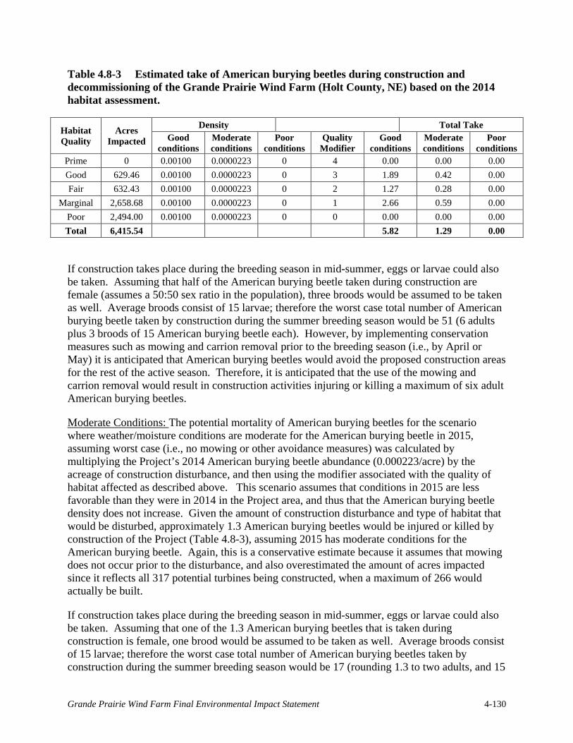
Table 4.8-3 Estimated take of American burying beetles during construction and decommissioning of the Grande Prairie Wind Farm (Holt County, NE) based on the 2014 habitat assessment.
Habitat Quality
Acres Impacted
Density Total Take Good
conditions Moderate conditions
Poor conditions
Quality Modifier
Good conditions
Moderate conditions
Poor conditions
Prime 0 0.00100 0.0000223 0 4 0.00 0.00 0.00 Good 629.46 0.00100 0.0000223 0 3 1.89 0.42 0.00 Fair 632.43 0.00100 0.0000223 0 2 1.27 0.28 0.00
Marginal 2,658.68 0.00100 0.0000223 0 1 2.66 0.59 0.00 Poor 2,494.00 0.00100 0.0000223 0 0 0.00 0.00 0.00 Total 6,415.54 5.82 1.29 0.00
If construction takes place during the breeding season in mid-summer, eggs or larvae could also be taken. Assuming that half of the American burying beetle taken during construction are female (assumes a 50:50 sex ratio in the population), three broods would be assumed to be taken as well. Average broods consist of 15 larvae; therefore the worst case total number of American burying beetle taken by construction during the summer breeding season would be 51 (6 adults plus 3 broods of 15 American burying beetle each). However, by implementing conservation measures such as mowing and carrion removal prior to the breeding season (i.e., by April or May) it is anticipated that American burying beetles would avoid the proposed construction areas for the rest of the active season. Therefore, it is anticipated that the use of the mowing and carrion removal would result in construction activities injuring or killing a maximum of six adult American burying beetles.
Moderate Conditions: The potential mortality of American burying beetles for the scenario where weather/moisture conditions are moderate for the American burying beetle in 2015, assuming worst case (i.e., no mowing or other avoidance measures) was calculated by multiplying the Project’s 2014 American burying beetle abundance (0.000223/acre) by the acreage of construction disturbance, and then using the modifier associated with the quality of habitat affected as described above. This scenario assumes that conditions in 2015 are less favorable than they were in 2014 in the Project area, and thus that the American burying beetle density does not increase. Given the amount of construction disturbance and type of habitat that would be disturbed, approximately 1.3 American burying beetles would be injured or killed by construction of the Project (Table 4.8-3), assuming 2015 has moderate conditions for the American burying beetle. Again, this is a conservative estimate because it assumes that mowing does not occur prior to the disturbance, and also overestimated the amount of acres impacted since it reflects all 317 potential turbines being constructed, when a maximum of 266 would actually be built.
If construction takes place during the breeding season in mid-summer, eggs or larvae could also be taken. Assuming that one of the 1.3 American burying beetles that is taken during construction is female, one brood would be assumed to be taken as well. Average broods consist of 15 larvae; therefore the worst case total number of American burying beetles taken by construction during the summer breeding season would be 17 (rounding 1.3 to two adults, and 15
Grande Prairie Wind Farm Final Environmental Impact Statement 4-130

larvae). However, by implementing conservation measures such as mowing and carrion removal prior to the breeding season (i.e., by April or May) it is anticipated that American burying beetles would avoid the proposed construction areas for the rest of the active season. Therefore, it is anticipated that the use of the mowing and carrion removal would result in construction activities injuring or killing a maximum of two adult American burying beetles.
Poor Conditions: If the weather/moisture conditions are poor for the American burying beetle in 2015, it is possible that the abundance in the Project area would decline. For this scenario, it was assumed that the American burying beetle population would be zero, similar to what was found during the trapping survey in the Project in 2012. In this scenario, 2015 construction would not take any American burying beetles.
2016 Construction: In order to examine the potential range of mortality that could occur if construction starts in 2016 instead of 2015, it was conservatively assumed that the relatively good moisture conditions that were documented in the action area in 2014 continue in both 2015 and 2016. The 4.5x multiplier arrived at above for the level of increased density to expect in a good moisture/weather year was then applied to the projected 2015 American burying beetle density to arrive at an assumed density of 0.00451 American burying beetle/acre (0.00100/acre 2015 density x 4.5) if the conditions are good in 2016. The 0.00451 density was then multiplied by the acreage of construction disturbance per habitat type (Table 4.8-2), then using a modifier associated with the quality of habitat affected as described above. Given the amount of construction disturbance and type of habitat that would be disturbed, approximately 26.2 American burying beetles would be injured or killed by construction of the Project, assuming both 2015 and 2016 have good conditions for the American burying beetle (Table 4.8-4). This is a conservative estimate because it assumes that mowing does not occur prior to the disturbance, and also overestimates the amount of acres impacted since it reflects all 317 potential turbines being constructed, when a maximum of 266 would actually be built.
Table 4.8-4 Estimated take of American burying beetles during construction of the Grande Prairie Wind Farm (Holt County, NE) based on the 2014 habitat assessment and assuming construction occurs in 2016 rather than 2015.
Habitat Quality Acres Impacted Density Quality Modifier Total Take Prime 0 0.00451 4 0.000 Good 629.46 0.00451 3 8.510 Fair 632.43 0.00451 2 5.700 Marginal 2,658.65 0.00451 1 11.982 Poor 2,494.00 0.00451 0 0.000 Total 6,414.54 26.193
Grande Prairie Wind Farm Final Environmental Impact Statement 4-131

Operations and Maintenance Effects
Disturbance/Displacement
The effects of wind turbine operation on the burying beetle have not been widely studied. It has been hypothesized that wind turbines may provide a novel and rich source of carrion for the burying beetle. However, a single laboratory study has shown that the burying beetle may have sensory challenges due to the seismic vibrations from the spinning of the rotors, increasing the carcass burial time needed, though there was no effect found on fecundity (Moore et al. 2012). The majority of the data from this study are not published, and therefore information is not available on the characteristics of vibration (frequency, amplitude, and distance from turbines) that produced effects on carcass burial rates.
The habitat in the Project area is already fragmented by center pivot and other agricultural practices, and the small permanent footprint of the turbine pads and access roads in burying beetle habitat, along with low beetle density (0.000223/acre), would not be expected to affect the burying beetle population in the area.
Mortality
After construction of the Project, limited vegetation clearing or other soil disturbing activities would be anticipated as part of operation, and traffic levels would be low volume and confined to defined access roads. Limited mowing may have to occur to maintain post-construction mortality monitoring plots. Most of the habitat in the action area is already fragmented by center pivots and other agricultural practices, and the small additional fragmentation from the turbine pads and access roads in burying beetle habitat would not be expected to affect the American burying beetle population in the area.
Decommissioning Effects
Ground disturbance activities and areas affected by decommissioning are anticipated to be similar to those affected by construction. Therefore, similar to construction, it is anticipated that decommissioning activities would injure or kill a maximum of 26 adult burying beetles depending on site conditions.
4.8.1.6 Northern Long-eared Bat
Potential direct effects on the northern long-eared bat from the proposed Project include collision with wind turbines or vehicles and habitat loss or degradation through placement of turbines or other Project facilities through or in close proximity to potential hibernacula, forested areas, and water sources.
Construction Effects
Construction of the Project is not expected to result in mortality or loss of reproductive fitness for the northern long-eared bat in the Project area due to the limited amount of suitable summer maternity habitat and the absence of hibernacula. If trees or man-made structures must be removed between April 1 and September 30, a biologist would be consulted to confirm that there
Grande Prairie Wind Farm Final Environmental Impact Statement 4-132

are no northern long-eared bats (or nesting birds) which would be injured or displaced. To the extent possible, no trees or man-made structures would be removed during Project construction between April 1 and September 30, which would avoid the maternity season for northern long-eared bats in Nebraska (USFWS 2014). Thus, construction is not expected to cause mortality of roosting bats since any activity which would impact potentially suitable roosting habitat would not occur while bats are present. In addition, impacts to potential roost trees, which include live or dead trees and snags ≥3 inches dbh that have exfoliating bark, cracks, crevices or cavities, would be avoided. Trees surrounding potential roosts would not be removed in order to maintain the microclimate. Foraging bats are not expected to be at risk of mortality from Project construction because nighttime construction activities would be minimal and construction activities around areas of likely foraging activity (e.g., open water, riparian corridors, and fencerows/shelterbelts) would be avoided after sunset. Therefore, mortality of bats is not anticipated as a result of Project construction.
Construction activities and associated increases in noise, vibration, human activity, and/or traffic are not expected to disturb or displace northern long-eared bats from the Project area. Construction activity at night would be minimal, so there should be no avoidance behavior for foraging bats. Additionally, turbines are placed away from woodlots and other potential roost sites, such that daytime construction activities should not affect any roosting bats. Grande Prairie Wind would avoid or minimize fragmentation of large forested areas or tree-lined corridors in order to improve the integrity of forest patches with known northern long-eared bat use. Because construction activities are not known to impact migrating bats and would occur primarily during daylight hours, little impact to migrating bats is anticipated.
Operations and Maintenance Effects
As discussed in Section 3.8.2.1, northern long-eared bats occur within the Project area.
Disturbance/Displacement
Northern long-eared bats are not expected to be displaced from the Project area as a result of operation of the Project. Although northern long-eared bat behavior at wind energy facilities is not well understood, displacement from wind facilities has not been documented for any species of bat. Additionally, the Project area provides only minimal suitable maternity habitat, roosting habitat, summer foraging habitat, and no fall swarming habitat or hibernacula from which northern long-eared bats could be displaced.
Maintenance activities would be required to maintain the safety and operability of the Project. Maintenance may include changing oil in the turbine nacelle, maintaining electrical equipment inside the turbine tower, etc. Additionally, on an as-needed basis, tree branches identified as hazardous to the continued operation of the gen-tie line would need to be trimmed.
Mortality
Growing wind energy development in the United States presents an increasing threat to bat populations resulting from collisions of flying bats with wind turbines (Kunz et al. 2007b). Collision risk to an individual bat is dependent upon a number of factors, including the species’ relative abundance in the area, behavior, and weather. Using fatality estimates from 19 wind
Grande Prairie Wind Farm Final Environmental Impact Statement 4-133
facilities in North America, Arnett et al. (2008) found mean fatalities to range from 0.8 – 53.3 bats/MW. Additional research suggests that bat fatalities at wind farms occur primarily on low wind nights but when turbines are operating at their maximum speeds (Arnett et al. 2008).
Three migratory tree-roosting species (lasiurines: eastern red bat, hoary bat and silver-haired bat) currently compose the majority of bat fatalities reported at wind facilities in most regions of North America (Johnson 2005, Kunz et al. 2007b, NAS 2007, Arnett et al. 2008). Behavioral differences between the two groups may explain why myotids (e.g., little brown bat and northern long-eared bat) appear to be less likely than lasiurines to suffer wind turbine fatalities (Kalko and Handley 2001).
Evidence indicates northern long-eared bats prefer mature forests for foraging (LaVal et al. 1977, Brack and Whitaker 2001, Caceres and Pybus 1998 as cited in ASRD and ACA 2009). Siting turbines in open areas away from edges of suitable habitat, as would be done at the Project, would minimize collision risks for northern long-eared bats.
The Project area lacks significant forested corridors and other vertical structure, and has a limited amount of suitable foraging and roosting habitat for bats. Based on the pre-construction acoustic survey results, peak bat occurrence in the Project area is expected to occur during fall migration, similar to that observed at other wind energy facilities in Nebraska and surrounding States, between 0.10 and 9.82 bats/MW/year with an average of 3.06 bats/MW/year (see Table 4.7-1). Most mortality is expected to occur during the fall migration season, given the patterns observed at other wind energy facilities located away from maternity habitat and hibernacula and the seasonal bat activity patterns observed during the pre-construction acoustic survey (see Section 3.7.2.2). Migratory tree bats (i.e., silver-haired bats, hoary bats, eastern red bats) are expected to account for the majority of bat fatalities at the Project, based on bat mortality patterns observed at wind facilities nationwide, although all bat species occurring within the Project area may be at risk.
As of 2011, only 13 northern long-eared bat fatalities have been recorded from wind energy facilities in the U.S., representing less than 0.2% of the total bat mortality (USFWS 2013c). The northern long-eared bat was not listed or proposed for listing when any of these fatalities occurred. However, these reports do provide information on the rarity of northern long-eared bat fatalities, given the large number of wind energy facilities operating within the species’ range. Relative to the Project area, the nearest publicly available record of a northern long-eared bat fatality was at Fowler Ridge Wind Farm, in Benton County, Indiana, over 500 miles east of the Project area.
Take of northern long-eared bats at the Project is expected to occur during fall migration and during the summer maternity season, based upon the presence of northern long-eared bats during the summer and patterns of mortalities at other wind farms. Given a yearly take estimate at the Project of approximately 1,200 bats (see Section 4.7.1.2), of which up to 0.2% are estimated to be northern long-eared bats (USFWS 2013c), this would indicate that approximately 3 northern long-eared bats would be killed each year at the Project.
Grande Prairie Wind has committed to raising the cut-in speed of any turbines located within 1,000 feet of suitable northern long-eared bat summer habitat to 5.0 m/s during the summer
Grande Prairie Wind Farm Final Environmental Impact Statement 4-134

period (April 1 to August 15) and at all Project turbines during the fall migration period (August 15 to November 15). This would decrease fatalities by at least 50% based upon the results of previous studies of curtailment (Arnett et al. 2010, Good et al. 2011); thereby, reducing the estimated take to 2 northern long-eared bats per year, or a total of 80 northern long-eared bats over the maximum life of the Project.
Decommissioning Effects
Decommissioning of the Project would minimize the long term impacts to all bats (when compared with re-commissioning or re-powering the Project) by removing turbines from the Project area and restoring the area to the pre-existing land use and vegetation communities. Impacts to northern long-eared bats from decommissioning activities would be the same as for construction activities and similar avoidance and minimization measures would be implemented. The impacts would be intermittent, short-term, and localized and are not expected to rise to the level of take.
4.8.1.7 Western Prairie Fringed Orchid
The western prairie fringed orchid may suffer mortality or habitat loss from ground disturbing activities or development that impacts the hydrology of sedge meadows, tallgrass prairies, or other orchid habitat. Western prairie fringed orchid surveys conducted by Olsson Associates in June 2012 and by Tetra Tech in July 2014 did not detect the species within the Project area (see Section 3.8.2.1). Although not all orchids bloom annually, due to various biotic and abiotic factors, two rounds of surveys were conducted prior to construction. Additionally, the majority of potentially suitable sedge meadow habitat for the orchid was found to occur along the riparian corridors of the more major streams within the Project area; these areas would not be impacted by ground-disturbing construction, maintenance, or decommissioning activities. Also, the hydrology of these habitats would be protected through implementation of BMPs, including horizontal directional boring, noxious weed prevention, and a SWPPP. Impacts to orchids from operation of wind energy facilities are not known to occur. Therefore, proposed Project activities, including construction, operations and maintenance, or decommissioning, would not affect the Western prairie fringed orchid.
4.8.1.8 Small White Lady’s Slipper
The small white lady’s slipper may suffer mortality or habitat loss from ground disturbing activities or development that impacts the hydrology of wet hay meadows, roadside ditches adjacent to meadows, or other orchid habitat. Small white lady’s slipper surveys conducted by Olsson Associates in May 2012 and by Tetra Tech in June 2014 did not detect the species within the Project area (see Section 3.8.2.1). Although not all orchids bloom annually, due to various biotic and abiotic factors, two rounds of surveys were conducted prior to construction. Additionally, the majority of potentially suitable habitat for the orchid was found to occur in sedge meadows along the riparian corridors of the more major streams within the Project area; these areas would not be impacted by ground-disturbing construction, maintenance, or decommissioning activities. Also, the hydrology of these habitats would be protected through implementation of BMPs, including horizontal directional boring, noxious weed prevention, and a SWPPP. Impacts to orchids from operation of wind energy facilities are not known to occur.
Grande Prairie Wind Farm Final Environmental Impact Statement 4-135

Therefore, no impacts from proposed Project activities including construction, operations and maintenance, or decommissioning are anticipated.
4.8.1.9 Avoidance, Minimization, and Mitigation Measures
Grande Prairie Wind is developing a WCS in coordination with USFWS and NGPC to identify avoidance, minimization, and possibly mitigation measures for impacts to listed birds, bats, and other species of concern during construction and operation (see Grande Prairie Wildlife Conservation Strategy, current version available online at: http://www.wapa.gov/ugp /Environment/GrandePrairie.htm). Avoidance, minimization, and mitigation measures for general wildlife (see Section 4.7.1.5) would also benefit the threatened and endangered species.
Whooping Crane
1) To ensure that Grande Prairie personnel and subcontractors are all able to identify whooping cranes and understand the contingencies, all would receive training on the contingency plan prior to the start of each migration season.
2) Photographs of whooping cranes would be posted year-round in a common area (e.g., the kitchen) of the O&M building to aid in the education and identification of the species.
3) Training would include:
a. History and behavior of the whooping crane;
b. How to identify the whooping crane (including distinguishing a whooping crane from similar species that may be present at Grande Prairie);
c. Reporting procedures should a whooping crane be sighted;
d. Definition of wildlife harassment, and measures to avoid harassing whooping cranes; and
e. How to properly use binoculars.
4) A pair of binoculars would be kept in all Project vehicles to aid in the identification of whooping cranes.
5) During construction, in the morning prior to equipment start-up, daily visual surveys for whooping cranes would be conducted within a 0.5-mile buffer around the area designated for construction on that day. The daily surveys would occur during spring (March 23 – May 10) and fall (mid-September through mid-November) migration. If cranes are observed by the qualified personnel, he/she can monitor their behavior and determine if construction activities need to be halted within 0.5 miles of where the cranes are observed.
6) Grande Prairie Wind is developing a site specific WCS that includes a whooping crane contingency plan to minimize the potential for take of whooping cranes at the Project. Contingency plans outline prudent and common-sense measures to be implemented if there is a whooping crane observed in the vicinity of the Project during the operational life cycle of the facility. Grande Prairie has provided the contingency plan to NGPC and USFWS for review (current version of the contingency plan can be found in the Wildlife Conservation Strategy).
Grande Prairie Wind Farm Final Environmental Impact Statement 4-136

7) If whooping cranes are observed within or near the Project area, a report containing information about the sighting (including behavior(s) observed with relation to wind turbines, length of stay, and direction/timing of departure) shall be maintained in the Operations and Maintenance building for the life of the Project; this report would also be sent to USFWS and NGPC.
8) The USFWS and NGPC may require mitigation if the Project were to impact wetlands considered to be suitable whooping crane habitat (wetlands occurring within 0.5 mile of turbines). This may include, but may not be limited to, protection of alternative, similar wetland habitat more than 5 miles from the Project area on a 1:1 or greater ratio (USFWS 2009). Micro-siting of turbines more than 0.5 mile from suitable wetlands during the development phase of the Project could further reduce impacts to whooping cranes that may stopover in the Project.
9) If stopover habitat is affected, Grande Prairie Wind would, using the guidelines established by the Nebraska Wind and Wildlife Working Group, and in consultation with USFWS and NGPC, develop a compensatory mitigation package for direct Project impacts to whooping crane stopover habitat.
10) No non-permitted ground disturbing activities in wetland or riparian habitat. The need for an Individual 404 permit is not anticipated for the Project.
American Burying Beetle
1) Some pesticide applications negatively impact American burying beetles, leading to reductions, isolation, and extirpations of populations from direct exposure, reduced availability of live insects as a food source, or secondary exposure from feeding on dead insects exposed to chemicals. Grande Prairie would time use of pesticide applications outside of American burying beetle activity times—May 15-October 15.
2) Prior to the topsoil replacement, any impacted area would be ripped (i.e., mechanically turned with a plow or ripping device) so as to reduce soil compaction. This would be done at a time when the soil is dry enough for normal tillage operations to occur on undisturbed farmlands adjacent to the areas being ripped.
3) When construction commences, Grande Prairie would keep construction activities above the frost line in areas of “good” American burying beetle habitat until the construction corridors are mowed and the grass has dried out (approximately 3 days).
4) For night construction work in June and August, and as safety conditions allow, Grande Prairie would use sodium-vapor lights that emit a yellowish light.
5) If construction in “good” American burying beetle habitat is not completed during the June activity period, Grande Prairie would maintain vegetation height and remove carrion in the construction corridors to keep American burying beetles out of these areas should construction activities carry into the August activity period and/or through October 15.
6) Nighttime construction would be avoided in “good” American burying beetle habitat within 2-miles of the two positive American burying beetle capture locations.
7) Site personnel operating in the Project area would be educated about American burying beetle habitat, biology, reasons for decline, and the responsibility of all personnel to
Grande Prairie Wind Farm Final Environmental Impact Statement 4-137

protect the American burying beetle. Training would ensure that all site personnel can identify American burying beetles and know the appropriate conservation measures to be implemented.
8) All personnel would be required to report any American burying beetle sightings to the Project manager or environmental inspector. Each worker would be provided with a full color Endangered Species Card with a photo of the American burying beetle and a summary of information on the card before they are allowed to conduct soil disturbing activities.
9) All food waste would be removed from the construction site each day, and pets would be prohibited.
10) Road kill or other carcasses around the Project would be cleared on a regular basis to avoid attracting scavengers. Site personnel would be trained so that only carcasses of non-federally protected animals are moved. The owner of Grande Prairie Wind, LLC would secure a special purpose permit from USFWS for removing road kill (MBTA-protected bird species) and a game/salvage permit from NGPC for removing road kill (such as deer).
11) As part of the Nebraska Power Review Board approval process in 2013, Grande Prairie committed to develop a compensatory mitigation package for direct project impacts to high value and/or sensitive habitat as identified by Grande Prairie in coordination with NGPC and USFWS. To fulfill that commitment as well as mitigate for habitat disturbance, a compensatory mitigation plan for disturbed American burying beetle habitat is currently being developed in coordination with USFWS and NGPC. This plan will include compensating for both temporary and permanent impacts to “good” habitat based upon a 2:1 ratio (USFWS 2013a). It is conservatively estimated that up to 630 acres of “good” habitat may be disturbed by the Project based on a 317 turbine scenario, and mitigation will require permanent protection of up to 1,260 acres of “good” or better American burying beetle habitat dependent upon final layout and subsequent habitat impacts.
Northern Long-Eared Bat
1) If structures owned or leased by Grande Prairie are identified as having roosting bats, Grande Prairie would minimize use of pesticides in and around those structures by applying pesticides in accordance with label instructions having to do with federally listed species.
2) If removal of trees or man-made structures must occur between 1 April and 30 September, a biologist would be consulted to ensure that no northern long-eared bats are roosting in that area, and tree clearing would occur during daylight hours to avoid impacts to foraging bats. Tree clearing would be restricted to winter clearing whenever practicable.
3) During the summer months, Grande Prairie would avoid conducting construction activities after sunset in areas within 1,000 feet of the suitable small roost/foraging and medium-large roost/foraging summer habitat that was field verified by WEST, Inc. in 2014. Lighting on permanent MET towers would be minimized to that which is required by the Federal Aviation Administration.
Grande Prairie Wind Farm Final Environmental Impact Statement 4-138

4) Both project substations would be outfitted with downward facing shields on all lights. The lights would be equipped with light sensors to come on at night for security purposes. All operators and technicians on site would be required to turn off internal lights when lights are not required for safety or compliance purposes.
5) Lighting on turbines would be minimized to that which is required by the Federal Aviation Administration.
6) Grande Prairie would avoid conducting construction activities after sunset in areas within 1,000 feet of suitable small roost/foraging and medium-large roost/foraging summer habitat, as field verified by WEST, Inc.
7) Grande Prairie would leave dead or dying trees standing wherever practicable. Grande Prairie would work with the contractor to clearly demarcate trees to be protected versus cut to ensure that no unnecessary trees are removed by mistake.
8) Grande Prairie would retain the integrity of forest patches with known northern long-eared bat use by avoiding and minimizing such areas for project components.
9) Grande Prairie would maintain existing forested corridors whenever practicable.
10) Should prescribed burns be necessary during construction or operation, the fire line would be at least two tree-lengths away from any known northern long-eared bat habitat.
11) If northern long-eared bats are discovered in structures slated for removal, Grande Prairie would conduct humane exclusion of northern long-eared bats and would consult with USFWS prior to doing so.
12) Cut-in speed would be raised to 5 m/s at turbines located within 1,000 feet of suitable northern long-eared bat habitat during the summer period (1 April to 14 August).
13) Cut-in speed would be raised to 5 m/s at all turbines within the Project during the fall migration period (15 August to 15 November).
14) As part of the Biological Assessment prepared under section 7 consultation, Grande Prairie committed to develop a compensatory mitigation package for direct project impacts to northern long-eared bats. To fulfill that commitment, a compensatory mitigation plan for the projected northern long-eared bat take estimate and impact of that take is currently being developed in coordination with USFWS and NGPC. This plan will include compensating for direct mortality of northern long-eared bats and the impact of that direct mortality (as measured through lost female reproductive potential) through the protection and/or restoration of habitat as calculated using an approved USFWS Resource Equivalency Analysis model. It is conservatively estimated that up to 133 acres would be required for mitigation; however, Grande Prairie is proposing to protect land on a 1.5:1 ratio (up to 200 acres) in a location to be determined through coordination with willing landowners, conservation groups, USFWS and NGPC. These 200 acres would be located in an area known to contain suitable northern long-eared bat habitat and confirmed presence of the northern long-eared bat with a goal of enhancing an existing habitat complex.
Grande Prairie Wind Farm Final Environmental Impact Statement 4-139

4.8.1.10 Summary
No significant impacts to Federal threatened, endangered or proposed endangered bird species are expected to occur based on the limited amount of suitable habitat available for listed bird species within the Project area. The interior least tern, the rufa red knot, and the piping plover are not expected to nest in, migrate through, or stopover in the Project area; these species are consequently not expected to experience impacts from Project construction, operations and maintenance, or decommissioning.
Construction, operations and maintenance, and decommissioning of the Project may affect, but would not adversely affect the whooping crane and would have no effect on whooping crane designated critical habitat for the following reasons:
1) Grande Prairie Wind would implement the whooping crane conservation measures discussed above;
2) There are no documented cases of any turbine-caused whooping crane mortality in the upper great plains;
3) Whooping cranes have not been documented within the Project area; and,
4) No designated whooping crane critical habitat is located within the Project area.
Marginally suitable sedge meadow habitat for the western prairie fringed orchid and the small white lady’s slipper is present within the Project area; however, two years of orchid surveys in these areas did not detect any individuals. Regardless, areas of potentially suitable orchid habitat would be avoided during Project construction and maintenance.
Construction and decommissioning activities are expected to result in direct mortality and habitat loss for the American burying beetle. Maintenance and operation activities are not expected to impact the species. It is estimated that a maximum of 52 adult American burying beetles would be taken under the proposed action (26 each during construction and decommissioning), and a total of approximately 6,415 acres of burying beetle habitat would be temporarily disturbed.
Operation of the Project is expected to result in direct mortality of northern long-eared bats. After the implementation of operational adjustments (i.e., raising cut-in speed to 5.0 m/s) in the summer and fall, take is estimated to be 2 northern long-eared bats/year, or a total of 80 northern long-eared bats over the maximum Project life.
4.8.2 No Action Alternative
Under the No Action Alternative, Western would not execute an interconnection contract with Grande Prairie Wind. For the purposes of impact analysis and comparison in this EIS, it is assumed that the proposed Project would not be built and that the environmental impacts associated with construction and operation of the proposed Project would not occur. The No Action Alternative is not expected to have impacts to threatened and endangered species that would be subject to NEPA review.
Grande Prairie Wind Farm Final Environmental Impact Statement 4-140

4.9 Cultural and Historic Resources
For this EIS, the direct APE is considered to be the Project area. Specifically, the direct APE includes the up to 266 turbine locations, access roads and buried interconnect lines, construction staging areas, gen-tie line, and the substation locations. The visual APE includes the area within 2 miles of all turbine locations.
During scoping, the NSHS noted the presence of historic properties within the Project boundary and provided information for consultation with the NeSHPO.
4.9.1 Proposed Action
4.9.1.1 Construction Effects
Archaeological Resources
Tetra Tech conducted archaeological investigations within the Project layout from June 11 to July 12, 2014, August 14 through August 22, 2014, and October 6 through October 12, 2014 in accordance with the provisions of section 106 of the NHPA as amended and its implementing regulations 36 CFR part 800. The survey found a total of 27 previously unrecorded archaeological sites within the survey corridor. Of these sites, 15 are within the Project direct APE and may be impacted by construction. Subsurface testing will be conducted at these 15 sites to determine if intact archaeological deposits are present. If no intact archaeological deposits are documented, then Grande Prairie would recommend that these be recommended as not eligible for listing in the NRHP and would recommend no further action at these sites. If the intact archaeological deposits are documented at these sites, Grande Prairie would work with Western and the NeSHPO to determine if the sites are eligible for listing in the NRHP and work with the agencies to mitigate any impacts. Western shall ensure that all scopes of work for archaeological identification and evaluation produced by Grande Prairie Wind include a plan for the treatment of human remains and funerary objects that might be encountered.
1) Phase I Archaeological Survey. Western will submit all deliverables to NeSHPO for review and comment.
a. If Western determines and NeSHPO concurs that a “site is not eligible” for the NRHP, then no further investigations of that site would be conducted.
b. If Western determines and NeSHPO concurs that a site with indeterminable eligibility can and would be avoided, which would be the preferred option of Western and Grande Prairie Wind, then no further investigation of that site would be conducted, unless avoidance no longer becomes feasible.
2) Phase II Archaeological Testing. If Western, in consultation with NeSHPO and other interested parties agrees that the “eligibility of a site is indeterminable” and avoidance is not feasible, Western shall ensure that a Phase II Research Design would be developed by Grande Prairie Wind in consultation with the NeSHPO and other interested parties. This document would be consistent with NeSHPO guidelines. Phase II work would be designed to provide information regarding the significance of an archaeological site as
Grande Prairie Wind Farm Final Environmental Impact Statement 4-141

“site is not eligible” or “site is eligible” to the NRHP. All deliverables would be submitted by Western to NeSHPO for review and comment.
a. If Western determines through consultation and NeSHPO concurs that a “site is not eligible” for the NRHP, then no further investigations of that site would be conducted.
b. If Western determines site eligibility through consultation but NeSHPO would not concur regarding eligibility, all appropriate information regarding the site would be submitted by Western to the Keeper of the National Register, National Park Service, for review. The Keeper’s determination of eligibility would be final.
c. If Western determines through consultation and NeSHPO concurs that an eligible site can and would be avoided, which would be the preferred option of Western and Grande Prairie Wind, then no further investigation of that site would be conducted, unless avoidance no longer becomes feasible.
Historic Structures The NeSHPO records search and on-site evaluations identified six historic properties within the Project area and a two mile buffer that are recommended eligible for listing in the NRHP: four within the Project area and two within the two-mile buffer. None of the six properties are located within the footprint of the 266 turbines or other Project infrastructure; therefore, none would be directly affected by the Project. Grande Prairie Wind would not stage construction traffic and machinery in proximity to the structures. Project construction would not have indirect effects to historic structures. Construction of the Project would have an adverse visual effect on five of these six structures.
4.9.1.2 Operations and Maintenance Effects
Archaeological Resources
No effects to archaeological resources would occur as a result of operations. Maintenance activities involved with upkeep and repair of turbines has little potential to affect buried archaeological resources as long as any ground-disturbing activities associated with operation are confined to previously surveyed areas.
Historic Structures
Based on the current Project layout, of the 266 turbines, 173 would have no visual effect on NRHP Listed, Eligible or Recommended Eligible resources. A total of five structures recommended eligible for the NRHP are each located within 2 miles of several proposed turbines (8-51 turbines) (Figure 4.9-1). The five structures were recommended eligible based on their architecture, as well as one of the following:
1) Association with Education (3)
2) Association with Rural Agriculture (2)
The presence of operating turbines within 2 miles of each of these structures would have an effect on the viewshed of the structure, which would have an adverse visual effect on the
Grande Prairie Wind Farm Final Environmental Impact Statement 4-142

structure’s associations with education or rural agriculture, but would not have any effect on their architectural eligibility.
4.9.1.3 Decommissioning Effects
Archaeological Resources and Historic Structures
Decommissioning activities would be similar to those associated with construction with a shorter duration than construction. Decommissioning has the potential to impact buried archaeological
Grande Prairie Wind Farm Final Environmental Impact Statement 4-143

This page intentionally left blank.
Grande Prairie Wind Farm Final Environmental Impact Statement 4-144

Figure 4.9-1 Historic Structures and Project Layout
Grande Prairie Wind Farm Final Environmental Impact Statement 4-145

This page intentionally left blank.
Grande Prairie Wind Farm Final Environmental Impact Statement 4-146

resources within the footprint of all turbines, facilities, and other components of the Project that would be removed. If any previously unsurveyed areas would be directly affected by decommissioning, archaeological surveys would be required to determine the presence of archaeological sites, and the potential effects. For Project elements that have visual impacts to cultural resources, decommissioning would have a beneficial effect due to the removal of the source of the impact.
4.9.1.4 Avoidance, Minimization, and Mitigation Measures
If adverse visual effects to the five historic properties cannot be avoided by Project design, Grande Prairie Wind is committed to mitigating for these impacts through a regional historic study that encompasses the rural history of the region, capturing the agricultural history and the nature of the educational system that resulted in the three NRHP-eligible school buildings being located within the Project area. A regional study would best capture the significance of these resources and more specifically address the adverse impacts from this Project.
4.9.1.5 Summary
The Project is expected to have adverse visual effects to cultural resources; however, Grande Prairie Wind is committed to mitigating for these impacts. Grande Prairie Wind is also committed to mitigating visual effects to historic structures.
4.9.2 No Action Alternative
Under the No Action Alternative, Western would not execute an interconnection contract with Grande Prairie Wind. For the purposes of impact analysis and comparison in this EIS, it is assumed that the proposed Project would not be built and that the environmental impacts associated with construction and operation of the proposed Project would not occur. The No Action Alternative is not expected to have impacts to cultural and historic resources that would be subject to NEPA review.
4.10 Land Use
During scoping, the USDA Farm Service Agency noted that there may be some CRP land within the Project area and provided information on current CRP policy for wind turbines.
4.10.1 Proposed Action
4.10.1.1 Construction Effects
In accordance with the Farmland Protection Policy Act (FPPA), Western completed a Farmland Conversion Impact Rating Form (AD-1006) to determine impacts to prime and unique farmland (form available online at: http://www.wapa.gov/ugp/Environment/GrandePrairie.htm). The USDA NRCS estimated that approximately 71% of the Project area is not prime farmland. Of the remaining 29%, 6% is prime farmland, 5% is prime farmland if irrigated, and 18% is farmland of State-wide importance. The NRCS evaluation considered the proportions of the Project area as well as the location of Project turbines and access roads in dryland corners and in-between irrigation pivots and determined that the total points awarded to the Project would be a maximum
Grande Prairie Wind Farm Final Environmental Impact Statement 4-147

of 144 points. The Farmland Conversion Impact Rating Form is based on a point system that has 160 points set as the minimum number of points that would trigger in-depth site reviews for Projects. Therefore, the Project was cleared of FPPA significant concerns. Project construction would not result in significant effects to prime and unique farmland.
As mentioned above, due to the placement of Project turbines and access roads, areas that are already in current agriculture use would not be affected. The Project would not change the predominant land use practices in Holt County. Commercial-scale wind farms have been found to be compatible with agricultural uses on a landscape level. Based on title work completed in 2012, there are no CRP lands in the Project area (NGPC 2012); lands enrolled in the CRP would not be affected.
Heavy construction equipment, workers, and increased traffic are not typically associated with rural agricultural areas; however, dust, noise, and large farm machinery on public roads are common in such areas at certain times of the year. Effects associated with construction traffic would be short-term. These impacts are not anticipated to occur in areas used for recreation, such as the nearby wildlife management areas, Niobrara State Park, or Missouri National Recreational River.
4.10.1.2 Operations and Maintenance Effects
Project operations would not affect local land uses. Landowners whose properties are directly impacted by the Project would be compensated through lease payments throughout the life of the Project. Aside from the areas in dryland corners and between irrigation pivots that would be utilized for turbine pads and access roads, land surrounding each turbine would continue to serve the current use, primarily agricultural cropland and pasture. Project operations would be consistent and compatible with current agricultural land uses.
4.10.1.3 Decommissioning Effects
Decommissioning activities would be similar in character to those associated with construction. Project decommissioning would not affect any lands not previously disturbed during construction. Once Project facilities have been removed, affected areas would be returned to the previous land use. Decommissioning activities would not adversely affect land uses in the Project area.
4.10.1.4 Avoidance, Minimization, and Mitigation Measures
The Proposed Action would not have significant effects to agricultural practices or other land-based uses, such as recreation. Grande Prairie Wind is not proposing to implement mitigation measures for land use.
4.10.1.5 Summary
The NRCS has evaluated the Project and cleared it of FPPA significant concerns. Grande Prairie Wind is committed to minimizing the conversion of prime farmland to the fullest extent practicable, through the placement of Project turbines and access roads in dryland corners and
Grande Prairie Wind Farm Final Environmental Impact Statement 4-148

the areas between irrigation pivots. The Proposed Action does not include effects that would be inconsistent with local land use, County zoning, or future planned development.
4.10.2 No Action Alternative
Under the No Action Alternative, Western would not execute an interconnection contract with Grande Prairie Wind. For the purposes of impact analysis and comparison in this EIS, it is assumed that the proposed Project would not be built and that the environmental impacts associated with construction and operation of the proposed Project would not occur. The No Action Alternative is not expected to have impacts to land uses that would be subject to NEPA review.
4.11 Visual Resources
NPS indicated concerns that the Project could potentially affect visual resources within the Missouri National Recreational River area, 5.5 miles north of the Project, and requested an assessment of Project impacts.
4.11.1 Proposed Action
4.11.1.1 Construction Effects
During construction, large trucks would transport turbine components through the visual analysis area. Large, mobile cranes would work briefly at each pad site to erect the tower and install the nacelle. The presence of the trucks and cranes would create some visual changes but these would be short-term impacts. Depending on the individual, the installation of a wind turbine generator could be regarded as a fascinating spectacle. Especially during those times when towers are raised and rotors are installed, it is expected that certain individuals may wish to observe wind farm construction, and the open landscape would allow them to do so from a safe distance.
Although Project construction would have some effect on the visual landscape, the impact would be temporary.
4.11.1.2 Operations and Maintenance Effects
As described in Section 3.11.2, the topography ranges from flat to undulating, with gentle to moderate slopes. The predominant agricultural character and subtle differences in elevation tend to create unobstructed views across much of the Project area.
Stantec conducted a desktop viewshed analysis to determine Project visibility from locations that individual observers may use within the areas of the Niobrara River managed by the State of Nebraska and NPS (see Viewshed Analysis, available online at: http://www.wapa.gov/ugp/ Environment/GrandePrairie.htm). The analysis used the "observer points" tool in ArcGIS 10.1 with 3D Analyst and Spatial Analyst Toolboxes to evaluate viewsheds from 10 points within the areas of the Niobrara River managed by the State of Nebraska and the NPS. For this analysis, the “observer points” tool calculated the region of the Project area where some portion of a 521
Grande Prairie Wind Farm Final Environmental Impact Statement 4-149

foot object would be visible to a 6.6 foot tall person standing at each of the 10 points. The analysis assumed that turbines could be installed anywhere within the Project area.
The analysis determined that wind turbines would not be visible to sensitive receptors using those observation points on the Niobrara River within the jurisdiction of the State Park or National Recreational River. This is not surprising given that the State Park is approximately 18 miles from the Project Area, and NPS jurisdiction lands are located below the elevation of the Project area along the banks of the Niobrara River. Conversely, most of the Project area would be visible from three observation points located outside NPS jurisdiction at higher elevation above the Niobrara River.
Because the landscape is gently rolling and possesses few obstructions, the turbines would create highly prominent, vertical elements in the Project area and its vicinity. The Project would be easily visible to local residents and those individuals traveling on the local roads. Being the first in Holt County, the Project could have a startling effect on some individuals if they have had no experience viewing a commercial-scale wind farm in an open landscape. People traveling through Holt County on U.S. Routes 20 and 281 would have intermittent and diminished views of the Project due to the rolling character of the terrain. Viewer reactions to the Project would likely be variable and impacts would be based on subjectivity. Wind turbines, whether one or several are visible, may degrade or enhance the aesthetic experience of a viewer.
Due to the character of the landscape and topography, and the nature of the structures proposed, Project turbines would be visible from almost everywhere in and around the site. It was not practical to evaluate every conceivable location where a turbine might be visible. Therefore, the evaluation of visual impacts was limited to two representative locations within the visual analysis area, including one from just outside of the City of O’Neill and a second along a roadway near the center of the Project area (Figure 4.11-1). Viewers were classified as either 1) local residents who would view the Project on a daily basis, or 2) individuals who would view the Project while traveling through Holt County and proximal to the Project Area. Photosimulations were created using photographs of the Project area taken from the two locations. Scaled images of turbines were added to the photographs for comparison and to illustrate potential effects to the two locations (see Photos 4.11-1 through 4.11-6 below).
Although considered significant, the effect of one or more turbines may be diminished or pronounced based on the context of the adjacent elements in the viewshed; e.g., vegetation, open sky, other structures, etc. In other words, one or two turbines that are visible in flat terrain against a backdrop of sky may have a diminished appearance as opposed to 30 or so turbines in a rolling landscape with open fields as a backdrop making the turbines more visible. Residents living in O’Neill and bicyclists or pedestrians using the Cowboy Trail as it passes through or near O’Neill would have screened views of the Project.
As described above, the Project area’s landscape is one of flat to gently rolling topography and rural character. Land cover is dominated by agriculture dotted with small communities, farmsteads, and residences. Naturally occurring vegetation is primarily confined to roadsides, farmyards, pastures, ditches, small streams, fencerows, and residual trees. Because the landscape is relatively flat with few trees, the turbines would present noticeable vertical elements in the Project area. Excepting those rare sites with enough trees to provide screening, views of turbines
Grande Prairie Wind Farm Final Environmental Impact Statement 4-150

Figure 4.11-1 Photosimulation Locations
Grande Prairie Wind Farm Final Environmental Impact Statement 4-151

This page intentionally left blank.
Grande Prairie Wind Farm Final Environmental Impact Statement 4-152

Photo 4.11-1. Existing view from the intersection of 872nd Road and 494th Avenue (NE edge of O’Neill) looking northeast
Photo 4.11-2. Simulated view from the intersection of 872nd Road 494th Avenue (NE edge of O’Neill) looking northeast. Note that proposed turbines are highlighted in red.
Grande Prairie Wind Farm Final Environmental Impact Statement 4-153

Photo 4.11-3. Existing view from the intersection of 881st Road and 503rd Avenue looking north.
Photo 4.11-4. Simulated view from the intersection of 881st Road and 503rd Avenue looking north.
Grande Prairie Wind Farm Final Environmental Impact Statement 4-154
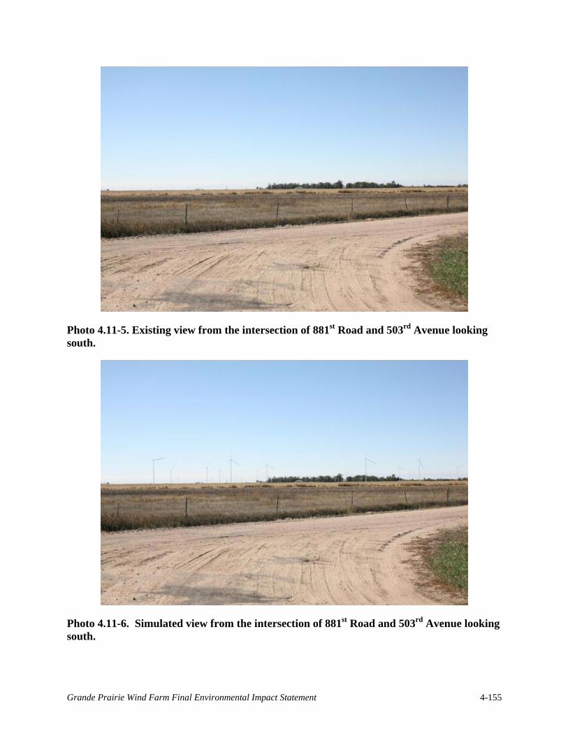
Photo 4.11-5. Existing view from the intersection of 881st Road and 503rd Avenue looking south.
Photo 4.11-6. Simulated view from the intersection of 881st Road and 503rd Avenue looking south.
Grande Prairie Wind Farm Final Environmental Impact Statement 4-155

would be irrefutably prominent. Some factors tend to moderate turbine prominence, such as cloudy or hazy conditions, which may tend to diminish turbine visibility as the structures tend to blend in with the sky. Views framed by trees or power poles also tend to diminish turbine visibility.
As required by the FAA, turbines would have red, flashing lights positioned at the top of towers to mark obstructions for aviation. Not all turbines would have this lighting because it is not necessary for aviation safety nor is it desirable from the standpoint of protecting nighttime migrating birds. The lights would be an added visual element to the nighttime viewshed, and given the flat topography and open character of the landscape, many of these lights would be visible from numerous locations.
In addition to the turbines, the Project would require new access roads, a gen-tie line, substations, and collector lines. These are considered to be minor visual impacts. The access roads would not be highly visible or perceived as out-of-place elements in the agricultural landscape. The gen-tie line would be notably visible but it would not have as striking a presence as the wind turbines. Collector lines would be buried and contribute no additional visual impact.
Shadow Flicker
Shadow flicker would have potential visual impact on persons within the Project area depending on location, distance from turbine and current weather conditions. Travelers along local roads within the Project area are likely to experience some shadow flicker at times while driving; however, exposure is expected to be minimal and not significantly different than existing conditions, such as sun shining through utility poles. Due to the rural nature of the Project area, residences and other inhabited buildings tend to be widely spaced. In addition, some rural residences would be screened by wind breaks, trees, and outbuildings.
Grande Prairie Wind would adhere to Holt County's zoning regulations for wind energy conversion facilities, including established setbacks and special safety and design standards. In some instances, Grande Prairie Wind requested and was granted a variance to a dwelling setback, with the consent of the landowner, as part of the Holt County Conditional Use Permit approval process in September 2014. Those landowners signed waivers allowing Grande Prairie Wind to encroach into the 0.5 mile turbine setback from occupied dwellings, allowing Grande Prairie Wind to place turbines as close as 1,200 feet from the dwelling. Holt County regulations require that turbines would be located a minimum of one-half times the rotor diameter from roads. Grande Prairie Wind would adhere to this regulation, and would generally place turbines a minimum of the tip height from public roads.
Shadow flicker diminishes with distance from a turbine, with the total impact distance dependent on current weather conditions, the time of day and season of the year. Wind direction also affects the amount of shadow flicker experienced at a receptor, as turbine blades rotating perpendicular to the line-of-sight would have a larger impact than blades rotating at oblique angles.
An analysis of expected shadow flicker impact at residences and other inhabited buildings within one mile of the turbines was completed using the Shadow module of WindPro, version 2.9 (Figure 4.11-2). WindPro was developed by EMD International and is an industry-wide
Grande Prairie Wind Farm Final Environmental Impact Statement 4-156

Figure 4.11-2 Shadow Flicker Analysis
Grande Prairie Wind Farm Final Environmental Impact Statement 4-157

This page intentionally left blank.
Grande Prairie Wind Farm Final Environmental Impact Statement 4-158

recognized tool for the analysis of wind farm project impacts. Several turbine models are under consideration. The analysis was completed using the Acciona AW 116/3000 model as its 116-meter rotor diameter would present the worst-case shadow-flicker impact of the turbine models under consideration. Two separate analyses were performed to estimate the annual hours of shadow flicker that would be expected within the Project area due to construction of the proposed Project. The first, an overview analysis, considered 317 turbine positions as if all were constructed and simultaneously operating. A second analysis considered 266 preferred turbine positions as if constructed and simultaneously operating. Climatological information, such as wind force, wind direction and sunshine probability were considered in the analyses. The receptors were modeled assuming windows were located on all sides of the structure. Results of the analyses indicate that a final design of the up to 400-MW wind farm could easily be achieved from the potential 317 turbines included in the preliminary design. A total of 104 potentially inhabited building locations were analyzed within one mile of the turbines.
Table 4.11-1 presents a summary of the results of both analyses. The effects of shadow flicker on inhabited buildings under the Proposed Action are expected to be minimal based on the established setbacks and design of the Project.
Table 4.11-1 Annual shadow flicker hours expected at potentially inhabited building locations within one mile of Project turbines.
Annual Shadow Hours
Number of Potentially Inhabited Buildings
(with 317 possible WTG1 locations)
Number of Potentially Inhabited Buildings
(with 266 preferred WTG locations)
Less than 20 91 95 20 - 25 4 4 25 - 30 4 2 Greater than 30 5 3 1 WTG – Wind Turbine Generator
4.11.1.3 Decommissioning Effects
Decommissioning activities would be similar in character to those associated with construction. However, the decommissioning timeframe is not likely to be as long as that for construction. Decommissioning would involve the large, mobile cranes that would work briefly at each location to dismantle the turbines. The presence of the trucks and cranes would be temporary and create short-term visual impacts. Dismantled turbine components would be transported through the visual analysis area on large trucks.
4.11.1.4 Avoidance, Minimization, and Mitigation Measures
The Proposed Action would have prominent effects to visual resources in the Project area and surrounding vicinity. Affected viewers would include local residents and travelers on the nearby County and State roads. To minimize visual complexity, all turbines would be similar in color and overall appearance. Turbines would not be used for commercial advertising or possess overly conspicuous lettering or logos. The blades, nacelle, and tower would be neutral off-white
Grande Prairie Wind Farm Final Environmental Impact Statement 4-159

in color. Where manufacturer specifications permit, non-reflective paint would be used on all outside surfaces to minimize reflected glare.
4.11.1.5 Summary
The construction, operation, and decommissioning of the Project turbines would not impact sensitive receptors using Niobrara State Park or points on the Niobrara River within the Missouri National Recreational River Area. More proximal to the Project, the addition of 266 turbines would have a significant effect on local viewsheds that could be considered adverse or favorable depending on the viewer.
4.11.2 No Action Alternative
Under the No Action Alternative, Western would not execute an interconnection contract with Grande Prairie Wind. For the purposes of impact analysis and comparison in this EIS, it is assumed that the proposed Project would not be built and that the environmental impacts associated with construction and operation of the proposed Project would not occur. Therefore, the No Action Alternative is not expected to result in the addition of new and prominent visual elements to the landscape subject to NEPA review.
4.12 Noise
4.12.1 Proposed Action
4.12.1.1 Construction Effects
Project construction would generate noise that would likely be audible at homes and public areas within and surrounding the Project area. Assessing construction noise impacts is difficult because the activity, equipment, and location would vary as construction progresses. Noise from most of the pieces of equipment typically used during wind farm construction attenuates below 50 dBA at or before traveling 1,000 feet (Table 4.12-1).
Table 4.12-1 Average Maximum Sound Levels (Lmax) of Representative Construction Equipment used in Construction of a Typical Wind Energy Facility1
Equipment Type Sound Levels at Varying Distances (dBA) 50 feet 100 feet 500 feet 1,000 feet 1 mile 5 miles
Rock blasting 126 118 101 93 75 58 Impact pile driver 110 102 85 77 59 42 Bulldozer 82 74 57 49 31 14 Excavator 81 73 56 48 30 13 Backhoe 78 70 53 45 27 10 Grader 89 81 64 56 38 21 Steamroller 80 72 55 47 29 12 Heavy dump truck 76 68 51 43 25 8 Concrete mixer truck 79 71 54 46 28 11 Concrete pump truck 81 73 56 48 30 13
Grande Prairie Wind Farm Final Environmental Impact Statement 4-160

Equipment Type Sound Levels at Varying Distances (dBA) 50 feet 100 feet 500 feet 1,000 feet 1 mile 5 miles
Crane 81 73 56 48 30 13 1Sound level estimates derived using Lmax = Construction Lmax at 50 feet – 25 * Log10 (distance from noise source (ft) / 50 ft). Reference measurements taken from Washington State Department of Transportation (2013).
Grande Prairie Wind would comply with Holt County's zoning regulations for wind energy conversion facilities, including established setbacks and special safety and design standards. In some instances, Grande Prairie Wind requested and was granted a variance to a dwelling setback, with the consent of the landowner, as part of the Holt County Conditional Use Permit approval process in September 2014. Those landowners signed waivers allowing Grande Prairie Wind to encroach into the 0.5 mile turbine setback from occupied dwellings, allowing Grande Prairie Wind to place turbines as close as 1,200 feet from the dwelling..
Noise levels from the construction activities would occur mostly during daylight hours. Noise audible to surrounding residences would be similar to that of a typical, nearby road construction project or mechanized farming operation; impacts to individual residences are expected to last a few days to a few weeks at a time. Audible sounds may include heavy truck traffic, earthmoving equipment, and possibly blasting or pile driving to excavate for turbine foundations.
Construction noise would have short-term, minor impacts on any dwellings within approximately 1,000 feet of construction activities.
4.12.1.2 Operations and Maintenance Effects
To assess the effects of noise produced by the operating Project, Stantec modeled sound propagation in and around the proposed turbines and developed predictions of sound levels for 104 potentially inhabited structures within one mile of the Project (Figure 4.12-1 and Table 4.12-1). The sound levels were modeled using the Decibel module of WindPro, version 2.9. WindPro was developed by EMD International and is an industry-wide recognized tool for the analysis of wind farm project impacts. Factors that would affect the propagation of sound within the Project area include the elevations of, and distance between, the turbines and receptors, the ground cover type within the Project and the location of other obstacles, such as trees and buildings near the receptor. The sound model inputs include elevations of turbines and receptors as well as a ground attenuation factor of 0.5 which represents the general level of the Project’s agricultural-type ground cover. Several turbine models are under consideration for the Project. The acoustical analysis was completed using the Siemens 2.3-108 model as it has the loudest sound signature of the turbines under consideration and thus predicts the worst-case sound impact.
Two separate analyses were performed to estimate the total maximum sound level that would be expected at each receptor within the Project area due to construction of the proposed Project. The first, an overview analysis, considered 317 turbine positions as if all were constructed and simultaneously operating. A second analysis considered 266 preferred turbine positions as if constructed and simultaneously operating. Table 4.12-2 presents a summary of the results of both analyses.
Grande Prairie Wind Farm Final Environmental Impact Statement 4-161

This page intentionally left blank.
Grande Prairie Wind Farm Final Environmental Impact Statement 4-162

Figure 4.12-1 Sound Analysis
Grande Prairie Wind Farm Draft Environmental Impact Statement 4-163

This page intentionally left blank.
Grande Prairie Wind Farm Final Environmental Impact Statement 4-164

Table 4.12-2 Results of Acoustical Analysis for the Grande Prairie Wind Farm
Sound Level Range (dBA)
Number of Potentially Inhabited Buildings
(with 317 possible WTG1 locations)
Number of Potentially Inhabited Buildings
(with 266 preferred WTG locations)
Less than 35 18 28 35 – 40 24 30 40 – 45 48 39 45 – 50 14 7
1 WTG – Wind Turbine Generator
The results of the acoustical analysis indicate that the Project would be in compliance with the Holt County Zoning Regulation noise limit of 50 dBA at homes and other occupied commercial or community structures that experience daily pedestrian traffic.
4.12.1.3 Decommissioning Effects
Decommissioning activities would be similar in character to those associated with construction. However, the decommissioning timeframe is not likely to be as long as that for construction. Decommissioning would involve the large, mobile cranes that would work briefly at each location to dismantle the turbines. The presence of the trucks and cranes would be temporary and create short-term noise impacts. Noise impacts associated with decommissioning are predicted to be minor and temporary.
4.12.1.4 Avoidance, Minimization, and Mitigation Measures
Construction noise would have short-term, minor impacts on any dwellings within 1,000 feet of construction activities. Construction vehicles and equipment would be maintained in proper operating condition and would be equipped with manufacturers’ standard noise control devices or better (e.g., mufflers, engine enclosures).
Grande Prairie Wind is committed to using modern turbines that employ special gears, vibration isolating mounts, and acoustic insulation to reduce sounds originating from the gearbox. Project operations would nonetheless create aerodynamic sound produced by the movement of the turbine blades through the air. Grande Prairie Wind would adhere to Holt County's zoning regulations for wind energy conversion facilities, including established setbacks and special safety and design standards. In some instances, Grande Prairie Wind requested and was granted a variance to a dwelling setback, with the consent of the landowner, as part of the Holt County Conditional Use Permit application. Those landowners signed waivers allowing Grande Prairie Wind to encroach into the 0.5 mile turbine setback from occupied dwellings, allowing Grande Prairie Wind to place turbines as close as 1,200 feet from the dwelling.
Based on the acoustical analysis, aerodynamic sound would not exceed the noise limits set by the County (50 dBA) at any occupied structures (Figure 4.12-1). Therefore, Grande Prairie Wind is not proposing any specific measures to mitigate for noise impacts. However, if noise levels exceed the predicted levels or if landowners have concerns over noise, Grande Prairie Wind would work with affected landowners to resolve the problem and/or develop specific minimization or mitigation measures as appropriate.
Grande Prairie Wind Farm Final Environmental Impact Statement 4-165

4.12.1.5 Summary
The construction, operation and decommissioning of the Project would generate sounds not currently heard within the Project area. The construction of the Project turbines would have temporary impacts to sensitive noise receptors within 1,000 feet of construction activities. Should rock-blasting be necessary, these noise impacts would affect receptors within one mile of the activity. Based on the acoustical modeling, Project operations would not exceed the noise limits set by the County to protect occupied structures.
4.12.2 No Action Alternative
Under the No Action Alternative, Western would not execute an interconnection contract with Grande Prairie Wind. For the purposes of impact analysis and comparison in this EIS, it is assumed that the proposed Project would not be built and that the environmental impacts associated with construction and operation of the proposed Project would not occur. The No Action Alternative is not expected to bring about impacts to the sound environment subject to NEPA review.
4.13 Socioeconomics and Environmental Justice
4.13.1 Proposed Action
4.13.1.1 Environmental Justice
Using the census block groups for nearby Townships and Holt County, minority populations potentially affected by the Project range from 2.9% to 5.8% of the population (see 2010 Census data shown in Table 3.13-3. Low income populations affected by the Project range from 0% to 15.8% [see Table 3.13-4]).
Readily available demographic information on minority and low-income populations indicates that it would be unreasonable to conclude there is a disproportionate risk to those populations. Although the Project area and surrounding vicinity includes residents, employees, and local businesses belonging to the minority and low-income groups of concern, those individuals would not be impacted by the Project at a rate that appreciably exceeds or is likely to appreciably exceed the risk or rate to the general population or other appropriate comparison group. If environmental impacts occur to some minority or low-income individuals and rise to the level of “significance” under NEPA, it is highly improbable the impacts would disproportionately burden these groups. Therefore, further consideration of the environmental justice policy under NEPA is not required. The potential effects, both positive and negative, would be neither disproportionately gained nor borne by minority or low-income populations under the Proposed Action.
This analysis emphasizes the Project’s potential effects to economic conditions in the region.
Grande Prairie Wind Farm Final Environmental Impact Statement 4-166

4.13.1.2 Socioeconomics
Construction Effects
Project construction would employ roughly 350 temporary workers. According to Grande Prairie Wind, beneficial impacts of the Project would include their investment of approximately $19 million spent on the local economy (within 50 miles of the Project) and $900,000 spent on temporary worker living and entertainment expenses. Because local and State construction trades would be used for constructing the Project, total wages and salaries paid to contractors and workers would increase temporarily and contribute to the total personal income in the region. During construction, local businesses would benefit from increased sales and revenue associated with the addition of construction workers as clientele.
Operations and Maintenance Effects
According to Grande Prairie Wind the total amount of taxes generated by the Project would be $2.6 million per year, of which approximately 26% would be paid to Holt County ($676,000 per year). The education system in Holt County would be a principal beneficiary of funds derived from the Project ($1.87 million). According to Grande Prairie Wind, the Project’s contribution to the tax base would facilitate lower property taxes for landowners in Holt County after roughly 2 to 3 years of operation. Grande Prairie Wind would also contribute $80,000/year or $1.6 million over 20 years to a community fund.
Operations and maintenance would employ 20 to 30 full-time workers for the life of the Project. Equipment, energy, fuel, operating supplies, and other product and service purchases would directly benefit businesses in Holt County and the State of Nebraska. Grande Prairie Wind’s dollars would circulate and recirculate through business expenditures and local and State taxes and generate additional personal income at the local and State levels.
The Project is not likely to result in significant alterations to any existing industries at the local level. Agricultural practices would continue to be an important component of the economic setting. The Project is also not expected to affect community services such as water and wastewater services.
The Project is not expected to result in decreased property values for those lands in and surrounding the Project. Although some wind energy facilities may cause property values to diminish during the facility proposal and planning stages, Hinman (2010) found that property values rebounded and some increased around and after development of a wind energy facility in Illinois. Similarly, Hoen et al. (2009) looked at data from roughly 7,500 homes situated within 10 miles of wind energy facilities. Hoen et al. (2009) found no conclusive evidence of any widespread property value impacts in these communities. In New York, Hoen et al. (2009) did not find any consistent, measurable, or statistically significant effect on home sales prices relative to either the view of a wind energy facility or the distance of the home to the facility. Therefore, the proposed Project is not expected to result in reduced valuation in properties in and around the Project.
Grande Prairie Wind Farm Final Environmental Impact Statement 4-167

Decommissioning Effects
During decommissioning, an increased number of employed workers would be needed to disassemble the Project. These workers would contribute to the local economy as clientele of local businesses. This positive effect would be temporary. If the Project is decommissioned as opposed to re-powered and no other wind facility is constructed in Holt County, the area would cease to receive the benefit of the added tax revenue provided by the Project. Additionally, participating landowners would no longer receive lease payments for the Project.
4.13.1.3 Avoidance, Minimization, and Mitigation Measures
The Project would have significant beneficial impacts to socioeconomic conditions in the County and State. No specific mitigation measures are proposed.
4.13.1.4 Summary
The potential effects of the Project, both positive and negative, would be neither disproportionately gained nor borne by minority or low-income populations. The Project is expected to have significant beneficial impacts to socioeconomic conditions in the County and State.
4.13.2 No Action Alternative
Under the No Action Alternative, Western would not execute an interconnection contract with Grande Prairie Wind. For the purposes of impact analysis and comparison in this EIS, it is assumed that the proposed Project would not be built and that the environmental impacts associated with construction and operation of the proposed Project would not occur. The No Action Alternative is not expected to have impacts to socioeconomic conditions subject to NEPA review. It can be assumed the current socioeconomic conditions and trends in the County and State would continue.
4.14 Transportation
This section describes potential effects to transportation facilities under implementation of the Proposed Action and No Action Alternative. No transportation issues were identified during the scoping period.
4.14.1 Proposed Action
4.14.1.1 Construction Effects
Project construction is projected to begin in early 2015 and take approximately 18 to 24 months to complete, including restoration activities. Potential effects related to construction were evaluated based on projected conditions in summer 2015 during the peak of construction.
Potential transportation issues include increased truck traffic during construction. Trucks transporting Project materials (e.g., tower sections, blades, nacelles), may create congestion on local and regional roads and give rise to nuisances typical of construction activities, including
Grande Prairie Wind Farm Final Environmental Impact Statement 4-168

increased vehicle emissions, noise, and dust. These effects are expected to be limited to the duration of Project construction.
At this stage in Project development, civil design is underway and exact locations of new access points are still to be determined. Once the new access point locations are determined, they would be shown on engineering drawings for the Project. Grande Prairie Wind may need to make minor improvements to some local roads prior to construction to improve turn radii and expand road widths to accommodate large vehicles.
Concrete would be supplied through an onsite temporary batch plant. Trucks would need to deliver components, equipment, and materials to construct the batch plant, but concrete delivery trucks would not be needed and would not add to traffic during construction.
Exact haul routes for Project components have not been determined. Grande Prairie Wind would enter into a road agreement with Holt County that would clearly define haul routes for Project component deliveries.
An estimated maximum of 200 workers may access the site each day during peak construction activities. Assuming an average worker vehicle occupancy of 1.3 persons, workers would arrive in approximately 154 vehicles. This analysis assumes that 75% of those worker vehicles would commute from O’Neill, while the remaining 25% would commute from Norfolk.
Proposed construction travel routes would be approved by the Holt County Highway Superintendent prior to construction. The County Highway Superintendent would conduct a pre-construction baseline survey to determine existing road conditions for assessing future damage. Any road damage caused by Grande Prairie Wind construction activities would be repaired to the satisfaction of the County Highway Superintendent.
Grande Prairie Wind, LLC originally filed 247 FAA 7460-1 forms with a total erected height of 488 feet on 16 May 2012. These filings were assigned Aeronautical Study Numbers 2012-WTE-2963-OE through 2012-WTE-3290-OE and were extended for an additional 18 months in December 2013. Grande Prairie Wind filed an additional 27 new FAA 7460-1 forms at a height of 499 feet for positions outside of the original filing area in December 2013. These filings were assigned Aeronautical Study Numbers 2013-WTE-8316-OE through 2013-WTE-8345-OE and received Determinations of No Hazard on January 8, 2014.
Because of changes in the Project layout design, only two of the proposed turbine positions are within 15 feet of an existing FAA Determination. However the previous Determinations of No Hazard indicate that the modified layout should not have adverse impacts to airspace.
All required approvals from FAA would be obtained prior to construction of the Project so that none of the turbines constitute a hazard to air navigation.
4.14.1.2 Operations and Maintenance Effects
The Project is expected to have a maximum 40-year operational lifespan. Impacts from operations are evaluated based on projected conditions from year 2015 to 2055 (i.e., just before decommissioning starts). Project operation is not expected to have significant effects on local
Grande Prairie Wind Farm Final Environmental Impact Statement 4-169
and regional traffic; approximately 20 - 30 full-time employees would travel to/from or within the Project area on a daily or weekly basis. Occasionally, repairs may require the service of a crane entailing an intermittent and minor addition to oversized loads on regional and local roads.
By the time of construction and operation, the Project would be in compliance with all applicable FAA requirements. Therefore, no significant adverse effects to air navigation would occur as a result of operations and maintenance.
4.14.1.3 Decommissioning Effects
Impacts from decommissioning are evaluated based on projected conditions in 2055 when the maximum 40-year operational life of the Project has been reached. Potential transportation issues as a result of Project decommissioning would be similar to those experienced during construction. Any road damage caused by decommissioning activities would be repaired to the satisfaction of the Holt County Highway Supervisor, as required by County Zoning Ordinance. No significant adverse effect to local and regional traffic would occur as a result of Project decommissioning.
4.14.1.4 Avoidance, Minimization, and Mitigation Measures
No significant adverse effect to local and regional traffic, rail service or air navigation would occur as a result of construction, operations and maintenance, or decommissioning of the Proposed Action; therefore, no specific mitigation measures are proposed.
4.14.1.5 Summary
The Project is not likely to cause adverse effects to transportation facilities.
4.14.2 No Action Alternative
Under the No Action Alternative, Western would not execute an interconnection contract with Grande Prairie Wind. For the purposes of impact analysis and comparison in this EIS, it is assumed that the proposed Project would not be built and that the environmental impacts associated with construction and operation of the proposed Project would not occur. The No Action Alternative is not expected to have impacts to local and regional traffic subject to NEPA review. It can be assumed conditions on local roads would remain unchanged.
4.15 Hazardous Materials
As described in Section 3.15, EDR found 430 unmapped orphan sites through various databases that may be within the Project area or its 1-mile buffer (see EDR Report, available online at: http://www.wapa.gov/ugp/Environment/GrandePrairie.htm). Because these sites are unmapped, it is not possible to analyze their effects on the affected environment.
This section discusses the potential impacts associated with the use and storage of hazardous materials resulting from the Project. For the purposes of this analysis, the study area encompasses the Project area and a 1-mile buffer. Transportation routes are not included in the study area for this analysis. However, any spills or accidents that would occur during the
Grande Prairie Wind Farm Final Environmental Impact Statement 4-170

transport of hazardous materials to and from the Project area would be addressed as described for those that would occur in the Project area or its 1-mile buffer.
4.15.1 Proposed Action
4.15.1.1 Construction Effects
The proposed Project includes construction of up to 266 wind turbines, access roads, two or more permanent MET towers, underground 34.5 kV collector lines, above ground gen-tie line, collector substations, interconnection switchyard, and an O&M facility. This would require cranes, heavy trucks, and other construction equipment, temporary concrete batch plants, electrical and turbine components, and welding equipment.
Table 4.15-1 lists materials that Grande Prairie Wind would likely use during Project construction activities. The maximum quantity of any one type of hazardous material used and stored onsite during construction is not expected to exceed 5,000 gallons.
Table 4.15-1 Hazardous materials typically associated with construction, operations and maintenance, and decommissioning of a wind farm.
Material Use Quantity present during
construction and decommissioning
Quantity present during operations
Monoammonium phosphate In ABC fire extinguishers 50 units 25 units
Acetylene Welding 1 compressed gas cylinder, 100 ft3 capacity 0
Anti-seizing compound: calcium fluoride, graphite, calcium distearate, petroleum distillates (naphthenic), mineral oil (naphthenic), calcium dodecylbenzene sulfonate, silica
Turbine gearbox maintenance 20 pounds 10 pounds
Bolt thread sealant For bolted turbine parts,
substation, and operations and maintenance building
10 pounds 2 pounds
Concrete curing compound (liquid plastics)
Turbine foundations 450 gallons 0
Concrete form oil Turbine foundations 300 gallons 0 Concrete plasticizer Turbine foundations 60 gallons 0 De-icers: Sodium chloride, magnesium chloride, calcium chloride, ethylene glycol, propylene glycol, diethylene glycol.
Vehicles, equipment, surfaces 15 gallons 3 gallons
Diesel fuel For vehicles, construction
equipment, and emergency generator
4,000 gallons 20 gallons
Grande Prairie Wind Farm Final Environmental Impact Statement 4-171

Material Use Quantity present during
construction and decommissioning
Quantity present during operations
Epoxy resin Turbine blade repair 5 gallons 5 gallons
Ethylene glycol Antifreeze / coolant for
turbine components, emergency generator
10 gallons 1,000 gallons
Gasoline Vehicle and equipment operation 500 gallons 50 gallons
Gearbox oil: polyalpha olefin or polyalkalene glycol
Turbine gearbox lubricants 0 ~80,000 gallons (300
gallons per turbine)1
Hydraulic fluid Turbine components, construction equipment 5,000 gallons 300 gallons
Oxide inhibiting compound (zinc or copper dust)
Joint compound to prevent oxidation in electrical conductors
2 gallons 1 gallon
Oxygen Welding 1 compressed gas cylinder, 80 ft3 capacity 0
Transformer oil (naphthenic mineral oil)
Transformer insulation and coolant 0
~151,000 gallons (~500 gallons per pad mount,
17,600 gallons for substation)1
1Based on the installation and operation of 266 1.6 MW GE turbines.
Many types of hazardous materials would be used during Project construction, but only in small quantities, and only small amounts of hazardous waste would be generated. Hazardous wastes would be generated in quantities less than 220 pounds per calendar month, the threshold amount to exempt a generator under Nebraska’s Hazardous Waste Rules (Title 128 NAC). Pursuant to Federal and State requirements, Grande Prairie Wind would dispose of all wastes properly at a permitted Treatment Storage and Disposal facility and as specified in Title 128 NAC.
All hazardous materials would be properly stored in either secondary containment vessels, such as concrete berms or manufactured containment pallets, to prevent an accidental release. Effects to human health and the environment could occur if hazardous materials were to leak from containment vessels, storage containers, or from vehicles. Improperly handled or transported hazardous materials could pose a risk to the public or construction workers.
Grande Prairie Wind would follow all applicable Federal, State, and local regulations for handling hazardous materials to minimize risk to the public or workers. Grande Prairie Wind’s SPCC Plan would document procedures for spill prevention, response, containment, reporting, and cleanup and would also describe training requirements, inspection protocols, and emergency procedures. Prior to beginning construction, workers would receive spill cleanup training. Grande Prairie Wind would make available spill kits for rapid and effective response in the construction office, vehicles, and laydown and staging areas. As indicated in Grande Prairie Wind’s SPCC Plan and in accordance with 40 CFR part 112 (regulations for oil pollution prevention), hazardous materials releases would be cleaned up immediately and affected soils would be disposed of according to regulatory requirements governing disposal of contaminated soils.
Grande Prairie Wind Farm Final Environmental Impact Statement 4-172

4.15.1.2 Operations and Maintenance Effects
Table 4.15-1 lists materials and applications that Grande Prairie Wind would use during Project operations and maintenance activities. Project operations and maintenance would not require the use or disposal of regulated amounts of hazardous materials.
To operate properly, wind turbines require relatively small amounts of hydraulic fluids, lubricating oils, and coolant (see Table 4.15-1 for approximate quantities). These materials would require periodic changing or refilling throughout the lifetime of the proposed Project. Once individual wind turbines have been serviced, Grande Prairie Wind would store and dispose of waste fluids at a facility that is licensed to accept hazardous wastes.
Threats and risks to the public and environment associated with hazardous materials and wastes would be similar to that described for construction activities. However, the potential for exposure to hazardous materials would be greater during operations and maintenance activities than that found during construction activities. The transportation, handling, storage, use, and disposal of hazardous materials are highly regulated, and Grande Prairie Wind would implement standard industry practices and BMPs to avoid and minimize the risks associated with hazardous materials. Western expects the risk of impacts would be low and any actual impacts minimal during operations and maintenance of the proposed Project.
As described for construction effects, Grande Prairie Wind would follow all applicable Federal, State, and local regulations for handling hazardous materials to minimize risk. Grande Prairie Wind’s SPCC Plan would document procedures for spill prevention, response, containment, reporting, and cleanup and would also describe training requirements, inspection protocols, and emergency procedures. All operations staff would receive spill cleanup training. Grande Prairie Wind would make available spill kits for rapid and effective response in the operations and maintenance building and staff vehicles. As indicated in Grande Prairie Wind’s SPCC Plan and in accordance with 40 CFR part 112 (Federal regulations for oil pollution prevention), hazardous materials releases would be cleaned up immediately and affected soils would be disposed of according to regulatory requirements governing disposal of contaminated soils.
4.15.1.3 Decommissioning Effects
Decommissioning activities would be similar in character to those associated with construction. Decommissioning is likely to require many of the same hazardous materials; however, their quantities would be significantly less. Decommissioning would involve many of same pieces of equipment, but length of time in which they would be used also would be significantly less as compared to construction. Effects associated with hazardous materials during decommissioning are predicted to be minor.
As described for construction and operations effects, Grande Prairie Wind and all staff would follow all applicable Federal, State, and local regulations for handling hazardous materials to minimize risk. Grande Prairie Wind would implement their SPCC Plan in the event of a hazardous materials release.
Grande Prairie Wind Farm Final Environmental Impact Statement 4-173

4.15.1.4 Avoidance, Minimization, and Mitigation Measures
Hazardous materials implemented during all Project phases would not have significant adverse impacts to public health or the environment. No specific mitigation measures are proposed.
Avoidance and Minimization Measures and BMPs
Grande Prairie Wind would develop their SPCC Plan that would include a hazard communications program and measures for handling, storing, and disposing hazardous materials. The avoidance and minimization measures included in the SPCC Plan would be a part of Grande Prairie Wind’s construction, operations and maintenance, and decommissioning plans. As the action agency, Western’s decision to allow the interconnection depends on Grande Prairie Wind’s commitment to implement these measures.
4.15.1.5 Summary
Under the Proposed Action, construction, operations and maintenance, and decommissioning activities would necessitate the use of various hazardous materials. None of these materials would be used in quantities sufficient to warrant regulation. Grande Prairie Wind and all staff would follow all applicable Federal and State regulations for handling hazardous materials. In the event of a release, hazardous materials under the Proposed Action would have minor effects to public health and the environment.
4.15.2 No-Action Alternative
Under the No Action Alternative, Western would not execute an interconnection contract with Grande Prairie Wind. For the purposes of impact analysis and comparison in this EIS, it is assumed that the proposed Project would not be built and that the environmental impacts associated with construction and operation of the proposed Project would not occur. The No Action Alternative is not expected to have impacts to public health or the environment associated with hazardous materials subject to NEPA review.
4.16 Communications
4.16.1 Proposed Action
4.16.1.1 Construction Effects
Construction activities associated with the Project could begin to affect communications systems as soon as one or more turbines are up and able to interfere with broadcast signals. Should communications systems become impacted during construction, Grande Prairie Wind is committed to addressing these issues as they arise and on a case-by-case basis.
Grande Prairie Wind Farm Final Environmental Impact Statement 4-174

4.16.1.2 Operations and Maintenance Effects
Microwave Paths
Wind turbines can interfere with microwave paths by blocking or partially blocking the line-of-sight path between microwave transmitters and receivers. Comsearch (2013a) reported there are no microwave paths intersecting the Project area. The Project turbines would not cause interference with any microwave paths.
Television
Wind turbines can block television broadcast signals or affect television reception.
Comsearch (2013b) reported that two stations have coverage areas that overlap with the Project area. The two low-power stations may have their reception disrupted in and around the Project area, primarily in locations on the opposite side of the wind turbines relative to the television station antennas. Communities and homes directly to the north and east of the Project may have degraded reception of both stations once wind turbines are installed. However, based on its coverage contour, disruption of the lower-power station would be limited primarily to the Project area only.
Based on the low number of full-power TV channels available in the immediate vicinity of the Project area, it is unlikely that off-air television stations are the primary mode of television service for local communities. TV cable service, where available, and direct broadcast satellite service (DBS) are more likely the dominant modes of service delivery. The turbines would not affect cable and direct broadcast satellite services.
If necessary and appropriate, Grande Prairie Wind could offer cable or satellite service to those residents who can show that their off-air TV reception has been disrupted by the presence of the wind turbines after they are installed. Grande Prairie Wind would resolve television interference on a case-by-case basis working with any affected resident(s) to identify the best solution.
Cellular and Two-way Radio
Currently, there is no evidence that wind turbines interfere with individual cell phones or two-way radio communications. Maintenance personnel at wind farms often use cell and radio equipment to perform their work. The turbines are not likely to introduce problems with two-way radios if the towers are not adjacent to the transmitting or receiving antennas. Western does not expect that Project operations would create problems with cellular and two-way radio communication.
Wireless Internet
Wireless system reliability and performance is strongly affected by the strength of an incoming signal. To maximize signal strength, links are usually designed with a clear line-of-sight between antennae. A wireless customer may have a reliability and/or performance issue, but the cause is not likely to be related to the presence of turbines. The proposed Project is not expected to create problems for wireless internet reliability.
Grande Prairie Wind Farm Final Environmental Impact Statement 4-175

4.16.1.3 Decommissioning Effects
During decommissioning, turbines and other Project structures would be dismantled and removed. Any interference from (and impacts due to) the partially or fully dismantled turbines during the decommissioning phase would be comparable to the interference that might be expected during the construction phase. Decommissioning activities would have no significant effect on communications regardless of the alternative chosen.
4.16.1.4 Avoidance, Minimization, and Mitigation Measures
Should any phase of the proposed Project result in impacts to any existing communications systems, Grande Prairie Wind would address each problem individually. The Project is not expected to have significant effects to communications resources. No specific mitigation measures are proposed.
4.16.1.5 Summary
If deemed necessary and appropriate, Grande Prairie Wind is committed to addressing any Project interferences with communication systems on a case-by-case basis. The construction, operation, maintenance, and decommissioning of the Project would not have significant adverse effects to communications services in the region.
4.16.2 No Action Alternative
Under the No Action Alternative, Western would not execute an interconnection contract with Grande Prairie Wind. For the purposes of impact analysis and comparison in this EIS, it is assumed that the proposed Project would not be built and that the environmental impacts associated with construction and operation of the proposed Project would not occur. The No Action Alternative is not expected to have impacts to communications that would be subject to NEPA review.
4.17 Health and Safety
4.17.1 Proposed Action
4.17.1.1 Construction Effects
Most safety concerns associated with wind farm construction are similar to those potential risks associated with construction of other tall structures, such as the potential for injuries to workers and the general public from the movement of construction vehicles, equipment, and materials; falls from structures or into open excavations; and electrocution.
Grande Prairie Wind is fully committed to a program of responsible management in all areas of health and safety. For construction, Grande Prairie Wind would prepare a Site Safety Plan to provide the framework for communicating specific policies and demonstrating their commitment to health and safety. The plan would address issues such as personal protective equipment, housekeeping, maintaining a safe workplace, fire prevention, and safe work practices. The Site Safety Plan would apply internally and externally as appropriate, and every contractor company
Grande Prairie Wind Farm Final Environmental Impact Statement 4-176

involved in Project construction would be expected to adhere to the requirements of the Site Safety Plan at a minimum. Compliance with Federal, State, and local safety regulations as well as the safety and training requirements of the contractor(s) and Grande Prairie Wind would be mandatory.
Beyond the potential general risks associated with construction described above, the Project would have no adverse effects on health and safety. Assuming proper planning, implementation and monitoring of potential construction-related health and safety risks, Project construction is not expected to have significant adverse effects on health and safety.
4.17.1.2 Operations and Maintenance Effects
Potential safety risks as a result of Project operations are described below and include structural failure and ice shedding, lightning strikes, fire and fuels, and concerns regarding electricity generation.
All design safety measures for the Project would be in compliance with Holt County’s zoning regulations for WECS and all applicable industry standards. The Project would operate under conditions specified in Grande Prairie Wind’s Site Safety Plan that would address potential safety risks to Project staff and to general public safety. The plan would address procedures for safe work practices, personal protective equipment, fire prevention, emergency procedures, and safe driving among others.
Structural Failure and Ice Shedding
Turbine structural failure includes turbine collapse and blade shear, both of which are potentially very serious, but also very rare. Such occurrences have been largely eliminated due to technological improvements and mandatory safety standards during turbine design, manufacturing, and installation.
Currently, there are no standard setbacks in the wind industry. Grande Prairie Wind would adhere to Holt County's zoning regulations for wind energy conversion facilities, including established setbacks and special safety and design standards.
Rademakers and Braam (2005) reviewed documented incidences of turbine failure in Europe and found:
• 1,650 feet was the maximum throw distance for small blade parts and tips;
• 495 feet was the maximum confirmed throw distance for an entire blade;
• The risk zone is approximately equal to one half the rotor diameter for rotor and nacelle collapse; and
• The risk zone is equal to the height of the tower plus one half the rotor diameter for entire tower collapse.
Grande Prairie Wind Farm Final Environmental Impact Statement 4-177

Ice shedding occurs when ice builds up on a turbine blade and either sheds straight to the ground or is thrown by the spinning motion. Although limited observations of ice throw exist, field observations indicate that most fragments fall within 330 feet of the turbine base (Morgan et al. 1998).
Grande Prairie Wind would adhere to Holt County's zoning regulations for wind energy conversion facilities, including established setbacks and special safety and design standards. In some instances, Grande Prairie Wind requested and was granted a Conditional Use Permit (CUP) and variances to dwelling setbacks, with the consent of the affected landowners, as part of the Holt County Conditional Use Permit approval process in September 2014. Those landowners signed waivers allowing Grande Prairie Wind to encroach into the 0.5 mile turbine setback from occupied dwellings, allowing Grande Prairie Wind to place turbines as close as 1,200 feet from the dwelling. Turbines would be located a minimum of one-half times the rotor diameter from roads.
Based upon the implementation of these setbacks and the low known incidence rate of blade shear, tower collapse, and ice throw, it is unlikely that the Project would result in risks to public health and safety. Additionally, all Project turbines would include a turbine control system designed to sense the effects of ice accumulation and shut down the turbine until the ice melts.
Lightning Strikes
Lightning strikes may occur at Project turbines, but are not expected to present a threat to public safety. Modern turbines have lightning protection systems, which typically include automatic shutdown procedures in the case of damage to the blades or turbine. All Project turbines would include lightning protection systems as well as an electrical grounding system to provide grounding for the electrical components of the turbine. Any turbine fires caused by lightning strikes are expected to be contained within the turbine. Project operations and maintenance personnel would be trained in fire safety and response procedures in the event of a turbine fire.
Fire and Fuels
Lightning, short circuit, or mechanical failure/malfunction poses the most significant risk of fire for turbines. Standard industry practice in the event that a wind turbine catches fire is to allow the fire to burn itself out while maintenance and fire personnel maintain a safety area around the turbine and protect against the potential for spot ground fires that might start due to sparks or falling material. Grande Prairie Wind would prepare emergency response plans that comply with OSHA regulations. Wind turbine operations and maintenance personnel would be trained in fire safety and response.
The fire risks associated with Project operations and maintenance would be similar to risks associated with other industrial and storage facilities. The Project would have no significant adverse impact on health and safety due to fire and fuels.
Stray Voltage and Electromagnetic Fields.
Proper electrical installation and grounding practices prevent stray voltage from occurring. The Project’s electrical collection system would meet applicable design and safety regulations, be
Grande Prairie Wind Farm Final Environmental Impact Statement 4-178

properly grounded, have adequate spacing from other electrical cables, and would not be connected to local distribution lines. Therefore, the Project would not have any adverse impacts on human health and safety due to stray voltage.
EMF at a wind project can originate from the collection system, turbine generators, transformers, and underground network cables. The primary source of EMF from the Project would be the interconnection line used to connect the Project substation to Western’s Fort Thompson to Grand Island transmission line. The interconnection would be approximately 72,000 feet and would not come within 850 feet of any residences. The interconnection is not likely to emit electric fields at any residences that exceed the limit of 5 kV/m set by the ICNIRP.
Intentional Destructive Acts
Based on two decisions the U.S. Court of Appeals for the Ninth District made in 2006, DOE NEPA documents are now required to include an evaluation that explicitly considers “intentional destructive acts,” (i.e., acts of sabotage or terrorism) and the potential environmental consequences of such acts (USDOE 2006).
The Project turbines and associated substations and other infrastructure could be the subject of intentional destructive acts. However, true acts of sabotage or terrorism most likely would target the regional electricity grid to cause widespread disruption. The proposed Project is a relatively small facility in a sparsely populated area, and any successful attempts to sabotage the Project likely would result in little impact on the surrounding population.
The proposed Project could also be susceptible to acts of vandalism. To prevent vandalism, Grande Prairie Wind would secure substations with security fencing. Grande Prairie Wind staff would travel to the Project area for normal maintenance activities. This would provide some level of security for the Project and help identify any illegal or suspicious activity on the site and in the area.
4.17.1.3 Decommissioning Effects
Decommissioning activities would be similar in character to those associated with construction and would be conducted under the same Site Safety Plan with the same safety expectations for contractor companies. Project decommissioning would remove the turbines and associated facilities from the landscape, thereby removing the potential for structural failure and ice shedding, lightning strikes, fire and fuels, concerns regarding electricity generation, and intentional destructive acts. Decommissioning activities would not adversely affect health and safety.
4.17.1.4 Avoidance, Minimization, and Mitigation Measures
The Proposed Action is not anticipated to have adverse impacts to public health and safety. Grande Prairie Wind is not proposing any specific mitigation measures.
Grande Prairie Wind Farm Final Environmental Impact Statement 4-179

Avoidance and Minimization Measures and BMPs
Grande Prairie Wind has identified and committed to implementing the following avoidance and minimization measures to protect worker and public health and safety. These avoidance and minimization measures would be a part of Grande Prairie Wind’s construction, operations and maintenance, and decommissioning plans. As the action agency, Western’s decision to allow the interconnection depends on Grande Prairie Wind’s commitment to implement these measures.
Worker Health and Safety
To mitigate potential risks to workers during construction and operation, all work at the Project site would be conducted following Federal OSHA (29 CFR part 1910, general industry standards, 29 CFR part 1926, construction industry standards) and NDOL Health and Safety standards (Neb. Rev. Stat. §§ 48-401 to 48-417 and §§ 48-419 to 48-435) to reduce risks to workers. To protect Project personnel from potential risks associated with the construction, operations and maintenance, and decommissioning of the Project, the following avoidance and minimization measures would be implemented:
1) Grande Prairie Wind would provide Project orientation to all site personnel, regardless of job responsibilities, and address procedures, requirements, and site rules as per Grande Prairie Wind’s Site Safety Plan. In addition to reviewing this information with all employees, Grande Prairie Wind would review the plan with personnel at the O’Neill Police and Fire, Page Fire Department, and any other emergency services personnel as they are identified to ensure response or evacuation plans and procedures are part of construction and operation activities and planning.
2) Site personnel would fuel vehicles in accordance with procedures that would minimize the risk of fires and spills.
3) Grande Prairie Wind and its construction contractor(s) would ensure that selected crew leads are trained in first aid, automated external defibrillator operation, and CPR. Grande Prairie Wind would make available onsite adequate materials and resources for onsite treatment, first aid, and stabilization in the event of an injury.
4) As required by OSHA, Grande Prairie Wind would prepare a Site Safety Plan for worker protection with emphasis on safety and health regulations for all Project activities. Grande Prairie Wind would require all employees to conform to safety procedures and receive appropriate training for their job responsibilities.
5) Heavy equipment would be outfitted with OSHA-required safety devices. Proper personal protective equipment appropriate to worker tasks and Project phase (i.e., construction, operations and maintenance, decommissioning) would be required for all on-site Project personnel.
Public Health and Safety
To protect the public from potential risks associated with the construction, operations and maintenance, and decommissioning of the Project, the following avoidance and minimization measures would be implemented:
Grande Prairie Wind Farm Final Environmental Impact Statement 4-180
1) Staff would drive the Project site frequently as part of routine maintenance, to conduct visual inspections of turbines, substations, transformers, other infrastructure, road conditions, and identify incidences of waste disposal, theft, vandalism, or signs of other illegal activities.
2) Grande Prairie Wind would install permanent chain-link fencing around the substations, any outdoor storage areas, and in other areas where security or theft might be a concern.
3) During construction, Grande Prairie Wind would place temporary plastic mesh around the areas of excavated turbine foundations, electrical collection system trenches, material laydown areas, or any other areas deemed hazardous to workers or the public. Open holes and trenches without fencing would be covered or fenced to prevent trapping or injuring wildlife and livestock.
4) The Project would install turbines that meet the minimum requirements specified in the International Electrotechnical Commission’s Standard 61400-1 for wind turbines.
5) During construction, the general public would not have access to the Project, which would be located completely on privately owned land and publically owned land that is not accessible to the general public. There are public roads within the Project area, and members of the public would be able to travel on public roads. Certain equipment deliveries may restrict or limit access on public roads for short durations of time.
6) Wind turbines would be set back from residences and public roads in accordance with Holt County’s zoning regulations for wind energy conversion facilities. This would minimize hazards associated with structural failure or ice shedding, and EMF impacts.
4.17.1.5 Summary
The Project is not likely to cause adverse effects to worker or public health and safety.
4.17.2 No Action Alternative
Under the No Action Alternative, Western would not execute an interconnection contract with Grande Prairie Wind. For the purposes of impact analysis and comparison in this EIS, it is assumed that the proposed Project would not be built and that the environmental impacts associated with construction and operation of the proposed Project would not occur. The No Action Alternative is not expected to have impacts to public health and safety that would be subject to NEPA review.
4.18 Cumulative Effects
The CEQ defines cumulative effects as:
“the impact on the environment which results from the incremental impact of the action when added to other past, present, and reasonably foreseeable future actions regardless of what agency (federal or non-federal) or person undertakes such other actions” (40 CFR part 1508.7).
In 1997, the CEQ published Considering Cumulative Effects under the NEPA as a comprehensive guidance document for cumulative analyses. The CEQ guidelines acknowledge
Grande Prairie Wind Farm Final Environmental Impact Statement 4-181

that while “in a broad sense all the impacts on affected resources are probably cumulative,” it is important to “count what counts” and narrow the focus of the analysis to important national, regional, and local issues. While the CEQ recommends this be done through scoping, they also caution that “not all potential cumulative effects issues identified during scoping need to be included” in an EIS, but only those effects with direct influence on the project and project decision-making.
This section analyzes the cumulative effects on each of the specific resources discussed in Sections 4.1 through 4.17, and provides an overall, synergistic analysis of the cumulative effects of the alternatives and other past, current, and reasonably foreseeable actions in the region surrounding the Project. Reasonably foreseeable actions are future actions that have been proposed. The geographic scope of this cumulative effects analysis varies for each resource depending on the spatial extent of potential cumulative impacts. The temporal scope of the cumulative analysis extends over a 40-year timeframe based on the maximum anticipated life of the Project.
4.18.1 Methodology for Cumulative Effects Analysis
The 1997 CEQ guidelines recommend analyzing cumulative effects according to a tiered approach, which allows for a quantitative, resource-specific analysis of regional actions. Per the CEQ guidelines, resources that would 1) not be impacted by the action alternative, 2) have beneficial effects, or 3) are only subject to temporary effects were excluded from this analysis. Table 4.18-1 summarizes the screening process to determine the resources included in the cumulative effects analysis.
Table 4.18-1 Summary of Cumulative Effects of the Project
Resource
Potential Long Term Adverse
Effects as a Result of the Project?
Potential Significant Effect
Cumulative Effects Analysis
Required? Analysis Area
Geology and Topography No No No N/A
Soils No No No N/A
Surface Water and Groundwater No
Only temporary effects during construction
No N/A
Air Quality and Climate No Minor beneficial
effect No N/A
Vegetation No No No N/A
Wetlands No Minor, temporary
effects during construction
No N/A
Bats Yes Potential for
significant effect is uncertain
Yes – direct mortality
Nebraska, South Dakota, Minnesota, Iowa, and Wyoming
Northern Long-eared Bat Yes
Potential for significant effect is
uncertain
Yes – direct mortality, habitat
loss
Nebraska, South Dakota, Minnesota, Iowa, and Wyoming
Grande Prairie Wind Farm Final Environmental Impact Statement 4-182

Resource
Potential Long Term Adverse
Effects as a Result of the Project?
Potential Significant Effect
Cumulative Effects Analysis
Required? Analysis Area
Birds Yes Project would have
minor adverse effects
Yes – direct mortality,
displacement, habitat loss
Partners in Flight Physiographic Region
34
Whooping Crane Yes Project would have
minor adverse effects
Yes – direct mortality,
displacement, habitat loss
Whooping crane migration corridor
Bald Eagle Yes Uncertain – To Be Determined
Uncertain – To Be Determined
Uncertain – To Be Determined
American Burying Beetle Yes
Project would have minor adverse
effects
Yes – direct mortality, habitat
loss
North-central Nebraska
Cultural and Historic Resources Yes No No N/A
Land Use No No No N/A
Visual Resources Yes
Adverse effects to viewshed
depending on receptor
Yes – addition of incompatible
features in landscape
Holt County
Noise No No No N/A Socioeconomic Resources No No No N/A
Transportation No No No N/A Hazardous Materials No No No N/A
Communications No No No N/A Health and Safety No No No N/A
4.18.2 Bats
4.18.2.1 Geographic and Temporal Scale and Types of Impacts
Most of the bats occurring within the Project area are migratory species that occur over large geographic areas and use habitat in different locations in different seasons. Not enough data are available to understand what spatial scale may be appropriate for bats occurring within the Project area and vicinity. For consistency with the discussion of anticipated bat mortality rates (Section 3.7.2.2), it was determined that an analysis area consisting of Nebraska and the surrounding States for which relevant post-construction monitoring studies are available (South Dakota, Minnesota, Iowa, and Wyoming) is the best available and most reasonable spatial scale to use. The cumulative effects analysis includes past and present actions and reasonably foreseeable actions over a 40-year timeframe based on the maximum anticipated life of the Project.
Many sources of mortality can affect bats, including mortality due to collisions with human-made obstacles such as lighthouses, communication towers, aircraft, and buildings (Johnson et
Grande Prairie Wind Farm Final Environmental Impact Statement 4-183

al. 2004, Peurach et al. 2009). It is expected that impacts to bats from these sources of mortality occur on a relatively small scale and would generally remain the same for the foreseeable future. Therefore, this section focuses on the largest known and foreseeable sources of mortality for bats: wind energy development and white-nose syndrome.
4.18.2.2 Bat Mortality from Wind Energy Development
To-date, there are approximately 9,906.38 MW of wind energy development installed in Nebraska and the surrounding States (South Dakota, Minnesota, Iowa, and Wyoming), based on the best available data on the capacity of wind energy facilities in each State. Wind energy development is currently progressing quickly in the western United States, where many States have the highest wind resources in the United States. Nebraska, South Dakota, Iowa, Wyoming, and Minnesota are ranked 4th, 5th, 7th, 8th, and 11th in the United States, respectively, for available wind resources.25 The extent to which these resources would ultimately be developed is difficult to predict. However, given the increasing rate of wind energy development and the excellent wind resource potential in many western States, it is assumed that over the maximum expected 40-year life of the Project, wind energy build-out in Nebraska and the surrounding States (South Dakota, Minnesota, Iowa, and Wyoming) could possibly reach up to 1,705,837.5 MW, or 50% of the region’s potential installed capacity as estimated from NREL projections, not including the proposed Project. Already, approximately 39,976.0 MW of development proposed for Nebraska and the surrounding States is in State queues.
Results from mortality monitoring studies at other facilities in Nebraska and the surrounding States have averaged 3.06 bats killed/MW/year. Applying this bat mortality rate to the estimated installed capacity of Nebraska and the surrounding States indicates that approximately 30,314 bats may currently be killed at other wind energy facilities in Nebraska and the surrounding States each year. It is expected that approximately 22,736 of these fatalities may be migratory tree bats (silver-haired bats, hoary bats, eastern red bats), since these three species have comprised approximately 75% of the total documented bat fatality at wind energy facilities throughout the United States (Kunz et al. 2007a). As discussed in Section 4.7.1.2, the additional level of mortality contributed by the Project is expected to be approximately 1,224 bats per year. At the current installed capacity of wind energy development in Nebraska and the surrounding States, the Project would contribute an additional 4% of the total bat mortality each year, on average. Annual bat mortality totaling 31,538 bats in Nebraska and the surrounding States is not expected to result in bat population declines because this mortality, mostly affecting migratory bats, is expected to be distributed over a broad geographic area and, consequently, be distributed across numerous breeding and hibernating populations.
Applying the current regional average bat mortality rate (3.06 bats/MW) to the expected level of build-out in Nebraska and the surrounding States over the next 40 years (1,705,837.5 MW) results in an estimated 5,219,863 total bats killed annually at other wind energy facilities across the region by the end of the life of the Project. Although the rate at which wind energy
25 https://www.awea.org/learnabout/publications/factsheets/factsheets_state.cfm
Grande Prairie Wind Farm Final Environmental Impact Statement 4-184

development would occur over the next 40 years is difficult to predict and dependent on many variables (including tax credits and energy market trends), averaging the expected maximum rate of bat mortality (5,219,863 bats/year at the 40-year maximum build-out capacity) with the current estimated rate of bat mortality (30,314 bats/year at the currently installed capacity) indicates that an average of 2,625,089 total bats may be killed at wind energy projects in Nebraska and the surrounding States each year for the next 40 years. This sums to an overall total of 105,003,560 bats killed in Nebraska and the surrounding States during the life of the Project. In addition to this mortality, the Project would contribute over its lifespan a total of approximately 48,960 bats, contributing 0.005% to the overall mortality of bats over the next 40 years in Nebraska and the surrounding States.
The actual level of bat mortality across Nebraska and the surrounding States over the life of the Project may be lower, as new wind energy facilities within the range of the federally endangered Indiana bat (Myotis sodalis) in Iowa would likely implement at least some degree of modified turbine operations during the fall bat migration season to reduce the risk of take as defined by the ESA. Additionally, the northern long-eared bat has been proposed by the USFWS to be listed as endangered under the ESA. In January 2014, the USFWS released interim guidance for avoiding impacts to northern long-eared bats (USFWS 2014). Therefore, all new wind energy facilities and many of the installed facilities within the species’ range in Minnesota, South Dakota, Iowa, and Nebraska would likely be required to implement some form of modified turbine operations to reduce the risk of take as defined by the ESA. Facilities may also implement conservation plans to mitigate for the anticipated level of take of ESA-listed bats; these conservation plans would likely be beneficial to local non-listed bat species as well. However, under the current regulations for most bats in Nebraska and the surrounding States, wind energy development over the life of the Project may present a significant source of mortality for bats. Although the Project is not expected to contribute greatly, the cumulative effects of potential wind energy build-out may be unsustainable for certain bat species, particularly the migratory tree bats. As described in Section 4.7.1.2, these bat species are adapted to a life strategy of high adult survival rates and low fecundity rates and are consequently not expected to be able to sustain high levels of mortality within a population. Research is ongoing to estimate population levels for these species and to better understand what potential impacts the widespread development of wind energy facilities may have.
4.18.2.3 Bat Mortality from White-Nose Syndrome
WNS is a rapidly spreading epidemic that has caused mass mortality of cave-dwelling bats in the Northeastern United States since its discovery in February 2006. In January 2012, the USFWS estimated that the death toll had exceeded 5.5 million bats (USFWS 2012c). WNS is characterized by white fungal growth on the muzzle and other body parts of infected hibernating bats, caused by the fungus Pseudogymnoascus destructans. Although the actual mechanism by which the fungus kills bats is not currently understood, WNS is associated with uncharacteristic behavior and extremely high rates of mortality among infected bats and hibernacula (USFWS 2012d).
WNS mortality in the Northeast has varied by species and State, ranging from 12% in small-footed myotis (Myotis leibii) populations to 98% in northern long-eared bat populations and from 68% in Virginia to 98% in Pennsylvania. Overall mortality averages 88% for all species
Grande Prairie Wind Farm Final Environmental Impact Statement 4-185

combined. The reasons for mortality variation are not currently understood and may be due in part to census biases resulting from behavioral differences among species and in WNS-infected bats. Species with smaller WNS-related population reductions documented to-date are hopefully less susceptible or more resistant to P. destructans, but it is possible that they are just declining at a slower rate, with total mortality rates eventually reaching those of the other species (Turner et al. 2011). Consequently, the best assumption at this time is that newly infected bat populations would experience a similar overall rate of mortality.
Although some populations in the Northeast show some evidence of stabilization post-WNS, at severely reduced levels these populations remain very susceptible to the impacts of disease, predation, weather impacts, stochastic events, and other sources of mortality and much less resilient than larger populations. For example, post-WNS annual survey numbers have stabilized at just over 1,000 bats for the past four years in Hailes Cave, New York, down from a pre-WNS survey count of 15,374 bats (Turner et al. 2011). Unfortunately, many results of WNS monitoring in the Northeast have indicated levels of mortality consistent with the models developed by Frick et al. (2010), which predict potential regional extinction of the little brown bat, a previously (pre-WNS) common and ubiquitous species throughout much of North America, due to WNS in the next 7 to 30 years. Based on observed WNS mortality rates, similar fate may await Indiana bats, northern long-eared bats, and tri-colored bats (Turner et al. 2011). Even if certain species are not lost to extinction, the species composition of impacted bat communities is expected to change dramatically as WNS spreads geographically, as has already been observed in the Northeast.
Although WNS has not yet affected bat populations in Nebraska and two of the surrounding States (South Dakota and Wyoming), our current understanding of the disease indicates that it should be expected to have impacts similar to those documented in the Northeast as the epidemic progresses across the Midwest. WNS has been suspected in eastern Iowa since winter 2011-2012 and in southeast Minnesota since winter 2012-2013 and is expected to continue spreading west (USFWS 2013e). It is anticipated that WNS may eventually affect all cave-dwelling bat species that occur in Nebraska and the surrounding States. The rate at which WNS may impact these bat populations cannot be predicted, as the progression from detection of a single bat with visible fungus to large-scale mortality has been observed to occur within a matter of weeks at some sites in the Northeast but at others it has not occurred until the next hibernation season, or even later (Turner et al. 2011). However, it is expected that WNS may ultimately have similarly devastating impacts on hibernacula in Nebraska and the surrounding States, causing mortality near 88% and possibly the abandonment or extinction of certain hibernacula.
Although efforts are ongoing to study the basic biology of WNS and to generate a toolkit of mitigation strategies, it is unknown if and when effective mechanisms for fighting WNS will be developed. Therefore, the impacts of WNS on cave-dwelling bat populations in Nebraska and the surrounding States are expected to be severe, which would make additional mortality from other sources, such as wind energy facilities, more significant.
4.18.2.4 Summary of Cumulative Effects to Bats
Installed wind energy facilities are presumed to be currently causing small-scale bat mortality throughout Nebraska and the surrounding States (South Dakota, Minnesota, Iowa, and
Grande Prairie Wind Farm Final Environmental Impact Statement 4-186

Wyoming). WNS has not yet affected bat populations in some of these States and in Iowa and Minnesota the disease is still limited to one county in each state. However, both sources of mortality may increase considerably over the life of the Project. Although the Project is not expected to contribute a substantial amount of additional mortality, the cumulative effects of wind energy development and WNS may be unsustainable for bat populations in Nebraska and the surrounding states. These bat species are characterized by high adult survival rates and low fecundity and are consequently not adapted to sustain high levels of mortality. There is little information on the population sizes for these species at the local, regional, or range-wide scales from which to assess the impact of mortality due to wind energy development and/or WNS. Research into the population-level consequences of bat mortality due to wind energy facilities and WNS is ongoing, including the possible interaction or amplifying effects of the two mortality sources.
4.18.3 Northern Long-eared Bat
4.18.3.1 Geographic and Temporal Scale and Types of Impacts
The northern long-eared bat’s range covers much of the eastern and north central United States, from Maine to North Carolina westward to eastern Oklahoma, Wyoming and Montana, as well as all Canadian provinces from the Atlantic Ocean west to the southern Yukon Territory and eastern British Columbia. Not enough data are available to understand what spatial scale may be appropriate for northern long-eared bats occurring within the Project area and vicinity. For consistency with the discussion of anticipated northern long-eared bat mortality rates (Section 4.8.1.6), it was determined that an analysis area consisting of Nebraska and the surrounding States for which relevant post-construction monitoring studies are available (South Dakota, Minnesota, Iowa, and Wyoming) is the best available and most reasonable spatial scale to use. The cumulative effects analysis includes past and present actions and reasonably foreseeable actions over a 40-year timeframe based on the maximum anticipated life of the Project.
Many sources of mortality can affect northern long-eared bats, including mortality due to collisions with human-made obstacles such as lighthouses, communication towers, aircraft, and buildings (Johnson et al. 2004, Peurach et al. 2009). It is expected that impacts to bats from these sources of mortality occur on a relatively small scale and would generally remain the same for the foreseeable future. Therefore, this section focuses on the largest known and foreseeable sources of mortality for bats: wind energy development and white-nose syndrome.
4.18.3.2 Northern Long-eared Bat Mortality from Wind Energy Development
To-date, there are approximately 9,906.38 MW of wind energy development installed in Nebraska and the surrounding States (South Dakota, Minnesota, Iowa, and Wyoming), based on the best available data on the capacity of wind energy facilities in each State. Wind energy development is currently progressing quickly in the western United States, where many States have the highest wind resources in the United States. Nebraska, South Dakota, Iowa, Wyoming, and Minnesota are ranked 4th, 5th, 7th, 8th, and 11th in the United States, respectively, for available wind resources. The extent to which these resources would ultimately be developed is difficult to predict. However, given the increasing rate of wind energy development and the excellent wind resource potential in many western States, it is assumed that over the maximum
Grande Prairie Wind Farm Final Environmental Impact Statement 4-187

expected 40-year life of the Project, wind energy build-out in Nebraska and the surrounding States (South Dakota, Minnesota, Iowa, and Wyoming) could possibly reach up to 1,705,837.5 MW, or 50% of the region’s potential installed capacity as estimated from NREL projections, not including the proposed Project. Already, approximately 39,976.0 MW of development proposed for Nebraska and the surrounding States is in State queues.
Results from mortality monitoring studies at other facilities in Nebraska and the surrounding States have averaged 3.06 bats killed/MW/year. Applying this bat mortality rate to the estimated installed capacity of Nebraska and the surrounding States indicates that approximately 30,314 bats may currently be killed at other wind energy facilities in Nebraska and the surrounding States each year. It is expected that approximately 61 of these fatalities may be northern long-eared bats, since this species has comprised less than 0.2% of all bat fatalities in the United States (USFWS 2014). As discussed in Section 4.7.1.2, the additional level of mortality contributed by the Project is expected to be approximately 1,224 bats per year. Of this, approximately 3 would be northern long-eared bats; however, this number decreases to 2 northern long-eared bats when minimization measures are implemented, as discussed in Section 4.8.1.6. At the current installed capacity of wind energy development in Nebraska and the surrounding States, the Project would contribute an additional 3.2% of the total northern long-eared bat mortality each year, on average. Annual northern long-eared bat mortality totaling 63 bats in Nebraska and the surrounding States is not expected to result in northern long-eared bat population declines because this mortality is expected to be distributed over a broad geographic area and, consequently, be distributed across numerous breeding and hibernating populations.
Applying the current regional average bat mortality rate (3.06 bats/MW) to the expected level of build-out in Nebraska and the surrounding States over the next 40 years (1,705,837.5 MW) results in an estimated 5,219,863 total bats killed annually at other wind energy facilities across the region by the end of the life of the Project. Assuming up to 0.2% of these fatalities would be northern long-eared bats, a total of 10,440 northern long-eared bats could be killed annually across the region by the end of the life of the Project. Although the rate at which wind energy development would occur over the next 40 years is difficult to predict and dependent on many variables (including tax credits and energy market trends), averaging the expected maximum rate of northern long-eared bat mortality (10,440 bats/year at the 40-year maximum build-out capacity) with the current estimated rate of bat mortality (61 bats/year at the currently installed capacity) indicates that an average of 5,251 northern long-eared bats may be killed at wind energy projects in Nebraska and the surrounding States each year for the next 40 years. This sums to an overall total of 210,040 northern long-eared bats killed in Nebraska and the surrounding States during the life of the Project. In addition to this mortality, the Project would contribute over its lifespan a total of approximately 80 northern long-eared bats, contributing 0.04% to the overall mortality of bats over the next 40 years in Nebraska and the surrounding States.
The actual level of northern long-eared bat mortality across Nebraska and the surrounding States over the life of the Project may be lower. In January 2014, the USFWS released interim guidance for avoiding impacts to northern long-eared bats (USFWS 2014). Therefore, all new wind energy facilities and many of the installed facilities within the species’ range in Minnesota, South Dakota, Iowa, and Nebraska would likely be required to implement some form of modified turbine operations to reduce the risk of take as defined by the ESA. Facilities may also
Grande Prairie Wind Farm Final Environmental Impact Statement 4-188

implement conservation plans to mitigate for the anticipated level of take of ESA-listed bats; these conservation plans would likely be beneficial to local non-listed bat species as well. However, under the current regulations for most bats in Nebraska and the surrounding States, wind energy development over the life of the Project may present a significant source of mortality for bats. Although the Project is not expected to contribute greatly, the cumulative effects of potential wind energy build-out may be unsustainable for northern long-eared bats. Research is ongoing to estimate population levels for northern long-eared bats and to better understand what potential impacts the widespread development of wind energy facilities may have.
4.18.3.3 Northern Long-eared Bat Mortality from White-Nose Syndrome
WNS has been identified as the primary threat to the northern long-eared bat (USFWS 2013X). WNS has been confirmed on northern long-eared bats from New York, Tennessee, Kentucky, and Ohio, indicating that the species is highly susceptible to the disease. The decline within surveyed hibernacula from 8 states is approximately 99% for the northern long-eared bat (USFWS 2014).
Although WNS has not yet affected bat populations in Nebraska and two of the surrounding States (South Dakota and Wyoming), our current understanding of the disease indicates that it should be expected to have impacts similar to those documented in the Northeast as the epidemic progresses across the Midwest. WNS has been suspected in eastern Iowa since winter 2011-2012 and in southeast Minnesota since winter 2012-2013 and is expected to continue spreading west (USFWS 2013e). It is anticipated that WNS may eventually affect all cave-dwelling bat species that occur in Nebraska and the surrounding States. It is expected that WNS may ultimately have similarly devastating impacts on hibernacula in Nebraska and the surrounding States, causing mortality near 99% and possibly the abandonment or extinction of certain hibernacula.
Although efforts are ongoing to study the basic biology of WNS and to generate a toolkit of mitigation strategies, it is unknown if and when effective mechanisms for fighting WNS will be developed. Therefore, the impacts of WNS on northern long-eared bat populations in Nebraska and the surrounding States are expected to be severe, which would make additional mortality from other sources, such as wind energy facilities, less likely, but more significant.
4.18.3.4 Summary of Cumulative Effects to Northern Long-eared Bats
Installed wind energy facilities are presumed to be currently causing small-scale northern long-eared bat mortality throughout Nebraska and the surrounding States (South Dakota, Minnesota, Iowa, and Wyoming). WNS has not yet affected bat populations in some of these States and in Iowa and Minnesota the disease is still limited to one county in each state. However, both sources of mortality may increase considerably over the life of the Project. Although the Project is not expected to contribute a substantial amount of additional mortality, the cumulative effects of wind energy development and WNS may be unsustainable for northern long-eared bat populations in Nebraska and the surrounding states. This bat species is characterized by high adult survival rates and low fecundity and is consequently not adapted to sustain high levels of mortality. There is little information on the population sizes for northern long-eared bats at the
Grande Prairie Wind Farm Final Environmental Impact Statement 4-189

local, regional, or range-wide scales from which to assess the impact of mortality due to wind energy development and/or WNS. Research into the population-level consequences of northern long-eared bat mortality due to wind energy facilities and WNS is ongoing, including the possible interaction or amplifying effects of the two mortality sources.
4.18.4 Birds
4.18.4.1 Geographic and Temporal Scale and Types of Impacts
Because most birds that may occur within the Project area are highly mobile species with breeding populations that may extend over large geographic ranges, the Partners in Flight (PIF) Physiographic Region 34 (Central Mixed-Grass Prairie) (Figure 4.18-1) was selected as the cumulative effects analysis area for birds. PIF Region 34 includes 54,628,327 acres, covering much of western Kansas, most of Nebraska, and a small section of southern South Dakota. The cumulative effects analysis includes past and present actions and reasonably foreseeable actions over a 40-year timeframe based on the maximum anticipated life of the Project.
This cumulative effects analysis for birds primarily focuses on mortality impacts attributable to the Project in the context of other existing and planned wind facilities in PIF Region 34. However, certain other anthropogenic (i.e., caused or produced by humans) sources are known to cause much higher rates of avian mortality and are also considered in this analysis. These other sources of avian mortality are discussed briefly and on a national scale. This is largely because the data have mostly been treated to provide estimates on the national scale.
In addition to causing avian mortality, the proposed Project has the potential to displace birds due to Project presence and habitat alteration. These effects are also analyzed for PIF Region 34 so as to remain in the context of a similar landscape.
It is recognized that, in addition to the effects of energy production and human development within PIF Region 34, migratory birds that breed in the region may be affected by mortality sources and habitat loss on their wintering grounds located outside of the region.
4.18.4.2 Avian Mortality from Wind Energy Development
To date, there are approximately 1,331.19 MW of wind energy development installed in PIF Region 34, as estimated based on the best available data concerning the capacity and distribution of wind energy facilities in each State in PIF Region 34. Given the rapidly increasing rate of wind energy development and the excellent wind resource potential in many western States, it is assumed that over the maximum 40-year life of the Project, wind energy build-out in PIF Region 34 could possibly reach up to 591,871.05 MW, or 50% of the region’s potential installed capacity as estimated from NREL projections, excluding the proposed Project. Already, approximately 6,100.91 MW of development proposed for PIF Region 34 is in State queues.
Results from mortality monitoring studies at other facilities in Nebraska and the surrounding States have averaged 3.08 birds killed/MW/year (Section 4.7.1.3). Applying this avian mortality rate to the estimated installed capacity of PIF Region 34 indicates that approximately 4,100 birds may currently be killed at other wind energy facilities in PIF Region 34 each year. It is expected
Grande Prairie Wind Farm Final Environmental Impact Statement 4-190

Figure 4.18-1 Partners in Flight Physiographic Regions
Grande Prairie Wind Farm Final Environmental Impact Statement 4-191

This page intentionally left blank.
Grande Prairie Wind Farm Final Environmental Impact Statement 4-192

that approximately 3,075 of these fatalities may be passerines, since migrating and resident passerines have comprised approximately 75% of all bird mortalities recorded at wind energy facilities throughout the Midwest (Barclay et al. 2007, Poulton 2010). However, these cumulative impacts are not expected to disproportionately affect any one species or group of species. As discussed in Section 4.7.1.3, the additional level of mortality contributed by the Project is expected to be approximately 1,232 birds per year. Therefore, at the current installed capacity of wind energy development in PIF Region 34, the Project would contribute an additional 30% of the total bird mortality in the region each year, on average. Annual bird mortality totaling 5,332 birds in PIF Region 34 is not expected to result in bird population declines.
Applying the current regional average bird mortality rate to the expected level of build-out in PIF Region 34 over the next 40 years results in an estimated 1,822,963 total birds killed annually at other wind energy facilities across the region by the end of the life of the Project. Although the rate at which wind energy development would occur over the next 40 years is difficult to predict and dependent on many variables (including tax credits and energy market trends), averaging the expected maximum rate of bird mortality (1,822,963 birds/year at the 40-year maximum build-out capacity) with the current estimated rate of bird mortality (4,100 birds/year at the current installed capacity) indicates that an average of 913,532 total birds may be killed at wind energy projects in PIF Region 34 each year for the next 40 years. This sums to an overall total of 36,541,280 birds killed in PIF Region 34 during the life of the Project. In addition to this mortality, the Project would contribute over its lifespan a total of approximately 24,640 birds, entailing an increase of 0.07% to the overall mortality of birds over the next 40 years in PIF Region 34. Therefore, mortality of birds at the Project is not expected to be a significant addition to the overall level of bird mortality at wind energy facilities in PIF Region 34. Because the mortality from wind energy facilities in PIF Region 34 is expected to be distributed across the thousands of species and millions of individual birds that migrate through the region, the overall bird mortality at wind energy facilities is not expected to result in bird population declines. Additionally, it is expected that many of the wind energy facilities constructed in the region in the future would implement measures to reduce avian impacts per the USFWS Land-based Wind Energy Guidelines (USFWS 2012a).
4.18.4.3 Other Anthropogenic Sources of Avian Mortality
Many sources of mortality can affect birds, including predation by feral and domestic cats, poisoning from pesticide use and other hazardous materials releases, electrocution, and mortality due to collisions with human-made obstacles such as aircraft, vehicles, buildings, high tension lines, and communication towers. It is expected that impacts to birds from these sources of mortality would generally remain the same for the foreseeable future.
Table 4.18-2 provides annual mortality levels of birds due to anthropogenic sources in the United States. The national level is not the cumulative effects analysis area selected for birds in this EIS, but similar estimates for PIF Region 34 are not available.
Grande Prairie Wind Farm Final Environmental Impact Statement 4-193

Table 4.18-2 Estimated annual avian mortality from anthropogenic causes in the United States.
Mortality Source Estimated Annual Mortality % of Overall Mortality Collisions with buildings (including windows) 97-1,200 million 17-66
Collisions with power lines 130-174 million 10-23 Legal harvest 120 million 7-21 Depredation by domestic cats 100 million 6-18 Automobiles 50-100 million 9-18 Pesticides 67 million 4-12 Communication towers 4-50 million 1-3 Oil pits 1.5-2 million 0.1-0.3 Wind turbines 20,000-440,000 <0.1 Total mortality 569.5-1,813 million -- Source: Various cited in Erickson et al. (2005), Thogmartin et al. (2006), and Manville (2009). Communication Towers
Avian collisions with communication towers in the United States present a significant source of annual mortality, particularly for nocturnally migrating songbirds (Erickson et al. 2005). As of June 2003, 93,000 towers were listed with the Federal Communication Commission (FCC) Antenna Structure Registry Database (FCC 2013). However, the number of towers is constantly increasing, and the actual number is probably much higher (Manville 2005). Erickson et al. (2005) suggest the number of communication towers in the United States may be as high as 200,000 towers and that 5,000 to 10,000 new towers are built each year. Cellular, radio, and television towers range in height from less than 100 feet to over 2,000 feet (Kerlinger 2000).
Mortality estimates range from 4-5 million to 40-50 million birds per year in the United States and involve over 230 species (Kerlinger 2000, Shire et al. 2000, Erickson et al. 2005, Manville 2005, Thogmartin et al. 2006). Estimates of mean annual collisions per tower have ranged from 82 birds per year at an 825-foot tower in Alabama, to 3,199 birds per year at a 1,000-foot tower in Wisconsin (Erickson et al. 2005). Collisions occur throughout the year though are most frequently documented during migration periods. Studies indicate fatality rates are highest at taller, guyed towers (Gehring et al. 2011), and pulsating beacons and steady burning FAA obstruction lighting result in higher collision rates than towers lit only with flashing or white strobe beacons (Erickson et al. 2005, Gehring et al. 2011). Some researchers suspect that during nights with fog or low cloud-ceiling heights, nocturnal migrants become disoriented by strobe and/or steady burning lights on towers (Erickson et al. 2005).
Buildings
Based on the probable number of commercial buildings and residential houses in the United States, estimates of bird mortality due to collisions with buildings and windows range from 3.5 million to 1,200 million bird deaths per year (Erickson et al. 2005, Thogmartin et al. 2006). The American Bird Conservancy has suggested these numbers may be significantly higher (ABC 2013). The vast majority of avian building and window collisions involve passerines (Erickson
Grande Prairie Wind Farm Final Environmental Impact Statement 4-194

et al. 2005). A study conducted in 1996 in Toronto, Ontario, estimated 733 avian fatalities per building per year (Erickson et al. 2005). A study of avian collisions with residential windows indicated that avian fatalities range from 0.65 to 7.7 birds per house per year (Erickson et al. 2005). Collisions with other tall structures such as smoke stacks are estimated to result in tens to hundreds of thousands of collisions.
Power Lines
Manville (2005) estimated that there are collectively 500,000 miles of transmission lines in the United States; Williams indicated there are 116,531,289 distribution poles in the United States.26 An accurate estimate of the collective distance of distribution lines is not feasible, but Manville (2005) suggests the length to be in the millions of miles. In general, avian collision and electrocution mortality at power transmission and distribution lines are not systematically monitored and are subject to observational biases. Collision estimates range from hundreds of thousands to 175 million birds annually, and estimates of electrocutions range from tens to hundreds of thousands of birds annually. Raptors, particularly eagles, are most commonly reported for collision or electrocution with transmission or distribution lines in the United States (Manville 2005). The species composition of birds involved in power line collisions is largely dependent on location. For example, power lines located in wetlands have resulted in collisions of mainly waterfowl and shorebirds, while power lines located in uplands and away from wetlands have resulted in collisions of mainly raptors and passerines (Erickson et al. 2005, Manville 2005).
Vehicles and Airplanes
Vehicle strikes are estimated to result in 50 million to 100 million avian fatalities per year (Thogmartin et al. 2006). Numbers and species involved in vehicle collisions are dependent on habitat and geographical location (Erickson et al. 2005). Including both U.S. Air Force and civil aircraft strikes, it is estimated that over 28,500 avian collisions occur each year (Erickson et al. 2005). The majority of bird species involved in airplane strikes includes gulls, waterfowl, and raptors (Erickson et al. 2005).
Pesticides
Based on data collected in the 1980s and 1990s, approximately 160 million acres of cropland in the United States are treated with pesticides each year. Consequently, 67 million birds (10% of the 672 million birds estimated to be exposed) are estimated to die in the United States annually due to pesticide exposure (Pimental et al. 1991 as cited by Erickson et al. 2005, USFWS 2000). Other estimates indicate 72 million pesticide-related avian fatalities per year (USFWS 2002). One study indicated that there are 0.1 to 3.6 avian fatalities per acre of pesticide-treated cropland (Mineau 1988 as cited by Erickson et al. 2005).
26 http://archive.audubonmagazine.org/incite/incite0001.html
Grande Prairie Wind Farm Final Environmental Impact Statement 4-195

Domestic Cats
Dauphiné and Cooper (2009) estimate that 117 to 157 million feral and free-ranging domestic cats within the United States kill at least 1 billion birds annually. Based on this estimate and others (Manville 2005, Erickson et al. 2005), cat predation may be the most significant anthropogenic source of bird mortality in the United States (Dauphiné and Cooper 2011). Butchart et al. (2006) cited domestic cats as significant threats to rare, threatened, and endangered birds and sources of species extinction worldwide.
Hunting
Greater prairie-chickens and sharp-tailed grouse are game bird species in Nebraska and other States (Connelly et al. 1998, Johnson et al. 2011). However, hunting is highly regulated by the NGPC and other State game agencies to ensure that legal harvest does not cause populations to decline.
4.18.4.4 Habitat Loss and Displacement
The Project is anticipated to result in the loss of some avian habitat, mostly through the displacement of birds away from turbines and human activity. These impacts are difficult to estimate or quantify based on the best available scientific information. The 592,271.05 MW of wind energy development that may be installed in PIF Region 34 over the life of the Project would like result in displacement and habitat loss for some species at those sites, particularly given the prairie landscape and prevalence of grassland bird species in the region. This development may therefore result in further fragmentation of an already patchy landscape for displacement-sensitive species. Prairie grouse in particular may be displaced from lekking sites, limiting reproductive opportunities and potentially lowering productivity (Johnson et al. 2011), although adult survival may increase at wind energy development sites and nesting may not be affected (Sandercock et al. 2012). The biological significance of habitat fragmentation for prairie grouse and other grassland bird species is difficult to assess, as impacts are currently not quantifiable and the population-level consequences of habitat loss are not well understood but are likely to be specific to individual species and breeding populations (The Ornithological Council 2007). However, impacts may be lessened if areas of unique or unfragmented habitat are avoided by wind energy development and if wind turbines are sited in previously disturbed areas.
Other past, ongoing, and foreseeable development projects in PIF Region 34 are expected to contribute to the displacement and habitat fragmentation impacts to grassland birds. Extensive agricultural activities and heavy grazing pressure have a negative effect on many grassland bird species, including prairie grouse (Vickery 1996, Connelly et al. 1998, Johnson et al. 2011). Roads, utility corridors, fences, windbreaks and other tree rows, communication towers, and other energy developments (e.g., oil and gas production fields) fragment grassland habitat and often cause displacement impacts extending beyond the footprint of physical disturbance (Robb and Schroeder 2005). Habitat loss and fragmentation has been responsible for population declines and range declines of many grassland birds in North America and continuing development in PIF Region 34 can be expected to negatively affect grassland bird populations if not effectively mitigated (Vickery et al. 1999). CRP lands have the potential to provide suitable
Grande Prairie Wind Farm Final Environmental Impact Statement 4-196

habitat for many grassland bird species, including prairie grouse (Vickery 1996, Connelly et al. 1998, Johnson et al. 2011); the CRP program is currently implemented in all three States that include PIF Region 34 and may help maintain grassland bird habitat in fragmented landscapes and withstand future development. As of October 2011, Nebraska had 1,013,432 acres enrolled in the CRP, Kansas had 2,540,861 acres, and South Dakota had 1,083,433 acres (USDA-FSA 2011).
4.18.4.5 Summary of Cumulative Effects to Birds
Many sources of mortality may affect birds within PIF Region 34, including wind energy development; predation by domestic cats; poisoning from pesticide use and other hazardous materials releases; electrocution; and collisions with aircraft, buildings, power lines, vehicles, and communication towers. Bird mortality from most of these sources has been ongoing for decades and the extent of their impact on bird populations is expected to remain generally the same for the foreseeable future. Wind energy development represents a relatively new and increasing source of bird mortality. Compared to other anthropogenic sources of bird mortality, however, wind energy development currently contributes a very low magnitude of bird mortality, less than 1% (Table 4.18-2). Even at the maximum expected levels of wind energy development, bird mortality at wind turbines would be cumulatively minor.
The introduction of wind turbines is expected to cause displacement of some grassland birds in PIF Region 34, resulting in habitat loss and fragmentation in areas of wind energy development. Although the spatial and temporal magnitude of these impacts and the population-level consequences are complex and poorly understood, it can be anticipated that certain species would be negatively affected. As wind energy development increases in the region, the consequences of habitat loss and fragmentation may become more significant for affected species if not effectively mitigated.
4.18.5 Whooping Crane
4.18.5.1 Geographic and Temporal Scale and Types of Impacts
As described in Section 3.8.2.1, the Project is located within the migration corridor of the only self-sustaining wild population of whooping crane, the AWBP. Cranes of the AWBP winter in and around the Aransas NWR near Austwell, Texas, and breed in and around the wetlands of Wood Buffalo National Park in Alberta and the Northwest Territories of northern Canada. The population migrates twice annually along an established migration corridor in the Central Flyway (Figure 3.8-1). Although the majority of the population’s wintering grounds and the breeding grounds are protected lands, the cranes are susceptible to anthropogenic impacts throughout their migration corridor. Therefore, the migration corridor is the cumulative effects analysis area for whooping cranes.
The cumulative effects analysis includes past and present actions and reasonably foreseeable actions over a 40-year timeframe based on the maximum anticipated life of the Project.
Grande Prairie Wind Farm Final Environmental Impact Statement 4-197

4.18.5.2 Whooping Crane Mortality from Wind Energy Development
Whooping crane mortality is not likely to occur at the Project due to the minimal amount of marginally suitable habitat in the Project area and the surrounding vicinity, and the expected displacement impact of the turbines, as explained in Section 4.8.1.4. However, much of the whooping crane migration corridor overlaps with areas of the highest wind energy potential in the United States,27 and consequently, a large amount of wind energy development is expected within the corridor. Although the scale of future development is dependent on many factors (e.g., market forces) and cannot be accurately predicted, the USFWS is aware of multiple projects that are already proposed in the Central Flyway and anticipates that several thousand turbines may be installed over the next decade (USFWS 2009). The development of turbines throughout the corridor would introduce an additional source of potential mortality for migrating whooping cranes, particularly if facilities are sited near areas used as stopover habitat. It is expected that wind turbines have the potential to cause whooping crane mortality, especially under foggy or other low-visibility conditions, but the likelihood of crane mortality due to turbine collisions is currently unknown; to-date, no whooping cranes are known to have been killed at wind energy facilities.
A regional Habitat Conservation Plan (HCP), the Great Plains Wind Energy HCP, is being developed to provide a consistent, systematic, and predictable approach for wind energy development in the whooping crane migration corridor and thereby reduce the potential impacts on several species, including whooping cranes, at the landscape level.28 The details of the HCP are not yet known, but it is expected to guide developers to sites with lower potential impacts and provide developers with effective species take avoidance measures as well as focused mitigation options to compensate for unavoidable impacts to the covered species. This HCP may help coordinate a strategy for low-impact wind energy development within the whooping crane migration corridor.
Wind turbine collisions may or may not threaten the recovery of the AWBP, but whooping cranes remain highly vulnerable to a number of threats and any additional mortality can be expected to hinder the growth of the AWBP toward the de-listing criterion of 1,000 individuals (USFWS 2012b). According to the most recent population viability analysis done for the AWBP, the population would show a significant drop in the probability of persistence and become a nonviable population if the annual mortality increases by a factor equal to or greater than 3% of the population (USFWS 2009). For a population of approximately 270 birds, a 3% increase in annual mortality equates to only eight birds per year (NGPC and USFWS 2011).
4.18.5.3 Other Anthropogenic Sources of Whooping Crane Mortality
Anthropogenic sources of mortality for whooping cranes include: collisions with power lines, fences, vehicles, and aircraft and accidental and intentional shootings. Non-anthropogenic sources of mortality include food shortage, sibling aggression, disease, and predation.
27 http://www.windpoweringamerica.gov/wind_maps.asp 28 http://www.fws.gov/southwest/es/wind.html
Grande Prairie Wind Farm Final Environmental Impact Statement 4-198

Approximately 60% to 80% of the AWBP’s mortality, excluding hatchling mortality, occurs during migration (CWS and USFWS 2007). The overall AWBP survival apparently follows a 10-year cycle (USFWS 2012b). Few carcasses are recovered, so the proportion of migratory whooping crane mortality attributable to the various known sources of whooping crane mortality cannot be determined. However, power line collisions are believed to be the principal cause of whooping crane mortality during migration. The development of additional power lines to meet the distribution needs associated with increasing wind energy development and urban development within the corridor would likely increase mortality risk for migrating whooping cranes over the life of the Project unless minimization measures such as bird flight diverters are implemented. The population-level effect of whooping crane mortality due to power line collisions would depend on the actual magnitude of power line development over the life of the Project, the location of new power lines relative to whooping crane stopover sites and wintering and summer grounds, and the extent of bird diverter installation on new and existing power lines. Power line collisions may or may not threaten the recovery of the AWBP but, as mentioned above, whooping cranes remain highly vulnerable to a number of threats and any additional mortality can be expected to hinder the growth of the AWBP toward the de-listing criterion of 1,000 individuals (USFWS 2012b).
4.18.5.4 Habitat Loss and Displacement
Significant portions of the whooping crane migration corridor have been impacted by development (e.g., construction of power lines and roads), conversion to non-compatible land uses (e.g., urbanization), or on-going land management resulting in habitat loss (e.g., degradation and fragmentation caused by draining of wetlands for conversion to croplands). Based on their preferences for quiet, secluded stopover habitat and demonstrated avoidance of human development, it is expected that wind turbines may also cause habitat loss and fragmentation due to displacement impacts on whooping cranes (USFWS 2012b). The scale of displacement from wind turbines has not yet been studied, but it is currently estimated that wind turbines constructed within or next to suitable whooping crane stopover habitat may cause cranes to abandon or greatly reduce use of habitat within 0.5 mile of turbines (USFWS 2009).
As described in Section 4.8.1.4, loss and fragmentation of stopover habitat due to wind energy development may have energetic consequences for migrating whooping cranes if they are forced to fly farther or out of their way to find suitable stopover habitat (USFWS 2009). The magnitude of these potential impacts has been shown to vary depending on the diet supported by the landscape in which the stopover habitat was lost (i.e., wheat agriculture, corn agriculture, wetlands) and the proximity of alternative suitable habitat with high-quality forage.
The Project may contribute to the cumulative displacement impacts of wind energy development in the whooping crane migration corridor, as the areas of marginally suitable stopover habitat within and adjacent to the Project are expected to become unsuitable for whooping crane use if the Project is constructed. However, the stopover habitat within the Project area is of marginal quality for cranes and is currently used rarely, if at all, by whooping cranes. The landscape surrounding the Project area is scattered with intermittent wetland stopover habitats that provide high-quality corn agriculture foraging opportunities and are likely of comparable suitability to the wetlands within the Project area. Therefore, the energetic consequences for any whooping
Grande Prairie Wind Farm Final Environmental Impact Statement 4-199

cranes avoiding the Project area are expected to be minimal and unlikely to result in reduced survival or reproduction.
The Great Plains Wind Energy HCP discussed in Section 4.18.5.2 may reduce the displacement impacts from wind energy development at the landscape level by providing a strategy for avoiding, minimizing, and mitigating habitat loss due to the displacement of whooping cranes from stopover areas as wind energy development progresses within the migration corridor.
Climate change may exacerbate the effects of habitat loss and fragmentation for whooping cranes if changing weather patterns result in drier conditions on the summer breeding grounds and migration stop-over sites or if sea levels rise at the wintering grounds (CWS and USFWS 2007). Impacts associated with changing water regimes include: diminished wetlands, salt marsh and open water areas too deep for whooping crane use, reduced availability of invertebrate and crustacean food for whooping cranes, reduced availability of quality nesting sites, and increased exposure of nests and young to predators. These impacts may severely reduce the suitability of current remaining whooping crane habitats or cause cranes to abandon these habitats altogether. Additionally, warmer temperatures associated with climate change may affect the timing of whooping cranes breeding and migration, possibly disrupting the synchronization of these events with the availability of a food supply and nest sites in areas of suitable habitat. Wind energy development is expected to help lessen the magnitude of impacts from climate change over the life of the Project by replacing carbon-producing and greenhouse gas-emitting sources of energy with non-polluting renewable energy.
Habitat loss is currently considered the greatest threat to the recovery of whooping cranes. Neither the Aransas NWR nor the Wood-Buffalo National Park currently protect sufficient acreage to support a population of 1,000 cranes, the de-listing criterion most likely to be met for the species (USFWS 2012b), and the availability of habitat adjacent to these areas, particularly on the wintering grounds in Texas, is rapidly diminishing due to human development. Although the loss of habitat to wind energy development in the migration corridor may negatively impact migrating individuals of the AWBP (possibly to the point of reduced migration/overwinter survival or reduced reproductive rates), wintering ground habitat loss from housing development, coastal habitat degradation, climate change, red tide toxicity, and potential chemical releases is expected to be the limiting factor for the recovery of the species (USFWS 2012b).
4.18.5.5 Summary of Cumulative Effects to Whooping Cranes
As wind energy development progresses within the wind-rich AWBP migration corridor, it would introduce a new source of potential mortality for whooping cranes and contribute to stopover habitat loss and fragmentation. The Project’s contribution to these cumulative impacts is expected to be minimal: no whooping crane mortality is predicted to occur at the Project and potential displacement from marginal stopover habitat within the Project area is not expected to have significant energetic or fitness consequences for any affected cranes. In addition, the Project’s gen-tie line would be fitted with bird diverters along its entire length and Grande Prairie Wind is developing a WCS and whooping crane contingency plan to further reduce the likelihood of mortality. Although conservation actions such as the regional HCP may provide effective strategies for greatly reducing the impact of wind energy development on whooping cranes and other species, the potential for adverse effects on the AWBP may arise as
Grande Prairie Wind Farm Final Environmental Impact Statement 4-200

development increases. However, unlike most other species, the whooping crane population is closely monitored through annual abundance surveys at the Aransas NWR. Any declines in the population due to wind energy development or other sources would be quickly detected.
4.18.6 Bald Eagle
Bald eagle use surveys are ongoing at the site, and will continue through January 2015. At this time, risk modeling cannot be completed since the data collection process is ongoing; therefore, the impact of the Project on bald eagles cannot be determined. Upon completion of the surveys, Grande Prairie will compile the survey results and complete risk modeling using methods described in the ECP Guidance (USFWS 2013a), and will continue to consult with the USFWS regarding impacts to eagles. If risk modeling reveals an adverse effect on bald eagles, Grande Prairie would consult with USFWS and NGPC to determine the need for an ECP and associated Eagle Take Permit (ETP). Should an ETP be deemed necessary for the Project, issuance of the ETP would require a separate NEPA analysis which would include a cumulative effects analysis.
4.18.7 American Burying Beetle
4.18.7.1 Geographic and Temporal Scale and Types of Impacts
Because American burying beetles are non-migratory, the population within the Nebraska Sand Hills was selected as the cumulative effects analysis area for the American burying beetle. This area ranges from western Cherry, Grant and Arther counties, east to Boone, Antelope and Knox counties (Figure 3.8-4). The cumulative effects analysis includes past and present actions and reasonably foreseeable actions over a 40-year timeframe based on the maximum anticipated life of the Project.
NGPC currently considers eastern red cedar encroachment, drought, land development, light pollution, scavengers and climate change to be threats to the American burying beetle (NGPC 2013). The specific numbers of any of these impacts are difficult if not impossible to quantify. However, it is clear that there are numerous, continuing, and expanding impacts to American burying beetles and their habitats, and all of these activities/events can cause loss and further fragmentation of American burying beetle habitat.
This cumulative effects analysis for American burying beetles primarily focuses on habitat loss attributable to the Project in the context of other existing and planned developments in north-central Nebraska. In addition to causing habitat loss, the proposed Project would also result in direct mortality during construction and decommissioning.
4.18.7.2 Past, Present, and Reasonably Foreseeable Actions Considered
Impacts to American burying beetle habitat can occur in association with those activities that alter habitat, such as roads, buildings, vegetation alterations (removed or planted), and utilities (pipelines, transmission lines, wind farms). Past development in Holt County consists primarily of agricultural activities. As indicated in Section 3.10.2, 99.5% of the land in Holt County is in farms. Of the land in farms, 37% is in harvested cropland, and the rest is predominately rangeland for calf and beef production and haying. The extent of irrigated cropland increased from 48,000 acres in 1969 (Ragon et al. 1983) to 339,000 acres in 2007 (USDA 2009), much of
Grande Prairie Wind Farm Final Environmental Impact Statement 4-201

that in the form of center-pivot irrigation, which is not considered suitable habitat for the American burying beetle.
There are few large buildings that house manufacturing facilities and provide retail space for farming equipment. Individual small or medium-sized businesses may come into the area. These businesses likely would move into existing facilities or be constructed immediately adjacent to other industrial/commercially zoned areas in the County. The towns are small, have experienced little expansion in the past, and are not expected to grow significantly in the future. Populations have been declining in some communities (see Section 3.13.2).
Reasonably foreseeable future development in Holt County is expected to include utilities, road maintenance and building, and residential development. Agriculture practices as they currently exist are expected to remain in place.
Nebraska Public Power District (NPPD) is in the planning stages for constructing a 345-kV transmission line from NPPD’s substation in Lincoln County north to the Cherry County area and then east to the Holt/Antelope County line where it will tie into Western’s 345-kV transmission line (NPPD 2013). Construction of this line will likely result in the temporary disturbance of suitable American burying beetle habitat.
The Keystone XL Pipeline is a proposed 1,179-mile, 36-inch diameter, crude oil pipeline that would begin in Hardisty, Alberta, Canada and travel south through the United States to Steele City, Nebraska. This pipeline would go through Holt County and include a pump station in O’Neill. This pipeline is expected to impact American burying beetles through both direct mortality as well as permanent and temporary habitat loss.
Climate change over the life of the project may exacerbate the effects of habitat loss and fragmentation for American burying beetles. American burying beetles are susceptible to decreased humidity and drought conditions that can cause dehydration and mortality (Schneider et al. 2011).
4.18.7.3 Summary of Cumulative Effects to American burying beetles
Many actions may impact American burying beetles within the north-central Nebraska population, including development causing habitat loss, construction activities causing mortality, increased light pollution, pesticide applications, and climate change. Impacts from most of these sources have been ongoing for decades and the extent of their impact on American burying beetle populations is expected to remain generally the same for the foreseeable future.
Although the spatial and temporal magnitude of these impacts and the population-level consequences are complex and poorly understood, it can be anticipated that American burying beetles would be negatively affected. As development increases in the region, the consequences of habitat loss and fragmentation may become more significant for American burying beetles if not effectively mitigated. The loss of two American burying beetles over the 40-year maximum life of the Project is not expected to contribute significantly to the cumulative effects on this species.
Grande Prairie Wind Farm Final Environmental Impact Statement 4-202

4.18.8 Visual Resources
4.18.8.1 Geographic and Temporal Scale and Types of Impacts
The cumulative effects analysis area for visual resources is Holt County, and the reasonably foreseeable future time-frame is 40 years, the maximum life of the proposed Project.
4.18.8.2 Past, Present, and Reasonably Foreseeable Actions Considered
Impacts to visual resources can occur in association with those activities that alter viewsheds, such as roads, buildings, vegetation alterations (removed or planted), and utilities (pipelines, transmission lines, wind farms). Past development in Holt County consists primarily of agricultural activities. As indicated in Section 3.10.2, 99.5% of the land in Holt County is in farms. Of the land in farms, 37% is in harvested cropland, and the rest is predominately rangeland for calf and beef production and haying. Typical agricultural views in Holt County have changed little in the past 50 years. The extent of irrigated cropland increased from 48,000 acres in 1969 (Ragon et al. 1983) to 339,000 acres in 2007 (USDA 2009), much of that in the form of center-pivot irrigation, which brings striking visual contrasts compared to the native landscape.
Visual features that provide an introduced vertical component to the landscape include communications towers, transmission lines, and buildings. According to the FCC (2013), there are 29 constructed communications towers in Holt County, and there are 4 that are licensed for construction. The existing towers range in heights from 18 feet to 153 feet. These towers are unlikely to have significant effects on viewsheds because there are so few, and all of them are less than 200 feet. There are 25 existing transmission lines that are located within 15 miles of the Project boundary.
Large buildings in the landscape are primarily those associated with farms and towns. There are few large buildings that house manufacturing facilities and provide retail space for farming equipment. Individual small or medium-sized businesses may come into the area. These businesses likely would move into existing facilities or be constructed immediately adjacent to other industrial/commercially zoned areas in the County. The towns are small, have experienced little expansion in the past, and are not expected to grow significantly in the future. Populations have been declining in some communities (see Section 3.13.2).
Reasonably foreseeable future development in Holt County is expected to include utilities, road maintenance and building, and residential development. Agriculture practices as they currently exist are expected to remain in place.
NPPD is in the planning stages for constructing a 345-kV transmission line from NPPD’s substation in Lincoln County north to the Cherry County area and then east to the Holt/Antelope County line where it will tie into Western’s 345-kV transmission line (NPPD 2013).
Large-scale industrial projects in Holt County include the proposed Verdigre Wind Farm. This wind farm would comprise up to 48 turbines and be located east of and adjacent to the Grande Prairie Wind Project.
Grande Prairie Wind Farm Final Environmental Impact Statement 4-203

The Keystone XL Pipeline is a proposed 1,179-mile, 36-inch diameter, crude oil pipeline that would begin in Hardisty, Alberta, Canada and travel south through the United States to Steele City, Nebraska. This pipeline would go through Holt County and include a pump station in O’Neill.
In O’Neill, proposed projects include the Northeast Community College Extended Campus, which would be construction of a 12,000 square foot building. Also, Cargill is proposing to construct and operate a new grain storage and unloading facility.
4.18.8.3 Summary of Cumulative Effects to Visual Resources
Past and present effects on viewsheds in Holt County are low compared to those landscapes that have been extensively developed. Visual impacts in Holt County have and would continue to occur in association with farming, utility lines, and some large buildings. These elements have been a part of the landscape for decades. Future impacts would include additions to the electricity transmission and distribution system and possibly a few large buildings.
The Project would add cumulatively to these impacts. Furthermore, the Project would add a new type of visual impact in a concentrated form that may affect viewsheds in northeastern Holt County. The magnitude of this impact is subjective and would depend on the opinion of the receptor.
4.19 Unavoidable Adverse Effects
Pursuant to NEPA regulations (40 CFR part 1502.16), this EIS identifies environmental effects that cannot be avoided if the proposed Project is implemented. The Project is likely to result in bat and avian mortality, which is unavoidable. The mortality rates estimated for the Project mortalities would be considered adverse effects to individual bats and birds. The estimated levels of loss caused by the Project have the potential to result in significant adverse effects to tree-roosting migratory bats at the population level, but this is uncertain due to the lack of knowledge surrounding populations of tree-roosting migratory bats. The Project would likely have displacement effects to small, local, breeding populations of individual bird species. Impacts to the distributions of the local populations of individual species would be an unavoidable adverse effect.
4.20 Short-Term Uses and Long-Term Productivity
Pursuant to NEPA regulations (40 CFR part 1502.16), this EIS considers the relationship between short-term uses of the environment and the maintenance and enhancement of long-term productivity.
Construction of the Project would have temporary impacts associated with construction activities, including increased noise, traffic, impacts to air quality, vegetation removal, and displacement of wildlife. The Project would affect 3,468 acres of grassland and cultivated cropland, of which 264 acres (7.6%) would remain disturbed for the life of the Project. The presence of the Project would not prevent farming activities in the surrounding area, but the Project would require commitments of land use in the 264-acre Project footprint for the life of
Grande Prairie Wind Farm Final Environmental Impact Statement 4-204
the Project. The Project would affect bird and bat resources and alter the visual characteristics of the Project area.
However, the Project would bring both temporary and permanent employment opportunities and provide a substantial annual tax contribution to Holt County throughout the projected maximum 40-year life of the Project. Introducing a new, renewable energy power production project to the regional electric grid would be expected to reduce reliance on carbon-based energy sources, increase domestic energy production and supply, and contribute to long-term improvement of air quality and environmental health.
After Project decommissioning, all Project turbines and associated facilities would be removed from the landscape and the 264 acres of disturbance would be reclaimed and restored to original conditions, re-establishing the long-term productivity of these areas.
4.21 Irreversible and Irretrievable Commitment of Resources
Irretrievable commitment of resources refers to the lost production or use value of renewable natural resources as a result of the Project (40 CFR part 1508.1 1). Irreversible commitment of resources refers to the loss, as a result of the Project, of future options for resource development or management, especially of nonrenewable resources such as minerals and cultural resources (40 CFR part 1508.1 1). Operation of the Project would involve the irreversible and irretrievable commitment of material resources, energy, and biological resources.
The use of material resources would be required for Project construction, including building materials for wind turbines, an O&M facility, access roads, underground and overhead electricity collection lines, MET towers, and substations. Equipment used for Project construction would require use of fossil fuels, a nonrenewable natural resource. Conversely, Project operation would have the benefit of lowering overall fossil fuel use because power generated by the Project would be expected to offset that generated at existing conventional power plants powered by the combustion of fossil fuels. During Project decommissioning, metal, cable, and other material resources used for the Project would be separated and recycled as possible.
Project construction and operation would result in an irreversible commitment of land, soil, and vegetation within the 264-acre footprint of the Project, mostly pastureland and dry land corners of irrigation pivots. With decommissioning of the Project, the commitment of land, soil, and vegetation would not be irretrievable.
Project operation would result in an irreversible or irretrievable loss of some biological resources over the life of the Project, specifically the displacement and mortality of bird and bat individuals. However, this loss is not expected to have irreversible or irretrievable impacts on bird or bat populations. Over the potential 40-year operational life of the Project, approximately 48,960 (range: 1,600-157,120) bats may be killed. Of those, approximately 80 would be northern long-eared bats. Over the potential 40-year operational life of the Project, approximately 49,280 (range: 7,840-131,200) birds may be killed. During construction and decommissioning of the Project, up to 52 (range: 0-52) adult American burying beetles may be killed.
Grande Prairie Wind Farm Final Environmental Impact Statement 4-205

Additionally, visual resources within the Project area and surrounding vicinity would be irreversibly altered for the maximum 40-year life of the Project. With decommissioning of the Project, the alteration of visual resources would not be irretrievable.
No irreversible or irretrievable loss of cultural resources is expected, as all known sites and all sites discovered as part of surveys conducted for the Project would be avoided or mitigated.
Grande Prairie Wind Farm Final Environmental Impact Statement 4-206

CHAPTER 5 CONSULTATION AND COORDINATION
5.1 Consultation and Coordination
Section 1.6 summarizes the initial public scoping process used in development of this EIS, including issuance of the NOI, and a summary of the issues identified by the public, federal, state, and local agencies, and non-governmental organizations during the scoping process.
5.1.1 Distribution of the Draft EIS
In accordance with NEPA, the Draft EIS was circulated for public review and comment. The Notice of Availability for the Draft EIS was published in the Federal Register (FR) for public review on June 20, 2014 (79 FR 35346) in accordance with requirements set forth in the NEPA and its implementing regulations. Public comments were accepted during a 45-day period following publication of the Federal Register Notice of Availability. Once public hearing was held during the comment period, on July 1, 2014 in O’Neil, Nebraska. Responses to substantive comments can be found in the Comments Received on the Draft EIS and Responses document (available online at: http://www.wapa.gov/ugp/Environment/GrandePrairie.htm).
The Draft EIS was distributed to individuals and organizations who specifically requested a copy of the document. In addition, copies or web links were sent to the following elected officials, federal agencies and state, county and local offices:
• Federal Agencies U.S. Department of the Interior U.S. Department of the Interior, U.S. Fish and Wildlife Service U.S. Department of the Interior, National Park Service U.S. Department of Transportation, Office of the Secretary U.S. Army Corps of Engineers, Omaha District U.S. Environmental Protection Agency, Region 7 U.S. Department of Agriculture Rural Development USDA, Natural Resources Conservation Service U.S. Department of Agriculture Farm Service Agency U.S. Department of Energy Federal Emergency Management Agency, Region 7 Federal Communications Commission Federal Aviation Administration Federal Railroad Administration Federal Highway Administration U.S. Department of Commerce Advisory Council on Historic Preservation
• Tribes Iowa Tribe of Kansas and Nebraska Iowa Tribe of Oklahoma
Grande Prairie Wind Farm Final Environmental Impact Statement 5-207

Omaha Tribe of Nebraska Otoe-Missouria Tribe of Indians Pawnee Nation of Oklahoma Ponca Tribe of Indians of Oklahoma Ponca Tribe of Nebraska Sac & Fox Nation—Oklahoma Sac & Fox Nation of Missouri in Kansas and Nebraska Sac & Fox Tribe of the Mississippi in Iowa Santee Sioux Nation Winnebago Tribe of Nebraska Yankton Sioux Tribe of South Dakota
• State Agencies
Nebraska Game and Parks Commission Nebraska Department of Roads Nebraska State Historical Society
• Federal and State Elected Officials
Governor Dave Heineman U.S. Senator Deb Fischer (Senator) U.S. Senator Mike Johanns (Senator) U.S Representative Jeff Fortenberry U.S. Representative Lee Terry U.S. Representative Adrian Smith
• Local Units of Government
Holt County Board of Supervisors Holt County Sheriff City of O’Neill O’Neill Public Library
• Organizations
Nebraska Public Power District Nebraska Chapter – The Wildlife Society
• Individuals
Roger L. Fahrenholz Lowell and Vicky Krieger James and Norma Frerichs Maurice Koenig
Grande Prairie Wind Farm Final Environmental Impact Statement 5-208
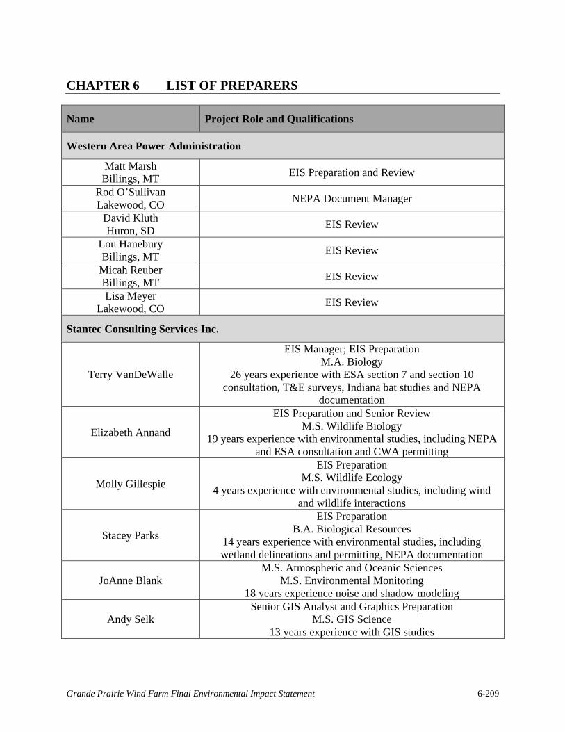
CHAPTER 6 LIST OF PREPARERS
Name Project Role and Qualifications
Western Area Power Administration
Matt Marsh Billings, MT EIS Preparation and Review
Rod O’Sullivan Lakewood, CO NEPA Document Manager
David Kluth Huron, SD EIS Review
Lou Hanebury Billings, MT EIS Review
Micah Reuber Billings, MT EIS Review
Lisa Meyer Lakewood, CO EIS Review
Stantec Consulting Services Inc.
Terry VanDeWalle
EIS Manager; EIS Preparation M.A. Biology
26 years experience with ESA section 7 and section 10 consultation, T&E surveys, Indiana bat studies and NEPA
documentation
Elizabeth Annand
EIS Preparation and Senior Review M.S. Wildlife Biology
19 years experience with environmental studies, including NEPA and ESA consultation and CWA permitting
Molly Gillespie
EIS Preparation M.S. Wildlife Ecology
4 years experience with environmental studies, including wind and wildlife interactions
Stacey Parks
EIS Preparation B.A. Biological Resources
14 years experience with environmental studies, including wetland delineations and permitting, NEPA documentation
JoAnne Blank M.S. Atmospheric and Oceanic Sciences
M.S. Environmental Monitoring 18 years experience noise and shadow modeling
Andy Selk Senior GIS Analyst and Graphics Preparation
M.S. GIS Science 13 years experience with GIS studies
Grande Prairie Wind Farm Final Environmental Impact Statement 6-209

This page intentionally left blank.
Grande Prairie Wind Farm Final Environmental Impact Statement 6-210

CHAPTER 7 LITERATURE CITED
ABC (American Bird Conservancy). 2013. Birds and collisions. American Bird Conservancy, Washington, DC <http://www.abcbirds.org/abcprograms/policy/collisions/index.html>. Accessed 10 January 2013.
ASRD and ACA (Alberta Sustainable Resource Development and Alberta Conservation Association). 2009. Status of the northern Myotis (Myotis septentrionalis) in Alberta. Wildlife Status Report No. 3. Alberta Sustainable Resource Development, Edmonton, Alberta, Canada.
Armbruster, M. J. 1990. Characterization of habitat used by Whooping Cranes during migration. U.S. Fish and Wildlife Service Biological Report 90(4).
Arnett, E. B., Brown, W. K., Erickson, W. P., Fiedler, J. K., Hamilton, B. L., Henry, T. H., Jain, A., Johnson, G. D., Kerns, J., Koford, R. R., Nicholson, C. P., O’Connell, T. J., Piorkowski, M. D., and R. D. Tankersley. 2008. Patterns of bat fatalities at wind energy facilities in North America. Journal of Wildlife Management 72:61-78.
Arnett, E.B., M.M.P. Huso, M.R. Schirmacher, and J.P. Hayes. 2010. Effectiveness of Changing Wind Turbine Cut-in Speed to Reduce Bat Fatalities at Wind Facilities: Final Report. Annual report prepared for the Bats and Wind Energy Cooperative (BWEC) and the Pennsylvania Game Commission. Bat Conservation International (BCI), Austin, Texas. May 2010.
Austin, J. E., and A. L. Richert. 2001. A comprehensive review of observational and site evaluation data of migrant whooping cranes in the United States, 1943-1999. U.S. Geological Survey, Northern Prairie Wildlife Research Center, Jamestown, North Dakota, USA.
Baerwald, E. F., G. H. D’Amours, B. J. Klug, and R. M. R. Barclay. 2008. Barotrauma is a significant cause of bat fatalities at wind turbines. Current Biology 18: R695-R696.
Barclay, R. M. R., E. F. Baerwald, and J. C. Gruver. 2007. Variation in bat and bird fatalities at wind energy facilities: assessing the effects of rotor size and tower height. Canadian Journal of Zoology 85: 381-387.
Benedict, R.A. 2004. Reproductive activity and distribution of bats in Nebraska. Western North American Naturalist, 64:231-248.
Brack, V., Jr., and J. O. Whitaker, Jr. 2001. Foods of the northern myotis, Myotis septentrionalis, from Missouri and Indiana, with notes on foraging. Acta Chiropterologica 3: 203-210.
Butchart, S. H. M., A. J. Stattersfield, and N. J. Collar. 2006. How many bird extinctions have we prevented? Oryx 40: 266–278.
Grande Prairie Wind Farm Final Environmental Impact Statement 7-211

Butler, S.R. 2011. Tests of marking methods and survey protocols for burying beetles (Coloptera: Silphidae). MS Thesis, University of Nebraska-Kearney.
Chamberlain, D. E., M. R. Rehfisch, A. D. Fox, M. Desholm, and S. J. Anthony. 2006. The effect of avoidance rates on bird mortality predictions made by wind turbine collision risk models. Ibis 148: 198-202.
Comsearch. 2013a. Wind Power GeoPlanner™ microwave study, Grande Prairie. Prepared on behalf of Geronimo Energy. Comsearch, Ashburn, Virginia, USA. 25 November.
Comsearch. 2013b. Wind Power GeoPlanner™ off-air television report, Grande Prairie. Prepared on behalf of Geronimo Energy. Comsearch, Ashburn, Virginia, USA. 25 November.
Connelly, J. W., M. W. Gratson, and K. P. Reese. 1998. Sharp-tailed Grouse (Tympanuchus phasianellus). Issue No. 354 in A. Poole, editor. The Birds of North America online. Cornell Lab of Ornithology, Ithaca, New York, USA. <http://bna.birds.cornell.edu/bna/ species/354>. Accessed 28 June 2012.
Cooper, J.M. 2006. Sandhill crane breeding on northern Vancouver Island, British Columbia. Northwestern Naturalist 87: 146-149.
Cowardin, L.M., V. Carter, F.C. Golet and E.T. LaRoe. 1979. Classification of Wetland and Deepwater Habitats of the United States. FWS/OBS-79/31. U.S. Fish and Wildlife Service, Office of Biological Services. Washington D.C.
Crampton, L. H., and R. M. R. Barclay. 1998. Selection of roosting and foraging habitat by bats in different-aged aspen mixedwood stands. Conservation Biology 12: 1347-1358.
Cryan, P. 2008. Overview of issues related to bats and wind energy. Wind Turbine Guidelines Advisory Committee Technical Workshop and Federal Advisory Committee Meeting, Washington, DC. 26 February.
Cryan, P. M., and A. C. Brown. 2007. Migration of bats past a remote island offers clues toward the problem of bat fatalities at wind turbines. Biological Conservation 139: 1–11.
Cryan, P. M., M. A. Bogan, and G. M. Yanega. 2001. Roosting habits of four bat species in the Black Hills of South Dakota. Acta Chiropterologica 3: 43-52.
CWS and USFWS (Canadian Wildlife Service and U.S. Fish and Wildlife Service). 2007. International recovery plan for the whooping crane (third revision). Canadian Wildlife Service Recovery of Nationally Endangered Wildlife, Ottawa, Ontario, CA and U.S. Fish and Wildlife Service, Albuquerque, New Mexico, USA. March.
Dauphiné, N., and R. J. Cooper. 2009. Impacts of free-ranging domestic cats (Felis catus) on birds in the United States: a review of recent research with conservation and management recommendations. Pages 205-219 in Proceedings of the Fourth International Partners in Flight Conference, 13-16 February 2008, McAllen, Texas, USA.
Grande Prairie Wind Farm Final Environmental Impact Statement 7-212

Dauphiné, N., and R. J. Cooper. 2011. Pick one: outdoor cats or conservation, the fight over managing an invasive predator. The Wildlife Professional 5: 50-52.
Derby, C., A. Dahl., W. Erickson, K. Bay, and J. Hoban. 2007. Post-construction monitoring report for avian and bat mortality at the NPPD Ainsworth Wind Farm. Prepared for Nebraska Public Power District. Western EcoSystems Technology, Inc., Cheyenne, Wyoming, USA.
Derby, C., K. Chodachek, and K. Bay. 2010a. Post-construction bat and bird fatality study Crystal Lake II Wind Energy Center, Hancock and Winnebago Counties, Iowa, final report, April 2009-October 2009. Prepared for NextEra Energy Resources. Western EcoSystems Technology, Inc., Bismarck, North Dakota, USA. 2 June.
Derby, C., K. Chodachek, and K. Bay. 2010b. Post-construction fatality surveys for the Winnebago Wind Project, March 2009-February 2010. Prepared for Iberdrola Renewables, Inc. Western EcoSystems Technology, Inc., Bismark, North Dakaota, USA.
Derby, C., K. Chodachek, K. Bay, and A. Merrill. 2010c. Post-construction fatality surveys for the Moraine II Wind Project, March-December 2009. Prepared for Iberdrola Renewables, Inc. Western EcoSystems Technology, Inc., Bismark, North Dakaota, USA.
Derby, C., K. Chodachek, K. Bay, and A. Merrill. 2010d. Post-construction fatality surveys for the Elm Creek Wind Project, March 2009-February 2010. Prepared for Iberdrola Renewables, Inc. Western EcoSystems Technology, Inc., Bismark, North Dakaota, USA.
Derby, C., A. Dahl, A. Merrill, and K. Bay. 2010e. 2009 Post-construction monitoring results for the Wessington Springs Wind Energy Facility, South Dakota, final report. Prepared for Wessington Wind Energy Center, LLC. Western EcoSystems Technology, Inc., Bismark, North Dakaota, USA. 19 August.
Derby, C., K. Chodachek, K. Bay, and A. Merrill. 2010f. Post-construction fatality survey for the Buffalo Ridge I Wind Project, May 2009-May 2010. Prepared for Iberdrola Renewables, Inc. Western EcoSystems Technology, Inc., Bismark, North Dakaota, USA.
Derby, C., T Thorn, and M. Wolfe. 2012. Whooping and sandhill crane monitoring at five operating wind facilities in North and South Dakota. Poster presented at the National Wind Coordinating Collaborative (NWCC) Wind Wildlife Research Meeting IX. November 27-30, 2012, Denver, CO.
Dugan, J. T., T. J. McGrath, and R. B. Zelt, 1994.Water-level changes in the High Plains aquifer--predevelopment to 1992. U.S. Geological Survey Water-Resources Investigations Report: 94-4027. <http://pubs.er.usgs.gov/publication/wri944027.> Accessed 4 July 2013.
Elliott-Smith, E., and S. M. Haig. 2004. Piping Plover (Charadrius melodus). Issue No. 2 in A Poole, editor. The Birds of North America online. Cornell Lab of Ornithology, Ithaca, New York, USA. <http://bna.birds.cornell.edu/bna/species/002.> Accessed 28 June 2012.
Grande Prairie Wind Farm Final Environmental Impact Statement 7-213

Erickson, W. P., G. D. Johnson, M. D. Strickland, D. P. Young, Jr., K. J. Sernka, and R. E. Good. 2001. Avian collisions with wind turbines: a summary of existing studies and comparisons to other sources of avian collision mortality in the United States. National Wind Coordinating Committee, Washington, DC and Western EcoSystems Technologies, Inc., Cheyenne, Wyoming, USA. August.
Erickson, W., G. Johnson, D. Young, D. Strickland, R. Good, M. Bourassa, K. Bay, and K. Sernka. 2002. Synthesis and comparison of baseline avian and bat use, raptor nesting and mortality information from proposed and existing wind developments. Prepared for Bonneville Power Administration. Western EcoSystems Technology, Inc., Cheyenne, Wyoming, USA.
Erickson, W. P., G. D. Johnson, and D. P. Young. 2005. A summary and comparison of bird mortality from anthropogenic causes with an emphasis on collisions. USDA Forest Service, General Technical Report PSW-GTR-191.
Everaert, J. 2003. Wind turbines and birds in Flanders: preliminary study results and recommendations. Natuur. Oriolus 69: 145-155.
FCC (Federal Communications Commission). 2013. Antenna structure registration. Federal Communications Commission, Washington, DC. <http://wireless2.fcc.gov/UlsApp/ AsrSearch/asrRegistrationSearch.jsp.> Accessed 4 March 2013.
Feldhamer, G. A., T. C. Carter, and J. O. Whitaker Jr. 2009. Prey consumed by eight species of insectivorous bats from Southern Illinois. The American Midland Naturalist 162: 43-51.
Foster, R. W., and A. Kurta. 1999. Roosting ecology of the northern bat (Myotis septentrionalis) and comparisons with the endangered Indiana bat (Myotis sodalis). Journal of Mammalogy 80: 659-672.
Frick, W. F., J. F. Pollock, A. C. Hicks, K. E. Langwig, D. S. Reynolds, G. G. Turner, C. M. Butchkoski, and T. H. Kunz. 2010. An emerging disease causes regional population collapse of a common North American bat species. Science 329: 679-682.
Fritcher, S. C., M. A. Rumble, and L. D. Flake. 2004. Grassland bird densities in seral stages of mixed-grass prairie. Rangeland Ecology & Management 57: 351-357.
Gehring, J., P. Kerlinger, and A. M. Manville II. 2011. The role of tower height and guy wires on avian collisions with communication towers. Journal of Wildlife Management 75: 848-855.
Good, R.E., W. Erickson, A. Merrill, S. Simon, K. Murray, K. Bay, and C. Fritchman. 2011. Bat Monitoring Studies at the Fowler Ridge Wind Energy Facility Benton County, Indiana, April 13 – October 15, 2010. Prepared for: Fowler Ridge Wind Farm. Prepared by Western EcoSystems Technology, Inc., Cheyenne, Wyoming, January 28, 2011.
Grande Prairie Wind Farm Final Environmental Impact Statement 7-214

Good, R. E, A. Merrill, S. Simon, K. L. Murray, and K. Bay. 2012. Bat monitoring studies at the Fowler Ridge Wind Farm, Benton County, Indiana, final report, April 1 – October 31, 2011. Prepared for Fowler Ridge Wind Farm. Western EcoSystems Technology, Inc. Bloomington, Indiana, USA.
Helzer, C. J., and D. E. Jelinski. 1999. The relative importance of patch area and perimeter–area ratio to grassland breeding birds. Ecological Applications 9: 1448–1458.
Henderson, L. E., and H. G. Broders. 2008. Movements and resource selection of the northern long-eared myotis (Myotis septentrionalis) in a forest-agriculture landscape. Journal of Mammalogy, 89: 952-963.
Henderson, L. E., L. J. Farrow, and H. G. Broders. 2008. Intra-specific effects of forest loss on the distribution of the forest-dependent northern long-eared bat (Myotis septentrionalis). Biological Conservation. 141: 1819–1828.
Hinman, J.L. 2010. Wind farm proximity and property values: a pooled hedonic regression analysis of property values in central Illinois. M.S. thesis. Illinois State University, Normal, Illinois, USA.
Hoen, B., R. Wiser, P. Cappers, M. Thayer, and G. Sethi. 2009. The impact of wind power projects on residential property values in the United States: a multi-site hedonic analysis. Lawrence Berkeley National Laboratory, Berkley, California, USA. December.
Horn, J. W., E. B. Arnett, and T. H. Kunz. 2008. Behavioral responses of bats to operating wind turbines. Journal of Wildlife Management 72: 123-132.
Jain, A. A. 2005. Bird and bat behavior and mortality at a northern Iowa windfarm. M.S. Thesis. Iowa State University, Ames, Iowa, USA.
Johnson, G. D., W. P. Erickson, M. D. Strickland, M. F. Shepherd, and D.A. Shepherd. 2000. Final report, avian monitoring studies at the Buffalo Ridge, Minnesota Wind Resource Area: results of a 4-year study. Prepared for Northern States Power Company. Western EcoSystems Technology, Inc., Cheyenne, Wyoming, USA.
Johnson, G. D., W. P. Erickson, M. D. Strickland, M. F. Shepherd, D. A. Shepherd, and S. A. Sarappo. 2002. Collision mortality of local and migrant birds at a large-scale wind-power development on Buffalo Ridge, Minnesota. Wildlife Society Bulletin 30: 879-887.
Johnson, G., Erickson, W., White, J., and R. McKinney. 2003. Avian and bat mortality during the first year of operation at the Klondike Phase I Wind Project, Sherman County, Oregon. Prepared for Northwestern Wind Power. Western EcoSystems Technology, Inc., Cheyenne, Wyoming, USA.
Johnson, G. D., M. K. Perlik, W. P. Erickson, and M. D. Strickland. 2004. Bat activity, composition, and collision mortality at a large wind plant in Minnesota. Wildlife Society Bulletin 32: 1278-1288.
Grande Prairie Wind Farm Final Environmental Impact Statement 7-215

Johnson, G. D. 2005. A review of bat mortality at wind-energy developments in the United States. Bat Research News 46:45-49.
Johnson, J. A., M. A. Schroeder, and L. A. Robb. 2011. Greater Prairie-chicken (Tympanuchus cupido). Issue No. 36 in A Poole, editor. The Birds of North America online. Cornell Lab of Ornithology, Ithaca, New York, USA. <http://bna.birds.cornell.edu/bna/species/036.> Accessed 28 June 2012.
Jorgensen, J.G., and L.R. Dinan. 2013 Nebraska Bald Eagle Nesting Report. Nebraska Game and Parks Nongame Bird Program. http://outdoornebraska.ne.gov/wildlife/programs/ nongame/NGbirds/pdf/2013_NebraskaBaldEagleNestingReport.pdf
Kalko, E.K.V., and C.O. Handley. 2001. Neotropical bats in the canopy: diversity, community structure, and implications for conservation. Plant Ecology 153:319–333.
Keck, T. 2011. The tornado climatology for the NWS North Platte County warning and forecast area from 01 January 1950 to 31 December 2008. NWSFO North Platte, North Platte, Nebraska, USA. <http://www.crh.noaa.gov/lbf/?n=100828lbftorclimo.> Accessed 28 June 2012.
Kerlinger, P. 2000. Avian mortality at communication towers: a review of recent literature, research, and methodology. Prepared for U.S. Fish and Wildlife Service Office of Migratory Bird Management. Curry & Kerlinger, LLC, Cape May Point, New Jersey, USA. March.
Kerlinger, P. 2002. An assessment of the impacts of Green Mountain Power Corporation’s Wind Power Facility on breeding and migrating birds in Searsburg, Vermont, July 1996-July 1998. Prepared for Vermont Department of Public Service. Curry & Kerlinger, LLC, Cape May Point, New Jersey, USA.
Kerns, J., and P. Kerlinger. 2004. A study of bird and bat collisions at the Mountaineer Wind Energy Center, Tucker County, West Virginia, annual report for 2003. Prepared for FPL Energy and the Mountaineer Wind Energy Center Technical Review Committee. Curry and Kerlinger, LLC, Cape May, New Jersey, USA. 14 February. <http://www.wvhighlands.org/Birds/MountaineerFinalAvianRpt-%203-15-04PKJK.pdf.> Accessed 28 June 2012.
Kerns, J., W. P. Erickson, and E. B. Arnett. 2005. Bat and bird fatality at wind energy facilities in Pennsylvania and West Virginia. Pages 24–95 in E. B. Arnett, editor. Relationships between bats and wind turbines in Pennsylvania and West Virginia: an assessment of bat fatality search protocols, patterns of fatality, and behavioral interactions with wind turbines. Bats and Wind Energy Cooperative. Bat Conservation International, Austin, Texas, USA.
Kheifets, L., A. Ahlbom, C. M. Crespi, G. Draper, J. Hagihara, R. M. Lowenthal, G. Mezei, S. Oksuzyan, J. Schüz, J. Swanson, A. Tittarelli, M. Vinceti, and V. Wunsch Filho. 2010. Pooled analysis of recent studies on magnetic fields and childhood leukaemia. British Journal of Cancer 103:1128–1135.
Grande Prairie Wind Farm Final Environmental Impact Statement 7-216

Kingsley, A., and B. Whittam. 2005. Wind turbines and birds: a background review for environmental assessment. Prepared for Canadian Wildlife Service/Environment Canada. Bird Studies Canada, Port Rowan, Ontario, CA. 12 May.
Kunz, T. H., E. B. Arnett, B. M. Cooper, W. P. Erickson, R. P. Larkin, T. Mabee, M. L. Morrison, M. D. Strickland, and J. M. Szewczak. 2007a. Assessing impacts of wind energy development on nocturnally active birds and bats: a guidance document. Journal of Wildlife Management 71: 2449-2486.
Kunz, T. H., E. B. Arnett, W. P. Erickson, A. R. Hoar, G. D. Johnson, R. P. Larkin, M. D. Strickland, R. W. Thresher, and M. D. Tuttle. 2007b. Ecological impacts of wind energy development on bats: questions, research needs and hypotheses. Frontiers in Ecology and the Environment 5: 315-324.
Lacki, M. J., D.R. Cox, L. E. Dodd, and M. B. Dickinson. 2009. Response of northern bats (Myotis septentrionalis) to prescribed fires in eastern Kentucky forests. Journal of Mammalogy 90: 1165-1175.
LaGrange, T. 2005. Guide to Nebraska wetlands and their conservation needs. Nebraska Game and Parks Commission, Lincoln, Nebraska, USA.
LaVal, R. K., R. L. Clawson, M. L. LaVal, and W. Caire. 1977. Foraging behavior and nocturnal activity patterns of Missouri bats, with emphasis on the endangered species Myotis grisescens and Myotis sodalis. Journal of Mammalogy 58: 592-599.
Madders, M., and D.P. Whitfield. 2006. Upland raptors and the assessment of wind farm impacts. Ibis 148: 43-56.
Manville, A. M., II. 2005. Bird strikes and electrocutions at power lines, communication towers, and wind turbines: state of the art and state of the science—next steps toward mitigation. USDA Forest Service General Technical Report PSW-GTR-191.2005.
Manville, A. M., II. 2009. Towers, turbines, power lines, and buildings—steps being taken by the U.S. Fish and Wildlife Service to avoid or minimize take of migratory birds at these structures. Pages 262-272 in Tundra to Tropics: Proceedings of the 4th International Partners in Flight Conference 2008. T. D. Rich, C. Arizmendi, D. W. Demarest, and C.Thompson, editors. Partners in Flight.
McGuire, V. L. 2011. Water-level changes in the High Plains aquifer, predevelopment to 2009, 2007-08, and 2008-09, and change in water in storage, predevelopment to 2009. U.S. Geological Survey Scientific Investigations Report 2011-5089. <http://pubs.usgs.gov/sir/ 2011/5089/pdf/SIR2011-5089.pdf.> Accessed 28 June 2012.
Menzel, M. A., S. F. Owen, W. M. Ford, J. W. Edwards, P. B. Wood, B. R. Chapman, K. V. Miller. 2002. Roost tree selection by northern long-eared bat (Myotis septentrionalis) maternity colonies in an industrial forest of the central Appalachian mountains. Forest Ecology and Management 155: 107–114.
Grande Prairie Wind Farm Final Environmental Impact Statement 7-217

Mineau, P. 1988. Avian mortality in agroecosystems: 1. the case against granule insecticides. Pages 13-27 in Field methods for the study of environmental effects of pesticides, proceedings or a symposium organized by the British Crop Protection Council. M. P. Graves, B. D. Smith, and P.W . Greig-Smith, editors. Churchill College, Cambridge, UK.
Moore, C.L., C.H. Johnson, C.L. Hall, and D.R. Howard. 2012. The effect of wind-turbine induced vibration on the reproductive behavior of the endangered American burying beetle (Nicrophorus americanus). North Central Branch of the Entomological Society of America Annual Meeting, 4 June 2012.
Morgan, C. E. Bossanyi, and H. Seifert. 1998. Assessment of safety risks arising from wind turbine icing. Proceeding of BOREAS IV Conference on Wind Energy Production in Cold Climates, Hetta, Finland, 31 March - 2 April 1998. Finnish Meteorological Institute, Helsinki, Finland. <http://virtual.vtt.fi/virtual/arcticwind/publications.htm#.> Accessed 6 March 2013.
NAS. 2007. National Academy of Sciences. Environmental Impacts of Wind-Energy Projects. The National Academies Press, Washington, D.C., USA.
NIEHS. 2002. EMF: electric and magnetic fields associated with the use of electric power, questions and answers. National Institutes of Environmental Health Sciences, Washington, DC. June.
NOAA-NWS (National Oceanic and Atmospheric Administration-National Weather Service). 2010. 1971-2000 daily/monthly station normals: COOP ID 256290, O’Neill, NE 02. National Oceanic and Atmospheric Administration, National Weather Service. <http://www.crh.noaa.gov/lbf/?n=onlncoopdailynormal.> Accessed 28 June 2012.
Nebraska Bird Library. 2013. Sharp-tailed Grouse. Nebraska Bird Library, Lincoln, Nebraska, USA. <http://nebraskabirdlibrary.org/index.php/galliformes/phasianidae/sharp-tailed-grouse.html .> Accessed 1 March 2013.
Nebraska Bird Partnership. 2010. Nebraska birds: Greater Prairie-chicken (Tympanuchus cupido). Nebraska Bird Partnership, Lincoln, Nebraska, USA. <http://www.nebraskabirds.org/index.php/nebraskabirds/species/160-greater-prairie-chicken.html.> Accessed 1 March 2013.
NDEQ (Nebraska Department of Environmental Quality) Air Quality Division. 2010. Nebraska air quality: 2010. Nebraska Department of Environmental Quality, Air Quality Division, Lincoln, Nebraska, USA. http://www.deq.state.ne.us/Publica.nsf/ c4afc76e4e077e11862568770059b73f/a12a5ada6cce1c1686257a47004e0633/$FILE/AirQuality%202010.pdf
NDOL (Nebraska Department of Labor). 2013a. News release: Nebraska unemployment rate dips for third straight month. Nebraska Department of Labor, Lincoln, Nebraska, USA. 20 December. http://www.dol.nebraska.gov/infolink/OtherFiles/MSR.pdf
Grande Prairie Wind Farm Final Environmental Impact Statement 7-218

NDOL. 2013b. News release: Nebraska’s county unemployment rates. Nebraska Department of Labor, Lincoln, Nebraska, USA. 20 December. http://www.dol.nebraska.gov/infolink/LaborAreaSummaries/LAS_Annual.pdf.
NGPC (Nebraska Game and Parks Commission). 2011. Wind energy and Nebraska’s wildlife: an index of the sensitivity of wildlife habitats to wind energy development, based on selected at-risk species. Nebraska Game and Parks Commission, Lincoln, Nebraska. December.
NGPC. 2012. Nebraska public access atlas. Nebraska Game and Parks Commission, Lincoln, Nebraska, USA. <http://outdoornebraska.ne.gov/hunting/programs/CRP/.> Accessed 4 March 2012.
NGPC. 2013. American burying beetle (Nicrophorus americanus): A species conservation assessment for the Nebraska Natural Legacy Project. March 2013. http://outdoornebraska.ne.gov/wildlife/programs/legacy/pdfs/assessments/ABB.pdf. Accessed 28 August 2014.
NGPC and USFWS. 2012. Wind energy and Nebraska’s wildlife, avian assessment guidance for wind energy facilities in Nebraska, draft version 3.1. Nebraska Game and Parks Commission and U.S. Fish and Wildlife Service. Lincoln, Nebraska, USA.
North East Ecological Services. 2013. Pre-construction impact assessment of wind development on bats, Grande Prairie Wind Project, Holt County, Nebraska. Prepared for Midwest Wind Energy, LLC. North East Ecological Services, Bow, New Hampshire, USA. 27 January.
NPPD (Nebraska Public Power District). 2013. R-Project. Nebraska Public Power District, Columbus, Nebraska, USA. <http://www.nppd.com/rproject/.> Accessed 27 February 2013.
NWWWG (Nebraska Wind and Wildlife Working Group). 2011. Guidelines for wind energy and wildlife resource management in Nebraska. Nebraska Wind and Wildlife Working Group. 8 February. <http://outdoornebraska.ne.gov/wildlife/pdfs/newwguidelines.pdf.> Accessed 3 July 2013.
Ornithological Council, The. 2007. Critical literature review: impact of wind energy and related human activities on grassland and shrub-steppe birds. Prepared for the National Wind Coordinating Collaborative. Ornithological Council, Chevy Chase, Maryland, USA. October.
Owen, S. F., M. A. Menzel, W. M. Ford, B. R. Chapman, K. V. Miller, J. W. Edwards, and P. B. Wood. 2003. Home-range size and habitat used by the northern Myotis (Myotis septentrionalis). American Midland Naturalist 150: 352-359.
Pearse, A. T., and S. M. Selbo. 2012. Model of whooping crane energetics as foundation for development of a method to assess potential take during migration, Open-File Report 2012-1156. U.S. Geological Survey, Reston, Virginia, USA.
Grande Prairie Wind Farm Final Environmental Impact Statement 7-219
Peterson, T. 2011. Letter to Laura Hill, USFWS, regarding a bird mortality event at the Laurel Mountain Substation. Stantec Consulting Services Inc., Topsham, Maine, USA. 25 October.
Peurach, S. C., C. J. Dove, and L. Stepko. 2009. A decade of U.S. Air Force bat strikes. Human–Wildlife Conflicts 3: 199–207
Pimentel, D., A. Greiner, and T. Bashore. 1991. Economic and environmental costs of pesticide use. Archives of Environmental Contaminants and Toxicology 21: 84-90.
Poulin, R., L. D. Todd, E. A. Haug, B. A. Millsap, and M. S. Martell. 2011. Burrowing Owl (Athene cunicularia), The Birds of North America Online (A. Poole, Editor). Cornell Lab of Ornithology, Ithaca, New York, USA. <http://bna.birds.cornell.edu/bna/species/061.> Accessed 28 June 2012.
Poulton, V. 2010. Summary of post-construction monitoring at wind projects relevant to Minnesota, identification of data gaps, and recommendations for further research regarding wind energy development in Minnesota. Prepared for State of Minnesota Department of Commerce. Western EcoSystems Technology, Inc., Cheyenne, Wyoming, USA.
Preston, C. R. and R. D. Beane. 2009. Red-tailed Hawk (Buteo jamaicensis). Issue No. 52 in A. Poole, editor. The Birds of North America online. Cornell Lab of Ornithology, Ithaca, New York, USA. <http://bna.birds.cornell.edu/bna/species/052.> Accessed 28 June 2012.
Rademakers, L. W. M. M., and H. Braam. 2005. Analysis of risk-involved incidents of wind turbines, Version 1.1. Energy Research Centre of the Netherlands, Petten, Netherlands. January.
Ragon, L. G., V. C. Seevers, O. Indra, F. V. Belohlavy, S. J. Lobaugh, J. Carlson, and H. Schultz. 1983. Soil survey of Holt County, Nebraska. USDA-Soil Conservation Service and University of Nebraska Conservation and Survey Division. Lincoln, Nebraska, USA. March.
Ratcliffe, J. M. and J. W. Dawson. 2003. Behavioral flexibility: the little brown bat, Myotis lucifugus, and the northern long-eared bat, M. septentrionalis, both glean and hawk prey. Animal Behaviour 66: 847-856.
Robb, L. A. and M. A. Schroeder. 2005 . Lesser Prairie-chicken (Tympanuchus pallidicinctus): a technical conservation assessment. USDA Forest Service, Rocky Mountain Region, Bridgeport, Washington, USA. 31March. <http://www.fs.fed.us/r2/projects/scp/ assessments/lesserprairiechicken.pdf.> Accessed 1 March 2013.
Rollins, K. E., D. K. Meyerholz, G. D. Johnson, A. P. Capparella1, and S. S. Loew. 2012. A forensic investigation into the etiology of bat mortality at a wind farm: barotrauma or traumatic injury?. Veterinary Pathology 49: 362-371.
Grande Prairie Wind Farm Final Environmental Impact Statement 7-220

Sandercock, B. K., L. M. Hunt, V. Winder, A. J. Gregory, L. B. McNew, and S. M. Wisely. 2012. Effects of wind power development on greater prairie-chickens in Kansas. National Wind Coordinating Collaborative, Wind Wildlife Research Meeting IX. November 28-30, 2012. Broomfield, Colorado, USA. <http://www.nationalwind.org/assets/ research_meeting_ix_presentations/2_1_Sandercock.pdf.> Accessed 1 March 2013.
Schneider, R., K. Stoner, G. Steinauer, M. Panella, and M. Humpert (editors). 2011. The Nebraska Natural Legacy Project: State Wildlife Action Plan. 2nd edition. The Nebraska Game and Parks Commission, Lincoln, Nebraska, USA. <http://outdoornebraska.ne.gov/wildlife/programs/legacy/pdfs/NE%20Natural%20Legacy%20Project%20-%202nd%20edition.pdf.> Accessed 1 March 2013.
Schnell, G.D., A. E. Hiott, J. C. Creighton, V. L. Smyth, and A. Komendat. 2007. Factors affecting overwinter survival of the American burying beetle, Nicrophorus americanus (Coleoptera: Silphidae). Journal of Insect Conservation DOI 10.1007/s10841-007-90865.
Shaffer, J. A., and D. H. Johnson. 2008. displacement effects of wind developments on grassland birds in the Northern Great Plains. National Wind Coordinating Collaborative, Wind Wildlife Research Meeting VII. October 28-29, 2008. Milwaukee, Wisconsin, USA.
Shire, G. G., K. Brown, and G. Winegrad. 2000. Communication towers: a deadly hazard to birds. American Bird Conservancy, Washington, DC. June.
Smithsonian (Smithosonian Nation Zoological Park). 1998. “Optimal Migration, special issue”. Journal of Avian Biology. 29(4).
Stantec (Stantec Consulting Services Inc.). 2010a. Stetson I Mountain Wind Project, year 1 post-construction monitoring report, 2009 for the Stetson Mountain Wind Project in Penobscot and Washington Counties, Maine. Prepared for First Wind Management, LLC. Stantec Consulting Services Inc, Topsham, Maine, USA. February.
Stantec. 2010b. Cohocton and Dutch Hill Wind Farms year 1 post-construction monitoring report, 2009 for the Cohocton and Dutch Hill Wind Farms in Cohocton, New York. Prepared for Canandaigua Power Partners, LLC and Canandaigua Power Partners II, LLC. Stantec Consulting Services Inc., Topsham, Maine, USA. March.
Stehn, T. 2011. Whooping crane recovery activities, October, 2010 – August, 2011. U.S. Fish and Wildlife Service, Aransas National Wildlife Refuge, Austwell, Texas, USA. 31 August.
Stehn, T. V., and T. Wassenich. 2008. Whooping crane collisions with power lines: an issue paper. Proceedings of the North American Crane Workshop 10: 25-36.
Strickland, D. 2004. Overview of non-collision related impacts from wind projects. In S. S. Schwartz, editor. Understanding and resolving bird and bat impacts: Proceedings of the Wind Energy and Birds/Bats Workshop, 18-19 May 2004, Washington, DC. September.
Grande Prairie Wind Farm Final Environmental Impact Statement 7-221

Strickland, M. D., E. B. Arnett, W. P. Erickson, D. H. Johnson, G. D. Johnson, M. L. Morrison, J. A. Shaffer, and W. Warren-Hicks. 2011. Comprehensive guide to studying wind energy/wildlife interactions. Prepared for the National Wind Coordinating Collaborative, Washington, D.C., USA.
Tetra Tech. 2011. Titan I Wind Farm whooping crane monitor and sandhill crane behavioral report, spring and fall 2010. Report prepared by Tetra Tech EC, Inc. for BP Wind Energy North America (February).
Thogmartin, W. E., F. P. Howe, F. C. James, D. H. Johnson, E. T. Reed, J. R. Sauer, and F. R. Thompson III. 2006. A review of the population estimation approach of the North American Landbird Conservation Plan. The Auk 123: 892-904.
Thompson, B. C., J. A. Jackson, J. Burger, L. A. Hill, E. M. Kirsch, and J. L. Atwood. 1997. Least Tern (Sternula antillarum). Issue No. 290 in A. Poole, editor. The Birds of North America online. Cornell Lab of Ornithology, Ithaca, New York, USA <http://bna.birds.cornell.edu/bna/species/290.> Accessed 1 March 2013.
Tigner, J., and E. D. Stukel. 2003. Bats of the Black Hills: a description of status and conservation needs. Wildlife Division Report 2003-05. South Dakota Department of Game, Fish and Parks, Fort Pierre, South Dakota, USA. March.
Trapp, J. L. 1998. Bird kills at towers and other human-made structures: an annotated partial bibliography (1960-1998). U.S. Fish and Wildlife Service, Office of Migratory Bird Management, Arlington, Virginia, USA.
Turner, G. G., D. M. Reeder, and J. T. H. Coleman. 2011. A five-year assessment of mortality and geographic spread of white-nose syndrome in North American bats and a look to the future. Bat Research News. 52: 13-27.
University of Nebraska. 2004. Cartography and geographic information systems laboratory: water resources. University of Nebraska-Omaha, Omaha, Nebraska, USA. <http://maps.unomaha.edu/Peake/1030/water.html.> Accessed 5 March 2013.
University of Nebraska. 2012. GIS geology databases: bedrock geology. University of Nebraska-Lincoln, School of Natural Resources, Lincoln, Nebraska, USA. <http://snr.unl.edu/data/ geographygis/NebrGISgeology.asp#bedrock.> Accessed 5 March 2013.
USDA (U.S. Department of Agriculture). 2009. 2007 Census of Agriculture—county data, Nebraska. US Department of Agriculture, National Agricultural Statistics Service, Washington, DC. February. <http://www.agcensus.usda.gov/Publications/2007/ Full_Report/Volume_1,_Chapter_2_County_Level/Nebraska/.> Accessed 4 March 2013.
USDA-FSA (U. S. Department of Agriculture-Farm Service Agency). 2011. The Conservation Reserve Program: 41st signup results. U. S. Department of Agriculture, Farm Service Agency, Conservation and Environmental Programs Division. Washington, DC. <http://www.fsa.usda.gov/Internet/FSA_File/su41state.pdf.> Accessed 1 March 2013.
Grande Prairie Wind Farm Final Environmental Impact Statement 7-222

USDOE. 2006. Memorandum: Need to consider intentional destructive acts in NEPA documents. U.S. Department of Energy, Office of NEPA Policy and Compliance, Washington, D.C. 1 December.
USEPA. 2013. Draft inventory of U.S. greenhouse gas emissions and sinks: 1990-2011. U.S. Environmental Protection Agency, Washington, D.C. <http://www.epa.gov/ climatechange/Downloads/ghgemissions/US-GHG-Inventory-2011.pdf.> Accessed 5 March 2013.
USFWS (U. S. Fish and Wildlife Service). 1991. American Burying Beetle (Nicrophorus americanus) recovery plan. U.S. Fish and Wildlife Service, Newton Corner, Massachusetts, USA.
USFWS. 1996. Platanthera praeclara (western prairie fringed orchid) recovery plan. U.S. Fish and Wildlife Service, Fort Snelling, Minnesota, USA.
USFWS. 2000. Pesticides and birds. U.S. Fish and Wildlife Service, Office of Migratory Bird Management, International Migratory Bird Day Events and Information Coordinator. March.
USFWS. 2002. Migratory bird mortality: many human-caused threats afflict our bird populations. U.S. Fish and Wildlife Service, Division of Migratory Bird Management, Arlington, Virginia, USA. January.
USFWS. 2007. National Bald Eagle Management Guidelines. United States Fish and Wildlife Service, May 2007.
USFWS. 2009. Whooping cranes and wind development - an issue paper. U.S. Fish and Wildlife Service, Albuquerque, New Mexico and Lakewood, Colorado, USA. April.
USFWS. 2011. Questions and answers pertaining to effects analyses for Indiana bats and wind energy projects. U.S. Fish and Wildlife Service, Midwest Region, Bloomington, Indiana, USA. 26 October. <http://www.fws.gov/midwest/endangered/mammals/inba/ pdf/inbaS7and10WindGuidanceFinal26Oct2011.pdf.> Accessed 12 July 2012.
USFWS. 2012a. Land-based wind energy guidelines. 23 March. U.S. Fish and Wildlife Service. <http://www.fws.gov/windenergy/docs/WEG_final.pdf.> Accessed 4 July 2013.
USFWS. 2012b. Whooping crane (Grus americana) 5-year review: summary and evaluation. Aransas National Wildlife Refuge, Austwell, Texas and Corpus Christi Ecological Service Field Office, Texas, USA. 13 February. <http://ecos.fws.gov/docs/five_year_review/doc3977.pdf.> Accessed 1 March 2013.
USFWS. 2012c. News release: North American bat death toll exceeds 5.5 million from white-nose syndrome. U.S. Fish and Wildlife Service, Office of Communications, Arlington, Virginia, USA. 17 January. <http://www.fws.gov/WhiteNoseSyndrome/pdf/ WNS_Mortality_2012_NR_FINAL.pdf.> Accessed 25 July 2012.
Grande Prairie Wind Farm Final Environmental Impact Statement 7-223

USFWS. 2012d. White-nose syndrome: the devastating disease of hibernating bats in North America. U. S. Fish and Wildlife Service, Hadley, Massachusetts, USA. August. <http://whitenosesyndrome.org/sites/default/files/resource/white-nose_fact_sheet_9-2012.pdf.> Accessed 3 July 2013.
USFWS. 2013a. Eagle conservation plan guidance, Module 1 – land-based wind energy, Version 2. U.S. Fish and Wildlife Service, Migratory Birds Division. <http://www.fws.gov/ migratorybirds/PDFs/Eagle%20Conservation%20Plan%20Guidance-Module%201.pdf.> Accessed 1 May 2013.
USFWS. 2013b. Endangered and threatened wildlife and plants; proposed threatened status for the rufa red knot (caladris canutus rufa). United States Fish and Wildlife Service. 30 September.
USFWS. 2013c. Endangered and threatened wildlife and plants; 12-month finding on a petition to list the eastern small-footed bat and the northern long-eared bat as endangered or threatened species; listing the northern long-eared bat as an endangered species. Green Bay Ecological Services Office, New Franken, Wisconsin, USA. 2 October.
USFWS. 2013d. Biological Opinion on the Effects to Threatened and Endangered Species from the issuance of a Presidential Permit to TransCanada Keystone Pipeline, LP (Keystone) by the U.S. Department of State for the proposed construction, connection, operation and maintenance of the Keystone XL pipeline and associated facilities at the border of the United States for importation of crude oil from Canada. FWS-NE: 2010-377.
USFWS. 2013e. Bat white-nose syndrome (WNS) occurrence by county/district (or portions thereof). 20 December. U.S. Fish and Wildlife Service, Hadley, Massachusetts, USA. <http://whitenosesyndrome.org/resources/map.> Accessed 22 December 2013.
USFWS. 2014. Northern Long-Eared Bat Interim Conference and Planning Guidance. USFWS Regions 2, 3, 4, 5, & 6. January 6, 2014.
USGS. 2012. Mineral resources online spatial data: geology: by state: Nebraska: Ogallala Group or Formation. U.S. Geological Survey <http://tin.er.usgs.gov/geology/state/sgmc-unit.php?unit=NETo%3B0.> Accessed 25 July 2012.
Vickery, P.D. 1996. Grasshopper Sparrow (Ammodramus savannarum). Issue No. 239 in A. Poole, editor. The Birds of North America online. Cornell Lab of Ornithology, Ithaca, New York, USA. <http://bna.birds.cornell.edu/bna/species/239/.> Accessed 4 July 2013.
Vickery,P.D., J.R. Herkert, F.L. Knopf, J. Ruth and C.E. Keller. 1999. Grassland birds: an overview of threats and recommended management strategies. In R. Bonney, D. N. Pashley, R. J. Cooper, and L. Niles, editors. Strategies for bird conservation: The Partners in Flight Planning Process. Cornell Lab of Ornithology, Ithaca, New York, USA.
Grande Prairie Wind Farm Final Environmental Impact Statement 7-224

Washington State Department of Transportation. 2013. Biological assessment preparation for transportation projects - advanced training manual - version 2013. Washington State Department of Transportation, Olympia, Washington, USA. <http://www.wsdot.wa.gov/ Environment/Biology/BA/BAguidance.htm#manual.> Accessed 7 March 2013.
Whitfield, D.P. 2009. Collision avoidance of golden eagles at wind farms under the ‘Band’ collision risk model. Report from Natural Research to Scottish Natural Heritage, Banchory, UK.
Whitfield, D.P., and M. Madders. 2006. A review of the impacts of wind farms on hen harriers (Circus cyaneus) and an estimation of collision avoidance rates. Natural Research Information Note 1 (Revised). Natural Research, LTD. Banchory, Aberdeenshire, UK. August.
WHO. 2007. Extremely low frequency fields; environmental health criteria 238. World Health Organization, WHO Press, Geneva, Switzerland.
Wilkinson, G. S. and J. M. South. 2002. Life history, ecology and longevity in bats. Aging Cell 1: 124-131.
Young, D., and Z. Courage. 2011. Memorandum dated September 30, 2011 to NedPower regarding a bird kill on September 25, 2011at the Mount Storm Wind Power facility. Western EcoSystems Technology, Inc., Cheyenne, Wyoming, USA.
Young, D.P., Jr., Erickson, W. P., Good, R. E., Strickland, M. D., and G. D. Johnson. 2003. avian and bat mortality associated with the initial phase of the Foote Creek Rim Windpower Project, Carbon County, Wyoming, November 1998-June 2002. Prepared for Pacificorp, Inc., SeaWest Windpower, Inc., and BLM Rawlins District Office. Western EcoSystems Technology, Inc., Cheyenne, Wyoming, USA.
Grande Prairie Wind Farm Final Environmental Impact Statement 7-225

This page intentionally left blank.
Grande Prairie Wind Farm Final Environmental Impact Statement 7-226

CHAPTER 8 DISCLOSURE STATEMENT
Organizational Conflict of Interest Representation Statement
I hereby certify as a representative of my organization that, to the best of my knowledge and belief, no facts exist relevant to any past, present or currently planned interest or activity (financial, contractual, personal, organizational or otherwise) that relate to the proposed work; and bear on whether I or the organization has a possible conflict of interest with respect to (1) being able to render impartial, technically sound, and objective assistance or advice; (2) being given an unfair competitive advantage; or (3) having a financial interest in the outcome of the project.
Signature: Date: June 3, 2014
Name: Terry VanDeWalle
Title: Senior Associate
Organization: Stantec Consulting Services Inc
Grande Prairie Wind Farm Final Environmental Impact Statement 8-227

This page intentionally left blank.
Grande Prairie Wind Farm Final Environmental Impact Statement 8-228
CHAPTER 9 GLOSSARY
Abiotic: Of or characterized by the absence of life or living organisms.
Affected Environment: Existing biological, physical, social, and economic conditions of an area subject to change, both directly and indirectly, as the result of a proposed human action.
Aggregate: Mineral materials such as sand, gravel, crushed stone, or quarried rock used for construction purposes.
Air quality: Assessment of the health-related and visual characteristics of the air often derived from quantitative measurements of the concentrations of specific injurious or contaminating substances. Air quality standards are the prescribed levels of substances in the outside air that cannot be exceeded during a specific time in a specified area.
Air Quality Standards: The level of pollutants prescribed by regulation that may not be exceeded during a specified time in a defined area.
American Indian Religious Freedom Act of 1978 (AIRFA): This act requires Federal agencies to consult with Tribal officials to ensure protection of religious cultural rights and practices.
Anthropogenic: Human impact on the environment.
Archaeological Site: Any location where humans have altered the terrain or discarded artifacts during prehistoric or historic times.
Area of Potential Effect (APE): The area in which disturbance to cultural resources may occur and within which a systematic cultural resource inventory is required.
Attenuation: Reduction of the level or intensity of sound.
Avian Power Line Interaction Committee (APLIC): Committee that works in partnership with other utilities, resource agencies and the public to develop and provide educational resources, identify and fund research, develop and provide cost-effective management options, and serve as the focal point for avian interaction utility issues.
Avian Protection Plan (APP): A utility-specific program designed to reduce the operational and avian risks that result from avian interactions with electric utility facilities.
Aquifer: A permeable underground formation that yields usable amounts of water to a well or spring. The formation could be sand, gravel, limestone, and/or sandstone.
Balance of Plant (BOP): All infrastructure elements of power plants, including: turbines, substations, civil works, electrical cables, and switchyard.
Grande Prairie Wind Farm Final Environmental Impact Statement 9-229

Bald and Golden Eagle Protection Act (BGEPA): A Federal law enacted in 1940 and amended several times, prohibits anyone, without a permit from the Secretary of the Interior, from “taking” bald and golden eagles, including their parts, nests, or eggs.
Batch Plant: Mixing plant that produces batches of concrete or aggregate-asphalt mixture, offsite or at the site of another plant.
Best Management Practices (BMP): Structural and/or management practices employed before, during, and after construction to protect receiving-water quality. These practices provide techniques to either reduce soil erosion or remove sediment and pollutants from surface runoff.
Biotic: A living or once living component of a community.
Bird and Bat Conservation Strategy (BBCS): Formerly known as Avian Protection Plan, now known as a Wildlife Conservation Strategy.
Clean Air Act: This act establishes national ambient air quality standards and requires facilities to comply with emission limits or reduction limits stipulated
Clean Water Act (Section 404)(CWA): The Federal Water Pollution Control Act Amendments of 1972 (33 U.S.C. § 401 et seq.) is the enabling legislation for protection of waters of the United States by the U.S. Army Corps of Engineers and the U.S. Environmental Protection Agency.
Code of Federal Regulations (CFR): A compilation of the general and permanent rules published in the Federal Register by the executive departments and agencies of the United States. It is divided into 50 titles that represent broad areas subject to Federal regulation. Each volume of the CFR is updated once each calendar year and is issued on a quarterly basis.
Conservation Reserve Program (CRP): A voluntary program available to agricultural producers to help them use environmentally sensitive land for conservation benefits, typically by planting long-term, resource-conserving covers to improve the quality of water, control soil erosion, and develop wildlife habitat.
Council on Environmental Quality (CEQ): Established by the National Environmental Policy Act (NEPA), the CEQ consists of three members appointed by the President. A CEQ regulation (Title 40 CFR parts 1500-1508, as of July 1, 1986) describes the process for implementing NEPA, including preparation of environmental assessments and environmental impacts statements, and the timing and extent of public participation.
County Warning and Forecast Area (CWFA): A group of counties for which a National Weather Service Forecast Office is responsible for issuing warning and weather forecasts.
Critical Habitat: The specific area within the geographical area occupied by a species at the time it is listed as an endangered or threatened species. The area in which physical or biological features essential to the conservation of the species is found. These areas may require special management or protection.
Grande Prairie Wind Farm Final Environmental Impact Statement 9-230

Culvert: A pipe or covered channel that directs surface water through a raised embankment or under a roadway from one side to the other.
Cumulative Impact: The impact on the environment which results from the incremental impact of the action when added to other past, present, and reasonably foreseeable future actions regardless of what agency (Federal or non-Federal) or person undertakes such other actions. Cumulative impacts can result from individually minor but collectively significant actions taking place over a period of time.
Daisy chained: A wiring scheme in which multiple devices are wired together in sequence or in a ring.
Decibel (dB): A standard unit for measuring the loudness or intensity of sound. In general, a sound doubles in loudness with every increase of ten decibels.
Decibel, A-Weighted (dBA): A measurement of sound approximating the sensitivity of the human ear and used to characterize the intensity of loudness of a sound.
Decommissioning: All activities necessary to take out of service and dispose of a facility after its useful life.
Direct Effects: The immediate effects on the social, economic, and physical environment caused by the construction and operation of a highway. These impacts are usually experienced within the rights-of-way or in the immediate vicinity of the highway or another element of the proposed action.
Diurnal: Having a daily cycle or occurring every day.
Echolocation: The use of reflected sound waves by some animals to gather critical information such as the location of obstructions, predators, food, or for purposes of reproduction.
Ecoregion: A geographically distinct area of land that is characterized by a distinctive climate, ecological features, and plant and animal communities.
Ecosystem: A group of organisms and their physical environment interacting as an ecological unit.
Effect: A direct result of an action that occurs at the same time or place or an indirect result of an action which occurs later in time or in a different place and is reasonably foreseeable.
Electromagnetic Fields (EMF): Electromagnetic fields are generated when charged particles (e.g., electrons) are accelerated. Charged particles in motion produce magnetic fields. Electromagnetic fields are typically generated by alternating current in electrical conductors. They are also referred to as EM fields.
Endangered Species: Any species (plant or animal) that is in danger of extinction throughout all or a significant part of its range. Requirements for declaring a species endangered are found in the Endangered Species Act.
Grande Prairie Wind Farm Final Environmental Impact Statement 9-231

Endangered Species Act (ESA): This act from 1973 requires consultation with the U.S. Fish and Wildlife Service and/or the National Marine Fisheries Service to determine if endangered or threatened species or their habitats will be impacted by a proposed activity and what, if any, mitigation measure are needed to address the impacts.
Environmental Impact Statement (EIS): A document required of Federal agencies by the National Environmental Policy Act for major proposals or legislation that will or could significantly affect the environment.
Environmental Justice: The fair treatment of people of all races, cultures, incomes, and educational levels with respect to the development, implementation, and enforcement of environmental laws, regulations, and policies.
Erosion: The wearing away of the land surface by wind and water.
Farmland Protection Policy Act (FPPA): Federal legislation enacted in 1981 for the purpose of preserving farmland by making provisions for restoring, maintaining, and improving the quality of farmland.
Fecundity: The potential reproductive capacity of an individual or population.
Floodplain: The lowlands adjoining inland and coastal waters and relatively flat areas, including at a minimum that area inundated by a 1-percent or greater chance flood in any given year. The base floodplain is defined as the 100-year (1.0 percent) floodplain. The critical action floodplain is defined as the 500-year (0.2 percent) floodplain.
Frequency: For sound waves, frequency is the rate at which the source-producing sound wave is vibrating or the rate at which the sound-producing body completes one vibration cycle. Frequency is expressed in units of Hertz (Hz), where one Hz is equal to one complete vibration cycle per second.
Fugitive Dust: The dust released from activities associated with construction, manufacturing, or transportation.
Generation-tie (gen-tie): A connection between systems, such as electrical power or communications systems.
Greenhouse gases: Gases that warm the earth’s atmosphere by absorbing solar radiation reflected from the earth’s surface.
Groundwater: Water within the earth that supplies wells and springs.
Habitat: The place where a plant or animal lives.
Habitat Conservation Plan (HCP): Agreements and wildlife plans outlining methods for maintaining, enhancing, and protecting habitat needed for listed species on a property.
Grande Prairie Wind Farm Final Environmental Impact Statement 9-232

Harm: An act that actually kills or injures listed wildlife, including significant habitat modification or degradation which significantly impairs essential behavioral patterns, including but not limited to breeding, feeding, or sheltering.
Harass: An intentional or negligent act or omission which creates the likelihood of injury to wildlife by annoying it to an extent as to significantly disrupt normal behavioral patterns, including but not limited to breeding, feeding, or sheltering.
Hazardous Material: Any material that poses a threat to human health and/or the environment. Hazardous materials are typically toxic, corrosive, ignitable, explosive, or chemically reactive.
Hertz (Hz): The unit of measurement of frequency, equivalent to one cycle per second.
Hibernaculum: Refers to a place in which an animal seeks refuge for winter hibernation.
Historic Properties: Any prehistoric or historic districts, sites, buildings, structures, or objects included in, or eligible for inclusion in, the National Register of Historic Places maintained by the Secretary of the Interior. They include artifacts, records, and remains that are related to and located within such properties.
Impact: See definition for “Effect”.
Incidental take: Take of any federally listed wildlife species that is incidental to, but not the purpose of, otherwise lawful activities.
Indirect Effects: Effects caused by a given action occurring later in time or farther removed in distance but that are reasonably foreseeable (e.g., induced changes to land-use patterns, population density, and growth rate).
Infrastructure: Basic physical and organizational structures needed for the operation of a society or enterprise.
Interconnection agreement: A business contract between electrical transmission and/or generation organizations for the purpose of interconnecting their electrical systems for the transmission of electricity.
Irretrievable: Applies to losses of production, harvest, or commitment of renewable natural resources. For example, some or all of the timber production from an area is irretrievably lost during the time an area is used as a winter sports site. If the use is changed, timber production can be resumed.
Irreversible: A term that describes the loss of future options and applies primarily to the effects, or use of nonrenewable resources, such as minerals or cultural resources, or to those factors, such as soil productivity that are renewable only over long periods of time.
Kilovolt (kV): The electrical unit of power that equals 1,000 volts.
Grande Prairie Wind Farm Final Environmental Impact Statement 9-233

Land-Based Wind Energy Guidelines (LWEG): A set of guidelines to help ensure wind farms minimize impacts on wildlife, through the use of species-specific study protocols; best management practices for construction, operation, and retrofitting; repowering; and decommissioning.
Lasiurines: A group of migratory tree-roosting bat species, such as the eastern red bat, hoary bat and silver-haired bat.
Lek: A traditional place where certain male birds assemble during the mating season and engage in competitive displays.
Light Detection and Ranging (LIDAR): Remote sensing technology that measures distance by illuminating a target with a laser and analyzing the reflected light to create high-resolution maps.
Megawatt (MW): The electrical unit of power that equals one million watts or one thousand kilowatts.
Metropolitan: Cities or urbanized areas with populations >100,000
Micropolitan: Cities with populations of 10,000 to 50,000.
Microtesla (µT): An SI unit of magnetic flux density equal to 10-6 teslas.
Migratory Bird Treaty Act (MBTA): Establishment of a Federal prohibition, unless permitted by regulations, to "pursue, hunt, take, capture, kill, attempt to take, capture or kill, possess, offer for sale, sell, offer to purchase, purchase, deliver for shipment, ship, cause to be shipped, deliver for transportation, transport, cause to be transported, carry, or cause to be carried by any means whatever, receive for shipment, transportation or carriage, or export, at any time, or in any manner, any migratory bird, included in the terms of this Convention for the protection of migratory birds or any part, nest, or egg of any such bird." (16 U.S.C. 703)
Migration: Periodic movements from one region or climate to another, such as certain species of birds, fish and other animals.
Mitigation: Under NEPA regulations, to moderate, reduce or alleviate the impacts of a proposed activity, such as through compensating for the impact by replacing or providing substitute resources or environments.
Mitigation Measures: Specific design commitments made during the environmental evaluation and study process that serve to moderate or lessen impacts deriving from a proposed action. In accordance with CEQ Regulations, mitigation includes avoidance, minimization, rectification, reduction, and compensation.
Myotids: Bat species in the genus Myotis, such as the little brown bat and northern long-eared bat.
Nacelle: The housing that protects the major components (e.g., generator and gear box) of a wind turbine.
Grande Prairie Wind Farm Final Environmental Impact Statement 9-234

National Ambient Air Quality Standards (NAAQS): Air quality standards established by the Clean Air Act, as amended. The primary National Ambient Air Quality Standards specify maximum outdoor air concentrations of criteria pollutants that would protect the public health within an adequate margin of safety. The secondary National Ambient Air Quality Standards specify maximum concentration that would protect the public welfare from any known or anticipated adverse effects of a pollutant.
National Environmental Policy Act (NEPA): This act (42 U.S.C. § 4341, passed by Congress in 1975) established a national policy designed to encourage consideration of the influences of human activities (e.g., population growth, high-density urbanization, industrial development) on the natural environment. NEPA also established the CEQ. NEPA procedures require that environmental information be made available to the public before decisions are made. Information contained in NEPA documents must focus on the relevant issues in order to facilitate the decision-making process.
National Historic Preservation Act (NHPA): This 1966 act requires Federal agencies to prepare a detailed statement on the environmental impacts of their proposed major actions significantly affecting the quality of the human environment.
National Register of Historic Places (NRHP): The NRHP is the official list of the Nation's historic places worthy of preservation. Authorized by the National Historic Preservation Act of 1966, the National Register is part of a national program to coordinate and support public and private efforts to identify, evaluate, and protect America's historic and archeological resources.
National Resources Conservation Service (NRCS): Formerly the Soil Conservation Service, NRCS is a department in the U.S. Department of Agriculture responsible for administering the Farmland Protection Policy Act.
National Wetlands Inventory (NWI): A series of maps produced by U.S. Fish and Wildlife Service (USFWS) to show wetlands and deepwater habitats to illustrate reconnaissance level information on the location, type, and size of these resources. The maps are prepared from the analysis of high altitude imagery. Wetlands are identified based on vegetation, visible hydrology, and geography. A margin of error is inherent in the use of imagery; thus, detailed on-the-ground inspection of any particular site may result in revision of the wetland boundaries or classification established through image analysis.
Notice of Availability (NOA): A formal notice, published in the Federal Register, which announces the issuance and public availability of a draft or final EIS.
Notice of Intent (NOI): A formal announcement of intent to prepare an EIS.
Noxious Weeds: Plant species that have been designated by State or national agricultural authorities as a plant that is injurious to agricultural and/or horticultural crops and/or humans and livestock. Most have been introduced into a foreign ecosystem either by accident or mismanagement, but some are also native species. Typically they are plants that are aggressive growing, multiply quickly, and adversely affect desirable plants, or are somehow injurious to livestock or humans either by contact or when ingested.
Grande Prairie Wind Farm Final Environmental Impact Statement 9-235

Oblique: An angle that is not a right angle or a multiple of a right angle.
Occupational Health and Safety Administration (OSHA): Congress created the Occupational Safety and Health Administration under the Occupational Safety and Health act on December 29, 1970. Its mission is to prevent work-related injuries, illnesses, and deaths.
Ogallala Formation: Generally semi consolidated clay, silt, sand, gravel, and caliche 0 to 400 feet thick.
Open Access Transmission Tariff (Tariff): Electronic transmission tariff accepted by the U.S. Federal Energy Regulatory Commission requiring the Transmission Service Provider to furnish to all shippers with non-discriminating service comparable to that provided by Transmission Owners to themselves.
Palustrine: Wetlands less than 6.6 feet deep, and includes inland marshes, swamps, bogs, fens, tundra, and floodplains that lack flowing water and contain salt concentrations of less than 0.05%.
Partners in Flight (PIF): Organization involving partnerships among federal, state, and local agencies, philanthropic foundations, professional organizations, conservation groups, and private individuals that emphasizes the conservation of birds not covered by existing conservation initiatives.
Particulate matter: Fine solid or liquid particles, such as dust, smoke, mist, fumes, or smog found in air or emissions.
Passerine: Perching birds.
Perennial Streams: A stream that typically has running water on a year-round basis.
Population: A group of individuals of the same species occupying a defined locality during a given time that exhibit reproductive continuity from generation to generation.
Potable Water: Water that is safe for drinking and cooking.
Power Purchase Agreement (PPA): A contract between two parties, one who generates electricity for the purpose, and one who is looking to purchase electricity.
Proposed Action: Under NEPA, a plan that has a goal which contains sufficient details about the intended actions to be taken or that will result, to allow alternatives to be developed and its environmental impacts to be analyzed (40 CFR part 1508.23).
Proposed Species: A species for which a proposed rule to add the species to the Federal list of threatened and endangered species has been published in the Federal Register.
Quaternary: Neogene period that spans from 2.58 million years ago to present day.
Raptor: Bird of prey, such as an eagle, owl, or hawk.
Grande Prairie Wind Farm Final Environmental Impact Statement 9-236

Renewable Energy: Alternative energy sources such as wind power or solar energy that can keep producing energy indefinitely without being used up.
Resource Conservation and Recovery Act (RCRA): Enacted in 1976, is the principal federal law in the United States governing the disposal of solid waste and hazardous waste.
Right-of-way (ROW): Land acquired by purchase, gift, or eminent domain to build and maintain a public road, bridge, railroad, or public utility.
Riparian: Relating to, living in, or located on the bank of a river, lake, or tidewater.
Riverine: Relating to or associated with a river or other flowing freshwater body.
Rotational Speed: The rate (in revolutions per minute) at which a turbine blade makes a complete revolution around its axis. Wind turbine speeds can be fixed or variable.
Rotor: The portion of a modern wind turbine that interacts with the wind. It is composed of the blades and the central hub to which the blades are attached.
Rotor Diameter: The diameter of the circular area that is swept by the rotating tip of a wind-turbine blade. It is equal to twice the blade length and the diameter of the central hub.
Run-off: The portion of rainfall, melted snow, or irrigation water that flows across the ground surface and may eventually enter streams.
Scoping: An early, open process for determining the scope of issues to be addressed and for identifying the significant issues related to a proposed action.
Section 7 of the Endangered Species Act (ESA): The section of the Endangered Species Act that requires all Federal agencies, in consultation with the U.S. Fish and Wildlife Service, to ensure that their actions are not likely to jeopardize the continued existence of listed species or result in destruction or adverse modification of critical habitat.
Section 106 National Historic Preservation Act: Section 106 of the National Historic Preservation Act and its implementing regulations (36 CFR part 800) require Federal agencies to take into account the effects of their undertakings on historic properties and afford the Advisory Council on Historic Preservation a reasonable opportunity to comment on such undertakings. The purpose of the section 106 process is to identify, evaluate, and protect cultural resources eligible for listing in the NRHP that may be affected by Federal actions or undertakings (16 U.S.C. §470 et seq.).
Sedimentation: The process of deposition of sediment, especially by mechanical means from a state of suspension in water.
Sheetflow: An overland flow or downslope movement of water taking the form of a thin, continuous film over a relatively smooth soil or rock surfaces and not concentrated into channels larger than rills.
Grande Prairie Wind Farm Final Environmental Impact Statement 9-237

Shelterbelt: A plantation usually made up of one or more rows of trees or shrubs planted in such a manner as to provide shelter from wind and protect soil from erosion.
Sonic Detection and Ranging (SODAR): A meteorological instrument used as a wind profiler to measure the scattering of sound waves by atmospheric turbulence.
Special Concern: When relating to a species, may have a decline population, limited occurrence, or low numbers for any of a variety of reasons.
Species: Any subspecies of fish or wildlife or plants, and any distinct population segment of any species of vertebrate fish or wildlife which interbreeds in nature.
Spill Prevention, Control, and Countermeasures Plan (SPCC Plan): A plan implemented to help prevent any discharge of petroleum products into navigable waters or adjoining shorelines.
Storm Water Pollution Prevention Plan (SWPPP): A plan required to be implemented for construction projects disturbing more than one acre of land. Implementation of a SWPPP is a requirement to obtain a State pollutant discharge elimination system permit coverage for storm water discharges.
Subirrigated: Method of irrigation where water is delivered to the plant root zone from below the soil surface and absorbed upwards.
Substation: A facility where electric energy is passed for transmission, transformation, distribution, or switching.
Sulfur dioxide (SO2): A gas formed from burning fossil fuels. Sulfur dioxide is one of the six criteria air pollutants specified under Title I of the Clean Air Act.
Sulfur hexafluoride (SF6): A colorless, odorless gas considered by the Intergovernmental Panel on Climate Change to be one of the more potent GHGs in the atmosphere. SF6 is used in electrical equipment, such as circuit breakers.
Supervisory Control and Data Acquisition (SCADA): A software program used to communicate directly with individual wind turbines to monitor performance, report energy output, and trouble-shoot technical difficulties.
Surface Water: All bodies of water on the surface of the earth and open to the atmosphere, such as rivers, lakes, reservoirs, ponds, seas, and estuaries.
Swale: Low tract of land, especially one that is moist or marshy.
Switchyard: Facility with circuit breakers and automatic switches to turn power on and off on different transmission lines. Switchyards are typically associated with substations.
Take: Under section 3(18) of the ESA, “…to harass, pursue, hunt, shoot, wound, kill, trap, capture, or collect, or to attempt to engage in any such conduct” with respect to federally listed species of wildlife.
Grande Prairie Wind Farm Final Environmental Impact Statement 9-238

Tertiary: Geologic period from 66 million to 2.58 million years ago.
Topography: The elevation or slope of the land surface.
Traditional Cultural Property (TCP): A property or site that is eligible for inclusion on the National Register of Historic Places because of its association with cultural practices or beliefs of a living community that are rooted in that community’s history and are important to maintaining the continuing cultural identity of the community.
Transmission Line: The structures, insulators, conductors and other equipment used to transfer electrical power from one point to another.
Transformer: A device for transferring electric power from one circuit to another in an alternating current system. Transformers are also used to change voltage from one level to another.
Viewshed: T he total landscape seen or potentially seen from all or a logical part of a travel route, use area, or water body.
Visual Resource: The visible physical features of a landscape.
Waters of the United States: As defined by the Clean Water Act, waters of the United States applies only to surface waters, rivers, lakes, estuaries, coastal waters, and wetlands. Waters of the United States include all interstate waters, intrastate waters used in interstate and/or foreign commerce, tributaries of the above, territorial seas at the cyclical high tide mark, and wetlands adjacent to all the above.
Wetlands: Areas that are soaked or flooded by surface or groundwater frequently enough or long enough to support plants, birds, animals and aquatic life. Wetlands generally include swamps, marshes, bogs, estuaries, and other inland and coastal areas and are federally protected.
Wild and Scenic Rivers Act (Rivers Act): Act of 1968 to preserve selected rivers in the United States for possessing outstandingly remarkable scenic, recreational, geologic, fish and wildlife, historic, cultural or other similar values.
Yaw: Side-to-side movement. For wind turbines, it refers to the angle between the axis of the rotor shaft and the wind direction. As this angle increases, the turbine’s ability to capture the wind’s energy decreases.
Grande Prairie Wind Farm Final Environmental Impact Statement 9-239

This page intentionally left blank.
Grande Prairie Wind Farm Final Environmental Impact Statement 9-240

CHAPTER 10 INDEX
Access roads .... 1, 10, 1-5, 2-25, 2-26, 4-93, 4-96, 4-100, 4-102, 4-104, 4-105, 4-109, 4-116, 4-141, 4-147, 4-148, 4-156, 4-171, 4-205
Acoustic survey(s) ............................................. 3-42, 4-108 Air quality ............. 13, 3-32, 4-97, 4-98, 4-99, 4-204, 4-205 American burying beetle 15, 1-10, 1-11, 3-51, 3-52, 3-64, 3-
67, 4-123, 4-127, 4-201 American Indian Religious Freedom Act ..................... 3-73 Anthropogenic sources of bird mortality .................... 4-197 Aransas-wood buffalo population (AWBP) .. 3-55, 4-124, 4-
126, 4-197, 4-198, 4-199, 4-200 Archaeological resources .................. 16, 3-72, 4-142, 4-147 Area of Potential Effect (APE) .......................... 3-79, 4-141 Avian Power Line Interaction Committee (APLIC) .. 4-114,
4-117 A-weighted decibel (dBA) ...... 1-9, 3-80, 3-81, 4-160, 4-165 Bald and Golden Eagle Protection Act (BGEPA) .... 1-11, 4-
116 Bald eagle ................................................................... 4-201 Bald eagle(s) ......................... 3-46, 3-48, 3-49, 4-116, 4-117 Batch plant(s) ........................................ 8, 2-24, 4-97, 4-171 Bird and Bat Conservation Strategy (BBCS) ..... 1-10, 4-118 Black-footed ferret ............................................... 1-11, 3-51 Breeding bird survey ................. 3-40, 3-43, 3-44, 3-45, 3-46 Burrowing owl ............................... 3-43, 3-46, 4-111, 4-113 Clean Air Act ................................................................ 3-32 Clean Water Act (CWA) ............................................. 6-209 Climate ............... 13, 3-32, 3-33, 4-99, 4-125, 4-182, 4-200 Communication(s) . 17, 1-9, 1-10, 3-42, 3-55, 3-70, 3-81, 3-
87, 4-96, 4-114, 4-174, 4-175, 4-176, 4-183, 4-193, 4-194, 4-196, 4-197, 4-203
Conservation Reserve Program (CRP) . 12, 1-13, 3-47, 3-79, 4-147, 4-148, 4-196, 4-197
Contingency plan ............................................. 4-136, 4-200 Cowboy Trail ..................................................... 3-85, 4-150 Cultural resource(s) ............ 3-72, 3-73, 4-147, 4-205, 4-206 Cumulative effects . 4-91, 4-92, 4-111, 4-181, 4-182, 4-183,
4-185, 4-187, 4-190, 4-193, 4-197, 4-201, 4-203 Decibel (dB) ................................................................. 3-80 Decommissioning ... 10, 11, 13, 14, 15, 16, 17, 1-9, 2-26, 3-
88, 4-91, 4-92, 4-93, 4-94, 4-95, 4-97, 4-98, 4-100, 4-101, 4-102, 4-104, 4-109, 4-115, 4-117, 4-118, 4-122, 4-123, 4-127, 4-135, 4-136, 4-140, 4-147, 4-148, 4-159, 4-160, 4-165, 4-166, 4-168, 4-169, 4-170, 4-171, 4-173, 4-174, 4-176, 4-179, 4-180, 4-205, 4-206
Electromagnetic fields (EMF) ............................ 3-89, 4-178 Emission(s) ................... 3-33, 3-34, 3-86, 4-97, 4-98, 4-169 Endangered Species Act (ESA) .. 1-11, 3-41, 3-47, 4-118, 4-
185, 6-209 Environmental Justice .................................. 16, 3-82, 4-166 Environmental Protection Agency (EPA) . 12, 1-12, 3-32, 3-
33, 3-86, 4-99, 5-207 Erosion ......... 13, 4-94, 4-95, 4-96, 4-97, 4-99, 4-102, 4-103 Farmland Protection Act (FPPA) ..................... 4-147, 4-148 Federal Emergency Management Agency (FEMA) ...... 3-31 Fire(s) 3-88, 3-89, 4-171, 4-176, 4-177, 4-178, 4-179, 4-180 Floodplain ...................................................... 11, 1-12, 3-32 Fugitive dust ................................................................. 4-97
Generation-tie line (gen-tie line) 1-1, 4-96, 4-100, 4-114, 4-117, 4-123, 4-141, 4-156, 4-171, 4-200
Geology ................................................. 13, 3-29, 4-92, 4-93 Golden eagle(s) ............................................................. 3-48 Gray wolf ............................................................. 1-11, 3-51 Greater prairie-chicken(s) ................................... 3-47, 4-196 Greenhouse gases (GHGs) ............................................ 3-33 Greenvale Wildlife Management Area ................. 3-56, 3-75 Habitat Conservation Plan (HCP) .................... 4-198, 4-200 Hazardous materials ......................................... 4-102, 4-174 Health and safety ... 17, 3-88, 4-176, 4-177, 4-178, 4-179, 4-
180, 4-181 Henslow’s sparrow ........................................................ 3-43 Historic resources ......................................... 16, 3-72, 4-147 Ice shedding ................................ 3-88, 4-177, 4-179, 4-181 Intentional destructive acts .......................................... 4-179 Interior least tern 15, 1-10, 1-11, 3-43, 3-51, 3-52, 4-123, 4-
140 Land use .. 16, 3-74, 3-75, 4-95, 4-104, 4-109, 4-115, 4-116,
4-117, 4-127, 4-135, 4-148, 4-149, 4-204 Lek ............................................................. 3-43, 3-47, 3-48 Lightning strikes .......................... 3-88, 4-177, 4-178, 4-179 Loggerhead shrike ......................................................... 3-43 Low-income populations ............................................... 3-82 Migratory Bird Treaty Act (MBTA) .................... 1-11, 3-43 Minority populations ..................................................... 3-82 Missouri National Recreational River . 12, 16, 1-13, 3-31, 3-
56, 3-79, 3-80, 4-148, 4-149, 4-160 Mitigation 1-10, 4-91, 4-136, 4-137, 4-148, 4-165, 4-168, 4-
170, 4-174, 4-176, 4-179, 4-186, 4-198 Mortality 10, 14, 15, 2-26, 3-43, 3-69, 4-103, 4-104, 4-105,
4-106, 4-107, 4-108, 4-109, 4-110, 4-111, 4-112, 4-113, 4-114, 4-115, 4-116, 4-117, 4-122, 4-123, 4-124, 4-126, 4-127, 4-133, 4-134, 4-135, 4-182, 4-183, 4-184, 4-185, 4-186, 4-187, 4-189, 4-190, 4-193, 4-194, 4-195, 4-196, 4-197, 4-198, 4-199, 4-200, 4-201, 4-204, 4-205
National Environmental Policy Act (NEPA) ... 11, 12, 13, 1-11, 1-12, 1-13, 4-101, 4-103, 4-123, 4-140, 4-147, 4-149, 4-160, 4-166, 4-168, 4-170, 4-174, 4-176, 4-179, 4-181, 4-201, 4-204, 5-207, 6-209
National Historic Preservation Act (NHPA) .. 3-72, 3-73, 4-141
National Park Service (NPS) .. 12, 1-12, 1-13, 3-31, 3-79, 4-149, 4-150
National Pollutant Discharge Elimination System (NPDES) .............................................................. 3-86, 4-95, 4-97
National Register of Historic Places (NRHP) 3-72, 3-73, 3-79, 4-141, 4-142
National Wetlands Inventory (NWI) .......... 3-39, 3-63, 3-64 National Wildlife Refuge (NWR) 3-55, 4-197, 4-200, 4-201 Natural Resources Conservation Service (NRCS) .... 3-30, 4-
95, 4-147, 4-148 Nebraska Department of Roads .................... 12, 1-12, 5-208 Nebraska Game and Parks Commission (NGPC) ... 10, 1-10,
2-26, 3-34, 3-39, 3-40, 3-46, 3-47, 3-50, 3-52, 3-55, 3-56, 3-63, 3-64, 3-68, 3-70, 3-71, 3-79, 3-85, 4-118, 4-123, 4-125, 4-136, 4-137, 4-148, 4-196, 4-198, 4-201
Nebraska Natural Legacy Project .................................. 3-35
Grande Prairie Wind Farm Final Environmental Impact Statement 10-241
Niobrara River 16, 3-29, 3-31, 3-46, 3-49, 3-51, 3-55, 3-56, 3-79, 4-149, 4-150, 4-160
Noise . 14, 16, 3-80, 3-81, 3-88, 4-103, 4-104, 4-105, 4-106, 4-109, 4-110, 4-111, 4-122, 4-133, 4-148, 4-160, 4-161, 4-165, 4-166, 4-169, 4-183, 4-204, 6-209
Northern long-eared bat 15, 1-11, 3-41, 3-51, 3-52, 3-69, 3-70, 4-132, 4-133, 4-134, 4-140, 4-185
Notice of Intent (NOI) ........................ 11, 1-11, 1-12, 5-207 Noxious Weed Control Act ......................................... 4-100 O. John Emerson Wildlife Management Area ..... 3-56, 3-75 Particulate matter .......................................................... 4-97 Partners in Flight (PIF) .............. 4-190, 4-193, 4-196, 4-197 Photosimulations ......................................................... 4-150 Piping plover 1-10, 1-11, 3-43, 3-51, 3-52, 4-123, 4-124, 4-
140 Prime farmland .............................. 3-30, 3-75, 4-147, 4-148 Project facilities ........................... 3-72, 4-101, 4-132, 4-148 Raptor(s) ..... 3-40, 3-43, 3-46, 3-49, 4-110, 4-111, 4-112, 4-
113, 4-114, 4-117, 4-121, 4-195 Redbird Wildlife Management Area .................... 3-56, 3-75 Resource Conservation and Recovery Act (RCRA) 3-85, 3-
86 Riparian ... 3-34, 3-35, 3-39, 3-41, 3-42, 3-49, 3-57, 3-63, 3-
68, 3-70, 3-71, 4-100, 4-103, 4-105, 4-113, 4-124, 4-135, 4-137
Rufa red knot .................. 15, 3-43, 3-51, 3-52, 4-123, 4-140 Scoping .... 11, 12, 1-11, 1-12, 1-13, 4-141, 4-147, 4-168, 4-
182, 5-207 Sediment and/or sedimentation ... 13, 3-29, 4-95, 4-96, 4-97,
4-102, 4-103, 4-104 Shadow flicker ............................. 3-80, 4-110, 4-156, 4-159 Sharp-tailed grouse ........................ 3-47, 3-48, 4-113, 4-196 Small white lady’s slipper .............. 1-10, 3-71, 4-135, 4-140 Socioeconomic(s) ........................... 16, 4-166, 4-167, 4-168 Soil(s) ... 13, 15, 3-30, 3-63, 3-64, 3-68, 3-71, 3-75, 4-93, 4-
94, 4-95, 4-96, 4-99, 4-101, 4-125, 4-172, 4-173, 4-182 Spill Prevention, Control, and Countermeasure (SPCC) ... 4-
96, 4-102, 4-172, 4-173, 4-174 State Historic Preservation Office (NeSHPO) ... 12, 1-12, 3-
73, 4-141, 4-142 Stormwater Pollution Prevention Plan (SWPPP) 9, 13, 2-25,
4-94, 4-95, 4-96, 4-97, 4-102, 4-103, 4-104, 4-135
Stray voltage ................................. 3-88, 3-89, 4-178, 4-179 Structural failure .......................... 3-88, 4-177, 4-179, 4-181 Substations . 1-1, 4-93, 4-96, 4-115, 4-156, 4-171, 4-179, 4-
181, 4-205 Threatened and endangered species ........ 3-50, 4-123, 4-140 Topography ... 13, 1-8, 3-29, 3-79, 4-92, 4-93, 4-113, 4-149,
4-150, 4-156, 4-182 Traditional cultural properties (TCPs) .................. 1-11, 3-74 Transportation .. 16, 3-84, 3-85, 4-161, 4-168, 4-170, 4-173,
4-183, 5-207 U.S. Army Corps of Engineers (USACE) .12, 1-12, 4-96, 4-
102 U.S. Department of Agriculture (USDA) ..12, 1-13, 3-29, 3-
30, 3-34, 3-74, 3-75, 4-147, 4-197, 4-203, 5-207 U.S. Department of Energy (DOE) ....... 11, 1-1, 1-12, 4-179 U.S. Fish and Wildlife Service (USFWS) . 10, 12, 1-8, 1-10,
1-12, 2-26, 3-40, 3-41, 3-43, 3-46, 3-47, 3-49, 3-50, 3-51, 3-52, 3-55, 3-56, 3-63, 3-64, 3-68, 3-69, 3-70, 4-106, 4-116, 4-117, 4-118, 4-123, 4-125, 4-126, 4-127, 4-134, 4-136, 4-137, 4-185, 4-186, 4-193, 4-195, 4-198, 4-199, 4-200, 4-201
Vegetation ... 13, 3-34, 3-80, 4-95, 4-98, 4-99, 4-100, 4-101, 4-104, 4-109, 4-115, 4-117, 4-127, 4-135, 4-150, 4-182, 4-203, 4-204, 4-205
Verdigris-Bazile Biologically Unique Landscape (BUL) .. 3-35, 4-99
Visual resources ............... 3-79, 4-149, 4-159, 4-203, 4-206 Water quality ...................... 3-33, 4-96, 4-102, 4-103, 4-104 Waters of the United States ......................................... 4-102 Western prairie fringed orchid 1-10, 1-11, 3-51, 3-52, 3-68,
3-71, 4-123, 4-135, 4-140 Wetland(s) . 11, 13, 1-12, 3-34, 3-39, 3-40, 3-41, 3-52, 3-55,
3-56, 3-57, 3-63, 3-64, 3-75, 3-79, 4-102, 4-103, 4-105, 4-108, 4-124, 4-125, 4-126, 4-127, 4-137, 4-195, 4-197, 4-199, 4-200, 6-209
White-nose syndrome (WNS) ..... 3-69, 4-185, 4-186, 4-187 Whooping crane 1-10, 1-11, 3-43, 3-51, 3-52, 3-55, 3-56, 3-
63, 3-64, 4-123, 4-124, 4-125, 4-126, 4-127, 4-136, 4-137, 4-140, 4-183, 4-197, 4-198, 4-199, 4-200, 4-201, 7-223
Wildlife Conservation Strategy (WCS) xi, 10, 1-10, 2-26, 4-118, 4-119, 4-120, 4-127, 4-136, 4-200
Grande Prairie Wind Farm Final Environmental Impact Statement 10-242