Embed Size (px)
Citation preview

DOE/EA-1444
ENVIRONMENTAL ASSESSMENT
For the Construction of New Office Building, Child-Care Facility, Parking Garage,
And Storm Water Retention Pond
United States Department of Energy National Energy Technology Laboratory
September 2002


DOE/EA-1444
ENVIRONMENTAL ASSESSMENT
For the Construction of New Office Building, Child-Care Facility, Parking Garage,
And Storm Water Retention Pond
United States Department of Energy National Energy Technology Laboratory
September 2002


National Environmental Policy Act (NEPA) Compliance Cover Sheet
Proposed Action: The U.S. Department of Energy (DOE) proposes to upgrade facilities and infrastructure at the National Energy Technology Laboratory (NETL), Morgantown, WV, through acquisition of a 5-acre parcel of land adjoining the existing NETL property and construction of a new office building, parking garage, and replacement child-care facility. About seven existing office-trailer buildings, including trailers used for child-care, would be removed, and the occupants of all removed trailers would be relocated into either the existing or the new facilities. The new office building would be constructed on a portion of the existing 132-acre NETL property that currently provides a primary parking area for NETL employees, and the new child-care facility would be constructed on the property proposed for acquisition. Both new buildings would border Collins Ferry Road. A new 3-level parking garage would be constructed in the rear of the new office building, and a new access route from Collins Ferry Road into the NETL facilities would be provided between the new office building and the child-care facility. Stormwater runoff would be directed into a retention pond that would be constructed on the property proposed for acquisition. A visitor parking area would be constructed on the site of the existing child-care facility. Additionally, the NETL management is considering the relocation of the credit union to the area of the proposed land acquisition. Type of Statement: Environmental Assessment Lead Agency: U.S. Department of Energy; National Energy Technology Laboratory DOE Contacts: Project Information: NEPA Information: Mark McKoy Lloyd Lorenzi NEPA Document Manager NEPA Compliance Officer U.S. Department of Energy U.S. Department of Energy
National Energy Technology National Energy Technology Laboratory Laboratory Laboratory
P.O. Box 880 P.O. Box 10940 Morgantown, WV 26507-0880 Pittsburgh, PA 15236-0940 304-285-4426; 304-285-4403 (fax) 412-386-6159; 412-386-4604 (fax) [email protected] (e-mail) [email protected] (e-mail) Abstract: The DOE would purchase 5 acres of land adjoining the existing NETL property, construct a new 9,200 ft2, 1.5- to 2-story building to provide child-care for a maximum of 142 children; construct a new 3-story office building with 48,000 ft2 of usable office space, sufficient to accommodate approximately 135 employees; construct a 3-level parking garage; and construct a stormwater retention pond. The site occupied by the existing child-care facility would be paved to provide additional parking. Two residential dwellings on the acquired property would be removed to accommodate the new child-care facility. The environmental analysis identified that the most notable changes to result from the proposed action would occur in the following areas: aesthetics and land use, wetland involvement, wildlife habitat, vehicular traffic, cumulative effects, and construction-related impacts resulting from traffic, equipment emissions, fugitive dust, noise, and surface water runoff. No adverse environmental effects were identified in analyzing the potential consequences of these changes.

Public Participation: DOE encourages public participation in the NEPA process. The draft Environmental Assessment (EA) was released for public review and comment. The public was invited to provide oral, written, or e-mail comments on the draft Environmental Assessment to DOE by the close of the comment period on August 23, 2002. Copies of the draft EA were also distributed to cognizant Federal and State agencies. Comments received by the close of the comment period were considered in preparing a final Environmental Assessment for the proposed DOE action. No comments, oral written or email, were received from the public during the public review and comment period. During the public review and comment period, a Community Interest Group Meeting was held at the Morgantown DOE NETL facility B26 – Room G5A/B (July 23rd, 6:30 – 8:00 PM). Notes from this meeting can be found in Appendix D.

TABLE OF CONTENTS
LIST OF ACRONYMS EXECUTIVE SUMMARY
1.0 INTRODUCTION ................................................................................................1
1.1 Background.......................................................................................................1 1.2 Description of Proposed Action......................................................................1
2.0 PURPOSE AND NEED FOR AGENCY ACTION...............................................3
2.1 Scoping Process...............................................................................................4
3.0 ALTERNATIVES, INCLUDING THE NO-ACTION ALTERNATIVE ...................5
3.1 No-Action Alternative .......................................................................................5 3.2 Off-Site Lease....................................................................................................5 3.3 Off-Site Purchase..............................................................................................5 3.4 On-Site Construction........................................................................................6
4.0 AFFECTED ENVIRONMENT and ENVIRONMENTAL CONSEQUENCES OF
PROPOSED ACTION.........................................................................................9
4.1 Socio-economic ................................................................................................9 4.1.1 Economics and Employment .......................................................................9
4.1.1.1 Construction .......................................................................................10 4.1.1.2 Operation............................................................................................10
4.1.2 Population and Housing ............................................................................10
4.1.2.1 Construction .......................................................................................11 4.1.2.2 Operation............................................................................................11
4.1.3 Residential and Commercial Displacements .............................................11
4.1.3.1 Construction .......................................................................................11 4.1.3.2 Operation............................................................................................11
4.1.4 Environmental Justice ...............................................................................11
4.1.4.1 Construction .......................................................................................12 4.1.4.2 Operation............................................................................................12
4.2 Land Use..........................................................................................................12 4.2.1 Construction ..............................................................................................12 4.2.2 Operation...................................................................................................12

4.3 Parks, Recreation Areas ................................................................................13 4.3.1 Construction ..............................................................................................13 4.3.2 Operation...................................................................................................13
4.4 Vegetation and Wildlife ..................................................................................13 4.4.1 Construction ..............................................................................................14 4.4.2 Operation...................................................................................................14
4.5 Threatened and Endangered Species...........................................................14 4.5.1 Construction ..............................................................................................14 4.5.2 Operation...................................................................................................15
4.6 Water Quality / Streams .................................................................................15 4.6.1 Permitted Discharge Areas........................................................................15 4.6.2 Construction ..............................................................................................15 4.6.3 Operation...................................................................................................16
4.7 Floodplains......................................................................................................16 4.7.1 Construction ..............................................................................................16 4.7.2 Operation...................................................................................................16
4.8 Wetlands..........................................................................................................16 4.8.1 Construction ..............................................................................................17 4.8.2 Operation...................................................................................................18
4.9 Groundwater ...................................................................................................18 4.9.1 Construction ..............................................................................................18 4.9.2 Operation...................................................................................................19
4.10 Public Facilities and Services .......................................................................19 4.10.1 Construction ..............................................................................................19 4.10.2 Operation...................................................................................................19
4.11 Utilities.............................................................................................................19 4.11.1 Construction ..............................................................................................20 4.11.2 Operation...................................................................................................20
4.12 Traffic...............................................................................................................20 4.12.1 Construction ..............................................................................................20 4.12.2 Operation...................................................................................................20
4.13 Air Quality........................................................................................................20 4.13.1 Permitted Areas.........................................................................................21 4.13.2 Construction ..............................................................................................21 4.13.3 Operation...................................................................................................21
4.14 Noise and Vibration ........................................................................................21 4.14.1 Construction ..............................................................................................21 4.14.2 Operation...................................................................................................22

4.15 Waste Site Evaluation ....................................................................................22 4.15.1 Construction ..............................................................................................22 4.15.2 Operation...................................................................................................22
4.16 Cultural Resources.........................................................................................22 4.16.1 Historic Resources ....................................................................................22
4.16.1.1 Construction .......................................................................................23 4.16.1.2 Operation............................................................................................23
4.16.2 Archaeological Resources.........................................................................23 4.16.2.1 Construction .......................................................................................23 4.16.2.2 Operation............................................................................................24
4.17 Visual Resources............................................................................................24 4.17.1 Viewshed Analysis.....................................................................................24 4.17.2 Construction ..............................................................................................25 4.17.3 Operation...................................................................................................25
4.18 Right-of-Way Impacts.....................................................................................25 4.18.1 Construction ..............................................................................................25 4.18.2 Operation...................................................................................................25
4.19 Secondary Impacts.........................................................................................26 4.19.1 Construction ..............................................................................................26 4.19.2 Operation...................................................................................................27
4.20 Cumulative Impacts........................................................................................27 4.20.1 Construction ..............................................................................................27 4.20.2 Operation...................................................................................................27
4.21 Temporary Construction Impacts .................................................................28
LIST OF TABLES Table 1 – Projected Unit Annual Costs for New Building ………………………………… .9 Table 2 – Projected Unit Annual Cost for New Child-Care Facility……………………….. 9 Table 3 – Top Ten Employers in Monongalia County…………………………………… 12 Table 4 – Five Acre Land Use and Land Cover…………………………………………….14 Table 5 – Summary of Wetlands……………………………………………………………..20 FIGURES Figure 1 - Project Region Figure 2 - Location Map Figure 3 - Proposed Site Plan and Constraints APPENDICES A. Project Resource Checklist B. Agency Correspondence/ List of Agencies, Organizations, and Persons Consulted C. Environmental Questionnaires D. Public Participation E. References

LIST OF ACRONYMS Ac Acre APE Area of Potential Effect ASTM American Standards of Testing Materials CERCLA Comprehensive Environmental Response Compensation and Liability Act CEQ Council of Environmental Quality CFR Code of Federal Regulations DOE Department of Energy EA Environmental Assessment E&S Erosion & Sedimentation ERDA Energy Research and Development Administration FEMA Federal Emergency Management Agency FIRM Flood Insurance Rate Map Ft2 Feet Squared FY Federal Year GD Ground Water Discharge GPDU Gas Process Development Unit GSF Gross Square Foot ha Hectare HVAC Heating, Ventilation, and Air Conditioning LEED Leadership in Energy and Environmental Design m meters MRT Monongalia River Trail MUB Morgantown Utility Board NAAQ National Ambient Air Quality NEPA National Environmental Policy Act NETL National Energy Technology Laboratory NPDES National Pollutants Discharge Elimination System NRCS Natural Resources Conservation Service NRHP National Register of Historic Places NWI National Wetland Inventory PEM Palustrine Emergent PM Particulate Matter SF Square Foot SHPO State Historic Preservation Office STP Shovel Test Pit STR Sediment/Toxicant Retention US United States USDA United States Department of Agriculture USEPA United States Environmental Protection Agency USFWS United States Fish and Wildlife Service USGS United States Geological Survey WDA Wildlife Diversity/Abundance WET Wetland Evaluation Technique WV West Virginia WVDEP West Virginia Division of Environmental Protection WVDNR West Virginia Department of Natural Resources WVDOH West Virginia Division of Highways WVU West Virginia University

EXECUTIVE SUMMARY
This Environmental Assessment (EA) addresses the potential environmental impacts of a proposed facilities improvement project at the Morgantown, WV site of the National Energy Technology Laboratory (NETL). This project comprises the demolition or sale of several pre-existing trailer-buildings, the construction of a three-story (48,000 ft2) (net useable) office building, the construction of a three-story parking garage, the purchase of an adjoining five -acre parcel of land, the construction of a replacement 1.5-story or two-story 9,200 ft2 child-care building, with an associated 10,000 ft2 playground, and a 16,000 ft2 parking area and driveway, the construction of a 5000 ft2 to 9000 ft2 parking area on the site of the existing child-care facility, and the construction of a storm-water retention pond. This action is proposed to modernize NETL facilities and improve the safety of employees and visitors. Primarily, the new office facility would replace existing substandard office space. Currently, seven old trailer buildings at the NETL site are used to house approximately 108 contractor employees. These temporary buildings are beginning to present increasing safety and maintenance concerns. Likewise, the proposed new child-care facility would replace the existing child-care facility, which comprises a trailer building that suffers from the same maintenance concerns as the other trailer buildings. The trailer building also provides inadequate space to meet the current demand for child-care. Executive Order 13123, "Greening the Government Through Efficient Energy Management", requires Federal Agencies to improve their environmental and energy performance and to meet specified environmental performance goals. Replacing the old trailer buildings with an energy efficient building would allow NETL to reduce electricity use and meet environmental performance goals. This Environmental Assessment has been prepared to satisfy requirements of the National Environmental Policy Act (NEPA) of 1969 (42 United States Code 4321 et seq.) and its implementing regulations found in Title 40, Code of Federal Regulations (CFR), Parts 1500-1508 (Council on Environmental Quality) and Title 10, CFR, Part 1021 (Department of Energy). Results of this assessment indicate that impact to wetlands, streams, and wildlife habitat would occur as a result of construction activities. Construction activities implemented under the Proposed Action would impact all of the palustrine emergent wetlands, which total 0.033-hectare (0.080 acre), within the project area. Construction of the storm water retention pond would directly impact 72.24m (237ft) of an unnamed stream. The proposed building upslope from the stream would be a temporary source of pollution and sediment loading in the stream, during construction. This degradation in water quality could include the loss of aquatic habitat due to increased sediment loading and create a potential change in chemical and thermal composition of the stream (i.e., from fuel leaks and spills, chemical spills of construction materials. Usage of the new buildings could cause thermal pollution if the storm water retention pond is used as a heat source and sink.

These potential impacts would be minimized through regulatory channels and the use of best management practices. All permitting requirements involving the Clean Water Act § 404, West Virginia State 401 Water Quality Certification, and the West Virginia Public Land Corporation Stream Activity Permit would be implemented. Additionally, a stormwater discharge permit (National Pollutants Discharge Elimination System – NPDES permit) for construction activities and for potential thermal exchange effects of the retention pond would be obtained.

1
1.0 INTRODUCTION
This Environmental Assessment (EA) addresses the potential environmental impacts of a proposed facilities improvement project at the Morgantown site of the National Energy Technology Laboratory (NETL). Figures 1 and 2 depict the project region and location. This project includes either the demolition or sale of several pre-existing trailer-buildings and the construction of a three-story, 48,000 ft2 (net useable) office building, the possible construction of a three-story parking garage, the purchase of an adjoining five acre parcel of land, the possible construction of a replacement 1.5 story or two-story, 9,200 ft2 child-care building, with a 10,000 ft2 playground, a 16,000 ft2 parking area and driveway, and the construction of a 5000 ft2 to 9000 ft2 parking area on the site of the current child-care facility, and the construction of a storm-water retention pond. Figure 3 presents the proposed site plan. This study has been prepared in accordance with the National Environmental Policy Act (NEPA) of 1969 (42 United States Code 4321 et seq.) and its implementing regulations found in Title 40, Code of Federal Regulations (CFR), Parts 1500-1508 (Council on Environmental Quality) and Title 10, CFR, Part 1021 (Department of Energy). The information in this EA is based on field investigations conducted during March, April, and May of 2002; personal interviews with NETL officials; correspondence with regulatory agencies; a review of previous environmental documents at NETL; and a review of published literature.
1.1 Background
Since 1954, the Federally owned and operated laboratory complex in Morgantown, West Virginia, has engaged in fossil energy related research. Initially, the site was known as the Appalachian Experiment Station, which was a part of the U.S. Department of the Interior, Bureau of Mines. In 1975, the site became a part of the Energy Research and Development Administration (ERDA), which was incorporated into the U.S. Department of Energy in 1977. In 1999, the laboratory complex was renamed the Morgantown Campus of the National Energy Technology Laboratory. Over its life span, the laboratory complex has generally continued to grow, although slowly during the past two decades.
1.2 Description of Proposed Action
The Morgantown site of NETL proposes both to eliminate several existing trailer buildings and to replace them through the construction of new facilities. First NETL proposes to construct a new three-story office building with 48,000 ft2 of net useable floor space, which could accommodate approximately 135 employees. This building would be located within the existing main employee parking lot, near Collins Ferry Road (refer to Figure 3). In addition to housing administrative areas, the building would accommodate laboratory visitors, provide general office space, and showcase NETL's work products and environmental awareness. To replace the lost existing parking area, a parking garage would be built behind (east of) the proposed new building. The parking garage would have three levels and would occupy part of the valley on the north and east side of the existing North Parking Lot.

2
Second, NETL proposes to purchase five acres of land adjoining the northwestern border of the developed site and to construct a child-care facility on this land, outside the main security fence for the laboratory. This would mean that the child-care facility would have less security than currently exists. The land would also provide space for a storm-water retention pond with potential geothermal HVAC applications for the new buildings. The child-care facility would consist of a 1.5-story or a two-story, 9,200-ft2 building, an adjoining 10,000-ft2 playground, and a 16,000 ft2 parking area and driveway for drop-off and pick-up of children. The entrance to the parking area would connect directly with Collins Ferry Road, separate from the NETL laboratory facility. The new facility would potentially accommodate 142 children, ages six weeks to 12 years (including the "After-School Program"). The entire facility, bounded by a security fence, would occupy 37,000 ft2. At the option of NETL management, the employee credit union may be moved into a part of the child-care building or located elsewhere on the five-acre parcel. The current child-care facility would be replaced with 5000 ft2 to 9000 ft2 of additional parking space. All new buildings would be designed and constructed to minimize energy consumption and environmental impact. This would be accomplished by installation of energy efficient building materials (roof and wall insulation, windows, etc), energy efficient HVAC systems, low-wattage lighting systems and effective use of daylight. Alternative energy sources, such as solar cells, wind turbines, gas turbines, and fuel cells, could be considered for non-critical settings. The designers would apply the LEED Rating System (Leadership in Energy and Environmental Design) as an evaluation tool with the aim of achieving a "Platinum" rating. The LEED rating also includes the use of recycled-content products and recycling efforts for construction and demolition wastes.

3
2.0 PURPOSE AND NEED FOR AGENCY ACTION
To enhance NETL's stature and to position the Laboratory for continued efficient operations, NETL has proposed a series of construction projects and a land purchase. These actions constitute a core part of the "NETL New Building Construction & Renovation Project", which also includes the renovation of several existing facilities. The key goals are to modernize the laboratory facilities, to improve the safety of employees and visitors, and to meet the facility requirements of future operations. In recent years, the need for traditional chemistry and physical science laboratories at NETL has diminished, and the need for office space, high-speed computer services, and visualization facilities has grown. Some laboratory space is currently being redesigned to provide computing and visualization facilities. Along with changing requirements for the site's facilities, a slight increase in staff (less than 50 new jobs) could occur within the next few years. Primarily, the new permanent office space would replace existing sub-standard office space. Currently, seven old trailer buildings housing approximately 108 site-support contractor employees exist at the site. These buildings have served their useful life span and present increasing safety and maintenance concerns. An eighth trailer building recently burned as a result of an electrical fire, further manifesting the concerns over personnel safety and protection of material assets. In addition to these larger trailer buildings, which provide office space, several small trailer buildings serve various functions. NETL desires to retire most of the remaining trailer buildings from service and remove them from the site. New office space would be needed for the displaced employees. Likewise, the proposed new child-care facility would replace the existing child-care facility. Currently, the children are housed in an old trailer building, which suffers from the same maintenance concerns as the other trailer buildings. The trailer building also provides inadequate space to meet the current demand for child-care. NETL proposes to retire this trailer building from service and remove it from the site. The present location of the child-care facility would be converted into much needed visitor parking, near the main conference hall. Each trailer building consists of one to eight trailers joined together with a metal skirt around the base. These trailer buildings were installed during a period of growth during the 1970s and were intended to temporarily solve a shortage of office space until permanent office buildings could be built. Aging mechanical, electrical and plumbing systems inside these trailers require constant maintenance; and these trailer buildings perform far below current energy efficiency standards because of minimal insulation in the walls, roof, floor and windows. The trailer buildings are reaching the end of their cost-effectiveness and life expectancy. Recent concerns over public safety have prompted NETL to review its physical security measures. Currently, the child-care facility and the credit union require access by non-employees and their vehicles in areas where they present an increased risk for other parts of the laboratory complex. The volume of traffic and the lack of queuing space for incoming vehicles hinder searches and inquisitions by the security officers.

4
To provide increased physical security for the laboratory complex and to increase the safety of people utilizing the child-care facility and the credit union, NETL proposes to move the child-care and credit union facilities to lower risk areas, separate from the main employee access areas and parking areas. However, the proximity of the proposed locations would provide the current level of convenience to employees who use these facilities. Other factors establishing the need for the Proposed Actions are as follows: • Increased office space is needed to meet the current operational requirements.
Some employees are located in leased off-site offices, which are less cost-effective. Other employees are located in small cubicles, which provide insufficient space for their job functions. Some visiting summer interns were located two per cubicle.
• Increased child-care space is needed to meet the existing demand for child-care
services. Currently, the child-care facility accommodates 75 children on-site and another 30 to 40 children off-site in an After-School Program. However, the excellent care provided and the convenience of the service for federal employees has created a large increase in demand.
• The existing child-care facility is in a location where it has increased incidental risks
from terrorist activities aimed at the main federal facilities. The proposed new location would be safer.
• Trailer buildings create an undesirable image for the NETL, making it more difficult to
hire and retain the best workers. • Executive Order 13123, "Greening the Government Through Efficient Energy
Management", requires Federal Agencies to improve their environmental and energy performance and to meet specified environmental performance goals. Replacing the old trailer buildings with an energy efficient building would allow NETL to consume less electricity and help NETL meet its environmental performance goals.
• A new building provides an excellent opportunity for NETL to showcase some of its
own (or sponsored) technology, such as the use of advanced fuel cells and solid-state electroceramescent lighting.
2.1 Scoping Process
Potential environmental impacts from the Proposed Actions have been identified or considered through two processes. One process involved the use of a comprehensive subject matter outline when drafting the EA. In this process, the EA writers and investigators reviewed available information in the hope of including all potential impacts. This process was performed by the consulting firm employed to write the body of this EA. The second process involved review of a broad-based environmental questionnaire (Refer to Appendix C) in the hope of identifying most potential impacts. This process was performed by the NETL NEPA document manager. Review comments by other NETL employees have also been incorporated into the document.

5
3.0 ALTERNATIVES, INCLUDING THE NO-ACTION ALTERNATIVE
NETL has considered alternatives to address the needs identified within Section 2.0. Consideration was given to off-site leases, off-site purchases, and on-site construction. With regard to issues of systems reliability, maintenance costs, operational costs, occupant safety, and asset security, NETL has determined that new construction is a reasonable option.
3.1 No-Action Alternative
The No-Action Alternative involves continued maintenance and use of the existing trailer-buildings. This option is very low cost in the short-term but does not meet any of NETL's objectives or address the serious concerns for life safety and protection of material assets. In this case, safety concerns outweigh the costs saved in the short term. In the long-term, the trailer buildings would require renovation, which would not achieve NETL's objectives. At a minimum, renovations would require replacing the windows, doors, flooring, roof systems, HVAC systems, lighting systems and wiring systems. Continuing high costs for heating and maintenance may make this alternative less attractive and would fail to comply with the DOE’s energy management initiative. These concerns also apply to the existing child-care facility. The No-Action Alternative would not cause any adverse impacts on the affected environment until building renovations begin. The maintenance and upkeep of the existing facilities would not yield any significant environmental consequences.
3.2 Off-Site Lease
NETL currently has 27 employees located in off-site offices. Additional employees could be moved into leased space. One advantage of leasing is that nearby office space is readily available. New commercial office buildings might be built to accommodate additional employees. In the future, employees could be moved to better or cheaper office space at the end of lease periods, which typically range from five to twenty years. However, leased office space reduces the degree of physical and information security that is provided on-site. Computer systems and material assets would be more vulnerable. Off-site buildings do not meet building standards for Federal facilities, and additional funding would be required to comply with these standards. Furthermore, the greater the physical distance between coworkers, the less efficiently they perform certain tasks that require a significant amount of personal interaction. The lower costs of private-sector construction may be completely offset by the interest add-on of a lender and by the profit add-on of the landlord in this leasing arrangement. Space is currently leased at an annual cost of $17.98 per square foot of useable office space, compared to $17.21 per square foot for newly constructed on-site space. With regard to the child-care facility, off-site leasing has not been assessed as a part of this project.
3.3 Off-Site Purchase
NETL has not identified any suitable off-site office buildings that are currently available for purchase and that would be in sufficiently close proximity to the laboratory complex.

6
Purchase of an off-site building to provide needed office space would decrease work efficiency. Maintaining all employees on-site would result in benefits from more frequent personal interaction and quick access to laboratory areas and support services. With regard to the child-care facility, an off-site purchase of a suitable facility has not been assessed as a part of this project.
3.4 On-Site Construction
On-site construction is the preferred alternative (Proposed Action). The costs of on-site construction are comparable to the costs of leased office space on a unit area basis. Employees and material assets would be retained within the fenced complex where security is greater and where personal interactions would be encouraged. Because of the relatively small size of the site, most reasonable alternative locations within the developed area of the site would create essentially the same potential environmental impacts. An available developed area that is sufficiently large for an administrative office building is the southwestern corner, near Collins Ferry Road, where the child-care facility currently sits. Most of the undeveloped areas of the site would not be favorable because: (1) the new buildings would be far from the main road, making these locations less desirable for a building that is intended to serve NETL visitors; (2) bringing visitors and their vehicles further into the fenced area of the site would present increased security concerns; and (3) environmental impacts would be substantially greater. The proposed office building would have an equivalent projected annual cost of about $17.21 per square foot of useable office space. This projected cost is based on the estimated construction cost of the new building spread over a 40-year span plus the current average operating costs per gross square foot (GSF) of NETL buildings. Because the major operating costs component of this estimate ($3.64/GSF) for maintenance of existing NETL buildings) should greatly exceed the real maintenance costs of the new building for the first ten years, it is likely that the real total costs would be much lower than this estimate. The energy efficiency of the new building should further reduce the effective (operating plus construction) costs (Refer to Table 1).

7
Table 1. Projected Unit Annual Costs for New Building
Projected Unit Annual Costs for New Building
finished cost, $ 17,000,000.00
net useable space, SF 48,000 Estimated construction cost
unit cost, $/SF/yr (40 yrs) 8.85
utilities, $/SF (gross) 2.46 maintenance, $/SF (gross) 3.64
custodial, $/SF (gross) 1.49 parking, $/SF (gross) 0.12
Operating costs, based on NETL buildings for FY 2000
grounds, $/SF (gross) 0.65
Total costs, Dollars ($)/Square Foot (SF)/Year (yr) 17.21
With regard to the child-care facility, a similar unit cost comparison would be expected. A pre-design construction cost estimate of $199.82/SF (including landscaping, playgrounds, security, architectural fees, etc.) has been developed for the child-care facility. Maintaining a child-care facility on-site offers the advantages of additional security protection and convenience to NETL employees/parents (Refer to Table 2).
Table 2. Projected Unit Annual Costs for New Child-Care Facility
Projected Unit Annual Costs for New Child-Care Facility finished cost, $ 1,838,323.00 net useable space, SF 9,200 Estimated construction cost unit cost, $/SF/yr (40 yrs) 5.00 costs of 1 acre site, $ 120,000.00
Estimated land costs for facility unit cost, $/SF/yr (40 yrs) 0.33 utilities, $/SF (gross) 2.46 maintenance, $/SF (gross) 3.64 custodial, $/SF (gross) 1.49 parking, $/SF (gross) 0.12
Operating costs, based on NETL buildings for FY 2000
grounds, $/SF (gross) 0.65 Total costs, $/SF/yr 13.69

9
4.0 AFFECTED ENVIRONMENT and ENVIRONMENTAL CONSEQUENCES OF PROPOSED ACTION
In this section the term “Proposed Action” represents “On-Site Construction and land acquisition for the proposed facilities”. The Proposed Action is the preferred alternative and is the focus of the following analysis. Appendix A (Project Resource Checklist) provides a brief summary and quick reference of the resources discussed within this Environmental Assessment.
4.1 Socio-economic
The existing and potential future social, economic, and land use conditions were evaluated by the use of primary and secondary methods. The primary methods consisted of coordination with the West Virginia Region Vl - Planning and Development Council and the US Census Bureau. Secondary methods included a review of census and planning statistics/data from the West Virginia Region Vl - Planning and Development Council and the US Census Bureau. Also, field views and consultations within the project area were conducted. Social and economic trends are influenced by several regional and community growth factors. The following discussion reviews the proposed project’s influence on economics and employment, population and housing, residential and commercial displacements, and environmental justice.
4.1.1 Economics and Employment
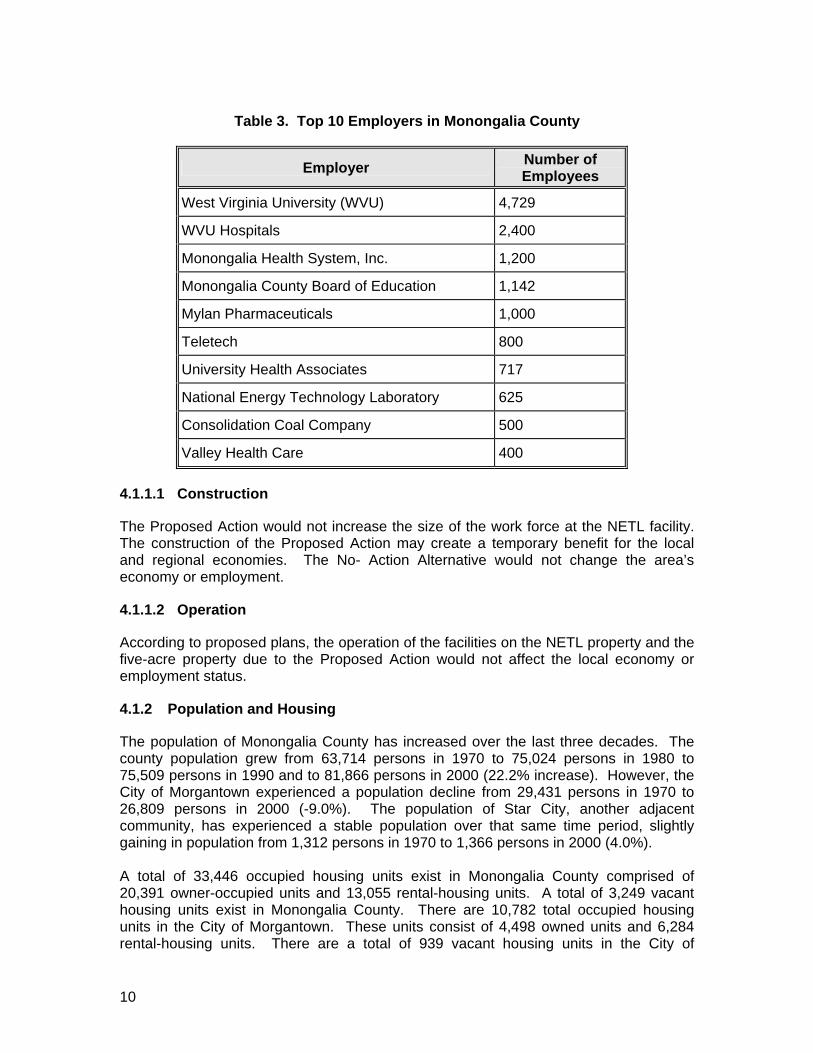
The most recent employment trends in Monongalia County indicate a shift from “goods producing” industry (primarily mining and manufacturing) to “service producing” industry, dominated by wholesale, retail, and service employment. The goods producing employment in Monongalia County decreased from 6,038 persons in 1986 to 3,798 in 1997. This decline coincided with an increase in service producing employment, which rose from 11,004 in 1986 to 20,847 in 1997 (the last year with available data). Additionally, total civilian labor force increased in Monongalia County from 1989 (39,360) to 2000 (40,460). Monongalia County’s unemployment rate decreased over this time period from 4.5% to 2.4%. A list of the top ten employers within Monongalia County is provided in Table 3.
10
Table 3. Top 10 Employers in Monongalia County
Employer Number of Employees
West Virginia University (WVU) 4,729
WVU Hospitals 2,400
Monongalia Health System, Inc. 1,200
Monongalia County Board of Education 1,142
Mylan Pharmaceuticals 1,000
Teletech 800
University Health Associates 717
National Energy Technology Laboratory 625
Consolidation Coal Company 500
Valley Health Care 400
4.1.1.1 Construction
The Proposed Action would not increase the size of the work force at the NETL facility. The construction of the Proposed Action may create a temporary benefit for the local and regional economies. The No- Action Alternative would not change the area’s economy or employment.
4.1.1.2 Operation
According to proposed plans, the operation of the facilities on the NETL property and the five-acre property due to the Proposed Action would not affect the local economy or employment status.
4.1.2 Population and Housing
The population of Monongalia County has increased over the last three decades. The county population grew from 63,714 persons in 1970 to 75,024 persons in 1980 to 75,509 persons in 1990 and to 81,866 persons in 2000 (22.2% increase). However, the City of Morgantown experienced a population decline from 29,431 persons in 1970 to 26,809 persons in 2000 (-9.0%). The population of Star City, another adjacent community, has experienced a stable population over that same time period, slightly gaining in population from 1,312 persons in 1970 to 1,366 persons in 2000 (4.0%). A total of 33,446 occupied housing units exist in Monongalia County comprised of 20,391 owner-occupied units and 13,055 rental-housing units. A total of 3,249 vacant housing units exist in Monongalia County. There are 10,782 total occupied housing units in the City of Morgantown. These units consist of 4,498 owned units and 6,284 rental-housing units. There are a total of 939 vacant housing units in the City of

11
Morgantown. There are 697 total occupied housing units in Star City, which consist of 407 owned units, and 290 rental housing units. There are a total of 56 vacant housing units in Star City.
4.1.2.1 Construction
Construction of the Proposed Action would not affect the existing population and housing in the immediate project area, the surrounding communities, and Monongalia County. One residential displacement would be anticipated as a result of the Proposed Action.
4.1.2.2 Operation
Operation of the proposed facilities on the NETL property and the five-acre property would not affect the existing population and housing in the immediate project area, surrounding communities, or Monongalia County.
4.1.3 Residential and Commercial Displacements
Under the Proposed Action, two residential units, including one unoccupied unit and one rental unit, would be purchased. Neither of these properties provides subsidized governmental rental units. Since the two residential units and the associated three property parcels (five-acre property) would be purchased, no condemnation activities would occur.
4.1.3.1 Construction
Construction of the Proposed Action would result in no residential or commercial displacements.
4.1.3.2 Operation
Operation of the facilities on the NETL property and the five-acre property due to the Proposed Action would result no residential or commercial displacements. Therefore, no mitigation measures are needed or required.
4.1.4 Environmental Justice
Population data from the 2000 census was analyzed for the project area. Additionally, interviews were conducted during May 2002 with regional planning personnel and City of Morgantown personnel to review environmental justice issues. Moreover, windshield survey observations related to identification of special population groups were conducted in April 2002. The 2000 census indicates that Monongalia County is 92.2% white and 7.8% other minority races; the City of Morgantown is 89.5% white and 10.5% other minority races; and Star City is 93.6% white and 6.4% other minority races. Based on conducted interviews, observations, and data analysis, there are no identifiable pockets of minority or low-income populations in the project area. Based on available information, no disproportionate adverse effects on minority or low-income populations would result from the proposed action.
12
4.1.4.1 Construction
Construction of the Proposed Action will not affect the existing population with regard to environmental justice issues.
4.1.4.2 Operation
Operation of the facilities on the NETL property and the five-acre property as a result of the Proposed Action will not have an effect on existing environmental justice issues in the project area, surrounding communities, or Monongalia County.
4.2 Land Use
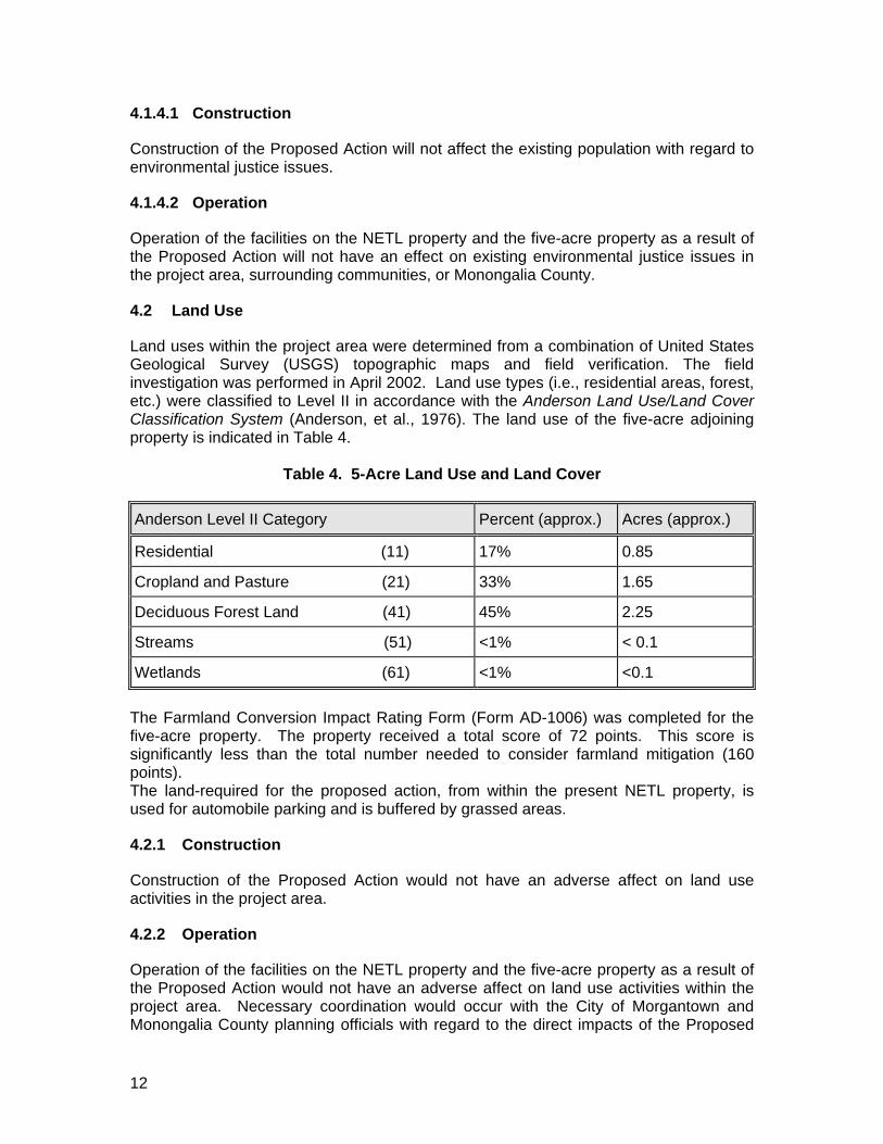
Land uses within the project area were determined from a combination of United States Geological Survey (USGS) topographic maps and field verification. The field investigation was performed in April 2002. Land use types (i.e., residential areas, forest, etc.) were classified to Level II in accordance with the Anderson Land Use/Land Cover Classification System (Anderson, et al., 1976). The land use of the five-acre adjoining property is indicated in Table 4.
Table 4. 5-Acre Land Use and Land Cover Anderson Level II Category Percent (approx.) Acres (approx.)
Residential (11) 17% 0.85
Cropland and Pasture (21) 33% 1.65
Deciduous Forest Land (41) 45% 2.25
Streams (51) <1% < 0.1
Wetlands (61) <1% <0.1
The Farmland Conversion Impact Rating Form (Form AD-1006) was completed for the five-acre property. The property received a total score of 72 points. This score is significantly less than the total number needed to consider farmland mitigation (160 points). The land-required for the proposed action, from within the present NETL property, is used for automobile parking and is buffered by grassed areas.
4.2.1 Construction
Construction of the Proposed Action would not have an adverse affect on land use activities in the project area.
4.2.2 Operation
Operation of the facilities on the NETL property and the five-acre property as a result of the Proposed Action would not have an adverse affect on land use activities within the project area. Necessary coordination would occur with the City of Morgantown and Monongalia County planning officials with regard to the direct impacts of the Proposed
13
Action, the location of project improvements, and the anticipated schedule for project implementation. Local land use planning can control the type, density, and location of development; however, these types of land use controls are implemented at the discretion of local officials. The five-acre property (including all three parcels) is presently zoned by the City of Morgantown as B-1 (neighborhood business). According to the City of Morgantown Planning Department, the Federal Government is exempt from applying for zoning variances within the city. However, the proposed new construction within the 5-acre property could be considered to comply with the present zoning classification of ‘neighborhood business’.
4.3 Parks, Recreation Areas
There are no county or regional parks in proximity to the project area. The only county/regional park and state park in Monongalia County is Chestnut Ridge Park, which is located adjacent to Coopers Rock State Forest. Chestnut Ridge Park is located approximately eight miles from the NETL site. The City of Morgantown has fourteen (14) recreational facilities, none of which are located near the project area. Star City leases the section of the Mon River Trail (MRT) that bisects Star City’s corporate limits from the Mon River Trail Conservancy. The MRT extends upstream and downstream along the Monongahela River and at one point is approximately 900 feet from the project area. However, the project activities would not impact the MRT.
4.3.1 Construction
Construction of the Proposed Action would not affect local or regional parks and recreation areas.
4.3.2 Operation
Operation of the facilities on the NETL property and the five-acre property as a result of the Proposed Action will not impact local or regional parks and recreation areas.
4.4 Vegetation and Wildlife
Wildlife, vegetation, and habitat conditions were analyzed for both the National Energy Technology Laboratory (NETL) site and the adjacent five-acre parcel. Conditions were determined from the combined use of United States Geological Survey (USGS) topographic maps, research of existing documents, and field verification. The field investigation was performed in April 2002. Upland habitat types as well as land use types (i.e., deciduous forest) were classified to Level II in accordance with the Anderson Land Use/Land Cover Classification System (Anderson, et al., 1976) (Refer to Section 4.2 Land Use). Wetland types were classified in accordance with the Classification of Wetlands and Deepwater Habitats of the United States (Cowardin et al., 1979) (Refer to Section 4.8 Wetlands).

14
Vegetation on the affected part of the existing NETL site is comprised mostly of grass species and a few deciduous and coniferous trees. Vegetation observed on the adjoining five-acre parcel includes mostly shrub and brush, herbaceous wetland species, and many species of deciduous trees. Species observed include multiflora rose (Rosa multiflora), soft rush (Juncus effuses), yellow poplar (Liriodendron tulipfera), American beech (Fagus grandifolia), eastern flowering dogwood (Cornus florida), elderberry (Sambucus canadensis), common blackberry (Rubus allegheniensis), and black cherry (Prunus serotina). Wildlife observed included white-tailed deer (Odocoileus virginianus), raccoon (Procyon lotor), eastern cottontail (Sylvilagus floridanus), and red-tailed hawk (Buteo jamaicensis).
4.4.1 Construction
Construction impacts on the existing NETL site would be negligible due to the lack of important wildlife habitat. Construction impacts to vegetation on the five-acre parcel would mainly affect grassland species, palustrine emergent wetland vegetation, and a small stand of hardwood. This hardwood stand is considered to be wildlife habitat because of its provided cover and forage production. The stand, however, is not exceedingly valuable because of its small size, and distance from other similar stands of hardwood species. Large terrestrial mammals would be affected mostly by construction noise, vibrations and movement [i.e., white-tailed deer (Odocoileus virginianus)]. Adverse effects due to the loss of forage and cover would be minor. Nesting habitat for birds and rodents on the five-acre parcel (grass/shrub area) would be disturbed and partially eliminated.
4.4.2 Operation
Operation of the proposed facilities on the NETL property and on the five-acre property would not cause significant additional impacts over those initially caused by construction. A pond that may be constructed would likely cause only a small increase in edge effect (disruption of wildlife habitat) from what currently exists on the five-acre property. The buildings to be constructed would be adjacent to existing NETL buildings, so no habitat fragmentation would be expected.
4.5 Threatened and Endangered Species
Requests for information concerning rare, threatened, and endangered species were made to the West Virginia Division of Natural Resources (WVDNR) and the United States Department of the Interior, Fish and Wildlife Service (USFWS) in April 2002. According to the WVDNR no rare, threatened, or endangered species are known to inhabit the area (Refer Appendix B).
4.5.1 Construction
The Proposed Action would not impact any threatened or endangered species, as no known species of special concern occur in the project area.

15
4.5.2 Operation
The operation of the proposed facilities would not affect rare, threatened, and endangered species, as none of these species are known to occur in the project area.
4.6 Water Quality / Streams
One stream, which is an unnamed tributary to West Run, is located in the project area. This tributary has been impacted with drainage from a source that is high in iron (Fe). Apparently, the source of this Fe-laden discharge is from natural iron oxides in the A aquifer of the Lake Monongahela sediments. These iron oxides generate an orange coloration in the stream.
4.6.1 Permitted Discharge Areas
The NETL is authorized to discharge storm water under the general permit WV0111457. The NETL is authorized to discharge industrial wastewater into the Morgantown Utility Board’s (MUB) sanitary sewer system under the permit MUB 012. The renewal date of this permit was July 1, 2000. The expiration date for this permit is June 30, 2005. Effluents from the Gas Process Development Unit (GPDU) undergo on-site treatment, prior to discharge into the MUB system. However, the GPDU is not located within the project site for this project and would not cause any impacts with regard to this project. Information concerning the permit renewal application submitted in May of 2000 can be found in a letter to MUB (Refer to Appendix B).
4.6.2 Construction
All permitting requirements involving the Clean Water Act § 404, West Virginia State 401 Water Quality Certification, and the West Virginia Public Land Corporation Stream Activity Permit would be reviewed and implemented. Additionally, a storm water discharge permit (National Pollutants Discharge Elimination System – NPDES permit) for construction activities would be required and must be applied for at least 30 days prior to groundbreaking activities. The unnamed tributary to West Run in the project site would be directly impacted by construction of the storm water retention pond. Presently, 72.24 m (237 ft) of stream would be impacted by the Proposed Action. The building construction upslope from the stream would be a temporary source of pollution and sediment loading. This degradation in water quality could include the loss of aquatic habitat due to increased sediment loading and a potential change in chemical composition in the stream (i.e., from fuel leaks and spills, chemical spills from construction materials). An increased impervious area (due to heavy machinery used during construction) would cause an increase in surface water runoff. This increased runoff, along with the use of hazardous materials during construction, would increase the amount of contaminants that move throughout the drainage system in surface water. This contaminant runoff, as well as the other listed impacts would be minimized through the use of best management practices during construction. The No-Action Alternative would not cause water quality / stream impacts.

16
4.6.3 Operation
The operation of the proposed facilities would impact the tributary with runoff from increased parking (impervious) area. However, the storm water retention pond would be expected to minimize this affect by reducing the impact of high velocity flows on the stream channel. The storm water retention pond would also decrease the length of stream (lotic) habitat due to its construction, and would cause thermal changes to the stream and would present a barrier to the movement of aquatic species. This degradation in water quality could include the loss of aquatic habitat due to a potential change in thermal composition in the stream (e.g., the use of the storm water retention pond as a heat exchange mechanism).
4.7 Floodplains
The 100-year floodplain is the elevation that becomes inundated by rising waters and has a one percent chance of flooding every year. A review of the Federal Emergency Management Agency’s (FEMA) Flood Insurance Rate Map’s (FIRM) was conducted on the North Morgantown area in order to determine any impacts to the floodplains and/or flood hazards. The FIRM community-panel number used was: 54041 0001D.
4.7.1 Construction
The NETL facility and the five-acre property are located in Zone X on the FIRM. Zone X signifies areas that are determined to be outside the 500-year floodplain. For this reason, any construction on either site would not impact either the 100-year or the 500-year floodplain. Also, because the NETL is located in Zone X, the property is not prone to flood hazards.
4.7.2 Operation
The operation of any of the new facilities associated with the NETL would not have an adverse effect on floodplains.
4.8 Wetlands
Wetland investigations were conducted in April 2002. Five palustrine emergent wetlands within the project area were identified and delineated through the use of existing information and field investigation. Existing information utilized in the investigation included the United States Department of Agriculture (USDA), Natural Resources Conservation Service (NRCS), Monongalia County Soil Survey and U.S. Fish and Wildlife Service’s (USFWS) National Wetland Inventory (NWI) maps. Palustrine emergent wetland habitats were delineated utilizing the Corps of Engineers Wetlands Delineation Manual (Technical Report Y-087-1). The wetlands within the project study area were classified in accordance with the Classification of Wetlands and Deepwater Habitats of the United States (Cowardin, et al., 1979). Field investigations identified five jurisdictional palustrine emergent wetlands in the project area. Refer to Figure 3 for the wetland locations. The functions and values of the project area wetlands were assessed using parameters derived from the WET 2.0 predictive model. Wetlands 1 through 5 received a high rating in the Groundwater Discharge category. Wetlands 3 through 5 received a high rating when considering Wildlife Diversity/Abundance. Wetland 5 received a high rating in the Sediment/Toxicant Retention category. Characteristics of

17
the wetlands are summarized in Table 5. The total area of wetlands and impacted wetlands at the project site would be 0.033 hectare (0.080 acre).
4.8.1 Construction
Construction of the Proposed Action would impact all of the palustrine emergent wetlands identified within the project area. Evaluation of potential wetland impacts and actions to avoid adverse effects would need to be reviewed during Final Design of the project site. Any changes to the Final Design would be reviewed to avoid and minimize any encroachments and impacts to wetland resources. If avoidance and minimization efforts fail to avoid or minimize wetland impacts, then mitigation of wetland impacts would be necessary. A potential wetland mitigation location may be the proposed stormwater retention pond. This location could potentially achieve a net gain in wetland resources if designed properly. If the storm water retention pond would be constructed with heat exchanging capabilities, then thermal loading would be an issue for water quality and would dictate the type of plant and animal species that can utilize the facility. Thus, the temperature range of the facility’s water would need to be considered when designing the wetland mitigation area. Another mitigation site could be located farther downstream from the project site by creating a wetland or enhancing an existing wetland found in that area of the NETL facility. Plans are currently being developed for NETL’s non-industrial land use, including the enhancement of NETL’s wetland areas. This plan will be made available to the public on the NETL website. All permitting requirements involving the Clean Water Act § 404, West Virginia State 401 Water Quality Certification, and the West Virginia Public Land Corporation Stream Activity Permit would be reviewed and implemented. The No-Action Alternative would not cause wetland impacts.
Table 5. Summary of Wetlands
Wetland Classification Location Area ha (ac)
Impacted Area ha (ac)
WET 2.0 HIGH
Functional Ratings
W1 PEM NETL 0.004 (0.009) 0.004 (0.009) GD
W2 PEM NETL 0.004 (0.009) 0.004 (0.009) GD
W3 PEM 5-acre site 0.008 (0.020) 0.008 (0.020) GD, WDA
W4 PEM 5-acre site 0.009 (0.022) 0.009 (0.022) GD, WDA
W5 PEM 5-acre site 0.008 (0.020) 0.008 (0.020) GD, WDA, STR
Total ____ ____ 0.033 (0.080) 0.033 (0.080) ____
GD = Groundwater Discharge WDA = Wildlife Diversity/Abundance STR = Sediment/Toxicant Retention PEM= Palustrine Emergent
18
4.8.2 Operation
No wetland impacts would occur due to operation of the proposed NETL facilities. If the storm water retention pond would be constructed with heat exchanging capabilities, then thermal loading would be an on-going issue and an NPDES permit would be necessary.
4.9 Groundwater
Bedrock beneath the National Energy Technology Laboratory (NETL) is part of the Conemaugh Group. The Conemaugh Group consists of fractured shales, siltstones and sandstones, with a few thin limestone and coal beds. Two aquifers of the Conemaugh Group, the Morgantown Sandstone and the Grafton Sandstone, outcrop around the NETL site. These aquifers provide water supplies for any nearby homes that are not served by the municipal supply. Wells in these aquifers typically yield two gallons per minute or less (NETL Groundwater Protection Plan, 2001). Immediately beneath the project site, and overlying the Morgantown Sandstone, is the Clarksburg Shale. Overlying the bedrock and underlying most of the NETL are alternating layers of unconsolidated Lake Monongahela sediments (clay, silt, and sand), including three water-bearing clayey sand layers (NETL Groundwater Protection Plan, 2001). Locally, water within these sand layers flows towards the surface streams. In the project site, the water flows toward springs and seeps on the 5-acre parcel. One springhouse was noted in the field, north and west of the facility. In the past, groundwater monitoring focused on two areas at the NETL. The first of these locations was near building B-1. This area formerly contained leaking underground chemical pipes that were removed in the late 1980’s. The second location was near the reclaimed industrial wastewater holding pond. After the closure of the pond, the area was converted to a parking lot. Some contaminants were detected in both areas. Statistical analysis has shown that contaminant levels are within baseline levels at the industrial waste pond 005 (Site Assessment, 1992). The West Virginia State Health Department has not labeled the NETL as a wellhead protection area (Environmental Baseline Characterization). A wellhead protection area is defined by section 1428 of the Safe Drinking Water Act (42 U.S.C. 300f-300j-9) as “the surface and subsurface area surrounding a water well or wellfield, supplying a public water system, through which contaminants are reasonably likely to move toward and reach such water well or wellfield.”
4.9.1 Construction
The use of hazardous materials during construction (i.e., fuel, cement curing aids, sealants, and fill used from other areas) could, if not properly handled, cause direct impacts to groundwater sources. Because the NETL site is not labeled as a wellhead protection area and does not provide a important recharge area for water wells, the risks of impact to humans using groundwater would be minimal. The quantity of groundwater recharge at the project sites would also be impacted. Groundwater recharge would decrease due to increased impervious areas over the project sites soil. Decreased infiltration could be caused by the compaction effect of heavy machinery and/or materials used during construction. This increase in impervious
19
area would have a low impact on the quantity of groundwater being recharged on both sites, because of the relatively small footprint at the high impact areas at the site. Operation The operation of proposed NETL facilities would not affect groundwater within the project area. The new buildings and parking lots would decrease the infiltration rate of rainwater. This impact would be considered low, however, because the new facilities would not cover a large recharge area.
4.10 Public Facilities and Services
In consultation with the local municipal authorities, numerous public facilities and services were identified within the surrounding area of the project site in Monongalia County. Due to the suburban nature of the project area, these facilities are found within the proximity of the project area, but not directly adjacent to the NETL facility. These facilities include recreation areas, fire departments, emergency services, schools, libraries, and municipal facilities. The Morgantown Fire Department provides fire protection. The Monongalia County Emergency and Transport Services provide emergency services to the project area via the 911 center in Morgantown. The project area is serviced by the Monongalia County School District. Suncrest Elementary School, North Elementary School, Suncrest Middle School, and Morgantown High School serve students in the project area. The public library that services the project area is located on Spruce Street in Morgantown.
4.10.1 Construction
Construction of the Proposed Action would not impact the local or regional public facilities or services, since little or no traffic disruption would be expected. However, coordination with local municipal and county planning officials would be conducted to inform the public with respect to the location of project improvements and the anticipated schedule of project implementation, which would minimize the potential for impact.
4.10.2 Operation
Operation of the facilities on the NETL property and adjacent five-acre property would not affect local or regional public facilities or services in the study area.
4.11 Utilities
Some of the utility companies that could be affected by construction are: Allegheny Power, Hope Gas, and Verizon. The NETL acquires water for domestic use from the Morgantown Utility Board (MUB). MUB draws water from Cobun Creek during high water flows, and from the Monongahela River during dry low-flow periods (Site Assessment, 1992). In the past, stormwater and wastewater at the NETL were dealt with in two different ways. Sanitary sewage was and is discharged to the municipal sewage treatment system (MUB). Any other waste and stormwater was collected by a storm sewer system that discharged into Burroughs Run and selected tributaries of West Run. To upgrade
20
the system, three wastewater collection systems were developed. These systems are industrial wastewater, sanitary wastewater, and stormwater (NETL Engineering Plan Sheets, 1993). The only piping system that would be impacted by the Proposed Action is the stormwater system located at the discharge point to the unnamed tributary to West Run.
4.11.1 Construction
All utility companies that service NETL and the five-acre property would be notified before construction begins. Impacts to utilities during construction would involve relocation, rerouting or adding utility services for existing and proposed facilities.
4.11.2 Operation
No impacts would be anticipated during normal operation of the proposed facilities.
4.12 Traffic
4.12.1 Construction
The immediate project area would experience an increase in traffic during construction. This increase would be temporary and of short duration as construction workers, deliveries, and equipment enter and exit the site. Disruptions in access during the construction phase would be minimized since most work would be conducted on NETL property. When necessary, coordination would occur with the West Virginia Division of Highways and the City of Morgantown, as applicable, to coordinate maintenance of traffic. Design phase partnering would be conducted during final design and construction in order to coordinate project activities and schedules with, but not limited to, emergency service providers, local schools, U.S. Postal Service, and local/state highway maintenance offices.
4.12.2 Operation
Upon completion of the project, a net increase in traffic to the administrative office building would not be expected. Although this facility would be constructed for occupation by additional staff (50), no immediate plans exist to increase staff. All employees would utilize current routes to access the facility, which would not increase traffic on other streets or change surrounding traffic patterns. The only potential impact to traffic within the project area would be related to the proposed child-care facility. A child-care facility currently exists at the NETL. The proposed facility would provide capacity for an additional 40 children, which could potentially increase traffic during morning and afternoon hours. However, the additional 40 children would belong to existing NETL employees who would drive to work each day regardless of the child-care service, therefore, there would be less traffic than normally associated with the commuting of 40 children and their parents.
4.13 Air Quality
A review of air quality for the general project site was completed utilizing the National Ambient Air Quality NAAQ database
21
(http://homer.ornl.gov/oepa/data/showcity.cfm?ID=142) maintained by the U.S. Environmental Protection Agency (USEPA, 2002). The NAAQ database was created in August 1999 and details whether the area in question is currently meeting or in attainment for air quality parameters. The NETL facility located in Morgantown, WV was found to be in attainment for all air quality parameters, which include ozone, carbon monoxide, PM-10, sulfur dioxide, nitrous oxide, and lead.
4.13.1 Permitted Areas
NETL’s air permits for the facility are individually based for specific projects. For the Proposed Action, a specific air quality permit would need to be acquired in order to complete construction activities of this specific project. This permit would be used in controlling fugitive dust as per West Virginia Division of Environmental Protection (WVDEP) air quality regulations (see below).
4.13.2 Construction
During construction, the project would have two major effects on air quality: an increase in emissions by heavy construction equipment and an increase in dust by construction activities. This project would require the use of material-handling and earth-moving equipment. Dust and exhaust particulate emissions from heavy equipment operations would temporarily degrade air quality in the immediate construction zone. The increase in air particulates would be minimized by the performance of the work in compliance with the requirements of the Air Pollution Control Act (Act 245-1972, as amended), 45 CFR 17 - West Virginia Title 45 Legislative Rule, Series 17 – To Prevent and Control Particulate Matter, Air Pollution From Materials Handling, Preparation, Storage, and Other Sources of Fugitive Particulate Matter, and all other applicable state and local regulations.
4.13.3 Operation
None of the proposed structures at the project site would be expected to have an impact on air quality during their normal operation.
4.14 Noise and Vibration
Noise and vibration levels are not usually an issue at the NETL facility. However, on occasion there have been periods of higher noise and vibration levels due to specific on-site facility activities. Subsequent field investigations determined that the underlying geologic structure (unconsolidated Lake Monongahela sediments) transmitted vibrations from facility equipment to other locations of the NETL facility. Based on this previous experience, construction-related vibrations could be expected to transmit for hundreds of feet through the soils from the point of origin.
4.14.1 Construction
Construction activities would result in temporary and short duration increases in noise and vibration levels. To minimize these potential impacts, major construction activities would be scheduled during normal daylight working hours and would be implemented consistent with 23 CFR, Part 772.19, which require construction contractors to use

22
equipment, that is adapted to operate with appropriate noise muffling devices resulting in the least possible noise. Every effort would be taken to minimize the noise levels including the mandatory use of construction equipment with operable mufflers. Although none is anticipated, if blasting is required, it would be controlled so that no property or structural damage would occur. Measures that may be taken include, but are not limited to, timing of work and laying blast mats. Piles may be driven to provide foundation for the office building and parking garage. Pile driving would be expected to transmit vibrations for hundreds of feet through surrounding soils.
4.14.2 Operation
An increase in noise and vibration levels is not expected upon completion of the proposed facility.
4.15 Waste Site Evaluation
A Phase I Environmental Site Assessment was conducted by the U.S. Army Corps of Engineers to assess the potential for hazardous or residual wastes on the subject properties. The Phase I Environmental Site Assessment was conducted utilizing procedures outlined in ASTM Practice E 1527-00, entitled Standard Practice for Environmental Site Assessments: Phase I Environmental Site Assessment Process. The Phase I investigation identifies, to the extent feasible, any “Recognized Environmental Conditions.” ASTM defines recognized environmental conditions as “the presence or likely presence of any hazardous substances or petroleum products on a property under conditions that indicate an existing release, a past release, or a material threat of release of any hazardous substance or petroleum products into structures on the property or into the ground, groundwater, or surface water of the property.” The assessment involved document, database, and photo searches, as well as inquiries directed to local authorities, and a site reconnaissance. The site reconnaissance and walkover of the property was conducted on May 10, 2002. The property has one occupied dwelling, and one unoccupied dwelling. The vacant dwelling has a detached garage. The rest of the property is overgrown and wooded.
4.15.1 Construction
Based on the results of the investigation, no major sources of potential contamination exist on or in the vicinity of the target property. No evidence exists to suggest incurring CERCLA liability due to property acquisition.
4.15.2 Operation
The operations of the constructed facilities would not be expected to have any associated impacts.
4.16 Cultural Resources
4.16.1 Historic Resources
An initial field review for historic resources was completed in May 2002. Four resources possibly pre-dating 1955 were identified in the Area of Potential Effect (APE), including
23
two dwellings and a garage on the five acre parcel, and a residence with garage across the road from the five acre parcel. Based upon the initial site review, a Phase I Archaeological Survey and Historic Resource Survey was performed in May 2002.
4.16.1.1 Construction
No previously recorded historic resources, or National Register of Historic Places (NRHP) – listed or – eligible properties are present within the APE. The State Historic Preservation Office (SHPO) for their concurrence reviewed the Phase I Archaeological Survey and Historic Resource Survey Report (Phase I Report). The SHPO determined that the “project will have no effect on any property eligible for or listed in the National Register of Historic Places. Therefore, no further consultation is necessary with this office”.
4.16.1.2 Operation
The SHPO concurs with the Phase I Report and its recommendations (i.e., none of the resources are NRHP eligible), therefore no mitigation would be necessary.
4.16.2 Archaeological Resources
A field view of the Area of Potential Effect (APE) was conducted in May 2002. The proposed construction areas within the existing boundaries have all been heavily disturbed. However, soil augering on the five-acre parcel showed relatively intact upland soils occurring in the vicinity of springs/seeps. In addition, vegetation in the current yard area suggests that a historic house site may have been present. Approximately two of the five acres are not severely sloped or disturbed, and required a Phase I survey. Based upon this initial site review, a Phase I Archaeological Survey and Historic Resource Survey were performed in May 2002. The Phase I survey included background research, a geomorphological reconnaissance, field-testing, which included 37 shovel test pits (STPs), analysis, and reporting. The Phase I investigation yielded no cultural material; therefore, the report concludes that no further investigation is necessary.
4.16.2.1 Construction
No previously recorded archaeological sites, historic resources, or National Register of Historic Places (NRHP) – listed or – eligible properties are present within the APE. The State Historic Preservation Office (SHPO) for their concurrence reviewed the Phase I Archaeological Survey and Historic Resource Survey Report (Phase I Report). The SHPO determined that the Phase I Report “satisfactorily addresses our concerns regarding the presence of archaeological resources within the project area. Systematic testing of the project area located no previously unrecorded historic or prehistoric sites therefore, no further archaeological investigations are recommended. We have also determined that no known archaeological sites listed or eligible for inclusion in the National Register will be affected by this project. No further consultation is necessary regarding archaeological resources unless the scope of work should change”.

24
4.16.2.2 Operation
The SHPO concurs with the Phase I Report and its recommendations (i.e., none of the resources are NRHP eligible), therefore no mitigation would be necessary.
4.17 Visual Resources
4.17.1 Viewshed Analysis
Construction of the Proposed Action would change the appearance of the existing project area landscape. The visual quality was assessed through the interpretation of aerial photographs, mapping, and by field observations of the project area. The visual changes would be aesthetically pleasing and are considered to be a positive improvement. Based on the design height of the proposed structures and field observations, line-of-site analysis is not required. The project area is relatively hilly and adjacent to commercial and residential properties (neighborhood setting). The general area continues to be developed for commercial and residential land use activities. Visually, as one drives along Collins Ferry Road toward the project area, the visual characteristics change. These visual changes (described below) are characterized by respective changes in physical conditions or parameters. For descriptive purposes, the general project vicinity has been broken into two areas that are described in the following paragraphs. The first area involves the general project area from Collins Ferry Road intersection with University Avenue to the NETL facility. Currently in this area, numerous businesses and residences are located along Collins Ferry Road, with mixed land cover types (i.e., residential, commercial, small forested wood lots and small rangeland areas) located on the hilltop ridgeline. The commercial and residential structures in this area will not be impacted by the construction of this project. No changes would occur to modify the physical appearance in this area. Overall, the viewshed in this area should not be affected. The second area involves the project area at the NETL facility. Currently in the project area, numerous commercial properties (i.e., NETL facility, Mylan Pharmaceuticals facility, and other small businesses) and residences are located adjacent to the project site along Collins Ferry Road, with mixed land cover types (i.e., residential, commercial, utilities, small forested wood lots and small rangeland areas) located on and bisecting the hilltop ridge line. Three residential parcels to be purchased for the Proposed Action have two residential structures (one vacant and one occupied) that will be removed by the construction of this project. Approximately 40% of these parcels is mature stage deciduous forest. The other 60% of the parcels is a typical grassed residential yard and fallow fields. Visual benefits involved with the Proposed Action include observed improvements to the area by the elimination of the vacant residence and the occupied rented residence and by improved landscaping, the elimination of discarded residential waste and vehicles, and the incorporation of the area into the NETL facility. Additionally, a pond would be incorporated into the Proposed Action, which may encourage improvements to wildlife habitat. Changes to the physical appearance in this area would result from construction of the office building, parking garage, day care center and/or credit union, and possibly a pond. Overall, the viewshed in this area should not change from what is currently observed.

25
The new office building, which will be located on the present automobile parking lot, is designed to be a showplace for innovative energy technologies. The architecture of this structure is of modern design and will enhance the local landscape. The new parking garage will be located behind the proposed office building and will not deter from the streetscape or surrounding community. In fact, the construction of the parking garage will enhance the streetscape by providing enclosed parking encompassing less area. The construction of the child-care facility on the present site of the two residential dwellings is also considered to be a visual improvement over the present condition.
4.17.2 Construction
The overall visual quality of the Proposed Action would be a positive improvement as a result of the careful planning and coordination upon implementation. Currently, the vacant residence and the occupied rented residence do not enhance the present landscape. Where possible, disturbed areas would be revegetated with native plant materials to provide a natural and positive visual effect. In some instances, planting’s could be introduced to buffer views of unsightly areas and vegetation cleared to open views of scenic areas.
4.17.3 Operation
Normal operation of the facility would include regular maintenance, which will preserve the aesthetics of the facility and surrounding viewshed.
4.18 Right-of-Way Impacts
The proposed NETL Construction Project is currently planned utilizing the existing parking lot at the Morgantown NETL facility and the adjacent five-acre parcel. As proposed, minimal amounts of construction impacts to property adjacent to the planned facility are anticipated. The impacts include roadway frontage and the associated Right-of-Way along Collins Ferry Road to gain access to the project site. The Collins Ferry Road Right-of-Way is controlled by the West Virginia Division of Highways (WVDOH) and is 30 feet wide (City of Morgantown – Public Works, 2002). Another Right-of-Way that should experience no impact belongs to Allegheny Power. This Right-of-Way is along the northern property boundary of the five-acre parcel. This Right-of-Way crosses the NETL facility and will not be impacted by this project.
4.18.1 Construction
Access to the project site for construction activities will necessitate a temporary impact to the Right-of-Way along Collins Ferry Road, which is controlled by the WVDOH. Coordination with the WVDOH officials will be required in regards to the temporary impact and any potential permitting requirements.
4.18.2 Operation
No additional impacts are anticipated upon construction of the facility.

26
4.19 Secondary Impacts
The potential for secondary development impacts associated with the proposed NETL Construction Project were evaluated in accordance with 40 CFR 1508.8. Secondary impact evaluation for this project included the analysis of four major factors. • Zoning within the study area • Land suitability for development of surrounding area • Local planning initiatives • Continued private-sector development. The project is serviced by all major utilities and services; therefore growth is not restricted by the absence of any utilities. Land uses surrounding the project area are residential, commercial services, industrial, transportation and communications, cropland and pasture and deciduous forest. These areas are located adjacent to the existing project area. The project area is the last property to the east on Collins Ferry Road within the City of Morgantown’s limits. The project area is surrounded on two sides by the present NETL facility. All other adjoining properties including those across Collins Ferry Road are outside of the city limits and do not have zoning restrictions. Therefore, any future secondary development will not be restricted by local zoning regulations. Planning initiatives of the City of Morgantown do not extend beyond the city limits. Thus, any secondary impacts to properties adjoining the project area are outside the city’s jurisdiction. Adjacent properties are suitable for future development. Zoning regulations do not restrict properties opposite the project area along Collins Ferry Road and the terrain is suitable for future development. Therefore, it is reasonable to believe that further development will take place near the project site. However, at the present time there is limited remaining undeveloped land along Collins Ferry Road near the project site. Another secondary development factor considered is private sector development. Based upon a review of the available properties of the project area, most of the private sector development appears to be concentrated in the vicinity of the project area towards the end of Collins Ferry Road. Collins Ferry Road has no outlet beyond the project area. At this time, growth and development appear to be occurring by new property owners (e.g., Mylan Pharmaceuticals). Due to other adjoining land suitable for development, the potential for limited growth and development does exist.
4.19.1 Construction
No secondary development impacts are anticipated to occur to the project area’s natural, social, and cultural resources due to the construction of the Proposed Action. However, the project area has shown a trend of increasing development, and development could occur more rapidly due to this project. Overall, secondary impacts are expected to be small. The No-Action alternative would not cause secondary development impacts.

27
4.19.2 Operation
Because NETL’s work activities and number of employees will remain the same, operational activities are not expected to cause secondary impacts from the implementation of the Proposed Action. When necessary, NETL would coordinate with the City of Morgantown in regards to any direct impacts of the Proposed Action, the location of project improvements, and the anticipated schedule of the project implementation.
4.20 Cumulative Impacts
Guidelines prepared by the Council of Environmental Quality (CEQ) for implementing NEPA, broadly define cumulative impacts as those “impacts which result from the incremental consequences of an action when added to other past and reasonably foreseeable future actions” (40 CFR 1508.8). Cumulative impacts are past, present and future impacts which when considered as a whole and in concert with other foreseeable developments and projects result in a combined effect which is greater than that expected from considering these components in isolation. Environmental impacts from development that may occur in the future combined with impacts from past development have cumulative effects on the environment. Accumulated secondary effects and incremental growth from other inter-related projects can influence and result in cumulative effects. Past development trends in the project area were historically restricted to areas adjacent to and along Collins Ferry Road and included a mixture of residential and commercial/industrial developments. For reasons provided in Section 4.19, current development trends are anticipated to continue. Based in part upon the conclusions of the secondary impacts assessment, and the analysis of anticipated changes in development patterns, the NETL project would have some cumulative effects upon the general project area. In the project area, past development has been located along and adjacent to Collins Ferry Road. Future development is anticipated to occur to the east of the project area between Collins Ferry and Van Voorhis Roads in the form of residential development. While past development impacts have had an effect on the local environment, this project and other future development could create other additional impacts on the local environment. With respect to Morgantown or Monongalia County, the effect on the environment from the project related impacts would be negligible.
4.20.1 Construction
No substantial cumulative impacts would be anticipated for the Proposed Action. The No- Action Alternative would not cause cumulative impacts.
4.20.2 Operation
No substantial cumulative impacts would be anticipated for the Proposed Action. The No- Action Alternative would not cause cumulative impacts.

28
4.21 Temporary Construction Impacts
Construction of the Proposed Action would have short-term effects and benefits on the surrounding community. Short-term effects associated with construction would include but are not limited to increased noise, dust, and inconvenient traffic conditions. Short-term benefits would include increased construction employment. These temporary conditions would disappear when the construction is completed. During construction, the project would have three major effects on air quality: an increase in emissions by heavy construction equipment, an increase in dust by construction activities, and an increase in particulate from the allowable burning of vegetation during land clearing. This project would require the use of material-handling and earth-moving equipment. The equipment used would emit peak noise levels greater than normal traffic noise levels. Dust and exhaust particulate emissions from heavy equipment operations would temporarily degrade air quality in the immediate construction zone. Other construction activities would result in increased noise levels during construction of the proposed project. These increased noise levels will be temporary and of short duration. To minimize these potential impacts, the contractor would consider scheduling activities during normal daylight working hours. These specifications require contractors to use equipment, which is adapted to operate with appropriate noise muffling devices resulting in the least possible noise. The removal of existing vegetation for construction would result in a temporary increase in erosion within the project area. However, following an approved Erosion & Sedimentation (E&S) control plan would minimize erosion. A stormwater discharge permit would be required and must be applied for at least 30 days prior to construction activities. During construction, access along Collins Ferry Road to the project area (Proposed Action) would be safely and adequately maintained for local and through traffic. A traffic detour would not be required for the construction of Proposed Action. Construction operations would be scheduled to minimize traffic delays. The increase in air particulates would be minimized by the performance of the work in compliance with requirements of the Air Pollution Control Act (Act 245-1972, as amended), and all applicable federal and state regulations. To minimize burning, the NETL would preferably sell, chip or shed wood and would allow natural decay of other woody materials. Every effort would be taken to minimize the noise levels, including the mandatory use of construction equipment with operable mufflers. If blasting were required, it would be controlled so that no property or structural damage would occur. Measures, which may be taken include, but are not limited to timing of work and laying blast mats. Appropriate erosion and sedimentation control measures presented in the E&S Control Plan would be implemented. Sediment-laden runoff exiting the project site would be controlled by the proper implementation of erosion control measures. Some of these controls may include, but are not limited to:

29
• diverting stormwater originating off-site away from the construction area • temporary and permanent seeding and mulching • construction of temporary sedimentation ponds • use of silt barrier fence and/or hay bales. In addition, the maximum length of time and extent which unprotected soil could be exposed would be limited within the contract documents. Gravel-armored construction entrances would also be located at all site entrances, which exit onto paved roads. Access to all residents and businesses along the Collins Ferry Road would be maintained during construction although temporary disruptions could occur. Coordination with all major utility companies prior to and during construction would be initiated to locate and minimize disturbance to utility services. Maintenance and protection of traffic would be in accordance with West Virginia Division of Highways specifications and applicable federal guidelines. When necessary design phase partnering would occur during final design and construction in order to coordinate project activities and schedules with, but not limited to, emergency service providers, the City of Morgantown, the Monongalia County School District, U.S. Postal Service, and local/state highway maintenance offices. Construction would be performed to comply with all applicable federal and state laws regarding safety, health, and sanitation. All reasonable precautions would be implemented to protect the life and health of project employees, safety of the public, and the integrity of property adjacent to the work.

APPENDIX A
PROJECT RESOURCE CHECKLIST

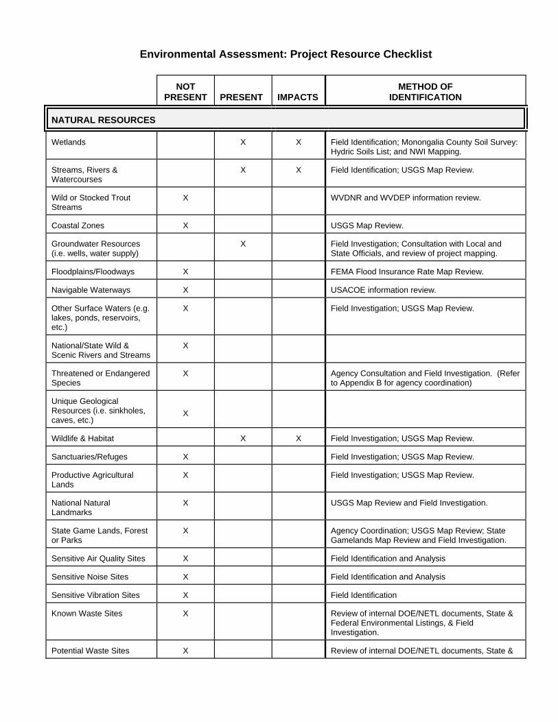
Environmental Assessment: Project Resource Checklist
NOT PRESENT
PRESENT
IMPACTS
METHOD OF
IDENTIFICATION NATURAL RESOURCES Wetlands
X
X
Field Identification; Monongalia County Soil Survey: Hydric Soils List; and NWI Mapping.
Streams, Rivers & Watercourses
X
X
Field Identification; USGS Map Review.
Wild or Stocked Trout Streams
X
WVDNR and WVDEP information review.
Coastal Zones
X
USGS Map Review.
Groundwater Resources (i.e. wells, water supply)
X
Field Investigation; Consultation with Local and State Officials, and review of project mapping.
Floodplains/Floodways
X
FEMA Flood Insurance Rate Map Review.
Navigable Waterways
X
USACOE information review.
Other Surface Waters (e.g. lakes, ponds, reservoirs, etc.)
X
Field Investigation; USGS Map Review.
National/State Wild & Scenic Rivers and Streams
X
Threatened or Endangered Species
X
Agency Consultation and Field Investigation. (Refer to Appendix B for agency coordination)
Unique Geological Resources (i.e. sinkholes, caves, etc.)
X
Wildlife & Habitat
X
X
Field Investigation; USGS Map Review.
Sanctuaries/Refuges
X
Field Investigation; USGS Map Review.
Productive Agricultural Lands
X
Field Investigation; USGS Map Review.
National Natural Landmarks
X
USGS Map Review and Field Investigation.
State Game Lands, Forest or Parks
X
Agency Coordination; USGS Map Review; State Gamelands Map Review and Field Investigation.
Sensitive Air Quality Sites
X
Field Identification and Analysis
Sensitive Noise Sites
X
Field Identification and Analysis
Sensitive Vibration Sites
X
Field Identification
Known Waste Sites
X
Review of internal DOE/NETL documents, State & Federal Environmental Listings, & Field Investigation.
Potential Waste Sites
X
Review of internal DOE/NETL documents, State &
F d l E i l Li i & Fi ld I
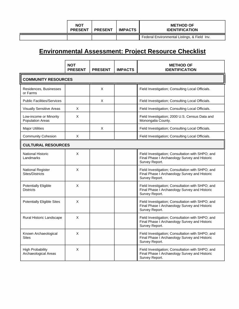
NOT
PRESENT
PRESENT
IMPACTS
METHOD OF
IDENTIFICATION
Federal Environmental Listings, & Field Inv.
Environmental Assessment: Project Resource Checklist
NOT PRESENT
PRESENT
IMPACTS
METHOD OF
IDENTIFICATION COMMUNITY RESOURCES Residences, Businesses or Farms
X
Field Investigation; Consulting Local Officials.
Public Facilities/Services
X
Field Investigation; Consulting Local Officials.
Visually Sensitive Areas
X
Field Investigation; Consulting Local Officials.
Low-income or Minority Population Areas
X
Field Investigation; 2000 U.S. Census Data and Monongalia County.
Major Utilities
X
Field Investigation; Consulting Local Officials.
Community Cohesion
X
Field Investigation; Consulting Local Officials.
CULTURAL RESOURCES National Historic Landmarks
X
Field Investigation; Consultation with SHPO; and Final Phase I Archaeology Survey and Historic Survey Report.
National Register Sites/Districts
X
Field Investigation; Consultation with SHPO; and Final Phase I Archaeology Survey and Historic Survey Report.
Potentially Eligible Districts
X
Field Investigation; Consultation with SHPO; and Final Phase I Archaeology Survey and Historic Survey Report.
Potentially Eligible Sites
X
Field Investigation; Consultation with SHPO; and Final Phase I Archaeology Survey and Historic Survey Report.
Rural Historic Landscape
X
Field Investigation; Consultation with SHPO; and Final Phase I Archaeology Survey and Historic Survey Report.
Known Archaeological Sites
X
Field Investigation; Consultation with SHPO; and Final Phase I Archaeology Survey and Historic Survey Report.
High Probability Archaeological Areas
X
Field Investigation; Consultation with SHPO; and Final Phase I Archaeology Survey and Historic Survey Report.

APPENDIX B
AGENCY CORRESPONDENCE/LIST OF AGENCIES, ORGANIZATIONS, AND
PERSONS CONSULTED


LIST OF AGENCIES, ORGANIZATIONS, AND PERSONS CONSULTED
• Barbara Sargent
Environmental Resource Specialist West Virginia Division of Natural Resources
• James Bell
Resource Soil Scientist United States Department of Agriculture –
Natural Resources Conservation Service
• Kent Rollins Region 6 Planning and Development Council
• Staff Planning Department Public Works Department City of Morgantown, WV
• Staff
Star City, WV
• Susan M. Pierce Deputy State Historic Preservation Officer West Virginia Division of Culture and History
• Dwight McCure
Water Quality Specialist West Virginia Division of Environmental Protection
• Jesse Hanshaw
Air Quality Specialist West Virginia Division of Environmental Protection

APPENDIX C
ENVIRONMENTAL QUESTIONNAIRES

APPENDIX D
PUBLIC PARTICIPATION


Notes from the NETL Community Interest Group Meeting B26 - Room G5A/B
July 23rd 6:30 - 8:00 PM
Facilitator Mr. Robert Clonch opened the meeting and asked those in attendance to introduce themselves. Mr. Clonch passed out an agenda. First, Dr. Larry Bissett provided an update on the HGD-PDU and handed out a status sheet. After questions on the PDU, Dr. Jan Wachter made a presentation on the NETL plans to change the current facilities. Dr. Wachter provided a handout of his presentation to visitors and discussed the draft Environmental Assessment recently released for public comment. Then Dr. Wachter described the four principle actions: (1) the construction of a new administration building and parking garage, (2) the acquisition of five acres of land, (3) the construction of a child-care facility, and (4) the construction of a storm-water retention pond. The following questions were asked during and after Dr. Wachter’s presentation. Text presented below expresses the substance of the questions and answers but does not constitute quotations. List of Attendees & Abbreviations: FM Ms. Florence Merow, Morgantown City Council JS Mr. John Sneckenberger, Suncrest Neighborhood Assoc. JC Ms. Julie Cryser, Suncrest Neighborhood Assoc. MR Mr. Mark Reasor, Suncrest Neighborhood Assoc. JW Dr. Jan Wachter, DOE, Div. Director of Environmental, Safety & Health AM Ms. Alice Murphy, DOE, Assistant Director for Site Operations MM Mr. Mark McKoy, DOE, NEPA Document Manager JP Mr. James Prisk, Skelly & Loy, Inc, Assistant Vice President Ms. Mary Sneckenberger, Suncrest Neighborhood Assoc. Ms. Shaunda Rauch, MECCA 9-1-1 Ms. Marlene Fullmer, visitor Mr. Robert Clonch, DOE Dr. Larry Bissett, DOE Ms. Elaine Everitt, DOE Mr. Joe Kanosky, DOE Mr. Randy Moore, EG&G, Inc. Ms. Rose McGrath, EG&G, Inc.

Questions and Answers on the Draft EA
Visitor JS: Where would the new buildings be built? DOE JW: In the north end of the site down Collins Ferry Road. Visitor FM: Does the site already have a child-care facility? DOE JW: The trailer that currently houses the child-care facility is very old. More space is needed for the children. The facility has a long waiting list. Visitor JS or MR: Would NETL hire additional employees? DOE JW: NETL is allowing for up to 50 new employees in the expansion plans, but this is not certain. Visitor JS or MR: Are transportation issues considered in the EA? DOE JW: Yes. The transportation issues are primarily related to construction traffic. Visitor FM: Would the parking garage have 2 or 3 stories? DOE MM: The EA says 3 stories, but now it would likely be 2 stories. Visitor FM: Would the new construction (child-care facility and storm-water retention pond) be inside the city limits? DOE JW: No. the new area would be outside of the Morgantown City limits, which follows the fence line at the north end of the parking lot. [ed. - This statement is later corrected.] Construction within the existing NETL site would be within the city limits. Visitor FM: Would the Planning Commission be involved? The five acres may be within the city limits. DOE JW: NETL must consider their comments if the project is within the city limits but does not have to accept the recommendations and is forbidden by law from paying fees. It was noted that the land being acquired is listed as B-1 in the local land-use plan. Visitor FM: Are the nature trails for employees only? DOE JW: The trails would be for NETL employees and the children at the child-care facility. Visitor JC: Asked about secondary development, in regards to new businesses locating in this vicinity. Is REM an example of secondary development? DOE JW: The existence of NETL has encouraged professional firms to locate in this vicinity, and these firms have moved into existing and newly constructed buildings. Dr. Wachter noted that the best example might be the new buildings located south of the

current NETL site (the Research Ridge buildings) and the offices of Fluent, REO, and REM across Collins Ferry Road: these are buildings for site support contractors. Visitor FM: It is good to see NETL grow. NETL is doing fantastic things! DOE JW: There is a focus on maintaining or improving the environmental integrity, beauty and natural diversity of the entire NETL site. Visitor JC: There was an earlier plan by a local developer to build a child-care facility. What happened to this plan? DOE AM: Nothing materialized. NETL is not aware of any on-going effort to build a private child-care facility in the immediate vicinity of NETL. The possibility of a private child-care to serve NETL's needs was discussed before DOE received an appropriation to build the facility, but now that DOE has an appropriation to build a new child-care facility, the plans are to build the facility ourselves. Visitor JS: Will the Esposito children attend the NETL child-care facility? DOE JW: No. The facility is for Federal employees and site-support contractors. Visitor MR: How much would the proposed expansion would cost the taxpayers. DOE JW: It was still early in the planning, but expected cost was around 9 or 10 million. MM noted that page 9 of the draft EA contains some cost information. Visitor JS: Have traffic flows in and out of town been studied? What was happening from NETL's perspective about getting in and out of town? Will the West Run By-Pass be rescheduled for development? DOE JW: Noted that NETL has done a lot of traffic studies and that Collins Ferry is congested. NETL gets approximately one tractor trailer delivery per day. Both NETL and Mylan construction activities occasionally affect traffic. No huge delays are anticipated in the future. The proposed By-Pass could be rescheduled in the future, but NETL has no influence on this. Visitor JS: Questioned the impact of additional traffic for the expanded child-care facility and the possibility of 50 new employees in the future. [ed. - There are no plans at the present time to hire more employees. However, it seems prudent to plan for possible future expansion, rather than risk the need for more office space in the near future. Because the parents of the 40 additional children would commute to work at NETL regardless of the child-care opportunity, there would be little increase in traffic related to the additional children.] Visitor FM: Could NETL use Federal funds to improve Collins Ferry Road? (expressed displeasure with the possibility of a by-pass re-routing traffic away from the business sector of town) DOE JW: No. Such expenditures are not within DOE's budgetary authority.
Visitor JC: What has NETL done to slow down traffic? DOE AM: NETL has posted several intranet announcements to remind employees of the 25 mph speed limit on Collins Ferry Road. City police patrols work best! Visitor JS: Does the site director allow flexibility in the work start/end times? DOE JW: Yes, this change has nearly eliminated lines of cars on Collins Ferry Road entering the site. Visitor JS: Has NETL included Mylan in discussions regarding traffic-related matters? DOE JW: Yes, when the impacts affect both entities. Visitor JP: Noted that the 5 acres to be acquired by NETL are within the city limits and are included the current land use classification. Visitor JS: Has NETL considered using land that does not front Collins Ferry Road? DOE JW: The developed portion of the site occupies about 50 acres of the total 130 acres, but much of the remainder is not as suitable for a child-care facility. One of NETL's goals is to preserve, to the extent feasible, the environmental integrity of its land holdings. AM: Public access into the main part of the site is not desirable for security reasons. Furthermore, the other public areas (conference rooms, cafeteria, and working quarters) are consolidated near Collins Ferry Road. There being no further questions on the new facilities or the draft EA, Dr. Wachter made a presentation on NETL's pursuit of ISO 14001 certification. Dr Wachter provided an overview of ISO 14001 and talked about NETL's Environmental Aspects and its Environmental Management Plans and performance goals and targets. After the presentation, questions and answers on ISO 14001, Mr. Robert Clonch discussed the date and agenda for the next CIG meeting. The group agreed to meet in about six months and asked to discuss the status of the PDU and to continue the discussion on transportation and traffic.

APPENDIX E
REFERENCES


REFERENCES
Adamus, Paul R., Clairain, Ellis J., Smith, R. Daniel and Young, Richard E., Wetland Evaluation Technique (WET), United States Army Corps of Engineers, Washington, DC 20314-1000, 1988. Cowardin, L.M., Charter, V., Golet, F.C., and LaRoe, E.T., Classification of Wetlands and Deepwater Habitats of the United States, Report No. FWS/OBL-79/31, U.S. Department of the Interior, Fish and Wildlife Service, Washington, DC, December 1979. Department of the Army; Corps of Engineers: Morgantown Energy Technology
Center. Site Assessment. December 11, 1992. Department of the Army; Corps of Engineers: Morgantown Energy Technology
Center. Sitewide Soil Surveillance Project. March 1995. Department of the Army; Corps of Engineers: National Energy Technology
Laboratory. Phase 1 Environmental Site Assessment (ESA). May 2002. Housing and Population Quick Table, United States Census Bureau.
http://factfinder.census.gov/servlet/BasicFactsServlet Major Employers, Morgantown Economic Partnership.
http://www.morgantown.org/employers.shtml Munsell Soil Color Charts, Macbeth Division of Kollmargen Instruments
Corporation, New Windsor, New York, 1994. Reed, Porter B., National List of Plant Species That Occur in Wetlands, National Wetlands Inventory, U.S. Fish and Wildlife Service, St. Petersburg, FL, 1998. Skelly and Loy, Inc. National Energy Technology Laboratory. Phase 1 Archaeological Survey and Historic Resource Survey. May 2002. Soil Survey of Marion and Monongalia Counties, West Virginia, United States Department of Agriculture, Soil Conservation Service, in cooperation with the Marion County Commission, the Monongalia County Commission, and the West Virginia University Agricultural Experiment Station. July 1982. United States Army Corps of Engineers Environmental Laboratory, Corps of Engineers Wetlands Delineation Manual, Technical Report Y-87-1, U.S. Army Engineer Waterways Experiment Station, Vicksburg, MS, 1987. United States Department of Agriculture. West Virginia Erosion and Sediment
Control Handbook for Developing Areas. May 1993. United States Department of Energy: Morgantown Energy Technology Center.
Environmental Baseline Characterization. June 1993. United States Department of Energy: Morgantown Energy Technology Center.
Environmental Survey Preliminary Report. June 1988.