Embed Size (px)
Citation preview


DOCKET NO. 473 - Homeland Towers, LLC and Cellco Partnership d/b/a Verizon Wireless application for a Certificate of Environmental Compatibility and Public Need for the construction, maintenance, and operation of a telecommunications facility located at 515 Morehouse Road, Easton, Connecticut.
}
}
}
Connecticut
Siting
Council
August 18, 2017
DRAFT Findings of Fact
Introduction
1. Homeland Towers, LLC and Cellco Partnership d/b/a Verizon Wireless, collectively the Applicant,
in accordance with provisions of Connecticut General Statutes (C.G.S.) § 16-50g, et seq, applied to the Connecticut Siting Council (Council) on April 21, 2017 for a Certificate of Environmental Compatibility and Public Need (Certificate) for the construction, maintenance, and operation of a 150-foot monopole wireless telecommunications facility at 515 Morehouse Road in Easton, Connecticut (refer to Figure 1). (Applicant 1, p. ES-i)
2. Homeland Towers, LLC (HT) is a New York limited liability company with offices at 22 Shelter Rock Lane, Danbury, Connecticut. HT has developed numerous tower facilities in Connecticut and New York. HT would construct, maintain, and own the proposed facility and would be the Certificate Holder. (Applicant 1, p. 3)
3. Cellco Partnership d/b/a Verizon Wireless (Cellco) is a Delaware Partnership with an administrative office located at 99 East River Drive, East Hartford, Connecticut. Cellco is licensed by the Federal Communications Commission (FCC) to provide personal wireless communication service to Fairfield County, Connecticut. (Applicant 1, pp. 3, 7)
4. The parties in this proceeding are the Applicant and Pamela Westmoreland of 400 Morehouse Road, Easton. (Transcript 1, June 20, 2017, 3:00 p.m. [Tr. 1], pp. 1, 5; Westmoreland 1)
5. The purpose of the proposed facility is to provide reliable wireless service to existing service gaps
primarily in the central and southern sections of Easton and increase network capacity to surrounding Cellco telecommunication facilities. (Applicant 1, pp. 7-8, Tab 6)
6. Pursuant to C.G.S. § 16-50l(b), public notice of the filing of the application to the Council was published in the Connecticut Post on April 18 and April 19, 2017. (Applicant 1, p. 4)
7. Pursuant to C.G.S. § 16-50l(b), notice of the application filing was provided to all abutting property owners by certified mail. Notice was unclaimed by one abutter at 410 Morehouse Road. The Applicant resent notice to this abutter by first class mail. (Applicant 1, Tab 4; Applicant 2, R. 26)
8. On April 21, 2017, the Applicant provided notice to all federal, state and local officials and agencies listed in C.G.S. § 16-50l (b). This includes notice to the Town of Fairfield, located within 2,500 feet of the proposed site. (Applicant 1, Tab 2)
Procedural Matters
9. Upon receipt of the application, on April 26, 2017 the Council sent a letter to the Town of Easton and the Town of Fairfield, which is within 2,500 feet of the proposed facility, as notification that the application was received and is being processed, in accordance with C.G.S. § 16-50gg. (Record)

Docket No. 473 Findings of Fact Page 2 10. During a regular Council meeting on May 11, 2017, the application was deemed complete pursuant
to Connecticut Regulations of State Agencies (R.C.S.A.) § 16-50l-1a and the public hearing schedule was approved by the Council. (Record)
11. Pursuant to C.G.S. § 16-50m, on May 18, 2017 the Council published legal notice of the date and
time of the public hearing in the Easton Courier. (Record) 12. Pursuant to C.G.S. § 16-50m, on June 24, 2016, the Council sent letters to the Town of Easton and
Town of Fairfield to provide notification of the scheduled public hearing and invite the municipalities to participate. (Record)
13. On May 23, 2017, the Council held a pre-hearing teleconference on hearing procedural matters for interested parties to discuss the requirements for pre-filed testimony, exhibit lists, administrative notice lists, expected witness lists, filing of pre-hearing interrogatories and the logistics of the public inspection of the site held on June 20, 2017. (Council Pre-hearing Conference Memorandum, dated May 17, 2017)
14. In compliance with R.C.S.A. § 16-50j-21, the Applicant installed a four-foot by six-foot sign near the entrance to the subject property on May 31, 2017. The sign presented information regarding the project and the Council’s public hearing. (Applicant 3)
15. The Council and its staff conducted an inspection of the proposed site on June 20, 2017, beginning
at 2:00 p.m. During the field inspection, the applicant flew a four-foot diameter red balloon at the proposed site to simulate the proposed 157-foot tall faux tree tower. During the field review, winds were generally calm with an occasional wind gust of 8 to 15 mph. The balloon was aloft from approximately 8:00 a.m. to 6:00 p.m. for the convenience of the public. (Council’s Hearing Notice dated June 13, 2017; Tr. 1, pp. 38-39)
16. Pursuant to C.G.S. § 16-50m, the Council, after giving due notice thereof, held a public hearing on June 20, 2017, beginning with the evidentiary portion of the hearing at 3:00 p.m. and continuing with the public comment session at 7:00 p.m. at the Easton Public Library, 691 Morehouse Road, Easton, Connecticut. (Council's Hearing Notice dated May 12, 2017; Tr. 1, p. 1; Transcript 2, June 20, 2017, 7:00 p.m. [Tr. 2], p. 1)
17. On July 18, 2017, the Council received correspondence from the Town of Easton Planning and Zoning Commission regarding a change in the Town’s position for the design of the tower and a recommendation regarding the placement of utilities to service the proposed telecommunications facility. On the same date, the Council issued a memorandum to parties and intervenors requesting that parties consider whether or not to reopen the evidentiary record to provide for additional cross examination specific to these potential telecommunications facility design changes. Parties were requested to notify the Council on or before July 27, 2017. No response to the Council’s memorandum was received from any of the parties. (Record)
State Agency Comment
18. Pursuant to C.G.S. § 16-50j (g), on May 12, 2017, the following State agencies were solicited by the Council to submit written comments regarding the proposed facility: Department of Energy and Environmental Protection (DEEP); Department of Public Health (DPH); Council on Environmental Quality (CEQ); Public Utilities Regulatory Authority (PURA); Office of Policy and Management (OPM); Department of Economic and Community Development (DECD); Department of Agriculture (DOAg); Department of Transportation (DOT); Connecticut Airport Authority (CAA);

Docket No. 473 Findings of Fact Page 3
Department of Emergency Services and Public Protection (DESPP); and State Historic Preservation Office (SHPO). (Record)
19. The Council received a response from the DOT’s Bureau of Engineering and Construction on May 16, 2017 indicating that DOT had no comments. (DOT Comments received May 16, 2017)
20. The Council received a response from the DPH Drinking Water Section on May 23, 2017. The DPH noted that the proposed facility is located within the public water supply watershed of the Hemlocks Reservoir System operated by the Aquarion Water Co., offering recommendations to protect this public water supply during construction. (DPH letter dated May 19, 2017)
21. The following agencies did not respond with comment on the application: DEEP, CEQ, PURA, OPM, DECD, DOAg, CAA, DESPP, and SHPO. (Record)
Municipal Consultation
22. HT and the Town began discussing the feasibility of installing a tower telecommunications facility at
the 515 Morehouse Road parcel in February 2012. (Applicant 1, p. 20, Tab 8)
23. During this discussion, the Town indicated its desire to enhance its public safety network by locating on a telecommunications tower. (Applicant 1, p. 21)
24. A tower facility at the subject parcel was discussed at four Board of Selectmen’s meetings from April to September 2012 and one Planning and Zoning (P&Z) Commission meeting in September 2012. A site visit with Town officials was held in October 2012. (Applicant 1, p. 21)
25. The P&Z Commission decided to study the extent of need for a new facility in Easton in October 2012. (Applicant 1, p. 21)
26. In October 2013, the Town began a Request for Proposals (RFP) process for a tower telecommunications facility at either the 515 Morehouse Road parcel or at the Town-owned park on Black Rock Road. (Applicant 1, p. 21)
27. HT met with the new First Selectman, Honorable Adam Dunsby, in January 2014 to discuss the RFP and need for telecommunication service. (Applicant 1, p. 22)
28. The Town held a public hearing in February 2014 to discuss the cell tower proposal on Town property. (Applicant 1, p. 22)
29. The Town reissued its RFP on September 4, 2014 and selected HT to develop a tower at the proposed site on November 6, 2014. (Applicant 1, p. 22)
30. A Town public hearing was held on November 20, 2014 for the 515 Morehouse Road site. (Applicant 1, p. 22)
31. A fully executed lease between the Town and HT for the 515 Morehouse Road site was completed in January 2015. (Applicant 1, p. 22)
32. On March 31, 2017, First Selectman Dunsby requested that HT immediately proceed to submit the Application to the Council, waiving the need for any additional municipal consultation as required by

Docket No. 473 Findings of Fact Page 4
C.G.S. § 16-50l (e). The Town of Fairfield First Selectman, Michael Tetreau, also waived the Town’s right to a pre-application municipal consultation. (Applicant 1, pp. 22-23, Tab 16)
33. First Selectman Dunsby made a limited appearance statement into the record at the June 20, 2017 3:00 p.m. public hearing expressing support for the proposed facility, stating that there is a severe lack of wireless service in central Easton. (Tr. 1, pp. 6-8)
34. The Town of Easton Police Chief Tim Shaw, Easton Fire Department Chief Steve Waugh, and
Easton EMS Chief Carolyn Kearney made limited appearance statements at the June 20, 2017 3:00 p.m. public hearing stating the proposed facility would allow the Town to improve its emergency communication equipment as well as improve public safety by providing reliable wireless service to roadways, residential areas, parks and public buildings. (Tr. 1, pp. 8-14)
35. On July 18, 2017, the Easton Planning and Zoning Commission submitted correspondence to the
Council indicating that the Town prefers a monopole design at the site and that HT should examine the feasibility of extending utilities along the existing access road rather than along a separate easement. (Town of Easton Planning and Zoning Commission letter of July 14, 2017)
Public Need for Service
36. In 1996, the United States Congress recognized a nationwide need for high quality wireless
telecommunications services, including cellular telephone service. Through the Federal Telecommunications Act of 1996, Congress seeks to promote competition, encourage technical innovations, and foster lower prices for telecommunications services. (Council Administrative Notice Item No. 4 – Telecommunications Act of 1996)
37. In issuing cellular licenses, the Federal government has preempted the determination of public need for cellular service by the states, and has established design standards to ensure technical integrity and nationwide compatibility among all systems. Cellco is licensed by the FCC to provide personal wireless communication service to Fairfield County, Connecticut. (Council Administrative Notice Item No. 4 – Telecommunications Act of 1996; Applicant 1, pp. 3, 7)
38. Section 253 of the Telecommunications Act of 1996 prohibits any state or local statute or regulation, or other state or local legal requirement from prohibiting or having the effect of prohibiting the ability of any entity to provide any interstate or intrastate telecommunications service. (Council Administrative Notice Item No. 4 – Telecommunications Act of 1996)
39. Section 704 of the Telecommunications Act of 1996 prohibits local and state entities from discriminating among providers of functionally equivalent services and from prohibiting or having the effect of prohibiting the provision of personal wireless services. This section also requires state or local governments to act on applications within a reasonable period of time and to make any denial of an application in writing supported by substantial evidence in a written record. (Council Administrative Notice Item No. 4 – Telecommunications Act of 1996)
40. Section 704 of the Telecommunications Act of 1996 also prohibits any state or local entity from regulating telecommunications towers on the basis of the environmental effects of radio frequency emissions, which include effects on human health and wildlife, to the extent that such towers and equipment comply with FCC’s regulations concerning such emissions. (Council Administrative Notice Item No. 4 – Telecommunications Act of 1996)
41. In February 2009, as part of the American Recovery and Reinvestment Act, Congress directed the
FCC to develop a National Broadband Plan to ensure every American has “access to broadband capability.” Congress also required that this plan include a detailed strategy for achieving affordability

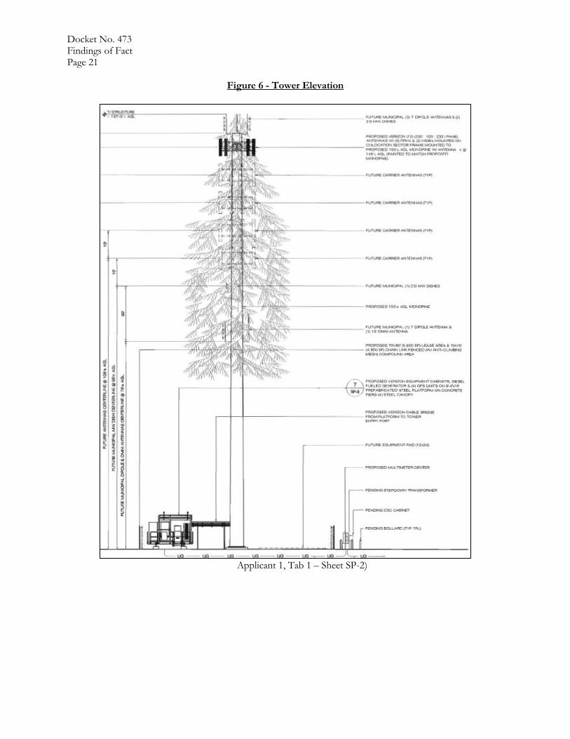
Docket No. 473 Findings of Fact Page 5
and maximizing use of broadband to advance “consumer welfare, civic participation, public safety and homeland security, community development, health care delivery, energy independence and efficiency, education, employee training, private sector investment, entrepreneurial activity, job creation and economic growth, and other national purposes.” (Council Administrative Notice Item No. 18 – The National Broadband Plan)
42. Section 706 of the Telecommunications Act of 1996 requires each state commission with regulatory jurisdiction over telecommunications services to encourage the deployment on a reasonable and timely basis of advanced telecommunications capability to all Americans, including elementary and secondary schools, by utilizing regulating methods that promote competition in the local telecommunications market and remove barriers to infrastructure investment. (Council Administrative Notice Item No. 4 – Telecommunications Act of 1996)
43. In December 2009, President Barack Obama recognized cell phone towers as critical infrastructure
vital to the United States. The Department of Homeland Security, in collaboration with other federal stakeholders, state, local, and tribal governments, and private sector partners, has developed the National Infrastructure Protection Plan to establish a framework for securing our resources and maintaining their resilience from all hazards during an event or emergency. (Council Administrative Notice Item No. 11 – Presidential Proclamation 8460, Critical Infrastructure Protection)
44. In February 2012, Congress adopted the Middle Class Tax Relief and Job Creation Act to advance wireless broadband service for both public safety and commercial users. The Act established the First Responder Network Authority to oversee the construction and operation of a nationwide public safety wireless broadband network. Section 6409 of the Act contributes to the twin goals of commercial and public safety wireless broadband deployment through several measures that promote rapid deployment of the network facilities needed for the provision of broadband wireless services. (Council Administrative Notice Item No. 8 – Middle Class Tax Relief and Job Creation Act of 2012)
45. In June 2012, President Barack Obama issued an Executive Order to accelerate broadband infrastructure deployment declaring that broadband access is a crucial resource essential to the nation’s global competitiveness, driving job creation, promoting innovation, expanding markets for American businesses and affording public safety agencies the opportunity for greater levels of effectiveness and interoperability. (Council Admin Notice Item No. 20 – FCC Wireless Infrastructure Report and Order; Council Admin Notice Item No. 12 – Presidential Executive Order 13616, Accelerating Broadband Infrastructure Development)
46. Pursuant to Section 6409(a) of the Middle Class Tax Relief and Job Creation Act of 2012, also
referred to as the Spectrum Act, a state or local government may not deny and shall approve any request for collocation, removal or replacement of equipment on an existing wireless tower provided that this does not constitute a substantial change in the physical dimensions of the tower. The Federal Communications Commission defines a substantial change in the physical dimensions of a tower as follows:
a) An increase in the existing height of the tower by more than 10% or by the height of one additional antenna array with separation from the nearest existing antenna not to exceed twenty feet, whichever is greater. Changes in height should be measured from the dimensions of the tower, inclusive of originally approved appurtenances and any modifications that were approved prior to the passage of the Spectrum Act.
b) Adding an appurtenance to the body of the tower that would protrude from the edge of the tower more than twenty feet, or more than the width of the tower structure at the level of the appurtenance, whichever is greater.

Docket No. 473 Findings of Fact Page 6
c) Installation of more than the standard number of new equipment cabinets for the technology involved, but not to exceed four, or more than one new equipment shelter.
d) A change that entails any excavation or deployment outside the current site. e) A change that would defeat the concealment elements of the tower. f) A change that does not comply with conditions associated with the siting approval of the
construction or modification of the tower, provided however that this limitation does not apply to any modification that is non-compliant only in a manner that would exceed the thresholds identified in (a) – (d).
(Council Administrative Notice Item No. 8 – Middle Class Tax Relief and Job Creation Act of 2012; Council Administrative Notice Item No. 20 – FCC Wireless Infrastructure Report and Order)
47. According to state policy, if the Council finds that a request for shared use of a facility by a municipality or other person, firm, corporation or public agency is technically, legally, environmentally and economically feasible, and the Council finds that the request for shared use of a facility meets public safety concerns, the Council shall issue an order approving such shared use to avoid the unnecessary proliferation of towers in the state. (C. G. S. §16-50aa)
Existing and Proposed Wireless Service - Cellco
48. Cellco established a search area for a site in the Easton area in May 2014. (Applicant 2, R. 12) 49. Cellco’s proposed installation at the 145-foot level of the 150-foot tower would provide coverage to
existing service gaps and would provide capacity relief to adjacent Cellco sites. (Applicant 1, p. 8) 50. Cellco would initially deploy Long Term Evolution (LTE) voice and data service equipment in the
700 MHz and 2100 MHz frequency bands. Cellco designs its LTE network using a 114 dB Reverse Link Operational Path Loss standard for in-vehicle service and 95 Reverse Link Operational Path Loss standard for in-building service. (Applicant 2, R. 2, R. 3)
51. The 700 MHz frequency is the primary frequency of Cellco’s LTE network, as it provides a much larger service area than the 2100 MHz network and can penetrate buildings and other structures more easily than other frequencies. The 2100 MHz frequency is used for additional LTE capacity within the service footprint and would be utilized in close proximity to the cell site. (Applicant 2, R. 2)
52. Existing Cellco facilities surrounding the proposed site cannot provide adequate service to the target service area. At 700 MHz, there are 2.75 square miles of unreliable service. Additionally, no 2100 MHz service is available in the area around the proposed site. (Applicant 2, R. 4)

Docket No. 473 Findings of Fact Page 7
53. Adjacent Cellco facilities include:
Cellco Site Name Site Address Distance and
Direction from Proposed Tower
Antenna Height
(agl)
Structure Type
Trumbull Center Merrimac Drive, Trumbull
2.4 miles northeast 50 feet Water tank
Plattsville 175 Jefferson Street, Fairfield
2.3 miles southeast 50 feet Rooftop
Fairfield 281 Woodhouse Drive, Fairfield
2.5 miles south 158 feet Monopole tower
Weston North 237 Godfrey Road, Weston
4.0 miles northwest 165 feet Lattice tower
Easton North 2 Everett Road, Easton 3.8 miles north 128 feet Monopole tower
(Applicant 1, pp. 9-10; Record)
54. Cellco’s installation at a tower height of 146 feet is projected to provide the following service to the surrounding target area:
700 MHz Service 2100 MHz Service
Route 58 (5,200 ADTs*) 2.9 miles 0.9 miles
Route 59 (8,900 ADTs*) 1.9 miles 1.2 miles
Route 136 (6,500 ADTs*) 3.1 miles 0.4 miles
Land Area 18.9 square miles 3.21 square miles
* ADTs- Average Daily Trips – DOT vehicle data. Refer to Figures 2, 3, 4 and 5 for wireless service models. (Applicant 1, pp. 8-9; Applicant 2, R. 9)
55. Cellco’s proposed installation would provide capacity relief to its adjacent Fairfield facility by
offloading approximately 8 to 10 percent of the traffic from Alpha sector at both the 700 MHz and 2100 MHz frequencies. Similarly, capacity relief would be achieved at the Plattsville facility by offloading approximately 12 to 15 percent of the traffic at the Plattsville Gamma sector at the 700 MHz frequency. Both of these sectors are at their service capacity limits and the anticipated capacity relief would allow these sectors to operate unconstrained for at least one year. (Applicant 1, p. 8; Applicant 2, R. 7)
56. Local topography would limit the effectiveness of wireless service in some areas including an approximate 0.4 mile section of Route 58 along the west side of the Aspetuck Reservoir and along Route 136 near its intersection with Route 58 where service would be unreliable. (Applicant 1, Tab 6, Tab 9; Applicant 2, R. 4; Tr. 1, pp. 40-41)
57. Additional small cell facilities are being evaluated to provide additional capacity relief to sectors approaching capacity limits. (Applicant 2, R. 7)

Docket No. 473 Findings of Fact Page 8 58. Once Cellco’s installation is operational, the wireless system is field examined by radio frequency
engineers to identify further necessary adjustments or the need for additional Cellco facilities to provide service to isolated service deficient areas. Once adjustments are made, the effective service area of the 700 MHz network would be approximately 6.4 square miles. (Applicant 2, R. 7)
Site Selection
59. HT began a site search in the area of Morehouse Road in early 2012. HT determined a need for a
facility based on informal consultations with various telecommunications carriers as well as in-house analysis of wireless network performance. (Applicant 1, Tab 8; Tr. 1. pp. 47-48)
60. HT approached the Town in February 2012 to discuss potential locations for a telecommunications facility on town property. The Town was interested in leasing Town property for a telecommunications site and eventually studied numerous parcels as well as investigated current service in town and technologies to provide service. (Applicant 1, Tab 8; Tr. 1, pp. 6-7, 44-46)
61. During the tower site development process that occurred over several years, HT examined numerous other locations including:
a) 244 Beers Rd., Easton – Town-owned parcel, town decided tower was not appropriate use; b) 15 Westport Rd., Easton – Town-owned parcel, town decided tower was not appropriate use; c) 680 Morehouse Rd., Easton – Town-owned parcel, town decided tower was not appropriate
use; d) 488 Morehouse Rd., Easton - landowner not interested; e) 681 Morehouse Rd., Easton - landowner not interested; f) 100 Banks Rd., Easton - landowner not interested; g) 194 Banks Rd., Easton - landowner not interested; h) 260 Westport Rd., Easton - landowner not interested; i) Wilson Rd., Easton – Aquarion Water Co. property, landowner not interested; j) 20 Wilson Rd., Easton – landowner not interested; k) Center Rd. (Lot 24), Easton - landowner not interested; l) 271 Center Rd., Easton – landowner not interested; m) 210 Westport Tpk., Easton – landowner not interested; n) 186 Westport Tpk., Easton – landowner not interested; o) Aspetuck Park, Black Rock Road, Easton – part of Town RFP issued October 2013, sine
withdrawn by the Town. (Applicant 1, pp. 21-22, Tab 8)
62. Although it is technically possible to provide wireless service to the target service area using numerous small cells, the actual number of small cells necessary would be significant due to the large size of the service area to be covered. The use of a macro-cell at the proposed site is the most efficient and cost effective method for providing a large coverage footprint. (Applicant 2, R. 5)
63. A tower in the animal control shelter area of the property was initially examined by the Town early in
the search for suitable tower locations on the property but was rejected since the area is 60 feet lower in ground elevation than the proposed site, thus requiring a much taller tower. Additionally, the Town wanted to maintain the wooded area around the shelter as open space. (Applicant 2, R. 22)
64. Relocating the proposed tower further west would require more tree removal, additional ground disturbance to overcome sloping terrain, and a reduction in the distance to wetland resources on the abutting Aquarion watershed lands. (Applicant 2, R. 21; Westmoreland 1)

Docket No. 473 Findings of Fact Page 9
Facility Description
65. The proposed site is located in the southerly portion of a 104.4-acre parcel owned by the Town. (Applicant 1, Tab 1)
66. The subject property is zoned Residential - R-3. (Applicant 1, Tab 1)
67. The parcel includes a school and associated athletic fields in the north portion; woodland, open fields, and a public works yard in the central portion; and an animal control shelter in the southern portion. (Applicant 1, Tab 1)
68. The proposed site consists of a 70-foot by 80-foot lease area in a wooded area, adjacent to a field in the south-central portion of the parcel. (Applicant 1, Tab 1)
69. HT would construct at 150-foot faux tree tower at the site. The faux branches would extend to a height of 157 feet above ground level (agl) to provide a simulated conical shape. (Applicant 1, Tab 1)
70. The tower site is at a ground elevation of 440 feet above mean sea level (amsl). Topography in the area ranges from 95 feet amsl to 657 feet amsl. (Applicant 1, Tab 1)
71. The tower would be designed to support five levels of wireless carrier antennas as well as municipal emergency services antennas. Refer to Figure 6. (Applicant 1, Tab 1)
72. Cellco would install up to 12 panel antennas and 9 remote radio heads on an antenna platform at a centerline height of 145 feet above ground level. The faux branches would conceal Cellco’s antennas. The antennas would be painted to match the faux tree color. (Applicant 1, p. 8, Tab 1; Tr. 1, p. 29)
73. The Town would locate three seven-foot long whip antennas and two dish antennas on a mounting bar at the 150-foot level of the tower, one seven-foot whip antenna on a standoff arms at the 75-foot level of the tower and a 10-foot whip antenna at a the 95-foot-foot level of the tower. The faux braches would conceal the whip and dish antennas at the top of the tower. (Applicant 1, Tab 1; Tr. 1, pp. 28; Tr. 2, p. 11)
74. HT would establish a 70-foot by 70-foot equipment compound within the lease area, enclosed by an eight-foot tall chain link fence with an anti-climb mesh. Refer to Figure 7. (Applicant 1, Tab 1)
75. Cellco would install equipment cabinets on a 9.3-foot by 16-foot elevated steel platform covered by a canopy within the compound. The cabinets are locked and are remotely monitored for intrusion 24 hours a day. (Applicant 1, Tab 1; Applicant 2, R. 15) )
76. A 10-foot by 10-foot equipment shelter would serve the Town’s communication antennas. (Applicant 1, Tab 1 –Sheet SP-2)
77. A vehicle access easement would utilize an existing driveway that extends 1,650 feet to the public works yard. A new 12-foot wide gravel access road would be established for 315 feet through a field southwest of the public works yard to the compound gate. (Applicant 1, Tab 1)
78. Utilities would be installed underground to the compound from Morehouse Road using a utility specific easement over a length of 890 feet.. The easement would extend southeast along Morehouse Road for 200 feet. In the area of 400 Morehouse Road, the utility easement would turn southwest, through a shrubby area at the edge of the Public Works yard. Underground utilities would be

Docket No. 473 Findings of Fact Page 10
installed to the site along the easement from a new utility pole across from 418 Morehouse Road. (Applicant 1, Tab 1; Tr. 1, pp. 19-20, 24-27)
79. There are four residential structures within 1,000 feet of the proposed tower site. (Applicant 1, p. 15)
80. The nearest abutting property from the proposed tower is a residential property located approximately 753 feet to the northeast at 418 Morehouse Road. The Westmoreland residence is approximately 884 feet east of the compound location. (Applicant 1, p. 19, Tab 1)
81. The estimated cost of the proposed facility is:
Tower and foundation $225,000 Site development $112,000 Utility installation $38,250 Subtotal: HT Cost $375,250 Cellco antennas and coax $95,000 Cellco radio equipment $300,000 Cellco power systems and other equipment $85,000 Subtotal: Cellco’s Cost $480,000 Total Estimated Facility Cost $855,250 (Applicant 1, pp. 24-25)
82. Construction of the site would take approximately six weeks, depending on scheduling and site conditions. Once radio equipment and antennas are installed, cell site integration and system testing would require another two weeks before the site is fully operational within Cellco’s wireless network. (Applicant 1, p. 25)
Public Safety 83. The Wireless Communications and Public Safety Act of 1999 (911 Act) was enacted by Congress to
promote and enhance public safety by making 9-1-1 the universal emergency assistance number, by furthering deployment of wireless 9-1-1 capabilities, and by encouraging construction and operation of seamless ubiquitous and reliable networks for wireless services. (Council Administrative Notice Item No. 6 - Wireless Communications and Public Safety Act of 1999)
84. The proposed facility would be in compliance with the requirements of the 911 Act and would provide Enhanced 911 services. (Applicant 1, p. 6)
85. Wireless carriers have voluntarily begun supporting text-to-911 services nationwide in areas where municipal Public Safety Answering Points (PSAP) support text-to-911 technology. Text-to-911 will extend emergency services to those who are deaf, hard of hearing, have a speech disability, or are in situations where a voice call to 911 may be dangerous or impossible. However, even after a carrier upgrades its network, a user’s ability to text to 911 is limited by the ability of the local 911 call center to accept a text message. The FCC does not have the authority to regulate 911 call centers; therefore, it cannot require them to accept text messages. (Council Administrative Notice Item No. 19 – FCC Text-to-911: Quick Facts & FAQs)
86. Cellco’s facility would be capable of supporting text-to-911 service as soon as the PSAP is capable of
receiving text-to-911. However, no PSAPs in the vicinity of the proposed tower site are able to accept text-to-911 service at this time. (Cellco 2, R. 10)

Docket No. 473 Findings of Fact Page 11 87. Pursuant to the Warning, Alert and Response Network Act of 2006, “Wireless Emergency Alerts”
(WEA) is a public safety system that allows customers who own certain wireless phone models and other enabled mobile devices to receive geographically-targeted, text-like messages alerting them of imminent threats to safety in their area. WEA complements the existing Emergency Alert System that is implemented by the FCC and FEMA at the federal level through broadcasters and other media service providers, including wireless carriers. (Council Administrative Notice No. 5 – FCC WARN Act)
88. Pursuant to CGS § 16-50p(a)(3)(G), the tower would be constructed in accordance with the governing standard in the State of Connecticut for tower design in accordance with the currently adopted 2016 Connecticut State Building Code. Final tower and foundation design details would be provided in the Development and Management (D&M) Plan for the facility. (Applicant 1 p. 6, Tab 1; Applicant 2, R. 16)
89. The proposed tower would not constitute an obstruction or hazard to air navigation and would not require any obstruction marking or lighting. (Applicant 1, p. 23)
90. The tower radius would remain on the host property. (Applicant 1, Tab 1)
91. The cumulative worst-case maximum power density from the radio frequency emissions from the operation of the proposed municipal and Cellco antennas is 1.1 percent of the standard for the General Public/Uncontrolled Maximum Permissible Exposure, as adopted by the FCC, around the base of the proposed tower. This calculation was based on methodology prescribed by the FCC Office of Engineering and Technology Bulletin No. 65E, Edition 97-01 (August 1997) that assumes all antennas are operating at full power, all antenna channels would be operating simultaneously, and all radio transmitters are operating at full power which creates the highest possible power density levels. Under normal operation, this equipment would be not at maximum operating capacity and the radio frequency power associated with the antennas would be oriented towards the horizon, thus resulting in significantly lower power density levels in areas around the tower. (Applicant 2, R. 13)
Emergency Backup Power 92. In response to two significant storm events in 2011, Governor Malloy formed a Two Storm Panel
(Panel) that was charged with an objective review and evaluation of Connecticut’s approach to the prevention, planning and mitigation of impacts associated with emergencies and natural disasters that can reasonably be anticipated to impact the state. (Council Administrative Notice Item No. 44 - Final Report of the Two Storm Panel)
93. In response to the findings and recommendations of the Panel, and in accordance with C.G.S. §16-
50ll, the Council, in consultation and coordination with DEEP, DESPP, and PURA, studied the feasibility of requiring backup power for telecommunications towers and antennas as the reliability of such telecommunications service is considered to be in the public interest and necessary for the public health and safety. The study was completed on January 24, 2013. (Council Administrative Notice Item No. 24 – Council Docket No. 432)

Docket No. 473 Findings of Fact Page 12
94. The Council reached the following conclusions in the study:
a) “Sharing a backup source is feasible for CMRS providers, within certain limits. Going forward, the Council will explore this option in applications for new tower facilities;” and
b) “The Council will continue to urge reassessment and implementation of new technologies to improve network operations overall, including improvements in backup power.”
(Council Administrative Notice Item No. 24 – Council Docket No. 432)
95. Cellco would install a battery cabinet on its steel platform within the compound. The battery could supply two to eight hours of emergency power depending on site loading. A 20 kW diesel generator would also be installed in order to recharge the battery during prolonged outages. (Applicant 1, p. 8; Applicant 2, R. 17)
96. The Town has not yet decided on an emergency power source for its installation. Existing Town communication equipment utilizes a battery backup system. (Applicant 2, R. 19)
97. It is feasible to install a generator that could power both Cellco’s and the Town’s equipment. (Applicant 2, R. 20)
98. According to R.C.S.A. §22a-69-1.8, noise created as a result of, or relating to, an emergency, such as an emergency backup generator, is exempt from the State Noise Control Regulations. (R.C.S.A. §22a-69-1.8)
Environmental Considerations
99. No historic properties would be affected by the proposed facility. (Applicant 1, p. 17)
100. Development of the tower compound would require the removal of 37 trees with a diameter of six inches at breast height within a 0.3-acre area of disturbance. Shrubby vegetation would be removed along the underground utility run, generally to a width of 10 to 12 feet to accommodate construction equipment. (Applicant 1, Tab 1, Tab 10; Tr. 1, pp. 25-26)
101. The tower compound is located in an approximately 199 acre edge forest with a mesic oak/hickory cover type. The edge forest surrounds a 118-acre core forest that is located generally west of the proposed site. Development of the site would not result in fragmentation of the core forest block but would result in 0.3-acres of clearing within the edge forest. (Applicant 2, R. 25)
102. The Town is not willing to relocate the compound out of the edge forest area to the adjacent field north of the compound. The Town does not want to encumber potential future use of the field area and the Town believes the current location offers screening of the compound from surrounding areas. (Tr. 1, pp. 64-65; Tr. 2, p. 27)
103. According to the Natural Diversity Database, the proposed site is not within an area with records of State-listed species. (Applicant 1, Tab 11)
104. Connecticut is within the range of the northern long-eared bat (NLEB), a federally-listed Threatened species and State-listed Endangered species. There are no known NLEB hibernacula or known maternity roost trees near the project area and thus the proposed facility is not likely to adversely impact the NLEB. The United States Fish and Wildlife Service (USFWS) did not respond to the Applicants NLEB submittal, and in accordance with USFWS rules, the project site is thus deemed in compliance and no further action is necessary. (Applicant 1, Tab 10; Tr. 1, pp. 39-40)

Docket No. 473 Findings of Fact Page 13 105. The proposed site is located approximately 2.2 miles from Devil’s Den, a Nature Conservancy
preserve identified by the Connecticut Audubon Society as an Important Bird Area (IBA). The IBA includes protected land in Easton, Weston, Redding and Wilton. (Applicant 2, R. 23)
106. The design of the proposed facility would comply with United States Fish and Wildlife Service guidelines for minimizing the potential impact of telecommunications towers to bird species. The guidelines recommend that towers be less than 199 feet tall, avoid the use of aviation lighting, and avoid guy-wires as tower supports, among others. (Applicant 2, R. 24)
107. The USFWS service guidelines also contain tree clearing recommendations to minimize the risk to migratory birds during site construction. HT would adhere to the recommendations by restricting tree clearing to certain time periods or conducting an avian survey to determine if breeding birds would be disturbed. (Applicant 2, R. 24)
108. The nearest wetland to the tower compound is approximately 322 feet to the west. The wetland is a dry topographic swale with seasonal saturated soils. The wetland does not possess vernal pool characteristics. (Applicant 1, p. 17, Tab 12; Tr. 1, pp. 68-70)
109. The proposed project would be constructed in compliance with the 2002 Connecticut Guidelines for Soil
Erosion and Sedimentation Control. (Applicant 1, p. 20, Tab 12) 110. The site is located in the Federal Emergency Management Agency Zone X, an area outside of the
500-year flood zone. (Applicant 1, p. 20)
111. The site is within a public water supply watershed of the Hemlocks Reservoir System that is operated by the Aquarion Water Co. The DPH recommended the adherence to construction best management practices to protect the public water supply watershed, including the following:
proper placement of erosion and sedimentation controls.
making provisions to inspect and maintain these controls.
servicing machinery outside the watershed area.
refueling vehicles and machinery on impervious pads with secondary pads.
not storing fuel and other hazardous materials within the water supply area.
keeping a fuel spill remediation kit on-site.
notification to Aquarion prior to commencement of construction and allowing Aquarion to inspect the project during construction.
(DPH letter dated May 19, 2017)
112. The 92-gallon diesel fuel tank for the emergency generator is located within the generator unit. The unit features a double-walled fuel tank and leak detection alarms. The generator also maintains a secondary containment for engine oil and coolant within the generator enclosure. (Applicant 2, R. 18; Tr. 1, pp. 52-53)
113. The fuel tank would be re-filled every three to four months by a fuel delivery contractor. The contractor is required to have a spill clean-up kit in the fuel delivery vehicle. (Tr. 1, pp. 54, 59-60)
114. Natural gas is available in the tower area. HT would have to examine the existing gas main and possible access to site to determine if the use of natural gas to power an emergency generator is feasible. (Tr. 1, pp. 59-60, 94)
115. Operation of the proposed facility would not cause any significant noise, air, or water impacts or present a hazard to human health. (Applicant 1, p. 18)

Docket No. 473 Findings of Fact Page 14
Visibility
116. The proposed tower would be visible year-round from approximately 106 acres within a two-mile
radius of the site (refer to Figure 8). During leaf-off conditions, the tower would be visible from an additional 281 acres. (Applicant 1, Tab 9 – Visibility Analysis Viewshed Map)
117. Generally, year-round views of the facility would occur across open fields north of the site for a distance of 0.75 miles. Land-use with year-round views consists of open fields, athletic fields, a school, and several residences along Morehouse Road. (Applicant 1, Tab 9 - Visibility Analysis Viewshed Map)
118. During leaf-off conditions, seasonal visibility would extend approximately 0.5 miles around to the site. These areas include wooded properties owned by the Town and Aquarion and residential properties along Morehouse Road to the west. (Applicant 1, Tab 9 - Visibility Analysis Viewshed Map)
119. The tower would be screened by leaf-on vegetation from the Westmoreland residence. There could be some views through the trees during leaf-off conditions of the upper portions of the tower. (Tr. 1, pp. 33-36)
120. The tower would not be visible from a section of Route 58 along the Hemlock and Aspetuck Reservoirs, a State designated scenic road 1.25 miles southwest of the site. (Applicant 1, Tab 9)
121. Pursuant to C.G.S § 16-50p(a)(3)(F), the nearest school is the Staple Elementary School located approximately 0.6 mile north of the proposed facility. The nearest commercial child day care facility is located approximately 1.0 mile northeast of the proposed facility. The proposed tower would be visible from the Staples School. (Applicant 1, Tab 9)
122. Projected visibility of the proposed tower from specific locations within a two-mile radius of the site
is presented in the table below:
Specific Location Photo location on Map*
Approx. Portion of Facility Visible
Approx. Distance & Direction to Tower
Banks Road at Morehouse Road 1 Year-round – 100 feet 0.60 mile southeast
515 Morehouse Road (Staples School)
2 Year-round – 90 feet 0.51 mile southeast
Host Property (near baseball field)
3 Year-round – 100 feet 0.31 mile south
Host Property (soccer field) 4 Year-round – 100 feet 0.29 mile southeast
Morehouse Road, (near #436) 5 Year-round – 90 feet 0.20 mile south
Morehouse Road, (near #418) 6 Seasonal – 30 feet 0.13 mile south
Host Property (animal shelter) 7 Seasonal – 80 feet 0.07 mile north
Beers Road 8 Not visible 0.46 mile north
Rolling Hills Drive 9 Not visible 0.69 mile northwest
Blue Bell Lane 10 Not visible 0.86 mile northwest
Fawn Road 11 Not visible 0.75 mile northwest
Sport Hill Road 12 Not visible 0.96 miles southwest
Center Road 13 Not visible 1.02 miles south
Westport Road (Rt. 58) 14 Not visible 1.68 mile east

Docket No. 473 Findings of Fact Page 15
Morehouse Road (hear high school)
15 Not visible 1.18 mile southeast
Brianna Lane 16 Not visible 0.82 mile northwest
*Viewshed map provided as Figure 8 (Applicant 1, Tab 1, Tab 9 photo-simulations)
123. The Town initially requested a tree tower design at the site. During the public hearing on June 20, 2017, the First Selectman Dunsby stated that Town officials would discuss the appropriateness of a tree tower at a future date. On July 18, 2017, the Town’s P&Z Commission submitted a letter to the Council indicating that the P&Z Commission prefers a monopole at the proposed site. (Tr. 2, p. 27; Record)
124. Ms. Westmoreland prefers a stealth tower design rather than a standard monopole with a galvanized finish. (Tr. 1, p. 94)

Docket No. 473 Findings of Fact Page 16
Figure 1 – Site Location
(Applicant 1, Tab 11)

Docket No. 473 Findings of Fact Page 17
Figure 2 - Existing LTE 700 MHz Service
(Applicant 1, Tab 6)

Docket No. 473 Findings of Fact Page 18
Figure 3 - Proposed LTE 700 MHz Service
(Applicant 1, Tab 6)

Docket No. 473 Findings of Fact Page 19
Figure 4 - Existing LTE 2100 MHz Service
(Applicant Tab 6)

Docket No. 473 Findings of Fact Page 20
Figure 5 - Proposed LTE 2100 MHz Service
(Applicant 1, Tab 6)
Docket No. 473 Findings of Fact Page 21
Figure 6 - Tower Elevation
Applicant 1, Tab 1 – Sheet SP-2)

Docket No. 467
Findings of Fact
Page 22
Figure 7 – Site Plan
(Applicant 1, Tab 1 – Sheet SP-1)

Docket No. 467
Findings of Fact
Page 20
Figure 8 – Visibility Analysis
1” + 1450’ N
(Applicant 1, Tab 9 – Viewshed Map)