Embed Size (px)
Citation preview

GRC Transactions, Vol. 41, 2017
Do Geothermal Systems Play a Role in Lithium Brine
Enrichment in Nevada Playas?
Catherine Hickson and Mark Coolbaugh
Dajin Resources Corp, 450-789 West Pender Street
Vancouver, BC, V6C 1H2 Canada [email protected] and [email protected]
Keywords
lithium, geothermal, brine, Nevada
ABSTRACT
Exploration for economic deposits of lithium to be processed for use in batteries to power
electric vehicles has become supercharged in the past three years. Numerous companies have
entered the race to identify deposits and many are focused on potential brine deposits within the
internally drained basins that make up the Basin and Range covering the western US and Nevada
and Utah in particular. Only one operating lithium brine mine exists in the US, and it is found in
Clayton Valley, Nevada. The question remains as to what other lithium brine deposits exist in the
US. In general, lithium brine deposits are pre-request on a set of geological and climatological
factors: 1) a source of lithium, 2) an extraction mechanism, 3) a transport mechanism, 4) a trap
(closed basin), 5) a suitable solar evaporation rate, and 6) scale (mass flux of lithium and limited
dissolved salt competition). Geothermal fluids may contribute to more efficient and selective
extraction of lithium from basin sediments and basement rocks; they may help transport the
enriched fluids due to thermal upwelling; and finally provide long term mass flux that over
sufficient time leads to significant endowment in basins. The basins of western Nevada have
many of these prerequisites, but are dominated by clastic sediments and have relatively high
subsidence and sedimentation rates. For these reasons it is likely that lithium-enriched brines are
deeper than in the mature basins of South America. Since few basins in Nevada have had deep
drilling, paleo-brines may remain to be discovered at depths not yet investigated by exploration
companies.
1. Introduction
Exploration for lithium from brine and hard rock sources has grown significantly over the past
three years with companies targeting many localities on the globe. Brines are currently receiving
a lot of attention due to their lower development costs, and Nevada is one of the places receiving
a lot of this attention. The increased interest has also led to increased research into the origin of
lithium brines in the United States and elsewhere.
Hickson and Coolbaugh
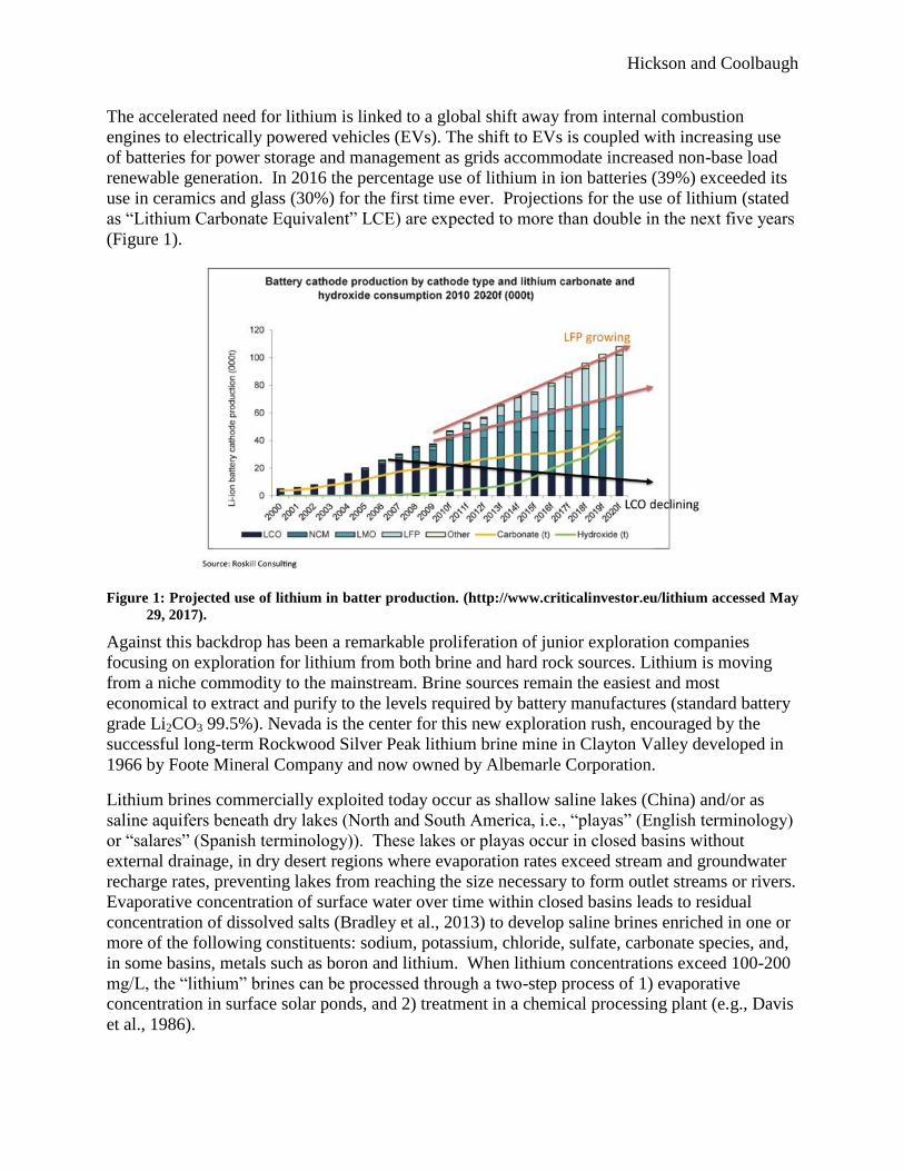
The accelerated need for lithium is linked to a global shift away from internal combustion
engines to electrically powered vehicles (EVs). The shift to EVs is coupled with increasing use
of batteries for power storage and management as grids accommodate increased non-base load
renewable generation. In 2016 the percentage use of lithium in ion batteries (39%) exceeded its
use in ceramics and glass (30%) for the first time ever. Projections for the use of lithium (stated
as “Lithium Carbonate Equivalent” LCE) are expected to more than double in the next five years
(Figure 1).
Figure 1: Projected use of lithium in batter production. (http://www.criticalinvestor.eu/lithium accessed May
29, 2017).
Against this backdrop has been a remarkable proliferation of junior exploration companies
focusing on exploration for lithium from both brine and hard rock sources. Lithium is moving
from a niche commodity to the mainstream. Brine sources remain the easiest and most
economical to extract and purify to the levels required by battery manufactures (standard battery
grade Li2CO3 99.5%). Nevada is the center for this new exploration rush, encouraged by the
successful long-term Rockwood Silver Peak lithium brine mine in Clayton Valley developed in
1966 by Foote Mineral Company and now owned by Albemarle Corporation.
Lithium brines commercially exploited today occur as shallow saline lakes (China) and/or as
saline aquifers beneath dry lakes (North and South America, i.e., “playas” (English terminology)
or “salares” (Spanish terminology)). These lakes or playas occur in closed basins without
external drainage, in dry desert regions where evaporation rates exceed stream and groundwater
recharge rates, preventing lakes from reaching the size necessary to form outlet streams or rivers.
Evaporative concentration of surface water over time within closed basins leads to residual
concentration of dissolved salts (Bradley et al., 2013) to develop saline brines enriched in one or
more of the following constituents: sodium, potassium, chloride, sulfate, carbonate species, and,
in some basins, metals such as boron and lithium. When lithium concentrations exceed 100-200
mg/L, the “lithium” brines can be processed through a two-step process of 1) evaporative
concentration in surface solar ponds, and 2) treatment in a chemical processing plant (e.g., Davis
et al., 1986).

Hickson and Coolbaugh
Currently, new technologies are being developed that may circumvent the solar pond step and
enable extraction of lithium with higher efficiencies and at lower concentrations. These are
generally termed “direct extraction” methods as lithium is removed from the brine directly and
then the spent brine is reinjected. Although to date most lithium brine plants rely upon
traditional evaporation ponds, an increasing number of companies are working on direct
extraction technologies that are able to extract and purify lithium from brines without the need
for evaporative pre-concentration.
2. Lithium Exploration Model
Most playa waters do not have economic concentrations of lithium. But there are some areas of
the world where favorable conditions for the development of lithium-rich brines are found.
These conditions include: 1) an arid climate, 2) a closed (internally drained) basin with a playa
(or salar), 3) tectonically driven subsidence, 4) associated igneous or geothermal activity, 5)
suitable lithium source rocks, 6) one or more adequate aquifers, and 7) sufficient time to
concentrate a brine (Bradley et al., 2013). The Basin and Range physiographic province of the
western US (Figure 2) provides the closed basins, arid climate, and many of the other factors
noted as important for brine formation.
Figure 2: Basin and Range region of Nevada, showing Dajin Resources Corps’ Teels Marsh and Alkali Lake
properties as well as the Rockwood Silver Peak lithium brine mine in Clayton Valley.

Hickson and Coolbaugh
Despite the large number of closed basins within the Basin and Range, and despite at least two
rounds of increased exploration interest since the Clayton Valley discovery more than 50 years
ago, the Rockwood Silver Peak mine remains the only operating lithium brine mine in the US.
However, economic concentrations of lithium in brines at Silver Peak were reportedly not
discovered until drilling was initiated (Davis et al., 1986). As discussed in this paper, brines
saturated in dissolved salts are denser than fresh water and thus have the potential to sink and
displace less-dense fluids below the surface. Most playas in the Great Basin have not been tested
at depth for the presence of lithium brines; therefore, significant potential remains for finding
undiscovered resources.
Ultimately, suitable brine enrichment depends on a number of factors such as the mass flux of
lithium in incoming groundwater and surface water sources, the weighted average lithium/salt
ratios in that water, and a solar evaporation rate high enough that the fresh water component can
be removed. Once a dense brine forms it will likely sink within the sedimentary column of the
basin until downward movement is impeded by an aquitard or by impermeable basement rocks at
the bottom of the basin. Sealing of the upper surface and development of aquitards within the
basin are likely the result of weather related flood events significant enough to wash large
quantities of fine grained material into the basins. Wind-blown material during drying periods
may also have been prevalent as forests died off leaving barren slopes exposed to wind and water
erosion.
In west-central Nevada the presence of thick volcanic ash deposits may be an important factor in
lithium concentration. Felsic ash is relatively high in lithium relative to other bed rock sources
and the glassy ash shards are highly reactive with groundwater and may be especially so when
subjected to heated geothermal water. The presence of a thick volcanic tephra layer (the Bishop
Tuff) deposited during the eruption of the Long Valley caldera 0.76 Ma ago blankets much of
west-central Nevada (Figure 3). This tephra layer forms the largest single lithium brine aquifer
at Clayton Valley, where it ranges from 5 to 30 feet (1.5 to 9.1 metres) thick and occurs at depths
ranging from 60 to 230 metres (200 to 750 feet)(Zampirro, 2004).
2.1 Aquifers
Within rapidly subsiding closed basins, sedimentation is typically dominated by clastic layers of
silt, sand, or gravel in addition to volcanic ash deposits from both local and distal sources. The
closed basins of west-central Nevada, including Clayton Valley and Teels Marsh, fall into this
category, termed “immature basins” by Houston et al. (2011) to distinguish them from “mature
basins”, where chemical sedimentation (halite) is more important. The type of basin has an
impact on subsurface exploration potential, because clastic-rich aquifers in immature basins can
maintain permeability at depth, whereas salt aquifers tend to lose permeability quickly with
depth because of the plastic behavior of salt under pressure (Houston et al., 2011). Conceptually,
the presence of viable aquifers at depth in immature basins provides the opportunity for lithium-
rich, relatively dense saline brines to descend into the basin where drilling is required to find
them. To the authors’ knowledge, the deepest lithium aquifers in the world from which lithium
is being produced are at Clayton Valley, where surface concentrations of lithium are inferred to
have been lower than in the subsurface (Davis et al., 1986).

Hickson and Coolbaugh
Figure 3: The eruption of the Long Valley Caldera covered much of the western United States under a thick
layer of ash (tephra or tuff, shown in blue on the diagram). This ash is a source of lithium as well as a
potential aquifer. These ash layers have proven to be the most productive brine sources at the
Rockwood Silver Peak mine in Clayton Valley (figure adapted from Zampirro, 2004).
2.2 Climate and Flooding
The tectonic regime in the Basin and Range has led to long term subsidence of basins for
millions of years and the development of independent closed basins. The present climatic
conditions of the Basin and Range are such that evaporation exceeds precipitation. During the
Quaternary and late Tertiary, the climate has alternated between wet and dry. A notable event
during the geologically recent history of the Basin and Range is widespread flooding by Lake
Lahonton (Figure 4). The lake persisted from 54,000 y.b.p. to 12,000 y.b.p and several wet and
dry periods during this period are recorded in the sediments in the basins (Benson et al. 1995,
Bradbury et al., 1988). During the wet periods the emergent land was covered with forests
similar to the present day Sierra Nevada Mountains.
The waters of Lake Lahonton had a significant impact on ground waters in the region (Benson et
al. 1995) leading to widespread recharge. During dry cycles and since the Wisconsin glaciation,
the periods where the basins evaporated to dryness left silt and salt deposits that characterize the
basins’ present day surfaces. During periods of high stand, it is likely that recharge of the
aquifers led to dilution of the subsurface brines. Whether dissolution of lithium from near surface
volcanic ash deposits was accelerated during this time period remains unknown. During dry
periods, precipitation of lithium bearing minerals such as hectorite or searlesite occurred, and the
surfaces of many playas, including Clayton Valley, Fish Lake Valley, and Teels Marsh, have
elevated lithium values in sediments (Figure 5).

Hickson and Coolbaugh
Figure 4: Extent of glacial Lake Lahonton from Decumanus at en.wikipedia, CC BY-SA 3.0
(https://commons.wikimedia.org/w/index.php?curid=11123512 (accessed May 28, 2017).
Figure 5: Lithium concentrations in shallow auger sediments sampled by Dajin Resources Corp. at Teels
Marsh, Nevada. Ordinary kriging was used to interpolate lithium concentrations using a maximum of
12 input points for each grid cell, after averaging all lithium concentrations for a given auger site
(figure taken from Coolbaugh and Hickson, 2017).

Hickson and Coolbaugh
During the Pleistocene lakes have filled and desiccated (Figure 6, Reheis 1999) in the
tectonically driven pull apart basins of the region in response to climatic, tectonic and
geomorphic events. Detailed, multidisciplinary paleolimnologic records from related subbasins
are required to separate these processes and understand the lake level history before it can be
reliably used to interpret paleoclimatology (Benson et al., 1995, Bradbury et al. 1988). To the
best of our knowledge, no work has been done correlating lithium brine deposits in Clayton
Valley to paleo-lakes that may have occupied the basin in the past.
Figure 6: Extent of Pleistocene glacial lakes in the Clayton Valley and Teels Marsh areas (from Reheis, 1999).
3. A Geothermal Connection
In addition to closed basins and climate, there appears to be a good spatial correlation between
felsic volcanism, geothermal activity and lithium brines, lithium-enriched clays (e.g. hectorite)
and lacustrine sediments containing lithium minerals (e.g. searlesite). A geothermal association
is known or suspected at a number of lithium-brine deposits around the world, including Clayton
Valley (Davis et al., 1986; NBMG, 2014), Salar de Atacama, Chile (Lowenstein and Risacher,
2009), and the Qaidam Basin, China (Yu et al., 2013).
Geothermal activity may not be a necessary prerequisite for lithium brine formation, because
there is evidence that non-thermal devitrification and weathering processes can liberate lithium
from volcanic rocks (Price et al., 2000). We argue nonetheless, that thermal groundwater can
make the process more efficient by accelerating the dissolution of lithium rich glassy volcanic
rocks and by selectively dissolving lithium relative to other constituents. This is demonstrated
by abundant empirical data on the composition of geothermal fluids as a function of temperature.
These data show that the Li/Mg (Fouillac and Michard, 1981) and Li/Na (Kharaka and Mariner,
1989) ratios systematically increase multiple orders of magnitude as temperature increases;
indeed, these correlations form the basis for the Li/Mg and Li/Na geothermometers (Fouillac and
Michard, 1981; Kharaka and Mariner, 1989). Houston et al. (2011) observe that many Central
Andean brines have elevated Li/Mg ratios, which are difficult to explain under surface

Hickson and Coolbaugh
weathering conditions in volcanic terrains where groundwater commonly has elevated
magnesium concentrations, but easier to understand in the context of a geothermal groundwater
history.
Yu et al. (2013) provide a well-documented example of short-term (since the last glacial period)
lithium enrichment in several basinal brines currently being mined for their lithium in the
Qaidam Basin, China. This lithium originates from lithium-rich hot springs that flow into rivers
that eventually feed into the Qaidam Basin after traveling more than 300 km. Mass flux
calculations show that the lithium endowment in the Qaidam Basin can be explained by the
current flow rates if operating over approximately 6,000 years (Yu et al., 2013).
3.1 Lithium in Groundwater
An extreme case of lithium-rich geothermal fluids is provided by the Salton Sea, where
production fluids have lithium concentrations ranging to over 300 ppm (Klein and Gaines, 2011).
Most geothermal waters have much lower lithium concentrations, but still much greater than
found in typical non-thermal groundwater. Thermal groundwater in Nevada has lithium
concentrations that commonly exceed 1 mg/L, but average 0.66 mg/L (638 analyses, GBCGE
(2017a). In comparison, average lithium concentrations reported for municipal water supplies in
the US are at least an order of magnitude lower (<0.05 mg/L, Durfor and Becker, 1964).
Importantly, our studies show that many geothermal waters in the Great Basin, if evaporated to
the point of halite saturation, would generate brines with lithium concentrations in the range of
several hundreds of mg/L and higher, without the need of further concentration from
precipitation of salt minerals. This provides a suggestive fingerprint, pointing to the viability of
generating lithium-rich brines over relatively short periods of time in basins where geothermal
influx is significant.
3. Teels Marsh Lithium Exploration
As an example of the influence of geothermal activity on lithium-brine formation, we review the
links and evidence for lithium concentration in Teels Marsh, Nevada. Teels Marsh, located in
west central Nevada (Figure 2), is the target of lithium brine exploration (Coolbaugh and
Hickson, 2017)), and provides an example of the influence of geothermal activity on lithium
brine formation.
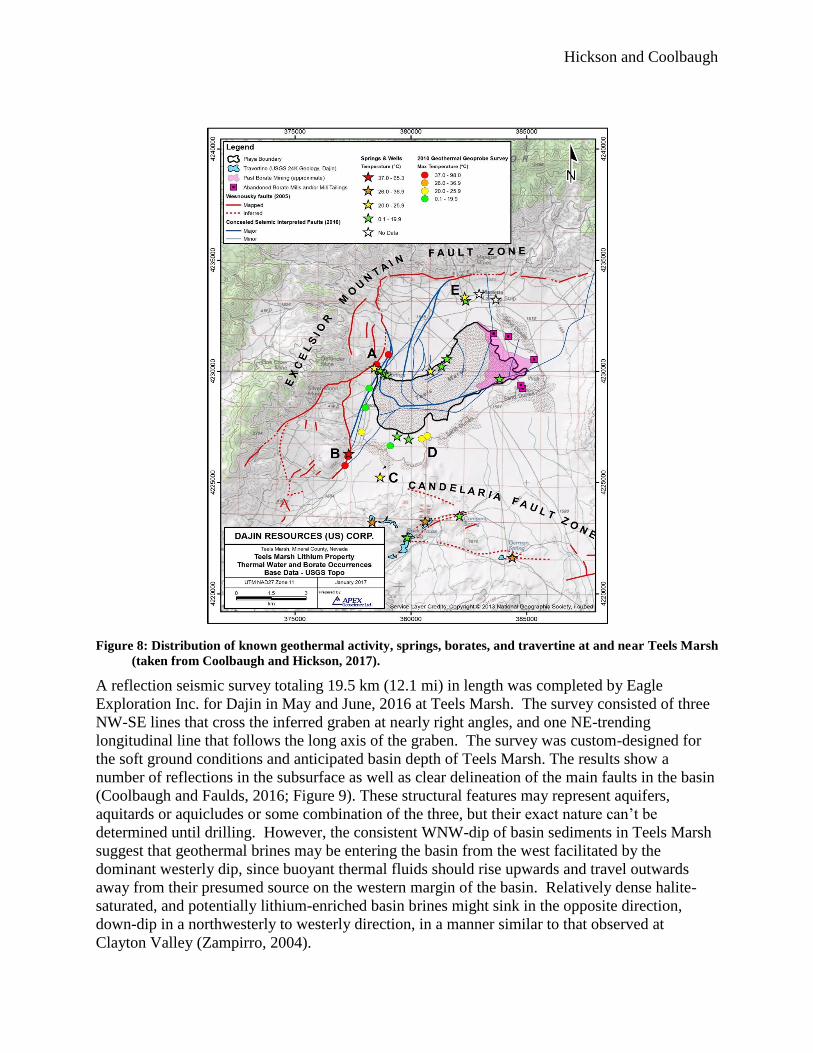
Teels Marsh is a rapidly subsiding basin within the Mina deflection (Figure 7) and has an
estimated depth of 2.5 km (Coolbaugh and Faulds 2016). It is located at the western mapped
terminus of the Excelsior Mountain fault system (Figure 7 and 8). As mapped by Wesnousky
(2005), the Excelsior Mountain fault bounds Teels Marsh basin on its northern and western
margins. The stronger development of faulting on the north and west sides of the basin
compared to the east and south sides has led to the development of a composite half-graben
within the basin. Seismic profiles and detailed gravity modelling document the deep, central
half-graben up to 2.5 km deep, lying within an outer half-graben bounded by the Excelsior
Mountain fault (Figure 8; Coolbaugh and Hickson 2017).
Numerous geothermal systems are associated with the basins within the Mina Deflection (Figure
7). Several blind systems were identified there by researchers at the University of Nevada, Reno
(UNR) (Coolbaugh et al., 2006, 2013). No thermal springs or wells were known to exist in Teels

Hickson and Coolbaugh
Marsh basin prior to the UNR work, but the presence of geothermal activity was suspected based
on a recognized link in Nevada between young borates and geothermal activity (Coolbaugh et
al., 2006). The geothermal exploration work consisted of geochemical sampling of springs and
wells to calculate geothermometer temperatures (Coolbaugh et al., 2006), spectral surveys of
surface borate occurrences (Kratt et al., 2006), 2-metre temperature surveys (Kratt et al., 2008),
and ultimately, Geoprobe drilling in 2010 (Zehner et al., 2012). The Geoprobe drilling
encountered temperatures of up to 97°C at a 40 m depth northwest of the marsh (site “A”, Figure
8), and 78°C at 30 m depth southwest of the marsh (site “B”, Figure 8). An additional source of
thermal waters to the playa is indicated by the presence of thermal springs (previously
undocumented) south of Teels Marsh associated with large travertine terraces.
Figure 7: Quaternary faults and geothermal systems in the Mina Deflection. The physical extent of the Mina
Deflection encompasses the geothermal areas: 1 = Sodaville, 2 = Rhodes Marsh, 3 & 4 = North & south
Teels Marsh, 5 = Redlich, 6 = SW Columbus Marsh; and thermal wells 7, 8, and 9 at Whiskey Flat,
Huntoon Valley, and NE of Queen Valley, respectively. RSM = Rhodes Salt Marsh, TM = Teels Marsh,
CSM = Columbus Salt Marsh, GF = Garfield Flat, HV = Huntoon Valley, RF = Rattlesnake Flat, MLB
= Mono Lake Basin, LV = Long Valley caldera, AV = Adobe Valley, QV = Queen Valley, GV = Gabbs
Valley, EX = Excelsior Mountain fault, GM = Gumdrop Hills fault, CL = Coaldale fault, BS = Benton
Springs fault. Blue circles are geothermal systems outside the Mina Deflection with measured or
estimated temperatures >70°C. Taken from Coolbaugh et al. (2013) and originally adapted from
Wesnousky (2005).
Hickson and Coolbaugh
Figure 8: Distribution of known geothermal activity, springs, borates, and travertine at and near Teels Marsh
(taken from Coolbaugh and Hickson, 2017).
A reflection seismic survey totaling 19.5 km (12.1 mi) in length was completed by Eagle
Exploration Inc. for Dajin in May and June, 2016 at Teels Marsh. The survey consisted of three
NW-SE lines that cross the inferred graben at nearly right angles, and one NE-trending
longitudinal line that follows the long axis of the graben. The survey was custom-designed for
the soft ground conditions and anticipated basin depth of Teels Marsh. The results show a
number of reflections in the subsurface as well as clear delineation of the main faults in the basin
(Coolbaugh and Faulds, 2016; Figure 9). These structural features may represent aquifers,
aquitards or aquicludes or some combination of the three, but their exact nature can’t be
determined until drilling. However, the consistent WNW-dip of basin sediments in Teels Marsh
suggest that geothermal brines may be entering the basin from the west facilitated by the
dominant westerly dip, since buoyant thermal fluids should rise upwards and travel outwards
away from their presumed source on the western margin of the basin. Relatively dense halite-
saturated, and potentially lithium-enriched basin brines might sink in the opposite direction,
down-dip in a northwesterly to westerly direction, in a manner similar to that observed at
Clayton Valley (Zampirro, 2004).

Hickson and Coolbaugh
Figure 9: NW-SE seismic reflection profile through Teels Marsh, looking northeast. Red lines are interpreted
faults, and the yellow line is the interpreted contact between basin-fill deposits above and rocks below.
Gray line is the basin fill-rock contact from the basin-removed topographic elevation model of Wright
(2015). Proposed drill-hole 2 is projected to section. QTs = Quaternary and Tertiary sediments, MzTu
= undivided Mesozoic and Tertiary rocks. Vertical to horizontal scale is 1:1. (figure taken from
Coolbaugh and Faulds, 2016).
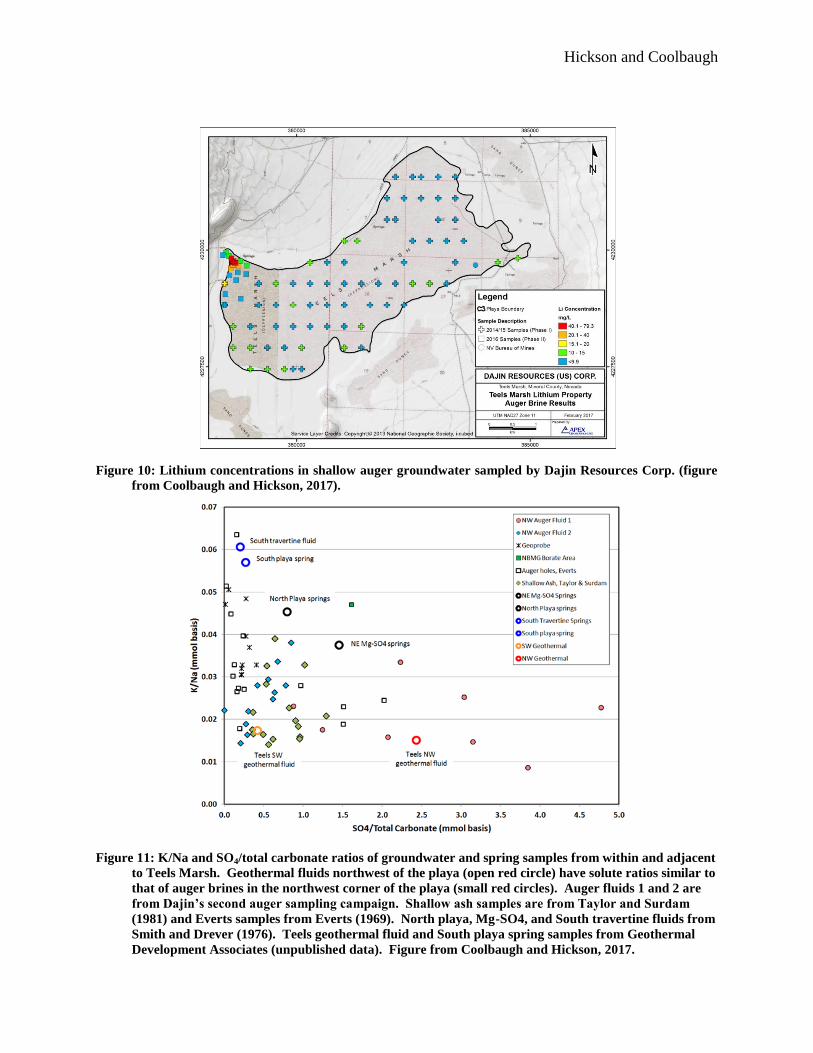
At Teels Marsh, elevated lithium concentrations of up to 79 mg/L in brines in the northwest
corner of the playa (Figure 10) appear to be related to the incursion of geothermal fluids into the
basin. This relationship is inferred on the basis that 1) the highest temperature known
geothermal waters in Teels Marsh occur in close proximity to the northwest corner of the playa
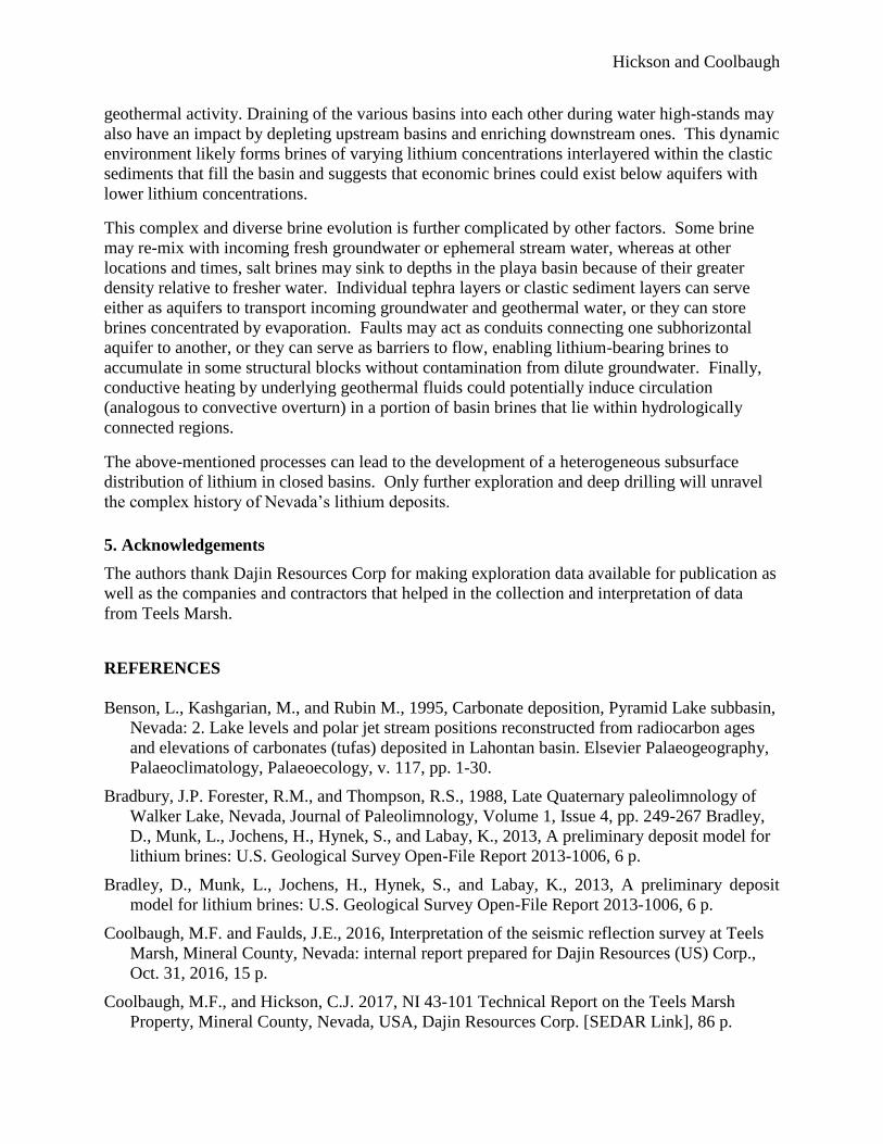
where lithium concentrations are highest in shallow basin brines, and 2) the solute ratios of the
playa brines in this area are different from ratios in most of the Teels playa brines, but quite
similar to solute ratios in the nearby geothermal waters (Figure 11).
The lithium-brines in the northwest corner of Teels Marsh provide a hint that perhaps additional
lithium brines may be present at depth. The highest concentrations of lithium encountered in
auger groundwater come from relatively dilute brines, with sodium and chloride concentrations
not exceeding 57,000 and 68,000 mg/L, respectively (Figure 12). If a best-fit evaporation trend
in the lithium-bearing brines (Figure 12) is extrapolated to the highest sodium and chloride
concentrations observed in the shallow brine data (which are probably at or near halite-
saturation), the predicted lithium concentration would be in the range of 140-195 mg/L. It is
theorized that as the density of the surface water increases due to natural evaporation, the brines
sink below the playa surface.
Hickson and Coolbaugh
Figure 10: Lithium concentrations in shallow auger groundwater sampled by Dajin Resources Corp. (figure
from Coolbaugh and Hickson, 2017).
Figure 11: K/Na and SO4/total carbonate ratios of groundwater and spring samples from within and adjacent
to Teels Marsh. Geothermal fluids northwest of the playa (open red circle) have solute ratios similar to
that of auger brines in the northwest corner of the playa (small red circles). Auger fluids 1 and 2 are
from Dajin’s second auger sampling campaign. Shallow ash samples are from Taylor and Surdam
(1981) and Everts samples from Everts (1969). North playa, Mg-SO4, and South travertine fluids from
Smith and Drever (1976). Teels geothermal fluid and South playa spring samples from Geothermal
Development Associates (unpublished data). Figure from Coolbaugh and Hickson, 2017.

Hickson and Coolbaugh
Figure 12: Lithium and sodium concentrations of groundwater sampled during Dajin’s second auger drilling
campaign. Samples that cluster in the northwest corner of the playa (red circles) fall along a single
evaporation trend suggesting that they come from a single source fluid with a lithium/sodium ratio
distinct from other auger brine samples. Figure from Coolbaugh and Hickson, 2017.
4. Summary
Without deep drilling and associated geochemical testing for lithium and other elements in the
brines it is not possible to determine the total magnitude of lithium enrichment at Teels Marsh
caused by geothermal influx. However, our research leads us to believe the following factors are
important and are all necessary for successful exploration:
1) a source of lithium,
2) an extraction mechanism,
3) a transport mechanism,
4) a trap (closed basin),
5) a sufficient solar evaporation rate, and,
6) scale: mass flux of lithium and limited dissolved salt competition
Of these factors, we believe that 2, 3, and 6 can be significantly influenced by the presence of
geothermal fluids.
The time period of economic brine formation can be short and economic brines might form
during one period of basin formation (one dry period), but not in another period in the same
basin, depending on mass flux of lithium, exposures of source material to leaching, and level of
Hickson and Coolbaugh
geothermal activity. Draining of the various basins into each other during water high-stands may
also have an impact by depleting upstream basins and enriching downstream ones. This dynamic
environment likely forms brines of varying lithium concentrations interlayered within the clastic
sediments that fill the basin and suggests that economic brines could exist below aquifers with
lower lithium concentrations.
This complex and diverse brine evolution is further complicated by other factors. Some brine
may re-mix with incoming fresh groundwater or ephemeral stream water, whereas at other
locations and times, salt brines may sink to depths in the playa basin because of their greater
density relative to fresher water. Individual tephra layers or clastic sediment layers can serve
either as aquifers to transport incoming groundwater and geothermal water, or they can store
brines concentrated by evaporation. Faults may act as conduits connecting one subhorizontal
aquifer to another, or they can serve as barriers to flow, enabling lithium-bearing brines to
accumulate in some structural blocks without contamination from dilute groundwater. Finally,
conductive heating by underlying geothermal fluids could potentially induce circulation
(analogous to convective overturn) in a portion of basin brines that lie within hydrologically
connected regions.
The above-mentioned processes can lead to the development of a heterogeneous subsurface
distribution of lithium in closed basins. Only further exploration and deep drilling will unravel
the complex history of Nevada’s lithium deposits.
5. Acknowledgements
The authors thank Dajin Resources Corp for making exploration data available for publication as
well as the companies and contractors that helped in the collection and interpretation of data
from Teels Marsh.
REFERENCES
Benson, L., Kashgarian, M., and Rubin M., 1995, Carbonate deposition, Pyramid Lake subbasin,
Nevada: 2. Lake levels and polar jet stream positions reconstructed from radiocarbon ages
and elevations of carbonates (tufas) deposited in Lahontan basin. Elsevier Palaeogeography,
Palaeoclimatology, Palaeoecology, v. 117, pp. 1-30.
Bradbury, J.P. Forester, R.M., and Thompson, R.S., 1988, Late Quaternary paleolimnology of
Walker Lake, Nevada, Journal of Paleolimnology, Volume 1, Issue 4, pp. 249-267 Bradley,
D., Munk, L., Jochens, H., Hynek, S., and Labay, K., 2013, A preliminary deposit model for
lithium brines: U.S. Geological Survey Open-File Report 2013-1006, 6 p.
Bradley, D., Munk, L., Jochens, H., Hynek, S., and Labay, K., 2013, A preliminary deposit
model for lithium brines: U.S. Geological Survey Open-File Report 2013-1006, 6 p.
Coolbaugh, M.F. and Faulds, J.E., 2016, Interpretation of the seismic reflection survey at Teels
Marsh, Mineral County, Nevada: internal report prepared for Dajin Resources (US) Corp.,
Oct. 31, 2016, 15 p.
Coolbaugh, M.F., and Hickson, C.J. 2017, NI 43-101 Technical Report on the Teels Marsh
Property, Mineral County, Nevada, USA, Dajin Resources Corp. [SEDAR Link], 86 p.

Hickson and Coolbaugh
Coolbaugh, M.F., Kratt, C., Sladek, C., Zehner, R.E., and Shevenell, L., 2006, Quaternary borate
deposits as a geothermal exploration tool in the Great Basin: Geothermal Resources Council
Transactions, v. 30, p. 393-398.
Coolbaugh, M., Kratt, C., Faulds, J., Zehner, R., and Sladek, C., 2013, Active geothermal
systems of the Mina Deflection, southwestern Nevada, in L.J. Garside, ed., Geothermal and
Petroleum Developments in Several Extensional Basins of the Central Walker Lane, Nevada:
2013 Nevada Petroleum and Geothermal Society Field Trip Guidebook, Oct. 12-13, 2013, p.
101-116.
Davis, J.R., Friedman, I., and Gleason, J.D., 1986, Origin of the lithium-rich brine, Clayton
Valley, Nevada: U.S. Geological Survey Bulletin 1622, 138 p.
Durfor, C.N. and Becker, E., 1964, Public water supplies of the 100 largest cities in the United
States, 1962: U.S. Geological Survey Water-Supply Paper 1812, 364 p.
Everts, C.H., 1969, The Evolution of Playa Waters, Teels Marsh, Mineral County, Nevada:
University of Wisconsin M.Sc. Thesis, 105 p.
Fouillac, C. and Michard, G., 1981, Sodium/lithium ratio in water applied to geothermometry of
geothermal reservoirs: Geothermics, v. 10, n. 1, p. 55-70.
GBCGE (Great Basin Center for Geothermal Energy) accessed 2017a unpublished data
(http://www.nbmg.unr.edu/Geothermal/GeochemDatabase.html)),
GBCGE (Great Basin Center for Geothermal Energy) accessed 2017b unpublished data,
(http://www.nbmg.unr.edu/Geothermal/GeochemDatabase.html))
Houston, J., Butcher, A., Ehren, P., Evans, K., and Godfrey, L., 2011, The evaluation of brine
prospects and the requirement for modifications to filing standards; Economic Geology, v. 106,
p. 1225-1239.
Kharaka, Y.K. and Mariner, R.H., 1989, Chemical geothermometers and their application to
formation waters from sedimentary basins; in, Naeser, N.D. and McCulloh, T.H., eds., Thermal
History of Sedimentary Basins, Methods and Case Histories: Springer-Verlag, New York, NY,
p. 99-117.
Klein, K. and Gaines, L., 2011, Reducing foreign lithium dependence through co-production of
lithium from geothermal brine; Geothermal Resources Council Transactions, v. 35, p. 645-649.
Kratt, C., Coolbaugh, M., and Calvin, W., 2006, Remote detection of Quaternary borate deposits
with ASTER satellite imagery as a geothermal exploration tool: Geothermal Resources
Council Transactions, v. 30, p. 435-439.
Kratt, C., Coolbaugh, M., Sladek, C., Zehner, R., Penfield, R., and Delwiche, B., 2008, A new gold
pan for the west: discovering blind geothermal systems with shallow temperature surveys:
Geothermal Resources Council Transactions, v. 32, p. 153-158.
Lowenstein, T.K. and Risacher, F., 2009, Closed basin brine evolution and the influence of Ca-Cl
inflow waters: Death Valley and Bristol Dry Lake California, Qaidam Basin, China, and Salar
de Atacama, Chile; Aquatic Geochemistry, v. 15, p. 71-94.
Nevada Bureau of Mines and Geology, 2014, Site Description, Silver Peak, 5 p.
Hickson and Coolbaugh
Price, J.G., Lechler, P.J., Lear, M.B., and Giles, T.F., 2000, Possible volcanic source of lithium
in brines in Clayton Valley, Nevada, in Cluer, J.K., Price, J.G., Struhsacker, E.M.,
Hardyman, R.F., and Morris, C.L., eds., Geology and Ore Deposits 2000: The Great Basin
and Beyond: Geological Society of Nevada Symposium Proceedings, Reno, Nevada, May
15-18, 2000, p. 241–248.
Reheis, M., 1999, Extent of Pleistocene Glacial Lakes in the Western Great Basin, Miscellaneous
Field Studies Map MR-2323, United States Geological Survey
Smith, C.L. and Drever, J.I., 1976, Controls on the chemistry of springs at Teels Marsh, Mineral
County, Nevada: Geochimica et Cosmochimica Acta, v. 40, p. 1081-1093.
Spanjers, R.P., 2015, Inferred resource estimate for lithium, Clayton Valley South Project,
Clayton Valley, Esmeralda County, Nevada, USA; Technical Report for NI 43-101: Prepared
on behalf of Pure Energy Minerals, Ltd., July 17, 2015.
Taylor, M.W. and Surdam, R.C., 1981, Zeolite reactions in the tuffaceous sediments at Teels
Marsh, Nevada; Clays and Clay Minerals, v. 29, n. 5, p. 341-352.
Wesnousky, S.G., 2005, Active faulting in the Walker Lane: Tectonics, v. 24, 35 p.
Yu, J., Gao, C., Cheng, A., Liu, Y., Zhang, L., and He, X., 2013, Geomorphic, hydroclimatic and
hydrothermal controls on the formation of lithium brine deposits in the Qaidam Basin,
northern Tibetan Plateau, China; Ore Geology Reviews, v. 50, p. 171-183.
Zampirro, D., 2004, Hydrogeology of Clayton Valley brine deposits, Esmeralda County, Nevada,
in Castor, S.B., Papke, K.G., and Meeuwig, R.O., eds., Betting on industrial minerals:
Proceedings of the 39th Forum on the Geology of Industrial Minerals, Reno-Sparks, Nevada,
May 18-24, 2003; Nevada Bureau of Mines and Geology Special Publication 33, p. 271-280.
Zehner, R.E., Tullar, K.N., and Rutledge, E., 2012, Effectiveness of 2-meter and Geoprobe
shallow temperature surveys in early stage geothermal exploration: Geothermal Resources
Council Transactions, v. 36, p. 835-841.