Embed Size (px)
Citation preview

Transportation Concept Report: State Route 116
California Department of Transportation 1
TRANSPORTATION CONCEPT REPORT State Route 116
District 4
Disclaimer: The information and data contained in this document are for planning purposes only and should not be
relied upon for final design of any project. Any information in this Transportation Concept Report (TCR) is subject
to modification as conditions change and new information is obtained. Although planning information is dynamic
and continually changing, the District 4 System Planning Division makes every effort to ensure the accuracy and
timeliness of the information contained in the TCR. The information in the TCR does not constitute a standard,
specification, or regulation, nor is it intended to address design policies and procedures.
California Department of Transportation Provide a safe, sustainable, integrated and efficient transportation system to enhance California’s
economy and livability.
Approvals: _________________________ _______ _______________________ _______ JEAN C.R. FINNEY Date BIJAN SARTIPI Date District 4 Deputy Director District 4 Director Transportation Planning and Local Assistance

Transportation Concept Report: State Route 116
California Department of Transportation 2
This TCR will be posted in the Documents section of the Caltrans District 4 System Planning website at:
http://www.dot.ca.gov/dist4/systemplanning/ctsp_documents.htm
This SR 116 Transportation Concept Report was prepared by: Mike Jones Associate Transportation Planner Office of System and Regional Planning Ina Gerhard District Branch Chief Office of System & Regional Planning
Stephen H. Yokoi, AICP District Office Chief Office of System and Regional Planning
For questions about this TCR contact:
Office of System & Regional Planning Caltrans District 4
Division of Transportation Planning and Local Assistance P.O. Box 23660, MS 10C, Oakland, CA 94623-0660
http://www.dot.ca.gov/dist4/systemplanning/
Transportation Concept Report: State Route 116
California Department of Transportation 3
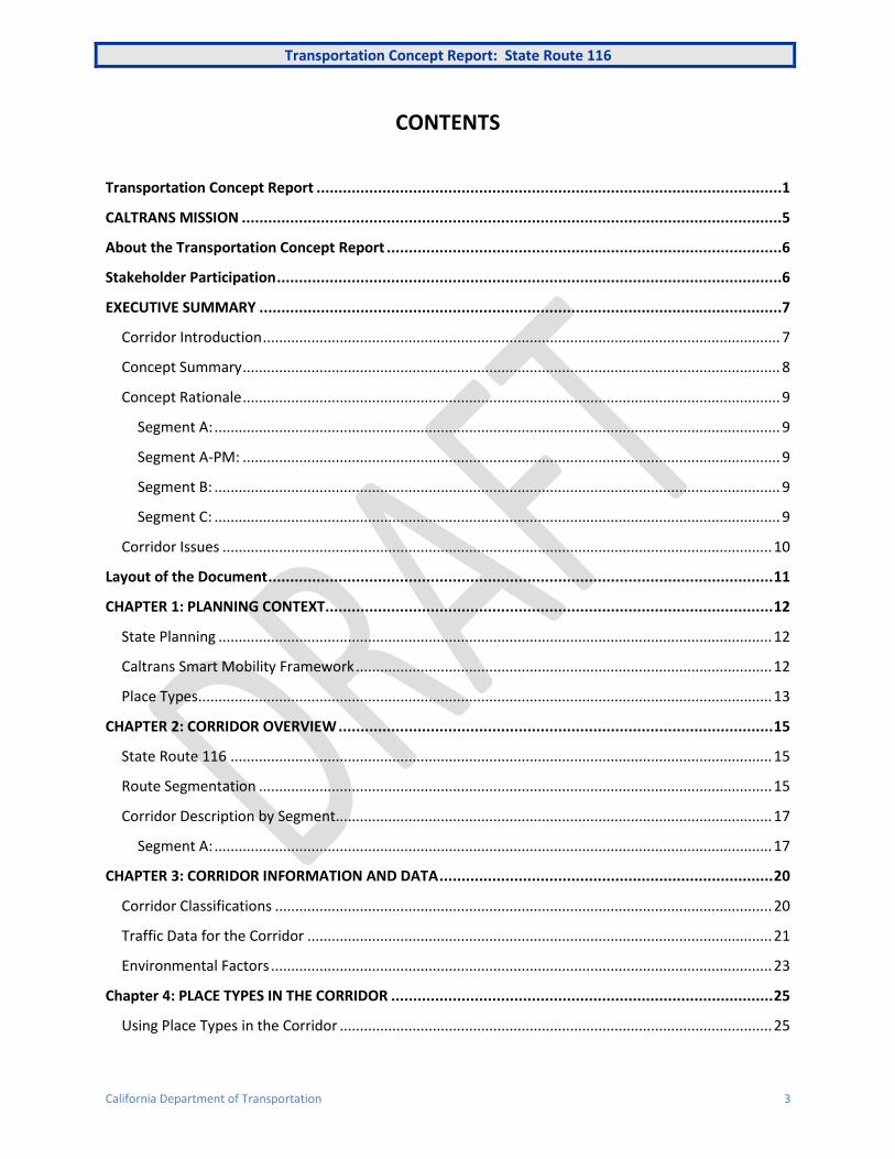
CONTENTS
Transportation Concept Report ..........................................................................................................1
CALTRANS MISSION ...........................................................................................................................5
About the Transportation Concept Report ..........................................................................................6
Stakeholder Participation ...................................................................................................................6
EXECUTIVE SUMMARY .......................................................................................................................7
Corridor Introduction ................................................................................................................................ 7
Concept Summary ..................................................................................................................................... 8
Concept Rationale ..................................................................................................................................... 9
Segment A: ............................................................................................................................................ 9
Segment A-PM: ..................................................................................................................................... 9
Segment B: ............................................................................................................................................ 9
Segment C: ............................................................................................................................................ 9
Corridor Issues ........................................................................................................................................ 10
Layout of the Document ................................................................................................................... 11
CHAPTER 1: PLANNING CONTEXT...................................................................................................... 12
State Planning ......................................................................................................................................... 12
Caltrans Smart Mobility Framework ....................................................................................................... 12
Place Types .............................................................................................................................................. 13
CHAPTER 2: CORRIDOR OVERVIEW ................................................................................................... 15
State Route 116 ...................................................................................................................................... 15
Route Segmentation ............................................................................................................................... 15
Corridor Description by Segment............................................................................................................ 17
Segment A: .......................................................................................................................................... 17
CHAPTER 3: CORRIDOR INFORMATION AND DATA ............................................................................ 20
Corridor Classifications ........................................................................................................................... 20
Traffic Data for the Corridor ................................................................................................................... 21
Environmental Factors ............................................................................................................................ 23
Chapter 4: PLACE TYPES IN THE CORRIDOR ....................................................................................... 25
Using Place Types in the Corridor ........................................................................................................... 25

Transportation Concept Report: State Route 116
California Department of Transportation 4
Current Setting ........................................................................................................................................ 25
Future Potential ...................................................................................................................................... 28
CHAPTER 5: Key CORRIDOR ISSUES ................................................................................................... 31
CHAPTER 6: CONCEPT & STRATEGIES BY SEGMENT ........................................................................... 36
Summary of Suggested Strategies and Projects by Mode ...................................................................... 37
APPENDiCIES.................................................................................................................................... 40
Appendix A: Regional Transportation Plan ............................................................................................. 40
Appendix B: State Transportation Planning ............................................................................................ 43
Appendix C: County Transportation Planning ......................................................................................... 44
Appendix D: Pertinent Transportation Plans, Policies, Legislation, and Programs ................................. 46
Appendix F: Functional Classification ..................................................................................................... 50

Transportation Concept Report: State Route 116
California Department of Transportation 5
CALTRANS MISSION
Provide a safe, sustainable, integrated and efficient transportation system to enhance California’s economy and livability
GOALS
Safety and Health Provide a safe transportation system for workers and users, and promote health through active transportation and reduced pollution in communities.
Stewardship and Efficiency Money counts. Responsibly manage California’s transportation-related assets.
Sustainability, Livability and Economy Make long-lasting, smart mobility decisions that improve the environment, support a vibrant economy, and build communities, not sprawl.
System Performance Utilize leadership, collaboration and strategic partnerships to develop an integrated transportation system that provides reliable and accessible mobility for travelers.
Organizational Excellence Be a national leader in delivering quality service through excellent employee performance, public communication, and accountability.

Transportation Concept Report: State Route 116
California Department of Transportation 6
ABOUT THE TRANSPORTATION CONCEPT REPORT
System Planning is the long-range transportation planning process for the California Department of
Transportation (Caltrans). The System Planning process fulfills Caltrans’ statutory responsibility as
owner/operator of the State Highway System (SHS) (Gov. Code §65086) by evaluating conditions and
proposing enhancements to the State’s transportation system. Through System Planning, Caltrans
focuses on developing an integrated multimodal transportation system that meets the State’s planning
and legislative objectives.
STAKEHOLDER PARTICIPATION
The following organizations were consulted for the final production of this document:
Sonoma County Transportation Authority (SCTA)
City of Sebastopol
Sonoma County
Sonoma County Regional Parks Department
TCR Purpose
California’s State Highway System needs long-range planning documents to guide the logical
development of transportation systems as required by CA Gov. Code §65086 and as necessitated by
the public, stakeholders, and system users. The purpose of the TCR is to evaluate current and
projected conditions along the route and communicate the vision for the development of each route
in all Caltrans Districts during a 20-25 year planning horizon. The TCR is developed with the goals of
increasing safety, improving mobility, providing excellent stewardship, and meeting community and
environmental needs along the corridor through integrated management of the transportation
network, including the highway, transit, pedestrian, bicycle, freight, operational improvements and
travel demand management components of the corridor.
Transportation Concept Report: State Route 116
California Department of Transportation 7
EXECUTIVE SUMMARY
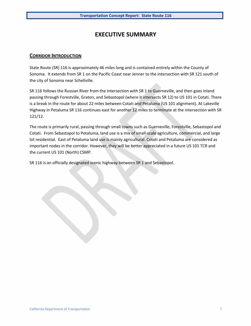
CORRIDOR INTRODUCTION
State Route (SR) 116 is approximately 46 miles long and is contained entirely within the County of
Sonoma. It extends from SR 1 on the Pacific Coast near Jenner to the intersection with SR 121 south of
the city of Sonoma near Schellville.
SR 116 follows the Russian River from the intersection with SR 1 to Guerneville, and then goes inland
passing through Forestville, Graton, and Sebastopol (where it intersects SR 12) to US 101 in Cotati. There
is a break in the route for about 22 miles between Cotati and Petaluma (US 101 alignment). At Lakeville
Highway in Petaluma SR 116 continues east for another 12 miles to terminate at the intersection with SR
121/12.
The route is primarily rural, passing through small towns such as Guerneville, Forestville, Sebastopol and
Cotati. From Sebastopol to Petaluma, land use is a mix of small-scale agriculture, commercial, and large
lot residential. East of Petaluma land use is mainly agricultural. Cotati and Petaluma are considered as
important nodes in the corridor. However, they will be better appreciated in a future US 101 TCR and
the current US 101 (North) CSMP.
SR 116 is an officially designated scenic highway between SR 1 and Sebastopol.
Transportation Concept Report: State Route 116
California Department of Transportation 8
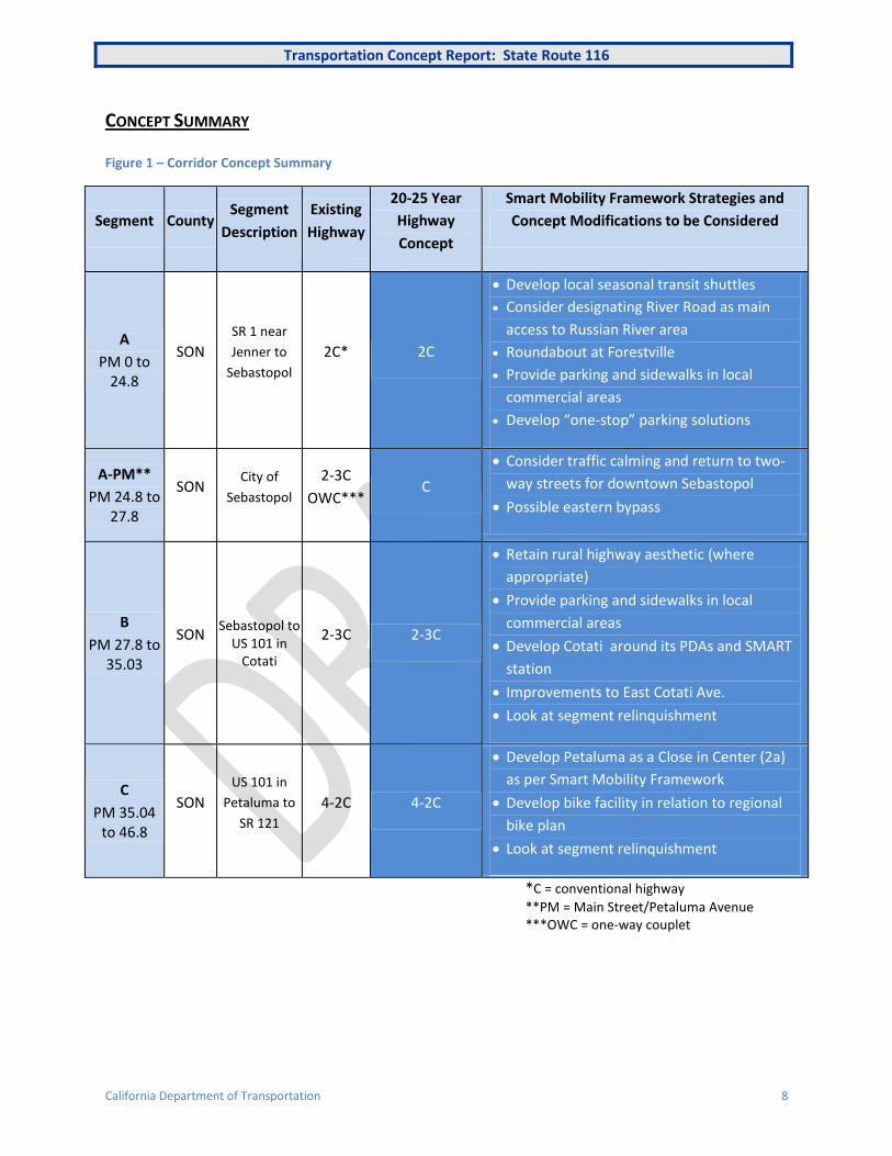
CONCEPT SUMMARY
Figure 1 – Corridor Concept Summary
Segment County Segment
Description
Existing
Highway
20-25 Year
Highway
Concept
Smart Mobility Framework Strategies and
Concept Modifications to be Considered
A
PM 0 to 24.8
SON
SR 1 near
Jenner to
Sebastopol
2C* 2C
Develop local seasonal transit shuttles
Consider designating River Road as main
access to Russian River area
Roundabout at Forestville
Provide parking and sidewalks in local
commercial areas
Develop “one-stop” parking solutions
A-PM**
PM 24.8 to 27.8
SON City of
Sebastopol
2-3C
OWC*** C
Consider traffic calming and return to two-
way streets for downtown Sebastopol
Possible eastern bypass
B
PM 27.8 to 35.03
SON Sebastopol to
US 101 in Cotati
2-3C 2-3C
Retain rural highway aesthetic (where
appropriate)
Provide parking and sidewalks in local
commercial areas
Develop Cotati around its PDAs and SMART
station
Improvements to East Cotati Ave.
Look at segment relinquishment
C
PM 35.04 to 46.8
SON
US 101 in
Petaluma to
SR 121
4-2C 4-2C
Develop Petaluma as a Close in Center (2a)
as per Smart Mobility Framework
Develop bike facility in relation to regional
bike plan
Look at segment relinquishment
*C = conventional highway
**PM = Main Street/Petaluma Avenue ***OWC = one-way couplet

Transportation Concept Report: State Route 116
California Department of Transportation 9
CONCEPT RATIONALE
This TCR looks to the next 25 years and makes use of the planning principles developed in Caltrans
Smart Mobility Framework (SMF). SMF provides tools and strategies to meet the goals of Assembly Bill
32 (AB 32) and Senate Bill 375 (SB 375) on climate change and CO2 emissions reduction. (See Caltrans
Smart Mobility Framework on page 12.) The TCR raises issues that might result in a concept change in
part(s) of the corridor within the 20-25 year planning horizon. Many of these issues are not yet clearly
defined and will need further study and discussion with external partners.
Segment A:
The Russian River Valley is a significant recreational destination, and attracts substantial additional
traffic and subsequent congestion in the summer months. The concept suggests ways to mitigate this
traffic while enhancing the experience for locals and visitors. At Forestville it supports the idea that a
roundabout will improve traffic flow through this community, but expresses concern over the impacts of
a by-pass to the community.
Segment A-PM:
As with the SR 12 (West) TCR, the concept sees the removal of the current one-way streets system in
Sebastopol as way of restoring a better balance between livability and vehicle through-put in the
downtown area. A by-pass route that would be designed to correspond with the surrounding area may
also be a future solution, taking a large proportion of SR 12 and SR 116 traffic out of the downtown.
Segment B:
The concept seeks to retain the rural aesthetic of this road while accommodating the needs of residents
and businesses that use it. The need for widening and turn pockets should be carefully considered and
weighed against the benefits of a narrower roadway that conforms to the rural character of the area.
Sidewalks should be added in sections with pedestrian demand. In Cotati the city should maximize its
location efficiency through its two Priority Development Areas (PDAs) and ensure that ridership on
Sonoma-Marin Area Rail Transit (SMART) is not solely determined by the size of the parking lot, but by
surrounding mixed-use developments. East Cotati Avenue links the PDAs, SMART and Sonoma State
University, and by applying the principles of Smart Mobility Framework and the guidance in Caltrans
Main Street guide could be made much more attractive to the community and non-motorized modes.
Segment C:
This segment of SR 116 has little role to play in the State Highway System, and the designated highway is
not always the even busiest route. Relinquishment may be a practical solution. Bicycle facilities should
be improved as part of the Regional Bicycle Plan. Petaluma is a Compact Community that has retained
and enhanced its economic vitality and livability. With the SMART rail service and its proximity to San
Francisco (40 miles) it could be developed more as a Close in Center (2a) with an enhanced local and
regional transit system as described in Smart Mobility Framework.

Transportation Concept Report: State Route 116
California Department of Transportation 10
CORRIDOR ISSUES
The following are a list of corridor issues discussed in this TCR that might impact the future concept.
(Full details are described in Chapter 5).
SR 116 and the Russian River Valley
Forestville Bypass
Sebastopol’s Downtown Traffic Circulation
Complete Streets and Main Streets
Development of PDAs in Petaluma and Cotati
Route Relinquishment and Re-designation

Transportation Concept Report: State Route 116
California Department of Transportation 11
LAYOUT OF THE DOCUMENT
Chapter 1: Planning Context explains the principles of SMF and introduces “place types” as a concept
for explaining existing and potential future land uses. SMF is a new way of looking at land
use/transportation interactions and solutions.
Chapter 2: Corridor Overview examines the existing conditions and transportation facilities in the
corridor, and explains the segmentation process used for this document. The descriptive elements of
this chapter make use of place types described in SMF, reducing ambiguity and suggesting solutions to
meet the legislation and planning objectives. It is therefore strongly recommended that the reader
become familiarized with the various place types in SMF prior to continuing through the document. A
summary is provided in Chapter 1: Planning Context.
Chapter 3: Corridor Information & Data presents traffic data and road classification information
providing a background of existing conditions. As SMF is about change, this section is given less weight
than in traditional TCRs, but it remains a useful source of information.
Chapter 4: Place Types in the Corridor describes the place types present in the corridor and assesses the
potential for place type changes. A map summarizes the place types for the entire corridor.
Chapter 5: Corridor Issues presents the main transportation issues identified in the TCR and stakeholder
input.
Chapter 6: Corridor Concept includes future transportation changes beyond the current highway
configuration. These are seen as potential solution to improve the corridor within the 20-25 year
planning horizon of the TCR.
The Appendices contain information on the region’s Plan Bay Area process (especially Priority
Development Areas), relevant plans, policies, programs, and project lists.
Transportation Concept Report: State Route 116
California Department of Transportation 12
CHAPTER 1: PLANNING CONTEXT
This section of the TCR introduces select State planning documents and outlines the principles of the Smart Mobility Framework (SMF) used throughout the TCR. (See Appendix for a complete list of State planning efforts.)
STATE PLANNING
The California Transportation Plan (CTP) provides a long-range policy framework to meet California’s future mobility needs and reduce greenhouse gas emissions. The CTP defines goals, performance-based policies, and strategies to achieve the collective vision for an integrated multimodal transportation system. The plan envisions a sustainable system that improves mobility and enhances quality of life. Key to this vision is considering “the 3 E’s of Sustainability”: a prosperous economy, quality environment and social equity in all transportation decisions. The CTP works to both support and guide regional transportation planning efforts to meet AB 32 and SB 375.
The California Interregional Blueprint (CIB) is a State-level document that articulates the State’s vision for an integrated multimodal transportation system which complements regional transportation and land use plans. It links statewide transportation goals with regional transportation and land use goals to produce a unified transportation strategy. It supports the development of Sustainable Communities Strategies at the regional level, and has been incorporated into the CTP.
CALTRANS SMART MOBILITY FRAMEWORK
Caltrans 2020 Smart Mobility: A Call to Action for the New Decade presents a new approach to the integration of transportation and land use. The Smart Mobility Framework (SMF), seeks to develop multi-modal and sustainable transportation strategies for California. SMF was prepared in partnership with the US Environmental Protection Agency, the Governor’s Office of Planning and Research, and the California Department of Housing and Community Development.
SMF aims to address:
The State’s mandate to reduce greenhouse gas (GHG) emissions and find solutions to climate change.
The need to reduce per capita vehicle miles traveled. Reduced per capita auto use will lower emissions of GHG and conventional pollutants, reduce petroleum consumption and associated household transportation costs, and minimize negative impacts on air quality, water quality, and noise environments.
The demand for a reliable and safe transportation system that gets people and goods to their destinations. SMF endorses the application of strategies that result in a shift away from higher-polluting modes to the use of transit, carpooling, walking, and biking to meet travel needs.
The commitment to create a transportation system that advances social equity and environmental justice. SMF integrates social equity concerns into transportation decisions and investments.
Transportation Concept Report: State Route 116
California Department of Transportation 13
SMF recognizes that transportation planning extends beyond the transportation system and sees land use as an important determinant in developing transportation solutions. The principles of SMF look to a multi-modal vision actively deemphasizing the use of vehicle-only Level of Service for transportation decision-making.
PLACE TYPES
While SMF does not mandate land use patterns, it does promote “location efficiency.” Location
efficiency describes the fit between a specific physical environment and its corresponding transportation
system and services to achieve more efficient integration of land use and transportation modes. The
physical environment is summarized as a “place type” for a particular location. SMF distinguishes seven
broad place types, listed below, which represent a distinct context where implementation of certain
transportation investments, along with other planning strategies, will help improve location efficiency
and achieve Smart Mobility benefits:
1. Urban Centers
2. Close-in Compact Communities
3. Compact Communities
4. Suburban Communities
5. Rural and Agricultural Lands
6. Protected Lands
7. Special Use Areas
The place types are themselves broken down further, though remain generalized for use in sketch
planning, not implying specific zoning or land use. Definitions and examples for place types are provided
in Figure 2.
Transportation Concept Report: State Route 116
California Department of Transportation 14
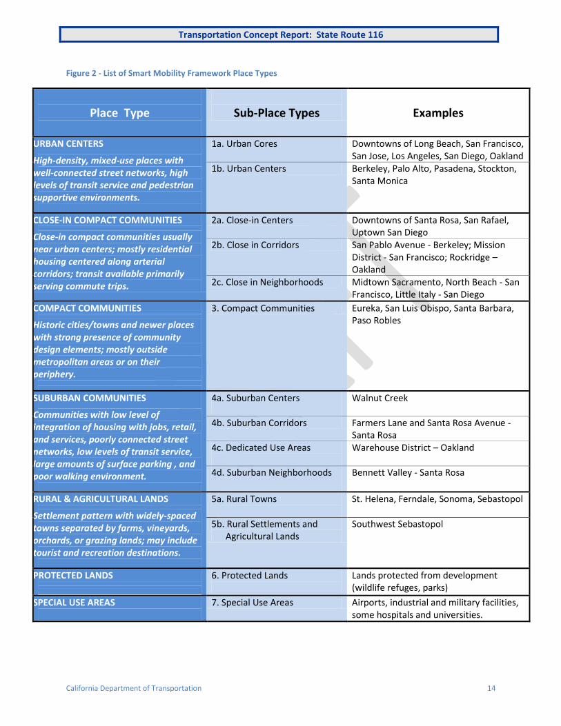
Figure 2 - List of Smart Mobility Framework Place Types
Place Type
Sub-Place Types
Examples
URBAN CENTERS
High-density, mixed-use places with well-connected street networks, high levels of transit service and pedestrian supportive environments.
1a. Urban Cores Downtowns of Long Beach, San Francisco, San Jose, Los Angeles, San Diego, Oakland
1b. Urban Centers Berkeley, Palo Alto, Pasadena, Stockton, Santa Monica
CLOSE-IN COMPACT COMMUNITIES
Close-in compact communities usually near urban centers; mostly residential housing centered along arterial corridors; transit available primarily serving commute trips.
2a. Close-in Centers Downtowns of Santa Rosa, San Rafael, Uptown San Diego
2b. Close in Corridors San Pablo Avenue - Berkeley; Mission District - San Francisco; Rockridge – Oakland
2c. Close in Neighborhoods Midtown Sacramento, North Beach - San Francisco, Little Italy - San Diego
COMPACT COMMUNITIES
Historic cities/towns and newer places with strong presence of community design elements; mostly outside metropolitan areas or on their periphery.
3. Compact Communities Eureka, San Luis Obispo, Santa Barbara, Paso Robles
SUBURBAN COMMUNITIES
Communities with low level of integration of housing with jobs, retail, and services, poorly connected street networks, low levels of transit service, large amounts of surface parking , and poor walking environment.
4a. Suburban Centers
Walnut Creek
4b. Suburban Corridors Farmers Lane and Santa Rosa Avenue - Santa Rosa
4c. Dedicated Use Areas
Warehouse District – Oakland
4d. Suburban Neighborhoods
Bennett Valley - Santa Rosa
RURAL & AGRICULTURAL LANDS
Settlement pattern with widely-spaced towns separated by farms, vineyards, orchards, or grazing lands; may include tourist and recreation destinations.
5a. Rural Towns
St. Helena, Ferndale, Sonoma, Sebastopol
5b. Rural Settlements and Agricultural Lands
Southwest Sebastopol
PROTECTED LANDS
6. Protected Lands
Lands protected from development (wildlife refuges, parks)
SPECIAL USE AREAS
7. Special Use Areas Airports, industrial and military facilities, some hospitals and universities.

Transportation Concept Report: State Route 116
California Department of Transportation 15
CHAPTER 2: CORRIDOR OVERVIEW
This section presents a summary description of the corridor followed by how the corridor was
segmented and finally a more detailed description of each segment. (See Appendix F for Functional
Classification (FC) designations.)
STATE ROUTE 116
SR 116 is a 46-mile long State highway in Sonoma County. The route runs from SR 1 on the Pacific Coast
near Jenner to SR 121 south of the City of Sonoma. From SR 1 the route heads east along the north bank
of the Russian River to Guerneville, River Road continues east along the river to US 101, but SR 116 goes
inland passing through Forestville, Graton, and Sebastopol, where it intersects with SR 12, coming from
Santa Rosa. SR 116 continues through Sebastopol to join US 101 in Cotati. There is then a “break in
route” with the SR 116 resuming in Petaluma at Lakeville Highway. From Petaluma the route heads east
to the intersection SR 121. This last segment has various names in different locations: Lakeville Highway,
Stage Gulch Road, and Arnold Drive.
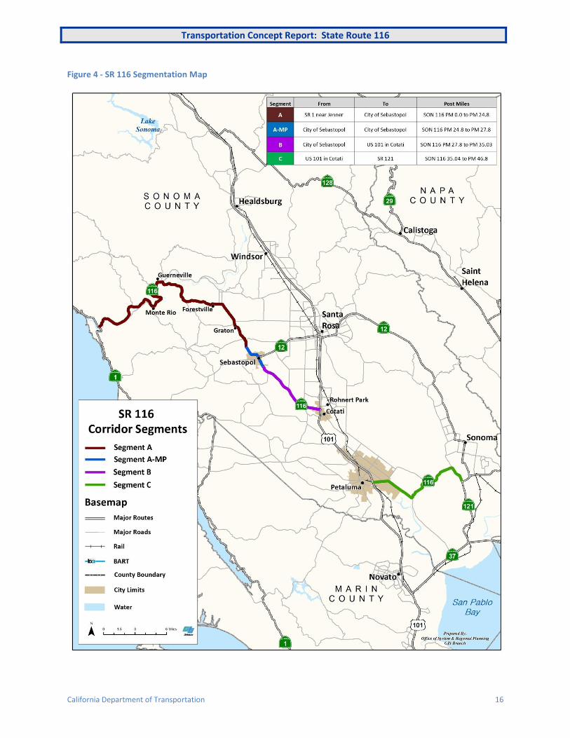
ROUTE SEGMENTATION
The route has been segmented for planning, and not necessarily operational purposes. The defined
segments reflect the changing use and character of SR 116.
Figure 3 - SR 116 Segmentation
Segment From To Post Miles
A Intersection with SR 1 near Jenner City of Sebastopol
(northern city limits) SON 116 PM 0.0 to PM 24.8
A-MP* City of Sebastopol
(northern city limits)
City of Sebastopol
(southern city limits) SON 116 PM 24.8 to PM 27.8
B City of Sebastopol
(southern city limits) US 101 in Cotati SON 116 PM 27.8 to PM 35.03
C US 101 in Petaluma Intersection with SR 121 SON 12 PM 35.04 to PM 46.8
*MP = Main Street/Petaluma Ave
Transportation Concept Report: State Route 116
California Department of Transportation 16
Figure 4 - SR 116 Segmentation Map

Transportation Concept Report: State Route 116
California Department of Transportation 17
CORRIDOR DESCRIPTION BY SEGMENT
This section describes the current conditions in each segment. It makes reference to “place types” from
the Caltrans Smart Mobility Framework (SMF) 2010. Place types are a way of characterizing land uses.
Each place type has an associated “location efficiency” a term depicting the degree to which existing
transportation options within a place or an area optimize access and mobility. The principles
constituting the SMF place types come with a toolbox of suggestions for increasing location efficiency.
This is described in Caltrans Smart Mobility Framework on page 11 - 13.
Segment A:
SR 116 is a two-lane conventional highway that follows the Russian River as far as Guerneville, running
along the old railroad alignment from Monte Rio. The Jenner-to-Guerneville section is subject to
frequent flooding, and there have been twelve major floods since 1955. During these, travel on SR 116
and many local roads can be impossible. The highway passes through Monte Rio, Guerneville,
Forestville, and other small roadside communities (Rural Towns 5a) where SR 116 functions as a “main
street”, with many driveways providing access to residences, businesses, and community facilities. The
Russian River Valley is a notable recreation and tourist area for the Bay Area and beyond. Between SR 1
and Guerneville it is largely the only continuous road, with limited river crossings. There are, however,
two “summer bridges” near Guerneville, which are dismantled in the winter, that provide additional
crossing points. At Guerneville SR 116 crosses and heads away from the river, whereas River Road
continues east and is the most direct route to connect to US 101 (following the old railroad alignment
between Guerneville and Santa Rosa) continuing along the Russian River. In Guerneville, a new bridge
was constructed in 1998, though the historic steel truss bridge (built in 1922) was maintained for use by
pedestrians and bicyclists. Travelling to/from San Francisco via SR 116 is marginally slower than via River
Road and US 101, but on summer weekends traffic by either route is very congested. A roundabout is
planned in Forestville at Mirabel Road, and a Forestville by-pass is under consideration.
West County Regional Trail - A recreational trail that runs between Sebastopol and Forestville.
This approximately 5 ½ mile trail, with an unpaved equestrian adjacent to the paved trail, follows
the route of the old Petaluma and Santa Rosa Railroad. The Petaluma and Santa Rosa Railroad
was an electrified inter-urban service that terminated in Forestville with passenger service
ending in 1933. In Sebastopol the trail is linked to the 8 ½ mile Joe Rodota Trail connecting to
Santa Rosa. The trail provides an off road alternative to SR 116 between Sebastopol and
Forestville, and an extension is planned from Forestville to River Road. Because it is unlit and
somewhat isolated, it cannot be seen as an all year round commuting facility.

Transportation Concept Report: State Route 116
California Department of Transportation 18
Transit is provided by Sonoma Transit, with a regular service (around every 90 minutes) between Monte
Rio and Santa Rosa via Sebastopol (#20 Bus), though more limited service at weekends. Sonoma Transit
also run a supplemental local service (Bus #28), but frequency is low and there is no weekend service.
Truck traffic is generally low, but there is some local movement of sand and gravel from a quarry near
Forestville.
Between Guerneville and Forestville there is little to no shoulder along the rolling, winding road and
only occasional driveways and pullouts. However, there are alternative routes to SR 116 for bicyclists by
continuing along River Road to Martinelli and Mirabelle roads (see West County Trail description page
16). The Sonoma County Bike Plan (updated in 2014) suggests bike lanes on SR 116 between
Guerneville and Forestville. However, implementation would be costly and benefits should be weighed
against impacts of widening on the rural nature of this section SR 116. From Monte Rio to Guerneville SR
116 is included in MTC’s Regional Bike Plan.
Segment A-PM:
Segment A-PM is the portion of SR 116 within the City of Sebastopol. State highways 116 and 12 are at
the center of historic downtown Sebastopol. Sebastopol is a local hub for this part of Sonoma County
and a center for apple and wine production. Within the city, SR 116 was divided into two one-way
arterials in the 1980s, Main Street and Petaluma Avenue, southbound and northbound respectively. The
one-way streets, designed to improve vehicle flow, make the downtown more a place to drive through
rather than to walk or bike. There is also a circulatory (one-way) system that merges traffic from SR 12
further impacting the downtown. These two traffic elements have somewhat bisected the downtown
and do not maximized its location efficiency as a larger Rural Town 5a. Conversion to two-way streets
and/or a by-pass are possible solutions (See Corridor Issues Chapter 5).
Sonoma Transit Routes #20 and #22 provide an approximate hourly all day service on SR 12 to Santa
Rosa, with the last bus from Santa Rosa to Sebastopol at 8:30 pm. However, within the SR 116 corridor
bus services are less frequent. There is no direct bus to Petaluma, but the “Sebastopol Shuttle” provides
a lifeline service (it ends about 3:30pm) 6 days a week.
Recent pedestrian safety projects and planned bike lanes along SR 116 as part of the city’s “Streets
Smart Sebastopol” are improvements to the bicycle and pedestrian environment in the corridor within
the constraints of the existing one-way system. While the downtown is compact, the rest of Sebastopol
is fairly dispersed, but with sidewalks on most streets.
Segment B:
Between Sebastopol and Cotati SR 116 is a two-lane rural highway with varying shoulder widths, except
for a four-lane segment between Gilchrist and Stony Point Roads, where there a no shoulders. For
consistency this could be converted to 2-lanes with shoulders. Numerous private driveways and country
road intersections line the segment, while Stony Point Road via SR 116 provides access to the Graton
Resort and Casino west of US 101. Traffic is mostly light, but becomes an issue during summer
weekends. This segment is not a critical part of the State Highway System (SHS). Many businesses are

Transportation Concept Report: State Route 116
California Department of Transportation 19
served by ad hoc parking and there are few sidewalks, even when the walking distance between them is
short. There are proposed plans to widen SR 116 west of the US 101 interchange (SON-116-34.5 to 35)
from two lanes to four lanes as mitigation for a proposed retail development. With SB 743 de-linking
Level of Service (LOS) from environmental mitigation under CEQA, this project will need to be re-
evaluated as to its transportation impacts and potential for sprawl.
Sonoma Transit runs a limited weekday service in this segment that runs via the Graton Resort Casino
from Sebastopol to Rohnert Park/Cotati, but no service to connect Sebastopol directly with Petaluma.
There is no weekend service. In this segment SR 116 has shoulders and there is a network of local roads
that cyclists can utilize. There are rarely sidewalks for pedestrians outside of Cotati.
Segment C:
The segment is a two-lane conventional highway (called Lakeville Highway, Stage Gulch Road and Arnold
Drive), except for the initial section within Petaluma, which is four-lanes with a median. The section
between Lakeville Highway and Adobe Road is narrow without shoulders. It has a very low AADT (3,200)
as most traffic is using Adobe Road to connect to SR 116 from Petaluma. Recent improvements of the
two-lane Stage Gulch Road east of Adobe Road have straightened the alignment and added shoulders.
While overall the AADT of this segment of SR 116 is moderate (up to 17,000), this is not a critical part of
the SHS.
There is a limited bus service between Sonoma and Petaluma (Sonoma Transit #40) on SR 116 and
Adobe Road with no weekend service.
While the 10 to 15 miles between Sonoma and Petaluma is beyond average bike commuting distance
(considering the rural nature of the route), SR 116 is a useful link between the Sonoma Valley and
Petaluma for recreational cyclists and is included in the Regional Bike Plan. For the section without
shoulders between Lakeville Highway and Adobe Road, Adobe Road is a viable alternative.
Figure 5 - SR 116 - Stage Gulch Road Before and After the Widening and Realignment Project
Transportation Concept Report: State Route 116
California Department of Transportation 20
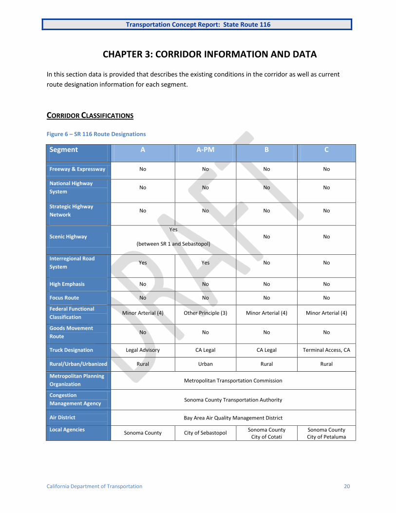
CHAPTER 3: CORRIDOR INFORMATION AND DATA
In this section data is provided that describes the existing conditions in the corridor as well as current
route designation information for each segment.
CORRIDOR CLASSIFICATIONS
Figure 6 – SR 116 Route Designations
Segment A A-PM B C
Freeway & Expressway No No No No
National Highway
System No No No No
Strategic Highway
Network No No No No
Scenic Highway Yes
(between SR 1 and Sebastopol) No No
Interregional Road
System Yes Yes No No
High Emphasis No No No No
Focus Route No No No No
Federal Functional
Classification Minor Arterial (4) Other Principle (3) Minor Arterial (4) Minor Arterial (4)
Goods Movement
Route No No No No
Truck Designation Legal Advisory CA Legal CA Legal Terminal Access, CA
Rural/Urban/Urbanized Rural Urban Rural Rural
Metropolitan Planning
Organization Metropolitan Transportation Commission
Congestion
Management Agency Sonoma County Transportation Authority
Air District
Bay Area Air Quality Management District
Local Agencies Sonoma County City of Sebastopol
Sonoma County City of Cotati
Sonoma County City of Petaluma
Transportation Concept Report: State Route 116
California Department of Transportation 21
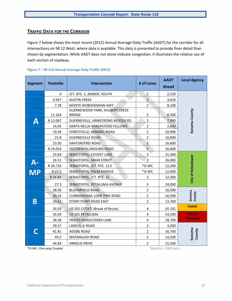
TRAFFIC DATA FOR THE CORRIDOR
Figure 7 below shows the most recent (2012) Annual Average Daily Traffic (AADT) for the corridor for all
intersections on SR 12 West, where data is available. This data is presented to provide finer detail than
shown by segmentation. While AADT does not alone indicate congestion, it illustrates the relative use of
each section of roadway.
Figure 7 – SR 116 Annual Average Daily Traffic (2012)
Segment Postmile Intersection # of Lanes AADT
Ahead
Local Agency
A
0 JCT. RTE. 1, JENNER, SOUTH 2 2,150
Son
om
a C
ou
nty
4.927 AUSTIN CREEK 2 3,650
7.78 MONTE RIOBOHEMIAN HWY 2 8,100
11.164 GUERNEWOOD PARK, HULBERT CREEK BRIDGE 2 8,300
R 12.067 GUERNEVILLE, ARMSTRONG WOODS RD 2 7,900
14.05 SANTA NELLA WINERY/ODD FELLOWS 2 2,600
19.39 FORESTVILLE, MIRABEL ROAD 2 10,900
21.8 GUERNEVILLE ROAD 2 10,000
23.05 GRATON/FREI ROAD 2 16,600
R 24.054 OCCIDENTAL/MOLINO ROAD 3 16,400
25.69
SEBASTOPOL, COVERT LANE 3 21,300
Cit
y o
f Se
bas
top
ol
A-MP
26.51 SEBASTOPOL, MAIN STREET 3 26,000
R 26.733 SEBASTOPOL, JCT. RTE. 12 E *O-WC 12,200
R 27.2 SEBASTOPOL, PALM AVENUE *O-WC 12,000
R 26.82 SEBASTOPOL, JCT. RTE. 12 3 12,300
27.3 SEBASTOPOL, PETALUMA AVENUE 3 24,000
B
28.56 BLOOMFIELD ROAD 2 16,500
Son
om
a
Co
un
ty
30.33 CUNNINGHAM, LONE PINE ROAD 2 16,500
33.61 STONY POINT ROAD EAST 2 13,700
35.03 US 101 COTATI (Break of Route) 4 US 101 Cotati
35.04
US 101 PETALUMA 4 24,200 City of
Petaluma
C
36.36 FRATES ROAD/CADER LANE 4 18,700
39.27 LAKEVILLE ROAD 2 3,200
Son
om
a
Co
un
ty
41.81 ADOBE ROAD 2 16,700
44.2 WATMAUGH ROAD 2 14,100
44.84 ARNOLD DRIVE 2 15,500
*O-WC- One-way Couplet Source: Caltrans

Transportation Concept Report: State Route 116
California Department of Transportation 22
Future Vehicular Demand
Figure 8 below shows the assessed increase in vehicular traffic for each segment. This TCR uses
nonnumeric values (HIGH, MODERATE, LOW) to give an indication of the potential for vehicular growth
in the corridor based on existing policies and land use trends. Actual forecast numbers are incorporated
as trends in the assessment in addition to other factors, as described under Potential Growth below.
In the context of Smart Mobility Framework, traffic projections have limited use as they will largely
perpetuate the existing vehicular flows and modal split. However, if additional capacity is not provided
(and there is not surplus existing capacity) increased congestion will affect either modal choice and/or
trip distribution. In addition, future capacity enhancements (transit and highway) will have an effect on
trip distributions within the local network. Smart Mobility Framework and state legislation such as AB 32
and SB 375 consider traffic growth (VMT) as something to be reduced, not accommodated through
additional capacity.
Figure 8 - SR 116 Potential Traffic Growth by Segment
Segment Current AADT Range (2012) Current Traffic Levels Potential Growth
A 2,150 – 21,300 MODERATE HIGH
A-MP 24,000 -26,000 HIGH MODERATE
B 13,700 – 24,200 LOW LOW
C 3,200 – 18,700 LOW LOW
Current AADT Range: 2013 Annual Average Daily Traffic range for each segment.
Current Traffic Levels: Uses the current AADT in relation to the existing facilities, and the impact this has
on users and the community, including transit and non-motorized modes. HIGH would suggest that the
existing system is sometimes under stress, causing traffic congestion and delay to transit services. LOW,
on the other hand, implies that the current roadway facility is not stressed and there may be more
capacity than needed.
Potential Growth: This is based not only modeled forecasts, but also on an assessment of planned and
potential Priority Development Areas and Rural Community Investment Areas within the corridor. The
values are used to describe the need to accommodate additional travel opportunities in the future, by any
mode. A large PDA would indicate HIGH potential growth, but not necessarily the need for more highway
capacity.
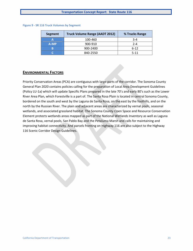
Freight Traffic
As for most of the North Bay truck volumes (AADT) are low, usually below 1,000 AADT. but while low
both imports and exports are essential to the economic vitality of the many small communities. Road
closures due to winter storms or flooding can have an almost immediate effect on delivering or
exporting goods, with few viable alternatives. Also, with narrow windy roads and steep gradients, truck
traffic can appear to have a larger impact than the numbers suggest. Within the corridor, seasonal
congestion is an issue for freight and is raised within the Corridor Issues Chapter 5. Only near US 101 are
truck volumes significant.
Transportation Concept Report: State Route 116
California Department of Transportation 23
Figure 9 - SR 116 Truck Volumes by Segment
Segment Truck Volume Range (AADT 2012) % Trucks Range
A 100-460 3-4
A-MP 900-910 2-4
B 900-2400 6-12
C 840-2550 5-11
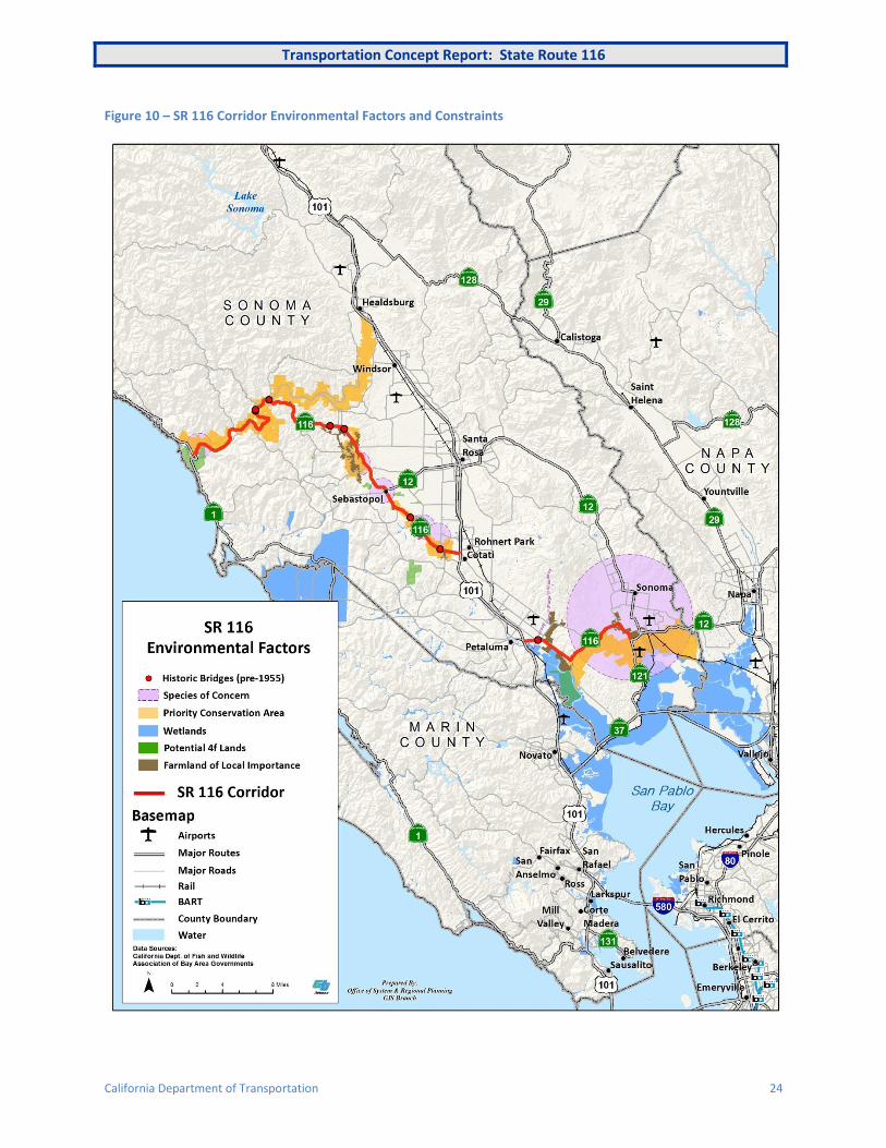
ENVIRONMENTAL FACTORS
Priority Conservation Areas (PCA) are contiguous with large parts of the corridor. The Sonoma County
General Plan 2020 contains policies calling for the preparation of Local Area Development Guidelines
(Policy LU-1a) which will update Specific Plans prepared in the late 70’s and early 80’s such as the Lower
River Area Plan, which Forestville is a part of. The Santa Rosa Plain is located in central Sonoma County,
bordered on the south and west by the Laguna de Santa Rosa, on the east by the foothills, and on the
north by the Russian River. The plain and adjacent areas are characterized by vernal pools, seasonal
wetlands, and associated grassland habitat. The Sonoma County Open Space and Resource Conservation
Element protects wetlands areas mapped as part of the National Wetlands Inventory as well as Laguna
de Santa Rosa, vernal pools, San Pablo Bay and the Petaluma Marsh and calls for maintaining and
improving habitat connectivity. And parcels fronting on Highway 116 are also subject to the Highway
116 Scenic Corridor Design Guidelines.
Transportation Concept Report: State Route 116
California Department of Transportation 24
Figure 10 – SR 116 Corridor Environmental Factors and Constraints
Transportation Concept Report: State Route 116
California Department of Transportation 25
CHAPTER 4: PLACE TYPES IN THE CORRIDOR
In this section place types from Caltrans’ Smart Mobility Framework are used to describe the corridor
and its potential for change (see Smart Mobility Framework in Chapter 1).
USING PLACE TYPES IN THE CORRIDOR
Place Types (shown in green) are a tool to help understand and summarize land uses in the corridor.
Figure 11 below shows the main place types identified in the corridor and two areas where the place
types may change under Smart Mobility Framework principles (Potential Transition Zones A and B).
Place types applicable to the corridor are summarized in the text. For full descriptions and the concept
of place types, see the reference document Smart Mobility 2010 – A Call to Action for a New Decade.
Places in square brackets [ ] are communities quoted as examples in the document.
CURRENT SETTING
As a whole, away from US 101, the SR 116 corridor consists of Rural Settlement and Agricultural Lands
(5b) with small Rural Towns (5a). Incorporated communities, with the notable exception of Sebastopol,
are located in the US 101 corridor.
Settlement and Agricultural Lands (5b) –Scattered dwelling units and supporting
commercial uses and public facilities, no significant subdivisions and limited non-
agricultural industrial or commercial land use, and lands in agricultural or grazing use.
North of Sebastopol are a number of small Rural Towns 5a that become increasing reliant upon
tourism, especially in the Russian River Valley. Sonoma County has designated some of these as Rural
Investment Areas (RIA), recognizing that they will not meet the requirements or scope of a PDA, but still
should be developed in a sustainable way to increase their location efficiency. Forestville and
Guerneville are both on SR 116, while Graton is just off the highway. Monte Rio and Occidental are
included in this TCR as places that would also specifically benefit from the principles of SMF and
Caltrans’ Main Street guidance.
Rural Towns 5a - Contain a mix of housing, services and public institutions in a
compact form. They will continue to depend on a high level of automobile use. Smart
Mobility should focus on walkable streets with speeds suitable for their context.
Centrally locating community using services (public & private) should be encouraged.
[St. Helena]
Sebastopol (7,500 pop. 2012) is shown as a Rural Town (5a) and is expected to remain largely the same,
despite some expected growth within the City and its surrounding communities. It is also expected that
Transportation Concept Report: State Route 116
California Department of Transportation 26
the area around Sebastopol will remain rural (Rural 5b). However, Sebastopol with its proximity to Santa
Rosa, and its important role as a local hub, is expected to have higher than average location efficiency
for this place type.
Cotati (7,400 pop 2012), while an incorporated city, is more a small Rural Town 5a. Two small PDAs will
add 400 units, near the planned SMART station and downtown. Unfortunately, the current service
planned by SMART is not frequent enough to bring significant benefits as seen by SMF. The downtown is
very walkable, but the outside of downtown housing developments are scattered with poor connectivity
between them.
Petaluma (60,000 pop. 2012) is a Compact Community (3) that has a PDA designated around the
downtown and the planned SMART station just east of the downtown. While the PDA will enhance the
already well developed downtown area (adding 1,800 units), the principles of SMF need to be extended
to other parts of the city to better utilize the potential of the new SMART station. Particularly east of US
101, the outer parts of Petaluma are Suburban Neighborhoods (4d) and local access needs to be
improved between the two parts of the city.
Compact Communities 3 - Historic towns characterized by a strong presence of
community design elements. Local and regional transit connectivity are low, but mixed
use development and mixed income housing together with enhanced bike and
pedestrian facilities give a high location efficiency. [Eureka, Paso Robles]
Rohnert Park (40,000 approximate pop. 2012) is perhaps more part of the US 101 corridor, but it will
have a station on SMART. Currently, it is a Suburban Neighborhood (4d), however two PDAs are
planned to provide 3,000 additional housing units both within easy access of the SMART station.
Suburban Neighborhood 4d – Residential subdivisions and complexes including
housing, public facilities and local-serving commercial uses, typically separated by
arterial corridors. [Bennett Valley - Santa Rosa, Sierra Foothills suburbs]

Transportation Concept Report: State Route 116
California Department of Transportation 27
Figure 11 - Corridor Place Types
Transportation Concept Report: State Route 116
California Department of Transportation 28
FUTURE POTENTIAL
The future development of land use is mainly regulated by the County and cities, with some guidance
from State legislation. Economic factors and regional policies will impact growth and development
patterns. With significant population and economic growth projected for the State in the coming
decades, change is a certainty for California communities.
As mentioned previously, place types can be used as a tool, in combination with the Smart Mobility
principles, to support strategic decision-making on how a city or town will change over time and which
transportation programs and projects to chose to influence change. Two transition zones that affect the
SR 116 corridor have been identified because they are expected to see PDAs developed under the
region’s Sustainable Communities Strategy (SCS) (see Appendix A - Regional Transportation Plan).
“Transition Zones” are defined as places that will see significant change, with the potential to “evolve”
over time with a significantly greater presence of location efficiency factors that justify a change in the
place type designation. The suggestion is that transportation solutions in the transition zones should
look more to desired future conditions, rather than the current place type. In the SR 116 corridor these
transition zones are related to SMART rail that will provide new stations at Petaluma and Cotati.
Potential Transition Zone A: Petaluma
The actual number of additional units proposed for the Petaluma-Central PDA is not large (1,700 units),
but there could be significant changes as part of the region’s SCS and the impact of the under
construction SMART rail station. Currently, Petaluma’s regional accessibility by public transit is low,
which per SMF is a limiting factor in improving locational efficiency and contributes to the current place
type designation of Compact Community (3). However, Petaluma is just 40 miles from San Francisco,
and SMART will provide a direct fast transit link to Marin and Santa Rosa, as well as competitive trip
times to San Francisco.
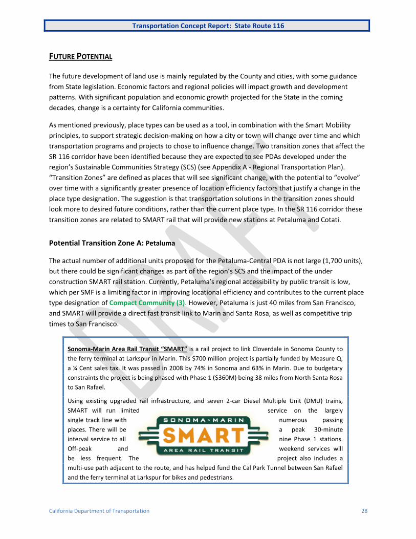
Sonoma-Marin Area Rail Transit “SMART” is a rail project to link Cloverdale in Sonoma County to
the ferry terminal at Larkspur in Marin. This $700 million project is partially funded by Measure Q,
a ¼ Cent sales tax. It was passed in 2008 by 74% in Sonoma and 63% in Marin. Due to budgetary
constraints the project is being phased with Phase 1 ($360M) being 38 miles from North Santa Rosa
to San Rafael.
Using existing upgraded rail infrastructure, and seven 2-car Diesel Multiple Unit (DMU) trains,
SMART will run limited service on the largely
single track line with numerous passing
places. There will be a peak 30-minute
interval service to all nine Phase 1 stations.
Off-peak and weekend services will
be less frequent. The project also includes a
multi-use path adjacent to the route, and has helped fund the Cal Park Tunnel between San Rafael
and the ferry terminal at Larkspur for bikes and pedestrians.

Transportation Concept Report: State Route 116
California Department of Transportation 29
The impact of SMART will depend upon the level of service provided. The presently planned service level
is not enough to sustain a higher level of development, with no all-day service and a very limited service
planned for weekends. Together with all-day SMART service and higher service frequency plus increased
HOV opportunities on US 101, there is however the potential for Petaluma to become nearer to a Close-
in Center (2a) if
Close-in Centers 2a - Small and medium sized downtowns, with transit
oriented development, institutions, lifestyle centers and other centers of
activity. [San Rafael, Santa Monica]
The provision of a more frequent SMART service could also help stimulate an enhancement in the local
Petaluma Transit bus service that, while reasonably frequent during the day, ends early and is limited at
weekends. While provisional, this higher level of location efficiency as a Close-in Center (2a) should be
considered when assessing proposed transportation solutions.
Potential Transition Zone B: City of Cotati
In 2014 Cotati declared itself as being in a “fiscal emergency” and has concerns over its viability as an
incorporated city. The decision to designate two PDAs indicates a desire for change in the community.
The corridor (East Cotati Avenue) between the downtown PDA and the SMART station PDA is almost a
mile in length, and its development to SMF principles could create a synergy that would benefit a much
larger portion of the community. Further east, Sonoma State University is just over one mile in distance
from the SMART station, but again East Cotati Avenue provides poor aesthetics for biking or walking. If
the benefits of SMART are to be extended beyond the 170 proposed parking spaces, the city should look
to improvements as suggested by SMF to develop the Cotati SMART station area into a community
asset. SMF improvements would not change the place type designation of Rural Town (5a), but would
give Cotati a higher degree of location efficiency, building on the historical assets of the downtown and
the railroad. For example, projects located west of US 101 would have a low location efficiency in
comparison to the PDA sites, and non-motorized access though the US 101/SR 116 interchange, to the
downtown and the future SMART station is poor.
Suburban Corridors 4b – Arterial streets with a variety of fronting
development type, frequently characterized by inadequate walk and bike
environments, low land use efficiency and poor aesthetics. [Farmers Lane,
Santa Rosa]
Transportation Concept Report: State Route 116
California Department of Transportation 30
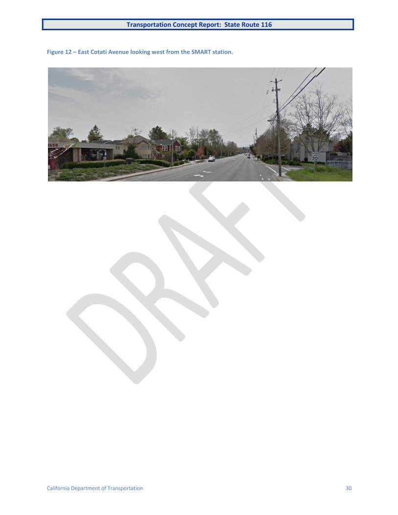
Figure 12 – East Cotati Avenue looking west from the SMART station.
Transportation Concept Report: State Route 116
California Department of Transportation 31
CHAPTER 5: KEY CORRIDOR ISSUES
In this section key transportation issues are discussed and a 20-25 year concept presented together with
potential improvement strategies for the corridor.
SR 116 includes a number of different environments, and serves different markets and needs, as
described in Chapter 2: Corridor Overview. Some of the current and potential future transportation
issues in the corridor are listed below with particular reference to the principles outlined in Caltrans
Smart Mobility Framework. The place types introduced previously help define the context and
recommended solution. The issues are presented as talking points to frame future discussions and the
20-25 year vision for the corridor. It is understood that further detailed study and analysis will be
necessary in order to fully understand the implications the proposed changes.
1. Enhancing the Russian River Experience
While Plan Bay Area seeks to reduce the need to travel, and there is a trend showing that people are
driving less, some places are going to remain largely auto-centric for access. The Russian River Valley is a
destination that will probably see increased demand from growing population and income levels, but
the infrastructure, and the space for new infrastructure is limited and it will need to plan for growth.
There would be major benefits to both locals and visitors if a practical one-stop parking scheme could be
developed during the summer season. This would allow those driving to the Russian River either as day
visitors or overnight to use public transportation or bikes once there. A bus shuttle system would be a
way of reducing congestion and parking requirements at peak periods, and enhancing the overall
experience for visitors. Besides linking the communities in the valley a shuttle service might also provide
access to the coast (Sonoma Coast State Park), the various resorts, wineries and/or the Armstrong
Redwoods, but this would need to be determined locally. Not only visitors would benefit as, like in many
busy tourist areas, locals find it increasingly difficult to make essential daily trips due to the congestion.
Trucks also get caught up in the congestion, just as the demand is highest, increasing the costs to local
businesses.
For bicycles, while an off-road (Class 1) facility is a desire, the limited right of way remains an issue. A
shorter timescale solution, in conjunction with bike lanes where possible on SR 116, would be a signed
Russian River bike route. This would direct bicyclists to some of the quieter roads that parallel SR
116/River Road and make use of the seasonal bridges crossing the Russian River.
Transportation Concept Report: State Route 116
California Department of Transportation 32
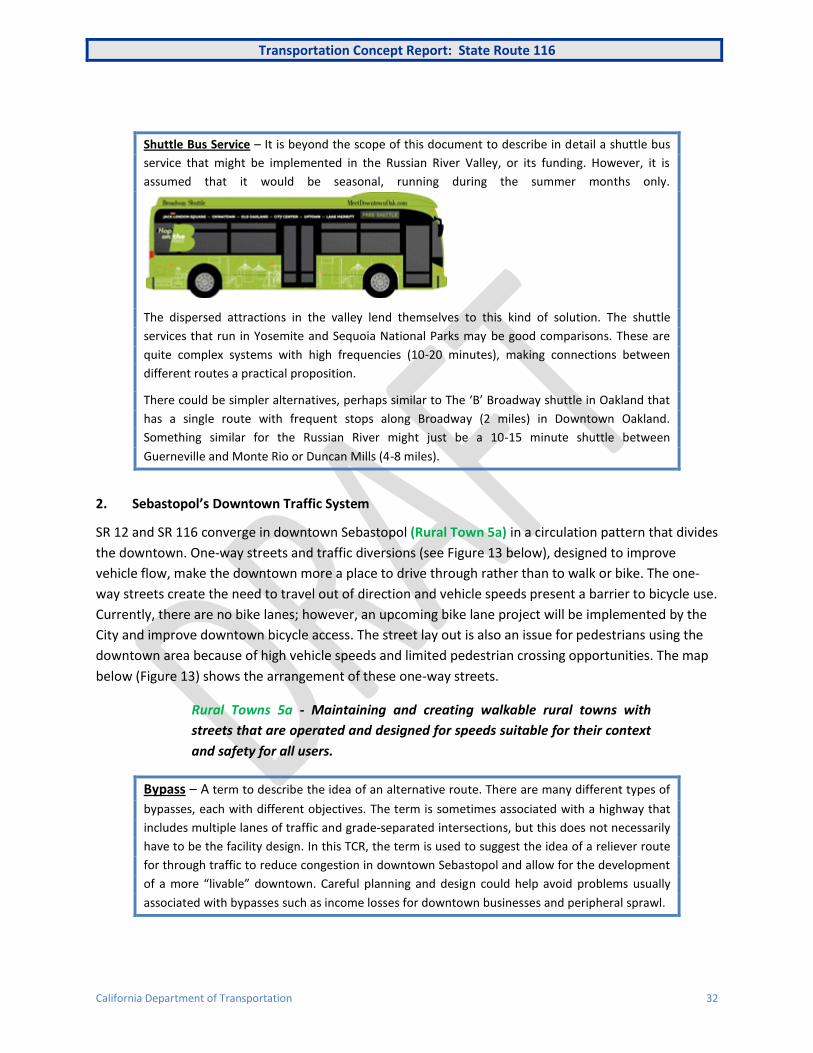
Shuttle Bus Service – It is beyond the scope of this document to describe in detail a shuttle bus
service that might be implemented in the Russian River Valley, or its funding. However, it is
assumed that it would be seasonal, running during the summer months only.
The dispersed attractions in the valley lend themselves to this kind of solution. The shuttle
services that run in Yosemite and Sequoia National Parks may be good comparisons. These are
quite complex systems with high frequencies (10-20 minutes), making connections between
different routes a practical proposition.
There could be simpler alternatives, perhaps similar to The ‘B’ Broadway shuttle in Oakland that
has a single route with frequent stops along Broadway (2 miles) in Downtown Oakland.
Something similar for the Russian River might just be a 10-15 minute shuttle between
Guerneville and Monte Rio or Duncan Mills (4-8 miles).
2. Sebastopol’s Downtown Traffic System
SR 12 and SR 116 converge in downtown Sebastopol (Rural Town 5a) in a circulation pattern that divides
the downtown. One-way streets and traffic diversions (see Figure 13 below), designed to improve
vehicle flow, make the downtown more a place to drive through rather than to walk or bike. The one-
way streets create the need to travel out of direction and vehicle speeds present a barrier to bicycle use.
Currently, there are no bike lanes; however, an upcoming bike lane project will be implemented by the
City and improve downtown bicycle access. The street lay out is also an issue for pedestrians using the
downtown area because of high vehicle speeds and limited pedestrian crossing opportunities. The map
below (Figure 13) shows the arrangement of these one-way streets.
Rural Towns 5a - Maintaining and creating walkable rural towns with
streets that are operated and designed for speeds suitable for their context
and safety for all users.
Bypass – A term to describe the idea of an alternative route. There are many different types of
bypasses, each with different objectives. The term is sometimes associated with a highway that
includes multiple lanes of traffic and grade-separated intersections, but this does not necessarily
have to be the facility design. In this TCR, the term is used to suggest the idea of a reliever route
for through traffic to reduce congestion in downtown Sebastopol and allow for the development
of a more “livable” downtown. Careful planning and design could help avoid problems usually
associated with bypasses such as income losses for downtown businesses and peripheral sprawl.

Transportation Concept Report: State Route 116
California Department of Transportation 33
Sebastopol has much to offer for visitors and is a destination for tourists in the area. Therefore, an
eastern bypass of Sebastopol that would permit through-traffic on SR 116 (and SR 12) to avoid the
downtown and allow a more conventional street system to be reintroduced does not necessarily have to
impact downtown businesses. A “one stop” parking strategy (see page 35), whereby parking is shared
between businesses, could also be developed to reduce vehicle impacts on the downtown. This has
been successfully implemented in Pasadena and helped revitalized its downtown.
Figure 13 - Current Traffic System in Downtown Sebastopol
3. Route Relinquishment and/or Redesignation
The importance of SR 116 to the State and regional road network is mainly in linking SR 1 to US 101
along the Russian River. The next parallel link is SR 128 about 70 to 80 miles to the north. SR 116 not
only provides access to the coast but to the important tourist and recreation area of the Russian River
Valley. However, east of Guerneville SR 116 heads away from the Russian River and it is River Road that
continues to US 101. From Guerneville south to Sebastopol SR 116 is part of the IRRS, but it remains
quicker to travel on River Road and/or Mirabel Road. Beyond Sebastopol SR 116 is not classified as part
of the IRRS and some of the route’s southern portion east of US 101 is a rural road with very low traffic.
Relinquishing SR 116 between Guerneville and its terminus at SR 121, with the re-designation of River
Road to US 101 as SR 116 could be a worthwhile State Highway System (SHS) re-designation to consider.
Transportation Concept Report: State Route 116
California Department of Transportation 34
Alternatively, Sebastopol to Guerneville could be designated SR 12 as there are no plans to extend SR 12
west of Sebastopol. Regardless of ownership and designation, resources would best be prioritized on the
River Road corridor (see issue #3).
River Road – The River Road has a current AADT of up to 16,000. It was build on the track bed of
the Fulton and Guerneville Railroad that connected with the Pacific Northwest Railroad (future
SMART) at Fulton just north of Santa Rosa. Due to falling traffic the line was closed in 1935 and
the right of way converted to River Road utilizing bridges and other infrastructure from the old
railroad. The Hacienda Bridge on River Road (near Westside Road), an original railroad crossing of
the Russian River (1914), is still in use today. As it was an old railroad alignment it has gentle
curves and gradients, but in some places the right of way is very restricted and the roadway is
heavily engineered making any potential widening difficult.
4. Improving the effectiveness of SMART
The presently planned service level for SMART is not frequent enough to sustain the level of
development for the proposed PDAs in the corridor. In particular, the service planned for weekends and
evenings does not allow SMART to act as substitute to the private car. While travel to and from San
Francisco will probably remain peak orientated due to having to transfer at Larkspur to/from the ferry,
SMART has convenient stations in both San Rafael and Santa Rosa. By providing a regular all day service
SMART will have the potential to reduce vehicle trips (and second car ownership) and sustain the
planned PDAs in the corridor.
5. Forestville Bypass
Sonoma County’s Measure M includes money for a bypass of the small unincorporated town of
Forestville. While this would take SR 116 through traffic out of the downtown area, including trucks
from a local quarry, it could also adversely affect the economic viability of the small commercial district.
Unlike Sebastopol, Forestville is a destination mostly for those who live there and the small community
is fairly dispersed. The loss of economic activity from through traffic would need to be compensated by
local spending. To this end, some in the local community have suggested street improvements to make
the downtown more of a local destination and take advantage of the reduced summer congestion a
bypass would bring. Others are against the bypass and the planned roundabout at Mirabel Road, which
is both an integral part of the bypass and a standalone project. A roundabout at Mirabel Road will help
mitigate congestion in commercial area, but the value of a bypass, together with its environmental
impacts, needs to be seen in a wider context as to the future role of SR 116 (see #3 above).
Complete Street – A transportation facility that is planned, designed, operated, and maintained
to provide safe mobility for all users, including bicyclists, pedestrians, transit riders, and
motorists appropriate to the function and context of the facility. [Caltrans Complete Streets
Deputy Directive 64 – R1, 2008]
Transportation Concept Report: State Route 116
California Department of Transportation 35
6. SR 116 as a “Main Street”
There are a number of places in the corridor where SR 116 acts as a main street for the community.
Caltrans’ Complete Streets policy and “Main Street, California” guidance provide workable solutions to
improving the highway and the livability and efficiency of these communities as per Smart Mobility
Framework. These solutions would not only work well with the idea of an enhanced local transit service,
but provide a useful amenity all year. In particular, continuous sidewalks in some communities would
improve their economic viability by permitting one-stop parking. In addition, the availability of LED
street lights should be used to enhance the pedestrian experience after dark. In many places, roadway
orientated lighting together with street trees can leave extended lengths of sidewalk unlit. LED lights,
with their lower electricity consumption and reduced maintenance, can be used to develop more
pedestrian oriented lighting solutions.
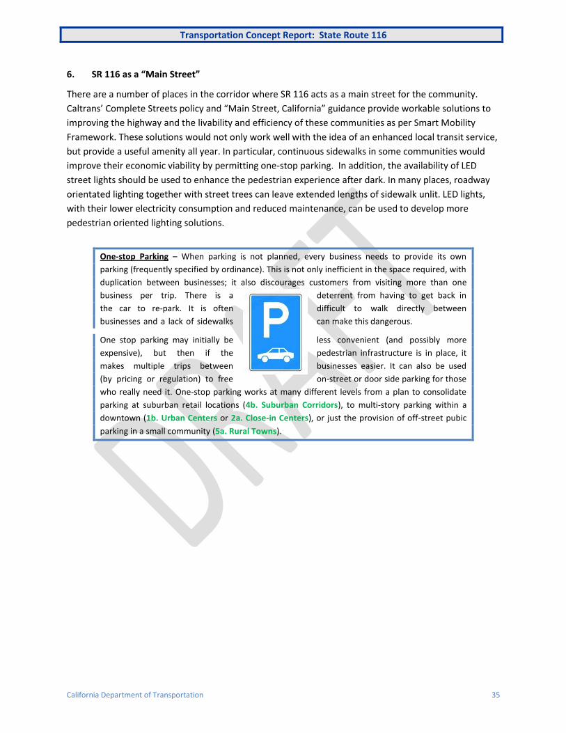
One-stop Parking – When parking is not planned, every business needs to provide its own
parking (frequently specified by ordinance). This is not only inefficient in the space required, with
duplication between businesses; it also discourages customers from visiting more than one
business per trip. There is a deterrent from having to get back in
the car to re-park. It is often difficult to walk directly between
businesses and a lack of sidewalks can make this dangerous.
One stop parking may initially be less convenient (and possibly more
expensive), but then if the pedestrian infrastructure is in place, it
makes multiple trips between businesses easier. It can also be used
(by pricing or regulation) to free on-street or door side parking for those
who really need it. One-stop parking works at many different levels from a plan to consolidate
parking at suburban retail locations (4b. Suburban Corridors), to multi-story parking within a
downtown (1b. Urban Centers or 2a. Close-in Centers), or just the provision of off-street pubic
parking in a small community (5a. Rural Towns).
Transportation Concept Report: State Route 116
California Department of Transportation 36
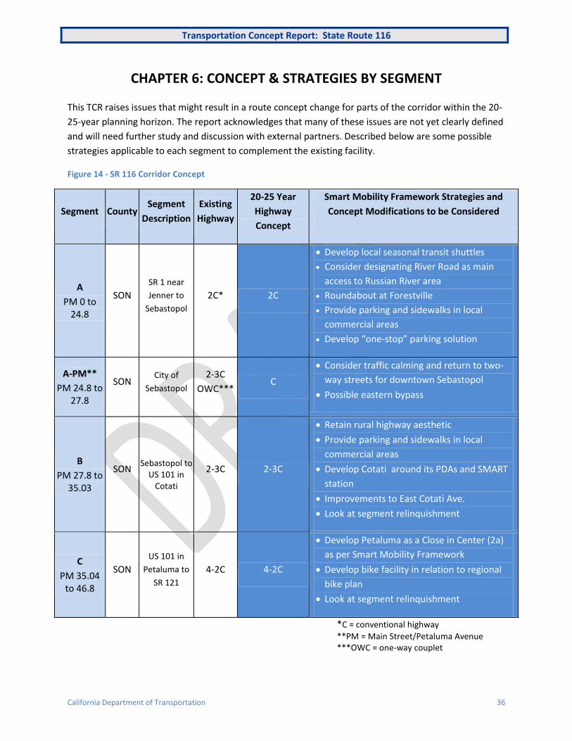
CHAPTER 6: CONCEPT & STRATEGIES BY SEGMENT
This TCR raises issues that might result in a route concept change for parts of the corridor within the 20-
25-year planning horizon. The report acknowledges that many of these issues are not yet clearly defined
and will need further study and discussion with external partners. Described below are some possible
strategies applicable to each segment to complement the existing facility.
Figure 14 - SR 116 Corridor Concept
Segment County Segment
Description
Existing
Highway
20-25 Year
Highway
Concept
Smart Mobility Framework Strategies and
Concept Modifications to be Considered
A
PM 0 to 24.8
SON
SR 1 near
Jenner to
Sebastopol
2C* 2C
Develop local seasonal transit shuttles
Consider designating River Road as main
access to Russian River area
Roundabout at Forestville
Provide parking and sidewalks in local
commercial areas
Develop “one-stop” parking solution
A-PM**
PM 24.8 to 27.8
SON City of
Sebastopol
2-3C
OWC*** C
Consider traffic calming and return to two-
way streets for downtown Sebastopol
Possible eastern bypass
B
PM 27.8 to 35.03
SON Sebastopol to
US 101 in Cotati
2-3C 2-3C
Retain rural highway aesthetic
Provide parking and sidewalks in local
commercial areas
Develop Cotati around its PDAs and SMART
station
Improvements to East Cotati Ave.
Look at segment relinquishment
C
PM 35.04 to 46.8
SON
US 101 in
Petaluma to
SR 121
4-2C 4-2C
Develop Petaluma as a Close in Center (2a)
as per Smart Mobility Framework
Develop bike facility in relation to regional
bike plan
Look at segment relinquishment
*C = conventional highway
**PM = Main Street/Petaluma Avenue ***OWC = one-way couplet
Transportation Concept Report: State Route 116
California Department of Transportation 37
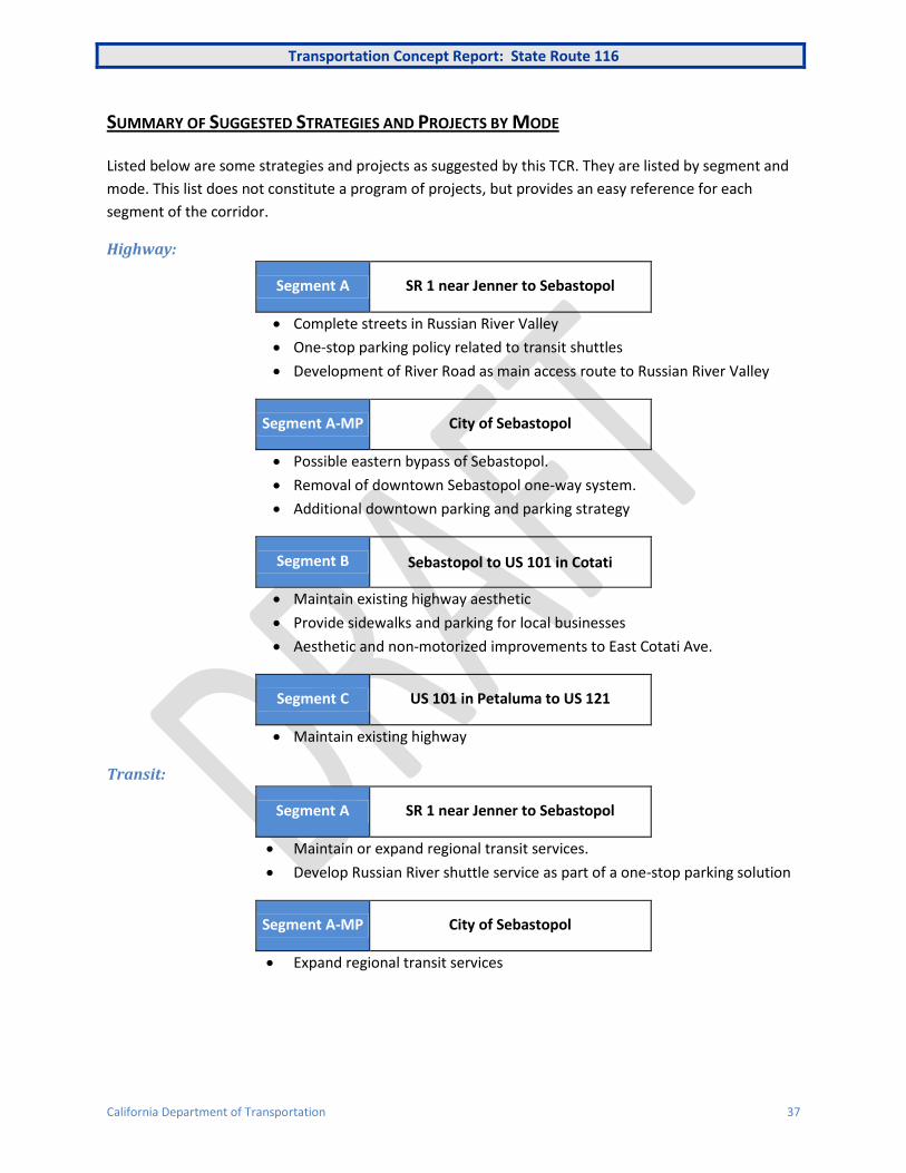
SUMMARY OF SUGGESTED STRATEGIES AND PROJECTS BY MODE
Listed below are some strategies and projects as suggested by this TCR. They are listed by segment and
mode. This list does not constitute a program of projects, but provides an easy reference for each
segment of the corridor.
Highway:
Segment A SR 1 near Jenner to Sebastopol
Complete streets in Russian River Valley
One-stop parking policy related to transit shuttles
Development of River Road as main access route to Russian River Valley
Segment A-MP City of Sebastopol
Possible eastern bypass of Sebastopol.
Removal of downtown Sebastopol one-way system.
Additional downtown parking and parking strategy
Segment B Sebastopol to US 101 in Cotati
Maintain existing highway aesthetic
Provide sidewalks and parking for local businesses
Aesthetic and non-motorized improvements to East Cotati Ave.
Segment C US 101 in Petaluma to US 121
Maintain existing highway
Transit:
Segment A SR 1 near Jenner to Sebastopol
Maintain or expand regional transit services.
Develop Russian River shuttle service as part of a one-stop parking solution
Segment A-MP City of Sebastopol
Expand regional transit services

Transportation Concept Report: State Route 116
California Department of Transportation 38
Segment B Sebastopol to US 101 in Cotati
Enhance planned off-peak service on SMART (Cotati) in conjunction with
development of PDAs
Segment C US 101 in Petaluma to US 121
Continue development of transit services between Petaluma and the City of
Sonoma
Enhance planned off-peak service on SMART (Petaluma) in conjunction with
development of PDAs
Pedestrian:
Segment A SR 1 near Jenner to Sebastopol
Implement complete streets and main streets policy in local communities
along SR 116.
Provide sidewalks for local businesses along the highway.
Segment A-PM City of Sebastopol
Removal of downtown Sebastopol one-way system.
Reduce crossing distance at intersections and introduce traffic calming
measures
Ensure street lighting meets needs of pedestrians, using low cost LED
lighting.
Segment B Sebastopol to US 101 in Cotati
Provide sidewalks for local businesses along the highway.
Enhance the connectivity in Cotati to maximize pedestrian access to/from
SMART
Aesthetic and non-motorized improvements to East Cotati Ave.
Segment C US 101 in Petaluma to US 121
Enhance the connectivity in Petaluma to maximize pedestrian access
to/from SMART
Ensure street lighting meets need of pedestrians, using low cost LED lighting
in urban areas.
Transportation Concept Report: State Route 116
California Department of Transportation 39
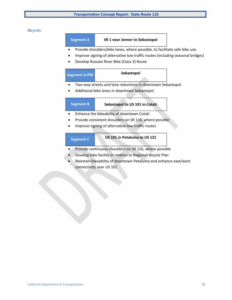
Bicycle:
Segment A SR 1 near Jenner to Sebastopol
Provide shoulders/bike lanes, where possible, to facilitate safe bike use.
Improve signing of alternative low traffic routes (including seasonal bridges)
Develop Russian River Bike (Class 3) Route
Segment A-PM Sebastopol
Two-way streets and lane reductions in downtown Sebastopol.
Additional bike lanes in downtown Sebastopol.
Segment B Sebastopol to US 101 in Cotati
Enhance the bikeability of downtown Cotati
Provide consistent shoulders on SR 116, where possible
Improve signing of alternative low traffic routes
Segment C US 101 in Petaluma to US 121
Provide continuous shoulders on SR 116, where possible
Develop bike facility in relation to Regional Bicycle Plan
Maintain bikeability of downtown Petaluma and enhance east/west
connectivity over US 101
Transportation Concept Report: State Route 116
California Department of Transportation 40
APPENDICIES
APPENDIX A: REGIONAL TRANSPORTATION PLAN
Regional Planning
Plan Bay Area is the San Francisco Bay Area’s 2040 Regional Transportation Plan. It was adopted in July 2013. The Plan includes the region’s Sustainable Communities Strategy and the 2040 Regional Transportation Plan and represents the next iteration of a planning process that has been in place for decades. Plan Bay Area marks the nine-county region’s first long-range plan to meet the requirements of California’s landmark 2008 Senate Bill 375 (Steinberg), which calls on each of the state’s 18 metropolitan areas to develop a Sustainable Communities Strategy to accommodate future population growth and reduce greenhouse gas emissions from cars and light trucks. This is important because in the Bay Area the transportation sector represents about 40 percent of the GHG pollution that scientists say is causing climate change.
Under SB 375 each region must develop a Sustainable Communities Strategy (SCS) that promotes compact, mixed-use commercial and residential development that is walkable and bikable and close to mass transit, jobs, schools, shopping, parks, recreation and other amenities. Plan Bay Area is intended to give people more transportation choices, create more livable communities and reduce the pollution that causes climate change.
Land Use Planning
The Metropolitan Transportation Commission (MTC) 2040 Regional Transportation Plan (RTP) or Plan Bay Area, will incorporate the implementation of SB 375 through the designation of Priority Development Areas (PDAs), among other measures.
PDAs are locally-identified, infill development opportunity areas within existing communities. They are generally areas of at least 100 acres where there is local commitment to developing more housing along with amenities and services to meet the day-to-day needs of residents in a pedestrian-friendly environment served by transit. To be eligible to become a PDA, an area has to be within an existing community, near existing or planned fixed transit or served by comparable bus service, and planned for more housing. Within the SR 12 (West) corridor there are a number of designated PDAs as shown on the map below.
A 2010 survey by the Association of Bay Area Governments (ABAG) indicated that planned PDAs in the Bay Area expect to add approximately 209,000 housing units and 607,000 jobs over the next 25 years. As a result, in 2035 there are anticipated to be nearly 579,000 housing units and 1.6 million jobs in the region’s planned PDAs. These numbers indicate that, while the 92 planned PDAs included in this assessment account for a little over one percent of the land area of the Bay Area, they are planned to accommodate 32 percent of the housing growth and 37 percent of the job growth forecasted in ABAG’s Projections and Priorities 2009: Building Momentum. It is expected that the majority of this growth will take place in the inner Bay Area cities, if only because the majority of PDAs are found in these areas.
MTC/ABAG have chosen a preferred option and developed a list of projects associated with it. Below are specific projects in or affecting the corridor.
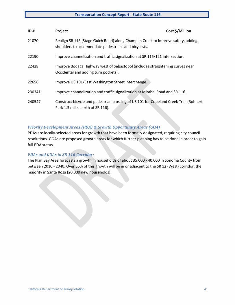
Transportation Concept Report: State Route 116
California Department of Transportation 41
ID # Project Cost $/Million
21070 Realign SR 116 (Stage Gulch Road) along Champlin Creek to improve safety, adding
shoulders to accommodate pedestrians and bicyclists.
22190 Improve channelization and traffic signalization at SR 116/121 intersection.
22438 Improve Bodaga Highway west of Sebastopol (includes straightening curves near
Occidental and adding turn pockets).
22656 Improve US 101/East Washington Street interchange.
230341 Improve channelization and traffic signalization at Mirabel Road and SR 116.
240547 Construct bicycle and pedestrian crossing of US 101 for Copeland Creek Trail (Rohnert
Park 1.5 miles north of SR 116).
Priority Development Areas (PDA) & Growth Opportunity Areas (GOA)
PDAs are locally-selected areas for growth that have been formally designated, requiring city council
resolutions. GOAs are proposed growth areas for which further planning has to be done in order to gain
full PDA status.
PDAs and GOAs in SR 116 Corridor:
The Plan Bay Area forecasts a growth in households of about 35,000 - 40,000 in Sonoma County from
between 2010 - 2040. Over 55% of this growth will be in or adjacent to the SR 12 (West) corridor, the
majority in Santa Rosa (20,000 new households).

Transportation Concept Report: State Route 116
California Department of Transportation 42
Figure 15 - Map of Priority Development Areas and Rural Investment Areas

Transportation Concept Report: State Route 116
California Department of Transportation 43
Figure 16 below gives details on the PDAs and RIAs in the SR 116 corridor. The final column “% of
Increase” show how much each PDA/RIA is contributing to the growth in PDA that are eligible for One
Bay Area grants.
Figure 16 - List of Priority Development Areas and Rural Investment Areas
PDA/RIA Households 2010
Households 2040
Household Increase
% of Increase
A Cotati Downtown & Station (PDA)
890 1,290 400 10%
B Petaluma Central (PDA) 810 2,570 1,760 44%
C Sebastopol Central 2,510 2,890 390 10%
D Forestville (RIA) 300 600 300 8%
E Guerneville (RIA) 219 400 184 5%
F Graton (RIA) 254 500 246 6%
G Penngrove (RIA) 140 414 274 7%
H City of Sonoma (not a PDA/RIA)
4,960 5,390 430 10%
TOTALS 10,083 14,054 3,984 100.00%
APPENDIX B: STATE TRANSPORTATION PLANNING
Planned & Programmed Projects STIP Projects
0A6320 SON 116 WIDENING AND NEW SIGNAL $2.9M at US 101 in Cotati
SHOPP (State Highway and Operations and Protection Program) Projects
No major projects

Transportation Concept Report: State Route 116
California Department of Transportation 44
APPENDIX C: COUNTY TRANSPORTATION PLANNING
Figure 17 – Costed Highway Projects in 2009 Sonoma County Transportation Plan
Hwy 116/Hwy 121 intersection improvements and Arnold Drive improvements $14.8
Bodega Highway improvements west of Sebastopol $2.0
River Road channelization and improvements $4.0
Mirabel road and SR 116 signalization and Channelization $3.0
Realign SR 116 (Stage Gulch Road) along Champlin Creek segments to accommodate pedestrians and
bicyclists and widen remaining $38.0
Rehabilitate and widen SR 116 from Elphick road to Redwood Drive (realignment, new shoulders and
channelization improvements) $83.0
U.S. 101/East Washington Street interchange improvements $23.0
Petaluma cross-town connector and Rainier interchange $58.7
Forestville bypass on SR 116
Cotati/Rohnert Park E Cotati Avenue Hwy 101 to Snyder, implement arterial management $ 1.10
Todd Road: reconstruct Petaluma Hill Road from Stony Point Road to Llano Road extend east to $5.80
Southern Crossing Caulfield Lane, Petaluma $72.0
Lakeville Road Widen to 4 Lanes forms SR 37 to SR 116 $22.00
Bodega Hwy, west of Sebastopol, Upgrade unimproved sect to 36’—full reconstruct $5.50
Sebastopol Intersection Control on SR 116 at 4 locations in Sebastopol $1.40
Sebastopol Road Bypass—Llano road improvements & extension, Hwy 116 to Occidental $3.00
Measure M – Sonoma County’s quarter cent sales tax measure passed in 2004. The measure generates between $15-20 million per year in revenue. Expenditures are allocated as follows.
Local Roads and Streets projects 20%
Local Roads Rehabilitation 20%
U.S. 101 Widening projects 40%
Local Bus Transit improvements 10%
SMART Passenger Rail 5%
Bicycle and Pedestrian projects 4%
Administration 1%
Figure 18 –Projects in 2011 Sonoma County Measure M Strategic Plan
Measure M Highway Projects in the SR 116 Corridor (See Measure M in Appendix E)
Highway 121/116 Intersection & Arnold Drive Improvements ($15M)
Bodega Highway improvements ($2M)
Forestville By-pass ($13M)
River Road Improvements near Forestville ($2M)
Measure M Bicycle/Pedestrian Projects in the SR 116 Corridor
Transportation Concept Report: State Route 116
California Department of Transportation 45
Street Smart Sebastopol- bicycle and pedestrian improvements in the downtown area ($2.5M)
Petaluma River Trail- class 1 access from eastern Petaluma to Downtown ($6M)
Transportation Concept Report: State Route 116
California Department of Transportation 46
APPENDIX D: PERTINENT TRANSPORTATION PLANS, POLICIES, LEGISLATION, AND PROGRAMS
The following is a listing of federal, State, and regional transportation planning efforts and policies related to this Transportation Concept Report.
Federal
Moving Ahead for Progress in the 21st Century Act (MAP-21), P.L. 112-141, was signed into law in July 2012. This act will provide funding for surface transportation programs for Fiscal Year (FY) 2013/14. MAP-21 is the first long-term highway authorization bill enacted since 2005. MAP-21 creates a streamlined, performance-based, and multimodal program to address the many challenges facing the U.S. transportation system. These challenges include improving safety, improving and/or maintaining infrastructure condition, reducing traffic congestion, improving efficiency of the system and freight movement, protecting the environment, and reducing delays in project delivery.
Federal Transportation Improvement Program (FTIP) - All federally funded projects, and regionally significant projects vis-à-vis air quality (regardless of funding), must be listed in the FTIP, per federal law. A project is not eligible to be programmed in the FTIP until it is programmed in the State Transportation Improvement Program (STIP) or in the State Highway Operations and Protection Program (SHOPP). Other types of funding (Federal Demonstration, Congestion Mitigation and Air Quality (CMAQ), Transportation Enhancement Activities (TEA), or Surface Transportation Program (STP)) must be federally approved before the projects can be included in the FTIP.
State
California Transportation Plan (CTP) - The California Transportation Plan 2035 focuses on plans, policies, and processes that address the provisions of MAP 21. It is a statewide, long-range transportation policy plan that provides for the movement of people, goods, services, and information. The CTP offers a blueprint to guide future transportation decisions and investments that will ensure California's ability to compete globally, provide safe and effective mobility for all persons, better link transportation and land use decisions, improve air quality, and reduce petroleum energy consumption. An update of the CTP is currently underway and is expected to be finalized in 2015.
Interregional Transportation Strategic Plan (ITSP) –The Interregional Transportation Strategic Plan (ITSP) provides guidance for the identification and prioritization of interregional State highway projects with regard to the statutorily-identified Interregional Road System (IRRS) and interregional transportation modes, including intercity passenger rail. The IRRS serves interregional movement of people and goods. The ITSP is the counterpart to the Regional Transportation Plans prepared by the Regional Transportation Planning Agencies in California. Caltrans finalized an update of the ITSP in October 2013.
State Transportation Improvement Program (STIP) - The State Transportation Improvement Program (STIP) is a multi-year capital improvement program of transportation projects on and off the State Highway System, funded with revenues from the Transportation Investment Fund and other funding sources. The California Transportation Commission (CTC) biennially adopts and submits to the Legislature and Governor a STIP. The STIP is a resource management document to assist state and local entities to plan and implement transportation improvements and to utilize available resources in a cost-effective manner.
Interregional Transportation Improvement Program (ITIP) – The Interregional Transportation Improvement Program (ITIP) is a State-funding program. Caltrans nominates and the California

Transportation Concept Report: State Route 116
California Department of Transportation 47
Transportation Commission approves a listing of interregional highway and rail projects for 25 percent of the funds to be programmed in the STIP (the other 75% are Regional Improvement Program funds). The purpose of the ITIP is to improve interregional mobility for people and goods in the State of California. As an interregional program the ITIP is focused on increasing the throughput for highway and rail corridors of strategic importance outside the urbanized areas of the state. The ITIP compliments regional congestion reduction activities focused within the urbanized areas of the State. A sound transportation network between, and connecting, urbanized areas, ports and borders is vital to the State’s economic vitality.
State Highway Operation and Protection Program (SHOPP) - Caltrans prepares the SHOPP for the expenditure of transportation funds for improvements necessary to preserve and protect the State Highway System. The SHOPP is a four-year funding program. SHOPP projects are limited to capital improvements relative to maintenance, safety, and rehabilitation of State highways and bridges.
Senate Bill (SB) 45 (1997) – California’s Senate Bill 45 stipulates that the State will nominate transportation improvements that facilitate the movement of people and goods between the State’s transportation regions as well as to and through the State. The State is responsible for developing highway system performance standards, that will accommodate interregional travel demand, and specifying corridor facility concepts that improve interregional travel on the State Highway System. The corridor concepts included in Transportation Concept Reports reflect the State’s vision regarding System accommodation of interregional, regional and local travel needs.
California Interregional Blueprint (CIB) - The California Interregional Blueprint informs and enhances the State’s transportation planning process. Similar to requirements for regional transportation plans under Senate Bill 375, Senate Bill 391 requires the State’s long-range transportation plan to meet California’s climate change goals under Assembly Bill 32. In response to these statutes, Caltrans prepared a State-level transportation blueprint to inform CTP 2040 and articulate the State’s vision for an integrated, multi-modal interregional transportation system that complements regional transportation plans and land use visions. The CIB will integrate the State’s long-range multi-modal plans and Caltrans-sponsored programs to enhance our ability to plan for and monitor the transportation system as a whole, while meeting the GHG-reduction targets resulting from SB 375.
California Strategic Growth Plan - The Governor and Legislature have initiated the first phase of a comprehensive Strategic Growth Plan to address California’s critical infrastructure needs over the next 20 years. California faces over $500 billion in infrastructure needs to meet the demands of a population expected to increase by 23 percent over the next two decades. In November 2006, the voters approved the first installment of that 20-year vision to rebuild California by authorizing a series of general obligation bonds totaling $42.7 billion.
District System Management Plan (DSMP) - The District System Management Plan (DSMP) is a long-range (20 year) strategic and policy planning document that presents the long range goals, policies, and programs the district intends to follow in maintaining, managing, and developing the transportation system. It serves as a resource for informing federal, state, regional, and local agencies, and the public and private sector of the plans the district intends to follow in its partnership role with local and regional agencies.
Goods Movement Action Plan (GMAP) - The Goods Movement Action Plan (GMAP) was issued by the California Business, Transportation and Housing Agency (Agency) and the California Environmental Protection Agency (Cal EPA) in two phases in 2005 and 2007. It was a major milestone in statewide policy and planning for freight transportation, trade corridors, and related air quality issues. The GMAP helped guide project selection for the allocation of funds under the $2 billion Trade Corridors
Transportation Concept Report: State Route 116
California Department of Transportation 48
Improvement Fund (TCIF) program, authorized by the voter-approved Highway Safety, Traffic Reduction, Air Quality and Port Security Bond Act of 2006 (Proposition 1B). An update of the GMAP, the California Freight Mobility Plan, is currently underway.
Caltrans Deputy Directive 64 R1: Complete Streets – Integrating the Transportation System - Caltrans fully considers the needs of non-motorized travelers (including pedestrians, bicyclists and persons with disabilities) in all programming, planning, maintenance, construction, operations and project development activities and products. The intent is to plan for multimodal transportation facilities.
Assembly Bill 32 - Global Warming Solutions Act (2006) - This bill requires the State’s greenhouse gas emissions to be reduced to 1990 levels by the year 2020. Caltrans’ strategy to reduce global warming emissions has two elements. The first is to make transportation systems more efficient through operational improvements. The second is to integrate emission reduction measures into the planning, development, operations and maintenance of transportation elements.
Senate Bill 375 - California’s 2008 Senate Bill 375 requires each of the State’s 18 metropolitan areas to reduce greenhouse gas (GHG) emissions from cars and light trucks. It also states that each region must develop a Sustainable Communities Strategy (SCS) that promotes compact, mixed-use commercial and residential development that is walkable and bikeable and close to mass transit, jobs, schools, shopping, parks, recreation and other amenities.
Senate Bill (SB) 743- creates a process to change the way that transportation impacts are analyzed under CEQA. Specifically, SB 743 requires the Governor’s Office of Planning and Research (OPR) to amend the CEQA Guidelines to provide an alternative to LOS for evaluating transportation impacts. Particularly within areas served by transit, those alternative criteria must “promote the reduction of greenhouse gas emissions, the development of multimodal transportation networks, and a diversity of land uses.” (New Public Resources Code Section 21099(b)(1).) Measurements of transportation impacts may include “vehicle miles traveled, vehicle miles traveled per capita, automobile trip generation rates, or automobile trips generated.” (Ibid.) OPR also has discretion to develop alternative criteria for areas that are not served by transit, if appropriate.
Once the CEQA Guidelines are amended to include those alternative criteria, auto delay will no longer be considered a significant impact under CEQA. (b)(2).) Transportation impacts related to air quality, noise and safety must still be analyzed under CEQA where appropriate.
SB 743 also amended congestion management law to allow cities and counties to opt out of LOS standards within certain infill areas. (See Amended Government Code Sections 65088.1 and 65088.4.)
Aside from changes to transportation analysis, SB 743 also included several important changes to CEQA that apply to transit oriented developments, including aesthetics and parking.
Caltrans - Climate Action Plan - Greenhouse gas (GHG) emissions and the related subject of global climate change are emerging as critical issues for the transportation community. The California Department of Transportation (Caltrans) recognizes the significance of cleaner, more energy efficient transportation. On June 1, 2005 the State established climate change emissions reduction targets for California which lead to development of the Climate Action Program. This program highlights reducing congestion and improving efficiency of transportation systems through smart land use, operational improvements, and Intelligent Transportation Systems (objectives of the State’s Strategic Growth Plan). The Climate Action Plan approach also includes institutionalizing energy efficiency and GHG emission reduction measures and technology into planning, project development, operations, and maintenance of transportation facilities, fleets, buildings, and equipment.

Transportation Concept Report: State Route 116
California Department of Transportation 49
Corridor Mobility Improvement Account (CMIA) - The California Transportation Commission adopted the $4.5 billion Corridor Mobility Improvement Account (CMIA) program, the first commitment of funds from the $19.9 billion transportation infrastructure bond approved by California voters as Proposition 1B in November 2006. The statewide CMIA program includes nearly $1.3 billion in Bay Area projects, plus an additional commitment of $405 million through the State Highway Operations and Protection Program (SHOPP) for replacement of Doyle Drive in San Francisco. This brings the total amount programmed for Bay Area transportation projects to roughly $1.7 billion.
Corridor System Management Plans (CSMP) - CSMPs were developed for corridors that received funding from the Corridor Mobility Improvement Account (CMIA). They were required by the California Transportation Commission per resolution adopted in 2007 stating that “…the Commission expects Caltrans and regional agencies to preserve the mobility gains of urban corridor capacity improvements over time that will be described in Corridor System Management Plans (CSMPs).” The CSMPs incorporate detailed operational analysis into corridor planning through performance assessments, analysis and evaluation, leading to recommendations of system management strategies for a corridor.
Trade Corridors Improvement Fund (TCIF) - In November 2006, voters approved Proposition 1B, a roughly $20 billion Transportation Bond. It established the Trade Corridors Improvement Fund that included a total of $3.1 billion for goods movement-related programs, of which $2 billion was set aside for infrastructure improvements statewide.
Freeway Performance Initiative (FPI) – This is the Metropolitan Transportation Commission’s effort to improve the operations, safety and management of the Bay Area’s freeway network by deploying system management strategies, completing the HOV lane system, addressing regional freight issues, and closing key freeway infrastructure gaps.
Region
Regional Transportation Plan – Plan Bay Area – See Appendix A.
Regional Transportation Improvement Program (RTIP)-The Regional Transportation Improvement Program is a sub-element of the State Transportation Improvement Program (STIP). The Metropolitan Transportation Commission is responsible for developing regional project priorities for the RTIP for the nine counties of the Bay Area. The biennial RTIP is then submitted to the California Transportation Commission for inclusion in the STIP

Transportation Concept Report: State Route 116
California Department of Transportation 50
APPENDIX F: FUNCTIONAL CLASSIFICATION
Transportation Concept Report: State Route 116
California Department of Transportation 51

![IMMUNOGLOBULINE E T CELL RECEPTOR T. Strachan e A.P. … · B cell antigen receptor tetramero [ IgH 2 + IgL 2 (Ig oppure Ig )] T cell receptor (TCR) eterodimero TCR /TCR TCR /TCR](https://img.dokumen.tips/doc/110x75/5c017b5c09d3f26f1e8cc6a0/immunoglobuline-e-t-cell-receptor-t-strachan-e-ap-b-cell-antigen-receptor.jpg)