Embed Size (px)
Citation preview
1 Copyright © 2012, Elsevier Inc. All rights reserved. 1 - 1
Distributed and Cloud Computing K. Hwang, G. Fox and J. Dongarra
Chapter 9: Ubiquitous Clouds and
The Internet of Things
Chapter 9 - Sections 9.3 – 9.4
Adapted from Kai Hwang
University of Southern California
Nov 29, 2012

2
Internet of Things
The Internet of Things refers to uniquely identifiable objects (things) and their virtual representations in an Internet-like structure.
The term Internet of Things was first used by Kevin Ashton in 1999.

3 Copyright © 2012, Elsevier Inc. All rights reserved. 1 - 3
The Internet of Things : Enabling Technologies

4 Copyright © 2012, Elsevier Inc. All rights reserved. 1 - 4

5 Copyright © 2012, Elsevier Inc. All rights reserved. 1 - 5
Architecture of The Internet of Things
Merchandise
Tracking
Environment
Protection
Intelligent
Search
Tele-
medicine
Intelligent
Traffic
Cloud Computing Platform
Smart
Home
Mobile Telecom Network
The
Internet Information
Network
RFID
RFID Label
Sensor Network
Sensor Nodes
GPS
Road Mapper
Sensing Layer
Network Layer
Application Layer

6 Copyright © 2012, Elsevier Inc. All rights reserved. 1 - 6
Cloud Support of the Internet of Things and
Social Network Applications
1. Smart and pervasive cloud applications for individuals, homes,
communities, companies, and governments, etc.
2. Coordinated calendar, itinerary, job management, events, and consumer
record management (CRM) services
3. Coordinated word processing, on-line presentations, web-based
desktops, sharing on-line documents, datasets, photos, video, and
databases, content distribution, etc.
4. Deploy conventional cluster, grid, P2P, social networking applications in
the cloud environments, more cost-effectively.
5. Earthbound applications that demand elasticity and parallelism to avoid
large data movement and reduce the storage costs
7 Copyright © 2012, Elsevier Inc. All rights reserved. 1 - 7
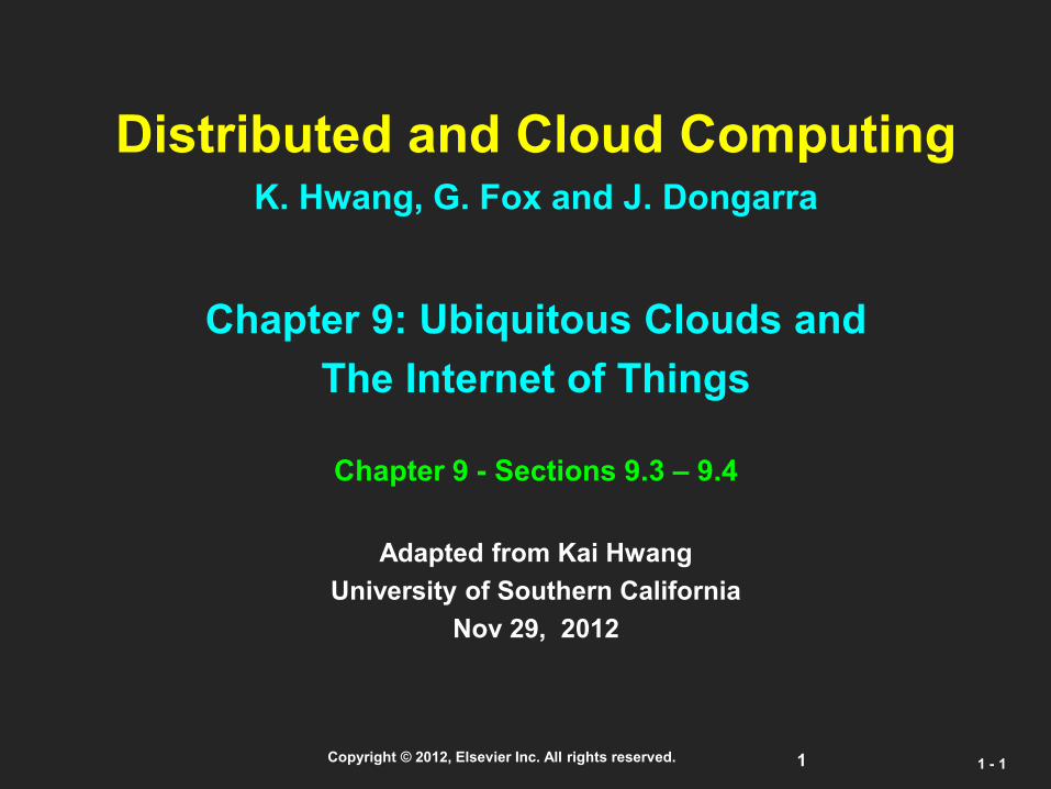
Some Cloud Services To Enable IoT Applications
1. Smart and pervasive cloud applications for individuals, homes,
communities, companies, and governments, etc.
2. Coordinated calendar, itinerary, job management, events, and
consumer record management (CRM) services
3. Coordinated word processing, on-line presentations, web-based
desktops, sharing on-line documents, datasets, photos, video, and
databases, etc.
4. Deploy conventional cluster, grid, P2P, social networking
applications in cloud environments, more cost-effectively.
5. Earthbound applications that demand elasticity and parallelism
rather data movement Costs

8
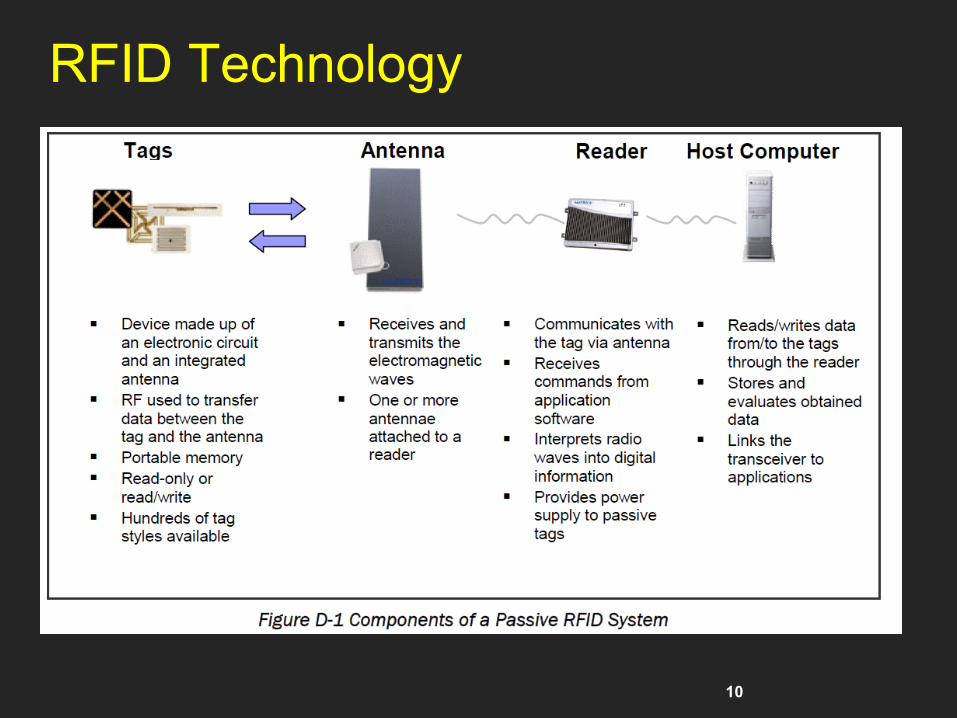
RFID : Radio Frequency IDentification Technology
RFID refers to small electronic devices that consist of a small chip and an antenna.
Chip typically can carry 2,000 bytes of data or less.
RFID chip next to a grain of rice. This chip contains a radio-frequency
electromagnetic field coil that modulates an external magnetic field to
transfer a coded identification number when queried by a reader
device. This small type is incorporated in consumer products, and even
implanted in pets, for identification.
An RFID tag used for
electronic toll collection.
http://en.wikipedia.org/wiki/Radio-frequency_identification
9
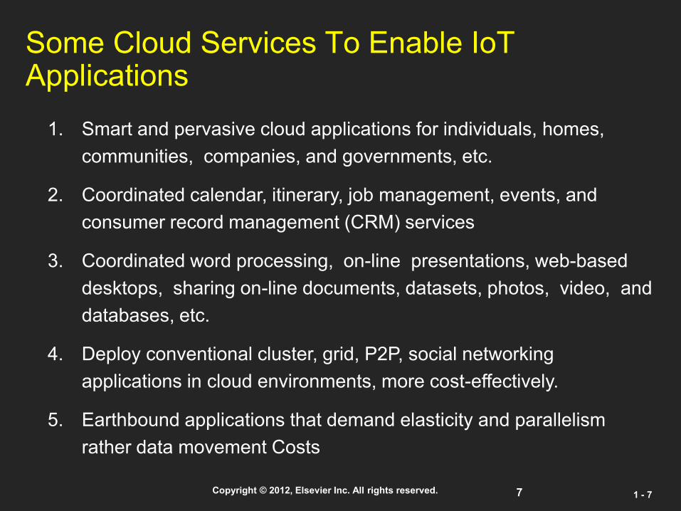
Bar Codes vs. RFID
tag, backed by data processing system
line-of-sight
immutable info
zero cost (…)
• tag, backed by
massive data
processing system
• no line-of-sight
• reprogrammable
• non-zero cost (target price: 10 cents)
• more dynamic
tracking
10
RFID Technology

11
RFID Technology
12 Copyright © 2012, Elsevier Inc. All rights reserved. 1 - 12
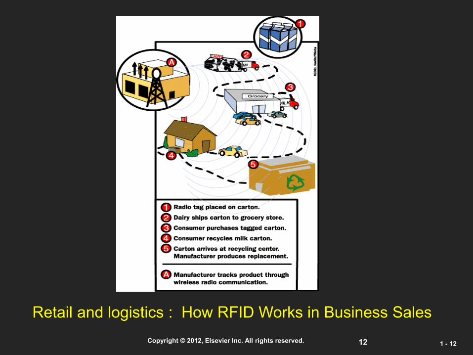
Retail and logistics : How RFID Works in Business Sales

13 Copyright © 2012, Elsevier Inc. All rights reserved. 1 - 13
RFID Merchandize Tracking
in Distribution Center

14 Copyright © 2012, Elsevier Inc. All rights reserved. 1 - 14

15 Copyright © 2012, Elsevier Inc. All rights reserved. 1 - 15
Sensor Nets: Enabling Technologies
Embedded Networked
Sensing
Control system w/
Small form factor
Untethered nodes
Exploit
collaborative
Sensing, action
Tightly coupled to physical world
Embed numerous distributed
devices to monitor and interact
with physical world
Network devices
to coordinate and perform
higher-level tasks
Exploit spatially/temporally dense, in situ/remote, sensing/actuation
16
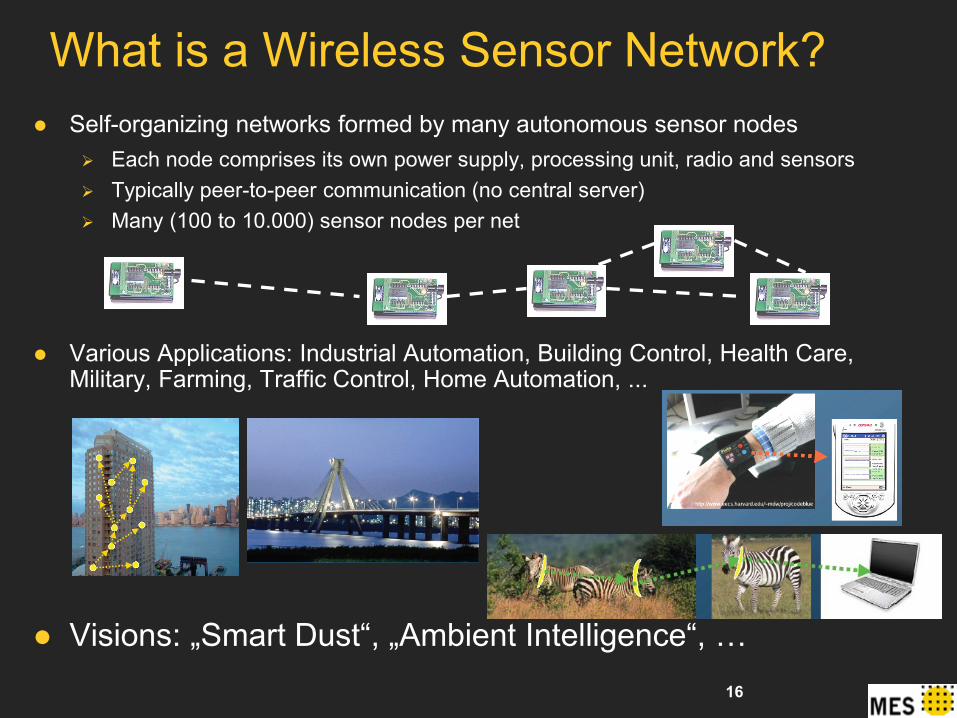
Self-organizing networks formed by many autonomous sensor nodes Each node comprises its own power supply, processing unit, radio and sensors
Typically peer-to-peer communication (no central server)
Many (100 to 10.000) sensor nodes per net
Various Applications: Industrial Automation, Building Control, Health Care, Military, Farming, Traffic Control, Home Automation, ...
Visions: „Smart Dust“, „Ambient Intelligence“, …
What is a Wireless Sensor Network?
17
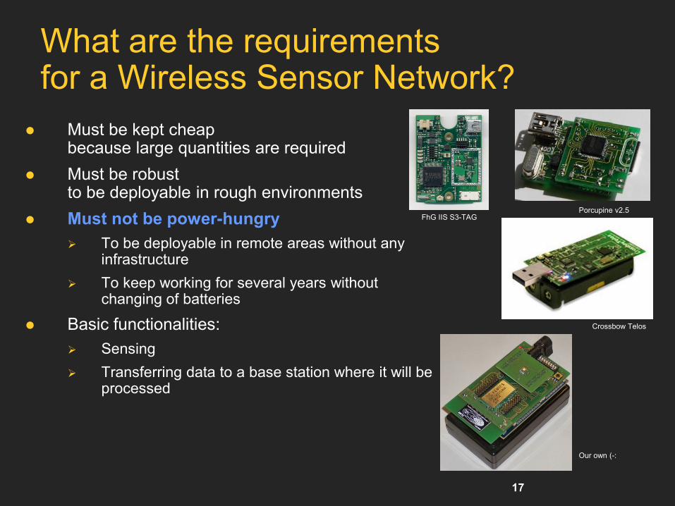
What are the requirements for a Wireless Sensor Network?
Must be kept cheap because large quantities are required
Must be robust to be deployable in rough environments
Must not be power-hungry
To be deployable in remote areas without any infrastructure
To keep working for several years without changing of batteries
Basic functionalities:
Sensing
Transferring data to a base station where it will be processed
Crossbow Telos
FhG IIS S3-TAG Porcupine v2.5
Our own (-:

18
Wireless Sensor Networks(WSN)
Unique characteristics of a WSN include:
Limited power they can harvest or store
Ability to withstand harsh environmental conditions
Ability to cope with node failures
Mobility of nodes
Dynamic network topology
Communication failures
Heterogeneity of nodes
Large scale of deployment
Unattended operation
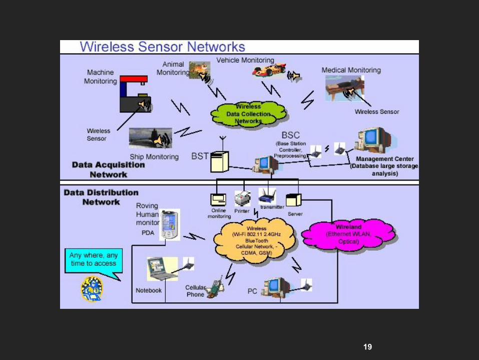
19
20
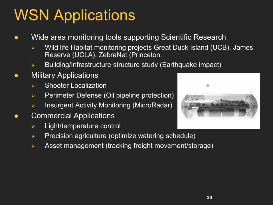
WSN Applications
Wide area monitoring tools supporting Scientific Research
Wild life Habitat monitoring projects Great Duck Island (UCB), James Reserve (UCLA), ZebraNet (Princeton.
Building/Infrastructure structure study (Earthquake impact)
Military Applications
Shooter Localization
Perimeter Defense (Oil pipeline protection)
Insurgent Activity Monitoring (MicroRadar)
Commercial Applications
Light/temperature control
Precision agriculture (optimize watering schedule)
Asset management (tracking freight movement/storage)
21
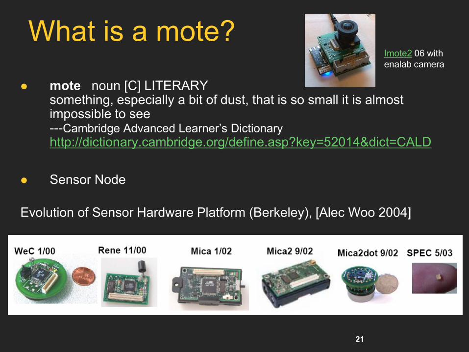
What is a mote?
mote noun [C] LITERARY something, especially a bit of dust, that is so small it is almost impossible to see ---Cambridge Advanced Learner’s Dictionary
http://dictionary.cambridge.org/define.asp?key=52014&dict=CALD
Sensor Node
Evolution of Sensor Hardware Platform (Berkeley), [Alec Woo 2004]
Imote2 06 with
enalab camera
22
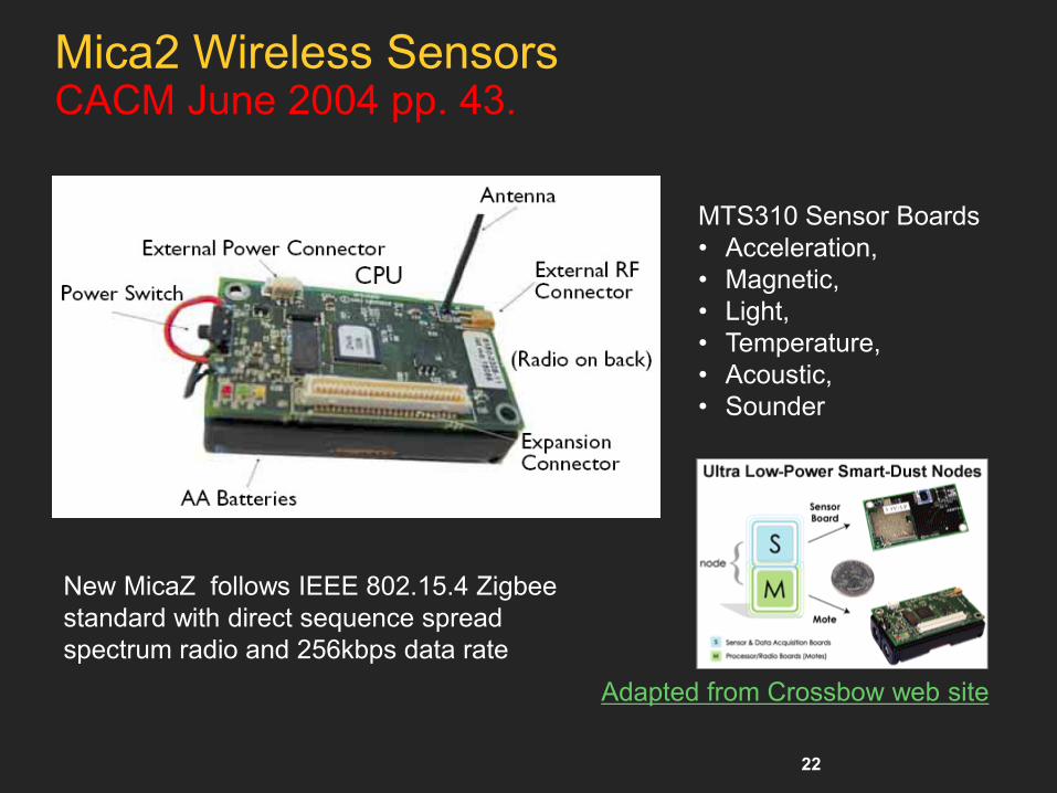
Mica2 Wireless Sensors CACM June 2004 pp. 43.
Adapted from Crossbow web site
New MicaZ follows IEEE 802.15.4 Zigbee
standard with direct sequence spread
spectrum radio and 256kbps data rate
MTS310 Sensor Boards
• Acceleration,
• Magnetic,
• Light,
• Temperature,
• Acoustic,
• Sounder

23
Motes and TinyOS
Motes (Mica2, Mica2dot, MicaZ) ATMega128L microcontroller
128KB program flash; 512KB measurement Flash; 4KB EEPROM
Standard platform with built-in radio chicon1000 (433MHz, 916MHz, 2.4GHz) 38.4kb; 256kbps for MicaZ IEEE 802.15.4. (1000ft, 500ft; 90/300ft) range
AA battery
Existing TinyOS code base
Convenient form factor for adding sensors
TinyOS TinyOS is an open source, BSD-licensed operating system
designed for low-power wireless devices, such as those used in sensor networks, ubiquitous computing, personal area networks, smart buildings, and smart meters.

24
Wireless Sensor Network
Stargate
• 802.11a/b
• Ethernet
• Mica2
• PCMCIA
• Compact flash
• USB
• JTAG
• RS232

25
Example: Trains in Time, Kristian Kloeckl
http://senseable.mit.edu/trainsofdata/

26 Copyright © 2012, Elsevier Inc. All rights reserved. 1 - 26
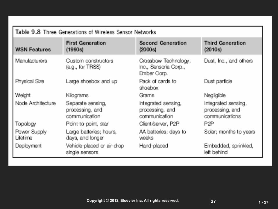
27 Copyright © 2012, Elsevier Inc. All rights reserved. 1 - 27
28 Copyright © 2012, Elsevier Inc. All rights reserved. 1 - 28
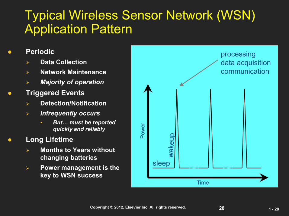
Typical Wireless Sensor Network (WSN) Application Pattern
Periodic
Data Collection
Network Maintenance
Majority of operation
Triggered Events
Detection/Notification
Infrequently occurs
But… must be reported
quickly and reliably
Long Lifetime
Months to Years without
changing batteries
Power management is the
key to WSN success
sleep
processing
data acquisition
communication
Po
we
r
Time

29 Copyright © 2012, Elsevier Inc. All rights reserved. 1 - 29
ZigBee Applications (Wireless Home-Area Networks, WHAN)
http://www.zigbee.org/
asset mgt
process control
environmental
energy mgt
ZigBee Wireless Control that
Simply Works
RESIDENTIAL/
LIGHT
COMMERCIAL
CONTROL
CONSUMER
ELECTRONICS
TV
VCR
DVD/CD
remote
PC &
PERIPHERALS
INDUSTRIAL
CONTROL
PERSONAL
HEALTH CARE
BUILDING
AUTOMATION
mouse
keyboard
joystick
patient
monitoring
fitness
monitoring
ZigBee Wireless Control that
Simply Works
ZigBee Wireless Control that
Simply Works
TV
VCR
DVD/CD
remote
ZigBee Wireless Control that
Simply Works
mouse
keyboard
joystick
TV
VCR
DVD/CD
remote
security
HVAC
lighting control
access control
lawn & garden
irrigation
ZigBee Wireless Control that
Simply Works
security
HVAC
AMR
lighting control
access control
RESIDENTIAL/
LIGHT
COMMERCIAL
CONTROL
INDUSTRIAL
CONTROL
RESIDENTIAL/
LIGHT
COMMERCIAL
CONTROL INDUSTRIAL
CONTROL
RESIDENTIAL/
LIGHT
COMMERCIAL
CONTROL

30
Why ZigBee?
Pervasive Ad-hoc Self-organizing Mesh Networks
Configurable Radio Range: based on service
requirements, from contactless (~cm) to meters and
even kilometers, using multi-hop
High Security Level (encryption and authentication at all
protocol layers, concept of trust center, no collisions)
Easy integration with appliance/terminals in
miniaturized peripherals with integrated antenna

31 Copyright © 2012, Elsevier Inc. All rights reserved. 1 - 31
ZigBee Architecture
Zigbee Devices
Full Function Devices (FFD’s)- ZigBee Coordinator , ZigBee Router
Reduced Function Devices (RFD’s)- ZigBee End Device
ZigBee Coordinator (ZC)
Only one required for each ZB network, Initiates network
Acts as 802.15.4 2003 PAN coordinator (FFD).
May act as router once network is formed.
ZigBee Router (ZR) : Optional component, may associate with ZC ,
Acts as 802.15.4 2003 coordinator (FFD). Multihop routing of messages.
ZigBee End Device (ZED) : Optional network component, Shall
not allow association, Shall not participate in routing.

32
• 65,536 network (client) nodes
• 27 channels over 2 bands
• 250Kbps data rate
• Optimized for timing-critical applications and power management
• Full Mesh Networking Support
Network coordinator
Full Function node
Reduced Function node
Communications flow
Virtual links
Basic Network Characteristics

33
ZigBee Device Types
ZigBee Coordinator (ZC)
One required for each ZB network.
Initiates network formation.
ZigBee Router (ZR)
Participates in multihop routing of messages.
ZigBee End Device (ZED)
Does not allow association or routing.
Enables very low cost solutions

34
ZigBee Network Topologies
ZigBee Coordinator
ZigBee Router
ZigBee End Device
Star
Mesh
Cluster Tree

35
Some Application Profiles
Home Automation [HA] Defines set of devices
used in home automation
Light switches
Thermostats
Window shade
Heating unit
etc.
Industrial Plant Monitoring
Consists of device definitions for sensors used in industrial control
Temperature
Pressure sensors
Infrared
etc.
36
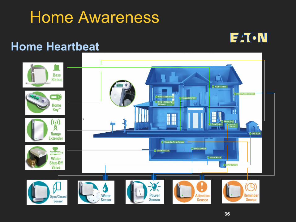
Home Awareness
Home Heartbeat

37
Z-SIM: M-commerce and Beyond
Service
Center Distribution Network
Digital Smart City Access Control
Parking payment system
Infomobility services (e.g. traffic
control)
Environmental Monitoring
Localization
M-Commerce Services m-payments (bar, shops, supermarkets)
m-ticketing (cinema, train, bus)
Home
Automation&Control Lights, HVAC, Domestic
appliances
Entertainment (e.g. DTT)
Healthcare, Tele-assistance
Monitoring & Security (e.g.
temperature, gas)
Mobile
Terminal
Z-SIM is the hub of the interaction between user and objects
ZigBee
Smart Home

38
Mobile Handset as ZigBee Gateway
Use mobile handset as a gateway to collect and display information
In a mobile phone a ZigBee enabled SIM, the personal token, can play the Gateway role
Service
Center NETWORK
OPERATOR
INFRASTRUCTURE 1.
Confirmation
for buying
“Il fuggiasco”.
Push Ok. ZigBee Network
The Telecom operator does more than transport data:
Trust-Center: security, user authentication, reliability
Service Provider of new value-added services
Service management, configuration and
personalization

39
Use Case : Cinema Example
DB
Do you
confirm the
purchase of
“La fabbrica di
cioccolato”?
STEP 2:
User having Z-SIM
is recognized by
the environment
and is invited to
buy a cinema ticket
GPRS/UMTS
Encrypted
SMS
Step 3:
The users with SIMTOOLKIT application buy the
content. The operator manages the bill
transaction and downloads the token to the SIM
for enabling the access to the cinema
STEP 1:
Environment with ZigBee node
Cinema
Step 4:
The token is received
and sent to the printer
via ZigBee
The ticket is
automatically printed
40
What’s Z-SIM? ZigBee node fully integrated in a SIM card (Antenna + RF + Processing)
• User centric approach
The SIM has all the user information in terms of profiling, service
personalization, credit
SIM is the Key-element for security, trusted environment (user authentication,
content protection)
Gateway on SIM guarantees the permanent connection between Service
Center and Ad hoc network for gathering info and reconfiguration
A SIM usable in all mobile terminals
• Mobile terminal independency (no changes needed in the mobile terminal, like
for BT, NFC)
ZSIM is independent from terminal tiers
• Not invasive technology: transparent to the user
Enabler for a multitude of innovative services
• Interaction with objects (Internet of Things)
• M-commerce: payments and ticketing
• Accelerating fixed and mobile convergence
1 2 34 5 67 8 9* 0 #
1 2 34 5 67 8 9* 0 #
1 2 34 5 67 8 9* 0 #
SIM
Functions
SIM
Functions
Transceiver
+
Antenna
Transceiver
+
Antenna
I/O
Interface
I1
Interface
I1
I/O
Z-SIM
Z-SIM

41 Copyright © 2012, Elsevier Inc. All rights reserved. 1 - 41
24 Satellites of GPS Deployed in Outer space

42 Copyright © 2012, Elsevier Inc. All rights reserved. 1 - 42
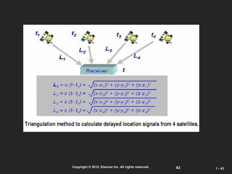
GPS Operation Principle
43 Copyright © 2012, Elsevier Inc. All rights reserved. 1 - 43
44 Copyright © 2012, Elsevier Inc. All rights reserved. 1 - 44
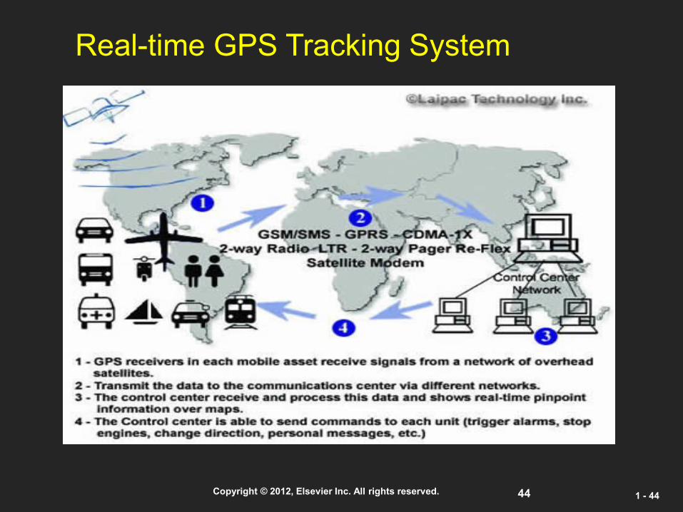
Real-time GPS Tracking System

45
Example:
Service Oriented Architecture for Geographic Information Systems Supporting Real Time Data Grids
Galip Aydin Department Of Computer Science, Indiana University
A Geographic Information System is a system for creating, storing, sharing, analyzing, manipulating and displaying spatial data and associated attributes.
Modern GIS requires:
Distributed data access for spatial databases
Utilizing remote analysis, simulation, or visualization tools.
46
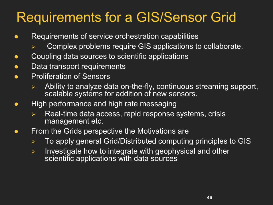
Requirements for a GIS/Sensor Grid
Requirements of service orchestration capabilities
Complex problems require GIS applications to collaborate.
Coupling data sources to scientific applications
Data transport requirements
Proliferation of Sensors
Ability to analyze data on-the-fly, continuous streaming support, scalable systems for addition of new sensors.
High performance and high rate messaging
Real-time data access, rapid response systems, crisis management etc.
From the Grids perspective the Motivations are
To apply general Grid/Distributed computing principles to GIS
Investigate how to integrate with geophysical and other scientific applications with data sources
47
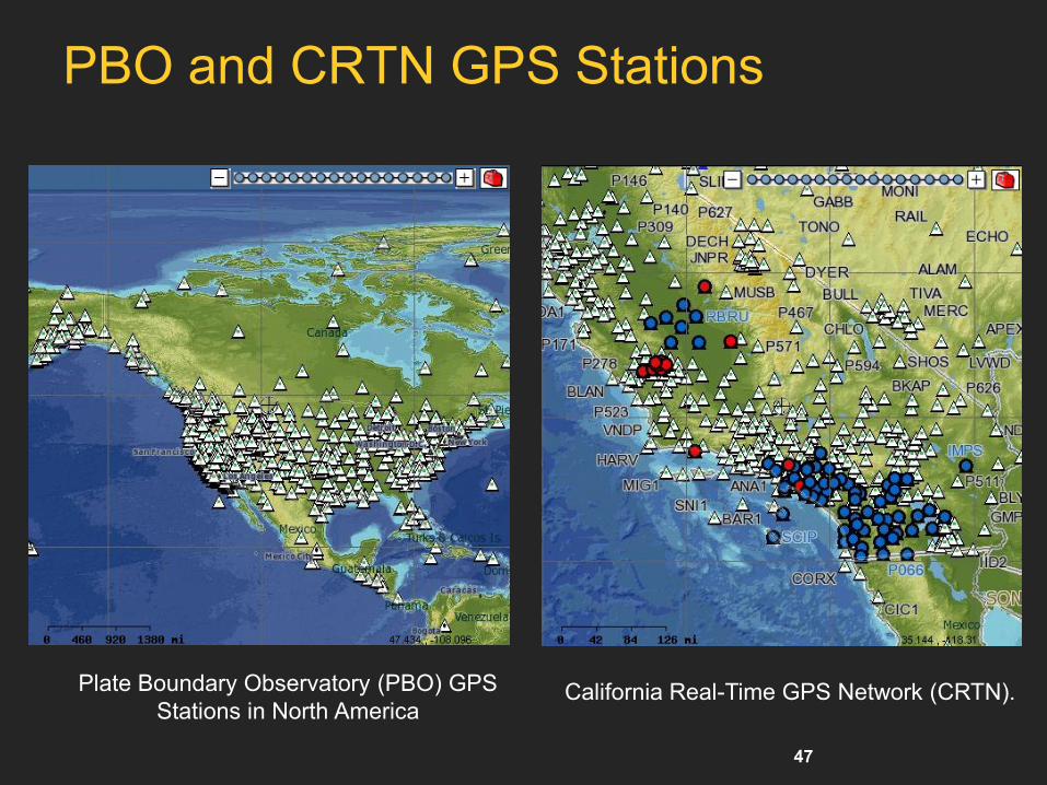
PBO and CRTN GPS Stations
Plate Boundary Observatory (PBO) GPS
Stations in North America California Real-Time GPS Network (CRTN).

48
Research Issues 1
Applying Web Service principles to GIS data services
Orchestration of Services, workflows. We need services suitable for large data sets and where quick response is required.
High Performance support in GIS services
The performance problem must be addressed in a complete and general framework supporting different data requirements
Interoperability
The system should bridge GIS and Web Service communities by adapting standards from both.
Other GIS applications should be able to consume data without having to do costly format conversions.
49
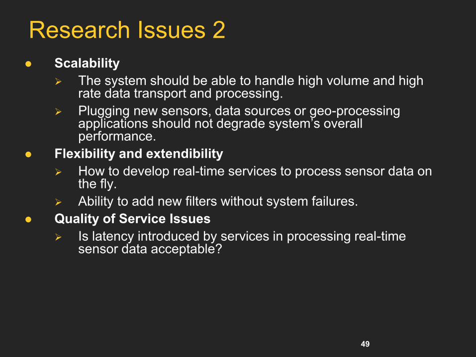
Research Issues 2
Scalability
The system should be able to handle high volume and high rate data transport and processing.
Plugging new sensors, data sources or geo-processing applications should not degrade system’s overall performance.
Flexibility and extendibility
How to develop real-time services to process sensor data on the fly.
Ability to add new filters without system failures.
Quality of Service Issues
Is latency introduced by services in processing real-time sensor data acceptable?

50
SOA for GIS – Geophysical Data Grid
To create a GIS Data Grid (Geophysical Grid) Architecture we utilize
Web Services to realize Service Oriented Architecture
OGC data formats and application interfaces to achieve interoperability at both data and service levels.
GIS Data Grid Features
Depending on the source, geospatial data can be archival or real-time. The architecture provides standard control and access interfaces for both types.
Supports alternate transport and representation schemes, uses topic based messaging infrastructure for data and message exchange.
Streaming and non-streaming services to access archived data.
Real-Time and near real-time filter services for accessing sensor metadata and sensor measurements.

51
GIS Grid Usage Model – Earthquake Science
Supporting geophysical repositories and real-time sensors is essential
To analyze a typical earthquake it is important to access to precise measurements of the initial earthquakes and aftershocks
To support earthquake forecasting and the time and spatial positions of the forecasts
Earth Science field is moving from a previously data poor field to a data rich world. There will be thousands of sensors spread around the world. (i.e. GPS sensors, satellites)
52
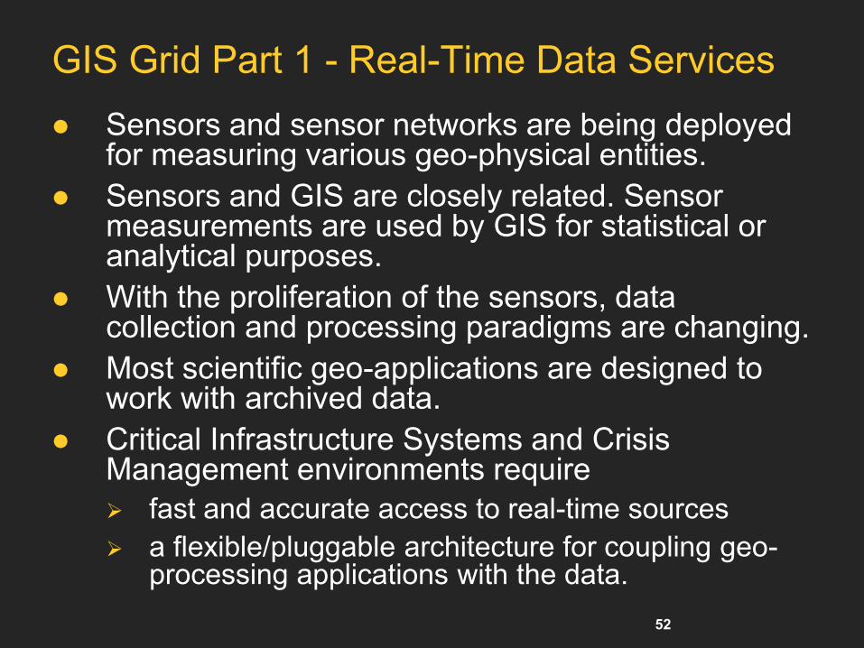
GIS Grid Part 1 - Real-Time Data Services
Sensors and sensor networks are being deployed for measuring various geo-physical entities.
Sensors and GIS are closely related. Sensor measurements are used by GIS for statistical or analytical purposes.
With the proliferation of the sensors, data collection and processing paradigms are changing.
Most scientific geo-applications are designed to work with archived data.
Critical Infrastructure Systems and Crisis Management environments require
fast and accurate access to real-time sources
a flexible/pluggable architecture for coupling geo-processing applications with the data.

53
Sensor Grid Architecture
Major components:
Real-Time filters
Publish-Subscribe
System
Information Service
Filters can be run as Web
Services to create
workflows.
Filter Chains can be
deployed for complex
processing.
Streaming messaging
provides high-performance
transfer options.
54
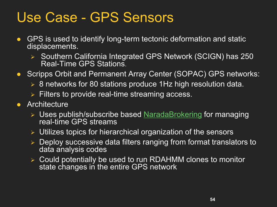
Use Case - GPS Sensors
GPS is used to identify long-term tectonic deformation and static displacements.
Southern California Integrated GPS Network (SCIGN) has 250 Real-Time GPS Stations.
Scripps Orbit and Permanent Array Center (SOPAC) GPS networks:
8 networks for 80 stations produce 1Hz high resolution data.
Filters to provide real-time streaming access.
Architecture
Uses publish/subscribe based NaradaBrokering for managing real-time GPS streams
Utilizes topics for hierarchical organization of the sensors
Deploy successive data filters ranging from format translators to data analysis codes
Could potentially be used to run RDAHMM clones to monitor state changes in the entire GPS network
55
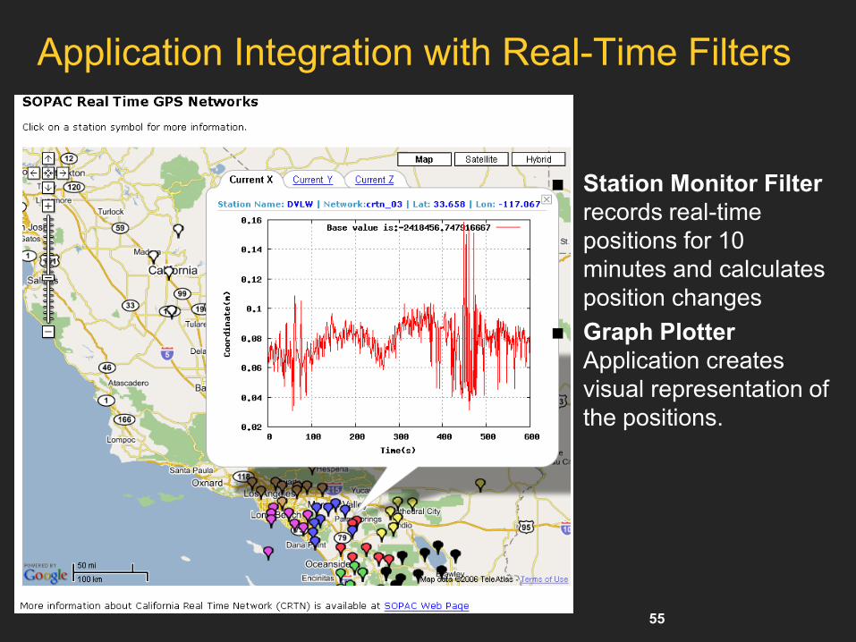
Application Integration with Real-Time Filters
Station Monitor Filter
records real-time
positions for 10
minutes and calculates
position changes
Graph Plotter
Application creates
visual representation of
the positions.

56 Copyright © 2012, Elsevier Inc. All rights reserved. 1 - 56
Cyber Physical Systems (CPSs)

57 Copyright © 2012, Elsevier Inc. All rights reserved. 1 - 57
IoT Telemedicine Applications:
Patient Data Transferred Using a Wireless Sensor Network.
(Courtesy of Inftech, 2007)

58 Copyright © 2012, Elsevier Inc. All rights reserved. 1 - 58
Example: Internet of Things: Sensor Grids A pleasingly parallel example on Clouds
A sensor (“Thing”) is any source or sink of time series
In the thin client era, smart phones, Kindles, tablets, Kinects, web-cams are sensors
Robots, distributed instruments such as environmental measures are sensors
Web pages, Googledocs, Office 365, WebEx are sensors
Ubiquitous Cities/Homes are full of sensors
They have IP address on Internet
Sensors – being intrinsically distributed are Grids
However natural implementation uses clouds to consolidate and control and collaborate with sensors
Sensors are typically “small” and have pleasingly parallel cloud implementations
58
(Courtesy of Geoffrey Fox, 2012)

59 Copyright © 2012, Elsevier Inc. All rights reserved. 1 - 59
Sensors as a Service (SaaS)
Sensors as a Service
Sensor Processing as a
Service (MapReduce)
A larger sensor ………
Output Sensor
(Courtesy of Geoffrey Fox, 2012)

60
Example:
Sensor Service GRID for Publishing Atmospheric Brown Cloud Observation Data in ICIMOD
HONDA Kiyoshi, A. Witayangkurn, R. Chinnachodteeranun, A. Shrestha, P. Koanantakool
Asian Institute of Technology
KhunSan Aung
ICIMOD

61
Background
Field Sensor Network Small and Low Cost Sensors
Wireless Field Platform
Mobile Internet
Real-Time Field Data Environment, Disaster, Agriculture
High Investment for System Development Communication
Archiving
Publishing
62
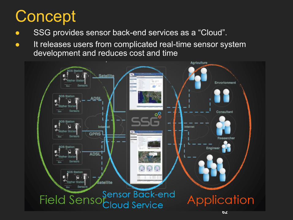
Concept SSG provides sensor back-end services as a “Cloud”.
It releases users from complicated real-time sensor system development and reduces cost and time
63
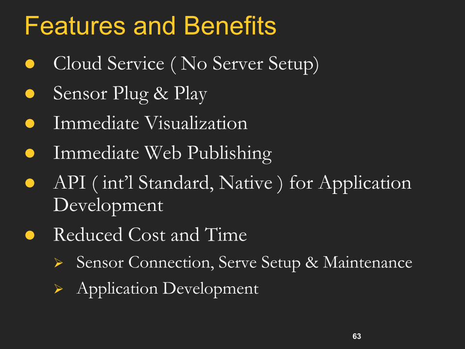
Features and Benefits
Cloud Service ( No Server Setup)
Sensor Plug & Play
Immediate Visualization
Immediate Web Publishing
API ( int’l Standard, Native ) for Application Development
Reduced Cost and Time
Sensor Connection, Serve Setup & Maintenance
Application Development
64
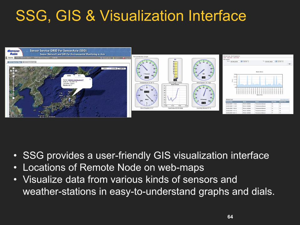
SSG, GIS & Visualization Interface
• SSG provides a user-friendly GIS visualization interface
• Locations of Remote Node on web-maps
• Visualize data from various kinds of sensors and
weather-stations in easy-to-understand graphs and dials.

65
Sensor Plug and Play Easy to add new sensor to SOS station
Select a Sensor Model
Edit Sensor Spec
Add Sensor
• Select Sensor Model and Edit
• Configure Sensor Setting even Remotely
• The system automatically starts archiving, changes interface.
• No Programming Required -> Reduce Cost
66 Copyright © 2012, Elsevier Inc. All rights reserved. 1 - 66
Innovative Applications of
The Internet of Things
67 Copyright © 2012, Elsevier Inc. All rights reserved. 1 - 67
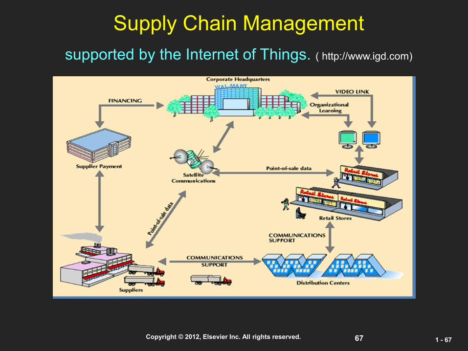
Supply Chain Management
supported by the Internet of Things. ( http://www.igd.com)

68 Copyright © 2012, Elsevier Inc. All rights reserved. 1 - 68
Smart Building Using IOT Technology

69 Copyright © 2012, Elsevier Inc. All rights reserved. 1 - 69
Smart Power Grid

70 Copyright © 2012, Elsevier Inc. All rights reserved. 1 - 70
Opportunities of IOT in 3 Dimensions