Embed Size (px)
Citation preview
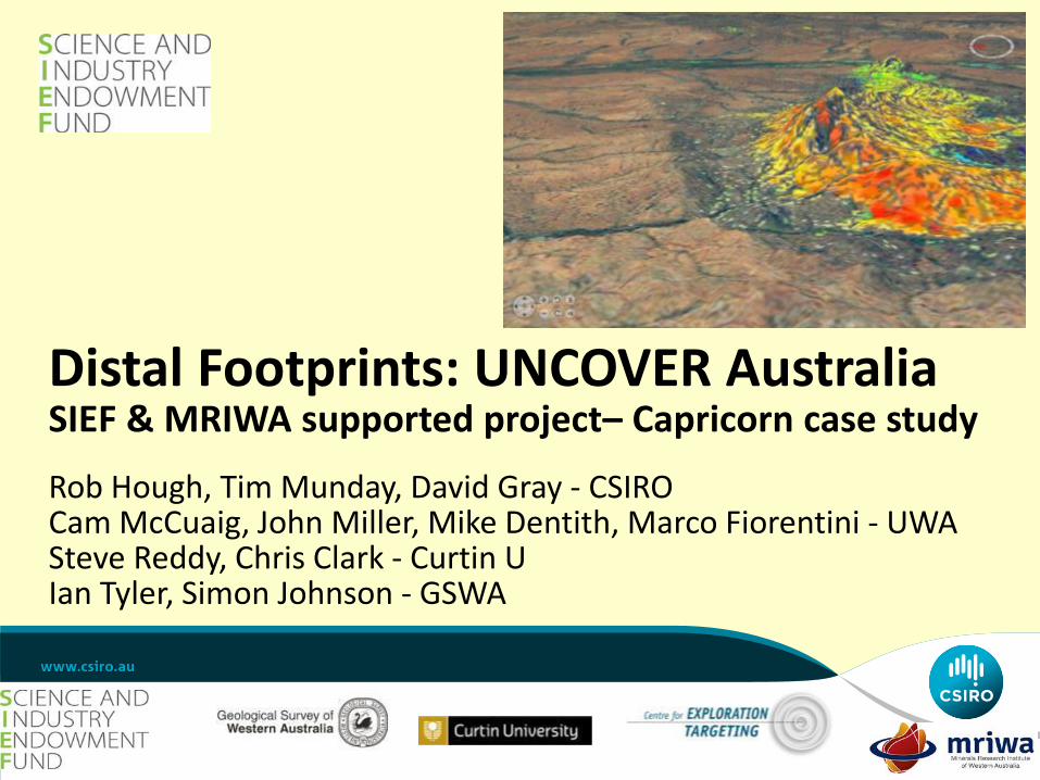
Distal Footprints: UNCOVER Australia SIEF & MRIWA supported project– Capricorn case study Rob Hough, Tim Munday, David Gray - CSIRO Cam McCuaig, John Miller, Mike Dentith, Marco Fiorentini - UWA Steve Reddy, Chris Clark - Curtin U Ian Tyler, Simon Johnson - GSWA


The Exploration Challenge
PDAC 2012
A New Search Space
Deep Exploration Targeting
Theme 1: A Mineral System Approach to the Capricorn Orogen • Understand the Capricorn mineral system in the context
of the 4D evolution of the Orogen • Important tectonic processes that have affected it
throughout its evolution • Different geodynamic settings that have affected the
region of its geological history. • Basis for understanding known ore deposits, and their
likely expression as distal footprints • Framework for regolith development and context for
future exploration.
PDAC 2012

Theme 1.1: Architecture of the Capricorn Orogen • Translate known western crustal structures into the eastern part of
the Orogen, where the rocks are poorly exposed. • Variety of deep geophysical techniques • 3D geologically attributed map of the distribution of magnetization
and density. • Magnetic modelling and inversion will incorporate estimates of
resultant magnetization direction for all prominent anomalies • Long period MT surveys across the study area. Geochemistry etc
also acquired as part of other Themes • Regional characterisation of geology, geochemistry and
geophysics from the top few metres to more than 100 km depth • Seismic recordings will complement the MT data
PDAC 2012

Capricorn Overview
Johnson et al 2011
PDAC 2012
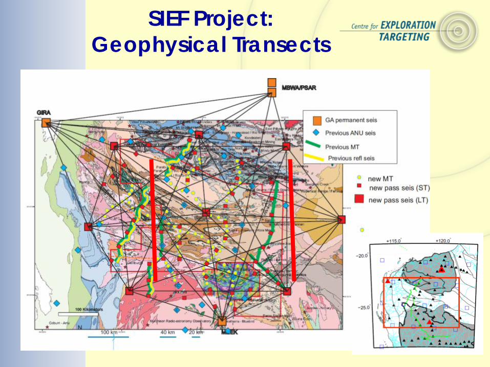
SIEF Project: Geophysical Transects
• 4-year passive source array deployment • 9-station 2D reference array at all time • 20 x 2 transects
Theme 1.2: Tectonic & Geodynamic Evolution • Reconstruct the earlier history of the crustal blocks caught up in
the Orogen and establish the role of continental margin formation in the potential enrichment of ore deposit precursors within the orogeny
• Immobile trace elements geochemistry. • U-Pb, O and Hf isotopes in key phases (e.g. zircon) within granitic
rocks and gneisses will provide constraints on the location and timing of melting and by inference the tectonic environment.
PDAC 2012

Time-Space Plot
Johnson 2013
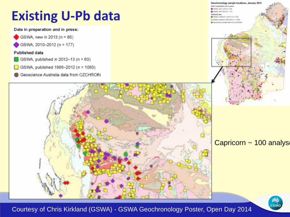
Existing U-Pb data
Courtesy of Chris Kirkland (GSWA) - GSWA Geochronology Poster, Open Day 2014
Capricorn ~ 100 analyse

Existing Capricorn data • U-Pb (geochronology)
Planned Capricorn zircon data • U-Pb (geochronology) • Trace elements geochemistry (e.g. Ti for Temperature) • REE (LREE vs HREE) • Hf isotope data (crustal residence time) • O data (crust vs mantle sources)
Zircon Geochemistry
PDAC 2012

Theme 1.3: Fluid Sources, Transport & Deposition • Precisely date mineralization, subject to access to paragenetically
well-constrained samples, using in-situ ion microprobe geochronology (zircon and phosphate dating)
• Link surface fluid flow to potential sources at depth. • focus on radiogenic (Lu–Hf) and stable isotopes (O & H) of
minerals (such as zircon, monazite and xenotime) and whole rocks, as well as trace element analyses,
• Analysis of microstructurally characterized fluid inclusions will be used to establish fluid chemistry and PT conditions of entrapment
PDAC 2012

Theme 2: Characterisation of Cover in the Capricorn Orogen • Combine regional geophysical and geochemical datasets • Effectively explore in remote and complex environments • Define the nature of the cover. • New datasets for exploring the Capricorn Orogen • New protocols for data integration and interpretation • Input from geophysics, remote sensing, geology, regolith science and
exploration geochemistry etc. • Depth to basement and 3D regolith framework will support other
exploration methods e.g. geochemistry. • Critical importance of sediment filled palaeovalleys. Sometimes
>150m deep and several km wide. Prospective for both U and CIDs • Geometry and internal variability mapped by a regional AEM survey
PDAC 2012
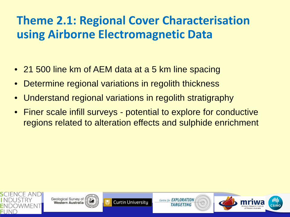
Theme 2.1: Regional Cover Characterisation using Airborne Electromagnetic Data
• 21 500 line km of AEM data at a 5 km line spacing • Determine regional variations in regolith thickness • Understand regional variations in regolith stratigraphy • Finer scale infill surveys - potential to explore for conductive
regions related to alteration effects and sulphide enrichment
PDAC 2012

Presentation title | Presenter name | Page 15
first vertical derivative magnetics conductivity from
the AEM from ~15 to 20 m Gaining knowledge of
Depth through the AEM
Multi-resolution Valley Bottom Flatness (MrVBF) (Gallant and Dowling, 2003). Flatness index using DEM
TEMPEST Survey
SPECTREM Survey
60-100m
PDAC 2012

Mapping and Working with Regolith Complexity A B
Geochemical sampling domains
AEM Section
Interpreted Regolith Section
Cover | Gray & Munday| Page 16 PDAC 2012

Outputs - Regolith Thickness (from AEM) – link to Geochemistry – eg Cu
Cover | Gray & Munday| Page 17 PDAC 2012
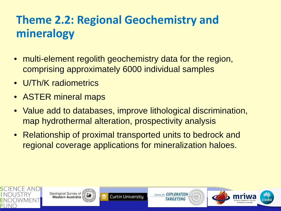
Theme 2.2: Regional Geochemistry and mineralogy
• multi-element regolith geochemistry data for the region, comprising approximately 6000 individual samples
• U/Th/K radiometrics • ASTER mineral maps • Value add to databases, improve lithological discrimination,
map hydrothermal alteration, prospectivity analysis • Relationship of proximal transported units to bedrock and
regional coverage applications for mineralization haloes.
PDAC 2012

Large scale lithological and weathering effects
PDAC 2012

Alteration assemblages
PDAC 2012

Theme 2.3: Regional Geochemistry Protocols
• Individual site will be selected to address specific problems
• Possibly Ashburton, Bryah-Padbury and Sylvania regions • Establish optimal sample media in the different regolith-
landform settings • Information on geochemical thresholds
PDAC 2012

PDAC 2012
How will this assist geochemical sampling?

Theme 3: Mineral hosts as Distal Footprints
• What are the distal footprints associated with mineral deposits? • A ‘distal footprints toolbox’, applied to exploration in the Capricorn
Orogen. E.g., • rutile is a useful mineral indicator that can survive prolonged
weathering, • goethite and hematite clasts can replace sulfides and retain primary
metal anomalism • alluvial gold grains are proving valuable in provenance studies. • Weathering sulfides can be reprecipitated into the cover sediments as
secondary minerals such as alunite useful anomalism indicator? • interface sampling at the base of unconformities in covered terrains,
or specific mineral species within the cover sediments • Develop understanding of key indicator elements and their mineral
associations at different distances from different ore deposit types
PDAC 2012

Theme 3.1: Characterization of distal footprints
• Hydrothermal rutile and magnetite as pathfinder minerals for mineral exploration through sampling of top of fresh rock, and base of transported overburden.
• Elements in these minerals can display characteristic signatures used to fingerprint hydrothermal ore deposits
• Apatite can be a useful mineral host for a magmatic signature with anomalous iron. Halogen signatures of mineralizing fluids in a system might be preserved in the apatite
• Targeting secondary minerals such as alunite, and iron oxides • Distal Footprint indicators
PDAC 2012

HMC
PDAC 2012

Theme 3.2: The Distal Footprint Toolbox
• Outline an approach for early exploration in a covered terrain, e.g.: • Major discontinuities in the upper and lower crust and mantle
lithosphere in a 3D volume of the crust as a vector to mineral systems
• How thick is cover in a given region? How do you use the geophysical data, the nature of the cover, the palaeosurface and the 3D regolith framework to prospect this ancient landscape.
• Using fresh rock analysis for a background v anomalism picture for alteration, lithogeochmistry, & indications of a potential mineralized system.
• Analysing faults for signatures of spent as well as pregnant fluid flux • Understanding the pre collisional structure as an indication of
potential fertility • Detecting the mineral system footprint through analysis.
PDAC 2012

• Map the hydrogeochemistry of specified areas within or adjacent to the Capricorn Orogen, to an approximate 5km spacing
• Determine background concentrations of elements with exploration importance for different rock types
• Modify and improve exploration parameters developed in previous project
• Develop utility of isotopes in groundwater for structural and prospectivity analysis
• Improve information on the prospectivity of the underexplored Capricorn Orogen
• Integrate with AEM, radiometrics and mapped soil geochemistry
• Disseminate the results and exploration implications of the research to the Industry sponsors
Theme 4: Hydrogeochemistry of the Capricorn
PDAC 2012

Tungsten Distribution – Thomson Belt Highly anomalous for Cuttaburra, consistent with drilling results running 0.41% W
Seeing through 100’s m of exotic cover
PDAC 2012

North Yilgarn Groundwater – Ca rel. Sr
PDAC 2012

Various Indices targeting at Regional & Prospect Scale
• NiS Index • Major Ni deposits
clearly observed • Harmony deposit
strongly anomalous • + additional
anomalies along strike
• Works very well at 10m – km scale
250000 300000
6850000
6900000
6950000
7000000
0 10 20 km
NiS Index > 0.85 0.75 - 0.85 0.60 - 0.75 0.40 - 0.60 < 0.40
Honeymoon Well
Yakabindie
Waterloo
Jaguar
270000
6925000
6930000
6935000 0 1 2 km
Harmony Ni deposit
265000

PDAC 2012
Carnotite Saturation + U:Th Radiometrics

Capricorn (& north Yilgarn) Groundwater Sampling
PDAC 2012

Theme 5: Geochemical Mapping for Lithospheric Evolution, Metal Reservoirs & Predictive Targeting
PDAC 2012
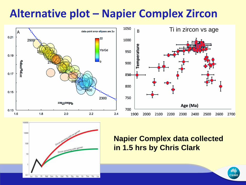
Alternative plot – Napier Complex Zircon Ti in zircon vs age
Napier Complex data collected in 1.5 hrs by Chris Clark
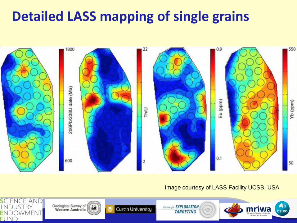
Detailed LASS mapping of single grains
Image courtesy of LASS Facility UCSB, USA
PDAC 2012

Multiple S isotopic Architecture of the Capricorn Orogen
In most mineralised systems, sulfides play a fundamental role in transporting and concentrating a wide range of metals Minerals such as pyrite (FeS2), chalcopyrite (CuFeS2), galena (PbS) are common in both hydrothermal and magmatic ore systems However, it is generally difficult to determine origin and timing of sulfides in ore systems
PDAC 2012

Sources and Sinks Most sulfur isotope studies in ore systems focussed on δ34S (not as insightful as easily reset and modified)
This study will utilise multiple S isotopes (δ34S , δ33S and δ36S) to accurately fingerprint sulfur source and map fluid pathways in magmatic and hydrothermal ore systems
Trace element (Se, Te, Co, Ni, As, Sb, Au, Ag) compositions of pyrite can also be used to correlate sources and sinks of ore forming fluids
Re-Os dating of sulphides to provide a time constraint
Multiple sulfur isotopic map of the orogen is the final goal: will superimpose and integrate with other datasets
Spatial and temporal representation of data is a critical part (=4D), and never done before at this scale
PDAC 2012

Representation of the predicted δS33/δS34 fractionation trend in young
S-bearing compounds (<2.0 Ga) = terrestrial fractionation line
Real world δS33/δS34 Fractionation trend in
S-bearing compounds (<2.0 Ga) Deviation = chemical tracer Re-Os of sulphides to
provide a time constraint
Method
PDAC 2012

The multiple sulfur isotope record
Mass-independent fractionation is a chemically-conservative tracer. For the Proterozoic Capricorn Orogen we will be able to detect if, and where, there is an Archean link to system – will tie with exisitng and new geophysical data generated by SIEF (MT, passive seismic)
PDAC 2012
Theme 6: Digital Model using virtual environments for data integration and visualization
PDAC 2012

Data Portal
PDAC 2012
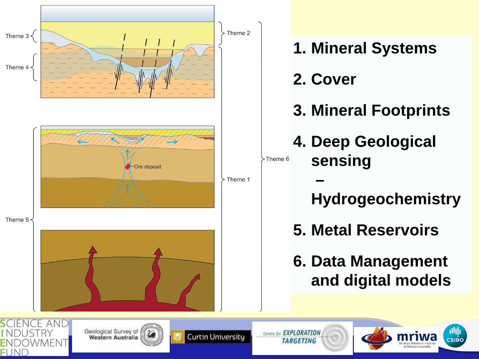
1. Mineral Systems
2. Cover
3. Mineral Footprints
4. Deep Geological sensing – Hydrogeochemistry
5. Metal Reservoirs
6. Data Management and digital models
PDAC 2012


![monazite/zircon and futile]zircon (multiple passes - downloads](https://img.dokumen.tips/doc/110x75/6231ccd013e4e240230def43/monazitezircon-and-futilezircon-multiple-passes-downloads.jpg)