Embed Size (px)
DESCRIPTION
My dissertation from level three undergraduate.
Citation preview

Awakened from the DeadA study of the Impact of Waterfronts on Regeneration and their Heritage Value
Justyn Nathan Landscape Architecture BA (Hons) C3225202January 2011
Contents 1.0 - Introduction
2.0 - Historical Evolution of Waterfronts within Cities 2.1 - Times of Antiquity 2.2 - The British Industrial Revolution 2.3 - The Retreat and Deindustrialisation of the Urban Waterfront 2.3.1 - The Introduction of Intermodal Container Activities and their effect on Labour and City-Port Ties 2.4 - The Initial Return to the Urban Waterfront
3.0 - Case Studies 3.1 - Pier Head, Liverpool 3.2 - Royal Victoria Square, London
4.0 - The Significance of Waterfront Regeneration 4.1 - Place Making 4.1.1 - Perception of Water
5.0 - Preserve - Regenerate - Enhance 5.1 - How does Heritage Inform Site Design within the United Kingdom 5.1.1 - Pier Head 5.1.2 - Royal Victoria Square
1
3456
810
111320
222425
29
30
3031
5.2 - From the Public’s Perception, Are they able to Distinguish that the Regenerated Waterfronts are sites of Imperative Values? 5.2.1 - Pier Head 5.2.2 - Royal Victoria Square
6.0 - Trends within Waterfront Regeneration 6.1 - The Trend of Inner City Living 6.1.1 - Institutional Constraints
7.0 - Conclusion of Study
Bibliography
Appendix
323234
383941
43
47
54
1.0 Introduction Waterfronts play an important part of a cities identity; the historic destination point for transportation and people, always in constant change from former shipping ports to ship yards. Countless waterfronts no longer connect with the outside world in terms of transportation. The once bustling, active and frenzied atmospheres have been left open to the elements.
The Critical Study will cover why the heritage and importance of the city waterfront legacy is imperative to preserve, and how it influences the revitalisation of these delicate sites. As part of this study a meeting was undertaken with the designers of the chosen case studies at AECOM London where a number of questions were posed, the responses of which are included in this report.
The investigation will reflect upon the following case studies:
1. Pier Head, Liverpool: Designed by AECOM London.
2. Royal Victoria Square, London:Designed by AECOM LONDON
The critical study will review the historical outline of waterfronts within cities and why settlements were originally founded in close proximity to water. In addition, there will be a discussion of the changes to Britain’s landscape, which came about as a result of the Industrial Revolution. Furthermore the study will review the loosening of historic port-city ties and how this lead to the retreat and decline of the urban waterfront, for example technological changes within the shipping industry and the introduction of new global transportation methods.
The study will investigate the return to the urban waterfront and review the significance of waterfront regeneration and the effects it has on communities.
1

In addition the study will understand the unique feeling of the waterfront through sense of place and why public are perceptually drawn towards the waters edge. The study will identify the importance of preserving, regenerating and enhancing historic buildings and structures within regeneration projects and how these historic structures can form design implications within the United Kingdom, by reviewing the two case studies and reflecting on the designers’ responses to these issues.
The Critical Study will also examine the trends within waterfront regeneration and review current trends within society such as the fashion of inner-city living and the effect this has on significantly important waterfronts. Following this the report will identify current institutional constraints surrounding waterfront redevelopment within certain US states and how this legislation can be applied to the United Kingdom, to form design restrictions for historic waterfronts.
Waterfronts have significance and are a valuable asset to the landscape, deep in cultural importance and once the hub of a city; therefore the renewal needs to be a sensitive
and sympathetic process which takes into consideration the surrounding character of the landscape. This process is both time consuming and costly (Hoyle et al, 1988). In the current society revitalisation of these delicate hearts is commonly overwhelmed by large developers who see the regeneration as a passageway for finance and investment, instead of preserving and reinstating traditions.
The significance and heritage of landscape is becoming twisted and lost as many waterfronts are regenerated as a modern assortment of office and apartment blocks. The sense of place and strong ties between cities and the waterfront are becoming lost.
2

2.0 Historical Evolutionof Waterfronts within Cities
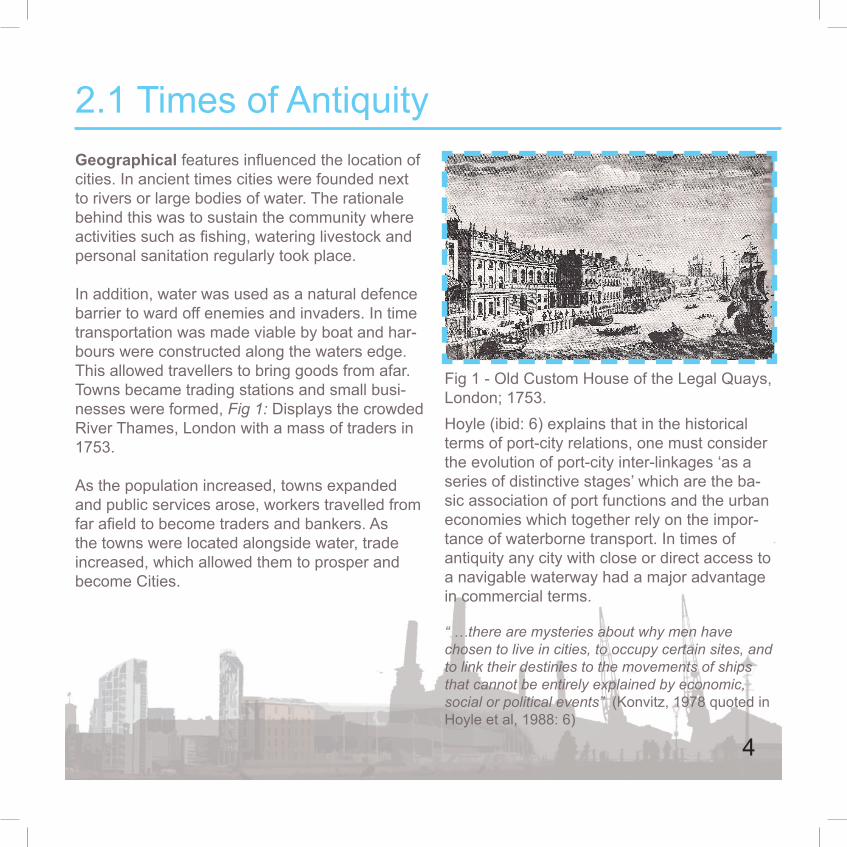
Geographical features influenced the location of cities. In ancient times cities were founded next to rivers or large bodies of water. The rationale behind this was to sustain the community where activities such as fishing, watering livestock and personal sanitation regularly took place.
In addition, water was used as a natural defence barrier to ward off enemies and invaders. In time transportation was made viable by boat and har-bours were constructed along the waters edge. This allowed travellers to bring goods from afar. Towns became trading stations and small busi-nesses were formed, Fig 1: Displays the crowded River Thames, London with a mass of traders in 1753.
As the population increased, towns expanded and public services arose, workers travelled from far afield to become traders and bankers. As the towns were located alongside water, trade increased, which allowed them to prosper and become Cities.
2.1 Times of Antiquity
Fig 1 - Old Custom House of the Legal Quays, London; 1753.Hoyle (ibid: 6) explains that in the historical terms of port-city relations, one must consider the evolution of port-city inter-linkages ‘as a series of distinctive stages’ which are the ba-sic association of port functions and the urban economies which together rely on the impor-tance of waterborne transport. In times of antiquity any city with close or direct access to a navigable waterway had a major advantage in commercial terms.
“ …there are mysteries about why men have chosen to live in cities, to occupy certain sites, and to link their destinies to the movements of ships that cannot be entirely explained by economic, social or political events” (Konvitz, 1978 quoted in Hoyle et al, 1988: 6)
4

2.2 The British Industrial Revolution The Industrial Revolution was a period which occurred between the 18th and 19th Centuries within the United Kingdom. The era bought new innovative technologies to industry, which created distinctive changes to the British landscape including the steam railway and the canal system. These greatly influenced the growth and appearance of many towns. The latter part of the 18th Century saw a transitional change from former manual based labours to new mechanised manufacturing. The new technology started with the mechanisation of the textile industry, furthering to the development of iron production and the increased use of refined coal.
New methods of manufacture relied on a constant source of water to churn water wheels which fuelled the mechanics of new textile factories. In addition, factories and warehouses were erected along the rivers edge, changing the visual landscape, as pictured in Fig 2.
Canals played a large role in the industrialisation of Britain and a key asset of trade expansion. They were built to link the major manufacturing centres of the Midlands and the north to seaports and with London. “If Britain had to depend on her roads to carry her heavy goods traffic the effective impact of the Industrial Revolution may well have been delayed until the railway age” (Turnbull, 1987: 537). Canals were the first technology to allow efficient transportation of bulk materials across the country.
Fig 2: The changing landscape, a smoggy skyline along the waters edge.
5

2.3 The Retreat and Deindustrialisation of the Urban Waterfront Port-City relationships are widely recognised and identified as an ‘area in transition’ (Hoyle et al, 1988) by geographers, economists, politicians and planners, port authorities, port users and property developers
Since times of antiquity there has been a strong historical tie between cities and their ports. This tie has loosened as a great change occurred to the city-port relationships during the 1970’s and 1980’s as maritime, cargo and transportation methods radically advanced. Ports have adjusted themselves to accommodate the technological changes of the shipping industry, until the 1980’s when size and draught of vessels drastically increased. The layout of city-port terminals could not cater for new shipping methods, such as intermodal container activities. With container activities, the ratio between the length of a berth and the amount of land needed for cargo handling has changed radically in relation to former conventional shipping methods and the space required for
container activates is ten times more than the conventional process. The traditional one to two hectare port terminals were not adequate and had to be replaced with ten to fifteen hectare terminals. The majority of city-ports lacked extensive space for expansion which was required for container shipping activities, deeming them impractical and therefore unusable. Fig 3 Displays the stages of the evolution of the city-port interface.
The new methods of transportation drifted away from city ports; which as explained above accelerated the separation of urban ports which therefore loosened the traditional ties between cities and their ports.
A trend became apparent as ports retreated from the traditional waterfront, abandoning their cities in aid for deeper water downstream, where larger vessels would be able to access the docks and more space was readily available.
6

This created both spatial and functional segregation between the historic port-city ties; which accelerated from the 1960s.
Fig 2.1 - Shows the stages in the evolution of the city-port interface from Medieval times to 1990’s
The retreat from the city-port left sites of historic values behind, waterfronts which once created wealth for a city are left baron, with the potential for regeneration and restoration and the possibilities to create public spaces, which will reconnect the city-port relationship.
7
Fig 2.2
Fig 2.2 Displays the trends and developments at the city-port interface. The table shows evident changes which seaports and technological changes caused on city-ports

2.3.1 The Introduction of Intermodal Container Activites and their Effect on Labour and City-Port TiesIntermodal container activities (Containerisation) are modes of transportation which is part of the ‘Intermodal Freight Transport System’. This system of transportation is carried out by sealing ISO type shipping containers as approved by the International Organisation for Standardisation (ISO) which can be affixed to; freight trains, container vessels, cargo planes and cargo-trailer trucks. (Lowe, 2008)
Facilities such as modern bulk terminals and intermodal container activities were introduced to transfer goods on a continuous movement through the entire transport chain. This system increased port handling efficiency, productivity and improved the turn around of ships within ports. Containerisation methods made it possible for the rapid movement of large bodies of cargo, with ports acting as a link in the transportation chain. It is evident that container activities are vastly more efficient and boost trade in comparison to the former cargo methods as all containers are
handled mechanically without the need for manual interaction.
In conjunction to this issue the relocation of city-ports and the introduction of intermodal container activities meant that in order to process larger volumes of cargo on a continuous movement the need for gantry cranes and other land equipment were integrated. The increased changes in port productivity created a drastic change from a former labour intensive operation to a capital-investment industry. In comparison to conventional general cargo system, containerisation ports employs one tenth if the man power needed. The mass reduction of jobs was partially the cause of the labour unrest and strikes which occurred in many ports around the world during the 1970s (Hoyle: 1988)
8
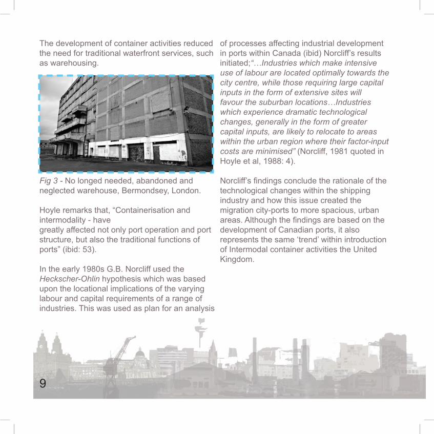
The development of container activities reduced the need for traditional waterfront services, such as warehousing.
Fig 3 - No longed needed, abandoned and neglected warehouse, Bermondsey, London.
Hoyle remarks that, “Containerisation and intermodality - have greatly affected not only port operation and port structure, but also the traditional functions of ports” (ibid: 53).
In the early 1980s G.B. Norcliff used the Heckscher-Ohlin hypothesis which was based upon the locational implications of the varying labour and capital requirements of a range of industries. This was used as plan for an analysis
of processes affecting industrial development in ports within Canada (ibid) Norcliff’s results initiated;“…Industries which make intensive use of labour are located optimally towards the city centre, while those requiring large capital inputs in the form of extensive sites will favour the suburban locations…Industries which experience dramatic technological changes, generally in the form of greater capital inputs, are likely to relocate to areas within the urban region where their factor-input costs are minimised” (Norcliff, 1981 quoted in Hoyle et al, 1988: 4).
Norcliff’s findings conclude the rationale of the technological changes within the shipping industry and how this issue created the migration city-ports to more spacious, urban areas. Although the findings are based on the development of Canadian ports, it also represents the same ‘trend’ within introduction of Intermodal container activities the United Kingdom.
9

2.4 The Initial Return to the Waterfront The retreat from the city waterfront as created issues within both spatial and functional segregation in port-city relations; these issues have now become apparent around the world in economic and political terms (Hoyle et al, 1988). The development issues within this chapter have led to the abandonment and neglect of the city-ports. These have been generated by a chain of events through history, including the increasing size of vessels and the changes of world shipping methods with the introduction of intermodal container activities. These unfortunate consequences on a positive note have led to new innovations and changes in technology. Hoyle refers to redevelopment of the urban waterfront as; “…there is now a widespread return to the waterfront, a redevelopment of the ‘abandoned doorstep’ for new uses associated with recreation rather than international trade” (ibid: 15). This provides evidence that societies understand the valuable assets and the potentials of regeneration of the urban waterfront, and the return of the traditional city-port ties.
Within the United Kingdom national and local authorities have been slow to undertake regeneration waterfront projects, on the other hand three city councils have transformed their ‘abandoned doorsteps’ as Gilman and Burn highlight “…three major city ports – London, Liverpool and Bristol – have in different ways already achieved a remarkable transformation of some of their abandoned docklands, dilapidated warehouses, derelict waterfronts…” (Gilman and Burn, 1983 quoted in Hoyle, 1988: 248).
10

3.0 Case Studies

As part of this critical study two case studies have been thoughtfully chosen, reflecting prime examples of City waterfront brownfield sites which have been regenerated within the United Kingdom.
Pier Head, Liverpool and Royal Victoria Square, London; are both large scale sites of imperative values which have been regenerated. The designers have sought to understand the local vernacular and reflected upon the heritage of the sites. They both display understanding that waterfronts are rare and valuable assets within cites and therefore should be created into spaces for the people; strengthening the former historic ties between cities and their ports and reconnecting people to the former heritage of a city, thus creating a sense of communal ownership and pride.
It is hoped that in using these case studies a sense of understanding will be created in how to incorporate and replicate imperative heritage within design and the limitations it can cause
Field visits to both case studies have been carried out with a series of questions collated that were subsequently posed to during a meeting with the designers AECOM London. The critical report will investigate issues within waterfront regeneration and refer to the case studies and designers responses in specific sections within this study.
12

3.1 Pier Head, LiverpoolLandscape Architect – AECOM LondonClient – Liverpool City Council Date of Completion – 2008
Fig 4 - Pier Head at dusk, displaying the conceptual ferry terminal, the architectual Royal Liver building and the extended canal.
The first case study, Pier Head has been chosen due to its importance and the connections it has to world maritime history. The site is located within
the city centre of Liverpool, situated in the cities‘maritime mercantile’ docks, which is sited on the north banks of the River Mersey.
The site is located within the centre of Liverpool’s ‘World Heritage Site’ as officially named by the United Nations Educational, Scientific and Cultural Organisation (UNESCO.)
This bares witness to the development of one of the world’s major trading centres of the eighteenth and nineteenth centuries and played an important role in early development of global trading and the growth of the British Empire, becoming a major port for the movement of slaves and emigrants from northern Europe to America.
The city was also renowned for generating technologies for dock construction and port management in the eighteenth and nineteenth centuries (UNESCO, 2004).
13

The site is surrounded by listed significant commercial and civic buildings such as the world famous international ‘Three Graces’, which are the three architectural ‘world heritage’ buildings, the Royal Liver Building (1911) see Fig 5, the Cunard Building (1916), see Fig 6 and Customs House (1907), see Fig 7.
Fig 5 Fig 6
Fig 7
14
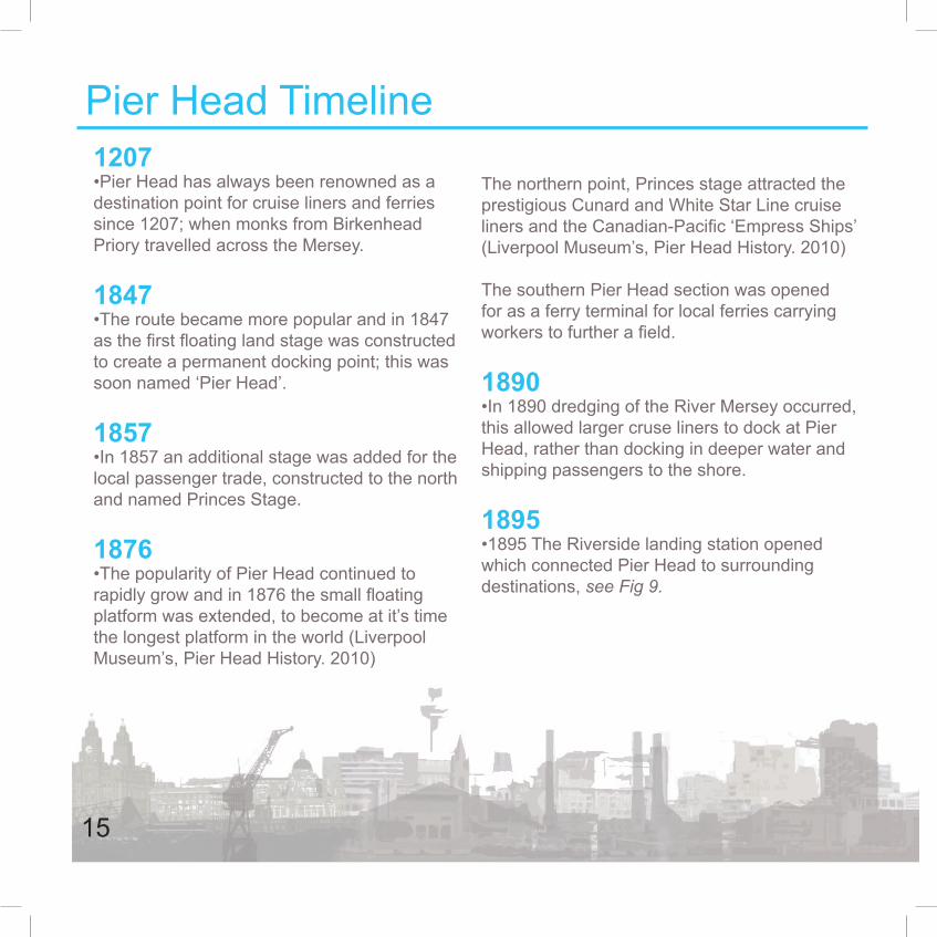
Pier Head Timeline 1207•Pier Head has always been renowned as a destination point for cruise liners and ferries since 1207; when monks from Birkenhead Priory travelled across the Mersey.
1847 •The route became more popular and in 1847 as the first floating land stage was constructed to create a permanent docking point; this was soon named ‘Pier Head’.
1857•In 1857 an additional stage was added for the local passenger trade, constructed to the north and named Princes Stage.
1876•The popularity of Pier Head continued to rapidly grow and in 1876 the small floating platform was extended, to become at it’s time the longest platform in the world (Liverpool Museum’s, Pier Head History. 2010)
The northern point, Princes stage attracted the prestigious Cunard and White Star Line cruise liners and the Canadian-Pacific ‘Empress Ships’ (Liverpool Museum’s, Pier Head History. 2010)
The southern Pier Head section was opened for as a ferry terminal for local ferries carrying workers to further a field.
1890 •In 1890 dredging of the River Mersey occurred, this allowed larger cruse liners to dock at Pier Head, rather than docking in deeper water and shipping passengers to the shore.
1895•1895 The Riverside landing station opened which connected Pier Head to surrounding destinations, see Fig 9.
15

1905-1917 •1905-1917; the famous ‘Three Graces’ were constructed.
1950’s•The 1950’s saw fewer passengers and boats using Pier Head, see Fig 10.
2007 - Today •£19 Million was invested to construct a new cruise liner terminal. The largest liners in the world can now dock in the city centre of Liverpool. This asset has boosted the regional economy (Liverpool City Council, 2010). The Mersey ferry company, which is popular attraction for tourists and commuters across the Mersey tourists (Liverpool Museums, 2010).
Fig
10 P
ier H
ead
Ferr
y
C
ross
ing
1947
Fi
g 9
Pie
r Hea
d Tr
ansp
ort
I
nter
chan
ge
Fig
8 P
ier H
ead
1770
’s
16
The famous site has been regenerated to reflect it’s international World Heritage status and also part of Liverpool’s 2008 European Capital of Culture celebrations (AECOM, 2008). The space has become a contemporary ‘vibrant and memorable’ landscaped area that acts as “a focal point and ‘centre of gravity’ of the waterfront” (ibid). Inspirations for this project were drawn from the docks rich history and the sites former materials to ensure that the future Pier Head blends with the important legacy of the area.
The idea of the space is to create the feeling of the waterfront and act as a thoroughfare, as the site serves the purpose of a transitional location, being the point of arrival and gateway of the waterfront. Pier Head has been designed carefully to respond to varied scales including a strong relation with the ‘Three Graces’, which shall be discussed in more detail within this study. The landscape space also serves as the largest open air venue within the city of Liverpool for public gatherings and events.
During the regeneration of the site, British Waterways invested £18.5 million along with
Liverpool City Council to extend the Leeds to Liverpool canal through to the Albert Dock, via Pier Head and Princes Dock; as part of the Liverpool canal link project and the ‘City Centre Movement strategy’. The moving corridor was created as two open canal basins within the site. These were tunnelled and pass underneath the new Liverpool City Museum (See Fig 11), which will be discussed in further detail within this study.
A new multi-million pound ferry terminal for Merseytravel funded by ‘European Regional Development Fund’ has been constructed within the landscaped area replacing the former 1960’s terminal. The terminal includes a gift shop, café and purchasing office, see Fig 12.
The new museum of Liverpool is currently under construction, located in a key position of along the waterfront, overlooking the ‘Three Graces’. The museum is planned to be an ‘anchor’ for Pier Head, with 750,000 estimated visitors a year. The building is an iconic development along the waterfront and a cultural asset to the Liverpool City Centre (Liverpool City Council, 2010), see Fig 13.
17

Fig 11 - Extended tunnel canal link Fig 12 - Conceptual Mersy ferry terminal
Fig 13 - Architects impression, Museum of Liverpool in Pier Head
18

The famous site has been regenerated to reflect it’s international World Heritage status and also part of Liverpool’s 2008 European Capital of Culture celebrations (AECOM, 2008). The space has become a contemporary ‘vibrant and memorable’ landscaped area that acts as “a focal point and ‘centre of gravity’ of the waterfront” (ibid). Inspirations for this project were drawn from the docks rich history and the sites former materials to ensure that the future Pier Head blends with the important legacy of the area.
The idea of the space is to create the feeling of the waterfront and act as a thoroughfare, as the site serves the purpose of a transitional location, being the point of arrival and gateway of the waterfront. Pier Head has been designed carefully to respond to varied scales including a strong relation with the ‘Three Graces’, which shall be discussed in more detail within this study. The landscape space also serves as the largest open air venue within the city of Liverpool for public gatherings and events.
During the regeneration of the site, British Waterways invested £18.5 million along with Liverpool City Council to extend the Leeds to Liverpool canal through to the Albert Dock, via Pier Head and Princes Dock; as part of the Liverpool canal link project and the ‘City Centre Movement strategy’. The moving corridor was created as two open canal basins within the site. These were tunnelled and pass underneath the new Liverpool City Museum, which will be discussed in further detail within this study.
A new multi-million ferry terminal for Merseytravel funded by ‘European Regional Development Fund’ has been constructed within the landscaped area replacing the former 1960’s terminal. The terminal includes a gift shop, café and purchasing office.
The new museum of Liverpool is currently under construction, located in a key position of along the waterfront, overlooking the ‘Three Graces’. The museum is planned to be an ‘anchor’ for Pier Head, with 750,000 estimated visitors a year. The building is an iconic development along the waterfront and a cultural asset to the Liverpool City Centre (Liverpool City Council, 2010)
19

3.2 Royal Victoria Square, LondonLandscape Architect – EDAW - Aecom London Client – London Development Agency Date of Completion – 2000
Fig 14 - Royal Victoria Square at dusk, displaying coloured jet fountains and architectual seating canopy.
The second case study was purposely chosen as a city-port which has been regenerated. The Royal Victoria Square is located on the
northern wing within the former Royal Victoria Dock on the banks of the River Thames, situated opposite the residential development of Silvertown (Cabe, 2010). Royal Victoria forms part of the ‘Royal Docks’ within the London Docklands. The Royal docks closed in 1985 after the rapid decline of London city-ports.
The Royal Victoria Dock faced a £533 million regeneration project. Major development proposals were prepared by the former ‘London Dockland Development Corporation’ (which became the ‘London Development Agency’); these were agreed to by the local authority, the London borough of Newham. The developments include The London Excel exhibition hall, shops, offices and housing as well as the creation of Royal Victoria Square.
Royal Victoria Square is larger than Trafalgar Square and acts not only as a transitional and functional space, but moreover as a
20

thoroughfare to Custom House DLR station and a public plaza for Excel London. The square forms part of the open space network and acts as a catalyst for the regeneration works for the surrounding area (ibid).
‘Cabe describes the site as; “the public space at Royal Victoria Square creates a link between the modern buildings and historic industrial context of London’s Docklands” (ibid). The public space is built on one of the former finger docks of Royal Victoria. Aecom promotes the design to be ‘contemporary interpretation on the areas historic identity as a industrial dock’ (Aecom, 2000) The plaza incorporates historic features within the design, such as the few remaining warehouses within Royal Victoria Docks and the former lifting cranes on the waters edge.
Fig 15 - Photo displaying seating canopy.
Fig 16 - Photo displaying linear plantation of trees adding height and a sense of enclosure.
21
4.0 The significance of Waterfront Regeneration

Within the United Kingdom there has been a slow but gradual return to the waterfront in comparison to Europe. Local governments and authorities have realised the unique potentials of these valuable assets within the landscape; but why should derelict industrial spaces be regenerated and what advantage do they have on local communities?
The study has previously discussed the historical ties between cities and their waterfronts and how over time this relationship was loosened by the technological changes within the shipping industry and the introduction of worldwide Intermodal Container Activities. This downturn heralded the retreat and abandonment of the waterfront, which led to societies turning their backs on city-ports and waterfronts of local importance. This has led to the trend within society of historic hearts becoming abandoned, neglected and derelict; leaving sites of imperative values behind.
Historic places such as city-ports and waterfronts connect to local vernacular and achievements, for example industry which once created wealth and helped cities to prosper.
The loosening of this tie has created both spatial and functional segregation within cities, the consequence of which has made communities turn their backs on local heritage, culture and traditions.
CABE describe that local heritage and the quality of the location where you live as having a powerful impact of your attachment to a place and on your quality of life. This proves the need to regenerate the former meaningful waterfronts and historic remains which lie rich in culture and heritage (Cabe, 2010). Regenerating these interesting hearts within a city will reconnect the historic ties between cities and their ports and also bring sites of imperative values back to communities, developing baron and neglected wasteland and shells to an enhanced public space. In turn this will create a memorable place with meaning and help create a sense of communal ownership and pride. Project for Public Spaces describe waterfront regenerations projects as:
“A waterfront project opens up the debate about the soul of a city for all to see” (PPS 2010).
23
Grady Clay, an American Journalist specialising in landscape architecture and ubran design quoted:
“It has become apparent that urban waterfronts, whether natural or artificial, are now prime pieces of real estate, essential ingredients in forming a community image, valuable stages for architectural display and great places for public recreation.” (Grady Clay, 1998, quoted from University of Idaho).
In 2006 PPS (Project for Public Spaces) asked the public to define the term ‘Place making’, they received over 750 responses, the best ones characterise the term.
Place making is…
“…taking back the public realm to create memorable, beautiful, vibrant places where people want to gather and participate in the community.”
“…the art and science of developing public spaces that attract people, build community by bringing people together, and create local identity.”
“…capturing the soul of a neighbourhood.”
“…embracing people, buildings, events, nature.”
(PPS, 2006)
4.1 Place MakingEach waterfront has a different and has a sense of place, known as ‘genius loci’; the unique feeling of a site. The perceptions of place which have become apparent through layers of understanding the landscape, created from physical and human geography and the heritage of a place. (Urban Design Compendium 1, 2009: 22)
24

The feedback which PPS gained from this demonstrates that the public have a general understanding of what they expect from public spaces and how they can effectively influence local identities and communities.
For successful waterfront regeneration project developers need to understand the larger context of a site, including the community needs, heritage, history and the local vernacular. It can be argued that waterfront regeneration is not successful as the developers have failed to understand the wider context of the site as a result of lack of consultation with local communities. This issue will be discussed further in this study.
Waterfronts have rich visual textures and contrasts, Every waterfront is an exciting unique environment.
Conceptually the landscape is constructed from edges and spaces, the edges form what the viewer sees by providing spatial definition. In relation to this theory there is no more defined edges within the landscape than where land meets the waters edge. The smooth horizontal surface of water contrasts against the bold vertical elements found along the waters edge (Wrenn, 1983: 34).
Today waterfronts are seen as a destination point where people are inherently drawn towards a body of water for the aesthetic and recreational qualities which will be discussed within this section.
4.1.1 Perception of Water
25

The rich textures and contrasts of the waterfront are produced by the variety of surface materials such as course granite and steel which are used within the floorscape and for construction. Typically these will weather to create an eye pleasing variation between established and new materials, Fig 17 exhibits an example of rich texture in St. Katherines Dock, London, Fig 18 displays the visual textures between old and new materials in Royal Victoria Square,London.
Fig 17 - Rich visual textures in the historic St. Katherines dock, London
Fig 18 - Visual contrast textures of new granite paving against erect steel lifting cranes
The feeling of openness along a body of water within a city is desirable. In addition to textures the wind corridor creates a breeze along the waterfront which can create a tranquil effect, creating stationed boats to bob on the water and nautical flags to wave in the wind adding to the perceived textures of the waterfront (ibid).
26
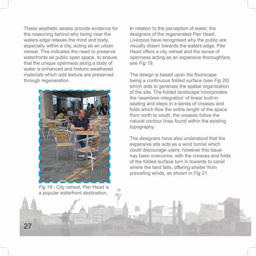
These aesthetic assets provide evidence for the reasoning behind why being near the waters edge relaxes the mind and body, especially within a city, acting as an urban retreat. This indicates the need to preserve waterfronts as public open space, to ensure that the unique openness along a body of water is enhanced and historic weathered materials which add texture are preserved through regeneration.
Fig 19 - City retreat, Pier Head is a popular waterfront destination.
In relation to the perception of water, the designers of the regenerated Pier Head, Liverpool have recognised why the public are visually drawn towards the waters edge. Pier Head offers a city retreat and the sense of openness acting as an expansive thoroughfare, see Fig 19. The design is based upon the floorscape being a continuous folded surface (see Fig 20) which aids to generate the spatial organisation of the site. The folded landscape incorporates the ‘seamless integration’ of linear built-in seating and steps in a series of creases and folds which flow the entire length of the space from north to south, the creases follow the natural contour lines found within the existing topography.
The designers have also understood that the expansive site acts as a wind tunnel which could discourage users; however this issue has been overcome, with the creases and folds of the folded surface turn in towards to canal where the land falls, offering shelter from prevailing winds, as shown in Fig 21.
27

Fig 20 - Displays the visually attractive continuous folded floorscape of Pier Head, which generate the spatial organisation of the site.
Fig 21 - The designers impression of the folded floorscape, creases and folds turn towards falls within the to-pography of the site.
28

5.0 Preserve Regenerate Enhance

Waterfronts on regeneration often acquire historic buildings and structures of significant importance which contribute towards the unique character of a site. The buildings and structures are obtained when waterfronts are often in a deprived state, but on a positive note can provide exciting opportunities for restoration and preservation, enhancing the character and retaining the heritage of a site.
“…historic preservation is not sentimentality but a psychological necessity. We must learn to cherish history and preserve worth old buildings…we must learn how to preserve them, not as pathetic museum pieces, but by giving them new uses” (Austin et al after Huxtable, 1988 quoted from Llewelyn-Davies, 2007: 98)
Buildings and structures of significant importance can cause design implications such as the English Heritage Listing system and UNESCO World Heritage convention; these both caused design implications for Pier Head Liverpool and Royal Victoria Square London. The study will investigate how designers approached this issue.
5.1 How doesHeritage InformSite Design withinthe UK?
5.1.1 Pier Head
As Pier Head is located within Liverpool’s maritime ‘World Heritage Site’ it had to follow UNESCO’s regulations and guidelines.
i. The ‘Three Graces’ which are striking and of architectural beauty. They line the waterfront and act as a boundary of the Pier Head public plaza. The design for Pier Head needed to be conceptual but to an extent, the design had to work around the Three Graces without taking attention away.
30

ii. The designers needed to understand the importance and the former use of the site. Using the right materials were vital, responding to the context for inspiration.
iii. To work with existing statues of the site, the design team worked closely alongside English Heritage to their regulations to authorise the cleaning, restoration and movement of them.
5.1.2 Royal Victoria Square
Royal Victoria Square lies within Royal Victoria Dock, which was a former finger docks listed A-Z. Each dock has a series of warehouses to store imported goods. Almost all the warehouses have been demolished and all the finger docks have been filled with concrete.
The square is located on former dock W which has a small number of grade II listed
warehouses which still remain, see Fig 22.
Constraints of the site was working with the grade II warehouses cranes and picking up on local vernacular responding to the pre-existing features.
Fig 22 - Listed warehouses surrounding Royal Victoria Square
31

5.2 From the Public’s Perception, are they able to Distinguish that the Regenerated Waterfronts are Sites of Imperative Values?Historic waterfronts which have been regenerated should be able to stand alone and be easily perceived by the public. It should be clear that they are sites of significant importance typically containing historic remains, restored and preserved buildings and structures.
5.2.1 Pier Head
As previously discussed, Pier Head has been purposely intended to harmonise with the Three Graces which is reflected within the granite paving which depicts the light stone which the Graces are constructed from, this is evident in Fig 23.
Fig 23 - The harmonising landscape against the Three Graces, (The Royal Liver Building).
32

AECOM describe the design and landscape as simple, to ensure the public appreciate the buildings. It is evident that the landscape is intricate and conceptual due to the abstract creases and folds within the landscape, but not simplistic, which is evident in Fig 21.
The Three Graces border the site, but feel separate as there is no evident connection within the landscaped site except from the paving colouration, as displayed in Fig 24. The striking architecture of the Graces could be reflected throughout the site, which can still harmonise together, without removing the attention from the Three Graces.
Pier Head has always been renowned a destination point since 1207 when monks from Birkenhead Priory crossed the Mersey, today even the largest cruise liners can dock at the waters edge. A ferry terminal has existed on Pier Head for an extensive period and although the terminal building has been reconstructed many times it does not feel like a ‘heritage’ feature to the site, seen in Fig 25.
Fig 24 - Isolated. The Three Graces do not related to the site, the road acts as a visual barrier.
33

This poses the question; is there the need to recognise the local vernacular, heritage and context of a site of historical importance, if the users are not able to distinguish that the sites are of imperative values?
5.2.2 Royal Victoria Square
Royal Victoria Square is a space situated within the Excel centre, a historic warehouse and a series of listed cranes. As with Pier Head the designers aim with the Royal Victoria Square was to create a contemporary interpretation of the area’s identity and as a former working dock (AECOM, 2000).
In comparison to Pier Head the public are able to distinguish that Royal Victoria Square is a site of historical value. This is due to the fact that the square incorporates numerous historic features of the remaining finger dock, which have been fully restored, such as the warehouse which dominates the space and the ever present lifting cranes which are intimidating to the eye, see Fig 26.
Fig 25 - A heritage future to Pier Head, The Mersey Ferry Terminal - too conceptual?
AECOM’s feedback of the Pier Head regeneration is that generations who have lived in Liverpool all their lives remark that the site still has the same feeling, although redeveloped. It is clear that the landscaped plaza is a masterpiece it’s self and now a major tourist attraction within Liverpool city centre, however from vision no obvious relevance to the strong historic background of the site can be seen
34

In addition to incorporating historic features within the design, the designer has also introduced new sculptures, which further conserve and enhance the historic values of the site, see Fig 27.
The designer explained the logic behind chosen materials during the meeting undertaken with the AECOM design team. It was claimed that the chosen materials have a historic rationale which complement the existing features and reflect the sites heritage. The use of granite and steel has been used due to their value and importance within the docklands, renowned for their strength and durability. The steel work has been painted a minimal grey to relate to the cranes and the warehouse creating a harmonious effect, evident in Fig 26. The use of these materials improves the sense of place and reflects a site of former importance.
The designer intricately used of paving styles and colours within the floorscape to highlight the former inlet ‘Finger Dock’, which is evident in Fig 28. New innovative sculptures have been incorporated within the space which further reflect the heritage of the finger dock, particularly dock ‘W’, seating two seating canopies are positioned
Fig 26 - Listed Cranes of the former finger dock, are imposing at Royal Victoria Square, but reminds the user it was once a working site. They act as functional features framing important vistas along the visual corridor of the River Thames, such as the City of London.
35
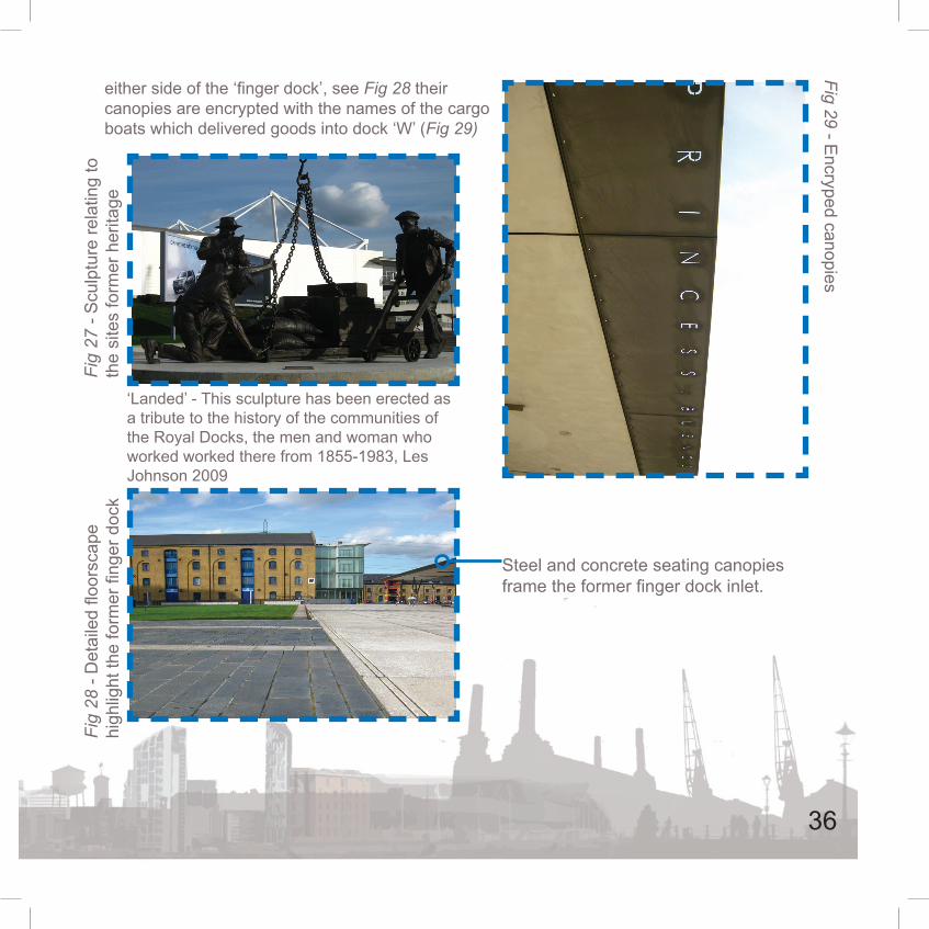
either side of the ‘finger dock’, see Fig 28 their canopies are encrypted with the names of the cargo boats which delivered goods into dock ‘W’ (Fig 29)
Fig
27 -
Scu
lptu
re re
latin
g to
th
e si
tes
form
er h
erita
geFi
g 28
- D
etai
led
floor
scap
e hi
ghlig
ht th
e fo
rmer
fing
er d
ock
Steel and concrete seating canopies frame the former finger dock inlet.
‘Landed’ - This sculpture has been erected as a tribute to the history of the communities of the Royal Docks, the men and woman who worked worked there from 1855-1983, Les Johnson 2009
Fig 29 - Encryped canopies
36

The elements of the square all have a meaning, including new structures and sculptures, all relating to the importance of the site. The elements are all bold and big, including immense vistas, big sky and an open vast river, emphasising the London Docklands.
The Urban Design Compendium express, “reviving historic features provide opportunities to enrich outdoor space and can include natural and man-made elements” (LLEWELYN-DAVIES, 2007: 26). Waterfronts which have included buildings and structures of significance importance with the addition of distinctive structures such as the new ferry terminal on Pier Head and the canopies at Royal Victoria Square act as landmarks.
The Urban Design Compendium conveys that public find it easier to navigate and recognise where they are in new developments which preserve important views and incorporate existing and new landmarks, these act as markers guiding one from A to B and onto C (LLEWELYN-DAVIES, 2007: 61).
37
6.0Trends within Waterfront Regeneration

The study has discussed the importance of waterfront regeneration within cities and how they reconnect the longstanding traditional ties between cities and their ports. Waterfronts regeneration also connects communities to the heritage of their cities by creating logic of self ownership and pride, allowing sites of imperative values to once again prosper within communities.
Waterfront regeneration is often overseen and driven by large development companies who see a regeneration project as a scheme for investment. This chapter will understand the trends within waterfront regeneration and how they ignore the important legacy of a site, resulting in waterfronts becoming a mass modern high-rise construction.
The regeneration of waterfronts is a challenging and complex prospect, which is undertaken successfully, can be gratifying and rewarding to cities and their communities.
6.1 The Trend of Inner-CityLiving
The fashion of inner-city living has become a trend within society. Residences are sought after, particularly those with waterside views.
The demand for exclusive waterfront properties on the British waterside is becoming more popular (Knight Frank, 2008); waterfronts are now prime development land for classical investment developers, this poses a threat for waterfront regeneration in relation to preserve the unique characteristics of the waterfront.
A waterside view can increase property value by up to 60%, “The Waterfront market encompasses properties on or very near to water, or where water views are the prime selling feature of the property, whether that be near a river, a lake or on the coast. A good view over water can add significantly to the value of the property” (ibid).
39

Fig 30 - In demand: Caspian Wharf, proposed modern waterfront residences on the banks of the River Thames, London.
As discussed waterfronts and city ports are typically sites of heritage, which connect to the local vernacular and industrial achievements of a city. The regeneration of waterfronts should reflect and preserve the cities heritage and give sites of imperative values back to communities, creating a sense of communal pride and ownership; but the redevelopment of waterfronts are often prime locations for new
residences, office blocks and shopping districts. These modern quarters within cities create a cosmopolitan front which could be found in a city anywhere in the world, there planning and construction often over see the historic importance and local vernacular of these
delicate sites, see Fig 31.
Fig 31 - The extreme, Hong Kong waterfront, a mix of high rise residences, office blocks and shopping arcades. Drowning the heritage of the waterfront.
40
The desire for waterfront living has resulted in large scale mixed developments being constructed, but should they be erected on the waters edge?
Whilst it is evident that the creation of cosmopolitan districts within cities is often positive, these arguably should be constructed at a distance from the shoreline, as these areas should be reserved and regenerated as public space for communities, thereby preserving the heritage of the site. As discussed the public are attracted to the waters edge due to the feeling of openness and aesthetic quality, in addition to the recreational and relaxation properties for the mind and body.
As discussed in chapter 5, waterfronts often acquire buildings of significant importance contributing towards the unique character of a site. If waterfront living is desired, these could be converted into residences as opposed to the erection of apartment blocks.
6.1.1 Institutional Constraints States within America such as Seattle (see Fig 33) have legislations for the regeneration of their waterfronts. Such institutional legislation is designed to protect the waterfront from misuse and restrict the development process (Wrenn, 1983: 42).
The Shoreline Management Program of 1976 for the City of Seattle, grants priority to water dependant uses which increase the public’s ability to enjoy the waterfront. This act prevents the construction of new residential and office developments on the waterfront. The program for the city’s central waterfront as follows:
•Reinforce the historic marine water-orientation of Seattle as a major downtown theme;
•Strengthen water-orientated recreation tourist activity, related business, and public areas open to the water;
•Maintain a full complement of water dependant uses;
41

•Preserve and enhance the views of Elliot bay…no additional coverage of the water by fixed structures shall be permitted. (ibid)
Fig 32 - The Seattle Waterfront, preserving the waters edge for public space.
Within the United Kingdom there is currently no legislation or regulations which specifically create limitations to waterfront development. As shown within the case studies, policies and bodies such as UNESCO World Heritage
Convention and English Heritage have formed design implications but are not specific to waterfront regeneration and also do not apply to all historic waterfronts within the United Kingdom.
As illustrated in the Shoreline Management Program of 1976, Seattle, the British government need to create regulations which form limitations to waterfront redevelopment. This study has demonstrated the importance of regenerating waterfronts for communities as public spaces, reconnecting the historical ties between cities and their ports. This creates a sense of communal pride and ownership as they are reconnected with their cities heritage. Legislation within the United Kingdom needs to be formed to ensure that British heritage is preserved and not lost forever.
42

7.0 Conclusion
In conclusion, the Critical study has investigated the regeneration of waterfronts within cities and the importance of preserving the heritage. In response to the question the study has acknowledged the role in which waterfronts have within cities and understood the historical context of waterfronts including the Industrial Revolution. Additionally, it has taken into account why a bodies of water influenced the location of towns and cities and how new technologies caused visual changes to the British Landscape. The study has examined the evolution of port-city ties and how the introduction of Intermodal Container Activities and how this caused strain on city-port relations which led to cities retreating from the waterfront, leaving sites of heritage and importance behind, allowing them to become abandoned and derelict. Through understanding the importance of historic places within cities and CABE’s approach to historic regeneration, the study analysed the outcome of the retreat of the waterfront and how this caused communities to turn their backs on local heritage, culture and traditions. These findings demonstrated that by
regenerating and preserving sites of historical values will create a powerful impact on people’s attachment to a place and quality of life by creating memorable places for the community; helping create communal pride and a sense ownership; reconnecting cities and their ports.
This investigation found that the public are visually perceived and drawn towards the waters edge because of the unique environment created from rich visual textures and the feeling of openness along a body of water, hence why these aspects are desirable within cities. In relation to this, findings established the need to regenerate the waterfront as a public space thus enhancing the historic elements. The study found that historic structures are often acquired through waterfront regeneration and found that significant structures contribute towards the unique character of the sites, in relation to this it found that these structures provide opportunities for preservation and restoration which enhanced the heritage of a site.
44

In reflection to the primary investigation conducted, the study investigated how the heritage of waterfronts formed design implications and determined whether the public are able to distinguish sites of imperative values. These questions reflected upon the chosen case studies with feedback reviewed from a meeting conducted at AECOM London with the designers and field visits carried out for each case study. The primary research analysed how the sites relate to the local vernacular and heritage of the site, through restoration and reflection, critiquing the visual connections to the sites former heritage. Findings from this showed that there is a need to recognise the local vernacular, heritage and context of a site if the users are not able to distinguish that sites are of imperative values.
The study has examined trends within waterfront regeneration and recognised the fashion of inner-city living. The findings demonstrated that waterfront residences can increase property value by up to 60%. Waterfronts are prime development land for investment developers, which pose threats for waterfront regeneration as public space.
The investigation found that institutional constraints exist in States within America which have legislation for the regeneration of their waterfronts, which restrict the development for construction along the waters edge, ensuring heritage is protect and preserved. Cities have strong historic relations with their ports, which have loosened overtime due to the gradual decline of the waterfront; this finding concludes that communities have turned their backs on heritage, culture and traditions. The regeneration of city waterfronts strengthens the relation between cities and their ports by preserving and reflecting heritage.
The gentrification of these sites connect communities to the heritage of their city, creating a sense of self ownership and pride, allowing sites of imperative values to once again prosper. With regards to understanding the institutional constraints within Seattle, America; evidence showed there is no specific legislation within the United Kingdom, which protects the heritage of the waterfront and limits development along the waters edge.
45

Overall the critical study has been successful. Given the restraint and time period of the investigation it can be further explored. Elements such as researching and creating specific legislation for waterfronts within the United Kingdom and the possibility of developing the study by comparing waterfronts across Europe for a more in-depth study. These factors could be carried out during the authors future education, such as; Post Graduate and Masters.
46

Bibliography

Books:
•FOSTER, J. (1999) Docklands, Cultures in conflict, Worlds in Collision. 1st Ed. London: Routledge.
•HOSKINS, G.W. (1955) The Making of the English Landscape. United Kingdom: Penguin.
•HOYLE, B.S. and PINDER D.A. (1988) Revitalising the Waterfront. 1st Ed. Londno: Belhaven Press.
•LLEWELYN-DAVIES. (2007) Urban Design Compendium 1. 2nd Ed. London: Seacourt.
•AL NAIB, S.K. (1991) London Docklands, Past, Present and Future. 2nd Ed. London: Ashmead Press Ltd.
•WRENN, D.M. (1983) Urban Waterfront Development. 1st Ed. Washington D.C: The Urban Landscape Institute.
Electronic Journals:
•TURNBALL, G. (1987) Canals, Coal and the regional growth the Industrial Revolution. The Economic History Review [Internet] 40 (4) November. 537-360. Available from: < http://www.jstor.org/stable/2596392 > [Accessed 1st December 2010].
Email Discussion: •Blackwell, M. 9th September 2010. Re: Dissertation([email protected]). Email to J. Nathan ([email protected])
•Lloyd, C. 13th September 2010. Re: St. Katherines Dock. ([email protected]). Email to J. Nathan ([email protected])
•Osborne, W. 7th January 2011. Re: Royal Victoria Square, Development Proposals. ([email protected]). Email to J. Nathan ([email protected])
•Uribe, E. 5th November 2010. Re: Meeting Warren. ([email protected]). Email to J. Nathan ([email protected])
48

•Young, J. 5th November 2010. Re: Waterfront Design. ([email protected]). Email to J. Nathan ([email protected])
In house Publications:
•AECOM (2000) Royal Victoria Square. {In-house publication}. Available in Appendix A.
•AECOM (2008) The Pier Head Public Realm. {In-house publication}. Available in Appendix B.
Primary Information Sources:Osborne, W. and Uribe, E., 2010 Questions: Pier Head and Royal Victoria Square case studies. [Meeting] (Meeting conducted at AE-COM London with the designers. Available in
Appendix C.
Websites:
•Benson, E.D., Hansen, J.L. & Schwartz Jr., A.L. (2000) “Water Views and Residential Property Values”, Appraisal Journal. Available online: http://www.highbeam.com/doc/1G1-64263559.html [Accessed January 26, 2011].
•British Waterways (2010) Waterside Regeneration [Internet]. Available online:< http://www.britishwaterways.co.uk/our-work/de-livering-public-benefit/waterside-regeneration >[Accessed 24th December 2010].
•Bond, T.M., Seiler, V.L & Seiler, M.J (2010) Residential Real Estate Prices: A Room with a View [Internet] Bond, Seiler and Seiler. Avail-able online:<http://business.fullerton.edu/Finance/journal/papers/pdf/past/vol23n0102/08.129_138.pdf> [Accessed 16th January 2011]
•Cabe (2011) Place making [Internet] Available online: <http://www.cabe.org.uk/place-making>[Accessed 3rd January 2011]
•Cabe (2010) Royal Victoria Square, London [Internet] Available online: < http://www.cabe.org.uk/case-studies/royal-vic-toria-square> [ Accessed 30th December 2010]
•Cook, L. (2004) Waterfront Regeneration, Gentrification and the Entrepreneurial State: The Redevelopment of Gunwharf Quays, Portsmouth [Internet] Manchester University. Available online: <http://www.sed.man.ac.uk/ge-ography/staff/documents/cook_2004_SPA.pdf> [Accessed 16th January 2011]

•Knight Frank (2008) Waterfront Review [Internet] Available online: <http://resources.knightfrank.com/GetRe-searchResource.ashx?id=11246>[Accessed 16th January 2011]
•Liverpool City Council (2010) Pier Head [Internet] Available online: <http://www.liverpool.gov.uk/Business/Econom-ic_development/Area_or_site_specific_regenera-tion/pier_head/index.asp>[Accessed 29th December 2010]
•Liverpool Museum’s (2010) Trading Places, Pier Head History [Internet] Available online: <http://www.liverpoolmuseums.org.uk/nof/docks/access/dock_history10.html> [Accessed 29th December 2010]
•Lowe, D. (2008) Intermodal Freight Transport, [Internet] David Lowe Transport Writer. Available online: <http://www.davidlowe.org/Inter_Modal_Freight.htm>[Accessed 24th December 2010]
•Merseyside Maritime Museum (2010) Liver-pool: World Heritage City [Internet] Available online:<http://www.liverpoolmuseums.org.uk/maritime/exhibitions/worldheritagecity/index.asp > [Accessed 29th December 2010]
•PPS (2006) Place Making is… [Internet] Available online:< http://www.pps.org/articles/placemakingis/>[Accessed 8th January 2011]
•SYKES, M. (2007) The Regeneration of Salford Quays. Salford City Council [Internet] June 2007. Available online: <www.salford.gov.uk/milestones_v2.pdf> [Accessed 27th October 2010]
•University of Idaho (2011) Waterfront Development [Internet] Available online: <http://www.class.uidaho.edu/communityresearch/waterfront_development.htm> [Accessed 3rd January 2011]
50
•Fig 5 - The Liver Birds and the Royal Liver Building Liverpool. (2008) [Online Image]. Available online < http://www.freefoto.com/preview/806-26-8634?ffid=806-26-8634>[Accessed 23rd January 2011]
•Fig 6 - Vorderseite des Cunard Building. (2010) [Online Image]. Available online < http://de.academic.ru/dic.nsf/dewiki/287876>[Accessed 23rd January 2011]
•Fig 7 - The Cunard Building (2011) [On-line Image]. Available online <http://fo-rums.liverpooldailypost.co.uk/viewtopic.php?f=6&t=120033&start=15>[Accessed 23rd January 2011]
•Fig 8 - Pier Head, 1770’s (2006) [AECOM London PDF, Pier Head and Mann Island Public Realm Design Guidance].
•Fig 9 - Pier Head Landing Stage, 1930’s (2006) [AECOM London PDF, Pier Head and Mann Island Public Realm Design Guidance].
•Fig 10 - Crossing the River Mersey, 1947 (2006) [AECOM London PDF, Pier Head and Mann Island Public Realm Design Guidance].
•Fig 11 - Pier Head (2008) [AECOM London PDF, Pier Head Public Realm]
Illustation References:
•Fig 1 - AL NAIB, S.K., 1991, The Old Custom House of the Legal Quays seen from the river, based on an engraving by J Bowler 1753.[London Docklands, Past, Present and Future: 2].
•Fig 2 - The Industrial Revolution. (2011) [Online Image]. Available online: < https://ir-newspaper.wikispaces.com/Opinion+Article> [Accessed 23rd January 2011]
•Fig 2.1 - HOYLE, B.S. and PINDER, D.A., 1988,Stages in the evolution of the port-city interface. [Revitalising the Waterfront: 7]
•Fig 2.2 - HOYLE, B.S. and PINDER, D.A., 1988, Trends and developments at the port-city interface. [Revitalising the Waterfront: 54]
•Fig 3 - Old warehouse, Bermondsey. (2006) [Online Image]. Available online: <http://www.urban75.org/london/images/rotherhithe-08.jpg> [Accessed 23rd January 2011].
•Fig 4 - Pier Head, Liverpool. (2011)[Online Image]. Available online: < http://www.aecom.com/What+We+Do/Design+and+Planning/stories/Pier+Head,+Liverpool> [Accessed 23rd January 2011]

•Fig 12 - Hamilton Architects: Pier Head Ferry Terminal, Liverpool. (2009) [Online Image]. Available online < http://www.archi-tecturetoday.co.uk/?p=1337> [Accessed 23rd January 2011]
•Fig 13 - Proposed Liverpool Museum, East Elevation. (2006) [AECOM London PDF, Pier Head and Mann Island Public Realm Design Guidance].
•Fig 14 - Royal Victoria Square, London. (2011) [Online Image]. Available online < http://www.marmorit.co.uk/render-systems.php> [Accessed 23rd January 2011]
•Fig 15 - Royal Victoria Square, Seating Canopy. (2010) Authors own image.
•Fig 16 - Royal Victoria Square, plantation of trees. (2010) Authors own image.
•Fig 17 - St. Katherines Dock, visual textures. (2010) Authors own image.
•Fig 18 - Royal Victoria Square, contrasting textures. (2010) Authors own image.
•Fig 19 - Pier Head, Public Space. (2010) Authors own image.
•Fig 20 - Pier Head, Folded Landscape. (2008) [AECOM London PDF, Pier Head Public Realm]
•Fig 21 - Conceptual Plaza Fold Lines. (2006) [AECOM London PDF, Pier Head and Mann Island Public Realm Design Guidance].
•Fig 22 - Listed Warehouse, Royal Victoria Square. (2010) Authors own image.
•Fig 23 - The Royal Liver Building, harmonising landscape. (2010) Authors own image. •Fig 24 - The Three Graces at Pier Head. (2010) Authors own image.
•Fig 25 - The New Pier Head Ferry Terminal Building. (2005) [Online Image].Available online < http://www.blooloop.com/Article/New-visitor-attractions-and-riverfront-amenities-fuel-urban-development-in-Liverpool-and-its-neighbors/164> [Accessed 24th January 2011]
•Fig 26 - The Listed Cranes at Royal Victoria Square. (2010) Authors own image.
•Fig 27 - ‘Landed’ Sculpture at Royal Victoria Square. (2010) Authors own image.
•Fig 28 - Royal Victoria Square, detailed floorscape. (2010) Authors own image.
•Fig 29 - Encrypted Detailing of the seating canopies Royal Victoria Square. (2010) Au-thors own image
52

•Fig 30 - Pacific Court, Caspian Wharf, London (2009) [Online Image]. Available online:< http://www.kingsturge.com.hk/en-GB/interna-tional-project-launches/Pacific-Court-Caspian-Wharf-London-E3.aspx>[Accessed 25th January 2011]
•Fig 31 - Hong Kong Waterfront (2011). [On-line Image] Available online: < http://farm1.static.flickr.com/143/351382091_0bd3f69b1d.jpg>[Accessed 25th January 2011]
•Fig 32 - The Seattle Waterfront (2009). [On-line Image] Available online : < http://www.gonorthwest.com/Washington/seattle/Water-front/images/DSC_2204_458x307.jpg> [Accessed 25th January 2011]
53

Appendix