Embed Size (px)
Citation preview

Disruptive
Democratised
Geospatial Technology
Investment PresentationJuly 2015
www.takor.com.au

Disclaimer
This presentation has been prepared by Takor Group Pty Ltd (“Company”). It does not purport to contain all the information that a prospective investor may require in
connection with any potential investment in the Company. You should not treat the contents of this presentation, or any information provided in connection with it, as
financial advice, financial product advice or advice relating to legal, taxation or investment matters.
No representation or warranty (whether express or implied) is made by the Company or any of its officers, advisers, agents or employees as to the accuracy,
completeness or reasonableness of the information, statements, opinions or matters (express or implied) arising out of, contained in or derived from this presentation or
provided in connection with it, or any omission from this presentation, nor as to the attainability of any estimates, forecasts or projections set out in this presentation.
This presentation is provided expressly on the basis that you will carry out your own independent inquiries into the matters contained in the presentation and make your
own independent decisions about the affairs, financial position or prospects of the Company. The Company reserves the right to update, amend or supplement the
information at any time in its absolute discretion (without incurring any obligation to do so).
Neither the Company, nor its related bodies corporate, officers, their advisers, agents and employees accept any responsibility or liability to you or to any other person
or entity arising out of this presentation including pursuant to the general law (whether for negligence, under statute or otherwise), or under the Australian Securities and
Investments Commission Act 2001, Corporations Act 2001, Competition and Consumer Act 2010 or any corresponding provision of any Australian state or territory
legislation (or the law of any similar legislation in any other jurisdiction), or similar provision under any applicable law. Any such responsibility or liability is, to the
maximum extent permitted by law, expressly disclaimed and excluded.
Nothing in this material should be construed as either an offer to sell or a solicitation of an offer to buy or sell securities. It does not include all available information and
should not be used in isolation as a basis to invest in the Company.
Future matters
This presentation contains reference to certain intentions, expectations, future plans, strategy and prospects of the Company.
Those intentions, expectations, future plans, strategy and prospects may or may not be achieved. They are based on certain assumptions, which may not be met or on
which views may differ and may be affected by known and unknown risks. The performance and operations of the Company may be influenced by a number of factors,
many of which are outside the control of the Company. No representation or warranty, express or implied, is made by the Company, or any of its directors, officers,
employees, advisers or agents that any intentions, expectations or plans will be achieved either totally or partially or that any particular rate of return will be achieved.
Given the risks and uncertainties that may cause the Company’s actual future results, performance or achievements to be mater ially different from those expected,
planned or intended, recipients should not place undue reliance on these intentions, expectations, future plans, strategy and prospects. The Company does not warrant
or represent that the actual results, performance or achievements will be as expected, planned or intended.
US disclosure
This document does not constitute any part of any offer to sell, or the solicitation of an offer to buy, any securities in the United States or to, or for the account or benefit
of any “US person” as defined in Regulation S under the US Securities Act of 1993 (“Securities Act”). The Company’s shares have not been, and will not be, registered
under the Securities Act or the securities laws of any state or other jurisdiction of the United States, and may not be offered or sold in the United States or to any US
person without being so registered or pursuant to an exemption from registration including an exemption for qualified institutional buyers.
For ASX Release 39 July, 2015

Takor Company Profile
For ASX Release 49 July, 2015
A leading Australian geospatial and disruptive location based technology company founded in 2009, offering proprietary products to enterprise clients and consumers.
Proprietary geospatial technology provides businesses
and consumers with intelligence by capturing, utilising and
analysing all types of spatial or geographical data available
in the market.
The Company operates two flagship products, which have
been developed and commercialised: Mappt® and Kojai™
The Company also holds yet to be commercialised Remote
Sensing (RS) datasets and Thermal Imagery capabilities.
Disruptive mobile
mapping
application
Location based
social sharing
application
Kojai
Note 1: 2013, December, Industry Recap, Geospatial World Magazine, Volume 4 Issue 5
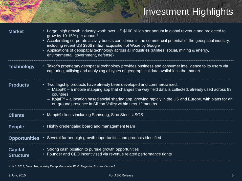
Investment Highlights
9 July, 2015 For ASX Release 5
Market • Large, high growth industry worth over US $100 billion per annum in global revenue and projected to
grow by 10-15% per annum1
• Accelerating corporate activity boosts confidence in the commercial potential of the geospatial industry,
including recent US $966 million acquisition of Waze by Google
• Applications of geospatial technology across all industries (utilities, social, mining & energy,
environmental, government, defense)
Technology • Takor’s proprietary geospatial technology provides business and consumer intelligence to its users via
capturing, utilising and analysing all types of geographical data available in the market
Products • Two flagship products have already been developed and commercialised:
– Mappt® – a mobile mapping app that changes the way field data is collected, already used across 83
countries
– Kojai™ – a location based social sharing app, growing rapidly in the US and Europe, with plans for an
on-ground presence in Silicon Valley within next 12 months
Clients • Mappt® clients including Samsung, Sino Steel, USGS
People • Highly credentialed board and management team
Opportunities • Several further high growth opportunities and products identified
Capital
Structure
• Strong cash position to pursue growth opportunities
• Founder and CEO incentivised via revenue related performance rights

Capital Allocation A$m %
Staff Capacity & Capability 1.5 33
Sales & Marketing 0.9 20
Technology & R+D 0.8 18
Costs of the offer 0.4 8
Working capital 0.9 21
Total Funds applied 4.5 100%
Cash on hand at March 2015 1.5
Funds raised under the Offer 3.0
Total Funds available 4.5
Capital Structure (pre-consolidation basis)
Existing Bone shares on issue 257,796,569
Shares issued to Takor Vendors 387,000,000
Shares issued to transaction negotiators 60,085,797
Shares issued in the Capital Raising (at $0.01) 300,000,000
Total shares outstanding 1,004,882,366
Market capitalisation at Capital Raising price A$10.0m
Cash A$4.5m
Enterprise Value A$5.5m
Employee options issued to Takor employees 20,000,000
Performance shares at listing2 350,000,000
Existing options3 32,059,017
Use of Funds Capital Structure
Note 1: To be issued under the ESOP terms TBA
Note 2: 175 million shares issued upon the achievement of $1.5m in revenue in any 12 month
period and 175 million shares issued upon the achievement of $5m in revenue in any 12 month
consecutive period
Note 3: Exercisable at 3.0 & 4.0 cents per share, expiring on 31/12/2016
Shareholder Split (post-transaction)
25.7%
38.5%
6.0%
29.9%
Existing shareholders
Takor vendors
Negotiator shares
Capital Raisingshares
Capital Raising & Capital Structure
9 July, 2015 For ASX Release 6
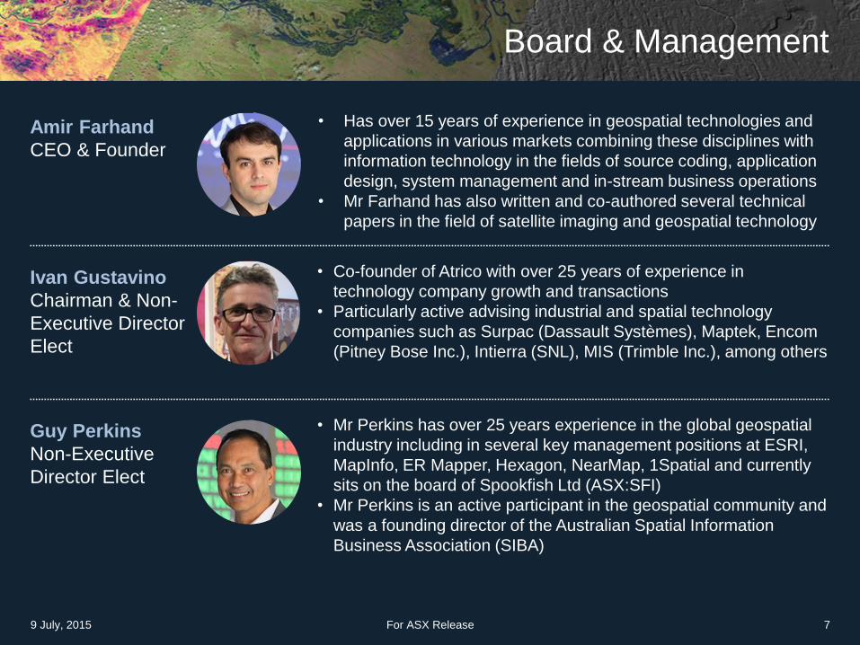
Board & Management
For ASX Release 79 July, 2015
Ivan Gustavino
Chairman & Non-
Executive Director
Elect
• Co-founder of Atrico with over 25 years of experience in
technology company growth and transactions
• Particularly active advising industrial and spatial technology
companies such as Surpac (Dassault Systèmes), Maptek, Encom
(Pitney Bose Inc.), Intierra (SNL), MIS (Trimble Inc.), among others
Guy Perkins
Non-Executive
Director Elect
• Mr Perkins has over 25 years experience in the global geospatial
industry including in several key management positions at ESRI,
MapInfo, ER Mapper, Hexagon, NearMap, 1Spatial and currently
sits on the board of Spookfish Ltd (ASX:SFI)
• Mr Perkins is an active participant in the geospatial community and
was a founding director of the Australian Spatial Information
Business Association (SIBA)
Amir Farhand
CEO & Founder
• Has over 15 years of experience in geospatial technologies and
applications in various markets combining these disciplines with
information technology in the fields of source coding, application
design, system management and in-stream business operations
• Mr Farhand has also written and co-authored several technical
papers in the field of satellite imaging and geospatial technology

What is Geospatial Technology?
• Geospatial technology affects almost every aspect of life:
– from navigating, farmers miners through to social media
• Google Maps and Google Earth first to unleash the power of geospatial technology to the
masses almost 10 years ago
• From your from the air, to the introduction of smartphones, geospatial technology changed
forever
• Additional metrics and applications became quickly evident:
– ‘cool’ imagery to data enabling
• Geospatial technology:
– next generation of the language of business and consumer metrics
• It will not only dictate efficiency, but also distribution and re-use of almost all forms of
acquired data in the future
• With biotechnology and 3D printing = the 3rd chapter of technology advancement in the
next 20 years – it is set to explode!
9 July, 2015 For ASX Release 8

Putting Geospatial into Perspective
• Historical advances in infrastructure:
– Postal Service
– Rail, Road & Highways
– Electricity
– Telecommunications
– Internet & Cellular Networks
….Geospatial!
• So what is Geospatial infrastructure?
– Its satellites
– Its planes with special cameras
– Its drones
– Its driver-less cars
…. all the way down to your mobile phone and its GPS
• We are poised for the significant augmentation of geospatial infrastructure
9 July, 2015 For ASX Release 9
Benefits and Uses
• Supports a wide range of businesses, government and community activities, and the use and re-use of
this information has significant productivity-related benefits
• Helps solve complex problems, decision making processes and service delivery
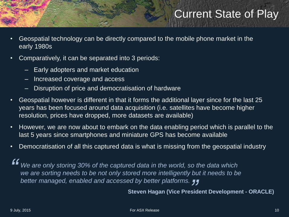
Current State of Play
• Geospatial technology can be directly compared to the mobile phone market in the
early 1980s
• Comparatively, it can be separated into 3 periods:
– Early adopters and market education
– Increased coverage and access
– Disruption of price and democratisation of hardware
• Geospatial however is different in that it forms the additional layer since for the last 25
years has been focused around data acquisition (i.e. satellites have become higher
resolution, prices have dropped, more datasets are available)
• However, we are now about to embark on the data enabling period which is parallel to the
last 5 years since smartphones and miniature GPS has become available
• Democratisation of all this captured data is what is missing from the geospatial industry
“ “We are only storing 30% of the captured data in the world, so the data which
we are sorting needs to be not only stored more intelligently but it needs to be
better managed, enabled and accessed by better platforms.
Steven Hagan (Vice President Development - ORACLE)
9 July, 2015 For ASX Release 10

Welcome to the Future ‘Where’…
Every single feature on
a satellite or aerial
image is mapped and
extracted allowing for
pixel accuracy mapping
You will know when (or
if) your luggage is
coming out of the
carousel
Drones will deliver
packages to your home
or even walk your dog
according to a specified
track or geofence
Which aisles are the
specials located?
Where exactly is the
item I need?
By 2017 a whopping
20% of all search on the
internet will be ‘where’
queries*
All that drone imagery,
Where will it all go?20%
9 July, 2015 For ASX Release 11
Source: Google Report, 2014

Market Opportunity: Size and Timing
For ASX Release 12
Mobile Mapping SolutionsSocial Media &
Big Data Analytics
Remote Sensing &
Thermal Imaging
Subset of US$ 6 billion per
annum GIS software market
Over US $20 billion of valuations
in last 2 years
Expected to growing to US $5
billion by 2020
Sources: Market Analysis Oxera, 2015
9 July, 2015
Democratisation of cheap
hardware means software is
accessible to more people,
creating a perfect storm of
opportunity
Global geospatial industry is
valued at over US$100billion
with growth rates of 30% per
annum
− Geospatial World 2013
Increasing applications of
geospatial technology:
automated cars, retail, disaster
management, home security
and military uses
KEY MARKET OPPORTUNITIES
Takor is a ‘data enabler’ with products targeting each of these segments

• Geospatial industry is dominated by Hexagon AB & Trimble
• Hexagon A$20B market cap / Trimble A$8B market cap
• High valuations for recent Geo-spatial M&A’s
Recent Data Points (Acquisitions)
US Acquisitions
$900M DigitalGlobe
$966M Google
$500M Google
Australian Listed Geospatial companies
$200M market Cap
$50M market Cap
9 July, 2015 For ASX Release 13
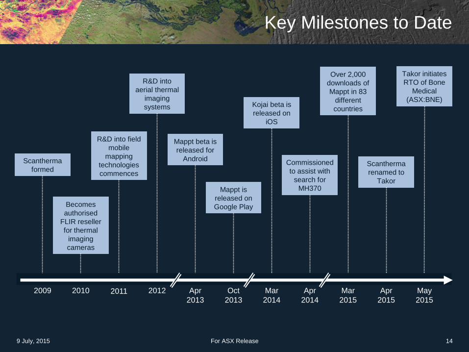
Key Milestones to Date
For ASX Release 14
Scantherma
formed
2009
Becomes
authorised
FLIR reseller
for thermal
imaging
cameras
2010
R&D into field
mobile
mapping
technologies
commences
2011
R&D into
aerial thermal
imaging
systems
2012 Apr
2013
Mappt beta is
released for
Android
Oct
2013
Mappt is
released on
Google Play
Mar
2014
Kojai beta is
released on
iOS
Apr
2014
Commissioned
to assist with
search for
MH370
Mar
2015
Over 2,000
downloads of
Mappt in 83
different
countries
Apr
2015
Scantherma
renamed to
Takor
May
2015
Takor initiates
RTO of Bone
Medical
(ASX:BNE)
9 July, 2015
Initial Takor Products
1. Mappt®
2. KojaiTM
9 July, 2015 For ASX Release 15

Mappt® Overview
• User acceptance. Used in 83 different countries
• User base represented by numerous large
organisations including:
For ASX Release 16
KEY FEATURES
Fast, simple & accurate
field data processing
Low cost of entry
Functions completely
offline – no need for WiFi,
3G/4G
Ability to load unlimited
ECW and JP2 format
imagery
Data agnostic
Embedded GPS tracking
No service charge or cloud
service lock-in
Thematic mapping
capabilities
Measurement tools
9 July, 2015
Please Click to Play Video

Mappt® − Target Audience
Mappt® currently has clients
spanning the following
industries:
• Local government
• Asset management
• Mining & exploration
• Engineering
• Agricultural
• Environmental & conservation
• Cultural & heritage mapping
• Education & training
• Statistical data collection
For ASX Release 179 July, 2015
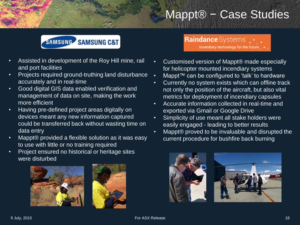
• Assisted in development of the Roy Hill mine, rail
and port facilities
• Projects required ground-truthing land disturbance
accurately and in real-time
• Good digital GIS data enabled verification and
management of data on site, making the work
more efficient
• Having pre-defined project areas digitally on
devices meant any new information captured
could be transferred back without wasting time on
data entry
• Mappt® provided a flexible solution as it was easy
to use with little or no training required
• Project ensured no historical or heritage sites
were disturbed
• Customised version of Mappt® made especially
for helicopter mounted incendiary systems
• Mappt™ can be configured to ‘talk’ to hardware
• Currently no system exists which can offline track
not only the position of the aircraft, but also vital
metrics for deployment of incendiary capsules
• Accurate information collected in real-time and
exported via Gmail or Google Drive
• Simplicity of use meant all stake holders were
easily engaged - leading to better results
• Mappt® proved to be invaluable and disrupted the
current procedure for bushfire back burning
Mappt® − Case Studies
For ASX Release 189 July, 2015

Mappt® Growth Strategy
Targeting 20% of mobile GIS market by 2018
For ASX Release 19
Develop &
release
Mappt®
Software
Development
Kit (SDK)
Increase
Mappt®
user base
Distributor
arrangements
Establish
foothold in the
education
market
Sales to key
high profile
global
organisations
Continuing development of Mappt® features
9 July, 2015

Mappt® − Commercialisation
For ASX Release 209 July, 2015
White Labelling
• Custom versions Mappt® -
white-labelled for each client
paying an agreed license fee
Licensing model
• Two-tier license for each
installation (Standard $660 vs.
Professional $990)
• For educational institutions, an
‘enterprise’ based license
scheme which allows for
multiple licenses within a single
institution
• Licensing of the Software
Development Kit (SDK) on a
minimum revenue payment and
profit sharing basis

Kojai™ Overview
• Location based social media app for Apple’s iOS.
• Allows users to geo-tag photos and posts for Twitter
and Facebook to share moments and places with
friends
• Provides a unique visual sharing experience −
earned it an App Store rating of 4.5 stars
• In beta Kojai™ has proved popular with over 20,000
users in 20 countries globally
• Takor will be committing development expenditure
focusing on resourcing the further expansion of this
product into these key user markets
For ASX Release 21
KEY FEATURES
Easy sign up for
Facebook users
Adds spatial dimension
to the social media
experience
Photos taken outside of
cellular network, can still
be posted in Kojai™
using the phone’s in-built
GPS
Custom ‘tag’ − allowing
areas that are otherwise
not catalogued by
Google Maps, Facebook
or Twitter to be tagged
Privacy mode
9 July, 2015

Kojai™ − Growth Strategy and Target Users
9 July, 2015 For ASX Release 22
Target Users
Address commercial opportunities to generate revenue from improved client and app services
Expansion to Android platform – Q4 2015
Target marketing roll out to Europe and North America to build the user base including office in San Francisco – Q3 2015
Upcoming Releases in Kojai™
Server rewrite and architecture
update
Improve user login and
registration
Convert database to ‘geoaware’ database
Automate server
architecture & deployment
Enable push notifications to the end
user
Redesign & performance
upgradesActive: Facebook
(1.44 billion MAUs)
and,
Active: Twitter (302
million MAUs)
users
Males and females
aged between 16
and 35
Travellers
Phone
photographers

Kojai™ − Commercialisation Strategy
While Kojai™ is a free app there are a number of potential routes to generate
revenue from the service:
For ASX Release 239 July, 2015
Advertising
Based on user
preferences / history
for location based
events and items of
interest
Ability to target user
via geospatial
intelligence
Commissions
On transactions
initiated through
Kojai™ for:
• Buying tickets to
events of interest
or in the local area
• Commission on
vouchers using
geofencing
Data mining
Capabilities and
targeted search
Other information
related to the
locations, such as
financial data, user
patterns and trends
££

Focused Group Strategy for Rapid Growth
For ASX Release 249 July, 2015
Expand adoption of its mobile mapping platform, Mappt®, via SDK
opportunities
Targeted market expansion for adoption of Kojai™ in North America
and Europe
Commercialise Kojai™ user base and Remote Sensing datasets and
Thermal Imagery products
Develop R&D pipeline focusing on data acquisition and processing
technologies to be served via both Mappt® and web based platforms
Expand market share in key target verticals locally and overseas,
leveraging off key technology platforms
Expand adoption
of mobile
platforms
Market expansion
of KojaiTM
Further
commercialisation
Develop R&D
pipeline
Expand market
share

Development Pipeline
For ASX Release 25
Mappt®
• Develop and release Mappt® software
development kit (SDK) for Mappt®
• Increase user base on the Android platform
• Establish distributor arrangements
Kojai™
• Improvements to Kojai™ performance
including: architecture update, registration
process, convert database to ‘geoware’, push
notifications and client app design
Global remote sensing datasets and thermal
imaging
• Integration of the datasets into online portal
• Continue processing of unprocessed datasets
• Creation of new datasets for natural resource
exploration
• Acquire additional remote sensing datasets of
areas of interest and process these for
incorporation into a dataset package.
Mappt®
• Establish foothold in the education market
• Sales to key high profile organisations
Continuing development of Mappt® features.
Kojai™
• Target marketing roll out to Europe and North
America
• Expansion to Android platform
• Address commercial opportunities to generate
further revenues
Global remote sensing datasets and thermal
imaging
• Continue processing of unprocessed datasets
• Creation of new datasets for natural resource
exploration
• Acquire additional remote sensing datasets of
areas of interest and process these for
incorporation into a dataset package.
9 July, 2015
2015 2016

Merger & ASX RTO
USE OF FUNDS
Staff capacity & capability
• Additional staff to further assist in development of
Takor product suite
Marketing
• Growth of the Takor’s brands (Kojai™ and Mappt®)
• Focus on high value-return and performance based
marketing for core technologies
Sales
• Drive advocacy sales in key international markets
• Build the sales pipeline for thorough identification of
high value market opportunities
Technology R&D
• Expand R&D for development of new geospatial
technologies
• Constant improvement of existing products
9 July, 2015 For ASX Release 26
ASX RTO
• Planned Merger and ASX RTO
with Bone Medical (ASX:BNE)
announced May 2015
• Raising A$3m to fund rapid
product marketing and growth
• Re-listed company will have
~$4.0m in cash on hand.
• Mkt cap of ~A$10m.
• Relisting anticipated for
Aug/Sept 2015
APPENDIX 1
• Takor Background & History
• Applications of Geospatial Technology
• Peer Analysis
• Traction to Date: Mappt®
• Further Opportunity − Remote Sensing Data Sets
9 July, 2015 For ASX Release 27
Takor Background & History
• Started out as Scantherma in 2009
• Initially focused on using satellite imagery for iron ore exploration with clients
such as FMG, BHP and Sino Steel
• Government and industry funded mineral exploration datasets in nations
including Australia, Uzbekistan, Tajikistan, Indonesia, China and Peru
• In late 2009, pioneered a unique RADAR algorithm for mineral exploration
• This technique has now become an accepted procedure for mapping geological
structures in dense tropical landscapes
• In 2011 and 2012 initiated R&D into field mobile mapping technologies and
thermal imaging systems
• Commissioned in search for missing Malaysian airline MH370 in April 2014
• Renamed to Takor in April 2015
9 July, 2015 For ASX Release 28
Takor Background & History (cont’d)
• Takor’s proprietary geospatial technology provides business and consumer
intelligence to its users via capturing, utilising and analysing all types of
geographical data available in the market
• Operates in the large and growing geospatial industry
• Two proprietary applications have already been developed and commercialised:
Mappt® and Kojai™
• Mappt® has a wide range of users in 83 different countries, with a tier one clients
including Samsung, Sino Steel and USGS
• $3 million capital raising planned to accelerate growth through enhanced staff
capacity and capability, targeted marketing campaigns and further investments in
technology and research and development
• Highly credentialed board & management team with vast experience in the
geospatial industry
9 July, 2015 For ASX Release 29

Applications of Geospatial Technology
9 July, 2015 For ASX Release 30
Utilities & Infrastructure Business Applications Mining & Resources
Energy distribution Marketing Exploration
Telecommunications Targeted advertising Commodity identification
Logistics & transport Search Geological mapping
Security & Defense Property Services Environmental
Intelligence gathering Real estate Conservation
Emergency planning Land titles Animal welfare & tracking
Infield combat Urban developments Wildfire management
Aviation & Safety Insurance Government
Navigation Disaster recovery Planning
Drone delivery Compliance Asset management
Compliance & assurance Active warnings Asset tracking

Peer AnalysisMobile Accessibility, Our Key Differentiator
9 July, 2015 For ASX Release 31
Geospatial / Location
IntelligenceThermal Imaging Mobile
Digital Mapping /
Geospatial Imagery
(Desktop)

Mappt® − Traction to Date
For ASX Release 329 July, 2015
0
500
1000
1500
2000
2500
3000
Do
wn
load
s
Play
Release
SEO
Program
Initiated
Formal
presentation
to industry

Further Opportunity − Remote Sensing Data Sets
Takor currently holds over 34TB remote sensing (RS) datasets already processed
to create a broad reaching archive of satellite data covering across globe
The RS datasets held by Takor can be used for a variety of applications including:
For ASX Release 33
Intellectual Property
The datasets are processed and completed by Takor. The ownership becomes
the IP of Takor and can be on-sold to clients and end users.
9 July, 2015
Mining &
exploration
Oil & gas
exploration
Environmental
managementAgriculture
Utilities and
infrastructure
Local, State
and Federal
government

Thermal Imagery
Takor has completed thermal mapping of Perth and South-West Australia
Applications of Thermal Imagery:
• Heat mapping for urban planning
• Energy usage & diagnostics
• Vegetation health
• Real estate
• Bushfire management
• Targeted advertising
• Mineral exploration
9 July, 2015 For ASX Release 34
Disruptive
Democratised
Geospatial Technology
Andrew Frazer (Lead Manager)
Email: [email protected]
Phone: +61 9 6141 6300
9 July, 2015 For ASX Release 35
Amir Farhand (CEO)
Email: [email protected]
Phone: +61 400 972 365