Embed Size (px)
Citation preview
M U N N –R E E S EBroadcast Engineering Consultants
Coldwater, MI 49036
ENGINEERING REPORT
FM Translator MinorChange
Applicationfor
W286DC – East Lansing, MI(Facility ID: 156707)
License:0000112077
as a fill-in FM Translator for
WKAR(AM) – East Lansing, MI
August 2021

M U N N –R E E S EBroadcast Engineering Consultants
Coldwater, MI 49036
Table of Contents
Discussion of Report
FM Booster/Fill-in Translator Requirements (See Discussion)
Interference/Overlap RequirementsExhibit 13.1 - Copy of Existing Antenna Structure Registration (if applicable)Exhibit 13.2 - Proposed Service and AM Fill-In Contour MapExhibit 13.3 - Tabulation of Proposed AllocationExhibit 13.4 - §74.1204(d) 2nd/3rd Adjacent Waiver Request (if applicable)Exhibit 13.5 - Copy of Manufacturer’s Vertical Radiation Pattern (if applicable)
TV Channel 6 Protection Requirements (See Discussion)
Multiple Translator Requirements (See Discussion)
RF Radiation Study RequirementExhibit 17.1 - RF Compliance Study
M U N N –R E E S EBroadcast Engineering Consultants
Coldwater, MI 49036
Discussion
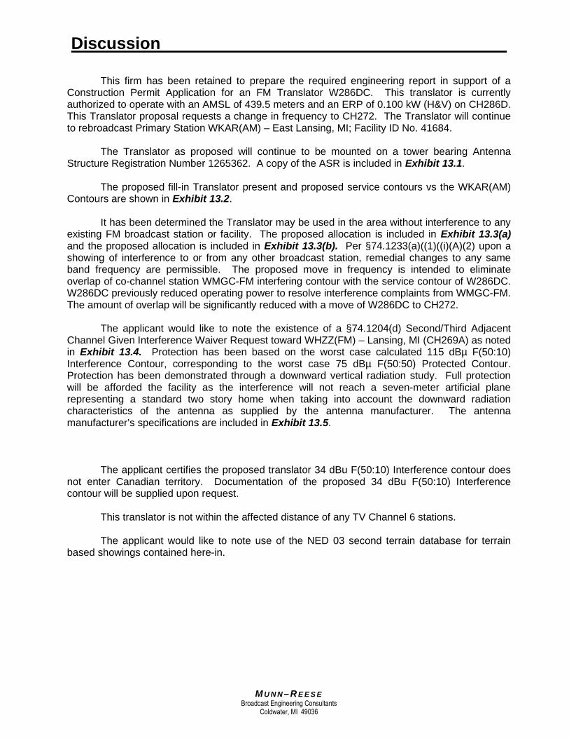
This firm has been retained to prepare the required engineering report in support of aConstruction Permit Application for an FM Translator W286DC. This translator is currentlyauthorized to operate with an AMSL of 439.5 meters and an ERP of 0.100 kW (H&V) on CH286D.This Translator proposal requests a change in frequency to CH272. The Translator will continueto rebroadcast Primary Station WKAR(AM) – East Lansing, MI; Facility ID No. 41684.
The Translator as proposed will continue to be mounted on a tower bearing AntennaStructure Registration Number 1265362. A copy of the ASR is included in Exhibit 13.1.
The proposed fill-in Translator present and proposed service contours vs the WKAR(AM)Contours are shown in Exhibit 13.2.
It has been determined the Translator may be used in the area without interference to anyexisting FM broadcast station or facility. The proposed allocation is included in Exhibit 13.3(a)and the proposed allocation is included in Exhibit 13.3(b). Per §74.1233(a)((1)((i)(A)(2) upon ashowing of interference to or from any other broadcast station, remedial changes to any sameband frequency are permissible. The proposed move in frequency is intended to eliminateoverlap of co-channel station WMGC-FM interfering contour with the service contour of W286DC.W286DC previously reduced operating power to resolve interference complaints from WMGC-FM.The amount of overlap will be significantly reduced with a move of W286DC to CH272.
The applicant would like to note the existence of a §74.1204(d) Second/Third AdjacentChannel Given Interference Waiver Request toward WHZZ(FM) – Lansing, MI (CH269A) as notedin Exhibit 13.4. Protection has been based on the worst case calculated 115 dBµ F(50:10)Interference Contour, corresponding to the worst case 75 dBµ F(50:50) Protected Contour.Protection has been demonstrated through a downward vertical radiation study. Full protectionwill be afforded the facility as the interference will not reach a seven-meter artificial planerepresenting a standard two story home when taking into account the downward radiationcharacteristics of the antenna as supplied by the antenna manufacturer. The antennamanufacturer’s specifications are included in Exhibit 13.5.
The applicant certifies the proposed translator 34 dBu F(50:10) Interference contour doesnot enter Canadian territory. Documentation of the proposed 34 dBu F(50:10) Interferencecontour will be supplied upon request.
This translator is not within the affected distance of any TV Channel 6 stations.
The applicant would like to note use of the NED 03 second terrain database for terrainbased showings contained here-in.

M U N N –R E E S EBroadcast Engineering Consultants
Coldwater, MI 49036
Discussion (continued)
RADIATION PROTECTION: The Commission requires an engineering study regardingcompliance with the guidelines for human protection from radiofrequency radiation. This reportsection is in response to that provision of the Rules. The current Federal CommunicationsCommission guidelines for RF radiation protection are set forth in OET Bulletin No. 65 (Edition97-01), and the accompanying Supplement A, (Edition 97-01).
The FM Broadcast facility proposed in this application will not produce human exposure toradiofrequency radiation in excess of the applicable safety standards specified in §1.1307(b)(3) ofthe Commission's rules concerning RF contributors of less than 5%. Exhibit 17.1 provides thedetails of the study that was made to demonstrate compliance. The facility is properly markedwith signs, and entry is restricted by means of fencing with locked doors and/or gates. Any othermeans as may be required to protect employees and the general public will be employed.
In the event work would be required in proximity to the antenna such that theperson or persons working in the area would be potentially exposed to fields in excess ofthe guidelines set forth in OET Bulletin No. 65 (Edition 97-01), the transmitter power will bereduced or the station will cease operation during the critical period.

10/16/2019 ASR Registration 1265362
https://wireless2.fcc.gov/UlsApp/AsrSearch/asrRegistration.jsp?regKey=2664709&printable 1/2
ASR Registration Search
Registration 1265362 Map Registration
Registration Detail
Reg Number 1265362 Status Constructed
File Number A0754204 Constructed 07/05/2011
EMI No Dismantled
NEPA No
Antenna Structure
Structure Type TOWER - Free standing or Guyed Structure used for Commu
Location (in NAD83 Coordinates)
Lat/Long 42-42-06.9 N 084-24-47.8 W Address 4101 Dobie Road
City, State Okemos , MI
Zip 48864 County INGHAM
Center ofAM Array
Position of Towerin Array
Heights (meters)
Elevation of Site Above Mean Sea Level Overall Height Above Ground (AGL)
259.1 313.3
Overall Height Above Mean Sea Level Overall Height Above Ground w/o Appurtenances
572.4 297.8
Painting and Lighting Specifications
FAA Chapters 3, 4, 5, 12Paint and Light in Accordance with FAA Circular Number 70/7460-1K
FAA Notification
FAA Study 2011-AGL-4543-OE FAA Issue Date 12/08/2011
Owner & Contact Information
FRN 0007619026 Owner EntityType
Owner
Board of Trustees, Michigan State University Attention To: Nancy Gilleo283 Comm. Arts & Sci. Bldg.East Lansing , MI 48824-1212
P: (517)432-9527F: E: [email protected]
Contact
P: F: E:
Last Action Status
Status Constructed Received 02/06/2012
Purpose Notification Entered 02/06/2012
Mode Interactive
Related Applications
02/06/2012 A0754204 - Notification (NT)

DetroitDetroitDetroitDetroitDetroitDetroitDetroitDetroitDetroitDetroit
Grand RapidsGrand RapidsGrand RapidsGrand RapidsGrand RapidsGrand RapidsGrand RapidsGrand RapidsGrand RapidsGrand Rapids
WarrenWarrenWarrenWarrenWarrenWarrenWarrenWarrenWarrenWarren
FlintFlintFlintFlintFlintFlintFlintFlintFlintFlint
LansingLansingLansingLansingLansingLansingLansingLansingLansingLansing
Sterling HeightsSterling HeightsSterling HeightsSterling HeightsSterling HeightsSterling HeightsSterling HeightsSterling HeightsSterling HeightsSterling Heights
Ann ArborAnn ArborAnn ArborAnn ArborAnn ArborAnn ArborAnn ArborAnn ArborAnn ArborAnn Arbor
LivoniaLivoniaLivoniaLivoniaLivoniaLivoniaLivoniaLivoniaLivoniaLivonia
KalamazooKalamazooKalamazooKalamazooKalamazooKalamazooKalamazooKalamazooKalamazooKalamazoo
SouthfieldSouthfieldSouthfieldSouthfieldSouthfieldSouthfieldSouthfieldSouthfieldSouthfieldSouthfield
SaginawSaginawSaginawSaginawSaginawSaginawSaginawSaginawSaginawSaginaw
TaylorTaylorTaylorTaylorTaylorTaylorTaylorTaylorTaylorTaylor
PontiacPontiacPontiacPontiacPontiacPontiacPontiacPontiacPontiacPontiac
WaterfordWaterfordWaterfordWaterfordWaterfordWaterfordWaterfordWaterfordWaterfordWaterford
Battle CreekBattle CreekBattle CreekBattle CreekBattle CreekBattle CreekBattle CreekBattle CreekBattle CreekBattle Creek
PortagePortagePortagePortagePortagePortagePortagePortagePortagePortage
Muskegon Muskegon Muskegon Muskegon Muskegon Muskegon Muskegon Muskegon Muskegon Muskegon
KentwoodKentwoodKentwoodKentwoodKentwoodKentwoodKentwoodKentwoodKentwoodKentwood
MidlandMidlandMidlandMidlandMidlandMidlandMidlandMidlandMidlandMidland
NoviNoviNoviNoviNoviNoviNoviNoviNoviNovi
Bay CityBay CityBay CityBay CityBay CityBay CityBay CityBay CityBay CityBay City
JacksonJacksonJacksonJacksonJacksonJacksonJacksonJacksonJacksonJackson
HollandHollandHollandHollandHollandHollandHollandHollandHollandHolland
InksterInksterInksterInksterInksterInksterInksterInksterInksterInkster
Mount PleasantMount PleasantMount PleasantMount PleasantMount PleasantMount PleasantMount PleasantMount PleasantMount PleasantMount Pleasant
MonroeMonroeMonroeMonroeMonroeMonroeMonroeMonroeMonroeMonroeAdrianAdrianAdrianAdrianAdrianAdrianAdrianAdrianAdrianAdrian
NortonShores NortonShores NortonShores NortonShores NortonShores NortonShores NortonShores NortonShores NortonShores NortonShores
GrangerGrangerGrangerGrangerGrangerGrangerGrangerGrangerGrangerGranger
Highland ParkHighland ParkHighland ParkHighland ParkHighland ParkHighland ParkHighland ParkHighland ParkHighland ParkHighland Park
TrentonTrentonTrentonTrentonTrentonTrentonTrentonTrentonTrentonTrenton
JenisonJenisonJenisonJenisonJenisonJenisonJenisonJenisonJenisonJenison
OwossoOwossoOwossoOwossoOwossoOwossoOwossoOwossoOwossoOwosso
Grand Haven Grand Haven Grand Haven Grand Haven Grand Haven Grand Haven Grand Haven Grand Haven Grand Haven Grand Haven
Big RapidsBig RapidsBig RapidsBig RapidsBig RapidsBig RapidsBig RapidsBig RapidsBig RapidsBig Rapids
Niles Niles Niles Niles Niles Niles Niles Niles Niles Niles
HoltHoltHoltHoltHoltHoltHoltHoltHoltHolt
EcorseEcorseEcorseEcorseEcorseEcorseEcorseEcorseEcorseEcorse
Beverly HillsBeverly HillsBeverly HillsBeverly HillsBeverly HillsBeverly HillsBeverly HillsBeverly HillsBeverly HillsBeverly Hills
SturgisSturgisSturgisSturgisSturgisSturgisSturgisSturgisSturgisSturgis
AlbionAlbionAlbionAlbionAlbionAlbionAlbionAlbionAlbionAlbion
FCC F(50-50) 60.00 dBu (FCC HAAT)FCC F(50-50) 60.00 dBu (FCC HAAT)
2.0 mV/m
Circle R = 40.0 kmWKAR.LWKAR.LWKAR.LWKAR.LWKAR.LWKAR.LWKAR.LWKAR.LWKAR.LWKAR.L W286DCW286DCW286DCW286DCW286DCW286DCW286DCW286DCW286DCW286DCW286DC.PW286DC.PW286DC.PW286DC.PW286DC.PW286DC.PW286DC.PW286DC.PW286DC.PW286DC.P
V-Soft Communications LLC ® ©
Scale 1:1,000,000
0 10 20 30km
WKAR.L
Latitude: 42-42-19 N
Longitude: 084-28-30 W
ERP: 0.10 kW
Channel: 201
Frequency: 0.87 MHz
AMSL Height: 0.0 m
Elevation: 0.0 m
Horiz. Pattern: Omni
Vert. Pattern: No
Prop Model: None
WKAR.L
W286DC (286)
W286DC.P (272)
Munn-Reese.Com
Exhibit 13.2 W286DC - Present and Proposed vs AMContours
W286DC
0000112077
Latitude: 42-42-06.77 N
Longitude: 084-24-47.89 W
ERP: 0.10 kW
Channel: 286
Frequency: 105.1 MHz
AMSL Height: 439.5 m
Elevation: 259.1 m
Horiz. Pattern: Directional
Vert. Pattern: No
Prop Model: None
W286DC.P
Proposed
Latitude: 42-42-06.77 N
Longitude: 084-24-47.89 W
ERP: 0.10 kW
Channel: 272
Frequency: 102.3 MHz
AMSL Height: 439.5 m
Elevation: 259.1 m
Horiz. Pattern: Directional
Vert. Pattern: No
Prop Model: None

Exhibit 13.3(a)Board Of Trustees Of Michigan State Univ
REFERENCE CH# 286D - 105.1 MHz, Pwr= 0.1 kW DA, HAAT= 0.0 M, COR= 439.5 M DISPLAY DATES42 42 06.90 N. Average Protected F(50-50)= 5.64 km DATA 07-26-2184 24 47.80 W. Standard Directional SEARCH 08-04-21-------------------------------------------------------------------------------------------------------------CH CALL TYPE ANT AZI DIST LAT PWR(kW) INT(km) PRO(km) *IN* *OUT*CITY STATE <-- FILE # LNG HAAT(M) COR(M) LICENSEE (Overlap in km)-------------------------------------------------------------------------------------------------------------286D W286DC LIC DCN 0.0 0.00 42 42 06.90 0.100 ---Reference---East Lansing MI 0.0 0000112077 84 24 47.80 440 Board Of Trustees Of Michi
286B WMGC-FM LIC _CN 104.7 105.95 42 27 13.10 50.000 136.1 63.4 -33.7* 24.2Detroit MI 285.5 BMLH20061004AIW 83 09 49.70 150 349 Beasley Media Group Licens
284D W284AH LIC _CN 283.3 8.88 42 43 13.10 0.250 1.1 11.9 -6.0* -3.7*Lansing MI 103.3 BLFT20160916AAH 84 31 08.90 349 West Central Michigan Medi
289B WSRW-FM LIC _CN 267.1 91.19 42 39 17.50 265.000 10.2 86.0 67.4 3.8Grand Rapids MI 86.3 BLH20071129AJD 85 31 38.00 177 424 Ihm Licenses, LLC
285A WBXX LIC _CN 224.6 60.33 42 18 52.10 6.000 42.0 27.1 6.4 16.0Marshall MI 44.3 BLH20160527AAL 84 55 43.70 97 381 Townsquare License, LLC
287A WKHM-FM LIC _CN 179.1 60.93 42 09 14.10 2.200 38.3 25.3 14.9 26.2Brooklyn MI 359.1 BLH19940201KC 84 24 06.80 115 418 Mckibbin Media Group, Inc.
285A WQBX LIC NCN 348.2 75.78 43 22 08.10 6.000 43.6 28.4 20.8 32.7Alma MI 168.1 BLH20141219ACN 84 36 19.00 100 327 Jacom, Inc.
288B1 WWCK-FM LIC ZCN 60.8 70.98 43 00 39.10 25.000 4.2 45.3 61.9 25.5Flint MI 241.3 BLH19970124KD 83 39 03.80 100 337 Cumulus Licensing LLC
287B AL6792 RSV-A ___ 301.5 138.30 43 20 36.08 50.000 75.6 62.8 49.1 46.9Coopersville MI 120.5 RM10545 85 52 16.18 150 382
287B WHTS LIC _CN 299.5 139.37 43 18 35.10 20.000 74.3 63.1 51.4 47.4Coopersville MI 118.5 BLH20060516ACU 85 54 45.20 242 469 Radio License Holding Cbc,
286D W286AU LIC _CN 246.8 107.49 42 18 52.10 0.250 38.8 11.3 55.7 53.2Kalamazoo MI 66.0 BLFT20121121ARS 85 36 54.00 84 345 Kalamazoo Broadcasting Com
286D W286CI LIC _CN 25.7 89.90 43 25 47.10 0.170 24.7 7.4 57.1 61.5Saginaw MI 206.0 BLFT20130610AAD 83 55 51.90 37 219 Plonta Broadcasting Inc.
283A WILZ LIC NCN 27.2 86.48 43 23 34.10 2.900 2.4 26.9 76.1 59.4Saginaw MI 207.5 BLH19920825KB 83 55 26.90 126 309 Radio License Holding Cbc,
284B WIOT LIC _CN 144.2 140.38 41 40 23.20 50.000 6.3 67.2 128.8 73.0Toledo OH 324.9 BMLH20020611AAX 83 25 30.80 165 345 Ihm Licenses, LLC
285D W285FO LIC _CN 285.4 108.47 42 57 13.10 0.250 21.6 14.3 73.1 73.4Grand Rapids MI 104.5 BLFT20161021ABE 85 41 55.10 353 Townsquare Media Of Grand
283B WSNX-FM LIC _CN 293.6 142.87 43 12 16.10 32.000 5.7 63.7 123.4 77.7Muskegon MI 112.5 BLH19880930KC 86 01 45.20 189 392 Ihm Licenses, LLC
286B1 WQHK-FM LIC _CN 200.4 188.35 41 06 39.20 5.700 99.6 43.9 78.5 109.7Huntertown IN 19.8 BLH20120307AAG 85 11 43.90 210 457 Jam Communications, Inc.
288D W288DW LIC DCN 104.7 93.33 42 29 01.10 0.099 0.7 5.5 89.1 87.5Southfield MI 285.4 0000126515 83 18 43.80 299 Word Broadcasters, Inc.
233C1 WCEN-FM LIC DCN 352.3 114.90 43 43 36.10 100.000 169.8 84.6 21.5R 93.4MHemlock MI 172.2 BMLH20041124AGB 84 36 16.00 299 519 Alpha Media Licensee LLC
-------------------------------------------------------------------------------------------------------------Terrain database is NED 03 SEC , R= 73.215 qualifying spacings or FCC minimum Spacings in KM, M= Margin in KMIn & Out distances between contours are shown at closest points. Reference zone= East Zone, Co to 3rd adjacent.All separation margins (if shown) include rounding. Call signs with strikeout need not be protected.Ant Column: (D= DA Standard, Z= DA 73.215, N= Not DA 73.215, _= Omni), Polarization (C,H,V,E), Beamtilt(Y,N,X)"*"affixed to 'IN' or 'OUT' values = site inside restricted contour.« = Station meets FCC minimum distance spacing for its class.

Exhibit 13.3(b)Board Of Trustees Of Michigan State Univ
REFERENCE CH# 272D - 102.3 MHz, Pwr= 0.1 kW DA, HAAT= 0.0 M, COR= 439.5 M DISPLAY DATES42 42 06.90 N. Average Protected F(50-50)= 5.64 km DATA 07-26-2184 24 47.80 W. Standard Directional SEARCH 08-04-21-------------------------------------------------------------------------------------------------------------CH CALL TYPE ANT AZI DIST LAT PWR(kW) INT(km) PRO(km) *IN* *OUT*CITY STATE <-- FILE # LNG HAAT(M) COR(M) LICENSEE (Overlap in km)-------------------------------------------------------------------------------------------------------------269A WHZZ LIC _CN 264.4 11.88 42 41 29.10 4.100 2.7 28.4 -4.3* -17.2*Lansing MI 84.3 BLH19990811KD 84 33 28.90 121 386 The Macdonald Broadcasting
273B WIOG LIC _CN 28.1 97.41 43 28 24.10 86.000 97.4 79.9 -7.9 1.6Bay City MI 208.5 BLH19850207KK 83 50 39.90 244 427 Radio License Holding Cbc,
271B WMUK LIC _CN 251.3 96.93 42 25 01.10 49.000 74.5 61.5 9.3 7.3Kalamazoo MI 70.5 BLED20140522AFS 85 31 55.00 151 414 Western Michigan Universit
275B WWWW-FM LIC DCN 137.4 68.60 42 14 46.10 50.000 5.2 60.6 58.7 7.6Ann Arbor MI 317.8 BLH20110408AAK 83 50 57.80 134 406 Cumulus Licensing LLC
272C3 WYBR LIC NCN 319.4 144.53 43 41 01.10 10.500 102.3 37.6 29.5 64.6Big Rapids MI 138.6 BLH19921112KE 85 34 56.20 133 443 Mentor Partners, Inc.
219B WUOM LIC _CN 128.5 52.45 42 24 27.10 93.000 169.8 84.6 14.5R 38.0MAnn Arbor MI 308.8 BLED19990204KA 83 54 49.80 237 513 Regents Of The University
270D W270CJ LIC DCN 175.5 51.84 42 14 13.10 0.250 1.1 8.8 43.0 42.5Jackson MI 355.6 BLFT20140401AMD 84 21 51.80 39 334 Mckibbin Media Group, Inc.
275B WYHA LIC _CN 285.4 108.47 42 57 13.00 50.000 5.7 63.1 89.0 43.9Grand Rapids MI 104.5 0000106685 85 41 55.00 150 365 Bible Broadcasting Network
273A WBZV LIC _CN 185.7 91.36 41 53 03.10 6.000 38.4 25.2 44.2 56.1Hudson MI 5.6 BLH19950315KG 84 31 23.80 100 430 Madsun Investments, LLC
272A WPOS-FM LIC _CN 154.0 132.91 41 37 32.20 6.000 82.7 25.2 44.2 94.5Holland OH 334.4 BMLH20140415ABD 83 42 40.80 95 285 Maumee Valley Broadcasting
270B WDET-FM LIC _CN 108.9 117.26 42 21 06.10 48.000 6.1 66.1 107.6 51.0Detroit MI 289.8 BLED19980624KB 83 03 47.70 169 354 Wayne State University
274B WDKL LIC DCN 104.1 102.55 42 28 16.00 36.000 3.1 44.2 95.9 56.7Mount Clemens MI 284.9 BLED20190820AAV 83 12 01.00 174 380 Educational Media Foundati
271L1 WFAH-LP LIC _CN 53.4 70.54 43 04 40.10 0.060 57.3 59.6Flint MI 233.9 BLL20170616AAS 83 42 55.80 39 266 Greater Flint Arts Council
272D W272DG LIC _CN 128.2 76.19 42 16 33.00 0.007 9.3 2.9 62.9 61.9Pittsfield Township MI 308.7 0000124534 83 41 07.00 24 267 Michigan Community Radio
274D W274AQ LIC DCN 234.4 77.80 42 17 32.20 0.250 1.1 11.7 64.2 65.2Battle Creek MI 53.9 BLFT20150129AAP 85 10 58.00 359 Midwest Communications, In
272A WGBJ LIC NCN 202.7 162.41 41 21 07.80 6.000 85.2 27.2 66.8 105.5Auburn IN 22.2 0000119017 85 09 55.60 100 375 Sarkes Tarzian, Inc.
270D W270DN CP _CN 306.9 85.35 43 09 35.10 0.250 1.1 7.5 70.9 77.2Greenville MI 126.3 BNPFT20180426AAN 85 15 18.10 282 Packer Radio Greenville, I
273D W273AR LIC _CN 247.1 111.01 42 18 23.10 0.250 24.0 16.0 73.9 75.5Paw Paw MI 66.2 BLFT20110831AAS 85 39 25.00 153 412 Townsquare License, LLC
273D W273DD LIC DCN 289.8 110.84 43 01 58.10 0.155 16.7 11.4 80.4 78.6Grand Rapids MI 108.9 BLFT20170222ABT 85 41 47.10 316 Goodrich Radio, LLC
271C2 WLEW-FM LIC _CN 37.8 168.42 43 53 28.10 50.000 78.9 52.9 82.4 108.5Bad Axe MI 218.7 BLH19890117KK 83 07 25.80 150 350 Thumb Broadcasting, Inc.
269D W269CS LIC _CN 240.1 96.49 42 15 52.10 0.080 0.6 5.3 83.1 89.4Galesburg MI 59.4 BLFT20151006AAK 85 25 46.90 292 Spring Arbor University
272A WGRT LIC _CN 74.8 162.69 43 04 08.10 3.000 74.2 23.2 84.5 128.0Port Huron MI 256.1 BLH19911230KD 82 28 47.70 97 296 Port Huron Family Radio, I
218C3 WMHW-FM LIC _CN 343.3 101.44 43 34 33.10 9.100 169.8 84.6 11.5R 89.9MMount Pleasant MI 163.1 BMLED20161222AAW 84 46 29.00 164 405 Central Michigan Universit
269A WPRJ LIC _CN 358.1 123.36 43 48 39.10 4.600 2.8 29.3 109.9 93.7Coleman MI 178.1 0000112403 84 27 50.00 114 328 Spirit Communications, Inc
-------------------------------------------------------------------------------------------------------------Terrain database is NED 03 SEC , R= 73.215 qualifying spacings or FCC minimum Spacings in KM, M= Margin in KMIn & Out distances between contours are shown at closest points. Reference zone= East Zone, Co to 3rd adjacent.All separation margins (if shown) include rounding. Call signs with strikeout need not be protected.Ant Column: (D= DA Standard, Z= DA 73.215, N= Not DA 73.215, _= Omni), Polarization (C,H,V,E), Beamtilt(Y,N,X)"*"affixed to 'IN' or 'OUT' values = site inside restricted contour.« = Station meets FCC minimum distance spacing for its class.

InghamEaton
LansingLansingLansingLansingLansingLansingLansingLansingLansingLansingEast LansingEast LansingEast LansingEast LansingEast LansingEast LansingEast LansingEast LansingEast LansingEast Lansing
OkemosOkemosOkemosOkemosOkemosOkemosOkemosOkemosOkemosOkemos
HoltHoltHoltHoltHoltHoltHoltHoltHoltHolt
HaslettHaslettHaslettHaslettHaslettHaslettHaslettHaslettHaslettHaslett
CharlotteCharlotteCharlotteCharlotteCharlotteCharlotteCharlotteCharlotteCharlotteCharlotte
Grand LedgeGrand LedgeGrand LedgeGrand LedgeGrand LedgeGrand LedgeGrand LedgeGrand LedgeGrand LedgeGrand Ledge
MasonMasonMasonMasonMasonMasonMasonMasonMasonMason
Eaton RapidsEaton RapidsEaton RapidsEaton RapidsEaton RapidsEaton RapidsEaton RapidsEaton RapidsEaton RapidsEaton Rapids
De WittDe WittDe WittDe WittDe WittDe WittDe WittDe WittDe WittDe Witt
FowlervilleFowlervilleFowlervilleFowlervilleFowlervilleFowlervilleFowlervilleFowlervilleFowlervilleFowlerville
WilliamstonWilliamstonWilliamstonWilliamstonWilliamstonWilliamstonWilliamstonWilliamstonWilliamstonWilliamston
PerryPerryPerryPerryPerryPerryPerryPerryPerryPerry
WebbervilleWebbervilleWebbervilleWebbervilleWebbervilleWebbervilleWebbervilleWebbervilleWebbervilleWebberville
PottervillePottervillePottervillePottervillePottervillePottervillePottervillePottervillePottervillePotterville
DimondaleDimondaleDimondaleDimondaleDimondaleDimondaleDimondaleDimondaleDimondaleDimondale
LaingsburgLaingsburgLaingsburgLaingsburgLaingsburgLaingsburgLaingsburgLaingsburgLaingsburgLaingsburg
VernonVernonVernonVernonVernonVernonVernonVernonVernonVernonWestphaliaWestphaliaWestphaliaWestphaliaWestphaliaWestphaliaWestphaliaWestphaliaWestphaliaWestphalia
MorriceMorriceMorriceMorriceMorriceMorriceMorriceMorriceMorriceMorrice
BancroftBancroftBancroftBancroftBancroftBancroftBancroftBancroftBancroftBancroft
DansvilleDansvilleDansvilleDansvilleDansvilleDansvilleDansvilleDansvilleDansvilleDansville
EagleEagleEagleEagleEagleEagleEagleEagleEagleEagle
FCC F(50-50) 75.24 dBu (FCC HAAT)
W286DCW286DCW286DCW286DCW286DCW286DCW286DCW286DCW286DCW286DC
WHZZWHZZWHZZWHZZWHZZWHZZWHZZWHZZWHZZWHZZ
V-Soft Communications LLC ® ©
Scale 1:250,000
0 3 6 9km
Munn-Reese.com
Exhibit 13.4 - W286DC vs. WHZZ(FM)Signal Strength of WHZZ(FM) at W286DC inSupport of 74.1204(d) waiver request
WHZZ
Proposed Operation
Latitude: 42-41-28.97 N
Longitude: 084-33-28.98 W
ERP: 4.10 kW
Channel: 269
Frequency: 101.7 MHz
AMSL Height: 386.0 m
Elevation: 258.0 m
Horiz. Pattern: Omni
Vert. Pattern: No
Prop Model: None
W286DC
0000112077
Latitude: 42-42-06.77 N
Longitude: 084-24-47.89 W
ERP: 0.10 kW
Channel: 286
Frequency: 105.1 MHz
AMSL Height: 439.5 m
Elevation: 259.1 m
Horiz. Pattern: Directional
Vert. Pattern: No
Prop Model: None
W286DC (286)
WHZZ (269)

Vertical Horizontal ArtificialDistance Distance Plane
185 m 125 m 7.0 m174 m 120 m 7.0 m165 m 108 m 7.0 m161 m 89 m 7.0 m161 m 66 m 7.0 m165 m 42 m 7.0 m146 m 66 m 7.0 m183 m 2 m 7.0 m181 m 4 m 7.0 m168 m 17 m 7.0 m161 m 20 m 7.0 m156 m 20 m 7.0 m154 m 18 m 7.0 m154 m 14 m 7.0 m154 m 11 m 7.0 m156 m 8 m 7.0 m158 m 5 m 7.0 m160 m 2 m 7.0 m162 m 0 m 7.0 m
Proposed Antenna: Nicom BKY/5 2 Bay Antenna Slant 45Proposed Power: 0.1 kW
Antenna Height AGL: 184.5 metersInterference Contour: 115 dBu f(50:10)
Artificial Ground Plane Height: 7 metersDistance (Free Space) Equation: =(10^((106.92-[desired dBu]+[ERP in dBk])/20))*1000
Field Strength (dBu) Equation "=106.92-(20*(LOG10[DistMeters]/1000)))+[ERPin dBk]
Depression DistanceAngle Antenna from Ant. Distance Field StrengthDistance Field StrengthBelow Relative ERP ERP to Interferencefrom Ant. to in dBu @ from Ant. in dBu @
Horizon Field in kW in dBk Contour Artificial PlaneArtificial Planeto Ground LevelGround Level0° 1 0.100 -10.00 124.74 m infinite --- --- ----5° 0.968 0.094 -10.28 120.75 m 2036.58 m 90.46 dBu 2116.90 m 90.12 dBu-10° 0.88 0.077 -11.11 109.77 m 1022.18 m 95.62 dBu 1062.49 m 95.28 dBu-15° 0.736 0.054 -12.66 91.81 m 685.81 m 97.53 dBu 712.85 m 97.20 dBu-20° 0.561 0.031 -15.02 69.98 m 518.98 m 97.60 dBu 539.44 m 97.26 dBu-25° 0.3735 0.014 -18.55 46.59 m 420.00 m 95.90 dBu 436.56 m 95.56 dBu-30° 0.615 0.038 -14.22 76.71 m 355.00 m 101.69 dBu 369.00 m 101.36 dBu-35° 0.016 0.000 -45.92 2.00 m 309.46 m 71.19 dBu 321.67 m 70.85 dBu-40° 0.0423 0.000 -37.47 5.28 m 276.14 m 80.62 dBu 287.03 m 80.29 dBu-45° 0.1885 0.004 -24.49 23.51 m 251.02 m 94.43 dBu 260.92 m 94.10 dBu-50° 0.2435 0.006 -22.27 30.37 m 231.71 m 97.35 dBu 240.85 m 97.02 dBu-55° 0.2755 0.008 -21.20 34.37 m 216.69 m 99.01 dBu 225.23 m 98.67 dBu-60° 0.2815 0.008 -21.01 35.11 m 204.96 m 99.68 dBu 213.04 m 99.34 dBu-65° 0.2715 0.007 -21.32 33.87 m 195.85 m 99.76 dBu 203.57 m 99.42 dBu-70° 0.2605 0.007 -21.68 32.49 m 188.89 m 99.71 dBu 196.34 m 99.38 dBu-75° 0.238 0.006 -22.47 29.69 m 183.76 m 99.17 dBu 191.01 m 98.83 dBu-80° 0.213 0.005 -23.43 26.57 m 180.24 m 98.37 dBu 187.35 m 98.03 dBu-85° 0.194 0.004 -24.24 24.20 m 178.18 m 97.66 dBu 185.20 m 97.32 dBu-90° 0.184 0.003 -24.70 22.95 m 177.50 m 97.23 dBu 184.50 m 96.90 dBu
0 m
20 m
40 m
60 m
80 m
100 m
120 m
140 m
160 m
180 m
200 m
-100 m 0 m 100 m 200 m 300 m 400 m 500 m 600 m 700 m
Dis
tan
ce
Ab
ove
Gro
un
d
Distance from Antenna Interference Contour Artif icial Plane

TX station: BLK5 2 BAY HORIZONTAL Site name: 0.85 WAVE SEPARATION
Frequency: 100.00 MHz
Horizontal diagram of Maxima
Max azimuth: 0°
Max depression: 0.0°
0.1 -20.00.3 -10.50.5 -6.00.7 -3.10.9 -0.9Er (u) Er (dB)
NORTH
EAST
SOUTH
WEST
0.0° depres. (Total antenna), Gain (dBd): 9.20 ERP T.max (KW): 8.316 ERP E
Microsoft

TX station: BLK5 2 BAY HORIZONTAL Site name: 0.85 WAVE SEPARATION
Frequency: 100.00 MHz
Horizontal diagram of Maxima
Az (°) Dep (°) Er (%) ERP (KW)
0.0 0.0 100.0 7.585.0 0.0 99.4 7.49
10.0 0.0 96.4 7.0515.0 0.0 91.4 6.3420.0 0.0 85.6 5.5625.0 0.0 80.1 4.8730.0 0.0 73.7 4.1235.0 0.0 66.5 3.3640.0 0.0 59.6 2.6945.0 0.0 51.1 1.9850.0 0.0 44.1 1.4755.0 0.0 36.9 1.0360.0 0.0 28.5 0.6265.0 0.0 22.0 0.3770.0 0.0 15.0 0.1775.0 0.0 9.2 0.0680.0 0.0 6.2 0.0385.0 0.0 3.7 0.0190.0 0.0 5.9 0.0395.0 0.0 7.8 0.05
100.0 0.0 10.9 0.09105.0 0.0 12.9 0.13110.0 0.0 13.4 0.14115.0 0.0 13.7 0.14
Az (°) Dep (°) Er (%) ERP (KW)
120.0 0.0 12.8 0.12125.0 0.0 12.1 0.11130.0 0.0 10.5 0.08135.0 0.0 8.1 0.05140.0 -0.5 6.7 0.03145.0 -2.5 4.3 0.01150.0 7.5 2.5 0.00155.0 8.5 2.4 0.00160.0 -4.5 3.7 0.01165.0 -2.0 5.5 0.02170.0 -1.0 6.3 0.03175.0 0.0 7.5 0.04180.0 0.0 7.9 0.05185.0 0.0 7.5 0.04190.0 -1.0 6.3 0.03195.0 -2.0 5.5 0.02200.0 -4.5 3.7 0.01205.0 8.5 2.4 0.00210.0 7.5 2.5 0.00215.0 -2.5 4.3 0.01220.0 -0.5 6.7 0.03225.0 0.0 8.1 0.05230.0 0.0 10.5 0.08235.0 0.0 12.1 0.11
Az (°) Dep (°) Er (%) ERP (KW)
240.0 0.0 12.8 0.12245.0 0.0 13.7 0.14250.0 0.0 13.4 0.14255.0 0.0 12.9 0.13260.0 0.0 10.9 0.09265.0 0.0 7.8 0.05270.0 0.0 5.9 0.03275.0 0.0 3.7 0.01280.0 0.0 6.2 0.03285.0 0.0 9.2 0.06290.0 0.0 15.0 0.17295.0 0.0 22.0 0.37300.0 0.0 28.5 0.62305.0 0.0 36.9 1.03310.0 0.0 44.1 1.47315.0 0.0 51.1 1.98320.0 0.0 59.6 2.69325.0 0.0 66.5 3.36330.0 0.0 73.7 4.12335.0 0.0 80.1 4.87340.0 0.0 85.6 5.56345.0 0.0 91.4 6.34350.0 0.0 96.4 7.05355.0 0.0 99.4 7.49
Microsoft

TX station: BLK5 2 BAY HORIZONTAL Site name: 0.85 WAVE SEPARATION
Frequency: 100.00 MHz
Vertical diagram
Dep (°)
Er (%) Er (dB)
0.0 10.0 20.0 30.0 40.0 50.0 60.0 70.0 80.0 90.0
10 -20
30 -10.5
50 -6
70 -3.1
100 0
0.0° Az. (Total antenna)
Microsoft

TX station: BLK5 2 BAY HORIZONTAL Site name: 0.85 WAVE SEPARATION
Frequency: 100.00 MHz
Vertical diagram at an azimuth of 0° degrees
Dep (°) Er (%) ERP (KW)
0.0 100.0 7.580.5 100.0 7.581.0 99.9 7.571.5 99.7 7.542.0 99.5 7.512.5 99.3 7.483.0 99.0 7.433.5 98.6 7.384.0 98.2 7.324.5 97.8 7.255.0 97.2 7.175.5 96.7 7.096.0 96.1 7.006.5 95.4 6.907.0 94.7 6.807.5 93.9 6.698.0 93.1 6.578.5 92.2 6.459.0 91.3 6.329.5 90.3 6.19
10.0 89.3 6.0510.5 88.2 5.9011.0 87.0 5.7411.5 85.8 5.5912.0 84.6 5.4212.5 83.3 5.2613.0 81.9 5.0913.5 80.6 4.9214.0 79.2 4.7514.5 77.7 4.5815.0 76.3 4.4115.5 74.7 4.2316.0 73.1 4.0516.5 71.4 3.8717.0 69.8 3.6917.5 68.1 3.5218.0 66.4 3.3418.5 64.7 3.1719.0 62.9 3.0019.5 61.2 2.8420.0 59.4 2.6720.5 57.6 2.5221.0 55.8 2.3621.5 54.0 2.2122.0 52.2 2.0622.5 50.3 1.9223.0 48.5 1.7823.5 46.6 1.6524.0 44.8 1.5224.5 42.9 1.4025.0 41.0 1.2825.5 39.1 1.1626.0 37.2 1.0526.5 35.2 0.9427.0 33.3 0.8427.5 31.4 0.7528.0 29.5 0.6628.5 27.6 0.5829.0 25.7 0.5029.5 23.8 0.43
Dep (°) Er (%) ERP (KW)
30.0 21.9 0.3630.5 20.0 0.3031.0 18.2 0.2531.5 16.3 0.2032.0 14.5 0.1632.5 12.7 0.1233.0 10.9 0.0933.5 9.1 0.0634.0 7.4 0.0434.5 5.6 0.0235.0 4.0 0.0135.5 2.3 0.0036.0 0.6 0.0036.5 1.0 0.0037.0 2.6 0.0137.5 4.2 0.0138.0 5.7 0.0238.5 7.2 0.0439.0 8.7 0.0639.5 10.2 0.0840.0 11.6 0.1040.5 13.1 0.1341.0 14.4 0.1641.5 15.8 0.1942.0 17.2 0.2242.5 18.5 0.2643.0 19.8 0.3043.5 21.0 0.3444.0 22.3 0.3844.5 23.5 0.4245.0 24.6 0.4645.5 25.7 0.5046.0 26.8 0.5446.5 27.8 0.5847.0 28.7 0.6347.5 29.7 0.6748.0 30.6 0.7148.5 31.4 0.7549.0 32.3 0.7949.5 33.1 0.8350.0 33.8 0.8750.5 34.6 0.9151.0 35.4 0.9551.5 36.2 0.9952.0 36.9 1.0352.5 37.5 1.0753.0 38.2 1.1153.5 38.8 1.1454.0 39.4 1.1854.5 40.0 1.2155.0 40.6 1.2555.5 41.0 1.2856.0 41.5 1.3156.5 41.9 1.3357.0 42.3 1.3657.5 42.7 1.3858.0 43.0 1.4058.5 43.4 1.4359.0 43.7 1.4559.5 43.9 1.46
Dep (°) Er (%) ERP (KW)
60.0 44.2 1.4860.5 44.3 1.4961.0 44.4 1.5061.5 44.5 1.5062.0 44.6 1.5162.5 44.6 1.5163.0 44.7 1.5163.5 44.7 1.5164.0 44.6 1.5164.5 44.6 1.5165.0 44.5 1.5065.5 44.6 1.5166.0 44.7 1.5266.5 44.8 1.5267.0 44.8 1.5267.5 44.9 1.5368.0 44.9 1.5368.5 44.9 1.5369.0 44.9 1.5369.5 44.9 1.5370.0 44.8 1.5370.5 44.7 1.5171.0 44.5 1.5071.5 44.3 1.4972.0 44.1 1.4872.5 43.9 1.4673.0 43.7 1.4573.5 43.4 1.4374.0 43.2 1.4174.5 42.9 1.4075.0 42.7 1.3875.5 42.4 1.3676.0 42.0 1.3476.5 41.7 1.3277.0 41.4 1.3077.5 41.1 1.2878.0 40.7 1.2678.5 40.3 1.2379.0 40.0 1.2179.5 39.6 1.1980.0 39.2 1.1780.5 38.9 1.1581.0 38.7 1.1381.5 38.4 1.1282.0 38.1 1.1082.5 37.8 1.0883.0 37.4 1.0683.5 37.1 1.0584.0 36.8 1.0384.5 36.5 1.0185.0 36.1 0.9985.5 35.8 0.9786.0 35.5 0.9586.5 35.1 0.9487.0 34.8 0.9287.5 34.5 0.9088.0 34.1 0.8888.5 33.8 0.8689.0 33.4 0.8589.5 33.0 0.83
Microsoft

TX station: BLK5 2 BAY VERTICAL Site name: 0.85 WAVE SEPARATION
Frequency: 100.00 MHz
Horizontal diagram of Maxima
Max azimuth: 0°
Max depression: 0.0°
0.1 -20.00.3 -10.50.5 -6.00.7 -3.10.9 -0.9Er (u) Er (dB)
NORTH
EAST
SOUTH
WEST
0.0° depres. (Total antenna), Gain (dBd): 9.21 ERP T.max (KW): 8.337 ERP E
Microsoft

TX station: BLK5 2 BAY VERTICAL Site name: 0.85 WAVE SEPARATION
Frequency: 100.00 MHz
Horizontal diagram of Maxima
Az (°) Dep (°) Er (%) ERP (KW)
0.0 0.0 100.0 7.605.0 0.0 99.7 7.56
10.0 0.0 98.5 7.3815.0 0.0 97.5 7.2320.0 0.0 95.5 6.9325.0 0.0 93.0 6.5830.0 0.0 91.0 6.3035.0 0.0 87.5 5.8240.0 0.0 84.0 5.3745.0 0.0 81.0 4.9950.0 0.0 75.0 4.2855.0 0.0 70.0 3.7360.0 0.0 65.0 3.2165.0 0.0 60.0 2.7470.0 0.0 52.5 2.1075.0 0.0 47.0 1.6880.0 0.0 41.0 1.2885.0 0.0 37.0 1.0490.0 0.0 32.0 0.7895.0 0.0 28.0 0.59
100.0 0.0 23.9 0.43105.0 0.0 19.8 0.30110.0 0.0 16.8 0.22115.0 0.0 13.9 0.15
Az (°) Dep (°) Er (%) ERP (KW)
120.0 0.0 11.9 0.11125.0 0.0 9.9 0.08130.0 0.0 9.0 0.06135.0 0.0 8.0 0.05140.0 0.0 7.5 0.04145.0 -0.5 7.1 0.04150.0 -0.5 7.1 0.04155.0 -0.5 7.1 0.04160.0 -0.5 7.6 0.04165.0 0.0 8.0 0.05170.0 0.0 8.2 0.05175.0 0.0 8.3 0.05180.0 0.0 8.4 0.05185.0 0.0 8.3 0.05190.0 0.0 8.2 0.05195.0 0.0 8.0 0.05200.0 -0.5 7.6 0.04205.0 -0.5 7.1 0.04210.0 -0.5 7.1 0.04215.0 -0.5 7.1 0.04220.0 0.0 7.5 0.04225.0 0.0 8.0 0.05230.0 0.0 9.0 0.06235.0 0.0 9.9 0.08
Az (°) Dep (°) Er (%) ERP (KW)
240.0 0.0 11.9 0.11245.0 0.0 13.9 0.15250.0 0.0 16.8 0.22255.0 0.0 19.8 0.30260.0 0.0 23.9 0.43265.0 0.0 28.0 0.59270.0 0.0 32.0 0.78275.0 0.0 37.0 1.04280.0 0.0 41.0 1.28285.0 0.0 47.0 1.68290.0 0.0 52.5 2.10295.0 0.0 60.0 2.74300.0 0.0 65.0 3.21305.0 0.0 70.0 3.73310.0 0.0 75.0 4.28315.0 0.0 81.0 4.99320.0 0.0 84.0 5.37325.0 0.0 87.5 5.82330.0 0.0 91.0 6.30335.0 0.0 93.0 6.58340.0 0.0 95.5 6.93345.0 0.0 97.5 7.23350.0 0.0 98.5 7.38355.0 0.0 99.7 7.56
Microsoft
TX station: BLK5 2 BAY VERTICAL Site name: 0.85 WAVE SEPARATION
Frequency: 100.00 MHz
Vertical diagram
Dep (°)
Er (%) Er (dB)
0.0 10.0 20.0 30.0 40.0 50.0 60.0 70.0 80.0 90.0
10 -20
30 -10.5
50 -6
70 -3.1
100 0
0.0° Az. (Total antenna)
Microsoft

TX station: BLK5 2 BAY VERTICAL Site name: 0.85 WAVE SEPARATION
Frequency: 100.00 MHz
Vertical diagram at an azimuth of 0° degrees
Dep (°) Er (%) ERP (KW)
0.0 100.0 7.600.5 99.9 7.581.0 99.7 7.561.5 99.5 7.522.0 99.2 7.482.5 98.8 7.433.0 98.4 7.373.5 98.0 7.304.0 97.5 7.234.5 96.9 7.155.0 96.4 7.065.5 95.6 6.956.0 94.8 6.846.5 94.0 6.717.0 93.1 6.597.5 92.2 6.468.0 91.2 6.328.5 90.2 6.189.0 89.1 6.049.5 88.0 5.89
10.0 86.8 5.7310.5 85.4 5.5411.0 83.9 5.3511.5 82.4 5.1612.0 80.8 4.9712.5 79.3 4.7813.0 77.7 4.5913.5 76.0 4.4014.0 74.4 4.2114.5 72.7 4.0215.0 71.0 3.8415.5 69.3 3.6516.0 67.5 3.4616.5 65.7 3.2817.0 63.8 3.1017.5 62.0 2.9218.0 60.2 2.7518.5 58.3 2.5919.0 56.5 2.4319.5 54.6 2.2720.0 52.8 2.1220.5 50.8 1.9621.0 48.9 1.8221.5 46.9 1.6722.0 45.0 1.5422.5 43.1 1.4123.0 41.2 1.2923.5 39.3 1.1724.0 37.4 1.0624.5 35.5 0.9625.0 33.7 0.8625.5 31.9 0.7826.0 30.2 0.6926.5 28.5 0.6227.0 26.7 0.5427.5 25.1 0.4828.0 23.4 0.4228.5 21.8 0.3629.0 20.1 0.3129.5 18.6 0.26
Dep (°) Er (%) ERP (KW)
30.0 17.0 0.2230.5 15.4 0.1831.0 13.8 0.1531.5 12.3 0.1232.0 10.8 0.0932.5 9.4 0.0733.0 8.0 0.0533.5 6.6 0.0334.0 5.3 0.0234.5 4.0 0.0135.0 2.8 0.0135.5 1.6 0.0036.0 0.4 0.0036.5 0.7 0.0037.0 1.7 0.0037.5 2.8 0.0138.0 3.7 0.0138.5 4.7 0.0239.0 5.6 0.0239.5 6.5 0.0340.0 7.3 0.0440.5 8.1 0.0541.0 8.8 0.0641.5 9.5 0.0742.0 10.1 0.0842.5 10.7 0.0943.0 11.3 0.1043.5 11.8 0.1144.0 12.3 0.1144.5 12.7 0.1245.0 13.1 0.1345.5 13.5 0.1446.0 13.8 0.1446.5 14.0 0.1547.0 14.3 0.1547.5 14.5 0.1648.0 14.6 0.1648.5 14.7 0.1649.0 14.8 0.1749.5 14.8 0.1750.0 14.9 0.1750.5 14.9 0.1751.0 15.0 0.1751.5 15.0 0.1752.0 15.0 0.1752.5 15.0 0.1753.0 14.9 0.1753.5 14.9 0.1754.0 14.8 0.1754.5 14.7 0.1655.0 14.5 0.1655.5 14.4 0.1656.0 14.2 0.1556.5 14.0 0.1557.0 13.8 0.1457.5 13.5 0.1458.0 13.3 0.1358.5 13.0 0.1359.0 12.7 0.1259.5 12.4 0.12
Dep (°) Er (%) ERP (KW)
60.0 12.1 0.1160.5 11.9 0.1161.0 11.7 0.1061.5 11.5 0.1062.0 11.3 0.1062.5 11.1 0.0963.0 10.9 0.0963.5 10.6 0.0964.0 10.4 0.0864.5 10.1 0.0865.0 9.8 0.0765.5 9.6 0.0766.0 9.4 0.0766.5 9.1 0.0667.0 8.9 0.0667.5 8.6 0.0668.0 8.4 0.0568.5 8.1 0.0569.0 7.8 0.0569.5 7.6 0.0470.0 7.3 0.0470.5 7.1 0.0471.0 6.8 0.0471.5 6.6 0.0372.0 6.4 0.0372.5 6.1 0.0373.0 5.9 0.0373.5 5.6 0.0274.0 5.4 0.0274.5 5.1 0.0275.0 4.9 0.0275.5 4.7 0.0276.0 4.6 0.0276.5 4.4 0.0277.0 4.3 0.0177.5 4.1 0.0178.0 4.0 0.0178.5 3.8 0.0179.0 3.7 0.0179.5 3.5 0.0180.0 3.4 0.0180.5 3.3 0.0181.0 3.2 0.0181.5 3.2 0.0182.0 3.1 0.0182.5 3.0 0.0183.0 3.0 0.0183.5 2.9 0.0184.0 2.8 0.0184.5 2.7 0.0185.0 2.7 0.0185.5 2.8 0.0186.0 2.9 0.0186.5 3.0 0.0187.0 3.2 0.0187.5 3.3 0.0188.0 3.4 0.0188.5 3.5 0.0189.0 3.7 0.0189.5 3.8 0.01
Microsoft

Exhibit 17.1Compliance with Radiofrequency Radiation Guidelines
The RF Compliance Study has been evaluated for human exposure to non-ionizing radiofrequency radiation at thetransmitter site. The site is intended to house multiple transmitters. The potential for human exposure to non-ionizingradiofrequency radiation at the proposed transmitter site has therefore been evaluated with regards to the §1.1307(b)(3), fivepercent (5%) contribution rule, for multiple transmitter sites.
The minor change to construction permit application for W286DC – East Lansing, MI, TN analog FM Translator (FacilityID: 156707 will operate on CH272D (102.3 MHz) with 0.1kW ERP circular polarization (H&V). The proposed operation willbroadcast from an antenna COR mounted 181 meters above ground level (AGL). The facility will operate with a two bayantenna employing an assumed worst case EPA Type 1 elements as defined by FM Model - Appendix B issued March 31,20161. This facility will not operate with HD/IBOC facilities at this time.
To evaluate the total exposure to non-ionizing radio-frequency radiation with regards to the five percent contributionexclusion rule, it is necessary to establish 5.0% of the maximum permissible limit. 5.0% of the 200 µW/cm² results in10 µW/cm². Therefore if the resulting contribution is less than or equal to 10 µW/cm² or 5.0%, the exposure is concluded to bewithin the guidelines of OET Bulletin No. 65 (Edition 97-01) and §1.1307(b)(3). Protection of the more restrictive uncontrolledlimit implies protection of the controlled limit.
Inspection of the graph below indicates the maximum contribution for the uncontrolled environment is less than the10 µW/cm² (5.0%) limit as set forth by §1.1307(b)(3), therefore the facility is in compliance with FCC guidelines. §1.1307(b)(3)states that facilities contributing less than five percent of the exposure limit at locations with multiple transmitters arecategorically excluded from responsibility for taking any corrective action in the areas where its contribution is less than fivepercent. Since this instant application meets the five percent exclusion test at all ground level areas, the impact of the proposedfacility may be considered independently from other facilities operating at or nearby this site. It is believed the impact of theproposed operation should not be considered to be a factor at ground level as defined under §1.1307(b)(3).
In addition to the protection afforded by the proposed antenna height above ground, the facility is or will be properlymarked with signs, and entry to the facility will be restricted by means of fencing with locked doors and/or gates if required. Anyother means that may be required to protect employees and the general public will also be employed. In the event work isrequired in proximity to the antenna(s) such that the person or persons working in the area will be potentially exposed to fields inexcess of the current guidelines, an agreement signed by all broadcast parties at the site will be in effect for the offendingtransmitter(s) to reduce power, or cease operation during the critical period.
MUNN-REESEBroadcast Engineering Consultants
Coldwater, MI 490361(517)278-7339
Justin Asher
1 The current FM Model web-based softwareapplication employs the standards as detailedin OET Bulletin No. 65 (Edition 97-01). FMradiofrequency radiation levels have beenpredicted using both the array pattern, thecalculations of which are based on the numberof bays in the antenna and wavelength spacingbetween the bays, and the element pattern.The element pattern has been determined byusing measured element data prepared by theEPA and published in “An EngineeringAssessment of the Potential Impact of FederalRadiation Protection Guidance on the AM, FMand TV Services,” by Paul C. Gailey andRichard Tell - April 1985, U.S. EnvironmentalProtection Agency. The results of theevaluation for the FM station have been shownat the end of this RF compliance discussion.To ensure complete protection, the maximumFM contribution has been assumed withoutregard to any restricted access fencingdistance.