Embed Size (px)
Citation preview
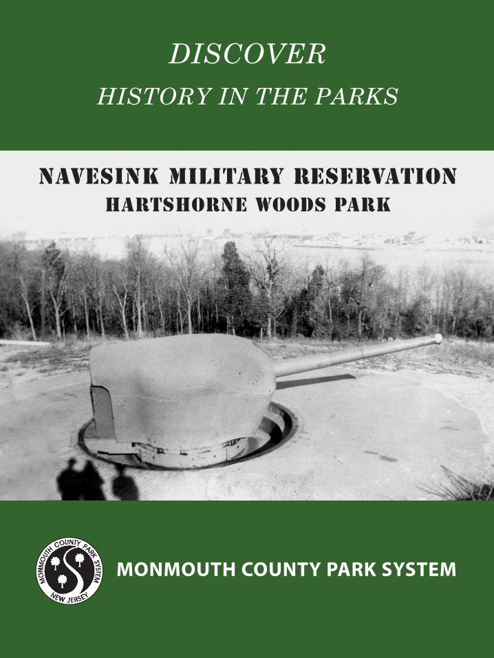
MONMOUTH COUNTY PARK SYSTEM
Navesink Military Reservationhartshorne woods park
DISCOVER
HISTORY IN THE PARKS
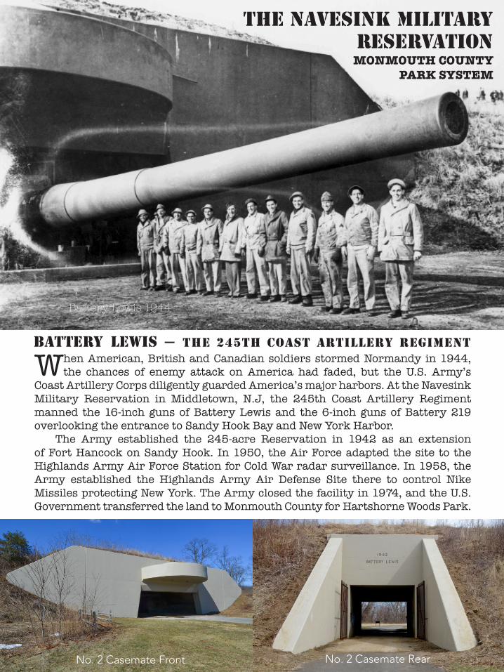
BATTERY LEWIS — The 245Th coasT arTillery regimenT
THE Navesink Military Reservation
When American, British and Canadian soldiers stormed Normandy in 1944, the chances of enemy attack on America had faded, but the U.S. Army’s
Coast Artillery Corps diligently guarded America’s major harbors. At the Navesink Military Reservation in Middletown, N.J, the 245th Coast Artillery Regiment manned the 16-inch guns of Battery Lewis and the 6-inch guns of Battery 219 overlooking the entrance to Sandy Hook Bay and New York Harbor.
The Army established the 245-acre Reservation in 1942 as an extension of Fort Hancock on Sandy Hook. In 1950, the Air Force adapted the site to the Highlands Army Air Force Station for Cold War radar surveillance. In 1958, the Army established the Highlands Army Air Defense Site there to control Nike Missiles protecting New York. The Army closed the facility in 1974, and the U.S. Government transferred the land to Monmouth County for Hartshorne Woods Park.
MONMOUTH COUNTYPARK SYSTEM
No. 2 Casemate Front No. 2 Casemate Rear
Battery Lewis 1944

With an elevation of 266 feet at Mount Mitchill, the Navesink Highlands peninsula in the northeastern corner of Monmouth County is the highest formation on
the East Coast between Maine and the Yucatan. The park lies at the southeast corner of the peninsula, which is bounded by Sandy Hook Bay on the north, the Shrewsbury River on the east, and the Navesink River on the south. For the defense of New York Harbor during WWII, a U.S. Army General called the Highlands “a natural fortress.”
Navesink Highlands — hartshorne Woods park, middletown, NJ
The Navesink Highlands overlook Sandy Hook and New York City to the north.

Richard Hartshorne (1641-1722), an English Quaker born in Leicestershire, acquired Sandy Hook and most of the Navesink Highlands in the late 17th
Century, and his descendants retained large portions of it over nearly three centuries. A c1910 Survey (above) shows 527 acres owned by Robert Hartshorne (1866-1927), including the unspoiled Hartshorne Woods. Julia Hartshorne Trask (1863-1955) lived on Rocky Point in a mansion (bottom left), built by her great uncle, Edward Minturn, that overlooked the Shrewsbury River and Atlantic Ocean (bottom right). The War Department acquired 224 acres of Hartshorne lands including Rocky Point for the Navesink Military Reservation in 1942.
The Hartshornes and Hartshorne Woods
Hartshorne-Minturn-Trask House on Rocky Point c1890
Hartshorne Minturn House Lawn overlooking Sea Bright c1890
Hartshorne-Minturn-Trask House Lawn overlooking Sea Bright c1890
Battery Murphy, Boston by Jerry Butler
Military Annals of Nahant

The Reservation contained the 16-inch gun Battery Lewis at an elevation of 230 feet, the 6-inch gun Battery 219 on Rocky Point, two cantonments for housing 382
troops of the 245th Coast Artillery Regiment, and facilities for controlling the firing of the guns, including an early version of RADAR on Hill 250, the site’s highest point.
The Army Corps of Engineers designed the 16-inch gun batteries based on prototypes at the Golden Gate at San Francisco. The gun casemates were 500 feet apart with an ammunition magazine and power plant in between.
Navesink military reservation 1942-1948
Battery Lewis
Battery219
Hill 250 Fire Control
& Radar Stations
Fire Control Stations
Battery Murphy, Boston by Jerry Butler
Military Annals of Nahant
Battery LewisPlotting-Switchboard
Room
U.S. Army Corps of Engineers Navesink Military Reservation
Site Plan, 1944

The Corps of Engineers designed the batteries to withstand 2,000 lb. aerial bombs. The 1939 construction of Battery Davis at Fort Funston (above left) in San Francisco
shows the 60-feet long by 3-feet high steel ceiling beams, and 8-feet tall steel trusses over the guns (above & below right). The beams are visible at Battery Lewis (below, left).
the massive wwii 16-inch gun batteries
The 16-inch guns were 68-feet long and weighed 153 tons (below, right). Their Barbette Carriages weighed 332 tons and could rotate 145 degrees and raise 46 degrees to fire
2,240-lb. shells over 25.4 miles. Soldiers at Battery Townsley in San Francisco (below, left) loaded a shell conveyed from the magazine to the guns by an overhead trolley.
Battery Lewis Casemate No. 2
Battery DavisSan Francisco Battery Davis
San Francisco
16-inch Gun on Barbette Carriage

Secondary Armament 6-inch gun Batteries
The Corps of Engineers cited Battery 219
(above) at an elevation of 150 feet on Rocky Point on the Navesink Reservation (see maps pgs. 2 & 4) so that its two 6-inch guns could protect New York Harbor and the North Jersey coast from ships and landing craft. The 200-series batteries (left) measure approximately 170-feet long by 120-feet wide by 20-feet high, and had a central magazine and powerplant inbetween the 6-inch guns.
The Corp of Engineers built a similar 6-inch gun Battery 223 (below) in 1943 at the Cape May Military Reservation to protect the entrance to the Delaware River. The shoreline was then about 800 feet further south and Battery 223 was covered with earth like all the WWII batteries. Erosion has left Battery 219 uncovered on the beach, revealing the high-quality concrete construction of the WWII batteries.
Battery DavisSan Francisco
Battery 219West Entrance
Battery 219Gun Platform
Battery 223 - Cape May Point Military Reservation - Cape May Point State Park
Battery 208, Boston, by Jerry Butler Military Annals of Nahant
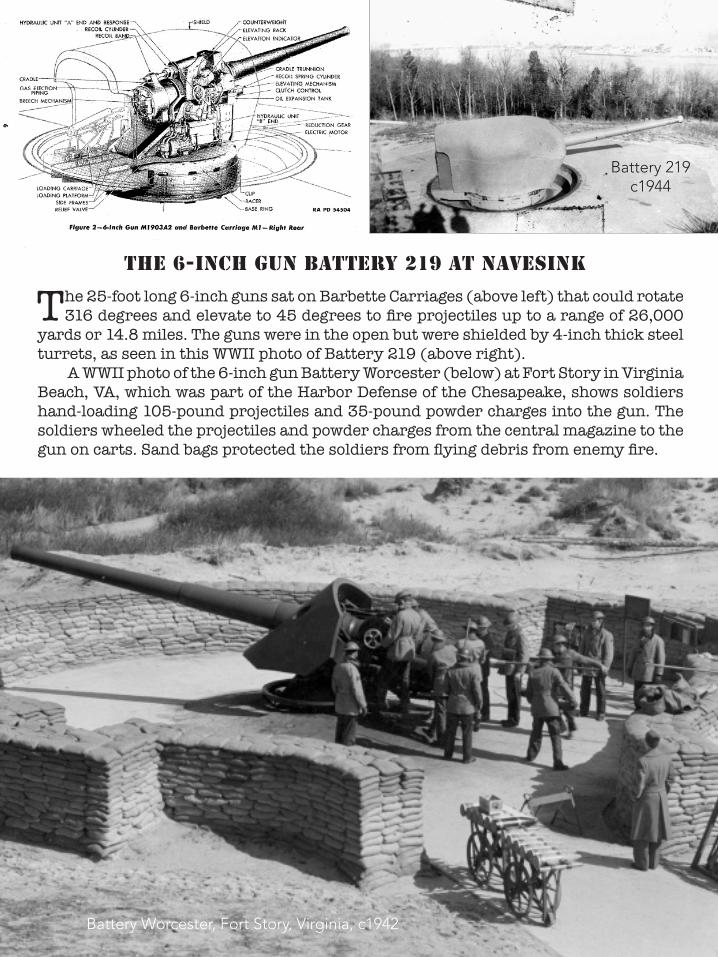
The 25-foot long 6-inch guns sat on Barbette Carriages (above left) that could rotate 316 degrees and elevate to 45 degrees to fire projectiles up to a range of 26,000
yards or 14.8 miles. The guns were in the open but were shielded by 4-inch thick steel turrets, as seen in this WWII photo of Battery 219 (above right).
A WWII photo of the 6-inch gun Battery Worcester (below) at Fort Story in Virginia Beach, VA, which was part of the Harbor Defense of the Chesapeake, shows soldiers hand-loading 105-pound projectiles and 35-pound powder charges into the gun. The soldiers wheeled the projectiles and powder charges from the central magazine to the gun on carts. Sand bags protected the soldiers from flying debris from enemy fire.
The 6-inch gun Battery 219 at navesink
Battery 219c1944
Battery Worcester, Fort Story, Virginia, c1942

Fire control for Coastal Batteries
The Coast Artillery Corps used a targeting system known as Fire Control (FC)to determine the direction and distance of ships. Each battery had several Fire
Control Stations for observing ships and collecting data on the azimuth (the horizontal angle from due north) of potential targets.
The Corps of Engineers built two “dug-in” FC Stations at Navesink (No. 1, above, left) into the hill near Battery 219 (see maps, pages 2 & 4). At a rehabilitated Fire Control Station at Fort Rosecranz in San Diego (above, right), a spotter reenactor stands behind an azimuth telescope. Charts like the one behind the soldier showed the profiles of WWII ships. Spotters used telephones, like the ones on the front wall, to relay data to soldiers in a Plotting Switchboard Room (PSR). Battery 219 contained a PSR, but the Battery Lewis PSR (below left, and map pg. 5) was a separate earth-covered structure that isolated the plotters from the roar of the16-inch guns.
The Corps of Engineers also erected a 100-foot high tower with an FC Station on the Navsink Military Reservation’s highest point, which they named Hill 250 after its elevation (see maps). The total elevation of 350 feet enabled spotters to record the vertical angle of targets for triangulating their range or distance. The Engineers also installed in the tower an early version of RADAR (Radio Detection and Ranging), which used radio wave echoes to identify both the angle and distance of targets. The tower was visible from the Navesink River, as seen in the WWII photo (below, right) with Portland, the ancestral home of the Hartshornes.
Battery Lewis Plotting Switchboard Room
Hill 250 Tower & Portland Mansion
c1944
Fire Control Station
Restored Fire Control StationFort Rosecrans, San Diego

At Fort Story in Virginia Beach, VA, in 1942, soldiers in Battery Worcester’s Plotting-Switchboard Room demonstrated the use of a Plotting Board for determining the firing coordinates of the guns. The PSR for Battery Lewis (pg.9)looked very similar, including the standard lighting.
At Battery Gunnison on Fort Hancock at Sandy Hook, NJ, 245th Coast Artillery Regiment reenactors have replicated a WWII Plotting Room with a Plotting Board and period radio equipment. The volunteer reenactors meet several times a year to help maintain the Battery and its two 6-inch guns, which are rare survivors of WWI-WWII ordnance.
plotting and switchboard rooms
In each battery’s Plotting Switchboard Room (PSR), plotters developed the Fire Control information for the gunners. Soldiers in the PSRs used telephones to
collect data on the angles of targets observed in the battery’s Fire Control Stations. The plotters used the data to layout angles on a Plotting Board that represented the firing area of the guns over the water and some of the adjacent land. From the intersection of the different angles recorded in the FC Stations, the plotters determined the distance of the target and then adjusted for its speed, the speed of the wind, and other factors to provide the gunners with accurate firing coordinates.
Plotting RoomFort Story, Virginia, 1942
Replica Plotting Room
Battery Gunnison Fort HancockSandy Hook
Missile Master on Hill 250, Highlands Army Air Defense Site, c1960
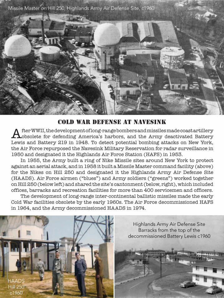
After WWII, the development of long-range bombers and missiles made coast artillery obsolete for defending America’s harbors, and the Army deactivated Battery
Lewis and Battery 219 in 1948. To detect potential bombing attacks on New York, the Air Force repurposed the Navesink Military Reservation for radar surveillance in 1950 and designated it the Highlands Air Force Station (HAFS) in 1953.
In 1955, the Army built a ring of Nike Missile sites around New York to protect against an aerial attack, and in 1958 it built a Missile Master command facility (above) for the Nikes on Hill 250 and designated it the Highlands Army Air Defense Site (HAADS). Air Force airmen (“blues”) and Army soldiers (“greens”) worked together on Hill 250 (below left) and shared the site’s cantonment (below, right), which included offices, barracks and recreation facilities for more than 400 servicemen and officers.
The development of long-range inter-continental ballistic missiles made the early Cold War facilities obsolete by the early 1960s. The Air Force decommissioned HAFS in 1964, and the Army decommissioned HAADS in 1974.
cold war defense at navesink
Missile Master on Hill 250, Highlands Army Air Defense Site, c1960
HAADS Hill 250 c1960
Highlands Army Air Defense Site Barracks from the top of the
decommissioned Battery Lewis c1960

hartshorne woods park
After the decommissioning of the Highlands Air Force Station in 1964, the Air Force declared 161 acres of the former Navesink Military Reservation as
surplus. Officials of the Monmouth County Park System (MCPS), which the County had established in 1960, promptly communicated their interest in preserving the 161 acres for open space. President Richard Nixon established a “Legacy of Parks” program in 1972 to preserve some Federal surplus properties for public recreation, and the U.S. Department of the Interior transferred the 161-acre Navesink site and two smaller sites to MCPS in 1974. MCPS established Hartshorne Woods Park in 1973 with the initial acquisitions of several private forested parcels on the Highlands totaling 436 acres, and MCPS added the 161 Navesink acres to the new park in 1974.
In that same year, the Army declared the 63-acre Highlands Army Air Defense Site (the Hill 250 area) as surplus, and MCPS officials requested its transfer for the park. Competing interests for the site and the demolition and cleanup of its military structures delayed its transfer until 1984. At the request of MCPS, Battery Lewis and its Plotting-Switchboard Room, Battery 219 and the two Fire Control Stations were left in place. Today, Hartshorne Woods Park preserves 787 acres of forest, fields and the WWII military structures for conservation, recreation and interpretation.
Battery Lewis Casemate No. 2 West Entrance
Rocky Point from the top of Battery Lewis
Produced by C.W. Zink, Princeton, NJFunded by THE Friends of Monmouth County PArk SYSTEM
2016

acknowledgements
This publication is based on research collected by Gail Hunton, Supervising Historic Preservation Specialist, Monmouth County Park System, on additional research
for the Navesink Military Reservation National Register Nomination, and on other sources including Bolling Smith, Coast Artillery Historian; Mark Berhow, Coast Defense Study Group; Cory Newman; John Martini; Joe Hammond; Tom Hoffman, National Park Service, Fort Hancock; Fort Hancock Archives; National Archives and Records Administration, New York and College Park, MD; and Dennis Bertland.
Navesink Military Reservation illustrations Page 1: Battery 219, c1944, National Archives & Records Administration (NARA)Page 2: Battery Lewis c1944, Monmouth County Park System (MCPS)(top); Battery Lewis Casemate 2, 2013, C.W. Zink (CWZ)(bottom left); Casemate 2 Rear, 2014, MCPS (right). Page 3: Navesink Military Reservation Map, MCPS, 2014 (top); Location Map, MCPS, 2004 (bottom left); 2010, MCPS (right).Page 4: Robert Hartshorne Property c1910, Monmouth County Historical Association (top); Hartshorne-Minturn-Trask House (bottom left) and front lawn (right) c1890, MCPS.Page 5: Navesink Military Reservation Map 1944, (NARA) (top); Battery Murphy, “Military Annals of Nahant,” 1996 (bottom). Page 6: Battery Davis, San Francisco, 1937, NARA (top); Battery Lewis Casemate 1, 2013, CWZ (center left); Battery Davis, “Seacoast Fortifications,” 1979 (right); Battery Townsley, San Francisco, 1939, NARA (bottom left); War Department FM 4-86, 1943 (right). Page 7: Battery 219, 2013, CWZ (top); Battery
206 Phantom View, “Military Annals of Nahant,” 1996 (center); Battery 223, Cape May Point State Park, 2010, fortwiki (bottom). Page 8: War Department TM 9-428, 1943 (top left); Battery 219, c1944, NARA (right); Battery Worcester, c1942, Coast Defense Journal, August 2011 (bottom). Page 9: Navesink Fire Control Station, 2013, CWZ (top left); Fort Rosecrans Fire Control Station, Biamonte, 2012 (right); Battery Lewis Plotting SwitchBoard Room entrance, 2013, CWZ (bottom left); Portland c1948, MCPS (right). Page 10: Fort Story Plotting Switchboard Room, 1942, Library of Congress (top); Battery Gunnison Plottimg Room, 2014, CWZ (bottom).Page 11: Highlands Army Air Defense Site Missile Master, c1960, MCPS (top); Missile Master c1962 (bottom left) and Highlands Barracks, c1962 (right), MCPS/John Corbett.Page 12: Hartshorne Woods Park, Battery Lewis to Rocky Point, 2014, MCPS (top); Battery Lewis Casemate 2 Rear Entrance, 2014, MCPS (bottom).
MONMOUTH COUNTY PARK SYSTEMwww.monmouthcountyparks.com
sources American Seacoast Defenses: A Reference Guide, Mark Berhow, Editor, CDGS Press, McLean, Va., Third Edition, 2013. Military Annals of Nahant, Massachusetts, Gerald Butler, Nahant Historical Society, 1996. Navesink Military Reservation, National Register Nomination, C.W. Zink for Monmouth County Park System, 2014. Seacoast Fortifications of the United States:
An Introductory History, Raymond Emanuel Lewis, Naval Institute Press, Annapolis, 1979. “The Six-Inch Part of the Modernization Program of 1940,” Robert Zink, Coast Defense Journal, Volume 8, Issue 2, May 1994, 218. “The 16-inch Batteries at San Francisco and the Evolution of the Casemated 16-inch Battery,” Bolling Smith, Coast Defense Journal, Volume 15, Issue 1, February 2001.
Produced by C.W. Zink, Princeton, NJFunded by THE Friends of Monmouth County PArk SYSTEM
2016