Embed Size (px)
Citation preview
Disaster Risk Reduction and Local Knowledge in Flood-Prone
Communities: A Nigerian Case Study
by
Uchenna Uzoma Okoroji
A thesis
presented to the University of Waterloo
in fulfillment of the
thesis requirement for the degree of
Masters in Environmental Studies
in
Sustainability Management
Waterloo, Ontario, Canada, 2018
©Uchenna Uzoma Okoroji 2018
ii
Author’s Declaration
I hereby declare that I am the sole author of this thesis. This is a true copy of the
thesis, including any required final revisions, as accepted by my examiners. I
understand that my thesis may be made electronically available to the public.

iii
Abstract
There has been a long debate regarding the value of traditional/indigenous/local
knowledge in disaster risk reduction. Often viewed as ‘backwards’, governments
instead have emphasised ‘advanced’ technologically sophisticated and
economically expensive approaches to DRRM (generally equated with ‘Western
science’). Increasingly, however, it is recognised that local participation and ways
of knowing are essential for long-term DRRM. This is formally articulated in
numerous inter-governmental and governmental documents. Despite this
recognition, the gap between saying and doing remains wide. There continues to
be an over-reliance on techno/economic approaches to DRRM led by state actors,
while local people and contexts are broadly ignored. In many cases, DRR plans
are little more than empty proclamations. When disaster strikes, people are left to
fend for themselves; where the government is involved, it is generally in a
reactive, crisis-management way.
In this thesis, the author examines the case of Nigeria. He describes the Nigerian
setting. He analyses the formal government position on DRRM, in particular
reflecting on the ways that government foresees local participation and
contributions to DRRM. He then looks at three case studies of disaster events in
three different states of Nigeria. Each community was hard hit by flooding in
2012. They were again hard hit by flooding in 2017. The author reflects on the
event and the outcome of each occurrence in each case: what was the

iv
preparedness setting? What were the effects on the community? How did the
community react? How did these actions align with government DRRM policy,
programming and action? It is hypothesised that, in the context of evolving global
attention to DRRM mainly through the Hyogo and Sendai frameworks, one
would anticipate different events and outcomes in the study areas. Put differently,
five years after the 2012 flood events, the effects of the 2017 flood should have
been better prepared for, so leading to less intense negative local level side
effects.
The author reveals that the 2017 flood event was similar in effect to the 2012
event. Indeed, interestingly people failed to heed early warnings from authorities
regarding impending flood and recommended action. While it is beyond the scope
of this thesis to analyse why this is so, one can reflect on the actions taken by
local people in each case and examine them for the potential to build bridges with
state authorities, so drawing local action and understanding into alignment with
government claims regarding DRRM.
Key Words: Social Resilience, Local Knowledge, Climate Change, Coastal
Communities, Flood Management.

v
Acknowledgements
I would like in the first place, acknowledge the valuable guidance and advice of
my committee members. My sincere gratitude to my supervisor Dr. Larry Swatuk
for his insights and guidance throughout this research. Despite his busy schedule,
Dr. Swatuk always found time for discussion and exchange. His support and
encouragement have made the completion of this research possible. In the same
way, I would like also to thank Dr. Brent Doberstein, committee member, for his
counsel and for his input into my research.
I am grateful to Dr. Prateep Nayak for having accepted, on a very short notice,
to be the reader on the committee.
I would like also to extend my gratitude to my siblings for their moral support. I
must acknowledge all my friends who provided me with their unwavering and
constant support throughout the process of my studies at the University of
Waterloo. Here, I personally thank Dr. Emenogu Barnabas and his family for
making their home available to me. My sincere gratitude to Dr. Chukwuma
Okoroji for his support and encouragement during my studies.

vi
Dedication
This research work is dedicated to Mrs Chioma Ethel Okoroji, who despite being
widowed at a young age, saw to it that her children get education and aspire to
greatness.

vii
Table of Contents
Authors Declaration ………………………………………………………………………..…….. ii
Abstract …………………………………………………………………………………….….…. iii
Acknowledgement……………………...……………………………………..………...………… v
Dedication ………………………..………………………………………………………………. vi
List of Acronyms ………….……………………………………………………………………... ix
List of Figures ……………………………..……………………………..………………………. x
List of Tables ……………………………………..……………………………………………… xi
1. Introduction/Background………..…………………………………………….………..…………. 1
1.1. Thesis Statement …………………………………………………………............................. 7
1.2. Research Question ……………………………………………………………...……..……. 8
2. Literature Review …………………………………………………………………..………........ 10
2.1. A Warm Earth and Its Consequences ….………...…………………...……..………........... 10
2.2. What is Local Knowledge? ………………...………………………………..…………….. 14
2.3. Local Knowledge and Flood Management …………………………………..……….......... 19
2.4 Local Knowledge for Disaster Risk Reduction ……………………………………….……. 25
2.4.1 Value of Local Knowledge (Preparedness and Post-disaster) ………...……….…………. 32
2.4.2 Does Western Scientific Knowledge Complement Local Knowledge? ……..……….... 35
3. Methodology ………………………………………………….………………......……………... 39
3.1. Research Context ……………………………………………………...……...…………..... 40
3.2. The Qualitative Approach …………………………………………..………...………....… 40
3.3. Content Analysis ………………………………………………………...……...….…...…. 42
3.3.1. Coding ………………………………………………...…………………………..….. 42
3.4. Deductive Approach ………………………………………...…………………..…...…….. 43
3.5. Case Studies………………………………………...……………………………...…...…... 44
3.6. Study Area …………………………………………...………...………………...…...……. 44
3.7. Limitations of The Study ………………………….…………………………………...….. 47
4. Content Analysis and Case Studies….……………………………………..……………………. 49
4.1. National Disaster Management Framework ………………………...………..…………..... 50
4.2. Kogi State…………...………………………………………...………..………………...... 53

viii
4.2.1. Event …………………………………………………………....……….………..…... 55
4.2.1.1 Flood Event 2012 …………………………………………………………...… 55
4.2.1.2 Flood Event 2017 ……………………………………………………………... 58
4.2.2. Response …………………………………………………….….………...…............... 59
4.3. Benue State ……………………………………………………...……………..…...……… 60
4.3.1. Event …………………………………………………….……….…...………...…….. 62
4.3.1.1 Flood Event 2012 ……………………………………………………………... 62
4.3.1.2 Flood Event 2017 …………………………………………………...………… 63
4.3.2. Response ……………………………………………………..……...………...……… 65
4.4. Adaptive Responses of Some communities in Nigeria ………………..……….….………. 66
5. Discussion …………………………………………………………...….……..…………............ 70
5.1. Perceived Gaps Between Policy and Implementation………………………………...…… 70
5.2. Crisis of Trust …………………………………….…………………..………………...…. 73
5.3. Streamlining Disaster Management Practice….…………………………...……......……… 74
6. Conclusion and recommendation …..…….………………………...……………..……..……... 78
References …………………………………….…………………………………….………….. 81

ix
List of Acronyms
CRED – Centre for Research on the Epidemiology of Disasters
DRRM – Disaster Risk Reduction Planning and Management
GDP – Gross Domestic Product
HFA – Hyogo Framework for Action
IWC – International Whaling Commission
IDP – Internally Displaced Persons
LDC – Least Developed Countries
NDMF – National Disaster Management Framework
NEMA – National Emergency Management Agency
NERA – National Emergency Relief agency
NIMET – Nigerian Meteorological Agency
PNG – Papua New Guinea
SFDRR – Sendai Framework for Disaster Risk Reduction
SDG – Sustainable Development Goals
TEK – Traditional Ecological Knowledge
UNISDR – United Nations International Strategy for Disaster Reduction

x
List of Figures
Figure 1: Global Assessment Report for Disaster Risk Reduction …………………………..…….… 2
Figure 2: Global Flood Occurrence ……………………………………………………….………… 14
Figure 3: Climate Change Vulnerability Index ……………………………………………….…….. 21
Figure 4: Coastal States in Nigeria ……………………………...……………………….………….. 25
Figure 5: Types of Coding ………………………………………...…………………..……….……. 43
Figure 6: Hierarchy of Authority ………..………………………...………………….……………... 51
Figure 7: Annual Rainfall Prediction …………………………..…….……………………………… 54
Figure 8: Flood Water in Kogi ………..……………….………………..………………………..….. 56
Figure 9: Severed Transportation Route ……………………..…………...……………………….… 57
Figure 10: Flood Water in Lokoja ………..………………...………………………………………... 58
Figure 11: Map of Benue State ………………………………………...…………………….……… 61
Figure 12: Map Showing the Stretch of River Benue Flooded in 2012 …....……………………….. 63
Figure 13: Flood Water in Makurdi ………………………….……………………………………… 64
Figure 14: Sand Bags Used for Flood Abatement ……………….…..……………………………….66
Figure 15: Local Knowledge and Disaster Management Cycle ……..……………………………… 77

xi
List of Tables
Table 1: Hyogo vs Sendai ……………………………..……………………………………………. 28
Table 2: Disaster Indicator and Response in Selected Countries ………………………………….. 34
Table 3: Natural Hazards in Nigeria ………………………………………..……………………..... 45
Table 4: Open Codes from The National Disaster Management Framework and Ascertained
Properties …………………………………………………………………….……………………… 52
Table 5: Local signs and Ecological Indicators of Flooding Occurrence ……..…………………….. 67
1
Chapter 1: Introduction
1.0 Background:
This thesis project seeks to contribute to the literature of disaster risk reduction
and the role of local knowledge in influencing the coping strategies of vulnerable
communities in developing countries with focus on Nigeria. This study is
informed by the existing gap in the literature describing the coping strategies of
at-risk communities in West Africa and how local knowledge informs and
strengthens social resilience1. The UNISDR defines a disaster as “ a serious
disruption of the functioning of a community or society involving widespread
human, material, economic or environmental losses and impacts, which exceeds
the ability of the affected community or society to cope with using its own
resources.”
Anthropogenic climate events experienced the world over suggest a worsening
weather. There abounds evidence of melting glaciers, warming oceans, extinction
of plant and animal species, drought, and disease outbreak, all of which are
attributed to climate change. It is, therefore, no surprise that Skoufias (2003)
asserts that natural disasters including floods and weather extremities will affect
households through the destruction of physical and human capital stock (i.e.
1 Local knowledge is often referred to in different terms, but not limited to traditional knowledge, indigenous technical knowledge, peasant knowledge, traditional environmental knowledge and folk knowledge. Depending on the term used, it evokes diverse meanings (see Brokensha et al.1980; Sillitoe 2000; Fernando 2000). This thesis adopts the term “Local Knowledge” to imply that people have a detailed knowledge about their environment and community.
2
human lives). Noy and Vu (2010) assessed the impact of the disaster in a
developing economy(Vietnam) and discovered that lethal disaster events affect
the growth of the macroeconomy. In a World Bank policy research paper,
Raddatz (2009) suggests that economic output of low-income countries dealing
with climate change related disasters is significantly affected. Simulations carried
out in the World Bank report identify a one percent decline in the gross domestic
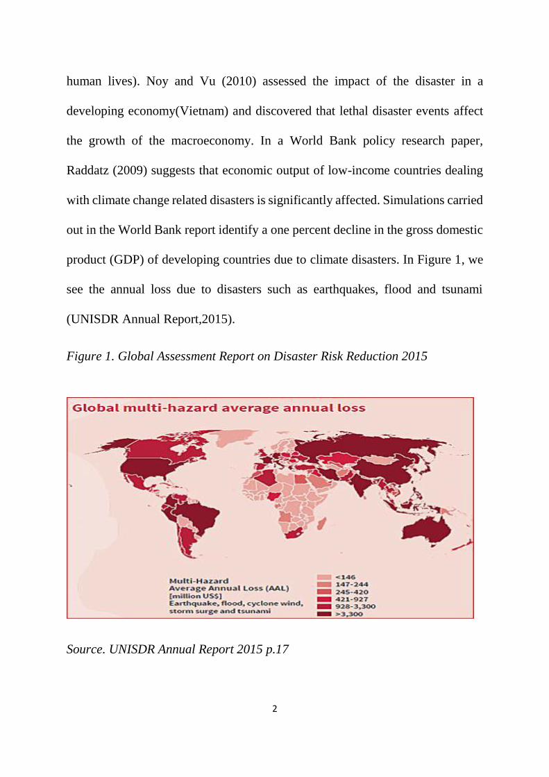
product (GDP) of developing countries due to climate disasters. In Figure 1, we
see the annual loss due to disasters such as earthquakes, flood and tsunami
(UNISDR Annual Report,2015).
Figure 1. Global Assessment Report on Disaster Risk Reduction 2015
Source. UNISDR Annual Report 2015 p.17
3
Extreme weather events increase the debt burden of developing countries, and
on an annual basis, emerging economies have incurred $35 billion in cost due to
natural disasters (Mirza, 2003). Diley & Heyman, (1995) are of the opinion that
the financial and human cost occasioned by droughts and floods are among the
highest in the world when compared to other disasters. On the continent of Africa,
increasing cases of droughts, flood, landslides, disease outbreaks and weather
extremes will worsen futher the already fragile conditions of human health,
infrastructure and food security.
Few (2003), posits that the changing climatic conditions will disproportionately
impact the developing nations with increased frequencies of flood. It is estimated
that global sea level rise will affect low-lying coastal and riverine communities
and cost affected countries a significant portion of their national income (Boko et
al. 2007). Many cities and smaller settlements in Africa are located along the
coast, thus increasing their vulnerability to the extremities of weather. As one
example of this, Mozambique experienced a devastating flood in the year 2000
that left in its wake massive destruction of lives and properties. Mirza (2003)
states that these floods caused over 700 deaths, left over 500,000 households
homeless and significantly impacted urban infrastructure and agricultural
livelihoods of rural dwellers. Similarly, in September of 2009, Burkina Faso,
Senegal, Ghana, and Niger were inundated with floods that resulted in the
displacement of 600,000 people (Di Baldassarre et al. 2010). However, regardless

4
of their spatial classification, most at-risk communities have evolved in their
environment, and developed local knowledge of dealing with disasters. In their
assessment of coping mechanisms of coastal communities in Bangladesh, Alam
and Collins (2010) attribute their survival to their application of indigenous
warning systems to prepare for and deal with impending cyclones. These systems
and practices are intertwined with architecture, agriculture and religion. The
authors describe practices such as building homes on plinths 10 feet above sea
level, planting trees around homesteads to protect households from the raging
winds, cultivating crops that may survive the monsoon floods and the reverence
of deities to prevent floods. In the central region of Vietnam, Tran et al (2007)
identify the application of local knowledge by residents in building construction
and productive economic activities. Also, Marfai et al (2008), reiterate the use of
local knowledge by residents in Semarang, Indonesia. Homes are reportedly built
on higher ground and small dykes constructed in front of homes.
The scholarship on the use of local knowledge by vulnerable communities also
describes the impact of culture and religious affiliations on the relevance of
coping strategies. In a bid to withstand the onslaught of cyclones and flood, some
communities resort to divination and ritual sacrifices to deities and gods.
Although certain religious practices may raise questions in the scientific
community, Mitchell (2003) is of the opinion that the role of religion (prayer) in
disasters is poorly understood and that disaster risk reduction efforts will be more

5
effective when there is respect for the cultural and religious beliefs of people.
Culturally, warnings about various disasters are contained in folklores. Pareek
and Trivedi (2011) enunciate the impact of culture and tradition on the coping
strategies adopted by coastal communities in Rajasthan, India. The authors
identify warnings and ideas related to disasters contained in religious books used
by the communities. In one instance, the religious book (sutra) described the
significance of wind direction on weather and agriculture. In their field work,
they document that community members imbue meanings to the position of the
sun, and, for example, the cry of a specific bird is thought to help predict rains
and floods. Also, Galliard and Texier (2010) believe communities do not assess
risk in simple terms; rather their assessment reflects a blend of economic and
religious considerations. The authors give an example of a Javanese community
located on the slopes of Mt Merapi Volcano, and suggest that the community
considers the volcanic activities of the mountain as a reflection of their normal
daily lives and events. These observations about local disaster/hazard knowledge
appear to be similar across the continents of Africa, Asia, North America and
Latin America/Caribbean.
It bears emphasis to state that, there exists a need to strengthen the adaptive
capacities of developing countries. This concern stems from the fact that much of
the livelihood of communities in the continent is tied to the physical environment,
(in particular direct access to land & water). Brown, Hammill and McLeman

6
(2007) attest that designing and implementing strategies for adaptation can create
or resolve conflicts. Cannon and Muller-Mahn (2010), assert that until now,
development studies have focused on scientific approaches in the discourse of
climate change with little or no cognizance for mutual perspective or interactive
relationship between science and the local economy. Indeed, humanitarian aid
has poured into the developing economies, but the efficacy of this aid in respect
to increasing extreme climatic events is debatable.
The inclusion of ideas from at-risk communities in the disaster planning process,
engenders success and enhance cooperation. Ahrens and Rudolph (2006) identify
participation, the rule of law, transparency, equity and accountability as important
factors to be embodied when implementing a sustainable development and
disaster risk reduction program. However, in much of the developing economies,
the factors above are lacking thus negatively impinging on the efficiency of
disaster management policies. Corruption, bureaucracy and a gradual eroding of
social values threaten the ability of developing states to attend to disaster
management. In a study of post-disaster housing projects in Colombia, El Savador
and Turkey, Davidson et al. (2007) identify a lack of commitment by community
members that adopted the top-down approach, where project managers made
decisions about projects. The authors assert that there was a disconnect between
communities and project operators. Conversely, projects that involved
community members in the decision-making process recorded more progress and

7
helped build capacity. Similarly, McEntire (2001) suggests that disaster managers
must not be the sole administrators of projects. It, therefore, suggests that
enhancing the capacity of vulnerable communities is important especially in the
era of global warming and its attendant ills.
1.1 Thesis Statement:
Climate change will initiate sea level rise and trigger extreme weather events,
with grave consequences for vulnerable communities. For example, Carey (2005)
and Slenning (2010) suggest that melting glaciers will alter weather events and
increase the severity of rains, droughts, floods and incidences of disease outbreak.
In the development context, at-risk communities have devised traditional
techniques over time to cope with environmental hazards within their locality.
The top-down approach of administering disaster risk reduction policies and
regulatory provisions has returned significant benefit to vulnerable communities
but these will achieve more if complemented with local knowledge. This
dissertation seeks to identify the local hazard coping mechanisms of vulnerable
communities, describe the relevance, and evaluate the extent to which state
disaster regulations incorporate local knowledge. It is hypothesized that disaster
risk reduction planning and management will be suboptimal in the absence of
local knowledge, thereby increasing at-risk communities’ vulnerability to climate
change, climate variability, and extreme weather events. It is hypothesised that

8
the interaction of local and scientific knowledge will result in the enhanced
resilience of vulnerable communities, specifically in relation to flooding.
1.2 Research Question:
The primary research question of this thesis is: With specific relation to flooding,
how has local knowledge informed and shaped the coping mechanisms of
vulnerable communities? Secondary questions follow: Are these forms of
knowledge incorporated into state planning for DRRM? If so, how so? Are there
opportunities for creating best planning practice for DRRM that includes
traditional as well as contemporary scientific knowledge? This research project
will contribute to the body of knowledge around disaster risk reduction and
climate resilience by formulating a model that depicts interactions between
western and local knowledge.
This thesis engages the literature around the coping mechanisms of vulnerable
communities, with emphasis on the role local knowledge plays in the disaster
risk reduction process. Chapter One provides an introduction of the subject of
discussion and chapter Two argues the relevance of local knowledge in disaster
risk management by reviewing the literatures relevant to the subject. Chapter
Three describes the methods that were employed in the research, and chapter
Four provides the results from the content analysis and subsequently discuss its
implication with reference to the literature review. Chapter Five provides case

9
studies of vulnerable communities and chapter Six introduces a conceptual
framework designed by the researcher for disaster risk reduction at the local
level. Chapter seven contains conclusions from the research thesis.

10
Chapter 2: Literature Review
Disaster risk reduction and management (DRRM) forms a major part of policy in
all regions of the world. Nations must statutorily set aside a portion of their
national income to combat the negative effects of natural and physical disasters.
This project seeks to evaluate the role of local coping mechanisms of at-risk
communities in the disaster risk reduction process, and the possibility for better
aligning state determined, scientific planning for DRR with locally determined,
traditional processes. This review will seek to introduce the concept of local
knowledge, to (or “intending to”) argue its relevance and importance in the
disaster risk reduction process. Relevant literature will be assessed to provide
information on recent happenings around the world.
2.1 A warm earth and its consequences.
The majority of researchers assert that increased warming of the earth’s
atmosphere will lead to climate change which will in turn cause a significant sea
level rise, and impel flooding events across the globe. Indeed, Levitus et al (2001)
adduce to the warming of the earth’s atmosphere and the role of humans in
worsening the climate systems. The earth is warming at an increasing rate, and
research suggests that if it carries on this way, the fate of human race is at risk. A
warmer atmosphere posits consequences that transcend the economic, social and
environmental spheres of human wellbeing. Roessig et al (2004) confirm that
11
climate change will pose a danger to the marine ecosystem to the extent that
communities that depend on fishing will be affected by changing fish
distributions. Similarly, a warm climate portends severe risk to the coral reefs of
the world's ocean (Hoegh-Guldberg et al, 2007). The authors argue that coral
bleaching will become pervasive with the warming of the earth atmosphere.
Interestingly, the erosion of the corals by climate change threatens the sustenance
of economies and welfare. Furthermore, Haines and Parry (1993) make a case for
the direct impact of a warming climate on the health status of humans. They argue
that adaptability to climate extremes in humans ebbs markedly through middle
age and into old age, thus suggesting why mortality from coronary diseases and
strokes peaks during heat waves. The authors also predict an increase in vector-
borne and other communicable diseases due to the prevalence of climate change.
For example, they suggest that increased temperature and rainfall could occasion
additional outbreaks of cholera and malaria in the tropics. Epstein (2001) believes
the warming of the earth’s atmosphere has informed a resurgence and
redistribution of infectious diseases, regrettably in both plants and animals. In the
study of climate change and its attendant effects, little is known about the fate of
plant life. However, Anderson et al. (2004) describe new plant diseases as a
consequence of the anthropogenic introduction of pathogens and parasites, with
severe implications for agriculture, conservation and biodiversity.
12
Barnett and Adger (2007) agree that climate change may impact human security,
to the extent that migration and violence may ensue, especially in the developing
countries of the world. They argue that the decline in the welfare of citizens will
cause them to migrate to urban centres, thus increasing the demand for urban
infrastructure. The knock-on effect is a marked growth of political pressure on
the state to provide necessary services, and in the event that the required services
are not adequate, skirmishes and deteriorating social relations among residents
could begin to emanate. The relationship between climate change and violence
may assume various dimensions, and is corroborated by Reuveny (2007) who
opines that climate-induced migration may prompt violence in the receiving
areas. He substantiates his claim by putting forward a conceptual model that
offers insights into the alleged causes of conflict between environmental migrants
and their hosts. The model identifies competition, distrust, and other auxiliary
conditions as principal culprits in the declining relations. The United Nations
Intergovernmental Panel on Climate Change has warned of pronounced sea-level
rise because of an anthropogenically effected temperature increase (Cazenave and
Cozannet, 2014). In recent times, the researchers have provided evidence of a
rapid melting of the world's glaciers and ice-sheets, and with it, an increased
incidence of floods and storm surges. To this end, Horton et al. (2014) posit a
median sea-level rise of 0.6-1.0m at low temperatures, and 2.0m-3.0m at high
temperatures, to the warming of polar glaciers. A sea-level rise of this magnitude

13
will portend serious dangers of coastal flooding for vulnerable communities.
Interpreting data from the CRED (2016) international disaster database, it is
evident that the incidence of flooding across the globe is on the increase. Nicholls
(2002), in a simulation of global sea-level rise, posits that it will cause an increase
in coastal flooding among other discomforting impacts. Thus, the author makes a
case for proactive steps to help prepare for the possible implications of a warmer
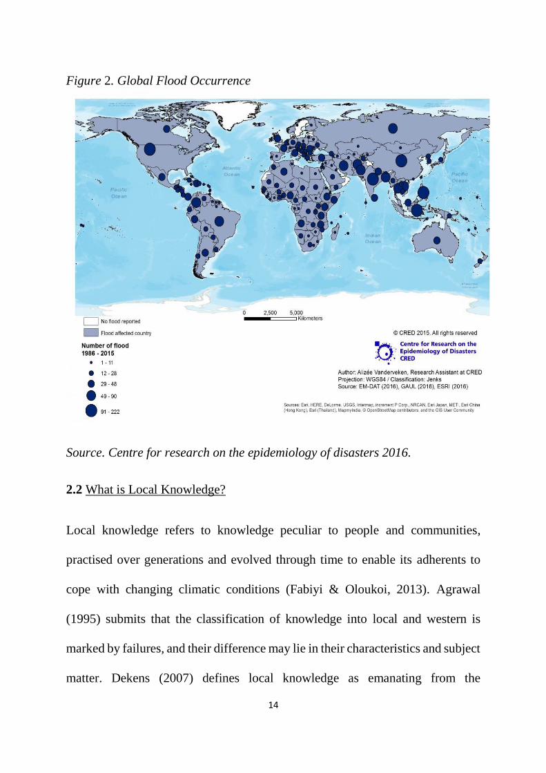
climate. Figure 2 indicates an increasing trend in flood events across the globe
(CRED,2016). It indicates an increasing trend in flood events in the developing
nations of Africa and Asia, with attendant consequences to the inhabitants,
infrastructure, businesses and environment of the regions. The increased trend in
reporting flood events can be ascribed to better data gathering capacities and
media coverage, and the large number of people susceptible to the impact of
flood.
14
Figure 2. Global Flood Occurrence
Source. Centre for research on the epidemiology of disasters 2016.
2.2 What is Local Knowledge?
Local knowledge refers to knowledge peculiar to people and communities,
practised over generations and evolved through time to enable its adherents to
cope with changing climatic conditions (Fabiyi & Oloukoi, 2013). Agrawal
(1995) submits that the classification of knowledge into local and western is
marked by failures, and their difference may lie in their characteristics and subject
matter. Dekens (2007) defines local knowledge as emanating from the

15
relationship communities/inhabitants have developed with the environment in
which they inhabit. The concept of local knowledge has been subject to
ambivalence, resulting in it being called different names. Davidson et al. (2001)
confirm the ambiguity in the definition of local knowledge by submitting that in
the age of post-colonization and post-modern musings, it has become difficult to
draw a clear boundary in the description of local knowledge. There exist
oppositions to the concept of local knowledge. Briggs (2005) opines that it is not
helpful to consider local knowledge as a universal knowledge, suggesting that it
is not shared across all members of differing cultures. The author argues that local
knowledge is specific to time and place. Leach and Mearns (1996) suggest that
knowledge developed by local people is not easily transferable, thus impeding
the efficacy of local knowledge outside of its socio-political environment. Briggs
and Sharp (2004) allege that the decontextualization of what constitutes local
knowledge has led to absurdities in its interpretations. They identify the binary
tension between western scientific knowledge and local knowledge to have stifled
and distorted the contents of what constitutes local knowledge. Thus local
knowledge is not given an opportunity to contribute to development.
It is important to state differences may exist in the use of the term indigenous
knowledge, traditional knowledge and traditional ecological knowledge, but at
their core, they serve the purpose to help communities adapt to changes in their
environment. Traditional knowledge/indigenous knowledge/traditional

16
ecological knowledge may be considered as non-quantitative, anecdotal and
unscientific due to its varying forms and homogeneity across cultures and
geographical space (Hobson,1992). Riedlinger and Berkes (2001) describe
traditional knowledge as emanating from the extensive use of land by
communities guided by their observations of variations in weather and climate.
Similarly, Berkes et al. (2000) posit that traditional ecological knowledge (TEK)
originates from local developed practices of resource use by local communities.
It is common place to find literature and journals using terms such as Traditional
Ecological Knowledge (TEK) to describe the knowledge base of local coping
strategies2. In recent time, there has been an increased interest in the efficacy of
local knowledge in disaster risk management, and it is informed by the observed
adaptive capacities of local communities toward extreme weather events. Gomez-
Baggethun et al. (2012) document the role of local knowledge in helping residents
of Donana, South West Spain cope with environmental crises. The authors
identify coping mechanisms to include; veneration of a local deity, pooling of
resources together, seasonal spreading of production to ensure harvest of food
throughout the year, and reallocation of family homes when flooding risks
increased.
2 Indigenous coping strategies take different forms, such as rain seeding, cloud reading, cultivating crops on terraces, observing animal behaviours and building homes on plinths above flood waters.

17
Technological solutions may not always offer a full proof solution to disasters, to
this end, Few (2003) reiterates the limitation of engineered solutions to climate
change. Similarly, Yin and Li (2001) aver that human intervention has worsened
the flood risk in the Yangtze river basin. The construction of levees is blamed for
the silting up of the Yangtze River, thus leading to a remarkable rise in the flood
level. For developing countries, the cost of acquiring engineering controls for
disaster risk reduction may prove to be too much, and even where construction is
feasible, quality control issues may threaten its integrity. Also, the competence to
manage such sophisticated structures may be lacking.
Furthermore, (Dekens, 2007) corroborates the case for local knowledge with the
assertion that technological solutions to disaster risk reduction tend to emphasise
one-off solutions and tend to trigger significant environmental impacts. Short-
term gains here reflect the quick - fix nature of technical solutions in the disaster
risk context. Much of technological solutions to disasters seek to provide
immediate protection and will require maintenance to remain functional. Plate
(2002) posits that engineered river works have received opposition due to its
geomorphic adjustments of rivers, in the construction of dams, dykes and
embankments. The author furthers his argument by citing the impairment of flora
and fauna, which consequently impacts the welfare of communities. It can be
adduced that the situation in Lake Chad (West Africa) mirrors the argument
furthered by Plate (2002). The damming of the rivers that feed Lake Chad has

18
contributed to its drying up, with severe consequences for communities that
depend on it.
However, it is important to state that worsening climatic conditions may have
also contributed to the disappearance of the Lake (Onuoha, 2008). Similarly,
Airoldi et al. (2005) acknowledge that structural flood defence mechanisms have
resulted in the artificialization of coastal areas. It implies changes to vulnerable
landscapes, alteration to species diversity and the introduction of new habitats.
Indeed, structural flood defence serves an important purpose. Nonetheless, they
also impose danger to the environment. In developing countries, the siting and
construction of such controls (dams) impacts the livelihood opportunities of
resettled communities.
Yankson et al. (2017) describe the building of the Bui dam in Ghana as negatively
impacting the communities around the dam. The authors conclude that the
construction of the dam gave benefits to the Ghanaian government and Chinese,
while denying communities in the affected area access to land, water and food,
and thus further worsening the pre-existing poverty situation in the area3.
Msilimba et al. (2009) discuss the political implication of water resource
governance in the Songwe river basin of Southern Africa. Results from the
author’s research suggest that the proposed developments (river diversion and
3 The Ghanaian authorities earn profits by selling electricity generated by the dam to its teeming consumers in adjoining cities. Loan repayments to the Chinese financiers, earns them profits and benefits the Chinese economy.

19
dam constructions) by the governments of Tanzania and Malawi do not portend
positive benefits for the communities living within the Songwe river Basin.
It is of particular importance to state that local knowledge on the coastlines of
Africa, Asia and the Caribbean entails flood prediction and recovery initiatives.
Also, local knowledge is expressed in different forms in the various communities:
stories, proverbs, dances, beliefs, rituals and agricultural practices. However,
there appears to be a loss of this knowledge due to a plethora of factors, and it is
beyond the purview of this dissertation to discuss this trend (See Ezeanya, 2016
and Studley, 1998). The term traditional knowledge and scientific knowledge is
used in this thesis to identify the context from which knowledge originates.
However, local knowledge is adopted throughout the thesis to describe
knowledge possessed by local communities about their environment and living
conditions.
2.3 Local Knowledge and Flood Management.
The world over, communities at risk of flooding have existed and persevered
despite the recurring onslaught of extreme weather events and disasters. Wisner
(1995) agrees that many rural people have encountered severe natural
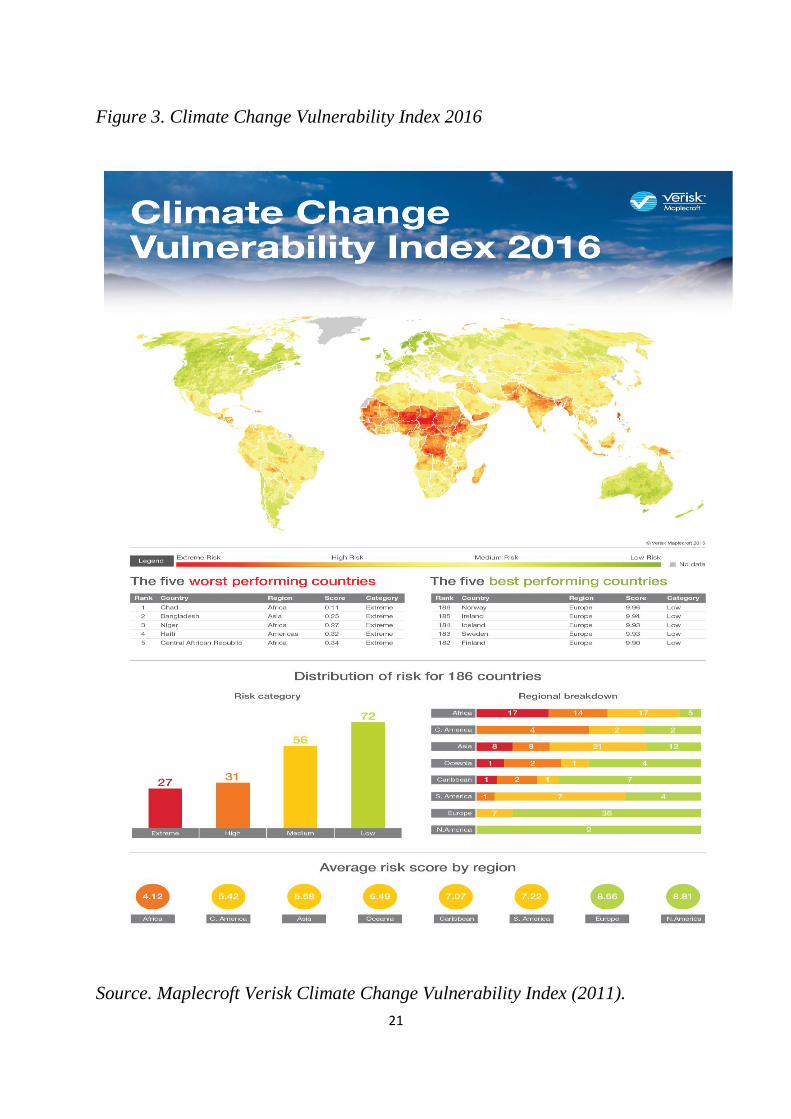
occurrences and even climate change. Figure 3 depicts the vulnerability of the
developing nations to climate change due to their lack of preparedness for climate
change, and changing weather patterns. A regional breakdown of data for 36

20
countries suggests that 17 countries in Africa are at extreme risk, 14 countries are
at high risk, and 5 countries are at low risk. The susceptibility of the continent of
Africa is further compounded by a low risk score of 4.12. Africa is evidently less
prepared than many other regions for the implications of climate change, thus,
the continent as a whole receives a high vulnerability rating (Maplecroft Verisk
Climate Change Vulnerability Index, 2011).
21
Figure 3. Climate Change Vulnerability Index 2016
Source. Maplecroft Verisk Climate Change Vulnerability Index (2011).

22
Research literature, books and documentaries are laden with instances where
local knowledge employed by communities has helped preserve life and
properties in the event of a disaster. For example, Mercer and Kelman (2008)
document the coping mechanism of a riverine community in Papua New Guinea,
where a community rejected a regional government enactment, requiring the
village to relocate to higher grounds. Rather, they chose to stay, and avoid flood
impacts by employing their local knowledge of ways to deal with seasonal
flooding4. Similarly, Arunotai (2008) describes the knowledge base of a
traditional group (Moken) in Thailand and explains how this knowledge helped
them survive the 2004 Indian Ocean Tsunami. The author posits that an oral
legend about “waves” informed the villagers about warning signs of the
approaching Tsunami and what to do to avoid its effects. The “legend of the seven
rollers” is a sacred oral story native to the Moken and its describes the giant waves
from the sea in the event of a Tsunami5. Indigenous coastal communities in
Canada have also been observed to possess local knowledge for dealing with
floods. Newton (1995), in a field study of three indigenous coastal communities
across the North West Territories and the province of Ontario, affirm that local
4 The community built their homes on elevated platforms, cultivated flood resistant crops, and observed the swelling of the river bank by marking its level on rocks. 5 The legend of the seven rollers warned of giant waves. Residents are implored to run to high ground and stay away from the shores of the ocean.

23
communities have developed experiental knowledge of coping with floods. Their
intricate knowledge of weather patterns informs their perceptions, which
subsequently informs preparation for flood events, and response and recovery in
the study communities are influenced by this local knowledge acquired over time
or passed down by previous generations. Mavhura et al. (2013) analyse the role
of local knowledge in flood management and disaster risk reduction in two
communities in the Muzarabani district, Zimbabwe. These communities are flood
prone and have employed local knowledge to help mitigate and cope with floods
through selection of crop varieties, selection of building materials, and farm
practices. The authors also discovered that households commonly planted
drought resistant seasonal crops to be sold in the local market. Homesteads were
built preferably to float in flood waters and essential household items stored on
raised platforms.
The cases described do not differ significantly from what has been observed in
the coastal communities of Nigeria. A vast majority of coastal communities on
the Nigerian coastline are situated on the fringes of the Atlantic Ocean and inland
rivers and creeks thus exposing them to the recurring incidence of floods,
occasioned by the variations in weather conditions. It can be adduced that their
closeness to the ocean is influenced by their livelihood patterns and vice versa6
6 Coastal and riverine communities in Nigeria primarily depend on artisanal fishing activities and agriculture for their sustenance. Also, cultural and religious orientation of vulnerable communities, reflects their closeness to the sea.

24
(Fabiyi & Oloukoi, 2013). Coastal and riverine communities in Nigeria are multi-
ethnic with substantial differences in cultural and religious traditions. However,
there exists a synergy in the presence and application of traditional knowledge in
the event of floods. Veneration of tribal deities is common practice among coastal
and riverine communities in Nigeria: these communities hold cultural beliefs
which reflect the variability of the river and ocean currents, and are embodied in
cultural events such as annual festivals to appease deities. Field work conducted
by Fabiyi & Oloukoi (2013), in coastal communities in Southern Nigeria,
identified local meteorological signals and knowledge acquired by these
communities. The authors confirm the existence of lunar observations; at the
sighting of a new moon, villages prepare for floods. It is important to state that
this does not suppose the occurrence of a flood at the sighting of a new moon.
They also identify cloud reading as one of the practices common in coastal
communities. According to their study, villagers confirmed studying the
behaviour of aquatic animals in a bid to predict floods. Building styles are also
linked to the incidence of flooding in the communities, as houses are built on stilts
and on high ground. Figure 4 shows the coastal areas in Nigeria and their
proximity to the Atlantic. Urban cities such as Lagos, Uyo, Port Harcourt and
Yenagoa will not be spared the effect of global sea level rise (SLR) which will
accentuate coastal flooding and flash floods due to the hardening surface of the
landscape. Also, communities lying on flood plains and lagoons will be impacted.

25
Figure 4. Coastal States in Nigeria
Source. Indigenous Knowledge System and Local Adaptation
2.4 Local Knowledge for Disaster Risk Reduction.
The role of local knowledge in disaster reduction strategies have been recognised
by the United Nations, and several disaster events around the world have proved
the effectiveness of local knowledge. In 2005, the United Nations launched the
Hyogo framework for action, still under the ambit of the international strategy for
disaster risk reduction. The Hyogo Framework for action 2005-2015: Building
the resilience of nations and communities to disasters (HFA) is a global strategy
to reduce disaster risks. It is the outcome of negotiations at the World conference
on Disaster Reduction which held in Kobe, Hyogo, Japan, in 2005. The HFA
26
propagates the concept of disaster preparedness by doing away with the
traditional dichotomy between natural and human induced disaster. Five priorities
for action is contained in the HFA: (1) To ensure disaster risk reduction is a
national and local priority with a strong institutional basis for implementation, (2)
To identify, assess and monitor disaster risks and enhance early warning, (3) To
use knowledge, innovation and education to build a culture of safety and
resilience at all levels, (4) To reduce the underlying risk factors, and (5) To
strengthen disaster preparedness for effective response at all levels. Enia (2013)
avers that a mid-term review of the HFA by the United Nations, reveals an uneven
implementation and progress across member countries. Conversely, Oluwo
(2013) is of the opinion that the HFA makes a commitment for meeting its target
by proposing the establishment of a global platform, national platform and
progress reports. Also, Kniveton et al. (2013) believe the HFA priority 3 makes
a case for the application of local knowledge in the disaster reduction process.
At the expiration of the mandate for the Hyogo framework, the Sendai
framework for disaster reduction was promulgated to improve the strength and
weakness of the previous frameworks. The Sendai Framework for Disaster risk
reduction (SFDRR) builds on the achievements of the Hyogo framework and
aims to protect ecosystems, critical infrastructure and livelihoods from disasters.
SFDRR is a 15-year term global strategy (2015-2030), that addresses the need for
understanding disaster risk through its global targets and indicators. There are
27
seven global targets proposed in the SFDRR: (1) Substantially reduce global
mortality by 2030, (2) Substantially reduce the number of affected people
globally by 2030, (3) Reduce direct disaster economic loss in relation to global
gross domestic product (GDP) by 2030, (4) Substantially reduce disaster damage
to critical infrastructure and disruption of basic services, (5) Increase the number
of countries with national local disaster risk reduction strategies, (6) Extend
international cooperation to developing countries through adequate and
sustainable support to complement their national action to implement the
framework, and (7) Increase the availability of and access to multi-hazard early
warning systems and disaster information. At the heart of the framework, is the
resolve to engender health resilience for at-risk communities and those affected
by disasters and emergencies.
The global targets and indicators set out in the SFDRR serve to encourage
political commitment and financial resources, but indicators are not without
limitations (Maini et al. 2017). The authors argue that measurement of the
indicators requires robust and complete data which may not be readily available.
Also, wrong analysis of data may cause indicators to mislead policy and planning.
Prior and Roth (2015) identify shortcomings in the SFDRR and surmise that when
measured against the Yokohama strategy and HFA, the SFDRR could hardly be
considered a giant leap for global DRR strategy. The authors aver that the removal
of concrete numerical targets and de-linking conflicts and disaster rob the SFDRR

28
of important milestones. Afrose (2017) argues that the SFDRR promotes the
concept of “build back better” by strengthening planning and efficient monitoring
and evaluation, promoting disaster assessments and building financial resilience.
Similarly, Zia and Wagner (2015) affirm, the advancement of early warning
systems in the Sendai framework offers opportunities for disaster relief and
recovery. In an evaluation of the UNISDR framework(s), Diallo (2015) contends
that local knowledge is indeed recognised as a valuable tool necessary to build
the resilience of local communities, but its influence wanes in the implementation
of community disaster risk measures. Table 1 compares the Hyogo and Sendai
frameworks, identifying their differences.
Table 1. Hyogo vs Sendai
Hyogo Sendai
Recognizes the growing incidence of disasters of
hydrometeorological origin.
It seeks to fill gaps prevalent in the Hyogo
framework.
Argues for the integration of disaster risk efforts
into policies, plans and programmes with a focus
on prevention, mitigation, preparedness and
vulnerability reduction.
Establishes timelines for achieving objectives.
Advocates for the introduction of gender
perspectives in disaster risk plans and decision-
making processes.
Introduces the concept of “building back better” in
the post-disaster/rehabilitation phase in a bid to
avert the creation of new risks.
Disaster prone developing countries and small
island developing states deserve to be aided cope
with disasters.
The framework expounds on the types of
assistance required by disaster prone countries to
include: finance, technology transfer, capacity
building and international cooperation

29
Makes a case for the establishment of early
warning systems for effective prediction.
Prioritizes the need to safeguard the health of
people, and the ecosystem that supports life.
Seeks to address gaps in the Yokohama strategy.
The Hyogo and Sendai frameworks prescribe indicators for monitoring and
assessing implementation. The convergence of three United Nations landmark
agreements including the Sendai framework, the sustainable development goals,
and climate change agreements, offers the opportunity to improve participation
in disaster risk strategies, mitigation and adaptation (Aitsi-selmi et al., 2015).
Similarly, Wilkinson et al. (2016) opine that bringing together the commitments
in the disaster policies, and SDGs could offer a coherent approach to addressing
climate induced displacement.
Technological/scientific disaster risk reduction strategies may not have identified
adequate solutions to the disaster related problems of developing countries. Some
researchers argue that such imposition of ideas have done more harm than good
(Briggs, 2005 and Shizha, 2006). Grenier (1998) affirms that development
planning has failed to achieve sustainable development; rather dependencies have
been created. It is widely known that a majority of development solutions are
alien to the traditional and cultural beliefs of those being planned for, thus
necessitating its abandonment. The exclusion and displacement from Eurocentric
scientism have left rural people wary of intervention from external authorities
(Wisner, 1995). Increasingly, development practitioners have given credence to
30
the efficacy of local knowledge in improving the coping and adaptive capacities
of rural coastal communities (Rumbach and Foley, 2014).
Assessment of disaster events around the world, reveals that local knowledge and
institutions have played important roles in safeguarding lives and properties.
McAdoo et al. (2008), posit that the possession of local knowledge by a section
of the population in the Solomon Islands saved their lives during the 2007
Tsunami. The authors assert that residents’ local to the island understood the
dynamics of earthquakes and the emptying of the ocean around them as being
signs of an impending Tsunami7. However, immigrant communities on the island
lacked this knowledge, thus suffering huge losses. In 2004, a Tsunami was
recorded in the Indian Ocean and lives, and properties were lost. However, an
island community off the coast of Indonesia is said to have survived by virtue of
a folklore (smong) which described a Tsunami and informed on steps to take in
the event that it happens. The Simeulue Islands people’s survival in the 2004
Tsunami is a celebrated case depicting the prowess of local knowledge in disaster
risk reduction. Baumwoll (2008) suggests that the Simeuluean’s success calls for
the inclusion of local knowledge in disaster risk reduction programmes.
7 An earthquake that registered 8.1 on the Richter scale hit the Solomon Islands and generated waves 12m high. Local indigenous residents were knowledgeable of Tsunami’s. Thus, when the lagoons around their homes emptied after the earthquake hit, they ran to higher grounds. However, immigrant communities on the island not knowledgeable of Tsunami’s, went to observe the exposed sea bed and were affected by the waves that followed the quake.

31
Rumbach and Foley (2014) describe how the indigenous composition of
communities on the island of American Samoa enabled their response and
survival during the Tsunami that hit the island in 2009. Three earthquakes hit the
South Pacific Ocean in the vicinity of Samoa and minutes later, a Tsunami struck.
Immediately, the fa’a Samoa villages aided by their local institutions (age grade
committee and women group) initiated rescue of residents trapped in the surging
ocean wave, before emergency services from the central government arrived. It
can be argued, therefore, that local institutions can aid response and recovery in
the event of a disaster. There is a growing realisation that local knowledge may
have something to teach the West, in that it may increase the scientific
understanding of natural events (Breidlid, 2009). With the increased warming of
the earth and melting of the glaciers, development practitioners and institutions
have called for an interactional expertise between scientific and local knowledge.
This knowledge sharing between different paradigms is informed from climate
simulations which suggest that the developing nations will be at the receiving end
of extreme climatic events. To this end, Nyong et al. (2007), asserts that there is
a need to integrate local knowledge into formal DRR, and climate mitigation and
adaptation policies. The need to engender the cooperation of rural vulnerable
communities in climate change and DRR programs can be adduced to be one
reason for the increased interest in local knowledge. A synergy between local
knowledge and science will help to improve existing disaster risk control

32
measures for efficient administration. It is noteworthy that the knowledge base of
local knowledge can improve the resilience of communities. Ecologists believe
that local knowledge is vital to the conservation of biodiversity, and in the
dispensation of sustainable resource management. Gadgil et al. (1993) argue that
management based on the simplification of complex ecological systems by
science have resulted in environmental degradation. By contrast, traditional
ecological knowledge acquired over time by communities dependent on the
natural environment is replete with knowledge about the characteristics of flora
and fauna local to their environment. The authors surmise that the preservation
and use of this knowledge will help conservation strategies. The integration of
local knowledge with western scientific information will empower local
communities to deal with climate extremes (Fabiyi and Oloukoi, 2013).
2.4.1 Value of Local Knowledge (Preparedness and Post-disaster recovery)
Previous discussion has described the multiple roles of local knowledge in
disaster preparedness, response and recovery. Hiwasaki et al (2014) document
how coastal communities in Asia have developed techniques to prepare for and
mitigate hydro-meteorological changes. In their research, the authors describe
how communities predict rainfall and strong winds by closely observing the
changing characteristics of clouds, wind direction and animal behaviour. Similar
to the events described by Fabiyi and Oloukoi (2013), the texture of clouds
informs the communities decision to prepare for floods. Furthermore, local

33
technical knowledge in building and construction has influenced at-risk
communities’ preparation for disasters. Walshe and Nunn (2012) in their study of
disaster risk reduction and the place of local knowledge in Vanuatu, conclude that
the local “kastom knowledge” is an important tool for the island country. The
authors argue that local knowledge, in the form of storytelling helped save lives
in the Tsunami that hit the country in 1999. Stories of Tsunamis are embellished
with local customs, to inform the local populace of the dangers lurking in their
immediate environment and provide guidance on what to do in the event of a
disaster.
Disaster risk reduction also entails post-disaster recovery activities. Many local
communities possess the ability to engender cooperation and cohesion in disaster
recovery, and this is confirmed by Lambert (2014) in his study of indigenous
Maori people and their responses to the earthquake that hit Christchurch, New
Zealand. The author affirms that kinship and hospitality were displayed by the
Maoris, to the effect that neighbours opened their doors to residents who may
have lost their homes in the ensuing disaster. Also, traditional meeting places
were made available to provide temporary accommodation. Enarson (1998)
argues the gendered disparity in the disaster risk reduction discourse, by asserting
that women play a major role in environmental crisis given their roles as food
producers, caregivers and custodians of local knowledge and environmental

34
resources. It is evident from case studies cited that local communities possess the
skills and knowledge to prepare for disaster.
Table 2. Disaster Indicator and Response in Selected Countries
Place Threat Response Comment
Indonesia (Simeule) Tsunami Run to high ground A local folklore
‘Smong’ describing
the signs of a
Tsunami, helped the
villagers survive
Thailand (Moken) Tsunami Run to high ground Possession of
knowledge about
weather events and
local folklore, helped
the village survive
Vanuatu Tsunami Run to high ground Local knowledge,
provided the villagers
with the necessary
information to
survive a Tsunami
New Zealand Earthquake Seek shelter Communities rallied
together to help their
affected neighbours
Source. Adapted from the Value of Indigenous Knowledge for Disaster Risk
reduction
Table 2 identifies the threat and responses to varying disaster types in different
countries. Local knowledge takes varying forms to inform adaptation in at-risk
communities. Oral renditions, cloud reading, cultural beliefs and social relations
are common forms of adaptive strategies adopted.

35
2.4.2 Does Western Scientific Knowledge Complement Local Knowledge?
The complementarity of local knowledge with science has been questioned on all
aspect of influence. Regardless, research exists to suggest that it is possible to
seek an interactive relationship between the different paradigms of knowledge.
Huntington (2000) presents three examples where traditional ecological
knowledge and science have complemented each other to achieve significant
milestones for society: 1) the bowhead whale census, 2) Alaska beluga whale
committee and 3) Exxon Valdez oil spill. A ban was imposed on the harvest of
bowhead whales by the International Whaling Commission (IWC), and this
impinged on the traditional activities of whaling communities living around the
shores of Alaska8. The whaling communities formed a group to fight the ban, and
this resulted in a census to help establish a good fishing quota for the whales.
Initial census by the IWC produced a census figure that was keenly contested by
local Eskimo communities and prompted a second census that involved a
partnership between scientists from the Commission and the whaling
communities, thus enabling communities to apply their local knowledge in the
mapping of the migratory pattern of the whales. Their partnership resulted in a
census result that was more accurate and acceptable to both parties.
8 The Alaska Eskimo Whaling Commission comprises of eleven whaling communities: Gambell, Savoonga, Wales, Little Diomede, Kicalina, Point Hope, Point Lay, Wainwright, Barrow, Nuiqsut and Kaktovik.

36
The case of the Alaska Beluga Whale Committee was a lesson learnt from the
bowhead saga. The author describes the beluga whale committee as an
organisation that engendered cooperation between scientists and local
communities. Invasive and intrusive technologies such as satellite tag implants
and radio collars otherwise considered disrespectful and cruel to the animals by
the native residents were employed in tandem with local knowledge of the
environment possessed by communities. The collaboration has culminated in the
promotion of better ecology for the Beluga whale and a management of its stocks
in the Alaskan Shore. The grounding of the oil tanker Exxon Valdez, released an
estimated 38,000 tons of crude oil into the water bodies around Prince William
Sound, Alaska and the spill was blamed for the dearth of herrings’ fish stock.
However, collaboration between the natives and scientists, have helped improve
the herring population in the area.
In the disaster risk context, there appears to be a paucity of case studies where
science and local knowledge have worked together to improve the resilience of
local vulnerable communities. Interestingly, Mercer et al. (2010) through
participatory action research in Papua New Guinea (PNG) developed an
integrated framework for reducing the vulnerability of communities to
environmental hazards. The framework was designed such that communities
prescribed the appropriate local knowledge for coping with different
environmental hazards and the researchers with their scientific knowledge acted

37
as guides9. The framework was designed in stages by carrying out participatory
action research in three communities; Kumalu, Singas, and Baliau. Community
engagement informs the first stage in the framework. The researchers having
agreed on the communities to include in the research, approached them to develop
rapport and explain the aims and objectives of the research. Assessing the
vulnerability of the communities to different inherent hazard types, is the focus
of the next stage. The vulnerability level of the communities is established by
identifying extrinsic factors outside the control of the communities and intrinsic
factors resulting from extrinsic ones, which the community can address10. The
third stage in the framework process entails the identification of indigenous and
scientific strategies used to cope with intrinsic factors affecting the vulnerability
of the communities. The final stage involves the iteration of results from step 2
and step 3. Interactive strategy which comprising of local and scientific
knowledge is developed, to reduce the community’s vulnerability to
environmental hazards. This stage is participatory as it involves members of the
community and the researchers who analyse their vulnerability level and specify
strategies to improve their resilience to hazards.
9 The communities planned and implemented adaptive strategies designed by the community members and fine-tuned by the researchers. The researchers confirm that in the years following their visit, they have been a marked increase in the resilience of the communities to flood risk. 10 Extrinsic factors refer to anthropogenic and non-anthropogenic processes beyond the control of the communities, and intrinsic factors refer to coping strategies which leave communities vulnerable and are a product of the extrinsic factor. For example, the swelling of rivers caused by excess rain, leads to flood events, which cause the communities to build on high grounds (unstable land), thus exposing them to the ills of landslides.

38
The literature review attempts to make a case for local knowledge in the disaster
risk process. Methodology and framework to be employed in this research, is
discussed in the next chapter.

39
Chapter 3: Methodology
Disaster management regulations in Nigeria will be analysed contextually to
confirm the extent to which it recognises the adequacy of local knowledge. Also,
multiple embedded case studies of vulnerable cities/townships will be employed
to ascertain the role of local knowledge in flood risk management. It is pertinent
to note, that the analysis of secondary data describes the approach to be employed.
The textual analysis of the disaster management framework and the inquiry from
the case studies will provide information on the role of local knowledge in
disaster management strategies between government establishments and at-risk
communities. The North Central region is plagued by recurrent flood events.
Communities in this region are bounded by River Niger and River Benue, thus
providing good examples of flood prone communities. The flood events in 2012
affected parts of the communities selected for this study and was adjudged the
worst in a decade. Ministries, departments and agencies of government in the
areas affected reacted to the flood events with a promise to forestall future
occurrence. A reoccurrence of floods in 2017 impacted livelihoods and disrupted
businesses in the selected communities, thus offering the opportunity to evaluate
state response and coping strategies in the area when compared to the previous
flood event of 2012. Also, the shift from the Hyogo to Sendai framework when
assessed with Nigerian disaster planning, suggests that perhaps adequate

40
measures were not taken to ensure the implementation of objectives form the
Sendai framework to help forestall/reduce impacts from flood.
This research will employ the use of content analysis and case studies to elicit
information and discuss the subject of interest.
3.1 Research Context
The choice of Nigeria for this study stems from the warnings from the
Intergovernmental Panel on Climate Change and numerous environmental groups
who affirm that climate change will hit the developing nations of the world the
worst. Nigeria is the economic hub of West Africa and possesses a high
population compared to its neighbours. Analysis employed in the Nigeria case
study is tied to primary and secondary objectives; a review of the National
disaster management framework, and development of a framework to fill in
identified gaps. The results are presented as follows: the first section introduces
the national disaster management framework and attempts to itemise the codes
and categories generated from the National disaster management framework. The
second section provides discussions of critical findings from the analysis.
3.2 The Qualitative Approach
A qualitative approach to research appeals to different academic backgrounds,
with Social Science and Natural Science dominating in its usage. Morgan and

41
Smircich (1980) are of the opinion that the use of qualitative approach is informed
by the type of study to be carried out. Similarly, Gephart (2004) describes
qualitative research as being descriptive and relying on words and talk to create
text. Literature abounds, that describe different types of approach/methods to
conduct qualitative research. Nonetheless, Bryman and Bell (2016) differentiate
qualitative approach from quantitative, by suggesting the former is usually
inductive, interpretivist, constructionist and Naturalistic. The authors further
posit that qualitative researchers object to the notion of reliability and validity.
Thus they offer alternatives, trustworthiness and authenticity. Their discourse on
the elements of the concepts above suggests that trustworthiness comprises of
four criteria: transferability, credibility, dependability and confirmability.
While the qualitative approach has garnered accolades and support across
research fields, it is pertinent to note that it has its limitation and critics. Bryman
and Bell (2016) agree to the common limitations of the qualitative approach, thus
labelling it as subjective, difficult to replicate, the problem of generalisation and
a lack of transparency. Malterud (2001) opine that qualitative research offers the
opportunity to increase the understanding of complex phenomena, through
triangulation. Summarily, it can be deduced that the primary goal of qualitative
research is to see through the eyes of the people being studied.

42
3.3 Content Analysis
Content analysis is a research methodology that involves a blend of both
qualitative and quantitative approach. Hsieh and Shannon (2005) describe content
analysis as a widely used qualitative research technique with three distinct
approaches. Also, Elo and Kyngas (2007) define content analysis as a systematic
means of describing the phenomenon. The authors aver that through content
analysis, it is possible to test theory and enhance the understanding of data.
Stemler (2001) makes a case for content analysis enhancing the reliability of
inference from a text, yet also posits that poor categorisation, selection of themes
and codes may lead to reliability problems.
3.3.1 Coding
Qualitative researchers organise data into categories and themes to (or “intending
to”) make sense of a phenomenon or explain it. Neuman and Robson (2012)
affirm that ideas and evidence are interdependent. Bryman and Bell (2016) define
coding as a review of notes, transcripts, materials and labelling items that share
similar themes and possess theoretical significance. The authors posit that coding
is an integral part of data analysis, informed by the research question(s). Coding
entails organising text materials and projecting its meanings in themes and
categories. Basit (2010) is of the opinion that the choice of coding in qualitative

43
research is informed by the availability of funds, the expertise of the researcher
and project size.
Figure 5. Types of Coding
Source. Basics of Qualitative Research, Corbin and Strauss (1990).
3.4 Deductive Approach
This method is used where existing theory exists about a phenomenon and would
benefit from further analysis and description. Hsieng and Shannon (2005) refer
to this approach as “Directed Content Analysis”. Elo and Kyngas (2007) describe
the deductive approach, as a retesting of data in a new context, and it is based on
previous research work. In the field of disaster risk reduction, the scholarship is
replete with discussions on the top-down and bottom-up dichotomy. Content
analysis of the disaster management framework for Nigeria against the top-down
and bottom-up orientation will offer explanations as it pertains to vulnerable
communities and their resilience against floods.

44
3.5 Case Studies
Cooper and Morgan (2008) are of the opinion that case study as a research method
helps to understand situations of uncertainty, uniqueness, instability and value
conflict. However, Simons (1996) is of the opinion that a common disadvantage
of case study research is the difficulty of generalising from a single case. The
author argues that if generalisation is acknowledged, it offers the opportunity to
yield unique and universal understanding of case’s being studied. This research
work will rely on newspaper reports and journal articles about the flood events
and coping mechanisms of residents. Jick (1979) define triangulation as a vehicle
for cross-validation of distinct methods. There will be an iterative process of
traversing between results from the content analysis of Nigeria’s national disaster
management framework and results from the embedded case studies to inform
the design of a framework that informs cooperation between government
agencies and residents of flood prone areas.
3.6 Study Area
The United Nations Economic Commission for Africa (2015) suggest that 94
disaster events occurred in Nigeria between 1980 and 2010, impacting 6,306,441
people and costing the economy $188 million. Adebimpe (2011) posits that flood
is the most widespread natural hazard in Nigeria. Joshua et al. (2014) document
disasters that have occurred in Nigeria and characterize them as;

45
Industrial/technological, Civil strife and Conflicts, and Natural Events. Similarly,
Okoli (2014) list disasters in Nigeria to include; Auto crash, Boat mishap,
Terrorism, Pipeline explosion, Oil spills, Landslide/Erosion, Drought, Floods,
Disease outbreaks and Mine collapse. Table 3 identifies the disasters prevalent in
the 36 states of Nigeria. There is a prevalence of Flood across the Northern and
Southern states, and Drought in the Northern states.
Table 3. Natural Hazards in Nigeria
Hazard Geographical Area
Floods Urban areas with poor drainage; settlements located in low-lying river flood
plains; settlements fringing the Niger, Benue, Cross, Katsina Ala, and Imo rivers.
Landslides Hilly terrains, particularly in the south-eastern part of Nigeria with Cretaceous
sedimentary geological formations.
Soil erosion Widespread across the country but occurs particularly in areas undergoing rapid
deforestation, intensive agriculture and rapid urbanization without adequate
provisions for protecting topsoil.
Gully erosion Predominantly in Anambra, Cross River, AkwaIbom, Imo, Benue, Abia, Enugu,
Ekiti, Kogi, Edo and Plateau states. Itis caused by devegetation of sloppy terrains
and the impact of high intensity rains, which cause overland flow, riling and
gulling.
Coastal erosion The most severely affected areas are the coastal areas of Lagos, Ondo, Delta,
Bayelsa, Rivers, AkwaIbom and Cross River states. An estimated 25 million people
(28% of the population) live in coastal zones and are at risk of coastal flooding.
Windstorms At the onset of the rainy season, rainfall is usually accompanied with strong
winds. Wind speeds of up to 200 km/h have been recorded. The winds are usually
associated with the tropical easterlies and coincide with thunderstorms. They
occur virtually countrywide.
Drought and
desertification
Mainly areas within the Sudan-Sahel ecological region, including areas north of
the 11th parallel north (Borno, Yobe, Adamawa, Taraba, Sokoto, Bauchi, Katsina,
Kano, Gombe, Kebbi and Zamfara states).
Sandstorms
All states within the Sudan-Sahel ecological region are vulnerable (Borno, Yobe,
Adamawa, Taraba, Sokoto, Bauchi, Katsina, Kano, Gombe, Kebbi and Zamfara
states). They are caused by the propagation of north-easterly trade winds across
the Sahara desert into these northern states.
Pest invasion Pests of various typesoccasionally attack agricultural lands (locusts and quails are
common). When it occurs, the farmlands of whole communities are ravaged,
leaving people impoverished. All areas of the country are vulnerable.

46
Source. United Nations Economic Commission for Africa. (2015).
Flood events are common in Nigeria. Lagos state, the commercial hub of Nigeria
lies on the coast of the Atlantic Ocean and suffers the debilitating effects of
Floods. Adelekan (2016) asserts that Flood events are caused by heavy rainfall.
In July 2011, a seventeen-hour precipitation event inundated Lagos with
233.3mm of rainfall and caused Floods that claimed 25 lives and displaced 5393
persons from their homes (Adelekan,2016). In Southern Nigeria, Flood
constitutes a major disaster. Chiadikobi et al. (2011) confirms the impact of Flood
on residents of Port Harcourt, Rivers state.
The early 1970’s heralded a great famine that spread across much of the Sahel
and Northern parts of Nigeria. Watts (1983) argues that a 7-8-month dry period
followed by an intense but short wet season may have altered the precipitation
pattern and brought about drought, which in turn caused the famine. Odjugo
(2010) opines that decreasing rainfall and increasing temperature has led to the
incidence of drought and desertification experienced in Northern Nigeria.
Drought and desertification has resulted in the encroachment of sand dunes, water
scarcity, ecological degradation and emigration of people and animals (Odjugo
Wildfire All areas are at risk of wildfire but the Sudan, Guinea and derived savannah
ecological regions and the drier parts of the rainforest are particularly susceptible.
Fires are usually seasonal and are often caused naturally by lightning flashes or
through uncontrolled bush burning.
Volcanic activity Volcanic activity is common on the Biu and Jos plateaus and in the Benue valley.
Plateau, Adamawa and Taraba States are most susceptible.

47
an Ikhuoria, 2003). The impact of drought is multi-pronged, and it is affirmed by
Obioha (2009) who is of the opinion that agricultural production and livelihoods
have suffered negative consequences prompting government and aid agencies to
intervene. Bello et al. (2012) are of the opinion that drought has influenced the
cultivation of certain crops in Northern Nigeria. The authors suggest that millet,
maize and beans are planted as a means of adaptation, rather than the preferred
crops (Groundnut and Guinea corn). Drought and desertification have resulted in
the reduction of arable lands for cultivation, thus informing new farming
practices. The reoccurrence of droughts has enabled the spread of disease
carrying vectors, thus impacting livestock and human health (Hotez and Kamath,
2009). The areas to be studied are Benue and Kogi states, because of their
susceptibility to fluvial floods. Benue and Kogi states are bounded by two major
rivers in Nigeria (Benue and Niger). The area constitutes important agricultural
lands and is referred to as the food basket of Nigeria. Recurrent flood incidents
in the area have claimed lives and destroyed properties with serious consequences
for the economy of Nigeria. Flood events will be analysed for year 2012 and 2017
to inform the discourse of this research.
3.7 Limitations of The Study
This research would have benefited from actual field visits, to gather data and
gain insight from at-risk communities. The lack of funds did not afford the
opportunity to make field visits. There was also a paucity of literature on local

48
knowledge in Nigeria. Despite the aforementioned shortcomings, this research
work will offer a better understanding of disaster management practice in Nigeria
and offer possible solutions to improve the existing measures and enhance the
resilience of flood prone communities. The methods adopted in the research is
discussed in the next chapter.
49
Chapter 4: Content Analysis and Case Studies
Nigeria may not be rightly described as a disaster-prone country, yet it has
experienced large scale emergencies that have cost lives and properties. Nigeria
is the economic hub of West Africa, with its coastlines in the south bounded by
the Atlantic Ocean. Much of its cities and economic hubs are built on the
shoreline of major rivers. Similarly, there are over 3,000 local settlements and
fishing communities inhabiting the coastlines of Nigeria (Fabiyi and Oloukoi,
2013). The National Emergency Management Agency (NEMA) is the sole federal
institution mandated to undertake and implement disaster management
responsibilities. In a bid to improve NEMA’s operational efficiency, the National
Disaster Management Framework (NDMF) was developed. The core purpose of
the NDMF is, to guide disaster management activities in the country. The
National Disaster Management Framework was subjected to content analysis in
order to evaluate the extent to which the NDMF recognises the inputs of local
communities in the disaster risk reduction process
This chapter presents the results of the content analysis of the disaster
management framework in Nigeria and case studies of specific communities in
states that were ravaged by floods in 2012 and 2017 and inquire about the role of
local knowledge in disaster risk management and discuss how the events were
managed to inform gaps in the disaster management process. An exhaustive
search for materials that speak to the essence of the research topic was conducted.

50
Numerous repositories of academic institutions, research bodies and government
agencies were queried to identify relevant policy documents, conference papers
and articles. Also, newspaper articles provided data and information relevant to
the case studies. 4 journal articles, 3 newspaper reports, and 2 policy reports from
government agencies were consulted for Kogi state. Benue state comprised of 3
journal articles and 1 newspaper report.
4.1 National Disaster Management Framework
The “National Emergency Management Agency” (n.d.) suggest disaster
management in Nigeria dates back to 1906 with the establishment of the fire
brigade, and with each passing government (Military and Democratic), disaster
management remained an ad-hoc arrangement under the office of the head of
state. The devastating drought of 1972/73 in Nigeria, prompted the creation of a
national emergency relief agency (NERA) in 1976. In a bid to embolden disaster
management, the federal government of Nigeria (FGN) commissioned an inter-
ministerial body to evaluate disaster reduction strategies. Consequently, backed
by a decree of the military regime, the status of the NERA changed to that of an
independent institution supervised by the office of the presidency. In 1999, the
National Emergency Management Agency (NEMA) was established to replace
the defunct emergency relief agency and with a mandate to manage disasters
nationwide. The National Emergency Management Agency encountered
challenges and difficulties in implementing its proposed disaster management

51
strategies, thus necessitating the National Disaster Management Framework to
correct gaps and improve the delivery of disaster management in Nigeria
(“National Emergency Management Agency”, n.d.). Figure 6 depicts the
hierarchical relationship of disaster management authorities in Nigeria.
Figure 6: Hierarchy of Authority.
Source: National Disaster Management Framework pp. 21.
The national disaster management framework serves to improve consistency and
engender efficacy among the stakeholders involved in the disaster management
process. Table 4 describes the open codes and their properties derived from
searching the framework for words that connote or support the application of
local knowledge. It affords the opportunity to understand the structure of the
document being reviewed.
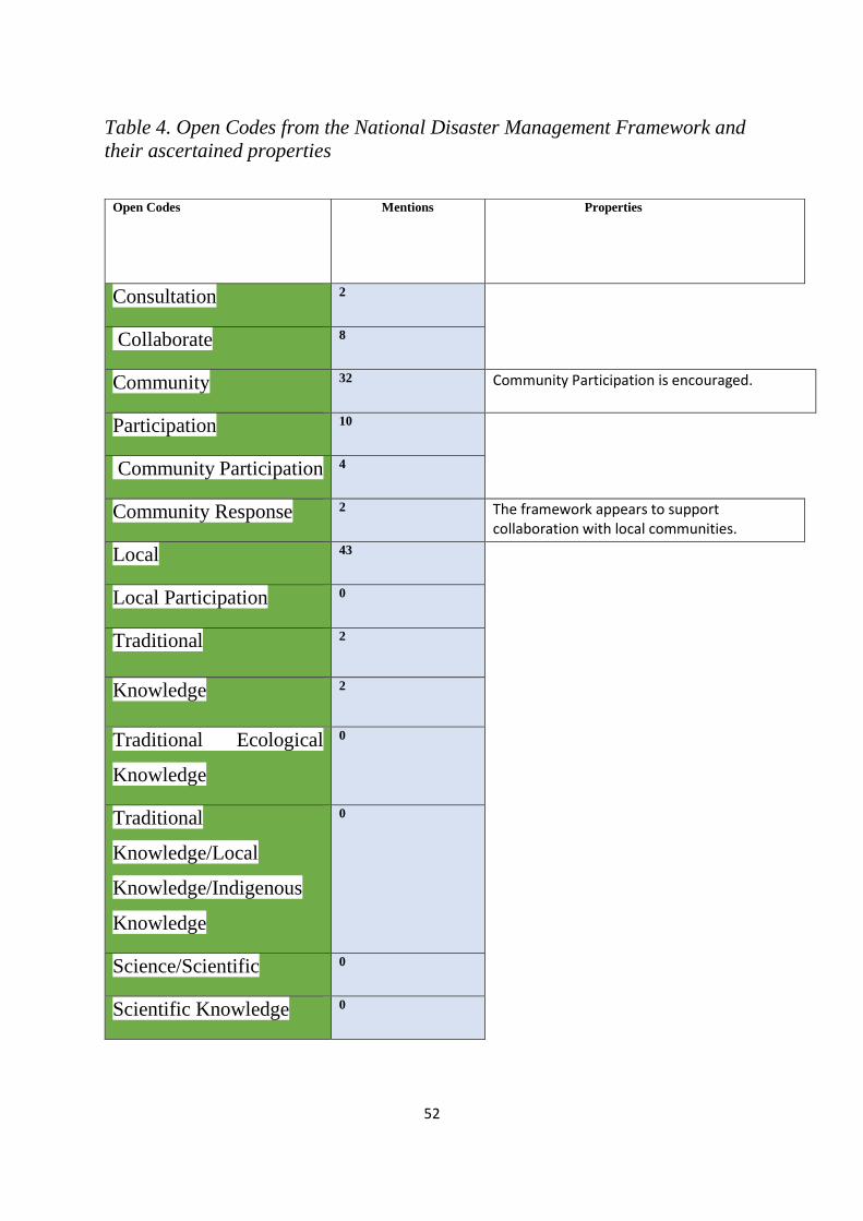
52
Table 4. Open Codes from the National Disaster Management Framework and
their ascertained properties
Open Codes Mentions
Properties
Consultation 2
Collaborate 8
Community 32 Community Participation is encouraged.
Participation 10
Community Participation 4
Community Response 2 The framework appears to support collaboration with local communities.
Local 43
Local Participation 0
Traditional 2
Knowledge 2
Traditional Ecological
Knowledge
0
Traditional
Knowledge/Local
Knowledge/Indigenous
Knowledge
0
Science/Scientific 0
Scientific Knowledge 0

53
Source: Adapted from An Overview of Content Analysis (2001).
The content analysis of the framework reveals codes that suggest a collaborative
strategy is encouraged. The NDMF ascribes relevance to the local governments
in the planning of disaster management strategies. Disaster management planning
in the NDMF allude to the role of community institutions and proposes
community response as an important tool. Collaboration between state agents and
relevant stakeholders in the disaster risk process is enshrined in all thematic areas
of the framework. For example, the framework stipulates that emergency
management authorities at all levels shall collaborate with other stakeholders to
ensure coherent and relevant disaster risk reduction planning is undertaken
nationwide, and consistent with the national disaster risk reduction management
plan. Therefore, it is deduced that local knowledge is favoured in the disaster risk
management strategies prescribed by the NDMF.
The case studies involve three states in the Niger-Benue Basin, a flood prone area
in the North-Central geo-political zone of Nigeria.
4.2 Kogi State:
Kogi state is situated in the North-Central zone of Nigeria. It is called the
confluence state, as a result of the confluence of River Niger and River Benue in
its capital, Lokoja. The state lies on latitude 7.49 N and Longitude 6.45 E, and its
geological feature comprises of sedimentary rocks and alluvium along the river

54
beds, thus, promoting agriculture. Average annual rainfall ranges from 1016 mm
to 1524 mm, with a maximum temperature of 33.2 ⁰C. The city of Lokoja is low-
lying, with over 60% of its built area lying on the floodplains of River Niger
(Samuel et al., 2017). Figure 7 depicts the annual rainfall predictions for 2012
and its deviation for 2017. Lokoja, Makurdi, and Jalingo were expected to receive
rainfall in the region of 700-1500mm in 2012. In 2017, rainfall in the region was
expected to be below normal compared to previous predictions.
Figure 7: Annual Rainfall Prediction
Source: Nigerian Meteorological Agency
Anunobi (2014) describes Lokoja as a riparian town consisting of an extensive
floodplain favourable for agriculture and fishing. The author confirms the

55
recurrent flooding of the floodplains beginning in September and peaking in
November. As the state capital, it is no surprise that much of the town is primarily
built up to accommodate commerce and industry. The socio-economic
characteristics of Lokoja evince the cluster of neighbourhoods ranging from
medium density to high density (Samuel et al., 2017). Aderoju et al. (2016) affirm
that communities native to the floodplains are often connected to their
environment in spiritual and ritualistic terms, to the extent that ritual cleansing is
carried out to pacify natural spirits and deity to avert floods.
4.2.1 Event
The Nigerian Meteorological Agency (NIMET) in their seasonal rainfall
prediction in January 2012, warned about imminent floods in various parts of
Nigeria, as a result of heavy rainfall (Njoku, 2012). The agency advised the
federal and state governments to prepare for the rains by cleaning their drainage
systems, creating awareness for residents in the affected region, and carrying out
maintenance of dams in their jurisdiction. Nine local governments in the state
sustained severe damages, with over 2000 homes submerged in flood water
(Njoku, 2012).
4.2.1.1 Flood Event of 2012
The floods that occurred in 2012 were adjudged the worst in four decades
(“Lingering hardship and floods”, 2014). Kogi state experienced much of the
destruction across the country, with 1.3 million people displaced and 413 lives
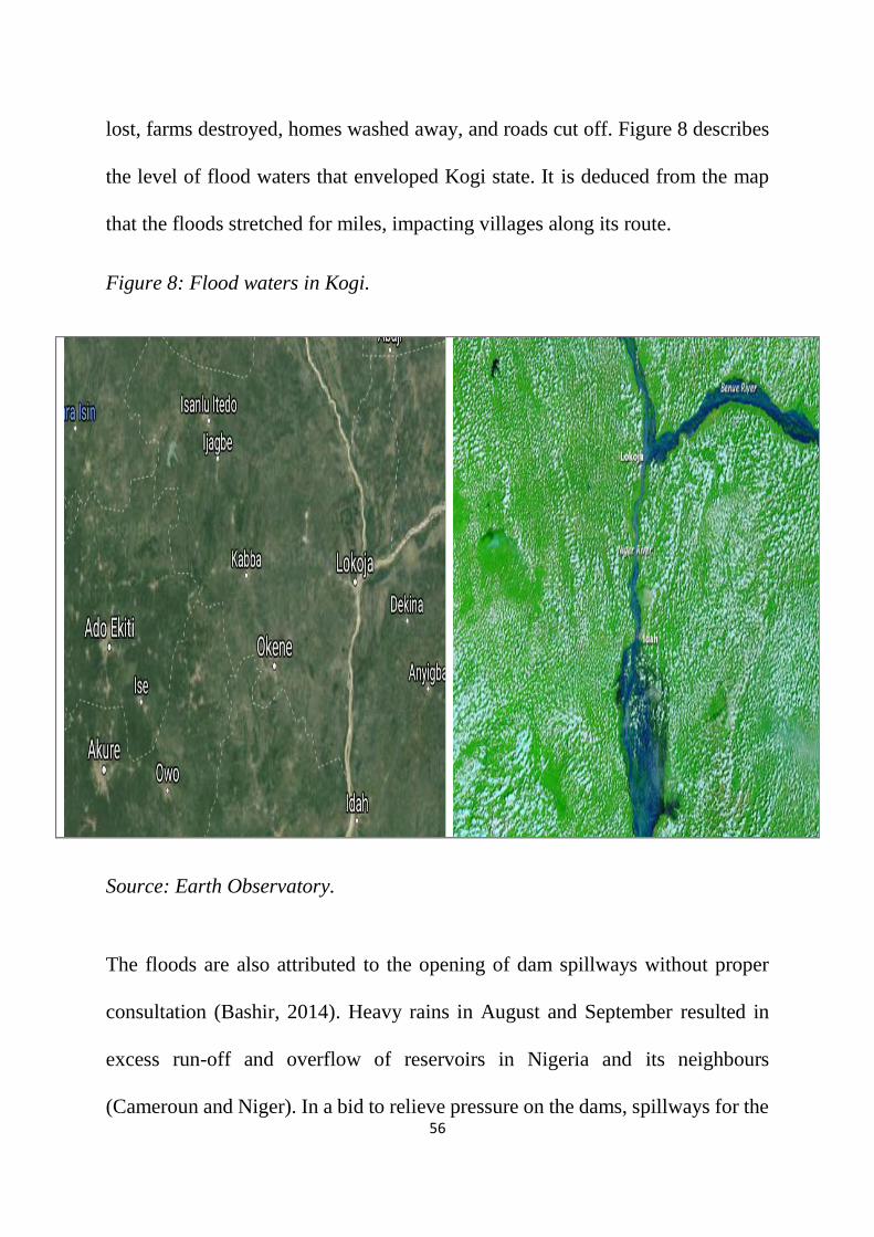
56
lost, farms destroyed, homes washed away, and roads cut off. Figure 8 describes
the level of flood waters that enveloped Kogi state. It is deduced from the map
that the floods stretched for miles, impacting villages along its route.
Figure 8: Flood waters in Kogi.
Source: Earth Observatory.
The floods are also attributed to the opening of dam spillways without proper
consultation (Bashir, 2014). Heavy rains in August and September resulted in
excess run-off and overflow of reservoirs in Nigeria and its neighbours
(Cameroun and Niger). In a bid to relieve pressure on the dams, spillways for the

57
Lagbo dam, Shiroro dam and Kainji dam were opened thus leading to flooded
river banks. Kogi state shares its boundary with ten other states which transcend
the South – West, North – Central, South – East, and North – Western parts of
Nigeria. The disruptions in transportation impacted commerce and trade, thus
causing a spike in food prices. Figure 9 shows the blockage of an important
highway. The Lokoja -Abuja carriageway is an essential route for the movement
of people and transportation of food between the Northern states and Southern
Nigeria. The floods of 2012 resulted in its closure and with dire consequences for
farmers and commuters.
Figure 9: Severed transportation route
Source: Geospatial Techniques for the Assessment and Analysis of Flood Risk
along the Niger-Benue Basin in Nigeria.

58
4.2.1.2 Flood Event of 2017
Rainfall prediction for 2017 was expected to be below normal. However, Davies
(2017) suggest that flood in Kogi state has caused the displacement of over 10,000
people. Heavy downpour in September which lasted several hours resulted in
flood waters in Ganaja and Sarkin-Noma axis of Lokoja city. Other areas affected
by the flood include; Ajaokuta, Bassa, Igalamela/Odolu, and Koton Karfi. Also,
the Lokoja – Abuja highway was submerged thus impacting traffic. Figure 10
shows flood waters in a residential area of Lokoja.
Figure 10: Flood waters in Lokoja
Source: Nigerian Meteorological Agency

59
4.2.2 Response
The investigation into the role of government and its agencies, reveals that
warnings from the weather agency were not heeded. Also, in the wake of the
flood, monetary donations were made by well-meaning Nigerians and corporate
organisations to the state treasury to the tune of $2,118,412.12 (Bashir,2014).
There exist no records, at least to the public, to explain how the funds were spent
to ameliorate the sufferings of those impacted by the flood.
Daramola et al. (2016) in their assessment of flood prone communities in Kogi
and other affected states document observed coping strategies to include: relying
on rain water for drinking, relying on oil lamps and candles, taking refuge in
religious establishments and squatting with friends/relatives. The use of herbs to
treat diseases is also identified by the authors. Similarly, Anunobi (2014) in a
study of the flood risk of Shinkatu community, a sub-urban neighbourhood on the
outskirts of Lokoja, identifies coping strategies employed by residents. The
author identifies flood proofing techniques used by the community to include: the
use of waterproof sheets in buildings, and the use of sandbags and sealants to
block possible water escape routes. Also, relocation from flooded premises and
elevation of buildings with high foundation is a common practice employed. In
September 2017, flood wreaked havoc in parts of Kogi State. A joint assessment
by disaster risk managers from relevant agencies in the state and representatives
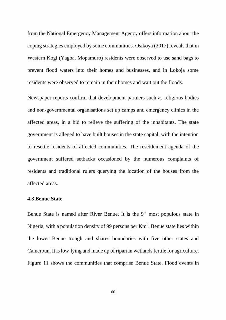
60
from the National Emergency Management Agency offers information about the
coping strategies employed by some communities. Osikoya (2017) reveals that in
Western Kogi (Yagba, Mopamuro) residents were observed to use sand bags to
prevent flood waters into their homes and businesses, and in Lokoja some
residents were observed to remain in their homes and wait out the floods.
Newspaper reports confirm that development partners such as religious bodies
and non-governmental organisations set up camps and emergency clinics in the
affected areas, in a bid to relieve the suffering of the inhabitants. The state
government is alleged to have built houses in the state capital, with the intention
to resettle residents of affected communities. The resettlement agenda of the
government suffered setbacks occasioned by the numerous complaints of
residents and traditional rulers querying the location of the houses from the
affected areas.
4.3 Benue State
Benue State is named after River Benue. It is the 9th most populous state in
Nigeria, with a population density of 99 persons per Km2. Benue state lies within
the lower Benue trough and shares boundaries with five other states and
Cameroun. It is low-lying and made up of riparian wetlands fertile for agriculture.
Figure 11 shows the communities that comprise Benue State. Flood events in

61
Benue state impact communities as far as Vandeikya due to the rivers and
tributaries that surround the state.
Figure 11: Map of Benue State.
Source: A severe flooding event in Nigeria in 2012 with a specific focus on Benue
State.
Markurdi town lies within the floodplain of the lower River Benue valley and
serves as the administrative headquarters of Benue State. The town is drained
principally by River Benue, which divides it into Makurdi North and South. Hula
and Udoh (2015) opine that the low topographical relief of the area results in the
floods experienced by residents. The National Population Census figure shows
that Makurdi is home to 300,377 persons.

62
4.3.1 Event
Flood has ravaged different parts of Benue State. It has impacted livelihoods and
caused displacements of people from their homes. The low relief nature of
Makurdi town, high water table, Urbanisation and human activities are identified
as some of the causative factors of recurrent floods in the area (Clement, 2012).
4.3.1.1 Flood Event of 2012
Benue State was one of the states ravaged by floods in 2012. Severe flooding was
experienced across all the major towns on the banks of River Benue. Despite the
warnings by the weather agency to prepare for increased rainfall and floods,
Agada and Nirupama (2015) submit that a visit to the major cities, reveals
drainage and canals silted with sand, plastic and other non-decomposable
garbage’s, buildings sited on drainage channels and erosion passages. Similar to
the situation in Kogi, heavy downpour and the opening of the Lagbo dam spillway
is fingered to be the cause of the flood. Homes, farmlands and valuable
belongings were lost to the raging flood waters. Ojigi et al. (2013) assert that
flood in Makurdi township displaced 112,362 persons and inundated 932.46 km2
of land. Newspaper reports surmise that flood waters ravaged and swept away
buildings and farmlands within 10 kilometres radius of the bank of River Benue.
The devastation of the flood stretched to communities in Apa, Agatu, Guma and
Otukpo, with attendant difficulties experienced by residents of these areas. Figure

63
12 shows the stretch of the Benue river flooded in 2012. The flood waters
submerged buildings and polluted water systems.
Figure 12: Map showing the stretch of River Benue flooded in 2012
Source: A severe flooding event in Nigeria in 2012 with a specific focus on Benue
State.
4.3.1.2 Flood Event of 2017
In August 2017, a 72-hour downpour resulted in flooding of Makurdi, the state
capital (Duru, 2017). The recent flood event is considered to be worse than the
floods experienced in 2012. Reports emanating from the state, suggest that
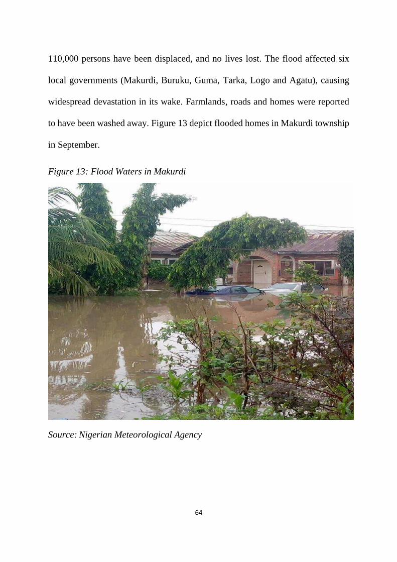
64
110,000 persons have been displaced, and no lives lost. The flood affected six
local governments (Makurdi, Buruku, Guma, Tarka, Logo and Agatu), causing
widespread devastation in its wake. Farmlands, roads and homes were reported
to have been washed away. Figure 13 depict flooded homes in Makurdi township
in September.
Figure 13: Flood Waters in Makurdi
Source: Nigerian Meteorological Agency

65
4.3.2 Response
Again, camps were set up to accommodate displaced persons and relief materials
doled out to meet the needs of camp residents. The reaction of the government to
the recent flood event is hampered by the paucity of funds. It is on record that
Benue State owes its workers nine months’ salary amidst other debts owed
service providers. From the preceding, it is evident that disaster management
response is somewhat reactive. Coping strategies reported by the news media
reveals that households and communities clean up drains and construct their
homes on elevated foundation level. Post-assessment study of coping strategies
employed by residents of Makurdi reveals that construction of new drainage
channels and sand removal from existing drains as standard practice (Shabu and
Tyonum, 2013). Similarly, Hula and Udoh (2015) in their research, ascertain
flood risk reduction measures employed by residents in Makurdi to include:
relocation, use of sandbags, and raising the foundation of buildings. Similarly,
Ocheri (2012) identify the construction of temporary bridges in flood ravaged
areas as one of the coping strategies employed by residents. Figure 14 shows the
use of sandbags to abate flood waters in a residential neighbourhood in Makurdi.

66
Figure 14: Sand Bags used for flood abatement
Source: Coping measures of flood-prone areas in Makurdi.
4.4 Adaptive Responses of Some Communities in Nigeria
Flood is endemic in almost all the regions in Nigeria, and communities have
developed strategies to adapt and improve their resilience. However, the literature
informing the role of local knowledge is scarce. Therefore, it can be deduced that
academic research may not have given priority to these forms of knowledge.
Fabiyi and Oloukoi (2013) provide evidence of uses of local knowledge across
communities in 4 local government areas that traverse the western and southern
parts of the country. The authors confirm the existence of flood related local

67
knowledge and practices and its entrenchment in past experiences, culture and
religious orientation.
Religious practices in the study areas involve the veneration of ancestral spirits.
Cultural practices include the marking of the traditional calendar at the onset of
the rainy season and the observation of traditional meteorological signals; lunar
observation, sea animal behaviour, cloud study, water colour observation and
leaves and particle observation.
Table 5. Local Signs and Local Knowledge of Flood Occurrence in The
Selected Communities.
Communities
Local
Perceptions/Signs
of Flood
Ecological
Indicators
Indigenous
Knowledge
Applications
Abereke
Heavy rainfall of more
than two hours signifies
potential flooding.
2 hours after a particular
wind or storm
Loss of some vegetation
species: opepe
(Sarcocephalus
latifolius), abura
(Mitragyna ciliate)
Efforts are made to bring
the domestic animals
and other valuables into
safe place. The
floodwater often come at
night
Ori Oke
Approaching full moon
shows flood is likely to
come from the sea
Fishermen are cautioned

68
Araromi
Consultation of
Ojuoluweri river god, to
know how strong and
disastrous the flood will
be in advance
There is yearly prediction
of flooding by the priest
of the water god
When oriro, orika and ini
months approach
The domestic cooking
fireplaces are raised on a
platform albeit
temporarily.
Obefela
Thick clouds signify
heavy rain and flooding
when the moon is getting
fuller.
High tides are known by
all and preparations are
made to avert losses
Awoye
Calculation of months
predict the high tide
period (November,
December, January –
February)
Fullness of the moon
Loss of some vegetation
species: raffia palm,
opepe, abura
Preparations are made to
reduce damages from
flood disasters. They
have relocated the king’s
palace twice due to
flooding and subsidence.
Ayetoro
Full moon
Rainy season, when it
rains more than two times
a week between 11 and 15
of January.
Source: Adapted from Fabiyi & Oloukoi (2013). p. 12.

69
Table 5 illustrates the pre-flood local knowledge adopted by at-risk villages in
some of the communities studied. The knowledge base of the communities
encompasses different facets of communal living. Summarily, the role of local
knowledge in the communities studied by the authors includes: (a) In Abereke
community, the loss of a particular vegetation (Opepe), informs the decision to
prepare for floods. Livestock and valuables are moved to safer grounds. (b)
Cloud readers warn that an approaching full moon heralds the onset of floods
from the sea. Therefore, fishermen are cautioned to be careful. (c) Veneration of
deities in the communities inform the decision to prepare for flood. (d)
Communities possess knowledge of months of the year that bring about high tides
from the sea. At the onset of the high tide season, preparations are made to reduce
damages from floods. Similarly, Olorunfemi and Raheem (2013) posit that poor
communities in the south-western state of Kwara, cope with floods by turning to
relatives and accessing personal savings.
The communities studied by Fabiyi and Oloukoi (2013) are largely coastal and
rural. Conversely, the communities studied in this research are urban settlements
and largely riverine with similar coping strategies. It is not likely that the same
form of knowledge in the rural areas will be practiced in urban areas. Perhaps,
similarities may exist among rural communities regardless of their geographical
location.

70
Chapter 5: Discussion
This thesis began with arguing for the role of local knowledge in disaster risk
reduction albeit promoting interactional expertise between science and local
knowledge. The results of the analysis conducted, reveal that local knowledge is
limited in application in the town centres and the disaster management framework
makes a case for collaboration and participation of communities in the disaster
risk process. More significantly, the exercise informs the researcher that
communities vulnerable to floods continuously strive to protect their homes and
business from the onslaught of flood waters. The contention of the researcher is
that while the NDMF makes a case for collaboration, it doesn’t identify or define
opportunities that will engender cooperation between local communities and state
agents. The framework suggests a uniform approach for all disaster type.
Consequently, it fails to address the disaster risk peculiar to coastal and riverine
communities appropriately.
5.1 Perceived Gaps Between Policy and Implementation
While the framework makes provisions and enactments that posit efficiency in
disaster management practice in Nigeria, the case studies reveal that
implementation is near absent. Implementation involves activities carried out to
achieve objectives of established policies. It entails converting material, financial,

71
technical and human inputs into outputs. Makinde (2005) opines that the absence
of critical factors such as communication, resources, disposition or attitudes, and
bureaucratic structure, leads to implementation problems of public policies. The
disposition/attitude of departments and agencies of government in the areas
studied, is rather reactive. It appears that government presence is noticed only
when disaster strikes. Resources such as human capital, finance and land needed
to implement the NDMF suffer setbacks.
Disasters regardless of its form/type occur on land and is a collective
responsibility of all levels of government in dealing with it. However, in the case
of Nigeria, at the onset of a disaster, the debate arises as to whether it occurred
on federal or state land. Braimoh and Onishi (2007) avers that the Land Use Act
of 1978 has not been able to replace the customary land administration system,
rather it has largely improved access to land for government, high net-worth
individuals and corporate organizations. Thus, access to land for low-income
earners is achieved through informal arrangements, and such land are located in
peri-urban locations that lack basic social services. Also, land hitherto designated
as green space, parks, watersheds and natural drain pathways have been converted
to other uses, such as building residential homes and markets. On the 8th and 9th
of July 2017, heavy rains in Lagos (a coastal urban metropolis) resulted in floods
that destroyed properties and disrupted business activities (Fasan, 2017). The
flood was prevalent in the Lekki peninsula and Victoria island axis

72
(neighbourhoods with proximity to the Lagos lagoon). Urban planners and
stakeholders knowledgeable of the situation have blamed the incidence on the
development of a new ultra-modern city (Eko Atlantic) on a former beach site.
The skewed land administration regime favours political decisions and limits the
role of traditional institutions in decision making. This may inform the limited
role of local knowledge in disaster management as evinced by the case studies.
While the act establishing the National Emergency Management Agency
mandates the creation of branches in states across the federation; the reality is that
not all states have complied with this directive. This is confirmed by the findings
by Adedeji et al. (2012) that not all state in the federation have complied with the
directive to create emergency agencies and where they exist, they are not
functionally independent and equipped to perform their duties. The states argue
that their budgets do not provide for the creation of new parastatals. It is argued
that this argument is flawed, given the cost of governance imbued by the
politicians. The budgetary situation in Nigeria as argued by Adeolu and
Osabuohien (2007) suggest that the rising proportion of allocations to support
government administrative structures has permitted a high incidence of poverty
and influenced economic collapse of vibrant sectors. Furthermore, an evaluation
of the capital budget of Nigeria for the 2012 fiscal year by Ogujiuba and
Ehigiamusoe (2014) reveals that only 51% of appropriated funds were utilised.

73
It, therefore, suggests that departments and agencies were starved of funds to
carry out their operations.
5.2 Crisis of Trust
Flood warnings issued by the Nigerian Meteorological Agency was not
acknowledged in both 2012 and 2017. Residents in the affected areas rather than
depend on government, prepare for floods on their individual/collective terms.
Akinola (2007) posit that the wide gap between state and society, is a result of
centralised administrative and governance arrangements which has robbed state
structures of people-oriented institutions. The author asserts that self-organized
arrangements in rural communities in South-Western Nigeria provided
infrastructural facilities at the cost of $ 1,546,071 as against $ 20,452 spent by
government on the same type of facilities. The reactive role of state agencies in
disaster management may also contribute to the erosion of trust for government
initiatives.
Tajudeen and Adebayo (2013) confirm the non-existence of Internally Displaced
Persons (IDP) camps of a lasting nature in Nigeria. It is common practice to find
schools, hospitals, and military barracks converted as temporary shelter and for a
limited period. The management of displaced persons occasioned by flood
incidents is fraught with maladministration. The case study of Benue State reveals
case where displaced persons was sacked from camps to make way for students
74
resuming school. In Kogi state, the government mulled the idea to resettle
displaced communities in towns/cities far from their homes and livelihoods. It is
argued that the experience of flood ravaged communities in the camps further
worsens their disposition to government initiatives. Makinde (2005) speaks to the
essence of communication in policy implementation. The situation in the areas
studied, do not signal proper information sharing between federal, state and local
governments. A robust information dissemination strategy is needed to help
enshrine disaster risk reduction strategies.
5.3 Streamlining Disaster Management Practice
The areas studied reveal that residents have developed local knowledge to cope
with floods. Coping strategies observed reflects the complexity of the
environment in which people reside. Paul and Routray (2010) affirm that coping
strategies differ according to geographical locations. Coping strategies employed
by residents in the areas studied differ from those observed by Fabiyi and Oloukoi
(2013) in their field study of communities in the Niger-Delta region. Local
knowledge in Lokoja, Jalingo and Makurdi do not possess spiritual/religious
undertones. Regardless of their differences, the local knowledge possessed by
flood prone communities is important in sustaining their livelihood. The
differences in local knowledge, suggest disaster strategies must recognize the
differences between communities and regions in their domain. It speaks to the
essence of planning for different disaster types.

75
Given the warnings and experiences emanating around the globe regarding the
effect of climate change, it is expedient that the Nigerian government as a matter
of priority must empower residents of cities, townships and rural communities
with the necessary tools to plan and implement their coping strategies. The
existence of numerous actors at both state and federal levels necessitates some
form of planning and coordination. States across the county must be allowed to
organise their disaster management practice to align with their resources and
environmental concerns. The national agency rather than seek to regulate the
branches may opt to provide guidance and support to the states. Guthiga and
Newsham (2011) describe a project in Kenya, where the Meteorology department
and rainmakers in a local community shared knowledge to improve weather
prediction. The authors confirm convergence of results between the scientist in
the weather office and local knowledge holders. They argue that integration of
local knowledge in climate policies is encouraged with further gains for
cooperation and implementation of disaster risk strategies.
The results obtained from this research seeks to inform policy, particularly the
need to review the National Disaster Management framework. It is important that
the framework defines strategies and programmes that encourage participation of
at- risk communities. Figure 15 describes the potential contributions of local
knowledge to Nigeria’s disaster management cycle. The role of local knowledge
in described across the different stages of the cycle. At the onset of a disaster

76
event, local knowledge can help at-risk communities prepare for floods and
droughts respectively. In drought-stricken areas, local knowledge can inform the
decision of farmers to plant drought resistant crops. Likewise, rain seeding and
cloud watching can help coastal and riverine communities prepare for flood.
Local knowledge has been proven to save lives and preserve livelihoods during
disasters. The Simeulue Island case study is a classic example. After the impact
of a disaster, it is imperative that recovery and rehabilitation is encouraged. To
this end, local knowledge exists in communities that can engender recovery. The
framework designed by Mercer et al. (2010) emphasize the cooperation between
science and local knowledge. The final stage in the process framework entails
integrative approaches identified by the communities to address their
vulnerabilities, and it aligns with figure 15. Figure 15 offers disaster managers in
Nigeria the opportunity to appreciate the contributions of local knowledge in
enhancing the resilience of at-risk communities. A comprehensive vulnerability
assessment will improve the contents of the model and afford the Nigerian
authorities the opportunity to plan for disasters at every stage of the disaster
management spectrum.
Disaster management strategies of the government rather than adopt a centralized
structure, may seek to empower communities and local governments by
empowering them to plan their disaster reduction strategies based on their
peculiar disaster profile. While the Hyogo and Sendai frameworks make

77
important contributions to disaster management practice, Figure 15 seeks to bring
disaster planning by local institutions close to national strategies. Collaboration
between science and local knowledge holds the key to improve disaster response
and reduce vulnerabilities.
Figure 15: Local Knowledge and Disaster Management Cycle
Source: Urban Flood Disaster Management pp.32.

78
Chapter 6: Conclusion and Recommendations
The incidence of disaster is spread across the different nations of the world.
However, Alcantara – Ayala (2002), is of the opinion that the impacts of natural
disasters are higher in the least developed countries (LDC). The author furthers
his argument by suggesting that geographical location and geomorphological
settings influence the occurrence of disasters; developing countries are located in
regions predisposed to floods, and seismic activities. Also, the economic, social
and cultural characteristics may pose some form of vulnerability to disaster. Toya
et al. (2001) in their empirical analysis of economic losses from disasters
conclude that a greater ease of access, a healthy financial sector, education and a
small government may improve the resilience of countries to disasters. The
political situation of most developing countries offers a glimpse into why the
impact of disasters is high. Cohen and Werker (2008) assert that natural disasters
may offer governments the opportunity to redistribute power, by focusing disaster
infrastructure in regions that are loyal to the government. The authors also argue
that government at the national level will pay less attention to disaster mitigation
at the local level, given that the national income is not impacted by the occurrence
of a natural disaster.
Kuban (1996) avers that the initiation of disaster preparedness and maintaining
momentum for disaster reduction policies is the most significant role of

79
government. It is expected that disaster risk reduction will be prioritised given the
worsening climatic condition. Opportunities exist for collaboration between
public institutions and development partners. Most importantly, the people being
planned for must be given a voice in the planning process vis-à-vis integrating
local knowledge into disaster planning. Local knowledge is not a static form of
knowledge. It has evolved overtime and possess the ability to guarantee buy in
into policies by local communities. Drawing on the findings of this research, a
list of recommendations that can improve disaster management practice in
Nigeria is proposed:
• Review the National Disaster Management Framework to empower local
communities to plan their disaster management strategies.
• Ensure adequate budgetary allocation to disaster management agencies.
• Promote consultation between state agencies and local institutions, in a bid
to develop effective early warning systems and share information
• Clearly define disaster management strategies for riverine, coastal and
inland communities.
In a dynamic field of research such as disaster management, this research work
presents gaps in the current structure of disaster management practice in Nigeria,
thus paving the way for future research to improve the vulnerability of at-risk
communities to disasters. Furthermore, it is recommended that the following

80
actions be implemented in the short term, to begin the process of re-orientation
of disaster management practice in Nigeria:
• The federal government in conjunction with state governments must
commission participatory action research with a view to identify the
traditional knowledge(s) practiced by communities across the 6 geo-
political zones. Researchers domiciled within the study regions should be
mobilized to carry out the research.
• An assessment of disasters prevalent in the different temporal/vegetative
zones that make up the country.
81
References
Abah, D., Ogah, M. O., & Agbo, M. E. (2016). Climate change adaptation
decisions among farming households in otukpo local government area of
benue state. Pat, 12(2), 59-70.
Adebimpe, R. U. (2011). Climate change related disasters and vulnerability: An
appraisal of the nigerian policy environment.Environmental Research
Journal, 5(3), 97-103.
Adedeji, O. H., Odufuwa, B. O., & Adebayo, O. H. (2012). Building capabilities
for flood disaster and hazard preparedness and risk reduction in nigeria: Need
for spatial planning and land management. Journal of Sustainable
Development in Africa, 14(1), 45-58.
Adelekan, I. O., & Asiyanbi, A. P. (2016). Flood risk perception in flood-affected
communities in lagos, nigeria. Natural Hazards, 80(1), 445-469.
Adeyemo, D. O. (2005). Local government autonomy in nigeria: A historical
perspective. The Journal of Social Sciences, 2, 77-87.
Adger, W. N., Hughes, T. P., Folke, C., Carpenter, S. R., & Rockstrom, J. (2005).
Social-ecological resilience to coastal disasters.Science (New York,
N.Y.), 309(5737), 1036-1039. doi:309/5737/1036 [pii]
Afrose, T. (2017). Disaster risk management and the sendai framework. Juniper
Online Journal of Public Health, 2(4), 1-5.
Agada, S., & Nirupama, N. (2015). A serious flooding event in nigeria in 2012
with specific focus on benue state: A brief review. Natural Hazards, 77(2),
1405-1414.

82
Agbola, T. (1987). Institutional constraints on housing development: The urban
areas of nigeria: The land-use decree and the building plan approval
process. Habitat International, 11(2), 113-120.
Agrawal, A. (1995). Dismantling the divide between indigenous and scientific
knowledge. Development and Change, 26(3), 413-439.
Ahrens, J., & Rudolph, P. M. (2006). The importance of governance in risk
reduction and disaster management. Journal of Contingencies and Crisis
Management, 14(4), 207-220.
Airoldi, L., Abbiati, M., Beck, M. W., Hawkins, S. J., Jonsson, P. R., Martin, D.,
. . . berg, P. (2005). An ecological perspective on the deployment and design
of low-crested and other hard coastal defence structures. Coastal
Engineering, 52(10), 1073-1087.
Aitsi-Selmi, A., Egawa, S., Sasaki, H., Wannous, C., & Murray, V. (2015). The
Sendai framework for disaster risk reduction: Renewing the global commitment
to people’s resilience, health, and well-being. International Journal of Disaster
Risk Science, 6(2), 164-176.
Akinola, S. R. (2007). Coping with infrastructural deprivation through collective
action among rural people in nigeria. Nordic Journal of African
Studies, 16(1), 30-46.
Ako, R. T. (2009). Nigeria's land use act: An anti-thesis to environmental
justice. Journal of African Law, 53(2), 289-304.
Akonga, J. (2015). In Robert Mutiso, Orieko Chitetre (Eds.), Participatory-
action research in development (2nd ed.). Nairobi, Kenya.: University of
Nairobi Press.

83
Alabi, M. O. (2009). Urban sprawl, pattern and measurement in lokoja,
nigeria. Theoretical and Empirical Researches in Urban Management, 4(4
(13), 158-164.
Alam, E., & Collins, A. E. (2010). Cyclone disaster vulnerability and response
experiences in coastal bangladesh. Disasters, 34(4), 931-954.
Alcantara-Ayala, I. (2002). Geomorphology, natural hazards, vulnerability and
prevention of natural disasters in developing
countries. Geomorphology, 47(2), 107-124.
Anderson, P. K., Cunningham, A. A., Patel, N. G., Morales, F. J., Epstein, P. R.,
& Daszak, P. (2004). Emerging infectious diseases of plants: Pathogen
pollution, climate change and agrotechnology drivers. Trends in Ecology &
Evolution, 19(10), 535-544.
Anunobi, A. I. (2014). Informal riverine settlements and flood risk management:
A study of lokoja, nigeria. Journal of Environment and Earth Science, 4(12),
35-43.
Arikpo, A. B. (2007). Development imperatives for the twenty-first century in
nigeria. Convergence, 40(1), 55-66.
Arunotai, N. (2008). Saved by an old legend and a keen observation: The case of
moken sea nomads in thailand. Indigenous Knowledge for Disaster Risk
Reduction, 73
Ayeni, A. O., & Olorunfemi, F. B. (2014). Reflections on environmental security,
indigenous knowledge and the implications for sustainable development in
nigeria. J.Res.Natl.Dev, 12(1), 46-57.
Bala, A., & Gheverghese Joseph, G. (2007). Indigenous knowledge and western
science: The possibility of dialogue. Race & Class, 49(1), 39-61.
84
Barnett, J., & Adger, W. N. (2007). Climate change, human security and violent
conflict. Political Geography, 26(6), 639-655.
Basit, T. (2003a). Manual or electronic? the role of coding in qualitative data
analysis. Educational Research, 45(2), 143-154.
Bashir, M. (2014, January 7). Kogi after 2012 floods. The Nation. Retrieved from
http://www.thenationonlineng.net.
Baumwoll, J. (2008). The value of indigenous knowledge for disaster risk
reduction: A unique assessment tool for reducing community vulnerability to
natural disasters (Unpublished doctoral dissertation). Webster University,
Missouri
Bello, O. B., Ganiyu, O. T., Wahab, M., Afolabi, M. S., Oluleye, F., Mahmud, J.,
Abdulmaliq, S. Y. (2012). Evidence of climate change impacts on agriculture
and food security in nigeria. International Journal of Agriculture and
Forestry, 2(2), 49-55.
Berkes, F., Colding, J., & Folke, C. (2000). Rediscovery of traditional ecological
knowledge as adaptive management. Ecological applications, 10(5), 1251-1262.
Boko, M., I. Niang, A. Nyong, C. Vogel, A. Githeko, M. Medany, B. Osman-
Elasha, R. Tabo and P. Yanda. (2007). Synthesis report. contribution of
working groups I, II and III to the fourth assessment report of the
intergovernmental panel on climate change. Synthesis report. contribution of
working groups I, II and III to the fourth assessment report of the
intergovernmental panel on climate change, IPCC, Geneva, Switzerland.
Botes, L., & Van Rensburg, D. (2000). Community participation in development:
Nine plagues and twelve commandments. Community Development
Journal, 35(1), 41-58.

85
Boudreaux, K. (2008). Urbanisation and informality in africa's housing
markets. Economic Affairs, 28(2), 17-24.
Br�utigam, D. A., & Knack, S. (2004). Foreign aid, institutions, and governance
in sub-saharan africa. Economic Development and Cultural Change, 52(2),
255-285.
Braimoh, A. K., & Onishi, T. (2007). Spatial determinants of urban land use
change in lagos, nigeria. Land use Policy, 24(2), 502-515.
Breidlid, A. (2009). Culture, indigenous knowledge systems and sustainable
development: A critical view of education in an african context. International
Journal of Educational Development, 29(2), 140-148.
Briggs, J. (2005). The use of indigenous knowledge in development: Problems
and challenges. Progress in Development Studies, 5(2), 99-114.
Briggs, J., & Sharp, J. (2004). Indigenous knowledges and development: A
postcolonial caution. Third World Quarterly, 25(4), 661-676.
Buckle, P., Marsh, G., & Smale, S. (2003). The development of community
capacity as applying to disaster management capability. Research Project
Report, 14, 2002.
Cannon, T., & Mller-Mahn, D. (2010). Vulnerability, resilience and development
discourses in context of climate change. Natural Hazards, 55(3), 621-635.
Carey, M. (2005). Living and dying with glaciers: People's historical
vulnerability to avalanches and outburst floods in peru. Global and Planetary
Change, 47(2), 122-134.
Cazenave, A., & Cozannet, G. L. (2014). Sea level rise and its coastal
impacts. Earth's Future, 2(2), 15-34.
86
Chhetri, M. B. P. (2001). A practitioner's view of disaster management in nepal:
Organisation, system, problems and prospects. Risk Management, 3(4), 63-
72.
Chiadikobi, K. C., Omoboriowo, A. O., Chiaghanam, O. I., Opatola, A. O., &
Oyebanji, O. (2011). Flood risk assessment of port harcourt, rivers state,
nigeria. Advances in Applied Research, 2(6), 287-298.
Clement, A. R. (2012). Causes of seasonal flooding in flood plains: a case of
Makurdi, Northern Nigeria. International journal of environmental studies, 69(6),
904-912.
Cohen, C., & Werker, E. D. (2008). The political economy of` Natural
disasters. Journal of Conflict Resolution, 52(6), 795-819.
Cooper, D. J., & Morgan, W. (2008). Case study research in
accounting. Accounting Horizons, 22(2), 159-178.
Cronin, S. J., Gaylord, D. R., Charley, D., Alloway, B. V., Wallez, S., & Esau, J.
W. (2004). Participatory methods of incorporating scientific with traditional
knowledge for volcanic hazard management on ambae island,
vanuatu. Bulletin of Volcanology, 66(7), 652-668.
Dambatta, S. H., & Aliyu, B. S. (2011). A survey of major ethno medicinal plants
of kano north, nigeria, their knowledge and uses by traditional
healers. Bayero Journal of Pure and Applied Sciences, 4(2), 28-34.
Daramola, A. Y., Oni, O. T., Ogundele, O., & Adesanya, A. (2016). Adaptive
capacity and coping response strategies to natural disasters: A study in
nigeria. International Journal of Disaster Risk Reduction, 15, 132-147.

87
Daura, M. M., & Mayomi, I. (2015). Geo-spatial assessments of flood disaster
vulnerability of benue and taraba states. Academic Research
International, 6(6), 11-29.
Davidson, C. H., Johnson, C., Lizarralde, G., Dikmen, N., & Sliwinski, A. (2007).
Truths and myths about community participation in post-disaster housing
projects. Habitat International, 31(1), 100-115.
Davies, R. (2017). Thousand displaced by floods in Kogi State. Floodlist.
Retrieved from http://www.floodlist.com/africa.
De la Poterie, Arielle Tozier, & Baudoin, M. (2015). From yokohama to sendai:
Approaches to participation in international disaster risk reduction
frameworks. International Journal of Disaster Risk Science, 6(2), 128-139.
Dekens, J. (2007). Local knowledge for disaster preparedness: A literature
review International Centre for Integrated Mountain Development
(ICIMOD).
Dewan, T. H. (2015). Societal impacts and vulnerability to floods in bangladesh
and nepal. Weather and Climate Extremes, 7(1), 36-42.
Di Baldassarre, G., Montanari, A., Lins, H., Koutsoyiannis, D., Brandimarte, L.,
& Blschl, G. (2010). Flood fatalities in africa: From diagnosis to
mitigation. Geophysical Research Letters, 37(22), 1-5.
Dilley, M., & Heyman, B. N. (1995). ENSO and disaster: Droughts, floods and
el nio/southern oscillation warm events. Disasters, 19(3), 181-193.
Dolan, A. H., & Walker, I. J. (2006). Understanding vulnerability of coastal
communities to climate change related risks. Journal of Coastal Research, ,
1316-1323.

88
Duru, P. (2017, August 27). Flood displaces 15,000 in Makurdi. Vanguard
Newspaper. Retrieved from http://www.vanguardngr.com.
Eisenhardt, K. M. (1989). Building theories from case study research. Academy
of Management Review, 14(4), 532-550.
Ekpoh, I. J. (2010). Adaptation to the impact of climatic variations on agriculture
by rural farmers in north-western nigeria. Journal of Sustainable
Development, 3(4), 194-202
Elo, S., & Kyngs, H. (2008). The qualitative content analysis process. Journal of
Advanced Nursing, 62(1), 107-115.
Enia, J. (2013). The spotty record of the hyogo framework for action:
Understanding the incentives of natural disaster politics and policy
making. The Social Science Journal, 50(2), 213-224.
Epstein, P. R. (2001). Climate change and emerging infectious
diseases. Microbes and Infection, 3(9), 747-754.
Etuonovbe, A. K. (2011). The devastating effect of flooding in nigeria. FIG
Working Week, , 201(1)
Ezeanya, C. (2016). Research, innovation and indigenous knowledge in sub-
saharan africa: In search of a nexus. Economic integration, currency union,
and sustainable and inclusive growth in east africa (pp. 99-114) Springer.
Fabiyi, O. O., & Oloukoi, J. (2013). Indigenous knowledge system and local
adaptation strategies to flooding in coastal rural communities of nigeria.
Journal of Indigenous Social Development, 2(1), 1-19.
Fasan, R. (2017, July 12). Lagos flood as a failure of governance. Retrieved
August 20, 2017, from http://www.vanguardngr.com/2017/07/lagos-flood-
failure-governance/

89
Few, R. (2003). Flooding, vulnerability and coping strategies: Local responses to
a global threat. Progress in Development Studies, 3(1), 43-58.
Fletcher, S. M., Thiessen, J., Gero, A., Rumsey, M., Kuruppu, N., & Willetts, J.
(2013). Traditional coping strategies and disaster response: Examples from
the south pacific region. Journal of Environmental and Public
Health, 2013(264503), 1-9.
Flooding in Nigeria. (2012, October 13). Retrieved September 24, 2017, from
http://www.earthobservatory.nasa.gov/NaturalHazards
Gadgil, M., Berkes, F., & Folke, C. (1993). Indigenous knowledge for
biodiversity conservation. Ambio, , 151-156.
Gaillard, J., & Texier, P. (2010). Religions, natural hazards, and disasters: An
introduction. Religion, 40(2), 81-84.
Garboa, K., Oruonye, E. D., & Ahmed, Y. M. (2016). Urban sprawl analysis in
jalingo metropolis, taraba state nigeria. Review of Environment and Earth
Sciences, 3(2), 30-37.
Gephart, R. P. (2004). Qualitative research and the academy of management
journal. Academy of Management Journal, 47(4), 454-462.
Green, D., & Raygorodetsky, G. (2010). Indigenous knowledge of a changing
climate. Climatic Change, 100(2), 239-242.
Grenier, L. (1998). Working with indigenous knowledge: A guide for
researchers IDRC.
Guleria, S., & Edward, J. P. (2012). Coastal community resilience: Analysis of
resilient elements in 3 districts of tamil nadu state, india. Journal of Coastal
Conservation, 16(1), 101-110.

90
Guthiga, P., & Newsham, A. (2011). Meteorologists meeting rainmakers:
Indigenous knowledge and climate policy processes in kenya. IDS
Bulletin, 42(3), 104-109.
Haines, A., & Parry, M. (1993). Climate change and human health. Journal of the
Royal Society of Medicine, 86(12), 707-711.
Hiwasaki, L., Luna, E., & Maral, J. A. (2015). Local and indigenous knowledge
on climate-related hazards of coastal and small island communities in
southeast asia. Climatic Change, 128(12), 35-56.
Hiwasaki, L., Luna, E., & Shaw, R. (2014). Process for integrating local and
indigenous knowledge with science for hydro-meteorological disaster risk
reduction and climate change adaptation in coastal and small island
communities.International Journal of Disaster Risk Reduction, 10, 15-27.
Hobson, G. (1992). Traditional knowledge is science. Northern
Perspectives, 20(1), 1-2.
Hoegh-Guldberg, O., Mumby, P. J., Hooten, A. J., Steneck, R. S., Greenfield, P.,
Gomez, E., Caldeira, K. (2007). Coral reefs under rapid climate change and
ocean acidification. Science, 318(5857), 1737-1742.
Horton, B. P., Rahmstorf, S., Engelhart, S. E., & Kemp, A. C. (2014). Expert
assessment of sea-level rise by AD 2100 and AD 2300. Quaternary Science
Reviews, 84, 1-6.
Hotez, P. J., & Kamath, A. (2009). Neglected tropical diseases in sub-saharan
africa: Review of their prevalence, distribution, and disease burden. PLoS
Neglected Tropical Diseases, 3(8), 1-10.
Howell, P. (2003). Indigenous early warning indicators of cyclones: Potential
application in coastal bangladesh Benfield Greig Hazard Research Centre.

91
Hsieh, H., & Shannon, S. E. (2005). Three approaches to qualitative content
analysis. Qualitative Health Research, 15(9), 1277-1288.
Hula, M. A., & Udoh, J. C. (2015). An assessment of the impact of flood events
in makurdi, nigeria. Civil and Environmental Research, 7(10), 53-60.
Huntington, H. P. (2000). Using traditional ecological knowledge in science:
Methods and applications. Ecological Applications, 10(5), 1270-1274.
Ibarrarn, M. E., Ruth, M., Ahmad, S., & London, M. (2009). Climate change and
natural disasters: Macroeconomic performance and distributional
impacts. Environment, Development and Sustainability, 11(3), 549-569.
Igoli, J. O., Ogaji, O. G., Tor-Ayiin, T. A., & Igoli, N. P. (2006). Traditional
medicine practice amongst the igede people of nigeria. part II. African
Journal of Traditional, Complementary and Alternative Medicines
(AJTCAM), 2(2), 134-152.
Jiboye, A. D. (2011). Sustainable urbanization: Issues and challenges for
effective urban governance in nigeria. Journal of Sustainable
Development, 4(6), 211-224.
Jick, T. D. (1979). Mixing qualitative and quantitative methods: Triangulation in
action. Administrative Science Quarterly, 24(4), 602-611.
Jigyasu, R. (2002). Reducing disaster vulnerability through local knowledge and
capacity. the case of earthquake prone rural communities in india and Nepal
(Unpublished doctoral dissertation). Norwegian University of Science and
Technology, Trondheim.
Johnson, J. T., Cant, G., Howitt, R., & Peters, E. (2007). Creating anti‐colonial
geographies: Embracing indigenous peoples’ knowledges and
rights. Geographical Research, 45(2), 117-120.
92
Johnston, I. (2014). Disaster management and climate change adaptation: A
remote island perspective. Disaster Prevention and Management, 23(2), 123-
137.
Joshua, I. A., Makama, J. G., Joshua, W. I., Audu, O., & Nmadu, A. G. (2014).
Disasters in nigeria: A public health perspective.Journal of Community
Medicine and Primary Health Care, 26(1), 59-75.
Kahn, M. E. (2005). The death toll from natural disasters: The role of income,
geography, and institutions. The Review of Economics and Statistics, 87(2),
271-284.
Karim, M. F., & Mimura, N. (2008). Impacts of climate change and sea-level rise
on cyclonic storm surge floods in bangladesh. Global Environmental
Change, 18(3), 490-500.
Kniveton, D., Visman, E., Tall, A., Diop, M., Ewbank, R., Njoroge, E., &
Pearson, L. (2015). Dealing with uncertainty: Integrating local and scientific
knowledge of the climate and weather. Disasters, 39(1), 35-53.
Kuban, R. (1996). The role of government in emergency preparedness. Canadian
Public Administration, 39(2), 239-244.
Lambert, S. (2014). Indigenous peoples and urban disaster: Māori responses to
the 2010-12 christchurch earthquakes.Australasian Journal of Disaster and
Trauma Studies, 18(1), 39-48.
Leach, M., & Mearns, R. (1996). Environmental change and policy. The Lie of
the Land: Challenging Received Wisdom on the African
Environment.Oxford: James Currey, , 1-33.

93
Levitus, S., Antonov, J. I., Wang, J., Delworth, T. L., Dixon, K. W., & Broccoli,
A. J. (2001). Anthropogenic warming of earth's climate
system. Science, 292(5515), 267-270.
Lingering hardship after Nigerian floods. (2014, February 14). Retrieved
September 24, 2017, from http://www.irinnews.org/environment-and-disasters
López-Marrero, T., & Wisner, B. (2012). Not in the same boat: Disasters and
differential vulnerability in the insular caribbean.Caribbean Studies, 40(2),
129-168.
Maini, R., Clarke, L., Blanchard, K., & Murray, V. (2017). The sendai framework
for disaster risk reduction and its indicators—where does health fit
in? International Journal of Disaster Risk Science, 8(2), 150-155.
Makinde, O. O. (2014). Housing delivery system, need and
demand. Environment, Development and Sustainability, 16(1), 49-69.
Makinde, T. (2005). Problems of policy implementation in developing nations:
The nigerian experience. Journal of Social Sciences, 11(1), 63-69.
Malterud, K. (2001). Qualitative research: Standards, challenges, and
guidelines. The Lancet, 358(9280), 483-488.
Maplecroft, V. (2011). Climate change vulnerability index 2016. Climate Change
and Environmental Risk Atlas,
Marfai, M. A., King, L., Sartohadi, J., Sudrajat, S., Budiani, S. R., & Yulianto, F.
(2008). The impact of tidal flooding on a coastal community in semarang,
indonesia. The Environmentalist, 28(3), 237-248.
94
Mavhura, E., Manyena, S. B., Collins, A. E., & Manatsa, D. (2013). Indigenous
knowledge, coping strategies and resilience to floods in muzarabani,
zimbabwe. International Journal of Disaster Risk Reduction, 5, 38-48.
McAdoo, B. G., Baumwoll, J., & Moore, A. (2008). Indigenous knowledge saved
lives during 2007 solomon islands tsunami.Indigenous Knowledge for
Disaster Risk Reduction, , 64.
McEntire, D. A. (2001). Triggering agents, vulnerabilities and disaster reduction:
Towards a holistic paradigm. Disaster Prevention and Management: An
International Journal, 10(3), 189-196.
Meier, M. F., Dyurgerov, M. B., Rick, U. K., O'neel, S., Pfeffer, W. T., Anderson,
R. S., . . . Glazovsky, A. F. (2007). Glaciers dominate eustatic sea-level rise
in the 21st century. Science, 317(5841), 1064-1067.
Mercer, J., & Kelman, I. (2008). Living with floods in singas, papua new
guinea. Indigenous Knowledge for Disaster Risk Reduction, , 46.
Mercer, J., Kelman, I., Suchet‐Pearson, S., & Lloyd, K. (2009). Integrating
indigenous and scientific knowledge bases for disaster risk reduction in papua
new guinea. Geografiska Annaler: Series B, Human Geography, 91(2), 157-
183.
Mercer, J., Kelman, I., Taranis, L., & Suchet‐Pearson, S. (2010). Framework for
integrating indigenous and scientific knowledge for disaster risk
reduction. Disasters, 34(1), 214-239.
Mirza, M. M. Q. (2003). Climate change and extreme weather events: Can
developing countries adapt? Climate Policy, 3(3), 233-248.
Mitchell, J. T. (2003). Prayer in disaster: Case study of christian clergy. Natural
Hazards Review, 4(1), 20-26.

95
Mitchell, T. C. (2006). No title. Building a Disaster Resilient Future: Lessons
from Participatory Research in St.Kitts and Montserrat,
Morgan, G., & Smircich, L. (1980). The case for qualitative research. Academy
of Management Review, 5(4), 491-500.
Msilimba, G., Jimu, I., & Swatuk, L. A. (2009). Transboundary water resources
governance in the songwe river basin, malawi and tanzania: Conventional
management techniques, local perceptions, and developmental
needs. Transboundary Water Governance in Southern Africa, 2, 179-196.
Muttarak, R., & Pothisiri, W. (2013). The role of education on disaster
preparedness: Case study of 2012 indian ocean earthquakes on thailand’s
andaman coast. Ecology and Society, 18(4), 51-66.
National Emergency Management Agency. (n.d). Retrieved from
http://www.nema.gov.ng
Neuman, W. L., & Robson, K. (2012). Qualitative interviewing. Basics of social
research qualitative and quantitative approaches (pp. 187-203). Boston, MA:
Pearson Education, Inc.
Newsham, A. J., & Thomas, D. S. (2011). Knowing, farming and climate change
adaptation in north-central namibia. Global Environmental Change, 21(2),
761-770.
Newton, J. (1995). An assessment of coping with environmental hazards in
northern aboriginal communities. The Canadian Geographer/Le Gographe
Canadien, 39(2), 112-120.
Nicholls, R. J. (2002). Analysis of global impacts of sea-level rise: A case study
of flooding. Physics and Chemistry of the Earth, Parts A/B/C, 27(32), 1455-
1466.
96
Nigerian Meteorological Agency. Seasonal Rainfall Predictions. Retrieved from
http:// www.nimet.gov.ng
Njoku, J. (2012, October 3). 2012 year of flood fury: A disaster foretold, but
ignored? Vanguard Newspaper. Retrieved from http://www.vanguardngr.com
Nkeki, F. N., Henah, P. J., & Ojeh, V. N. (2013). Geospatial techniques for the
assessment and analysis of flood risk along the niger-benue basin in
nigeria. Journal of Geographic Information System, 5(2), 123-135.
Noy, I., & Vu, T. B. (2010). The economics of natural disasters in a developing
country: The case of vietnam. Journal of Asian Economics, 21(4), 345-354.
Nyong, A., Adesina, F., & Elasha, B. O. (2007). The value of indigenous
knowledge in climate change mitigation and adaptation strategies in the
african sahel. Mitigation and Adaptation Strategies for Global
Change, 12(5), 787-797.
Nyong, A. & Niang-Diop, I. (2006). Impacts of Climate Change in the Tropics:
The African Experience. In: Schellnhuber, H.J. (Eds.), Avoiding Dangerous
Climate Change. Cambridge University Press, Cambridge.
Obioha, E. E. (2009). Climate variability, environment change and food security
nexus in nigeria. Journal of Human Ecology, 26(2), 107-121.
Ocheri, M. (2012). Social impact and people’s perception of flooding in Makurdi
town, Nigeria. Special Publication of the Nigerian Association of Hydrological
Sciences, 97-105.
Odjugo, P. (2010). General overview of climate change impacts in
nigeria. Journal of Human Ecology, 29(1), 47-55.
97
Odjugo, P., & Ikhuoria, A. I. (2003). The impact of climate change and
anthropogenic factors on desertification in the semi-arid region of
nigeria. Global Journal of Environmental Sciences, 2(2), 118-127.
Ojigi, M. L., Abdulkadir, F. I., & Aderoju, M. O. (2013, April). Geospatial
mapping and analysis of the 2012 flood disaster in central parts of Nigeria. In 8th
National GIS Symposium. Dammam. Saudi Arabia (pp. 1067-1077).
Okhankhuele, O. T., & Opafunso, O. Z. (2013). Causes and consequences of
rural-urban migration nigeria: A case study of ogun waterside local
government area of ogun state, nigeria. British Journal of Arts and Social
Sciences, 16(1), 185-194.
Okoli, A. C. (2014). Disaster management and national security in nigeria: The
nexus and the disconnect. International Journal of Liberal Arts and Social
Science, 2(1), 21-59.
Okonya, J. S., & Kroschel, J. (2013). Indigenous knowledge of seasonal weather
forecasting: A case study in six regions of uganda. Agricultural
Sciences, 4(12), 641-648.
Olorunfemi, F. B., & Adebimpe, R. U. (2008). Sustainable disaster risk reduction
in nigeria: Lessons for developing countries.African Research Review, 2(2),
187-217.
Olorunfemi, F. B., & Raheem, U. A. (2013). Floods and rainstorms impacts,
responses and coping among households in ilorin, kwara stat. Journal of
Educational and Social Research, 3(4), 135-149.
Olorunfemi, F. (2008). Disaster incidence and management in nigeria. Institute
of African Studies Research Review, 24(2), 1-23.

98
Olowu, D. (2010). The hyogo framework for action and its implications for
disaster management and reduction in africa.JAMBA: Journal of Disaster
Risk Studies, 3(1), 303-320.
Onuoha, F. C. (2008). Environmental degradation, livelihood and conflicts: A
focus on the implications of the diminishing water resources of lake chad for
north-eastern nigeria. African Journal on Conflict Resolution, 8(2), 35-61.
Oruonye, E. D. (2012a). An assessment of flood risk perception and response in
jalingo metropolis, taraba state, nigeria.Hydrology for Disaster
Management, 3(4), 4-12.
Osikoya, R.O. (2017). Joint Assessment Conducted August 15-18, 2017 With
NEMA On Communities of Kogi state Affected by Flood and rainstorm disasters.
Retrieved from http://www.kogistate.gov.ng
Palut, M. P. J., & Canziani, O. F. (2007). Contribution of working group II to the
fourth assessment report of the intergovernmental panel on climate change.
Pareek, A., & Trivedi, P. C. (2011). Cultural values and indigenous knowledge
of climate change and disaster prediction in rajasthan, india. Indian Journal
of Traditional Knowledge, 10(1), 183-189.
Paul, S. K., & Routray, J. K. (2010). Flood proneness and coping strategies: the
experiences of two villages in Bangladesh. Disasters, 34(2), 489-508.
Parvin, G. A., Takahashi, F., & Shaw, R. (2008). Coastal hazards and community-
coping methods in bangladesh. Journal of Coastal Conservation, 12(4), 181-
193.
99
Pearce, L. (2003). Disaster management and community planning, and public
participation: How to achieve sustainable hazard mitigation. Natural
Hazards, 28(2), 211-228.
Pelling, M., & Uitto, J. I. (2001). Small island developing states: Natural disaster
vulnerability and global change. Global Environmental Change Part B:
Environmental Hazards, 3(2), 49-62.
Plate, E. J. (2002). Flood risk and flood management. Journal of
Hydrology, 267(1), 2-11.
Prabhakar, S., Srinivasan, A., & Shaw, R. (2009). Climate change and local level
disaster risk reduction planning: Need, opportunities and
challenges. Mitigation and Adaptation Strategies for Global Change, 14(1),
7.
Prior, T., & Roth, F. (2015). Global disaster politics post sendai. Center for
Security Studies, 173(173), 1-4.
Raddatz, C. E. (2009). The wrath of god: Macroeconomic costs of natural
disasters. World Bank policy research working paper 5039. The World Bank,
Washington D.C.
Reuveny, R. (2007). Climate change-induced migration and violent
conflict. Political Geography, 26(6), 656-673.
Riedlinger, D., & Berkes, F. (2001). Contributions of traditional knowledge to
understanding climate change in the Canadian Arctic. Polar Record, 37(203),
315-328.
100
Robinson, J. B., & Herbert, D. (2001). Integrating climate change and sustainable
development. International Journal of Global Environmental Issues, 1(2),
130-149.
Roessig, J. M., Woodley, C. M., Cech, J. J., & Hansen, L. J. (2004). Effects of
global climate change on marine and estuarine fishes and fisheries. Reviews
in Fish Biology and Fisheries, 14(2), 251-275.
Roncoli, C., Ingram, K., & Kirshen, P. (2001). The costs and risks of coping with
drought: Livelihood impacts and farmers¹ responses in burkina faso. Climate
Research, 19(2), 119-132.
Rumbach, A., & Foley, D. (2014). Indigenous institutions and their role in
disaster risk reduction and resilience: Evidence from the 2009 tsunami in
american samoa. Ecology and Society, 19(1), 19.
Samuel, J. K., Yakubu, S., Ologunorisa, T. E., & Kola-Olusanya, A. (2017). A
post-disaster assessment of riverine communities impacted by a severe
flooding event. Ghana Journal of Geography, 9(1), 17-41.
Shabu, T., & Tyonum, T. E. (2013). Residents coping measures in flood prone
areas of makurdi town, benue state. Applied Ecology and Environmental
Sciences, 1(6), 120-125.
Shaw, W. S., Herman, R. D. K., & Dobbs, G. R. (2006). Encountering
indigeneity: Re‐imagining and decolonizing geography. Geografiska
Annaler: Series B, Human Geography, 88(3), 267-276.
Shizha, E. (2006). Legitimizing indigenous knowledge in zimbabwe: A
theoretical analysis of postcolonial school knowledge and its colonial legacy.
Journal of Contemporary Issues in Education, 1(1), 20-35.

101
Sillitoe, P. (1998). The development of indigenous knowledge: A new applied
anthropology 1. Current Anthropology, 39(2), 223-252.
Simons, H. (1996). The paradox of case study. Cambridge Journal of
Education, 26(2), 225-240.
Skoufias, E. (2003). Economic crises and natural disasters: Coping strategies and
policy implications. World Development, 31(7), 1087-1102.
Slenning, B. D. (2010). Global climate change and implications for disease
emergence. Veterinary Pathology, 47(1), 28-33.
Stemler, S. (2001). An overview of content analysis. Practical Assessment,
Research & Evaluation, 7(17), 137-146.
Strauss, A., & Corbin, J. (1990). Basics of qualitative research Newbury Park,
CA: Sage.
Studley, J. (1998). Dominant knowledge systems and local knowledge. Mountain
Forum: A Global Network for Mountain Communities, Environment and
Sustainable Development. Available at http://www.mtnforum.Org/Rs/Ol.
Tajudeen, O. A., & Adebayo, F. O. (2013). Issues of refugees and displaced
persons in nigeria. Journal of Sociological Research, 4(1), 1-18.
Thapa, M. B., Luintel, Y. R., Gauchan, B., & Amatya, K. (2008). Indigenous
knowledge on disaster mitigation: Towards creating complementarity
between communities’ and scientists’ knowledge. Indigenous Knowledge for
Disaster Risk Reduction, 30-34.
Tingsanchali, T. (2012). Urban flood disaster management. Procedia
Engineering, 32(2012), 25-37.

102
Toya, H., & Skidmore, M. (2007). Economic development and the impacts of
natural disasters. Economics Letters, 94(1), 20-25.
Tran, P., Marincioni, F., Shaw, R., & Sarti, M. (2008). Flood risk management in
central vietnam: Challenges and potentials.Natural Hazards, 46(1), 119-138.
Ukiwo, U. (2003). Politics, ethno-religious conflicts and democratic
consolidation in nigeria. The Journal of Modern African Studies, 41(1), 115-
138.
United Nations Economic Commission for Africa (2015). Assessment Report of
Mainstreaming and Implementing Disaster Risk Reduction Measures in Nigeria.
Addis Ababa, Ethiopia: ECA publishing and distribution unit.
Walshe, R. A., & Nunn, P. D. (2012). Integration of indigenous knowledge and
disaster risk reduction: A case study from baie martelli, pentecost island,
vanuatu. International Journal of Disaster Risk Science, 3(4), 185-194.
Watts, M. (1983). Hazards and crises: A political economy of drought and famine
in northern nigeria. Antipode, 15(1), 24-34.
Wilkinson, E., Kirbyshire, A., Mayhew, L., Batra, P., & Milan, A. (2016).
Climate-induced migration and displacement: closing the policy gap. London:
Overseas Development Institute (ODI).
Wisner, B. (1995). Bridging “expert” and “local” knowledge for counter-disaster
planning in urban south africa. GeoJournal, 37(3), 335-348.
Wisner, B. (2010). Climate change and cultural diversity. International Social
Science Journal, 61(199), 131-140.

103
Yankson, P. W., Asiedu, A. B., Owusu, K., Urban, F., & Siciliano, G. (2017).
The livelihood challenges of resettled communities of the bui dam project in
ghana and the role of chinese dam‐builders. Development Policy Review,1-
25 (In press).
Yin, H., & Li, C. (2001). Human impact on floods and flood disasters on the
yangtze river. Geomorphology, 41(2), 105-109.
Zia, A., & Wagner, C. H. (2015). Mainstreaming early warning systems in
development and planning processes: Multilevel implementation of sendai
framework in indus and sahel. International Journal of Disaster Risk
Science, 6(2), 189-199.
![Mapping of Flood Prone Areas in Surulere, Lagos, Nigeria: A ...Like [6] rightly said “In the year 2012, Nigeria witnessed the highest flood disaster in 100 years, where over ten](https://img.dokumen.tips/doc/110x75/5f8b10d1c906231c5e43934d/mapping-of-flood-prone-areas-in-surulere-lagos-nigeria-a-like-6-rightly.jpg)