Embed Size (px)
Citation preview
Protection and Sustainable Use of the Dinaric Karst Transboundary Aquifer System
Country Report (Regional Aspect)
- Croatia
http://diktas.iwlearn.org
Protection and Sustainable Use of the Dinaric Karst Transboundary Aquifer System
Contents
HYDROGEOLOGICAL OVERVIEW
1. Introduction 1.1. Project task and role of WG1 1.2. General on karst – term, distribution. Importance 1.3. Histrical review of karst researches
2. Physiography and climate 2.1. Geographic position and boundaries 2.2. Vegetation and land cover 2.3. Rainfall regime 2.4. Air temperature 2.5. Other climate elements
3. Hydrology 3.1. Hydrographic network 3.2. Stream-flow regime 3.3. Controlling streamflow – dams and reservoirs
4. Geological pattern 4.1. Paleogeography of Dinaric region 4.2. Dinaric Carbonate Platform (External Dinarides) - litostratigraphic units 4.3. Tectonic
5. Geomorphology and karstification 5.1. Karstification process 5.2. Karstic features 5.2.1. Surface karstic features 5.2.2. Potholes and caves
6. Aquifer systems 6.1. Aquifers classification and distribution
7. Groundwater basins 7.1. Regional groundwater direction 7.2. Grounwater bodies
ENVIRONMENT AND SOCIO-ECONOMIC OVERVIEW
1. Administrative boundaries 2. Population and demography 3. Tourism 4. Land use 5. Sources of income 6. Agriculture 7. Roads 8. Industries 9. Mining sites 10. Solid waste disposal 11. Wastewater treatment
Protection and Sustainable Use of the Dinaric Karst Transboundary Aquifer System
12. Dams and Hydropower Plants 13. Protected areas 14. Karstic caves 15. Groundwater dependent ecosystems 16. Water use 17. Surface water quality
LEGAL AND INSTITUTIONAL FRAMEWORK AND POLICY
1. Introduction 2. Updated report on legal, institutional and policy framework in Croatia 3. Questionnaire on GW management issues 4. National SWOT analysis 5. List of references
STAKEHOLDER ANALYSIS
1. Introduction 1.1 Stakeholders Analysis in the framework of the DIKTAS project 1.2 Methodology
2 Analysis 2.1 Stakeholder Analysis 2..1.1 Croatian On-line Survey Results 2.1.2 Zagreb National Consultation Meeting Results 2.1.3 Results from Interviews 2.1.4 Conclusions for Croatia 2.2. Perceived Significant Issues Analysis 2.2.1 Perceived Significant Issues in Croatia 2.2.1.1 Issues 2.2.1.3 Other Significant Issues 2.2.1.4 Hot Spots
Annex 1- Perceived Significant Issues in Croatia per method used Results from On-line Survey Results from Zagreb National Consultation Meeting Croatian Results from Interviews
Protection and Sustainable Use of the Dinaric Karst Transboundary Aquifer System
Country Report (Regional Aspect) – CROATIA 1
HYDROGEOLOGICAL OVERVIEW
1. Introduction
DIKTAS is an acronym of the GEF-UNDP regional project „Protection and Sustainable Use of the Dinaric Karst Transboundary Aquifer System“. This is one of the first-ever attempts to establish sustainable integrated management principles in a transboundary karst aquifers at the magnitude of the Dinaric Karst System.
The Inception DIKTAS report stated, „At the global level the project aims at focusing the attention of the international community on the huge but vulnerable water resources contained in karst aquifers (porous carbonate rock formations), which are widespread globally, but poorly understood”.
Partner countries within the framework of the DIKTAS project are Albania, Bosnia and Herzegovina, Croatia and Montenegro as GEF-recipient countries, as well as Greece, Italy and Slovenia as non-recipient countries. In addition a number of international organizations and institutions such as the International Association of Hydrogeologists (IAH) Karst Commission, GWP-Med, French Geological Survey (BRGM), and the Competence Pool Water (Austria) are actively participating in the DIKTAS project as co-financing partners. The project is being implemented by UNDP and executed by UNESCO‘s International Hydrological Programme (IHP), an intergovernmental scientific cooperative programme in water research, water resources management, education and capacity-building. The UNESCO‘s regional office for science and culture in Europe, located in Venice, as well as the UNESCO Antenna office in Sarajevo are actively supporting the project implementation.
Project preparatory stage had been covered the years 2008 and 2009. Most important events during preparatory stage are: Incection workshop in Podgorica (November 2008), Zagreb workshop (March 2009) and Final Validation Workshop (Venice, October 2009). After signing of the Letters of Commitment by competent national authorities and endorse of the Project document (in November 2009) DIKTAS full size project was prepared to take into enforce.
The Full size project duration is 2011-2014.
1.1. Project task and role of WG1
The proposed project Protection and Sustainable Use of the Dinaric Karst Transboundary Aquifer System is the first ever attempted globally to introduce sustainable integrated management principles in a transboundary karstic freshwater aquifer. At the global level the project aims at focusing the attention of the international community on the huge but vulnerable water resources contained in karst aquifers, which are widespread globally, but poorly understood.
The Dinaric Karst Aquifer System, shared by several countries and one of the world’s largest, has been identified as an ideal opportunity for applying new and integrated management approaches to these unique freshwater resources and ecosystems. At the regional level the project’s objectives are to (i) facilitate the equitable and sustainable utilization and management of the transboundary water resources of the Dinaric Karst Aquifer System, and (ii) protect from natural and
Protection and Sustainable Use of the Dinaric Karst Transboundary Aquifer System
Country Report (Regional Aspect) – CROATIA 2
man-made hazards, including climate change, the unique groundwater dependent ecosystems that characterize the Dinaric Karst region of the Balkan Peninsula.
The DIKTAS project aims at addressing the issue of the sustainable management of karstic groundwater and dependable ecosystems. It focuses on one of the world’s largest karstic geological provinces and aquifer systems: the karst region corresponding to the Dinaric mountain range, which runs from Friuli (NE Italy) through Slovenia, Croatia, Bosnia - Herzegovina, Montenegro and Albania.
The task of Work Group 1 – Hydrogeology within DIKTAS project is to collect, analys and process data and information necessary for a complete and reliable Transboundary Diagnostic Analysis (TDA). It is necessarily prepare a report about the current status of knowledge on the assessment of the hydrogeological characteristics of the Dinaric Karst aquifers at the national level including compilation of information available, review of existing relevant text and cartographic documentation on geology, structural geology, hydrogeology, geomorphology, hydrochemistry etc.
Briefly, the WG Hydrogeology will: based on all relevant data defined (if it is precisely possible) transboundary aquifers (TBA) between parties provide characterisation of TBA, including definition of status of present use of the aquifers collect data and analyse existing plans and projects and possible interactions regarding transboundary karst aquifers; define qualitative status of groundwaters in the transboundary aquifers define main pressure regarding quantity analyze and prioritize existing threats to groundwater quality in the the Dinaric Karst including contamination from point and disperse sources and land degradation;
The group will develop the first regional GIS hydrogeological base, with all relevant data regarding groundwater, especially in the area of TBA. 1.2. General on karst – term, distribution. Importance
Karst is defined as a terrain, generally underline by limestone or dolomite, in which the topography is chiefly formed by the dissolving of rocks, and whitch is characterized by sinkholes, sinking streams, closed depression, subterranean drainage and caves. The term can also be applied to any region made up of other soluble rocks: anhydrite, gypsum, salt. In a broader sense, the term is utilized to designate every phase of the karstification process in karstifiable rocks.
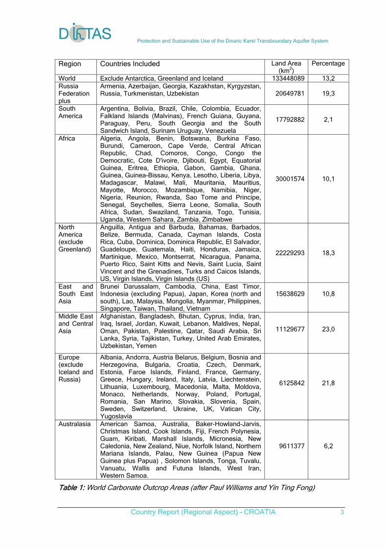
The first version of the world map of carbonate rocks appeared in Ford & Williams (1989) Karst Geomorphology and Hydrology. A revision was published in Williams & Ford (2006) Zeitschrift für Geomorphologie Suppl-Vol 147, 1-2, and used in Ford & Williams (2007) Karst Hydrogeology and Geomorphology (Wiley).
Excluded Antartica, Grenland and Island karst regions wide the world cover 133448089 km2 or 13.2%. In Europe the karst areas cover 6125842 or 21.8% of territory (table 1).
The Dinaric karst, one of the European the biggest, extended from Slovenia via Croatia, Bosnia and Herzegovina, Serbia, Montenegro up to Albania.
Protection and Sustainable Use of the Dinaric Karst Transboundary Aquifer System
Country Report (Regional Aspect) – CROATIA 3
Region Countries Included Land Area (km2)
Percentage
World Exclude Antarctica, Greenland and Iceland 133448089 13,2 Russia Federation plus
Armenia, Azerbaijan, Georgia, Kazakhstan, Kyrgyzstan, Russia, Turkmenistan, Uzbekistan 20649781 19,3
South America
Argentina, Bolivia, Brazil, Chile, Colombia, Ecuador, Falkland Islands (Malvinas), French Guiana, Guyana, Paraguay, Peru, South Georgia and the South Sandwich Island, Surinam Uruguay, Venezuela
17792882 2,1
Africa Algeria, Angola, Benin, Botswana, Burkina Faso, Burundi, Cameroon, Cape Verde, Central African Republic, Chad, Comoros, Congo, Congo the Democratic, Cote D'ivoire, Djibouti, Egypt, Equatorial Guinea, Eritrea, Ethiopia, Gabon, Gambia, Ghana, Guinea, Guinea-Bissau, Kenya, Lesotho, Liberia, Libya, Madagascar, Malawi, Mali, Mauritania, Mauritius, Mayotte, Morocco, Mozambique, Namibia, Niger, Nigeria, Reunion, Rwanda, Sao Tome and Principe, Senegal, Seychelles, Sierra Leone, Somalia, South Africa, Sudan, Swaziland, Tanzania, Togo, Tunisia, Uganda, Western Sahara, Zambia, Zimbabwe
30001574 10,1
North America (exclude Greenland)
Anguilla, Antigua and Barbuda, Bahamas, Barbados, Belize, Bermuda, Canada, Cayman Islands, Costa Rica, Cuba, Dominica, Dominica Republic, El Salvador, Guadeloupe, Guatemala, Haiti, Honduras, Jamaica, Martinique, Mexico, Montserrat, Nicaragua, Panama, Puerto Rico, Saint Kitts and Nevis, Saint Lucia, Saint Vincent and the Grenadines, Turks and Caicos Islands, US, Virgin Islands, Virgin Islands (US)
22229293 18,3
East and South East Asia
Brunei Darussalam, Cambodia, China, East Timor, Indonesia (excluding Papua), Japan, Korea (north and south), Lao, Malaysia, Mongolia, Myanmar, Philippines, Singapore, Taiwan, Thailand, Vietnam
15638629
10,8
Middle East and Central Asia
Afghanistan, Bangladesh, Bhutan, Cyprus, India, Iran, Iraq, Israel, Jordan, Kuwait, Lebanon, Maldives, Nepal, Oman, Pakistan, Palestine, Qatar, Saudi Arabia, Sri Lanka, Syria, Tajikistan, Turkey, United Arab Emirates, Uzbekistan, Yemen
11129677
23,0
Europe (exclude Iceland and Russia)
Albania, Andorra, Austria Belarus, Belgium, Bosnia and Herzegovina, Bulgaria, Croatia, Czech, Denmark, Estonia, Faroe Islands, Finland, France, Germany, Greece, Hungary, Ireland, Italy, Latvia, Liechtenstein, Lithuania, Luxembourg, Macedonia, Malta, Moldova, Monaco, Netherlands, Norway, Poland, Portugal, Romania, San Marino, Slovakia, Slovenia, Spain, Sweden, Switzerland, Ukraine, UK, Vatican City, Yugoslavia
6125842
21,8
Australasia American Samoa, Australia, Baker-Howland-Jarvis, Christmas Island, Cook Islands, Fiji, French Polynesia, Guam, Kiribati, Marshall Islands, Micronesia, New Caledonia, New Zealand, Niue, Norfolk Island, Northern Mariana Islands, Palau, New Guinea (Papua New Guinea plus Papua) , Solomon Islands, Tonga, Tuvalu, Vanuatu, Wallis and Futuna Islands, West Iran, Western Samoa.
9611377
6,2
Table 1: World Carbonate Outcrop Areas (after Paul Williams and Yin Ting Fong)
Protection and Sustainable Use of the Dinaric Karst Transboundary Aquifer System
Country Report (Regional Aspect) – CROATIA 4
Outcrops of kartified rocks are registered on the 50% of the Croatian territory. Karst terrains in the biggest degree cover the External Dinarides zone which geographically corresponds to territories of Istria peninsula, Gorski Kotar, Lika and Dalmatia.
Karst has traditionally been the subject of hydrogeological research, given the abundant water resources that are stored in it. Great range of karstic features that are part of our natural heritage and some of them form major tourist attractions (landscapes of natural parks, geosites and show caves, for example). Karst areas often serve as landscapes or as substrates for human activity.
Increasing demand for drinking water, land reclamation, and energy has gradually changed the engineer’s attitude toward the use of karst regions. In the past few decades, many water resource projects have been successfully developed in countries with large karst regions, such as Bosnia and Herzegovina, Serbia, Montenegro, Croatia, China, France, Greece, Iran, Italy, Russia, Slovenia, Spain, Turkey, the United States.
Karst is a highly fragile ecosystem and the exploitation of its resources or inappropriate land uses give rise to environmental problems (water pollution, subsidence, flooding, changes in the subterranean environment, etc.).
1.2. Historical review of karst researches
After the WW II work on Basic Geological Map of Yugoslavia in scale 1:100.000 (with working sheets 1:25.000) enabled to upgrade the geological information about Dinaric karst. Important articles on hydrogeology in Croatia have been provided by A. Šarin, and many others.
As karst has always been of central interest to hydrogeologists, its investigations have expanded to a larger scale, due to numerous projects that included construction of large and medium dams in the country and abroad. In 1970s several such dams were built with the support of ex-Yugoslavia companies and experts (Croatia, Herzegovina, Montenegro) and it was for the first time in such porous media as karst that successful results were achieved. Technical applications for control and regulation of karst aquifer through the construction of galleries, batteries of wells, and groundwater reservoirs (storage) represent an important contribution to the international hydrogeological science.
The late seventies of XX Ct. was a period when a new generation of karst hydrogeologists started their works. In Croatia, the most important hydrogeologists in the 1970’s were A. Magdalenic, B. Biondić, S. Bozicevic, S. Bahun, A. Pavicic; in the 1990’s there appears a new group of young hydrogeologists lead by A. Renic, J. Kapelj, M. Kuhta, A. Stroj, J. Terzic. 2. Physiography and climate
2.1. Geographic position and boundaries
The Republic of Croatia is a Central European and a Mediterranean country, located between the Danube river basin in the north and the Adriatic Sea in the
Protection and Sustainable Use of the Dinaric Karst Transboundary Aquifer System
Country Report (Regional Aspect) – CROATIA 5
south. The total surface of the state territory equals 87,609 km2, of which continental Croatia covers 56,538 km2, while the remaining 31,071 km2 are coastal waters. The county's terrestrial border is 2,028 km long, and the length of the coastal line equals 5,835 km.
The state territory is administratively divided into 20 counties and the City of Zagreb, which represent regional government and self-government and include 546 towns and municipalities, i.e. local self-government units.
Croatia has the population of 4,437,460 (census 2001), or 78.5 inhabitants per km2, and is among less populated European countries, with a negative population growth rate. The spatial distribution of population is markedly uneven, which is the result of regionally differentiated economic development and further emigration from areas which had already been scarcely populated and less developed due to the war. The most heavily populated is the northwestern part of the country, where nearly 40% of the total population inhabits about 15% of the state territory. A lower, although still above-average population density is present in the easternmost, westernmost and southernmost areas, whereas the large central space, which covers one half of the national territory, is to a large extent demographically and economically depleted.
Size of settlement
(population) Number of settlements Population % of Croatian population
without population 105 - -
1 - 500 5.387 799.240 18
501 - 2.000 1.040 953.305 21
2.001 - 7.000 173 594.516 13
7.001 - 15.000 29 291.756 7
15.001 - 30.000 9 174.361 4
30.001 - 80.000 12 523.207 12
over 80.000 4 1.101.075 25
Total 6.759 4.437.460 100
Table 2: Structure of settlements (census 2001) Smaller settlements and disperse population density are predominant, which is also indicated by the average of 657 inhabitants per settlement. The fragmentation of settlements is particularly marked in the hilly and mountainous inland areas and in Istria. There are four large urban centers that stand out, the capital city Zagreb (population 691.724), Split (175.140), Rijeka (143.800) and Osijek (90.411), which are home to about one fourth of the total population and which are the centers of development of their greater gravitational areas.
As a while, Croatia belongs to less urbanized countries, in which the share of urban population barely exceeds one half of the total population, whose consequence is the unsatisfactory level of social and municipal standards for a significant part of the population.
Natural characteristics
Based on the relief characteristics, three natural/geographic units can be differentiated in Croatia:
Protection and Sustainable Use of the Dinaric Karst Transboundary Aquifer System
Country Report (Regional Aspect) – CROATIA 6
- low Panonian and Peripannonian area in the north,
- hilly-mountainous area in the central part,
- Adriatic area in the south of the country.
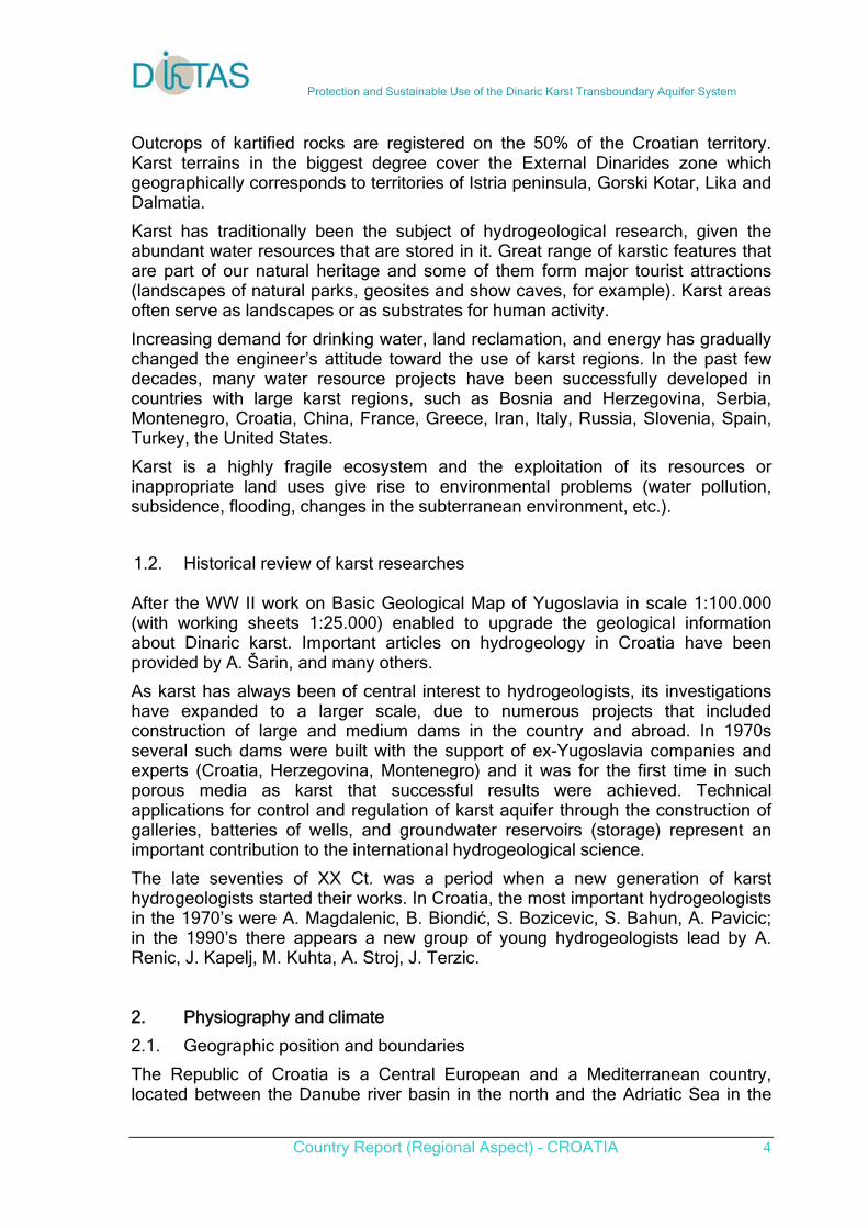
Northern Croatia covers the marginal part of the Panonian basin, which is a generally lowland area (80 - 135 m a.s.l.) with some isolated, relatively low mountain ranges. It is dominated by elongated valleys of the Sava and Drava rivers, which are filled with large quantities of swamp and alluvial sediment. Eastern Slavonia and Baranja are the lowest areas, with spacious wetlands and floodplains and relatively dry, well-drained terraces. Towards the west, the lowlands narrow down into the flat and the hilly relief, which finally changes into the Pre-alpine central range.
The Dinaric mountain range forms the basis of the mountainous Croatia, with its highest mountains (1.300 – 1.800 m a.s.l.). It divides the inland from the Adriatic coastal area and is the divide between the Black Sea basin and the Adriatic Sea basin. It is dominated by carbonate rocks in characteristic karst forms.
The Adriatic area also belongs to the Dinaric karst. It consists of islands and a narrow continental strip, separated from the inland by high mountains. Three parallel relief belts are observed along this area: islands, coast and the hinterland. The rock composition is mostly dominated by carbonate deposits, which form the inland mountainous ranges, peninsulas and islands, whereas the lower inland plateaus are mostly built of flysch deposits and dolomites.
Based on pedological characteristics, Croatia belongs to the countries with significant reserves of arable land, although their quality is not particularly high. There are large regional differences between the Pannonian, mountainous and coastal parts of the country. In the area between the Drava, Sava and Kupa rivers, representative soils are loessed and different kinds of hydromorphic soils, whereas highly fertile soils dominate in the easternmost parts of Slavonia (black soil, brown soil and loessal soils). Mostly different types of brown soils are present in the mountainous areas. The coastal area and the islands are poor in terms of arable land. The most valuable agricultural areas are in located in karst fields and soils formed on flysch, marl and isolated alluvial deposits. Only locally (primarily Istria), there are deeper soils of fertile terra rossa.
For the entire area of Croatia, the Basic pedological map in scale 1:50.000 was developed, which also exists in the GIS technology. Based on this map, the hydropedological map in scale 1:100.000 was also developed, in which data on
Fig. 1 Relief
Protection and Sustainable Use of the Dinaric Karst Transboundary Aquifer System
Country Report (Regional Aspect) – CROATIA 7
porosity and permeability of individual pedological members was additionally processed and runoff coefficients defined.
significantly more (50,000 – 120,000). Croatia is characterized by a large number of endemic and relic species and sub-species, which are mostly related to karst and karst underground, which is a globally unique area in this part of Europe. 2.2. Vegetation and land cover
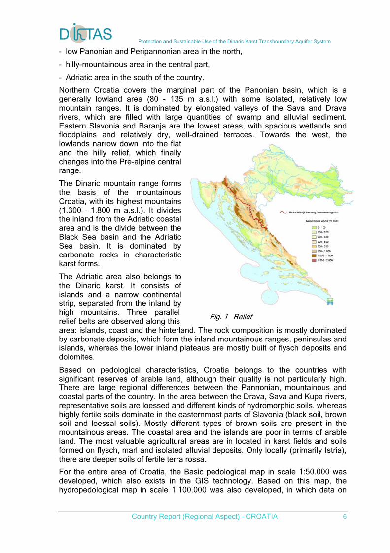
Vegetation covers about 87% of Croatian state territory, of which about 25% is cultivated, while meadows, pastures and rare vegetation cover about 17% and forests about 45% of the inland surface of Croatia. There are significant regional differences in the structure of vegetation cover. In the lowland part of the inland, arable surfaces with traditionally continental crop cultures are predominant. The mountainous and hilly areas of northern and central Croatia are dominated by forests, mostly beech and oak as well as fir and spruce. They are less dense in the transitional area towards the Sub-mediterranean forest belt and gradually degrade into thickets, undergrowth and pastures. Bare rocky soils and bare rocks are mostly located in Dalmatian coastal areas and on the islands.
Fields and gardens
Perpetual plantations
Meadows, pastures,
rare vegetation
Forests Bare rocky soils
Other River basins
%
Black Sea 32,9 0,2 9,6 49,0 0,1 8,2 Adriatic 10,9 0,8 28,5 39,3 15,5 5,0 Total 24,6 0,4 16,8 45,2 6,0 7,0
*Areas determined by approximate generalization of satellite images
Table 3: Land use and vegetation
Fig.2. Corine land use map of Croatia
Protection and Sustainable Use of the Dinaric Karst Transboundary Aquifer System
Country Report (Regional Aspect) – CROATIA 8
For the entire area of Croatia the Land use map was developed by using the CORINE methodology. The check of accuracy in relation to the cadastral survey was also carried out.
Based on its biogeographical location, Croatia is located on the divide separating three large ecoregions – the Hungarian lowland, Dinaric western Balkans and Mediterranean Sea. Thanks to its location and a relatively good preservation of ecosystems, Croatia has, in European relations, very valuable biological diversity. The number of known plant and animal species exceeds 30,000, but is estimated by a large number of endemic and relic species and sub-species, which are mostly related to karst and karst underground, which is a globally unique area in this part of Europe.
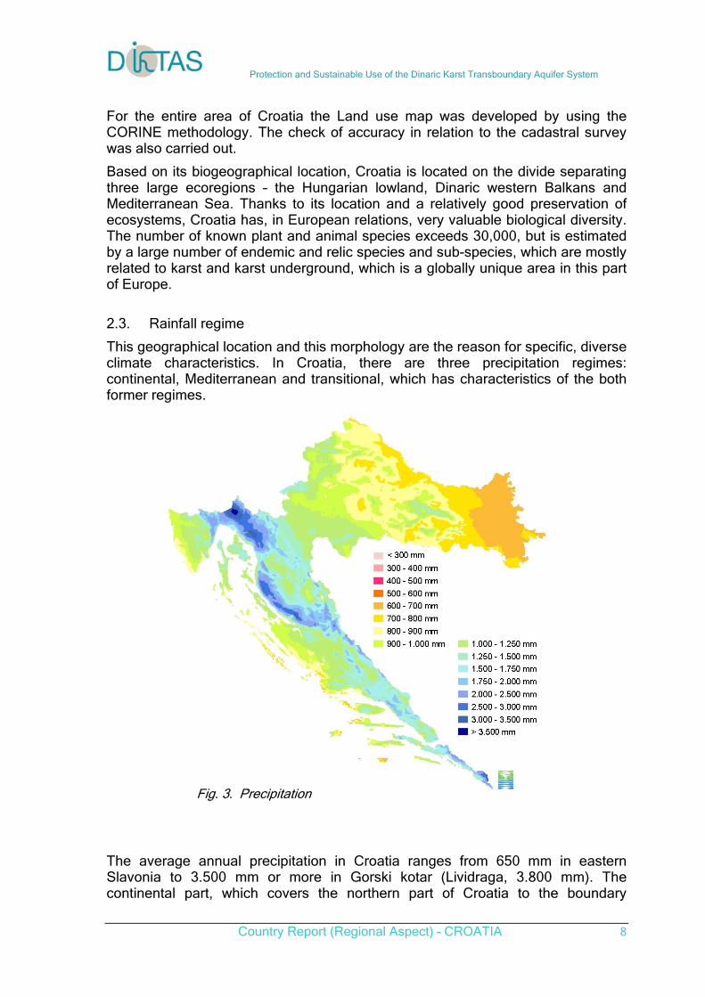
2.3. Rainfall regime
This geographical location and this morphology are the reason for specific, diverse climate characteristics. In Croatia, there are three precipitation regimes: continental, Mediterranean and transitional, which has characteristics of the both former regimes.
The average annual precipitation in Croatia ranges from 650 mm in eastern Slavonia to 3.500 mm or more in Gorski kotar (Lividraga, 3.800 mm). The continental part, which covers the northern part of Croatia to the boundary
Fig. 3. Precipitation
Protection and Sustainable Use of the Dinaric Karst Transboundary Aquifer System
Country Report (Regional Aspect) – CROATIA 9
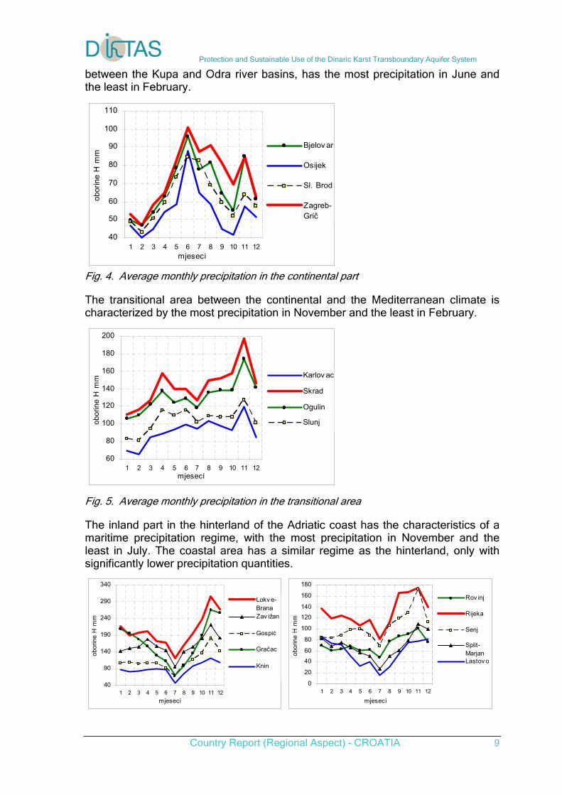
between the Kupa and Odra river basins, has the most precipitation in June and the least in February.
40
50
60
70
80
90
100
110
1 2 3 4 5 6 7 8 9 10 11 12mjeseci
obor
ine
H m
m
Bjelov ar
Osijek
Sl. Brod
Zagreb-Grič
Fig. 4. Average monthly precipitation in the continental part
The transitional area between the continental and the Mediterranean climate is characterized by the most precipitation in November and the least in February.
60
80
100
120
140
160
180
200
1 2 3 4 5 6 7 8 9 10 11 12mjeseci
obor
ine
H m
m Karlov ac
Skrad
Ogulin
Slunj
Fig. 5. Average monthly precipitation in the transitional area
The inland part in the hinterland of the Adriatic coast has the characteristics of a maritime precipitation regime, with the most precipitation in November and the least in July. The coastal area has a similar regime as the hinterland, only with significantly lower precipitation quantities.
40
90
140
190
240
290
340
1 2 3 4 5 6 7 8 9 10 11 12
mjeseci
obo
rine
H m
m
Lokv e-BranaZav ižan
Gospić
Gračac
Knin
0
20
40
60
80
100
120
140
160
180
1 2 3 4 5 6 7 8 9 10 11 12
mjeseci
obo
rine
H m
m
Rov inj
Rijeka
Senj
Split-MarjanLastov o
Protection and Sustainable Use of the Dinaric Karst Transboundary Aquifer System
Country Report (Regional Aspect) – CROATIA 10
Fig. 6. Average monthly precipitation in the hinterland and the coastal area
2.4. Air temperature
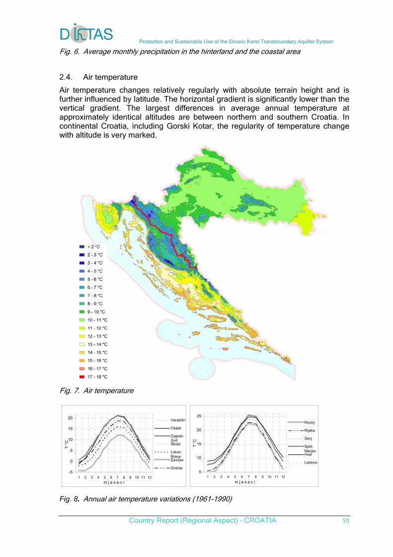
Air temperature changes relatively regularly with absolute terrain height and is further influenced by latitude. The horizontal gradient is significantly lower than the vertical gradient. The largest differences in average annual temperature at approximately identical altitudes are between northern and southern Croatia. In continental Croatia, including Gorski Kotar, the regularity of temperature change with altitude is very marked.
Fig. 7. Air temperature
-5
0
5
10
15
20
1 2 3 4 5 6 7 8 9 10 11 12
m j e s e c i
T °
C
Varaždin
Osijek
Zagreb-GričSkrad
Lokve-BranaZavižan
Gračac5
10
15
20
25
1 2 3 4 5 6 7 8 9 10 11 12
m j e s e c i
T °
C
Rovinj
Rijeka
Senj
Split-MarjanHvar
Lastovo
Fig. 8. Annual air temperature variations (1961-1990)
Protection and Sustainable Use of the Dinaric Karst Transboundary Aquifer System
Country Report (Regional Aspect) – CROATIA 11
The average annual temperatures range from 3.5 °C to 16.3 °C. Fig. 7 shows the annual air temperature variations for several climate stations. The first graph shows the average monthly air temperatures for the continental part, and the second one for the coastal part of Croatia. The lowest temperatures occur in January, and the highest in July.
2.4. Other climate elements
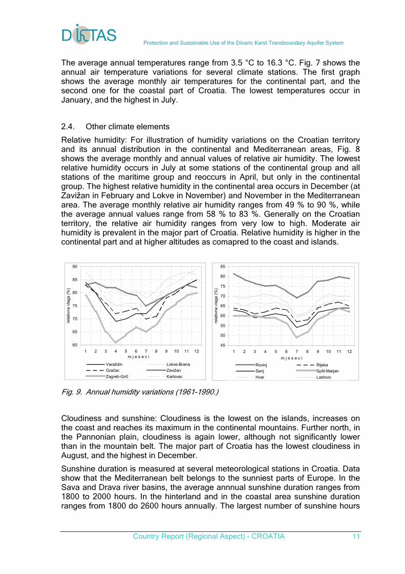
Relative humidity: For illustration of humidity variations on the Croatian territory and its annual distribution in the continental and Mediterranean areas, Fig. 8 shows the average monthly and annual values of relative air humidity. The lowest relative humidity occurs in July at some stations of the continental group and all stations of the maritime group and reoccurs in April, but only in the continental group. The highest relative humidity in the continental area occurs in December (at Zavižan in February and Lokve in November) and November in the Mediterranean area. The average monthly relative air humidity ranges from 49 % to 90 %, while the average annual values range from 58 % to 83 %. Generally on the Croatian territory, the relative air humidity ranges from very low to high. Moderate air humidity is prevalent in the major part of Croatia. Relative humidity is higher in the continental part and at higher altitudes as comapred to the coast and islands.
60
65
70
75
80
85
90
1 2 3 4 5 6 7 8 9 10 11 12m j e s e c i
rela
tivna
vla
ga (
%)
Varaždin Lokve-Brana
Gračac Zavižan
Zagreb-Grič Karlovac
45
50
55
60
65
70
75
80
85
1 2 3 4 5 6 7 8 9 10 11 12
m j e s e c i
rela
tivna
vla
ga (
%)
Rovinj Rijeka
Senj Split-Marjan
Hvar Lastovo
Fig. 9. Annual humidity variations (1961-1990.)
Cloudiness and sunshine: Cloudiness is the lowest on the islands, increases on the coast and reaches its maximum in the continental mountains. Further north, in the Pannonian plain, cloudiness is again lower, although not significantly lower than in the mountain belt. The major part of Croatia has the lowest cloudiness in August, and the highest in December.
Sunshine duration is measured at several meteorological stations in Croatia. Data show that the Mediterranean belt belongs to the sunniest parts of Europe. In the Sava and Drava river basins, the average annnual sunshine duration ranges from 1800 to 2000 hours. In the hinterland and in the coastal area sunshine duration ranges from 1800 do 2600 hours annually. The largest number of sunshine hours
Protection and Sustainable Use of the Dinaric Karst Transboundary Aquifer System
Country Report (Regional Aspect) – CROATIA 12
is in July, which is the sunniest month in entire Croatia, while December has the least number of sunshine hours.
Evapotranspiration. Measurements of evapotranspiration from the water surface are carried out at a smaller number of stations. There are generally no systematic measurements of evapotranspiration from the plant cover and soil. The assessment of evapotranspiration ranges from 500 - 650 mm in the continental part and 850 – 1,000 mm in the Mediterranean belt, so that the average precipitation runoff in Croatia equals about 40%. The least runoff is in the Pannonian area, where it equals only about 11% in the Bosut river basin, and the highest in the mountainous karst area, where the precipitation runoff is over 50% (mostly 60 - 70%).
3. Hydrology
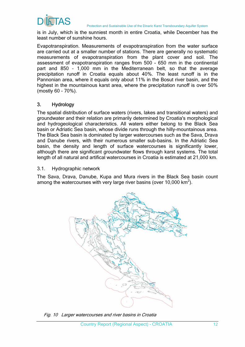
The spatial distribution of surface waters (rivers, lakes and transitional waters) and groundwater and their relation are primarily determined by Croatia's morphological and hydrogeological characteristics. All waters either belong to the Black Sea basin or Adriatic Sea basin, whose divide runs through the hilly-mountainous area. The Black Sea basin is dominated by larger watercourses such as the Sava, Drava and Danube rivers, with their numerous smaller sub-basins. In the Adriatic Sea basin, the density and length of surface watercourses is significantly lower, although there are significant groundwater flows through karst systems. The total length of all natural and artifical watercourses in Croatia is estimated at 21,000 km. 3.1. Hydrographic network
The Sava, Drava, Danube, Kupa and Mura rivers in the Black Sea basin count among the watercourses with very large river basins (over 10,000 km2).
Fig. 10 Larger watercourses and river basins in Croatia
Protection and Sustainable Use of the Dinaric Karst Transboundary Aquifer System
Country Report (Regional Aspect) – CROATIA 13
In the Adriatic Sea basin, the Neretva river is a watercourse with a very large river basin, whereas the Lika, Zrmanja, Krka and Cetina rivers have large river basins. At the contact areas between the coastal waters and the inland, where the sea significantly influences the dynamics of movement as well as the quality and ecological characteristics of fresh water, there appear the so called transitional or brackish waters. Among the significant watercourses under the influence of the sea are the Krka and Zrmanja rivers and the Vransko lake at Biograd, which is connected to the sea by the canal Prosika and through the underground. A significant sea influence is also present on the Lower Neretva river, wheres the intense mixing of salt water and fresh water is present at the river mouths of the Žrnovnica, Cetina, Jadra, Ombla in Dalmatia, of the Raša, Dragonja and Mirna in Istria and of the Rječina in the Kvarner bay. 3.2. Stream-flow regime
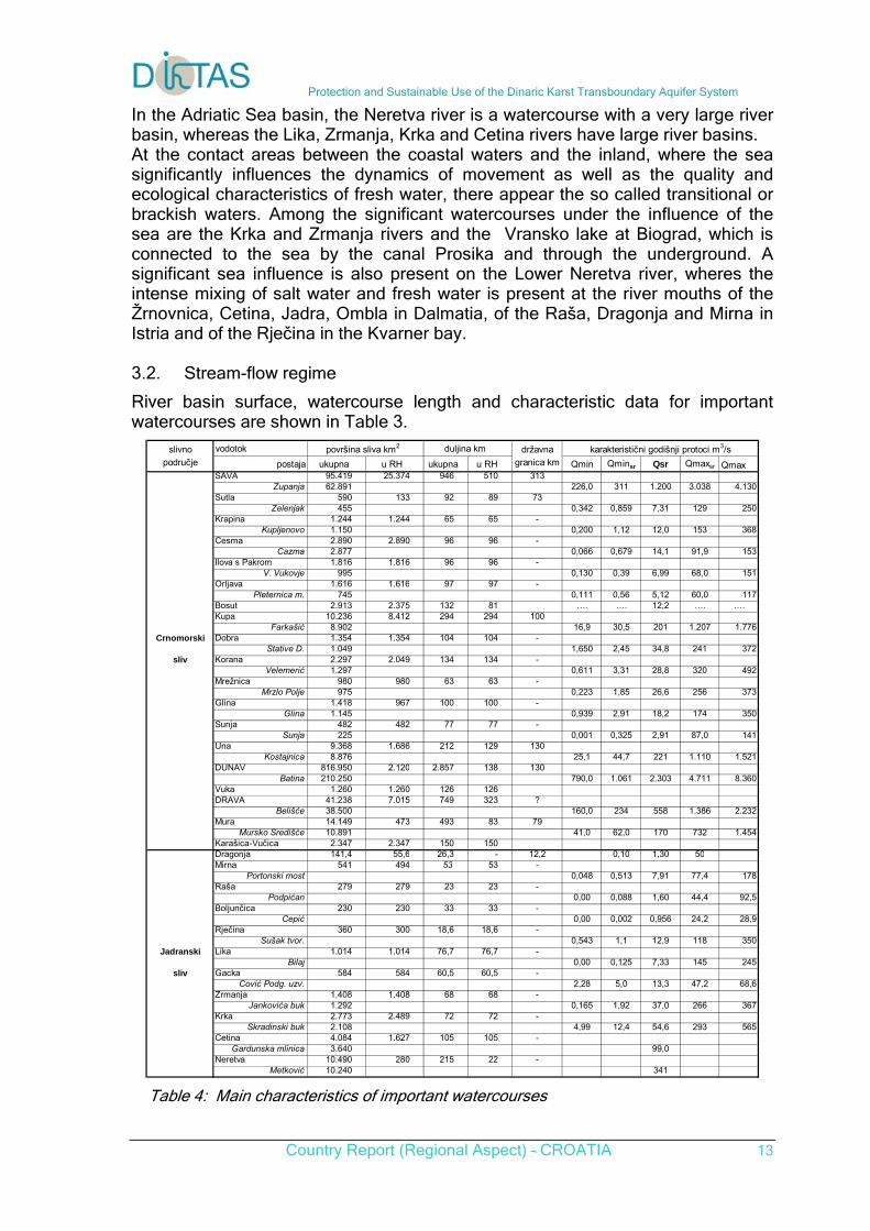
River basin surface, watercourse length and characteristic data for important watercourses are shown in Table 3.
slivno vodotok površina sliva km2 duljina km državna karakteristični godišnji protoci m3/spodručje postaja ukupna u RH ukupna u RH granica km Qmin Qminsr Qsr Qmaxsr Qmax
SAVA 95.419 25.374 946 510 313Županja 62.891 226,0 311 1.200 3.038 4.130
Sutla 590 133 92 89 73Zelenjak 455 0,342 0,859 7,31 129 250
Krapina 1.244 1.244 65 65 -Kupljenovo 1.150 0,200 1,12 12,0 153 368
Česma 2.890 2.890 96 96 -Čazma 2.877 0,066 0,679 14,1 91,9 153
Ilova s Pakrom 1.816 1.816 96 96 -V. Vukovje 995 0,130 0,39 6,99 68,0 151
Orljava 1.616 1.616 97 97 -Pleternica m. 745 0,111 0,56 5,12 60,0 117
Bosut 2.913 2.375 132 81 …. …. 12,2 …. ….Kupa 10.236 8.412 294 294 100
Farkašić 8.902 16,9 30,5 201 1.207 1.776Crnomorski Dobra 1.354 1.354 104 104 -
Stative D. 1.049 1,650 2,45 34,8 241 372sliv Korana 2.297 2.049 134 134 -
Velemerić 1.297 0,611 3,31 28,8 320 492Mrežnica 980 980 63 63 -
Mrzlo Polje 975 0,223 1,85 26,6 256 373Glina 1.418 967 100 100 -
Glina 1.145 0,939 2,91 18,2 174 350Sunja 482 482 77 77 -
Sunja 225 0,001 0,325 2,91 87,0 141Una 9.368 1.686 212 129 130
Kostajnica 8.876 25,1 44,7 221 1.110 1.521DUNAV 816.950 2.120 2.857 138 130
Batina 210.250 790,0 1.061 2.303 4.711 8.360Vuka 1.260 1.260 126 126DRAVA 41.238 7.015 749 323 ?
Belišće 38.500 160,0 234 558 1.386 2.232Mura 14.149 473 493 83 79
Mursko Središće 10.891 41,0 62,0 170 732 1.454Karašica-Vučica 2.347 2.347 150 150Dragonja 141,4 55,6 26,3 - 12,2 0,10 1,30 50Mirna 541 494 53 53 -
Portonski most 0,048 0,513 7,91 77,4 178Raša 279 279 23 23 -
Podpićan 0,00 0,088 1,60 44,4 92,5Boljunčica 230 230 33 33 -
Čepić 0,00 0,002 0,956 24,2 28,9Rječina 360 300 18,6 18,6 -
Sušak tvor. 0,543 1,1 12,9 118 350Jadranski Lika 1.014 1.014 76,7 76,7 -
Bilaj 0,00 0,125 7,33 145 245sliv Gacka 584 584 60,5 60,5 -
Čović Podg. uzv. 2,28 5,0 13,3 47,2 68,6Zrmanja 1.408 1.408 68 68 -
Jankovića buk 1.292 0,165 1,92 37,0 266 367Krka 2.773 2.489 72 72 -
Skradinski buk 2.108 4,99 12,4 54,6 293 565Cetina 4.084 1.627 105 105 -
Gardunska mlinica 3.640 99,0Neretva 10.490 280 215 22 -
Metković 10.240 341 Table 4: Main characteristics of important watercourses
Protection and Sustainable Use of the Dinaric Karst Transboundary Aquifer System
Country Report (Regional Aspect) – CROATIA 14
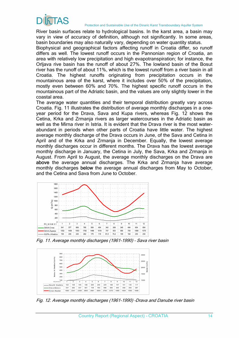
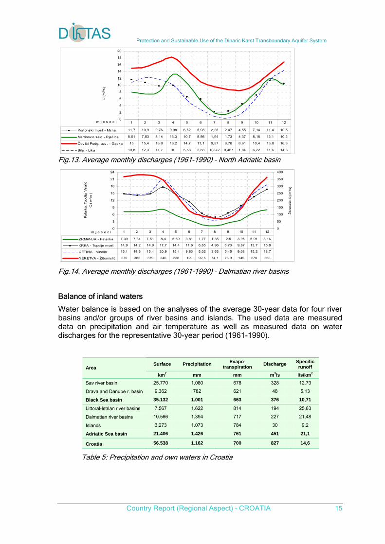
River basin surfaces relate to hydrological basins. In the karst area, a basin may vary in view of accuracy of definition, although not significantly. In some areas, basin boundaries may also naturally vary, depending on water quantity status. Biophysical and geographical factors affecting runoff in Croatia differ, so runoff differs as well. The lowest runoff occurs in the Pannonian region of Croatia, an area with relatively low precipitation and high evapotranspiration; for instance, the Orljava rive basin has the runoff of about 27%. The lowland basin of the Bosut river has the runoff of about 11%, which is the lowest runoff from a river basin in all Croatia. The highest runoffs originating from precipitation occurs in the mountainous area of the karst, where it includes over 50% of the precipitation, mostly even between 60% and 70%. The highest specific runoff occurs in the mountainous part of the Adriatic basin, and the values are only slightly lower in the coastal area. The average water quantities and their temporal distribution greatly vary across Croatia. Fig. 11 illustrates the distribution of average monthly discharges in a one-year period for the Drava, Sava and Kupa rivers, whereas Fig. 12 shows the Cetina, Krka and Zrmanja rivers as larger watercourses in the Adriatic basin as well as the Mirna river in Istria. It is evident that the Drava river is the most water-abundant in periods when other parts of Croatia have little water. The highest average monthly discharge of the Drava occurs in June, of the Sava and Cetina in April and of the Krka and Zrmanja in December. Equally, the lowest average monthly discharges occur in different months. The Drava has the lowest average monthly discharge in January, the Cetina in July, the Sava, Krka and Zrmanja in August. From April to August, the average monthly discharges on the Drava are above the average annual discharges. The Krka and Zrmanja have average monthly discharges below the average annual discharges from May to October, and the Cetina and Sava from June to October.
0
200
400
600
800
1000
1200
1400
1600
1800
m j e s e c i
Q (
m3/s
)
SAVA-Crnac 541 577 669 765 569 454 342 269 345 484 654 654
SAVA-Županja 1302 1438 1553 1782 1466 1018 707 503 590 793 1080 1379
KUPA-J.Kiselica 194 204 243 262 175 119 81,5 74,2 109 164 230 234
1 2 3 4 5 6 7 8 9 10 11 12
Fig. 11. Average monthly discharges (1961-1990) – Sava river basin
100
200
300
400
500
600
700
800
900
m j e s e c i
Bvot
ov, M
. Sre
dišće
Q (m
3 /s)
1000
1500
2000
2500
3000
Bez
dan Q
(m
3 /s)
Mura-M. Središće 102 108 145 198 265 254 225 189 157 141 135 117
Drav a-Botov o 337 360 437 581 738 783 696 565 493 458 455 387
Dunav -Bezdan 1993 2241 2359 2883 2961 3054 2792 2372 1885 1604 1590 1898
1 2 3 4 5 6 7 8 9 10 11 12
Fig. 12. Average monthly discharges (1961-1990) –Drava and Danube river basin
Protection and Sustainable Use of the Dinaric Karst Transboundary Aquifer System
Country Report (Regional Aspect) – CROATIA 15
0
2
4
6
8
10
12
14
16
18
20
m j e s e c i
Q (
m3 /
s)
Portonski most - Mirna 11,7 10,9 9,76 9,98 6,62 5,93 2,26 2,47 4,55 7,14 11,4 10,5
Martinov o selo - Rječina 8,01 7,53 8,14 13,3 10,7 5,56 1,94 1,73 4,37 8,16 12,1 10,2
Čov ići Podg. uzv . - Gacka 15 15,4 16,8 18,2 14,7 11,1 9,57 8,78 8,61 10,4 13,8 16,8
Bilaj - Lika 10,8 12,3 11,7 10 5,58 2,83 0,872 0,467 1,84 6,22 11,6 14,3
1 2 3 4 5 6 7 8 9 10 11 12
Fig.13. Average monthly discharges (1961-1990) – North Adriatic basin
0
3
6
9
12
15
18
21
24
m j e s e c i
Pal
anka
, T
opol
je,
Vin
alić
Q (
m3 /
s )
0
50
100
150
200
250
300
350
400
Žito
mis
lić Q
(m
3 /s)
ZRMANJA - Palanka 7,39 7,34 7,51 8,4 5,69 3,81 1,77 1,35 2,5 3,96 6,91 8,16
KRKA - Topolje most 14,9 14,2 14,9 17,7 14,4 11,6 6,65 4,96 6,73 9,87 13,7 16,8
CETINA - Vinalić 15,1 14,6 15,4 20,9 15,4 9,83 5,02 3,63 5,45 9,08 15,2 18,7
NERETVA - Žitomislić 370 382 379 346 238 129 92,5 74,1 76,9 145 278 368
1 2 3 4 5 6 7 8 9 10 11 12
Fig.14. Average monthly discharges (1961-1990) – Dalmatian river basins
Balance of inland waters
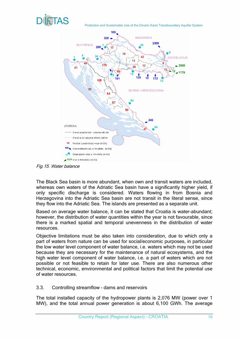
Water balance is based on the analyses of the average 30-year data for four river basins and/or groups of river basins and islands. The used data are measured data on precipitation and air temperature as well as measured data on water discharges for the representative 30-year period (1961-1990).
Surface Precipitation Evapo-transpiration
Discharge Specific runoff Area
km2 mm mm m3/s l/s/km2
Sav river basin 25.770 1.080 678 328 12,73
Drava and Danube r. basin 9.362 782 621 48 5,13
Black Sea basin 35.132 1.001 663 376 10,71
Littoral-Istrian river basins 7.567 1.622 814 194 25,63
Dalmatian river basins 10.566 1.394 717 227 21,48
Islands 3.273 1.073 784 30 9,2
Adriatic Sea basin 21.406 1.426 761 451 21,1
Croatia 56.538 1.162 700 827 14,6 Table 5: Precipitation and own waters in Croatia
Protection and Sustainable Use of the Dinaric Karst Transboundary Aquifer System
Country Report (Regional Aspect) – CROATIA 16
Fig.15. Water balance
The Black Sea basin is more abundant, when own and transit waters are included, whereas own waters of the Adriatic Sea basin have a significantly higher yield, if only specific discharge is considered. Waters flowing in from Bosnia and Herzegovina into the Adriatic Sea basin are not transit in the literal sense, since they flow into the Adriatic Sea. The islands are presented as a separate unit.
Based on average water balance, it can be stated that Croatia is water-abundant; however, the distribution of water quantities within the year is not favourable, since there is a marked spatial and temporal unevenness in the distribution of water resources.
Objective limitations must be also taken into consideration, due to which only a part of waters from nature can be used for social/economic purposes, in particular the low water level component of water balance, i.e. waters which may not be used because they are necessary for the maintenance of natural ecosystems, and the high water level component of water balance, i.e. a part of waters which are not possible or not feasible to retain for later use. There are also numerous other technical, economic, environmental and political factors that limit the potential use of water resources.
3.3. Controlling streamflow – dams and reservoirs
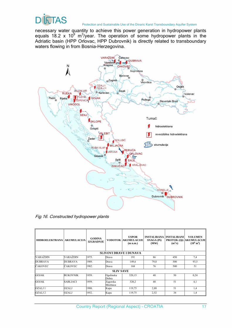
The total installed capacity of the hydropower plants is 2,076 MW (power over 1 MW), and the total annual power generation is about 6,100 GWh. The average
Protection and Sustainable Use of the Dinaric Karst Transboundary Aquifer System
Country Report (Regional Aspect) – CROATIA 17
necessary water quantity to achieve this power generation in hydropower plants equals 18.2 x 10⁹ m3/year. The operation of some hydropower plants in the Adriatic basin (HPP Orlovac, HPP Dubrovnik) is directly related to transboundary waters flowing in from Bosnia-Herzegovina.
Fig.16. Constructed hydropower plants
HIDROELEKTRANA AKUMULACIJA GODINA
IZGRADNJE VODOTOK
USPOR AKUMULACIJE
(m n.m.)
INSTALIRANA SNAGA (Pi)
(MW)
INSTALIRANI PROTOK (Qi)
(m3/s)
VOLUMEN AKUMULACIJE
(106 m3)
SLIVOVI DRAVE I DUNAVA VARAŽDIN VARAŽDIN 1975. Drava 191 86 450 7,4
DUBRAVA DUBRAVA 1989. Drava 149,6 79,8 500 93,5
ČAKOVEC ČAKOVEC 1982. Drava 168 76 500 51
SLIV SAVE GOJAK BUKOVNIK 1959. Ogulinska
Dobra 320,15 48 50 0,24
GOJAK SABLJACI 1959. Zagorska Mrežnica
320,2 48 51 4,1
OZALJ 1 OZALJ 1908. Kupa 119,75 2,88 51 1,4
OZALJ 2 OZALJ 1952. Kupa 119,75 2,52 34 1,4
Protection and Sustainable Use of the Dinaric Karst Transboundary Aquifer System
Country Report (Regional Aspect) – CROATIA 18
ZELENI VIR ZELENI VIR 1921. Curak / 1,8 4 /
PRIMORSKO-ISTARSKI SLIVOVI RIJEKA VALIĆI 1968. Rječina 229,5 36,8 21 0,6
SENJ SELIŠTE 1965. Lika 484 216 60 3,66
SENJ GUSIĆ POLJE 1965. Lika i Gacka 436,5 216 60 1,66
SKLOPE KRUŠČICA 1970. Lika 554,2 23,5 45 142
VINODOL LOKVARKA 1957. Lokvarka, Križ potok
772 84 16,8 35,91
VINODOL LEPENICA 1987. Lepenica 733,2 84 16,8 4,47
VINODOL BAJER 1952. Ličanka, Lokvarka Križ
717 84 16,8 1,5
VINODOL POTKOŠ 1952. Potkoš 712 84 16,8 0,35
CHE FUŽINE LOKVE 1957. Lokvarka 772 4,8 9,9 35,26
RHE LEPENICA LEPENICA 1987. Lepenica 733,2 1,14 6,2 4,47
DALMATINSKI SLIVOVI RHE VELEBIT OPSENICA 1984. Opsenica 575 276 60 4,3
RHE VELEBIT ŠTIKADA 1984. Ričica 553,5 276 60 13,6
RHE VELEBIT RAZOVAC 1984. Zrmanja 9 276 60 1,81
RHE VELEBIT OTUČA 1984. Otuča 555 276 60
ĐALE ĐALE 1989. Cetina 292 40,8 220 3,7
KRALJEVAC KRALJEVAC 1912./1932. Cetina 165.05 41,6 50 0,105
ORLOVAC **B.BLATO 1974. Vodotoci u BiH
716,40 237 70 785,3
ORLOVAC **LIPA 1984. Vodotoci u BiH
704 237 70 2,0
ORLOVAC **MANDAK 1984. Vodotoci u BiH
775,50 237 70 3,5
RHE B. BLATO** **B.BLATO 1974. Vodotoci u BiH
716,4; 704 10,8 70 785,3 i 2,0
PERUĆA PERUĆA 1960. Cetina 361,5 41,6 120 570,9
ZAKUČAC PRANČEVIĆI 1961./1980. Cetina 273 486 220 6,8
GOLUBIĆ GOLUBIĆ 1981. Butišnica 307,5 6,5 14 3,0
JARUGA JARUGA 1903. Krka 25,3 5,6 31 /
MHE KRČIĆ KRČIĆ 1988. Krčić / 0,35 1 /
MILJACKA BRLJAN 1906./1956. Krka 187,6 24 30 0,4
ROŠKI SLAP ROŠKI SLAP 1910./1998. Krka 66 1,76 12 /
DUBROVNIK **BILEĆA 1965. Vodotok u BiH
402 216 90 1300
DUBROVNIK **GORICA 1965. Vodotok u BiH
295 216 90 11,89
ZAVRELJE ZAVRELJE 1953. Zavrelje 78,75 2,,1 3 /
Table 6: Hydropower plants in Croatia Hydropower facilities and plants in Croatia have a great importance in the system of management and use of water resources, because they generally have a multipurpose character, and therefore a greater social and water management significance (flood protection, water supply, hydropower generation, irrigation, regulation of low water regime, sport and recreation, etc.). Hydropower facilities have a significant influence on the surface water and groundwater regime, so it is of great importance to have these facilities under public authority. In Croatia, 25 concession permits were issued for the use of hydropower in generation of electrical energy (2001).
4. Geological pattern
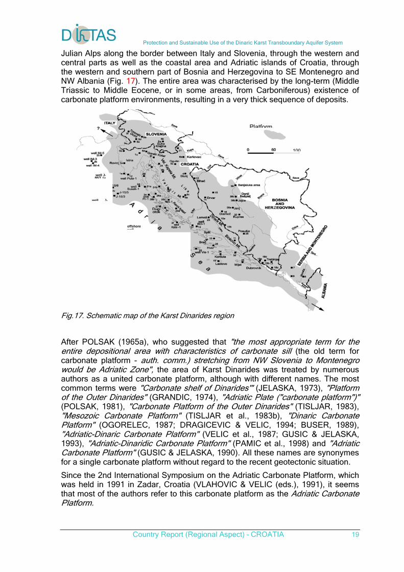
4.1. Paleogeography of Dinaric region
Platform carbonate deposits found along the NE Adriatic coast, usually referred to as the "Karst Dinarides", represent a belt approximately 700 km long and, (after tectonic reduction), 80-210 km wide. This huge carbonate body stretches from the
Protection and Sustainable Use of the Dinaric Karst Transboundary Aquifer System
Country Report (Regional Aspect) – CROATIA 19
Platform
100
well J-86/1 2ai
well J-
offshore well
Julian Alps along the border between Italy and Slovenia, through the western and central parts as well as the coastal area and Adriatic islands of Croatia, through the western and southern part of Bosnia and Herzegovina to SE Montenegro and NW Albania (Fig. 17). The entire area was characterised by the long-term (Middle Triassic to Middle Eocene, or in some areas, from Carboniferous) existence of carbonate platform environments, resulting in a very thick sequence of deposits.
Fig.17. Schematic map of the Karst Dinarides region
After POLSAK (1965a), who suggested that "the most appropriate term for the entire depositional area with characteristics of carbonate sill (the old term for carbonate platform - auth. comm.) stretching from NW Slovenia to Montenegro would be Adriatic Zone", the area of Karst Dinarides was treated by numerous authors as a united carbonate platform, although with different names. The most common terms were "Carbonate shelf of Dinarides'" (JELASKA, 1973), "Platform of the Outer Dinarides" (GRANDIC, 1974), "Adriatic Plate ("carbonate platform")" (POLSAK, 1981), "Carbonate Platform of the Outer Dinarides" (TISLJAR, 1983), "Mesozoic Carbonate Platform" (TISLJAR et al., 1983b), "Dinaric Carbonate Platform" (OGORELEC, 1987; DRAGICEVIC & VELIC, 1994; BUSER, 1989), "Adriatic-Dinaric Carbonate Platform" (VELIC et al., 1987; GUSIC & JELASKA, 1993), "Adriatic-Dinaridic Carbonate Platform" (PAMIC et al., 1998) and "Adriatic Carbonate Platform" (GUSIC & JELASKA, 1990). All these names are synonymes for a single carbonate platform without regard to the recent geotectonic situation.
Since the 2nd International Symposium on the Adriatic Carbonate Platform, which was held in 1991 in Zadar, Croatia (VLAHOVIC & VELIC (eds.), 1991), it seems that most of the authors refer to this carbonate platform as the Adriatic Carbonate Platform.
Protection and Sustainable Use of the Dinaric Karst Transboundary Aquifer System
Country Report (Regional Aspect) – CROATIA 20
A second, smaller group of authors accepted the geotectonic concept of the Dinarides according to HERAK (1986), considering the existence of several palaeogeographic units in the same area during the Mesozoic. According to HERAK (1986, 1989, 1991, 1993) two carbonate platforms existed in the area of the Karst Dinarides from the Late Triassic to the Eocene - the Adriatic Carbonate Platform (Adriaticum) and the Dinaric Carbonate Platform (Dinaricum), separated by a persistant deep-water interplatform trough (Epi-adriaticum).
4.2. Dinaric Carbonate Platform (External Dinarides) - litostratigraphic units
Carbonate platform deposits of the Karst Dinarides are, besides their significant thickness (4500-8000 m, 6000 m in average), characterised by frequent lateral and vertical alternations of different facies, mostly associated with shallow marine environments. Environments ranging from peritidal through low-energy shallow subtidal - lagoons, restricted inner platform shallows, high-energy tidal bars, beach and shoreface to reefal-perireefal areas are the most common, but the succession also comprises deposits of carbonate slopes and temporarily drowned platform facies and intraplatform troughs.
On the basis of their main sedimentological, lithological, biofacies and lithofacies characteristics, the deposits accumulated in this area from the Early Jurassic to Eocene can be subdivided into several megafacies units characterised by their extensive occurrence, i.e. regional importance, regardless of their thickness.
Jurassic carbonate deposits of the Karst Dinarides can be subdivided into 9 megafacies units:
J-1: Megafacies of peritidal micritic, fenestral and vadose limestones with interbeds of early-diagenetic dolomites and emersion breccia, emersions and occasional bauxites;
J-2: Megafacies of lagoonal and subtidal inner platform oncoid, pelletal and skeletal mudstones/wackesto-nes;
J-3: Megafacies of bioturbated and late-diagenetically dolomitized "spotty limestones" - mudstones and wackestones deposited in isolated and restricted lagoon/deeper subtidal areas of the inner platform;
J-4: Megafacies of lithiotid and brachiopod lithosomes and tempestite coquinas of shallow subtidal and lagoonal regions of the inner platform;
J-5: Megafacies of ooid grainstones deposited in environments with agitated water and ooid bars;
J-6: Megafacies of skeletal and intraclastic grainstones/ rudstones deposited in shallows with agitated water;
J-7: Megafacies of peri-reefal bioclastic limestones (rudstones and grainstones) with hydrozoan, stroma-toporoid and coral patch reefs and biostromes;
J-8: Megafacies of "limestones with cherts" (including "Lemes deposits"), deposited within intraplatform troughs with temporary or continuous connection to the open sea, and
J-9: Megafacies of late-diagenetic dolomites.
Protection and Sustainable Use of the Dinaric Karst Transboundary Aquifer System
Country Report (Regional Aspect) – CROATIA 21
Deposits of megafacies J-1, i.e. peritidal micritic, fenestral and vadose limestones with interbeds of early-diagenetic dolomites and emersion breccia, emersions and occasional bauxites, are most common in the Lower and Middle Lias, Dogger, Oxfordian, Kimmeridgian and Upper Tithonian deposits. They are mostly composed of fenestral and/or vadose limestones (mudstones, pelletal and/or skeletal wackestones), with layers of LLH-stromatolites and skeletal/pelletal packstones and grainstones, while black-pebble and tempestite breccias and early-diagenetic dolomites are infrequent. At some localities, mostly within Middle Lias and Tithonian sediments, deposits of this megafacies are characterised by numerous shallowing-upward cycles on a dm- to m-scale. Cycles ending with desiccation cracks, desiccation breccia or vadose features.
Megafacies J-2 is a dominant facies type within Jurassic deposits. It is composed of thick-bedded to massive wackestones/packstones to floatstones with algal oncoids, as well as pelletal and skeletal wackestones and mudstones containing faecal pellets, gastropod cortoids and centripetally micritized benthic foraminiferal tests and mollusc bioclasts. Massive and/or thick-bedded mudstones and wacke-stones of megafacies J-2 are predominant in the Middle Lias, Lower and Middle Dogger, Oxfordian and Kimmeridgian carbonates.
Deposits of megafacies J-3 are typical for the Upper Lias of the Velebit Mt., Velika Kapela Mt., and Platak-Gornje Jelenje in Gorski Kotar. This megafacies is widely distributed in the western part of the Karst Dinarides, stretching from W Bosnia and S Croatia (northern Dalmatia) towards the NW into southern Slovenia. However, it
is completely missing in the ESE, from central Bosnia towards Herzegovina, Montenegro and the Croatian southern Adriatic coast. The main characteristic of these "spotty limestones" is intense bioturbation of carbonate muds in restricted areas with very reduced fossil assemblages, indicating low sedimentation rates during late Lias. The depositi-onal area was probably an isolated, restricted lagoon in the inner part of the platform, formed by the interaction of gentle synsedimentary tectonics and eustatic sea-level change. This spotty appearance is a consequence of bioturbation and different amounts of organic matter in a host rock (predominantly mudstones) and bioturbation infillings (mostly wackestones to packstones), although differences have been subsequently exaggerated by the variable influences of late-diagenetic dolomitization and recrystallization.
Deposits separated into megafacies J-4 are present only within the Middle Lias deposits in Velebit Mt., near Duga Resa in the Karlovac area, Velika Kapela Mt., and Dubrovnik area. Biostromes are 0.3-0.8 m thick, and are characterised by their limited lateral extent. They are composed of very large shells of lithiotids and brachiopods lithified in living position, and occur only at some localities. However, shell coquinas and tempestite coquinas consisting of coarse debris of lithiotids and brachiopods very often occur in penecontemporaneous deposits, both in these and other aforementioned localities. Limestones with lithiotids can be found throughout the area of the former platform except for its marginal parts. Depending on bathymetry and morphology of the sea bottom, the frequency of these beds varies from place to place, with maximal 4 to 12 beds in Middle Lias of the Velebit Mt. and minimal 1 to 3 beds in the W Gorski Kotar. Tempestite coquinas were deposited by storm waves and storm tides in shallow subtidal to lower intertidal environments, and are associated with limestones of megafacies J-1, J-2 and J—6.
Protection and Sustainable Use of the Dinaric Karst Transboundary Aquifer System
Country Report (Regional Aspect) – CROATIA 22
Deposits of megafacies J-5 are widely distributed in several levels of Jurassic rocks of the Karst Dinarides, most commonly in Upper Lias-Lower Dogger, Dogger and Malm in general, and Oxfordian and Tithonian. The best outcrops are described from Bosnia and Herzegovina, SE of Kupres, Montenegro, and especially Slovenia in different levels of stratigraphic range Middle Lias to Kimmeridgian, and in some places throughout the Dogger, Oxfordian and Lower Kimmeridgian. Ooid grainstones were frequently deposited in the form of ooid bars, exhibiting large-scale cross-bedding, but also ooid grainstones or ooid-bioclastic-intraclastic grainstones to rudstones are common as the first member of the shallowing-upward cycles. In this type of parasequences the second member is pelletal or oncoid wackestone or peloid-oncoid floatstone, while the third, upper member of the cycles, is pelletal or oncoid wackestone with fenestral fabric, locally with vadose features. Ooid grainstones are composed of well-sorted, spheroidal and frequently broken ooids and mosaic and/ or fibrous calcite cement. Ooid grainstones of megafacies J-5 were deposited in environments of ooid shoals and bars with high water-energy.
Megafacies J-6 consists of bioclastic grainstones and rudstones, and sporadically of floatstones containing well-sorted and rounded intraclasts, bioclasts and coated bioclasts ("cortoids"), 0.5-10 mm in size. Bioclasts of hydrozoans and other stromatoporoids, intraclasts and ooids are predominant, while fragments of corals and gastropods are relatively rare. These rocks are characterised by their high content of drusy mosaic and often fibrous rim calcite cement, and they originated by the destruction of skeletons of reef and patch-reef organisms in open shoals with high water energy and normal marine salinity and by migration and deposition of bioclasts in shoals with agitated water. Deposits of megafacies J-6 are common only in the Malm of western and southern Slovenia in the Trnovski Gozd area, and in Croatia in the Pokuplje, and Karlovac area, in western Istria, in Oxfordian sediments of western Gorski Kotar area, in the Upper Tithonian of Velika Kapela Mt. and Senj-Ogulin profile, and in the Oxfordian of Velebit Mt., and Biokovo Mt. A variety of megafacies J-6 deposits, composed of well-sorted and rounded intraclasts and bioclasts of pachyodont shells and echinoderms deposited in shallows with agitated water, occur in the Lower and Middle Lias in western Slovenia, in the Middle Lias and Upper Dogger of Velebit Mt., while in the Lower Dogger of the Biokovo Mt. skeletal and intraclastic grainstones/rudstones occur. Deposits of this variety of megafacies J-6 are especially important for the Middle Dogger succession of the Dubrovnik area.
Deposits of megafacies J-7 only occur sporadically in typical carbonate platform deposits, usually within the succession of megafacies J-6 in Malm deposits. Smaller coral and/or hydrozoan patch-reefs were well developed in the Oxfordian of the Island of Lastovo in the Tithonian of Velika Kapela Mt. and the Senj-Ogulin profile and in the Gorski Kotar (Zlobin area). During the Late Jurassic the northern, NE and SE margins of the platform were characterised by an almost continuous belt of coral-hydrozoan barrier reefs stretching from W Slovenia to SE Montenegro and NW Albania. In addition, there were also coral-hydrozoan reefs within the platform interior, where they surrounded intraplatform depressions, e.g. in Gorski Kotar or the "Lemes" trough extending approximately from the vicinity of Bihac in W Bosnia towards the South to Central Dalmatia, i.e. Knin, Drniš and Sinj. Besides this, barrier reefs, extending for tens or hundreds of kilometres, there were also isolated patch reefs. Most of these reefs were not preserved in situ as skeletal reefs - they occur as smaller or larger quantities of skeletal detritus in the form of
Protection and Sustainable Use of the Dinaric Karst Transboundary Aquifer System
Country Report (Regional Aspect) – CROATIA 23
peri-reefal bioclastic limestones of a rudstone/grainstone type. Large organic reefs or reef complexes have not been recognized within Jurassic carbonates in the Croatian part of the Adriatic Carbonate Platform. Some of these ancient reefs have been completely destroyed and redeposited. Opinion is divided concerning the stratigraphic position of reefal/peri-reefal deposits within Upper Jurassic deposits in Slovenia. Reefal/perireefal deposits with abundant corals and hydrozoans are very common along the NE margin of the platform in the area from central Bosnia to southern Montenegro, but their stratigraphic age is generally determined as Upper Jurassic.
Megafacies J-8 comprises "limestones with cherts", and it is especially well developed in the Kimmeridgian of Velika Kapela Mt., in the area of Karlovac and within the socalled "Lemeš beds" which can be found in the central part of the platform from Bihać in NW Bosnia, along the Una valley, through E Lika (Donji Lapac, Udbina) and N Dalmatia (Knin, Drniš) to central Dalmatia (Sinj). Comparable deposits are completely missing in the coastal area and on the islands of the central and southern Adriatic. "Limestones with cherts" have also been found in Slovenia. In the area of Velika Kapela Mt. and the Senj-Ogulin profile thin- to well-bedded grey to dark grey mudstones/wackestones with interbeds of cherts gradually overlaid Oxfordian deposits of megafacies J-2. Their thickness is very variable, and their upper boundary is also gradual with redeposited bioclastic limestones of megafacies J-5. In their lower part "limestones with cherts" are composed of grey to dark grey pelletal-bioclastic wacke-stones and mudstones with nodules and rare lenses of cherts. In their upper part within the well-bedded rocks of similar lithology, but including small peloids, oncoids, pelagic crinoids, bioclasts of echinoderms, corals, hydrozoans and stromatoporoids, rare ooids and very rare ammonites, there are lot of nodules, lenses and intercalations of cherts. Cherts comprise numerous relics of radiolarians and spicules of silica sponges. They originated by early-diagenetic silicification of carbonate muds under the influence of solutions enriched in silicic acid originating from fine volcanoclastic detritus, and some beds are direct products of the alteration of tuffs. "Lemeš beds" were described as platy to thick-bedded limestones with interbeds and lenses of cherts and/or thin-bedded silicified limestones. Limestones are mostly pale brown fossiliferous mudstones to wackestones, but also wackestones to packstones comprising pellets, ooids, oncoids and bioclasts. They contain relatively numerous ammonites, aptichuses, fish remains, brachiopods, benthic and pelagic foraminifera, calcisphaeres and radiolarians.
Megafacies J-9 includes large masses, bodies and layers of microcrystalline to coarsely-crystalline dolomites with mosaic texture. They often contain relics of more or less intensively dolomitized limestones, mainly of megafacies J-2, J—6 and J—7, and rarely of megafacies J-1. Their late-diagenetic origin is suggested by the following features: the relative large size of dolomite crystals (0.02-0.8 mm), selective dolomitization of limestone components, occurrence of irregular dolomite lenses and bodies within undolomitized or weakly dolomitized limestones, gradual transitions of limestones to dolomite and undolomitized relics of limestones in dolomites, practically constant structures and composition of dolomites in large
areas formed by dolomitization of different structural, genetic and stratigraphic types of limestones. Megafacies J-9 is the dominant megafacies unit of the Lower Oxfordian and Upper Tithonian of Velika Kapela Mt. and the Senj-Ogulin profile,
Protection and Sustainable Use of the Dinaric Karst Transboundary Aquifer System
Country Report (Regional Aspect) – CROATIA 24
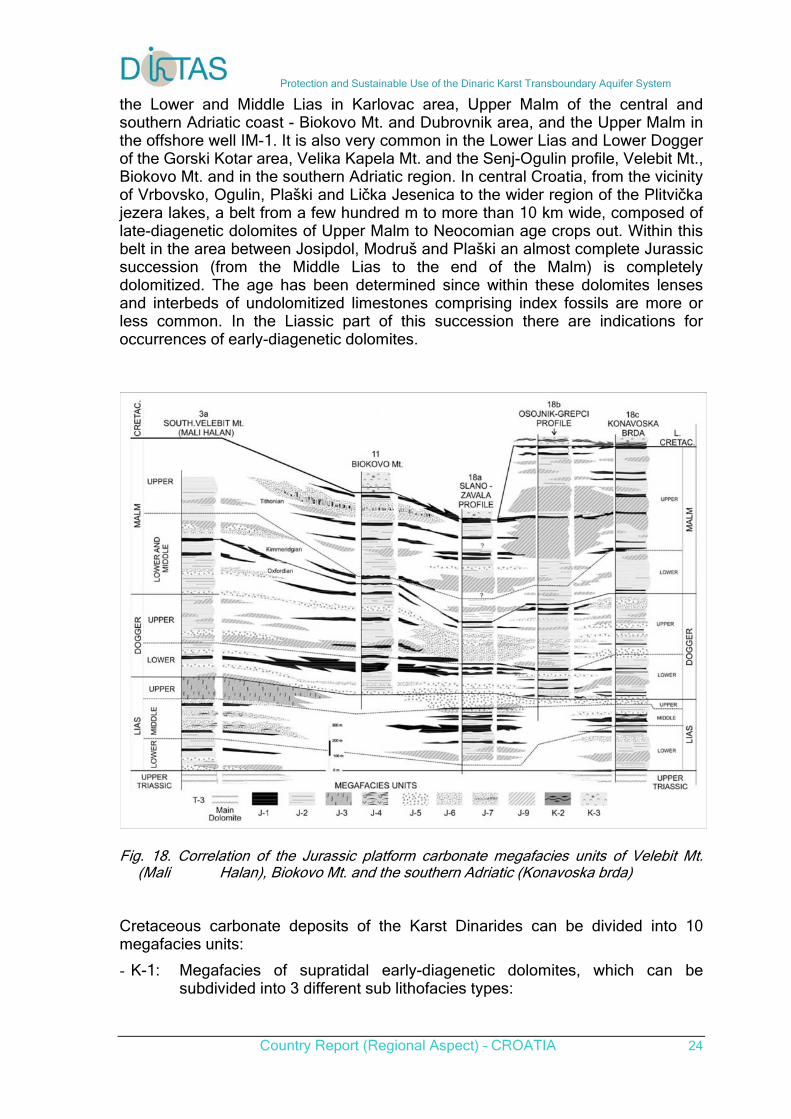
the Lower and Middle Lias in Karlovac area, Upper Malm of the central and southern Adriatic coast - Biokovo Mt. and Dubrovnik area, and the Upper Malm in the offshore well IM-1. It is also very common in the Lower Lias and Lower Dogger of the Gorski Kotar area, Velika Kapela Mt. and the Senj-Ogulin profile, Velebit Mt., Biokovo Mt. and in the southern Adriatic region. In central Croatia, from the vicinity of Vrbovsko, Ogulin, Plaški and Lička Jesenica to the wider region of the Plitvička jezera lakes, a belt from a few hundred m to more than 10 km wide, composed of late-diagenetic dolomites of Upper Malm to Neocomian age crops out. Within this belt in the area between Josipdol, Modruš and Plaški an almost complete Jurassic succession (from the Middle Lias to the end of the Malm) is completely dolomitized. The age has been determined since within these dolomites lenses and interbeds of undolomitized limestones comprising index fossils are more or less common. In the Liassic part of this succession there are indications for occurrences of early-diagenetic dolomites.
Fig. 18. Correlation of the Jurassic platform carbonate megafacies units of Velebit Mt.
(Mali Halan), Biokovo Mt. and the southern Adriatic (Konavoska brda) Cretaceous carbonate deposits of the Karst Dinarides can be divided into 10 megafacies units:
- K-1: Megafacies of supratidal early-diagenetic dolomites, which can be subdivided into 3 different sub lithofacies types:
Protection and Sustainable Use of the Dinaric Karst Transboundary Aquifer System
Country Report (Regional Aspect) – CROATIA 25
- K-1a: Facies of supratidal early-diagenetic dolomites without evaporites,
- K-1b: Facies of supratidal early-diagenetic dolomites with evaporites, i.e. sabkha cycles, and
- K-1c: Facies of supratidal laminated early-diagene-tic dolomites with crystal moulds of evaporite minerals;
- K-2: Megafacies of peritidal and vadose limestones, black-pebble breccia/conglomerates, emersion breccia, clays, swamp deposits and palaeosols, long-lasting emersions and bauxites;
- K-3: Megafacies of peritidal-tidal flat pelletal and stro-matolitic limestones forming shallowing-upward cycles;
- K-4: Megafacies of inner platform lagoonal and shallow subtidal oncoid and peloidal micritic limestones;
- K-5: Megafacies of intraclastic/peloidal and skeletal foreshore and shoreface grainstones and packstones;
- K-6: Megafacies of rudist coquinas/coquinites with small rudist biostromes and lithosomes;
- K-7: Megafacies of limestones with pelagic fauna which originated during phases of temporary platform drowning;
- K-8: Megafacies of late-diagenetic dolomites;
- K-9: Megafacies of slope carbonates: debrites and turbi-dites, and
- K-10: Megafacies of calclithite-marly flysch.
Deposits of megafacies K-1 occur within Cretaceous platform carbonates of the Dinaric karst region as three types, differing according to their origin and depo-sitional environments.
- Facies of supratidal early-diagenetic dolomites without evaporites (K-1a)
Deposits of facies K-1a only occur in Lower Cretaceous carbonates in the Berriasian succession of western Istria, Berriasian and Valanginian carbonates of southern Slovenia, Upper Albian/Vraconian of Biokovo Mt., offshore well Kate-1 in the Kornati area and in the Dubrovnik area.
- Facies of supratidal early-diagenetic dolomites with evaporites, i.e. sabkha cycles (K-1b). Deposits of facies K-1b only occur in the Lower Cretaceous deposits in wells drilled in the Ravni Kotari area and wells in the Adriatic region. Lower Cretaceous sabkha anhydrites are represented by typical sabkha cycles. Cretaceous sabkha anhydrites from deep wells have significantly different mineralogical, petrological, sedimentological and geochemical properties from Upper Permian anhydrites.
Deposits of facies K-1c only crop out within Upper Santonian-Lower Campanian peritidal deposits in the area of Sućuraj on the island of Hvar. This megafacies is characterised by the typical alternation of thin (0.2-6 mm), very wavy laminae of light and dark coloured dolomites, as well as fenestral fabric and desiccation cracks, resulting from recurrent dehydration and moisturisation by high and storm tides in supratidal environments. Occurrence of this type of deposits within Upper
Protection and Sustainable Use of the Dinaric Karst Transboundary Aquifer System
Country Report (Regional Aspect) – CROATIA 26
Santonian-Lower Campanian peritidal carbonates of megafacies K-3 has very important sedimentological, palaeomorphological and palaeoclimatological signi-ficance for the interpretation of sedimentary environments and evolution of the Adriatic Carbonate Platform in the Late Cretaceous.
Deposits of megafacies K-2 without long-lasting emersion and bauxites are most common within limestones of the Upper Aptian, and in some parts of Hauterivian, Barremian, and Lower Albian successions in the continental part of the Karst Dinarides. They also occur on the islands of Brijuni, Cres, Lošinj, Vis, Hvar, Korčula, Mljet and the Pelješac peninsula, as well as in onshore and offshore wells. After important relative sea level falls connected with emersions, e.g. after the regional Aptian emersion, several shallowing-upward cycles were initiated composed of peritidal limestones alternating in vertical, partially even in lateral succession with soft pebble conglomerates, black-pebble breccias, emersion brec-cias, grey and dark clay intercalations and palaeosols. The frequent short-lived emersions in Lower Cretaceous limestones were connected with interruptions of sedimentation, temporary emersions of incompletely consolidated carbonate deposits and the appearance of thin intercalations of soft pebble conglomerates, black-pebble breccias, emersion breccias, grey and dark green clay intercalations and palaeosols. The grey, greenish and dark clays were deposited during relative sea level fall when swamp environments were developed in the coastal area. Greenish clays associated with Lower Cretaceous peritidal and lagoonal carbonates, especially within the Late Aptian to middle Albian long-lasting emersion in Istria, but also in other parts of the platform, show evidence of subaerial exposure and pedogenesis, and are considered palaeo-sols.
Deposits of megafacies K-3 are mostly characterised by the alternation of thin-bedded pelletal wackestones/ packstones to grainstones and LLH-stromatolites. In the Lower Cretaceous shallowing-upward cycles composed of pelletal or skeletal wackestones and LLH-stromatolites with fenestral fabric and desiccation cracks within mudstone laminae are most frequent. In the Upper Cretaceous, deposits of megafacies K-3 very often occur on the entire carbonate platform within the Middle and Upper Cenomanian and Upper Turonian to Lower Santonian deposits.
In the Upper Cretaceous deposits the first member of a shallowing-upward cycle is usually foraminiferal-peloidal wackestone/packstone with green-algae.
During the Late Cretaceous within the peritidal parts of restricted shallows and lagoons with weak circulation and poor water aeration, i.e. oxygen deficiency, there are sporadic occurrences of "platy limestones with fishes".
Within the Cretaceous succession of the Karst Dinarides deposits of megafacies K-4 are the most widespread type, especially in the Valanginian, Hauterivian and Lower Aptian, but they are also very frequent in Berriasian, Barremian, Lower Albian, Cenomanian, Turonian and Coniacian-Lower Campanian deposits. They are represented by thick beds (0.4-3 m) or even massive mudstones, oncoid, pelletal and skeletal wackestones/packstones to floatstones. The limestones of megafacies K-4 were deposited in lagoons and restricted shallows in the inner part of the carbonate platform. In the Lower Cretaceous these limestones are mostly micritic rocks consisting predominantly of carbonate mud. During the Late Cretaceous, limestones of megafacies K-4 were deposited within a complex pattern of lagoons and restricted shallows behind areas with abundant rudist and chondrodont communities and shallows characterised by the rapid deposition of
Protection and Sustainable Use of the Dinaric Karst Transboundary Aquifer System
Country Report (Regional Aspect) – CROATIA 27
bioclastic debris produced by these assemblages. Alternations of this type are very common within Cenomanian and Senonian deposits throughout the Karst Dinarides. Within the Upper Albian inner platform, lagoonal and shallow subtidal oncoid and peloidal mud-bearing limestones of megafacies K-4 the occurrence of "quartz diagenetic sediments" or "quartz sediments" is very characteristic. They occur in central and southern Istria, Ćićarija Mt. in NE Istria and on the island of Vis, as well as authigenic quartz in Dinara Mt. and Svilaja Mt. In earlier papers these deposits were known as "quartz sands" and "quartz sandstones".
Deposits of megafacies K-5 are predominantly composed of well-sorted and rounded intraclasts and/or peloids, benthic foraminiferal tests and in some places mollusc bioclasts (bivalves and gastropods). In the Lower Cretaceous succession of the Karst Dinarides megafacies K-5 is a typical megafacies unit in the Upper Albian of Istria, Lower Aptian of the Dinara Mt., Upper Aptian of Biokovo Mt., and the Albian of the entire carbonate platform region, especially of the Dinara Mt., Biokovo Mt. and Korčula Island. Well-sorted and rounded grains (intraclasts, peloids and miliolid tests), cross-lamination and cross-bedding, small-current ripples and wave ripples indicate the existence of foreshore and shoreface environments with agitated water, tidal channels and carbonate sand bars. In the Upper Cretaceous succession, deposits of megafacies K-5 occur only sporadically.
Deposits of megafacies K-6 are mostly composed of thick-bedded to massive floatstones, wackestones/packstones and rudstones. They usually contain a large quantity of rudist with very variable amounts of matrix and calcite cements. These deposits are very common in Cenomanian, Turonian and Santonian-Campanian deposits over the entire area of the Mesozoic carbonate platform. Alternations of rudist coquinas and thinner or thicker rudist biostromes and/or thickets with rudist shells in life position are common, and in some localities are even the predominant lithologies. During the Late Cretaceous, rudist assemblages, in some places accompanied by chondrodonts and gastropods, colonized vast areas of inner platform shallows and flourished along inner marginal areas towards intra-platform troughs and platform margins. Disintegration of rudist and chondrodont shells by bioerosion and other physical processes produced enormous quantities of bioclastic material, both coarsegrained which accumulated within shallows with agitated water, and fine-grained, well-sorted material within lagoons and platform margins. Migration and accumulation of skeletal detritus was commonly very intensive, resulting in some places with the formation of clinoform bodies within high-energy foreshore-shoreface environments. Fine-grained detritus was redistributed by currents and waves, sometimes over large distances, and accu-mulated within low-energy inner platform deposits of megafacies K-4 or deeper environments characterised by pelagic fossil assemblages (megafacies K-7 and K-9a). Along the N-NE margin of the platform, e.g. in NW and central Bosnia, from the Upper Santonian to the Maastrichtian there were occurrences of reefs and peri-reefal deposits composed of corals, hydrozoans, stromatoporoids and abundant rudists. Destruction of these deposits produced enormous quantities of material, redeposited during the Late Cretaceous in the form of flysch deposits on platform slopes and in the proximal part of the basin.
Deposits of megafacies K-7 are most common around the Cenomanian/Turonian boundary and within the Late Santonian-Campanian succession. They are composed of micritic limestones with pelagic fossil assemblages, formed during temporary drowning of the platform caused by the interaction of eustatic sea-level
Protection and Sustainable Use of the Dinaric Karst Transboundary Aquifer System
Country Report (Regional Aspect) – CROATIA 28
rise and synsedimentary tectonics. Because of the latter, the influence of eustatic changes was not constant over all areas of the platform. Within Lower Cretaceous platform carbonates of the Karst Dinarides, the oldest pelagic fauna is recorded in the Lower Aptian deposits of the Ogulin area in central Croatia. This represents evident pelagic influence during the deposition of lagoonal limestones.
Deposits of megafacies K-8 are very frequent and occur in large bodies, especially at the beginning and at the end of the Lower Cretaceous - in the Berriasian and Albian of Istria, in the Berriasian, Valanginian and Upper Albian-Lower Ceno-manian of the Velika and Mala Kapela Mts., in the Kordun and Lika areas, in central Dalmatia, Dinara Mt., Biokovo Mt., the Dubrovnik area, and the islands of Cres, Krk, Dugi Otok, Rava, Pašman, Prvić, Zlarin, Hvar, Korčula and Mljet, and in the Upper Cretaceous of the islands of Brač, wells Kate-1 and Boraja-1, and island of Vis. All the Cretaceous examples are hypidiotopic and xenotopic mosaic macrocrystalline and/or microcrystalline dolomites with high Ca-excess and a low degree of lattice ordering. They very often contain relics of more or less intensely dolomitized limestones of megafacies K-3, K-4, K-5 and K-6. However, late-diagenetic dolomites of megafacies K-8 are frequently dedolomitized or calcitized and transformed into microcrystalline "limestones of recrystallized texture".
Deposits of megafacies K-9 mostly occur within the Upper Cretaceous, most frequently the Upper Santonian and Campanian, in some places in deposits of Maastrichtian age or transitional Cretaceous-Tertiary sequences along the platform margins, or along fault escarpments within the platform. They can be traced along the NE margin from the Slovenian trough in the NW, through Slovenia and central Croatia, SE of Karlovac, Slunj and Bihać to central Bosnia, Herze-govina and Montenegro. The best outcrops can be found in the area of Karlovac-Slunj-Bihać-Banjaluka-Jajce-Kupres, while along the SW margin they have been documented from offshore wells.
Megafacies K-9 can be subdivided into two types according to its lithological and sedimentological properties:
- K-9a - carbonate debrites and coarse-grained carbonate turbidites, and
- K-9b - middle to fine-grained carbonate turbidites or allodapic limestones.
- Along the NE margin deposits of facies K-9a are represented by coarse-grained (2-60 cm) carbonate breccias composed of angular to subangular, weakly sorted clasts (up to small blocks) of shallow-water Jurassic and Cretaceous limestones and dolomites. In the area of the SW margin of the platform, deposits of megafacies K-9 have been found in numerous offshore wells in the northern and central Adriatic. In the northern Adriatic area, W and SW of Istria in offshore wells, deposits of this megafacies are several hundred metres thick. Generally, these deposits accumulated in environments ranging from carbonate platform, carbonate ramp with distributary channels and the transition
Deposits of megafacies K-10 are predominantly composed of calclithite sandstones and marls forming typical Bouma Ta-d sequences. Intervals Ta-c are usually represented by calcirudites to calcisiltites, and Td intervals by marls and silty marls. Within such flysch deposits in some places, e.g. in the region of Karlovac and the river Vrbas in NW and central Bosnia, there are occurrences of coarse-grained turbidites, i.e. breccias and breccio-conglomerates composed of poorly-sorted fragments, with or without large oli-stoliths of Jurassic and
Protection and Sustainable Use of the Dinaric Karst Transboundary Aquifer System
Country Report (Regional Aspect) – CROATIA 29
Cretaceous limestones and dolomites. These occurrences indicate synsedimentary tectonics with the formation of steeper slopes in the initial phase of flysch trough formation .
Deposits of megafacies K-10 were predominantly deposited from turbidity currents of low density, although occasionally there are deposits accumulated from high-density currents. In the deeper parts of the basin, farther from the mainland and islands deposition of carbonate muds took place in the same period. These mudstone and wackestone limestones contain pelagic fauna and grains of fine sand, silt or clay, and usually diagenetic chert nodules and layers. These are so-called "Scaglia" limestones, which laterally and vertically gradually pass into flysch deposits.
Cretaceous deposits are directly overlain by the following megafacies units:
- KP-1: Megafacies of emersions with bauxites, and terrestrial, fresh-water and brackish (Liburnian) deposits,
- P-2: Megafacies of peritidal/lagoonal stromatolitic, pelletal and skeletal micritic limestones,
- P-3: Megafacies of Foraminiferal limestones, and
- P-4: Megafacies of pelagic limestones and carbonate turbidites - allodapic limestones.
Deposits of megafacies KP-1 comprise very variable rocks, united by their non-marine environments of origin, either during long-lasting emersion with or without bauxites, or within fresh-water or brackish environments before the final Palaeogene transgression. Non-marine conditions prevailed for very variable periods of time in different parts of the former carbonate platform. The emersion commenced at different times, but in some parts it had already started in the Early Cretaceous, while the Palaeogene transgression in the Croatian parts of the Karst Dinarides started mostly in the early Eocene. In central Istria there are several occurrences of Palaeogene limestones covering Lower Cretaceous deposits, and depressions in the palaeorelief of karstified Cenomanian limestones are filled by bauxites and brackish Palaeogene Liburnian deposits, while in southern Istria the youngest Cretaceous rocks are of Upper Santonian age. In the northern part of the island of Cres bauxites overlie Upper Cenomanian deposits. On the island of Krk bauxites cover Upper Cenomanian to Lower Turonian deposits, while on the islands of Lošinj and Pag the youngest Cretaceous deposits are of Senonian age, similar to the situation in the Ravni Kotari area. In Dalmatia and Herzegovina emersion commenced differently from place to place, and bauxites, if present, and Palaeogene fresh-water, brackish and marine deposits cover emerged and more or less palaeokarstified Upper Cretaceous rocks of different stratigraphic levels. In Herzegovina bauxites and brackish deposits cover Turonian-Senonian limestones. Bauxite deposits occur as sedimentary bodies of various shapes and sizes. They were formed in palaeorelief recesses on the underlying limestones and represent a regional palaeogeographical and sedimentological marker connected with emersion phases. Their stratigraphic position - as defined by the age of underlying and overlying rocks - is very variable. Liburnian deposits resulted from oscillatory ingression, and are mostly represented by fresh-water and brackish deposits of Lower Eocene age composed of alternating layers of gastropod wackestones/packstones and algal wackestones, and occasionally bivalve float-
Protection and Sustainable Use of the Dinaric Karst Transboundary Aquifer System
Country Report (Regional Aspect) – CROATIA 30
stones or packstones and Microcodium-bearing wacke- stones/mudstones. They were deposited only in the lowermost parts of the palaeorelief. At some localities in SW Slovenia there is almost a continuous succession from the Cretaceous to the Palaeogene, but in Croatia Palaeocene rocks are practically missing, and Maastrichtian deposits are relatively rare. Deposits of megafacies P-2 represent the first Palaeogene marine deposits, in some places overlying a sequence of megafacies KP-1, while elsewhere they represent the oldest Palaeogene rocks infilling the lowest parts of the palaeorelief. They are characterised by the alternation of laminated and/or thin-bedded wackestones/mudstones with characean gyrogonnites and frequent Microcodium with LLH-stromatolites and miliolid wackestones deposited in intertidal and shallow subtidal environments. Deposits of megafacies P-3 can be subdivided into four lithostratigraphic types, mostly deposited from the Early to Middle Eocene, named after the prevailing biota as Miliolid limestones, Alveolinid limestones, Nummulite limestones and Discocyclinid limestones. Since these facies units penecontemporaneously occupied different environments, from restricted shallows to carbonate slopes in the investigated carbonate successions characterised by a general transgressive trend, they are mostly in superpositional relations. Foraminiferal limestones are mostly composed of the complete and disintegrated tests of benthic foraminifera, while the detritus of molluscs, echinoderms and bryozoans, as well as glauconite in the uppermost (i.e. youngest) part, are subordinate. Such a composition is typical of a foramol association. Miliolid limestones represent the restricted inner part of the carbonate platform, Alveolinid limestones and Nummulite limestones the shallower and deeper parts of shoreface environments and Discocyclinid limestones the deeper parts of relatively open carbonate ramps. The same types in different areas are usually of somewhat different ages, but a general deepening-upward trend is always present. This trend is a consequence of the interaction of several causes, mainly intense synsedimentary tectonics (restricting the carbonate factory to the relatively narrow zones along the basin margins and ensuring appropriate accommodation space was available for the redistribution of shallow water material to the basin), and relatively low net sedimentation rate as a consequence of deposition in environments which were no longer ideal for biogenic carbonate production. Deposits of this megafacies are most common in the coastal area and hinterland of the Karst Dinarides, especially in SW Slovenia, along the Adriatic coast in Croatia, in Herzegovina and SE Montenegro. Deposits of megafacies P-4 are composed of mud-supported pelagic limestones and intercalations of thinner or thicker calcarenite layers. In the lowermost part they are usually characterised by the so-called "transitional beds" - marls with frequent crabs and glauconite grains. Megafacies P-4 rocks are common along the Adriatic coast, on islands and in western Herzegovina, as well as in numerous offshore wells. Similar deposits also occur along the NE platform margin. Pelagic limestones of mudstone, wackestone to packstone types contain a rich planktonic fauna (especially planktonic foraminifera) and variable amounts of very fine-grained detritus. Usually they have thin intercalations of calcarenites with variable amounts of siliciclastic grains. This alternation can be interpreted as fine-grained or muddy carbonate turbidites of a Piper type. In some localities within pelagic
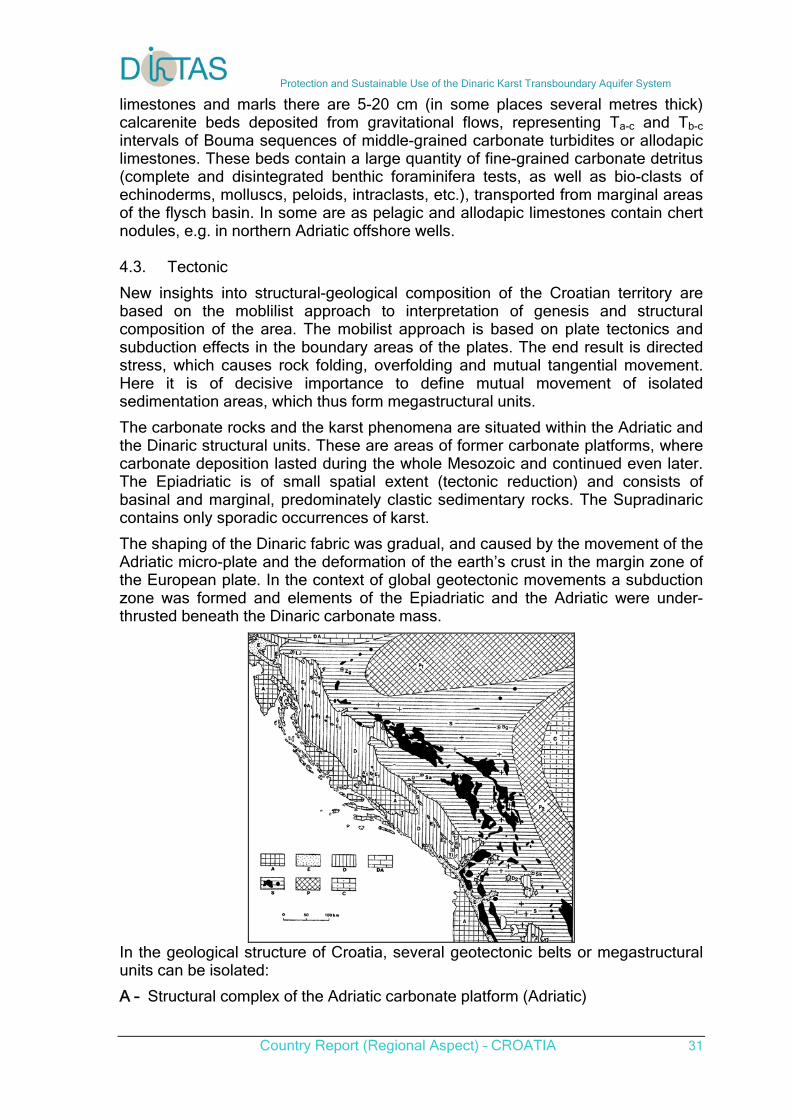
Protection and Sustainable Use of the Dinaric Karst Transboundary Aquifer System
Country Report (Regional Aspect) – CROATIA 31
limestones and marls there are 5-20 cm (in some places several metres thick) calcarenite beds deposited from gravitational flows, representing Ta-c and Tb-c intervals of Bouma sequences of middle-grained carbonate turbidites or allodapic limestones. These beds contain a large quantity of fine-grained carbonate detritus (complete and disintegrated benthic foraminifera tests, as well as bio-clasts of echinoderms, molluscs, peloids, intraclasts, etc.), transported from marginal areas of the flysch basin. In some are as pelagic and allodapic limestones contain chert nodules, e.g. in northern Adriatic offshore wells. 4.3. Tectonic
New insights into structural-geological composition of the Croatian territory are based on the moblilist approach to interpretation of genesis and structural composition of the area. The mobilist approach is based on plate tectonics and subduction effects in the boundary areas of the plates. The end result is directed stress, which causes rock folding, overfolding and mutual tangential movement. Here it is of decisive importance to define mutual movement of isolated sedimentation areas, which thus form megastructural units.
The carbonate rocks and the karst phenomena are situated within the Adriatic and the Dinaric structural units. These are areas of former carbonate platforms, where carbonate deposition lasted during the whole Mesozoic and continued even later. The Epiadriatic is of small spatial extent (tectonic reduction) and consists of basinal and marginal, predominately clastic sedimentary rocks. The Supradinaric contains only sporadic occurrences of karst.
The shaping of the Dinaric fabric was gradual, and caused by the movement of the Adriatic micro-plate and the deformation of the earth’s crust in the margin zone of the European plate. In the context of global geotectonic movements a subduction zone was formed and elements of the Epiadriatic and the Adriatic were under-thrusted beneath the Dinaric carbonate mass.
In the geological structure of Croatia, several geotectonic belts or megastructural units can be isolated:
A – Structural complex of the Adriatic carbonate platform (Adriatic)
Protection and Sustainable Use of the Dinaric Karst Transboundary Aquifer System
Country Report (Regional Aspect) – CROATIA 32
E – Formations of pelagic origin related to interplatform belt (Epiadriatic) with tectonic holes into the Dinaric (E1) D – Structural complex of the Dinaric carbonate platform (Dinaric) DA – Boundary area of the Dinarides and the Alpides S – Structural complex of the internal Dinarides (Supradinaric) P – Pre-alpine structural complexes (Panonian structures)
This process began during the transition into the Paleogene and the convexial currents caused intensive folding and the formation of nappe structures. As a consequence, the major part of the Croatian classical karst is manifested as a complex orogenic karst accumulation. The present structural-tectonic fabric was formed by neotectonic movements, characterized by radial tectonics, accompanied by further disruption of rock masses and the differential downthrow or uplift of individual blocks.
5. Geomorphology and karstification
5.1. Karstification process
The first favourable conditions for karstification occurred in the Dinaride area after the Pyrenean orogeny, when large masses of carbonate rocks were exposed to exogenous processes. However, the Neotectonic movements, which commenced in Miocene and were intensified toward the end of Pliocene and the beginning of Pleistocene, played the major role in the reshaping of the landscape and the development of karstification. At that time, the mountain ranges were uplifted, while depressions developed as isolated karst plateaux and poljes. Recent studies performed in the Dinaric karst terrain indicate that the present landscape is very young. The majority of the most important and developed morphological features were created during the Lower Pleistocene and Holocene (FRITZ, 1992). 5.2. Karstic features
5.2.1. Surface karstic features
On the terrain surface, in addition to the relatively unimportant forms such as karren and solution pans (kamenica) the most frequent are sinkholes and uvalas. In intensively karstified regions the sinkhole density can be over 160 sinkholes per km2 (Šarin, 1984), of which some are several hundred meters in diameter and they are more than 100m deep. The largest morphological phenomena are the poljes (valleys). Fourteen major Karst poljes are with a surface larger than 10 km2 are located in Croatia. The largest polje is the Lièko polje with a surface of 465 km2. 5.2.2. Potholes and caves
Due to the fast infiltration of meteoric water, the surface hydrography is poorly developed and the flow is confided to individual rivers. In contrast to this, large quantities of water are retained in the karst underground, which formed a rich hydrographic network and numerous speleological phenomena. Until the present day about 7000 speleological objects have been investigated.
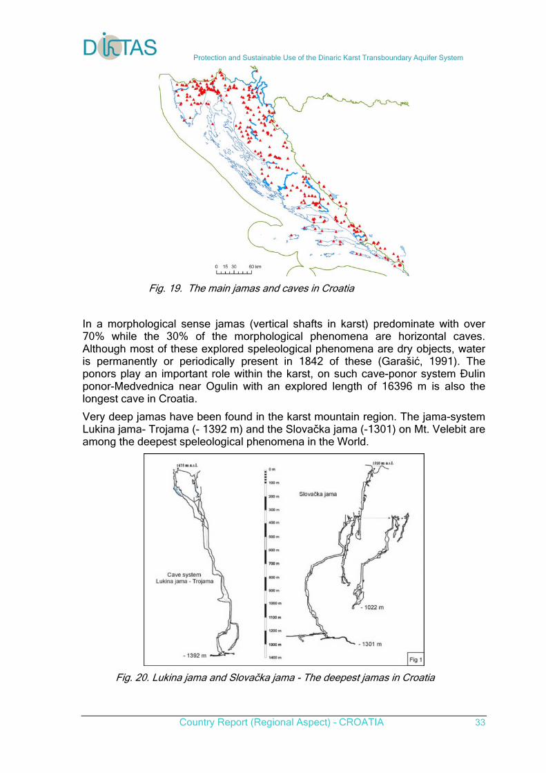
Protection and Sustainable Use of the Dinaric Karst Transboundary Aquifer System
Country Report (Regional Aspect) – CROATIA 33
Fig. 19. The main jamas and caves in Croatia
In a morphological sense jamas (vertical shafts in karst) predominate with over 70% while the 30% of the morphological phenomena are horizontal caves. Although most of these explored speleological phenomena are dry objects, water is permanently or periodically present in 1842 of these (Garašić, 1991). The ponors play an important role within the karst, on such cave-ponor system Ðulin ponor-Medvednica near Ogulin with an explored length of 16396 m is also the longest cave in Croatia.
Very deep jamas have been found in the karst mountain region. The jama-system Lukina jama- Trojama (- 1392 m) and the Slovačka jama (-1301) on Mt. Velebit are among the deepest speleological phenomena in the World.
Fig. 20. Lukina jama and Slovačka jama - The deepest jamas in Croatia
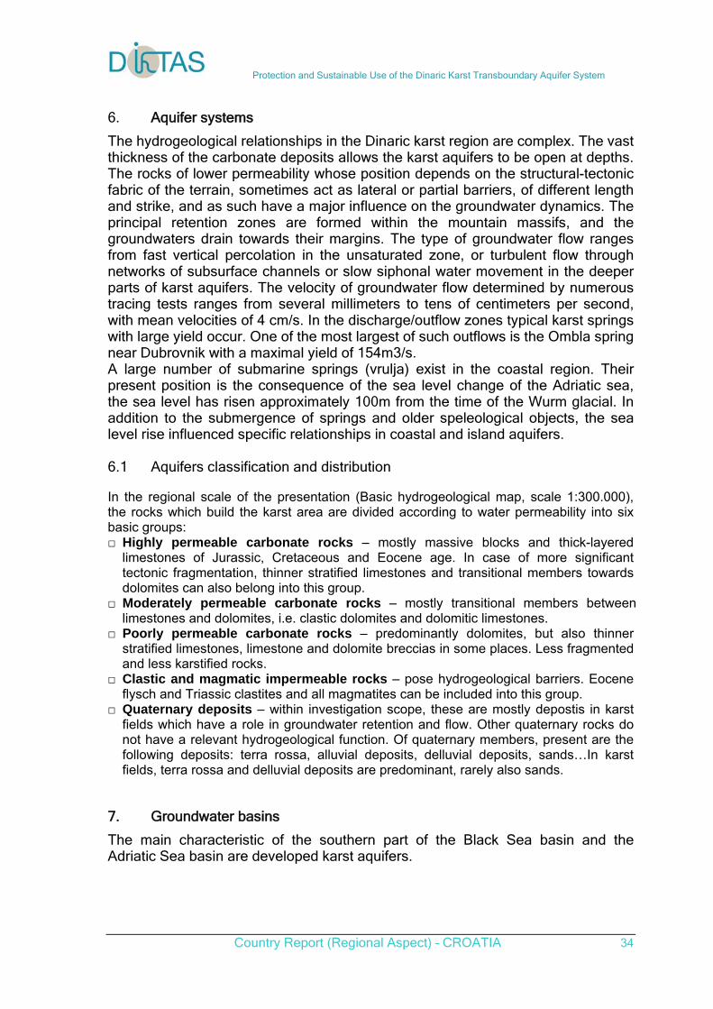
Protection and Sustainable Use of the Dinaric Karst Transboundary Aquifer System
Country Report (Regional Aspect) – CROATIA 34
6. Aquifer systems
The hydrogeological relationships in the Dinaric karst region are complex. The vast thickness of the carbonate deposits allows the karst aquifers to be open at depths. The rocks of lower permeability whose position depends on the structural-tectonic fabric of the terrain, sometimes act as lateral or partial barriers, of different length and strike, and as such have a major influence on the groundwater dynamics. The principal retention zones are formed within the mountain massifs, and the groundwaters drain towards their margins. The type of groundwater flow ranges from fast vertical percolation in the unsaturated zone, or turbulent flow through networks of subsurface channels or slow siphonal water movement in the deeper parts of karst aquifers. The velocity of groundwater flow determined by numerous tracing tests ranges from several millimeters to tens of centimeters per second, with mean velocities of 4 cm/s. In the discharge/outflow zones typical karst springs with large yield occur. One of the most largest of such outflows is the Ombla spring near Dubrovnik with a maximal yield of 154m3/s. A large number of submarine springs (vrulja) exist in the coastal region. Their present position is the consequence of the sea level change of the Adriatic sea, the sea level has risen approximately 100m from the time of the Wurm glacial. In addition to the submergence of springs and older speleological objects, the sea level rise influenced specific relationships in coastal and island aquifers. 6.1 Aquifers classification and distribution
In the regional scale of the presentation (Basic hydrogeological map, scale 1:300.000), the rocks which build the karst area are divided according to water permeability into six basic groups: □ Highly permeable carbonate rocks – mostly massive blocks and thick-layered
limestones of Jurassic, Cretaceous and Eocene age. In case of more significant tectonic fragmentation, thinner stratified limestones and transitional members towards dolomites can also belong into this group.
□ Moderately permeable carbonate rocks – mostly transitional members between limestones and dolomites, i.e. clastic dolomites and dolomitic limestones.
□ Poorly permeable carbonate rocks – predominantly dolomites, but also thinner stratified limestones, limestone and dolomite breccias in some places. Less fragmented and less karstified rocks.
□ Clastic and magmatic impermeable rocks – pose hydrogeological barriers. Eocene flysch and Triassic clastites and all magmatites can be included into this group.
□ Quaternary deposits – within investigation scope, these are mostly depostis in karst fields which have a role in groundwater retention and flow. Other quaternary rocks do not have a relevant hydrogeological function. Of quaternary members, present are the following deposits: terra rossa, alluvial deposits, delluvial deposits, sands…In karst fields, terra rossa and delluvial deposits are predominant, rarely also sands.
7. Groundwater basins
The main characteristic of the southern part of the Black Sea basin and the Adriatic Sea basin are developed karst aquifers.
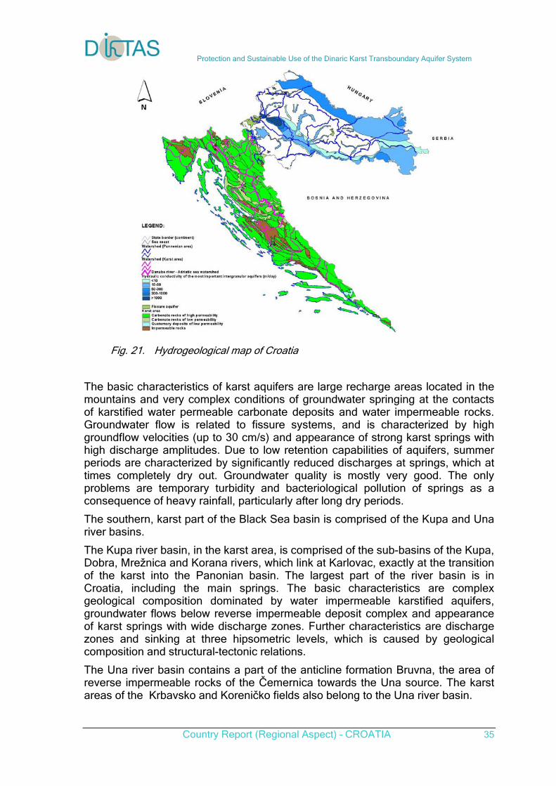
Protection and Sustainable Use of the Dinaric Karst Transboundary Aquifer System
Country Report (Regional Aspect) – CROATIA 35
Fig. 21. Hydrogeological map of Croatia
The basic characteristics of karst aquifers are large recharge areas located in the mountains and very complex conditions of groundwater springing at the contacts of karstified water permeable carbonate deposits and water impermeable rocks. Groundwater flow is related to fissure systems, and is characterized by high groundflow velocities (up to 30 cm/s) and appearance of strong karst springs with high discharge amplitudes. Due to low retention capabilities of aquifers, summer periods are characterized by significantly reduced discharges at springs, which at times completely dry out. Groundwater quality is mostly very good. The only problems are temporary turbidity and bacteriological pollution of springs as a consequence of heavy rainfall, particularly after long dry periods.
The southern, karst part of the Black Sea basin is comprised of the Kupa and Una river basins.
The Kupa river basin, in the karst area, is comprised of the sub-basins of the Kupa, Dobra, Mrežnica and Korana rivers, which link at Karlovac, exactly at the transition of the karst into the Panonian basin. The largest part of the river basin is in Croatia, including the main springs. The basic characteristics are complex geological composition dominated by water impermeable karstified aquifers, groundwater flows below reverse impermeable deposit complex and appearance of karst springs with wide discharge zones. Further characteristics are discharge zones and sinking at three hipsometric levels, which is caused by geological composition and structural-tectonic relations.
The Una river basin contains a part of the anticline formation Bruvna, the area of reverse impermeable rocks of the Čemernica towards the Una source. The karst areas of the Krbavsko and Koreničko fields also belong to the Una river basin.
Protection and Sustainable Use of the Dinaric Karst Transboundary Aquifer System
Country Report (Regional Aspect) – CROATIA 36
The Adriatic Sea basin can be generally divided into the Littoral-Istrian river basins and Dalmatian river basins.
In the area of the Littoral-Istrian river basins, the area of the Istrian peninsula forms, to a certain extent, a natural hydrogeological unit with several river basins, which drain towards the western or the eastern coast of the peninsula. The area of the Kvarner bay includes the karst area, which also drains towards the Tršćanski bay, while part of the waters flows towards the spring Sv. Ivan in Istria. The recharge areas of the springs in the town Rijeka, in the Bakar bay and in Novljanska Žrnovnica are formed in the carbonate massiff of the coastal slopes of Gorski kotar. The Gacka river basin covers the most part of the central mountains of Lika Sredogorje and Perušić, Vrhovinsko and Brinjsko karst fields, while the Lika river basin is formed on the northeastern side of the Velebit massiff, which, due to water impermeable deposits in the core, functions as a barrier.
Dalmatian river basins
The Zrmanja river basin in the area of Lika includes the sinking streams Obsenica, Ričica and Otuća, which, after a relatively short flow, sink in the Gračačko and Štikadsko fields. The reappearance of discharge zones of these waters is on the right bank of the Zrmanja river, downstream of Ervenik. The basin of Bokanjačko Blato and Nin has a wide discharge zone in the coastal area from Zadar towards Nin, and further towards Ljubački bay.
The Krka river basin spreads beyond the borders of the Republic of Croatia, towards Bosansko Grahovo. The cause of discharge of great groundwater quantities at the springs is due to the appearance of impermeable and poorly permeable dolomites and clastites in the area of Kinin.
The Cetina river basin covers the immediate drainage area of the river and the springs Jadro and Žrnovnica in the Split area. The major part of the river basin is in Bosnia-Hercegovina. The largest part of the recharge area is located on the left bank of the river towards Buško blato and the Livanjsko, Duvanjsko, Šuičko and Kupreško karst fields.
The main part of the Neretva river basin spreads deep into the territory of Bosnia-Herzegovina, while the river mouth (delta) and parts of the karst basin on the right and left banks of the river are located in Croatia. Naturally belonging to the river basin are also numerous coastal springs in the Dubrovnik coastal area, which are connected through the underground with the sinking zones of the Trebišnjica river. The recharge area of the springs on the right bank of the Neretva river is in the area of Dalmatinska zagora and in Herzegovina. For the water dynamics and multiple sinking and springing to surface, important characteristics are the appearance of water impermeable flysch rocks, whose shape is that of elongated lenses which spread into the predominatly highly permeable carbonate complex. The Imotsko field is the highest level of discharge in the river basin, followed by the Rastočko and Kokoričko field and also Vrgoračko field, down to the final discharges at the springs along the Baćinska lakes, the right bank of the Neretva and the area of Gradac in the coastal zone. On the Neretva left bank, there are carbonate rocks of the high karst, without the presence of flysch rocks. The first flysch barrier spreads along the coastal zone of the Dubrovnik area. The continuity of the barrier in the coastal zone is disrupted by erosion processes in several places, thus in the area of the Neretva river mouth towards Cavtat there appear numerous karst springs. This is how the largest karst spring of southern Croatia,
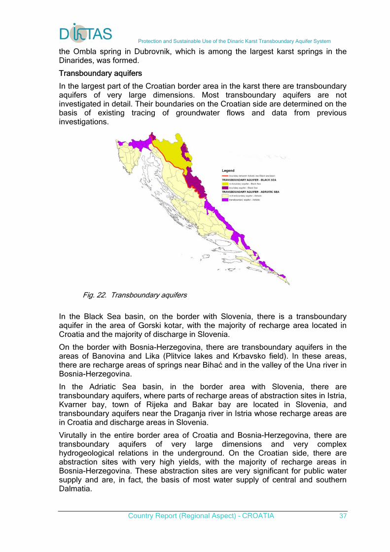
Protection and Sustainable Use of the Dinaric Karst Transboundary Aquifer System
Country Report (Regional Aspect) – CROATIA 37
the Ombla spring in Dubrovnik, which is among the largest karst springs in the Dinarides, was formed.
Transboundary aquifers
In the largest part of the Croatian border area in the karst there are transboundary aquifers of very large dimensions. Most transboundary aquifers are not investigated in detail. Their boundaries on the Croatian side are determined on the basis of existing tracing of groundwater flows and data from previous investigations.
Fig. 22. Transboundary aquifers
In the Black Sea basin, on the border with Slovenia, there is a transboundary aquifer in the area of Gorski kotar, with the majority of recharge area located in Croatia and the majority of discharge in Slovenia.
On the border with Bosnia-Herzegovina, there are transboundary aquifers in the areas of Banovina and Lika (Plitvice lakes and Krbavsko field). In these areas, there are recharge areas of springs near Bihać and in the valley of the Una river in Bosnia-Herzegovina.
In the Adriatic Sea basin, in the border area with Slovenia, there are transboundary aquifers, where parts of recharge areas of abstraction sites in Istria, Kvarner bay, town of Rijeka and Bakar bay are located in Slovenia, and transboundary aquifers near the Draganja river in Istria whose recharge areas are in Croatia and discharge areas in Slovenia.
Virutally in the entire border area of Croatia and Bosnia-Herzegovina, there are transboundary aquifers of very large dimensions and very complex hydrogeological relations in the underground. On the Croatian side, there are abstraction sites with very high yields, with the majority of recharge areas in Bosnia-Herzegovina. These abstraction sites are very significant for public water supply and are, in fact, the basis of most water supply of central and southern Dalmatia.

Protection and Sustainable Use of the Dinaric Karst Transboundary Aquifer System
Country Report (Regional Aspect) – CROATIA 38
7.1. Regional groundwater direction
7.1.1. Regional groundwater direction
The part of the karst area in the Dinaric range belongs to the Adriatic and a part to the Black Sea basin, i.e. a part of the karst area of the Dinaric range drains towards the Danube River, and a part drains through numerous shorter watercourses and directly through the underground into the Adriatic Sea. The water divide is related to geological forms of the anticline in the areas of Gorski Kotar and Lika, from where it crosses into the territory of the neighbouring Bosnia-Herzegovina.
Fig. 23. Regional groundwater flow direction
Genraly, groundwaters in the territory of Croatia flow in two directions:
- to the south in the Adriatic sea basin and - to the north in the Sava river basin (Black sea basin).
All grounwaters in the Adriatic sea basins generaly flow in direction from north to south. From springs, which drain karst masses in hinterland, in karst fields there are formed permanent or periodical surface streams on impermeable rocks of Tertiary age (e.g. Plovuća, Livanjsko polje). In accordance with this, these rivers can sink thru more swallow holes in its river bad or sink concentrate in sallow holes or swallow hole zones (e.g. Mušnica in Gatačko field).
7.1.2. Tracing test results
We have results of 199 tracing tests with 623 positive connections, carried out in the last 60 years. Knowledge at time, the materials and detection techniques available, as well as purpose of the particular test, result in different levels of the output data, that limited the possibilities and reach of the nowadays analyses.
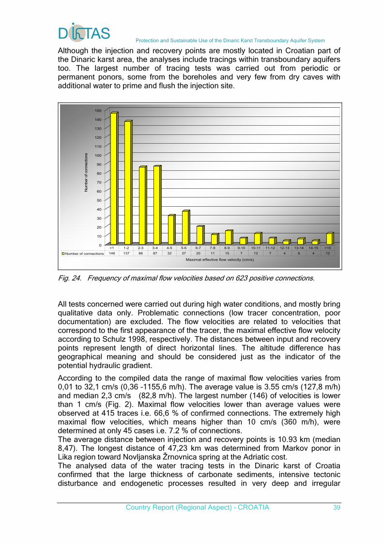
Protection and Sustainable Use of the Dinaric Karst Transboundary Aquifer System
Country Report (Regional Aspect) – CROATIA 39
Although the injection and recovery points are mostly located in Croatian part of the Dinaric karst area, the analyses include tracings within transboundary aquifers too. The largest number of tracing tests was carried out from periodic or permanent ponors, some from the boreholes and very few from dry caves with additional water to prime and flush the injection site.
0
10
20
30
40
50
60
70
80
90
100
110
120
130
140
150
Num
ber of
con
nect
ions
Maximal effective flow velocity (cm/s)
Number of connections 146 137 86 87 32 37 20 11 15 7 12 7 4 6 4 12
<1 1-2 2-3 3-4 4-5 5-6 6-7 7-8 8-9 9-10 10-11 11-12 12-13 13-14 14-15 >15
Fig. 24. Frequency of maximal flow velocities based on 623 positive connections. All tests concerned were carried out during high water conditions, and mostly bring qualitative data only. Problematic connections (low tracer concentration, poor documentation) are excluded. The flow velocities are related to velocities that correspond to the first appearance of the tracer, the maximal effective flow velocity according to Schulz 1998, respectively. The distances between input and recovery points represent length of direct horizontal lines. The altitude difference has geographical meaning and should be considered just as the indicator of the potential hydraulic gradient.
According to the compiled data the range of maximal flow velocities varies from 0,01 to 32,1 cm/s (0,36 –1155,6 m/h). The average value is 3.55 cm/s (127,8 m/h) and median 2,3 cm/s (82,8 m/h). The largest number (146) of velocities is lower than 1 cm/s (Fig. 2). Maximal flow velocities lower than average values were observed at 415 traces i.e. 66,6 % of confirmed connections. The extremely high maximal flow velocities, which means higher than 10 cm/s (360 m/h), were determined at only 45 cases i.e. 7.2 % of connections. The average distance between injection and recovery points is 10.93 km (median 8,47). The longest distance of 47,23 km was determined from Markov ponor in Lika region toward Novljanska Žrnovnica spring at the Adriatic cost. The analysed data of the water tracing tests in the Dinaric karst of Croatia confirmed that the large thickness of carbonate sediments, intensive tectonic disturbance and endogenetic processes resulted in very deep and irregular
Protection and Sustainable Use of the Dinaric Karst Transboundary Aquifer System
Country Report (Regional Aspect) – CROATIA 40
karstification, and complex hydrogeology of the area.
7.2. Grounwater bodies
Identification of groundwater bodies was carried out by application of the Geographical Information System based on the elements of natural systems. The following maps were used:
- Base geological map of the Republic of Croatia in scale 1:100,000 (Croatian Geological Survey)
- Hydrogeological map of the Republic of Croatia in scale 1:200,000 (Croatian Geological Survey)
- Base hydrogeological map of the Republic of Croatia in scale 1:200,000 (Croatian Geological Survey)
- Hydrogeological map of the Republic of Croatia in scale 1:300,000 (Biondic, B. et al., 1996)
- Water Management Master Plan of the Republic of Croatia – Chapter: Groundwater (Biondic, B. et al., 2001)
- Hydropedological map of the Republic of Croatia in scale 1:300,000 (Faculty of Agriculture, University of Zagreb)
- data on groundwater flow tracings (various reports)
- Hydrological analysis – assessment of more influential river basin areas on certain water gauging profiles
- Hydrogeochemical analysis – data on groundwater quality and genesis
In the first step was made basic identification and delineation of groundwater bodies according to EU Water Framework Directive and guides. In the karst area, in the Adriatic Sea basin 101 groundwater bodies were identified and 28 groundwaterbodies in the Black Sea basin. All the larger islands were identified as separate groundwater bodies.
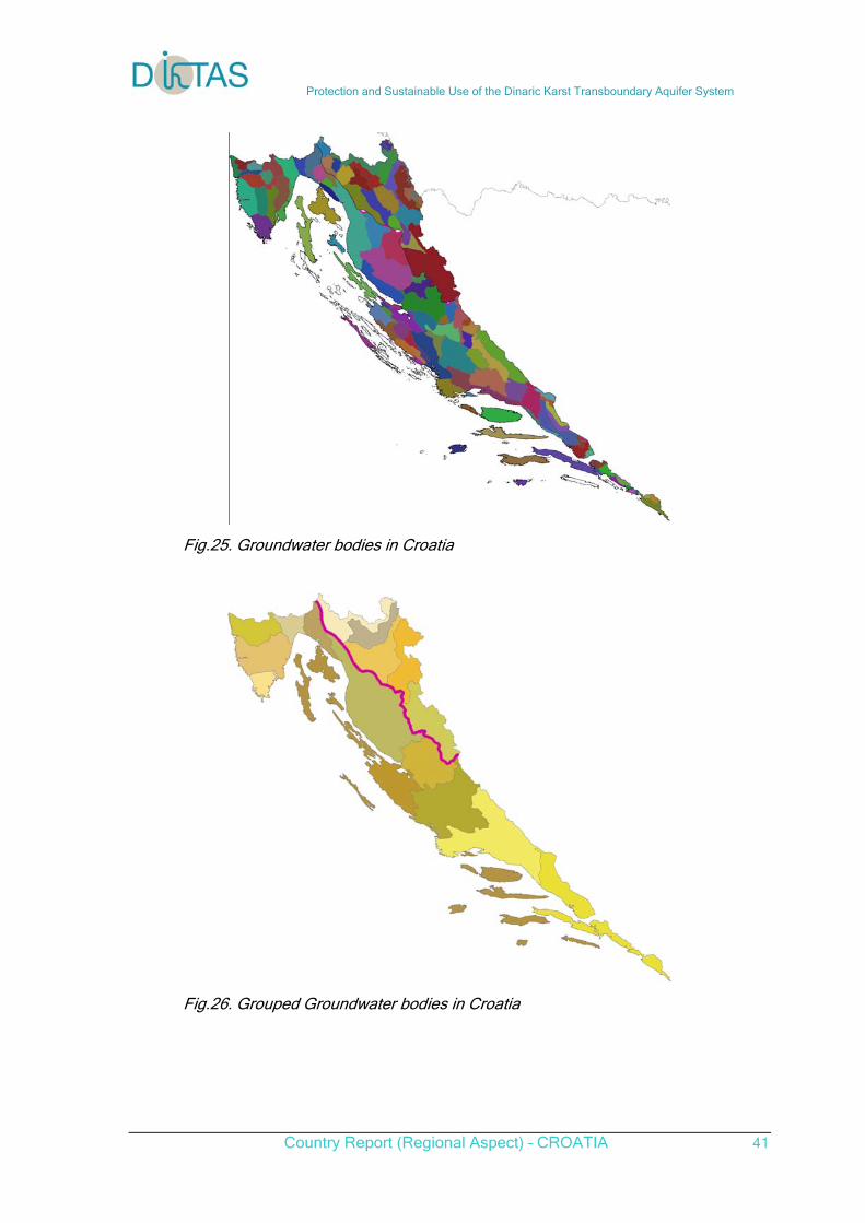
Protection and Sustainable Use of the Dinaric Karst Transboundary Aquifer System
Country Report (Regional Aspect) – CROATIA 41
Fig.25. Groundwater bodies in Croatia
Fig.26. Grouped Groundwater bodies in Croatia
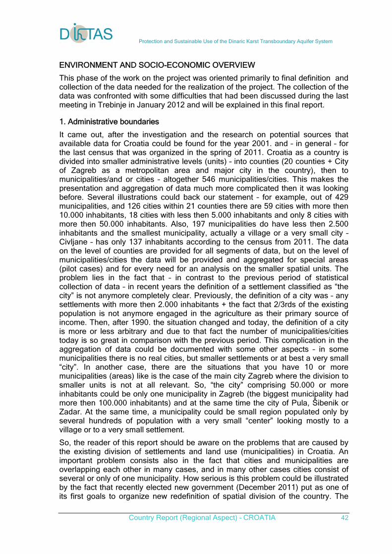
Protection and Sustainable Use of the Dinaric Karst Transboundary Aquifer System
Country Report (Regional Aspect) – CROATIA 42
ENVIRONMENT AND SOCIO-ECONOMIC OVERVIEW
This phase of the work on the project was oriented primarily to final definition and collection of the data needed for the realization of the project. The collection of the data was confronted with some difficulties that had been discussed during the last meeting in Trebinje in January 2012 and will be explained in this final report.
1. Administrative boundaries
It came out, after the investigation and the research on potential sources that available data for Croatia could be found for the year 2001. and – in general – for the last census that was organized in the spring of 2011. Croatia as a country is divided into smaller administrative levels (units) – into counties (20 counties + City of Zagreb as a metropolitan area and major city in the country), then to municipalities/and or cities – altogether 546 municipalities/cities. This makes the presentation and aggregation of data much more complicated then it was looking before. Several illustrations could back our statement – for example, out of 429 municipalities, and 126 cities within 21 counties there are 59 cities with more then 10.000 inhabitants, 18 cities with less then 5.000 inhabitants and only 8 cities with more then 50.000 inhabitants. Also, 197 municipalities do have less then 2.500 inhabitants and the smallest municipality, actually a village or a very small city – Civljane – has only 137 inhabitants according to the census from 2011. The data on the level of counties are provided for all segments of data, but on the level of municipalities/cities the data will be provided and aggregated for special areas (pilot cases) and for every need for an analysis on the smaller spatial units. The problem lies in the fact that – in contrast to the previous period of statistical collection of data – in recent years the definition of a settlement classified as “the city” is not anymore completely clear. Previously, the definition of a city was – any settlements with more then 2.000 inhabitants + the fact that 2/3rds of the existing population is not anymore engaged in the agriculture as their primary source of income. Then, after 1990. the situation changed and today, the definition of a city is more or less arbitrary and due to that fact the number of municipalities/cities today is so great in comparison with the previous period. This complication in the aggregation of data could be documented with some other aspects – in some municipalities there is no real cities, but smaller settlements or at best a very small “city”. In another case, there are the situations that you have 10 or more municipalities (areas) like is the case of the main city Zagreb where the division to smaller units is not at all relevant. So, “the city” comprising 50.000 or more inhabitants could be only one municipality in Zagreb (the biggest municipality had more then 100.000 inhabitants) and at the same time the city of Pula, Šibenik or Zadar. At the same time, a municipality could be small region populated only by several hundreds of population with a very small “center” looking mostly to a village or to a very small settlement.
So, the reader of this report should be aware on the problems that are caused by the existing division of settlements and land use (municipalities) in Croatia. An important problem consists also in the fact that cities and municipalities are overlapping each other in many cases, and in many other cases cities consist of several or only of one municipality. How serious is this problem could be illustrated by the fact that recently elected new government (December 2011) put as one of its first goals to organize new redefinition of spatial division of the country. The
Protection and Sustainable Use of the Dinaric Karst Transboundary Aquifer System
Country Report (Regional Aspect) – CROATIA 43
potential results of these efforts will be applied in our analysis as well if and when the new reorganization will take place eventually and will be officially accepted. Anyway, the data concerning the spatial and administrative division of the country are collected in this report and ready for further use with present division on counties and municipalities.
2. Population and demography
Till now, we established that, according to the census from 2001 the population of Croatia was ca 4,500.000 inhabitants, that demographic trends are stagnant and in certain areas even negative (islands, karstic areas, areas with very small villages, remote from smaller or bigger urban centers). Also, we established that migration of population usually follow the pattern towards urbanized, more developed areas, and from smaller, medium to greater urban centers. Many times the migratory population “overjump” the medium sized cities and settlements and move directly to the biggest cities (say, Zagreb) where the opportunities for job seekers, education and all what a contemporary bigger city possess exists. The data concerning the population are of an official nature – collected from the State Statistical Office of Croatia (www.dzs.hr) and are presented in three periods - years – when the census was organized - 1991, 2001, and 2011 year.
Also, we found out that the total area of the country covers 87.609 sq. km, and out of it 56.538 sq. km. represents the mainland, and 31.071 coastal (sea) areas. Also, as we mentioned earlier, the country is divided in 20 counties + City of Zagreb as the biggest city in the country with 828.621 inhabitants (2011). The city of Zagreb is also the place where the government, all administration, etc. is located. In Croatia, apart from many smaller settlements, there are several medium sized cities like Rijeka (ca 200.000 inhabitants), Split (ca 300.000), Osijek (ca 110.000), Pula (60.000), Zadar (70.000), Šibenik (60.000), Dubrovnik (45.000) as well as many smaller towns and settlements in the range of 10.000-30.000 inhabitants. Apart from that, the structure of population is dispersed in smaller settlements and villages. The smallest and the most dependent ones are on the mountainous regions of the country, populated usually with older population, mostly older women (senilization and feminization processes are taking its price). An especial problem relates to the general decrease of the population on the islands – in Croatia there are more then 1.000 smaller and bigger islands, not all of them populated. Only greater islands, closer to the mainland are somehow viable, and more remote ones are dependent on small scale fishing, tourism, and agriculture (olives, grapes, figs) - usually it is a combination of these three activities. Also, as we mention earlier, there are altogether 546 cities and municipalities in the country as a whole. For the purpose of the realization of the DIKTAS project whenever it will needed and possible, the data concerning the population and land use will be provided on the smallest land use units – municipalities or settlements (“cities” and villages).
3. Tourism
We also established that usual number of tourists varies in the range 3-4 millions per year (number of visitors and/or nights spent in beds in hotels and registered accommodation places – camping sites, for example) and that year of 2011 seems to be very rich in the number of visits – some projections are calculating on the 5-6 million visitors this year, mostly at the Adriatic area. This figure will be a great
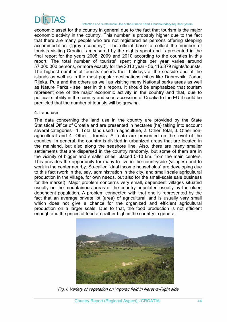
Protection and Sustainable Use of the Dinaric Karst Transboundary Aquifer System
Country Report (Regional Aspect) – CROATIA 44
economic asset for the country in general due to the fact that tourism is the major economic activity in the country. This number is probably higher due to the fact that there are many people who are not registered as persons offering sleeping accommodation (“grey economy”). The official base to collect the number of tourists visiting Croatia is measured by the nights spent and is presented in the final report for the years 2008, 2009 and 2010 according to the counties in this report. The total number of tourists’ spent nights per year varies around 57,000.000 persons, or more exactly for the 2010 year – 56,416.379 nights/tourists. The highest number of tourists spends their holidays at the seaside and at the islands as well as in the most popular destinations (cities like Dubrovnik, Zadar, Rijeka, Pula and the others as well as visiting many National parks areas as well as Nature Parks – see later in this report). It should be emphasized that tourism represent one of the major economic activity in the country and that, due to political stability in the country and soon accession of Croatia to the EU it could be predicted that the number of tourists will be growing.
4. Land use
The data concerning the land use in the country are provided by the State Statistical Office of Croatia and are presented in hectares (ha) taking into account several categories – 1. Total land used in agriculture, 2. Other, total, 3. Other non-agricultural and 4. Other – forests. All data are presented on the level of the counties. In general, the country is divided in urbanized areas that are located in the mainland, but also along the seashore line. Also, there are many smaller settlements that are dispersed in the country randomly, but some of them are in the vicinity of bigger and smaller cities, placed 5-10 km. from the main centers. This provides the opportunity for many to live in the countryside (villages) and to work in the center nearby. So-called “dual income households” are developing due to this fact (work in the, say, administration in the city, and small scale agricultural production in the village, for own needs, but also for the small-scale sale business for the market). Major problem concerns very small, dependent villages situated usually on the mountainous areas of the country populated usually by the older, dependent population. A problem connected with that one is represented by the fact that an average private lot (area) of agricultural land is usually very small which does not give a chance for the organized and efficient agricultural production on a larger scale. Due to that, the food production is not efficient enough and the prices of food are rather high in the country in general.
Fig.1. Variety of vegetation on Vrgorac field in Neretva-Right side
Protection and Sustainable Use of the Dinaric Karst Transboundary Aquifer System
Country Report (Regional Aspect) – CROATIA 45
5. Sources of income
Analyzing the existing data provided by the Statistical office for the year 2008 resulted in the adaptation of several categories used in the official statistics. We will provide the results for the Zagreb County- as an illustration, and other data are sorted on the level of the counties.
Zagreb County:
1. income from the agriculture – 6.3%
2. income from the quarrying and mining, electricity, gas, water supply – 25.8%
3. construction – 11.0%
4. wholesale and retail trade, etc. – 17.3%
5. hotels and restaurants – 2.4%
6. transport, storage and communication- 10.0%
7. financial intermediation, real estate, renting etc. – 16.3%
8. public administration and defense, social security, education, social work,
other community, social and personal services, households’ activities – 11.0%
These figures differ according to the level of development of each region – county in the country. For example, for the city of Zagreb, the percentage of agriculture, hunting, forestry and fishing is only 0.2%, and in the Virovitica county, mostly agricultural region, this ratio is 27.1%, but financial intermediation for the city of Zagreb is 17.8%. So, it is obvious that the ratios of different economic activities rely on the existing land use, history of activities as well as on other, situational and contextual as well as natural factors.
Some problems that we mentioned earlier that are connected with “dual incomes” incomes (say, administrative job and agriculture, or tourism) will not be possible to be presented precisely in this report due to the lack of data caused by the lack of evidence due to the fact that many “grey jobs” are not registered in any way. Apart from the State Statistical Office (www.dzs.hr), many data could be found on the web pages of each county. Unfortunately, not all data for the counties are adjusted to the newest data as well as not all the counties do have Management Developmental Plans where these kinds of data are usually presented. Each developmental plan of each county in Croatia do not follow a certain “general plan of development of the country” which makes these plans sometimes “a list of wishes” and not a realistic base for the development of managerial and strategical development plans that are relying on the existing resources. So these are major problems in the compilation of the collected and presented data for this sector.
6. Agriculture
The data concerning agriculture in Croatia are taken from the State Statistical Office and they follow the official categories presented in the statistics on the level of the counties. We will give the example of the Zagreb County concerning these data:
Protection and Sustainable Use of the Dinaric Karst Transboundary Aquifer System
Country Report (Regional Aspect) – CROATIA 46
Zagreb County-agriculture:
1. Total number of grape plants in ‘000 – 9236
2. total number of cattle – 45.965
3. total number of pigs – 160.490
4. total number of sheep – 13.120
5. total number of goats – 9199
6. Total number of horses – 931.
Apart from these categories, we collected the data concerning the agricultural households using different chemicals in their agriculture. Again, we’ll provide the example of the Zagreb County.
Zagreb County-the number of the households using some chemicals:
1. Using protraction products – 25.462
2. Using herbicides – 20.251
3. Using insecticides – 9797
4. Using mineral fertilizations – 24.466
5. Using organic fertilizations – 21.862
6. With irrigated area – 184
7. in preparation for ecological agriculture – 218.
As it can be seen from this illustrative data for the Zagreb County, this county is still “a mixture” of urbanized and non-urbanized areas where people live out of the agriculture. To document this, we’ll provide also the data concerning the households in the Zagreb County area:
Zagreb county – total number of households by categories:
1. with used agricultural land – 37.297
2. with arable land and gardens – 28.346
3. with vegetable gardens – 21.438
4. with meadows – 18.863
5. with grassland – 1651
6. with orchards – 23.963
7. with rough agricultural area – 8.486
8. with forests – 19.544
7. Roads
Official classification of the roads in Croatia, following the principles of the State Statistical Office makes several types of classification. The first differentiates main
Protection and Sustainable Use of the Dinaric Karst Transboundary Aquifer System
Country Report (Regional Aspect) – CROATIA 47
roads and secondary roads. Other classification differentiates between the 1. State roads, 2. County roads and 3. Local roads. This classification is used in the development plans of all counties and is also presented in the official statistical data. It came out, after careful overview of the categories that for some counties there were no exact data. In general, the state roads are second major types of roads, and municipality roads are the biggest category in all municipalities and counties and local roads are, taking into consideration overall length of this kind of roads rather close to the second category. In this sense, highways, which had been built especially during the last 15 years (Zagreb-Rijeka, Zagreb-Split – to be continued to Dubrovnik soon, Zagreb-Varaždin, Zagreb - Osijek, and Slavonski Brod till the border with Serbia, etc.) and “semi-highways” could be included in the 1st category (state roads) while any kind of secondary roads belong to the second category (municipality roads).
8. Industries
It came out that there were no existing basis of collected data for industries of all kinds that exist in the Republic of Croatia. Taking into account county development plans as a source of the data it is visible that in many cases these data are missing. It also should be mentioned that the statistics collects the data on “business subjects” together with “industrial enterprises” which makes a mess in any effort to make a reasonable classification of industries in Croatia.
It should be mentioned also that main industries that are of interest for the DIKTAS project are shipbuilding industries that are located in the major cities along the coastline – in Pula, Rijeka, Zadar, Šibenik, Split and at some islands – Ugljan, Mali Lošinj and the like. Many shipyards are not in the best shape taking into account their efficiency, but they are subsidized by the state in many cases.
It should be also mentioned that the process of de-industrialization is taking place too in many areas in the country due to the process of privatization, due to the fact that many industries in the former state of Yugoslavia had not been efficient enough and from the remaining industrial capacities including shipbuilding strong environmental control of all industries have been introduced. In Croatia, at the moment, there are 2 major cement industries (in Split and in Istria), several oil refineries (Rijeka, Sisak, the Island of Krk), one major factory producing artificial fertilizations in Kutina, food production factory in Koprivnica and many smaller industries scattered in the space of the country.
9. Mining sites
Concerning the data on mining sites, they have been collected using the data provided by the study made at the Geological Faculty at the University of Zagreb. There is an abundance of different kinds of “mining sites” including the ones that deal with ceramics and clay, the ones dealing with architectural-construction stone, technical construction stoner, construction sand and gravel, brick clay, hydrocarbons and geothermal water, bentonit clay, barite, flint sand, tufa, raw carbon for industrial processing, bauxite, barite talcum, gypsum, sea salt, etc. Traditionally, coal had been the major mining site in many areas in Croatia, especially in Istria, but now, almost all of the mining sites of that kind had been closed due to their inefficiency. As it is clear from the presented data and classifications, most of the “mining sites” belong to the category of different kinds
Protection and Sustainable Use of the Dinaric Karst Transboundary Aquifer System
Country Report (Regional Aspect) – CROATIA 48
of quarries. For the purpose of the DIKTAS project, several, major mining sites especially the ones close or on the pilot sites will be thoroughly selected and inspected in the course of further realization of the project.
10. Solid waste disposal
There are no complete statistics concerning the issues of solid waste in the country. The data are accessible on the web pages of the Agency that deals with the registration of solid waste sites (www.azo.hr) where a GIS data could be found as well. For example, in the Zagreb County there are 9 dumpsites, not regulated according to the prescribed normatives and in the area of the City of Zagreb, there are only 3 waste disposal sites, one of them being regulated and closed, and two, non regulated according to the standards but operating in the vicinity of the city. Similar situation could be found in the vicinity of all major cities in Croatia and around the smaller towns and settlement (on the edges) where mostly household’s garbage is being disposed. But, in most of the cases description of the solid waste disposal location as well as their substance, materials dumped, processing techniques, management of the waste etc. are not accessible to the general public. In the development county plans of development the locations of waste disposal solid waste locations are only mentioned and classified as satisfying, unregulated and illegal. That – in other words – tells that most of the solid waste disposal places (dumpsites) are not properly regulated and managed. So, when someone looks for the detailed information concerning the dumpsites in the country or at the level of counties he will be confronted with the sentence – “no data available” for the kind of waste as well for the classification of the potential pollutants. It is obvious that the majority of the dumpsites are locate din the vicinity of major or medium sized cities. Altogether, there are cca 250 solid waste dumpsites where only a few are regulated and built to the expected sanitary standards. For the purpose of the realization of the DIKTAS project, especial attention will be given to the ones in the vicinity of major cities, close or within the selected pilot cases of close to the karstic caves or areas.
The process of establishing, organizing and building of regional (on a county level) regulated land fields are in progress for the several past years. We might say, that in major cities the situation is under control, even not in all cities, in national parks, other protected areas, but major problems exist in smaller settlements and areas that do not have a proper systems of organized collection of communal garbage, proper placement of industrial supplies etc.
11. Wastewater treatment
Our findings have shown that in the country, as a whole, exist two major types of the collection and disposal of sewerage systems. One, centralized is organized and existing in major cities, and other, using septic tanks – completely closed or semi closed (the second part of the tank is usually in its part open and wastewater goes directly into the soil), exist in many areas, in smaller settlements, even in smaller sized cities (some areas), along the coastline, in weekend settlements, etc. This represents probably a major danger for the quality of water, sea as well as of the groundwater. Purification of sewerage waters – in general – is rather low, mostly mechanical, and biological much less (to be expected). Preliminary data show that in the settlements with more then 10.000 inhabitants 75-80% of the housing and other units are connected to the centralized sewerage system, and in the
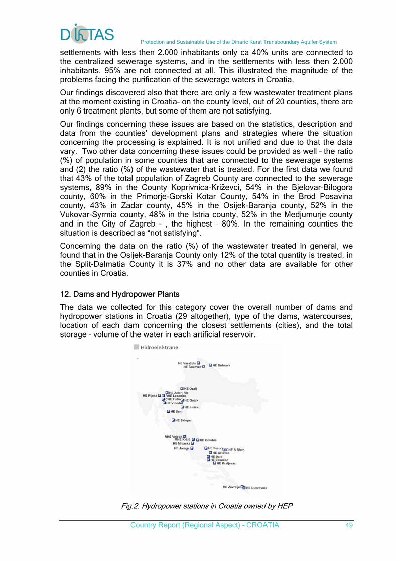
Protection and Sustainable Use of the Dinaric Karst Transboundary Aquifer System
Country Report (Regional Aspect) – CROATIA 49
settlements with less then 2.000 inhabitants only ca 40% units are connected to the centralized sewerage systems, and in the settlements with less then 2.000 inhabitants, 95% are not connected at all. This illustrated the magnitude of the problems facing the purification of the sewerage waters in Croatia.
Our findings discovered also that there are only a few wastewater treatment plans at the moment existing in Croatia- on the county level, out of 20 counties, there are only 6 treatment plants, but some of them are not satisfying.
Our findings concerning these issues are based on the statistics, description and data from the counties’ development plans and strategies where the situation concerning the processing is explained. It is not unified and due to that the data vary. Two other data concerning these issues could be provided as well – the ratio (%) of population in some counties that are connected to the sewerage systems and (2) the ratio (%) of the wastewater that is treated. For the first data we found that 43% of the total population of Zagreb County are connected to the sewerage systems, 89% in the County Koprivnica-Križevci, 54% in the Bjelovar-Bilogora county, 60% in the Primorje-Gorski Kotar County, 54% in the Brod Posavina county, 43% in Zadar county, 45% in the Osijek-Baranja county, 52% in the Vukovar-Syrmia county, 48% in the Istria county, 52% in the Medjumurje county and in the City of Zagreb - , the highest – 80%. In the remaining counties the situation is described as “not satisfying”.
Concerning the data on the ratio (%) of the wastewater treated in general, we found that in the Osijek-Baranja County only 12% of the total quantity is treated, in the Split-Dalmatia County it is 37% and no other data are available for other counties in Croatia.
12. Dams and Hydropower Plants
The data we collected for this category cover the overall number of dams and hydropower stations in Croatia (29 altogether), type of the dams, watercourses, location of each dam concerning the closest settlements (cities), and the total storage – volume of the water in each artificial reservoir.
Fig.2. Hydropower stations in Croatia owned by HEP
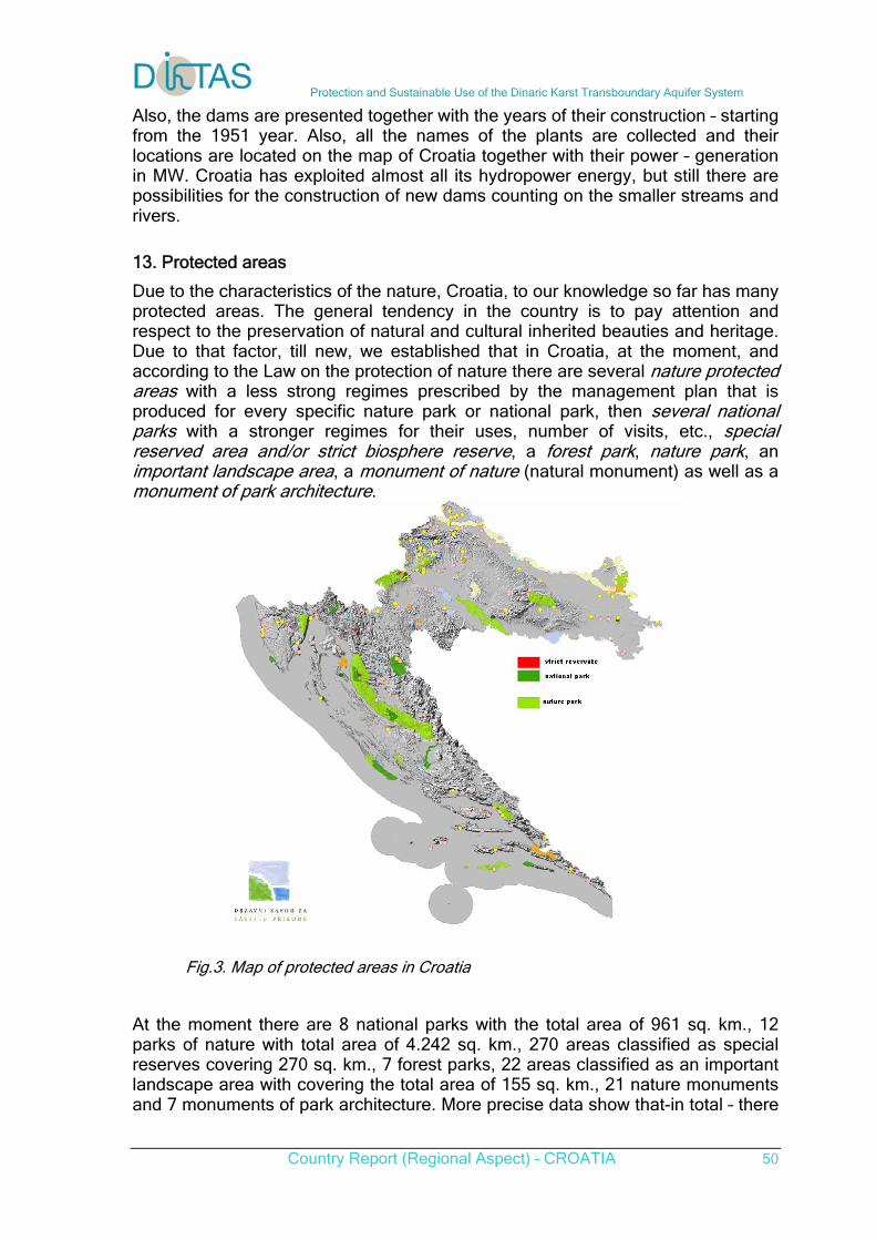
Protection and Sustainable Use of the Dinaric Karst Transboundary Aquifer System
Country Report (Regional Aspect) – CROATIA 50
Also, the dams are presented together with the years of their construction – starting from the 1951 year. Also, all the names of the plants are collected and their locations are located on the map of Croatia together with their power – generation in MW. Croatia has exploited almost all its hydropower energy, but still there are possibilities for the construction of new dams counting on the smaller streams and rivers.
13. Protected areas
Due to the characteristics of the nature, Croatia, to our knowledge so far has many protected areas. The general tendency in the country is to pay attention and respect to the preservation of natural and cultural inherited beauties and heritage. Due to that factor, till new, we established that in Croatia, at the moment, and according to the Law on the protection of nature there are several nature protected areas with a less strong regimes prescribed by the management plan that is produced for every specific nature park or national park, then several national parks with a stronger regimes for their uses, number of visits, etc., special reserved area and/or strict biosphere reserve, a forest park, nature park, an important landscape area, a monument of nature (natural monument) as well as a monument of park architecture.
Fig.3. Map of protected areas in Croatia
At the moment there are 8 national parks with the total area of 961 sq. km., 12 parks of nature with total area of 4.242 sq. km., 270 areas classified as special reserves covering 270 sq. km., 7 forest parks, 22 areas classified as an important landscape area with covering the total area of 155 sq. km., 21 nature monuments and 7 monuments of park architecture. More precise data show that-in total – there
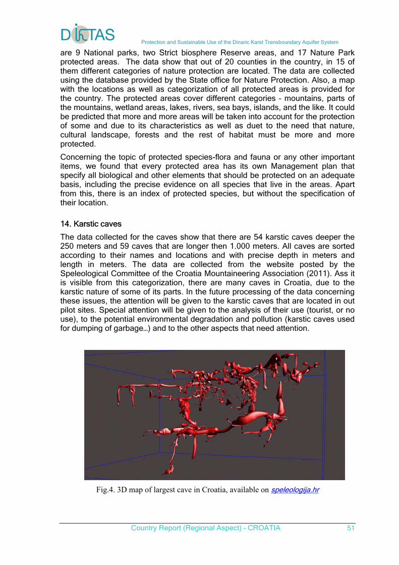
Protection and Sustainable Use of the Dinaric Karst Transboundary Aquifer System
Country Report (Regional Aspect) – CROATIA 51
are 9 National parks, two Strict biosphere Reserve areas, and 17 Nature Park protected areas. The data show that out of 20 counties in the country, in 15 of them different categories of nature protection are located. The data are collected using the database provided by the State office for Nature Protection. Also, a map with the locations as well as categorization of all protected areas is provided for the country. The protected areas cover different categories – mountains, parts of the mountains, wetland areas, lakes, rivers, sea bays, islands, and the like. It could be predicted that more and more areas will be taken into account for the protection of some and due to its characteristics as well as duet to the need that nature, cultural landscape, forests and the rest of habitat must be more and more protected.
Concerning the topic of protected species-flora and fauna or any other important items, we found that every protected area has its own Management plan that specify all biological and other elements that should be protected on an adequate basis, including the precise evidence on all species that live in the areas. Apart from this, there is an index of protected species, but without the specification of their location.
14. Karstic caves
The data collected for the caves show that there are 54 karstic caves deeper the 250 meters and 59 caves that are longer then 1.000 meters. All caves are sorted according to their names and locations and with precise depth in meters and length in meters. The data are collected from the website posted by the Speleological Committee of the Croatia Mountaineering Association (2011). Ass it is visible from this categorization, there are many caves in Croatia, due to the karstic nature of some of its parts. In the future processing of the data concerning these issues, the attention will be given to the karstic caves that are located in out pilot sites. Special attention will be given to the analysis of their use (tourist, or no use), to the potential environmental degradation and pollution (karstic caves used for dumping of garbage…) and to the other aspects that need attention.
Fig.4. 3D map of largest cave in Croatia, available on speleologija.hr
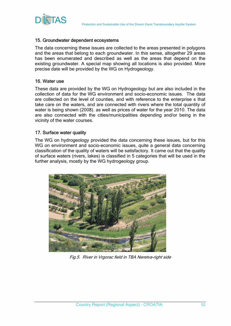
Protection and Sustainable Use of the Dinaric Karst Transboundary Aquifer System
Country Report (Regional Aspect) – CROATIA 52
15. Groundwater dependent ecosystems
The data concerning these issues are collected to the areas presented in polygons and the areas that belong to each groundwater. In this sense, altogether 29 areas has been enumerated and described as well as the areas that depend on the existing groundwater. A special map showing all locations is also provided. More precise date will be provided by the WG on Hydrogeology.
16. Water use
These data are provided by the WG on Hydrogeology but are also included in the collection of data for the WG environment and socio-economic issues. The data are collected on the level of counties, and with reference to the enterprise s that take care on the waters, and are connected with rivers where the total quantity of water is being shown (2008). as well as prices of water for the year 2010. The data are also connected with the cities/municipalities depending and/or being in the vicinity of the water courses.
17. Surface water quality
The WG on hydrogeology provided the data concerning these issues, but for this WG on environment and socio-economic issues, quite a general data concerning classification of the quality of waters will be satisfactory. It came out that the quality of surface waters (rivers, lakes) is classified in 5 categories that will be used in the further analysis, mostly by the WG hydrogeology group.
Fig.5. River in Vrgorac field in TBA Neretva-right side
Protection and Sustainable Use of the Dinaric Karst Transboundary Aquifer System
Country Report (Regional Aspect) – CROATIA 53
LEGAL AND INSTITUTIONAL FRAMEWORK AND POLICY
1. Introduction This report summarizes legal and institutional framework and policy part of the Croatian national report. It contains the following:
1) Updated report on legal, institutional and policy framework in Croatia. 2) Filled questionnaire on the current status of the implementation of EU
directives into national legislation, including instruments and mechanisms for implementing measures for the protection of quantitative and qualitative status of groundwater, particularly in transboundary aquifers.
3) National SWOT analysis on management, use and protection of water, particularly groundwater.
2. Updated report on legal, institutional and policy framework in Croatia
2.1. National Legal and Regulatory Setting (Water Policy, Water Law and Institutions) 2.1.1. Overview on institutions involved in water resources management
Duly authorized and responsible holders of the activities for passing laws and organizing the maintenance and control of water systems in the Republic of Croatia are the following: Croatian Parliament, National Water Council, the Government of the Republic of Croatia, Ministry of Regional Development, Forestry and Water Management (new Ministry of Agriculture) and other bodies of national administration, local and regional self-government units and Croatian Waters as a legal entity for water management.
The Ministry of Regional Development, Forestry and Water Management (new Ministry of Agriculture) and Croatian Waters as a national water agency are directly responsible for water management in Croatia. The Ministry of Regional Development, Forestry and Water Management (new Ministry of Agriculture) – the Water Management Directorate is particularly responsible for the following: incorporating water resources management and development into overall
economic development framework; participating in creating the water management plan bases; administrative and other issues related to integrated management of water
resources and water management systems; providing water resources for the purpose of supplying the settlements with
drinking water and the economies with water; protection of drinking water sources and the sea from land-based pollution
sources; planning and coordinating development and construction of large water
supply and wastewater collection and treatment systems; monitoring of surface waters and groundwater;
Protection and Sustainable Use of the Dinaric Karst Transboundary Aquifer System
Country Report (Regional Aspect) – CROATIA 54
water power utilization, planning and adjustment of the development and building of public water supply systems and public sewerage systems;
hydro-melioration drainage and soil irrigation coordination of carrying out the National Irrigation Plan and Management of
Agricultural Land and Waters assignment of the concessions for water use; carrying out the control of charge payments according to the Water Act and
Water Management Financing Act; carrying out the inspection surveillance on performing the activities which
have or may have the influence to the state of waters and hydro-constructions and systems, for the protection from the adverse effect of waters and protection of water from pollution, and collaboration and carrying out of coordinated inspection surveillance and other activities with other bodies of state administration.
Ministry of Regional Development, Forestry and Water Management (new Ministry of Agriculture) – Directorate of Water Policy and International Projects is also responsible for: defining the national policy in water management and coordination of such
policy with the policies of other sectors, and the policy of economic development of the Republic of Croatia, respectively;
coordination and making the water management plan basis; organization and carrying out the adjustment of water legislation to the
Community Acquis in the field of water management; coordination of the process of accessing the European Union in the field of
water economy; organization and carrying out professional training and improvement in
water management also for the process of accessing the European Union; providing the conclusion and carrying out of international contracts and
agreements and other international acts from the field of water economy; preparation of plans and programmes used as a basis for using
international funds for projects on water management; financing the projects from international funding sources; preparation and coordination of the projects from pre-accession
programmes and structural instruments of the European Union. Besides the Ministry of Regional Development, Forestry and Water Management (new Ministry of Agriculture), some jobs have been put under the jurisdiction of other state administrative bodies, such as: the Ministry of Environmental Protection, Physical Planning and Construction (new Ministry of Environmental and Nature Protection), the Ministry of the Maritime affairs, Transport and Infrastructure, the Ministry of Agriculture, Fisheries and Rural Development (new Ministry of Agriculture), the Ministry of Health and Social Welfare (new Ministry of Health) and the Ministry of Finance.
The units of local and regional self-government have competences and liabilities associated with water issues within their field of action.
Croatian Waters, as a national water agency, acts on the whole territory of the Republic of Croatia and covers all water and basin areas. Croatian Waters has overall responsibility for: preparation of the grounds for creating the water policy,
Protection and Sustainable Use of the Dinaric Karst Transboundary Aquifer System
Country Report (Regional Aspect) – CROATIA 55
preparation of programmes, plans and other acts which make the grounds for providing enough quantities of adequate water for different assignments, water protection from pollution, regulation of watercourses and other waters and protection from the adverse effects of water.
investment and other jobs by which the programmes and plans are carried out,
taking measures by which rational use of water, water protection and protection from flood and other adverse effects of water are ensured.
A full list of responsibilities of the Croatian Waters is prescribed by the new Water Act (article 186).
By the new Water Act a Council for water services has been established to ensure the legality of the pricing of water services under this Act, fees for the development and connection fees from the law governing the financing of water management.
In the Water Management Strategy the need for establishing a scientific-professional institution is determined. Such institution would carry out scientific-professional jobs and serve as a technical-professional support to present state institutions in carrying out the provisions from the Water Act and other relevant enactments. The new Water Act also anticipates that the Government of the Republic of Croatia, in accordance with special regulations on science, may establish scientific institution in the field of water to provide scientific support for water management in accordance with the Water Management Strategy, provisions of this Act and laws governing the financing of water management.
In support of harmonization of the European and Croatian legislation the Republic of Croatia has been given funds on a grant basis from CARDS and LIFE programmes, which were primarily used for strengthening the administrative capacities for the needs of making water basin district management plans, for the needs of transposition of the legal EU Acquis to Croatian water legislation and for the needs of the development of an Information Water System.
In the frame of the CARDS 2004 project – Capacity Building and Development of Guidelines for the Implementation of the WFD, which lasted from September 2007 until September 2009, the strengthening of institutional and administrative capacities for implementing the Water Framework Directive was carried out. It was a twinning project, carried out in collaboration with the German federal Ministry of Environment, Protection of Nature and Nuclear Security and the Holland Government Bureau for Land and Water Management. In carrying out this project, besides the Ministry of Regional Development, Forestry and Water Management (new Ministry of Agriculture), Croatian Waters also participated.
2.1.2. Overview on legal and regulatory frameworks for water and particularly groundwater
The concept of management and water protection in Croatia is determined by the Water Management Strategy, a long-term planning document which sets out the vision, mission, goals and tasks of state policy in water management. The preamble of the Strategy states that is a framework for the preparation of strategies and plans of physical planning, environmental protection, nature protection and development of other sectors that depend on water or affect water.

Protection and Sustainable Use of the Dinaric Karst Transboundary Aquifer System
Country Report (Regional Aspect) – CROATIA 56
Croatian principles for water policy have their strongholds in the Water Act enacted in 1995. Amendments to this Act and Water Management Financing Act in the year of 2005 made a partial legal transposition of European water directives, primarily the WFD. Although it was already transposed into Croatian legislation nearly 50% of the provisions and requirements form the WFD (in accordance with the assessment procedure of the European Commission) legal transposition was not fully implemented, because on the one hand was necessary to partially modify the legal system of water management, on the other hand certain issues covered by the directive should have been transposed in by-lows, pursuant to the provisions of the Water Act. In December 2009 a new Water Act and Water Management Financing Act have been enacted as well as whole series of bylaws (in 2010), which regulate specific areas of water management, in accordance with the requirements of the European water directives.
The new Water Act regulates the legal status of waters and water estate, the way and conditions of the water quality and quantity management, protection from flooding, a detailed land-improvement drainage and irrigation, activities of the public water supply and public sewage system, special activities for water management, institutional structure to carry out such activities and other issues related to water and water estate.
The new Water Act is applied to all surface and land groundwaters, coastal waters concerning their chemical and ecological status, waters of territorial sea concerning their chemical status and in relation to the drinking water resources, mineral and thermal waters, except for mineral and geothermal waters from which mineral resources can be gained or accumulated heat for energy purposes can be used.
According to the Water Act, water is a common good, which due to its natural properties can be in nobody’s ownership. The right to abstract water for using it for various purposes is gained by concession.
Concessions are not necessary (for the Republic of Croatia, local and territorial (regional) government or legal entity, for which the Republic of Croatia or local and territorial (regional) government is the majority shareholder or founder–dominated decision making) for: water use for public service (public irrigation, detailed melioration drainage and public water supply and public sewerage services) or for the abstraction intended for human consumption in its original form in a quantity greater than three and a half million cubic meters a year to its sales in the markets of other countries. In these cases, the water rights permits for water use are issued.
A further exception is the right of general use of water, which means that everybody is allowed, pursuant to the rules, to use water in a common way, which does not exclude others from the same use.
According to the Water Act the use of water for water supply of population for drinking and sanitary needs, for the needs of fire protection and defence has an advantage comparing to the use of water for other purposes.
Financing of water management is regulated by the Water Management Financing Act.
The protection of waters is based on:
Provisions of the Water Act,
Protection and Sustainable Use of the Dinaric Karst Transboundary Aquifer System
Country Report (Regional Aspect) – CROATIA 57
River Basin management plan for Danube river basin district and Adriatic basin district,
State plan of measures in case of exceptional and sudden water pollution, Regulations from the field of protection of waters from pollution and
respecting some other documents such as: the Nature Protection Act, the Physical Planning and Construction Act, the Physical Planning Strategy of the Republic of Croatia, Environment Protection Act, National Strategy of Environment Protection and National Plan of Environment Affecting and Utility Services Act.
Draft River Basin management plan for Danube river basin district and Adriatic basin district is made pursuant to the provisions of the Water Act ("Official Gazette" no. 153/09) and related regulations, and based on issued documents from the negotiating process with the European Union for Chapter 27 "Environment", according to a schedule established by the Action Plan for preparation and adoption of the river basin management plan that the Croatian Government has adopted on 9 September 2010 year.
The draft document was prepared based on available data from August 2010 years, and before its final adoption expected in late November 2011th year, it will be aligned with the comments and suggestions from the public discussion.
The contents of the document comply with the provisions of the Article 36 of the Water Act ("Official Gazette" no. 153/09) and Article 13 and Annex VII of the Water Framework Directive (2000/60/EC), so that the document contains an overview of the water status, review of the water monitoring systems, and a program of measures for improving the water status in the Republic of Croatia.
For each river basin district the following is provided: the analysis of its features, an overview of the impact of human activities on the state of surface waters, including transitional and coastal waters and groundwater, and economic analysis of water use.
Integral parts of the River Basin management plan are:
1. Register of protected areas as required by the Article 48 of the Water Act, 2. Register of detailed plans and programs related to specific sub-basins,
sectors, specific questions or types of water in the water area covered by the plan with a summary of their contents as required by the Article 36 of the Water Act,
3. Register of the water bodies with their features.
State plan of measures in case of exceptional and sudden water pollution ("Official Gazette" no. 5/11) is a document which sets out measures and actions to be taken in cases of exceptional and sudden pollution of inland waters caused by pollution from the mainland. State plan contains:
evaluation of the possibilities and the degree of risk of sudden and exceptional pollution,
measures and actions to be taken in cases of exceptional and sudden water pollution,
measures and actions to be taken in case of transboundary water pollution, carriers in implementing the State plan,
Protection and Sustainable Use of the Dinaric Karst Transboundary Aquifer System
Country Report (Regional Aspect) – CROATIA 58
obligation of issuing the content of the lower action plans in case of exceptional and sudden water pollution by physical and legal persons and their detailed duties and powers, duties and powers of the Croatian Waters and of the water services suppliers in cases of the pollution created in the water utility buildings, as well as the deadline for making the lower action plans,
measures taken in order to provide timely and complete information to the public.
State plan of measures in case of exceptional and sudden water pollution refers to the pollution of inland waters which might endanger the lives and health of people and nature and the environment in general. It applies to the Croatian territory in terms of pollution of inland waters. In the case of pollution of coastal waters and in the case of land pollution, as a result of sea pollution, applies Intervention plan in case of sudden marine pollution ("Official Gazette” No. 92/2008).
By the amendments to the Water Act from 2005, the National Plan for Water Protection from 1999 is to be replaced with the water basin district management plans. The present National Plan for Water Protection is effective until those plans are passed. The National Plan for Water Protection regulates the measures, which should be taken in the case of water pollution. According to the Operative Plan for the Case of Exceptional and Sudden Water Pollution, the water management makes and carries out an additional programme of testing water quality and economic operators carry out their operative plans of intervention measures approved by water use licences.
According to the Water Act enacted in 2009, the territory of the Republic of Croatia is, for water management purpose, divided into two water basins districts, which may be divided into sub-basins, small catchment areas and sectors. The boundaries of sub-basins, small catchment areas and sectors shall be determined by regulation of the Minister, upon proposal of the Croatian Waters. The water basins districts are Danube river basin district and Adriatic basin district. These water basin districts are the constituent parts of international water basin districts. The boundary between the water basins districts on the Croatian territory follows the natural hydrogeological and hydrographic boundary between the Adriatic and Black Sea basin.
Areas of sub-basins are the territorial unit for planning and reporting in water management to international river commissions on the Danube River Basin. Small catchment area is the basic territorial unit for carrying out operational work in water management. The sector represents more adjacent areas of small basins for which, due to linkage of the water issues, a unique water management is provided, particularly the implementation of flood control. The number and delineation of sub-basins, small catchment areas and sectors is defined by the Regulations on the border areas of sub-basins, small catchment areas and sectors ("Official Gazette” No. 97/2010).
Besides the Water Act and the Water Management Financing Act, particular provisions on waters can also be found in the acts regulating some other legal fields. These are especially: Environment Protection Act having particular provisions related to water as an essential part of the environment, Nature Protection Act dealing with the protection of water and land ecosystems and biodiversities, Natural Hazards Protection Act relating also to flood, erosion
Protection and Sustainable Use of the Dinaric Karst Transboundary Aquifer System
Country Report (Regional Aspect) – CROATIA 59
disasters and piling of ice on watercourses, Inland Waterway Navigation Act which regulates the competences and liabilities concerning the opening and marking the waterways on inland waters and their technical maintenance, Act on Utility Management, which contains provisions on utility services of drinking water supplies and sewerage and treatment of wastewaters. In the process of planning the scope of competences defined by the Physical Planning and Construction Act, the Forests Act, Act on Agricultural Land, Expropriation Act, Fresh-Water Fisheries Act, Energy Act and others have also been respected.
The needs of different economic activities in the Republic of Croatia for waters and their relation to waters are expressed in strategic and plan documents of the Republic of Croatia:
The Strategy of Agriculture and Fishery – by this Strategy the reconstruction of the present areas appropriate for irrigation and planning the new ones is initiated as well as providing the sufficient quantity of water of prescribed quality for irrigation of agicultural land; agriculture has been recognised as a significant source of dispersed pollution and the attenuation of this problem is expected by participation of water management in applying good agricultural practice, according to the provisions of EU Nitrates Directive;
The Croatian Tourism Development Strategy – by this Strategy a different approach to planning water utility services in coastal areas is stimulated, by which an emphasis is put to ensuring enough quantities of water and particularly the adequate sewerage system of wastewaters which will satisfy the needs in a tourist season;
The Energetic Development Strategy of the Republic of Croatia – by this Strategy a strategic importance of available water powers and hydropotentials for Croatia is emphasized and the increase of interest for construction of hydroelectric-power plants is announced, together with the increase of prices of fossil fuels – as a rule, they are the multi-purpose projects which can be a significant initiator of local and regional development; the plants of hydroelectric power plants on border and transboundary rivers due to the transboundary influence must be in accordance with bilateral agreements with neighbouring countries.
A long-term strategic document in the field of water management is the Water Management Strategy (Master Plan), which is harmonized with other sectoral strategies, and generally complies with the requirements set in EU Water Framework Directive. Following the guidelines of a new European water policy, the Water Management Strategy promotes the “user/polluter pays principle”, and the principle of recovery of the costs of water services.
The Water Management Strategy from 2008 has determined the commitment and guidelines of water management development, and represented the grounds for promoting the new Water Act and Water Management Financing Act, which are enacted in 2009.
The Water Management Strategy is based on scientific investigations, continuous monitoring of the status and phenomena concerning water and its use, on respect the specificities of water issues of each water basin district and the whole environment protection.
Protection and Sustainable Use of the Dinaric Karst Transboundary Aquifer System
Country Report (Regional Aspect) – CROATIA 60
The basic aim of the Strategy is the establishment of an integrated and coordinated water regime on the national territory and on each of the river basin districts, which includes the following:
provision of sufficient quantities of drinking water of good quality for the population,
provision of the required quantities of water of adequate quality for various economic purposes,
protection of people and assets against floods and other adverse effects of water, and
achieving and preserving the good status of water in order to protect aquatic and water-dependent ecosystems.
The Water Management Strategy supports activities related to the establishment of sanitary protection zones around well fields and springs and implementation of adequate protective measures in these zones. Also, activities related to the improvement of drinking water conditioning in accordance with the EU Drinking Water Directive, and activities related to the repair of losses from water supply distribution networks are expected to intensify. In view of the problems related to the existing status of water utility management, intensive work will be carried out on its consolidation, i.e. on the establishment of distribution/service areas as technologically and economically sustainable units.
According to the Water Management Strategy, the strategic goal of water protection is an intensive construction, repair, and reconstruction of urban wastewater sewerage and treatment systems.
The Water Management Strategy is a frame for preparing the strategies and plans of physical planning, environment protection, protection of nature and development of other sectors depending on waters or affecting the water status (agriculture, forestry, fishery, industry, energy, traffic, tourism, public health etc.).
The Water Management Strategy is harmonized with the development acts of the Republic of Croatia in which to a higher or lesser extent the issues of waters are included. They are the following:
the strategy of national physical planning, the national strategy of environment protection, the strategy and action plan for preservation of biological and landscape
diversity, the national forestry policy and strategy, the strategy of traffic development, the strategy of waste management and planning grounds of other economic sectors significantly depending on
waters or affecting waters.
In line with the WFD requirements, the Strategy defined the areas of special water protection, i.e. the protected areas:
areas designated for the abstraction of water intended for human consumption,
areas designated for the protection of economically significant aquatic species,
Protection and Sustainable Use of the Dinaric Karst Transboundary Aquifer System
Country Report (Regional Aspect) – CROATIA 61
bodies of water designated as recreational waters, including areas designated as bathing waters,
“vulnerable“ areas and “sensitive“ areas, areas designated for the protection of habitats or species (NATURA 2000)
The strategic reserves of groundwater in Croatia also belong to the protected areas.
The whole acreage of the protected areas of Croatia is about 47% of the acreage of the land territory of Croatia. In accordance with Article 48 of the Water Act, Croatian Waters establish the Register of Protected Areas in electronic form. Register of protected areas was developed and implemented to fill the registry data and information on designated protected areas. Pursuant to the Nature Protection Act, about 7.98% of Croatian was declared a protected area.
The protection of well fields and springs is carried out by defining the zones of sanitary protection. They are defined by the Rulebook on conditions for defining the zones of sanitary protection of springs (Official Gazette No 66/11), and the protection is realized in accordance with the Decision on Spring Protection. By the Decision, on the basis of previous water investigations, the size and borders of the water protected areas are determined as well as implementation of protective measures and water monitoring.
According to the valid Water Act and sub-Act on defining well field protection zones, safeguard zones or zones of sanitary protection should be incorporated in land-use planning documents. Reservation for the sanitary protection zones is carried out in the physical planning document based on the study of sanitary protection zones.
Implementation of the protection measures within the zones of sanitary protection is more difficult on all well fields in karst and alluvium, and particularly where the water supply springs are near larger cities, since they are endangered by the process of urbanization, industrialization, agriculture, unregulated waste dumps and wastewaters.
In accordance with the criteria established in Article 41 Paragraph 1 of the Water Act, sensitive areas are designated in Danube river basin district and Adriatic basin district. Danube river basin district is fully sensitive areas. On the Adriatic basin district, all areas designated as eutrophic, areas intended for the abstraction of water for human consumption and protected natural areas are a sensitive area.
The Nature Protection Act from 2005 defined nine categories of protected zones: strict reserve, national park, special reserve, park of nature, regional park, landmarks of nature, important landscape, park-forest and the landmarks of park architecture. The protection of the protected zones is carried out in accordance with the Act mentioned and the Bylaw on the interior order and the Plans of managing the protected zones, where also water management is analysed for preservation and maintenance of favourable state of the ecosystem. Making and issuing the physical plans for the protected zones is in progress, by which the way of using the area by users will be harmonized, thus setting the preconditions for preservation and protection of natural, biological and landscape diversity as well as for the integrated water management. For now, the water management does not systematically monitor the water status in the zones mentioned (except monitoring the water status in the frame of national monitoring of water quality),
Protection and Sustainable Use of the Dinaric Karst Transboundary Aquifer System
Country Report (Regional Aspect) – CROATIA 62
but the monitoring is carried out by public institutions which govern these zones only occasionally.
The forests and forest habitats are protected by: - the Water Management Strategy in the cases when they are: (i) zones
where there are surface and groundwater important from any aspects of water management, (ii) zones with the properties due to which they have been protected being directly dependent on keeping the regime of surface and groundwater, (iii) zones where forest is and provides protection of water-management systems;
- the Strategy and action plan on protection of biological and landscape diversity of the Republic of Croatia in the case when forests and forest habitats are directly dependent on the water status.
In the protected zones the parts of the Republic of Croatia protected by international conventions on nature protection are included, which should also be considered from the aspect of water-management. These are zones comprised in the Convention on Wetlands being of international importance particularly as habitats of wading birds (Ramsar Convention) and included also in the List of World Natural Heritage of UNESCO and in its scientific programme “Man and Biosphere” – MAB.
The Republic of Croatia is a signatory of all relevant international conventions in the field of nature protection, thus, among others, also of the Convention on Biological Diversity, Convention on the Conservation of European Wildlife and Natural Habitats (Bern Convention) as well as the Protocol Concerning Mediterranean Specially Protected Areas.
Besides the Water Management Strategy, other planning documents for managing waters in the Republic of Croatia are the following: the river basins management plan, financial plan of Croatian Waters and the plan of water management.
The Water Management Plan is an executive and planned document on which grounds revenues are collected and the expenses covered for carrying out the activities and the measures. This Plan should be adjusted to the river basins management plans.
The Water Management Strategy and the Water Act stipulate also an obligation of keeping the water documentation which consists of the following: a water book where administrative decisions are kept, water registers (cadastre) comprising the data on surface and groundwater and on water constructions for water utilization, water protection from pollution and protection from adverse effects of water.
In the frame of systematic collecting the data and information associated with the quantity and quality of water, for now the following segments are available:
- monitoring the quantity of precipitation and of surface waters, - monitoring the levels of groundwater and - monitoring the quality of waters and wastewaters.
Monitoring of water and water estate utilization consists of several sub-systems:
- monitoring of abstracted, treated and delivered quantities of water and monitoring the data on public utility companies and water prices;
- cadastre of waters, water estate and water constructions;
Protection and Sustainable Use of the Dinaric Karst Transboundary Aquifer System
Country Report (Regional Aspect) – CROATIA 63
- data on the collected water contributions and water recoveries. For monitoring the issues on groundwater, the system of Recording of data and economy of groundwater resources of Croatia has been established.
In the frame of the new Water Act, the public water supply and wastewater sewerage and treatment come within the competence of water management. By adopting the new Water Act the prices of water utility services are regulated by this Act and no more by the Act on Utility Management. Act on Financing Water Management establishes sources of funding for water management, particularly water charges, including the obligation to pay, the taxpayer, the tax base, calculation method, the amount of water charges, purpose of spending these funds, enforcement of the statute of limitations and other issues related to implementation and use of these funds.
The Water Management Strategy stipulates that the management of point pollution sources in the economy is based on respecting national and international standards for releasing wastewater in the environment. The technical starting points related to the standards of wastewater releasing in the environment are to the largest extent found in the provisions of the Integrated Pollution Prevention and Control Directive (IPPC) and the Directive on Discharges of Certain Dangerous Substances.
The obligation of respecting the regulations on water protection has been imposed by making and accepting the Waste Water Management Plan made by an economic subject. The list of measures and activities in the case of exceptional and sudden pollutions makes also a constituent part of waste water management plans.
The management of waste is carried out on all levels of administration (national, regional, local) and in all economic areas.
According to the Plan of Waste Management in the Republic of Croatia for the period 2007-2015, until 2011 the reconstruction of black points and waste dumps is planned. Building of the Centres for Waste Management according to European standards is progressing. The funds granted from the Environment Protection and Energetic Efficiency Fund in 2004 are used for reconstruction and closing of unregulated waste dumps.
The provisions of the Nitrates Directive and the Directive on Discharges of Certain Dangerous Substances concerning the management of diffuse sources of pollution from agriculture and their influence on waters are applied by the provisions of the Water Act and rules and regulations which will result from this Act, respecting the principle “the polluter pays”. The reduction of risks from water pollution will be carried out respecting the provisions of the “Seveso II Directive” and the Environmental Impact Assessment Directive (EIA). The Regulation on the assessment of the impact of the interventions to environment (Official Gazette, No 64/08, 67/09) is fully harmonized with the Environmental Impact Assessment Directive.
On the basis of the new Water Act, in 2010 a Bylaw on emission limit values of waste water (Official Gazette, No 87/10), was passed, which sets emission threshold values in technological wastewater before discharging into the construction of public sewage system or septic tanks and all the purified or
Protection and Sustainable Use of the Dinaric Karst Transboundary Aquifer System
Country Report (Regional Aspect) – CROATIA 64
unpurified wastewater discharged into the water, the conditions of temporary permission of discharges above the prescribed amount and the emission threshold values, criteria and conditions for collection, treatment and discharge of urban waste water and exceptionally allowed discharges into groundwater.
In 2010 the Regulation on quality standards was adopted, which provides quality standards for surface waters, including coastal waters and territorial sea waters and groundwater. In addition, this Regulation defines the objectives of protection of the aquatic environment, in accordance with the provisions of the Water Framework Directive and the criteria for assessing the status of water bodies and determining the characteristics of a permanent change
Accumulations for using water powers are designed and built in such a way that their utilization also ensures the protection from the adverse effects of waters. These accumulations are of multipurpose and are used for various purposes, e.g. water supply, irrigation, amelioration drainage, fish-farming, but also for reducing water pollution and reinforcing recharging of groundwater. According to the Physical Planning and Construction Act, the obligation to carry out the monitoring of hydrotechnical structures is the responsibility of the users. Socio-economic incentives and obstacles to effective groundwater management The means for financing water management are provided from water charges paid by the users of the water system and respectively water polluters, from the prices of water services which, in accordance with the Water Act, are paid by the users of water services, from the state budget or from the budget of the units of regional and local self-government.
Prices of water services are determined according to the principles of full cost recovery as determined by the Water Management Financing Act (Official Gazette, No. 153/09), the social acceptability of water prices and protection from monopoly.
According to the Water Framework Directive, for purposes of calculating the rate of cost recovery the economic costs are estimated, which include the financial costs and external environmental and water resources costs. Due to the complexity of the concept of external costs, processing rates of cost recovery so far is limited to financial costs and, possibly, to the part of the external costs, which are internalized. In Croatia there is no developed practice of calculating this indicator, or of its application, in terms of the analytical basis for decision making in the construction of new water infrastructure, or of the analysis of the cost of water services.
Means of the water charges are used jointly among all users, according to the priorities on the Croatian territory, the water district and area of the local (regional) governments, water supply areas, agglomeration and the service area.
The Water Management Financing Act highlights that the water has its economic value that consists of expenditure necessary to ensure its availability and protection, and for the construction, operation and maintenance of water systems, and the value of water prices must be expressed. Refund of expenses is provided in part with the payment of the price of water services in water supply areas, agglomeration or service area, according to the Water Act, in part with the payment of charges for the development and connection, and partly with the
Protection and Sustainable Use of the Dinaric Karst Transboundary Aquifer System
Country Report (Regional Aspect) – CROATIA 65
payment of charges for water usage and for water protection (following the principle of full cost recovery).
The original revenues of water management paid by the users in a water system are the following:
- water contribution, - water regulation charge - water use charge, - water protection charge, - amelioration drainage charge, - amelioration irrigation charge, - development charge and - connection charge.
The charges for water sources protection (development charges) can be introduced by cities and municipalities when, for the sake of protecting well fields and springs in the zones of sanitary protection, special increased investments to water supply system and the system of public sewerage of wastewaters are needed, specifically in the cities in the municipalities where water from that particular well field or spring is used. Such investments should be increased in proportion to the quantity of water being delivered on the territory of each local self-government unit mentioned.
The charges for water protection are used for financing activities for water protection. Part of the funds of these charges is used to invest in the construction of new water works for water protection. According to the Water Management Strategy, the charges for water protection should express also (1) the value of the water resources protection which is realized by protection planning (including also the physical planning), water control, issuance of water use licences for releasing wastewaters; by the programmes of monitoring the surface and groundwater, wastewaters and polluters, by eliminating the consequences of incidental and accidental pollutions and (2) the value of the development of water infrastructure for water utilization (key constructions of the system) at the state level.
The charge for water protection and the charge for water use are collected on the whole territory of the Republic of Croatia and redistributed by annual plans of water management applying the “principle of solidarity” and the principle of “priority in needs” on the state territory of the Republic of Croatia. The level of these charges is defined by the Government of the Republic of Croatia and today they amount 0.8 HRK/m3 (for water use - for type 1 water, according to the Regulation on Water Classification) and 0.9 HRK/m3 (for water protection).
The concession charge for abstracting water for the needs of public water supply has been introduced in the legal system for the first time by the Water Act from 1995. Today it exists together with the water use charge. The concession charge has never been considered as a developmental one.
The value added tax is paid to the prices of utility services, i.e. it does not charges development, water resource providing and its protection.
In accordance with the Water Act, water services are the responsibility of local (and partly regional) governments, which are required to ensure their performance in their area and take care of the reconstruction and development of water
Protection and Sustainable Use of the Dinaric Karst Transboundary Aquifer System
Country Report (Regional Aspect) – CROATIA 66
infrastructure. The local government entrust the operational performance of the activities to utility operator, which is responsible for operation, maintenance and infrastructure management. For services rendered, utility operator generates revenues through the price of the water utility service paid by the users.
Local authorities decide on the development of a water-utility system. Funds for capital investment are provided from the budgets of municipalities and cities, the state budget, extrabudgetary funds of Croatian Waters and other sources, including possible donation.
In principle, there are two groups of financial costs of water services:
costs of activities at the municipal operator and capital costs and costs of technical and administrative tasks in water
management related to security of water resources and protection of waters against pollution.
Complex tariff system is applied, which includes a number of components for the return of certain categories of costs of water services from the direct users.
The cubic meter of water is today burdened with at least seven and at most nine different expenditures. They are the following:
1. concession compensation for extracting water, which is an income of the state budget;
2. the price of utility service of water supply, which is an income of the service supplier;
3. the price of utility service of sewerage, which is an income of the service supplier;
4. the price of the utility service of treatment, which is an income of the service supplier;
5. the amount for maintenance and financing the construction (not obligatory), which goes to incomes of local administration units
6. the charges for well fields and springs protection (according to the new Water Act renamed to charges for development) (not obligatory), which go to incomes of local administration units;
7. the charges for water protection, which are an income of Croatian Waters,; 8. the charges for water use, which are an income of Croatian Waters; 9. the value added tax, which is an income of the state budget.
The concession compensation for extracting water is not a visible component of the water price. Its payer is a utility operator (and not the end user).
Items from 2 to 4 represent the prices of utility services, which represent commercial components of the water price, and items from 5 to 9 are public payments.
The utility service supplier does not set a service price by his own, but needs the consent of the local authorities of cities and municipalities. Croatian Government, upon proposal of the Council for water services, prescribes the lowest base price of water services and the types of costs that covers the cost of water services. The Croatian Government announced in the Official Gazette of 29 September 2009: "Regulation of the lowest base price of water services and the type of expenses
Protection and Sustainable Use of the Dinaric Karst Transboundary Aquifer System
Country Report (Regional Aspect) – CROATIA 67
covered by the price of water services". This regulation was starting point for the calculation of new prices for water services.
The prices of utility service must express a real value of fixed and variable costs of system maintenance (personnel, energy, business expenditures as well as depreciation of fixed assets). The decision on the price of water services includes: the type of water services, the amount of price (tariff of water service), the method of calculation and payment of services and the amount of charges that is calculated and charged at the cost of services.
The base price of water services for drainage and/or wastewater treatment plant is determined by the quantity (cubic meter) of discharged waste water, which is measured in the manner prescribed by the Water Management Financing Act.
Price of water services provided by public water supply must at least contain:
Basic price of water services and The price that pay socially vulnerable citizens for the amount of supplied
water, which is necessary for basic household needs (price for socially endangered citizens can not be greater than 60% of basic price of water services)
The total price paid by consumers of water is formed in such a way that the first calculation is made of the cost for the delivery of drinking water, which covers the maintenance cost (fixed cost) and water consumption in cubic meters, then calculation is made for the cost of sewage, which includes the maintenance cost (fixed cost) and the cost of collection and wastewater treatment. Value added tax is levied on all these items. After that, charges that are exempt from VAT are calculated.
The full economic price has not yet been reached in Croatia. At the moment the gradual increase of the water price is regulated by municipal and county authorities. In most cases the water price does not cover even the full costs of the system maintenance. The economic price of water, respecting the basic principle “consumer pays”, is expected to gradually be introduced until 2015. This will be achieved by technological integration of the system and by establishing the distribution zones with a unique water price.
In the water sector of the Republic of Croatia apart from the water price the following is financed: the protection against adverse effects of water, amelioration drainage and amelioration irrigation.
Financing of amelioration drainage and amelioration irrigation lies within the scope of the principle “user pays” where users are the users of melioration systems (landowners of agricultural land). In the Republic of Croatia, as a consequence of the inherited “social ownership” and fragmentized land fund, the present melioration systems are perceived as public systems that require also a publicly organized care. The Water Act from 1995 has defined them as the ownerships of the counties managed by Croatian Waters. The attempt of the Water Act from 1995 to apply a more contemporary concept to the constructions of detailed amelioration drainage and leave them to users, ended in general lack of maintenance and neglect of these systems. For that reason, by the amendments to the Water Act and Water Management Financing Act from December 2005, the financing and maintaining was returned to the scope of organized public
Protection and Sustainable Use of the Dinaric Karst Transboundary Aquifer System
Country Report (Regional Aspect) – CROATIA 68
competence – through calculation of the charges for amelioration drainage and through the competence of counties.
The same can also be applied to rare irrigation systems, except to those which are within privatized land entities of larger agricultural producers.
In summary of this chapter, it can be concluded that the principle of cost recovery is one of the fundamental principles of European water legislation, according to the Article 9 of the WFD, however it is not fully implemented in Croatian regulations. General principle of the application of the charges for the use and protection of water, in the way defined by the Water Act, is necessary to expand, taking into account the cost recovery of environmental protection and water resources, which are not properly defined in the Water Act and Water Management Financing Act. Specifically, although the Water Act mentions the economic value of water, it is not clearly defined, especially in terms of defining and evaluating the different functions of a water environment. In addition, it is necessary to stress the fact which was recognized by the consultants from the Twinning Project ("Capacity building and development of guidelines for implementing the Water Framework Directive"): “Financing of the water management from the state budget and budgets of local and regional self-government is not in accordance with the principle of cost recovery in the manner defined by the WFD”.
2.1.3 Known gaps in the policy and legal framework
In support of the harmonization of Croatian and European legislation, a Twinning project "Implementing the Water Framework Directive in the Republic of Croatia" was launched, which lasted from September 2007 until September 2009, with the aim of strengthening the institutional and administrative capacity to implement the Water Framework Directive. The results of this project showed that although there has been considerable progress in the Croatian implementation of EU water legislation, there are numerous areas where it is possible to improve the Croatian legislation, not only through direct implementation of the provisions of European Directives into Croatian legislation and regulations, but also through their practical application.
At the final meeting of the project, which was held in April 2010 year there were numerous objections regarding: identification of river basin districts and associated catchment areas; defining objectives in the framework of the Water Act, the provisions on water use, the definition and elaboration of measures, information and public participation, the principle of cost recovery and requirements for the determination of water bodies and their classification. One of the important conclusions from this meeting is that the Ministry of Regional Development, Forestry and Water Management (new Ministry of Agriculture) will continue with further harmonization of the Croatian water legislation, as well as with restructuring and adopting new approaches to water management, in accordance with the requirements of European water directives. Because of this, the Ministry sponsored the study titled "Analysis of harmonization of the European and Croatian Water Management Legislation" (in 2011 year), in order to determine:
- Whether the provisions of European directives were adequately transposed into the laws and bylaws;
Protection and Sustainable Use of the Dinaric Karst Transboundary Aquifer System
Country Report (Regional Aspect) – CROATIA 69
- The required level of detail (for example, measures or instruments for the implementation of laws / bylaws) that must be addressed in the framework of certain rules;
- Provision, which is necessary to convey at the level of laws and bylaws; - Are the existing laws and bylaws good foundation for the practical
implementation of EU directives. The results of this study showed certain shortcomings in the formal transposition of the provisions of European Directives into Croatian legislation, as well as a number of shortcomings related to the practical aspects of implementation of Croatian legislation. In addition, a public discussion on the adoption of River basins management plan is still on-going, so in this section the shortcomings identified in the draft Plan are also listed.
Although the Water act defines protected areas and the sanitary protection zones, the fundamental objection is that Water Act and other regulations, including draft River basins management plan, incorrectly interpret that in the register of protected areas only the zones of the sanitary protection of drinking water sources (well fields) should be included, and not the areas (water bodies) intended for the abstraction of drinking water. Furthermore, there is no clearly defined relationship between groundwater bodies which are intended for the abstraction of drinking water and sanitary protection zones. Specifically, in the context of the WFD, instead of sanitary protection zones, it is necessary to specify the water bodies, intended for the abstraction of water for human consumption - according to the directive, sanitary protection zones can be determined in order to focus protection measures within zones - that is not highlighted, nor in Plan, nor in any other Croatian regulations.
In the draft River basins management plan it is concluded that the established system of source (well field) protection measures can be considered sufficient. Current practice in protecting drinking water sources revealed numerous shortcomings of the existing system of groundwater protection. The basic disadvantage is primarily related to problems with determining and defining the strategic groundwater reserves of the Republic of Croatia, which should be the foundation for current and future supply of Croatia, and the fact that it is not clear how protective measures are implemented in the areas with strategic reserves, nor how these reserves are included in spatial planning documents.
Most present decisions on zones of sanitary protection around well fields and springs have been met according to the old Bylaw on protective measures and conditions for identifying the zones of sanitary protection of drinking water resources (from 1986), which was based on empirical dimensioning of zones and prohibitions of certain behaviour within these zones. In 2002 a new Rulebook on identifying water resources sanitary protection zones was passed prescribing that the zones of sanitary protection and protection measures in these zones are determined on the basis of previous water resources investigations. Most decisions have still not been harmonized with the provisions of neither that Rulebook neither with the provisions of new Rulebook (from 2011)
Furthermore, with the adoption of the Rulebook on establishing sanitary protection zones in 2002 year, a major change in approach and implementation of groundwater protection of public water supply systems in Croatia was expected, but it was not recorded significantly. This Rulebook, which was valid until June of
Protection and Sustainable Use of the Dinaric Karst Transboundary Aquifer System
Country Report (Regional Aspect) – CROATIA 70
this year, has determined the full range of so-called passive protection measures, which include the prohibition of conduct and performance of certain activities within certain zones of sanitary protection, but also determined the applicability of active protection measures, which include: regular monitoring of water quality in catchment areas of well fields and springs, construction and reconstruction of drainage and water supply systems, wastewater pre-treatment, and the introduction of clean production and installation of the tank with additional protection.
It turned out that in practice many decisions on well field and spring protection, issued pursuant to this Rulebook, are unenforceable, in terms of ensuring protection measures in the zones of sanitary protection. This Rulebook did not prescribe how to select the most acceptable combination of economic measures for the protection and remediation of ground water, which would be based, inter alia, on the valuing of groundwater resources and assessment of environmental and resources costs in the catchment areas of well field and springs.
In accordance with the WFD and the number of economic analysis, the application of most economically favourable combination of measures is needed to avoid deterioration of the quality of groundwater, which could lead to a greater degree of processing water at the wells or springs, and thus would lead to the breach of the provisions of the Water Framework Directive. In addition, although the Rulebook was adopted after the adoption of the WFD, which stipulates the obligation of designating protected areas for drinking water and EU Member States gives the possibility of determining sanitary protection zones, it does not define the relationship between these two conceptually quite different solutions for protection of ground water.
It was expected that with adoption of the new Rulebook on conditions for establishing sanitary protection zones (Official Gazette no. 66/11), these problems will be solved. However, new Rulebook on conditions for defining the zones of sanitary protection of springs (Official Gazette no. 66/11) brings some changes on remedial measures (relative to the Rulebook of 2002), however, there are still some gaps to be expected in implementation of those measures within the sanitary protection zones. In addition to that, it was expected that the new Rulebook would define the relationship with the Water Framework Directive and the Directive on the protection of groundwater against pollution and deterioration, through the application of economic measures and the most acceptable combination of basic and supplementary measures in the sanitary protection zone, however this did not happen. The fact is that, with regard to the protection measures and enforcement mechanisms for the protection of ground water in the catchment areas of well fields and springs, the new Rulebook brought a little substantial improvement compared to the old Rulebook from 2002.
Regarding protected areas, the objection is also that in the Croatian regulations and in the draft River basins management plans the strategic groundwater reserves of the Republic of Croatia are not mentioned at all, unlike the Water Management Strategy, which gives great importance to them.
Most of the objections related to the transposition of the provisions on measures are related to the elaboration of practical measures to be implemented to achieve environmental objectives. But in a formal sense, there are some criticisms that need to be emphasized. Specifically, the content of basic and supplementary
Protection and Sustainable Use of the Dinaric Karst Transboundary Aquifer System
Country Report (Regional Aspect) – CROATIA 71
measures of the Water Framework Directive is not specified by the Water Act. In bylaws the provisions of the directive, which calls for implementation of specific classes of the economically most acceptable measure or combination of measures are not transferred, or were inadequately transposed. The Water Act, except for measures related to implementation of good agricultural practices, does not emphasize the need to take into account, where possible, different measures to prevent or limit the introduction of pollutants from other diffuse sources such as industrial agglomerations, permeable sewage network or precipitation of pollutants from the air.
In the draft River basins management plan measures to achieve environmental objectives are set and presented too general. Lacks elaboration of basic and supplementary measures for each river basin district, primarily through the identification of specific instruments of environmental protection (water) to address identified problems, such as various regulatory and economic instruments and institutional mechanisms, such as restructuring the organization of state administration, education system and lifelong education (state administration).
Although the draft Plan stated that it still is not necessarily to define supplemental program of measures, there is no reason not to establish at least a list of possible supplementary measures (in accordance with Annex 6, Part B of the WFD) for specific water bodies. It is desirable to implement supplementary measures with the basic measures, especially as some of the categories of supplementary measures listed in the WFD, such as legal, administrative and economic instruments, or emission controls are already part of the proposal contained in this Plan. Action plans for lower-level units also are not specified in this Plan.
The estimated quantities of renewable groundwater supplies in the draft Plan substantially differ from those listed in the Water Management Strategy. It is not advisable that each successive document defines the various quantities of groundwater until the moment when methodology is agreed and real quantities are estimated (or until the process of reviewing the study, by which quantities of renewable groundwater supplies are estimated, is completed).
By the Decision on the boundaries of water areas and by the Bylaw on the boundaries areas of sub-basins, small catchment areas and sectors, boundaries of river basin districts and territorial units of a lower order for the management of water (catchment areas) are defined. However, on the one hand there is a problem as boundaries between the catchments (sub-catchments) are not consistent with boundaries of small catchment areas and sectors, on the other hand, there is a problem as lack of reference to the need to adopt management plans for the lower order, which would define the measures and activities specific to each catchment/sub-catchment area, which could integrate on the level of the river basin districts.
The following very significant problem is that, in the transposition of Article 5 of the WFD (Characteristics of the river basin district, review of the environmental impact of human activity and economic analysis of water use) in the Croatian law, is neither defined needs, nor developed methodology (in the subordinate legislation or guidelines), which will define the overall value of the water environment and the elements of water pricing, in a way that they include the cost of water services: capital costs, operating and maintenance costs, but also environmental and resource costs. In the draft RBMP, Economic Institute concludes that it is
Protection and Sustainable Use of the Dinaric Karst Transboundary Aquifer System
Country Report (Regional Aspect) – CROATIA 72
necessary to carry out studies of the economic costs, which will primarily include estimated environmental and resource costs. It was found that no such research in Croatia exists and that in the shortest possible time will be required to carry out a large number of studies to arrive at least until the first estimate of total economic costs.
Draft River basins management plan insufficiently define direct discharge of pollutants into groundwater. In the Plan, there is no elaboration on the criteria and conditions for determining the possibility of release, but it only refers to text that is mentioned in Article 10 of Bylaw on emission limit values of waste water. However, it should be noted that Bylaw, in the part concerning the regulation of allowable discharges to groundwater, is not very precise and clear. Specifically, the Bylaw allows the discharge of wastewater into groundwater without clear criteria for determining the costs of waste water discharges, as well as criteria for determining the precise conditions in which these discharges is possible. In addition to that, it is necessary to note that the provisions of the WFD Article 11.3 (j) on the prohibition of direct discharges of pollutants into groundwater by listing specific exceptions (research works, water from coal, natural or liquefied gas, construction works, which come into contact with groundwater water ...) are not transferred in Croatian legislation. In addition to that, the possibility of applying exceptions for direct discharge into groundwater of Art. 11.3 (j) of the WFD is incorrectly interpreted and entered in the art. 64th Paragraph 1 of the Water Act because the waste water in any case and even after any degree of purification can not be discharged directly into the groundwater.
Although the draft Plan outline the main guidelines for the prevention and reduction of accidental pollution, yet very generally (in the summary of measures to control water abstraction until 2015) mentions the obligation to implement remedial measures in the zones of sanitary protection. Furthermore, there is no elaboration of remediation measures of already present pollution in the underground. The fact is that there are many such "hot spots" in Croatia, some of them threatening the largest well fields.
Program of measures is probably the most challenging and important part of the river basin management plans; however it was not adequately defined in the Water Act or subordinate legislation. Provision of inadequate transposition of EU directives into Croatian legislation and not having the criteria and methodology for adoption of measures before making Plan may significantly affect the adoption of wrong decisions regarding the selection of "economically most acceptable measure or combination of measures."
With regard to groundwater quality standards, in the terms of implementation, problems can occur as the Croatian regulations (Regulation on water quality standards ("Official Gazette" no. 89/10)) do not predict where and when is applicable to establish more stringent threshold values in the relation to quality standards that are prescribed at Community level. In addition to that, Croatian legislation does not recognize the need (in Bylaw or a guide) to identify and test methodology for determining threshold values (a national groundwater quality standards), taking into account the economic criteria which will indicate how the change in value of the quality standard of ground water affects the costs of implementing measures.
Protection and Sustainable Use of the Dinaric Karst Transboundary Aquifer System
Country Report (Regional Aspect) – CROATIA 73
Criteria for determining good chemical status, according to the Directive for groundwater, are not adequately defined in the draft Plan. Specifically, Article 35 of the Regulation on water quality standard indicates only one criterion for determining good groundwater chemical status, which is listed in the Water Framework Directive. Although the Directive on the protection of groundwater against pollution and deterioration further elaborates on these criteria, by defining the groundwater quality standards and threshold values of substances (for those substances, which are in the characterization process defined as pollutants that pose a risk to groundwater bodies will not achieve good water status), this Regulation does not define the criteria in a satisfactory manner, and therefore this issue is not adequately resolved (transferred) in the draft Plan.
Although it is general conclusion that with the adoption of the new Water Act a transposition of the fundamental principles, objectives and measures from the EU Directives, in particular the Water Framework Directive, is substantially completed, there is a series of deficiencies, which, ultimately, can affect the decision on Amendments to this Act. Besides the already mentioned need to supplement the basic principles and goals of protecting the water environment in accordance with the provisions of the WFD, the general remark is that certain provisions of European directives are not clearly transferred to the Water Act, which may cause the wrong interpretation or implementation in practice.
Similar recommendations can be made for the Regulation on water quality standard, within which are supposed to be worked out criteria and methodology for the determination and application of quality standards and criteria for evaluation of chemical and ecological status and for determining the trends and starting point for changing trends. First of all, it should be noted that the name of the Regulation does not match its content, and therefore it is necessary to change. Moreover, the fact is that the Regulation contains a number of provisions that due to a general formulation and meaning should be placed already in the Water Act (for example water environment protection objectives). In addition, the Regulation contains literal translations from individual water directives, which are incorrectly translated into the Croatian language. A particular problem is the inadequate definition of water quality standards, which is also the central concept of this Regulation.
2.1.4 State of Law enforcement
The water protection in Croatia is based on the precautionary principle and on the principles that preventive action should be taken, water environment damage should be rectified at source and that the polluter should pay. The polluter pays principle is embedded in all new water management acts and regulations.
The surveillance of implementation of the provision of the Water Act and regulations passed on the basis of this Act is carried out by the National Water Inspection at the Ministry of Regional Development, Forestry and Water Management (new Ministry of Agriculture). According to the Water Act, the surveillance is also carried out by the state officials authorized by the Minister, by bodies of state administration authorized for sanitary inspection jobs and by the bodies of state administration authorized for the jobs of agricultural and phytosanitary inspection. The government body responsible for agricultural and phytosanitary inspection, may order the implementation of good agricultural practice in cases of diffuse sources of pollution, in accordance with the regulations
Protection and Sustainable Use of the Dinaric Karst Transboundary Aquifer System
Country Report (Regional Aspect) – CROATIA 74
in agriculture, and take other measures to which they are authorized by the Water Act and the regulations hereunder. The jobs of direct surveillance of the status of water and water constructions for preventing, identifying and eliminating water pollution and the damages of water constructions, unauthorized use of public water estate and unauthorized misappropriation of gravel and sand is carried out by water-guards.
The basic rules for water use are defined by the Water Act and the Water Management Financing Act. Also, certain provisions of the Environmental Protection Act generally regulate the protection of all environmental components, including the aquatic environment. For any water use exceeding scope of the general and free use of water requires a concession contract or a water rights permit setting out the conditions and limits of use for water users.
Right to use water and public water estate and to conduct economic and other activities on water and public water estate is acquired by the concession. Until the entry into force of the new Water Act concessions were needed for the abstraction of water for public water supply.
From 1st January 2010 water rights permits is issued for the abstraction of water intended for human consumption (to provide services to the public water supply or sell in the markets of other countries) to the Republic of Croatia, to the local and territorial (regional) governments and also to the legal entities in majority-ownership of local and regional government, which are engaged in the public water supply. Water rights permit is required for the discharge of waste water and for production and marketing of chemicals that get into the water after proper and intended use. Water rights permit for wastewater discharge is issued for all discharges subject to the Bylaw on emission limit values of waste water.
If, on the basis of special laws, integrated environmental protection requirements are issued for facilities that are subject to the IPPC directive, then binding opinion is issued instead of water rights permit. Activities or operations in the area that can change the water regime are regulated by the water rights conditions or water rights agreement. According to the Environmental Protection Act, for certain activities (operation) prior assessment of environmental impact (including the effects on the aquatic environment) is mandatory, which ensures the realization of the precautionary principle in the early stages of planning the project. 2.1.5 Link to implementation of EU Water Framework Directive and on-going and
planned activities to improve/update the current legal and regulatory framework
Partly harmonization of legislation associated with water management planning with the EU Water Framework Directive was carried out by adopting the Bylaw on making the Water Management Basis of Croatia in 2003, according to which the Water Management Basis of Croatia consisted of two parts: the strategic basis for water management in the Republic of Croatia, the bases/plans of water basin districts management.
The Bylaw defined the methodology by which the work on the Strategic Base for Water Management in the Republic of Croatia began.
Protection and Sustainable Use of the Dinaric Karst Transboundary Aquifer System
Country Report (Regional Aspect) – CROATIA 75
Harmonization of water legislation with the EU Acquis continued by the enactment of the amendments to the Water Act and the amendments to the Water Management Financing Act in December 2005.
The Water Act amended in 2005 gave the foundation for the many activities from the field of water management in order to comply with EU Water Framework Directive and other relevant EU directives.
By making the Water Management Strategy the process of harmonizing the legal provisions of the Republic of Croatia with the Water Framework Directive and other relevant EU directives continued. The directives in question were the following: Directive 2006/118/EC of the European Parliament and the Council from 12th December 2006 on the protection of groundwater against pollution and deterioration; Directive 2007/60/EC on the assessment and management of flood risks; Directive 91/271/EEC from 21st May 1991 concerning urban wastewater treatment; Directive 91/676/EEC from 12th December 1991 concerning the protection of waters against pollution caused by nitrates from agricultural sources; Directive 2006/11/EC of the European Parliament and the Council from 15th February 2006 on pollution caused by certain dangerous substances discharged into the aquatic environment of the Community; Directive 98/83/EC from 3rd November 1998 on the quality of water intended for human consumption; Directive 2006/7/EC of the European Parliament and the Council from 15th February 2006 concerning the management of bathing water quality and repealing Directive 76/160/EEC; Directive 2006/44/EC of the European Parliament and the Council from 6th September 2006 on the quality of fresh waters needing protection or improvement in order to support fish life; Directive 2006/113/EC of the European Parliament and the Council from 12th December 2006 on the quality required of shellfish waters.
The Strategy, finally adopted in the Croatian Parliament in 2008, was a base for preparing the negotiation stands for pre-accession negotiations, but also one of the bases for preparing the applications for using the funds from the pre-accession EU funds. It also represented a document on which basis the reforms of water sector were conducted to achieve European standards in water management, and it made the ground for passing a new Water Act and Water Management Financing Act as well as other relevant sub-legal normative deeds.
In December 2009 a new Water Act and Water Management Financing Act have been enacted as well as whole series of bylaws (in 2010), which regulate specific areas of water management, in accordance with the requirements of the European water directives. However, according to: a) final conclusions of the Twinning project "Implementing the Water Framework Directive in the Republic of Croatia", which lasted from September 2007 until September 2009, and b) results of the project, titled "Analysis of compatibility of the European and Croatian water legislation", of Croatian Water Pollution Control Society in the year 2011 (which is co-financed by Ministry of regional development, forestry and water management (new Ministry of Agriculture)), there are still certain shortcomings in the formal transposition of the provisions of European Directives into Croatian legislation, as well as a certain number of shortcomings related to the practical aspects of implementation of EU directives within Croatian legislation.
In conclusions of the Twinning project, numerous objections were outlined, regarding: identification of river basin districts and associated catchment areas;
Protection and Sustainable Use of the Dinaric Karst Transboundary Aquifer System
Country Report (Regional Aspect) – CROATIA 76
objectives in the framework of the new Water Act; provisions on water use; definition and elaboration of measures; information and public participation; principle of cost recovery and requirements for the determination of water bodies and their classification.
With the adoption of the new Water Act a transposition of the fundamental principles, objectives and measures from the EU Directives, in particular the Water Framework Directive, is substantially completed. However, it should be clearly stated that, according to the results of the project "Analysis of compatibility of the European and Croatian water legislation", national water legislation has a series of deficiencies, which, ultimately, can affect the decision on Amendments, particularly to the Water Act. Besides the need to supplement the basic principles and goals of protecting the water environment in accordance with the provisions of the WFD, the general remark is that certain provisions of European directives are not clearly transferred to the Water Act, which may cause the wrong interpretation or implementation in practice. With adoption of Regulation on water quality standards ("Official Gazette" no. 89/10), criteria and methodology for the determination and application of quality standards and criteria for evaluation of chemical and ecological status and for determining the trends and starting point for changing trends have been worked out. However, the results of the above mentioned project showed that Regulation contains some literal translations from individual water directives, which are incorrectly translated into the Croatian language.
2.2. International Cooperation (Bilateral, Regional, International)
International collaboration of the Republic of Croatia in a water sector is regulated by the Convention on the Protection and Use of Transboundary Watercourses and International Lakes (Helsinki Convention, Helsinki 1992) and the relevant Protocol on Waters and Health.
For carrying out the Convention the Ministry of Regional Development, Forestry and Water Management (new Ministry of Agriculture) is authorized with the collaboration of the Ministry of Health and Social Welfare (new Ministry of Health).
International collaboration on a Black sea catchment area is regulated by the Convention on Cooperation for the Protection and Sustainable Use of Danube River (the Danube Convention, Sophia, 1994) and the Framework Agreement on Sava River Basin, Kranjska Gora, 2002) as well as the relevant Protocol on Navigation Regime.
For carrying out the Convention on Cooperation for the Protection and Sustainable Use of Danube River the authorized ministry is the Ministry of Regional Development, Forestry and Water Management (new Ministry of Agriculture). For carrying out the Framework Agreement on Sava River Basin the Ministry of Maritime Affairs, Transport and Infrastructure and the Ministry of Regional Development, Forestry and Water Management (new Ministry of Agriculture) are authorized. The body authorized for carrying out the Framework Agreement on Sava River Basin is the International Sava River Basin Commission.
Collaboration on the Adriatic Sea catchment area is regulated by the Convention for the Protection of the Marine Environment and the Coastal Region of the Mediterranean (Barcelona Convention) adopted in 1976, and revised in Barcelona, Spain, in 1995 as the Convention for the Protection of the Marine Environment and
Protection and Sustainable Use of the Dinaric Karst Transboundary Aquifer System
Country Report (Regional Aspect) – CROATIA 77
the Coastal Region of the Mediterranean and the Protocol for the Protection of the Mediterranean Sea against Pollution from Land-based Sources and Activities (Athens) adopted in 1980 and revised in 1995. For the execution of the Barcelona Convention the Ministry of Environment Protection, Physical Planning and Construction (new Ministry of Environment and Nature Protection) is authorized. For the execution of Protocol the Ministry of Regional Development, Forestry and Water Management (new Ministry of Agriculture) is authorized.
The Republic of Croatia is also a signatory of the Convention on the Transboundary Effects of Industrial Accidents (Helsinki, 1992), and the authorized ministry is the Ministry of Environment Protection, Physical Planning and Construction (new Ministry of Environment and Nature Protection).
In accordance with the principles of the Water Framework Directive and the agreement between the member states of the International Commission for the Protection of Danube River (ICPDR) the national plans of water region management of Danubian countries (for Croatia the Sava River Basin and the Drava River and the Danube River basins) are the starting basis for conceiving the Plan of Water Management on the Danube River Basin which will comprise the parts of national plans regulating the issues significant for the Danube River Basin as a whole. These activities are in progress and are coordinated by the International Commission for the Protection of the Danube River, ICPDR. The similar principles were used for conceiving the Plan of Water Management on the Sava River Basin coordinated by the International Sava River Basin Commission, ISRBC.
The Adriatic-Ionian Initiative (AII) was formally established as a political initiative at a conference held in Ancona, Italy in May 2000. Seven countries cooperate within the framework of AII: Albania, Bosnia & Herzegovina, Croatia, Greece, Italy, Slovenia and Serbia & Montenegro.
The aim of AII is to link the coastal countries of the two seas for the purpose of cooperating in the development and safety of the whole area. The issue of environmental protection, which is central for socio economic development in the sub-region is the high sensitivity of the maritime and coastal areas of the closed Adriatic Sea.
The Croatian-Italian-Slovenian-Montenegrin Commission for the protection of the Adriatic Sea water and coastal areas. The main activities of Commission: the countries members of the Commission consider the Protocol on ICZM for the Mediterranean an important legal tool for achieving sustainable development goals in the coastal areas and consider this as an important contribution to the Rio+20 outcomes.
Focus should be on the implementation of the work program of UNEP/MAP on regional and trans-national cooperation and coordination in support of the implementation of MSFD and ICZM Protocol and Action plan.
The members of the Commission should prepare projects to encourage International financial institutions to support sub-regional sustainable solutions for coastal and marine environment and local development.
2.2.1 Existing bilateral or regional agreements on both surface and groundwater management schemes, international (transboundary) cooperation and water-related arrangements in the region
Protection and Sustainable Use of the Dinaric Karst Transboundary Aquifer System
Country Report (Regional Aspect) – CROATIA 78
The Republic of Croatia ratified bilateral international agreements related to the water management, e.g.:
- Agreement between the Government of the Republic of Croatia and the Government of the Republic of Hungary on Water Management Relations” (Pecs, June, 1994);
- Contract between the Government of the Republic of Croatia and the Government of the Republic of Slovenia on Water Management Relations” (Zagreb, October1996);
- Contract between the Government of the Republic of Croatia and the Government of Bosnia and Herzegovina on Water Management Relations (Dubrovnik, July, 1996).
- Contract between the Government of the Republic of Croatia and the Government of the Republic of Montenegro on Water Management Relations (Zagreb, September, 2007).
In collaboration with the neighbouring Bosnia and Herzegovina the adopting and carrying out the strategy, the management plan and the action plan for preventive protection from floods on the Neretva River Basin is being made. Based on this action plan accumulations in the upper parts of the basin belonging to the neighbouring country will be built and should function as an efficient environment protection and flood protection in the Neretva Delta.
2.2.2 Perceived transboundary issues of concern The main obstacles in effective management of international waters are different water management legislation in neighbouring countries and lack of co-operation in research activities. The sound scientific research outputs and common approach is needed in applied protection measures and methodologies related to delineation of e.g.: aquifers, catchment areas, zones of sanitary protections but also in aquifer vulnerability mapping.
Active bilateral and multilateral co-operation between countries is needed in promoting and establishing an interdisciplinary approach, by which water resources would be investigated in full and adequately evaluated and the system of water management, utilization and protection established by physical planning and protection of the integrity of natural aqueous systems.
The real problems in the management of international waters and transboundary aquifers can be expected in the future, due to economic growth in the region. The current problems are connected with the impacts of the large urban agglomerations due to the outdated industrial facilities with inadequate wastewater treatment and uncontrolled solid waste deposits. Enhanced agricultural activities in the region with excessive use of mineral nutrients and pesticides will increase the pressure on both surface water and groundwater. Great problems between neighbouring countries might be related to the rights to the groundwater and surface water abstraction for irrigation and water supply, but also for hydropower generation.
Protection and Sustainable Use of the Dinaric Karst Transboundary Aquifer System
Country Report (Regional Aspect) – CROATIA 79
2.2.3 Completed, on-going and planned international bilateral or multilateral activities
In the frame of IPA pre-accession programme (Instrument for Pre-accession Assistance) through the Priority Axis 2 „Protection of Water Resources of Croatia through Improvement of Water Supply System and Integrated Wastewater System Management” the projects from the field of public water supply and sewerage and treatment of wastewaters are funded. IPA Component IIIb - Environmental Operational Programme
In January 2010 the request for "Environmental Protection Operational Programme” modification was submitted to the EC containing following changes: addition of financial allocations for budgetary years 2010 and 2011 amounting to EUR 43.200.000; setting of IPA co financing rate to 85% for all Priority Axes; modification of monitoring indicators and modification of indicative list of projects. The European Commission adopted this request and process of amending the Financing Agreement (FA) for the “Multi-annual Environmental Operational Programme” is underway
As regards projects in the water management sector activities were performed as follows:
Project Slavonski Brod
The supervision contract, works contract for network and supply contract for equipment are signed and are now in implementation phase. The works contract for construction of WWTP is in tendering procedure and will be signed by the end of November 2011.
Project Knin
The supervision contract and network and WWTP works contracts are signed and now are under implementation. Supply contract for sewage maintenance equipment is in tendering phase. ToR for the Framework contract for HR development was approved in September, so the evaluation is foreseen for October and the contract signing for November 2011.
Project Drniš
All 4 contracts planned within Project (supervision contract, works contract for network, works contract for WWTP, supply contract for sewage maintenance equipment) are signed and in implementation phase.
Project Sisak
Following the re-submission of the revised MPA for project Sisak in July 2010 and the receipt of EC comments in March 2011, the application was corrected in accordance with DG REGIO comments and resubmitted to EC on 11 July 2011. Feedback is being awaited.
Project Poreč
An application for project Poreč was prepared and submitted to EC on 1 August 2011. Feedback is being awaited. Project of Managing the Neretva and Trebišnjica River
Protection and Sustainable Use of the Dinaric Karst Transboundary Aquifer System
Country Report (Regional Aspect) – CROATIA 80
The project of managing the Neretva River and the Trebišnjica River is a regional project between the Republic of Croatia and Bosnia and Herzegovina with the basic aim of implementing the Water Framework Directive on transboundary catchment area. The duration of the project is from 2009 to 2013 with a planned impact of improving the management of transboundary water resources of the Neretva River and the Trebišnjica River as well as the management and use of wetland ecosystems and biological diversity. It is also planned to carry out the priority jobs on the protection from water pollution and strengthen the participation of public and respectively include it into the decision making concerning the water resources management. The project is financed by GEF and co-financed by the Republic of Croatia and Bosnia and Herzegovina. Total project cost: 13.413.457.299 USD Total project value: 13.457.299 U.S $, of which: -GEF grants 8 million U.S. $ (6 millions for BIH and 2 millions for Croatia) -co-financing of Republic of Croatia: 1.072.000 mil U.S. $ -co-financing of Bosna and Hercegovina: 4.385.299 mil. USD Costal City Pollution Control Project (“Jadran project”) The project covers the improvement of the system of collecting, transport and treatment of utility wastewaters of the cities along the Adriatic Coast and on the islands with the aim of improving the quality of coastal waters and seas in Croatian Adriatic Sea and fulfilment of the EU standards related to the quality of the environment in local communities realized by the principle of active participation of local self-government units. The program is expected to realize in three phases by the World Bank loan, worth around 280 million Euros. The first one in the value of 80 million Euros (50% loan of the World Bank, 50% national means) was realized during the period from 2005 to 2009. The second phase starts in 2009 and lasts until 2013. Total project value in the second stage is 120 million Euros. 2.2.4 Main achievements and obstacles The Republic of Croatia is a signatory of numerous conventions and international agreements and actively participates in their realization through working bodies and sub-commissions. The signed conventions and the framework agreements with the neighbouring countries are good basis for the joint development of comprehensive and efficient water management plans. There is a strong political will for realization of the agreements signed and financing the projects from the field of environment protection. In addition, the Republic of Croatia has been granted funds from different EU programmes (e.g. CARDS and LIFE), primarily aimed for strengthening administrative capacities for the needs of making water regions management plans and for the needs of transposition of the EU Acquis into Croatian water legislation.
The main obstacle is that the Republic of Croatia lags behind in the achievement of EU standards in water management. One of the reasons is insufficient financing of scientific and professional projects that should give grounds to decision-makers and legislators for reaching necessary decisions. It is absolutely clear that scientific knowledge is not effectively transferred to policy makers. Another reason
Protection and Sustainable Use of the Dinaric Karst Transboundary Aquifer System
Country Report (Regional Aspect) – CROATIA 81
is the lack of experts, particularly planners, geologists, technologists, lawyers and economists at all levels of the water management.
Public awareness of the problems resulting from the water management process in the Republic of Croatia can generally be considered quite lacking or insufficient. The most of the stakeholders are unfamiliar with the concept of Integrated Water Resources Management planning and implementation process that brings stakeholders together to determine how to meet society’s long-term needs for water and coastal resources while maintaining essential ecological services and economic benefits. This is particularly true if water resources are shared by two or more countries. Although the general professional public is well aware of the problem and the need for water resources protection, the information it gets are neither full nor complete and very few people are directly involved in the process of decision making.
2.2.5 Lesson-learned and recommendations The general consensus in the Republic of Croatia is that the existing state and practice in the field of transboundary water management should be improved. There is a strong need to encourage NGO activities that contribute to the development and implementation of environmental policy, particularly in the field of groundwater protection. In this respect professional NGOs like Croatian Water Pollution Control Society could play a very important role in their efforts to increase the public awareness and understanding of water and environmental issues. Better communication between decision-makers and legislators and scientists working on national or international scientific projects should be initiated. A better transfer of the results of scientific investigations should be enabled to target groups, namely the legislators, the decision-makers and those working in the implementation of European directives, but also it should make possible for the decision-makers and legislators at all levels of decision-making to formulate the needs for future scientific investigations. The DIKTAS project might just in that sense initiate the establishment of a joint platform for better policy/science interfacing in the region. Transboundary karst water related problems would be better and more efficiently solved if professional and scientific principles are fully recognised and not affected or influenced by daily politics. Of paramount importance is to ensure a stable exchange of technical information and to create institutions and space where a public, free and open discussion among all the partners in process will be conducted.
In this respect, proactive bilateral and multilateral co-operation between countries is needed.
To reduce the uncertainty in predictions of groundwater quality status determination and to enhance the conceptual understanding of the karstic aquifer system and its interactions with receptors, terrestrial and aquatic ecosystems, it is important to quantify the risk to the groundwater that may influence its status. The risk depends on the pollutants of concern, the groundwater vulnerability and the nature and susceptibility of the receptors.
Due consideration should be given to the characterisation of the climate change impacts on the water quantity and quality and also to the socio-economy of
Protection and Sustainable Use of the Dinaric Karst Transboundary Aquifer System
Country Report (Regional Aspect) – CROATIA 82
groundwater and ecosystem services. It would be of great interest for all involved countries to apply common methodology on economic analysis of water services based on long-term forecasts of supply and demand for water in the Dinaric region. Inter-disciplinary scientific project on valuation of groundwater resources and ecosystem services, led by ten faculties of Zagreb University and Split University will be starting soon in Croatia and possibilities to support this project and coordinate its activities with DIKTAS project should be anticipated.
The great challenge for DIKTAS project will be to build inter-disciplinary research topics with different stakeholders in the region in order to meet the transboundary water policy and water management needs.
3. Questionnaire on GW management issues
1. Is the national strategy for water management defined? Does it include groundwater?
The concept of management and water protection in Croatia is determined by the national Water Management Strategy, a long-term planning document which sets out the vision, mission, goals and tasks of state policy in water management, including groundwater management.
a. If, yes, please specify the goals and requirements regarding groundwater
Water Management Strategy demands provision of sufficient quantities of drinking water of good quality for the population. It is important because 90% of drinking water comes from groundwater. Furthermore, Water Management Strategy demands provision of the required quantities of (ground)water of adequate quality for various economic purposes and achieving and preserving the good status of (ground)water in order to protect aquatic and water-dependent ecosystems. The strategic goal of development and improvement of public water supply system in Croatia is to secure additional sources of potable (high quality) groundwater, particularly in circumstances where the existing water supply systems are dependent on only one spring or well field. It is necessary to increase the security of public water supply where:
high vulnerability of the aquifer, or the permanent possibility of contamination due to anthropogenic influences and / or a relatively small thickness of top layer of the aquifer exists;
natural quality of groundwater is low; part of the catchment area is outside Croatia.
In areas of high aquifer vulnerability and significant anthropogenic impacts, measures are envisaged to assure adequate groundwater quality (contaminated groundwater will either be cleaned up or adequately treated before consumption). Karst groundwaters, which are extremely sensitive to any surface contamination, need to be comprehensively analyzed to determine the acceptable level of their protection with combinations of protection measures in the catchment areas and appropriate treatments.
Protection and Sustainable Use of the Dinaric Karst Transboundary Aquifer System
Country Report (Regional Aspect) – CROATIA 83
Water Management Strategy supports activities related to the establishment of sanitary protection zones around well fields and springs and implementation of adequate protective measures in these zones. It should be emphasized that Water Management Strategy for the first time clearly defines strategic groundwater reserves of the Republic of Croatia as resources that are of national importance for Croatia. The Strategy defines the need to adequately determine the rational use and protection of strategic reserves of groundwater and to include it in physical plans and physical planning documents. Taking into consideration criteria such as groundwater quantity and quality, the level of current usage of groundwater and its significance for present and future water supply and the possibility of protection in the Croatian territory, these groundwater reserves are divided into different types.
For the project DIKTAS of special importance are strategic groundwater reserves that are located in the southern Croatia, where the groundwater is of good quality, but they are seriously affected by transboundary impacts, because the groundwater recharge area is outside Croatian territory, which makes their protection more difficult.
According to Water Management Strategy the strategic goal of groundwater protection is an intensive construction, repair, and reconstruction of urban wastewater sewerage and treatment systems, which threaten groundwater quality.
b. If yes, does it include goals for transboundary waters, particularly groundwater?
c. Water Management Strategy does not define specific goals for transboundary waters. Regarding groundwater, the Strategy defines that the protection of recharge areas outside the Croatian borders will be dealt with by bilateral agreements with neighbouring countries. In addition, the Strategy defines that hydropower plants on the transboundary rivers, due to transboundary impact, must be in accordance with bilateral agreements with neighbouring countries.
d. If yes, does the Water Management Strategy comply with the requirements set in EU Water Framework Directive and of the Groundwater Directive?
In the preamble to the Strategy it is stated that the content of the Strategy complies with the relevant EU directives and thus form a basis for the preparation of negotiating positions for the accession negotiations, but also form one of the bases for the preparation of applications for use of pre-accession funds of the European Union. However, it should be clear that Strategy defines only framework for action in the field of water use and protection. It doesn't elaborate in detail implementing measures and mechanisms, which should be thoroughly covered and defined in the legislative documents.
e. Is it fully or partly harmonized with other sectoral related strategies (agriculture, environment, tourism …)
The preamble of the Strategy states that Water Management Strategy is a framework for the preparation of strategies and plans of physical planning, environmental protection, nature protection and development of other sectors that depend on water or affect water. However, Water Management Strategy is only
Protection and Sustainable Use of the Dinaric Karst Transboundary Aquifer System
Country Report (Regional Aspect) – CROATIA 84
partly harmonized with other sectoral strategies. The main reason is that some sectoral strategies are adopted many years ago and are obsolete. Just as an example, Strategy of the Physical Planning of Republic of Croatia (1997.) and Program of the Physical Planning of Republic of Croatia (1999) are prepared and adopted more than a decade without any major changes in their contents and guidelines.
f. If not, can you identify any long-term planning document which sets out the vision, mission, goals and tasks of state policy in water management, particularly groundwater management?
2. To what extent was performed transposition of European water directives, particularly the Water Framework Directive, new Groundwater Directive and Nitrate Directive into national legislation? What is the state of the implementation of these directives?
In December 2009 a new Water Act and Water Management Financing Act have been enacted as well as whole series of bylaws (in 2010), which regulate specific areas of water management, in accordance with the requirements of the European water directives. However, according to: a) final conclusions of the Twinning project "Implementing the Water Framework Directive in the Republic of Croatia", which lasted from September 2007 until September 2009, and b) results of the project, titled "Analysis of compatibility of the European and Croatian water legislation", of Croatian Water Pollution Control Society in the year 2011 (which is co-financed by Ministry of regional development, forestry and water management (new Ministry of Agriculture)), there are certain shortcomings in the formal transposition of the provisions of European Directives into Croatian legislation, as well as a certain number of shortcomings related to the practical aspects of implementation of EU directives within Croatian legislation. In conclusions of the Twinning project, numerous objections were outlined, regarding: identification of river basin districts and associated catchment areas; objectives in the framework of the new Water Act; provisions on water use; definition and elaboration of measures; information and public participation; principle of cost recovery and requirements for the determination of water bodies and their classification. With the adoption of the new Water Act a transposition of the fundamental principles, objectives and measures from the EU Directives, in particular the Water Framework Directive, is substantially completed. However, it should be clearly stated that, according to the results of the project "Analysis of compatibility of the European and Croatian water legislation", national water legislation has a series of deficiencies, which, ultimately, can affect the decision on Amendments, particularly to the Water Act. Besides the need to supplement the basic principles and goals of protecting the water environment in accordance with the provisions of the WFD, the general remark is that certain provisions of European directives are not clearly transferred to the Water Act, which may cause the wrong interpretation or implementation in practice. With adoption of Regulation on water quality standards ("Official Gazette" no. 89/10), criteria and methodology for the determination and application of quality standards and criteria for evaluation of chemical and
Protection and Sustainable Use of the Dinaric Karst Transboundary Aquifer System
Country Report (Regional Aspect) – CROATIA 85
ecological status and for determining the trends and starting point for changing trends have been worked out. However, the results of the above mentioned project showed that Regulation contains some literal translations from individual water directives, which are incorrectly translated into the Croatian language.
3. Can you explain how the “user/polluter pays principle” and the principle of recovery of the costs is promoted in the legislative framework of your country?
Following the guidelines of a new European water policy, Water Management Strategy promotes the “user/polluter pays principle”, and the principle of recovery of the costs of water services. The polluter pays principle is embedded in all new water management acts and regulations.
Water Management Financing Act (Official Gazette, No. 153/09) stipulates that prices of water services need to be determined according to the principles of full cost recovery. Refund of expenses (for ensuring (ground)water availability and protection), according to this Act, should be provided in part with the payment of the price of water services in water supply areas, agglomeration or service area, according to the Water Act, in part with the payment of charges for the development and connection, and partly with the payment of charges for water usage and for water protection (following the principle of full cost recovery).
According to the Water Framework Directive, for purposes of calculating the rate of cost recovery the economic costs need to be estimated, which include the financial costs and external environmental and water resources costs. Due to the complexity of the concept of external costs, processing rates of cost recovery in Croatia so far is limited to financial costs and, possibly, to the part of the external costs, which are internalized. In Croatia there is no developed practice of calculating this indicator, or of its application, in terms of the analytical basis for decision making in the construction of new water infrastructure, or of the analysis of the cost of water services.
It should be emphasized that principle of cost recovery is not fully implemented nor in Croatian regulations nor in water management practice as well. General principle of the application of the charges for the use and protection of water, in the way defined by the Water Act, is necessary to expand, taking into account the environmental and resources costs, which are not properly defined in the state regulations. Specifically, the economic value of groundwater is not clearly defined, especially in terms of defining and evaluating the different functions of a (ground)water environment.
Because of these arguments, the principle of cost recovery should be redefined in the water legislation as a goal to be achieved in the future, taking into account the environmental and resources costs. Water pricing policies should be defined based on previously conducted an economic analysis, which will include an analysis of costs and benefits of protection and use of water resources in a given area, and through the analysis of water pricing policies and the contributions of users it is necessary to define the way of funding of preventive or corrective measures that will guarantee the achievement of water goals, which is not fulfilled.
In addition, it is necessary to point out that water management in Croatia, is still very much financed from the state budget and budgets of local and regional self-
Protection and Sustainable Use of the Dinaric Karst Transboundary Aquifer System
Country Report (Regional Aspect) – CROATIA 86
government, although it is not in accordance with the principle of cost recovery in the manner defined by the WFD.
4. Can you specify any legal or policy document containing provisions on
integration of environmental and resource costs into the development of pricing policies?
The Water Management Financing Act (Official Gazette, No. 153/09) highlights that the water has its economic value that consists of expenditure necessary to ensure its availability and protection, and for the construction, operation and maintenance of water systems, and the value of water prices must be expressed. However, it should be noted that no legal or policy document in Croatia adequately define and prescribe the integration of environmental and resource costs into the development of pricing policies.
In the transposition of Article 5 of the WFD (Characteristics of the river basin district, review of the environmental impact of human activity and economic analysis of water use) in the Croatian law, is neither defined needs, nor developed methodology (in the subordinate legislation or guidelines), which will define the overall value of the water environment and the elements of water pricing, in a way that they include the cost of water services: capital costs, operating and maintenance costs, but also environmental and resource costs. In the draft River Basin management plan (from 2010), Economic Institute concludes that it is necessary to carry out studies of the economic costs, which will primarily include estimated environmental and resource costs. It was found that no such research in Croatia exists and that in the shortest possible time will be required to carry out a large number of studies to arrive at least until the first estimate of total economic costs.
5. Has your country implemented the approach for defining (qualitative and
quantitative) status of groundwater bodies, according to the WFD and GWD?
Criteria for determining good chemical and quantitative status for groundwater bodies, according to the WFD and GWD, are not adequately defined nor in Croatian regulations nor in the draft River basin management plan (from October 2010). Specifically, Article 35 of the Regulation on water quality standards ("Official Gazette" no. 89/10) indicates only one criterion for determining good groundwater chemical status, which is listed in the Water Framework Directive. Although the Directive on the protection of groundwater against pollution and deterioration further elaborates on these criteria, by defining the groundwater quality standards and threshold values of substances (for those substances, which are in the characterization process defined as pollutants that pose a risk to groundwater bodies will not achieve good water status), this Regulation does not define the criteria in a satisfactory manner, and therefore this issue is not adequately resolved (transferred) in the draft Plan.
Does it include:
a. some specific provisions on karstic areas?
Protection and Sustainable Use of the Dinaric Karst Transboundary Aquifer System
Country Report (Regional Aspect) – CROATIA 87
Regulation on water quality standards ("Official Gazette" no. 89/10) contains provisions on frequency of operational monitoring of quantitative and chemical status in karstic aquifers.
Appendix II (Analysis of the characteristics of the Adriatic basin district) of the draft River basin management plan contains elements (criteria) to assess the quantitative and chemical status of (mainly karst) groundwater, and includes a procedure for status assessment. Although Appendix I (Analysis of the characteristics of the Danube river basin district) of the draft River basin management plan partly covers karst groundwater too, the approach for assessing the chemical status of groundwater bodies is not entirely consistent with the approach used in the Adriatic basin district. For example, for the groundwater in the Adriatic basin district the background values of the naturally occurring parameters have been defined (as a basis for defining threshold values), but this was not done for the Danube river basin district. In addition, the methodology for the selection of parameters, on the basis of which the assessment of the groundwater chemical status has been done, is not harmonized for both basin districts. However, this draft document is still under preparation, so it might be subject to significant changes.
b. provisions on the methodology for defining threshold values and/or
groundwater quality standards, according to the GWD? With regard to groundwater quality standards, in the terms of implementation, problems can occur as the Croatian regulations (Regulation on water quality standards ("Official Gazette" no. 89/10)) do not predict where and when is applicable to establish more stringent threshold values in the relation to quality standards that are prescribed at Community level. In addition to that, Croatian legislation does not recognize the need (in bylaw or a guide) to identify and test methodology for determining threshold values (a national groundwater quality standards), taking into account the economic criteria which will indicate how the change in value of the quality standard of ground water affects the costs of implementing measures.
Furthermore, it is nowhere stated that threshold values may be established at the national level, the level of the river basin or part of an international river basin district falling within the territory of a Member State (Croatia) or at a level of groundwater bodies or groups of groundwater bodies. It is also not adequately defined the need for cooperation with neighbouring countries about the definition of threshold values, specifically for Member States of EU, and particularly for non-EU countries. The deadlines for the adoption of threshold values are not listed, and it is not defined that the additions to the list of threshold values will be performed on the basis of new knowledge about pollutants in the next planning cycles.
In the draft River Basin Management Plan it is stated that the threshold values of indicators/parameters are taken as a maximum permissible concentrations (standards), according to the Rulebook on health suitability of drinking water (Official Gazette, No. 47/08) (which sets standards for drinking water). However, maximum permissible concentrations are not suitable for use in estimation of the groundwater chemical status and may be used only to assess adverse effects to human health. All other environmental aspects (and objectives of the WFD) are not
Protection and Sustainable Use of the Dinaric Karst Transboundary Aquifer System
Country Report (Regional Aspect) – CROATIA 88
taken into account with these standards. In addition, the fact is that by comparing the measured concentrations with maximum permissible concentrations the real impact of anthropogenic impacts on all environmental functions can not be estimated. To distinguish between naturally and (anthropogenic) contaminated concentrations of substances in groundwater, the geochemical background of naturally occurring substances needs to be calculated. The importance of background levels is clearly stressed by the GWD in that, for “naturally occurring substances or ions, their indicator background levels have to be taken into account when establishing threshold values”.
6. What is the status of development of the national river basin management
plans?
National River Basin management plan for Danube river basin district and Adriatic basin district is still under preparation. Draft River Basin management plan for Danube river basin district and Adriatic basin district is made pursuant to the provisions of the Water Act ("Official Gazette" no. 153/09) and related regulations, and based on issued documents from the negotiating process with the European Union for Chapter 27 "Environment", according to a schedule established by the Action Plan for preparation and adoption of the river basin management plan that the Croatian Government has adopted on 9 September 2010 year.
The draft document was prepared based on available data from August 2010 years, and before its final adoption (it was expected in late November 2011, but it is postponed), it should be aligned with the comments and suggestions from the public discussion.
By now, the content of the draft River Basin management plan partly comply with the provisions of the Article 36 of the Water Act ("Official Gazette" no. 153/09) and Article 13 and Annex VII of the Water Framework Directive (2000/60/EC). Draft plan contains an overview of the water status and review of the water monitoring systems, however, the program of measures for improving the water status in the Republic of Croatia is not fully prescribed.
For each river basin district the following is provided: the analysis of its features, an overview of the impact of human activities on the state of surface waters, including transitional and coastal waters and groundwater, and economic analysis of water use. Upon finalisation, the integral parts of the River Basin management plan will be:
Register of protected areas as required by the Article 48 of the Water Act, Register of detailed plans and programs related to specific sub-basins,
sectors, specific questions or types of water in the water area covered by the plan with a summary of their contents as required by the Article 36 of the Water Act,
Register of the water bodies with their features.
7. Is the program of measures that will be applied within the river basin management plans already defined? If not, can you identify any legal or policy document in which such program of measures exists?
Protection and Sustainable Use of the Dinaric Karst Transboundary Aquifer System
Country Report (Regional Aspect) – CROATIA 89
Program of measures is probably the most challenging and important part of the river basin management plans. However, it was not adequately defined in the Water Act or subordinate legislation. Provision of inadequate transposition of EU directives into Croatian legislation and not having the criteria and methodology for adoption of measures before making Plan may significantly affect the adoption of wrong decisions regarding the selection of "economically most acceptable measure or combination of measures." Measures to achieve the environmental objectives, set out in European and Croatian water legislation (WFD, GWD and the Water Act) are set and presented too general in the draft River basins management plan (from 2010). There is no elaboration of the proposals of these measures. The draft Plan lacks elaboration of the basic (and supplementary) measures for each river basin district, particularly through the identification of specific instruments of environmental protection (water) to address identified problems, such as different regulatory and economic instruments, but also institutional mechanisms, such as restructuring the organization of state administration and education system (life long learning) for public administration.
8. If existing, how the program of measures relates to the WFD requirements,
specifically to the need for defining the basic and supplementary measures? Most of the objections related to the transposition of the provisions on measures (from EU directives in Croatian legislation) are related to the elaboration of practical measures to be implemented to achieve environmental objectives. But in a formal sense, there are some criticisms that need to be emphasized. Specifically, the content of basic and supplementary measures of the Water Framework Directive is not specified by the Water Act. In bylaws the provisions of the directive, which calls for implementation of specific classes of the economically most acceptable measure or combination of measures are not transferred, or were inadequately transposed. The Water Act, except for measures related to implementation of good agricultural practices, does not emphasize the need to take into account, where possible, different measures to prevent or limit the introduction of pollutants from other diffuse sources such as industrial agglomerations, permeable sewage network or precipitation of pollutants from the air. In the draft River basins management plan (from 2010) measures to achieve environmental objectives are set and presented too general. Lacks elaboration of basic and supplementary measures for each river basin district, primarily through the identification of specific instruments of environmental protection (water) to address identified problems, such as various regulatory and economic instruments and institutional mechanisms, such as restructuring the organization of state administration, education system and lifelong education (state administration). Furthermore, there is a problem as lack of reference to the need to adopt management plans for the territorial units of a lower order, which would define the measures and activities specific to each catchment/sub-catchment area, which could integrate on the level of the river basin districts.
Protection and Sustainable Use of the Dinaric Karst Transboundary Aquifer System
Country Report (Regional Aspect) – CROATIA 90
Although the draft Plan (from 2010) stated that it still is not necessarily to define supplemental program of measures, there is no reason not to establish at least a list of possible supplementary measures (in accordance with Annex 6, Part B of the WFD) for specific water bodies. It is desirable to implement supplementary measures with the basic measures, especially as some of the categories of supplementary measures listed in the WFD, such as legal, administrative and economic instruments, or emission controls are already part of the proposal contained in this draft Plan. Action plans for lower-level units also are not specified in this draft Plan. it was expected that the new Rulebook on conditions for establishing sanitary protection zones (Official Gazette no. 66/11) would define the relationship with the Water Framework Directive and the Directive on the protection of groundwater against pollution and deterioration, through the application of economic criteria and the most acceptable combination of basic and supplementary measures in the sanitary protection zone, however this did not happen. The fact is that, with regard to the protection measures and enforcement mechanisms for the protection of ground water in the catchment areas of well fields and springs, the new Rulebook brought a little substantial improvement compared to the old Rulebook from 2002.
a. Can you specify the most important measures which are or are planned to be implemented for groundwater protection?
Rulebook on defining the zones of sanitary protection of springs (“Official Gazette”, No. 55/2002), which was valid until June 2011, has determined the full range of so-called passive protection measures, which include the prohibition of conduct and performance of certain activities within certain zones of sanitary protection, but also determined the applicability of active protection measures, which include: regular monitoring of water quality in catchment areas of well fields and springs, construction and reconstruction of drainage and water supply systems, wastewater pre-treatment, and the introduction of clean production and installation of the tank with additional protection.
b. Can you specify whether and how the measures necessary to prevent or limit (direct or indirect) input of pollutants into groundwater are implemented?
Draft River basins management plan insufficiently defines direct discharge of pollutants into groundwater. In the Plan, there is no elaboration on the criteria and conditions for determining the possibility of release, but it only refers to text that is mentioned in Article 10 of Bylaw on emission limit values of waste water (Official Gazette, No. 87/10). However, it should be noted that Bylaw, in the part concerning the regulation of allowable discharges to groundwater, is not very precise and clear. Specifically, the Bylaw allows the discharge of wastewater into groundwater without clear criteria for determining the costs of waste water discharges, and criteria for determining the precise conditions in which these discharges is possible. In addition to that, it is necessary to note that the provisions of the WFD Article 11.3 (j) on the prohibition of direct discharges of pollutants into groundwater by listing specific exceptions (research works, water from coal, natural or liquefied gas, construction works, which come into contact with
Protection and Sustainable Use of the Dinaric Karst Transboundary Aquifer System
Country Report (Regional Aspect) – CROATIA 91
groundwater water ...) are not transferred in Croatian legislation. In addition to that, the possibility of applying exceptions for direct discharge into groundwater of Art. 11.3 (j) of the WFD is incorrectly interpreted and entered in the art. 64th Paragraph 1 of the Water Act because the waste water in any case and even after any degree of purification can not be discharged directly into the groundwater. Measures to prevent the introduction of hazardous substances or measures to restrict the introduction of priority substances and other pollutants, taking into account the principle of "combined approach" and "best environmental practice" are not properly defined in the Croatian legislations. In the Water Act, except for measures related to the introduction of good agricultural practice, is not stressed that, where possible, measures to prevent or limit input of pollutants from other diffuse sources, such as industrial agglomeration, deposition of air pollutants or permeable sewage network should be taken into account. Moreover, nowhere in the Croatian legislation is foreseen the possibility of exemptions from the application of measures to prevent or limit the entry of substances into groundwater, such as in cases of permitted discharges of substances into groundwater (soil) (which are not defined in Croatian legislation and in accordance with the provisions of the WFD should be defined) and discharges of small quantities of substances into groundwater, as well as in cases where the input of pollutants are result of accidents, exceptional circumstances of natural cause or artificial recharge. It turned out that in practice many decisions on well field and spring protection, issued pursuant to the Rulebook on defining the zones of sanitary protection of springs (“Official Gazette”, No. 55/2002), are unenforceable, in terms of ensuring protection measures in the zones of sanitary protection. This Bylaw did not prescribe how to select the most acceptable combination of economic measures for the protection and remediation of ground water, which would be based, inter alia, on the valuing of groundwater resources and assessment of environmental and resources costs in the catchment areas of well field and springs. Unfortunately, new Rulebook on conditions for establishing sanitary protection zones (Official Gazette no. 66/11) did not offer better solutions.
c. Does the program of measures contains the obligation of controlling and reducing water pollution from point and diffuse sources of pollution?
Water Management Strategy stipulates that the management of point pollution sources in the economy is based on respecting national and international standards for releasing wastewater in the environment. The technical starting points related to the standards of wastewater releasing in the environment are to the largest extent found in the provisions of the Integrated Pollution Prevention and Control Directive (IPPC) and the Directive on Discharges of Certain Dangerous Substances. The obligation of respecting the regulations on water protection has been imposed by making and accepting the Waste Water Management Plan made by an economic subject. The list of measures and activities in the case of exceptional and sudden pollutions makes also a constituent part of waste water management plans.
Protection and Sustainable Use of the Dinaric Karst Transboundary Aquifer System
Country Report (Regional Aspect) – CROATIA 92
According to the Plan of Waste Management in the Republic of Croatia for the period 2007-2015, until 2011 the reconstruction of black points and waste dumps is planned. Building of the Centres for Waste Management according to European standards is progressing. The funds granted from the Environment Protection and Energetic Efficiency Fund in 2004 are used for reconstruction and closing of unregulated waste dumps. The provisions of the Nitrates Directive and the Directive on Discharges of Certain Dangerous Substances concerning the management of diffuse sources of pollution from agriculture and their influence on waters are applied by the provisions of the Water Act and rules and regulations which result from this Act, respecting the principle “the polluter pays”., The only measure to control and reduce water pollution from diffuse sources of pollution from agriculture, which is clearly stated in the draft River basin management plan, is obligation of making an action program to reduce and prevent water pollution by nitrates. However, there is no elaboration how to apply this measure in practice. The reduction of risks from water pollution will be carried out respecting the provisions of the “Seveso II Directive” and the Environmental Impact Assessment Directive (EIA). The Regulation on the assessment of the impact of the interventions to environment (Official Gazette, No 64/08, 67/09) is fully harmonized with the Environmental Impact Assessment Directive. According to the Environmental Protection Act (Official Gazette, No 110/07), for certain activities (operation) prior assessment of environmental impact (including the effects on the aquatic environment) is mandatory, which ensures the realization of the precautionary principle in the early stages of planning the project. On the basis of the new Water Act, in 2010 a Bylaw on emission limit values of waste water (Official Gazette, No 87/10), was passed, which sets emission threshold values in technological wastewater before discharging into the construction of public sewage system or septic tanks and all the purified or non-purified wastewater discharged into the water, the conditions of temporary permission of discharges above the prescribed amount and the emission threshold values, criteria and conditions for collection, treatment and discharge of urban waste water and exceptionally allowed discharges into groundwater. Water Management Strategy stipulates that accumulations for using water powers should be designed and built in such a way that their utilization also ensures the protection from the adverse effects of waters. These accumulations should be used for various purposes, e.g. water supply, irrigation, amelioration drainage, fish-farming, but also for reducing water pollution and reinforcing recharging of groundwater.
9. Do you think that the existing system of protection of the well fields and springs is good in your country, or it requires some changes?
In the draft River basins management plan (from 2010) it is concluded that the established system of source (well field) protection measures can be considered sufficient. However, current practice in protecting drinking water sources revealed numerous shortcomings of the existing system of groundwater protection. The
Protection and Sustainable Use of the Dinaric Karst Transboundary Aquifer System
Country Report (Regional Aspect) – CROATIA 93
basic disadvantage is primarily related to problems with determining and defining the strategic groundwater reserves of the Republic of Croatia, which should be the foundation for current and future supply of Croatia, and the fact that it is not clear how protective measures are implemented in the areas with strategic reserves, nor how these reserves are included in spatial planning documents. Most present decisions on zones of sanitary protection around well fields and springs have been met according to the old Rulebook on protective measures and conditions for identifying the zones of sanitary protection of drinking water resources (from 1986), which was based on empirical dimensioning of zones and prohibitions of certain behaviour within these zones. In 2002 a Rulebook on defining the zones of sanitary protection of springs (“Official Gazette”, No. 55/2002) was passed prescribing that the zones of sanitary protection and protection measures in these zones are determined on the basis of previous water resources investigations. Most decisions have still not been harmonized with the provisions of neither that Rulebook neither with the provisions of new Rulebook (from 2011).
a. Can you specify the legal base for the existing practice of groundwater protection in the karstic areas?
Provisions of the Water Act, Rulebook on conditions for defining the zones of sanitary protection of
springs (Official Gazette No 66/11) - the protection is realized in accordance with the Decision on well filed/spring protection. By the Decision, on the basis of previous water investigations, the size and borders of the water protected areas are determined as well as implementation of protective measures and water monitoring,
River Basin management plan for Danube river basin district and Adriatic basin district (after its adoption),
National Plan for Water Protection from 1999 regulates the measures, which should be taken in the case of water pollution - is effective until adoption of River Basin management plan for Danube river basin district and Adriatic basin district
State plan of measures in case of exceptional and sudden water pollution ("Official Gazette" no. 5/11) is a document which sets out measures and actions to be taken in cases of exceptional and sudden pollution of inland waters caused by pollution from the mainland. It contains:
o evaluation of the possibilities and the degree of risk of sudden and exceptional pollution,
o measures and actions to be taken in cases of exceptional and sudden water pollution,
o measures and actions to be taken in case of transboundary water pollution,
o carriers in implementing the State plan, o obligation of issuing the content of the lower action plans in case of
exceptional and sudden water pollution by physical and legal persons and their detailed duties and powers, duties and powers of the Croatian Waters and of the water services suppliers in cases of the pollution created in the water utility buildings, as well as the deadline for making the lower action plans,
Protection and Sustainable Use of the Dinaric Karst Transboundary Aquifer System
Country Report (Regional Aspect) – CROATIA 94
o measures taken in order to provide timely and complete information to the public.
b. Is the requirement for implementation of any kind of remedial
measures in the zones of sanitary protection legally defined (e.g. implementation of BAT, removal of illegal facilities etc.)
Although the draft River basin management plan outline the main guidelines for the prevention and reduction of accidental pollution, yet very generally (in the summary of measures to control water abstraction until 2015) mentions the obligation to implement remedial measures in the zones of sanitary protection. Furthermore, there is no elaboration of remediation measures of already present pollution in the underground. The fact is that there are many such "hot spots" in Croatia, some of them threatening even strategically important groundwater reserves. Rulebook on defining the zones of sanitary protection of springs (“Official Gazette”, No. 55/2002) only vaguely mentions remediation/renovation of potential pollution sources. It is stated: "If it is proven that renovation is not possible, the structure must be removed, or shall be prohibited further conduct of business." New Rulebook on conditions for defining the zones of sanitary protection of springs (Official Gazette no. 66/11) brings some changes on remedial measures (relative to the Rulebook of 2002), however, there are still some gaps to be expected in implementation of those measures within the sanitary protection zones. New Rulebook prescribes that within 12 months from the date of the adoption of Decision on spring/well field protection, it is necessary to adopt program of measures of remediation/renovation for existing buildings and existing activities (that threaten groundwater quality or quantity) within the sanitary protection zones, which becomes an integral part of the Decision. According to the Rulebook, a program of measures must include a list of all sources of pollution in the sanitary protection zone, a description of the priority remedial treatments, deadlines for implementation of remedial treatment, remediation costs and taxpayers which have to finance the implementation of the programme of remediation measures. Although in this way the Rulebook establishes the obligation for local or regional government, the methodology of the program of measures is not further defined, hence problems might be expected in its implementation. In addition, the Rulebook doesn't prescribe the need of remediation of contaminated groundwater or soil, nor how to select the most acceptable combination of economic measures for the soil/groundwater remediation, which would be based, inter alia, on the estimation of environmental and resource costs in the catchment areas of well fields/springs.
i. If yes, does it include also the remediation measures of contaminated soil and groundwater?
10. Are there any differences in the approach for groundwater protection in
different types of aquifers?
Protection and Sustainable Use of the Dinaric Karst Transboundary Aquifer System
Country Report (Regional Aspect) – CROATIA 95
New Rulebook on conditions for defining the zones of sanitary protection of springs (Official Gazette no. 66/11) prescribes that the sanitary protection zones are determined depending on the type of aquifer, separately for aquifers with intergranular porosity and separately for aquifers with fracture porosity and fracture-cavernous porosity. For aquifers with intergranular porosity three zones of sanitary protection are prescribed:
Zone of restriction and control (third zone) Zone of strict restriction and control (second zone) Zone of strict protection regime and control (first zone)
For aquifers with fracture porosity and fracture-cavernous porosity there is also the fourth zone, Zone of restriction. If areas of the collection, retention, and runoff of the water to the water supply spring are located in the mountainous areas outside the zones of the sanitary protection, these areas can be identified as separate water supply reserves. In these areas the passive protection measures may be implemented that apply in the IV, III. and II. zone of sanitary protection.
If yes, define main differences, related to:
a. the methodology of delineation of sanitary protection zones, According to the Rulebook on conditions for defining the zones of sanitary protection of springs (Official Gazette no. 66/11) different criteria for delineation of sanitary protection zones exist for different types of aquifers. For karst aquifers the main criteria are related to groundwater velocities, time of travel and size (and volume) of catchment areas that contribute (as recharge areas) to particular spring. For aquifers with intergranular porosities the main criterion is the minimum residence time of water prior to its entrance to well.
b. the types of hydrogeological investigation needed for delineation of sanitary protection zones
Rulebook on defining the zones of sanitary protection of springs (“Official Gazette”, No. 55/2002) contained so called Instruction for determination of zones of sanitary protection (adopted by the former State Water Directorate in 2003). New Rulebook from 2011 prescribe that Croatian Waters, as a national water agency, will issue guidelines for determining the sanitary protection zone, which will serve as technical assistance to local or regional governments and experts in bringing decisions on zones of sanitary protection. At the moment, existing Croatian regulation doesn't contain further explanation on the types of hydrogeological investigation needed for delineation of sanitary protection zones in either type of aquifers.
c. the measures applied in different types of aquifers. Rulebook on conditions for defining the zones of sanitary protection of springs (Official Gazette no. 66/11) define so-called passive measures applied in different zones of sanitary protection. These measures are also different in different types of aquifers. The fact is that the Rulebook does not define methodology for selecting the most acceptable combination of economic measures within zones of
Protection and Sustainable Use of the Dinaric Karst Transboundary Aquifer System
Country Report (Regional Aspect) – CROATIA 96
sanitary protection, so it is not known under which criteria are established passive protection measures, but also active measures, which are defined in the same way for all types of aquifers. It should be noted that, according to the Rulebook, the active protection measures include: monitoring water quality within sanitary protection zones and undertaking activities to improve water status, in particular: regular monitoring of water quality in catchment areas of well fields and springs, construction and reconstruction of drainage and water supply systems, wastewater pre-treatment, and the introduction of clean production and installation of the tank with additional protection.
11. Is groundwater in the karstic area specifically treated in the national legislation?
As already mentioned, the Water Management Strategy demands that karst groundwaters, which are extremely sensitive to any surface contamination, need to be comprehensively analyzed to determine the acceptable level of their protection with combinations of protection measures in the catchment areas and appropriate treatments. Regarding national legislation, all specific provisions on karst groundwater are already mentioned in answers on questions 5a and 10 in this questionnaire.
12. Are the areas intended for the abstraction of water for human use specified in the regulations or strategic documents? How they are treated:
a. as whole groundwater bodies, according to the criteria set in the WFD, or
b. as a sanitary protection zones around the well fields and springs? Although the Water act (Official Gazette, No. 153/09) defines protected areas and the sanitary protection zones, the fundamental objection is that Water Act and other regulations, including draft River basins management plan (from 2010), incorrectly interpret that in the register of protected areas only the zones of the sanitary protection of drinking water sources (well fields) should be included, and not the areas (water bodies) intended for the abstraction of drinking water. Furthermore, there is no clearly defined relationship between groundwater bodies which are intended for the abstraction of drinking water and sanitary protection zones. Specifically, in the context of the WFD, instead of sanitary protection zones, it is necessary to specify the water bodies, intended for the abstraction of water for human consumption - according to the directive, sanitary protection zones can be determined in order to focus protection measures within zones - that is not highlighted, nor in draft Plan, nor in any other Croatian regulations. Furthermore, although the old Rulebook on defining the zones of sanitary protection of springs (“Official Gazette”, No. 55/2002) and the new Rulebook on conditions for defining the zones of sanitary protection of springs (Official Gazette no. 66/11) were adopted after the adoption of the WFD, which stipulates the obligation of designating protected areas for drinking water and EU Member States gives the possibility of determining sanitary protection zones, they do not define the relationship between these two conceptually quite different solutions for protection of ground water.
Protection and Sustainable Use of the Dinaric Karst Transboundary Aquifer System
Country Report (Regional Aspect) – CROATIA 97
13. Can you identify any other types of groundwater protected areas in your country, which are legally defined (other than the “Drinking water protected areas” (DWPA) or sanitary protection zones, which are specified in the WFD)? In Croatia we have designated the area with strategic groundwater reserves, which are intended for the current or future abstraction of water for human use.
In line with the WFD requirements, Water Management Strategy defined the areas of special water protection, i.e. the protected areas. According to the Strategy, the strategic reserves of groundwater in Croatia also belong to the protected areas. However, the fact is that this type of groundwater protected areas is not legally defined nor in the Water Act nor in related bylaws. In the Croatian regulations, but also in the draft River basins management plans (from 2010) the strategic groundwater reserves of the Republic of Croatia are not mentioned at all.
14. In what way is defined (within legislative framework) the need for inclusion of sanitary protection zones and other protected areas in the spatial planning documents?
According to the valid Water Act and Rulebook on conditions for establishing sanitary protection zones (Official Gazette no. 66/11), safeguard zones or zones of sanitary protection have to be incorporated in land-use planning documents. Reservation for the sanitary protection zones is carried out in the spatial planning document based on the study of sanitary protection zones.
15. Can you identify the legal base (e.g. law or rulebook) for establishment of groundwater monitoring?
Water Act ("Official Gazette" no. 153/09) defines monitoring goals, indicators and institutions responsible for carrying out monitoring programs. Regulation on water quality standards ("Official Gazette" no. 89/10) prescribes criteria (according to the WFD and GWD requirements for surveillance, operational and protected areas monitoring) for determining the spatial distribution of monitoring stations, groundwater quantity and quality parameters and indicators to be monitored and frequency of measurements of parameters and indicators. However, with respect to requirements arising from the application of Annex V of the WFD, in part that defines the monitoring of chemical and quantitative status of groundwater bodies in Croatian legislation, namely in the Regulation on water quality standards which further regulate this issue, there are many gaps and ambiguities, related to: use of appropriate indicators/parameters of groundwater status, choice of measurement points, the frequency of monitoring.
a. If yes, does it include clear criteria related to: i. Conceptual model of groundwater system ii. Representativeness of the monitoring places iii. Selection of parameters iv. Integrated monitoring requirements (e.g. in the case of proved
hydraulic connection between surface waters and groundwater)
v. Frequency of sampling etc.
Protection and Sustainable Use of the Dinaric Karst Transboundary Aquifer System
Country Report (Regional Aspect) – CROATIA 98
As stated in the WFD and GWD (even in the CIS guidelines: European Commission (2007): Guidance on Groundwater in Drinking Water Protected Areas, Guidance Document No 16. Technical Report - 2007 - 010. ISBN 978-92-79-06201-8. European Communities, Luxembourg; European Commission (2007) Guidance on groundwater monitoring, Guidance No. 15: Groundwater monitoring, ISBN 92-79-04558-X, European Communities, Luxembourg), monitoring of groundwater (parameter selection, location and sampling frequency) must be based primarily on the conceptual understanding of water-bearing systems (including the definition of natural geological, hydrogeological features, and characteristics of (anthropogenic) pressures and the behaviour of pollution in the aquifer systems), within which the monitoring is carried out. In the proposed draft plan such an explanation is not given, and the criteria for selection of sampling locations (monitoring) and the selection of indicators are not entirely in accordance with the requirements of the directives, above all do not ensure the representativeness of monitoring data. During the realization of the project "Analysis of compatibility of the European and Croatian water legislation", it was found out that, with respect to claims (for monitoring of quantitative, chemical and ecological status) arising from the implementation of Annex V of the WFD, in the Regulation on water quality standards ("Official Gazette" no. 89/10) there are many gaps and ambiguities, related to the: application of appropriate indicators of groundwater status (e.g. groundwater levels as an indicator of the quantitative status in karst aquifers); choice of measurement points; the frequency of monitoring; the monitoring methodology in the areas intended for human consumption. It was concluded that (groundwater) monitoring goals and criteria are insufficiently defined in Croatian regulation. For these reasons, it is recommended by the project that all aspects of groundwater monitoring should be regulated by the new bylaw, or guide, which could also include monitoring of (groundwater) protected areas.
16. Does your national legislation include provisions regulating GW abstraction
(quantity) such as permits systems, control on wells, and control on well drillers? Specify.
According to the right of general use of water (prescribed by the new Water Act), everybody is allowed, pursuant to the rules, to use ground water in a common way, which does not exclude others from the same use. For this purpose no permit or concession is needed.
For any water use that exceeds the scope of the general water use, or free use of water, a concession contract or a water rights permit for water use is required.
Right to use water and public water estate and to conduct economic and other activities on water and public water estate is acquired by the concession.
Until the entry into force of the new Water Act concessions were needed for the abstraction of water for public water supply. From 1st January 2010 water rights permits is issued for the abstraction of water intended for human consumption (to provide services to the public water supply or sell in the markets of other countries)
Protection and Sustainable Use of the Dinaric Karst Transboundary Aquifer System
Country Report (Regional Aspect) – CROATIA 99
to the Republic of Croatia, to the local and territorial (regional) governments and also to the legal entities in majority-ownership of local and regional government, which are engaged in the public water supply.
Concessions are not necessary (for the Republic of Croatia, local and territorial (regional) government or legal entity, for which the Republic of Croatia or local and territorial (regional) government is the majority shareholder or founder–dominated decision making) for: water use for public service (public irrigation, detailed melioration drainage and public water supply and public sewerage services) or for the abstraction intended for human consumption in its original form in a quantity greater than three and a half million cubic meters a year to its sales in the markets of other countries. In these cases, the water rights permits for water use are issued.
4. National SWOT analysis
Strengths - Croatia has a long tradition of water
management - the administrative capacity for effective
(ground)water management is significant
- Croatia has national strategy for water management, which is harmonized with the requirements set in EU Water Framework Directive and of the Groundwater Directive
- strategic groundwater reserves that are of national importance for Croatia are delineated and clearly stated in the Water Management Strategy
- with the adoption of the new Water Act and Water Management Financing Act a transposition of the fundamental principles, objectives and measures from the EU Directives, in particular the Water Framework Directive, is substantially completed
- polluter pays principle is embedded in all new water management acts and regulations
- Water Management Financing Act stipulates that prices of water services need to be determined according to the principles of full cost recovery
- Croatia has developed plan and started renovation/reconstruction of black points and waste dumps, as well as construction of the Centres for Waste Management according to European standards
- Regulation on the assessment of the impact of the interventions to environment is fully harmonized with the Environmental Impact Assessment Directive
- valid Water Act and Rulebook on conditions for establishing sanitary
Weaknesses - economic valuing of groundwater and
groundwater dependent ecosystem functions is missing
- no legal or policy document in Croatia adequately define and prescribe the integration of environmental and resource costs into the development of pricing policies
- principle of cost recovery is not fully implemented nor in Croatian regulations nor in water management practice, regarding the introduction of the environmental and resources costs
- strategic reserves of groundwater in Croatia are not legally defined nor in the Water Act nor in related bylaws
- the areas (water bodies) intended for the abstraction of drinking water are not properly defined in legislative documents
- status of all types of groundwater protected areas is not clearly defined in spatial planning documents
- most present Decisions on zones of sanitary protection around well fields and springs are still not harmonized with the existing regulations, particularly with valid Rulebook on conditions for establishing sanitary protection zones
- draft River basins management plan doesn't elaborate on the criteria and conditions for determining the possibility of release direct on indirect discharges into groundwater systems
- guidelines for determining the types of hydrogeological investigation needed for delineation of sanitary protection zones is not yet adopted (in accordance with requirements from valid regulations)
- some water supply systems are dependent on only one spring or well field, which may endanger a sustainability of this systems
Protection and Sustainable Use of the Dinaric Karst Transboundary Aquifer System
Country Report (Regional Aspect) – CROATIA 100
protection zones regulate that zones of sanitary protection have to be incorporated in land-use planning documents
- Croatia has well established system for regulation of groundwater abstraction
- current regulations do not prescribe the need of remediation of contaminated groundwater or soil, nor how to select the most acceptable combination of economic measures for the soil/groundwater remediation
- current regulations have many gaps and ambiguities linked to groundwater monitoring, due to unclear criteria related to development of conceptual model, specifically on: use of appropriate indicators/parameters of groundwater status, choice of measurement points, the frequency of monitoring etc.
- criteria for determining good chemical and quantitative status for groundwater bodies, according to the WFD and GWD, are not adequately defined nor in Croatian regulations nor in the draft River basin management plan
- methodology for determining threshold values is not fully implemented, according to the GWD and CIS guidelines, particularly regarding the economic criteria
- GW investigations lack interdisciplinary approach
- Croatia doesn't have representatives in CIS working groups that develop guidelines for (ground)water management at EU level
Opportunities - to use of EU funds, particularly
structural and cohesion funds (on the basis of well prepared project proposals) for co-financing (ground)water projects
- to start with realization of interdisciplinary scientific project on valuation of groundwater resources and ecosystem services, taking into account methodology proposed by ten faculties of Zagreb and Split Universities and results of past and current international scientific (FP) projects
- to build interdisciplinary research topics with significant stakeholders in the region in order to meet the transboundary (ground)water policy and (ground)water management needs
- to develop efficient education system (life long learning) for public administration (working on (ground)water management issues) in cooperation with decision-makers, legislators, NGOs and Universities
- to encourage and support NGO activities that contribute to the development and implementation of environmental policy, particularly in the field of groundwater protection
Threats - Water Management Strategy is only partly
harmonized with other sectoral (national) strategies, which may threaten the implementation of the groundwater protection measures
- the impact of climate change and changes in land use on (ground)water resources is unknown
- causes of adverse change in quantitative and qualitative characteristics of groundwater are not fully identified or understood, especially in karst aquifers
- River basin management plan is not yet adopted, which may cause the problems with timely implementation of measures
- program of measures is not adequately defined in the Water Act or subordinate legislation (including draft RBMP), which may cause a problems with its implementation
- program of measures prescribed by valid Rulebook on sanitary protection zones is not based on the application of economic criteria and principles of "combined approach" and "best environmental practice"
- karstic areas (aquifers) are not specifically treated in (ground)water legislation, which may pose the problems with implementation of the requirements set by EU directives,
Protection and Sustainable Use of the Dinaric Karst Transboundary Aquifer System
Country Report (Regional Aspect) – CROATIA 101
- to initiate better communication and dissemination of knowledge and experience between decision-makers and legislators and water scientists and experts working on national or international scientific or professional (ground)water projects
- to enable better transfer of the results of national (and international) scientific and professional (ground)water researches to target groups, namely the legislators, the decision-makers and those working in the implementation of European directives
- to finance national and regional scientific and professional interdisciplinary research on (transboundary) groundwater in order to quantify the risk to the groundwater that may influence its status (taking into account the impact of climate change and changes in land use) on (ground)water resources - in order to reduce the uncertainty in predictions of groundwater quality status determination and to enhance the conceptual understanding of the (karstic) aquifer system and its interactions with receptors, terrestrial and aquatic ecosystems
due to peculiarities of the karstic groundwater systems
- goals for transboundary (ground)waters (aquifers) are not specifically defined in the policy or legislation, which can make it difficult to harmonize the legal framework of protection of transboundary (ground)waters with neighbouring countries
5. List of references
Policy, legal and regulatory framework in Croatia
1. Physical Planning Strategy of the Republic of Croatia, june 1997. 2. National Strategy of Environment Protection (“Official Gazette of Croatia”,
No. 46/2002). 3. Strategy of Agriculture and Fishery of the Republic of Croatia (“Official
Gazette of Croatia”, No. 89/2002). 4. Croatian Tourism Development Strategy (“Official Gazette of Croatia”, No.
113/1993). 5. Energetic Development Strategy of the Republic of Croatia (“Official
Gazette of Croatia”, No. 38/2002). 6. Water Management Strategy (“Official Gazette of Croatia”, No. 91/2008). 7. Strategy and action plan on protection of biological and landscape diversity
of the Republic of Croatia (“Official Gazette of Croatia”, No. 81/1999). 8. Strategy of waste management of the Republic of Croatia (“Official Gazette
of Croatia”, No. 130/2005). 9. Water Act (“Official Gazette of Croatia”, No. 153/09, 130/11). 10. Water Management Financing Act (“Official Gazette of Croatia”, No. 153/09)
Protection and Sustainable Use of the Dinaric Karst Transboundary Aquifer System
Country Report (Regional Aspect) – CROATIA 102
11. Nature Protection Act (“Official Gazette of Croatia”, No. 70/2005, 139/08 and 57/11)
12. Physical Planning and Construction Act (“Official Gazette of Croatia”, No. 76/2007, 38/2009, 55/11 and 90/11).
13. Environmental Protection Act (“Official Gazette of Croatia”, No. 110/2007). 14. Act on Utility Management (“Official Gazette of Croatia”, No. 26/2003,
82/2004, 178/2004, 38/2009, 79/2009 and 49/11). 15. Natural Hazards Protection Act (“Official Gazette of Croatia”, No. 73/1997). 16. Forests Act (“Official Gazette of Croatia”, No. 140/2005, 82/2006, 129/08,
80/10 and 124/10). 17. Act on Agricultural Land (“Official Gazette of Croatia”, No. 152/08, 21/10
and 63/11). 18. Expropriation Act (“Official Gazette of Croatia”, No. 9/1994, 35/1994,
112/2000, 114/2001, 79/2006 and 45/11). 19. Fresh-Water Fisheries Act (“Official Gazette of Croatia”, No. 106/2001,
174/2004, 7/2003, 10/2005 and 49/2005). 20. Energy Act (“Official Gazette of Croatia”, No. 68/2001, 177/2004, 76/07,
152/08 and 127/10). 21. Regulation on water quality standards ("Official Gazette" no. 89/10). 22. Ordinance (Rulebook) on health safety of drinking water (Official Gazette,
No. 47/08) 23. Regulation on the assessment of the impact of the interventions to
environment (Official Gazette, No 64/08, 67/09). 24. National Plan of Environment Affecting (“Official Gazette of Croatia”, No.
46/2002). 25. Inland Waterway Navigation Act (“Official Gazette of Croatia”, No. 109/2007
and 132/07). 26. Ordinance (Rulebook) on good agricultural practice in use of fertilizers
(“Official Gazette of Croatia”, No. 56/08) 27. Ordinance (Rulebook) on conditions for establishing sanitary protection
zones (“Official Gazette of Croatia”, No. 66/11) 28. Ordinances (Rulebook) on emission limit values of waste water (“Official
Gazette of Croatia”, No. 87/10). 29. Plan of Waste Management in the Republic of Croatia for the period 2007-
2015 (“Official Gazette of Croatia”, No. 85/2007). 30. State plan of measures in case of exceptional and sudden water pollution
("Official Gazette" no. 5/11). 31. Draft River Basin management plan for Danube river basin district and
Adriatic basin district (from October 2010).
International contracts and agreements 1. Convention on the Protection and Use of Transboundary Watercourses and
International Lakes (Helsinki 1992), International Contracts (“Official Gazette of Croatia”, No. 4/1996).
2. Convention on Cooperation for the Protection and Sustainable Use of Danube River (Sophia, 1994), International Contracts (“Official Gazette of Croatia”, No. 2/1996).
3. Framework Agreement on Sava River Basin (Kranjska Gora, 2002), International Contracts (“Official Gazette of Croatia”, No. 14/2003).
Protection and Sustainable Use of the Dinaric Karst Transboundary Aquifer System
Country Report (Regional Aspect) – CROATIA 103
4. Protocol for the Protection of the Mediterranean Sea against Pollution from Land-based Sources, International Contracts (“Official Gazette of Croatia”, No. 12/1993).
5. Convention for the Protection of the Marine Environment and the Coastal Region of the Mediterranean, International Contracts (“Official Gazette of Croatia”, No. 17/1998).
6. Convention on the Transboundary Effects of Industrial Accidents (Helsinki, 1992), International Contracts (“Official Gazette of Croatia”, No. 7/1999).
7. Agreement between the Government of the Republic of Croatia and the Government of the Republic of Hungary on Water Management Relations” (Pecs, 1994), International Contracts (“Official Gazette of Croatia”, No. 10/1994).
8. Contract between the Government of the Republic of Croatia and the Government of the Republic of Slovenia on Water Management Relations” (Zagreb, 1996), International Contracts (“Official Gazette of Croatia”, No. 10/1997).
9. Contract between the Government of the Republic of Croatia and the Government of Bosnia and Herzegovina on Water Management Relations (Dubrovnik, 1996), International Contracts (“Official Gazette of Croatia”, No. 12/1996).
10. Contract between the Government of the Republic of Croatia and the Government of the Republic of Montenegro on Water Management Relations (Zagreb, 2007), International Contracts (“Official Gazette of Croatia”, No. 17/2008).
Protection and Sustainable Use of the Dinaric Karst Transboundary Aquifer System
Country Report (Regional Aspect) – CROATIA 104
STAKEHOLDER ANALYSIS
1. Introduction 1.1 Stakeholders Analysis in the framework of the DIKTAS project Stakeholders Analysis (SA) is prepared to produce the necessary information to be used:
(i) for the revision and adaptation of the preliminary SPPS by means of identifying the Stakeholders at national and transboundary levels and analysing their characteristics and positions
(ii) in support of the preparation of the TDA by identifying the issues and problems with regard to the management of the Dinaric Arc aquifer system as these are perceived by the stakeholders in Croatia.
(iii) in support of the preparation of the Shared Vision; information regarding the expectations and aspirations of stakeholders pertaining to the future of the transboundary Karst Aquifers management can be taken into consideration while the draft document Shared Vision is prepared.
The preparation of the SA is based on a combination of sources of information. Information was collected between October 2011 and June 2012. 1.2 Methodology
The basic methods for gathering and processing information for this stakeholder analysis include: Expert opinion and Expert knowledge (provided by the International and Country experts); Web-based survey; Workshop; Structured interviews.
Information collected from interviewees and workshop participants represent their perceptions and views, and have been used as such in conjunction with background research and expert knowledge. 2. Analysis The analysis presented here is structured in two sections as follows: 1. Stakeholder Analysis. 2. Analysis of the significant issues, as these are perceived by the stakeholders, regarding the management of the shared Dinaric Karst aquifer system. 2.1 Stakeholder Analysis This section presents information for Croat ia, that will be used for the revision of the preliminary SPPS; to define the level and means of participation of the stakeholders in the project and its activities – who to inform, consult, involve, when in the project implementation period and how.
This information is structured around the three methods used to acquire related
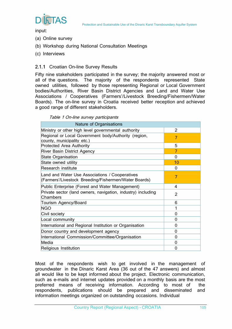
Protection and Sustainable Use of the Dinaric Karst Transboundary Aquifer System
Country Report (Regional Aspect) – CROATIA 105
input: (a) Online survey (b) Workshop during National Consultation Meetings (c) Interviews 2.1.1 Croatian On-line Survey Results
Fifty nine stakeholders participated in the survey; the majority answered most or all of the questions. The majority of the respondents represented State owned utilities, followed by those representing Regional or Local Government bodies/Authorities, River Basin District Agencies and Land and Water Use Associations / Cooperatives (Farmers’/Livestock Breeding/Fishermen/Water Boards). The on-line survey in Croatia received better reception and achieved a good range of different stakeholders. Table 1 On-line survey participants
Nature of Organisations
Ministry or other high level governmental authority 2 Regional or Local Government body/Authority (region, county, municipality etc.)
7
Protected Area Authority 5 River Basin District Agency 7 State Organisation 0 State owned utility 10 Research institute 0
Land and Water Use Associations / Cooperatives (Farmers’/Livestock Breeding/Fishermen/Water Boards)
7
Public Enterprise (Forest and Water Management) 4 Private sector (land owners, navigation, industry) including Chambers
2
Tourism Agency/Board 6 NGO 1 Civil society 0 Local community 0 International and Regional Institution or Organisation 0 Donor country and development agency 0 International Commission/Committee/Organisation 0 Media 0 Religious Institution 0
Most of the respondents wish to get involved in the management of groundwater in the Dinaric Karst Area (36 out of the 47 answers) and almost all would like to be kept informed about the project. Electronic communication, such as e-mails and internet updates provided on a monthly basis are the most preferred means of receiving information. According to most of the respondents, publications should be prepared and disseminated and information meetings organized on outstanding occasions. Individual
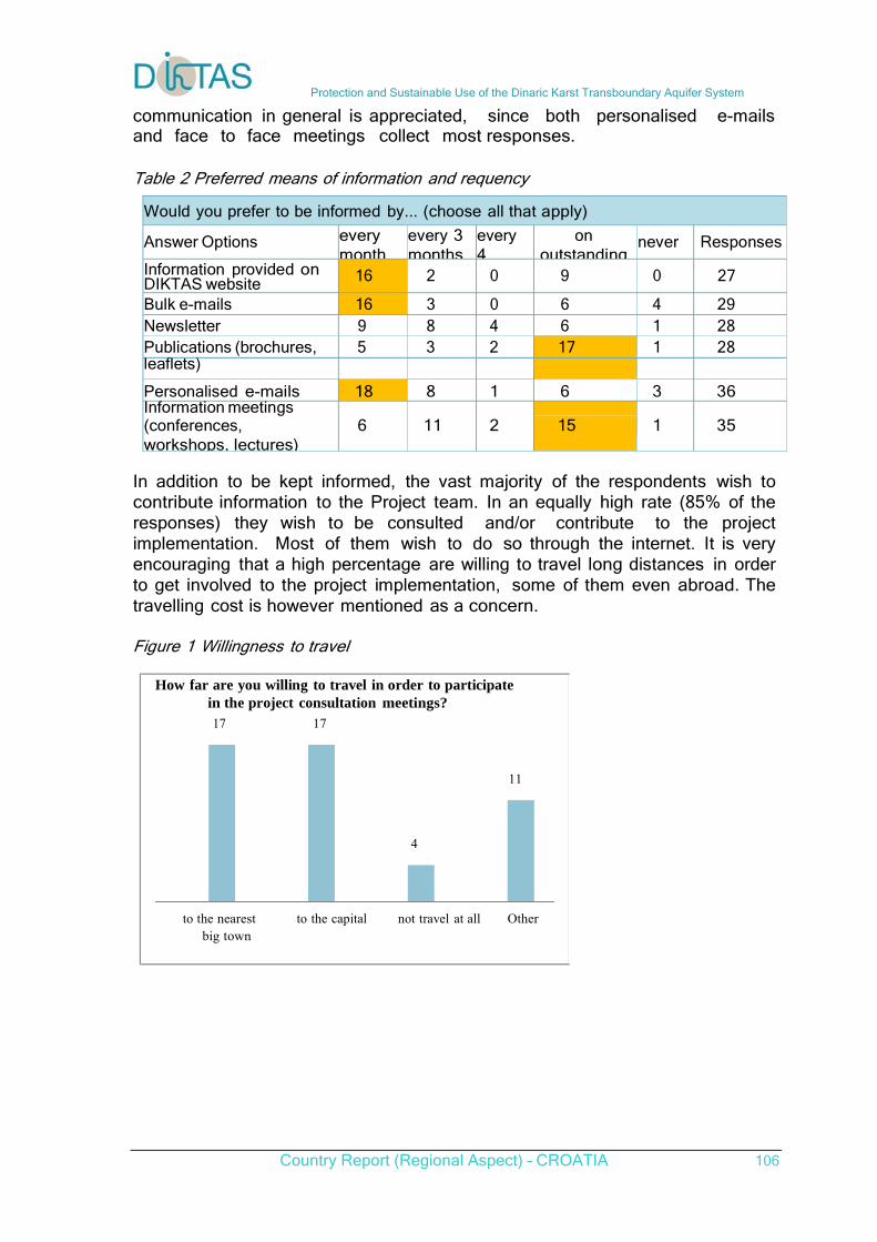
Protection and Sustainable Use of the Dinaric Karst Transboundary Aquifer System
Country Report (Regional Aspect) – CROATIA 106
communication in general is appreciated, since both personalised e-mails and face to face meetings collect most responses.
Table 2 Preferred means of information and requency
Would you prefer to be informed by... (choose all that apply)
Answer Options every month
every 3 months
every 4
on outstanding
never Responses
Information provided on DIKTAS website 16 2 0 9 0 27
Bulk e-mails 16 3 0 6 4 29 Newsletter 9 8 4 6 1 28 Publications (brochures, 5 3 2 17 1 28 leaflets)
Personalised e-mails 18 8 1 6 3 36 Information meetings (conferences, workshops, lectures)
6
11
2
15
1
35
In addition to be kept informed, the vast majority of the respondents wish to contribute information to the Project team. In an equally high rate (85% of the responses) they wish to be consulted and/or contribute to the project implementation. Most of them wish to do so through the internet. It is very encouraging that a high percentage are willing to travel long distances in order to get involved to the project implementation, some of them even abroad. The travelling cost is however mentioned as a concern.
Figure 1 Willingness to travel How far are you willing to travel in order to participate in the project consultation meetings? 17 17
11
4 to the nearest to the capital not travel at all Other big town
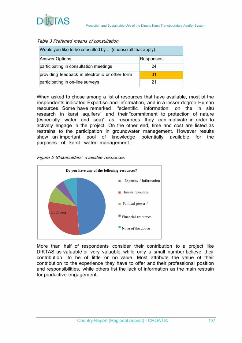
Protection and Sustainable Use of the Dinaric Karst Transboundary Aquifer System
Country Report (Regional Aspect) – CROATIA 107
Table 3 Preferred means of consultation
Would you like to be consulted by ... (choose all that apply)
Answer Options Responses
participating in consultation meetings 24
providing feedback in electronic or other form 31
participating in on-line surveys 21
When asked to chose among a list of resources that have available, most of the respondents indicated Expertise and Information, and in a lesser degree Human resources. Some have remarked “scientific information on the in situ research in karst aquifers” and their “commitment to protection of nature (especially water and sea)” as resources they can motivate in order to actively engage in the project. On the other end, time and cost are listed as restrains to the participation in groundwater management. However results show an important pool of knowledge potentially available for the purposes of karst water- management. Figure 2 Stakeholders’ available resources Do you have any of the following resources? Expertise / Information
Human resources
Political power / Lobbying
Financial resources
None of the above
More than half of respondents consider their contribution to a project like DIKTAS as valuable or very valuable, while only a small number believe their contribution to be of little or no value. Most attribute the value of their contribution to the experience they have to offer and their professional position and responsibilities, while others list the lack of information as the main restrain for productive engagement.
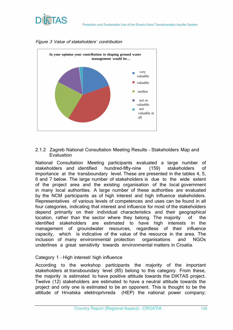
Protection and Sustainable Use of the Dinaric Karst Transboundary Aquifer System
Country Report (Regional Aspect) – CROATIA 108
Figure 3 Value of stakeholders’ contribution In your opinion your contribution to shaping ground water management would be… very valuable
valuable neither not so valuable not valuable at all 2.1.2 Zagreb National Consultation Meeting Results – Stakeholders Map and Evaluation
National Consultation Meeting participants evaluated a large number of stakeholders and identified hundred-fifty-nine (159) stakeholders of importance at the transboundary level. These are presented in the tables 4, 5, 6 and 7 below. The large number of stakeholders is due to the wide extent of the project area and the existing organisation of the local government in many local authorities. A large number of these authorities are evaluated by the NCM participants as of high interest and high influence stakeholders. Representatives of various levels of competences and uses can be found in all four categories, indicating that interest and influence for most of the stakeholders depend primarily on their individual characteristics and their geographical location, rather than the sector where they belong. The majority of the identified stakeholders are estimated to have high interests in the management of groundwater resources, regardless of their influence capacity, which is indicative of the value of the resource in the area. The inclusion of many environmental protection organisations and NGOs underlines a great sensitivity towards environmental matters in Croatia.
Category 1 – High interest/ high influence According to the workshop participants the majority of the important stakeholders at transboundary level (85) belong to this category. From these, the majority is estimated to have positive attitude towards the DIKTAS project. Twelve (12) stakeholders are estimated to have a neutral attitude towards the project and only one is estimated to be an opponent. This is thought to be the attitude of Hrvatska elektroprivreda (HEP) the national power company;
Protection and Sustainable Use of the Dinaric Karst Transboundary Aquifer System
Country Report (Regional Aspect) – CROATIA 109
special attention should be given to HEP as this is a primary user of water resources for power generation and a State owned utility of high importance. The category includes a very wide spectrum of competencies and organisations: international organisations, water related authorities, water management branch offices to the transboundary area, nature parks, scientific institutes, city authorities, tourism related stakeholders, Media etc. The category is mostly comprised by stakeholders relative to the management and protection of the resource, while primary users are under-represented. The agriculture sector is represented in this category by the Ministry of Agriculture and the Croatian Agricultural Agency (mostly related to livestock); no other Farmers Associations or Organisations are included. From these stakeholders fourteen are estimated to have medium importance. The vast majority are estimated to have high importance. There are six (6) stakeholders for which the workshop participants had mixed opinions or presumed to have varied and sometimes opposing attitudes towards the project, depending on specific objectives or activities. Effort should be put so as to gain support of these stakeholders, since they are of high importance and they have high influence and interest, and therefore the motivation and the means to promote or hinder the project objectives and activities. Table 4 Category 1 – High interest/ high influence
Croatia – Stakeholders Importance Attitude
European Commission (DG ENV, EG RTD) HIGH SUPPORTER
CIS working group Groundwater (WGC) HIGH SUPPORTER
European Water Association (EWA) HIGH SUPPORTER
GEF HIGH SUPPORTER
World Bank HIGH SUPPORTER
UNESCO HIGH SUPPORTER
UNEP HIGH SUPPORTER
WWF HIGH SUPPORTER
Environmental protection Committee of Croatian Parliament
HIGH SUPPORTER
Ministry of Foreign Affairs and European Integration HIGH SUPPORTER
Ministry of Environmental and Nature Protection HIGH SUPPORTER
Inspection Monitoring Department Šibenik HIGH SUPPORTER
Inspection Monitoring Department Zadar HIGH SUPPORTER
Department for water management HIGH SUPPORTER
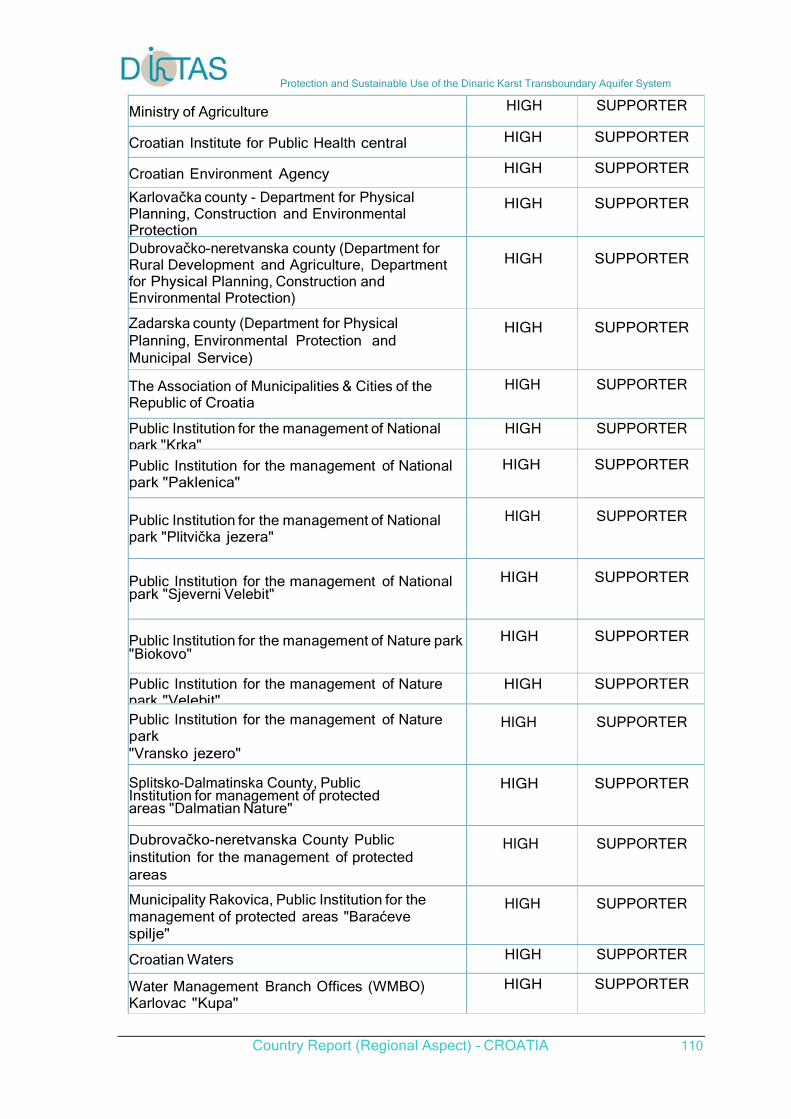
Protection and Sustainable Use of the Dinaric Karst Transboundary Aquifer System
Country Report (Regional Aspect) – CROATIA 110
Ministry of Agriculture HIGH SUPPORTER
Croatian Institute for Public Health central HIGH SUPPORTER
Croatian Environment Agency HIGH SUPPORTER
Karlovačka county - Department for Physical Planning, Construction and Environmental Protection
HIGH
SUPPORTER
Dubrovačko-neretvanska county (Department for Rural Development and Agriculture, Department for Physical Planning, Construction and Environmental Protection)
HIGH
SUPPORTER
Zadarska county (Department for Physical Planning, Environmental Protection and Municipal Service)
HIGH
SUPPORTER
The Association of Municipalities & Cities of the Republic of Croatia
HIGH SUPPORTER
Public Institution for the management of National park "Krka"
HIGH SUPPORTER
Public Institution for the management of National park "Paklenica"
HIGH
SUPPORTER
Public Institution for the management of National park "Plitvička jezera"
HIGH
SUPPORTER
Public Institution for the management of National park "Sjeverni Velebit"
HIGH
SUPPORTER
Public Institution for the management of Nature park"Biokovo"
HIGH
SUPPORTER
Public Institution for the management of Nature park "Velebit"
HIGH SUPPORTER
Public Institution for the management of Nature park "Vransko jezero"
HIGH
SUPPORTER
Splitsko-Dalmatinska County, Public Institution for management of protected areas "Dalmatian Nature"
HIGH
SUPPORTER
Dubrovačko-neretvanska County Public institution for the management of protected areas
HIGH
SUPPORTER
Municipality Rakovica, Public Institution for the management of protected areas "Baraćeve spilje"
HIGH
SUPPORTER
Croatian Waters HIGH SUPPORTER
Water Management Branch Offices (WMBO) Karlovac "Kupa"
HIGH SUPPORTER
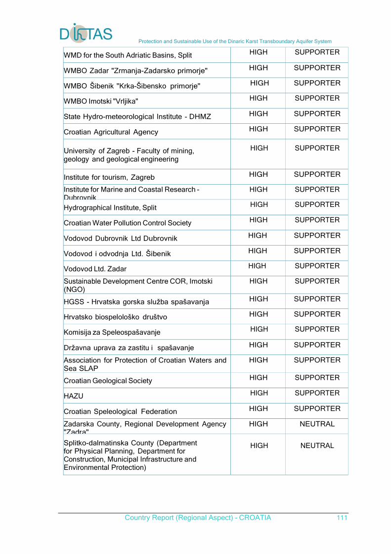
Protection and Sustainable Use of the Dinaric Karst Transboundary Aquifer System
Country Report (Regional Aspect) – CROATIA 111
WMD for the South Adriatic Basins, Split HIGH SUPPORTER
WMBO Zadar "Zrmanja-Zadarsko primorje" HIGH SUPPORTER
WMBO Šibenik "Krka-Šibensko primorje" HIGH SUPPORTER
WMBO Imotski "Vrljika" HIGH SUPPORTER
State Hydro-meteorological Institute - DHMZ HIGH SUPPORTER
Croatian Agricultural Agency HIGH SUPPORTER
University of Zagreb - Faculty of mining, geology and geological engineering
HIGH
SUPPORTER
Institute for tourism, Zagreb HIGH SUPPORTER
Institute for Marine and Coastal Research - Dubrovnik
HIGH SUPPORTER
Hydrographical Institute, Split HIGH SUPPORTER
Croatian Water Pollution Control Society HIGH SUPPORTER
Vodovod Dubrovnik Ltd Dubrovnik HIGH SUPPORTER
Vodovod i odvodnja Ltd. Šibenik HIGH SUPPORTER
Vodovod Ltd. Zadar HIGH SUPPORTER
Sustainable Development Centre COR, Imotski (NGO)
HIGH SUPPORTER
HGSS - Hrvatska gorska služba spašavanja HIGH SUPPORTER
Hrvatsko biospelološko društvo HIGH SUPPORTER
Komisija za Speleospašavanje HIGH SUPPORTER
Državna uprava za zastitu i spašavanje HIGH SUPPORTER
Association for Protection of Croatian Waters and Sea SLAP
HIGH SUPPORTER
Croatian Geological Society HIGH SUPPORTER
HAZU HIGH SUPPORTER
Croatian Speleological Federation HIGH SUPPORTER
Zadarska County, Regional Development Agency "Zadra"
HIGH NEUTRAL
Splitko-dalmatinska County (Department for Physical Planning, Department for Construction, Municipal Infrastructure and Environmental Protection)
HIGH
NEUTRAL
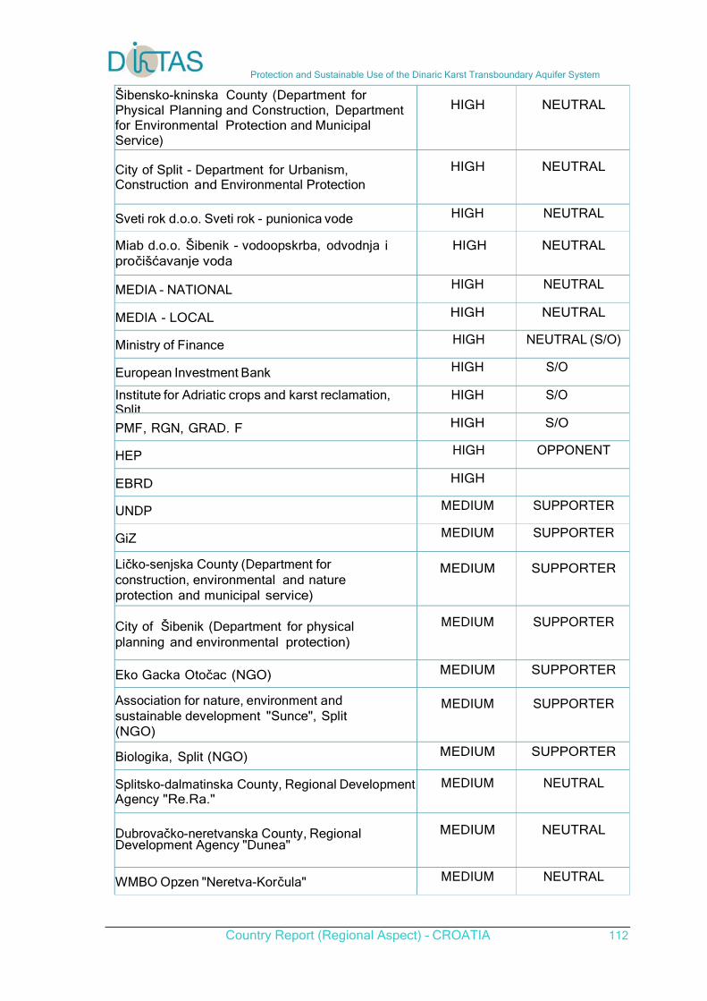
Protection and Sustainable Use of the Dinaric Karst Transboundary Aquifer System
Country Report (Regional Aspect) – CROATIA 112
Šibensko-kninska County (Department for Physical Planning and Construction, Department for Environmental Protection and Municipal Service)
HIGH
NEUTRAL
City of Split - Department for Urbanism, Construction and Environmental Protection
HIGH
NEUTRAL
Sveti rok d.o.o. Sveti rok - punionica vode HIGH NEUTRAL
Miab d.o.o. Šibenik - vodoopskrba, odvodnja i pročišćavanje voda
HIGH
NEUTRAL
MEDIA - NATIONAL HIGH NEUTRAL
MEDIA - LOCAL HIGH NEUTRAL
Ministry of Finance HIGH NEUTRAL (S/O)
European Investment Bank HIGH S/O
Institute for Adriatic crops and karst reclamation, Split
HIGH S/O
PMF, RGN, GRAD. F HIGH S/O
HEP HIGH OPPONENT
EBRD HIGH
UNDP MEDIUM SUPPORTER
GiZ MEDIUM SUPPORTER
Ličko-senjska County (Department for construction, environmental and nature protection and municipal service)
MEDIUM
SUPPORTER
City of Šibenik (Department for physical planning and environmental protection)
MEDIUM
SUPPORTER
Eko Gacka Otočac (NGO) MEDIUM SUPPORTER
Association for nature, environment and sustainable development "Sunce", Split (NGO)
MEDIUM
SUPPORTER
Biologika, Split (NGO) MEDIUM SUPPORTER
Splitsko-dalmatinska County, Regional Development Agency "Re.Ra."
MEDIUM NEUTRAL
Dubrovačko-neretvanska County, Regional Development Agency "Dunea"
MEDIUM
NEUTRAL
WMBO Opzen "Neretva-Korčula" MEDIUM NEUTRAL

Protection and Sustainable Use of the Dinaric Karst Transboundary Aquifer System
Country Report (Regional Aspect) – CROATIA 113
City of Solin - Department for Municipal Works, Economy and Physical Planning
MEDIUM
N/O
WMBO Sinj "Cetina" MEDIUM S/O
WMBO Split "Srednje dalmatinsko primorje i otoci" MEDIUM S/O
State Institute for Nature Protection
Zelena Akcija Zagreb (NGO)
Category 2– High interest/ low influence The twenty-eight (28) stakeholders under this category present a mixed picture regarding their level of importance. Thirteen (13) stakeholders are estimated to be of high importance, twelve (12) of medium and three (3) of low importance. The category includes again a wide range of stakeholders: local authorities, development agencies, NGOs, the tourist sector, private sector, etc. The majority of the stakeholders is estimated to be supportive (15) or neutral (9) towards the project objectives and activities, while three (3) stakeholders are perceived as opposing the project. Two of them belong to the private sector and one is a sports fishing association. Given the high interest and the high rate of neutral attitude attributed to it, this group should be treated with caution. Stakeholders included in it should be consulted regarding issues of their interest, and be well informed about the positive input and the efforts of the project for better resources management. They may also be included in general public participation activities since their high interest can provide motivation and support.
Table 5 Category 2 – High interest/ low influence
Croatia – Stakeholders Importance Attitude
Zadarska County, Public Institution for management of protected areas HIGH SUPPORTER
Šibensko-kninska County, Public Institution for management of protected areas HIGH SUPPORTER
Institute Ruđer Bošković. Zagreb HIGH SUPPORTER
Vodovod i kanalizacija Ltd. Split HIGH SUPPORTER
Komunalno poduzeće Ltd. Knin HIGH SUPPORTER
Association Divina Natura, Metkovi ć HIGH SUPPORTER
Mountaineering association Kamenar, Šibenik HIGH SUPPORTER
Šibensko-kninska county Regional Development Agency HIGH SUPPORTER
Nacionalno parjirensavo za UNESCO HIGH SUPPORTER
HGI, IGH HIGH SUPPORTER
Ličko-senjska County Tourism board HIGH NEUTRAL
Odvodnja Ltd Zadar HIGH NEUTRAL
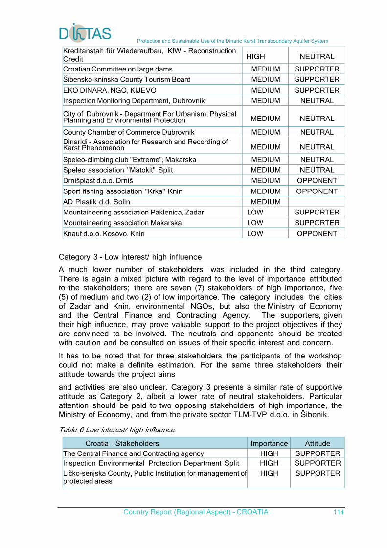
Protection and Sustainable Use of the Dinaric Karst Transboundary Aquifer System
Country Report (Regional Aspect) – CROATIA 114
Kreditanstalt für Wiederaufbau, KfW - Reconstruction Credit I i
HIGH
NEUTRAL
Croatian Committee on large dams MEDIUM SUPPORTER
Šibensko-kninska County Tourism Board MEDIUM SUPPORTER
EKO DINARA, NGO, KIJEVO MEDIUM SUPPORTER
Inspection Monitoring Department, Dubrovnik MEDIUM NEUTRAL
City of Dubrovnik - Department For Urbanism, Physical Planning and Environmental Protection
MEDIUM
NEUTRAL
County Chamber of Commerce Dubrovnik MEDIUM NEUTRAL Dinaridi - Association for Research and Recording of Karst Phenomenon
MEDIUM
NEUTRAL
Speleo-climbing club "Extreme", Makarska MEDIUM NEUTRAL
Speleo association "Matokit" Split MEDIUM NEUTRAL
Drnišplast d.o.o. Drniš MEDIUM OPPONENT
Sport fishing association "Krka" Knin MEDIUM OPPONENT
AD Plastik d.d. Solin MEDIUM
Mountaineering association Paklenica, Zadar LOW SUPPORTER
Mountaineering association Makarska LOW SUPPORTER
Knauf d.o.o. Kosovo, Knin LOW OPPONENT
Category 3 – Low interest/ high influence A much lower number of stakeholders was included in the third category. There is again a mixed picture with regard to the level of importance attributed to the stakeholders; there are seven (7) stakeholders of high importance, five (5) of medium and two (2) of low importance. The category includes the cities of Zadar and Knin, environmental NGOs, but also the Ministry of Economy and the Central Finance and Contracting Agency. The supporters, given their high influence, may prove valuable support to the project objectives if they are convinced to be involved. The neutrals and opponents should be treated with caution and be consulted on issues of their specific interest and concern.
It has to be noted that for three stakeholders the participants of the workshop could not make a definite estimation. For the same three stakeholders their attitude towards the project aims
and activities are also unclear. Category 3 presents a similar rate of supportive attitude as Category 2, albeit a lower rate of neutral stakeholders. Particular attention should be paid to two opposing stakeholders of high importance, the Ministry of Economy, and from the private sector TLM-TVP d.o.o. in Šibenik. Table 6 Low interest/ high influence
Croatia – Stakeholders Importance Attitude
The Central Finance and Contracting agency HIGH SUPPORTER Inspection Environmental Protection Department Split HIGH SUPPORTERLičko-senjska County, Public Institution for management ofprotected areas
HIGH SUPPORTER

Protection and Sustainable Use of the Dinaric Karst Transboundary Aquifer System
Country Report (Regional Aspect) – CROATIA 115
City of Knin - Tourism board HIGH SUPPORTER Eko Pan, Karlovac HIGH SUPPORTERMinistry of Economy HIGH OPPONENTTLM-TVP d.o.o. Šibenik HIGH OPPONENT Mountaineering association Sv. Mihovil, Šibenik MEDIUM SUPPORTER
MedPan MEDIUM SUPPORTER
Ličko-senjska county Development Agency "Lira" MEDIUM SUPPORTER City of Zadar - Department for Construction and MEDIUM NEUTRAL
Croatian Hydrological Society MEDIUM NEUTRAL Eco association "Gentiana" Knin LOW SUPPORTERWMBO Dubrovnik "Dubrovačko primorje" LOW NEUTRAL
Infra-grad Ltd Obrovac
Kap života Gospić Eko udruga Kosinj
Category 4 – Low interest/ low influence This category has the lowest number (3) of stakeholders estimated to have high importance. It also includes four (4) stakeholders that are thought to be opponents and of low importance, while almost half of the stakeholders appear to be neutral towards the project objectives and activities. The category includes environmental NGOs and protection organisations, private companies and a number of tourism boards. As in Bosnia and Herzegovina the Chambers are placed under this category, indicating the perception of the participants for these representatives of private sector as having low interest and low influence in water management issues. Taking into account that the area under consideration is close to or part of touristic destinations, tourism boards should be the target of more attention. Attention should also be given to the three stakeholders of high importance (the City of Metković, City of Knin - Department for physical planning, construction and municipal works, and the Association for Biological Research – BIOM). All stakeholders should be kept informed, always minding that their influence status may change.
Table 7 Category 4 – Low interest/ low influence
Croatia – Stakeholders Importance Attitude
Grad Knin - Department for Physical Planning, Construction and Municipal Works
HIGH
SUPPORTER
Association for Biological Research - BIOM, Zagreb HIGH SUPPORTER
City of Metković HIGH NEUTRAL
Splitsko-dalmatinska County Tourism board MEDIUM SUPPORTER
Eko udruga Una Gračac MEDIUM SUPPORTER
Association for Environmental Protection SEP Plvai l S li
MEDIUM SUPPORTER
Eco Delta, Metković MEDIUM SUPPORTER
Directorate for energy MEDIUM NEUTRAL
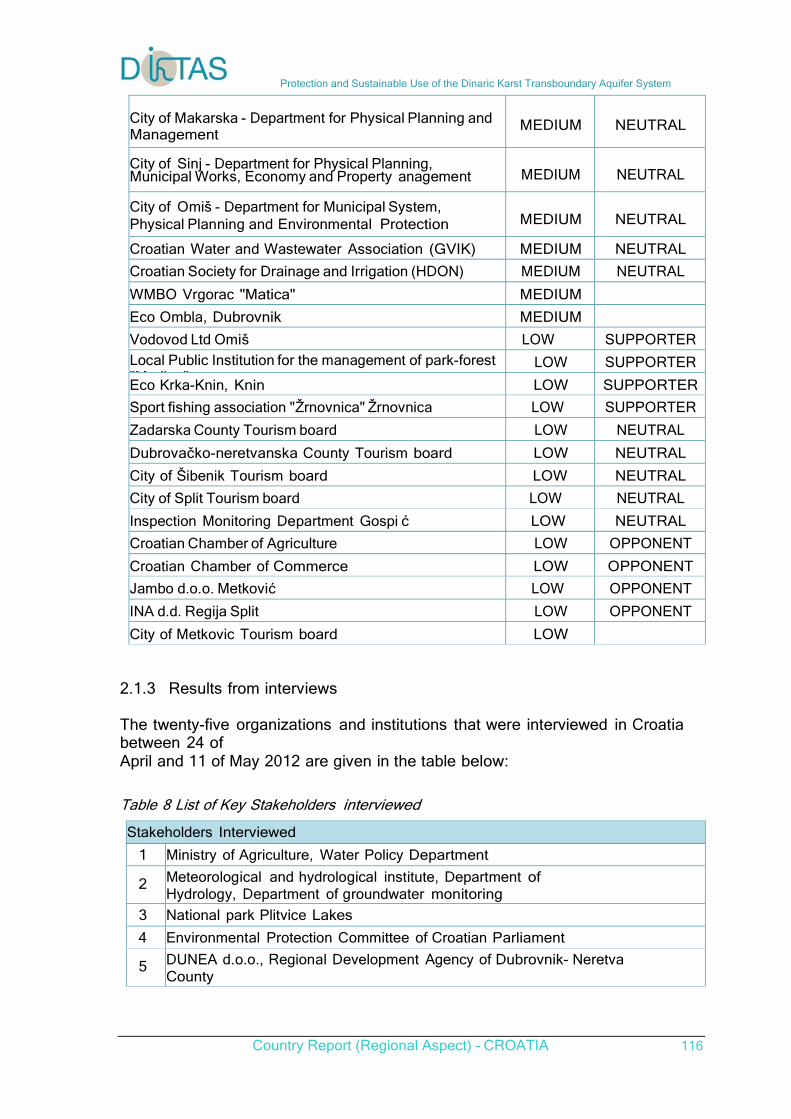
Protection and Sustainable Use of the Dinaric Karst Transboundary Aquifer System
Country Report (Regional Aspect) – CROATIA 116
City of Makarska - Department for Physical Planning and Management
MEDIUM
NEUTRAL
City of Sinj - Department for Physical Planning, Municipal Works, Economy and Property anagement
MEDIUM
NEUTRAL
City of Omiš - Department for Municipal System, Physical Planning and Environmental Protection
MEDIUM
NEUTRAL
Croatian Water and Wastewater Association (GVIK) MEDIUM NEUTRAL
Croatian Society for Drainage and Irrigation (HDON) MEDIUM NEUTRAL
WMBO Vrgorac "Matica" MEDIUM
Eco Ombla, Dubrovnik MEDIUM
Vodovod Ltd Omiš LOW SUPPORTER
Local Public Institution for the management of park-forest "M ij "
LOW SUPPORTER
Eco Krka-Knin, Knin LOW SUPPORTER
Sport fishing association "Žrnovnica" Žrnovnica LOW SUPPORTER
Zadarska County Tourism board LOW NEUTRAL
Dubrovačko-neretvanska County Tourism board LOW NEUTRAL
City of Šibenik Tourism board LOW NEUTRAL
City of Split Tourism board LOW NEUTRAL
Inspection Monitoring Department Gospi ć LOW NEUTRAL
Croatian Chamber of Agriculture LOW OPPONENT
Croatian Chamber of Commerce LOW OPPONENT
Jambo d.o.o. Metković LOW OPPONENT
INA d.d. Regija Split LOW OPPONENT
City of Metkovic Tourism board LOW
2.1.3 Results from interviews The twenty-five organizations and institutions that were interviewed in Croatia between 24 of April and 11 of May 2012 are given in the table below: Table 8 List of Key Stakeholders interviewed
Stakeholders Interviewed
1 Ministry of Agriculture, Water Policy Department
2 Meteorological and hydrological institute, Department of Hydrology, Department of groundwater monitoring
3 National park Plitvice Lakes
4 Environmental Protection Committee of Croatian Parliament
5 DUNEA d.o.o., Regional Development Agency of Dubrovnik- Neretva County
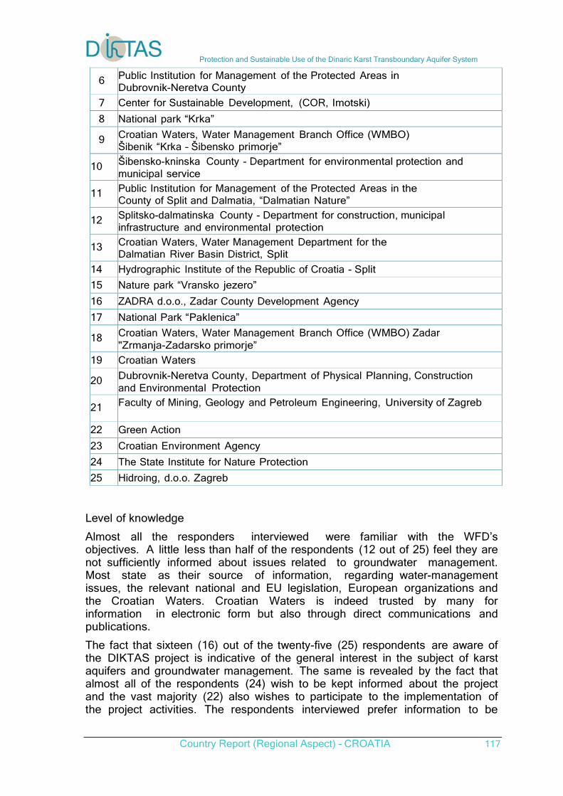
Protection and Sustainable Use of the Dinaric Karst Transboundary Aquifer System
Country Report (Regional Aspect) – CROATIA 117
6 Public Institution for Management of the Protected Areas in
Dubrovnik-Neretva County
7 Center for Sustainable Development, (COR, Imotski)
8 National park “Krka”
9 Croatian Waters, Water Management Branch Office (WMBO) Šibenik “Krka – Šibensko primorje”
10 Šibensko-kninska County - Department for environmental protection and
municipal service 11 Public Institution for Management of the Protected Areas in the
County of Split and Dalmatia, “Dalmatian Nature” 12 Splitsko-dalmatinska County - Department for construction, municipal
infrastructure and environmental protection 13 Croatian Waters, Water Management Department for the
Dalmatian River Basin District, Split
14 Hydrographic Institute of the Republic of Croatia - Split
15 Nature park “Vransko jezero”
16 ZADRA d.o.o., Zadar County Development Agency
17 National Park “Paklenica” 18 Croatian Waters, Water Management Branch Office (WMBO) Zadar
"Zrmanja-Zadarsko primorje”
19 Croatian Waters 20 Dubrovnik-Neretva County, Department of Physical Planning, Construction
and Environmental Protection 21 Faculty of Mining, Geology and Petroleum Engineering, University of Zagreb
22 Green Action
23 Croatian Environment Agency
24 The State Institute for Nature Protection
25 Hidroing, d.o.o. Zagreb
Level of knowledge
Almost all the responders interviewed were familiar with the WFD’s objectives. A little less than half of the respondents (12 out of 25) feel they are not sufficiently informed about issues related to groundwater management. Most state as their source of information, regarding water-management issues, the relevant national and EU legislation, European organizations and the Croatian Waters. Croatian Waters is indeed trusted by many for information in electronic form but also through direct communications and publications.
The fact that sixteen (16) out of the twenty-five (25) respondents are aware of the DIKTAS project is indicative of the general interest in the subject of karst aquifers and groundwater management. The same is revealed by the fact that almost all of the respondents (24) wish to be kept informed about the project and the vast majority (22) also wishes to participate to the implementation of the project activities. The respondents interviewed prefer information to be
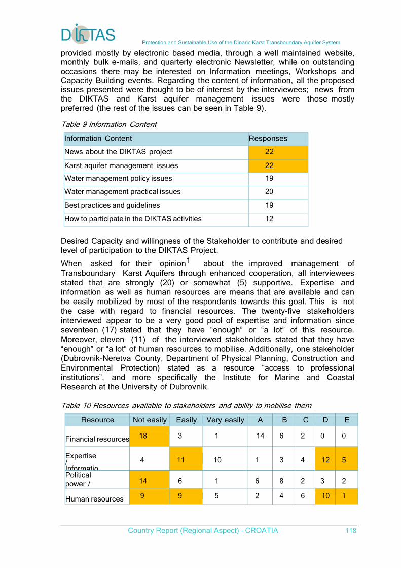
Protection and Sustainable Use of the Dinaric Karst Transboundary Aquifer System
Country Report (Regional Aspect) – CROATIA 118
provided mostly by electronic based media, through a well maintained website, monthly bulk e-mails, and quarterly electronic Newsletter, while on outstanding occasions there may be interested on Information meetings, Workshops and Capacity Building events. Regarding the content of information, all the proposed issues presented were thought to be of interest by the interviewees; news from the DIKTAS and Karst aquifer management issues were those mostly preferred (the rest of the issues can be seen in Table 9).
Table 9 Information Content
Information Content Responses
News about the DIKTAS project 22
Karst aquifer management issues 22
Water management policy issues 19
Water management practical issues 20
Best practices and guidelines 19
How to participate in the DIKTAS activities 12
Desired Capacity and willingness of the Stakeholder to contribute and desired level of participation to the DIKTAS Project.
When asked for their opinion1 about the improved management of Transboundary Karst Aquifers through enhanced cooperation, all interviewees stated that are strongly (20) or somewhat (5) supportive. Expertise and information as well as human resources are means that are available and can be easily mobilized by most of the respondents towards this goal. This is not the case with regard to financial resources. The twenty-five stakeholders interviewed appear to be a very good pool of expertise and information since seventeen (17) stated that they have “enough” or “a lot” of this resource. Moreover, eleven (11) of the interviewed stakeholders stated that they have “enough” or “a lot” of human resources to mobilise. Additionally, one stakeholder (Dubrovnik-Neretva County, Department of Physical Planning, Construction and Environmental Protection) stated as a resource “access to professional institutions”, and more specifically the Institute for Marine and Coastal Research at the University of Dubrovnik.
Table 10 Resources available to stakeholders and ability to mobilise them
Resource Not easily Easily Very easily A B C D E
Financial resources 18 3 1 14 6 2 0 0
Expertise / Informatio
4 11 10 1 3 4 12 5
Political power / 14 6 1 6 8 2 3 2
Human resources 9 9 5 2 4 6 10 1
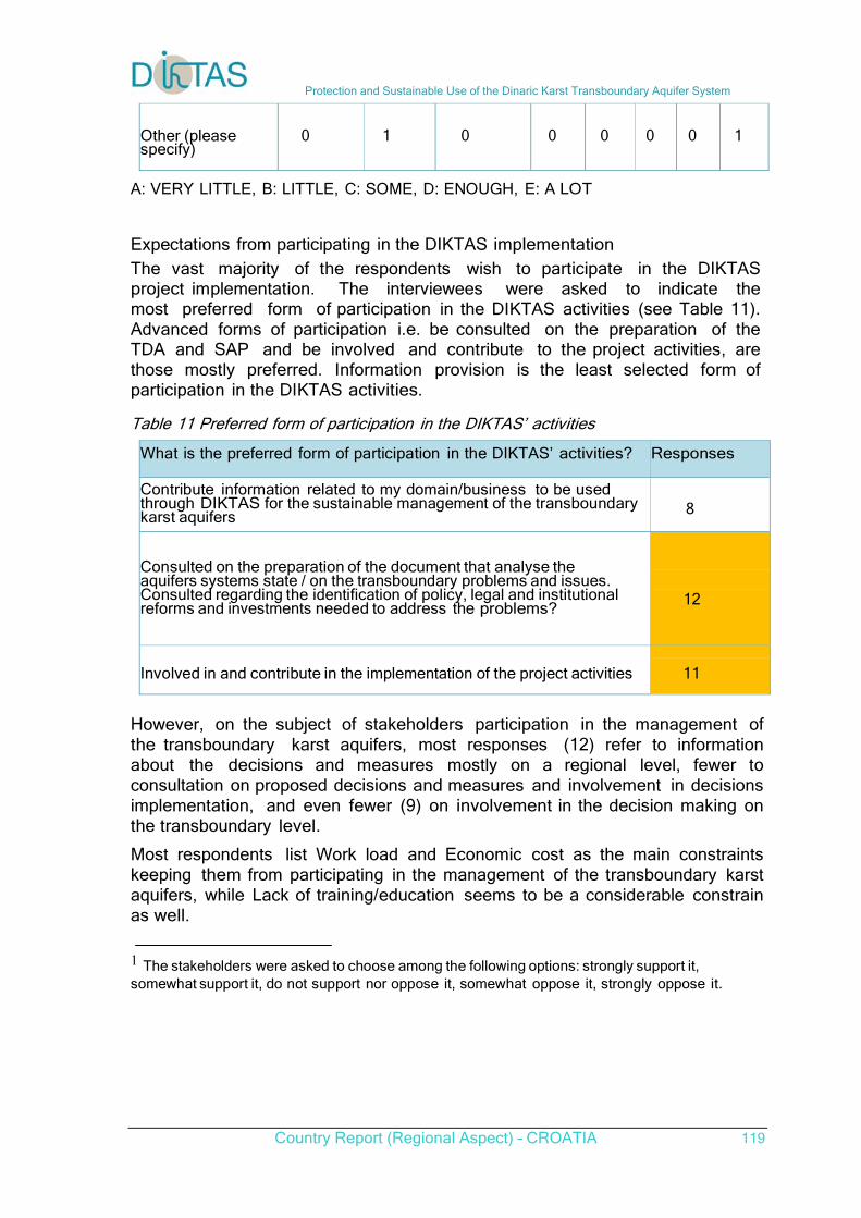
Protection and Sustainable Use of the Dinaric Karst Transboundary Aquifer System
Country Report (Regional Aspect) – CROATIA 119
Other (please specify)
0 1 0 0 0 0 0 1
A: VERY LITTLE, B: LITTLE, C: SOME, D: ENOUGH, E: A LOT Expectations from participating in the DIKTAS implementation The vast majority of the respondents wish to participate in the DIKTAS project implementation. The interviewees were asked to indicate the most preferred form of participation in the DIKTAS activities (see Table 11). Advanced forms of participation i.e. be consulted on the preparation of the TDA and SAP and be involved and contribute to the project activities, are those mostly preferred. Information provision is the least selected form of participation in the DIKTAS activities.
Table 11 Preferred form of participation in the DIKTAS’ activities
What is the preferred form of participation in the DIKTAS’ activities? Responses
Contribute information related to my domain/business to be used through DIKTAS for the sustainable management of the transboundary karst aquifers
8
Consulted on the preparation of the document that analyse the aquifers systems state / on the transboundary problems and issues. Consulted regarding the identification of policy, legal and institutional reforms and investments needed to address the problems?
12
Involved in and contribute in the implementation of the project activities 11
However, on the subject of stakeholders participation in the management of the transboundary karst aquifers, most responses (12) refer to information about the decisions and measures mostly on a regional level, fewer to consultation on proposed decisions and measures and involvement in decisions implementation, and even fewer (9) on involvement in the decision making on the transboundary level. Most respondents list Work load and Economic cost as the main constraints keeping them from participating in the management of the transboundary karst aquifers, while Lack of training/education seems to be a considerable constrain as well. 1 The stakeholders were asked to choose among the following options: strongly support it, somewhat support it, do not support nor oppose it, somewhat oppose it, strongly oppose it.
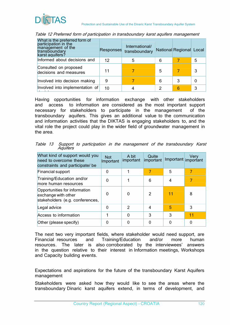
Protection and Sustainable Use of the Dinaric Karst Transboundary Aquifer System
Country Report (Regional Aspect) – CROATIA 120
Table 12 Preferred form of participation in transboundary karst aquifers management
What is the preferred form of participation in the management of the transboundary karst aquifers?
Responses
International/
transboundary
National
Regional
Local
Informed about decisions and 12 5 6 7 5
Consulted on proposed decisions and measures
11
7
5
7
3
Involved into decision making 9 7 6 3 0
Involved into implementation ofd i i
10 4 2 6 3 Having opportunities for information exchange with other stakeholders and access to information are considered as the most important support necessary for stakeholders to participate in the management of the transboundary aquifers. This gives an additional value to the communication and information activities that the DIKTAS is engaging stakeholders to, and the vital role the project could play in the wider field of groundwater management in the area.
Table 13 Support to participation in the management of the transboundary Karst Aquifers
What kind of support would you need to overcome these constraints and participate/ be
Not
Important
A bit
important
Quite
important
Important
Very
important
Financial support 0 1 7 5 7
Training/Education and/or more human resources
0
1
6
4
7
Opportunities for information exchange with other stakeholders (e.g. conferences,
ti )
0
0
2
11
8
Legal advice 0 2 4 5 3
Access to information 1 0 3 3 11
Other (please specify) 0 0 0 0 0
The next two very important fields, where stakeholder would need support, are Financial resources and Training/Education and/or more human resources. The later is also corroborated by the interviewees’ answers in the question relative to their interest in Information meetings, Workshops and Capacity building events.
Expectations and aspirations for the future of the transboundary Karst Aquifers management
Stakeholders were asked how they would like to see the areas where the transboundary Dinaric karst aquifers extend, in terms of development, and
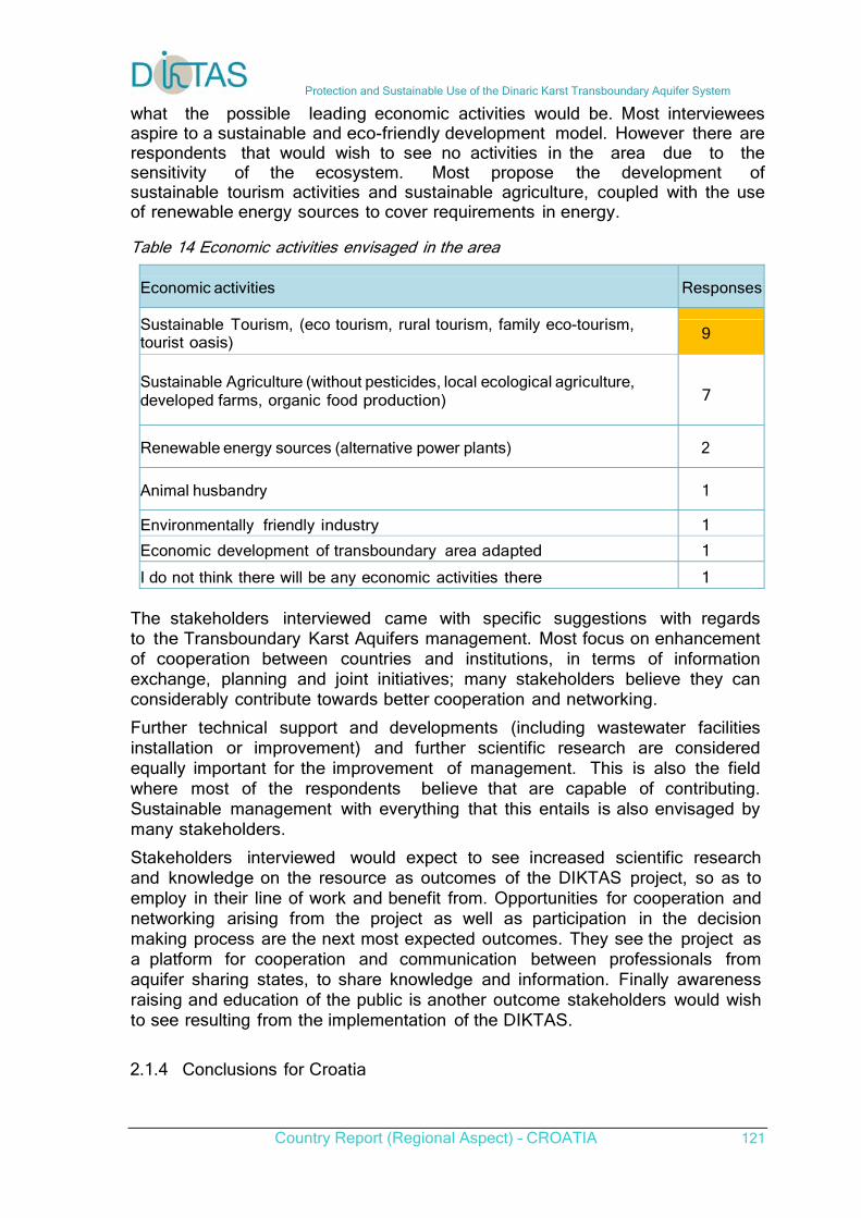
Protection and Sustainable Use of the Dinaric Karst Transboundary Aquifer System
Country Report (Regional Aspect) – CROATIA 121
what the possible leading economic activities would be. Most interviewees aspire to a sustainable and eco-friendly development model. However there are respondents that would wish to see no activities in the area due to the sensitivity of the ecosystem. Most propose the development of sustainable tourism activities and sustainable agriculture, coupled with the use of renewable energy sources to cover requirements in energy.
Table 14 Economic activities envisaged in the area
Economic activities Responses
Sustainable Tourism, (eco tourism, rural tourism, family eco-tourism, tourist oasis) 9
Sustainable Agriculture (without pesticides, local ecological agriculture, developed farms, organic food production)
7
Renewable energy sources (alternative power plants) 2
Animal husbandry 1
Environmentally friendly industry 1
Economic development of transboundary area adapted 1
I do not think there will be any economic activities there 1 The stakeholders interviewed came with specific suggestions with regards to the Transboundary Karst Aquifers management. Most focus on enhancement of cooperation between countries and institutions, in terms of information exchange, planning and joint initiatives; many stakeholders believe they can considerably contribute towards better cooperation and networking. Further technical support and developments (including wastewater facilities installation or improvement) and further scientific research are considered equally important for the improvement of management. This is also the field where most of the respondents believe that are capable of contributing. Sustainable management with everything that this entails is also envisaged by many stakeholders. Stakeholders interviewed would expect to see increased scientific research and knowledge on the resource as outcomes of the DIKTAS project, so as to employ in their line of work and benefit from. Opportunities for cooperation and networking arising from the project as well as participation in the decision making process are the next most expected outcomes. They see the project as a platform for cooperation and communication between professionals from aquifer sharing states, to share knowledge and information. Finally awareness raising and education of the public is another outcome stakeholders would wish to see resulting from the implementation of the DIKTAS. 2.1.4 Conclusions for Croatia
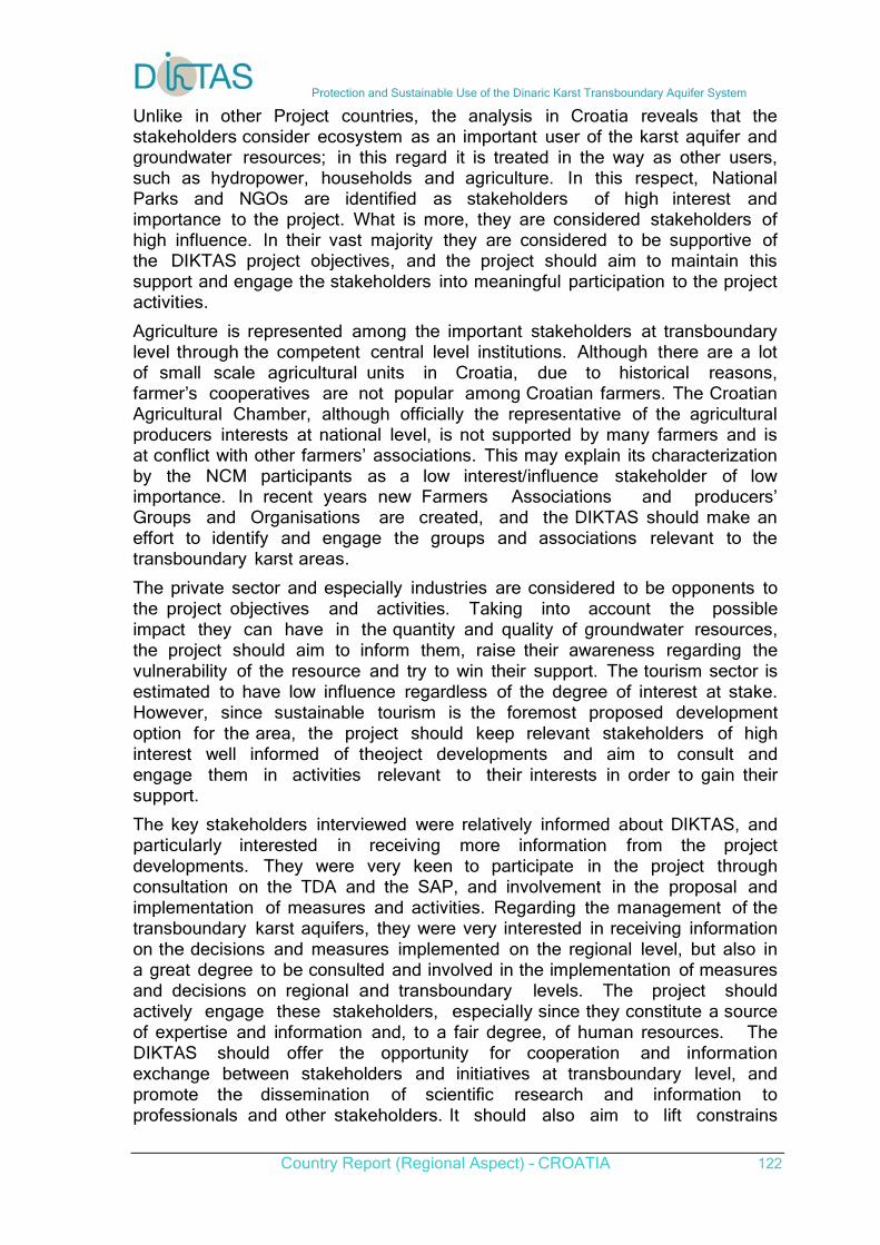
Protection and Sustainable Use of the Dinaric Karst Transboundary Aquifer System
Country Report (Regional Aspect) – CROATIA 122
Unlike in other Project countries, the analysis in Croatia reveals that the stakeholders consider ecosystem as an important user of the karst aquifer and groundwater resources; in this regard it is treated in the way as other users, such as hydropower, households and agriculture. In this respect, National Parks and NGOs are identified as stakeholders of high interest and importance to the project. What is more, they are considered stakeholders of high influence. In their vast majority they are considered to be supportive of the DIKTAS project objectives, and the project should aim to maintain this support and engage the stakeholders into meaningful participation to the project activities. Agriculture is represented among the important stakeholders at transboundary level through the competent central level institutions. Although there are a lot of small scale agricultural units in Croatia, due to historical reasons, farmer’s cooperatives are not popular among Croatian farmers. The Croatian Agricultural Chamber, although officially the representative of the agricultural producers interests at national level, is not supported by many farmers and is at conflict with other farmers’ associations. This may explain its characterization by the NCM participants as a low interest/influence stakeholder of low importance. In recent years new Farmers Associations and producers’ Groups and Organisations are created, and the DIKTAS should make an effort to identify and engage the groups and associations relevant to the transboundary karst areas. The private sector and especially industries are considered to be opponents to the project objectives and activities. Taking into account the possible impact they can have in the quantity and quality of groundwater resources, the project should aim to inform them, raise their awareness regarding the vulnerability of the resource and try to win their support. The tourism sector is estimated to have low influence regardless of the degree of interest at stake. However, since sustainable tourism is the foremost proposed development option for the area, the project should keep relevant stakeholders of high interest well informed of theoject developments and aim to consult and engage them in activities relevant to their interests in order to gain their support. The key stakeholders interviewed were relatively informed about DIKTAS, and particularly interested in receiving more information from the project developments. They were very keen to participate in the project through consultation on the TDA and the SAP, and involvement in the proposal and implementation of measures and activities. Regarding the management of the transboundary karst aquifers, they were very interested in receiving information on the decisions and measures implemented on the regional level, but also in a great degree to be consulted and involved in the implementation of measures and decisions on regional and transboundary levels. The project should actively engage these stakeholders, especially since they constitute a source of expertise and information and, to a fair degree, of human resources. The DIKTAS should offer the opportunity for cooperation and information exchange between stakeholders and initiatives at transboundary level, and promote the dissemination of scientific research and information to professionals and other stakeholders. It should also aim to lift constrains
Protection and Sustainable Use of the Dinaric Karst Transboundary Aquifer System
Country Report (Regional Aspect) – CROATIA 123
to wider participation, by minimising the cost of participation for the stakeholders and the strain on their human resources available, and by offering them opportunities for further training and education. Awareness raising is pinpointed by some of the key stakeholders as an important objective that the DIKTAS should pursue. Regarding the means of engagement and information, the electronic media i.e. a well maintained website, regular personalised and bulk e-mails, and electronic Newsletter on a quarterly basis are preferred, while many are interested in Information meetings, Workshops and Capacity Building events organised occasionally. Generally, the project should make efforts to keep well informed and expand the support of high interest stakeholders, regardless of their influence, since a large number of them appear to have a neutral attitude towards DIKTAS.
2.2 Perceived Significant Issues Analysis
This section elaborates on the significant issues, as these are perceived by the stakeholders, regarding the management of the shared Dinaric Karst aquifer system. This information will feed in the preparation of the TDA, assisting in the prioritization of the identified therein issues. The analysis of information from each method used to acquire input (on-line survey, workshops, interviews) is given in Annex 1. The combined results have been deducted and issues have been prioritized using input from all methods. The input from interviews is considered more accurate, due to the nature of the method and the stakeholders interviewed, hence has had more gravity in our analysis. In addition interviews provided a considerable level of detail with regard to the issues at hand. This input was combined and informed with that coming from the NCM, which incorporates the collective knowledge and perception of the NCM participants. In the case of discrepancies between the two, the input from interviews was given priority. The results of the web-based survey were used to verify the prioritization. The combined results of the analysis are given below in the document and are structured as follows: - The perceived significant groundwater related management issues for Croatia are given in sections 2.2.1. The issues are given in two parts: - The first includes the list of issues indicated by stakeholders in all three survey methods. - In the second part there are the issues that were indicated through the two survey methods; indicated through the interviews (open questions) and validated (and supported) by the analysis carried out during the National Consultation Meeting. - The results of the analysis related to the hot spots i.e. the specific areas or water bodies that the stakeholders indicate to be affected by specific
Protection and Sustainable Use of the Dinaric Karst Transboundary Aquifer System
Country Report (Regional Aspect) – CROATIA 124
issues are presented in section 2.2.1.4
2.2.1 Perceived Significant Issues in Croatia
In Croatia stakeholders have focused primarily on the issue of groundwater and surface water being affected by toxic substances, organic and bacteriological pollution. The most important cause is thought to be unsustainable/insufficient municipal solid waste management, followed by unsustainable/insufficient municipal waste water management; urbanisation plays an aggravating role with regard to pollution caused by the latter. The industry and manufacturing sector is also contributing to these issues, along with unsustainable tourism development. The decline of groundwater levels is pointed out, attributed equally to water abstraction for domestic use, industrial and tourism activities. Broader issues affecting the sustainable management of water resources are also identified, such as cooperation between countries as well as among institutions. Stakeholders indicate the need of an integrated approach to address the issues. Other challenges include funding, legislation etc. 2.2.1.2 Isues
a. Pollution Pollution is an outcome of different activities. The stakeholders indicated the following sources of pollution; these are classified in terms of perceived significance. Pollution from solid waste Solid waste related pollution is considered by the stakeholders as the most important issue linked to karst aquifers management in Croatia. Unsustainable/insufficient municipal solid waste management and specifically illegal landfills are mostly indicated as the cause/source. These are thought also to be the cause of transboundary groundwater pollution – via shared aquifers. Waste water pollution Unsustainable municipal waste water management is the second mostly mentioned issue related to karst aquifers. It is indicated to cause bacteriological pollution affecting both surface waters and groundwater. Pollution due to Unsustainable Agriculture Agriculture is recognized as one of the main uses in terms of pressure exerted to water resources (at the same level with households). According to stakeholders interviewed, unsustainable agricultural practices are the third major factor causing pollution, contributing to nitrate and phosphate pollution. On the other hand, sustainable agriculture is proposed by many stakeholders as an option for the development of the area, making this an issue worth of attention. b. Groundwater over- exploitation
Protection and Sustainable Use of the Dinaric Karst Transboundary Aquifer System
Country Report (Regional Aspect) – CROATIA 125
Over-exploitation of the resource leading to decline of groundwater levels is acknowledged as an issue of importance. The following are indicated among the causes: lack of regulation of the hydro-energy sector in relation to water use; absence of a set abstraction regime for drinking water supply; irrigation of agricultural land and; water for recreational purposes. c. Hydro-technical infrastructure Electricity production related hydro-technical infrastructure and particularly the construction of dams is considered as a cause of a range of issues mostly linked to the disturbance of the water balance and the hydrologic regime. Stakeholders have indicated that additional hydropower infrastructure planned to be constructed in the Trebišnjica River in Bosnia and Herzegovina will affect the hydrologic regime hence, the Dubrovnik-Neretva area in Croatia. 2.2.1.3. Other Significant Issues
a. Cross-border institutional communication and cooperation Insufficient or lack of institutional communication and cooperation among countries sharing the resource is the cause of many problems according to the interviewees. Improvement of cooperation is the most frequently mentioned proposed solution (it exceeds even pollution monitoring and control). In this regard, bilateral/multilateral/international agreements as well as joint activities and initiatives, are transcribed as solutions to most issues. b. Data and scientific knowledge / Research and application Stakeholders indicate that insufficient monitoring and research hence, lack of data and scientific knowledge to better understand the resource affects decision making and sustainable management of karst aquifers. The meaningful and practical application of the research results is cited as an additional challenge. c. Enhanced Water Management The issue of water management is (together with lack of data and knowledge) the third most commonly mentioned by the interviewed key stakeholders and the second most important cluster arising from the NCM. This is linked with the inadequate institutional framework, the failure to use modern management and assessment methods and tools, lack of awareness on behalf of stakeholders and decision makers, lack of resources, outdated systems and procedures for planning and management. d. Legislation Insufficient legislation and its insufficient implementation and enforcement, are recognised as causes for several of the issues. Harmonisation of legislation among countries sharing the resource is thought to be important. e. Public participation Lack of awareness and involvement of stakeholders in the management of the resource hence, failure to use their knowledge and resources are considered significant.
Protection and Sustainable Use of the Dinaric Karst Transboundary Aquifer System
Country Report (Regional Aspect) – CROATIA 126
2.2.1.4 Hot Spots
Additional to the general feedback on issues from the interviewed key stakeholders, several geographic specific issues have been indicated, in some cases providing detailed information. 1. Settlements near the Korenica and Plitvice Lakes need to be connected with wastewater treatment plants. 2. According to one interviewee an issue of transboundary importance, is the effect that the operation of the Refinery in Bosanski brod, in Bosnia and Herzegovina has to groundwater resources. The suggestion is for the refinery to modernise its operation to meet the environmental standards and acquire an environmental permit. 3. One interviewee has indicated that the area of Trgovska gora mountain (Una river) is still a location earmarked in the Physical Planning Program of Croatia for the disposal of the nuclear waste (low and medium radioactive waste) from Krško Nuclear Power Plant in Slovenia; according to the interviewee the geological conditions in this area are not suitable for the construction of such a disposal site. 4. The hydroelectric power plants planned to be constructed on the Trebišnjica River in Bosnia and Herzegovina will have an impact to Croatia. The proposal is for the two countries to prepare jointly an environmental impact assessment.
5. Pollution from Popovo polje reaches occasionally the area of Dubrovnik. 6. There are evident changes in groundwater flows in the Neretva River basin area attributed to the construction of reservoirs in neighbouring countries. 7. The reduction of the flow of groundwater is reported by another interviewee, to have negative impact on some ecosystems, such as “Malostonski zaljev” and “Malo more – uvala Bistrina”. The same interviewee quotes these areas (“Malostonski zaljev” and “Malo more”) together with the estuary of the river Ljuta, the estuary of river Ombla, and the coastal sea waters, as areas where efforts should be focused on preserving and protecting the economy and the ecological systems. Finally the stakeholder quotes findings of the Institute of Oceanography and Fisheries, Laboratory of Dubrovnik which has detected heavy metals in fish near the island Daksa, in the waters of the direct influence of river Ombla and transboundary groundwater flows. 8. Abstractions of water for domestic consumption and irrigation in the city of Sibenik and its County exert the pressure on the river Krka. 10. The Krka River is also quoted as the direct recipient of wastewater discharges from insufficient infrastructure and industrial facilities in Knin and Drniš.
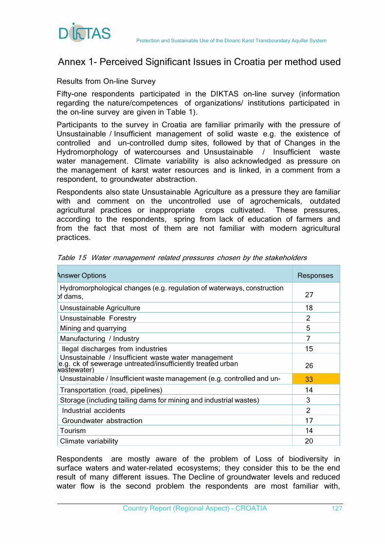
Protection and Sustainable Use of the Dinaric Karst Transboundary Aquifer System
Country Report (Regional Aspect) – CROATIA 127
Annex 1- Perceived Significant Issues in Croatia per method used Results from On-line Survey Fifty-one respondents participated in the DIKTAS on-line survey (information regarding the nature/competences of organizations/ institutions participated in the on-line survey are given in Table 1). Participants to the survey in Croatia are familiar primarily with the pressure of Unsustainable / Insufficient management of solid waste e.g. the existence of controlled and un-controlled dump sites, followed by that of Changes in the Hydromorphology of watercourses and Unsustainable / Insufficient waste water management. Climate variability is also acknowledged as pressure on the management of karst water resources and is linked, in a comment from a respondent, to groundwater abstraction. Respondents also state Unsustainable Agriculture as a pressure they are familiar with and comment on the uncontrolled use of agrochemicals, outdated agricultural practices or inappropriate crops cultivated. These pressures, according to the respondents, spring from lack of education of farmers and from the fact that most of them are not familiar with modern agricultural practices.
Table 15 Water management related pressures chosen by the stakeholders
Answer Options
Responses
Hydromorphological changes (e.g. regulation of waterways, construction of dams,
di i f i )
27
Unsustainable Agriculture 18
Unsustainable Forestry 2
Mining and quarrying 5
Manufacturing / Industry 7
llegal discharges from industries 15 Unsustainable / Insufficient waste water management
(e.g. ck of sewerage untreated/insufficiently treated urban wastewater)
26
Unsustainable / Insufficient waste management (e.g. controlled and un-ll d d i )
33
Transportation (road, pipelines) 14
Storage (including tailing dams for mining and industrial wastes) 3
Industrial accidents 2
Groundwater abstraction 17
Tourism 14
Climate variability 20 Respondents are mostly aware of the problem of Loss of biodiversity in surface waters and water-related ecosystems; they consider this to be the end result of many different issues. The Decline of groundwater levels and reduced water flow is the second problem the respondents are most familiar with,
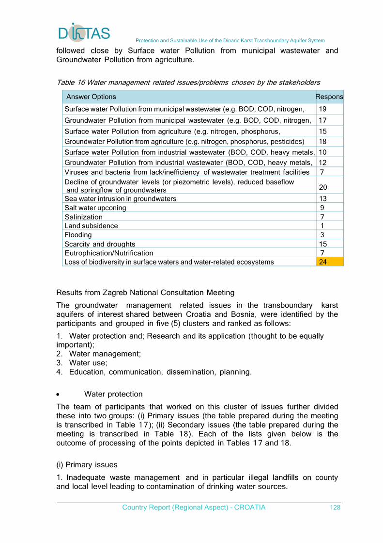
Protection and Sustainable Use of the Dinaric Karst Transboundary Aquifer System
Country Report (Regional Aspect) – CROATIA 128
followed close by Surface water Pollution from municipal wastewater and Groundwater Pollution from agriculture.
Table 16 Water management related issues/problems chosen by the stakeholders
Answer Options Respons
Surface water Pollution from municipal wastewater (e.g. BOD, COD, nitrogen, h h )
19
Groundwater Pollution from municipal wastewater (e.g. BOD, COD, nitrogen, 17
Surface water Pollution from agriculture (e.g. nitrogen, phosphorus, 15
Groundwater Pollution from agriculture (e.g. nitrogen, phosphorus, pesticides) 18
Surface water Pollution from industrial wastewater (BOD, COD, heavy metals, 10
Groundwater Pollution from industrial wastewater (BOD, COD, heavy metals, 12 Viruses and bacteria from lack/inefficiency of wastewater treatment facilities 7 Decline of groundwater levels (or piezometric levels), reduced baseflow and springflow of groundwaters
20
Sea water intrusion in groundwaters 13 Salt water upconing 9 Salinization 7 Land subsidence 1 Flooding 3 Scarcity and droughts 15 Eutrophication/Nutrification 7 Loss of biodiversity in surface waters and water-related ecosystems 24
Results from Zagreb National Consultation Meeting The groundwater management related issues in the transboundary karst aquifers of interest shared between Croatia and Bosnia, were identified by the participants and grouped in five (5) clusters and ranked as follows: 1. Water protection and; Research and its application (thought to be equally important); 2. Water management; 3. Water use; 4. Education, communication, dissemination, planning. Water protection The team of participants that worked on this cluster of issues further divided these into two groups: (i) Primary issues (the table prepared during the meeting is transcribed in Table 17); (ii) Secondary issues (the table prepared during the meeting is transcribed in Table 18). Each of the lists given below is the outcome of processing of the points depicted in Tables 1 7 and 18. (i) Primary issues 1. Inadequate waste management and in particular illegal landfills on county and local level leading to contamination of drinking water sources.
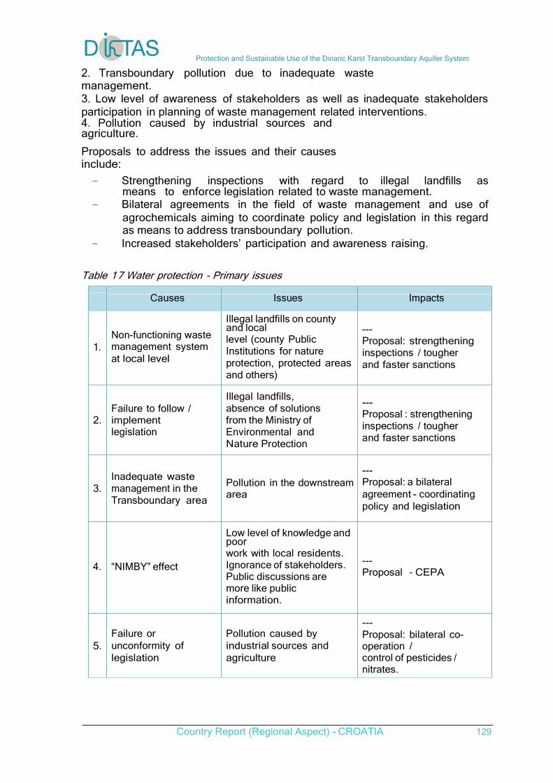
Protection and Sustainable Use of the Dinaric Karst Transboundary Aquifer System
Country Report (Regional Aspect) – CROATIA 129
2. Transboundary pollution due to inadequate waste management. 3. Low level of awareness of stakeholders as well as inadequate stakeholders participation in planning of waste management related interventions. 4. Pollution caused by industrial sources and agriculture. Proposals to address the issues and their causes include: - Strengthening inspections with regard to illegal landfills as
means to enforce legislation related to waste management. - Bilateral agreements in the field of waste management and use of
agrochemicals aiming to coordinate policy and legislation in this regard as means to address transboundary pollution.
- Increased stakeholders’ participation and awareness raising. Table 17 Water protection - Primary issues
Causes Issues Impacts
1. Non-functioning waste management system at local level
Illegal landfills on county and local level (county Public Institutions for nature protection, protected areas and others)
--- Proposal: strengthening inspections / tougher and faster sanctions
2. Failure to follow / implement legislation
Illegal landfills, absence of solutions from the Ministry of Environmental and Nature Protection
--- Proposal : strengthening inspections / tougher and faster sanctions
3. Inadequate waste management in the Transboundary area
Pollution in the downstream area
--- Proposal: a bilateral agreement - coordinating policy and legislation
4. “NIMBY” effect
Low level of knowledge and poor work with local residents. Ignorance of stakeholders. Public discussions are more like public information.
--- Proposal – CEPA
5. Failure or unconformity of legislation
Pollution caused by industrial sources and agriculture
--- Proposal: bilateral co-operation / control of pesticides / nitrates.
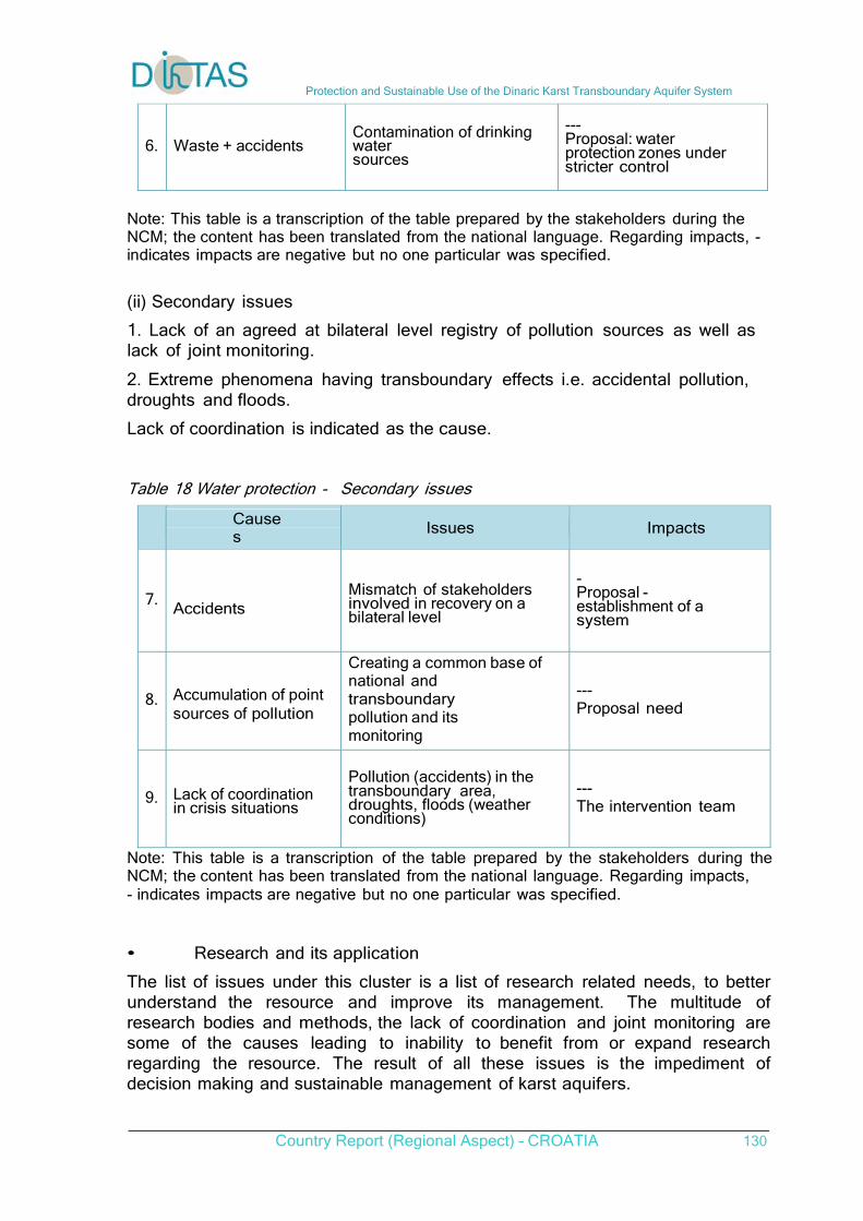
Protection and Sustainable Use of the Dinaric Karst Transboundary Aquifer System
Country Report (Regional Aspect) – CROATIA 130
6. Waste + accidents Contamination of drinking water sources
--- Proposal: water protection zones under stricter control
Note: This table is a transcription of the table prepared by the stakeholders during the NCM; the content has been translated from the national language. Regarding impacts, - indicates impacts are negative but no one particular was specified.
(ii) Secondary issues 1. Lack of an agreed at bilateral level registry of pollution sources as well as lack of joint monitoring.
2. Extreme phenomena having transboundary effects i.e. accidental pollution, droughts and floods. Lack of coordination is indicated as the cause. Table 18 Water protection - Secondary issues
Causes
Issues Impacts
7. Accidents
Mismatch of stakeholders involved in recovery on a bilateral level
- Proposal - establishment of a system
8. Accumulation of point sources of pollution
Creating a common base of national and transboundary pollution and its monitoring
--- Proposal need
9. Lack of coordination in crisis situations
Pollution (accidents) in the transboundary area, droughts, floods (weather conditions)
--- The intervention team
Note: This table is a transcription of the table prepared by the stakeholders during the NCM; the content has been translated from the national language. Regarding impacts, - indicates impacts are negative but no one particular was specified.
• Research and its application The list of issues under this cluster is a list of research related needs, to better understand the resource and improve its management. The multitude of research bodies and methods, the lack of coordination and joint monitoring are some of the causes leading to inability to benefit from or expand research regarding the resource. The result of all these issues is the impediment of decision making and sustainable management of karst aquifers.
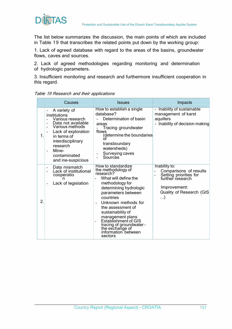
Protection and Sustainable Use of the Dinaric Karst Transboundary Aquifer System
Country Report (Regional Aspect) – CROATIA 131
The list below summarizes the discussion, the main points of which are included in Table 19 that transcribes the related points put down by the working group: 1. Lack of agreed database with regard to the areas of the basins, groundwater flows, caves and sources.
2. Lack of agreed methodologies regarding monitoring and determination of hydrologic parameters.
3. Insufficient monitoring and research and furthermore insufficient cooperation in this regard.
Table 19 Research and their applications
Causes Issues Impacts
1.
- A variety of institutions - Various research - Data not available - Various methods - Lack of exploration
in terms of interdisciplinary research
- Mine-contaminated and ine-suspicious area
How to establish a single database? - Determination of basin areas - Tracing groundwater flows
(determine the boundariesof transboundary watersheds)
- Surveying caves - Sources
- Inability of sustainable management of karst aquifers - Inability of decision making
2.
- Data mismatch - Lack of institutional
cooperation
- Lack of legislation
How to standardize the methodology of research? - What will define the
methodology for determining hydrologic parameters between countries
- Unknown methods for the assessment of sustainability of management plans
- Establishment of GIS tracing of groundwater - the exchange of information between sectors
Inability to: - Comparisons of results - Setting priorities for
further research
Improvement: Quality of Research (GIS...)
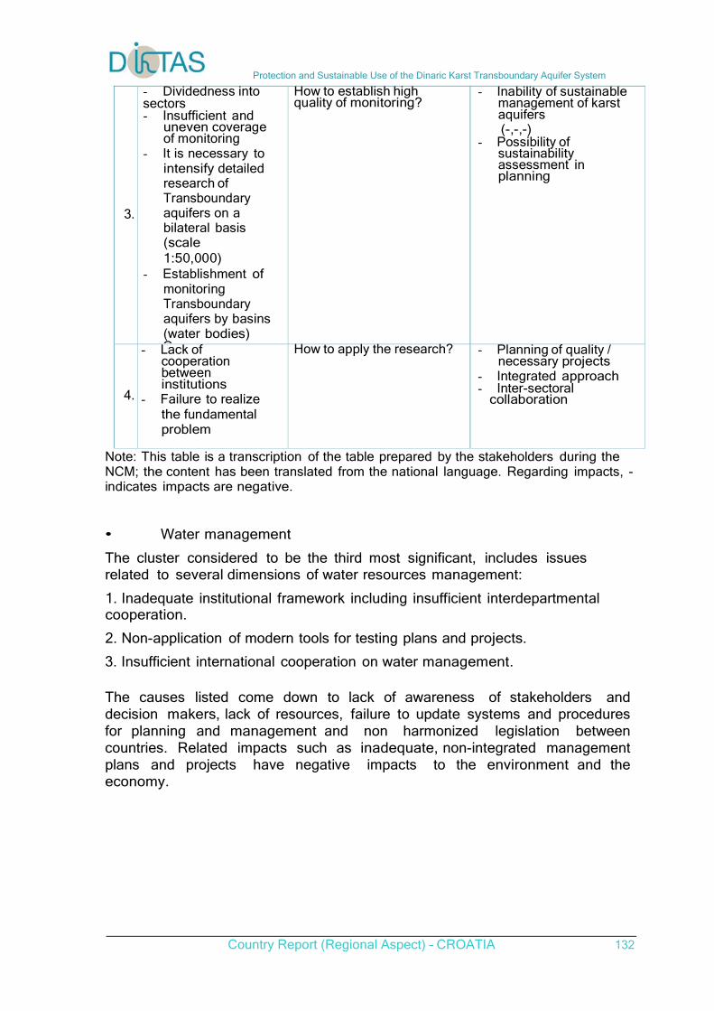
Protection and Sustainable Use of the Dinaric Karst Transboundary Aquifer System
Country Report (Regional Aspect) – CROATIA 132
3.
- Dividedness into sectors - Insufficient and
uneven coverage of monitoring
- It is necessary to intensify detailed research of Transboundary aquifers on a bilateral basis (scale 1:50,000)
- Establishment of monitoring Transboundary aquifers by basins (water bodies) Common
How to establish high quality of monitoring?
- Inability of sustainable management of karst aquifers (-,-,-)
- Possibility of sustainability assessment in planning
4.
- Lack of cooperation between institutions
- Failure to realize the fundamental problem
How to apply the research? - Planning of quality / necessary projects
- Integrated approach - Inter-sectoral collaboration
Note: This table is a transcription of the table prepared by the stakeholders during the NCM; the content has been translated from the national language. Regarding impacts, - indicates impacts are negative.
• Water management The cluster considered to be the third most significant, includes issues related to several dimensions of water resources management: 1. Inadequate institutional framework including insufficient interdepartmental cooperation.
2. Non-application of modern tools for testing plans and projects.
3. Insufficient international cooperation on water management. The causes listed come down to lack of awareness of stakeholders and decision makers, lack of resources, failure to update systems and procedures for planning and management and non harmonized legislation between countries. Related impacts such as inadequate, non-integrated management plans and projects have negative impacts to the environment and the economy.
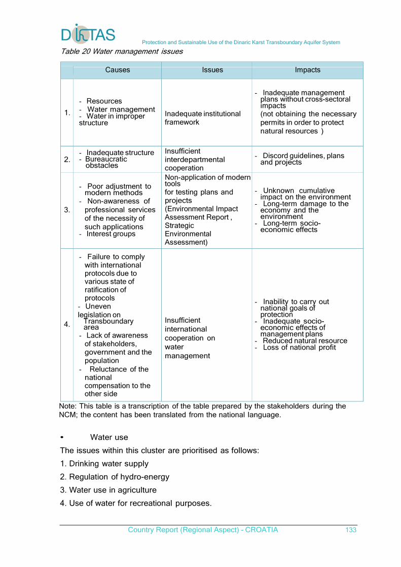
Protection and Sustainable Use of the Dinaric Karst Transboundary Aquifer System
Country Report (Regional Aspect) – CROATIA 133
Table 20 Water management issues
Causes Issues Impacts
1.
- Resources - Water management - Water in improper structure
Inadequate institutional framework
- Inadequate management plans without cross-sectoral impacts (not obtaining the necessary permits in order to protect natural resources )
2. - Inadequate structure - Bureaucratic obstacles
Insufficient interdepartmental cooperation
- Discord guidelines, plans and projects
3.
- Poor adjustment to modern methods
- Non-awareness of professional services of the necessity of such applications
- Interest groups
Non-application of moderntools for testing plans and projects (Environmental Impact Assessment Report , Strategic Environmental Assessment)
- Unknown cumulative impact on the environment
- Long-term damage to the economy and the environment
- Long-term socio-economic effects
4.
- Failure to comply with international protocols due to various state of ratification of protocols
- Uneven legislation on
Transboundary area
- Lack of awareness of stakeholders, government and the population
- Reluctance of the national compensation to the other side
Insufficient international cooperation on water management
- Inability to carry out national goals of protection
- Inadequate socio-economic effects of management plans
- Reduced natural resource - Loss of national profit
Note: This table is a transcription of the table prepared by the stakeholders during the NCM; the content has been translated from the national language. • Water use The issues within this cluster are prioritised as follows: 1. Drinking water supply
2. Regulation of hydro-energy
3. Water use in agriculture
4. Use of water for recreational purposes.
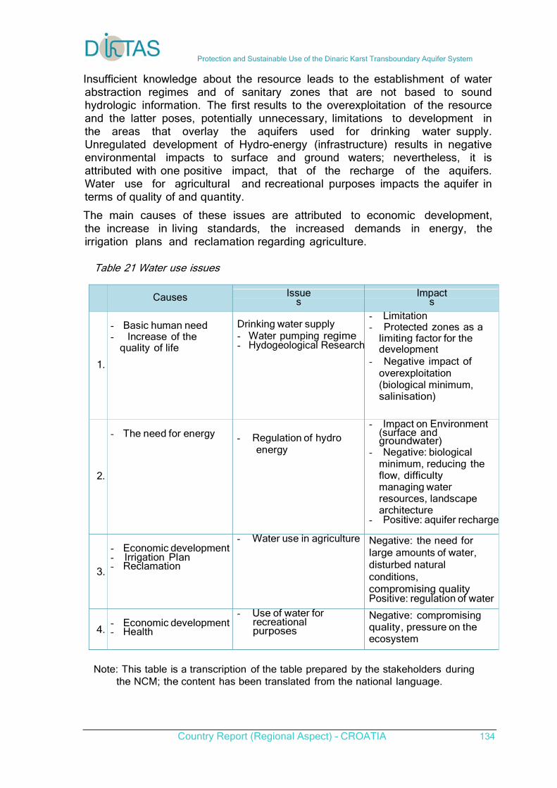
Protection and Sustainable Use of the Dinaric Karst Transboundary Aquifer System
Country Report (Regional Aspect) – CROATIA 134
Insufficient knowledge about the resource leads to the establishment of water abstraction regimes and of sanitary zones that are not based to sound hydrologic information. The first results to the overexploitation of the resource and the latter poses, potentially unnecessary, limitations to development in the areas that overlay the aquifers used for drinking water supply. Unregulated development of Hydro-energy (infrastructure) results in negative environmental impacts to surface and ground waters; nevertheless, it is attributed with one positive impact, that of the recharge of the aquifers. Water use for agricultural and recreational purposes impacts the aquifer in terms of quality of and quantity. The main causes of these issues are attributed to economic development, the increase in living standards, the increased demands in energy, the irrigation plans and reclamation regarding agriculture.
Table 21 Water use issues
Causes Issues
Impacts
1.
- Basic human need - Increase of the
quality of life
Drinking water supply - Water pumping regime - Hydogeological Research
- Limitation - Protected zones as a
limiting factor for the development
- Negative impact of overexploitation (biological minimum, salinisation)
2.
- The need for energy
- Regulation of hydro energy
- Impact on Environment (surface and groundwater)
- Negative: biological minimum, reducing the flow, difficulty managing water resources, landscape architecture
- Positive: aquifer recharge
3.
- Economic development - Irrigation Plan - Reclamation
- Water use in agriculture Negative: the need for large amounts of water, disturbed natural conditions, compromising quality Positive: regulation of water
4.
- Economic development - Health
- Use of water for recreational purposes
Negative: compromising quality, pressure on the ecosystem
Note: This table is a transcription of the table prepared by the stakeholders during
the NCM; the content has been translated from the national language.
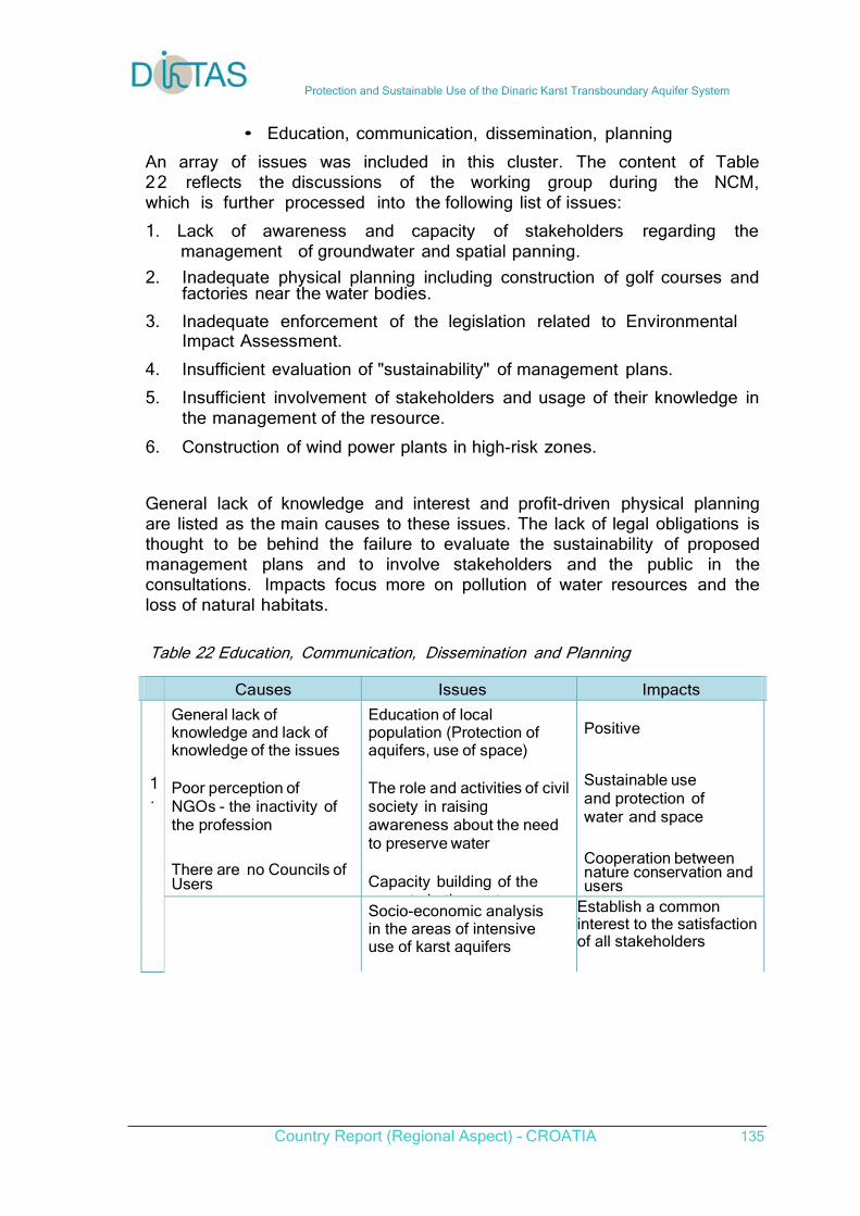
Protection and Sustainable Use of the Dinaric Karst Transboundary Aquifer System
Country Report (Regional Aspect) – CROATIA 135
• Education, communication, dissemination, planning
An array of issues was included in this cluster. The content of Table 22 reflects the discussions of the working group during the NCM, which is further processed into the following list of issues:
1. Lack of awareness and capacity of stakeholders regarding the management of groundwater and spatial panning.
2. Inadequate physical planning including construction of golf courses and factories near the water bodies.
3. Inadequate enforcement of the legislation related to Environmental Impact Assessment.
4. Insufficient evaluation of "sustainability" of management plans.
5. Insufficient involvement of stakeholders and usage of their knowledge in the management of the resource.
6. Construction of wind power plants in high-risk zones.
General lack of knowledge and interest and profit-driven physical planning are listed as the main causes to these issues. The lack of legal obligations is thought to be behind the failure to evaluate the sustainability of proposed management plans and to involve stakeholders and the public in the consultations. Impacts focus more on pollution of water resources and the loss of natural habitats.
Table 22 Education, Communication, Dissemination and Planning
Causes Issues Impacts
General lack of knowledge and lack of knowledge of the issues
Poor perception of NGOs - the inactivity of the profession
There are no Councils of Users
Education of local population (Protection of aquifers, use of space)
The role and activities of civil society in raising awareness about the need to preserve water
Capacity building of the
t i th t
Positive
Sustainable use and protection of water and space
Cooperation between nature conservation and users
1 .
Socio-economic analysis in the areas of intensive use of karst aquifers
Establish a common interest to the satisfaction of all stakeholders
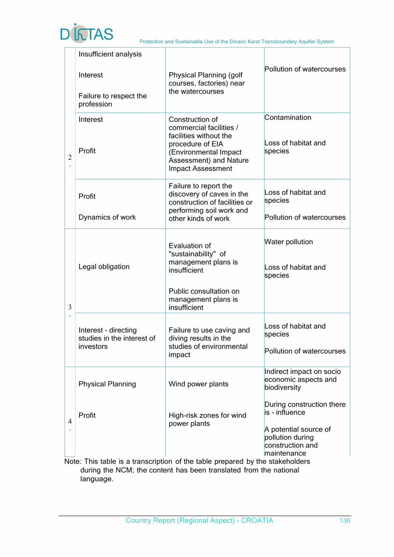
Protection and Sustainable Use of the Dinaric Karst Transboundary Aquifer System
Country Report (Regional Aspect) – CROATIA 136
Insufficient analysis
Interest
Failure to respect the profession
Physical Planning (golf courses, factories) near the watercourses
Pollution of watercourses
Interest
Profit
Construction of commercial facilities / facilities without the procedure of EIA (Environmental Impact Assessment) and Nature Impact Assessment
Contamination Loss of habitat and species
2 .
Profit
Dynamics of work
Failure to report the discovery of caves in the construction of facilities or performing soil work and other kinds of work
Loss of habitat and species Pollution of watercourses
Legal obligation
Evaluation of "sustainability" of management plans is insufficient
Public consultation on management plans is insufficient
Water pollution Loss of habitat and species
3 .
Interest - directing studies in the interest of investors
Failure to use caving and diving results in the studies of environmental impact
Loss of habitat and species Pollution of watercourses
4 .
Physical Planning
Profit
Wind power plants
High-risk zones for wind power plants
Indirect impact on socio economic aspects and biodiversity During construction there is - influence A potential source of pollution during construction and maintenance
Note: This table is a transcription of the table prepared by the stakeholders during the NCM; the content has been translated from the national language.
Protection and Sustainable Use of the Dinaric Karst Transboundary Aquifer System
Country Report (Regional Aspect) – CROATIA 137
Results from Interviews
According to the interviewees initial reaction, the most significant issue in the transboundary karst aquifers is by far pollution, whether be it from wastewater or from solid waste and illegal dumps or from industries and special waste.
The second most significant issue which acts as a starting point of many problems according to the interviewees is the lack of cross-border/institutional communication and cooperation. Subsequently, lack of data and scientific knowledge and lack or insufficient management, appear to have the same significance for interviewees. The harmonization of legislation is another issue that follows close and is usually tied in with bilateral cooperation between countries sharing the aquifers.
Other issues mentioned during the conversation include:
Groundwater over-abstraction mainly for irrigation but also for tourism and hydropower Salinization Poor and outdated water supply system Lack of control of pollutants Salt water upcoming Climate change Construction of reservoirs in neighbouring countries Inconsistent implementation of the ESPO Convention Inability to influence the physical planning and interventions in transboundary karst areas
The main water or other natural resources users that exert pressures and contribute in the development of the issues/problems stated by the interviewees are Households and Agriculture with Industry following close. Tourism is also acknowledged as a source of pressures.
What are the impacts, how are they expressed, how do they manifest?
The impacts from the significant issues become mostly evident in the failure in managing water resources in a sustainable way. Furthermore the loss of biodiversity (Vransko jezero is indicated as an example) and reduced quantity of water resources (examples include Malostonski zaljev, Malo more - uvala Bistrina and Neretva River) have also been observed.
How this issue/problem could be addressed in your opinion – what needs to be done in order to avoid or address the problem?
The most commonly proffered solution to the issues and problems afflicting water management in the transboundary areas according to the stakeholders interviewed, is the improvement of the cooperation at all levels, through bilateral, multilateral and international agreements and through undertaking joint activities and initiatives aimed at the protection and better management of the resource. The implementation of pollution control management and systematic monitoring, especially regarding wastewaters but also solid waste, is viewed essential. These combined with other protection measures will result in the enhancement of the state of the water
Protection and Sustainable Use of the Dinaric Karst Transboundary Aquifer System
Country Report (Regional Aspect) – CROATIA 138
resources.
Other points of improvement involve the implementation and enforcement of environmental legislation, including the EU Water Framework Directive. Furthermore, the implementation of comprehensive management plans, raising awareness of the stakeholders and even the restriction of harmful to the environment and water resources activities are believed to aid towards the alleviation of most of the issues.